rezoning and cup template - vbgov.com · the applicant also requests a conditional use permit to...
TRANSCRIPT

MARLYN DEVELOPMENT CORPORATION/CORAL DEVELOPMENT, LLC Agenda Items 16 & 17 Page 1
16 & 17 April 11, 2012 Public Hearing
APPLICANT:
MARLYN DEVELOPMENT CORPORATION
PROPERTY OWNER:
CORAL DEVELOPMENT,
LLC STAFF PLANNER: Faith Christie
REQUEST: Modification of Conditional Change of Zoning approved by the City Council on November 27, 2007 Conditional Use Permit (housing for seniors and disabled) ADDRESS / DESCRIPTION: Northeast corner of Sandbridge Road and Atwoodtown Road
GPIN: 24138897440000; 24138980330000; 24139981540000; 24138975010000; 24139960910000.
ELECTION DISTRICT: PRINCESS ANNE
SITE SIZE: 13.72 acres
AICUZ: Less than 65 dB DNL
APPLICATION HISTORY: The applicant requested a deferral of the request at the March 14, 2012 Planning Commission meeting so they could work with the surrounding land owners on development issues. The applicant met with staff, the Lago Mar Civic League Board of Directors, and property owners in Lago Mar directly adjacent to the site before submission of the request. When the site was posted with the required modification of conditions and conditional use permit signs residents along Sandbridge Road as well as in Sandbridge Beach called to inquire about the project. The applicant met with the Sandbridge Civic League to discuss traffic concerns. As discussed in the report housing for seniors typically does not place undue burdens on the “more costly services such as schools and transportation”. Additionally the Traffic Engineering division of Public Works reports that the proposed use “does not appear to add vehicular traffic beyond what the surrounding roadway network can adequately handle”. The applicant and surrounding civic leagues do not appear to have come to a

MARLYN DEVELOPMENT CORPORATION/CORAL DEVELOPMENT, LLC Agenda Items 16 & 17 Page 2
consensus on the proposed use of the site and the traffic issues. Therefore the applicant is requesting to move forward on the request.
The applicant is seeking a Modification of Proffers and a Conditional Use Permit for the site. The Conditional Rezoning from AG-2 Agricultural District to Conditional R-15 Residential District with a PD-H2 Planned Development District Overlay was approved by City Council on November 27, 2007. The site is approved for the development of 27 single-family homes. The recorded proffer agreement has 11 proffers. All of the proffers are being modified. The total area rezoned was 16.59 acres. The modification of proffers to the conditional rezoning will apply to 13.72 acres of the site, leaving 2.87 acres at the southeastern portion of the site to be developed as proffered with seven single-family lots. The applicant also requests a Conditional Use Permit to allow the development of the northwestern portion of the site with housing for seniors and disabled, aged 62 years and older. The applicant develops apartment and active adult communities. Active adult communities are defined as independent living facilities intended for residency by individuals capable of functional independence. Such facilities stress the social, rather than the medical, needs of the resident. The proposed Conditional Use Permit encompasses 13.72 acres of the overall site. The submitted development plan depicts the proposed building, parking, and landscaping in the northwestern portion of the site. The site will have 189 parking spaces. The plan shows a 30-foot landscaped buffer adjacent to the residential homes to the north and east, as well as street frontage and parking lot landscaping. Within the courtyard area of the proposed building a water feature, gazebo, meditation area, and raised garden plots are planned. The developer also provides a measured walk around the exterior of the building. The floodplain and wetland areas at the southern and eastern portions of the site will be left in their existing state. The proposed building will house 126 dwellings with a mix of one and two bedroom units. All units have interior entrances with controlled access to the exterior doors of the building. The proposed building is three stories in height. The architectural design is a coastal theme. Towers with fiber cement siding and metal roof panels provide architectural relief to the mass of the building. Building materials include fiber cement shingles and panels, vinyl lap siding, and stone veneer. Other amenities provided on site include a community room used for holiday celebrations and social gatherings, a business center with free internet, a library with a book exchange, a beauty salon, a game room, and a full fitness center. The project is designed to appeal to mid level income seniors.
LAND USE AND PLAN INFORMATION EXISTING LAND USE: Undeveloped site SURROUNDING LAND North: Single-family dwellings / R-15 Residential
SUMMARY OF REQUEST
MARLYN DEVELOPMENT CORPORATION/CORAL DEVELOPMENT, LLC Agenda Items 16 & 17 Page 3
USE AND ZONING: South: Atwoodtown Drive / Lotus Drive
Across Atwoodtown Drive and Lotus Drive are single-family dwellings / AG-2 Agricultural
East: Atwoodtown Road
Across Atwoodtown Road is Hell’s Point Golf Course / AG-2 Agricultural and P-1 Preservation
West: Sandbridge Road
Across Sandbridge Road are single-family dwellings / AG-2 Agricultural
NATURAL RESOURCE AND CULTURAL FEATURES:
The site was previously a cultivated field and is now grass covered. A ditch traverses the site from Sandbridge Road to Atwoodtown Road. Of the 16.59 acres of land area, 4.26 acres are within the floodplain.
COMPREHENSIVE PLAN: Suburban Area (adjacent to Transition Area) The Comprehensive Plan recommendations for the Suburban Area focus on preserving and protecting the overall character, economic value, and aesthetic quality of the stable neighborhoods and to create and protect open spaces. Achieving the goals of preserving neighborhood quality requires that all new development or redevelopment, whether residential or non-residential, either maintain or enhance the existing neighborhood through attractiveness of site and buildings, compatibility through a careful mix of land uses, and effectively buffered with respect to type, size, intensity, and relationship to the surrounding uses. Provision of adequate infrastructure and diversification of the housing, while containing suburban sprawl is the overall strategy for the Suburban Area. All new development and redeveloped proposals are to ensure preservation of the quality of our natural environment by adhering to established environmental planning principles. These include, among others, clustering of lots, where appropriate, to increase area of preserved natural resources, minimizing impervious cover of such features as building, roads and parking area, and utilizing drought tolerant plant material. The goals in the Plan’s Housing and Neighborhoods Plan chapter that are applicable to this request include the need to address future housing demand through providing an adequate supply of safe, decent, attractive and diverse housing with a range of values including owner-occupied and rental units and to implement ways to assist those requiring special housing. Policies associated with these goals state that areas planned for housing should be attractive and affordable to a range of income groups, ages, cultures and household types. This applies as well to projects that allow for and encourage the type and location of housing for seniors designed to meet their special needs and services including, but not limited to, independent living, assisted living and nursing facilities.
CITY SERVICES
MASTER TRANSPORTATION PLAN (MTP) / CAPITAL IMPROVEMENT PROGRAM (CIP): Access to this site is proposed to be from Sandbridge Road, approximately 650 feet north of its intersection with Atwoodtown Road. Sandbridge Road is a two-lane minor suburban arterial with a 50-ft right of way. The City’s Master Transportation Plan indicates an ultimate 135-ft right of way width for a four-lane parkway for Sandbridge Road. There are no Capital Improvement Projects scheduled for this portion of Sandbridge Road.

MARLYN DEVELOPMENT CORPORATION/CORAL DEVELOPMENT, LLC Agenda Items 16 & 17 Page 4
The proposed use for this site as an age-restricted community with 126 dwelling units increases the potential trip generation significantly beyond the original plan’s trip generation for approximately 20 single-family dwelling units. Additionally, the previous plan intended for access to be located along Atwoodtown Road, while the new proposal indicates access for these units to be solely from Sandbridge Road. In spite of these differences, the proposed plan does not appear to add vehicular traffic beyond what the surrounding roadway network can adequately handle.
The proposed left turn lane from Sandbridge Road shall conform to all City of Virginia Beach Public Works Standards for turn lanes, including appropriate taper and transition lengths. Additionally, the proposed access point along Sandbridge Road must conform to all applicable City of Virginia Beach Public Works Standards. If a divided entrance is approved, one lane entering and two lanes exiting (with one curb cut for the exit) will be the maximum allowable, such as is shown in the CVB Public Works Standard Detail D-6.
The proposed “Fire Truck Access” will need to be shielded and landscaped such that it is not easily visible to or accessible by residents/guests.
TRAFFIC: Street Name
Present Volume
Present Capacity Generated Traffic
Sandbridge Road 9,180 ADT 1 15,000 ADT
1 Existing Land Use
2 – 200
ADT (20 Peak Hour) Proposed Land Use
3 – 438
ADT (14 Peak Hour) 1 Average Daily Trips
2 as defined by 20 single-family dwellings
3 as defined by 126 elderly dwelling units
WATER: City water does not front this site, but may be extended provided hydraulic analysis supports the potential demand. Plans and bonds are required for construction of the extension of the water system.
SEWER: This site must connect to City sanitary sewer. The site is located within the service area of the proposed Pump Station #646 service area boundary. A pump station is required to be constructed for any proposed flows. There are an 8 inch city sanitary sewer force main and a 4 inch sanitary sewer force main (by others) on Sandbridge Road. There is a 10 inch City sanitary sewer force main in Atwoodtown Road.
SCHOOLS: School populations are not affected by the request.
Staff recommends approval of this request with the conditions and proffers below. This site is located in Sandbridge, adjacent to the Transition Area. Active adult communities should be encouraged in this area, as it is generally acknowledged that these communities have less impact on City services, particularly the more costly services such as schools and transportation. Additionally the Traffic Engineering division of
EVALUATION AND RECOMMENDATION

MARLYN DEVELOPMENT CORPORATION/CORAL DEVELOPMENT, LLC Agenda Items 16 & 17 Page 5
Public Works reports that the proposed use “does not appear to add vehicular traffic beyond what the surrounding roadway network can adequately handle”. The applicant met with the VA/VB Senior Housing Review Committee on January 30, 2012. The Committee reports that based on the information provided by the applicant the proposed use is considered suitable for providing independent living housing for moderate income seniors. After review of the request the Senior Housing Review Committee states that the proposal appears to meet the “Senior Housing Development Guidelines” as provided in the City’s “Report on Senior Housing Multi-family Issues: Policy Report”. The proposal to develop a facility for independent living for seniors is consistent with the Comprehensive Plan’s land use policies and the vision for the Suburban Area. The submitted development plan and building elevations are consistent with the Suburban Area design guidelines. The proposal is also consistent with the policies of the Comprehensive Plan in that it provides needed senior housing that is compatible with adjacent residential developments in type and density. The applicant proposes to develop a facility providing a 126-unit independent-living housing for seniors. The building materials of fiber- cement shingles and panels, vinyl lap and stone veneer siding, and architectural shingles for the roof will be long-lasting, attractive, and high quality, and reflects the character of the associated area. The proposal dedicates the wetlands and floodplain at the rear of the development adjacent to the existing residential neighborhood as well as at the intersection of Sandbridge Road and Atwoodtown Road as an ‘Open Space Area’ that will provide needed open space for passive recreation for the residents and offers protection for water resources.
PROFFERS The following are proffers submitted by the applicant as part of a Conditional Zoning Agreement (CZA). The applicant, consistent with Section 107(h) of the City Zoning Ordinance, has voluntarily submitted these proffers in an attempt to “offset identified problems to the extent that the proposed rezoning is acceptable,” (§107(h)(1)). Should this application be approved, the proffers will be recorded at the Circuit Court and serve as conditions restricting the use of the property as proposed with this change of zoning. PROFFER 1: Proffer Number 1 contained in the Original Proffers is hereby amended to read in its entirety as follows: “When developed, the Grantor shall develop the Multi-Family Parcel in substantial conformity with the concept plan prepared by Cox Kliewer & Company, P.C., dated November 7, 2011, and entitled “Sandbridge Villa’s, An Adult Community” (the “Multi-Family Concept Plan”), a copy of which is on file with the Department of Planning and has been exhibited to the City Council. When developed, the remainder of the Property not included in the Multi-Family Parcel (the “Remainder Parcel”) shall be developed in substantial conformity with the concept plan prepared by Burgess & Nipple, dated October 13, 2006, and titled “Concept Plan for Ashby’s Bridge, Sandbridge Road and Atwoodtown Road, Virginia Beach, Virginia" (the “Single Family Concept Plan”), a copy of which is on file with the Department of Planning and has been exhibited to the City Council.” PROFFERS 2, 3, 4 and 5: Proffers Number 2, 3, 4, and 5 shall apply only to the development of the Remainder Parcel. The development standards applied to the Multi-Family Parcel shall be established as part of the Conditional Use Permit Application heard simultaneously herewith. PROFFERS 6 and 7: Proffer Number 6 is hereby deleted.

MARLYN DEVELOPMENT CORPORATION/CORAL DEVELOPMENT, LLC Agenda Items 16 & 17 Page 6
Proffer Number 7 is amended to read in its entirety as follows: “If determined necessary as part of final site plan approval, prior to obtaining a final certificate of occupancy for any unit within the age-restricted apartment community to be constructed on the Multi-Family Parcel, Grantor shall (a) record a deed or plat dedicating to Grantee a portion of the Multi-Family Parcel sufficient to accommodate a left-turn lane for traffic turning left from eastbound Sandbridge Road into the Multi-Family Parcel, and (b) construct the referenced left turn lane (subject to obtaining required governmental approvals)”. PROFFER 8: Proffer Number 8 contained in the Original Proffers is hereby amended to read in its entirety as follows: “The green-shaded areas on the Concept Plan located to the south and east of the parking areas and drive-aisles associated with the proposed adult community to the developed on the Multi-Family Parcel (the “Open Space Area”) shall be subject to recorded restrictive covenants that restrict the use of such areas for any purpose other than recreation, open space, and stormwater management facility use. The restrictive covenants shall run with the land and be in full force and effect for a period of at least fifty (50) years. The covenants shall be approved by the City Attorney, or his designee, and recorded prior to the date a building permit is issued for the construction of the proposed adult community. PROFFER 9 Proffer Number 9 contained in the Original Proffers is hereby amended to read in its entirety as follows: “Grantor shall provide for maintenance of the Open Space Area. With the consent of Grantor (which shall not be unreasonably withheld), the Open Space Area shall be made available for passive recreational use by residents of the Remainder Parcel (when developed)”. PROFFER 10 Proffer Number 10 contained in the Original Proffers is hereby amended to read in its entirety as follows: “Grantor shall file and obtain approval of a rezoning petition to rezone the Open Space Area to P-1 Preservation District, as defined in the CZO, prior to the date the first building permit for any building on the Property is issued.” PROFFER 12 Proffer Number 12, which shall only apply to the Multi-Family Parcel, shall be added and shall read in its entirety as follows: “When developed, the residential units associated with the adult community developed on the Multi-Family Parcel shall be in substantial conformity with the architectural style, materials, and building heights depicted on the building rendering prepared by Cox Kliewer & Company, P.C., dated November 10, 2011, and entitled “Sandbridge Villa’s, An Adult Community” (the “Elevations”), a copy of which is on file with the Department of Planning and has been exhibited to the City Council.” STAFF COMMENTS: The proffers are acceptable as they insure the site will be developed in accordance with the submitted preliminary site and elevation plans. The submitted preliminary site plan depicts a coordinated development of the site in terms of design, parking layout and traffic control and circulation, and landscaping within the site. The submitted preliminary elevation plan depicts a building of high quality materials that is complementary to existing dwellings in the area.
MARLYN DEVELOPMENT CORPORATION/CORAL DEVELOPMENT, LLC Agenda Items 16 & 17 Page 7
The City Attorney’s Office has reviewed the proffer agreement dated November 14, 2011, and found it to be legally sufficient and in acceptable legal form.
CONDITIONS
1. A floodplain mitigation plan is required, including a hydrology study showing no net loss in the flood storage or no net rise in the hydrologic profile. Proposed mitigation areas shall not be located within
the floodplain.
2. Before any land disturbing activity takes place a Southern Watershed Management Plan shall be submitted for review and approval.
NOTE: Further conditions may be required during the administration of applicable City Ordinances and Standards. Any site plan submitted with this application may require revision during detailed site plan review to meet all applicable City Codes and Standards. All applicable permits required by the City Code, including those administered by the Department of Planning / Development Services Center and Department of Planning / Permits and Inspections Division, and the issuance of a Certificate of Occupancy, are required before any uses allowed by this Use Permit are valid.
The applicant is encouraged to contact and work with the Crime Prevention Office within the Police Department for crime prevention techniques and Crime Prevention Through Environmental Design (CPTED) concepts and strategies as they pertain to this site.

MARLYN DEVELOPMENT CORPORATION/CORAL DEVELOPMENT, LLC Agenda Items 16 & 17 Page 8

MARLYN DEVELOPMENT CORPORATION/CORAL DEVELOPMENT, LLC Agenda Items 16 & 17 Page 9
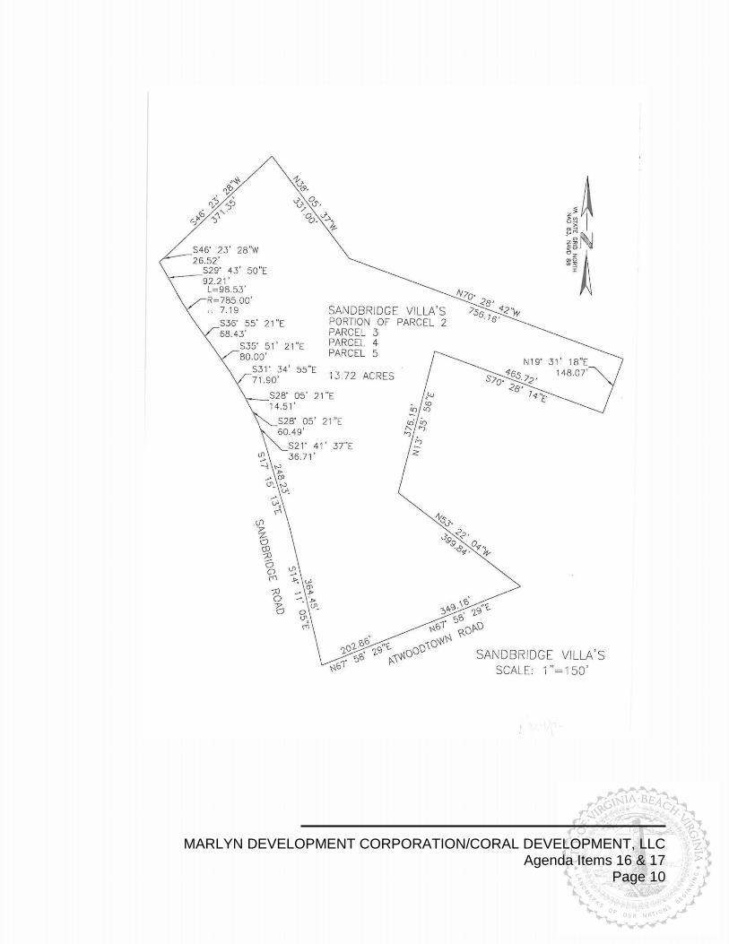
PROPOSED SITE PLAN
MARLYN DEVELOPMENT CORPORATION/CORAL DEVELOPMENT, LLC Agenda Items 16 & 17 Page 10

MARLYN DEVELOPMENT CORPORATION/CORAL DEVELOPMENT, LLC Agenda Items 16 & 17 Page 11
PROPOSED BUILDING ELEVATION

MARLYN DEVELOPMENT CORPORATION/CORAL DEVELOPMENT, LLC Agenda Items 16 & 17 Page 12
ZONING HISTORY
# DATE REQUEST ACTION
1 11/3/08 7/9/91
CONDITIONAL USE PERMIT (RETAIL SALES) CONDITIONAL USE PERMIT (RETAIL SALES)
WITHDRAWN DENIED
2 1/4/00 11/23/99
RECONSIDERATION OF FLOODPLAIN VARIANCE FLOODPLAIN VARIANCE
APPROVED DENIED
3 5/26/09 CONDITIONAL USE PERMIT (COUNTRY INN) APPROVED
4 8/911 MODIFICATION OF CONDITIONAL USE PERMIT APPROVED
5 11/27/07 REZONING (AG-2 AGRICULTURAL TO CONDITIONAL R-15 RESIDENTIAL WITH A PD-H2 PLANNED DEVELOPMENT OVERLAY) & FLOODPLAIN VARIANCE
APRROVED
5
1
2
3
4

MARLYN DEVELOPMENT CORPORATION/CORAL DEVELOPMENT, LLC Agenda Items 16 & 17 Page 13
DISCLOSURE STATEMENT

MARLYN DEVELOPMENT CORPORATION/CORAL DEVELOPMENT, LLC Agenda Items 16 & 17 Page 14
DISCLOSURE STATEMENT