review of visualizing historical architectural knowledge
TRANSCRIPT
HAL Id: hal-03121591https://hal.archives-ouvertes.fr/hal-03121591
Submitted on 26 Jan 2021
HAL is a multi-disciplinary open accessarchive for the deposit and dissemination of sci-entific research documents, whether they are pub-lished or not. The documents may come fromteaching and research institutions in France orabroad, or from public or private research centers.
L’archive ouverte pluridisciplinaire HAL, estdestinée au dépôt et à la diffusion de documentsscientifiques de niveau recherche, publiés ou non,émanant des établissements d’enseignement et derecherche français ou étrangers, des laboratoirespublics ou privés.
Distributed under a Creative Commons Attribution - NonCommercial - NoDerivatives| 4.0International License
Review of Visualizing Historical ArchitecturalKnowledge through Virtual Reality
Anahid Ehtemami, Sang Park, Shonda Bernadin, Laurent Lescop, AndrewChin
To cite this version:Anahid Ehtemami, Sang Park, Shonda Bernadin, Laurent Lescop, Andrew Chin. Review of VisualizingHistorical Architectural Knowledge through Virtual Reality. IEEE VR 21 Conference on VirtualReality and 3D User Interfaces, March 27-April 3, virtual, IEEE, Mar 2021, Lisbon, Portugal. �hal-03121591�
Review of Visualizing Historical Architectural Knowledgethrough Virtual Reality
Anahid Ehtemami*Electrical and computerengineering departmentFAMU-FSU College of
EngineeringTallahassee, Florida, USA
Sang Bum Park, PhD.†School of Architecture andEngineering Technology
Florida A and M UniversityTallahassee, Florida, USA
Shonda Bernadin, PhD.‡Electrical and computerengineering departmentFAMU-FSU College of
EngineeringTallahassee, Florida, USA
Laurent Lescop Prof. STA Dr.hab arch.dplg§
ENSA NantesCRENAU/ AAU
UMR-CNRS1563Nantes, France
Andrew Chin, PhD.¶School of Architecture andEngineering Technology
Florida A and M UniversityTallahassee, Florida, USA
ABSTRACT
Virtual Reality (VR) has become one of the emerging technologiesover the past decade for improving the quality of life in human ex-periences. It has exciting and popular applications in entertainment,sports, education, and even digital documentation of notable or his-torical sites, allowing users to immerse themselves in an alternatereality. By combining the principles of software development andimmersive VR, real-life VR experiences seek to transport users toan interactive environment where they can view, observe, and expe-rience historical events and artifacts in a new way. There are severalsteps involved in VR development of cultural and historical sitesthat require a solid understanding for adaptable and scalable design.This paper is a review of the VR development process for notablehistoric preservation VR projects. This process can be used to createimmersive VR experiences for other cultural sites.
Index Terms: Virtual Reality—Historical Preservation—Immersive—Architecture;
1 INTRODUCTION
Over the past few decades, Virtual reality (VR) technologies havegrown significantly and have been constantly evolving. Aside fromVR games, it provided an interesting, attractive, and productivemeans to educate a wide range of audience about a variety of topics.Virtual reality can provide the opportunity for users to experiencewhat might not be possible otherwise, such as exploring the high-risk vocational training, deep-sea levels, anatomy of human body,and cultural heritage projects that no longer exist [1–3]. “CulturalHeritage” refers to properties and sites with archaeological, aes-thetic, and historical value (Tan, 2009). Diverse media and differentdigital tools help us recreate these areas in a virtual world and thisexperience is referred to as “Virtual Heritage” [4]. A virtual heritageenvironment enhances the knowledge and understanding of heritageand social history and the connection between cultural sites andthe wider public by providing a greater sense of engagement withsocial-historical memories, in addition to preserving the structurethroughout time. Architectural heritage is now exposed to many
*e-mail: [email protected]†e-mail: [email protected]‡e-mail: [email protected]§e-mail: [email protected]¶e-mail: [email protected]
dangers due to natural disasters or human invasive actions. OnApril 15, 2019, a fire broke under the roof of Notre-Dame de Pariscathedral, a historic French Gothic structure built in 1163, as de-scribed below. Most of the wood/metal roof and the iconic spireof the cathedral was destroyed in the fire. The estimated cost ofreconstructions and restorations could surpass 1 billion dollars [5].The Past project in partnership with Nottingham’s museums andcultural heritage institutions, is a narrative-based VR project thatoffers the mentioned advantages. In 2012, Hrozek discussed theprocesses of creation of VR experience of the historical buildingof The State Theatre of Kosice, Slovania. Similar projects will bediscussed later in this text. After the destruction of Bamiyan stat-ues in Afghanistan in 2001, Ben Kacyra, the founding director ofCyArk, a nonprofit engaged in 3D digital preservation of culturalheritage sites worldwide, began capturing historical landmarks usinglaser-scanning technology. Partnering with Google Arts and Culturewas the start of launching the Open Heritage project, a new initiativededicated to digital preservation of landmarks such as the 1000 yearold Temple of Kukulkan in Chichen Itza, parts of the Roman city ofPompeii, and the Native American cliff dwellings at Mesa Verde insouthern Colorado.
1.1 Digital PreservationThe American Library Association describes digital preservation(DP) as “Combining policies, strategies, and actions that ensureaccess to reformatted and born digital content over time”, providingguidelines on content creation, content integrity, and maintenancefor DP projects. VR technology, one of the tools used for DP,facilitates the creation and visualization of the structure of historicalbuildings. 3D scanners are often used for accurately capturing thereal-world picture that can be used for modeling and visualization.Finally, software development principles help turn the models intothe interactive VR experience.
1.1.1 The Past ProjectNottingham’s cultural heritage and social history was captured inThe Past Project as a virtual heritage environment. The develop-ers provided a space that the audience could inhabit, rather thanjust watching a performance. Visitors move around and interactwith different elements in the space. They also encounter severalembedded video and audio narratives that are designed to providean immersive experience. The narratives are triggered as the vis-itors approach an object. The user experience was evaluated ondifferent occasions where they either purely observed or observedand interacted with the VR environment. This evaluation showedthat interactivity dramatically increased the positive response to theimmersive experience [6].
1.1.2 The State Theatre of KosiceThe historical building of The State Theatre of Kosice was recreatedin VR. For this project, the tasks are divided into 4 major steps:Preparation, Modelling, Verification, and Visualization. 3D scanningwas used to improve the modelling and visualization.
1.1.3 Notre DameThe historic Notre Dame Cathedral in Paris suffered a devastatingfire in 2019. It permanently destroyed parts of the building. However,the site was recently immortalized in 3D by TARGO, a VR studiospecializing in immersive documentaries.
2 DEVELOPMENT
In this section, the main components of developing a VR historicpreservation project are discussed.
2.1 Conceptual ModelA VR or Augmented Reality (AR) project includes several modulesthat interact at different levels. In figure 2, a project workflow isshown that is established by ChoroPhronesis, a research unit withinPenn State’s Department of Geography. This model divides theworkflow into 3 main processes: Data Collection, Development, andProduction. Many VR projects follow a similar structure
Figure 1: General 3D/VR application building workflow [7]
2.2 Program structureFor the development of the Nottingham museum project, Tuck de-signed a simplified program structure for the interactive VR projectsas follows:
• Program Start: User navigation User input to control the navi-gation (mouse, keyboard, VR controllers, VR motion sensor)
• Event Controller: Player coordinates and event triggers (fromuser input through controller/raycast and colliders, promixim-ity)
• Post Processing: 3D Scan rendering
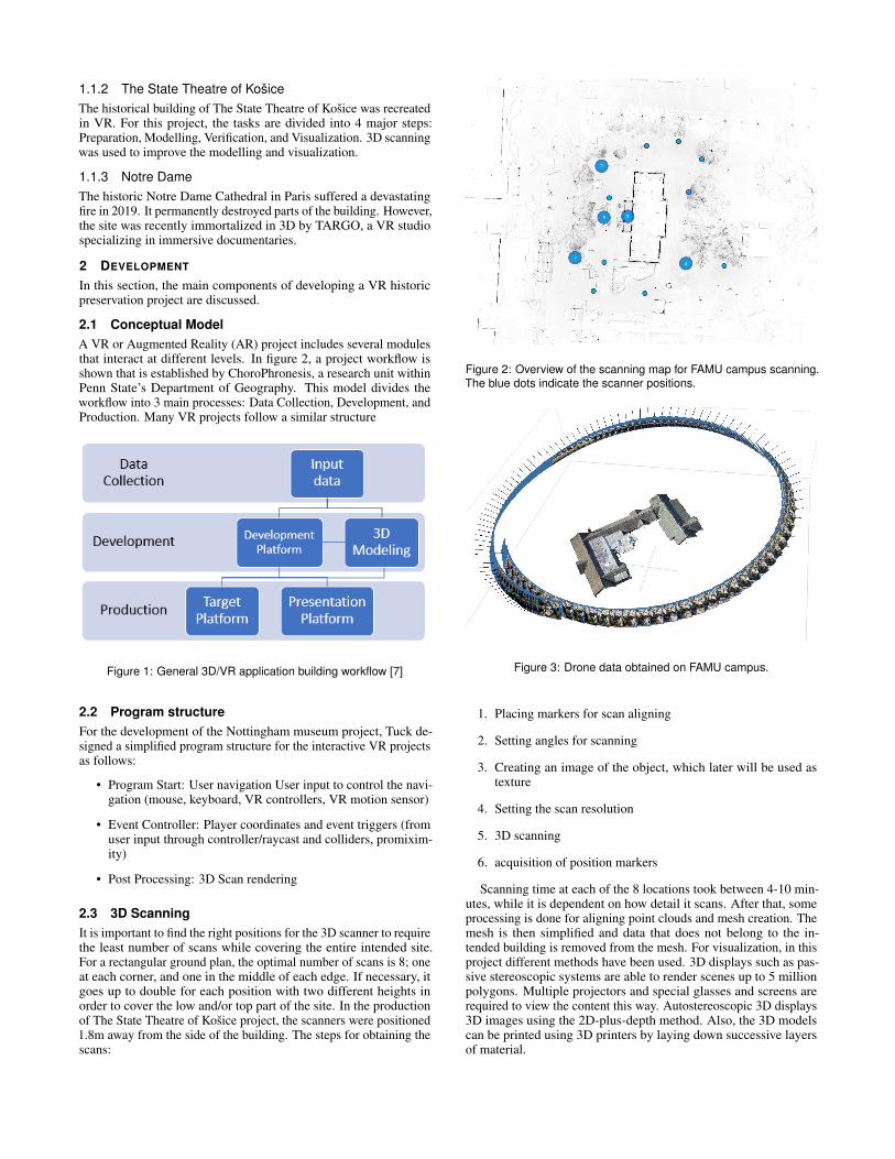
2.3 3D ScanningIt is important to find the right positions for the 3D scanner to requirethe least number of scans while covering the entire intended site.For a rectangular ground plan, the optimal number of scans is 8; oneat each corner, and one in the middle of each edge. If necessary, itgoes up to double for each position with two different heights inorder to cover the low and/or top part of the site. In the productionof The State Theatre of Kosice project, the scanners were positioned1.8m away from the side of the building. The steps for obtaining thescans:
Figure 2: Overview of the scanning map for FAMU campus scanning.The blue dots indicate the scanner positions.
Figure 3: Drone data obtained on FAMU campus.
1. Placing markers for scan aligning
2. Setting angles for scanning
3. Creating an image of the object, which later will be used astexture
4. Setting the scan resolution
5. 3D scanning
6. acquisition of position markers
Scanning time at each of the 8 locations took between 4-10 min-utes, while it is dependent on how detail it scans. After that, someprocessing is done for aligning point clouds and mesh creation. Themesh is then simplified and data that does not belong to the in-tended building is removed from the mesh. For visualization, in thisproject different methods have been used. 3D displays such as pas-sive stereoscopic systems are able to render scenes up to 5 millionpolygons. Multiple projectors and special glasses and screens arerequired to view the content this way. Autostereoscopic 3D displays3D images using the 2D-plus-depth method. Also, the 3D modelscan be printed using 3D printers by laying down successive layersof material.

Figure 4: Meshes reconstructed from data obtained on FAMU campus.
Figure 5: Wireframe shading of a reconstructed building on FAMUcampus.
2.4 Raw DataData that is used in reconstruction of sites can be found in differenttypes. In addition to 3D laser-scanning and photogrammetry [8, 9],data from Google Maps and older 2D images or videos, and on-sitesurveys can be used to improve the accuracy of the model. The twomost common types of 3D scanning are:
• LiDAR: This method is mainly used in architecture and con-struction. A LiDAR scanner uses a laser moving horizontallyand a mirror rotation around a vertical axis so the laser cancover a large area. The newest iPad’s LiDAR uses infrared lightwith depth-sensing system is also an example of LiDAR. [10]This method also requires high processing power.
• Photogrammetry: This method produces the 3D models byusing multiple pictures of an object. Software combines theimages and creates the 3D model. Photogrammetry methodworks best when conducted during a bright but cloudy dayto avoid shadows if the goal is to scan all sides of a building.A drone can be used to photograph the higher parts of thebuilding. After capturing the images, the data is importedinto a software. The software then can align them to extract3D information out of the photographs and generate a pointcloud and later dense point cloud from the point cloud dataand the image data. This step can be repeated until the densepoint cloud is satisfactory. There are tools that can be usedfor modifying the point cloud such as scaling, rotation, andtranslating. Next, a Mesh can be extracted from the point cloudor dense point cloud data. The textured mesh can be exportedusing the desired format for the intended use. For example, forapplications developed in Unity platform, *.obj files, *.fbx, or*. prefab can be used to import the textured meshes [11].
2.4.1 Lasergrammetry vs. PhotogrammetryThe two aforementioned 3D model acquisition methods producevery different point densities. Also, resampling is sometimes done toreduce the size of the dataset. To compare the accuracy of differentmodels, point-to-point, cloud-to-cloud, and cloud-to-mesh methodscan be used [12].
2.4.2 Point-to-point DistanceIn this method, a starting point and end point are selected to bethe closest and farthest point to the origin of the metric system.The distance is computed between similar points and the maximumdistance is considered. The number of points in the two datasetsshould be the same for this method.
2.4.3 Cloud-to-cloudAll points in the two sets are compared in cloud-to-cloud method.The computation time for this method can be very long if the datasetsare large. Therefore, homologous octrees can be used to quicklycalculate the Euclidean distances in a specific cube. An octree is adata structure where each node has eight children. Octrees are usedto partition 3D spaces by recursive subdivision [13].
2.4.4 Cloud-to-meshA Delaunay triangulation on a set of discrete points is a triangulationDT(P) that no point in the set is inside the circumcircle of anytriangle in DT(P). This method maximizes the minimum angle of allof the angles of the triangles in the triangulation [14]. In this method,Euclidean distances are calculated between points and meshes. Thetriangular meshes are computed from the point cloud generated bylasergrammetry. To improve the accuracy, the quadratic mean of allEuclidean distances is considered. This method also can be timeconsuming based on the size of the datasets.
2.5 Data TransformationAfter data collection, the next step is to use the data to create struc-tured point clouds, meshes, and textures.
2.5.1 Point CloudsDatasets that represent the external surface of objects or a space inthe form of X, Y, and Z geometric coordinates in computer graphicsare called point cloud [15].
2.5.2 Meshes and TexturesA polygon mesh in computer graphics is a collection of polygons thatdefine the external surface of an object. The use of polygon meshesremoves the risk of error-prone conversions such as CAD surfaces tomesh-based data from numerical simulations [16]. Higher number ofpolygons allows more precision in the surface representation but alsoincreases the size of the dataset. When the point cloud is available, itis converted into a structured data in the form of a polygonal mesh toproduce the best representation of the object or site [17]. 2D texturesare images that are applied to 3D objects to show the colors andshades. Textures are usually images obtained from real world datathat can sometimes be enhanced using image editing tools.
2.6 3D Modeling3D modeling is usually used for terrestrial applications and in case ofaerial domain, the term that is more frequently used is mapping [18].Generating 3D models for the purpose of documentations and con-servation requires the following properties:
• Accuracy, precision and reliability
• Portability for terrestrial acquisition
• Low cost

Figure 6: 3D point cloud data from laser scanning done on FAMUcampus.
• Fast acquisition
• Flexibility due to the great variety and dimensions of sites andobjects [19]
Often, one single technique cannot satisfy all of the requirementsfor a large and complex project. Therefore multiple sensors and tech-niques are usually used simultaneously to achieve a better model.Data fusion, or the integration of the data from different techniquescan be done at sensor level or in the processing phase after datacollection. Mobile mapping is an example of sensor integrationand cost-effective acquisition of geo-referenced spatial data, com-bined with the usage of digital imaging devices, laser scanners,and Global Navigation Satellite System/Inertial Measurement Unit(GNSS/IMU) positioning sensors [20]. Challenges:
• Identifying the best techniques for capturing data and process-ing
• Selecting an appropriate workflow that results in high qualityproduction
• Increasing the efficiency while maintaining the accuracy of themodel
• Displaying the 3D model effectively using the desired method(VR headset, 3D printing, etc.)
2.7 Game EngineMany platforms offer the ability to combine the visuals, physics,and interactivity. These platforms or game engines are developmentenvironments and consist of three smaller engines: Math engine,Rendering engine, and Physics engine. Some game engines likeUnity and ApertusVR support 3D graphics that can be used fordeveloping VR projects. As of now, Unity 3D has been rated themost high-performance VR game engine by G2 in 2020. G2 is thelargest tech marketplace and uses an unbiased scoring methodologyto rate products [21]. Performance and efficiency in VR develop-ment are key attributes, since VR usually includes large volumes ofgraphical data, and rendering modules require high computationalpower provided by Central Processing Units (CPU) or Graphics Pro-cessing Unit (GPU). Even if a module is not rendering, it could stillrepresent a noticeable portion of the CPU consumption. Choosingthe correct game engine according to the requirements of a projectis the key, since it runs the different modules by prioritizing andmulti-threading.Games are made up of different entities. The game engine holds eachentity in a container such as scenegraph. Scenegraph is a generictree that provides a fast way to traverse game entities [22]. A masterloop (game loop) continuously renders and updates the coordinate
Table 1: Popular game engines and features.
GameEngine Languages Dev OS Price
Unity c#, JavaScript, Boo macOS, Win Free
Unreal C++, Blueprint macOS, Linux,Windows Free
Blender Python macOS, Linux,Windows Free
CryEngine C++, Flash,ActionScript, Lua Windows Subscription
Frostbite C++ Windows Proprietary
space of each entity. If the game requires external forces such asgravity, physics engine is added. Gravity is an Ordinary DifferentialEquation (ODE) that will affect game entities. Motion equationintegration with other attributes that affect the entities can be donethrough either of Euler, Verlet, Heun’s, or Runge-kutta methods.The last two are the most complicated but exact method of integra-tion [23].Another well established game engine is Unreal developed by EpicGames. Unreal is free to download and the code for it exists onGithub for cloning. For years, there has been a debate betweenartists and developers whether Unreal is more suitable for a specificproject or Unity. To choose the game engine, there are several factorsto keep in mind such as the levels of visuals, target platform, andteam size. Both game engines offer similar contents, capabilities,and functionalities that are differently packaged [24].
2.7.1 Unity 3D
Here is a short summary of Unity features:Pros
• Unity3D is open-source and supports open-source technology.
• There is plethora of documentation available which canhelp with initial learning and troubleshooting throughout theproject.
• It is free as long as the developer team earns less than $100kfor a project.
• It supports collaborations, Internet of Things (IoT), and dis-tributed processing.
• Projects targeted for different platforms can be developed on itsince Unity3D is platform independent [25].
• It can work with third-party Integrated Development Environ-ments (IDEs)
Cons
• Memory garbage collection is automatic and can’t be modifiedmanually.
• Draw Call Batching is automatic. It also does not includeSkinned Renderers (characters).
• For dynamic batching, meshes need to have less than 900vertices.
• There are bugs in the development of Unity itself which havenot been resolved in later patches.

2.8 InteractivityHuman-computer interface is one of the most important aspects ofdesigning a system that users will be regularly interacting with. Thegoal of interaction design is to reduce the negative feedback thatinteracting with the system can cause for users [26]. In designingthe interactive interface, these are the things to keep in mind:
• Easy to use: The best design is the one that users can interactwith, with the least amount of “learning” time or frustration.The system should not cause confusion and be easy to breakby a novice user.
• Effectiveness of use: users must be able to perform the taskthey need through the user interface (UI).
• Providing a pleasant experience: in addition to learnabilityand effectiveness, a good UI will provide user with a posi-tive experience while interacting with the system. This is aneven more important issue when designing an interface for aneducational/entertainment project such as VR preservation ofhistorical sites.
By controlling the path that the visitor can take in the VR, thenarrative can progress steadily. It also can limit or neutralize theconsequences of decisions that the user has made [27].Common 3 Dimensional User Interface (3DUI) features include:head tracked view rendering, full body interaction, two-handedinput, finger interaction, gesture recognition, navigation methods,stereo and surround sounds, and physics engine. In developing theUI, there are other important factors to keep in mind such as inputdevice obstruction, programming interfaces, and error handling [28].
2.8.1 RaycastingRaycasting is used in VR spaces as a type of user input and workssimilar to a laser beam detector. The laser is sent out by the user ina direction in 2D or 3D and if it hits elements that are designed toreceive the raycast, it returns the information about what and whereit hit [29]. Most VR gears have predefined raycasting modules thatcan be reused and modified by the users. The attributes that can bemodified are the origin, the direction, and maxDistance. Elementsthat are able to interact with the raycast require the Raycast Targetattribute to be activated. A LayerMask can be defined to filter outany colliders that should not interact with the raycast.
2.8.2 EventsUnity handles the events through Bubbling. Event Bubbling meanswhen an event happens on an element, it first runs the handlers onit, then on its parent, then all the way up on the ancestor [30]. Ina VR project, events can be triggered by touching the collider onan element. Also, the user can be assigned a Raycast which willbe used to interact with UI or other elements. A controller buttonpress would then work as a mouse click. In Bubbling, the handlerworks until it handles that event all the way up. However, usingEvent Trigger can stop the bubbling and intercept all events. Thiscan cause issues when there are nested UI elements with events suchas OnPointer, OnPointerExit, and Click events, and should be usedwith caution.
3 CONCLUSION
In this paper, we have reviewed digital preservation using Virtual Re-ality. VR provides the means to transfer cultural, architectural, andhistorical assets in a way that is superior to the traditional methods.The use of audio, avatars, lighting, and different controllers have notbeen discussed here but are important components of realistic VRdevelopment. Basic steps of development and conceptual modelingof such projects were examined. However, considering the dynamic
nature of project requirements, developers must continuously ex-plore the new methods and tools in the field to provide the best endproduct.
REFERENCES
[1] O. Soto-Martin, A. Fuentes-Porto, and J. Martin-Gutierrez, “A digitalreconstruction of a historical building and virtual reintegration of muralpaintings to create an interactive and immersive experience in virtualreality,” Appl. Sci., vol. 10, p. 597, 2020.
[2] A. Ibanez-Etxeberria, C. Gomez-Carrasco, O. Fontal, and S. Garcıa-Ceballos, “Virtual environments and augmented reality applied to her-itage education. an evaluative study,” Appl. Sci., vol. 10, p. 2352, 2020.
[3] M. Obradovic, I. Vasiljevic, I. uric, J. Kicanovic, V. Stojakovic, andR. Obradovic, “Virtual reality models based on photogrammetric sur-veys—a case study of the iconostasis of the serbian orthodox cathedralchurch of saint nicholas in sremski karlovci (serbia),” Appl. Sci., vol. 10,p. 2743, 2020.
[4] M. Roussou, “Virtual heritage: from the research lab to the broadpublic,” Bar International Series, vol. 1075, pp. 93–100, 2002.
[5] “Notre dame fire: Experts weigh in on timeline and cost of restoration.”(Accessed on 11/05/2020).
[6] D. Tuck, I. Kuksa, and R. Guest, “Narrating the past project: navigatingaround the story space,” in Proceedings of ICERI 09 InternationalConference of Education Research and Innovation, 2009.
[7] “Chorophronesis — applied spatial intelligence.” https:
//chorophronesis.psu.edu/. (Accessed on 11/05/2020).[8] F. Remondino, “Heritage recording and 3d modeling with photogram-
metry and 3d scanning,” REmote Sens., vol. 3, pp. 1104–1138, 2011.[9] R. Levy, “The role of laser scanning in the preservation and renovation
of historic architecture,” 01 2005.[10] K. Evangelidis, S. Sylaiou, and T. Papadopoulos, “Mergin’ mode:
Mixed reality and geoinformatics for monument demonstration,” Appl.Sci., vol. 10, p. 3826, 2020.
[11] F. F. Ahmadi and H. Ebadi, “An integrated photogrammetric and spatialdatabase management system for producing fully structured data usingaerial and remote sensing images,” Sensors, vol. 9, no. 4, pp. 2320–2333, 2009.
[12] P. Charbonnier, P. Chavant, P. Foucher, V. Muzet, D. Prybyla, T. Perrin,P. Grussenmeyer, and S. Guillemin, “Accuracy assessment of a canal-tunnel 3d model by comparing photogrammetry and laserscanningrecording techniques,” International Archives of the Photogrammetry,Remote Sensing and Spatial Information Sciences, vol. 12, pp. 2–6,2013.
[13] D. Meagher, “Geometric modeling using octree encoding,” Computergraphics and image processing, vol. 19, no. 2, pp. 129–147, 1982.
[14] L. P. Chew, “Constrained delaunay triangulations,” Algorithmica, vol. 4,no. 1-4, pp. 97–108, 1989.
[15] Y. Wang, Y. Sun, Z. Liu, S. E. Sarma, M. M. Bronstein, and J. M.Solomon, “Dynamic graph cnn for learning on point clouds,” AcmTransactions On Graphics (tog), vol. 38, no. 5, pp. 1–12, 2019.
[16] M. Botsch, L. Kobbelt, M. Pauly, P. Alliez, and B. Levy, Polygon meshprocessing. CRC press, 2010.
[17] F. Remondino, “From point cloud to surface: the modeling and vi-sualization problem,” International Archives of the Photogrammetry,Remote Sensing and Spatial Information Sciences, vol. 34, 2003.
[18] P. Henry, M. Krainin, E. Herbst, X. Ren, and D. Fox, “Rgb-d mapping:Using kinect-style depth cameras for dense 3d modeling of indoorenvironments,” The International Journal of Robotics Research, vol. 31,no. 5, pp. 647–663, 2012.
[19] F. Remondino, “Heritage recording and 3d modeling with photogram-metry and 3d scanning,” Remote sensing, vol. 3, no. 6, pp. 1104–1138,2011.
[20] C. V. Tao and J. Li, Advances in mobile mapping technology, vol. 4.CRC Press, 2007.
[21] “G2 research scoring methodologies.” https://research.g2.com/g2-scoring-methodologies. (Accessed on 11/05/2020).
[22] I. Armeni, Z.-Y. He, J. Gwak, A. R. Zamir, M. Fischer, J. Malik, andS. Savarese, “3d scene graph: A structure for unified semantics, 3dspace, and camera,” in Proceedings of the IEEE International Confer-ence on Computer Vision, pp. 5664–5673, 2019.
[23] I. Millington, Game physics engine development. CRC Press, 2007.[24] S. D. Economics, “Developer economics: State of the developer nation
q1 2016,” 2016.[25] M. Farouk, G. Simon, and A. Ksentini, “Dissecting games engines: the
case of unity3d,” in ACM Netgames 2015, 2015.[26] J. Preece, H. Sharp, and Y. Rogers, Interaction design: beyond human-
computer interaction. John Wiley & Sons, 2015.[27] M.-L. Ryan, “Immersion vs. interactivity: Virtual reality and literary
theory,” SubStance, vol. 28, no. 2, pp. 110–137, 1999.[28] T. M. Takala, P. Rauhamaa, and T. Takala, “Survey of 3dui applications
and development challenges,” in 2012 IEEE Symposium on 3D UserInterfaces (3DUI), pp. 89–96, IEEE, 2012.
[29] “Intro to vive development : Input through raycasting— circuit stream.” https://circuitstream.com/blog/
htc-vive-tutorial-raycasting/. (Accessed on 11/05/2020).[30] “Bubbling and capturing.” https://javascript.info/
bubbling-and-capturing. (Accessed on 11/05/2020).