review of environmental factors core hole drilling of
TRANSCRIPT

Review of Environmental Factors
Core Hole Drilling of Turill No. 1 in PEL 456 - Gunnedah Basin
Santos QNT Pty Ltd
ABN: 33 083 077 196
Issue date: 04/05/2010

Review of Environmental Factors: Gunnedah Basin
Core Hole Drilling: PEL 456
3417-HS-H0004 | Revision: A Page 2 of 98
Executive Summary
Santos QNT Pty Ltd (Santos) has entered into a Farmin Agreement with the titleholder of PEL 456, Macquarie Energy (Macquarie) to explore for petroleum (in accordance with the Petroleum (Onshore) Act 1991(NSW)). Santos has been appointed the Operator for
and on behalf of the titleholder under the Farmin Agreement.
Condition 1.0 of the PEL 456 licence states that prior to carrying out any drilling activities a Review of Environmental Factors (REF) is required to be submitted to the Department of Industry and Investment (DII) to enable a determination to be made
under Part 5 of the Environmental Planning and Assessment Act 1979 (NSW).
The Turill 1 core hole is designed to investigate the hydrocarbon potential of PEL 456. Discovery of gas resources in this area has the potential to increase the state’s reserves
and revenue from coal seam gas and underpin future exploration or production in the region. This REF covers the drilling of Turill 1 core hole only.
The Turill No. 1 core hole site is located on privately owned land, zoned General Rural 1(a) under the Merriwa Local Environmental Plan (LEP). The REF provides details of the
planning controls for the area and the existing environment.
The site proposed for Turill 1 is a privately owned rural property in a gently undulating area, which is presently used for agricultural activities. The site is an operating farm and there is no native vegetation on the site which would need to be cleared for Turill 1. Turill 1 lease will be built on relatively level land, and is approximately 500 metres off the Golden Highway. Access is relatively simple through an existing gate on the Landholder’s property boundary, via a useable track. However, it may be necessary to
upgrade the track. Vehicular activity will be minimised when the ground is soft after rain. The surface will be rehabilitated. There is no residence within 1km of the Turill 1 site and the nearest residence is 2.5km to the south east from the Turill 1 site. The site is also located more than 1.5km east from the nearest creek/waterway which is known as Willy
Wally Creek.
To assess the coal seam gas potential of the Gunnedah Basin in PEL 456 it is proposed to drill Turill 1 as a HQ (96mm) diameter core hole to obtain information on coal depths,
seam sizes, continuity and quality. This core hole will also provide data on gas content, gas type, and permeability of the coal seams. In addition, tests for desorption isotherm behaviour will be undertaken on selected coal samples recovered during drilling operations to assess the potential flow of gas out of the coal seams.
The major equipment to be used will be a drilling rig known as Lucas Rig 13. A temporary building will be located at the site. The area to be disturbed for drilling activity will be approximately 80 by 60 metres for the core hole site plus necessary access track. However, only up to approximately 60% of the core hole area will require
hard stand. Associated lined drilling sumps and a flare pit will be constructed on site.
The period of the drilling activities to be undertaken for Turill 1 will be up to 60 days. Lease construction activities of 14 days and lease rehabilitation activities of 7 days will
be additional to the drilling period and may not occur concurrently to the drilling activities.
Environmental aspects considered by Santos for this new core hole location included potential impacts of noise, light and dust to the nearest sensitive receptor (i.e. greater

Review of Environmental Factors: Gunnedah Basin
Core Hole Drilling: PEL 456
3417-HS-H0004 | Revision: A Page 3 of 98
than 1000m), proximity to designated watercourses (i.e. greater than 200m), proximity
to registered archaeological, flora or fauna sites and the potential for sediment and erosion from the proposed site (i.e. slope greater than 10 degrees).
Santos requires its activities have minimal impacts on landholders, and has contacted
affected landowners and negotiated agreements regarding land access, compensation and rehabilitation with the landholder of the land on which Turill 1 is to be drilled. Regular contact with all landholders is to be maintained during activities at the site.
It should be noted that an assessment of the proposed location has shown that the Turill
1 core hole will be located in cleared grazing land. A Cultural Heritage inspection was conducted at the site on 21st May 2010 and it was noted that the lease area is not in close proximity to features that contain archaeological deposits (PADs). The area has been intensely used for agricultural activities for over a long period. The integrity would be impacted by these activities.
The proposed activities have associated potential environmental impacts, which are common to drilling activities carried out elsewhere in the Gunnedah Basin.
It is considered that the potential impacts can be successfully mitigated with the application of the management controls/measures outlined in this document. The controls/measures utilised by Santos and it contractors are consistent with the APPEA Code of Environmental Practice and are typical of good hydrocarbon field practice.
Section 5A of the Environmental Planning and Assessment Act 1979 (NSW) lists seven factors to be considered in relation to potential impacts on threatened species, populations or ecological communities, commonly referred to as the seven part test of
significance. An assessment was made against the seven factors as provided in Section 2.2 and concluded that:
• There are no known threatened species that would be impacted by the planned activities. The size and nature of the proposal is unlikely to affect the life cycle of any
viable populations of threatened flora/fauna if present.
• There are no known endangered populations that have been identified that would be impacted by this proposal. The size and nature of the proposal is unlikely to affect the life cycle of any viable populations of endangered populations if present at the sites.
• There are no known endangered ecological communities or critically endangered communities that have been identified that would be impacted by this proposal.
• It is not proposed to clear any natural habitat and planned activities will not constitute
a threatening process.
The potential environmental impacts of the proposed activities have been assessed and it is considered that the likely environmental impacts are minor and with appropriate management strategies the activities are not likely to have a significant impact on the environment. In particular, it is expected that:
• Impacts on landholders will be minimal;
• Impacts to air quality will be minor, localised and insignificant;
• Adverse effects on water resources will be minimal;
• Off-site impacts to soils will be avoided and on-site impacts will be minor and temporary;

Review of Environmental Factors: Gunnedah Basin
Core Hole Drilling: PEL 456
3417-HS-H0004 | Revision: A Page 4 of 98
• Noise impacts will be short term, and no threatened species or communities are likely
to be impacted;
• There will be no significant use of, or impact to, natural resources including groundwater;
• Impacts on the community and visual amenity will be insignificant and short term, particularly as the core hole sites are in a sparsely populated area;
• Impacts to heritage places or sites will be avoided;
• Disturbances to pastoral and cropping land use will be minor and short term and
managed in consultation with affected landholder(s); and
• There will be no significant environmental impacts.
On completion of the activities, the site will be rehabilitated to reflect the pre-existing land form and use and this will be undertaken in consultation with relevant landholders.
All waste will be disposed of in an appropriate manner.

Review of Environmental Factors: Gunnedah Basin
Core Hole Drilling: PEL 456
3417-HS-H0004 | Revision: A Page 5 of 98
Table of contents
Executive Summary...........................................................................2
1 Introduction .............................................................................9
1.1 Background ................................................................................................ 9
1.2 Proponent Contact Information...................................................................... 9
1.3 Structure .................................................................................................. 10
2 Legislation & Planning Framework .............................................11
2.1 Planning Framework................................................................................... 11
2.1.1 Overview ................................................................................................ 11
2.1.2 Environmental Planning Instruments ........................................................... 11
2.1.3 Local environmental plans ......................................................................... 12
2.2 Legislative Requirements, Petroleum Licenses and Approvals Required............. 13
2.3 Zoning ..................................................................................................... 16
2.4 Stakeholder Consultation............................................................................ 16
3 Project Description..................................................................18
3.1 Location and Tenure .................................................................................. 18
3.1.1 Location ................................................................................................. 18
3.2 Planned Activities ...................................................................................... 20
3.3 Abandonment............................................................................................ 21
3.4 Justification of the Activity .......................................................................... 22
3.5 Evaluation of Alternatives ........................................................................... 22
4 Regional Description................................................................24
4.1 Bioregion.................................................................................................. 24
4.2 Geology.................................................................................................... 25
4.2.1 Regional Geology ..................................................................................... 25
4.2.2 Soils ...................................................................................................... 28
4.3 Climate .................................................................................................... 28
4.4 Hydrology................................................................................................. 29
4.4.1 Surface Water ......................................................................................... 29

Review of Environmental Factors: Gunnedah Basin
Core Hole Drilling: PEL 456
3417-HS-H0004 | Revision: A Page 6 of 98
4.4.2 Groundwater ........................................................................................... 30
4.5 Topography .............................................................................................. 30
4.6 Flora and Fauna ........................................................................................ 31
4.6.1 Plant Communities ................................................................................... 32
4.6.2 Significant flora ....................................................................................... 34
4.6.3 Weeds.................................................................................................... 34
4.6.4 Significant Fauna ..................................................................................... 34
4.6.5 EPBC Act Due Diligence............................................................................. 34
4.7 Socio-Economic ......................................................................................... 36
4.7.1 Local Government Area ............................................................................. 36
4.7.2 Landuse .........................................................Error! Bookmark not defined.
4.7.3 Heritage ................................................................................................. 36
4.8 Protected Areas ......................................................................................... 37
4.8.1 National Parks and Reserves ...................................................................... 37
5 Environmental Impacts and Mitigation Measures.........................40
5.1 General .................................................................................................... 40
5.2 Socio-Economic ......................................................................................... 40
5.2.1 Existing Environment ................................................................................ 40
5.2.2 Potential Impacts and Mitigation Measures ................................................... 40
5.3 Air Quality ................................................................................................ 41
5.3.1 Existing Environment ................................................................................ 41
5.3.2 Potential Impacts and Mitigation Measures ................................................... 41
5.4 Hydrology................................................................................................. 42
5.4.1 Existing Environment ................................................................................ 42
5.4.2 Potential Impacts and Mitigation Measures ................................................... 42
5.5 Soils, Land use and Rehabilitation................................................................ 42
5.5.1 Existing Environment ................................................................................ 42
5.5.2 Potential Impacts and Mitigation Process...................................................... 43
5.6 Noise ....................................................................................................... 43
5.6.1 Existing Environment ................................................................................ 43
5.6.2 Potential Impacts and Mitigation Measures ................................................... 43
5.7 Flora and Fauna ........................................................................................ 44
5.7.1 Existing Environment ................................................................................ 44
5.7.2 Potential Impacts and Mitigation Measures ................................................... 44
5.8 Chemical and Hazardous Substance Management .......................................... 44

Review of Environmental Factors: Gunnedah Basin
Core Hole Drilling: PEL 456
3417-HS-H0004 | Revision: A Page 7 of 98
5.8.1 Existing Environment ................................................................................ 44
5.8.2 Potential Impacts and Mitigation Measures ................................................... 44
5.9 Contaminated Land.................................................................................... 45
5.9.1 Existing Environment ................................................................................ 45
5.9.2 Potential Impacts and Mitigation Measures ................................................... 46
5.10 Waste Minimisation and Management........................................................... 46
5.10.1 Existing Environment ................................................................................ 46
5.10.2 Potential Impacts and Mitigation Measures ................................................... 46
5.11 Visual Amenity .......................................................................................... 47
5.11.1 Existing Environment ................................................................................ 47
5.11.2 Potential Impacts and Mitigation Measures ................................................... 47
5.12 Aboriginal Heritage .................................................................................... 47
5.12.1 Existing Environment ................................................................................ 47
5.12.2 Potential Impacts and Mitigation Measures ................................................... 47
5.13 Cumulative Environmental Impacts.............................................................. 48
5.14 Risk Assessment........................................................................................ 48
5.15 Clause 228 Checklist .................................................................................. 58
6 Conclusions............................................................................60
7 References.............................................................................62
Appendix A.....................................................................................64
Threatened Flora Species located in the Upper Hunter LGA ........................................ 64
Appendix B.....................................................................................69
Noxious weeds likely to be found in region .............................................................. 69
Appendix C.....................................................................................78
Threatened Fauna Species in Upper Hunter LGA....................................................... 78
Appendix D.....................................................................................91
EPBC Threatened Species..................................................................................... 91
Appendix E. ....................................................................................96
Santos Group Risk Assessment Matrix .................................................................... 96

Review of Environmental Factors: Gunnedah Basin
Core Hole Drilling: PEL 456
3417-HS-H0004 | Revision: A Page 8 of 98
List of Figures
Figure 2-1: Local Government Areas Covering PEL 456 ............................................................ 12
Figure 3-1: Well Location ..................................................................................................... 18
Figure 3-2: Turril 1 Context Map ........................................................................................... 19
Figure 3-3: Typical Drilling Rig .............................................................................................. 22
Figure 4-1: Regional Map ..................................................................................................... 24
Figure 4-2: Stratigraphy of the Gunnedah Basin...................................................................... 27
Figure 4-3: Major Drainage................................................................................................... 30
Figure 4-4: Local Topography within the Vicinity of the Core Hole Sites...................................... 31
Figure 4-5: Typical vegetation cover at proposed core hole site................................................. 33
Figure -4-6: PEL 456 and Mining Tenures ............................................................................... 37
Figure 4-7: Location of National Parks, and Nature Reserves .................................................... 38
List of Tables
Table 2-1: PEL 456 Licence Conditions and Applicable Legislation .............................................. 15
Table 3-1: Co-ordinates of Proposed Core Hole Sites (GDA-Zone 56) ......................................... 18
Table 4-1: Nearest Water Courses to the Core Hole Site (See Figure 4.8 also) ............................ 29
Table 4-2: Matters of Environmental Significance under EPBC Act.............................................. 34
Table 5-1: Risk Assessment for Core Hole Activities ................................................................. 49
Table 5-2: Clause 228 Checklist ............................................................................................ 58

Review of Environmental Factors: Gunnedah Basin
Core Hole Drilling: PEL 456
3417-HS-H0004 | Revision: A Page 9 of 98
1 Introduction
1.1 Background
This Review of Environmental Factors (REF) has been prepared for the drilling of one core hole well (the Site) in the Gunnedah Basin, being explored under the conditions of Petroleum Exploration Licence (PEL 456) located in New South Wales (NSW).
The site proposed for Turill 1 is a privately owned rural property in a gently undulating area, which is presently used for agricultural activities. The site is an operating farm and there is no native vegetation on or in the vicinity of the site that would need to be cleared for Turill 1. Turill 1 lease will be built on relatively level land, and is
approximately 500 metres off the Golden Highway. Access is relatively simple through an existing gate on the Landholder’s property boundary, via a useable track. However, it may be necessary to upgrade the track. Vehicular activity will be minimised when the
ground is soft after rain. The surface will be rehabilitated. There is no residence within 1 km of the Turill 1 site and the nearest residence is 2.5km south east from the Turill 1 site. The site is also located more than 1.5km east of the nearest creek/waterway that is known as Willy Wally Creek.
The licence for PEL 456 permits exploration for petroleum, including coal seam gas, by methods including the drilling of core hole wells.
Condition 1.0 of the PEL 456 licence instrument states that, prior to carrying out any
drilling activities, a Review of Environmental Factors (REF) is required to be submitted to the Department of Primary Industries-Mineral Resources (DPI-MR) section of the Department of Industry & Investment (DII) to enable a determination to be made under Part 5 of the Environmental Planning and Assessment Act 1979 (NSW) (EP&A Act).
The purpose of this REF is to assess the environmental impacts of the drilling of the core hole to the fullest extent possible under section 111 of the EP&A Act and clause 228 of the Environmental Planning and Assessment Regulation.
1.2 Proponent Contact Information
The correspondence address for Santos is:
Santos (ABN 33 083 077 196) for and on behalf of the Titleholder Macquarie Energy Pty Ltd, (under a Farmin Agreement dated 17/08/2007 and registered with the DII).
Address: Level 22, Santos Place, 32 Turbot Street, Brisbane, Qld, 4000
Telephone Number: 07 3838 3676
Email: [email protected]
Contact Person: Mr P Lane, Team Leader Appraisal

Review of Environmental Factors: Gunnedah Basin
Core Hole Drilling: PEL 456
3417-HS-H0004 | Revision: A Page 10 of 98
1.3 Structure
This REF consists of:
• Section 1: Introduction and company details
• Section 2: Summary of relevant regulations applicable to the activity;
• Section 3: Proposed activities including location and timing;
• Section 4: Description of the local environment including its physical, natural and socio-economic overview;
• Section 5: Outline of the potential environmental impacts and mitigation measures; and
• Section 6: Concluding comments on the likely impacts.

Review of Environmental Factors: Gunnedah Basin
Core Hole Drilling: PEL 456
3417-HS-H0004 | Revision: A Page 11 of 98
2 Legislation & Planning Framework
2.1 Planning Framework
2.1.1 Overview
The EP&A Act is the primary legislation regulating land use planning in NSW. It provides
the framework for the development of state and local planning instruments that through their hierarchy determine the statutory process for environmental impact assessment. Under the EP&A Act there are three distinctive processes, which are:
• Part 3A, regulates specific types of ‘projects’ and requires an Environmental Assessment report to be prepared and submitted to the Department of Planning for the Planning Minister’s approval;
• Part 4, regulates ‘development’ and requires a development application accompanied
by a Statement of Environmental Effects to be submitted to council for development approval; and
• Part 5, regulates ‘activities’ and requires a Review of Environmental Factors for consideration by the determining authority.
The proposal satisfies the definition of an activity under Part 5 of the EP&A Act, because the proposal:
• may be carried out without development consent;
• is not an exempt development; and
• requires the approval of a determining authority.
A determining authority, for the purposes of this activity, is defined in Part 5 of the EP&A Act to include, but is not limited to a public authority. In relation to petroleum
exploration licences the DII is the determining authority for approving exploration activities and will, therefore be the determining authority for the activities covered by this Review of Environmental Factors. In order to enable the determining authority to
comply with its obligations under Part 5 of the EP&A Act, Santos has considered s111 of the EP&A Act and Clause 228 of the Environmental Planning Regulation (See Section 5.15) in preparing this REF.
2.1.2 Environmental Planning Instruments
The Environmental Planning Instruments (EPIs) regulate the permissibility to undertake an activity and the type of assessment process that is required. EPI is the generic term
used to describe state environmental planning policies, regional environmental plans and local environmental plans.
State Environmental Planning Policy (Mining, Petroleum Production and Extractive Industries) 2007 (SEPP 2007) recognises the importance to NSW of mining, petroleum production and extractive industries. SEPP 2007 seeks to facilitate the orderly and economic use of land containing mineral, petroleum and extractive material resources, whilst encouraging ecologically sustainable development.

Review of Environmental Factors: Gunnedah Basin
Core Hole Drilling: PEL 456
3417-HS-H0004 | Revision: A Page 12 of 98
Subject to certain exemptions, SEPP 2007 allows development for the purposes of
petroleum exploration to be carried out without development consent under Part 4 of the EP&A Act. The definition of petroleum under SEPP 2007 includes any naturally occurring hydrocarbon, whether in gaseous, liquid or solid state.
2.1.3 Local environmental plans
Local environmental plans (LEPs) are developed by the Council (they become law only after Ministerial approval) and guide planning provisions for the local government area (LGA). According to the Department of Planning, through zoning and development controls, they allow councils to supervise the ways in which land is used. Council LEPs also list heritage items that are of local heritage significance.
The local environmental plans applicable to PEL 456 are regulated by the shire councils of Warrumbungle and Upper Hunter. The application of SEPP 2007 overrides the zoning permissibility controls in the local environmental plans, as activities covered by SEPP 2007 are permissible without development consent. Figure 2.1 shows the location of the
various LGA’s and relevant core hole sites. Reference to LGAs will be limited in this REF to the Upper Hunter as the proposed core hole site is restricted to this LGA. The proposed core hole falls within General Rural Zone 1(a) within the Merriwa Local
Environmental Plan 1992.
Figure 2-1: Local Government Areas Covering PEL 456

Review of Environmental Factors: Gunnedah Basin
Core Hole Drilling: PEL 456
3417-HS-H0004 | Revision: A Page 13 of 98
2.2 Legislative Requirements, Petroleum Licenses and
Approvals Required
Petroleum (Onshore) Act 1991 (NSW)
Pursuant to s7 of the Petroleum (Onshore) Act 1991 (NSW), it is an offence to explore for petroleum (which includes coal seam gas) without a Petroleum Title. Santos has entered a Farmin Agreement with the holder of PEL 456, Macquarie Energy, which
grants the right to Santos as Operator to explore for petroleum (s7 Petroleum (Onshore) Act 1991 (NSW)) subject to meeting landholder and legislative requirements.
Prior to any exploration on private land, an access agreement and compensation arrangements must be agreed between the titleholder (or its agent) and the landowner
(s69 Petroleum (Onshore) Act 1991(NSW)). The legislation specifies those issues that must be covered by an access arrangement, which include:
• periods during which access may be permitted;
• parts of the land on which exploration may be undertaken;
• conditions to be observed during exploration, and
• compensation to be paid to the landholder.
In preparing this REF the necessary considerations found at the DII website at http://www.dpi.nsw.gov.au/minerals/titles/landholders-rights have been considered.
Whilst it is the Santos’ intention to negotiate an acceptable agreement with any affected landowner, the above legislation also details the mechanisms by which an access and
compensation agreement can be sought if a voluntary agreement cannot be obtained.
Operations must not affect any road or track unless with the prior written approval of the Director-General and subject to any conditions he may stipulate. Santos will pay to
the relevant authority (local council or Roads and Traffic Authority) any costs incurred in fixing any damage to roads caused by its operations.
Environmental Planning and Assessment Act 1979 (NSW)
Santos, on behalf of the titleholder, must also obtain an approval from the DII prior to carrying out core hole drilling activities. Before granting the approval, the DII is required to comply with Part 5 of the EP&A Act. The DII is required to consider the environmental impact of the activity to the fullest extent possible. The purpose of this REF is to provide an environmental assessment of the proposed activity to enable DII to
consider the environmental impact of the activity under Part 5 of the EP&A Act.
Under Section 5A of the EP&A Act, the DII is also required to consider whether the activity is likely to have a significant effect on threatened species, populations or
ecological communities, or their habitats. Section 5A lists seven factors to be considered, commonly referred to the ‘seven part’ test of significance. These are as follows:
a) in the case of a threatened species, whether the action proposed is likely to have an adverse effect on the life cycle of the species such that a viable local population
of the species is likely to be placed at risk of extinction;
b) in the case of an endangered population, whether the action proposed is likely to have an adverse effect on the life cycle of the species that constitutes the

Review of Environmental Factors: Gunnedah Basin
Core Hole Drilling: PEL 456
3417-HS-H0004 | Revision: A Page 14 of 98
endangered population such that a viable local population of the species is likely to
be placed at risk of extinction;
c) in the case of an endangered ecological community or critically endangered ecological community, whether the action proposed:
i. is likely to have an adverse effect on the extent of the ecological community such that its local occurrence is likely to be placed at risk of extinction; or
ii. is likely to substantially and adversely modify the composition of the
ecological community such that its local occurrence is likely to be placed at risk of extinction;
d) in relation to the habitat of a threatened species, population or ecological community:
i. the extent to which habitat is likely to be removed or modified as a result of the action proposed; and
ii. whether an area of habitat is likely to become fragmented or isolated from
other areas of habitat as a result of the proposed action; and
iii. the importance of the habitat to be removed, modified, fragmented or isolated to the long-term survival of the species population or ecological community in the locality.
e) whether the action proposed is likely to have an adverse effect on critical habitat (either directly or indirectly);
f) whether the action proposed is consistent with the objectives or actions of a
recovery plan or threat abatement plan; and
g) whether the action proposed constitutes or is part of a key threatening process or is likely to result in the operation of, or increase the impact of, a key threatening process
Protection of the Environment Operations Act 1997 (NSW)
Under the Protection of the Environment Operations Act 1997 (NSW), it is an offence to pollute waters. There are also broad offences of wilfully or negligently causing a substance to escape which causes or is likely to cause environmental harm without
lawful authority.
Pollution incidents causing or threatening material harm must be notified to the Environment Protection Authority. Under s147 material harm means:
• harm to the environment is material if:
a) it involves actual or potential harm to the health or safety of human beings or to
ecosystems that is not trivial; or
b) it results in actual or potential loss or property damage of an amount, or amounts in aggregate, exceeding $10,000 (or such other amount as is prescribed by the
regulations), and loss includes the reasonable costs and expenses that would be incurred in taking all reasonable and practicable measures to prevent, mitigate or make good harm to the environment.

Review of Environmental Factors: Gunnedah Basin
Core Hole Drilling: PEL 456
3417-HS-H0004 | Revision: A Page 15 of 98
It does not matter that harm to the environment is caused only in the premises where
the pollution incident occurs.
National Parks and Wildlife Act 1974 (NSW)
The National Parks and Wildlife Act 1974 (NSW) (NPW Act) protects Aboriginal
objects and places (under Part 6). The consent of the Director-General is required under s90 of the NPW Act if the proposed activity will destroy, deface or damage an Aboriginal object.
The NPW Act with the Threatened Species Conservation Act 1997 (NSW) also
protects threatened species, populations and ecological communities, their habitats and critical habitats (Part 8A). Under Section 5A of the EP&A Act, the DPI-MR is required to consider whether the activity is likely to have any impact on threatened species, populations and ecological communities
Environment Protection and Biodiversity Conservation Act 1999 (Cth)
The Environment Protection and Biodiversity Conservation Act 1999 (Cth) protects matters of national significance. As outlined in Section 4.6.5, Santos does not consider
that this proposal will trigger this Act, and does not intend to lodge a referral to the Commonwealth Department of Environment, Water, Heritage and Arts.
Water Management Act 2000 (NSW)
Under the regulations of the Water Management Act 2000 (NSW) there is an
exemption (clause 18 (e) of the Water Management (General) Regulation 2004 (NSW)) for the need of an access licence if the water is required for petroleum activities.
The relevant Acts are summarised in Table 2.1.
Table 2-1: PEL 456 Licence Conditions and Applicable Legislation
Legislation Requirements of Schedule 2 Licence Conditions Administering
Authority
Petroleum
(Onshore) Act
1991
The activities do not cause other than minimal/nil
impact on features listed in Section 75 (i.e. of
Aboriginal, Architectural, archaeological, historical or
geological interest). Where these are present, an exploration protocol acceptable to the Department must
be completed prior to exploration commencing to ensure that exploration activities will not have an adverse
impact on these features.
Full rehabilitation in accordance with Department
guidelines/standards is carried out after completion of the exploration activities.
Department of
Industry & Investment
– Mineral Resources
Environmental Planning and
Assessment Act
1979
Assess the impact of the activity on the environment under Part 5 of the EP&A Act)= from the DPI-MP prior to
carrying out core hole drilling activities.
Department of Primary Industries – Mineral
Resources
Threatened Species
Conservation Act 1995
The Licence holder is required to consult the register of Critical Habitat kept by the Director–General, and
consider the significance of any notations in respect of the area of any proposed exploration activity
Department of Environment and
Climate Change

Review of Environmental Factors: Gunnedah Basin
Core Hole Drilling: PEL 456
3417-HS-H0004 | Revision: A Page 16 of 98
Legislation Requirements of Schedule 2 Licence Conditions Administering
Authority
Fisheries Management Act
1994
Consult the register of critical habitat kept under this Act.
Department of Primary Industries – Fisheries
National Parks and
Wildlife Act 1974
The activities do not contravene Part 6 (Aboriginal
objects and Aboriginal places) of this Act.
National Parks and
Wildlife Service
Native Vegetation
Conservation Act 1997(now 2003)
The licence holder must not cut, destroy, ringbark or
remove any timber or other vegetative cover on any land subject of the licence except such as directly
obstructs or prevents the carrying on of operations. Any
clearing not authorised under the Petroleum (Onshore)
Act 1991 (NSW), must comply with the provisions of this Act.
Department of Climate
Change Energy and Water
Rural Fires Act
1997
Santos must take all precautions against causing an
outbreak of fire and must comply with the provisions
and regulations of the Act and must not burn off any
grass, foliage or herbage without the current consent of
the owner or occupier and the local fire authority.
NSW Rural Fires
Service
2.3 Zoning
Proposed core hole is located in the Upper Hunter Local Government Area (UHLGA) (1
core hole). Further details are presented in Table 3.1 and Figure 3.1.
The proposed core hole falls within Zone no. 1(a) General Rural Zone in the Merriwa Local Environment Plan (LEP) 1992. However, as noted in Section 2.1.3 above, the application of SEPP 2007 overrides the need to consider zoning controls to determine
permissibility of the activities, as activities covered by SEPP 2007 are permissible without consent.
2.4 Stakeholder Consultation
Key stakeholders relevant to the proposed core holes during the exploration phase
include:
• State regulatory agencies (DII, Department of Climate Change Energy and Water);
• Local governments;
• Landowners/occupiers;
• Aboriginal Groups/ Local Aboriginal Land Councils;
• Community, business and special interest groups, and
• Utilities operators.
In April 2008, Santos commenced a program of community and stakeholder consultation for the proposed coal seam gas (CSG) exploration program in the Upper Hunter Region. This program of consultation has involved briefings and discussions with a broad range of stakeholders to provide them with information on Santos and proposed exploration
activities to be undertaken in the Gunnedah Basin.
Groups consulted initially have included the local governments areas relevant to the activities proposed in this REF, relevant Members of Federal and State Parliament, Local

Review of Environmental Factors: Gunnedah Basin
Core Hole Drilling: PEL 456
3417-HS-H0004 | Revision: A Page 17 of 98
Aboriginal Land Councils, senior representatives of relevant government agencies and
various business, community and special interest groups (e.g. Gunnedah District Development Board, Liverpool Plains Land Management Committee, NSW Farmers Association, Caroona Coal Action Group, and Caroona Coal Community Consultation
Committee).
Fact sheets on the proposed activities and a map of the areas to be explored are presented on Santos’ website at:
http://www.Santos.com/library/Santos_Gunnedah_Basin_Project_Overview.pdf
Observations indicate that little is known in the community about the coal seam gas industry and the differences between the petroleum exploration legislation under which exploration activities are administered and mining legislation, with which the community is generally more familiar. Future consultation activities will be aimed at increasing the community understanding of coal seam gas exploration activities.
The site proposed for Turill 1 is a privately owned rural property in a gently undulating area, which is presently used for agricultural activities. The site is an operating farm and
there is no native vegetation on or in the vicinity of the site that would need to be cleared for Turill 1. Turill 1 lease will be built on relatively level land, and is approximately 500m off the Golden Highway. Access is relatively simple through an existing gate on the Landholder’s property boundary, via a useable track. However, it
may be necessary to upgrade the track. Vehicular activity will be minimised when the ground is soft after rain. The surface will be rehabilitated. There is no residence within 1km of the Turill 1 site and the nearest residence is 2.5km to the south east from the
Turill 1 site. The site is also located more than 1.5km east of the nearest creek/waterway known as Willy Wally Creek.
Consultation activities will be ongoing through the exploration program. Further consultation with other groups such as any local environmental groups, will occur if the
proposed core hole indicates a potentially commercially operation that will trigger a follow-up program. Progression to commercial production would necessitate drilling additional wells and infrastructure. Progress of the project beyond the core hole drilling stage will necessitate additional application to DII and further consideration of any
additional potential environmental impacts.

Review of Environmental Factors: Gunnedah Basin
Core Hole Drilling: PEL 456
3417-HS-H0004 | Revision: A Page 18 of 98
3 Project Description
3.1 Location and Tenure
3.1.1 Location
Santos has entered into a Farmin Agreement with the titleholder of Petroleum
Exploration Licence No 1 (PEL 456), Macquarie Energy, and has been appointed as Operator for and on behalf of the titleholder. The aim of the project described below in Section 3.2 is to explore the Gunnedah Basin by drilling the Turill 1 core hole. Table 3.1
shows the co-ordinates of the Turill 1 core hole site. Figure 3.1 shows the location of the core hole site within PEL 456. Figure 3.2 is a context map for the area in which Turrill 1 sits. The core hole is expected to be up to 1600 metres deep.
Table 3-1: Co-ordinates of Proposed Core Hole Sites (GDA-Zone 56)
Core Hole Node* Longitude Latitude Local Government Area Nearest Town
Turill 1 150.03.21 -32.03.47 Upper Hunter Merriwa
Figure 3-1: Well Location

Review of Environmental Factors: Gunnedah Basin
Core Hole Drilling: PEL 456
3417-HS-H0004 | Revision: A Page 19 of 98
Figure 3-2: Turril 1 Context Map

Review of Environmental Factors: Gunnedah Basin
Core Hole Drilling: PEL 456
3417-HS-H0004 | Revision: A Page 20 of 98
The environmental information in this document is based upon NSW database searches for flora and fauna covering the local government area within which the core hole will be drilled. The Commonwealth EPBC database searches were based on a 5km radius around
the proposed core hole location. If there are technical constraints identified at the core hole then the site will be relocated, subject to the necessary landholder approvals, in a similar environmental setting.
The site proposed in this REF is located on freehold land is on gently undulating
previously disturbed land used as an operating farm. The Turill 1 core hole is situated approximately 80km west of Scone and 32km west of Merriwa.
The proposed core hole site is not located in:
• An area reserved or dedicated under the National Parks and Wildlife Act 1974
(NSW);
• Land reserved or dedicated within the meaning of the Crown Lands Act 1989 (NSW) for preservation of other environmental protection purposes;
• A World Heritage Area;
• Environmental Protection Zones in environmental planning instruments;
• Lands protected under SEPP 14 – Coastal Wetlands;
• Lands protected under SEPP 26 – Littoral Rainforests;
• Land identified as wilderness under the Wilderness Act 1987 (NSW) or declared as wilderness under the National Parks and Wildlife Act 1974 (NSW);
• Aquatic reserves dedicated under the Fisheries Management Act 1994 (NSW);
• Wetland areas dedicated under the Ramsar Wetlands Convention;
• Land subject to a conservation agreement under the National Parks and Wildlife
Act 1974 (NSW);
• Western Lands Lease;
• Land identified as State Forest under the Forestry Act 1916 (NSW); or
• Crown Land.
3.2 Planned Activities
To assess the coal seam gas potential of the Gunnedah Basin in PEL 456, it is proposed
to drill Turill 1 as a HQ (96mm) diameter core hole to obtain information on coal depths, seam sizes, continuity and quality. This core hole will also provide data on gas content, gas type, and permeability of the coal seams. In addition, tests for desorption isotherm behaviour will be undertaken on selected coal samples recovered during drilling
operations to assess the potential flow of gas out of the coal seams.
Santos proposes to carry out the drilling activities for coal seam gas in accordance with the activities described below.
Santos has contacted and negotiated an access, compensation and rehabilitation
agreement with the affected landowner in respect to land access, compensation and

Review of Environmental Factors: Gunnedah Basin
Core Hole Drilling: PEL 456
3417-HS-H0004 | Revision: A Page 21 of 98
rehabilitation. A scouting survey has been undertaken in consultation with the relevant
landholder prior to drilling taking place to locate the site such that impacts are minimal.
Access to the site is through an existing gate on the Landholder’s property boundary, via a useable track. However, it may be necessary to upgrade the track. Vehicular activity
will be minimised when the ground is soft after rain. The access track surface will be rehabilitated to landholder requirements following completion of activities on the site.
The major equipment to be used will be a drilling rig known as Lucas Rig 13. A temporary building will be located at the site. The area to be disturbed for drilling
activity will be approximately 80 by 60 metres for the core hole site plus necessary access track. However, only up to approximately 60% of the core hole area will require hard stand. Associated lined drilling sumps and a flare pit will be constructed on site.
Turill 1 core hole will have a specific well design developed, compliant with the relevant legislation. An open hole of nominal 8-1/2” diameter will be drilled through any alluvial and/or weathered material into competent rock and a Blow Out Preventer casing cemented in place, which will have a blow out preventer installed on top of it. The hole
will be drilled using open hole rotary drilling methods to the depth at which core drilling will commence (core point). Drilling will then carry on using continuous HQ diameter coring techniques for the purposes of recovering core and conducting open hole testing and geophysical logging.
A water-based drilling fluid will be used, which may include calcium carbonate, potassium chloride and/or sodium chloride as weighting agents, and Xantham Gum and PAC as viscosifiers. As it is possible that some water-reactive clays may be found,
potassium chloride and PHPA polymer may be added to the drilling fluid to control swelling clays and increase the stability of the formations intersected. There will also be a need to add polymers while drilling the core hole. None of these additives are considered harmful to the immediate environment. Water will be sourced from the local
landholder or local authorities.
A selection of the potential production horizons may be tested for permeability by Drill Stem Test (DST).
In the event that a partially drilled core hole is abandoned (due to geological constraints
or drilling problems), a new nearby location will be selected where the alternative core hole can be completed. This will be subject to obtaining the necessary approval from the landholder. This will be within a radius of less than 5km from the existing core hole site
(i.e. within the database search area already undertaken as part of this REF).
The number of employees present at each site is expected to be up to 20 persons. The hours of operation during the drilling of Turill 1 will be on a 12 hour per day, 7 days per week basis which will be negotiated with the landowner.
Core hole drilling activities are temporary and will not have any long term impact on the visual amenity of the area. The period of the drilling activities to be undertaken for Turill 1 will be between 35 and 60 days. Lease construction activities of 14 days and lease
rehabilitation activities of 7 days will be additional to this period and may not occur concurrently to the drilling activities. A typical drilling rig on a location is shown in Figure 3-3.
3.3 Abandonment

Review of Environmental Factors: Gunnedah Basin
Core Hole Drilling: PEL 456
3417-HS-H0004 | Revision: A Page 22 of 98
Turill 1 core hole will not used for temporary monitoring purposes (e.g. standing water
levels), therefore it will be abandoned and the site area rehabilitated in line with legislative, landowner and licence requirements. Cement plugs will be set to fill the core hole from total depth to the surface, the casing will be cut off approximately 1m below
ground level and install plaque on top of casing prior to cellar being back filled. The area will then be rehabilitated in consultation with the landowner and DII. The Turill 1 core hole site will be monitored during this rehabilitation period.
Figure 3-3: Typical Drilling Rig
3.4 Justification of the Activity
Drilling of the Turill 1 core hole is a necessary step in the ongoing exploration and evaluation of the hydrocarbon potential in PEL 456, which to date has undergone limited
petroleum exploration. Discovery of coal seam gas resources in the area has the potential to increase the state’s reserves and revenue from gas, and underpin future exploration or production in the region.
The proposed program consists of drilling a core hole, geologically logging and sampling
cores for gas content, conducting drill stem tests,wire line geophysical logging and any incidental drilling operations required to complete the corehole over a 35-60 day period.
The programs are required to define and identify commercially valuable reserves of coal
seam gas. Santos is committed to undertake this work as part of its obligations under the NSW petroleum legislation and its obligations contained in the Farm-in Agreement entered into with Macquarie Energy Pty Ltd.
3.5 Evaluation of Alternatives

Review of Environmental Factors: Gunnedah Basin
Core Hole Drilling: PEL 456
3417-HS-H0004 | Revision: A Page 23 of 98
There is no reasonable industry alternatives to the drilling method proposed in Section
3.3 if commercially useful amounts of coal seam gas are to be located and assessed. There is limited previous drilling in this area of the Gunnedah Basin that is sufficiently deep for the purposes of petroleum exploration. Geophysical methods available (e.g.
seismic), which could be applied to exploration would show the structure of the basin but would not provide the ability to sample and analyse the stratigraphy of the Gunnedah Basin to quantify coal and coal seam gas potential.

Review of Environmental Factors: Gunnedah Basin
Core Hole Drilling: PEL 456
3417-HS-H0004 | Revision: A Page 24 of 98
4 Regional Description
Unless otherwise stated the major source reference for this section is the Bioregions of New South Wales: their biodiversity, conservation and history (NSW National Parks and Wildlife Service, 2003) located at
http://www.environment.nsw.gov.au/bioregions/BrigalowBeltSouthBioregion.htm
The proposed core hole site is located within the red box shown in Figure 4.1 below.
Figure 4-1: Regional Map
4.1 Bioregion
PEL 456 falls within the Brigalow Belt South Bioregion that extends from south of Dubbo in central-western NSW to mid-Queensland coast, of which about 20% is located in NSW. The towns of Baradine, Binnaway, Coonabarabran, Dubbo, Gunnedah, Merriwa, Moree and Narrabri occur within this bioregion. The nearest town is Merriwa about 32km
east of the core hole site.

Review of Environmental Factors: Gunnedah Basin
Core Hole Drilling: PEL 456
3417-HS-H0004 | Revision: A Page 25 of 98
4.2 Geology
4.2.1 Regional Geology
PEL 456 is located in the southern portion of the Gunnedah Basin where Jurassic and Cretaceous Surat Basin sediments unconformably overlie Permo Triassic Gunnedah Basin
sediments. The Gunnedah Basin, covers an area of more than 15,000 sq km and is defined in structural terms as being bounded to the east by the Hunter Mooki Thrust Fault System and the New England Fold Belt, and to the west by the Lachlan Fold Belt
onto which the Gunnedah Basin sediments gradually onlap.
Metavolcanics, meta-sediments and minor ignimbritic volcanics of the Lachlan Fold Belt form much of the basement under the western part of western part of the Gunnedah Basin and the Rocky Glen Ridge. Widespread Late Carboniferous and Early Permian
mafic lavas were succeeded by paralic-lacustrine environments with sediments of the Leard and Goonbri Formations deposited. This was followed by low energy fluvial conditions in which the coal measures of the Maules Creek Formation were deposited.
An Early Permian transgression then inundated the area and deposited shallow marine
para-conglomerate, sandstone and siltstone of the Porcupine and lower Watermark Formations and culminating in the deposition of the upper Watermark Formation marine claystone.
The Black Jack Formation was deposited in a major delta system with a dominantly northeast sediment source from the New England region. A minor westerly provenance associated with the emergence of the Lachlan Fold Belt is also apparent. The New England provenance of the lower Black Jack Formation resulted in generally quartz lithic
and arkosic sandstones with limited reservoir potential. The sandstones were deposited in a lower delta plain/marginal marine environment.
Deposition of the lower Black Jack Formation sediments was followed by an episode
when marine conditions affected the Gunnedah Basin, with the deposition of sandstones of poor to fair reservoir quality. Deposition of the western derived quartzose sandstones was followed by very widespread coal swamp conditions depositing the thick Hoskissons Coal seam that is readily correlated across the Basin. The thickness of the Hoskissons
Coal ranges from less than 1m in the west to more than 12m in the north and to 18m in the south-east.
Late Permian volcanic activity and tectonism to the east resulted in renewed deposition of more lithic sediments with an easterly provenance and consequently the upper Black
Jack Formation has only limited potential for reservoir development. A period of tectonism, uplift and erosion of variable intensity throughout the Basin followed Late Permian deposition. The end of the Permian is marked by a major regional unconformity.
The Digby Formation is marked by a basal conglomerate that has been derived from the New England Fold Belt. This unit thickens towards the east and onlaps onto the older sediments and basement to the west. Reservoir quality is generally poor due to a tight sandstone matrix. Thick near-shore marine shales of the overlying Napperby Formation
are considered a potential seal to any hydrocarbons reservoir in the Digby Formation.
A major period of uplift and erosion during the Late Triassic ended Gunnedah Basin deposition. Deposition of the Surat Basin sequence commenced during the Early
Jurassic, preceded by lava flows, pyroclastics with intercalated claystones of the

Review of Environmental Factors: Gunnedah Basin
Core Hole Drilling: PEL 456
3417-HS-H0004 | Revision: A Page 26 of 98
Garrawilla Volcanics (Nandewar Range). During the Tertiary period of tectonism, the
Liverpool Ranges were formed by massive extrusions of basalts representing the last major depositional episode in PEL 456.

Review of Environmental Factors: Gunnedah Basin
Core Hole Drilling: PEL 456
3417-HS-H0004 | Revision: A Page 27 of 98
Figure 4-2: Stratigraphy of the Gunnedah Basin

Review of Environmental Factors: Gunnedah Basin
Core Hole Drilling: PEL 456
3417-HS-H0004 | Revision: A Page 28 of 98
4.2.2 Soils
The soils across the region vary depending on the local sediment source. In the Upper Hunter LGA the soils are described as follows (UHSC, 2006):
• Black earths occur on the Tertiary basalt in the west of the Shire and on basic alluvium and colluvium between the Pages River and Kingdon Ponds;
• The Merriwa plateau is characterised by rich dark Vertisols with a uniform profile of well structured clay soil which is generally black, dark red or dark brown in colour.
They are reasonably fertile soils and generally do not have trace element deficiencies. The high clay content in black earths results in considerable swelling and shrinking on wetting and drying. Volume changes are typically between 20 and 40 per cent. This
does not restrict agricultural development of the soil, but can cause problems such as foundation cracking and underground pipe displacement. Black earths show considerable erodibility under poorly managed pasture or arable conditions even on gentle to moderate slopes;
• In general, alluvial soils are fertile and intensively used for grazing dairy cattle or cropping under irrigation. Erosion potential is low due to the low gradients on which the soil develops;
• The Euchrozem group of soils occur in the central area of the Shire on the slopes to the west and east of the New England Highway as far north as Wingen and to the east of Gundy. Euchrozems are gradational red and red brown clay soils grading from a clay loam or light clay to medium textured clay at depth without any sharp changes in
texture. They are moderately fertile. The erodibility of such soils is highly variable, reflecting the complexities of the underlying geology. Under pasture the soils are considered stable but they may be subject to severe erosion when cultivated, if adequate soil conservation measures are not employed;
• Solodic soils are associated with the hilly and rugged land developed on the Devonian and Carboniferous rocks in the eastern half of the Shire and on the belt of Permian, Triassic and Jurassic rocks to the west of Kingdon Ponds. Red solodic soils occur in
well drained locations, yellow solodic soils are confined to areas where the water table is high. Solodic soils comprise of loamy A horizon overlying a clay B horizon with a sharp change between horizons. These soils are of low fertility, with deficiencies in nitrogen and phosphorus, and are highly susceptible to erosion when disturbed; and
• A Krasnozem Prairies Soil Complex occurs in the high rainfall areas of the Shire, including the upper slopes of the Mount Royal Range and along the ridge of the Moobi Range to the southwest of Scone. The Krasnozem soils are similar to the Euchrozem
soils, with a more friable subsoil horizon. They are generally fertile and of low erodibility.
4.3 Climate
The town of Scone, which is representative of the Upper Hunter LGA, has average maximum temperatures varying from 32.0 degrees Celsius in January to 16.7 degrees
Celsius in July, while average minima range from 16.4 degrees Celsius in January and to 3.1 degrees Celsius in July (BOM, 2010).
The Upper Hunter LGA has a temperate climate with a summer dominant rainfall, and
annual rainfall of generally 600-800mm per annum. Climatic conditions vary across the LGA with generally drier conditions with increasing distance from the coast, and lower elevation areas (UPSC, 2006). Average annual rainfall in Scone is 646mm (BOM, 2010).

Review of Environmental Factors: Gunnedah Basin
Core Hole Drilling: PEL 456
3417-HS-H0004 | Revision: A Page 29 of 98
4.4 Hydrology
4.4.1 Surface Water
The permit PEL 456 overlies both the Hunter/Central Rivers and Central West catchment management areas.
The Upper Hunter LGA is dissected by a number of rivers and streams running from west to east. The core hole falls within this area. The surface water originates predominantly in the Liverpool and Mount Royal ranges and flow through the escarpments along well
defined drainage lines.
The principle river systems are:
• The Pages River;
• The Isis River;
• The Hunter River; and
• The Goulburn River.
However there are a number of other major stream systems that are important water sources, including:
• Dart Brook;
• Middle Brook;
• Wybong Creek;
• Merriwa River;
• Krui River;
• Moonan Brook; and
• Stewarts Brook.
Table 4.1 shows the nearest surface water body to the core hole location.
Table 4-1: Nearest Water Courses to the Core Hole Site (See Figure 4.8 also)
Core Hole Name Water Course Name Approximate distance of
nearest water course
Turill 1 Willy Wally Creek 1500m East

Review of Environmental Factors: Gunnedah Basin
Core Hole Drilling: PEL 456
3417-HS-H0004 | Revision: A Page 30 of 98
Figure 4-3: Major Drainage
4.4.2 Groundwater
It is expected that groundwater at the core hole site and within surrounding areas will
consist of both alluvial and hard rock aquifers. Alluvial aquifers are generally those that are closer to the surface and associated with more porous soil and rock materials. Depending on the topography and climate, they may be connected to surface water features and transmit waters to or receive waters from them. Alternatively, a hard rock
aquifer is an aquifer where groundwater is stored and flows through very small (relatively) joints or fractures in bedrock. They generally yield less water than porous rock (alluvial) aquifers but in some cases may provide high yielding bores.
4.5 Topography
In general the topography of the Upper Hunter LGA ranges from rugged land with slopes of greater than 30 per cent to flat and plateau lands with slopes of less than 3 per cent; and is closely related to the underlying geology (UHSC, 2006).
Topographical features include (UHSC, 2006):
• Rugged land, with mean slopes greater than 30 per cent and local relief exceeding 300m, is found in the Mount Royal Range in the eastern part of the Shire and in the Liverpool
Range to the west of the New England Highway. The location of the rugged topography is

Review of Environmental Factors: Gunnedah Basin
Core Hole Drilling: PEL 456
3417-HS-H0004 | Revision: A Page 31 of 98
closely related to the presence of hard, erosion resistant rocks which form cliffs and
bluffs;
• Areas of flat topography (less than 3 per cent slope) are confined to the flood plains of the Hunter River below Gundy and its tributaries, Pages River, Kingdon Ponds and
Dart Brook. These flat areas are characterised by alluvial terraces caused by the action of the watercourses;
• A plateau area with slopes of less than 5 per cent and local relief of less than 50m occurs in the far east of the Shire in the Mount Royal Range. This topography is
controlled by the underlying Tertiary Basalt;
• In between the rugged and flat areas the topography is undulating or hilly, depending on the underlying geology. Undulating topography, characterised by mean maximum slopes less than 15 per cent and local relief less than 30m, occurs on the Permian shales and sandstones in the central portion of the Shire and adjacent to the major drainage channels of the Merriwa Plateau in the west of the Shire. Elsewhere the topography tends to be hilly, with slopes between 10 per cent and 30 per cent and
local relief up to 150m.
Figure 4.4 shows the topography of the core hole drilling area will be flat to undulating.
Figure 4-4: Local Topography within the Vicinity of the Core Hole Sites
4.6 Flora and Fauna
The information presented below is based on a desktop assessment that included searching various published literature, databases and an examination of aerial photographs of the area of interest. It should be noted that an initial assessment of

Review of Environmental Factors: Gunnedah Basin
Core Hole Drilling: PEL 456
3417-HS-H0004 | Revision: A Page 32 of 98
proposed locations has shown that the core hole will be located in cleared grazing land.
Refer to Figure 4.8.
The NSW Department of Environment and Climate Change Atlas of NSW Wildlife On-line database was searched for records of threatened ecological communities, plants and
animals within the Upper Hunter LGA (DECC 2010).
Matters of conservation significance listed under the Environmental Protection and Biodiversity Conservation Act 1999 (Cth) (EPBC Act) that are known or predicted to occur in the study area was determined using the EPBC Protected Matters search tool
based on a 5km radius from each core hole site (DEWHA 2010a).
4.6.1 Plant Communities
The NSW National Parks and Wildlife Service (2003) has identified the following plant communities in the Brigalow Belt South Bioregion:
• Woodlands dominated by Blue-leaved Ironbark (Eucalyptus fibrosa), Scribbly Gum (Eucalyptus rossii), Black Cypress Pine (Callitris endlicheri), Whitewood (Atalaya hemiglauca) and Rough-barked Apple (Angophora floribunda) are found on stony sandstone plateau and streams;
• Silver-leaved Ironbark (Eucalyptus melanophloia), Spotted Gum (Eucalyptus
maculata) and Smooth-barked Apple (Angophora costata) occur on stony hills in the north of the bioregion. Narrow-leaved Red Ironbark (Eucalyptus creba), White Cypress Pine (Callitris glaucophylla), Red Stringybark (Eucalyptus macrorhynca), patches of Mallee (Eucalyptus sp.) and Broom Heath (Melaleuca uncinata) occur on gentler
sandstone slopes (NPWS, 2003);
• Acacia species are present in rocky outcrops. Grey box (Eucalyptus microcarpa), Yellow Box (Eucalyptus melliodora) and Rough-barked apple occur on valley floors, while river red gum (Eucalyptus camaldulensis) lines larger streams and river oak
(Casuarina cunninghamiana) the tributaries;
• The vegetation on the northern basalts includes Brigalow (Acacia harpophylla), Belah (Casuarina cristata), Whitewood, Wilga (Geijera parviflora), Budda (Eremophila
mitchellii) and Poplar Box (Eucalyptus populnea) on the hills, with River Red Gum, Belah, Myall (Acacia pendula) and Poplar Box on the flats. White box with Silver-leaved Ironbark, White Wood, Bull Oak and Brigalow are present on alluvial clays. River Red Gum occurs on all streams;
• Diverse grasslands dominate the Liverpool Plains. Common species include plains grass (Stipa sp.), panic grass (Panicum sp.), windmill grass (Chloris sp.) and blue grass (Dicanthium sp.) on black earths, with the occasional White Box, Yellow Box,
Poplar Box and Wilga. On the high (colder) ridge crests, Silvertop Stringybark (Eucalyptus laevopinea), Manna Gum (Eucalyptus viminalis) and Mountain Gum (Eucalyptus dalrympleana) are found with Snow Gum (Eucalyptus pauciflora) in cold air drainage hollows;
• Tallowood (Eucalyptus microcorys), Blackbutt (Eucalyptus pilularis) and Blue Gum (Eucalyptus saligna) occur on eastern slopes with small areas of vine forest. On northern slopes, White Box with rough-barked apple occur with belah in the creeks. Yellow box and Blakely's Red Gum are found on slopes with a southerly aspect.
Since European settlement the majority of the Upper Hunter LGA has been cleared or thinned for cropping and grazing. This applies to the proposed core hole location. For the
Review of Environmental Factors: Gunnedah Basin
Core Hole Drilling: PEL 456
3417-HS-H0004 | Revision: A Page 33 of 98
Namoi River catchment to the north of the PEL 456 Lampert and Short (2004) state
that:
• Remnant vegetation is now limited to areas where agriculture is restricted, due to inaccessibility or low soil fertility;
• Along many streamlines riparian vegetation corridors are thin and discontinuous or non-existent; and
• Where a riparian corridor has been maintained it is often structurally compromised and/or dominated by exotics.
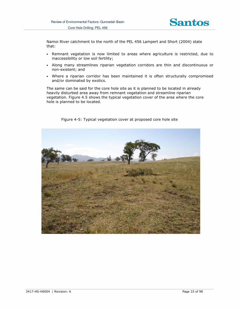
The same can be said for the core hole site as it is planned to be located in already heavily disturbed area away from remnant vegetation and streamline riparian vegetation. Figure 4.5 shows the typical vegetation cover of the area where the core hole is planned to be located.
Figure 4-5: Typical vegetation cover at proposed core hole site
Review of Environmental Factors: Gunnedah Basin
Core Hole Drilling: PEL 456
3417-HS-H0004 | Revision: A Page 34 of 98
4.6.2 Significant flora
There are three endangered ecological communities within the bioregion listed under Schedule 1 of the Threatened Species Conservation Act 1995 (NSW) (TSC Act).
These are the Semi-evergreen Vine Thicket (Cadellia pentastylis) (Ooline or scrub myrtle), Brigalow, and Carbeen open forest communities. NPWS (2003) found that the bioregion is important for the long-term viability of these vegetation communities that are predominantly found here, with a small area lying in the Nandewar Bioregion. The Carbeen open forest communities are now restricted to the Brigalow Belt South Bioregion and very limited areas of the Darling Riverine Plains Bioregion. The White Box-Yellow Box-Blakely’s Red Gum-Grassy Woodland and Derived Native Grassland
threatened ecological community also occurs in this bioregion. It is nationally endangered and protected under the EPBC Act 1999. However, the core hole sites have been cleared for rural activities.
Based on the TSC Act listings specifically for the Upper Hunter LGA, there are 22
threatened plants that are known to occur within the Upper Hunter LGA and these are listed in Appendix A. The core hole site has been cleared for rural activities and does not provide suitable habitat for any of these listed species.
4.6.3 Weeds
The noxious weeds that have been declared in the region are provided in Appendix B. In all there are 101 species that are declared.
4.6.4 Significant Fauna
A search of the NSW DECC on-line database Atlas of NSW wildlife listed 49 threatened
fauna species within the Upper Hunter LGA (DECC 2010). The species are listed in Appendix C.
The core hole site has been cleared for rural activities and will not be critical habitat for any of these listed species.
4.6.5 EPBC Act Due Diligence
The EPBC Database was searched and a Matters of Environmental Significance Report
was generated on the 20 April 2010 (DEWHA 2010a). Table 4.2 shows that there are no World Heritage Properties, National Heritage Places, Wetlands of International Significance (Ramsar Sites), or Commonwealth marine areas located near the core hole
site.
Table 4-2: Matters of Environmental Significance under EPBC Act
Aspect Presence within vicinity of the core hole
World Heritage Properties None
National Heritage Places None
Wetlands of International Significance (RAMSAR Sites) Within the catchment of Hunter Estuary Wetlands.
No potential impact.
Commonwealth Marine Areas None
Review of Environmental Factors: Gunnedah Basin
Core Hole Drilling: PEL 456
3417-HS-H0004 | Revision: A Page 35 of 98
Threatened Ecological Communities 4
Threatened Species 17
Migratory Species 13
Other Matters includes:
• Commonwealth Lands
• Commonwealth Heritage Places
• Places on the RNE
• Listed Marine Species
• Whales and Other Cetaceans
• Critical Habitats
• Commonwealth Reserves
None
None
None
10 Listed all fly over the site. No potential impact.
None
None
None
4.6.5.1 Threatened Ecological Community
There are four (4) Threatened Ecological Community (TEC) that could potentially be found within the region where the core hole site is to be located. They include the Grey
Box (Eucalyptas microcarpa) Grassy Woodlands and Derived Native Grasslands of South-eastern Australia (Endangered), the Natural grasslands on basalt and fine-textured alluviual plains of northern NSW and southern QLD (critically endangered), the Weeping
Myall Woodlands and the White Box-Yellow Box-Blakely’s Red Gum Grassy Woodland (Endangered) and Derived Native Grassland (critically endangered). These communities were formerly widespread along the western slopes and tablelands of the Great Dividing Range, throughout southern Queensland, western NSW, ACT and Victoria. Now less than
5% of these TECs remain in good condition and much of this occurs in small isolated pockets (DEWHA 2006).
The proposed core hole site will be located on land previously cleared for rural activities and as such will not have a significant impact on these TECs.
4.6.5.2 Threatened Species
There were up to 17 threatened species that could be potentially located within 5km of the proposed core hole site within PEL 456. These are provided in Appendix D. The
proposed core hole site will be located on land previously cleared for rural activities and as such will not provide critical habitat for threatened species.
4.6.5.3 Migratory Terrestrial and Wetland Species
There are up to 6 migratory terrestrial bird species and a further 7 birds that are wetland
species or migratory marine birds listed. It is considered that the planned activities will not have any significant impact on these species as the proposed core hole site will be located on land previously cleared for rural activities which do not provide suitable
habitat for these species.
4.6.5.4 Listed Marine Species
There are 10 species of birds that are listed marine species that may overfly the area. These are ‘other matters’ protected by the EPBC Act. It is considered that the planned
activities will not have any significant impact on these listed species.

Review of Environmental Factors: Gunnedah Basin
Core Hole Drilling: PEL 456
3417-HS-H0004 | Revision: A Page 36 of 98
4.7 Socio-Economic
4.7.1 Local Government Area
The planned activities lie within the local government area of the Upper Hunter. Population figures below are based on the 2006 census (ABS 2006).
The Upper Hunter LGA comprises the major population centres of Scone, Merriwa, Murrurundi and Aberdeen, plus a number of smaller areas such as Gundy, Moonan Flat, Blandford, Wingen, Parkville and Bunnan. In total the Upper Hunter LGA covers an area
of approximately 8060 square kilometres with a population of 12,976 based on the 2006 census.
4.7.2 Land use
The proposed core hole site is located which has been used extensively for agricultural activities since the 1830s. Agricultural activities include mixed farming of sheep, cattle and grain crops with a gradually larger reliance on cattle.
Sheep, beef cattle and grain farming are major rural land uses. Three coal mines are located in PEL 456. However these are not within the vicinity of the proposed core hole site. PEL 456 in relation to the mining leases is shown in Figure 4.6.
4.7.3 Heritage
4.7.3.1 Aboriginal Heritage
The Local Aboriginal Land Council for the area of interest is Walhallow, Nungaroo and
Wanaruah Local Aboriginal Land Councils. A search of the NSW Department of Environment and Climate Change (DECC) Aboriginal Heritage Information Management System (AHIMS) was made in 2008 (DECC, 2008). Details of the results are not to be made available to the public. None of the sites identified in the AHIMS search are in
close proximity to the planned core hole site. The nearest recorded Aboriginal heritage sites are located between 1 and 5 km from the closest core hole sites. The proposed core hole is away from the banks of any waterholes, creeks and ridgelines that are
generally accepted as having a higher potential for the location of Aboriginal objects and places. The core hole site is proposed on pastoral land that has been disturbed by clearing, grazing, cropping and general agricultural pursuits.
As of the 31st December 2009 there were no Native Title claims over the proposed core hole site location1.
4.7.3.2 Non-Indigenous Cultural Heritage
1 See Map at http://www.nntt.gov.au/Publications-And-Research/Maps-and-Spatial-Reports/Documents/Quarterly%20Maps/NSW_ACT_JBT_NTDA_Schedule.PDF

Review of Environmental Factors: Gunnedah Basin
Core Hole Drilling: PEL 456
3417-HS-H0004 | Revision: A Page 37 of 98
A search of the Commonwealth register of National Estate (DEWHA, 2010b) sites found over 40 sites
within the Upper Hunter LGA. While the search tool does not provide a specific location of each site, the majority of sites listed were most likely within town boundaries or Nature Reserves and National Parks. The proposed core hole site is not located within these locations.
The New South Wales Heritage Register for the Upper Hunter LGA identified over 9 items listed under the New South Wales Heritage Act (NSW Department of Planning, 2010). Like the National Register, these items are usually located within town boundaries and therefore will be avoided during the core hole activities which are proposed to be located on cleared grazing land in a rural
area.
Figure -4-6: PEL 456 and Mining Tenures
4.8 Protected Areas
4.8.1 National Parks and Reserves
A number of National Parks and Nature Reserves are found in PEL 456. Those of relevance to the core hole location are discussed below:
• Durridgere CCAZ3 is located in the Mudgee Area of the Blue Mountains Region, approximately 57 km north-east of Mudgee. The SCA lies just north of Goulburn River National Park, and features dry sclerophyll forests (shrubby subformation) of the
Dissected Sandstone Plateau biogeographic subregion. The core hole is about 11 km east of the nearest boundary.

Review of Environmental Factors: Gunnedah Basin
Core Hole Drilling: PEL 456
3417-HS-H0004 | Revision: A Page 38 of 98
• Goulburn River National Park covers an area of 72,296 hectares and extends along
approximately 90 kilometres of the Goulburn River. The area was reserved as the Goulburn River Nation Park in 1983. The core hole is about 12 km north of the nearest park boundary.
Figure 4-7: Location of National Parks, and Nature Reserves

Review of Environmental Factors: Gunnedah Basin
Core Hole Drilling: PEL 456
3417-HS-H0004 | Revision: A Page 39 of 98
Figure 4-8: Aerial Map

Review of Environmental Factors: Gunnedah Basin
Core Hole Drilling: PEL 456
3417-HS-H0004 | Revision: A Page 40 of 98
5 Environmental Impacts and Mitigation Measures
5.1 General
The activities will be undertaken in accordance with Santos’ Environmental, Health and Safety Management System (EHSMS), the Australian Petroleum Production and Exploration Association Code of Environmental Practice – October 2008 (APPEA 2008) and the Schedule of Onshore Petroleum Exploration and Production Safety Requirements (DPI, 1992).
5.2 Socio-Economic
5.2.1 Existing Environment
The catchment has been used extensively for agricultural activities since the early 1800s. The main agricultural activities include sheep, beef cattle and grain crops. The particular area of the proposed drilling activities is largely rural. There is also number of coal mine operations within the broad region.
5.2.2 Potential Impacts and Mitigation Measures
Potential impacts include disturbance to farming activities, disturbance to livestock and potential bushfire risks to flora, fauna, stock and personnel. Santos has entered into a Land Access Agreement with affected landowners in respect to land access conditions, compensation, rehabilitation and other matters as required under the Petroleum
(Onshore) Act 2007 (NSW). This consultation will involve the conducting of various land enquiries and meetings with the landowners in question. Regular contact with landholders will be made as necessary. Other matters such as air quality, weeds, water, and noise are addressed in sections 5.3, 5.4, 5.6 and 5.7.
To minimise impacts on landholders the following actions will be undertaken:
• Prior to the commencement of activities at each site, landholders will be provided with a notice of the planned activities, in particular drilling, including immediate neighbours
of the land on which the activities are to take place. Reasonable requests by landholders for rescheduling of activities will be considered;
• If unfenced roads are present on the roads to/from the rig, then as part of the site
induction or journey management program, drivers will be made aware of the hazard this presents;
• Internal access roads will be maintained in a condition satisfactory to the DPI-MR and Landholders until restoration of the lease is completed;
• If fencing is required, the site will be adequately fenced with a lockable gate and adequate signs warning of potential danger will be erected;
• Drilling sites will be selected such that a cleared buffer exists outside the drilling pad area to maintain an effective barrier against bushfires;
• The flare pit will be kept free of grass and leaf litter;
• A fire control water pump and hoses on site will be maintained;

Review of Environmental Factors: Gunnedah Basin
Core Hole Drilling: PEL 456
3417-HS-H0004 | Revision: A Page 41 of 98
• Liaison will occur with the local rural fire service officer;
• Fires on the surface of the land will be prohibited at each of the well sites except during flaring for safety purposes;
• Hot work (e.g. welding) specific procedures will be in place;
• The area of land disturbance will be minimised subject to safety constraints; and
• The site will be maintained in a clean and tidy condition.
5.3 Air Quality
5.3.1 Existing Environment
The existing air quality of the area is generally of good quality. The majority of pollutants, such as plant and vehicle emissions, arise from rural based activities.
5.3.2 Potential Impacts and Mitigation Measures
The proposed activity has the potential to introduce additional air emissions arising from the sources discussed below.
5.3.2.1 Dust generation
The dust generated by the mobilisation of the drilling and ancillary equipment travelling to and from a location will vary depending on road and weather conditions. In the case of improved or well compacted roads, dust will not be a significant issue. Occasional dust
suppression using a water cart will be used to reduce dust generation (see Section 5.4 for details on its source).
Liaison with local homesteads that may be affected by rig traffic will take place,
informing occupants of possible high traffic periods (i.e. during transport of the rig and equipment). The site is located 500m from a bitumen road on a private track. Speed limits on rig traffic will be imposed to minimise dust on the 500m access. Speed limits will be clearly communicated to all personnel working on or visiting the site.
The movement of rig equipment to and from the proposed drill site is expected to have more impact than the movements of equipment on sealed and unsealed roads within the district. The rig mobilisation, consisting up to 10 trailer loads, may require additional preparation of access ways. Additional access preparation will take place on external
road ways where required to facilitate the safe entry of the drilling rig. Damage to any external/internal access will be repaired as soon as possible after occurrence to minimise any impact on the landholder/ public. It is not expected to have any significant impacts
on road side vegetation.
Santos will notify the Upper Hunter Shire Council of the proposed start time of exploration drilling prior to its commencement and will liaise with the appropriate Council representatives should any repairs to Council roads be necessary.
5.3.2.2 Emissions from equipment
Operation of diesel fuelled vehicular traffic, plant and power generation, will be temporary and the minimal emissions are not expected to impact on air quality or be a
major contributor of greenhouse gases.

Review of Environmental Factors: Gunnedah Basin
Core Hole Drilling: PEL 456
3417-HS-H0004 | Revision: A Page 42 of 98
5.3.2.3 Flaring of gas
It is considered possible that gas bearing formations will be intersected during core hole drilling. A number of safety precautions and contingencies are therefore incorporated into the program in order to minimise any risks.
An appropriately sized and located flare pit will be installed at the commencement of drilling operations. The drill rig operator will locate the “blooie lines” so that gas is directed into the flare pit where an ignition source can safely burn/flare any gas that is intersected by drilling.
Approval from the relevant DII-MR Safety Inspector will be sought prior to any gas flaring other than that occurring as part of drilling safety procedures. Santos has a well established process for flaring produced gas during Drill Stem Testing.
5.4 Hydrology
5.4.1 Existing Environment
There are no creeks in the immediate vicinity of the core hole site that could be potentially affected if there are any spill incidents during the proposed activities.
5.4.2 Potential Impacts and Mitigation Measures
Preference will be to procure water supplies from dams or bores located in the vicinity of
the core hole site (with landholder permission) or from municipal supply via a water carter. In order to acquire the water necessary for drilling in situations where water cannot be obtained through the above means, approval will be sought from the appropriate authorities and landholder for the installation of a bore to access water from suitable reservoirs. This consent will be sought before the commencement of drilling operations.
There is potential to contaminate surface water or groundwater via run off from spill
incidents during associated with chemical storage & handling, refuelling and drilling fluids and cuttings management. Mitigation measures for these activities are discussed in Section 5.8 and 5.10. Groundwater cross contamination with the drilling fluid will be prevented as the core hole will be cased and completed in accordance with DPI-MR
requirements and specific well design.
In the case of a drilling sump, a liner may be used depending on the environment assessment of a given location. If a liner is used it will be removed after drilling with the
water re-used or taken to an appropriate site for disposal. Any waste pits temporarily left open after the rig has left will be fenced to protect livestock and other animals.
Associated water from the targeted coal seams are not expected to be produced as part of the core hole drilling activity and therefore no mitigation measures are presented.
5.5 Soils, Land use and Rehabilitation
5.5.1 Existing Environment
Review of Environmental Factors: Gunnedah Basin
Core Hole Drilling: PEL 456
3417-HS-H0004 | Revision: A Page 43 of 98
The soils in the vicinity of the core hole site are a valuable resource to pastoral or
agricultural interests.
5.5.2 Potential Impacts and Mitigation Process
An area of 80 metres by 60 metres plus access is required to accommodate a fully operational drilling rig and ancillary equipment, access to site, with about 60% of hard stand. A level area is required for the drilling rig pad and associated sumps and flare pit will be constructed on site. These will require topsoil to be removed and stockpiled for replacement during site rehabilitation. The potential for significantly disturbing the soil structure or future land use is low. If imported soils are required these will be sourced from the local area and if required, permission will be obtained from the landholder prior
to this being undertaken.
Scouting surveys will be undertaken in consultation with the relevant landholder prior to drilling taking place to locate the site such that impacts are minimal.
Management measures will include:
• Liaison with the Landholder to site the drill site
• Restricting the area to be disturbed to the minimum;
• Stockpiling top soil separately from other spoil and respreading;
• Return of natural/previous land contours;
• Reseeding if required in consultation with landholders; and
• Removal of all imported soil material with consideration to Landholder requirements.
5.6 Noise
5.6.1 Existing Environment
Noise levels in the location of the proposed core holes are generally low but variable due to periodic rural or coal mining activities.
5.6.2 Potential Impacts and Mitigation Measures
The proposed activity is likely to generate noise as a result of the following procedures:
• The drilling activity; and
• The movement of trucks and other vehicles.
The equipment used for the mobilisation of the drilling rigs have mufflers installed on their prime movers. The site is located further than 1 km from the nearest residence.
The distance to the nearest residence and combined with the muffling of the engines and the short term nature of the drilling activity, operations are unlikely to create any significant noise impacts for residents. Drilling operations will be carried out in
accordance with agreements with landowner and DPI-MR requirements.
Mitigation Measures will include:

Review of Environmental Factors: Gunnedah Basin
Core Hole Drilling: PEL 456
3417-HS-H0004 | Revision: A Page 44 of 98
• Prior to starting the activities Santos will confirm all potentially affected noise and/or
vibration sensitive receivers (including rural residences, and noise sensitive equipment);
• Noise and vibration monitoring may be undertaken on receipt of a complaint; and
• Appropriately informing affected residences and other relevant parties in advance of any activities and providing those people with updated information as required.
5.7 Flora and Fauna
5.7.1 Existing Environment
The proposed core hole site will be on land that has been previously cleared and is unlikely to be of significance to threatened species or communities. Appendix B lists the potential weeds that could be in or near the proposed core hole location.
5.7.2 Potential Impacts and Mitigation Measures
The likelihood of disturbing actual or potential habitats associated with species of
significance is low because of the small area and temporary nature of the impact; the extent and duration of clearing and grazing that has occurred locally; and the absence of remnant vegetation at the proposed core hole site. Scouting will be undertaken prior to the commencement of drilling to ensure that the physical location of the activities are
located in grazing land minimising impacts on sensitive species.
There is a potential for the introduction of weeds and pest species to the site via the entry of vehicles and plant (refer to Table 5-1). This shall be mitigated as follows. All vehicles travelling to site will be required to follow Santos standards. These vehicles will be assessed for weed exposure in the area of origin and if it is deemed required the vehicle, plant or ancillary equipment will be washed and/or brushed down at a suitable site external to the project area. This will entail the complete removal of soils and
organic matter from all areas capable of holding such material. Scouting of the proposed core hole site will identify if obvious any weeds present and assist in the determination of any additional measures that may be required as a result.
5.8 Chemical and Hazardous Substance Management
5.8.1 Existing Environment
The area is rural and there would be a variety of chemicals that could be stored and used throughout the region.
5.8.2 Potential Impacts and Mitigation Measures
The likelihood that a chemical or hazardous substance will impact on the environment is
low because all goods will be appropriately handled and stored away from sensitive locations.
The following management measures will be implemented:

Review of Environmental Factors: Gunnedah Basin
Core Hole Drilling: PEL 456
3417-HS-H0004 | Revision: A Page 45 of 98
• The amount of hazardous material stored and used on site shall be kept to the
minimum practicable;
• Hazardous materials shall be transported, stored and handled in accordance with the requirements of relevant legislation (e.g. Road and Rail Transport (Dangerous
Goods) Act 1997 (NSW), Australian Dangerous Goods Code) and Australian and Industry Standards;
• Fuels, lubricants and chemicals shall be stored and handled within containment areas (such as portable bunding) that are designed to prevent the release of spilt substances
to the immediate neighbouring environment, in accordance with relevant legislation and standards. A spill kit appropriate to operations of this size will be available at site; and
• Material Safety Data Sheets and handling procedures for hazardous chemicals and materials shall be kept on site.
Spill prevention and response measures will include:
• Personnel shall be advised of the location and use of the spill containment equipment
in the site induction;
• Spills or leaks shall be immediately reported to the senior Santos representative onsite and clean up actions initiated;
• In the event of a spill, the material shall be contained to the smallest area practicable;
• Spilt material and contaminated soils shall be treated on site with landholder acceptance or removed off-site for disposal at an appropriately licensed facility, as determined in consultation with Department of Environment and Climate Change
(DECC) and DPI-MR; and
• Spills shall be reported in accordance with regulatory and licensing requirements. There is a duty to notify the appropriate regulatory authority (broadly, the DECC or the local council) of pollution incidents where material harm to the environment is
caused or threatened (see Section 2.1 for definition of material harm).
The information about a pollution incident required to be included in a notification consists of:
• the time, date, nature, duration and location of the incident;
• the nature, the estimated quantity or volume and the concentration of any pollutants involved;
• the circumstances in which the incident occurred (including the cause of the incident,
if known);
• the action taken or proposed to be taken to deal with the incident and any resulting pollution or threatened pollution; and
• other information prescribed by the regulations.
5.9 Contaminated Land
5.9.1 Existing Environment
The land is currently either used for pastoral or crop production and the core hole site is
not expected to have been previously contaminated.

Review of Environmental Factors: Gunnedah Basin
Core Hole Drilling: PEL 456
3417-HS-H0004 | Revision: A Page 46 of 98
Core hole drilling will have minimal impact on the site’s soils. On completion of core hole
activities, all excavated material would be backfilled on site. Santos does not expect that land contamination would be an issue at any proposed core hole site.
5.9.2 Potential Impacts and Mitigation Measures
Mitigation measures are discussed in the following sections:
• Hydrology - Section 5.4;
• Soils - Section 5.5;
• Chemicals and Hazardous Substance Management - Section 5.8; and
• Waste Minimisation and Management - Section 5.10.
5.10 Waste Minimisation and Management
5.10.1 Existing Environment
The only waste presently stored at any of the core hole sites drilled by Santos is general waste before being transported to a licensed facility.
5.10.2 Potential Impacts and Mitigation Measures
The worksite will require the provision of systems for the management of sewage
wastes. Personnel numbers can reach up to 10 in the case of drilling operations.
All industrial solid wastes created during drilling and well operations will be collected in designated skips for disposal to an appropriately licensed facility. Water based drilling fluids and associated cuttings, will be stored in an excavated sump. Cuttings may remain
in the sump or be removed, and a liner may or not be utilised depending on an environmental assessment of each core hole location. The liner, if used, will be removed once the sump is no longer required. Topsoil will be respread over restored surfaces at final abandonment of the site to encourage revegetation of disturbed surfaces.
The following management measures will be implemented:
• Waste material (including domestic waste) shall be collected and stored in suitable bins to prevent loss and scavenging by stock, wildlife and feral animals;
• Where practicable, recyclable material (e.g. glass and cans, scrap metals, used chemical and fuel drums and timber pallets) shall be collected in designated skips for recycling;
• The waste bins shall be removed from the site as necessary following completion of drilling and their contents are to be deposited at a licensed waste management facility for appropriate disposal;
• All wastes are to be transported in covered or sealed containers to prevent the loss of
waste materials during transport;
• Waste shall be transported in accordance with appropriate standards and legislative requirements;
• Staff will be housed at accommodation in nearby towns;

Review of Environmental Factors: Gunnedah Basin
Core Hole Drilling: PEL 456
3417-HS-H0004 | Revision: A Page 47 of 98
• ‘Portaloos’ will be provided at the site and maintained as required by a suitable
contractor;
• Pits shall not be established in locations that pose a hazard to stock or wildlife. Any fencing shall be stock proof and suitable for ‘organic beef accredited’ properties, and
steel or untreated timber posts shall be used;
• Flare pits may also be fenced as above;
• Sumps containing waste fluids/cuttings shall be fenced off immediately following the rig moving off the premises;
• If a liner is used it will be removed, and depending on site conditions, cuttings may be disposed of a suitable location; and
• A perimeter fence around the site will be considered at each site if required to enclose all the above pits, sumps etc.
5.11 Visual Amenity
5.11.1 Existing Environment
The landscape in the region is dominated by broad views of rural properties, with
scattered pastoral infrastructure such as bores, tanks, dams, fences, roads, homesteads and other buildings.
5.11.2 Potential Impacts and Mitigation Measures
The visual impacts of drilling will be temporary and relatively insignificant and all equipment will be removed at the end of the coring program. If drilling is operated on a 12 hour a day basis, the site will be sufficiently lit by natural light for safe working conditions. Drilling activities will be undertaken at the site for a period of between 35-60 days. Lease construction activities of 14 days and lease rehabilitation activities of 7 days will be additional to this period and may not occur concurrently to the drilling activities.
5.12 Aboriginal Heritage
5.12.1 Existing Environment
The land where the core hole site is proposed (including access tracks) has been previously disturbed and cleared. A search of the DECC AHIMS database for the general area of the proposed core hole drilling has been made (DECC, 2008). No Aboriginal objects or places are recorded in close proximity (within 1km) of the proposed core hole site. Initial consultations with representatives of the Local Aboriginal Land Councils have
commenced.
5.12.2 Potential Impacts and Mitigation Measures
Potential impacts include disturbance of unrecorded artefacts or burial sites. However to minimise any potential impacts the following management measures will be implemented:
• Undertaking a pre-preparation heritage site inspection of the proposed drilling site;

Review of Environmental Factors: Gunnedah Basin
Core Hole Drilling: PEL 456
3417-HS-H0004 | Revision: A Page 48 of 98
• Heritage exclusion zones or sites identified during the heritage site inspection shall be
avoided;
• Personnel, vehicles and equipment shall be restricted to designated work areas and access tracks; and
• Aboriginal heritage issues and the potential for discovery of sites shall be covered in site inductions.
If a site is discovered during site preparation works, the following procedure shall be implemented:
• Halt work at this location and establish a 100m buffer around the site. Work may continue outside the buffer area;
• Contact Santos’ Cultural Heritage Group, relevant Local Aboriginal Land Council and National Parks and Wildlife Service (DECC), so that an evaluation of the nature of the discovery can be undertaken, along with the development of an appropriate course of action;
• The course of action may consist of recording the site location, removal of the cultural
material or site protection as appropriate under the relevant legislation; and
• If human remains are encountered, the local Police shall also be notified.
5.13 Cumulative Environmental Impacts
The core hole activities are temporary in nature and the site will be restored to enable previous land-uses to continue into the future. The mitigation measures outlined above
will ensure that there are no significant cumulative environmental impacts.
5.14 Risk Assessment
A risk assessment was carried out to identify the potential environmental impacts associated with the proposed core hole activities. Santos’ Risk Matrix (see Appendix E)
was used to determine the risk rating for each of the environmental elements identified as potentially being impacted. The risk ratings were determined prior to applying mitigation strategies and safeguards and then after considering measures to reduce risk. The unmitigated risk rating and residual risk ratings are both provided and ranged from a
1-3, which means that the risk identified can be managed through routine monitoring and procedures.
Table 5-1 shows the risk matrix including the management controls and performance
management indicators that will be utilised by Santos during the drilling activities. The focus of environmental management is to avoid where possible, then minimise and mitigate any impacts.

Review of Environmental Factors: Gunnedah Basin
Core Hole Drilling: PEL 456
3417-HS-H0004 | Revision: A Page 49 of 98
Table 5-1: Risk Assessment for Core Hole Activities
Aspect Potential Impacts UMRR Management Controls RRR Performance
Indicator Records
Air Quality Expected air emissions / air
quality issues associated with the
short term activities may
include:
• Combustion exhausts from the
flare stack (during testing); • Fugitive emissions from
(vehicles); and • Dust emissions from
earthworks and vehicular
activity.
• Fugitive emissions from
vehicles used during
appraisal activities are
anticipated to be minor due
to the small scale of activities
planned.
• Other minor sources of air
emissions include exhaust
fumes from earthmoving and
transport equipment.
• These sources are likely to
be negligible in the context
of existing activities including
grazing and transport within
the area.
• No measurable impact is
likely.
1
• Reducing the speed of
vehicles on field roads. • Watering of roads when
appropriate or when agreed.
• Investigating dust complaints and
responding appropriately.
• Planning the location of
activities in consultation
with landholders should
control impacts.
1
• Minimal
complaints from
Landholders
regarding dust
impacts.
• Amicable
resolution of non-
vexatious
complaints
• All complaints
made by the
Landholder and
any subsequent
actions are to
be recorded in
the Complaints
Register.

Review of Environmental Factors: Gunnedah Basin
Core Hole Drilling: PEL 456
3417-HS-H0004 | Revision: A Page 50 of 98
Aspect Potential Impacts UMRR Management Controls RRR Performance
Indicator Records
Community • The primary contact during
planning and development
will be with the Landholder.
• The activities have the
potential to impact upon
landholders.
• In general, land access will
be addressed in
compensation/access
agreements prior to the
commencement of petroleum
activities.
2
• Access will be discussed
with the Landholder during the field scouting
period and compensation
finalised.
• Land requirements and locations for
infrastructure will be
discussed with the Landholder.
• Where practical
infrastructure will be
located within previously disturbed areas.
• Land requirements will be minimised to that
required for safe operations.
• Land no longer required for normal operations will
be rehabilitated and where practical returned
to its previous use in
consultation with the Landholder.
1
• All land disturbed
by Santos is to be
returned to a
condition
consistent with
the adjacent area
and in
consultation with
the landholder.
• Santos records
contracts with
landholders.
Fire • Threat to the community,
flora and fauna or sensitive
areas.
2
• Drilling sites will be
selected such that a cleared buffer exists
outside the drilling pad area to maintain an
effective barrier against bushfires.
• The flare pit will be kept
free of grass and leaf
1
• No fires occur as
a result of the
proposed
activities.
• Incident
notification
records.

Review of Environmental Factors: Gunnedah Basin
Core Hole Drilling: PEL 456
3417-HS-H0004 | Revision: A Page 51 of 98
Aspect Potential Impacts UMRR Management Controls RRR Performance
Indicator Records
litter.
• A fire control water pump and hoses on site will be
maintained.
• Liaison will occur with the
local rural fire service officer.
• Fires on the surface of
the land will be prohibited at each of the well sites;
• Hot work (e.g. welding)
specific procedures will be
in place. • The site will be cleared to
minimise the potential for ignition of surrounding
pasture. • Diesel machinery will be
utilised for all activities.
Flora, Fauna
and
Environmental
Sensitive Areas
• Desktop searches have been
carried out to identify
possible threatened species
• The proposed location has
previously been highly
disturbed by agricultural
activities.
• No threatened flora or fauna
or sensitive areas will be
impacted by the proposed
core hole activities.
1
• Use of areas already
disturbed. • No unplanned or
unapproved damage to
flora and fauna.
• Restoration of disturbed areas to commence as
soon as practical. 1
• Recommendation
s and corrective
actions arising
from audits and
reviews will be
implemented.
• Ongoing
monitoring to
assess the
success and
integrity of
construction and
rehabilitation
• Santos will
maintain
records during
construction
and operation of
all monitoring
and assessment
activities.

Review of Environmental Factors: Gunnedah Basin
Core Hole Drilling: PEL 456
3417-HS-H0004 | Revision: A Page 52 of 98
Aspect Potential Impacts UMRR Management Controls RRR Performance
Indicator Records
measure and
ensure
appropriate
follow-up
rehabilitation
measures are
implemented.
Indigenous and
Non-
Indigenous
Cultural
Heritage
• Indigenous heritage. Site or
artefact of indigenous culture
may be inadvertently
damaged.
• Non-Indigenous Heritage:
Sites or artefacts of non-
indigenous settlement may
be inadvertently damaged.
• The proposed site is part of
an operating farm on a
highly disturbed area that
has previously been cleared.
• It is not expected that there
will be any impact on
indigenous and non-
indigenous cultural heritage
values of the area.
1
• Development will occur in
cleared/disturbed areas minimising the risk of
impact on cultural heritage.
• All disturbance activities
are reviewed to ensure
development avoids impacting on cultural
heritage before commencement. 1
• Cultural heritage
clearance
completed prior
to ground
disturbance.
• No indigenous or
non-indigenous
site is disturbed
by the proposed
activities.
• Records of any
cultural heritage
site are
maintained.

Review of Environmental Factors: Gunnedah Basin
Core Hole Drilling: PEL 456
3417-HS-H0004 | Revision: A Page 53 of 98
Aspect Potential Impacts UMRR Management Controls RRR Performance
Indicator Records
Land, Soils and
Terrain
• It is considered that the only
potential environmental
impact associated with the
activity is soil erosion from
the disturbed land at the drill
site and access tracks.
2
• All activities associated
with land disturbance
will be discussed with
the Landholder prior to
commencement.
• The area of all
disturbances will be
determined and placed
within Santos’
Geographic Information
System (GIS).
• An environmental
assessment will be carried out prior to the
acceptance of a site for a new activity.
• This assessment determines landholder
values, habitats, vegetation, and areas of
significant
environmental/cultural
value to be avoided. • The assessment also
outlines areas or issues
requiring particular environmental
management.
1
• The site is
rehabilitated upon
completion of the
activities.
• Records of
disturbance are
maintained
within Santos’
GIS.
Noise • Activities to be undertaken
during drilling operations
include drilling, running casing
and cementing, DST and geophysical logging.
2
• All activities apart from access to the site are
confined to the drill pad
with all work carried out during daytime hours
1
• All noise complaints will be recorded in
the Complaints
Register. • Amicable resolution
• Maintenance carried out on
equipment is to
be recorded. • Complaints

Review of Environmental Factors: Gunnedah Basin
Core Hole Drilling: PEL 456
3417-HS-H0004 | Revision: A Page 54 of 98
Aspect Potential Impacts UMRR Management Controls RRR Performance
Indicator Records
• Main vehicle movements are
based around personnel movements to and from site.
There are however the
occasional deliveries and other
personnel accessing the site outside of these times.
• The equipment used for the
mobilisation of the drilling rig have mufflers installed on their
respective power plants and
prime movers.
• The proposed drilling site is a distance of greater than 750 m
to the nearest dwelling that will be unoccupied during the
drilling activities.
only.
• To manage noise and minimise impacts the
following management
strategies/controls will be
implemented: • Landholder notification
will be given prior to
commencement of drilling.
• Equipment will be
maintained so that noise
levels remain constant. • Complaints will be
responded to in a timely manner.
• Where noise disturbance cannot be avoided,
Santos will investigate alternative arrangements
to suit the landholder.
• Noise barriers will be
implemented if necessary
of non-vexatious
complaints
Register.
Waste • Domestic waste including sewage.
1
• No waste will be disposed of on site.
• General and recyclable wastes (including glass,
paper and plastic)
generated during
construction will be transported to landfill and
recycling facilities on a
routine basis. • Regulated waste will be
collected by licensed
1
• Post construction
checks to ensure
all waste has
been
appropriately
removed and
disposed of.
• Operational
checks to
establish that all
• Waste
management
records.
• Complaints
register.

Review of Environmental Factors: Gunnedah Basin
Core Hole Drilling: PEL 456
3417-HS-H0004 | Revision: A Page 55 of 98
Aspect Potential Impacts UMRR Management Controls RRR Performance
Indicator Records
contractors for off-site
disposal. • Sewage will be collected
by licenced contractor for
off-site disposal.
• Non-vexatious
complaints are
addressed in a timely
manner.
• Waste is disposed of at
appropriate end point.
• All waste management
non-compliances are
managed in the
Incident Management
System.
• Any complaints from
the landholders
regarding waste
management are
recorded in the
Complaints Register.
waste has been
appropriately
removed from the
operational areas,
or correctly
stored and
waiting for
removal.
Water- Surface
and
Groundwater
• Incident or accident that may
result in a release of oils or
other chemicals maintenance
fluids to the ground. • Transport of sediments
through erosion of soils during construction activities.
2
• Water removed from site
will be managed by a
contractor licensed to
carry and handle water.
• Bunding of all areas storing or handling fuel,
fuel using equipment, and
chemicals, in line with Australian Standard 1940
1
• No incidents
where substances
are released to
surface or ground
water causing
contamination.
• Diversion
mechanisms in
• Records of
spills, leaks and
associated clean
ups are to be
managed using
the Incident
Management
System.

Review of Environmental Factors: Gunnedah Basin
Core Hole Drilling: PEL 456
3417-HS-H0004 | Revision: A Page 56 of 98
Aspect Potential Impacts UMRR Management Controls RRR Performance
Indicator Records
– 1993; The Storage and
Handling of Flammable and Combustible Liquids
• Where applicable
maintenance of roads,
drains, bund walls, contour and diversion
banks, will occur. All
drainage structures are to be maintained for the life
of the development.
• During rehabilitation,
diversion banks and ripping along the contour
will be completed to prevent the concentration
and momentum of water flow as required.
place, regularly
checked and
maintained to
redirect natural
stormwater
movement where
required.
• Maintenance
carried out to
remedy any
erosion and
water
channelling is to
be recorded
using the
Incident
Management
System.
• Records of
water storage
inspections to
be maintained.
Weed
Management
• Introduction or spread of
weeds through earthworks
equipment and general
traffic.
3
• All vehicles coming from declared weed infested to
non-declared weed areas are required to utilise
vehicle washing facilities
or any temporary
washing facilities established for this
purpose. • All vehicle movements
are restricted to defined areas agreed upon with
the Landholder/s.
• Land disturbance is to be minimised to prevent the
germination of weed seeds that may already
2
• Identify and
document areas
of new weed
infestations in the
Incident
Management
System.
• Vehicle Hygiene
Records.

Review of Environmental Factors: Gunnedah Basin
Core Hole Drilling: PEL 456
3417-HS-H0004 | Revision: A Page 57 of 98
Aspect Potential Impacts UMRR Management Controls RRR Performance
Indicator Records
exist in the soil.
• If a declared weed or weed of concern is
discovered, it shall be
monitored to ensure it
does not spread from the area of infestation.
• All land disturbed by
Santos is to be returned to a condition consistent
with the adjacent area or
to landholder
requirements at the end of the rehabilitation
process.
UMRR = Unmitigated Risk Rating
RRR = Residual Risk Rating

Review of Environmental Factors: Gunnedah Basin
Core Hole Drilling: PEL 456
3417-HS-H0004 | Revision: A Page 58 of 98
5.15 Clause 228 Checklist
Clause 228 of the EP&A Regulation states that for the purpose of Part 5 of the EP&A Act the following factors are to be taken into account concerning the impact of an activity on the
environment. These factors are considered below.
Table 5-2: Clause 228 Checklist
Factor Positive/Negative
Impact
Any environmental impact on the community
The proposed site lies approximately west of Scone.
Minor short term impacts such as noise would be experienced. Safeguards proposed in Section 5 and Table 5-1 would minimise these impacts.
Short term negative
Any transformation of a locality
There would be localised and non-permanent visual impact on the immediate vicinity of the hole for the duration of the programme. Safeguards proposed in Section 5 and Table 5-1 would minimise these
impacts.
Short term negative
Any environmental impact on the ecosystems of the locality
The area of proposed activities is highly disturbed, no environmental
impacts of the ecosystems of the locality would occur as a result of the project.
Nil
Any reduction of the aesthetic, recreational, scientific or other
environmental quality or value of a locality
During construction there may be a reduction in these values due to affecting visual amenity. Given the short term nature of activities and
the safeguards/mitigation detailed in Section 5 and Table 5-1 the potential for a reduction is considered negligible.
Nil
Any effect on a locality, place or building having aesthetic,
anthropological, archaeological, architectural, cultural, historical,
scientific or social significance or other special value for present or
future generations
No locality, place or building having aesthetic, anthropological,
archaeological, architectural, cultural, historical, scientific or social significance or other special value for present or future generations occur near the proposed site.
Nil
Any impact on the habitat of protected fauna (within the meaning of the
National Parks and Wildlife Act 1974)
The proposal would not impact on the habitat of protected fauna.
Nil
Any endangering of any species of animal, plant or other form of life,
whether living on land, in water or in the air
Nil

Review of Environmental Factors: Gunnedah Basin
Core Hole Drilling: PEL 456
3417-HS-H0004 | Revision: A Page 59 of 98
Factor Positive/Negative
Impact
The proposal would not endanger any species of animal, plant or other
form of life, whether living on land, in water or in the air.
Any long-term effects on the environment
The proposal would have no long-term effects on the environment
Nil
Any degradation of the quality of the environment
There is potential for minor short term environmental degradation due to noise impacts. Safeguards proposed in Section 5 and Table 5-1 would
minimise these impacts.
Minor short term negative
Any risk to the safety of the environment
The proposal may result in short term potential risks to the safety of the
environment due to potential accidents and spills. The likelihood of incidents occurring would be reduced through the application of Santos’s EHSMS Standards and mitigation proposed in Section 5.
Minor short term negative
Any reduction in the range of beneficial uses of the environment
The footprint of activities for the proposal would not result in any reduction in the range of beneficial use of the environment.
Nil
Any pollution of the environment
There is potential for additional short term negative impacts during activities. However mitigation documented in Section 5 would minimise any potential for impacts.
Nil
Any environmental problems associated with the disposal of waste
Drill cuttings would be essentially inert and any drilling fluid conditions
would be biodegradable or similarly inert and would be allowed to dry onsite and disposed of in drilling sumps. Any other waste generated by the activities will be collect and removed from site for disposal at approved landfill sites. Given the short term of the propose activity
waste production will be minimal.
Nil
Any increased demands on resources (natural or otherwise) that are, or
are likely to become, in short supply
Resources required for the proposal are not in limited supply in the area.
Nil

Review of Environmental Factors: Gunnedah Basin
Core Hole Drilling: PEL 456
3417-HS-H0004 | Revision: A Page 60 of 98
6 Conclusions
Drilling of the proposed core hole is a necessary step in evaluating the hydrocarbon potential of PEL 456. Discovery of coal seam gas resources in this area has the
potential to increase the state’s reserves and revenue from gas and underpin future exploration or production in the region.
Santos has consulted with landholders so as to identify any concerns with regard to planned activities. A Land Access Agreement was agreed to with the affected
landholder and the agreement addresses matters such as access, compensation and rehabilitation.
Scouting surveys will be undertaken in consultation with the relevant landholder
prior to drilling taking place to locate the site such that impacts are minimal. Desktop assessment has shown that there is minimal risk of affecting potential threatened species and critical habitat identified in the region. It should be noted that an initial assessment of proposed location has shown that the core hole should be located in cleared grazing land. If necessary the proposed core hole site can be moved to avoid any sensitive areas identified during final site scouting.
The proposed activities have associated potential environmental impacts, which are
common to drilling activities such as those carried out elsewhere in the Gunnedah Basin. It is considered that the potential impacts can be successfully mitigated with the application of the management strategies outlined in this document. The strategies are consistent with the APPEA Code of Environmental Practice and are
typical of good hydrocarbon field practice.
Section 5A of the EP&A Act lists seven factors to be considered in relation to potential impacts on threatened species, populations or ecological communities, commonly referred to the seven part test of significance. An assessment was made
against the seven factors to be considered under Section 5A of the EP&A Act i.e. “seven part test of significance” and concluded that:
• There are no known threatened species that would be impacted by the planned
activities. The size and nature of the proposal is unlikely to effect the life cycle of any viable populations of threatened flora/fauna if present;
• There are no known endangered populations that have been identified that would be impacted by this proposal. The size and nature of the proposal is
unlikely to effect the life cycle of any viable populations of endangered populations;
• There are no known endangered ecological communities or critically endangered
communities that have been identified that would be impacted by this proposal; and
• It is not proposed to clear any critical habitat for this proposal.
With the management strategies, it is expected that:
• Impacts on landholders will be minimal;
• Impacts to air quality will be minor, localised and insignificant;
• Adverse effects on water resources will be minimal during core hole drilling;
• Off-site impacts to soils will be avoided and on-site impacts will be minor and
temporary;
• The potential noise impacts will be short term, and no threatened species or communities are likely to be impacted;

Review of Environmental Factors: Gunnedah Basin
Core Hole Drilling: PEL 456
3417-HS-H0004 | Revision: A Page 61 of 98
• There will be no significant use of, or impact to, natural resources;
• Impacts on the community and visual amenity will be insignificant and short term, particularly as the core hole site is in a sparsely populated area;
• Impacts to heritage places or sites will be avoided;
• Disturbances to pastoral and agricultural land use will be minor and short term and managed in consultation with affected landholder(s); and
• There will be no significant environmental impacts.
On completion of the activities, the site will be rehabilitated to reflect the pre-existing land form and use in consultation with relevant landholder. All waste will be disposed of in an appropriate manner.

Review of Environmental Factors: Gunnedah Basin
Core Hole Drilling: PEL 456
3417-HS-H0004 | Revision: A Page 62 of 98
7 References
Australian Bureau of Statistics (2006), Census Data 2006, downloaded 13th October 2008, at
http://www.abs.gov.au/websitedbs/d3310114.nsf/home/Census+data
Australian Petroleum Production and Exploration Association (APPEA) (2008), Code of Environmental Practice October 2008, Published by the APPEA Canberra ACT.
Bureau of Metrology (BOM) (2010), Average Monthly Climate Statistics for the
Township of Scone, downloaded 29th March 2010 at: http://www.bom.gov.au/climate/averages/tables/cw_061069.shtml
Commonwealth of Australia (2010), National Native Title Tribunal Register.
Retrieved 20 April 2010, from National Native Title Tribunal: http://www.nntt.gov.au/registers/
Department of Environment and Climate Change (DECC), (2008), AHIMS Search. Confidential report of AHIMS database search results for Santos, NSW Department of Environment and Climate Change.
DECC (2010), NSW National Parks and Wildlife Service Atlas of Wildlife On-Line Database search for flora and fauna covering the Upper Hunter Local Government
Area, DECC database accessed on 20 April 2010 at: http://wildlifeatlas.nationalparks.nsw.gov.au/wildlifeatlas
Department of Environment, Water, Heritage and the Arts (DEWHA), 2006, EPBC Policy Statement 3.5, Nationally Threatened Species and Ecological Communities
Guidelines Department of the Environment and Heritage, May, downloaded 8th April, 2008, at http://www.environment.gov.au/epbc/publications/box-gum.html
DEWHA (2010a), EPBC Protected Matters Search. Retrieved 20 April 2010, from Department of the Environment, Water, Heritage and the Arts:
http://www.environment.gov.au/epbc/index.html
DEWHA (2010b), Search the Australian Heritage Database. Retrieved 20 April 2010, from Department of the Environment, Water, Heritage and the Arts:
http://www.environment.gov.au/cgi-bin/ahdb/search.pl
Department of Primary Industries (DPI) (1992), Schedule of Onshore Petroleum Exploration and Production Safety Requirements, published by NSW Department of Primary Industries.
DPI (2010), Noxious Weeds Declarations, downloaded 20 April 2010 from: http://www.dpi.nsw.gov.au/agriculture/pests-weeds/weeds/noxweed
Lampert, G & Short, A. (2004), Namoi River Styles Report - River Styles,
Indicative, Geomorphic Condition and Geomorphic Priorities for River Conservation and Rehabilitation in the Namoi Catchment, Department of Infrastructure Planning and Natural Resources.
New South Wales Parks and Wildlife Service (NSWPWS) (2003), The Bioregions of New South Wales- their biodiversity, conservation and history, NSW National Parks and Wildlife Service, Hurstville.
Review of Environmental Factors: Gunnedah Basin
Core Hole Drilling: PEL 456
3417-HS-H0004 | Revision: A Page 63 of 98
NSWPWS (2010), New South Wales Wildlife Atlas Search. Retrieved 20 April 2010, from New South Wales Parks and Wildlife Service: http://wildlifeatlas.nationalparks.nsw.gov.au/widlifeatlas/watlas.jsp
NSW Department of Planning (2010), NSW Heritage Register. Retrieved 20 April 2010, from Heritage Branch NSW: http://www.heritage.nsw.gov.au/07_subnav_04.cfm
Upper Hunter Shire Council (UHLGA), (2006), State of the Environment Report
2006.
Further reading:
Petroleum Exploration Licence (PEL) 456 Licence Instrument
DPI - Mineral Resources Division (2006), Guidelines for Review of Environmental Factors, June, NSW Department of Primary Industries.

Review of Environmental Factors: Gunnedah Basin
Core Hole Drilling: PEL 456
3417-HS-H0004 | Revision: A Page 64 of 98
Appendix A.
Threatened Flora Species located in the Upper
Hunter LGA
Source: DECC, NSW NPWS Atlas of Threatened Species database.
Species Common Name Status Distribution/Habitat/Ecology
Acacia dangarensis Endangered Acacia dangarensis is endemic to NSW and
confined to the summit and surrounding slopes of Mount Dangar south of Merriwa,
within Goulburn River National Park. The total
population size of Acacia dangarensis is estimated to be of the order of 1750 plants
extending over an area of about 70 hectares. It is not known to occur in any other location
despite considerable survey around the Hunter district in recent years
Acacia dangarensis occurs in pure stands or as a co-dominant tree in sclerophyll woodland
on the edge of dry rainforest on basalt and basalt colluvium.
Chiloglottis platyptera
Barrington Tops Ant Orchid
Vulnerable Found along the eastern edge of the New England Tablelands, from Ben Halls Gap to
east of Tenterfield, and also in the Barrington Tops area.
Grows in moist areas in tall open eucalypt forest with a grassy understorey, and also
around rainforest edges. It usually flowers from July to October. It generally occurs in
rich brown loam soils.
Commersonia rosea Endangered Only known from four localities in the Sandy
Hollow district of the upper Hunter Valley, New South Wales, all within an 8 km radius of
Sandy Hollow. No populations are within a conservation reserve.
Commersonia rosea occupies relatively small
areas at its known sites and has a total population of less than 200 plants. Observed
flowering in August, November, January and February.
Occurs on skeletal sandy soils in scrub or
heath vegetation with occasional emergents of
Eucalyptus crebra, Callitris endlicheri or Eucalyptus caleyi subsp. caleyi.
Cymbidium
canaliculatum
Cymbidium
canaliculatum population in
the Hunter Catchment
Endangered No information available in the Atlas.
Cynanchum
elegans
White-flowered
Wax Plant
Endangered Restricted to eastern NSW where it is
distributed from Brunswick Heads on the
north coast to Gerroa in the Illawarra region. The species has been recorded as far west as
Merriwa in the upper Hunter River valley.
The White-flowered Wax Plant usually occurs

Review of Environmental Factors: Gunnedah Basin
Core Hole Drilling: PEL 456
3417-HS-H0004 | Revision: A Page 65 of 98
Species Common Name Status Distribution/Habitat/Ecology
on the edge of dry rainforest vegetation.
Flowering occurs between August and May, with a peak in November. Flower abundance
on individual plants varies from sparse to prolific.
Diuris venosa Veined Doubletail
Vulnerable Veined Doubletail is widespread in sub-alpine areas on Barrington Tops and known from
Nowendoc and Brackendale, and possibly extends to southern parts of the New England
Tableland.
Veined Doubletail grows in moist tussock
grassland or open shrubland around the margins of subalpine swamps.
Eucalyptus
camaldulensis
Eucalyptus
camaldulensis
population in the Hunter
catchment
Endangered The Hunter population occurs from the west at
Bylong, south of Merriwa, to the east at
Hinton, on the bank of the Hunter River, in the Port Stephens local government area. It
has been recorded in the local government areas of Lithgow, Maitland, Mid-Western
Regional, Muswellbrook, Port Stephens, Singleton and Upper Hunter.
Prior to European settlement, between 10,000 and 20,000 ha of habitat suitable for the River
Red Gum occurred in the Hunter catchment.
Today only 19 stands are known, occupying at most c. 100 ha, the largest remnant being 15
- 20 ha in extent. Smaller remnants contain only one to several trees. The total number of
individuals is estimated to be between 600 - 1000 mature or semi mature trees.
May occur with Eucalyptus tereticornis, Eucalyptus melliodora, Casuarina
cunninghamiana subsp. cunninghamiana and Angophora floribunda
Most of the occurrences are on private land and there are no known occurrences in
conservation reserves.
Prior to European settlement, it is likely that
the species formed extensive stands of
woodland and open woodland on the major floodplains of the Hunter and Goulburn rivers,
especially in areas where water impoundment occurs after flood. Since settlement, most of
the floodplains have been cleared of woody vegetation. Flood mitigation works now
prevent most minor floods from inundating floodplains. These flow changes, coupled with
the clearing of native vegetation, have greatly
reduced the extent of habitat favourable to
the River Red Gum in the Hunter catchment.
Eucalyptus oresbia Small-fruited
Mountain Gum
Vulnerable Restricted to a small area between Nundle
and Hanging Rock in the southern section of the New England Tablelands and also north of
Murrurundi in the upper Hunter Valley.
Steep slopes in wet forest at higher altitudes.
Euphrasia ciliolata Polblue Eyebright
Vulnerable Polblue Eyebright is restricted to the northern tablelands of NSW. Major occurrences are on
the Barrington Tops and Gloucester Tops in

Review of Environmental Factors: Gunnedah Basin
Core Hole Drilling: PEL 456
3417-HS-H0004 | Revision: A Page 66 of 98
Species Common Name Status Distribution/Habitat/Ecology
Barrington Tops NP, but the species also
occurs in Werrikimbe NP, near Yarrowitch and in Nowendoc SF. An old collection from near
Deepwater has not been relocated.
Occurs on the edge of montane and sub-
alpine swamps and on open grassy slopes
bordering swamps, Snow Grass meadows, Snow Gum woodland, open boggy meadows
amidst Black Sallee woodland, and in seasonally inundated upland grassland.
Flowers December to May. Polblue Eyebright is an 'annual'. Polblue Eyebright is partly
parasitic upon other plants, such as Snow Grass, and may only be able to grow in close
proximity to such host plants.
Grevillea obtusiflora
Endangered Subspecies obtusiflora occurs near Rylstone, while subspecies fecunda occurs in the
Capertee Valley, north-west of Lithgow, and in the Gardens of Stone National Park.
Occurrences of both subspecies are within the Central Tablelands botanical subdivision.
Homoranthus
darwinioides
Vulnerable Rare in the central tablelands and western
slopes of NSW, occurring from Putty to the
Dubbo district. It is found west of Muswellbrook between Merriwa and Bylong,
and north of Muswellbrook to Goonoo SF. The species has been collected from Lee’s Pinch,
but not relocated at its original locality north of Mt Coricudgy above the headwaters of
Widden Brook. Goonoo SF is established as a definite locality.
Grows in various woodland habitats with shrubby understoreys, usually in gravely
sandy soils. Landforms the species has been recorded growing on include flat sunny ridge
tops with scrubby woodland, sloping ridges, gentle south-facing slopes, and a slight
depression on a roadside with loamy sand.
Kennedia retrorsa Vulnerable Believed to be restricted to the Mount Dangar
area and the adjacent Goulburn River catchment, within the Muswellbrook and
adjacent Merriwa local government areas. Sites occur within Goulburn River and Wollemi
National Parks and nearby private land.
Found in a variety of habitats from
mountainsides to riparian zones, from
sheltered forest to steep, exposed rocky ridgelines.
Peak flowering occurs September to December. Seeds are produced October to
December and are released at maturity, between December and January.

Review of Environmental Factors: Gunnedah Basin
Core Hole Drilling: PEL 456
3417-HS-H0004 | Revision: A Page 67 of 98
Species Common Name Status Distribution/Habitat/Ecology
Lasiopetalum longistamineum
Vulnerable Occurs in the Mt Dangar - Gungal area within Merriwa and Muswellbrook Local Government
Areas. A couple of sites are recorded within
Goulburn River NP.
Flowers in spring and grows in rich alluvial deposits.
Ozothamnus
tesselatus
Vulnerable Restricted to a few locations north of
Rylstone. Grows in eucalypt woodland.
Pomaderris
brunnea
Brown
Pomaderris
Vulnerable Brown Pomaderris is found in a very limited
area around the Nepean and Hawkesbury Rivers, including the Bargo area. It also
occurs at Walcha on the New England tablelands and in far eastern Gippsland in
Victoria.
Brown Pomaderris grows in moist woodland or
forest on clay and alluvial soils of flood plains and creek lines. Flowers appear in September
and October.
Pomaderris
queenslandica
Scant
Pomaderris
Endangered Widely scattered but not common in north-
east NSW and in Queensland. It is only known from a few locations on the New England
Tablelands and North West Slopes, including near Torrington and Coolatai, and also from
several locations on the NSW north coast.
Found in moist eucalypt forest or sheltered
woodlands with a shrubby understorey, and
occasionally along creeks.
Prostanthera cineolifera
Singleton Mint Bush
Vulnerable Restricted to only a few localities near Walcha, Scone and St Albans.
Grows in open woodlands on exposed sandstone ridges. Usually found in association
with shallow or skeletal sands.
Pterostylis cucullata Leafy
Greenhood
Vulnerable Occurs in Victoria, with an isolated occurrence
on Barrington Tops in NSW. The Barrington Tops populations are considered to represent
a new species and are currently referred to as Pterostylis species D.
Drier subalpine forest and woodland, on moist grassy slopes or in thickets of teatree close to
creeks. In the Barrington Tops it occurs on streambanks.
Pterostylis elegans Elegant Greenhood
Vulnerable The Elegant Greenhood is known from eight locations, with a restricted distribution from
the Barrington Tops to the Walcha district.
The species occurs in NSW, and is known to
occur on red-brown loams at elevations between 950 m and 1200 m. It is found
among grass and shrubs in tall open eucalypt forest and flowers between January and April.
Senecio linearifolius
var. dangarensis
Endangered Senecio linearifolius var. dangarensis is
restricted to a single known population in the
Goulburn River National Park where it has been recorded growing on an open scree
slope and in woodland and rainforest communities on basalt. The population is
estimated to contain 500 - 1000 individuals

Review of Environmental Factors: Gunnedah Basin
Core Hole Drilling: PEL 456
3417-HS-H0004 | Revision: A Page 68 of 98
Species Common Name Status Distribution/Habitat/Ecology
over an area of 20 hectares.
Grows in woodlands and rainforest on basalt soils.
Tasmannia glaucifolia
Fragrant Pepperbush
Vulnerable A scattered distribution on the eastern edge of the New England Tablelands, including Ben
Halls Gap and Point Lookout. Also found on Barrington and Gloucester Tops.
Usually grows in or near Antarctic Beech Nothofagus moorei rainforest along streams in
mountain areas at altitudes of between 1200 and 1500 m altitude. Also occurs in tall scrub,
on seepage lines in tall eucalypt forest and in grassy woodland.
Tasmannia
purpurascens
Broad-leaved
Pepperbush
Vulnerable Restricted to Barrington Tops, Gloucester
Tops and Ben Halls Gap on the Northern
Tablelands of NSW.
Broad-leaved Pepperbush grows in tall, moist
eucalypt forest, sub-alpine woodland and cool temperate rainforest.
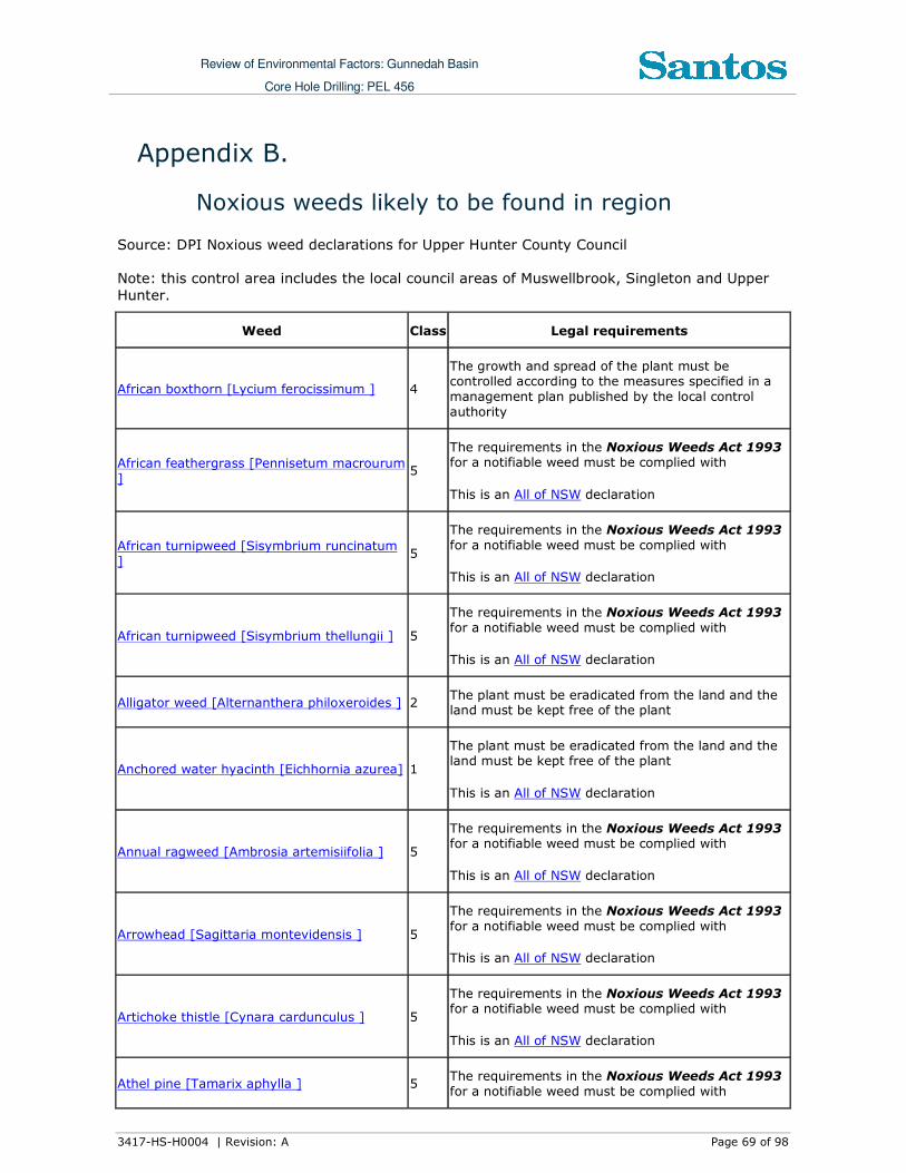
Review of Environmental Factors: Gunnedah Basin
Core Hole Drilling: PEL 456
3417-HS-H0004 | Revision: A Page 69 of 98
Appendix B.
Noxious weeds likely to be found in region
Source: DPI Noxious weed declarations for Upper Hunter County Council
Note: this control area includes the local council areas of Muswellbrook, Singleton and Upper Hunter.
Weed Class Legal requirements
African boxthorn [Lycium ferocissimum ] 4
The growth and spread of the plant must be controlled according to the measures specified in a
management plan published by the local control
authority
African feathergrass [Pennisetum macrourum
] 5
The requirements in the Noxious Weeds Act 1993 for a notifiable weed must be complied with
This is an All of NSW declaration
African turnipweed [Sisymbrium runcinatum
] 5
The requirements in the Noxious Weeds Act 1993
for a notifiable weed must be complied with
This is an All of NSW declaration
African turnipweed [Sisymbrium thellungii ] 5
The requirements in the Noxious Weeds Act 1993
for a notifiable weed must be complied with
This is an All of NSW declaration
Alligator weed [Alternanthera philoxeroides ] 2 The plant must be eradicated from the land and the land must be kept free of the plant
Anchored water hyacinth [Eichhornia azurea] 1
The plant must be eradicated from the land and the land must be kept free of the plant
This is an All of NSW declaration
Annual ragweed [Ambrosia artemisiifolia ] 5
The requirements in the Noxious Weeds Act 1993 for a notifiable weed must be complied with
This is an All of NSW declaration
Arrowhead [Sagittaria montevidensis ] 5
The requirements in the Noxious Weeds Act 1993
for a notifiable weed must be complied with
This is an All of NSW declaration
Artichoke thistle [Cynara cardunculus ] 5
The requirements in the Noxious Weeds Act 1993 for a notifiable weed must be complied with
This is an All of NSW declaration
Athel pine [Tamarix aphylla ] 5 The requirements in the Noxious Weeds Act 1993
for a notifiable weed must be complied with
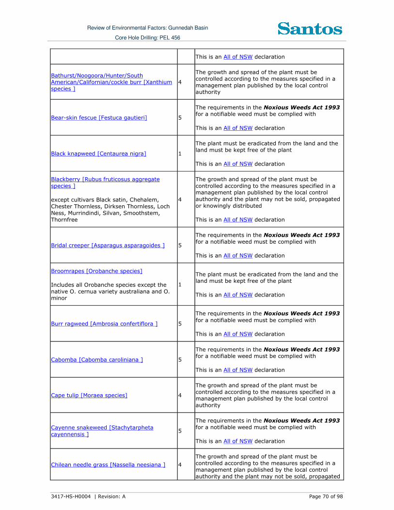
Review of Environmental Factors: Gunnedah Basin
Core Hole Drilling: PEL 456
3417-HS-H0004 | Revision: A Page 70 of 98
This is an All of NSW declaration
Bathurst/Noogoora/Hunter/South American/Californian/cockle burr [Xanthium
species ] 4
The growth and spread of the plant must be controlled according to the measures specified in a
management plan published by the local control authority
Bear-skin fescue [Festuca gautieri] 5
The requirements in the Noxious Weeds Act 1993 for a notifiable weed must be complied with
This is an All of NSW declaration
Black knapweed [Centaurea nigra] 1
The plant must be eradicated from the land and the land must be kept free of the plant
This is an All of NSW declaration
Blackberry [Rubus fruticosus aggregate
species ]
except cultivars Black satin, Chehalem,
Chester Thornless, Dirksen Thornless, Loch
Ness, Murrindindi, Silvan, Smoothstem,
Thornfree
4
The growth and spread of the plant must be
controlled according to the measures specified in a management plan published by the local control
authority and the plant may not be sold, propagated
or knowingly distributed
This is an All of NSW declaration
Bridal creeper [Asparagus asparagoides ] 5
The requirements in the Noxious Weeds Act 1993
for a notifiable weed must be complied with
This is an All of NSW declaration
Broomrapes [Orobanche species]
Includes all Orobanche species except the
native O. cernua variety australiana and O. minor
1
The plant must be eradicated from the land and the land must be kept free of the plant
This is an All of NSW declaration
Burr ragweed [Ambrosia confertiflora ] 5
The requirements in the Noxious Weeds Act 1993
for a notifiable weed must be complied with
This is an All of NSW declaration
Cabomba [Cabomba caroliniana ] 5
The requirements in the Noxious Weeds Act 1993 for a notifiable weed must be complied with
This is an All of NSW declaration
Cape tulip [Moraea species] 4
The growth and spread of the plant must be
controlled according to the measures specified in a management plan published by the local control
authority
Cayenne snakeweed [Stachytarpheta
cayennensis ] 5
The requirements in the Noxious Weeds Act 1993
for a notifiable weed must be complied with
This is an All of NSW declaration
Chilean needle grass [Nassella neesiana ] 4
The growth and spread of the plant must be
controlled according to the measures specified in a management plan published by the local control
authority and the plant may not be sold, propagated

Review of Environmental Factors: Gunnedah Basin
Core Hole Drilling: PEL 456
3417-HS-H0004 | Revision: A Page 71 of 98
or knowingly distributed
Chinese violet [Asystasia gangetica subspecies micrantha]
1
The plant must be eradicated from the land and the land must be kept free of the plant
This is an All of NSW declaration
Clockweed [Gaura parviflora] 5
The requirements in the Noxious Weeds Act 1993
for a notifiable weed must be complied with
This is an All of NSW declaration
Columbus grass [Sorghum x almum ] 4
The growth and spread of the plant must be
controlled according to the measures specified in a management plan published by the local control
authority
Corn sowthistle [Sonchus arvensis ] 5
The requirements in the Noxious Weeds Act 1993
for a notifiable weed must be complied with
This is an All of NSW declaration
Dodder [Cuscuta species]
Includes All Cuscuta species except the
native species C. australis, C. tasmanica and
C. victoriana
5
The requirements in the Noxious Weeds Act 1993 for a notifiable weed must be complied with
This is an All of NSW declaration
East Indian hygrophila [Hygrophila polysperma]
1
The plant must be eradicated from the land and the
land must be kept free of the plant
This is an All of NSW declaration
English broom [Cytisus scoparius ] See Scotch broom
Espartillo [Achnatherum brachychaetum ] 5
The requirements in the Noxious Weeds Act 1993
for a notifiable weed must be complied with
This is an All of NSW declaration
Eurasian water milfoil [Myriophyllum spicatum]
1
The plant must be eradicated from the land and the
land must be kept free of the plant
This is an All of NSW declaration
Fine-bristled burr grass [Cenchrus brownii ] 5
The requirements in the Noxious Weeds Act 1993
for a notifiable weed must be complied with
This is an All of NSW declaration
Fountain grass [Pennisetum setaceum ] 5
The requirements in the Noxious Weeds Act 1993
for a notifiable weed must be complied with
This is an All of NSW declaration
Gallon's curse [Cenchrus biflorus ] 5
The requirements in the Noxious Weeds Act 1993
for a notifiable weed must be complied with
This is an All of NSW declaration

Review of Environmental Factors: Gunnedah Basin
Core Hole Drilling: PEL 456
3417-HS-H0004 | Revision: A Page 72 of 98
Galvanised burr [Sclerolaena birchii] 4 The plant must be controlled where it impacts on
normal agricultural practices including cropping and pasture management
Giant Parramatta grass [Sporobolus fertilis ] 3 The plant must be fully and continuously suppressed and destroyed
Glaucous starthistle [Carthamus glaucus ] 5
The requirements in the Noxious Weeds Act 1993 for a notifiable weed must be complied with
This is an All of NSW declaration
Golden dodder [Cuscuta campestris] 4
The growth and spread of the plant must be controlled according to the measures specified in a
management plan published by the local control
authority
Golden thistle [Scolymus hispanicus ] 5
The requirements in the Noxious Weeds Act 1993 for a notifiable weed must be complied with
This is an All of NSW declaration
Green cestrum [Cestrum parqui ] 3 The plant must be fully and continuously suppressed
and destroyed
Harrisia cactus [Harrisia species ] 4
The growth and spread of the plant must be
controlled according to the measures specified in a
management plan published by the local control
authority and the plant may not be sold, propagated or knowingly distributed
This is an All of NSW declaration
Hawkweed [Hieracium species] 1
The plant must be eradicated from the land and the land must be kept free of the plant
This is an All of NSW declaration
Hemlock [Conium maculatum ] 4
The growth and spread of the plant must be
controlled according to the measures specified in a management plan published by the local control
authority
Horsetail [Equisetum species] 1
The plant must be eradicated from the land and the
land must be kept free of the plant
This is an All of NSW declaration
Hygrophila [Hygrophila costata ] 2 The plant must be eradicated from the land and the
land must be kept free of the plant
Hymenachne [Hymenachne amplexicaulis] 1
The plant must be eradicated from the land and the
land must be kept free of the plant
This is an All of NSW declaration
Italian bugloss [Echium species ] See Paterson's curse, Vipers bugloss, Italian bugloss
Johnson grass [Sorghum halepense ] 4 The growth and spread of the plant must be controlled according to the measures specified in a

Review of Environmental Factors: Gunnedah Basin
Core Hole Drilling: PEL 456
3417-HS-H0004 | Revision: A Page 73 of 98
management plan published by the local control
authority
Karoo thorn [Acacia karroo] 1
The plant must be eradicated from the land and the
land must be kept free of the plant
This is an All of NSW declaration
1. Kochia [Bassia scoparia]
except Bassia scoparia subspecies trichophylla
1
except B.scoparia subspecies trichophylla
The plant must be eradicated from the land and the
land must be kept free of the plant
This is an All of NSW declaration
Lagarosiphon [Lagarosiphon major] 1
The plant must be eradicated from the land and the
land must be kept free of the plant
This is an All of NSW declaration
Lantana [Lantana species ] 5
The requirements in the Noxious Weeds Act 1993 for a notifiable weed must be complied with
This is an All of NSW declaration
Leafy elodea [Egeria densa] 5
The requirements in the Noxious Weeds Act 1993
for a notifiable weed must be complied with
This is an All of NSW declaration
Long-leaf willow primrose [Ludwigia longifolia ]
5
The requirements in the Noxious Weeds Act 1993
for a notifiable weed must be complied with
This is an All of NSW declaration
Mexican feather grass [Nassella tenuissima ] 1
The plant must be eradicated from the land and the land must be kept free of the plant
This is an All of NSW declaration
Mexican poppy [Argemone mexicana ] 5
The requirements in the Noxious Weeds Act 1993
for a notifiable weed must be complied with
This is an All of NSW declaration
Miconia [Miconia species] 1
The plant must be eradicated from the land and the
land must be kept free of the plant
This is an All of NSW declaration
Mimosa [Mimosa pigra] 1
The plant must be eradicated from the land and the land must be kept free of the plant
This is an All of NSW declaration
Mintweed [Salvia reflexa ] 4
The growth and spread of the plant must be
controlled according to the measures specified in a management plan published by the local control
authority

Review of Environmental Factors: Gunnedah Basin
Core Hole Drilling: PEL 456
3417-HS-H0004 | Revision: A Page 74 of 98
Mossman River grass [Cenchrus echinatus ] 5
The requirements in the Noxious Weeds Act 1993
for a notifiable weed must be complied with
This is an All of NSW declaration
Mother-of-millions [Bryophyllum species and
hybrids ] 3
The plant must be fully and continuously suppressed and destroyed and the plant may not be sold,
propagated or knowingly distributed
Nodding thistle [Carduus nutans ] 4
The growth and spread of the plant must be
controlled according to the measures specified in a management plan published by the local control
authority
Noogoora burr [Xanthium species ] See Bathurst/Noogoora/Hunter/South
American/Californian/cockle burr
Onion grass [Romulea species]
Includes all Romulea species and varieties
except R. rosea var. australis
5
The requirements in the Noxious Weeds Act 1993 for a notifiable weed must be complied with
This is an All of NSW declaration
Oxalis [Oxalis species and varieties]
Includes all Oxalis species and varieties
except the native species O. chnoodes, O.
exilis, O. perennans, O. radicosa, O. rubens, and O. thompsoniae
5
The requirements in the Noxious Weeds Act 1993 for a notifiable weed must be complied with
This is an All of NSW declaration
Pampas grass [Cortaderia species ] 4
The growth and spread of the plant must be controlled according to the measures specified in a
management plan published by the local control authority
Parthenium weed [Parthenium
hysterophorus] 1
The plant must be eradicated from the land and the
land must be kept free of the plant
This is an All of NSW declaration
Paterson's curse, Vipers bugloss, Italian
bugloss [Echium species ] 4
The growth and spread of the plant must be controlled according to the measures specified in a
management plan published by the local control authority
Pond apple [Annona glabra] 1
The plant must be eradicated from the land and the land must be kept free of the plant
This is an All of NSW declaration
Prickly acacia [Acacia nilotica] 1
The plant must be eradicated from the land and the
land must be kept free of the plant
This is an All of NSW declaration
Prickly pear [Cylindropuntia species ] 4
The growth and spread of the plant must be
controlled according to the measures specified in a management plan published by the local control
authority and the plant may not be sold, propagated or knowingly distributed

Review of Environmental Factors: Gunnedah Basin
Core Hole Drilling: PEL 456
3417-HS-H0004 | Revision: A Page 75 of 98
This is an All of NSW declaration
Prickly pear [Opuntia species except O. ficus-indica ]
4
The growth and spread of the plant must be controlled according to the measures specified in a
management plan published by the local control authority and the plant may not be sold, propagated
or knowingly distributed
This is an All of NSW declaration
Red rice [Oryza rufipogon ] 5
The requirements in the Noxious Weeds Act 1993 for a notifiable weed must be complied with
This is an All of NSW declaration
Rhus tree [Toxicodendron succedaneum] 4
The growth and spread of the plant must be
controlled according to the measures specified in a management plan published by the local control
authority
This is an All of NSW declaration
Rubbervine [Cryptostegia grandiflora] 1
The plant must be eradicated from the land and the
land must be kept free of the plant
This is an All of NSW declaration
Sagittaria [Sagittaria platyphylla ] 5
The requirements in the Noxious Weeds Act 1993 for a notifiable weed must be complied with
This is an All of NSW declaration
Salvinia [Salvinia molesta ] 2 The plant must be eradicated from the land and the land must be kept free of the plant
Sand oat [Avena strigosa ] 5
The requirements in the Noxious Weeds Act 1993 for a notifiable weed must be complied with
This is an All of NSW declaration
Scotch broom [Cytisus scoparius ] 4
The growth and spread of the plant must be
controlled according to the measures specified in a
management plan published by the local control
authority
Senegal tea plant [Gymnocoronis
spilanthoides] 1
The plant must be eradicated from the land and the land must be kept free of the plant
This is an All of NSW declaration
Serrated tussock [Nassella trichotoma ] 3 The plant must be fully and continuously suppressed
and destroyed and the plant may not be sold, propagated or knowingly distributed
Siam weed [Chromolaena odorata] 1
The plant must be eradicated from the land and the land must be kept free of the plant
This is an All of NSW declaration

Review of Environmental Factors: Gunnedah Basin
Core Hole Drilling: PEL 456
3417-HS-H0004 | Revision: A Page 76 of 98
Silver-leaf nightshade [Solanum elaeagnifolium ]
4
The growth and spread of the plant must be
controlled according to the measures specified in a management plan published by the local control
authority
Smooth-stemmed turnip [Brassica barrelieri
subspecies oxyrrhina] 5
The requirements in the Noxious Weeds Act 1993
for a notifiable weed must be complied with
This is an All of NSW declaration
Soldier thistle [Picnomon acarna ] 5
The requirements in the Noxious Weeds Act 1993 for a notifiable weed must be complied with
This is an All of NSW declaration
Spiny burrgrass [Cenchrus incertus ] 4
The growth and spread of the plant must be
controlled according to the measures specified in a management plan published by the local control
authority and the plant may not be sold, propagated
or knowingly distributed
Spiny burrgrass [Cenchrus longispinus ] 4
The growth and spread of the plant must be
controlled according to the measures specified in a management plan published by the local control
authority and the plant may not be sold, propagated
or knowingly distributed
Spotted knapweed [Centaurea maculosa] 1
The plant must be eradicated from the land and the land must be kept free of the plant
This is an All of NSW declaration
St. John's wort [Hypericum perforatum ] 4
The growth and spread of the plant must be
controlled according to the measures specified in a management plan published by the local control
authority
Star thistle [Centaurea calcitrapa ] 4
The growth and spread of the plant must be
controlled according to the measures specified in a management plan published by the local control
authority
Sweet briar [Rosa rubiginosa ] 4
The growth and spread of the plant must be controlled according to the measures specified in a
management plan published by the local control authority
Texas blueweed [Helianthus ciliaris ] 5
The requirements in the Noxious Weeds Act 1993 for a notifiable weed must be complied with
This is an All of NSW declaration
Tree-of-heaven [Ailanthus altissima ] 4
The growth and spread of the plant must be
controlled according to the measures specified in a management plan published by the local control
authority
Water caltrop [Trapa species] 1 The plant must be eradicated from the land and the
land must be kept free of the plant

Review of Environmental Factors: Gunnedah Basin
Core Hole Drilling: PEL 456
3417-HS-H0004 | Revision: A Page 77 of 98
This is an All of NSW declaration
Water hyacinth [Eichhornia crassipes ] 2 The plant must be eradicated from the land and the land must be kept free of the plant
Water lettuce [Pistia stratiotes] 1
The plant must be eradicated from the land and the land must be kept free of the plant
This is an All of NSW declaration
Water soldier [Stratiotes aloides] 1
The plant must be eradicated from the land and the land must be kept free of the plant
This is an All of NSW declaration
Willows [Salix species]
Includes all Salix species except S. babylonica, S. x reichardtii, S. x calodendron
5
The requirements in the Noxious Weeds Act 1993
for a notifiable weed must be complied with
This is an All of NSW declaration
Witchweed [Striga species]
Includes all Striga species except native
species and Striga parviflora
1
The plant must be eradicated from the land and the land must be kept free of the plant
This is an All of NSW declaration
Yellow burrhead [Limnocharis flava] 1
The plant must be eradicated from the land and the land must be kept free of the plant
This is an All of NSW declaration
Yellow nutgrass [Cyperus esculentus ] 5
The requirements in the Noxious Weeds Act 1993
for a notifiable weed must be complied with
This is an All of NSW declaration

Review of Environmental Factors: Gunnedah Basin
Core Hole Drilling: PEL 456
3417-HS-H0004 | Revision: A Page 78 of 98
Appendix C.
Threatened Fauna Species in Upper Hunter LGA
Source: DECC, NSW NPWS Atlas of Threatened Species database.
Species Common
Name
Status Distribution/habitat/foraging/breeding
Amphibia
Litoria booroolongensis
Booroolong Frog
Endangered The Booroolong Frog is an amphibious frog known only from the tablelands and slopes of
New South Wales. It typically inhabits rocky
western-flowing creeks and their headwaters,
although a small number of animals have also
been recorded in eastern-flowing streams.
It is a seasonal breeder which is found on or
under rocks and debris of suitable streams. Although nocturnal, this species can also be
found on rocks in or near the water during daylight hours. Surveys of western-flowing
streams from the Northern Tablelands conducted over the past 15 years have failed to locate these
frogs in all but one locality, although historical records indicate they were once widespread. It is
suspected that the species is regionally extinct in
all but the south of this area.
Litoria daviesae Davies' Tree Frog
Vulnerable Davies Tree Frog occurs along the eastern edge of the New England Tablelands from the Hunter
Valley to south of the Hastings River in NSW in the headwaters of coastal rivers.
Davies Tree Frog occurs in permanently flowing
streams above 400 m elevation. Habitat includes
streamside vegetation such as rainforest, moist and dry eucalypt forest or heath and tea tree
with tussocks and ferns along streams. Breeding occurs in summer, and possibly in spring.
Litoria subglandulosa
Glandular Frog Vulnerable The headwaters of coastal rivers in a narrow band along the eastern edge of the New England
Tablelands from the Hastings River to south-east Queensland.
Glandular Frogs may be found along streams in rainforest, moist and dry eucalypt forest or in
subalpine swamps. Breeding occurs in summer,
and possibly in spring.
Aves
Callocephalon fimbriatum
Gang-gang Cockatoo
Vulnerable The Gang-gang Cockatoo is distributed from southern Victoria through south- and central-
eastern New South Wales. In New South Wales,
the Gang-gang Cockatoo is distributed from the south-east coast to the Hunter region, and inland
to the Central Tablelands and south-west slopes. It occurs regularly in the Australian Capital
Territory. It is rare at the extremities of its range, with isolated records known from as far
north as Coffs Harbour and as far west as Mudgee.
In summer, generally found in tall mountain

Review of Environmental Factors: Gunnedah Basin
Core Hole Drilling: PEL 456
3417-HS-H0004 | Revision: A Page 79 of 98
Species Common Name
Status Distribution/habitat/foraging/breeding
forests and woodlands, particularly in heavily timbered and mature wet sclerophyll forests. In
winter, may occur at lower altitudes in drier more open eucalypt forests and woodlands, and often
found in urban areas.
May also occur in sub-alpine Snow Gum Eucalyptus pauciflora woodland and occasionally
in temperate rainforests.
Move to lower altitudes in winter, preferring
more open eucalypt forests and woodlands, particularly in box-ironbark assemblages, or in
dry forest in coastal areas. Favours old growth attributes for nesting and roosting.
Calyptorhynchus Iathami
Glossy Black Cockatoo
Vulnerable The species is uncommon although widespread throughout suitable forest and woodland
habitats, from the central Queensland coast to East Gippsland in Victoria, and inland to the
southern tablelands and central western plains of NSW, with a small population in the Riverina. An
isolated population exists on Kangaroo Island, South Australia.
Inhabits open forest and woodlands of the coast and the Great Dividing Range up to 1000 m in
which stands of she-oak species, particularly Black She-oak (Allocasuarina littoralis), Forest
She-oak (A. torulosa) or Drooping She-oak (A. verticillata) occur.
Climacteris picumnus
Brown Treecreeper
Vulnerable The Brown Treecreeper is endemic to eastern Australia and occurs in eucalypt forests and
woodlands of inland plains and slopes of the Great Dividing Range. It is less commonly found
on coastal plains and ranges.
The Brown Treecreeper climbs up the trunks and
branches of trees in search of food. It probes into cavities and under loose bark with its long
downward curving bill. In this way it searches for insects and their larvae. The most favoured
insects are ants. Some feeding also takes place
on the ground on fallen logs. Sometimes, birds can be seen diving on ground-dwelling prey from
a perch in a tree. Feeding normally takes place in pairs or small groups.
Brown Treecreepers breed from June to January each year. During this season, pairs often have
two broods of two to three young. The nest is a collection of grasses, feathers and other soft
material, placed in a suitable tree hollow or
similar site.
Climacteris picumnus
victoriae
Brown Treecreeper
(eastern subspecies)
Vulnerable The eastern subspecies lives in eastern NSW in eucalypt woodlands through central NSW and in
coastal areas with drier open woodlands such as the Snowy River Valley, Cumberland Plains,
Hunter Valley and parts of the Richmond and Clarence Valleys.
The population density of this subspecies has been greatly reduced over much of its range,
with major declines recorded in central NSW and the northern and southern tablelands. Declines

Review of Environmental Factors: Gunnedah Basin
Core Hole Drilling: PEL 456
3417-HS-H0004 | Revision: A Page 80 of 98
Species Common Name
Status Distribution/habitat/foraging/breeding
have occurred in remnant vegetation fragments smaller than 300 hectares that have been
isolated or fragmented for more than 50 years.
Daphoenositta
chrysoptera
Varied Sittella Vulnerable No information available in the Atlas.
Glossopsitta
pusilla
Little Lorikeet Vulnerable No information available in the Atlas.
Grantiella Picta Painted honey-eater
Vulnerable The Painted Honeyeater is nomadic and occurs at low densities throughout its range. The greatest
concentrations of the bird and almost all breeding occurs on the inland slopes of the Great
Dividing Range in NSW, Victoria and southern
Queensland. During the winter it is more likely to
be found in the north of its distribution. Inhabits
Boree, Brigalow and Box-Gum Woodlands and Box-Ironbark Forests. A specialist feeder on the
fruits of mistletoes growing on woodland eucalypts and acacias. Prefers mistletoes of the
genus Amyema. Insects and nectar from
mistletoe or eucalypts are occasionally eaten.
Nest from spring to autumn in a small, delicate nest hanging within the outer canopy of drooping
eucalypts, she-oak, paperbark or mistletoe branches.
Hieraaetus
morphnoides
Little Eagle Vulnerable No information available in the Atlas.
Lathamus
discolor
Swift Parrot Endangered The Swift Parrot is small parrot about 25 cm
long. It is bright green with red around the bill, throat and forehead. Breeds in Tasmania during
spring and summer, migrating in the autumn and
winter months to south-eastern Australia from Victoria and the eastern parts of South Australia
to south-east Queensland.
In NSW mostly occurs on the coast and south
west slopes. Commonly used lerp infested trees include Grey Box E. microcarpa, Grey Box E.
moluccana and Blackbutt E. pilularis.
Return to home foraging sites on a cyclic basis
depending on food availability. Following winter they return to Tasmania where they breed from
September to January, nesting in old trees with hollows and feeding in forests dominated by
Tasmanian Blue Gum E. globulus. Migrates to the
Australian south-east mainland between March
and October
Leipoa ocellata Malleefowl Endangered Predominantly inhabit mallee communities,
preferring the tall, dense and floristically-rich mallee found in higher rainfall (300-450 mm
mean annual rainfall) areas. Less frequently
found in other eucalypt woodlands (e.g., mixed
Western Grey Box and Yellow Gum or Bimble Box, Ironbark-Callitris Pine, Callitris Pine, Mulga
(Acacia aneura), and Gidgee(A. cambagei).
Falsistrellus
tasmaniensis
Eastern False
Pipistrelle
Vulnerable The Eastern False Pipistrelle is found on the
south-east coast and ranges of Australia, from
southern Queensland to Victoria and Tasmania.
Prefers moist habitats, with trees taller than 20

Review of Environmental Factors: Gunnedah Basin
Core Hole Drilling: PEL 456
3417-HS-H0004 | Revision: A Page 81 of 98
Species Common Name
Status Distribution/habitat/foraging/breeding
m. Generally roosts in eucalypt hollows, but has also been found under loose bark on trees or in
buildings. Hunts beetles, moths, weevils and other flying insects above or just below the tree
canopy. Hibernates in winter. Females are
pregnant in late spring to early summer.
Melanodryas cucullata
Hooded Robin Vulnerable No information available in the Atlas.
Melanodryas cucullata
cucullata
Hooded Robin (south eastern
form)
Vulnerable The Hooded Robin is common in few places, and rarely found on the coast. It is considered a
sedentary species, but local seasonal movements are possible. The south-eastern form is found
from Brisbane to Adelaide throughout much of
inland NSW, with the exception of the north-
west. The species is widespread, found across Australia, except for the driest deserts and the
wetter coastal areas - northern and eastern coastal Queensland and Tasmania.
Prefers lightly wooded country, usually open eucalypt woodland, acacia scrub and mallee,
often in or near clearings or open areas. Requires structurally diverse habitats featuring mature
eucalypts, saplings, some small shrubs and a
ground layer of moderately tall native grasses.
Melithreptus gularis gularis
Black-chinned Honeyeater
(eastern subspecies)
Vulnerable The subspecies is widespread, from the tablelands and western slopes of the Great
Dividing Range to the north-west and central-west plains and the Riverina. It is rarely recorded
east of the Great Dividing Range, although
regularly observed from the Richmond River district. It has also been recorded at a few
scattered sites in the Hunter, Central Coast and
Illawarra regions. Occupies mostly upper levels
of drier open forests or woodlands dominated by box and ironbark eucalypts, especially Mugga
Ironbark (Eucalyptus sideroxylon), White Box (Eucalyptus albens), Grey Box (Eucalyptus
microcarpa), Yellow Box (Eucalyptus melliodora) and Forest Red Gum (Eucalyptus tereticornis).
Also inhabits open forests of smooth-barked gums, stringybarks, ironbarks and tea-trees. A
gregarious species usually seen in pairs and small groups of up to 12 birds. Feeding territories
are large making the species locally nomadic. Recent studies have found that the Black-chinned
Honeyeater tends to occur in the largest
woodland patches in the landscape as birds forage over large home ranges of at least 5
hectares.
Neophema pulchella
Turquoise Parrot
Vulnerable The Turquoise Parrot’s range extends from southern Queensland through to northern
Victoria, from the coastal plains to the western slopes of the Great Dividing Range. Lives on the
edges of eucalypt woodland adjoining clearings,
timbered ridges and creeks in farmland. Usually seen in pairs or small, possibly family, groups
and have also been reported in flocks of up to thirty individuals. Prefers to feed in the shade of
a tree and spends most of the day on the ground

Review of Environmental Factors: Gunnedah Basin
Core Hole Drilling: PEL 456
3417-HS-H0004 | Revision: A Page 82 of 98
Species Common Name
Status Distribution/habitat/foraging/breeding
searching for the seeds or grasses and herbaceous plants, or browsing on vegetable
matter.
Forages quietly and may be quite tolerant of
disturbance. However, if flushed it will fly to a
nearby tree and then return to the ground to browse as soon as the danger has passed.
Nests in tree hollows, logs or posts, from August to December. It lays four or five white, rounded
eggs on a nest of decayed wood dust.
Ninox connivens Barking Owl Vulnerable The Barking Owl is found throughout Australia except for the central arid regions and Tasmania.
It is quite common in parts of northern Australia,
but is generally considered uncommon in southern Australia. It has declined across much
of its distribution across NSW and now occurs only sparsely. It is most frequently recorded on
the western slopes and plains. It is rarely recorded in the far west or in coastal and
escarpment forests.
Inhabits eucalypt woodland, open forest, swamp
woodlands and, especially in inland areas, timber along watercourses. Denser vegetation is used
occasionally for roosting. During the day they roost along creek lines, usually in tall
understorey trees with dense foliage such as Acacia and Casuarina species, or the dense
clumps of canopy leaves in large Eucalypts.
Ninox strenua Powerful Owl Vulnerable The Powerful Owl is endemic to eastern and
south-eastern Australia, mainly on the coastal side of the Great Dividing Range from Mackay to
south-western Victoria. In NSW, it is widely distributed throughout the eastern forests from
the coast inland to tablelands, with scattered, mostly historical records on the western slopes
and plains. Now uncommon throughout its range where it occurs at low densities.
The Powerful Owl inhabits a range of vegetation
types, from woodland and open sclerophyll forest to tall open wet forest and rainforest.
The Powerful Owl requires large tracts of forest or woodland habitat but can occur in fragmented
landscapes as well. The species breeds and hunts in open or closed sclerophyll forest or woodlands
and occasionally hunts in open habitats. It roosts by day in dense vegetation comprising species
such as Turpentine Syncarpia glomulifera, Black
She-oak Allocasuarina littoralis, Blackwood
Acacia melanoxylon, Rough-barked Apple Angorphora floribunda, Cherry Ballart Exocarpus
cupressiformis and a number of eucalypt species.
The main prey items are medium-sized arboreal
marsupials, particularly the Greater Glider,
Common Ringtail Possum and Sugar Glider.
There may be marked regional differences in the
prey taken by Powerful Owls. For example in southern NSW, Ringtail Possum make up the bulk
of prey in the lowland or coastal habitat. At
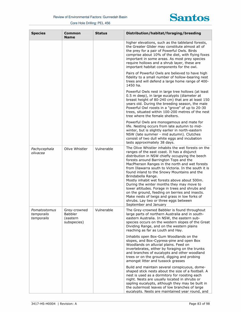
Review of Environmental Factors: Gunnedah Basin
Core Hole Drilling: PEL 456
3417-HS-H0004 | Revision: A Page 83 of 98
Species Common Name
Status Distribution/habitat/foraging/breeding
higher elevations, such as the tableland forests, the Greater Glider may constitute almost all of
the prey for a pair of Powerful Owls. Birds comprise about 10% of the diet, with flying foxes
important in some areas. As most prey species
require hollows and a shrub layer, these are important habitat components for the owl.
Pairs of Powerful Owls are believed to have high fidelity to a small number of hollow-bearing nest
trees and will defend a large home range of 400-1450 ha.
Powerful Owls nest in large tree hollows (at least 0.5 m deep), in large eucalypts (diameter at
breast height of 80-240 cm) that are at least 150 years old. During the breeding season, the male
Powerful Owl roosts in a "grove" of up to 20-30
trees, situated within 100-200 metres of the nest
tree where the female shelters.
Powerful Owls are monogamous and mate for
life. Nesting occurs from late autumn to mid-winter, but is slightly earlier in north-eastern
NSW (late summer - mid autumn). Clutches
consist of two dull white eggs and incubation lasts approximately 38 days.
Pachycephala
olivacea
Olive Whistler Vulnerable The Olive Whistler inhabits the wet forests on the
ranges of the east coast. It has a disjunct
distribution in NSW chiefly occupying the beech forests around Barrington Tops and the
MacPherson Ranges in the north and wet forests
from Illawarra south to Victoria. In the south it is
found inland to the Snowy Mountains and the Brindabella Range.
Mostly inhabit wet forests above about 500m.
During the winter months they may move to
lower altitudes. Forage in trees and shrubs and
on the ground, feeding on berries and insects. Make nests of twigs and grass in low forks of
shrubs. Lay two or three eggs between September and January
Pomatostomus temporalis
temporalis
Grey-crowned Babbler
(eastern subspecies)
Vulnerable The Grey-crowned Babbler is found throughout large parts of northern Australia and in south-
eastern Australia. In NSW, the eastern sub-species occurs on the western slopes of the Great
Dividing Range, and on the western plains
reaching as far as Louth and Hay.
Inhabits open Box-Gum Woodlands on the
slopes, and Box-Cypress-pine and open Box Woodlands on alluvial plains. Feed on
invertebrates, either by foraging on the trunks and branches of eucalypts and other woodland
trees or on the ground, digging and probing
amongst litter and tussock grasses
Build and maintain several conspicuous, dome-shaped stick nests about the size of a football. A
nest is used as a dormitory for roosting each night. Nests are usually located in shrubs or
sapling eucalypts, although they may be built in the outermost leaves of low branches of large
eucalypts. Nests are maintained year round, and

Review of Environmental Factors: Gunnedah Basin
Core Hole Drilling: PEL 456
3417-HS-H0004 | Revision: A Page 84 of 98
Species Common Name
Status Distribution/habitat/foraging/breeding
old nests are often dismantled to build new ones.
Pyrrholaemus
saggitatus
Speckled
Warbler
Vulnerable The Speckled Warbler has a patchy distribution
throughout south-eastern Queensland, the eastern half of NSW and into Victoria, as far west
as the Grampians. There has been a decline in population density throughout its range, with the
decline exceeding 40% where no vegetation remnants larger than 100ha survive.
The Speckled Warbler lives in a wide range of Eucalyptus dominated communities that have a
grassy understorey, often on rocky ridges or in gullies. Typical habitat would include scattered
native tussock grasses, a sparse shrub layer,
some eucalypt regrowth and an open canopy. Large, relatively undisturbed remnants are
required for the species to persist in an area.
The diet consists of seeds and insects, with most
foraging taking place on the ground around tussocks and under bushes and trees. Pairs are
sedentary and occupy a breeding territory of about ten hectares, with a slightly larger home-
range when not breeding.
The rounded, domed, roughly built nest of dry
grass and strips of bark is located in a slight hollow in the ground or the base of a low dense
plant, often among fallen branches and other litter. A side entrance allows the bird to walk
directly inside.
Stagonopleura
guttata
Diamond
Firetail
Vulnerable The Diamond Firetail is widely distributed in
NSW, with a concentration of records from the Northern, Central and Southern Tablelands, the
Northern, Central and South Western Slopes and the North West Plains and Riverina. Not
commonly found in coastal districts, though there are records from near Sydney, the Hunter Valley
and the Bega Valley. This species has a scattered distribution over the rest of NSW. Also found in
the Australian Capital Territory, Queensland,
Victoria and South Australia.
Found in grassy eucalypt woodlands, including
Box-Gum Woodlands and Snow Gum Eucalyptus pauciflora Woodlands. Also occurs in open forest,
mallee, natural temperate grassland, and in secondary grassland derived from other
communities. Often found in riparian areas (rivers and creeks), and sometimes in lightly
wooded farmland.
Feeds exclusively on the ground, on ripe and
partly-ripe grass and herb seeds and green leaves, and on insects (especially in the breeding
season).
Tyto
novaehollandiae
Masked Owl Vulnerable Extends from the coast where it is most
abundant to the western plains. Overall records for this species fall within approximately 90% of
NSW, excluding the most arid north-western corner. Lives in dry eucalypt forests and
woodlands from sea level to 1100 m.
A forest owl, but often hunts along the edges of

Review of Environmental Factors: Gunnedah Basin
Core Hole Drilling: PEL 456
3417-HS-H0004 | Revision: A Page 85 of 98
Species Common Name
Status Distribution/habitat/foraging/breeding
forests, including roadsides. The typical diet consists of tree-dwelling and ground mammals,
especially rats. Pairs have a large home-range of 500 to 1000 hectares. Roosts and breeds in
moist eucalypt forested gullies, using large tree
hollows or sometimes caves for nesting.
Tyto tenebricosa Sooty Owl Vulnerable Occupies the easternmost one-eighth of NSW, occurring on the coast, coastal escarpment and
eastern tablelands. There is no seasonal variation in its distribution.
Occurs in rainforest, including dry rainforest, subtropical and warm temperate rainforest, as
well as moist eucalypt forests.
Xanthomyza
phyrygia
Regent
Honeyeater
Endangered The Regent Honeyeater mainly inhabits
temperate woodlands and open forests of the inland slopes of south-east Australia. Birds are
also found in drier coastal woodlands and forests in some years. There are only three known key
breeding regions remaining: north-east Victoria (Chiltern-Albury), and in NSW at Capertee Valley
and the Bundarra-Barraba region. In NSW the distribution is very patchy and mainly confined to
the two main breeding areas and surrounding
fragmented woodlands. In some years non-breeding flocks converge on flowering coastal
woodlands and forests.
The Regent Honeyeater is a flagship threatened
woodland bird whose conservation will benefit a large suite of other threatened and declining
woodland fauna. The species inhabits dry open forest and woodland, particularly Box-Ironbark
woodland, and riparian forests of River Sheoak. Regent Honeyeaters inhabit woodlands that
support a significantly high abundance and species richness of bird species.
Mammalian
Chalinolobus dwyeri
Large-eared Pied Bat
Vulnerable Found mainly in areas with extensive cliffs and caves, from Rockhampton in Queensland south
to Bungonia in the NSW Southern Highlands. It is generally rare with a very patchy distribution in
NSW. There are scattered records from the New
England Tablelands and North West Slopes. Roosts in caves (near their entrances), crevices
in cliffs, old mine workings and in the disused, bottle-shaped mud nests of the Fairy Martin
(Hirundo ariel), frequenting low to mid-elevation dry open forest and woodland close to these
features. Females have been recorded raising young in maternity roosts (c. 20-40 females)
from November through to January in roof domes in sandstone caves. They remain loyal to the
same cave over many years.
Found in well-timbered areas containing gullies.
Dasyurus maculates
Spotted-tailed Quoll
Vulnerable Recorded across a range of habitat types, including rainforest, open forest, woodland,
coastal heath and inland riparian forest, from the sub-alpine zone to the coastline. Individual
animals use hollow-bearing trees, fallen logs, small caves, rock crevices, boulder fields and
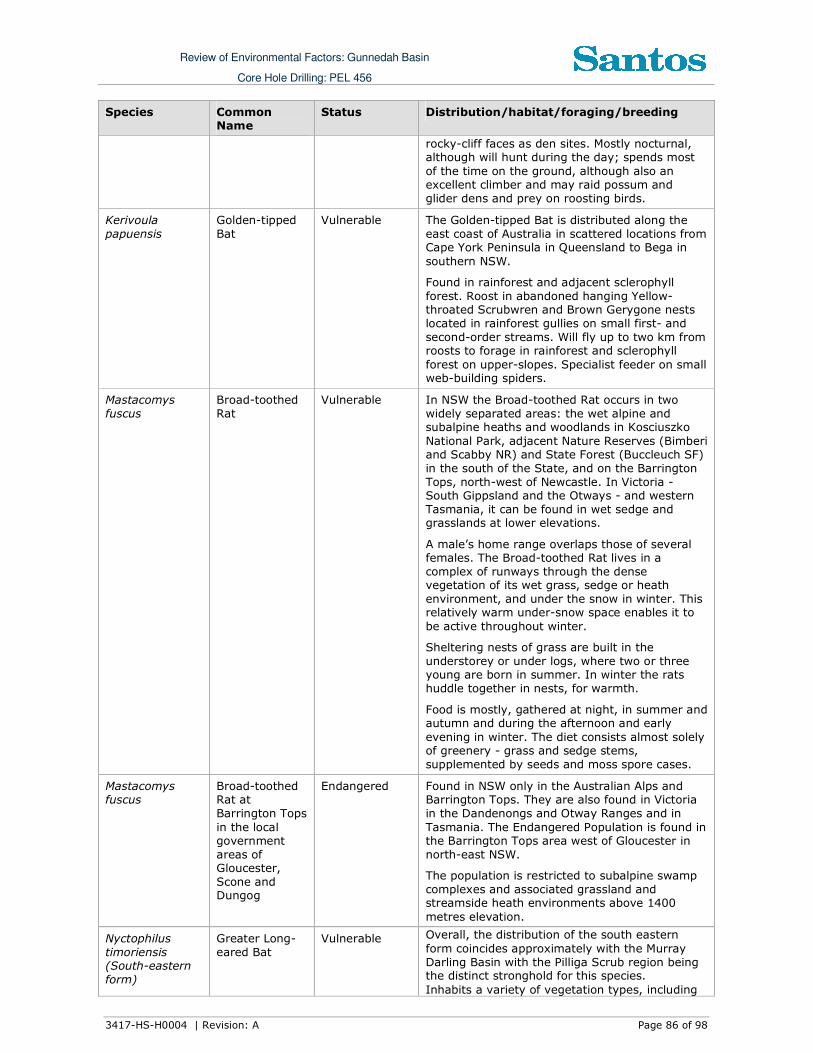
Review of Environmental Factors: Gunnedah Basin
Core Hole Drilling: PEL 456
3417-HS-H0004 | Revision: A Page 86 of 98
Species Common Name
Status Distribution/habitat/foraging/breeding
rocky-cliff faces as den sites. Mostly nocturnal, although will hunt during the day; spends most
of the time on the ground, although also an excellent climber and may raid possum and
glider dens and prey on roosting birds.
Kerivoula
papuensis
Golden-tipped
Bat
Vulnerable The Golden-tipped Bat is distributed along the
east coast of Australia in scattered locations from Cape York Peninsula in Queensland to Bega in
southern NSW.
Found in rainforest and adjacent sclerophyll
forest. Roost in abandoned hanging Yellow-throated Scrubwren and Brown Gerygone nests
located in rainforest gullies on small first- and
second-order streams. Will fly up to two km from roosts to forage in rainforest and sclerophyll
forest on upper-slopes. Specialist feeder on small web-building spiders.
Mastacomys
fuscus
Broad-toothed
Rat
Vulnerable In NSW the Broad-toothed Rat occurs in two
widely separated areas: the wet alpine and subalpine heaths and woodlands in Kosciuszko
National Park, adjacent Nature Reserves (Bimberi and Scabby NR) and State Forest (Buccleuch SF)
in the south of the State, and on the Barrington
Tops, north-west of Newcastle. In Victoria - South Gippsland and the Otways - and western
Tasmania, it can be found in wet sedge and grasslands at lower elevations.
A male’s home range overlaps those of several females. The Broad-toothed Rat lives in a
complex of runways through the dense vegetation of its wet grass, sedge or heath
environment, and under the snow in winter. This relatively warm under-snow space enables it to
be active throughout winter.
Sheltering nests of grass are built in the
understorey or under logs, where two or three young are born in summer. In winter the rats
huddle together in nests, for warmth.
Food is mostly, gathered at night, in summer and autumn and during the afternoon and early
evening in winter. The diet consists almost solely of greenery - grass and sedge stems,
supplemented by seeds and moss spore cases.
Mastacomys fuscus
Broad-toothed Rat at
Barrington Tops
in the local government
areas of Gloucester,
Scone and Dungog
Endangered Found in NSW only in the Australian Alps and Barrington Tops. They are also found in Victoria
in the Dandenongs and Otway Ranges and in
Tasmania. The Endangered Population is found in the Barrington Tops area west of Gloucester in
north-east NSW.
The population is restricted to subalpine swamp
complexes and associated grassland and streamside heath environments above 1400
metres elevation.
Nyctophilus
timoriensis (South-eastern
form)
Greater Long-
eared Bat
Vulnerable Overall, the distribution of the south eastern
form coincides approximately with the Murray
Darling Basin with the Pilliga Scrub region being the distinct stronghold for this species.
Inhabits a variety of vegetation types, including

Review of Environmental Factors: Gunnedah Basin
Core Hole Drilling: PEL 456
3417-HS-H0004 | Revision: A Page 87 of 98
Species Common Name
Status Distribution/habitat/foraging/breeding
mallee, bulloke Allocasuarina leuhmanni and box eucalypt dominated communities, but it is
distinctly more common in box/ironbark/cypress-pine vegetation that occurs in a north-south belt
along the western slopes and plains of NSW and
southern Queensland. Roosts in tree hollows, crevices, and under loose bark. Slow flying agile
bat, utilising the understorey to hunt non-flying prey - especially caterpillars and beetles - and
will even hunt on the ground. Mating takes place in autumn with one or two young born in late spring to early summer.
Petaurus
australis
Yellow-bellied
Glider
Vulnerable The Yellow-bellied Glider is found along the
eastern coast to the western slopes of the Great
Dividing Range, from southern Queensland to Victoria.
Forest type preferences vary with latitude and
elevation; mixed coastal forests to dry
escarpment forests in the north; moist coastal
gullies and creek flats to tall montane forests in the south.
Occur in tall mature eucalypt forest generally in
areas with high rainfall and nutrient rich soils.
Feed primarily on plant and insect exudates, including nectar, sap, honeydew and manna with pollen and insects providing protein.
Live in small family groups of two - six individuals and are nocturnal. Den, often in
family groups, in hollows of large trees. Very
mobile and occupy large home ranges between
20 to 85 ha to encompass dispersed and seasonally variable food resources.
Petaurus norfolcensis
Squirrel Glider Vulnerable The species is widely though sparsely distributed in eastern Australia, from northern Queensland
to western Victoria. Inhabits mature or old
growth Box, Box-Ironbark woodlands and River
Red Gum forest west of the Great Dividing Range and Blackbutt-Bloodwood forest with heath
understorey in coastal areas.
Prefers mixed species stands with a shrub or
Acacia midstorey. Require abundant tree hollows
for refuge and nest sites. Diet varies seasonally
and consists of Acacia gum, eucalypt sap, nectar, honeydew and manna, with invertebrates and
pollen providing protein.
Petrogale
penicillata
Brush-tailed
Rock Wallaby
Vulnerable Occupy rocky escarpments, outcrops and cliffs
with a preference for complex structures with
fissures, caves and ledges facing north. Browse
on vegetation in and adjacent to rocky areas eating grasses and forbs as well as the foliage
and fruits of shrubs and trees.
Shelter or bask during the day in rock crevices,
caves and overhangs and are most active at
night. Highly territorial and have strong site
fidelity with an average home range size of about 15 ha.
Phascogale tapoatafa
Brush-tailed Phascogale
Vulnerable The Brush-tailed Phascogale has a patchy
distribution around the coast of Australia. In NSW it is more frequently found in forest on the
Great Dividing Range in the north-east and

Review of Environmental Factors: Gunnedah Basin
Core Hole Drilling: PEL 456
3417-HS-H0004 | Revision: A Page 88 of 98
Species Common Name
Status Distribution/habitat/foraging/breeding
south-east of the State. There are also a few records from central NSW.
Prefer dry sclerophyll open forest with sparse
groundcover of herbs, grasses, shrubs or leaf
litter. Also inhabit heath, swamps, rainforest and wet sclerophyll forest.
Feeds mostly on arthropods but will also eat
other invertebrates, nectar and sometimes small
vertebrates. Females have exclusive territories of approximately 20 - 60 ha, while males have
overlapping territories of up to 100 ha. Nest and
shelter in tree hollows with entrances 2.5 - 4 cm wide and use many different hollows over a short
time span.
Mating occurs May - July; males die soon after
the mating season whereas females can live for
up to three years but generally only produce one litter.
Phascolarctos
cinereus
Koala Vulnerable The Koala has a fragmented distribution
throughout eastern Australia from north-east
Queensland to the Eyre Peninsula in South
Australia. In NSW it mainly occurs on the central
and north coasts with some populations in the
western region. It was historically abundant on the south coast of NSW, but now occurs in sparse
and possibly disjunct populations. Koalas are also known from several sites on the southern tablelands.
Inhabit eucalypt woodlands and forests and feed
on the foliage of more than 70 eucalypt species
and 30 non-eucalypt species, but in any one area will select preferred browse species.
Inactive for most of the day, feeding and moving
mostly at night. Spend most of their time in trees, but will descend and traverse open ground to move between trees.
Home range size varies with quality of habitat,
ranging from less than two ha to several hundred hectares in size.
Generally solitary, but have complex social
hierarchies based on a dominant male with a territory overlapping several females and sub-
ordinate males on the periphery. Females breed at two years of age and produce one young per
year.
Saccolaimus
flaviventris
Yellow-bellied
Sheathtail-bat
Vulnerable The Yellow-bellied Sheathtail-bat is a wide-
ranging species found across northern and eastern Australia. In the most southerly part of
its range - most of Victoria, south-western NSW and adjacent South Australia - it is a rare visitor
in late summer and autumn. There are scattered records of this species across the New England
Tablelands and North West Slopes. Roosts singly or in groups of up to six, in tree hollows and
buildings; in treeless areas they are known to utilise mammal burrows. When foraging for
insects, flies high and fast over the forest canopy, but lower in more open country.
Scoteanax rueppellii
Greater Broad-nosed Bat
Vulnerable The Greater Broad-nosed Bat is found mainly in the gullies and river systems that drain the Great
Dividing Range, from north-eastern Victoria to

Review of Environmental Factors: Gunnedah Basin
Core Hole Drilling: PEL 456
3417-HS-H0004 | Revision: A Page 89 of 98
Species Common Name
Status Distribution/habitat/foraging/breeding
the Atherton Tableland. It extends to the coast over much of its range. In NSW it is widespread
on the New England Tablelands, however does not occur at altitudes above 500 m.
Utilises a variety of habitats from woodland
through to moist and dry eucalypt forest and rainforest, though it is most commonly found in
tall wet forest.
Although this species usually roosts in tree
hollows, it has also been found in buildings.
Open woodland habitat and dry open forest suits
the direct flight of this species as it searches for beetles and other large, slow-flying insects; this
species has been known to eat other bat species.
Vespadelus
troughtoni
Eastern Cave
Bat
Vulnerable The Eastern Cave Bat is found in a broad band on
both sides of the Great Dividing Range from Cape York to Kempsey, with records from the New
England Tablelands and the upper north coast of NSW. The western limit appears to be the
Warrumbungle Range, and there is a single record from southern NSW, east of the ACT.
Miniopterus
australis
Little Bentwing-
bat
Vulnerable East coast of Australia from Cape York in
Queensland to Wollongong in NSW
Moist eucalypt forest, rainforest or dense coastal banksia scrub. Little Bentwing-bats roost in
caves, tunnels and sometimes tree hollows during the day, and at night forage for small
insects beneath the canopy of densely vegetated habitats.
They often share roosting sites with the Common Bentwing-bat and, in winter, the two species may
form mixed clusters.
In NSW the largest maternity colony is in close
association with a large maternity colony of Common Bentwing-bats (M. schreibersii) and
appears to depend on the large colony to provide the high temperatures needed to rear its young.
Miniopterus schreibersii
oceanensis
Eastern Bent-wing bat
Vulnerable Eastern Bent-wing Bats occur along the east and north-west coasts of Australia.
Caves are the primary roosting habitat, but also use derelict mines, storm-water tunnels,
buildings and other man-made structures.
Form discrete populations centred on a maternity
cave that is used annually in spring and summer for the birth and rearing of young.
Hunt in forested areas, catching moths and other
flying insects above the tree tops.
Myotis macropus Southern Myotis
Vulnerable No information available in the Atlas.
Potorous
tridactylus
Long-nosed
Potoroo
Vulnerable The Long-nosed Potoroo is found on the south-
eastern coast of Australia, from Queensland to
eastern Victoria and Tasmania, including some of the Bass Strait islands. There are geographically
isolated populations in western Victoria. In NSW it is generally restricted to coastal heaths and

Review of Environmental Factors: Gunnedah Basin
Core Hole Drilling: PEL 456
3417-HS-H0004 | Revision: A Page 90 of 98
Species Common Name
Status Distribution/habitat/foraging/breeding
forests east of the Great Dividing Range, with an annual rainfall exceeding 760 mm.
Inhabits coastal heaths and dry and wet sclerophyll forests. Dense understorey with
occasional open areas is an essential part of
habitat, and may consist of grass-trees, sedges, ferns or heath, or of low shrubs of tea-trees or
melaleucas. A sandy loam soil is also a common feature.
Often digs small holes in the ground in a similar way to bandicoots. Mainly nocturnal, hiding by
day in dense vegetation - however, during the winter months animals may forage during
daylight hours. Individuals are mainly solitary, non-territorial and have home range sizes
ranging between 2-5 ha. Breeding peaks typically
occur in late winter to early summer and a single
young is born per litter. Adults are capable of two reproductive bouts per annum.
Pseudomys oralis
Hastings River Mouse
Endangered A patchy distribution along the east side of the
Northern Tablelands and great escarpment of north-east NSW, usually but not always at
elevations between 500 m and 1100 m. Also recorded in south-east Queensland.
Found in a variety of dry open forest types with
dense, low ground cover and a diverse mixture of ferns, grass, sedges and herbs. Access to
seepage zones, creeks and gullies is important, as is permanent shelter such as rocky outcrops.
Nests may be in either gully areas or ridges and
slopes. They eat seeds, leaves, insects and fungi.
Pteropus poliocephalus
Grey-headed Flying-fox
Vulnerable Grey-headed Flying-foxes are found within 200
km of the eastern coast of Australia, from Bundaberg in Queensland to Melbourne in Victoria.
Occur in subtropical and temperate rainforests, tall sclerophyll forests and woodlands, heaths
and swamps as well as urban gardens and
cultivated fruit crops. Annual mating commences
in January and a single young is born each October or November. Travel up to 50 km to
forage. Feed on the nectar and pollen of native trees, in particular Eucalyptus, Melaleuca and
Banksia, and fruits of rainforest trees and vines.
Also forage in cultivated gardens and fruit crops
and can inflict severe crop damage.

Review of Environmental Factors: Gunnedah Basin
Core Hole Drilling: PEL 456
3417-HS-H0004 | Revision: A Page 91 of 98
Appendix D.
EPBC Threatened Species
Species Common Name Status Distribution/habitat/foraging/breeding
Birds
Leipoa ocellata Malleefowl Vulnerable Predominantly inhabit mallee
communities, preferring the tall, dense and floristically-rich mallee found in
higher rainfall (300-450 mm mean
annual rainfall) areas. Less frequently
found in other eucalypt woodlands (e.g.,
mixed Western Grey Box and Yellow Gum or Bimble Box, Ironbark-Callitris
Pine, Callitris Pine, Mulga (Acacia aneura), and Gidgee(A. cambagei).
Polytelis swainsonii Superb Parrot Vulnerable The Superb Parrot is a medium-sized
(length: 40 cm; weight: 130–160 g) parrot with bright green plumage and a
long tail. The species is usually seen in
small flocks, and occasionally larger ones of up to 60 or more birds. When
females are incubating, flocks may be comprised only of males.
The Superb Parrot occurs only in south-eastern Australia. The Superb Parrot is
found in NSW and northern Victoria, where it occurs on the inland slopes of
the Great Divide and on adjacent plains,
especially along the major river-
systems; vagrants have also been recorded in southern Queensland.
Lathamus discolor Swift Parrot Endangered Breeds in Tasmania; migrates in autumn and winter to mainland; forages in
nectar rich iron bark forests
Rostratula
australis
Australian Painted
Snipe
Vulnerable The Australian Painted Snipe is usually
found in shallow inland wetlands, either freshwater or brackish, that are either
permanently or temporarily filled. It is a cryptic bird that is hard to see and often
overlooked. Usually only single birds are seen, though larger groups of up to 30
have been recorded. It nests on the ground amongst tall reed-like vegetation
near water, and feeds near the water’s edge and on mudflats, taking
invertebrates, such as insects and worms, and seeds.
Anthochaera phrygia
Regent Honeyeater Endangered The Regent Honeyeater was once common in the woodlands of eastern
Australia, particularly along the inland slopes of the Great Dividing Range. It
once occurred as far west as Adelaide, but has now disappeared from South
Australia and western Victoria. Within this reduced range its population is

Review of Environmental Factors: Gunnedah Basin
Core Hole Drilling: PEL 456
3417-HS-H0004 | Revision: A Page 92 of 98
Species Common Name Status Distribution/habitat/foraging/breeding
fragmented, and the only breeding
habitat is in north-eastern Victoria and the central coast of New South Wales.
Regent Honeyeaters feed on nectar and insects within box-ironbark eucalypt
forests. When they're not breeding,
birds roam widely in search of these unpredictable food sources.
Approximately 75% of this habitat has been destroyed by clearing, and the
habitat that remains is being degraded by the continuing removal of trees.
Frogs
Litoria
booroolongensis
Booroolong Frog Endangered The Booroolong Frog is an amphibious
frog known only from the tablelands and
slopes of New South Wales. It typically inhabits rocky western-flowing creeks
and their headwaters, although a small number of animals have also been
recorded in eastern-flowing streams.
It is a seasonal breeder which is found
on or under rocks and debris of suitable streams. Although nocturnal, this
species can also be found on rocks in or
near the water during daylight hours. Surveys of western-flowing streams
from the Northern Tablelands conducted over the past 15 years have failed to
locate these frogs in all but one locality, although historical records indicate they
were once widespread. It is suspected that the species is regionally extinct in
all but the south of this area.
Mammals
Chalinolobus
dwyeri
Large eared Pied Bat Vulnerable Found mainly in areas with extensive
cliffs and caves, from Rockhampton in Queensland south to Bungonia in the
NSW Southern Highlands. It is generally
rare with a very patchy distribution in
NSW. There are scattered records from
the New England Tablelands and North West Slopes.
Petrogale
penicillata
Brush-tailed Rock
Wallaby
Vulnerable Occupy rocky escarpments, outcrops
and cliffs with a preference for complex
structures with fissures, caves and
ledges facing north. Browse on vegetation in and adjacent to rocky
areas eating grasses and forbs as well
as the foliage and fruits of shrubs and trees.
Shelter or bask during the day in rock
crevices, caves and overhangs and are
most active at night. Highly territorial and have strong site fidelity with an
average home range size of about 15 ha.
Nyctophilus
timoriensis
(South-eastern
Greater Long-eared
Bat
Vulnerable Overall, the distribution of the south
eastern form coincides approximately
with the Murray Darling Basin with the

Review of Environmental Factors: Gunnedah Basin
Core Hole Drilling: PEL 456
3417-HS-H0004 | Revision: A Page 93 of 98
Species Common Name Status Distribution/habitat/foraging/breeding
form) Pilliga Scrub region being the distinct
stronghold for this species.
Inhabits a variety of vegetation types,
including mallee, bulloke Allocasuarina leuhmanni and box eucalypt dominated
communities, but it is distinctly more
common in box/ironbark/cypress-pine vegetation that occurs in a north-south
belt along the western slopes and plains of NSW and southern Queensland.
Roosts in tree hollows, crevices, and under loose bark. Slow flying agile bat,
utilising the understorey to hunt non-flying prey - especially caterpillars and
beetles - and will even hunt on the ground. Mating takes place in autumn
with one or two young born in late
spring to early summer.
Dasyurus maculates
maculates (SE mainland
population)
Spot-tailed Quoll Endangered Recorded across a range of habitat types, including rainforest, open forest,
woodland, coastal heath and inland riparian forest, from the sub-alpine zone
to the coastline.
Individual animals use hollow-bearing
trees, fallen logs, small caves, rock crevices, boulder fields and rocky-cliff
faces as den sites.
Mostly nocturnal, although will hunt
during the day; spends most of the time
on the ground, although also an
excellent climber and may raid possum
and glider dens and prey on roosting birds.
Pteropus
poliocephalus
Grey-headed flying-
fox
Vulnerable Grey-headed Flying-foxes are found
within 200 km of the eastern coast of Australia, from Bundaberg in
Queensland to Melbourne in Victoria.
Occur in subtropical and temperate
rainforests, tall sclerophyll forests and
woodlands, heaths and swamps as well as urban gardens and cultivated fruit
crops. Annual mating commences in January and a single young is born each
October or November.
Plants
Cynanchum
elegans
White-flowered Wax
Plant
Endangered Restricted to eastern NSW where it is
distributed from Brunswick Heads on the north coast to Gerroa in the Illawarra
region. The species has been recorded as far west as Merriwa in the upper
Hunter River valley.
The White-flowered Wax Plant usually
occurs on the edge of dry rainforest vegetation.
Flowering occurs between August and
May, with a peak in November. Flower abundance on individual plants varies
from sparse to prolific.
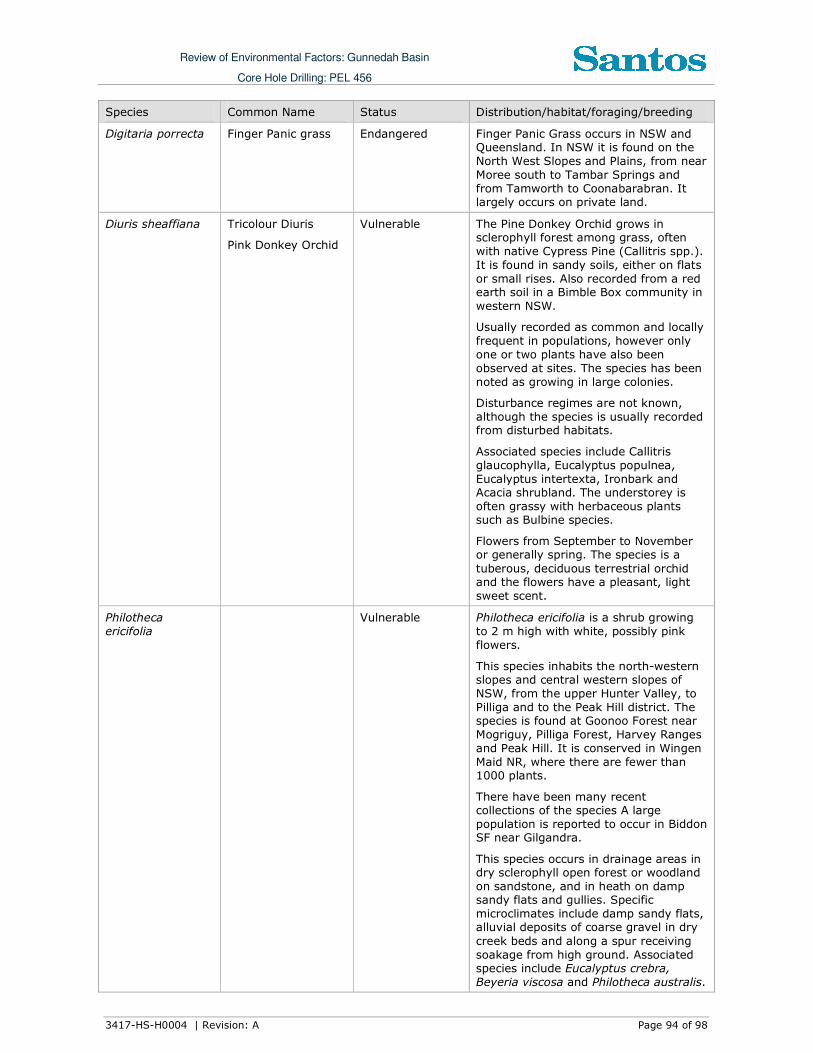
Review of Environmental Factors: Gunnedah Basin
Core Hole Drilling: PEL 456
3417-HS-H0004 | Revision: A Page 94 of 98
Species Common Name Status Distribution/habitat/foraging/breeding
Digitaria porrecta Finger Panic grass Endangered Finger Panic Grass occurs in NSW and Queensland. In NSW it is found on the
North West Slopes and Plains, from near
Moree south to Tambar Springs and
from Tamworth to Coonabarabran. It largely occurs on private land.
Diuris sheaffiana Tricolour Diuris
Pink Donkey Orchid
Vulnerable The Pine Donkey Orchid grows in sclerophyll forest among grass, often
with native Cypress Pine (Callitris spp.).
It is found in sandy soils, either on flats
or small rises. Also recorded from a red earth soil in a Bimble Box community in
western NSW.
Usually recorded as common and locally
frequent in populations, however only
one or two plants have also been
observed at sites. The species has been
noted as growing in large colonies.
Disturbance regimes are not known,
although the species is usually recorded from disturbed habitats.
Associated species include Callitris
glaucophylla, Eucalyptus populnea,
Eucalyptus intertexta, Ironbark and Acacia shrubland. The understorey is
often grassy with herbaceous plants such as Bulbine species.
Flowers from September to November or generally spring. The species is a
tuberous, deciduous terrestrial orchid and the flowers have a pleasant, light
sweet scent.
Philotheca
ericifolia
Vulnerable Philotheca ericifolia is a shrub growing
to 2 m high with white, possibly pink
flowers.
This species inhabits the north-western slopes and central western slopes of
NSW, from the upper Hunter Valley, to
Pilliga and to the Peak Hill district. The species is found at Goonoo Forest near
Mogriguy, Pilliga Forest, Harvey Ranges
and Peak Hill. It is conserved in Wingen
Maid NR, where there are fewer than 1000 plants.
There have been many recent collections of the species A large
population is reported to occur in Biddon SF near Gilgandra.
This species occurs in drainage areas in dry sclerophyll open forest or woodland
on sandstone, and in heath on damp sandy flats and gullies. Specific
microclimates include damp sandy flats, alluvial deposits of coarse gravel in dry
creek beds and along a spur receiving
soakage from high ground. Associated species include Eucalyptus crebra,
Beyeria viscosa and Philotheca australis.

Review of Environmental Factors: Gunnedah Basin
Core Hole Drilling: PEL 456
3417-HS-H0004 | Revision: A Page 95 of 98
Species Common Name Status Distribution/habitat/foraging/breeding
Thesium australe Austral Toadflax Vulnerable Austral Toad-flax is found in very small populations scattered across eastern
NSW, along the coast, and from the
Northern to Southern Tablelands.
Occurs in grassland or grassy woodland. Often found in damp sites in association
with Kangaroo Grass (Themeda
australis).
A root parasite that takes water and
some nutrient from other plants,
especially Kangaroo Grass.
Tylophora linearis Endangered Found in the Barraba, Mendooran,
Temora and West Wyalong districts in the northern and central western slopes
of NSW. Records include Crow Mountain
near Barraba, Goonoo SF, Pillaga West
SF, Cumbil SF, Eura SF, Coolbaggie NR,
Goobang NP and Beni CCA.
Grows in dry scrub and open forest.
Recorded from low-altitude sedimentary flats in dry woodlands of Eucalyptus
fibrosa, Eucalyptus sideroxylon,
Eucalyptus albens, Callitris endlicheri,
Callitris glaucophylla and Allocasuarina luehmannii.
Flowers in spring, with flowers recorded in November or May with fruiting
probably 2 to 3 months later.
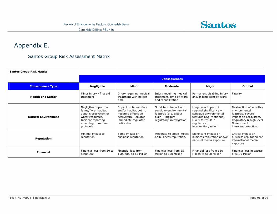
Review of Environmental Factors: Gunnedah Basin
Core Hole Drilling: PEL 456
3417-HS-H0004 | Revision: A Page 96 of 98
Appendix E.
Santos Group Risk Assessment Matrix
Santos Group Risk Matrix
Consequences
Consequence Type Negligible Minor Moderate Major Critical
Health and Safety
Minor injury - first aid
treatment
Injury requiring medical
treatment with no lost time
Injury requiring medical
treatment, time off work and rehabilitation
Permanent disabling injury
and/or long term off work
Fatality
Natural Environment
Negligible impact on fauna/flora, habitat, aquatic ecosystem or water resources. Incident reporting according to routine protocols
Impact on fauna, flora and/or habitat but no negative effects on ecosystem. Requires immediate regulator notification
Short term impact on sensitive environmental features (e.g. gibber plain). Triggers regulatory investigation.
Long term impact of regional significance on sensitive environmental features (e.g. wetlands). Likely to result in regulatory intervention/action
Destruction of sensitive environmental features. Severe impact on ecosystem. Regulatory & high level Government intervention/action.
Reputation
Minimal impact to reputation
Some impact on business reputation
Moderate to small impact on business reputation.
Significant impact on business reputation and/or
national media exposure.
Critical impact on business reputation /or
international media exposure
Financial Financial loss from $0 to $500,000
Financial loss from $500,000 to $5 Million.
Financial loss from $5 Million to $50 Million
Financial loss from $50 Million to $100 Million
Financial loss in excess of $100 Million

Review of Environmental Factors: Gunnedah Basin
Core Hole Drilling: PEL 456
3417-HS-H0004 | Revision: A Page 97 of 98
Consequences
Consequence Type Negligible Minor Moderate Major Critical
I IIIIIIII IIIIIIIIIIII IVIVIVIV VVVV
Almost Certain
Is expected to occur in most circumstances
A 2 3 4 5 5
Likely Could occur in most circumstances
B 1 3 3 4 5
Possible Has occurred here or
elsewhere C 1 2 3 3 4
Unlikely
Hasn’t occurred yet but could
D 1 1 2 2 3
Remote May occur in exceptional
circumstances
Likelihood
E 1 1 1 1 2

Review of Environmental Factors: Gunnedah Basin
Core Hole Drilling: PEL 456
3417-HS-H0004 | Revision: A Page 98 of 98
Risk Level Guideline for Risk Management
5 Immediate action or suspend activity. Notify VP. RMP by 1 week
4 Allocate manager responsibility, notify VP - RMP by 2 weeks
3 Allocate manager responsibility - RMP by 1 month
2 Manage by specific monitoring of controls. RMP by 3 months
1 Manage by routine procedures and regular monitoring