review of challenges of and practices for sustainable...
TRANSCRIPT

ORIGINAL PAPER
Review of challenges of and practices for sustainablemanagement of mountain flood hazards
Desiree Tullos1 • Elizabeth Byron1 • Gerald Galloway2 •
Jayantha Obeysekera3 • Om Prakash4 • Yung-Hsin Sun5
Received: 28 December 2015 / Accepted: 19 May 2016� Springer Science+Business Media Dordrecht 2016
Abstract Mountain areas are the source of important cultural, ecological, and life-sustaining
resources, but are also subject to devastating losses from floods. To work toward reducing
these losses, this paper aims to (a) synthesize understanding on the elements that make flood
risk management challenging in high mountain areas and (b) identify practices that can be
applied in reducing the exposure and vulnerability of mountain communities. Through a
review of the literature and case studies, we identified the flood-related challenges associated
with complex topography and hydrogeology, insufficient data and infrastructure, weakly
defined governance structures, and sensitivity to climatic and landscape changes. We
examined five practices needed for reducing flood risk in these vulnerable areas, involving (1)
the acquisition and effective dissemination of information about floods, (2) basin-scale
hazard assessment and disaster response planning, (3) clearly defining governance respon-
sibilities and distributing them across multiple jurisdictional layers, (4) implementing
effective and diverse mitigation measures, and (5) training and engaging local residents and
officials in flood risk reduction. Considerations and needs for implementing these practices in
mountain areas are discussed, highlighting the commitment of resources needed for dis-
tributed governance, effective planning, land use and building regulations, and engagement
of the public.
Keywords Flood risk reduction � Governance structures � Early warning systems � Landuse regulations � Hazard assessment
& Desiree [email protected]
1 Biological and Ecological Engineering Department, Oregon State University, Corvallis,OR 97331, USA
2 Department of Civil and Environmental Engineering, University of Maryland,College Park, MD, USA
3 South Florida Water Management District, West Palm Beach, FL, USA
4 WEST Consultants, Folsom, CA 95630, USA
5 MWH Global, Sacramento, CA, USA
123
Nat HazardsDOI 10.1007/s11069-016-2400-3
1 Introduction
Floods are among the most frequent and most destructive natural disasters globally (Noji
and Lee 2005) and are the most frequent of all natural disasters in Asia, affecting 2.2
billion people between 1975 and 2000 (Asian Disaster Reduction Center 2002). The
impacts of floods include the widely reported effects, such as direct mortality, loss of
agricultural productivity, damaged infrastructure, and disruptions to business and educa-
tion, as well as less-reported social impacts on communities (Lindell and Prater 2003) and
human health (Ahern et al. 2005; Du et al. 2010).
Floods are particularly devastating in high mountain areas, including the North
American Front Range (Gochis et al. 2015), South American Andes (NASA 2015),
European Alps (de Jong 2015), and the Himalaya (Webster et al. 2011). The losses
associated with flood hazards are high due to both the elevated exposure and vulnerability
in mountain areas. The high exposure of communities to floods can result from a hazardous
location in relationship to the river system, or from high population density. In Bangladesh
alone, it is estimated that 6.3 million people are exposed to frequent flooding from
mountain areas (Brammer 1990). In India and Pakistan, catastrophic flooding struck the
upper Indus (Jhelum River) basin in 2014, killing over 400 people. Scientists debated
whether the primary driver of vulnerability in the upper Indus basin was urbanization and
conversion of floodplains (Meraj et al. 2015) or the earthquakes, faulting, and other geo-
logic hazards that occur there naturally (Shah 2015). Geologic hazards, including land-
slides, debris flows, and Glacial Lake Outburst Floods (GLOFs), are a particularly
devastating flood threat (Bajracharya et al. 2007) in mountain areas.
While the effectiveness of flood risk management in floodplains has advanced over the
last century, mountain areas remain highly vulnerable and lack resilience due to unique
challenges in effective management of mountain floods. The result is elevated flood risk,
associated with (1) a lack of basic data that limits knowledge of the complex hydrology in
mountain areas (Shrestha et al. 2000), (2) water resources management and governance
that focus on short-term development goals, but often fail to achieve long-term sustain-
ability (Gupta 2013), (3) a broad suite of socioeconomic, environmental, and geopolitical
factors (Ives and Messerli 1989); and (4) sensitivity to land use and climate changes that
can increase the prevalence of destructive landslides, GLOFs (Bajracharya et al. 2007),
cloudburst events (Devi 2015) and other local precipitation events, and geophysical flows.
These issues span a range of spatial and temporal scales that make managing flood risk in
mountain areas particularly complex (Gardner 2015).
The objective of this review is thus (1) to characterize the elements that make flood risk
management challenging in high mountain areas and (2) to review case studies of flood
management practices to identify practices that can be applied in reducing the exposure
and vulnerability of mountain communities.
2 Challenges to flood management in mountains
Floods generated in mountainous areas can be very different from those that accumulate in
low-elevation valley floodplains in a number of key ways. These differences, summarized
below, lead to challenges in the forecasting of, response to, and recovery from floods.
Nat Hazards
123

2.1 Limited data, accessibility, and infrastructure
Establishing instrumentation and response systems in high mountain areas is difficult due
to issues with accessibility, remoteness, and limited communication networks and other
infrastructure. For example, key challenges for data collection include the logistics of
travel to and access of gauging sites, failing infrastructure during heavy storms, sharing of
data across transboundary river basins, and the cost of deployment and maintenance for
gauges. Furthermore, cellular coverage and radio telemetry are often not available in river
basins with steep valley walls, providing extremely limited options for transmitting
hydrographic data for long-term monitoring and early warning systems. To overcome the
challenges of in situ measurements, remote sensing platforms may be used, such as those
applied in the studies on intense precipitation (e.g., Anders et al. 2006; Barros et al. 2000;
Bookhagen 2010; Romatschke and Houze 2011; Shrestha et al. 2012a, b). However, these
also have significant limitations in mountain areas, including inadequate spatial and
temporal resolutions for the complex topography, on top of standard limitations of the data
(e.g., resource-intensive processing of remotely sensed data, limited data records, impacts
of cloud cover or other biases in the data).
Because data collection is difficult and data are often scarce, the hydrology in high
mountain areas is often not thoroughly understood and is considered to be a ‘‘black box’’
(Bandyopadhyay 2009). The lack of basic climate and hydrologic data, particularly in
regions such as the Himalayan region (Panthi et al. 2015), significantly impedes fore-
casting, projection, and evaluation of climate events that generate catastrophic flooding
(ICIMOD 2009), as well as the establishment of the flood warning and other management
systems that are known to save lives (Curtis 2013).
Furthermore, the complex and variable terrain, limited accessibility, scarcity of
hydrometeorological data, and inadequate statistical and process-based models make it
particularly difficult to forecast localized, extreme events that are highly destructive.
Mountain areas are often subject to localized flood events, associated with landslides,
landslides with lake outbursts, GLOFs, and cloudbursts, that range from difficult to
impossible to forecast. For example, landslides represent an important flood hazard
mechanism in mountain areas that are impacted by an area’s elevation, slope, soil depth,
vegetation, antecedent soil moisture, and heavy precipitation (Iverson 2000; Baum and
Godt 2010). The physical processes of landslides are generally well understood and
somewhat reliably modeled using process-based models, but are difficult to monitor and
forecast in mountain areas. One-dimensional, process-based, and statistical models
(Wilkinson et al. 2002), often based on precipitation thresholds, can be used to predict
when hillslope conditions might result in triggering a landslide. However, these models
lack the ability to predict the spatial footprint of the landslide, which establishes the degree
of hazard resulting from the landslide. Predicting landslide size requires three-dimensional
models that are generally computationally prohibitive (Bellugi et al. 2015), particularly for
mountain areas with limited resources. Thus, existing tools allow for identification of high-
hazard areas, but limit the ability of managers to reliably provide early warnings to resi-
dents (Baum and Godt 2010). Forecasting GLOFs for early warnings is similarly prob-
lematic. As a result, rather than real-time forecasting, planning for GLOFs has focused on
hazard characterization, including identification of the depths and extent of floods down-
stream using dam breach models (ICIMOD 2011), which may be coupled with vulnera-
bility assessments to support planning and mitigation of flood impacts.
Nat Hazards
123

The lack of hydrometeorological data and historical flood records in mountains hinders
forecasting of even precipitation-based flooding. Regardless of whether process-based,
statistical, or neural network models are applied, flood forecasting is generally data
intensive (Hapuarachchi et al. 2011). Global flood models (Alfieri et al. 2013) based on
remotely sensed data are a valuable resource, but their model resolution is still too coarse
to provide guidance for local-level design and decision-making (Ward et al. 2015). Given
that the limitations of global flood models are due to limited quality and availability of data
on topography, boundary conditions, and community exposure and vulnerability, the
application of global flood models is particularly problematic in mountain areas. Fur-
thermore, assessing flood risk and establishing flood frequencies for the design of flood
infrastructure are difficult because they depend on land use, channel capacity, precipitation
patterns, and existing flood protection infrastructure (Hirsch et al. 2004), which are rapidly
changing in mountainous areas (Gardner 2015).
2.2 Complex hydrology and limitations to knowledge on flood processes
Mountains are characterized by areas of complex terrain, high relief, and large precipi-
tation variability. The complex and steep topography leads to their uniquely sharp tran-
sitions in atmospheric (i.e., temperature, precipitation, pressure, radiation, humidity), soil,
vegetation, and hydrologic conditions over short distances (Beniston 2003; Whiteman
2000; Becker and Bugmann 1997). These sharp gradients across the landscape regulate the
intensity, frequency, and type of precipitation, soil moisture, groundwater interactions, and
vegetation, which in turn contribute to high variability in flood levels over short distances
(Beniston 2003). Futhermore, many of these gradients are impacted by atmospheric pro-
cesses at local and global spatial scales that occur over short and long timescales (Diaz
et al. 2003). When combined with the limited hydrometeorological data in mountain areas,
these complexities lead to limited knowledge on flood generation processes, particularly
those associated with localized, extreme events, such as cloudbursts and other convective
storms, landslides, and glacial lake outbursts.
Cloudburst flood events in the Himalaya are one of the least understood weather sys-
tems (Das et al. 2006). The result is that cloudbursts are impossible to forecast with current
technology and are often blamed for flood losses, even when it is not clear that the heavy
precipitation that generated flooding was a cloudburst event. For example, widespread
flooding in Uttarakhand, India, that occurred in June 2013 was reported as a cloudburst
event by some (Varghese and Jose Paul 2013), while others claimed it did not fit the
criteria and characteristics of a cloudburst (Gulati 2013). The terms cloudbursts and
thunderstorms have been used interchangeably for decades (Woolley et al. 1946), but
cloudbursts are difficult to study because they are very localized events that are rarely
instrumented with rain gauges, often occur on remote mountain slopes, and are only
documented if lives are lost (Thayyen et al. 2013).
While the exact mechanisms for the formation of cloudburst events are not completely
understood, they appear to be associated with interactions between the atmosphere and the
landscape, and particularly between convection and orography. Convection within the
cumulonimbus clouds associated with cloudbursts can rise to 15 km, with instability, deep
convection, and strong up and down drafts from orographic forcing (Thayyen et al. 2013).
Convective energy may be provided at night from evapotranspiration of vegetation, con-
vergence on windward valley slopes, and evaporative cooling of rainfall as seen in some
areas of the Himalaya (Barros et al. 2004). Alternate atmospheric mechanisms have also
been proposed, such as the collision of two clouds systems (Srivastava and Bhardwaj
Nat Hazards
123
2013), illustrating the wide uncertainty regarding the processes that generate cloudburst
floods. Given the degree of their damage to infrastructure and human capital, under-
standing the processes that generate cloudbursts and developing models for forecasting
them are critical.
Cloudbursts represent only one example of the diversity of flood processes in mountain
areas that need further investigation. Floods associated with geophysical flows, such as
landslide dam outburst floods (e.g., Mason 1929), river avulsions (e.g., Sinha 2009), glacial
lake outburst floods (Richardson and Reynolds 2000), and surging glacial dam burst floods
(Hewitt 1982), are also highly destructive and lack adequate data and models to understand
and manage them in mountain areas.
2.3 Governance structure and response resources
Risk governance in mountain areas is highly complex and is evolving. Risk management
has been shifting from the historical paradigm of local, community efforts to a more
current model of regional, national, and international efforts as the increasing flow of
people (e.g., via road construction, development, natural resource extraction) and infor-
mation (e.g., via television, cell networks, internet, and roads) reduce the historical iso-
lation of mountain areas (Gardner 2015). The result is more national and international
attention and resources committed following large natural hazards, which often focus
governance on external institutions. The cumulative effects of many small events can be
catastrophic to local communities, but not necessarily draw national or international
attention. The transitioning of responsibility for flood risk management and response can
lead to weak or unclear governance structures and a lack of/or limited hazard planning and
response, including a failure to establish funding and protocols for monitoring and post-
flood analyses.
2.4 Sensitivity to climate and landscape changes
Mountain areas are particularly sensitive to climate and landscape changes due to the rapid
response of glaciers, snow, permafrost, water, vegetation, and soils to global changes (Diaz
et al. 2003; Beniston 2003; de Jong 2015). As a result, high-elevation areas are among
those responding most rapidly to climate change (Shrestha et al. 1999; Shrestha et al.
2012a, b; Qiu 2013). In fact, some of the earliest evidence of the impacts of atmospheric
warming came from high mountain areas, where changing glaciers provided insight into
changing cryospheric processes (Haeberli and Beniston 1998). Studies have highlighted
how other hydrologic processes are rapidly changing in high mountain areas, including
shifting seasonal snowpack (e.g., Cayan 1996), which drives the runoff draining mountain
landscapes (e.g., Bookhagen and Burbank 2010). For areas in mountains near the melting
point, small changes in temperature may result in large changes in snowpack (Mote 2006;
Lopez-Moreno et al. 2009; Stewart 2009). For example, it has been projected that the
snow–rain transition will rise by 150 m for every 1 �C rise in temperature (Beniston 2003).
These changes can cascade into a range of effects on flood generation processes.
Decreasing size and extent of glaciers will initially enhance runoff, until the ice has shrunk
to a point that it no longer contributes to runoff, temporarily increasing flood depths and
potentially triggering landslides, GLOFs, and other geophysical flows. Impacts of a
changing climate may already be evident. For example, the June 2013 floods in northern
India, which killed 5700 people and caused USD$2 billion in damages, resulted from
unusually intense monsoonal rains, which may be a direct result of the warming climate in
Nat Hazards
123

the Himalayan region (Qiu 2013). Similarly, unusually intense precipitation triggered
massive devastation in Pakistan’s Indus River basin in 2010, affecting over 20 million
people and causing USD$40 billion in damages (Webster et al. 2011). The sensitivity of
mountain areas to climate change (Beniston 2003; de Jong 2015) translates to increasing
vulnerability of mountain communities as changing snowpack, glacial extent, and pre-
ciptation patterns increase frequency and severity of many mountain flood processes.
3 Case studies
We review five case studies of practices for flood management in lower-valley areas to
identify principles for reducing flood losses and investigate how they might be applied in
mountain areas.
3.1 Integrating flood risk management across multiple governance levels
Across the globe, there are multiple approaches to distributing responsibilities for and
governance of flood risk management, each with positive and negative aspects. This case
study outlines the governance approaches employed in the Netherlands and the USA, and
identifies their evolution, strengths, and weaknesses. Critical factors in the assessment of
governance structures include the attention given to the concepts of solidarity, sub-
sidiarity, resource availability, and integrated management. Common to all of these
approaches is the critical role played by those directly threatened by floods and their
consequences.
3.1.1 Distributed governance in the Netherlands
The Dutch trace their efforts with flood management to the 13th century and earlier.
Because of their position within the delta of the Rhine River, it was recognized early that
settlements could not exist without some protection from the frequent high-water events
that naturally occurred. Local groups were formed to support not only flood risk man-
agement, but also irrigation and drainage efforts. These groups relied on cooperation and
collaboration, rather than laws and regulations, to accomplish water resources goals. These
local groups eventually were transformed into what are now identified as water boards and
grew in number so that by 1850, there were over 2500 in the country. Following the
disastrous 1953 Netherlands North Sea flood, the Dutch government began a major
reduction in the number of water boards to consolidate responsibilities for managing flood
risk (Toonen et al. 2006). Furthermore, as modern communications developed, the need for
organizational efficiency expanded, and an increased level of technical expertise became
obvious, the number of water boards was gradually reduced through various reforms to 24
by 2014. A similar response occurred in the USA after the 2005 Hurricane Katrina disaster,
when the State of Louisiana similarly reduced the number of its levee boards (similar to
water boards in the Netherlands) to consolidate responsibilities for flood management.
At the heart of the water boards is the concept of local involvement and direction of
activities, which may also deal with water quality and navigation issues in some cases.
Today, water boards in the Netherlands are independent entities acting through governing
assemblies that operate under the authority of the National Constitution and a Water Board
Act, with the supervision of provincial (regional) governments. The national government
Nat Hazards
123
frames the countrywide approach to flood risk management and carries out development of
projects beyond the capacity of the water boards. Water boards have the power to establish
budgets for their operations, levy taxes to support these operations, and develop water
management plans. They also have responsibility for the supervision and maintenance of
the structures that make up the flood defenses in their areas of authority and for reporting
the results of periodic inspections to the national government.
The governing assemblies of the water boards generally are composed of representa-
tives of those who live and work in the area (i.e., landowners, households, building owners,
and industry) and are elected every four years. The assemblies establish their tax rates
based on who benefits from the water board works, the need for cost recovery, and
adherence to the principles of solidarity and polluter pays.
Because of the criticality for adequate flood protection, the national government con-
tinues to play a major role in oversight, planning, and coastal development to ensure that
the proper steps are taken to address potential flooding, both from major riverine floods and
from the devastating effects of coastal storms. However, through the water board system,
those living in harm’s way have direct involvement in managing their flood risk and
generally understand the relationship of their efforts to those of others, the costs of carrying
the needed work, and their personal role in providing for local flood defenses. Furthermore,
because the majority of land in the Netherlands is flood prone, land use decisions are
closely tied to decisions on infrastructure that reduces the risk of flooding. The government
recognizes the high probability of losses associated with short-term perspectives that
permit development where protection does not exist. In part, because a major flood could
literally destroy the economic and social viability of the country, individuals who are likely
to be affected by flooding are brought into the flood discussion at a fundamental level via
the payment of taxes, the democratization of governance through election of water boards,
and a national culture that understands catastrophic consequences of failure in the flood
risk reduction systems.
3.1.2 Shifting governance in the USA
The management of flood risk in the USA is diffuse due to lack of regulations, rather than a
deliberate flood management policy that distributes governance. Under the US Constitu-
tion, all powers not specifically delegated in the Constitution to the federal government
belong to the states. Water law and land planning are not addressed in the Constitution and
thus fall to the responsibilities of the states, with some notable examples discussed below.
In the case of land use, most states have delegated these responsibilities to the local
governments.
At the federal (national) level, two laws drive most national efforts with respect to flood
risk reduction. The first was the Flood Control Act of 1936, in which Congress indicated
that, ‘‘… destructive floods upon the rivers of the United States, upsetting orderly processes
and causing loss of life and property, including the erosion of lands and impairing and
obstructing navigation, highways, railroads, and other channels of commerce between the
States, constitute a menace to national welfare … [and] flood control… is a proper activity
of the Federal Government in cooperation with States, their political subdivisions and
localities’’ (33 U.S.C. 701a, 1936). As a result, both the federal government and local
institutions have constructed levees, dams, and other flood control structures across the
nation to reduce the risk to those living in floodplain areas. While initially the focus of
flood reduction efforts was on major cities, it was extended over time to smaller com-
munities and non-urban areas. Projects developed by the federal government, on
Nat Hazards
123
completion, were often turned over to the local governments to maintain and operate at
their expense. To supplement federal efforts in areas not likely to be supported by a federal
program, locally organized drainage districts and flood control organizations were estab-
lished to fund, build, and maintain necessary structures. These local organizations typically
represented the owners of the major land holdings of the regions, as opposed to the public
at large. The approval of the establishment of these organizations largely rested with state
and local governments, which approved the rules under which they operated. The infras-
tructure was developed under the supervision of state and federal agencies, whereas the
operation and maintenance of flood management infrastructure were left to the local
organizations. However, since each state established its own laws, the governance struc-
tures differed markedly across the nation (Holmes 1972; Holmes 1979; Galloway
2011a, 2011b).
The second law was passed in 1968 and, with supporting subsequent acts, established a
national flood insurance program (NFIP). The NFIP identified areas within the 100-year
(1 % annual chance) floodplain as high-risk areas and supported a flood insurance program
for communities that adopted land use regulations and prohibited future construction below
the 100-year flood elevation. Since 1968, more than 22,000 communities have joined the
NFIP, and those in the communities have purchased over 5 million flood insurance poli-
cies. In most cases, participating communities have regulated development in 100-year
floodplain. However, flood losses in the USA continue to rise for a variety of reasons.
There has been only limited control over development in areas outside of the 100-year
floodplain, which are still subject to floods. In addition, many of the initial designations of
the 100-year floodplain are out of date because they do not reflect changes in hydrology
and the advancement of flood assessment tools. Furthermore, increased runoff from
upstream development has expanded the extent and frequency of flooding so that indi-
viduals and businesses that were previously outside the 100-year flood zone now find
themselves at greater risk, and development behind levee-protected areas has had unin-
tended consequences, resulting in a reduction in the probability of flooding, but increases
in damages when floods do occur (CA-DWR 2012).
Following increased national interest in flood loss reduction after the disastrous 1927
and 1993 floods in the Mississippi River basin (Barry 1997; IFMRC 1994) and the highly
visible consequences of Hurricane Katrina in 2005 (NCLS 2009), examinations of the
national flood management efforts indicated that local governments were often ineffective
at limiting development in areas of high flood risk. Studies have also determined that
maintenance of many of the flood infrastructure has been severely neglected (ASCE 2013)
as local governments in the organizing bodies for these protective structures did not have
the resources to upgrade the structures to meet engineering standards (McGinnis 2014). It
was also identified that the requirement for those living in the floodplain to buy insurance
was being ignored in some cases due to a lack of enforcement of the regulations (NRC
2013).
Despite frequent calls for it, the USA does not have a national flood risk management
policy, and few states have directly addressed comprehensive floodplain management.
Strict land use planning does not seem to be in the immediate economic interest of local
governments. Local governments look to higher-level authorities for supervision of flood
risk reduction structures and program development, in part due to lack of capacity and
resources and in part because of the existence of the two major national programs (1936
Flood Control Act and NFIP). However, the state of California has recently initiated a
transformational program that integrates local land managers into flood risk reduction
efforts in an approach that should be transferrable to other areas.
Nat Hazards
123
3.1.3 Evolving Jurisdictional integration in California’s Central Valley floodmanagement system
The Central Valley water supply and flood management system includes ten multi-purpose
reservoirs on major tributaries and more than 1400 miles of levees to redistribute water and
protect the floodplain and water infrastructure from flooding. Responsibility for and
operation of the system are shared by local utilities, water districts, the USACE, the US
Bureau of Reclamation (USBR), and the California Department of Water Resources
(DWR). Despite the extensive implementation of flood reduction actions across the Central
Valley, it is still highly susceptible to flooding. Four recent major floods (1983, 1986, 1995,
and 1997) have caused well over USD$3 billion in damage (DWR 2012). Economic
development in the floodplain behind levees and downstream of dams has actually
increased the damages from higher-elevation floods in some areas, resulting in an increase
in overall flood risk due to flood infrastructure for the largest flood events (DWR 2012). At
the same time, the importance of Central Valley rivers and floodplains in providing
municipal, industrial, and agricultural water supply, fisheries and wildlife habitat, and
recreation has increased as a result of population growth and environmental degradation in
the State of California.
In November 2006, California voters passed the Disaster Preparedness and Flood
Prevention Bond Act (Proposition 1E) and the Safe Drinking Water, Water Quality and
Supply, Flood Control, River and Coastal Protection Bond Act (Proposition 84), autho-
rizing the sale of nearly USD$5 billion in state bonds for flood management improvements
throughout California, with over USD$4 billion of this amount specifically earmarked for
repairs and improvements to state and federal flood projects within the Central Valley. The
California Legislature enacted six interrelated bills in 2007 (Senate Bills 5 & 17 and
Assembly Bills 5, 70, 162, and 156) to improve flood management, strengthen the linkage
between local land use planning decisions and flood management practices, and guide the
use of Propositions 1E and 84 funds. Together, these bills added or amended over 25
sections in the California Government Code, Health and Safety Code, Public Resources
Code, and Water Code.
The 2007 California flood legislation package outlined a comprehensive approach to
improving flood management at the state and local levels, including the requirement of the
local governments, as land use authorities, to consider potential flood risks in the Sacra-
mento-San Joaquin Valley. This requirement is reflected in the Central Valley Flood
Protection Plan (CVFPP), which outlines how USD$14–17 billion would be invested in
flood management over the next 20 years (DWR 2012; CVFPB 2012). The investment
plan articulates three landscape-scale policy directives, which are expected to be applied in
future state funding eligibility criteria. One directs that the state will not invest in growth-
inducing flood management improvements and will oppose such improvements even if
local agencies are fully responsible financially. Implementing this, and the other directives,
requires a new model for establishing coordination and accountability across jurisdictions.
This model is reflected in Senate Bill (SB) 5 of 2007 (Code §65302.9, §65860.1), which
requires cities and counties within the Sacramento-San Joaquin Valley to amend their
general plans, zoning, and ordinances to be consistent with the regulations laid out in the
2007 legislative package. Since the 2012 CVFPP adoption on July 2, 2013, cities and
counties had up to 24 months to amend their local general plans and an additional
12 months thereafter to update local zoning ordinances. To facilitate the implementation,
DWR collaborated with cities and counties, planning professionals, and interested parties
Nat Hazards
123

to develop the Urban Level of Flood Protection Criteria (DWR 2012) to provide guidance
and additional details for complying with the legislative requirements. The Urban Level of
Flood Protection Criteria are not regulations, and the legislation provides no enforcement
authority. The seemingly apparent gap is deliberate since any citizen could enforce the law
through litigation if they demonstrate that the city or county did not apply the Urban Level
of Flood Protection Criteria or make a finding with insufficient evidence. This alleviates
the State of California from potential interference with local land use authorities or
enforcement costs, and holds the cities and counties accountable for their own decisions on
land use development. However, this approach does provide economic incentives for
complying with directives that lead to flood risk reduction via access to state funds for
project development and operations.
3.1.4 Summary
Each of the case studies examined faces unique problems. The USA has 320 million
people, land area of 9.1 million km2, and a gross domestic product (GDP) of USD$17.4
trillion, while the Netherlands with a population of 16 million only has 33,000 km2 in land
area and a GDP of USD$880 billion. California has a population of 39 million people, a
land area of 423,970 km2, and a GDP of USD$2.3 trillion. The differences in resources,
coupled with the varying flood threats they face, drive the ability of these nations and state
to carry out their flood risk management efforts.
Netherlands has clearly placed its focus on bringing management of flood risk to the
local level and empowered those at the local level with the ability to deal with flood-related
challenges. Where local institutions cannot deal with major flood challenge and infras-
tructure (e.g., the large Delta projects), the federal government accepts responsibility. The
federal government also helps link local efforts of the water boards and oversees their
execution. Solidarity, subsidiarity, and self-sustaining fiscal resource development play
major roles in creating this balance among different levels of government.
In the USA, the federal government’s 1936 move into assuming responsibilities for
flood control placed state and local officials into a secondary role in development of long-
term approaches to flood risk reduction. The 1968 flood insurance program furthered this
federal focus by linking homeowners and individual communities directly with the federal
government, in effect bypassing the states. Given these two federal programs, few states
and localities have moved into strong floodplain regulation and long-term land use plan-
ning. Lack of effective national, state, and local oversight has led to the deterioration of
many structural works that fell to the responsibility of local governments to maintain, but
now lack the resources to repair or improve. A federally centered approach seemingly
offers resources that might not otherwise be available at the local level, but as federal
resources to reinvest in flood infrastructure declined (McGinnis 2014), local institutions
must assume responsibilities that they have often neglected and for which they are often
not prepared. Furthermore, there have been few fiscal incentives or penalties placed on
local governance for their inability or lack of willingness to carry out land use regulations
and flood risk management activities. Unfortunately, it is often easier to dedicate more
attention and resources toward disaster recovery than to pre-disaster activities that can
dramatically reduce losses in the future.
California has implemented a more proactive program for distributing responsibility of
flood risk reduction, recognizing that land use regulation is a critical component of sus-
tainable, bottom-up approach to reduce flood-related losses. With land use authority often
residing at local government level, the key element of this practice is to connect local land
Nat Hazards
123

use decisions and the potential consequence of the land development for flood risk man-
agement. Land use regulation was successfully scaled to a large area where land use
authority is held by multiple cities and counties. Though this program, California has also
attempted to clarify the roles and responsibilities of the State and Federal governments, and
to align land use planning with other flood management actions by different levels of
government and agencies as an integrated system.
3.2 Coordinated and joint operating centers for flood alert and response
Management of flood disasters requires a well-coordinated effort, a theme that is common
in the management of all natural hazards. In this section, we describe a process through
which hurricane emergencies are managed in a large water resources agency in South
Florida and discuss elements that are relevant to the management of floods in high
mountain areas.
Florida is more likely to be hit by hurricanes than any other state in the USA (Malmstadt
et al. 2009). The state has an insured coastal property exceeding $2 trillion, and has been
hit by eight of the ten most expensive hurricanes ever to make landfall in US history. Land-
falling hurricanes in Florida cause extensive property damage through extreme winds and
floods, and they challenge the extensive water control system that consists of numerous
canals, levees, and water control structures. Because safeguarding the life and property of
the citizens is a direct responsibility of each government agency in Florida, emergency
management programs have been developed and implemented for all phases (i.e., before,
during, and after) of natural hazards. Here, we describe the emergency management
program that has been established by the South Florida Water Management District
(SFWMD), an agency of the state for integrated management of water resources in the
south Florida region. This program is based on the principles of the Incident Command
System (ICS), an essential element of the National Incident Management System (NIMS)
developed and used by the FEMA (2008). The ICS is a valuable tool for directing oper-
ations within a centralized, emergency management center and coordinating with other
similar centers in the region.
3.2.1 Overview of incident command system
The ICS enables effective and efficient incident management by integrating a combination
of facilities, equipment, personnel procedure, and communications operating within a
common organizational structure (FEMA 2008). It was developed in the 1970s following a
series of catastrophic fires in California, where a postmortem analysis discovered that the
response to the disasters were not caused by lack of resources or failure of tactics, but
rather were a result of inadequate management of the disaster. The ICS integrates many
levels of government including federal, state, and local institutions and agencies, and
establishes five major management functions as the foundation of the ICS: (1) incident
command; (2) operations; (3) planning; (4) logistics; and (5) finance and administration
(Table 1). The ICS is designed to expand or contract based on the incident complexity.
Large and complex incidents may require more supervisory layers to the organization
structure than smaller incidents. Establishment of ICS in any agency requires customiza-
tion based on the needs, resources, and nature of the hazard.
Nat Hazards
123

3.2.2 Establishment of the organizational structure for implementing ICS at SFWMD
The first step in establishing ICS was to identify an Emergency Management Advisory
Committee (EMAC) consisting of individuals representing positions in the emergency
management organizational structure. This team identified the personnel, equipment, and
other local, state, federal, and private agency resources that were needed to support
emergency operations. Based on the initial brainstorming of the team, several key impacts
of hurricanes were identified, including: (1) infrastructure damage (critical facilities, roads,
etc.); (2) debris in canals; (3) loss or failure of the communication system; (4) shortage of
fuel; (5) impact to business and to flood management staff; and (6) power failures. The
next step was to create a permanent position of an emergency manager for facilitating the
development and implementation of the emergency management program. This person has
the responsibility for the development of the Comprehensive Emergency Management Plan
(CEMP) and supporting documents using an ‘‘all-hazard’’ approach. An all-hazard
approach takes advantage of the common capabilities necessary to respond to any type of
disaster or emergency, but allows for incorporating unique response needs for particular
types of hazards, such as natural hazards, hazardous material incident, radiological inci-
dent, or an act of terrorism. This emergency manager also facilitates coordination among
various individuals and departments within the organization, and identifies training needs
and practice exercises. Managers of individual divisions in the agency are responsible for
development of standard operating procedures (SOPs) and the assignment of personnel. In
SFWMD, the primary divisions include engineering, construction, operations, planning,
regulation, and field stations. The SOPs define the roles of personnel in various organi-
zational units depending on their experience and skills. After the declaration of an
emergency, the employees assume assigned duties and their reporting switches to the
emergency management structure.
A key step in the emergency management program was the creation of an Emergency
Operations Center (EOC). The physical setting of EOC is a permanent location where
meetings, training, and exercises are held. During an incident, it becomes the location
where EOC staff conduct centralized incident coordination. The building has been con-
structed to protect response staff, critical infrastructure such as the computing systems, and
vital records such as hydrologic data, financial records, and infrastructure design docu-
ments. The facility can withstand wind speeds of up to 200 miles per hour. Critical data are
Table 1 Five essential management functions of ICS
Incident command Sets the incident objectives, strategies, and priorities and has overall responsibilityfor the incident. The Incident commander has overall responsibility for managingthe incident by establishing objectives, planning strategies, and implementingtactics
Operations Conducts operations to reach the incident objectives. Establishes the tactics anddirects all operational resources
Planning Supports the incident action planning process by tracking resources,collecting/analyzing information, and maintaining documentation
Logistics Provides resources and needed services to support the achievement of the incidentobjectives
Finance andadministration
Monitors costs related to the incident. Provides accounting, procurement, timerecording, and cost analyses
All these functions are standard organizational units in the ICS structure established in SFWMD (Fig. 1)
Nat Hazards
123

also duplicated in a remote location to ensure continuity of operations. The EOC is a
locational focal point for emergency or disaster management, and it permits a faster
response and recovery than a decentralized system would provide. When activated, the
EOC is a complete management system consisting of executive staff, affected organiza-
tional units, employee teams, and key external partners who have been trained on
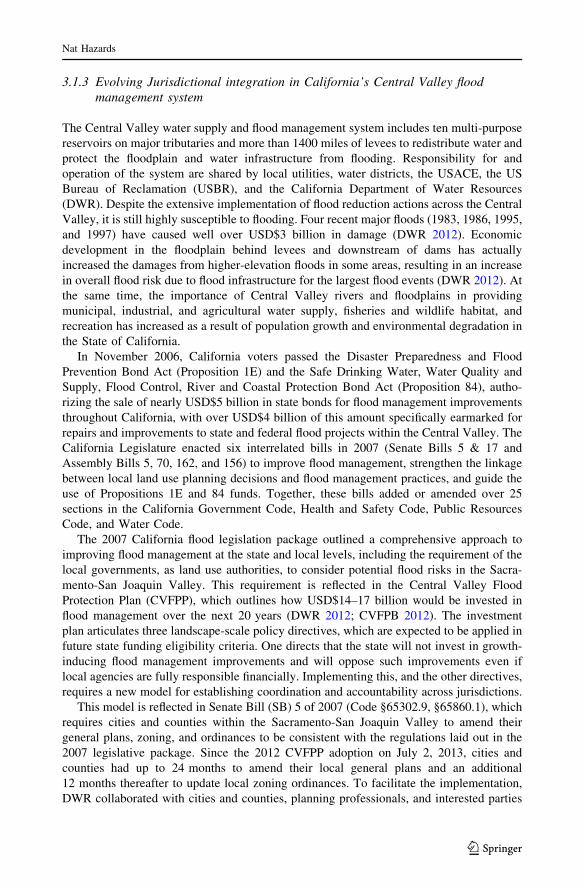
respective emergency roles and responsibilities (Fig. 1).
3.2.3 Activation and functioning of EOC
In consultation with the Executive Management Team of the agency, the emergency
manager initiates the declaration of the emergency (also known as an ‘‘incident’’) when
necessary. The activation of EOC for dealing with the emergency typically occurs in
levels. The sequence moves from Level 3 (normal day-to-day operation) through Level 2
(partial activation) to Level 1 (full activation). During Level 1 activation, all normal
SFWMD operations not supporting the particular emergency are suspended. The EOC
provides for the following functions: (1) determining incident priorities through situation
assessment. A situation assessment is a snapshot of the present conditions that is used to
plan for the future, involving the gathering, analysis, synthesis, communication, and
Fig. 1 Organizational structure of SFWMD EOC. The functions of ICS (Table 1) have been implementedas sections in the EOC structure. The functional units within each section have unique functions identified.Acronyms define the Army Corps of Engineers (ACOE), the Florida Department of EnvironmentalProtection (DEP), and Florida Power and Light (FPL). All other acronyms are defined in the text
Nat Hazards
123
discussion of data for making planning decisions about goals, objectives, and developing
response strategies; (2) providing strategic coordination and drafting action plans; (3)
acquiring critical resources and deploying them to impacted areas. For SFWMD, these
resources range from heavy equipment (i.e., cranes, excavating and earthmoving equip-
ment, dump trucks, backhoes, front end loaders, and pumps) to fill dirt, rip rap, fuel,
communications equipment, and appropriately trained or qualified personnel for the task
assignment; and (4) inter- and intra-agency coordination, including agencies outside of the
district that include the local power company, County Emergency Operations Center, State
departments of Environmental Protection and Emergency Management, and federal
agencies such as USACE and FEMA.
The EOC collects information from a variety of sources, such as other county EOCs and
impact assessments conducted by district response teams. This information is used by the
SFWMD’s Public Information Officers to develop statements and update external media
during the emergency for dissemination to the public, including through social media.
Additionally, liaison officers facilitate interagency collaboration and information sharing
(Fig. 1). Finally, specialized teams are deployed to share information on impacts to
SFWMD facilities, structures, and operations.
During an emergency, the Planning Section of EOC is responsible for the development
of two primary documents. The first document is an incident action plan, which is created
to define the incident objectives and reflects the tactics necessary to manage the incident
during a specified operational period. An operational period is the period of time scheduled
for executing a given set of tactical response actions as specified in the incident action plan.
Operational periods can vary depending upon the stage of the response. The length of the
operational period is established at the beginning of the operational planning cycle and
subsequently reviewed and adjusted throughout the life cycle of the incident. The period is
typically 12–24 h at the beginning of an incident requiring extensive response efforts. As
the SFWMD’s response transitions from immediate response to short- and long-term
recovery, operational periods may be several days or a week. For example, if a culvert is
washed out, the priority during the first few operational periods may be to stabilize the
culvert to prevent further damage. Once it is stabilized, the objectives may transition to
more permanent repair. Operational periods transition to one week or longer when oper-
ations are focused primarily on recovery programs.
The second document is the Situation Report, which communicates the incident status
to audiences outside of the EOC and is an outcome of daily briefings, situation assessment,
and interactions with external entities. At a minimum, this document is produced once a
day during the response phase, but may be produced more frequently depending upon the
nature of the incident. It is the primary means for communicating the status to SFWMD
governing board members, executives, local, state, and federal agencies.
During the activation of the EOC, extensive coordination among local, state, and federal
agencies occurs to ensure there is no duplication of effort, and an efficient response is
provided to manage the hurricane emergency. In addition to liaisons who directly coor-
dinate with other management agencies, Web-based software systems (e.g., WebEOC,
Intermedix 2015) are now available for incident tracking, used extensively by SFWMD to
provide secure, real-time information sharing to assist emergency response personnel and
regional field stations in mission assignments. These systems provide the ability to request
and track resources, facilitate briefings, and provide complete documentation of all actions
that were taken in response to an emergency incident.
Nat Hazards
123

3.2.4 Summary
The development and implementation of the emergency management program at SFWMD
was challenging because the daily problems or situations that generate the public interest
will always have a higher priority. However, the emergency management system, based on
ICS, has been very beneficial in managing hurricane response. The EOC organizational
structure supports disaster response planning effectively through proper coordination of
internal staff and external stakeholders, development of standard operating procedures, and
training. The system consists of clearly defined responsibilities, governance, a central
command, and communication. The acquisition and communication of reliable information
to the public and agencies external to and internally within EOC involves several tools,
such as interviews with both print and television media, liaisons located within EOCs of
several agencies, citizens’ information hotlines, employee communication through the
Web, social media, and software tools such as WebEOC.
3.3 Early warning systems: saving lives in Colorado
3.3.1 Overview of early warning systems
Advance warning of floods can substantially reduce the loss of life and damage of property
(Sorenson 2000) by providing time for people to evacuate and to move valuables to higher
elevations. Early warning systems have been developed over time to include a suite of field
observations (i.e., river depth, precipitation), satellite-based observations (i.e., precipita-
tion, wind speed), software (i.e., weather prediction, hydrologic models), data storage and
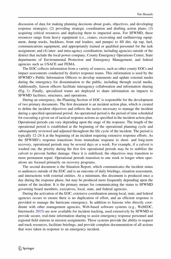
management, hazard assessments, and transmission and alert systems (Fig. 2). Technical
Fig. 2 Components of an early warning system Modified from University Corporation for AtmosphericResearch 2010
Nat Hazards
123
challenges typically focus on providing adequate accuracy and lead time for the advance
warnings (University Corporation for Atmospheric Research 2010) to generate appropriate
and timely precautionary action. However, the perception of risk and response of people to
the warnings is one of the most important, and often underemphasized, elements of early
warning systems, significantly impacting the ability to reduce losses (Twigg 2003). Thus,
in addition to the technical elements of a forecasting system, effective early warning
systems must also have a strong focus on the characteristics and social vulnerabilities of
the people exposed to the floods (Basher 2006) to help them prepare for and appropriately
respond to early warnings.
3.3.2 Success and challenges of an EWS in Colorado
The Colorado Front Range is the portion of the Rocky Mountains that is drained by the
headwater channels of the South Platte River basin. Primary flood generation mechanisms
in this semiarid, dry gulch include intense local thunderstorms that lead to flash floods,
intense widespread rainfall, and snowmelt (Collins et al. 1991). The area has a long history
of flash floods from local thunderstorms, the most destructive of floods, which generally
occur from May through September (University Corporation for Atmospheric Research
2010). In the summer, subtropical Pacific moisture can generate both widespread rainfall
events and intense local thunderstorms, primarily in the southwestern mountainous areas of
the state. During these events, runoff from the mountains quickly causes the water levels of
small creeks and dry streambeds to rise to unsafe levels, regularly reaching heights of
10–20 feet. The most destructive of the flash floods was the 1976 Big Thompsons Canyon
floods (NOAA 1976), which resulted in the loss of 146 lives. However, the event was a
catalyst for change, resulting in collaboration between county, local emergency manage-
ment agency officials, and weather forecast offices to develop early warnings and other
mitigation measures for flash floods (NOAA 2014).
Subsequently, another major flash flood event occurred in this same area during
September 2013. A low-pressure system centered on the western side of Colorado Front
Range pulled a plume of warm, tropical, moisture-rich air from the Gulf of Mexico into
Colorado from the southeast (Scott 2013). Torrential rainfall occurred from September 9
through 16, resulting in severe flash flood conditions that stretched for about 150 miles,
from Colorado Springs north to Fort Collins. Over 17 inches of precipitation fell during
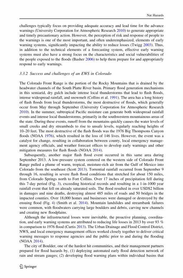
this 7-day period (Fig. 3), exceeding historical records and resulting in a 1-in-1000 year
rainfall event that fell on already saturated soils. The flood resulted in over USD$2 billion
in damages and nine deaths, destroying almost 485 miles of roads and 50 bridges in the
impacted counties. Over 18,000 homes and businesses were damaged or destroyed by the
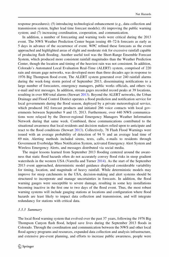
ensuing flood (Fig. 4) (Smith et al. 2014). Mountain landslides and streambank failures
were common, with floodwaters carrying large boulders and debris, carving new channels
and creating new floodplains.
Although the infrastructural losses were inevitable, the proactive planning, coordina-
tion, and early warning systems are attributed to reducing life losses in 2013 by over 93 %
in comparison to 1976 flood (Curtis 2013). The Urban Drainage and Flood Control District,
NWS, and local emergency management offices worked closely together to deliver critical
warning messages to response agencies and the public prior to and during the flooding
(NOAA 2014).
The city of Boulder, one of the hardest hit communities, and their management partners
prepared for flood hazards by, (1) deploying automated early flood detection network of
rain and stream gauges; (2) developing flood warning plans within individual basins that
Nat Hazards
123

were based on the different zones of flood risk, and creating polygons specific to flood
prone areas with crafted messages that were unique to that polygon area (Pittman 2014);
(3) revising standard operational procedures to better address flood threats; (4) conducting
annual flood training exercises (e.g., message dissemination, evacuation, emergency
Fig. 3 Total precipitation map from September 9–15, 2013, flood event Source: Lukas 2013
Fig. 4 Examples of severe flood damages in Colorado counties (Source: Andy Cross, Getty Images)
Nat Hazards
123
response procedures); (5) introducing technological enhancement (e.g., data collection and
transmission system, higher lead time forecast models); (6) improving the public warning
system; and (7) increasing coordination, cooperation, and communication.
In addition, a number of forecasting and warning tools were critical during the 2013
event. The NWS Weather Prediction Center began issuing 48–72-h forecasts as early as
5 days in advance of the occurrence of event. WPC refined these forecasts as the event
approached and highlighted areas of slight and moderate risk for excessive rainfall capable
of producing flash flooding. Another useful tool was the Short-Range Ensemble Forecast
System, which produced more consistent rainfall magnitudes than the Weather Prediction
Center, though the location and timing of the heaviest rain was not consistent. In addition,
Colorado’s Automated Local Evaluation Real-Time (ALERT) system, comprised of 220
rain and stream gage networks, was developed more than three decades ago in response to
1976 Big Thompson flood event, The ALERT system generated over 240 rainfall alarms
during the week-long storm period of September 2013, disseminating notifications to a
large number of forecasters, emergency managers, public works officials, and others via
e-mail and text messages. In addition, stream gages recorded record peaks at 39 locations,
resulting in over 800 total alarms (Stewart 2013). Beyond the ALERT networks, the Urban
Drainage and Flood Control District operates a flood prediction and notification service for
local governments during the flood season, deployed by a private meteorological service,
which produced 162 forecast products and initiated 266 voice contacts with local gov-
ernments between September 9 and 15, 2013. Furthermore, over 440 NWS communica-
tions were relayed by the Denver-regional Emergency Managers Weather Information
Network during that same week. Combined, these communications contributed to the
situational awareness that local residents and decision makers relied upon to anticipate and
react to the flood conditions (Stewart 2013). Collectively, 78 Flash Flood Warnings were
issued with an average probability of detection of 94 % and an average lead time of
69 min. Alerting methods included sirens, texts, calls, e-mails to residents through
Government Everbridge Mass Notification System, activated Emergency Alert System and
Wireless Emergency Alerts, and messages distributed via social media.
The major lessons learned from September 2013 flooding centered around the aware-
ness that static flood hazards often do not accurately convey flood risks in steep gradient
watersheds in the western USA (Varrella and Turner 2014). As the start of the September
2013 event approached, deterministic model guidance displayed considerable variability
for timing, location, and magnitude of heavy rainfall. While deterministic models may
improve for steep catchments in the USA, decision-making and alert systems should be
structured to incorporate and manage uncertainties in forecasts. In addition, the flood
warning gauges were susceptible to severe damage, resulting in some key installations
becoming inactive in the first one to two days of the flood event. Thus, the most robust
warning systems will include gauging stations at locations and configuration where flood
hazards are least likely to impact data collection and transmission, and will integrate
redundancy for stations with critical data.
3.3.3 Summary
The local flood warning system that evolved over the past 37 years, following the 1976 Big
Thompson Canyon flash flood, helped save lives during the September 2013 floods in
Colorado. Through the coordination and communication between the NWS and other local
flood agency programs and resources, expanded data collection and analysis infrastructure,
and extensive pre-event planning, and efforts to increase public awareness, people were
Nat Hazards
123

more successful in protecting themselves during the flash flooding of 2013, relative to
1976. However, despite the significance of flash flood events and the demonstrated benefits
of early warning systems, few countries have implemented flash flood warning systems.
This is due in part to the technical complexity of forecasting and resources required to
predict flash flood events with enough confidence (accuracy) and lead time (advance
warning) to take precautionary action. Furthermore, improving the effectiveness of early
warning systems does not, in itself, lead to reduced risk for disaster prone communities.
The early warning system is only effective if it can successfully trigger correct and early
actions to reduce losses.
3.4 Utilizing remotely sensed data in hazard assessments
3.4.1 FEMA’s HAZUS-MH Methodology for estimating flood losses
Remotely sensed data can provide a critical resource to managing floods in areas where
field data are scarce. However, remotely sensed data alone are not enough, and algorithms
to translate those data into assessments of flood risk and losses can require expertise that
may not exist in rural and mountain areas. This capacity issue is addressed to some extent
in HAZUS-MH, a GIS-based methodology established by FEMA to rapidly estimate
potential physical, economic, and social losses from floods, as well as earthquakes and
hurricanes. The output can contribute to the preparation for, mitigation of, response to, and
recovery from natural hazards, and has been shown to successfully contribute to a variety
of flood management projects, such as the evaluation of vulnerable populations to levee
breaches (Burton and Cutter 2008) and of alternatives for activation of floodways (Luke
et al. 2015).
Very broadly, the HAZUS algorithm first characterizes the flood hazard based on flood
elevations to define the flood boundary and depths (Scawthorn et al. 2006a), then calculates
potential damages (e.g., buildings, vehicles) and losses (e.g., life, agriculture) (Scawthorn
et al. 2006b). Direct loss calculations are made based on a library of depth–damage curves
(e.g., Figure 5), which are provided with the model or can be entered manually by the user.
The model also contains algorithms to estimate indirect economic losses, shelter needs, and
the benefits of early warnings, levees, and other flood management practices.
Fig. 5 Example damage curve for building contents, with uncertainty Source: Freni et al. 2010
Nat Hazards
123

The level of analysis can be coarse to site-specific, with varying levels of accuracy
(Ding et al. 2008), depending on the users’ data, resources, and needs. For application in
the USA, users load remotely sensed and/or default data into the HAZUS-MH model,
including topographic data that lead to a digital elevation model, ground elevations of
buildings, flood elevations, floodplain boundary information, FEMA’s Q3 and/or Digital
Flood Insurance Rate Map flood layer data, Flood Insurance Rate Map data, hydrology,
agriculture products, vehicles (approx. # per occupancy classification), essential facilities,
transportation and utility facilities, census demographics, and census tracts and blocks. In
addition, the user can define individual facilities, defined by the parcel shape, number of
stories, foundation type, first-floor height, content cost, square footage, and building value,
among others. Resulting loss estimates include (1) area-weighted damage estimates based
on the depth of flooding within a given census block, (2) cost of repair/replacement, shelter
needs, temporary housing, vehicles, crop and livestock losses, (3) induced losses from
debris resulting in direct damage to buildings, based on floor areas for census blocks; (4)
indirect losses for sectoral economic impacts; (5) annualized losses; (6) direct economic
losses as afunction of business inventory, restoration time, and income loss data; and (7)
damage for individual facilities.
Though valuable, the HAZUS approach is not without limitations, including those
inherent to flood modeling generally and those specific to HAZUS (Merz et al. 2010).
Strengths of the approach include the ease of use for the GUI and GIS interface, the ability
to address both riverine and coastal floods, the available tools for preprocessing data for
input, and the thorough documentation of the tools. Weaknesses include the fact that the
algorithms run on proprietary software (ArcMap), issues with model instability, and the
simplistic representation of levees. In addition, the spatial scale of analysis occurs at the
census block level (unless buildings are entered as user-defined facilities), which is valid
only if the composition of buildings is evenly distributed throughout the block. However,
some of these limitations can be overcome, and thus the reliability of loss estimates with
HAZUS-MH improved, by replacing default databases with local data, particularly for the
input DEM, if they are available (Tate et al. 2015).
3.4.2 Example remote sensing-based hazard assessment: ice jam floods in Eagle, AK
HAZUS has been applied in a number of locations and across a range of scales, including a
national-scale study of averaged annual loss (FEMA 2010). This example focuses on an
application in Eagle, Alaska, where HAZUS was applied to identify areas where risk to ice
jam floods is low for rebuilding following a flood. Eagle, Alaska, is a small (2010 pop-
ulation 86) rural town located along the south bank of the Yukon River. Despite its small
size, the town has important historical significance, with buildings from the Gold Rush era
listed as a National Historic Landmark and the town serving as an important stop along the
Yukon Quest sled dog race.
The Yukon River is the fifth largest river in North America, with a catchment of about
300,000 km2 upstream of Eagle (Brabets et al. 2000). The river drains glaciated mountains
in northwest British Columbia and southern Yukon Territory, flowing north toward the
Bering Sea. The typical annual hydrograph exhibits two peaks (Livingston et al. 2009). The
first peak, which occurs in early May, is associated with ice jams, which generate the
highest flood risk of the two flood processes. Ice jams are stationary accumulations of ice
fragments that restrict and/or block flow (Ashton 1978). During ice breakup periods in the
spring, ice jams can result in flooding by elevating river elevations upstream of the jam.
Alternately, ice jams can fail instantaneously, sending a rapid and destructive wave (aka
Nat Hazards
123

jave; Jasek and Beltaos 2008) of floodwater and ice fragments downstream (Smith 1980).
Ice jams develop at geometric transitions in the channel (Smith 1980), such as in a reach
between Dawson and Eagle, AK, where the channel transitions to a narrow, single-thread
channel with steep valley slopes and a contracted floodplain (Livingston et al. 2009). The
second peak in unrelated to ice, occurring later in the summer (e.g., June) as snow and
glaciers melt upstream in the catchment.
Ice jam floods represent important flood hazards due to their destructive nature, the
difficulty in providing early warnings due to the complex suite of factors that contribute to
ice jam failures (Smith 1980) and the logistical and instrumentation challenges associated
with gauging them (Livingston et al. 2009; Jasek et al. 2001). The reach of the Yukon near
Eagle, AK, is particularly hard hit by ice jam floods. Analysis of a 108-year record at
Dawson, approximately 100 miles upstream of Eagle, illustrates the geomorphic and
hazard significance of these events. Ice jam events occur frequently in this reach, on the
order of five times in 111 years (Jasek et al. 2001). Furthermore, ice jam floods appear to
be the only hydrologic events that generate out-of-bank flows in this reach (McCreath et al.
1988). A dyke was constructed in 1959 to protect Dawson from ice jam floods, though the
height had to be raised several times (McCreath et al. 1988), due to the challenges asso-
ciated with design of flood protection for ice jam events that are often not reliably pre-
dicted with the standard frequency-based flood analysis.
The 2008–2009 water year in Alaska was characterized by record-high snowfall, fol-
lowed by high April temperatures. This sequence led to flooding throughout the Yukon
region from runoff of melting snow and ice. An ice jam formed approximately 10 miles
(FEMA 2009a) downstream of Eagle on May 04, resulting in floodwaters rising over a
steel retaining wall. As water and ice accumulated in the reservoir behind the ice jam,
businesses, homes, and trees were damaged and/or pushed off their foundations by the
water and ‘‘house-sized’’ ice (FEMA 2009a). The damages were severe (Fig. 6), with up to
USD$6.9 million provided by FEMA and the US Small Businesses Administration to assist
in the recovery efforts (FEMA 2009b) that included funding to repair and replace housing,
property losses, and business losses.
HAZUS-MH simulations were rapidly conducted during the response phase of the flood
to focus and facilitate recovery efforts by identifying areas most severely impacted (FEMA
2010). Furthermore, HAZUS-MH was used after the event to identify areas outside of the
likely ice boundary for rebuilding after the flood (Fig. 7). By integrating HAZUS-MH
simulations with aerial photography and perishable data collected during the event,
managers were able to identify the boundaries of the flood and ice to establish recom-
mended building setbacks and minimum first-floor elevations (FEMA 2010). The result
was that some residents moved to higher-elevation areas in a new part of the town, whereas
other homes were elevated at their original location (FEMA 2009b).
The HAZUS-MH toolkit can be an important resource for hazard assessment in
mountain floods in a variety of ways. In areas where local information and expertise is
scarce, and/or decision and response times are short, HAZUS-MH can be an invaluable
tool for developing information on flood hazards that lead to more informed decisions prior
to and following floods. It also provides a venue for collaboration and communication
across management jurisdictions, researchers and managers, and managers and the public
(Jackman and Beruvides 2014).
Nat Hazards
123

Fig. 6 Ice jam damage in Eagle, AK Source: FEMA 2010
Fig. 7 Depth grid and ice boundary for 2009 Eagle ice jam, generated using HAZUS Data source: KellyStone, FEMA
Nat Hazards
123

3.5 FEMA’s community rating system
3.5.1 Background on the community rating system
FEMA’s Community Rating System (CRS) is an innovative program that incentivizes
flood risk reduction activities through reduced flood insurance rates. The CRS has three
primary goals (FEMA 2015a, b): (1) reduce flood insurance costs by reducing the damage
caused by floods; (2) utilize the framework established by the NFIP to improve floodplain
management beyond the required baseline already in place through the NFIP; and (3)
utilize every aspect of flood loss prevention through floodplain management, including
public education, early warning systems, and other non-structural and ecological approa-
ches to flood mitigation. Through the CRS program, communities implement projects that
demonstrate improvement in flood management and effort toward reducing flood impact.
Communities are assigned to classes based on the number and type of projects imple-
mented, with each class having a corresponding flood insurance premium reduction
(Table 2). Communities start as a Class 10, representing 0 % discount on flood insurance
premiums. Each project is associated with a number of credit points that are organized by
four elements of the program (Table 3), such that the number and level of projects com-
pleted determines the percent reduction in flood premium costs, with a maximum attain-
able 45 % reduction from normal flood insurance rates for a Class 1 community. CRS has
established a list of 18 qualifying projects, which are categorized under public information,
mapping and regulations, flood damage reduction, and flood preparedness (Table 2, FEMA
2015a, b).
The CRS impacts flood losses in two key ways. The first is the implementation of
mitigation measures, with credits designed to emphasizing some actions (e.g., strength-
ening land use regulations) over others (e.g., flood elevation certificates). The more
measures implemented in the community, the lower the class of the community and the
higher the insurance rate reductions (Table 2). The other key impact of the CRS on flood
losses is the promotion of public involvement. In order to be considered a CRS community,
Table 2 Percent reductions in NFIP flood premiums across CRS ratings Source: FEMA 2015a, b
Class Discount (%) Credit points required
SFHA Non-SFHA
1 45 10 4500?
2 40 10 4000–4499
3 35 10 3500–3999
4 30 10 3000–3499
5 25 10 2500–2999
6 20 10 2000–2499
7 15 5 1500–1999
8 10 5 1000–1499
9 5 5 500–999
10 0 0 0–499
SFHA refers to Special Flood Hazard Areas where the NFIP’s floodplain management regulations areenforced and flood insurance is required. Insurance discounts are lower for areas outside of the SFHA andincrease as the class, reflecting number of projects implemented, increases to incentivize implementation
Nat Hazards
123

a community must demonstrate public involvement, such as educational opportunities or
workshops to enhance knowledge and awareness on flooding. As seen in King County,
where 15 % of their efforts focused on public outreach, public involvement can have a
large impact on the effectiveness of flood mitigation approaches (Fig. 8).
3.5.2 CRS participation in King Co., Washington
Across the USA, over 1250 communities, representing over three million policyholders,
participate in the CRS, and the benefits of the program appear to be large. For example, in
the Clear Creek watershed near Houston, Texas, a 10-year study documented an 88 %
reduction in flood insurance claims after the CRS program was implemented there
(Blessing et al. 2014). In this case study, we report on the participation of communities
within King County, Washington, which represents a model community due to its
extensive efforts to reduce the impacts of flooding. Located in the western portion of
Washington State, King County is a large political district that drains six catchments with a
range of flood and socioeconomic conditions. Since 1990, the year King County began
participating in the CRS, the County has experienced 12 federally recognized flood dis-
asters (King County 2015a). Between 1990 and 2007, they implemented a variety of
projects to reach a Class 2 status, resulting in a 40 % reduction in flood insurance premium
that translates to 1400 policyholders receiving, on average, a $550 insurance reduction per
year (King County 2015b).
The projects implemented within King County support the four elements of the CRS
(Table 3). King County advanced public records and informed the public on flood man-
agement by utilizing a number of approaches. For example, maps regarding flood
Table 3 Points credited for var-ious mitigation actions takenunder CRS
The CRS has 18 projects with amaximum attainable number ofpoints under each projects(FEMA 2015a, b)
Mitigation action Maximum points
Public information
Elevation certificates 162
Map information service 140
Outreach projects 380
Hazard disclosure 81
Mapping and regulations
Additional flood data 1346
Open space preservation 900
Higher regulatory standards 2740
Flood data maintenance 239
Stormwater management 670
Flood damage reduction
Floodplain management planning 359
Acquisition and relocation 3200
Flood protection 2800
Drainage system maintenance 330
Flood preparedness
Flood warning program 255
Levee safety 900
Dam safety 175
Nat Hazards
123

insurance rates and FEMA elevation certificates now have a regular maintenance schedule.
King County also conducts substantial outreach on flood status and planning, protection
assistance, and other topics through a variety of venues, including online, at libraries,
through brochures, and walk-in inquiries. Furthermore, King County communicates reg-
ularly with residents regarding the limitations, purchase requirements, and motivations
behind flood insurance policies (King County 2015b).
King County has tackled both mapping and land use regulations to reduce flood risk.
Since joining the CRS, the county has mapped hundreds of miles of waterways to more
effectively understand the impacts of floods (King County 2015b). Land use regulations
require any development above the 100-year flood level to have three feet of protection to
prevent damage. In addition to setting a limit on the distance of development from the
floodplain, over 100,000 acres of floodplain in King County has been preserved in its
natural state (King County 2015b). King County has also delineated channel migration
zones, the areas into which the river is expected to migrate over time, in order to reduce
development in areas subject to flood hazards over time.
Flood damage reduction was addressed in part through establishing the King County
Flood Control District in 2007. Organized as a council, the members provide suggestions
of projects to reduce flooding, which are to be carried out by the King County Department
of Natural Resources and Parks. Projects include elevating houses to above the 100-year
base flood elevation and improving flood mitigation facilities (King County 2015a, b).
Flood preparedness has been addressed in King County through extensive flood warning
systems, including a flood warning system that provides flood forecasting to over 5000
people (King County 2015b), and through recognition by the National Weather Service as
a StormReady community.
3.5.3 Summary
While the CRS represents an effective, incentive-based program for engaging communities
in flood mitigation, participation within the USA is still limited, with only 1300 of the
Fig. 8 Breakdown of CRS credits in King County Source: King County 2007
Nat Hazards
123

22,000 participating and only 12 achieving the CRS classes of 1–4. The low participation is
presumably associated with the cost of implementing the practices needed to reduce flood
risk and achieve low CRS class designations, as well as the issues of centralized flood
management in the USA, as discussed in Sect. 3.1.2. Despite the limited participation in
the USA’s CRS program, the model is still valuable, and can be modified to fit the
available resources and social and geopolitical conditions of other areas. The key com-
ponent to making the CRS unique from other flood mitigation approaches, ultimately, is
the fact that it is community-driven and that the incentives are compelling to those
communities. Particularly in mountain areas, such a program may be crafted to focus on
public education, improving flood infrastructure, and/or increasing the data available
related to flooding and access to that data. However, application of a similar program in
mountain areas requires identifying the right incentives for the communities involved.
4 Discussion
It has been 17 years since the United Nations declared 2002 the International Year of the
Mountains (Diaz et al. 2003). This declaration reflects the importance of mountains to the
environment, economies, and social systems of the world. Mountains provide up to 100 %
of water resources for people living the lowlands beneath them (Meybeck et al. 2001) and
are considered to be ‘‘biodiversity hotspots’’ (Price et al. 2000). However, the lack of
research on and comprehensive management of mountain flood hazards threatens the
sustainability of these globally important socioecological systems (Diaz et al. 2003, ICI-
MOD 2009).
Based on the case study synthesis provided herein, review of peer-reviewed and gray
literature on flood hazards, and discussions with global leaders in flood management
(Tullos and Jain 2015), we identified five key practices that are needed to address the
substantial and unique challenges of reducing flood risk in mountainous areas.
4.1 Acquire and effectively communicate reliable information
The first practice reflects the development and effective dissemination of information about
flood hazards. Developing new information about flood hazards requires robust and long-
term monitoring of floods and instrumenting of the elements of the landscape that trigger
floods. Our case studies highlight how the communication and dissemination of infor-
mation, via Incident Control Systems, early warning systems, and through the CRS, have
contributed to reduced flood risk. However, the effectiveness of acquiring and commu-
nicating flood information is situationally dependent on the communication networks and
other local constraints. Thus, monitoring programs will need to be customized to the local
resources, needs, and nature of the flood hazard. The World Meteorological Organization
(WMO) produced the Guide to Hydrological Processes (2008), which offers several sug-
gestions for hydrologic gauging of mountains. For example, given the variability in runoff
across elevations in a mountainous region, precipitation and streamflow gauging networks
should be located such that they equally represent the distribution of flood events across the
network. In addition, because mountain rivers are typically characterized by high velocities
and turbulent flows, transport of boulders and other large debris, and high variability of
flows depths, gauging locations should be located in areas of stable channel geometry and
rectilinear flow to avoid damage during floods, which may require modification of the
Nat Hazards
123

channel. Beyond the WMO’s (2008) basic principles for traditional gauging of mountain
areas, as well as the use of remotely sensed precipitation and other hydrometeorological
data, new instrumentation is needed to provide reliable and timely gauging of mountain
areas that are durable under flood events for advancing understanding and management of
flood events.
4.2 Conduct basin-scale hazard assessment and flood response planning
Hazard assessment and disaster response planning are essential to reducing flood losses and
can be applied in a number of ways. Broadly, hazard assessment involves establishing
boundaries of high-hazard areas and the degree of hazard within those areas, identification
of risk mitigation measures, and the application of risk assessment outputs as a way of
prioritizing to prevent the greatest losses. While conducting hazard assessments in
mountain areas is complicated by limited and understanding on flood processes, some tools
exist that provide estimates of hazard boundaries and likelihoods, with a range of relia-
bilities. For example, HAZUS-MH can be an effective tool during the response and post-
flood redevelopment in a high-mountain flood, though defaults within HAZUS-MH are not
likely to be valid for many high mountain areas. Localizing inputs, such as structure
inventories and high-resolution DEMs, are likely to be necessary for output from the tool to
be reliable. In addition, early warning systems can be effective in reducing the loss of life
even in areas subject to flash floods, which can be challenging to forecast. However, the
collection of data and communication of warnings in high mountain areas, where access to
gauging stations difficult and steep catchments can limit connection to the cellular net-
work, remain a critical limitation and development need. Remotely sensed data and
satellite communication networks offer promise, but are likely to result in lower accuracy
and shorter lead times of flood warnings.
Other tools also exist and should be included in a comprehensive flood response plan.
For example, the flood inundation and hazard from GLOFs has been mapped in Nepal
(ICIMOD 2011). That effort involves analysis of aerial photos and satellite images to map
glacial lakes, dam break modeling, and hazard assessments for people and infrastructure
downstream, which is valuable for identifying vulnerable populations, but can be unreli-
able in estimating the probability and timing of occurrence. However, all of these tools
require the collection and integration of field-based and/or remotely sensed data, high-
lighting the importance of adequate local capacity, in terms of personnel, instruments, and
motivation. Furthermore, the data and analysis results alone do not complete a hazard
response plan. Data and analyses must be applied in the identification of actions and
responsibilities prior to a flood event.
4.3 Clearly defined and distributed governance responsibilities
Conflicts and questions around responsibility arise, as occurred during the destructive
Jammu Kashmir floods of 2014 (Najar and Barry 2014), when response by officials is slow
and inadequate. This finger pointing appears to occur most often when the scale of the
disaster is beyond the capacity of local governments to respond. This trend suggests that
raising the capacity of local governments and explicitly articulating the roles of different
institutions during a natural hazard are especially critical in mountain areas. Effective
governance in mountain areas requires that management of local needs and resources must
be balanced with management and resources from national and international institutions
(Gardner 2015). By clearly defining responsibilities, flood managers, responders, and the
Nat Hazards
123

public know who is in charge of what actions and the chain of command for decision-
making during and following a flood event. The ICS model implemented in the SFWMD
provides an important framework for structuring responsibilities across jurisdictions.
A central theme in the sustainable management of flood risk appears to be the shift
toward shared responsibility (Fig. 9) for mitigation and response, and especially including
individual residents and local agencies. The concept of shared responsibility requires
coordinated and complementary actions by state and local agencies and avoiding overre-
liance on federal support and subsidies. From the case studies we reviewed, we see the
benefits of this shared responsibility is most evident in the Dutch system and California’s
new land use regulations, whereas the problems associated with centralized flood man-
agement at the federal level are evident in the federal US system. A key result of weak
governance is reflected in a lack of or limited hazard planning and response, and/or the lack
of resources to manage hazards as they arrive. Strong governance systems include funding,
protocols, and clearly delineated responsibilities for the planning, response, and recovery
phases of a hazard, including monitoring and post-flood analyses.
4.4 Implement effective and diverse mitigation measures
Dams and levees have been effective at reducing flood losses in many areas of the world.
However, unintended consequences, including social (Tilt et al. 2009) and environmental
(Ligon et al. 1995; Hillyard and Goldsmith 1989) impacts, increases in flood risk when
coupled with unregulated floodplain development (CA-DWR 2012), and changing
hydrology (Milly et al. 2008), all call into the question the long-term effectiveness and
sustainability of centralized, structural flood management strategies for every location.
These strategies are particularly problematic for high mountain areas, where the limited
predictability of floods (e.g., from GLOFs, landslides, cloudbursts) generate substantial
design and operational uncertainties and limit the degree and reliability of flood risk
reduction provided by centralized, gray (i.e., dams) flood infrastructure. For example,
construction of concrete dams throughout the Himalaya to protect downstream commu-
nities from landslide-triggered floods and GLOF is neither practical from a cost perspective
nor is it effective from a risk reduction perspective. Instead, academics and water resources
Fig. 9 Shared responsibility in flood risk management Source: USACE 2015, which is modified fromoriginal source: Riley 2008
Nat Hazards
123

managers (Bandyopadhyay and Ghosh 2009; Gleick 2003; Hall and Murphy 2012; Rijs-
berman 2006) have argued that there is an urgent need to shift focus from more traditional
engineering philosophies on centralized flood management to a more comprehensive
management approach that distributes flood management across many different strategies
and stakeholders and increases flexibility of flood management systems under a changing
landscape (DiFrancesco and Tullos 2015). These strategies, such as the land use regula-
tions discussed in Sect. 3.1.3, as well as other practices such as floodplain reconnection and
early warning systems can be highly effective in reducing flood losses. In addition, for
mountain areas in particular, preserving and restoring vegetative cover, through sustainable
agriculture and forestry practices, is a critical element to minimizing the generation and
impact of floods in mountain areas (Beniston 2003). In addition to land use regulations, the
implementation and enforcement of building standards and codes (i.e., flood proofing,
retrofits for existing buildings) for buildings, roads, and bridges are an essential element of
fostering resilience to floods (Burby et al. 2000) in mountainous areas. However, such
strategies to flood management require collaborative research, the acquisition and sharing
of reliable data, policy development (Juarez Lucas and Kibler 2015), and engagement of
public officials and the public.
4.5 Train and engage local residents and officials
Establishing public involvement in flood risk management is essential in any flood man-
agement setting. Indeed, a primary barrier to switching toward more sustainable and
effective flood management is the public’s lack of awareness of and individual responsi-
bility for reducing their vulnerability to floods (Riley 2014; Moran and Russell 2014). The
historical ‘‘flood control’’ paradigm has led citizens to: a) believe that the government can
prevent all catastrophic flooding; b) obtain very limited and only required knowledge (e.g.,
FEMA’s Flood Risk Maps of inundation zones) about their own flood risk (Galloway
2014); and c) maintain little to no awareness of their individual responsibility for reducing
flood vulnerability.
Instead, the public should be involved in flood mitigation planning and flood response.
For example, the public may develop and serve on neighborhood planning and response
teams. In addition, evacuation planning should include both early warning systems and
early warning drills. Furthermore, public officials need to be part of those developing
knowledge on flood risk and engaging in its reduction, contributing to hazard assessments
and planning, dissemination of reliable information, and implementation of effective flood
mitigation measures. Furthermore, each of these means of engaging the public requires that
flood managers develop types of information that are useful to specific groups and work
continuously to ensure that the communities are indeed engaged.
5 Conclusions
Mountain areas are an important source of cultural, ecological, and life-sustaining
resources, but are also subject to devastating natural hazards. Flood hazards in mountain
areas are generated by a number of landscape processes (e.g., landsliding, glacial lake
failures, local convective and orographic precipitation events) that do not occur in the
valley floodplains, where most flood hazard planning and infrastructure has historically
been developed. Special attention is needed to effectively manage floods in mountain
areas, taking into consideration the challenges posed by the complex topography and
Nat Hazards
123
hydrogeology, the limited data and infrastructure, weakly defined governance structures,
and sensitivity to landscape and climatic changes.
Five practices were identified as necessary for reducing flood risk in these vulnerable
areas, involving (1) the acquisition and effective dissemination of information about floods,
(2) basin-scale hazard assessment and flood response planning, (3) clearly defining gov-
ernance responsibilities and distributing them across multiple jurisdictional layers, (4)
implementing effective and diverse mitigation measures, and (5) training and engaging
local people and officials in flood risk reduction. These practices represent elements of
comprehensive flood management and may be considered a checklist for managers orga-
nizing flood disaster prevention and response plans. Specific examples were discussed on
implementation of these practices in mountain areas that reflect the physical, infrastructure,
technological, and social challenges that these communities face. Broadly, implementation
of a comprehensive flood management program in mountain areas requires a logistical and
scientific commitment to long-term monitoring and analysis, integrated model-based
studies of environmental change and management impacts, and process-based studies of
hydrology along altitudinal gradients and across mountain regions. Implementation also
requires commitment to the resources needed for distributed governance, effective plan-
ning, development and enforcement of appropriate land use and building regulations, and
successful and continued engagement of the public.
The more these practices are implemented in mountain areas, the easier it will be for
other communities to adapt and adopt them. As such, it would be beneficial to implement
pilot projects to demonstrate a flood safe community in the mountains as a model for other
communities. Such a demonstration project should emphasize the implementation of
projects within a culture of adaptive management and with sensitivity to equity issues that
often occur with marginalized communities in rural areas. The impact of such a program is
likely to spread beyond the pilot projects to other communities and beyond the mitigation
flood disasters to other natural hazards.
Acknowledgments This manuscript derived from discussions at a workshop on Modeling and ManagingFlood Risk in Mountainous Areas, funded by a grant from the Indo-US Science and Technology Forum. Wealso gratefully acknowledge comments from anonymous reviewers that helped improve the clarity of themanuscript.
References
Ahern M, Kobats S, Wilkinson P, Few R, Matthies F (2005) Global health impacts of floods: epidemiologicevidence. Epidemiol Rev 27(1):36–46. doi:10.1093/epirev/mxi004
Alfieri L, Burek P, Dutra E, Krzeminski B, Muraro D, Thielen J, Pappenberger F (2013) GloFAS—globalensemble streamflow forecasting and flood early warning. Hydrol Earth Syst Sci 17:1161–1175
American Society of Civil Engineers (ASCE) (2013) Report card for America’s infrastructure, Washington,DC. http://www.infrastructurereportcard.org/
Anders AM, Roe GH, Hallet B, Montgomery DR, Finnegan NJ, Putkonen J (2006) Spatial patterns ofprecipitation and topography in the Himalaya. Special Paper 398 Geological Society of America.doi:10.1130/2006.2398(03)
Ashton GD (1978) River ice. Annu Rev Fluid Mech 10:369–392Assembly of the GFW National Flood Policy Forum, 107-109. http://www.nrcs.usda.gov/Internet/FSE_
DOCUMENTS/16/nrcs143_009401.pdfBajracharya SR, Mool PK, Shrestha BR (2007) Impact of climate change on Himalayan glaciers and glacial
lakes: case studies on GLOF and associated hazards in Nepal and Bhutan, pp xii ? 119 pp. ISBN:978-92-9115-032-8
Nat Hazards
123
Bandyopadhyay J (2009) Climate Change and Hindu-Kush Himalayan waters: knowledge gaps and prior-ities in adaptation. Sustain Mt Dev 56:17–20
Bandyopadhyay J, Ghosh N (2009) Holistic engineering and hydro-diplomacy in the Ganges–Brahmaputra–Meghna basin. Econ Polit Wly 44(45):50–60
Barros AP, Joshi M, Putkonen J, Burbank DW (2000) A study of 1999 monsoon rainfall in a mountainousregion in central Nepal using TRMM products and rain gauge observations. Geophys Res Lett27:3683–3686. doi:10.1029/2000GL011827
Barros AP, Kim G, Williams E, Nesbitt SW (2004) Probing orographic controls in the Himalayas during themonsoon using satellite imagery. Nat Hazards Earth Syst Sci 4(1):29–51
Barry JM (1997) Rising tide: the great Mississippi flood of 1927 and how it changed America. Simon &Schuster, New York
Basher R (2006) Global early warning systems for natural hazards: systematic and people-centred. PhilosTrans R Soc 364:2167–2182. doi:10.1098/rsta.2006.1819
Baum RL, Godt JW (2010) Early warning of rainfall-induced shallow landslides and debris flows in theUSA. Landslides 7(3):259–272. doi:10.1007/s10346-009-0177-0
Becker A, Bugmann H (1997) Predicting global change impacts on mountain hydrology and ecology:integrated catchment hydrology/altitudinal gradient studies: a workshop report. UNT Digital Library,Stockholm, Sweden. http://digital.library.unt.edu/ark:/67531/metadc12000/. Accessed 6 Oct 2015
Bellugi D, Milledge DG, Dietrich WE, McKean JA, Perron JT, Sudderth EB, Kazian B (2015) A spectralclustering search algorithm for predicting shallow landslide size and location. J. Geophys Res EarthSurf 120:300–324. doi:10.1002/2014JF003137
Beniston M (2003) Climatic change in mountain regions: a review of possible impacts. Clim Change59(1):5–31
Blessing R, Brody SD, Highfield WE (2014) Measuring the impact of mitigation activities on flood lossreduction at the parcel level: the case of the Clear Creek watershed on the upper Texas coast. NatHazards 74(2):687–704
Bookhagen B (2010) Appearance of extreme monsoonal rainfall events and their impact on erosion in theHimalaya. Geomat Nat Hazards Risk 1:37–50. doi:10.1080/19475701003625737
Bookhagen B, Burbank DW (2010) Toward a complete Himalayan hydrological budget: spatiotemporaldistribution of snowmelt and rainfall and their impact on river discharge. J Geophys Res 115:1–25.doi:10.1029/2009JF001426
Brabets TP, Wang B, Meade RH (2000) Environmental and hydrologic overview of the Yukon River Basin,Alaska and Canada. United States Geological Survey, Water-Resources Investigations Report 99–4204
Brammer H (1990) Floods in Bangladesh: II. Flood mitigation and environmental aspects. Geogr J156(2):158–165
Burby R, Deyle R, Godschalk D, Olshansky R (2000) Creating hazard resilient communities through landuse planning. Nat Hazards Rev 1(2):99–106
Burton C, Cutter S (2008) Levee failures and social vulnerability in the Sacramento-San Joaquin Delta Area,California. Nat Hazards Rev 9:136–149
California Department of Water Resources (DWR) (2012) 2012 Central Valley Flood Protection Plan. http://www.water.ca.gov/cvfmp/docs/2012_CVFPP_FullDocumentHighRes_20111230.pdf
Cayan DR (1996) Interannual climate variability and snow pack in the Western United States. J Clim9:928–948
Central Valley Flood Protection Board (CVFPB) (2012) Adopted resolution 2012–25 providing the board’svision for and adoption of the 2012 central valley flood protection plan and providing a framework forinterpretation and implementation of the plan. http://www.cvfpb.ca.gov/CVFPP/RevAdoptedResolution-8.29.12.pdf
Collins DL, Doesken NJ, Stanton WP (1991) Colorado floods and droughts. National Water Summary1988–89: hydrologic events and floods and droughts. In: Paulson RW, Chase EB, Roberts RS, MoodyDW (eds) United States Geological Survey water-supply paper 2375. U. S. Dept. of the Interior,Geological Survey, Washington, DC, pp 207–214
Curtis D (2013) Flood warning systems save lives during Colorado floods. National Hydrologic WarningCouncil press release. Accessed September 27, 2013 at http://www.hydrologicwarning.org/
Das S, Ashrit R, Moncrieff MW (2006) Simulation of a Himalayan cloudburst event. J Earth Syst Sci115(3):299–313. doi:10.1007/BF02702044
de Jong C (2015) Challenges for mountain hydrology in the third millennium. Front Environ Sci 3:38.doi:10.3389/fenvs.2015.00038
Devi R (2015) Spatio temporal occurrences of cloud burst in the Himachal Himalaya. Int J Res Soc Sci5(1):886–894
Nat Hazards
123

Diaz H, Grosjean M, Graumlich L (2003) Climate variability and change in high elevation regions: past,present and future. Clim Change 59(1):1–4
DiFrancesco K, Tullos D (2015) Assessment of flood management systems’ flexibility with application tothe Sacramento River basin, California, USA. Int J River Basin Manag. doi:10.1080/15715124.2014.917316
Ding A, White J, Ullman P, Fashokun A (2008) Evaluation of HAZUS-MH flood model with local data andother program. Nat Hazards Rev 9(1):20–28
Du W, FitzGerald GJ, Clark M, Hou XY (2010) Health impacts of floods. Prehosp Disaster Med25(3):265–272
FEMA (2008) FEMA’s national incident management system guidance 2008. http://www.fema.gov/pdf/emergency/nims/NIMS_core.pdf
FEMA (2009a) Success stories: State, FEMA and volunteers work together to help re-build Eagle. FEMARelease Number: FNF-09-039. Available online at: http://www.fema.gov/news-release/2009/08/11/success-stories-state-fema-and-volunteers-work-together-help-re-build-eagle
FEMA (2009b) Nearly $6.9 million in spring floods/ice jam recovery funds for individuals. FEMA releasenumber: 1843-015. https://www.fema.gov/news-release/2009/09/18/nearly-69-million-spring-floods/ice-jam-recovery-funds-individuals
FEMA (2010) Eagle, Alaska Uses HAZUS to map safe rebuilding zones following ice jam devastation.http://www.usehazus.com/uploads/main/03010-FEMA-HAZSUS-AlaskaSuccessStory-DV-10.pdf
FEMA (2015) National Flood Insurance Program (NFIP) Community Rating System (CRS): a local offi-cial’s guide to saving lives, preventing property damage, reducing the cost of flood insurance.Available online at: https://www.fema.gov/media-library/assets/documents/16104
FEMA (2015) National flood insurance program community rating system: a local official’s guide to savinglives, preventing property damage, reducing the cost of flood insurance–FEMA 573. Federal Emer-gency Management Agency. http://www.fema.gov/media-library-data/20130726-1708-25045-7720/99032_nfip_small_brochure.pdf
Freni G, La Loggia D, Notaro V (2010) Uncertainty in urban flood damage assessment due to urban drainagemodelling and depth–damage curve estimation. Water Sci Technol 61:2979–2993
Galloway G (2011a) Goals, institutions and governance: the US experience. In: Pender G, Faulkner H (eds)Flood risk science and management. Wiley-Blackwell, West Sussex
Galloway G (2011b) A plea for a coordinated national water policy. Bridge 41(4):37–46Galloway GE (2014) The ostrich syndrome: What we don’t know likely will hurt us. Water Resour Impact
16(1):17–18Gardner J (2015) Risk complexity and governance in mountain environments. In: Paleo UF (ed) Risk
governance. Springer, Dordrecht, pp 349–371Gleick PH (2003) Global freshwater resources: soft-path solutions for the 21st century. Science
302:1524–1528Gochis D, Schumacher R, Friedrich K, Doesken N, Kelsch M, Sun J, Ikeda K, Lindsey D, Wood A, Dolan
B, Matrosov S, Newman A, Mahoney K, Rutledge S, Johnson R, Kucera P, Kennedy P, Sempere-Torres D, Steiner M, Roberts R, Wilson J, Yu W, Chandrasekar V, Rasmussen R, Anderson A, BrownB (2015) The Great Colorado Flood of September 2013. Bull Am Meteorol Soc 96:1461–1487. doi:10.1175/BAMS-D-13-00241.1
Gulati V (2013) Uttarakhand havoc not due to cloudburst: Experts. The New Indian Express. IANS—Shimla/Dehradun. June 16, 2013. Retrieved from http://www.newindianexpress.com/nation/Uttarakhand-havoc-not-due-to-cloudburst-Experts/2013/06/26/article1653957.ece
Gupta J (2013) Climate change, poor policies multiply Himalayan flood effects. The Third Pole. June 26,2013. http://www.thethirdpole.net/climate-change-poor-policies-multiply-himalayan-flood-effects/
Haeberli W, Beniston M (1998) Climate change and its impacts on glaciers and permafrost in the Alps.Ambio 27:258–265
Hall J, Murphy C (2012) Adapting water supply systems in a changing climate. Water supply systems,distribution and environmental effects. Nova Science, New York
Hapuarachchi HAP, Wang QJ, Pagano TC (2011) A review of advances in flash flood forecasting. HydrolProcess 25:2771–2784. doi:10.1002/hyp.8040
Hewitt K (1982) Natural dams and outburst floods of the Karakoram Himalaya. In: Proceedings of the exetersymposium on hydrological aspects of alpine and high mountain areas, July 1982, pp 259–269. http://proceedings.esri.com/library/userconf/hazus14/papers/hazus-15.pdf
Hildyard N, Goldsmith E (1989) The social and environmental effects of large dams. Ecologist 14:1–16Hirsch RM, Cohn TA, Kirby WH (2004) What does the 1% flood standard mean? Revisiting the 100 year
flood. 2004 Assembly of the Gilbert F. White National Flood Policy Forum on Reducing Flood Losses:Is the 1% Chance (100-year) flood standard sufficient? Washington, DC, September 21–22, 2004
Nat Hazards
123

Holmes BH (1972) A history of federal water resources programs 1800–1960. Miscellaneous PublicationNumber 1233. U.S. Department of Agriculture, Washington, DC
Holmes BH (1979) History of federal water resources programs and policies 1961–1970, Number 1379. U.S.Department of Agriculture, Washington, DC
ICIMOD (2009) The changing Himalayas: impact of climate change on water resources and livelihoods inthe greater Himalayas. International Centre for Integrated Mountain Development, Kathmandu, Nepal.ISBN: 978-92-9115-111-0
ICIMOD (2011) Glacial Lakes and Glacial Lake outburst floods in Nepal. International Centre for IntegratedMountain Development, Kathmandu, Nepal. ISBN:978 92 9115 194 3
Interagency Floodplain Management Review Committee (IFMRC) (1994) Sharing the challenge: floodplainmanagement into the 21st Century. U.S. Government Printing Office, Washington, DC. http://www.floods.org/PDF/Sharing_the_Challenge.pdf
Intermedix (2015) WebEOC. https://www.intermedix.com/Iverson R (2000) Landslide triggering by rain infiltration. Water Resour Res 36(7):1897–1910Ives JD, Messerli B (1989) The Himalayan dilemma: reconciling development and conservation. Wiley,
LondonJackman A, Beruvides M (2014) Hazus and the larger goal: looking back at ten years of disaster mitigation
policy. 2014 Hazus Conference. August 4–6, 2014, Indianapolis, Indiana. http://proceedings.esri.com/library/userconf/hazus14/papers/hazus-15.pdf
Jasek M, Beltaos S (2008) Chapter 8. Ice-jam release: javes, ice runs and breaking fronts. In: Beltaos S (ed)River ice breakup. Water Resources Publications, Highlands Ranch
Jasek M, Muste M, Ettema R (2001) Estimation of Yukon River discharge during an ice jam near DawsonCity. Can J Civ Eng 28(5):856–864
Juarez Lucas A, Kibler K (2015) Integrated Flood Management in developing countries: balancing floodrisk, sustainable livelihoods, and ecosystem services. Int J River Basin Manag. doi:10.1080/15715124.2015.1068180
King County (2007) 2006 King County flood hazard management plan: king county, Washington.Department of Natural Resources and Parks–River and Floodplain Management Unit, Chapter 3. http://your.kingcounty.gov/dnrp/library/water-and-land/flooding/0701-flood-hazard-mgt-plan/fhmp2006-chapter-3.pdf
King County (2015a) Flood control district. http://www.kingcountyfloodcontrol.org/King County (2015b) Flood insurance discounts and the community rating system. http://www.kingcounty.
gov/environment/waterandland/flooding/community-rating-system.aspxLigon FK, Dietrich WE, Trush WJ (1995) Downstream ecological effects of dams. Bioscience
45(3):183–192. doi:10.2307/1312557Lindell M, Prater C (2003) Assessing community impacts of natural disasters. Nat Hazards Rev
4(4):176–185Livingston J, Smith D, Froese D, Hugenholtz C (2009) Floodplain stratigraphy of the ice jam dominated
middle Yukon River: a new approach to long-term flood frequency. Hydrol Process 23:357–371Lopez-Moreno JI, Goyette S, Beniston M (2009) Impact of climate change on snowpack in the Pyrenees:
horizontal spatial variability and vertical gradients. J Hydrol 374(3–4):384–396. doi:10.1016/j.jhydrol.2009.06.049
Lukas J (2013) Severe flooding on the Colorado front range. Published on behalf of the IRES Western WaterAssessment at the University of Colorado, NOAA ESRL Physical Science Division, and the CSUColorado Climate Center. http://wwa.colorado.edu/resources/front-range-floods/assessment.pdf
Luke A, Kaplan B, Neal J, Lant J, Sanders B, Bates P, Alsdork D (2015) Hydraulic modeling of the 2011New Madrid Floodway activation: a case study on floodway activation controls. Nat Hazards77(3):1863–1887
Malmstadt J, Scheitlin K, Elsner J (2009) Florida hurricanes and damage costs. Southeast Geogr49(2):108–131
Mason K (1929) Indus floods and Shyok glaciers. Himal J 1:10–29McCreath J, Bowden GK, Sellars CD (1988) Ice jam flood frequency and annual damages at Dawson City
on Yukon River. In: Proceedings of the fifth workshop on hydraulics of river ice/ice jams. NationalResearch Council of Canada, pp 63–84
McGinnis BP (2014) The long slog: What lies ahead for the financing of our nation’s inland waterwaysinfrastructure. Water Resour Impact 16(1):19–20
Meraj G, Romshoo S, Yousuf A, Altaf S, Altaf F (2015) Assessing the influence of watershed characteristicson the flood vulnerability of Jhelum basin in Kashmir Himalaya: reply to comment by Shah 2015. NatHazards 77(1):153–175. doi:10.1007/s11069-015-1861-0
Nat Hazards
123
Merz B, Kreibich H, Schwarze R, Thieken A (2010) Assessment of economic flood damage. Nat HazardsEarth Syst Sci 10:1697–1724. doi:10.5194/nhess-10-1697-2010
Meybeck M, Green P, Vorosmarty C (2001) A new typology for mountains and other relief classes: anapplication to global continental water resources and population distribution. Mt Res Dev 21(1):34–45
Milly PC, Betancourt J, Falkenmark M, Hirsch RM, Kundzewicz ZW, Lettenmaier DP, Stouffer RJ (2008)Stationarity is dead: whither water management. Science 319:573–574
Moran C, Russell S (2014) Debate: at a loss—responsibility, accountability, and (in)decision after floods.Pub Money Manag 34(4):248–250
Mote P (2006) Climate-driven variability and trends in mountain snowpack in western North America.J Climate 19:6209–6220. doi:10.1175/JCLI3971.1
Najar N, Barry E (2014) Embrace of social media aids flood victims in Kashmir. New York Times,September 14, 2014. http://www.nytimes.com/2014/09/13/world/asia/embrace-of-social-media-aids-flood-victims-in-kashmir.html?_r=0
NASA (2015) Flooding in the Chilean Desert. April 11, 2015. http://earthobservatory.nasa.gov/IOTD/view.php?id=85685
National Committee on Levee Safety (NCLS) (2009) Draft report to Congress on Recommendations for anational levee safety program. US Army Corps of Engineers, Washington. http://www.iwr.usace.army.mil/ncls/docs/NCLS-Recommendation-Report_012009_DRAFT.pdf
National Research Council (NRC) (2013) Levees and national Flood Insurance Program. National AcademyPress, Washington
NOAA (1976) Big Thompson Canyon flash flood of July 31–August 1. A report to the administrator. NaturalDisaster Survey Report 76-1, Rockville, Maryland, USA
NOAA (2014) The record front range and eastern colorado floods of September 11–17, 2013. Silver Spring,MD. http://www.nws.noaa.gov/om/assessments/pdfs/14colorado_floods.pdf
Noji EK, Lee CY (2005) Disaster Preparedness. In: Frumkin H (ed) Environmental health: from global tolocal, 1st edn. Jossey-Bass, San Francisco, pp 745–780
Panthi J, Krakauer NY, Pradhanang SM (2015) Sharing climate information in the Himalayas. Eos 96.doi:10.1029/2015EO033827
Pittman E (2014) How Boulder, Colorado, prepared for biblical rainfall. American Radio Relay League.https://coloradosectionmanager.wordpress.com/colorado-floods-2013/
Price M, Kohler T, Wachs T (2000) Mountains of the World: mountain forests and sustainable development.CDE, University of Bern, Switzerland
Qiu J (2013) Floods spur mountain study: Himalayan nations take action in response to changing climateand its deadly effects. Nature 501:14–15. doi:10.1038/501014a
Richardson SD, Reynolds JM (2000) An overview of glacial hazards in the Himalayas. Quat Int 65:31–47Rijsberman FR (2006) Water scarcity: fact or fiction? Agric Water Manag 80:5–22Riley D (2008) Improving public safety: from federal protection to shared risk reduction. U.S. Army Corps
of Engineers Policy White Paper. U.S. Army Corps of Engineers, Washington, DCRiley D (2014) Can we keep the public safe from floods? Water Resour Impacts 16(1):15–16Romatschke U, Houze AR (2011) Characteristics of precipitating convective systems in the premonsoon
season of South Asia. J Hydrometeorol 12:3–26. doi:10.1175/2010JHM1311.1Scawthorn C, Blais N, Seligson H, Tate E, Mifflin E, Thomas W, Jones C (2006a) HAZUS-MH flood loss
estimation methodology. I: overview and flood hazard characterization. Nat Hazards Rev 7(2):60–71.doi:10.1061/(ASCE)1527-6988(2006)7:2(60)
Scawthorn C, Flores P, Blais N, Seligson H, Tate E, Chang S, Lawrence M (2006b) HAZUS-MH flood lossestimation methodology. II. Damage and loss assessment. Nat Hazards Rev 7(2):72–81. doi:10.1061/(ASCE)1527-6988(2006)7:2(72)
Scott M (2013) Historic rainfall and floods in Colorado. News Report from NOAA, Climate, Science andInformation for a Climate-Smart Nation. http://www.climate.gov/author/michon-scott?page=2
Shah A (2015) Comment on assessing the influence of watershed characteristics on the flood vulnerability ofJhelum Basin in Kashmir Himalaya by Gowhar et al., 2015. Nat Hazards 77(3):2139–2143
Shrestha AB, Wake CP, Mayewski PA, Dibb JE (1999) Maximum temperature trends in the Himalaya andits vicinity: an analysis based on temperature records from Nepal for the period 1971–94. J Clim12:2775–2787
Shrestha AB, Wake CP, Dibb JE, Mayewksi PA (2000) Precipitation fluctuations in the Nepal Himalaya andits vicinity and relationship with some large scale climatological parameters. Int J Climatol20(3):317–327
Shrestha UB, Gautam S, Bawa K (2012a) Widespread climate change in the Himalayas and associatedchanges in local ecosystems. PLoS ONE 7(5):e36741
Nat Hazards
123

Shrestha D, Singh P, Nakamura K (2012b) Spatiotemporal variation of rainfall over the central Himalayanregion revealed by TRMM precipitation radar. J Geophys Res 117:1–14. doi:10.1029/2012JD018140
Sinha R (2009) The great avulsion of Kosi on 18 August 2008. Curr Sci 97(3):429–433Smith DG (1980) River ice processes: thresholds and geomorphologic effects in northern and mountain
rivers. In: Coates DR, Vitek JD (eds) Thresholds in geomorphology. Allen & Unwin, London,pp 323–343
Smith A, Lott N, Houston T, Shein K, Crouch J (2014) Billion-dollar U.S. weather and climate disasters1980–2014. National Climatic Data Center Asheville, NC, USA
Sorenson J (2000) Hazard warning systems: review of 20 years of progress. Nat Hazards Rev 1(2):119–125Srivastava K, Bhardwaj R (2013) Real-time nowcast of a cloudburst and a thunderstorm event with
assimilation of Doppler weather radar data. Nat Hazards 70(2):1357–1383. doi:10.1007/s11069-013-0878-5
Stewart IT (2009) Changes in snowpack and snowmelt runoff for key mountain regions. Hydrol Process23:78–94. doi:10.1002/hyp.7128
Stewart K (2013) The 2013 Colorado floods warning system. Information service and flood warning for theurban drainage and flood control district. http://www.colorado.edu/hazards/resources/floods/
Tate E, Munoz C, Suchan J (2015) Uncertainty and sensitivity analysis of the HAZUS-MH flood model. NatHazards Rev 16(3):04014030
Thayyen RJ, Dimri AP, Kumar P, Agnihotri G (2013) Study of cloudburst and flash floods around Leh,India, during August 4–6, 2010. Nat Hazards 65(3):2175–2204
Tilt B, Braun Y, He D (2009) Social impacts of large dam projects: a comparison of international casestudies and implications for best practice. J Environ Manag 90(3):S249–S257. doi:10.1016/j.jenvman.2008.07.030
Toonen TAJ, Dijkstra GSA, Van der Meer F (2006) Modernization and reform of Dutch waterboards:resilience or change? J Inst Econ 2(02):181. doi:10.1017/S1744137406000336
Tullos D, Jain SK (2015) Addressing challenges of mitigating flood risk in mountain areas. Eos 96. doi:10.1029/2015EO030887
Twigg J (2003) The human factor in early warnings: risk perception and appropriate communications. In:Zschau J, Kuppers A (eds) Early warning systems for natural disaster reduction. pp 19–26. doi:10.1007/978-3-642-55903-7_4
University Consortium on Atmospheric Research (2010) Flash flood early warning system reference guide.ISBN:978-0-615-37421-5. http://www.meted.ucar.edu/hazwarnsys/haz_fflood.php
USACE (2015) Shared responsibility for flood risk management. http://www.iwr.usace.army.mil/Missions/FloodRiskManagement/FloodRiskManagementProgram/PartnersinSharedResponsibility.aspx
U.S.C. (1936) Declaration of policy of 1936 act. Title 33, ch. 688, §1, 49 Stat. 1570. http://uscode.house.gov/view.xhtml?req=granuleid:USC-prelim-title33-section701a&num=0&edition=prelim
Varghese B, Jose Paul NI (2013) Disaster management: a case study of Uttarakhand. Water, climate andtourism—is it a boon or bane to mankind and economic environment? September 2013. Bangalore,India
Varrella B, Turner T (2014) No adverse impact flooding management in Fort Collins. Nat Hazards Observ,38(6):1–5
Ward P, Jongman B, Salamon P, Simpson A, Bates P, De Groeve T, Muis S, Coughlan de Perez E, Rudari R,Trigg M, Winsemius H (2015) Usefulness and limitations of global flood risk models. Nat ClimChange 5(8):712–715
Webster PJ, Toma VE, Kim HM (2011) Were the 2010 Pakistan floods predictable? Geophys Res Lett38:L04806. doi:10.1029/2010GL046346
Whiteman D (2000) Mountain meteorology: fundamentals and applications. Oxford University Press.ISBN:13:978-0195132717
Wilkinson PL, Anderson MG, Lloyd DM (2002) An integrated hydrological model for rain-induced land-slide prediction. Earth Surf Process Landf 27(12):1285–1297. doi:10.1002/esp.409
Woolley RR, Marsell RE, Grover NC (1946) Cloudburst floods in Utah, 1850–1938. US GovernmentPrinting Office. Retrieved from http://pubs.usgs.gov/wsp/0994/report.pdf
World Meteorological Organization (2008) Guide to hydrological practices, volume ihydrology—frommeasurement to hydrological information, WMO-No. 168. http://www.whycos.org/chy/guide/168_Vol_I_en.pdf
Nat Hazards
123