review - florida atlantic...
TRANSCRIPT
INTRODUCTION
Wetlands have disappeared or declined in many areasaround the world (Hollis 1990, 1992; Hollis & Jones1991; Jones et al. 1995; Sparks 1995; Wilen & Bates1995; Foote et al. 1996), and water resource develop-ment is a major cause (Allan & Flecker 1993; Dynesius& Nilsson 1994; Ligon et al. 1995; Thomas 1996;Milliman 1997; Lemly et al., 2000). Dams on many ofthe world’s large rivers divert water, produce hydro-electricity, assist navigation and control floods (Walker1985; Dynesius & Nilsson 1994; Power et al. 1995).Such changes have affected estuarine and coastalecology (Milliman 1997), and reduced the amount ofwater reaching floodplain wetlands, affecting their ecol-ogy. The most notorious example, ecologically, is theAral Sea, the floodplain terminus of the Amu-Daryaand Syr-Darya Rivers in Uzebekistan and Kazakhstan.Over a 27-year period from 1960 to 1987, diversionof water for irrigation upstream caused water levels inthis huge inland sea (68 000 km2) to drop by 13 m,
decreasing the wetland area by 40%, and having asevere impact on biodiversity (Micklin 1988). Waterresource development, primarily driven by irrigatedagriculture (Kingsford 1995a; Wasson et al. 1996), isalso affecting floodplain wetlands in Australia (Lemlyet al. 2000).
Reviews of literature regarding river ecology andimpacts of water resource development on biota inAustralia have generally focused on within-channelprocesses of rivers (Walker 1985; Lake & Marchant1990; Barmuta et al. 1992; Bren 1993; Lake 1995),not on floodplain wetlands, which are perhaps mostaffected by water resource development. Australianfloodplain wetlands are sites of extraordinary biologicaldiversity with abundant and diverse populations ofwaterbirds (Morton et al. 1990a, b; Kingsford 1995b;Halse et al. 1998), native fish (Ruello 1976; Puckridge1999), invertebrate species (Outridge 1987; Crome &Carpenter 1988; Shiel 1990; Boulton & Lloyd 1991),aquatic plants (Pressey 1990; Roberts & Ludwig1991) and microbes (Boon et al. 1996).
This review begins with the natural behaviour ofAustralian rivers and their floodplains, and then
Austral Ecology (2000) 25, 109–127
Review
Ecological impacts of dams, water diversions and rivermanagement on floodplain wetlands in Australia
R.T. KINGSFORDNSW National Parks & Wildlife Service, PO Box 1967, Hurstville, NSW 2220, Australia (Email: [email protected])
Abstract Australian floodplain wetlands are sites of high biodiversity that depend on flows from rivers. Dams,diversions and river management have reduced flooding to these wetlands, altering their ecology, and causing thedeath or poor health of aquatic biota. Four floodplain wetlands (Barmah-Millewa Forest and Moira Marshes,Chowilla floodplain, Macquarie Marshes, Gwydir wetlands) illustrate these effects with successional changes inaquatic vegetation, reduced vegetation health, declining numbers of water-birds and nesting, and declining nativefish and invertebrate populations. These effects are likely to be widespread as Australia has at least 446 large dams(>10 m crest height) storing 8.8 3 107 ML (106 L) of water, much of which is diverted upstream of floodplain wet-lands. More than 50% of floodplain wetlands on developed rivers may no longer flood. Of all of the river basinsin Australia, the Murray-Darling Basin is most affected with dams which can store 103% of annual runoff and87% of divertible water extracted (1983–84 data). Some floodplain wetlands are now permanent storages. Thishas changed their biota from one tolerant of a variable flooding regime, to one that withstands permanent flooding. Plans exist to build dams to divert water from many rivers, mainly for irrigation. These plans seldomadequately model subsequent ecological and hydrological impacts to floodplain wetlands. To avoid further loss ofwetlands, an improved understanding of the interaction between river flows and floodplain ecology, and investi-gations into ecological impacts of management practices, is essential.
Key words: Barmah-Millewa Forest, Chowilla, Gwydir, irrigation, Macquarie Marshes, Murray-Darling Basin,pumping, regulation, storage.
Accepted for publication September 1999.
examines how dams, diversions and river managementhave affected floodplain wetlands, focusing on fourfloodplain wetlands. The wide distribution and abun-dance of large dams and diversions provide a basis torecord the extent of such ecological impacts inAustralia, and to assess potential for future impact.Finally, I examine why interaction between waterresource management and floodplain wetland man-agement remains poor and how it may be improved.
RIVERS AND THEIR FLOODPLAINWETLANDS
Naturally flowing floodplain rivers are among the moredynamic ecosystems on earth (Power et al. 1995), withenormous spatial and temporal complexity. River flowsdetermine the distribution patterns of channels, back-swamps, marshes and tributaries that make up thefloodplain (Ward 1998). These floodplain wetlands alsoinclude freshwater and saline lakes, anabranches, billabongs, lagoons, overflows, swamps and waterholesin Australia. The flow regime of a river, and itsconnections to floodplain wetlands, govern bioticresponses, channel formation and sediment transfer(Junk et al. 1989; Walker et al. 1995).
When Australian floodplain wetlands receive waterfrom rivers, the flow carries organic matter (Outridge1988). Other accumulated organic matter within thewetland may consist of eucalypt leaf litter (Briggs &Maher 1983; Boulton 1991), aquatic macrophytes fromthe last filling (Briggs et al. 1985), or terrestrial plantsthat colonise wetlands when they dry. Arrival of waterin a floodplain wetland sets off dynamic ecologicalprocesses and interactions among a wide range ofspecies. Methanotrophic bacteria and algae may drivecomplex food webs (Bunn & Boon 1993; Bunn &Davies 1999). Organic matter provides food formicrobes (Outridge 1988; Boon et al. 1996), zoo-plankton shredders and scrapers (Lake 1995).Zooplankton emerge from newly flooded ‘seed banks’of eggs and drought-resistant forms (Boulton & Lloyd1992), and graze on microbes (Boon & Shiel 1990) andplants. Sedentary biota such as aquatic macrophytesalso germinate from ‘seed banks’ (Britton & Brock1994). Floodplain eucalypts use floodwater (Jolly &Walker 1996). Understorey aquatic plants, such aslignum Muehlenbeckia florulenta, grow (Craig et al.1991). Burrowing frogs, buried in a water-filled sacafter the last flood (Lee & Mercer 1967), emerge to feedand reproduce. Colonisers, such as fish larvae from theriver, arrive (Geddes & Puckridge 1989; Gehrke et al.1995), although initial high levels of tannins and lowoxygen may limit habitat suitability (Gehrke et al.1993). Abundant insects with rapid generation timesalso follow the flood sequence (Maher & Carpenter1984; Maher 1984), sometimes months after flooding
(Crome & Carpenter 1988). Aquatic macrophytes,invertebrates, frogs and fish provide food for water-birds (Kingsford & Porter 1994), which colonise thewetland from more permanent wetlands nearby(Kingsford 1996), and breed later (Crome 1986;Lawler & Briggs 1991). A variety of reptiles and thewater rat Hydromys chrysogaster live in floodplain wet-lands but knowledge of their ecology remains relativelypoor. Flowering eucalypts, frogs, fish and water-birdsmay also attract terrestrial bird species such as honey-eaters and birds of prey (Kingsford & Porter 1999).When floodplains dry, they may also provide habitatfor terrestrial animals (Briggs 1992).
The key drivers for these processes and subsequenthigh biodiversity are the lateral connectivity to the riverof the floodplain wetland, and the unpredictable flowsthat are not well served by current models of riverbehaviour (Walker et al. 1995). The River ContinuumConcept (Vannote et al. 1980) and the RiverineProductivity Model (Thorp & Delong 1994) adopt ariverine focus with little emphasis on floodplain wet-lands. Even the Serial Discontinuity Concept, model-ling impacts of dams, largely ignored floodplainsinitially (Ward & Stanford 1995). The Flood PulseConcept (Junk et al. 1989) rightly established floodsand lateral connections to the river as the drivers ofecological processes in many Australian rivers.However, predictability was considered important forbiotic adaptations – a hypothesis that is increasinglyquestioned (Power et al. 1995; Walker et al. 1995).Unpredictable flows, a feature of Australian drylandrivers (Puckridge et al. 1998), create wide ranges oftemporally and spatially different aquatic ecosystemsfor organisms (Power et al. 1995; Ward 1998). Highabundance and diversity of biota occur after floodingon floodplain wetlands of rivers in arid Australia(Walker et al. 1997; Kingsford et al. 1998; Kingsfordet al. 1999).
CHANGING FLOWS TO FLOODPLAINWETLANDS
Alienation of floodplain wetlands
The primary objective of river management and thedelivery of water for human purposes, may be theantithesis of the provision of water to floodplainwetlands. This objective was to provide ‘. . . maximumsupplies with minimum waste’ (Water Conservationand Irrigation Commission 1971; p. 64), meaning thatthe Murray-Darling Basin Commission must maximisethe conservation of water (i.e. reduce losses) under the Murray-Darling Basin Agreement (Wettin et al.1994). ‘Wasted’ water flows to either floodplain wet-lands, aquifers or the sea. Even the language of river
110 R.T. KINGSFORD
management extends this notion of waste. River catch-ments are ‘drainage’ divisions or basins (AustralianWater Resources Council 1975), rivers supply ‘efflu-ent’, creeks and floods are ‘surplus flows’ (Wettin et al.1994), and high water losses occur in floodplainwetlands (e.g. Macquarie Marshes, see Water Con-servation and Irrigation Commission 1971; p.61).However, effluent creeks, surplus flows and ‘lost’ waterare the primary source of water for floodplain wetlands.
Temporary or permanent cut-off of the water supply to floodplain wetlands can be achieved by fill-ing dams, diverting flows upstream, or river manage-ment on the river or floodplain (Table 1). Dams denyfloodplain wetlands of flows as they fill. BurrendongDam on the Macquarie River first filled after it was builtin 1967 (Kingsford & Thomas 1995) and again in1998, when it was 5% full, and most of these flows didnot reach the Macquarie Marshes. Dams can eliminateflows to floodplains by capturing the flood pulse andthen releasing this water for diversion, within the mainriver channel. Ecological attention has generallyfocused more on the regulatory effects of dams, not onthe impacts of diversions. A cumulative synergybetween dam building (including building of weirs andoff-river storages) and diversion increasingly alienatesfloodplain wetlands by reducing the frequency and vol-ume of flows to them. The initial impact of the HumeDam on average annual flows in the Murray River wasonly 2% but, within 23 years, this had increased to 21%(Maheshwari et al. 1995), despite increased flowsdiverted from eastward-flowing rivers (Bevitt et al.1998). Dams and diversions also affect the flow regime(Walker 1985), shifting flooding from a spring tosummer pattern on southern rivers (Maheshwari et al.1995) and affecting temperature (Walker 1985), chan-nel stability (Thoms & Walker 1993; Walker & Thoms1993) and salinity (Walker & Thoms 1993). Storagereleases, weir operations, rainfall rejection releases andtiming of pumping also affect natural flow variability.
After rainfall, dams and diversions of water upstreamgovern how much water reaches floodplain wetlands.Flows controlled by government-built dams or weirsand other river management structures (Table 1) arecalled ‘regulated’, while uncontrolled flows from tribu-taries, often downstream of dams, or overflows fromdams are ‘unregulated’ (see Appendix, Table A1, fordefinitions). Most diversions are from regulated sup-plies, proportionally allocated each year from waterheld in dams and weirs but pumps on a river also divert‘unregulated’ flows into off-river storages or ring tanks(up to 80 000 ML) (Table 1; Appendix 1, Table A1).
River management also alienates floodplain wetlands.Structures such as weirs, levees and block banks(Table 1) either stop or reduce flows to the floodplainthrough effluent channels or distributaries (WaterConservation and Irrigation Commission 1971;Kingsford, 1999c). Channels, levees and drains across
the floodplain can divert water to storages, denyingdownstream floodplains of water. Also, water deliveredat bank-full capacity (Thoms & Walker 1993) or withlow flows erodes river channels, reducing overbankflows to floodplain wetlands.
Dams and weirs affect riverine fauna and flora (Bellet al. 1980; Harris 1984; Walker 1985; Chessman et al.1987; Doeg et al. 1987; Marchant 1989; Walker &Thoms 1993) but ecological impacts on floodplain wet-lands are poorly understood. Loss of connectivity to theriver changes aquatic systems to terrestrial ecosystems.Aquatic plants, sedentary animals (burrowing frogs;aquatic invertebrates) and microbes adapted to unpre-dictable flood events eventually die, and are replacedby terrestrial vegetation. For long-lived floodplainspecies (e.g. eucalypts), this may not occur for 20 ormore years. Seed banks of aquatic plants and inverte-brate eggs have limited viability (Boulton & Lloyd 1992;Brock 1999). Habitat loss may have widespreadimpacts for native fish and water-birds. Regulationreduces the availability of floodplain habitat for youngfish, which leads to declining fish populations (Geddes& Puckridge 1989; Gehrke et al. 1995, 1999; Harris &Gehrke 1997). Colonial water-birds (e.g. ibis, egretsand herons) breed on only a few large floodplain wet-lands in Australia (Marchant & Higgins 1990), soreduced flooding may have an impact (Kingsford &Johnson 1999) on continental populations. Changes inthe timing of flooding may also have long-term impacts.We know little of the lagged effects of reduced floodingon populations’ capacities to respond to flooding(Boulton & Lloyd 1992; Walker et al. 1995). Rare largefloods may maintain population abundance acrosslandscapes for decades (Kingsford et al. 1999). Effectson food webs and other ecological processes are poorlyknown, but may be severe (Power et al. 1996).
Increased flows
Dams have submerged some wetlands, such as LakeSt Clair, Great Lake, Lake Pedder and Lagoon ofIslands, in Tasmania (Tyler 1976; Kirkpatrick & Tyler1988), and turned other floodplain wetlands (e.g.Menindee Lakes on the Darling River, Lakes Brewsterand Cargelligo on the Lachlan River, and Lake Victoriaon the Murray River) into off-river storages with damwalls, regulators and channels (Table 1). Weirs andlocks have the same impact although at a smaller scale(Walker & Thoms 1993). Increased low flows(Kingsford & Thomas 1995; Maheshwari et al. 1995)have meant some floodplain wetlands seldom dry out(e.g. 35% of wetlands along the Murray River; Pressey1990).
Substitution of a variable-flooding pattern with apermanent one, and loss of wet-dry cycles, has lastingecological effects. Seven species of macroinvertebrates
IMPACTS OF DAMS AND DIVERSIONS ON FLOODPLAIN WETLANDS 111
11
2R
.T. K
ING
SF
OR
D
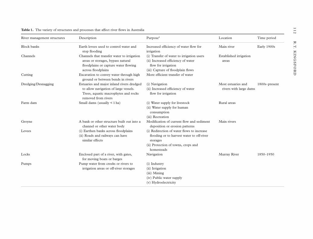
Table 1. The variety of structures and processes that affect river flows in Australia
River management structures Description Purposea Location Time period
Block banks Earth levees used to control water and Increased efficiency of water flow for Main river Early 1900sstop flooding irrigation
Channels Channels that transfer water to irrigation (i) Transfer of water to irrigation users Established irrigation areas or storages, bypass natural (ii) Increased efficiency of water areasfloodplains or capture water flowing flow for irrigationacross floodplains (iii) Capture of floodplain flows
Cutting Excavation to convey water through high More efficient transfer of waterground or between bends in rivers
Dredging/Desnagging Estuaries and major inland rivers dredged (i) Navigation Most estuaries and 1800s–presentto allow navigation of large vessels. (ii) Increased efficiency of water rivers with large damsTrees, aquatic macrophytes and rocks flow for irrigationremoved from rivers
Farm dam Small dams (usually < 1 ha) (i) Water supply for livestock Rural areas(ii) Water supply for human
consumption(iii) Recreation
Groyne A bank or other structure built out into a Modification of current flow and sediment Main riverschannel or other water body deposition or erosion patterns
Levees (i) Earthen banks across floodplains (i) Redirection of water flows to increase (ii) Roads and railways can have flooding or to harvest water to off-river
similar effects storages(ii) Protection of towns, crops and
homesteadsLocks Enclosed part of a river, with gates, Navigation Murray River 1850–1950
for moving boats or bargesPumps Pump water from creeks or rivers to (i) Industry
irrigation areas or off-river storages (ii) Irrigation(iii) Mining(iv) Public water supply(v) Hydroelectricity
IMP
AC
TS
OF
DA
MS
AN
D D
IVE
RS
ION
S O
N F
LO
OD
PL
AIN
WE
TL
AN
DS
11
3
Table 1. continued
River management structures Description Purposea Location Time period
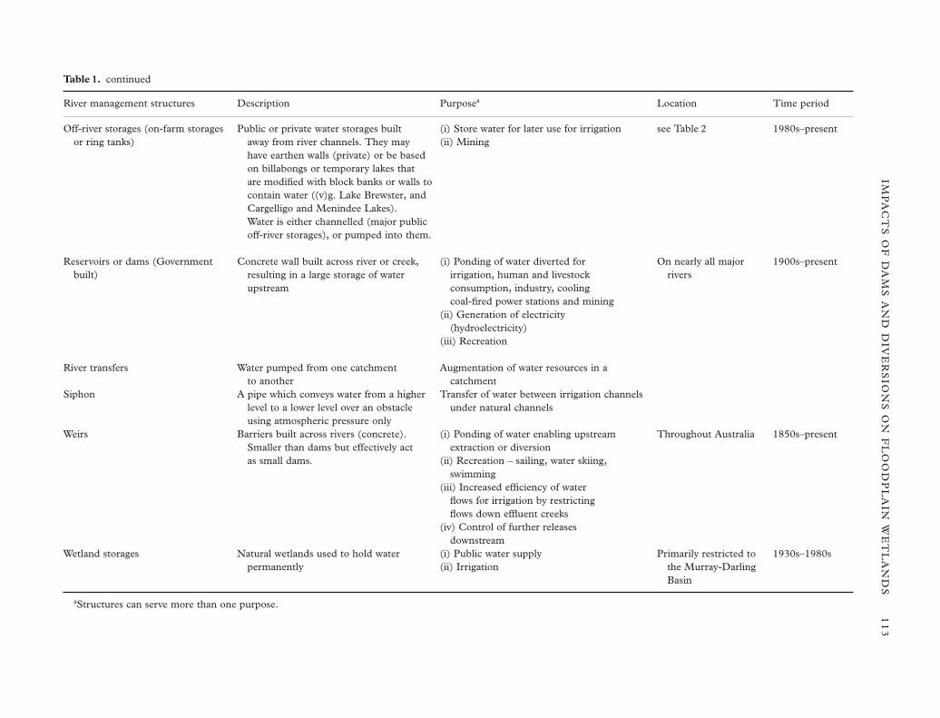
Off-river storages (on-farm storages Public or private water storages built (i) Store water for later use for irrigation see Table 2 1980s–presentor ring tanks) away from river channels. They may (ii) Mining
have earthen walls (private) or be based on billabongs or temporary lakes that are modified with block banks or walls to contain water ((v)g. Lake Brewster, and Cargelligo and Menindee Lakes). Water is either channelled (major public off-river storages), or pumped into them.
Reservoirs or dams (Government Concrete wall built across river or creek, (i) Ponding of water diverted for On nearly all major 1900s–presentbuilt) resulting in a large storage of water irrigation, human and livestock rivers
upstream consumption, industry, cooling coal-fired power stations and mining
(ii) Generation of electricity (hydroelectricity)
(iii) Recreation
River transfers Water pumped from one catchment Augmentation of water resources in a to another catchment
Siphon A pipe which conveys water from a higher Transfer of water between irrigation channels level to a lower level over an obstacle under natural channelsusing atmospheric pressure only
Weirs Barriers built across rivers (concrete). (i) Ponding of water enabling upstream Throughout Australia 1850s–presentSmaller than dams but effectively act extraction or diversionas small dams. (ii) Recreation – sailing, water skiing,
swimming(iii) Increased efficiency of water
flows for irrigation by restricting flows down effluent creeks
(iv) Control of further releases downstream
Wetland storages Natural wetlands used to hold water (i) Public water supply Primarily restricted to 1930s–1980spermanently (ii) Irrigation the Murray-Darling
Basin
aStructures can serve more than one purpose.
disappeared when Lake Pedder was flooded (McComb& Lake 1990; p. 139). Invertebrate communitiesbecome dominated by species adapted to lakes andstanding water (Shiel 1990; Bennison et al. 1991) andmay be less diverse or abundant than those in temp-orary billabongs (Boulton & Lloyd 1991). Unique‘islands’ of floating vegetation supporting successionalstages of aquatic and terrestrial vegetation have almostgone from the Lagoon of Islands (Tyler 1976).Floodplain eucalypts and lignum Muehlenbeckia floru-lenta die with prolonged flooding (Smith & Smith 1990;Walker & Thoms 1993; Thornton & Briggs 1994).Dead floodplain eucalypts around the edge ofMenindee Lake on the Darling River mark remains ofaquatic vegetation that covered the lake, probablychanging a diverse water-bird community to onedominated by piscivores (Kingsford 1995a). Followingpermanent inundation of Tom Bullen Lake on theMurrumbidgee River, the abundance of 14 water-birdspecies declined, compared with only two speciesincreased abundance. Egrets stopped breeding (Briggset al. 1994). Loss of productivity from disturbance ofwet-dry cycles may affect breeding and habitat use ofwater-birds. Prolonged flooding also reduces growthand survival of aquatic macrophytes (Brock & Casanova1991). When Lake Mokoan on the Broken River wasconverted to an off-river storage, high turbiditydestroyed submerged wetland vegetation (Casanova1999). Where water levels are reasonably stable, cum-bungi Typha spp. (Walker et al. 1994; Kingsford1995a) and introduced water hyacinth Eichorniacrassipes can become established (Pressey & Middleton1982; McCosker R. O. & Duggin J. A. (1992; Ginghamwatercourse resource management issues, GwydirRiver Basin, Moree NSW. Unpublished Report,
Department of Ecosystem Management, University ofNew England, Armidale). Regulation of flows may alsofavour exotic fish species such as European carpCyprinus carpio (Gehrke et al. 1995, 1999).
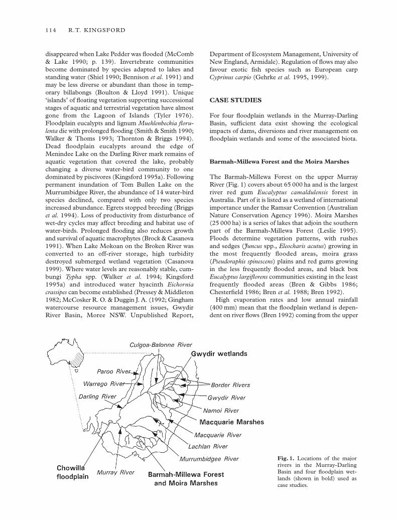
CASE STUDIES
For four floodplain wetlands in the Murray-DarlingBasin, sufficient data exist showing the ecologicalimpacts of dams, diversions and river management onfloodplain wetlands and some of the associated biota.
Barmah-Millewa Forest and the Moira Marshes
The Barmah-Millewa Forest on the upper MurrayRiver (Fig. 1) covers about 65 000 ha and is the largestriver red gum Eucalyptus camaldulensis forest inAustralia. Part of it is listed as a wetland of internationalimportance under the Ramsar Convention (AustralianNature Conservation Agency 1996). Moira Marshes(25 000 ha) is a series of lakes that adjoin the southernpart of the Barmah-Millewa Forest (Leslie 1995).Floods determine vegetation patterns, with rushes and sedges (Juncus spp., Eleocharis acutus) growing inthe most frequently flooded areas, moira grass(Pseudoraphis spinescens) plains and red gums growingin the less frequently flooded areas, and black boxEucalyptus largiflorens communities existing in the leastfrequently flooded areas (Bren & Gibbs 1986;Chesterfield 1986; Bren et al. 1988; Bren 1992).
High evaporation rates and low annual rainfall(400 mm) mean that the floodplain wetland is depen-dent on river flows (Bren 1992) coming from the upper
114 R.T. KINGSFORD
Fig. 1. Locations of the majorrivers in the Murray-DarlingBasin and four floodplain wet-lands (shown in bold) used ascase studies.
catchment of the Murray River. Hume (3 038 000 ML)and Dartmouth Dams (3 906 000 ML) regulate flows,permitting annual average diversion of 1 648 000 ML(1988/89–1992/93) (Murray-Darling Basin MinisterialCouncil 1995; Department of Land and WaterConservation, unpubl. data), mostly (98%) for irri-gation (Murray-Darling Basin Ministerial Council1995). This has more than halved natural averageannual flows at Yarrawonga, about 100 km upstreamof the Barmah-Millewa Forest (Maheshwari et al.1995), and shifted the pattern of flows from spring tosummer (Bren et al. 1987; Close 1990; Maheshwari etal. 1995).
Areas with high flood frequency are most affected(Bren 1988). The percentage of years that the Barmah-Millewa Forest used to flood has declined from 80%to 35% (Close 1990). Flows that water key parts of theforest of 550 000 ML month–1 and 912 000 MLmonth–1 have declined by 48% and 62%, respectively(Murray-Darling Basin Ministerial Council 1995). Inthe period 1895–1929, there were only two years of noflooding compared with 13 in the period 1935–84(Bren et al. 1987). Levees on the riverbank, block banksand regulators, alienate the floodplain and increase theefficiency of the river in the transmission of water down-stream through the naturally constrictive Barmah andMillewa Chokes. Before dams and diversions, thesechokes forced moderate to high flows into the wetland(Bren 1990).
Reduced flooding has changed the composition,growth and regeneration of the vegetation community(Bren et al. 1988; Bren 1991). Plants such as the com-mon reed Phragmites australis, cumbungi and moiragrass, which depend on frequent flooding, havedeclined in abundance (Chesterfield 1986), and redgums are replacing the moira grass plains (Bren 1992).Black box, tolerant of longer periods without floods, isreplacing red gums on the margins (Chesterfield1986). For the trees, reduced growth, crown conditionand regeneration and increased mortality and suscep-tibility to insect attack have accompanied these changes(Bacon et al. 1993; Stone & Bacon 1994). Suchchanges may affect the threatened superb parrotPolytelis swainsonnii, which breeds in large, healthy andmature red gums (Webster 1988).
Populations of fish, water-birds, snakes and leecheshave declined (Leslie 1995). Murray cod Maccullochellapeeli, rarely caught in the river, no longer live in MoiraLake and only 106 native fish were captured duringintense sampling (Gehrke et al. 1995) in an area thatsupported a major commercial native fishing industryfor 45 years, 1855–1900 (Leslie 1995). Brolgas Grusrubicundus are locally extinct and glossy ibis Plegadisfalcinellus, little egrets Ardea garzetta and whiskeredterns Chlidonias hybrida regularly bred in the forestbefore the 1970s, but no longer do so (Leslie 1995).Cormorants Phalacrocorax sp., great egrets Ardea alba,
intermediate egrets Ardea intermedia and rufous nightherons Nycticorax caledonicus still breed but in decliningnumbers (Leslie 1995). Snakes, rarely seen in theMoira Marshes today, were killed in numbers of 50 per day in the 1860s and leeches (Hirudo spp.),gathered in the 1930s for Victorian hospitals (per25 000–60 000 per year), were seldom seen after the1970s (Leslie 1995).
Low flows have increased to a small central part ofthe Barmah-Millewa Forest (Bren 1993; Maheshwariet al. 1995) that is permanently connected to the riveror filled during regulated flows during summer (Pressey1990). Here red gums have died (Bren 1992) andMyriophyllum propinquum has replaced moira grass(Bren 1992).
Chowilla floodplain
The Chowilla floodplain (17 700 ha) has lakes, billa-bongs, islands and more than 100 km of anabranchcreeks (Sharley & Huggan 1995; p. 81), 5–10 km eitherside of the lower Murray River, downstream of itsjunction with the Darling River (Fig. 1). It is the largestfloodplain forest on the lower Murray River andencompasses aquatic vegetation communities (Roberts& Ludwig 1991). Chowilla is listed as a wetland ofinternational importance under the Ramsar Con-vention (Taylor et al. 1996).
Average rainfall is low (250 mm year–1) so thefloodplain depends on upstream flows from the Murray and Darling Rivers, which naturally averaged13 400 000 ML year–1, with variability and absence ofseasonality driven by inflows from the Darling River(Maheshwari et al. 1995). Dams and river managementpermitted an average of 9 801 000 ML to be divertedeach year (1988/89–1992/93) upstream, mostly (about97%) for irrigation (Murray-Darling Basin MinisterialCouncil 1995). Some of this water would have suppliedfloodplain wetlands and aquifers upstream, but nowmedian natural flows to the Chowilla floodplain are halfof natural flows (Maheshwari et al. 1995; Murray-Darling Basin Ministerial Council 1995). Within thewetland, nine embankments stop water flowing downanabranch creeks to the floodplain, maintaining highwater levels in Lock 6 (Sharley & Huggan 1995; p. 87).As well, channel cross-sectional area is enlarged inmany sites, reducing the potential for flooding (Thoms& Walker 1993). Water used to reach the floodplainabout every 1.2 years but now reaches it every 2.5 years(Thoms & Walker 1993). The area of the floodplaininundated every second year has declined from 33 to5%, and the area inundated every 10 years has declinedfrom 77 to 54% (Jolly et al. 1992). Flows that used toflood about 30% of the floodplain (50 000 ML day–1)now occur every three years and last half as long(Sharley & Huggan 1995; p. 93). Large floods of
IMPACTS OF DAMS AND DIVERSIONS ON FLOODPLAIN WETLANDS 115
100 000 ML day–1 which previously inundated thefloodplain every three years, lasting for three months,now occur every 10 years and last for two months(Sharley & Huggan 1995; p. 93).
Reduced flooding has affected vegetation health.Saline groundwater previously flowed underneath thefloodplain into the Murray River before the lock wasbuilt, but the creeks now intercept it (Jolly et al. 1992;Taylor et al. 1996). Floods used to leach salt from thesoils but now saline groundwater is discharged in thefloodplain by evapotranspiration, and it is killing blackbox trees (Jolly et al. 1993). Black box trees flooded one year in 10 remain healthy (Taylor et al. 1996), butthey have died in areas not flooded for 35 years (Jollyet al. 1992). Red gums, restricted to the margins of thewatercourses (Roberts & Ludwig 1990), take waterfrom creeks and groundwater (Thorburn et al. 1994).Reduced flooding of the wetland has probably affectedother plants such as lignum, where foliage cover ispositively correlated with soil moisture and flooding(Craig et al. 1991).
Low frequency flooding (one year in 22) on theChowilla floodplain resulted in only protozoans hatch-ing and lower abundance and biomass of invertebratescompared to more frequent inundation (Boulton &Lloyd 1992). The temporary wetland habitats have thehighest invertebrate biodiversity (Boulton & Lloyd1991). Populations of 18 species of gastropod snails inthe lower Murray River have declined in the last 50years (Sheldon & Walker 1993). Such reductions willaffect survival of native fish species and the many water-birds that feed on invertebrates (Boulton & Lloyd1992). Native fish populations in the Murray River havedeclined with the increase in storage capacity after the1950s (Walker & Thoms 1993). Low flows haveincreased in the river and have contributed to the estab-lishment of dense littoral plants, reeds Phragmites aus-tralis and cumbungi Tyhpa spp., in weir pools(Maheshwari et al. 1995). Species richness of riparianvegetation was lowest in areas exposed to current andwave action and highest in the billabongs and back-waters of the floodplain (Roberts & Ludwig 1991).
Gwydir wetlands
The Gwydir River usually terminates in the Gwydirfloodplain wetlands (Fig. 1), the Lower Gwydir (to thesouth) and Gingham (to the north) watercourses.Annual rainfall is less than 450 mm (Keyte 1994), sothe wetlands rely on water from the upper catchment,300 km to the east. The network of wetlands of vary-ing persistence is surrounded primarily by coolabahEucalyptus coolabah and river cooba Acacia stenophylla,with lignum on low parts of the floodplain (McCosker& Duggin, 1992, unpubl. report; Keyte 1994). TheLower Gwydir watercourse supports about 24 000 ha
of wetland that includes 7500 ha of water couchPaspalum distichum and 700 ha of marsh club-rushBolboschoenus fluviatilis (Keyte 1994). The wetlandswere declared a Bird and Wildlife Sanctuary in 1921(Keyte 1994) for their waterbirds, and part is to belisted as a wetland of international importance underthe Ramsar Convention.
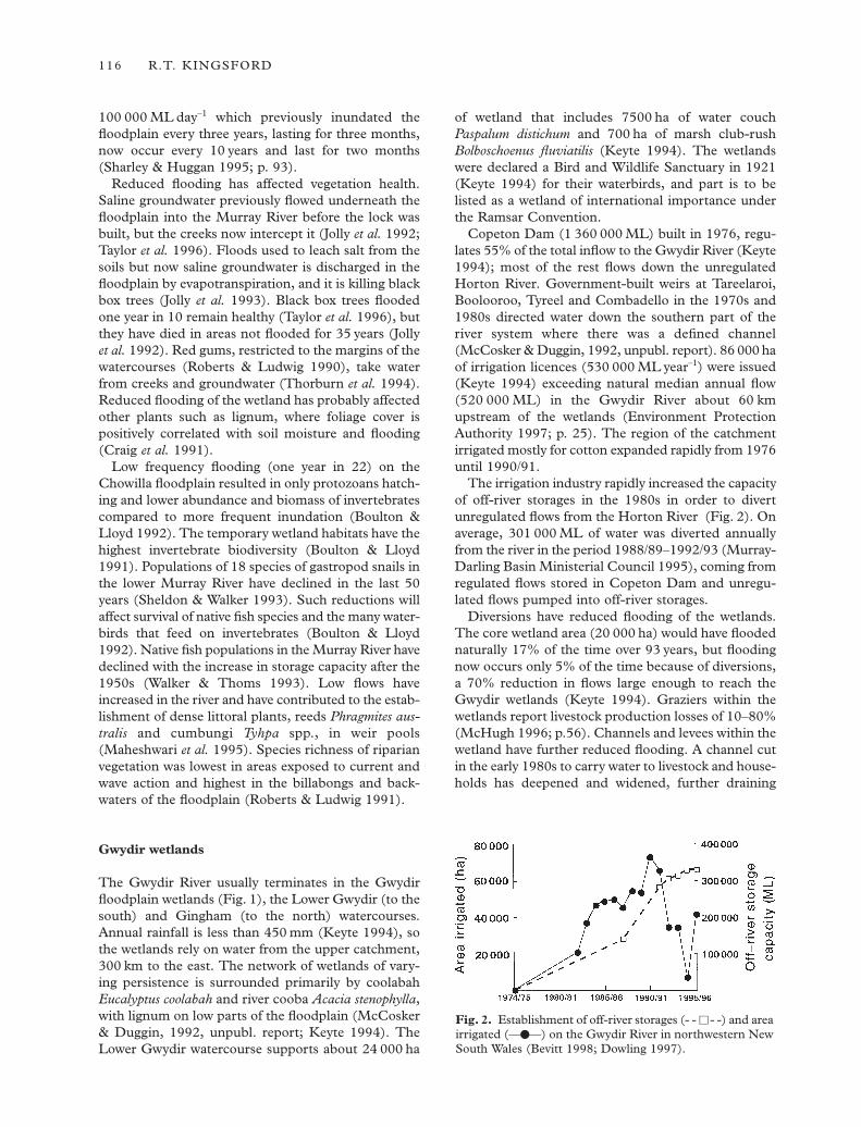
Copeton Dam (1 360 000 ML) built in 1976, regu-lates 55% of the total inflow to the Gwydir River (Keyte1994); most of the rest flows down the unregulatedHorton River. Government-built weirs at Tareelaroi,Boolooroo, Tyreel and Combadello in the 1970s and1980s directed water down the southern part of theriver system where there was a defined channel(McCosker & Duggin, 1992, unpubl. report). 86 000 haof irrigation licences (530 000 ML year–1) were issued(Keyte 1994) exceeding natural median annual flow(520 000 ML) in the Gwydir River about 60 kmupstream of the wetlands (Environment ProtectionAuthority 1997; p. 25). The region of the catchmentirrigated mostly for cotton expanded rapidly from 1976until 1990/91.
The irrigation industry rapidly increased the capacityof off-river storages in the 1980s in order to divertunregulated flows from the Horton River (Fig. 2). Onaverage, 301 000 ML of water was diverted annuallyfrom the river in the period 1988/89–1992/93 (Murray-Darling Basin Ministerial Council 1995), coming fromregulated flows stored in Copeton Dam and unregu-lated flows pumped into off-river storages.
Diversions have reduced flooding of the wetlands.The core wetland area (20 000 ha) would have floodednaturally 17% of the time over 93 years, but floodingnow occurs only 5% of the time because of diversions,a 70% reduction in flows large enough to reach theGwydir wetlands (Keyte 1994). Graziers within thewetlands report livestock production losses of 10–80%(McHugh 1996; p.56). Channels and levees within thewetland have further reduced flooding. A channel cutin the early 1980s to carry water to livestock and house-holds has deepened and widened, further draining
116 R.T. KINGSFORD
Fig. 2. Establishment of off-river storages (- - h- -) and areairrigated (—d—) on the Gwydir River in northwestern NewSouth Wales (Bevitt 1998; Dowling 1997).
wetland areas and reducing flows onto the floodplain(McCosker & Duggin, 1992, unpublished report).Another elevated (2 m) irrigation channel, licensed in1986, crosses the Lower Gwydir watercourse and stopswater from flowing to parts of the wetland (Keyte1994). Other levees, about 0.5 m high, redirect waterwithin the wetlands to maximise grazing benefits(Keyte 1994).
Cover by marsh club-rush in the Lower Gwydirwatercourse has contracted to one-third of its originalarea: 2200 ha to 700 ha (Keyte 1994). In parts of theLower Gwydir and Gingham watercourses, terrestrialvegetation has established where aquatic vegetationlived (McCosker & Duggin, 1992, unpublished report;Keyte 1994), and lignum communities in the LowerGwydir are degraded (Keyte 1994). There are no pub-lished accounts of the impacts of these changes on otherfauna and flora.
Macquarie Marshes
The Macquarie Marshes are major floodplain wetlandsat the end of the Macquarie River (Fig. 1). Theycovered about 130 000 ha during the 1990 flood(Kingsford & Thomas 1995). Flooding depends onflows from the upper catchment of the Macquarie River(Kingsford & Thomas 1995), more than 460 km to thesoutheast. During large floods, water flows through theMacquarie Marshes to reach the Darling River. TheMacquarie Marshes are recognised for their conser-vation importance with 18 000 ha proclaimed as aNature Reserve in 1971 and listed as a wetland of inter-national importance under the Ramsar Convention.They have the largest reed beds, the largest northernarea of red gums, and the most southerly occurrenceof coolabah in New South Wales (Environmental Pro-tection Authority 1995). Seventy-two species of water-birds, including 43 breeding, have been recorded withinthe marshes (Kingsford & Thomas 1995). They arealso one of the more important sites for colonially breed-ing water-birds in Australia (Marchant & Higgins 1990).
Burrendong Dam, built in 1967 with a storagecapacity of 1 678 000 ML, regulates most river flow(70%). Nine large dams, including Windamere Dam(353 000 ML), eight weirs, four bypass channels, a rivertransfer scheme and a system of 12 block banks, cut-tings, groynes, regulators and siphons help supply waterto irrigation, industry and towns. Most water (89%)diverted is for irrigation (Department of WaterResources 1991), which also takes unregulated flowswith pumps and off-river storages. Consequently, theirstorage capacity rose from 15 000 ML in 1986 to41 000 ML in 1992 (Kingsford & Thomas 1995). Twohundred thousand megalitres of unregulated flows in1991/1992 were diverted by refilling off-river storages(Kingsford 1999b). A cap of 50 000 ML now appliesto diversions of these flows (Department of Land and
Water Conservation and National Parks and WildlifeService 1996). An average of 471 000 ML year–1 wasdiverted from the river, predominantly upstream of theMacquarie Marshes, in the period 1988/89–1992/93and reached a maximum in 1993/94 (543 000 ML).Before regulation and diversions, about 51% of thewater passing the town of Dubbo (about 100 kmupstream) reached the Macquarie Marshes, but by thelate 1980s and early 1990s this had declined to about21% (Kingsford & Thomas 1995). This has reducedthe Macquarie Marshes to at least 40–50% of theiroriginal size (Kingsford & Thomas 1995). Reducedlarge flows and increased small flows have alsodecreased flow variability (Kingsford & Thomas 1995).
Low flows have eroded river channels, further reduc-ing flows to the floodplain (Bell et al. 1983). An 18-kmlong channel, the northern bypass channel, was dug bygovernment before 1970 to efficiently deliver water todownstream users (Water Conservation and IrrigationCommission 1975). Excavated soil formed a levee thatalienated the adjacent eastern part of the floodplainfrom the river and retained floodwater on the westernside for periods of more than 12 months (W. Johnson,1999, personal communication). Other levees have beenerected on the floodplain to redistribute flood flows.
Such changes have affected the biota. Abundanceand species richness of water-birds in the northern partof the Macquarie Marshes declined over an 11-yearperiod (Kingsford & Thomas 1995). Reduced flood-ing has resulted in smaller colony sizes and less frequentbreeding of colonial water-birds than would haveoccurred naturally (Kingsford & Johnson 1999). In thecore of the Macquarie Marshes, the area of river redgum has declined by about 14% (Brereton 1994) andin some areas mature trees are in poor health (BaconP. 1996; Relationships between water supply, waterquality and the performance of Eucalyptus camaldulen-sis in the Macquarie Marshes of NSW. UnpublishedReport to Macquarie Marshes Unit, NSW Departmentof Land and Water Conservation, Dubbo). Halving ofthe area growing red gums occurred between 1934 and1981, and of the area growing reed beds between 1963and 1972 (Brander 1987). Water couch in the core ofthe Marshes declined by 40% between 1949 and 1991and was replaced by dryland vegetation (Brereton1994). Constant small supplies of water down some ofthe channels have killed floodplain eucalypts. The leveeon the bypass channel retains floodwaters and has killedseveral hundred hectares of coolabahs 1970s (Johnson,W. J., pers. comm.).
EXTENT OF ECOLOGICAL IMPACTS ONFLOODPLAIN WETLANDS
The locations of 446 large dams and the distributionof diversions in river basins (Fig. 3, Table 2) provide a
IMPACTS OF DAMS AND DIVERSIONS ON FLOODPLAIN WETLANDS 117
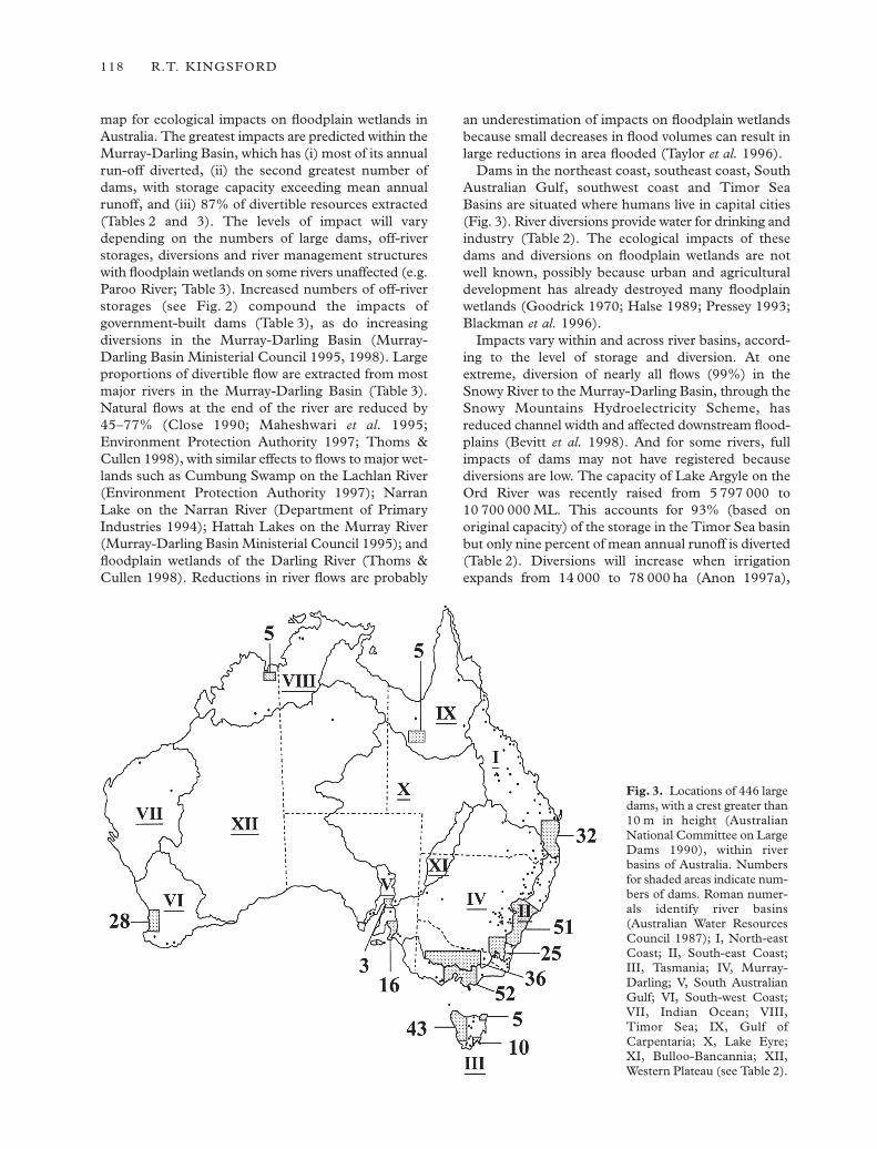
map for ecological impacts on floodplain wetlands inAustralia. The greatest impacts are predicted within theMurray-Darling Basin, which has (i) most of its annualrun-off diverted, (ii) the second greatest number ofdams, with storage capacity exceeding mean annualrunoff, and (iii) 87% of divertible resources extracted(Tables 2 and 3). The levels of impact will varydepending on the numbers of large dams, off-riverstorages, diversions and river management structureswith floodplain wetlands on some rivers unaffected (e.g.Paroo River; Table 3). Increased numbers of off-riverstorages (see Fig. 2) compound the impacts ofgovernment-built dams (Table 3), as do increasingdiversions in the Murray-Darling Basin (Murray-Darling Basin Ministerial Council 1995, 1998). Largeproportions of divertible flow are extracted from mostmajor rivers in the Murray-Darling Basin (Table 3).Natural flows at the end of the river are reduced by45–77% (Close 1990; Maheshwari et al. 1995;Environment Protection Authority 1997; Thoms &Cullen 1998), with similar effects to flows to major wet-lands such as Cumbung Swamp on the Lachlan River(Environment Protection Authority 1997); NarranLake on the Narran River (Department of PrimaryIndustries 1994); Hattah Lakes on the Murray River(Murray-Darling Basin Ministerial Council 1995); andfloodplain wetlands of the Darling River (Thoms &Cullen 1998). Reductions in river flows are probably
an underestimation of impacts on floodplain wetlandsbecause small decreases in flood volumes can result inlarge reductions in area flooded (Taylor et al. 1996).
Dams in the northeast coast, southeast coast, SouthAustralian Gulf, southwest coast and Timor SeaBasins are situated where humans live in capital cities(Fig. 3). River diversions provide water for drinking andindustry (Table 2). The ecological impacts of thesedams and diversions on floodplain wetlands are not well known, possibly because urban and agriculturaldevelopment has already destroyed many floodplainwetlands (Goodrick 1970; Halse 1989; Pressey 1993;Blackman et al. 1996).
Impacts vary within and across river basins, accord-ing to the level of storage and diversion. At oneextreme, diversion of nearly all flows (99%) in theSnowy River to the Murray-Darling Basin, through theSnowy Mountains Hydroelectricity Scheme, hasreduced channel width and affected downstream flood-plains (Bevitt et al. 1998). And for some rivers, fullimpacts of dams may not have registered becausediversions are low. The capacity of Lake Argyle on theOrd River was recently raised from 5 797 000 to10 700 000 ML. This accounts for 93% (based onoriginal capacity) of the storage in the Timor Sea basinbut only nine percent of mean annual runoff is diverted(Table 2). Diversions will increase when irrigationexpands from 14 000 to 78 000 ha (Anon 1997a),
118 R.T. KINGSFORD
Fig. 3. Locations of 446 largedams, with a crest greater than10 m in height (AustralianNational Committee on LargeDams 1990), within riverbasins of Australia. Numbersfor shaded areas indicate num-bers of dams. Roman numer-als identify river basins(Australian Water ResourcesCouncil 1987); I, North-eastCoast; II, South-east Coast;III, Tasmania; IV, Murray-Darling; V, South AustralianGulf; VI, South-west Coast;VII, Indian Ocean; VIII,Timor Sea; IX, Gulf ofCarpentaria; X, Lake Eyre;XI, Bulloo-Bancannia; XII,Western Plateau (see Table 2).
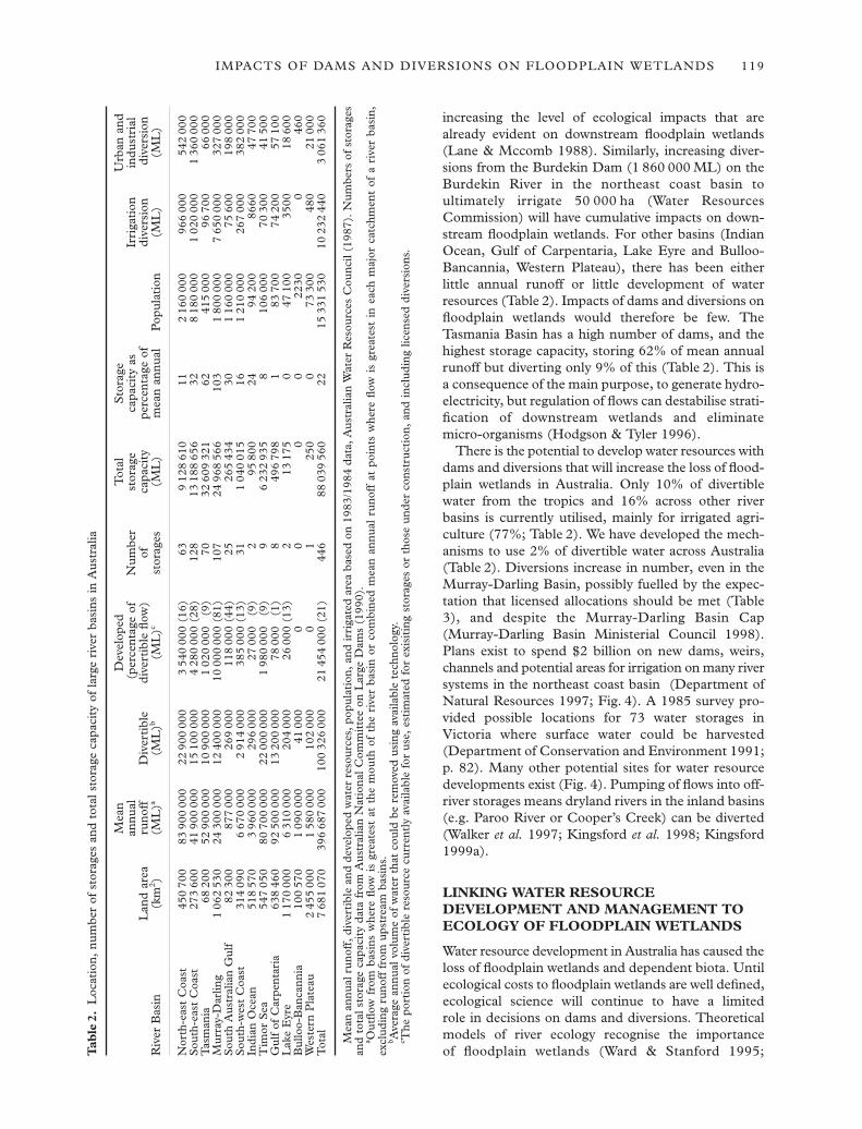
increasing the level of ecological impacts that arealready evident on downstream floodplain wetlands(Lane & Mccomb 1988). Similarly, increasing diver-sions from the Burdekin Dam (1 860 000 ML) on theBurdekin River in the northeast coast basin toultimately irrigate 50 000 ha (Water ResourcesCommission) will have cumulative impacts on down-stream floodplain wetlands. For other basins (IndianOcean, Gulf of Carpentaria, Lake Eyre and Bulloo-Bancannia, Western Plateau), there has been either little annual runoff or little development of waterresources (Table 2). Impacts of dams and diversions onfloodplain wetlands would therefore be few. TheTasmania Basin has a high number of dams, and thehighest storage capacity, storing 62% of mean annualrunoff but diverting only 9% of this (Table 2). This isa consequence of the main purpose, to generate hydro-electricity, but regulation of flows can destabilise strati-fication of downstream wetlands and eliminatemicro-organisms (Hodgson & Tyler 1996).
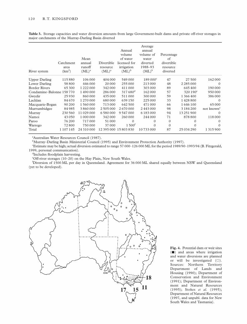
There is the potential to develop water resources withdams and diversions that will increase the loss of flood-plain wetlands in Australia. Only 10% of divertiblewater from the tropics and 16% across other riverbasins is currently utilised, mainly for irrigated agri-culture (77%; Table 2). We have developed the mech-anisms to use 2% of divertible water across Australia(Table 2). Diversions increase in number, even in theMurray-Darling Basin, possibly fuelled by the expec-tation that licensed allocations should be met (Table3), and despite the Murray-Darling Basin Cap(Murray-Darling Basin Ministerial Council 1998).Plans exist to spend $2 billion on new dams, weirs,channels and potential areas for irrigation on many riversystems in the northeast coast basin (Department ofNatural Resources 1997; Fig. 4). A 1985 survey pro-vided possible locations for 73 water storages inVictoria where surface water could be harvested(Department of Conservation and Environment 1991;p. 82). Many other potential sites for water resourcedevelopments exist (Fig. 4). Pumping of flows into off-river storages means dryland rivers in the inland basins(e.g. Paroo River or Cooper’s Creek) can be diverted(Walker et al. 1997; Kingsford et al. 1998; Kingsford1999a).
LINKING WATER RESOURCEDEVELOPMENT AND MANAGEMENT TOECOLOGY OF FLOODPLAIN WETLANDS
Water resource development in Australia has caused theloss of floodplain wetlands and dependent biota. Untilecological costs to floodplain wetlands are well defined,ecological science will continue to have a limited role in decisions on dams and diversions. Theoreticalmodels of river ecology recognise the importance of floodplain wetlands (Ward & Stanford 1995;
IMPACTS OF DAMS AND DIVERSIONS ON FLOODPLAIN WETLANDS 119
Tab
le2.
Loc
atio
n, n
umbe
r of
sto
rage
s an
d to
tal s
tora
ge c
apac
ity
of la
rge
rive
r ba
sins
in A
ustr
alia
Mea
n D
evel
oped
Tot
al
Sto
rage
U
rban
and
annu
al(p
erce
ntag
e of
Num
ber
stor
age
capa
city
as
Irri
gati
onin
dust
rial
Lan
d ar
earu
noff
Div
erti
ble
dive
rtib
le fl
ow)
ofca
paci
type
rcen
tage
of
dive
rsio
ndi
vers
ion
Riv
er B
asin
(km
2 )(M
L)a
(ML
)b(M
L)c
stor
ages
(ML
)m
ean
annu
alP
opul
atio
n(M
L)
(ML
)
Nor
th-e
ast
Coa
st45
070
083
900
000
2290
000
03
540
000
(16)
639
128
610
112
160
000
966
000
542
000
Sou
th-e
ast
Coa
st27
360
041
900
000
1510
000
04
280
000
(28)
128
1318
865
632
818
000
01
020
000
136
000
0T
asm
ania
6820
052
900
000
1090
000
01
020
000
(9)
7032
609
321
6241
500
096
700
6600
0M
urra
y-D
arlin
g1
062
530
2430
000
012
400
000
1000
000
0 (8
1)10
724
968
566
103
180
000
07
650
000
327
000
Sou
th A
ustr
alia
n G
ulf
8230
087
700
026
900
011
800
0 (4
4)25
265
434
301
160
000
7560
019
800
0S
outh
-wes
t C
oast
314
090
667
000
02
914
000
385
000
(13)
311
040
015
161
210
000
267
000
382
000
Indi
an O
cean
518
570
396
000
029
600
027
000
(9)
295
800
2494
200
8660
4770
0T
imor
Sea
547
050
8070
000
022
000
000
198
000
0(9
)9
623
293
58
106
000
7030
041
500
Gul
f of
Car
pent
aria
638
460
9250
000
013
200
000
7800
0(1
)8
496
798
183
700
7420
057
100
Lak
e E
yre
117
000
06
310
000
204
000
2600
0 (1
3)2
1317
50
4710
035
0018
600
Bul
loo-
Ban
cann
ia10
057
01
090
000
4100
00
(13)
00
022
300
460
Wes
tern
Pla
teau
245
500
01
580
000
102
000
0 (1
3)1
250
073
300
480
2100
0T
otal
768
107
039
668
700
010
032
600
021
454
000
(21)
446
8803
956
022
1533
153
010
232
440
306
136
0
Mea
n an
nual
run
off,
div
erti
ble
and
deve
lope
d w
ater
res
ourc
es, p
opul
atio
n, a
nd ir
riga
ted
area
bas
ed o
n 19
83/1
984
data
, Aus
tral
ian
Wat
er R
esou
rces
Cou
ncil
(198
7). N
umbe
rs o
f st
orag
esan
d to
tal s
tora
ge c
apac
ity
data
fro
m A
ustr
alia
n N
atio
nal C
omm
itte
e on
Lar
ge D
ams
(199
0).
a Out
flow
fro
m b
asin
s w
here
flow
is
grea
test
at
the
mou
th o
f th
e ri
ver
basi
n or
com
bine
d m
ean
annu
al r
unof
f at
poi
nts
whe
re fl
ow i
s gr
eate
st i
n ea
ch m
ajor
cat
chm
ent
of a
riv
er b
asin
,ex
clud
ing
runo
ff f
rom
ups
trea
m b
asin
s.b A
vera
ge a
nnua
l vol
ume
of w
ater
tha
t co
uld
be r
emov
ed u
sing
ava
ilabl
e te
chno
logy
.c T
he p
orti
on o
f di
vert
ible
res
ourc
e cu
rren
tly
avai
labl
e fo
r us
e, e
stim
ated
for
exi
siti
ng s
tora
ges
or t
hose
und
er c
onst
ruct
ion,
and
incl
udin
g lic
ense
d di
vers
ions
.
120 R.T. KINGSFORD
Table 3. Storage capacities and water diversion amounts from large Government-built dams and private off-river storages inmajor catchments of the Murray-Darling Basin diverted
Average Annual annualvolume volume of Percentage
Mean of water water ofCatchment annual Divertible licensed for diverted divertible
area runoff resource irrigation 1988–93 resourceRiver system (km2) (ML)a (ML)a (ML)b (ML)b diverted
Upper Darling 115 880 106 000 404 000 549 000d 189 000c 47 27 500d 162 000Lower Darling 58 800 446 000 20 000 255 000d 213 000d 48 2 285 000d 0Border Rivers 65 300 1 222 000 342 000 411 000d 303 000d 89 645 400d 190 000Condamine–Balonne 158 770 1 490 000 286 000 317 680d 162 000d 57 320 190e 950 000Gwydir 25 930 860 000 435 000 511 000d 300 000d 59 1 366 400d 386 000Lachlan 84 670 1 270 000 680 000 639 150d 225 000d 33 1 428 800d 0Macquarie-Bogan 90 200 1 560 000 713 000 642 500d 471 000d 66 1 646 100d 65 000Murrumbidgee 84 985 3 860 000 2 505 000 2 670 000d 2 443 000d 98 3 184 200d not knowne
Murray 230 560 11 029 000 6 580 000 9 547 000d 6 183 000d 94 13 251 900d 0Namoi 43 050 1 000 000 342 000 260 000d 244 000d 71 878 800d 118 000Paroo 76 200 717 000 51 000 0d 0d 0 0d 0Warrego 72 800 750 000 37 000 1 500f 0d 0 0d 0Total 1 107 145 24 310 000 12 395 000 15 803 830d 10 733 000d 87 25 034 290d 1 315 900
aAustralian Water Resources Council (1987).bMurray–Darling Basin Ministerial Council (1995) and Environment Protection Authority (1997).cEstimate may be high; actual diversion estimated to range 57 000–126 000 ML for the period 1989/90–1993/94 (B. Fitzgerald,
1999, personal communication).dIncludes floodplain harvesting.eOff-river storages (10–20) on the Hay Plain, New South Wales.fDiversion of 1500 ML per day in Queensland. Agreement for 36 000 ML shared equally between NSW and Queensland
(yet to be developed).
Fig. 4. Potential dam or weir sites(d) and areas where irrigationand water diversions are plannedor will be investigated (s).Sources: Northern TerritoryDepartment of Lands andHousing (1990); Department ofConservation and Environment(1991); Department of Environ-ment and Natural Resources(1995); Stokes et al. (1995);Department of Natural Resources(1997, and unpubl. data for NewSouth Wales and Tasmania).

Ward 1998). In practice, river managers focus on the hydrology of the river channel, while conservationmanagers concentrate on the ecology of floodplainwetlands.
Hydrological models have been primarily developedfor delivering water for human purposes. Their flowdata comes from the river channel and seldom fromfloodplain wetlands. The integrated water quantity andquality model, IQQM (Department of Water Resources1995), used to manage rivers in New South Wales andQueensland, has a series of diversion nodes mainly forhuman use (e.g. towns and irrigation industries).Climate data and runoff models provide input variablesfor simulated modelling of natural flows versus currentflows, usually based on 100 years of data. The relevanceof these to the inundation of floodplain wetlands isunknown, but their ecological simplicity fails to modelthe complex connectivity and flow patterns that occur.Despite this, the model was used to determine thehydrological impacts of diversions on the 100 000-km2
floodplain at Cooper’s Creek, using inadequate flowdata (Thoms & Cullen 1998; Puckridge 1999).Potential ecological impacts (Walker et al. 1997;Kingsford et al. 1998) were ignored and increaseddiversion recommended on the basis of hydrologicalanalyses (Department of Natural Resources 1998).Similarly, a proposal to build Nathan Dam(1 100 000 ML) on the Dawson River in Queenslandwas recommended after ecological and social impactassessment (Hyder Environmental 1997). Only 7.5%of the assessment dealt with downstream impacts (51 pages out of 291), and there was no reference topeer-reviewed studies of impacts of dams and waterdiversions.
Decisions to divert water from rivers remain theprime responsibility of water managers and there arefew opportunities to review the predictive power ofhydrological models (Thoms & Cullen 1998), or theirecological relevance. Complex jargon compounds theproblem (see Appendix, Table A1), and policies forallocation, off-allocation, floodplain harvesting, theMurray-Darling Cap, and sleeper allocation, interactwith and govern river flows and diversions. Thesepolicies ultimately determine how much water reachesfloodplain wetlands, but conservation strategies forfloodplain wetlands are often independent of riverflows. Wetland reserves, listing of Ramsar sites (Davis1994), and identification of important wetlands(Australian Nature Conservation Agency 1996), areconservation measures focused on wetland sites notwater. Even wetland policies (e.g. in New South Walesand Western Australia, and Commonwealth policies)deal poorly with the importance of river flows to flood-plain wetlands because they fail to identify trade-offsbetween flows to wetlands and diversions to humans.This lack of integration is exacerbated by fundingframeworks that separate the wetland from the river
(e.g. Wetlands and Rivercare programs in the NaturalHeritage Trust). Conservation measures seldom dealadequately with protection of flows upstream(Barendregt et al. 1995).
Three areas exist for urgent ecological research onfloodplain wetlands. First, long-term ecological impactsof water resource development on biota, ecologicalprocesses and hydrology of floodplain wetlands needto be investigated. This will allow the ecological costsof proposed water resource developments to be defined.Second, hypotheses about relationships betweenhydrology and floodplain ecology (states and processes)need to be tested, using floods as landscape-scaleexperiments (Sparks et al. 1990; Power et al. 1996).Few studies have investigated the impacts of regulationon connectivity of floodplains (Ward & Stanford 1993).Such analyses will be relevant to river managementdecisions. Finally, for rivers with little or no develop-ment, an understanding of the ecological importanceof natural flood events and their periodicity may pro-vide a basis on which to assess future impacts (e.g.Kingsford et al. 1999; Puckridge 1999).
Extended time scales are necessary for researchbecause flows of Australian rivers are amongst the mostvariable in the world (McMahon et al. 1992; Puckridgeet al. 1998). The conceptual framework of ‘controlsites’ and BACI designs (Green 1993; Underwood1993; Osenberg et al. 1994), and analyses of long-termtrends, can provide deeper insights and greater statis-tical power. Floodplains exist on some rivers (e.g. ParooRiver and Cooper’s Creek) that are not affected bydams and diversions, and may therefore be used forcomparison. Three historical sources of data areuseful: rainfall, water flow and satellite data. Rainfallstations over much of Australia measure climaticchanges and more than 50 years of flow data exists formany rivers in the eastern states. There are almost 20 years of satellite data offering continuous data onflooding at large spatial scales (Roughgarden et al.1991). Relationships between flows and flooding ofwetlands, combined with historical flow data, can helpdetermine the impacts of dams and water diversionson floodplain wetlands (Kingsford & Thomas 1995).Landscape measurement of biota in a floodplainwetland is difficult but possible with robust and rapidtechniques (Taylor et al. 1996). Processes such asrecruitment are more difficult to measure, but mayultimately determine a population’s capacity to respond(Walker et al. 1995).
Hydrological models must predict flooding and dry-ing patterns of floodplain wetlands and be linked toecological processes and biotic life cycles. Scientistsneed to work with management by proposing and test-ing hypotheses about flooding and ecological responsesand testing predictive power of hydrological modelling,and feeding these back into improving managementpractices (Walters & Holling 1990).
IMPACTS OF DAMS AND DIVERSIONS ON FLOODPLAIN WETLANDS 121

CONCLUSIONS
Reduced flooding to large areas of floodplain wetlandshave been caused by the building of dams and thecumulative impact of diversions and river managementupstream. Floodplains have turned into terrestrialecosystems. This effect is not well studied, and dataexist only for a fraction of potentially affected biota,even for four large floodplain wetlands (Fig. 1).Nevertheless, the range of biota affected by reducedflooding testifies to the generality of this problem. Theubiquity of large dams, diversions (Fig. 3; Tables 2 and3), and the solely hydrological principles used indecision-making models, means that ecological impactsare probably widespread in Australia, although few riversystems have been investigated. Hydrological modelsneed to incorporate connectivity of the floodplain sothat ecological costs can be adequately estimated forfuture water resource developments (Fig. 4).
Floodplain wetlands are sites of extraordinary bio-diversity and their loss will continue until there is awidespread understanding of the long-term ecologicaleffects of dams and diversions. We need to recognisethat flows to floodplain wetlands serve an ecologicalfunction and are not lost or wasted.
ACKNOWLEDGEMENTS
Thanks to Angela Arthington, Sue Briggs, Stuart Bunn,David Dutaillis, Bruce Fitzgerald, John Porter andStuart Halse who provided comments on this manu-script. Susan Davis helped with the figures and thetables.
The paper was supported by funding from the NewSouth Wales National Parks and Wildlife Service.
REFERENCES
Allan J. D. & Flecker A. S. (1993) Biodiversity conservation inrunning waters. Bioscience 43, 32–43.
Anon (1997a) WA will quadruple Ord scheme. Land Water News1, 8.
Australian Nature Conservation Agency (1996) A Directory ofImportant Wetlands in Australia, 2nd edn. Australian NatureConservation Agency, Canberra.
Australian National Committee on Large Dams (1990) Registerof large dams in Australia, 1990. (International Commissionon Large Dams, National Committee on Large Dams.)Hydroelectric Commission, Hobart.
Australian Water Resources Council (1975) Review of Australia’sWater Resources. Australian Government Publishing Service,Canberra.
Australian Water Resources Council (1987) 1985 Review ofAustralia’s Water Resources and Water Use, parts 1 and 2.(Department of Primary Industries and Energy.) AustralianGovernment Publishing Service, Canberra.
Bacon P. E., Stone C., Binns D. L., Leslie D. J. & Edwards D. W. (1993) Relationships between water availability and
Eucalyptus camaldulensis growth in a riparian forest. J. Hydrol. 150, 541–61.
Barendregt A., Wassen M. J. & Schot P. P. (1995) Hydrologicalsystems beyond a nature reserve, the major problem in wet-land conservation of Naardermeer (the Netherlands). Biol.Conserv. 72, 393–405.
Barmuta L. A., Marchant R. & Lake P. S. (1992) Degradationof Australian streams and progress towards conservation andmanagement in Victoria. In: River Conservation andManagement Boon (eds P. J. Boon, P. Calow & G. E. Petts)pp. 65–79. John Wiley & Sons, Chichester.
Bell J. D., Berra T. M., Jackson P. D., Last P. R. & Sloane R. D.(1980) Recent records of Australian grayling Prototroctesmaraena Gunther (Pisces: Prototroctidae) with notes on itsdistribution. Aust. J. Zool. 20, 419–31.
Bell F. C., Coates S. J. & Smith G. (1983) Resolution of a con-flict between water needs for irrigation and conservation? TheMacquarie Marshes. In: Proceedings of the Water ResourcesConference, Macquarie University, 16 July 1983 (eds P. Crabb, D. C. Rich & S. J. Riley) pp. 60–74.
Bennison G., Sullivan C. & Suter P. (1991) Macroinvertebrateand phytoplankton communities of the River Murray.Conservation in management of the River Murray system –making conservation count. In: Proceedings of the Third FennerConference on the Environment, Canberra, September 1989 (edsT. Dendy & M. Combe), pp. 231–9. South AustralianDepartment of Environment and Planning, with theAustralian Academy of Science, Adelaide.
Bevitt R. L., Erskine W., Gillespie G. et al. (1998) Expert Panel Environmental Flow Assessment of Various RiversAffected by the Snowy Mountains Scheme. Report to theNew South Wales Department of Land and WaterConservation, Sydney.
Blackman J. G., Perry T. W., Ford G. I. et al. (1996) Queensland.In: A Directory of Important Wetlands in Australia, 2nd edn(eds R. Blackley, S. Usback & K. Langford) pp. 177–433.Australian Nature Conservation Agency, Canberra.
Boon P. I. & Shiel R. J. (1990) Grazing on bacteria by zoo-plankton in Australian billabongs. Aust. J. Mar. Freshwat. Res.41, 247–57.
Boon P. I., Virtue P. & Nichols P. D. (1996) Microbial consor-tia in wetland sediments: a biomarker analysis of the effectsof hydrological regime, vegetation, and season on benthicmicrobes. Mar. Freshwat. Res. 47, 27–41.
Boulton A. J. (1991) Eucalypt leaf decomposition in an inter-mittent stream in south-eastern Australia. Hydrobiologia 211,123–36.
Boulton A. J. & Lloyd L. N. (1991) Aquatic macroinvertebrateassemblages in floodplain habitats of the lower River Murray.Regul. Riv. 6, 183–201.
Boulton A. J. & Lloyd L. N. (1992) Flooding frequency and inver-tebrate emergence from dry floodplain sediments of the RiverMurray, Australia. Regul. Riv. 7, 137–51.
Brander D. (1987) Environmental changes in the southernMacquarie Marshes: 1934–87. BSc (Hons) Thesis, Uni-versity of New South Wales, Sydney.
Bren L. J. (1988) Effects of river regulation on flooding of ariparian red gum forest on the River Murray, Australia. Regul.Riv. 2, 65–77.
Bren L. (1990) Red gum forests. In: The Murray (eds MackayN. & Eastburn D.) pp. 231–42. Murray-Darling BasinCommission, Canberra.
Bren L. J. (1991) Modelling the influence of River Murraymanagement on the Barmah river red gum forests. Aust. For.54, 9–15.
122 R.T. KINGSFORD

Bren L. J. (1992) Tree invasion of an intermittent wetland inrelation to changes in the flooding frequency of the RiverMurray, Australia. Aust. J. Ecol. 17, 395–408.
Bren L. J. (1993) Riparian zone, stream, and floodplain issues –a review. J. Hydrol. 150, 277–99.
Bren L. J. & Gibbs N. L. (1986) Relationships between floodfrequency, vegetation, and topography in a river red gumforest. Aust. For. Res. 16, 357–70.
Bren L. J., O’Neill I. C. & Gibbs N. L. (1987) Flooding in theBarmah forest and its relation to flow in the Murray-EdwardRiver system. Aust. For. Res. 17, 127–44.
Bren L. J., O’Neill I. C. & Gibbs N. L. (1988) Use of map analysisto elucidate flooding in an Australian riparian river red gumforest. Wat. Resour. Res. 24, 1152–62.
Brereton G. J. (1994) Summary Report: Macquarie MarshesManagement Strategy – Stage 1: Biophysical Investigations,Natural Resources Management Strategy. New South WalesDepartment of Water Resources, Dubbo, NSW.
Briggs S. V. (1992) Wetlands as drylands: a conservation per-spective. Bull. Ecol. Soc. Aust. 22, 109–10.
Briggs S. V. & Maher M. T. (1983) Litter fall and leaf decom-position in a river red gum (Eucalyptus camaldulensis) swamp.Aust. J. Bot. 31, 307–16.
Briggs S. V., Maher M. T. & Tongway D. S. (1985) Dry matterand nutrient loss from decomposing Vallisneria spiralis L.Aquat. Bot. 22, 387–92.
Briggs S. V., Hodgson P. F. & Ewin P. (1994) Changes in popu-lations of waterbirds on a wetland following water storage.Wetlands (Aust.) 13, 36–48.
Britton D. L. & Brock M. A. (1994) Seasonal germination fromwetland seed banks. Aust. J. Mar. Freshwat. Res. 45,1445–57.
Brock M. A. (1999) Are aquatic plant seed banks resilient to waterregime alteration? Implications for the Paroo river system.In: A Free-Flowing River: the Ecology of the Paroo River (ed.R. T. Kingsford) pp. 129–37. New South Wales NationalParks and Wildlife Service, Sydney.
Brock M. A. & Casanova M. T. (1991) Vegetative variation ofMyriophyllum variifolium in permanent and temporary wet-lands. Aust. J. Bot. 39, 487–96.
Bunn S. E. & Boon P. I. (1993) What sources of organic carbondrive food webs in billabongs? A study based on stable iso-tope analysis. Oecologia 96, 85–94.
Bunn S. E. & Davies P. M. (1999) Aquatic food webs in turbid,arid-zone rivers: preliminary data from Cooper Creek, west-ern Queensland. In: A Free-Flowing River: the Ecology of theParoo River (ed. R. T. Kingsford) pp. 67–76. New SouthWales National Parks and Wildlife Service, Sydney.
Casanova M. T. (1999) Plant establishment in Paroo wetlands:the importance of water regime. In: A Free-Flowing River:the Ecology of the Paroo River (ed. R. T. Kingsford) pp.138–48. New South Wales National Parks and WildlifeService, Sydney.
Chessman B. C., Robinson D. P. & Hortle K. G. (1987) Changesin the riffle macroinvertebrate fauna of the Tanjil River,southeastern Australia, during construction of Blue RockDam. Regul. Riv. 1, 317–29.
Chesterfield E. A. (1986) Changes in the vegetation of the riverred gum forest at Barmah, Victoria. Aust. For. 49, 4–15.
Close A. (1990) The impact of man on the natural flow regime.In: The Murray (eds N. Mackay & D. Eastburn) pp. 61–74.Murray-Darling Basin Commission, Canberra.
Craig A. E., Walker K. F. & Boulton A. J. (1991) Effects ofedaphic factors and flood frequency on the abundance oflignum (Muehlenbeckia florulenta Meissner) (Polygonaceae)
on the River Murray floodplain, South Australia. Aust. J. Bot.39, 431–43.
Crome F. H. J. (1986) Australian waterfowl do not necessarilybreed on a rising water level. Aust. Wildl. Res. 13, 461–80.
Crome F. H. J. & Carpenter S. M. (1988) Plankton communitycycling and recovery after drought – dynamics in a basin ona flood plain. Hydrobiologia 164, 193–211.
Davis T. J. (1994) The Ramsar Convention Manual. A guide to theConvention of Wetlands of International Importance especially aswaterfowl habitat. Ramsar Convention Bureau, Gland,Switzerland.
Department of Conservation and Environment (1991) WaterVictoria: the Next 100 Years. Department of Conservation andEnvironment, Victoria.
Department of Environment and Natural Resources (1995) South Australia: Our Water, Our Future. Department ofEnvironment and Natural Resources, Adelaide.
Department of Land and Water Conservation and National Parksand Wildlife Service (1996) Macquarie Marshes WaterManagement Plan 1996. Department of Land and WaterConservation and National Parks and Wildlife Service,Sydney.
Department of Natural Resources (1997) Water infrastructure plan-ning and development 1997–98 – 2001–02 Implementation Plan.Department of Natural Resources, Brisbane.
Department of Natural Resources (1998) Draft Water ManagementPlan for Cooper Creek. Department of Natural Resources,Longreach, Queensland.
Department of Primary Industries (1994) Unregulated flow studiesfor the Condamine/Balonne/Culgoa River system. ExecutiveSummary Report for the Dumaresq-Barwon Border Rivers Commission. Department of Primary Industries,Brisbane.
Department of Water Resources (1991) Water Resources of theMacquarie Valley. Department of Water Resources, Sydney.
Department of Water Resources (1995) IQQM (Integrated WaterQuantity and Quality Model). Technical Services Directorate(TS 95.019). Department of Water Resources, Sydney.
Doeg T. J., Davey G. W. & Blyth J. D. (1987) Response of themacroinvertebrate communities to the dam construction onthe Thomson River, southeastern Australia. Regul. Riv. 1,195–209.
Dowling D. (ed.) (1997) Australian Cottongrower. In: Cotton YearBook Toowomba, Queensland.
Dynesius M. & Nilsson C. (1994) Fragmentation and flow regu-lation of river systems in the northern third of the world.Science 266, 753–62.
Environmental Protection Authority (1995) New South Wales Stateof the Environment 1995. New South Wales EnvironmentalProtection Authority, Sydney.
Environment Protection Authority (1997) Proposed InterimEnvironmental Objectives for New South Wales Waters. NewSouth Wales Environment Protection Authority, Sydney.
Foote A. L., Pandey S. & Krogman N. T. (1996) Processes ofwetland loss in India. Environ. Conserv. 23, 45–54.
Geddes M. C. & Puckridge J. T. (1989) Survival and growth oflarval and juvenile native fish: the importance of the flood-plain. In: Proceedings of Workshop on Native Fish Management,Canberra 16–17 June, pp. 101–16. Murray-Darling BasinCommission, Canberra.
Gehrke P. C., Revell M. B. & Philbey A. W. (1993) Effects ofriver red gum, Eucalyptus camaldulensis, litter on goldenperch, Macquaria ambigua. J. Fish Biol. 43, 265–79.
Gehrke P. C., Brown P., Schiller C. B., Moffatt D. B. & BruceA. M. (1995) River regulation and fish communites in
IMPACTS OF DAMS AND DIVERSIONS ON FLOODPLAIN WETLANDS 123

the Murray-Darling River system, Australia. Regul. Riv.11, 363–75.
Gehrke P. C., Schiller C. B. & Brown P. (1999) Native fish andriver flows: the Paroo perspective. In: A Free-Flowing River:the Ecology of the Paroo River (ed. R. T. Kingsford) pp.201–22. New South Wales National Parks and WildlifeService, Sydney.
Goodrick G. (1970) A survey of wetlands of coastal New SouthWales. CSIRO Wildlife Research Technical Memorandumno. 5, Canberra.
Green R. H. (1993) Application of repeated measures designs inenvironmental impact and monitoring studies. Aust. J. Ecol.18, 81–98.
Halse S. A. (1989) Wetlands of the Swan Coastal Plain past andpresent. In: Proceedings of Swan Coastal GroundwaterManagement Conference (ed. G. Lowe) pp. 105–8. WesternAustralian Water Resources Council Publication no. 1/89,Perth.
Halse S. A., Pearson G. B. & Kay W. R. (1998) Arid zone net-works in time and space: waterbird use of Lake Gregory innorth-western Australia. Int. J. Ecol. Envir. Sci. 24, 207–22.
Harris J. H. (1984) Impoundment of coastal drainages of south-eastern Australia. Aust. Zool. 21, 235–50.
Harris J. H. & Gehrke P. E. (1997) Fish and Rivers in Stress: theNSW River Survey. New South Wales Fisheries Office ofConservation and the Cooperative Research Centre forFreshwater Ecology, Sydney.
Hodgson D. A. & Tyler P. A. (1996) The impact of a hydro-electric dam on the stability of meromictic lakes in south westTasmania, Australia. Arch. Hydrobiol. 137, 301–23.
Hollis G. E. (1990) Environmental impacts of development on wetlands in arid and semi-arid lands. Hyd. Sci. J. 35,441–28.
Hollis T. (1992) The causes of wetland loss and degradation inthe Mediterranean. In: Managing Mediterranean Wetlands andTheir Birds (eds C. M. Finlayson, G. E. Hollis & T. J. Davis)pp. 83–90. International Waterfowl and Wetlands ResearchBureau, Slimbridge, Special publication no. 20. Facts onFile, Oxford.
Hollis G. E. & Jones T. A. (1991) Europe and the MediterraneanBasin. In: Wetlands (eds M. Finlayson & M. Moser) pp.27–56. International Waterfowl and Wetlands ResearchBureau, Slimbridge. Facts on File, Oxford.
Hyder Environmental (1997) Impact Assessment Study for Proposed Dawson Dam. Hyder Consulting (Australia),Brisbane.
Jolly I. D., Walker G. R., Thorburn P. J. & Hollingsworth I. D.(1992) The cause of black box decline in the ChowillaAnabranch region, South Australia, and possible ameliorativeapproaches. In: Catchments of Green, Proceedings of aNational Conference on Vegetation and Water Management,Adelaide, South Australia, March 1992, pp. 33–41. GreeningAustralia, Adelaide.
Jolly I. D., Walker G. R. & Thorburn P. J. (1993) Salt accumu-lation in semi-arid floodplains soils with implications forforest health. J. Hydrol. 150, 589–614.
Jolly I. D. & Walker G. R. (1996) Is the field water use ofEucalyptus largiflorens F. Muell. affected by short-termflooding? Aust. J. Ecol. 21, 173–83.
Jones D., Cocklin C. & Cutting M. (1995) Institutional andlandowner perspectives on wetland management in NewZealand. J. Envir. Manag. 45, 143–61.
Junk W. J., Bayley P. B. & Sparks R. E. (1989) The flood-pulseconcept in river-floodplain systems. Canadian SpecialPublication. Fish. Aquat. Sci. 106, 110–27.
Keyte P. (1994) Lower Gwydir Wetland – Plan of Management1994–97. Report by New South Wales Department of WaterResources for the Lower Gwydir Wetland SteeringCommittee, Sydney.
Kingsford R. T. (1995a) Ecological effects of river managementin New South Wales. In: Conserving Biodiversity: Threats andSolutions (eds R. Bradstock, T. D. Auld, D. A. Keith, R. T.Kingsford, D. Lunney & D. Sivertsen) pp. 144–61. SurreyBeatty & Sons, Sydney.
Kingsford R. T. (1995b) Occurrence of high concentrations ofwaterbirds in arid Australia. J. Arid Envir.. 29, 421–5.
Kingsford R. T. (1996) Wildfowl (Anatidae) movements in arid Australia. Gibier Faune Sauvage, Game Wildl. 13,141–55.
Kingsford R. T. (1999a) The potential impact of water extrac-tion on the Paroo and Warrego Rivers. In: A Free-FlowingRiver: the Ecology of the Paroo River (ed. R. T. Kingsford) pp.257–77. New South Wales National Parks and WildlifeService, Sydney.
Kingsford R. T. (1999b) Social and economic costs and benefitsof taking water from our rivers: the Macquarie Marshes asa test case. In: Preserving Rural Landscapes: Issues and Solutions(eds A. I. Robertson & R. J. Watts) pp. 125–43. CSIROPublishing, Melbourne.
Kingsford R. T. (1999c) The Border Rivers region of aridAustralia: Government, irrigation and the environment. Wetl.Ecol. Manage 7, 25–35.
Kingsford R. T., Boulton A. J. & Puckridge J. T. (1998)Challenges in managing dryland rivers crossing politicalboundaries: Lessons from Cooper Creek and the ParooRiver, central Australia. Aquat. Conserv. Mar. Freshw. Ecosyst.8, 361–78.
Kingsford R. T., Curtin A. L. & Porter J. (1999) Water flows onCooper Creek in arid Australia determine ‘boom’ and ‘bust’periods for waterbirds. Biol. Conserv. 88, 231–48.
Kingsford R. T. & Johnson W. (1999) The impact of waterdiversions on colonially nesting waterbirds in the Macquarie Marshes in arid Australia. Colonial Waterbirds 21,159–70.
Kingsford R. T. & Porter J. L. (1994) Waterbirds on an adjacentfreshwater lake and salt lake in arid Australia. Biol. Conserv.69, 219–28.
Kingsford R. T. & Porter J. (1999) Wetlands and waterbirds ofthe Paroo and Warrego Rivers. In: A Free-Flowing River: theEcology of the Paroo River (ed. R. T. Kingsford) pp. 25–30.New South Wales National Parks and Wildlife Service,Sydney.
Kingsford R. T. & Thomas R. F. (1995) The MacquarieMarshes in arid Australia and their waterbirds: a 50 yearhistory of decline. Envir. Manag. 19, 867–78.
Kirkpatrick J. B. & Tyler P. A. (1988) Wetlands and theirconservation. In: The Conservation of Australian Wetlands (edsA. J. McComb & P. S. Lake) pp. 1–16. Surrey Beatty & Sons,Sydney.
Lake P. S. (1995) Of droughts and floods: river and streamecosystems of Australia. In: River and Stream Ecosystems (eds C. E. Cushing, K. W. Cummins & G. W. Minshall) pp.659–94. Elsevier, Amsterdam.
Lake P. S. & Marchant R. (1990) Australian upland streams: eco-logical degradation and possible restoration. Proc. Ecol. Soc.Aust. 16, 79–91.
Lane J. A. K. & Mccomb A. J. (1988) Western Australian wet-lands. In: The Conservation of Australian Wetlands (eds A. J.McComb & P. S. Lake) pp. 127–46. Surrey Beatty & Sons,Sydney.
124 R.T. KINGSFORD
Lawler W. & Briggs S. V. (1991) Breeding of maned duck andother waterbirds on ephemeral wetlands in north-westernNew South Wales. Corella 15, 65–76.
Lee A. K. & Mercer A. H. (1967) Cocoon surrounding desert-adapted frogs. Science 159, 87–8.
Lemly A. D., Kingsford R. T. & Thompson J. R. (2000) Irrigatedagriculture and wildlife conservation: conflict on a globalscale. Environ. Manage. (in press).
Leslie D. J. (1995) Moira Lake – a case study of the deterior-ation of a River Murray natural resource. MSc Thesis,University of Melbourne, Melbourne.
Ligon F. K., Dietrich W. E. & Trush W. J. (1995) Downstreamecological effects of dams. Bioscience 45, 183–92.
McComb A. J. & Lake P. S. (1990) Australian Wetlands. Angus& Robertson, Sydney.
McHugh S. (1996) Cottoning On. Stories of Australian Cotton-Growing. Hale & Iremonger, Sydney.
McMahon T. A., Finlayson B. L., Haines A. T. & Srikanthan R.(1992) Global Runoff: Continental Comparisons of AnnualFlows and Peak Discharges. Cremlingen-Destedt. Catena Verlag,Germany.
Maher M. (1984) Benthic studies of waterfowl breeding habitatin south-western New South Wales. I. The fauna. Aust. J.Mar. Freshwat. Res. 35, 85–96.
Maher M. & Carpenter S. M. (1984) Benthic studies of water-fowl breeding habitat in south-western New South Wales. II.Chironomid populations. Aust. J. Mar. Freshwat. Res. 35,97–110.
Maheshwari B. L., Walker K. F. & McMahon T. A. (1995) Effectsof regulation on the flow regime of the River Murray,Australia. Regul. Riv. 10, 15–38.
Marchant R. (1989) Changes in the benthic invertebrate com-munities of the Thomson River, southeastern Australia, afterdam construction. Regul. Riv. 4, 71–89.
Marchant S. & Higgins P. J. (1990) Handbook of Australian, NewZealand and Antarctic Birds, Vol. 1: Ratites to Ducks. OxfordUniversity Press, Melbourne.
Murray-Darling Basin Ministerial Council (1995) An Audit ofWater Use in the Murray-Darling Basin. Murray-DarlingMinisterial Council, Canberra.
Murray-Darling Basin Ministerial Council (1996) Setting the Cap.Report of the Independent Audit Group. Murray-DarlingBasin Ministerial Council, Canberra.
Murray-Darling Basin Ministerial Council (1998) Review of theCap Implementation 1997/1998. Murray-Darling MinisterialCouncil, Canberra.
Micklin P. P. (1988) Desiccation of the Aral Sea: a watermanagement disaster in the Soviet Union. Science 241,1170–6.
Milliman J. D. (1997) Oceanography – blessed dams or damneddams? Nature 386, 327.
Morton S. R., Brennan K. G. & Armstrong M. D. (1990a)Distribution and abundance of magpie geese, Anseranas semi-palmata, in the Alligator Rivers Region, Northern Territory.Aust. J. Ecol. 15, 307–20.
Morton S. R., Brennan K. G. & Armstrong M. D. (1990b)Distribution and abundance of ducks in the Alligator RiversRegion, Northern Territory. Aust. Wildl. Res. 17, 573–90.
Northern Territory Department of Lands and Housing (1990)Darwin Regional Land Use and Structure Plan. ColemansPrinting, Darwin.
Osenberg C. W., Schmitt R. J., Holbrook S. J., Abusaba K. E. &Flegal A. R. (1994) Detection of environmental impacts –natural variability, effect size, and power analysis. Ecol. Applic.4, 16–30.
Outridge P. M. (1987) Possible causes of high species diversityin tropical Australian freshwater macrobenthic communities.Hydrobiologia 150, 95–107.
Outridge P. M. (1988) Seasonal and spatial variations in benthicmacroinvertebrate communities of Magela Creek, NorthernTerritory. Aust. J. Mar. Freshwat. Res. 39, 211–23.
Power M. E., Sun A., Parker G., Dietrich W. E. & Wootton J. T.(1995) Hydraulic food chain models. Bioscience 45, 159–67.
Power M. E., Dietrich W. E. & Finlay J. C. (1996) Dams anddownstream aquatic biodiversity: Potential food web conse-quences of hydrologic and geomorphic change. Envir.Manag. 20, 887–95.
Pressey R. L. (1990) Wetlands. In: The Murray (eds N. Mackay& D. Eastburn) pp. 167–81. Murray-Darling BasinCommission, Canberra.
Pressey R. L. (1993) Wetlands of the Lower Macleay Floodplain,Northern Coastal New South Wales. Proc. Linn. Soc. NSW.111, 157–68.
Pressey R. L. & Middleton M. J. (1982) Impacts of flood miti-gation works on coastal wetlands in New South Wales.Wetlands (Aust.) 2, 27–44.
Puckridge J. T. (1999) The role of hydrology in the biology ofdryland rivers. In: A Free-Flowing River: the Ecology of theParoo River. (ed. R. T. Kingsford) pp. 97–112. New SouthWales National Parks and Wildlife Service, Sydney.
Puckridge J. T., Sheldon F., Walker K. F. & Boulton A. J. (1998)Flow variability and the ecology of arid zone rivers. Mar.Freshwat. Res. 49, 55–72.
Roberts J. & Ludwig J. A. (1990) Riparian habitats on theChowilla floodplain. Wetlands (Aust.) 9, 13–19.
Roberts J. & Ludwig J. A. (1991) Riparian vegetation alongcurrent-exposure gradients in floodplain wetlands of theRiver Murray, Australia. J. Ecol. 79, 117–27.
Roughgarden J., Running S. W. & Matson P. A. (1991) What doesremote sensing do for ecology? Ecology 72, 1918–22.
Ruello N. V. (1976) Observations on some massive fish kills inLake Eyre. Aust. J. Mar. Freshwat. Res. 27, 667–72.
Sharley T. & Huggan C. (1995) Chowilla Resource ManagementPlan. Murray-Darling Basin Commission’s ChowillaWorking Group, Canberra.
Sheldon F. & Walker K. F. (1993) Pipelines as a refuge for fresh-water snails. Regul. Riv. 8, 295–9.
Shiel R. (1990) Zooplankton. In: The Murray (eds N. Mackay &D. Eastburn) pp. 275–84. Murray-Darling BasinCommission, Canberra.
Smith P. & Smith J. (1990) Floodplain vegetation. In: The Murray(eds N. Mackay & D. Eastburn) pp. 215–28. Murray-DarlingBasin Commission, Canberra.
Sparks R. E., Bayley P. B., Kohler S. L. & Osborne L. L. (1990)Disturbance and recovery of large floodplain rivers. Envir.Manag. 14, 699–709.
Sparks R. E. (1995) Need for ecosystem management of largerivers and their floodplains. Bioscience 45, 168–82.
Stokes R. A., Beckwith J. A., Pound I. R., Stone R. R., CoghlanP. C. & Ng R. (1995) A Water Strategy for Perth andMandurah. Publication no. WP214. Water Authority ofWestern Australia, Perth.
Stone C. & Bacon P. E. (1994) Relationships among moisturestress, insect herbivory, foliar cineole content and thegrowth of river red gum Eucalyptus camaldulensis. J. Appl.Ecol. 31, 604–12.
Taylor P. J., Walker G. R., Hodgson G., Hatton T. J. & CorrellR. L. (1996) Testing of a GIS Model of Eucalyptus largiflorenshealth on a semiarid, saline floodplain. Envir. Manag. 20,553–64.
IMPACTS OF DAMS AND DIVERSIONS ON FLOODPLAIN WETLANDS 125
Thomas D. H. L. (1996) Dam construction and ecologicalchange in the riparian forest of the Hadejia-Jama’are flood-plain, Nigeria. Land Degrad. Devel. 7, 279–95.
Thoms M. & Cullen P. (1998) The impact of irrigation with-drawals on inland river systems. Rangel. J. 20, 226–36.
Thoms M. C. & Walker K. F. (1993) Channel changes associ-ated with two adjacent weirs on a regulated lowland alluvialriver. Regul. Riv. 8, 271–84.
Thorburn P. J., Mensforth L. J. & Walker G. R. (1994) Relianceof creek-side river red gums on creek water. Aust. J. Mar.Freshwat. Res. 45, 1439–43.
Thornton S. A. & Briggs S. V. (1994) A survey of hydrologicalchanges to wetlands of the Murrumbidgee River. Wetlands(Aust.) 13, 1–13.
Thorp J. H. & Delong M. D. (1994) The riverine productivitymodel: an heuristic view of carbon sources and organic pro-cessing in large river ecosystems. Oikos 70, 305–8.
Tyler P. A. (1976) Lagoon of Islands, Tasmania-death knell foran unique ecosystem. Biol. Conserv. 9, 1–11.
Underwood A. J. (1993) The mechanics of spatially replicatedsampling programmes to detect environmental impacts in avariable world. Aust. J. Ecol. 18, 99–116.
Vannote R. L., Minshall G. W., Cummins K. W., Sede J. R. &Cushin C. E. (1980) The river continuum concept. Can. J.Fish. Aquat. Sci. 37, 130–7.
Walker K. F. (1985) A review of the ecological effects of riverregulation in Australia. Hydrobiologia 125, 111–29.
Walker K. F. & Thoms M. C. (1993) Environmental effects offlow regulation on the Lower River Murray, Australia. Regul.Riv. 8, 103–19.
Walker K. F., Boulton A. J., Thoms M. C. & Sheldon F. (1994)Effects of water-level changes induced by weirs on the dis-tribution of littoral plants along the River Murray, SouthAustralia. Aust. J. Mar. Freshwat. Res. 45, 1421–38.
Walker K. F., Sheldon F. & Puckridge J. T. (1995) A perspectiveon dryland river ecosystems. Regul. Riv. 11, 85–104.
Walker K. F., Puckridge J. T. & Blanch S. J. (1997) Irrigationdevelopment on Cooper Creek, central Australia – prospectsfor a regulated economy in a boom-and-bust ecology. Aquat.Conserv. Mar. Freshwat. Ecosyst. 7, 63–73.
Walters C. J. & Holling C. S. (1990) Large-scale managementexperiments and learning by doing. Ecology 71, 2060–8.
Ward J. V. (1998) Riverine landscapes: biodiversity patterns, dis-turbance regimes and aquatic conservation. Biol. Conserv. 83,267–78.
Ward J. V. & Stanford J. A. (1993) Research needs in regulatedriver ecology. Regul. Riv. 8, 205–9.
Ward J. V. & Stanford J. A. (1995) The serial discontinuity con-cept: Extending the model to floodplain rivers. Regul. Riv.10, 159–68.
Wasson B., Banens B., Davies P. et al. (1996) Inland waters. In:Australia: State of Environment 1996 (eds N. Alexander &R. Taylor) pp. 1–55. CSIRO Publishing, Melbourne.
Water Conservation and Irrigation Commission (1971) WaterResources of New South Wales. Australian Government Printer,Sydney.
Water Conservation and Irrigation Commission (1975) Reporton the effect of the special release of 140 000 ac feet of waterfrom Burrendong Dam on the lower Macquarie River andeffluents – Sep/November 1970. Water Conservation andIrrigation Commission, Sydney.
Webster R. (1988) The Superb Parrot. A Survey of the BreedingDistribution and Habitat Requirements. Australian NationalParks and Wildlife Service Report Series no. 12. AustralianNational Parks and Wildlife Service, Canberra.
Wettin P., Jacobs T., Johnston P. & Ryan N. (1994) Water sharingand floodplain wetlands in Murray-Darling Basin. In:Murray-Darling Basin Floodplain Wetlands Management.Proceedings of the Floodplain Wetlands ManagementWorkshop, Albury, New South Wales, 20–22 October 1992(eds T. Sharley & C. Huggan) pp. 24–41. Murray-DarlingBasin Commission, Canberra.
Wilen B. O. & Bates M. K. (1995) The US Fish and WildlifeService’s National Wetlands Inventory project. Vegetatio 118,153–69.
Water Resources Commission Burdekin River Irrigation Project.Water Resources Commission, Queensland Department ofPrimary Industries, Brisbane.
126 R.T. KINGSFORD
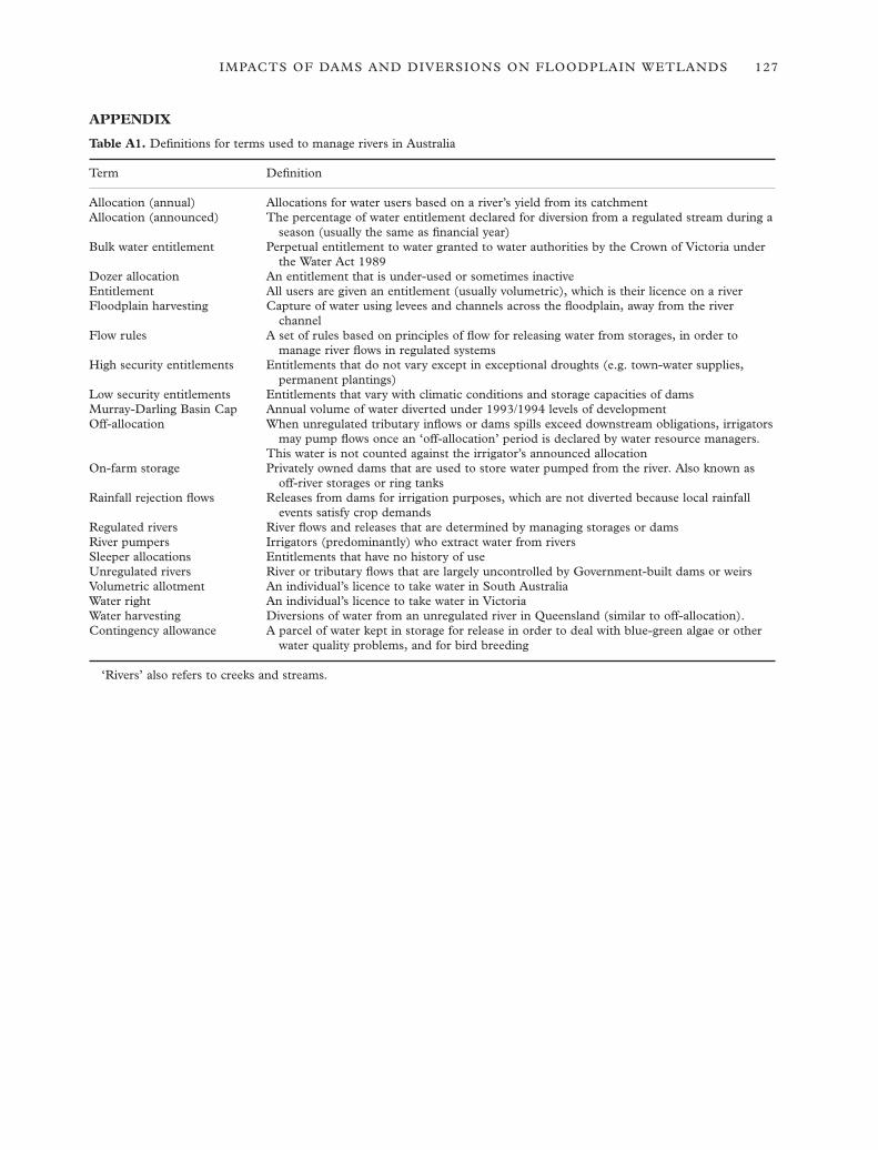
IMPACTS OF DAMS AND DIVERSIONS ON FLOODPLAIN WETLANDS 127
APPENDIX
Table A1. Definitions for terms used to manage rivers in Australia
Term Definition
Allocation (annual) Allocations for water users based on a river’s yield from its catchmentAllocation (announced) The percentage of water entitlement declared for diversion from a regulated stream during a
season (usually the same as financial year)Bulk water entitlement Perpetual entitlement to water granted to water authorities by the Crown of Victoria under
the Water Act 1989Dozer allocation An entitlement that is under-used or sometimes inactiveEntitlement All users are given an entitlement (usually volumetric), which is their licence on a riverFloodplain harvesting Capture of water using levees and channels across the floodplain, away from the river
channelFlow rules A set of rules based on principles of flow for releasing water from storages, in order to
manage river flows in regulated systemsHigh security entitlements Entitlements that do not vary except in exceptional droughts (e.g. town-water supplies,
permanent plantings)Low security entitlements Entitlements that vary with climatic conditions and storage capacities of damsMurray-Darling Basin Cap Annual volume of water diverted under 1993/1994 levels of developmentOff-allocation When unregulated tributary inflows or dams spills exceed downstream obligations, irrigators
may pump flows once an ‘off-allocation’ period is declared by water resource managers.This water is not counted against the irrigator’s announced allocation
On-farm storage Privately owned dams that are used to store water pumped from the river. Also known as off-river storages or ring tanks
Rainfall rejection flows Releases from dams for irrigation purposes, which are not diverted because local rainfall events satisfy crop demands
Regulated rivers River flows and releases that are determined by managing storages or damsRiver pumpers Irrigators (predominantly) who extract water from riversSleeper allocations Entitlements that have no history of useUnregulated rivers River or tributary flows that are largely uncontrolled by Government-built dams or weirsVolumetric allotment An individual’s licence to take water in South AustraliaWater right An individual’s licence to take water in VictoriaWater harvesting Diversions of water from an unregulated river in Queensland (similar to off-allocation).Contingency allowance A parcel of water kept in storage for release in order to deal with blue-green algae or other
water quality problems, and for bird breeding
‘Rivers’ also refers to creeks and streams.