review and evaluation of closure plans
TRANSCRIPT

L I
nz C6
REVIEW AND EVALUATION OF
CLOSURE PLANS FOR
LANDFILL AND RESOURCE RECOVERY INC
NORTH SMITHFIELD RI
Sutaitted by
WHITMAN BOWARD INC 45 Willi Strt
Wlleale y Maaeacbuae tta OZ181
MARCH 30 1981
~
~====------==-=====--------~=====---=----=~=T==_=====c----
_---- (-~middot- _ - WHITMAN amp HOWARD NC ~1 _Engineers and Architects2~ 45 WILLIAM STIUIET WILUSLIY MASS 021SI bull TIL 17middot217middot5000 -middotshy~middot--middot-shymiddot-bullD ~ -middot- - 0shyMarch 30 1981____ =_ ___ -middot- _ ~ A l otio
__ ~ Mr Bar ry w Muller Princi pal Engineer State of Rhode Ialand Department of Environmental Management Division of Air and Hazardous Materiala 75 Davie Street - 204 cannon Building Providence R I 02908
Dear Mr Muller
We are pleased to submit herewith our report on our review of the closure plan for the hazardous waste portion of the landfill operated by Landfill and Reaource Recovery Inc in North Smithfield R I
The text of the report details the review ite findingbull and our recoaaendatione A simplified euary etatent would be that in our opinion the Cloaure Plan bullubbullitted by L amp RR ia unacceptable in that it doea not addre cloeure of the hazardous waete portion of the landfill ae a eeparate isaue
we would be pleased to discuss this report vi th you at your convenience and we appreciate the opportunity to be of eervice to the Department of Envi ronmental Management
Very truly yours
WHITMAN amp HOWARD INC
~middotcent~1~~it- J~anR Brlg Asaociate - Bydrogeoloqist
Steven L Dean Manager Groundwater Management systems
JRB pdd
TABLE OF CONTENTS
1 0 INTRODUCTION
11 General 1 2 Purpoae and Authority 1 3 scope of work
2 0 BASELINE DATA
21 General 7 2 2 Site Content 9 2 3 Previoua Inveatigationa and Aaaeaamenta 11 24 Exiating Conditionbull and Oper ationbull 16
3 0 REVIEW AND EVALUATI ON
31 Gene ral 18 3 2 Reatricte4 Acebullbullbull and
Activity Separation 20 3 3 vertical Expanaion 22 3 4 Activity Separation 26 3 5 Leachate Collection Syltem 27 3 6 Groundwater Monitoring 28 3 7 amprthcover and Liner Maintenance 29
4 0 FINDINGS AND RECOMMENDATIONS
41 r indinga 30 4 2 RecOIIIDenda tiona 31
PLATES
Locua Plan 7A Sectionbull 20A Sectionbull 208 Sectionbull 20C Leachate Collection Syatem Alternative 27A
1 0 INTRODUCTION
11 ~ By an order iuued on June 20 1980 the
State of Rhode Illand Department of Environmental Manaqement
Divbion of Air and Hazardous Materiala (hereinafter referred
to as DEM) required Landfill and Resource Recovery Inc
(hereinafter referred to as LampRR) to prepare a closure plan
for their landfill facility located in North Smi thfield
Rhode leland The order was iasued
to ensure that the highest de9ree of attention is provided to protect the public health and environment from any adverse consequences caused by LampRRs oper ation
and it contained the following di rectives
11 1 By July 18 1980 install one aulti-level well at the toe of the refuse dope at a point equidistant between the two presently installed BARCAD type wells which were installed by the State in February 1980
2 By July 15 1980 complete and aubmit to DEM for approval a full ground water topotiJrampphic aurvey of the entire landfill d te
3 By Auguat 1 1980 aubmit a plan to the DEM preshyacribinq baaed on the apecificationa of the ground water aurvey the planned location of a network of multi-level or BARCAD-type wella at bedrock or three timea the number of cluater vella The well referred to in section 1 above can be considered aa one of the multi-level vella or theae cluater wella
4 By August 15 1980 submit a plan for closure of the entire facility
5 By September 1 1980 have all wells installed
LampRR appealed the order and hearings on this matter
began on July 24 1980 The original hearing officer
excused himself on Auquat 4 and the hearings were continued
-l shy
under Mr Frank P Geremia Adjudicative Bearing Officer on
Auqust 6 through 8 concluding on Auquat 14 1980 One of
the Conclusions of Law resulting from these hearings wa1
that
The requirements for closure and moni taring of the facility including groundwater wells by LampRR ordered by the Director on June 20 1980 are baaed on the 1tatutory and requlatory authority of the Director as enumerated above and are reasonable requirements to eff ect the intended purpoaes of the law and requlations
In addition the hearings also resulted in the iuuance of
the f ollowi ng
~
l That LampRR submit a plan for closure of the hazardoul Wamp8te facility by November 15 1980 Such plan shall include
a) A description of the methods to be used to restrict access to the facility and to prevent adc1i tiona hazardous waste disposal
b) A description of design and installation apecifications for the ialpermeable PVC liner including depth and analysis of cover above and installation procedure used The cover aaterial shall be at least two feet deep above the liner consilt of clean fill only and be free of boulders
c) A description of adequate top soil and vegetation sufficient to repair any eds tinq eros ion damage and to prevent f uture eroaion at the site
d ) A descr i ption of the methods to be used by LampRR t o establish and maintain a f inal grade that promotes surface water runoff without excessive erosion and to divert surface water drainage around and away from the 4isposal area
No references to proposed expansion of the LampRR facility
-2 shy
f) A hazardous waste site closure plan map or maps prepared and 1tamped by a registered profeuional engineer in the state of Rhode Ialand drawn to a minimum scale of one inch to one hundred feet (1 11 bull 100 ) delineating the following
i) Surface contourbull at intervala of five feet
ii) Groundwater contours at intervals of five feet and portraying groundwater flow
iii) Fences gatea road1 atructurea major aurface featuru etc
iv) North arrow and bar scale
v) Ground vater and surface water monitorshyinq devicea and atationa both existing and proposed
vi) Final cover areabull
vii) Top aoil and vegetation cover
viii) Final gradea
ix) Legal boundariu
x) Are vhere hazardoua waste have been placed
xi) Area covered by iaper~~eable PVC liner
xii) Areaa propoaed for continued unitary landfill (not hazardoua) operationa
g) A deacription of any other meaaurea to be conatructed undertaken or maintained and proposed by LampRR to protect groundwater and aurface water or to control air emiuiona from the facility
2 That LampRR install three additional multi-level monitoring wells (nine vella if cluster wells are used) by October 30 1980 The vella should be of the BARCAD type and of a deliqn in accordance vith Monitoring Well Design and installation criteria (See Attachment Exhibit A-1) (In lieu of BARCAD type wells cluster vella may be uaed but then of course the minimum number of vella would be three times the number of BARCAD type wells ) vith sampling points at three levela--within ten
-3shy
feet of the maximum groundwater tilhle at time of well installation at bedrock illld at a midpoint between the other two aampling levels The midpoint sampling level may be eliminated if the upper and lower sampling levels are separated by leas than twenty feet
The wells shall be located at the places accepted by Mr Frank Stevensons letter of Auquat 1 1980 along with the southern moat proposed well being located 25 east of OB-5 11 boring These locations are shown on Exhibit A-7 as open triangles with a cross hair pattern
3 ~~1~~~0~o~a~a~~I~t~eam~~Uo~lng system for as long as the OEM Director determines the hazardous waste poses a threat to the environshyment This monitoring plilll shall assume that the
~~~ara~~~~ ~~~fi~~~ap~~~to~0~ie and further ahall include as a minimum the followwing
a) A description of suplinq progru which IampRR ahall carry out whereby every multi-level well at the LampRR facility is sampled at each level at leaat once every three bullontha with the firat amplel froa all wells being taken by November 6 1980 whereby an analyaia of all volatile organics all utall from the primary drinking water stAndarcS and a groundshywater analyaia which ia currently required by the Depertment il made in accordance with accepted practice and all resulta immediately submitted to OEM and whereby OEM is formally notified of all samples to be taken at least 48 hours prior to each sample actually being taken
b) A program for physically maintaining the multi-level wells whereby the continued active life of each well through all sampling levels or a replacement is allured
4 That IampRR aubmi t to the OEM Director a final plot plan and cross sections that delineate the location of each type of waste disposed of at the facility by November 15 1980
-4shy
5 That LampRR shall establilh and continue in effect financial arrangements that are adequate to finance the longbullterm monitoring and maintenance required by this order and ahall describe these arrangements in writing to the DEM Director by November 15 1980 and further that LampRR ahall actually carry out the plana required above by thia order
6 That ahould monitoring results indicate the need for additional action to asaure that hazardous wute will be kept from endangering drinking water suppliea the DEM Director may order such additional action
7 That this adjudicative hearing officer will retain jurisdiction of this matter for purposes of detenininq compliance with the provisions of this order
The order signed by Frank P Geremia with concurrence
by w Edward wood Director DEM on october 15 1980
12 Purpose and Authority The purpou of this report
ia to provide OEM with a written review and evaluation of a
closure plan subaitted to them by LampRR The contractor is
required to e~nt upon speeific bauea and areas of the
plan as outlined in the scope of Work (paragraph 1 3 below)
on Septaber 5 1980 the DEM requested proposala from
eonaul tanU that would address the 1teo contained in their
order of June 20 1980 The request stated that OEM had
failed to receive an adequate c losure plan from LampRR that
covered the requirements of the closure order
On November 26 1980 the DEM issued a revised proposal
which requeated bids for review of a closure plan aubmitted
by LampRR This proposal contained a definitive scope of
-sshy
urvicea to be provided by the contractor Whitman amp Boward
Inc (hereinafter referred to u WampB Inc and or the Conshy
tractor) received notice of acceptance of ita bid to perform
the requi red work on December 19 1980 and a notice to
proceed was i ued by OEM and received by WampH Inc on
February 12 1981
1 3 Scope of Work By contract WampB Inc is required
to provide OEM with a written report conforming to the
following
1 The Contractor will conduct a technical review of the cloaure plan for the hazardoua waate portion of Landfill amp Rource Recovery Inc facility The entire plan bullbull 1ubmitted by Landfill amp Reaource Recovery Inc will be reviewed aa to ita adequacy by the Contractor Contractor ahampll particularly aa1e11 thoae probl a1 enuaerated below
a The Contractor 1hall review and evaluate Landfill amp Reaource Recovery Inc 11 plan of 17 Noveaber 1980 to reatrict acebull to the hazardoua waate portion of LampRR
b LampRR propo1e1 extendve vertical expanshydon for aolid waate di1po1al over the exiltinq hazardoubull waate diapoaal area o LampRR hu already placed a liner over the hazardoua waate dilpoaal area The Contractor ahall bullbullbullebullbull the impactbull of vertical expampMion over the impermeable liner and the impact of the expandon on leachate formation Parti cular attention to the impact on liner inteqrity under vertical expansion should be addresaed
c o The Contractor ahall review and evaluate LampRR 1 1 plan of 17 November 1980 for keepinq aeparate the 1olid waste disposal activities from the hazardous waste aite
-6shy
d The Contractor shall review and evaluate the leachate collection system for the hazardous waste portion of the facility and delineate additional requirements neceuary for an acceptable leachate collection 1ystem for the hazardous wute portion of the tacili ty
e The Contractor bullhall review and evaluate LampRR 1 s 17 November 1980 program for groundwater monitaring both during operation and folloving any final closure of the entire facility Recommendations
~~~a~i~1~94er~~Innr~~aillowingclosure are required A colt estimate for the long term monitoring of the lite and a method to en1ure financial means therefore (i e bonding trus t fund bull etc ) bullhould be developed
f The contractor shall review and evaluate a program bullubbullitted by LampRR on 17 November 1980 of earth cover and liner maintenance to continue in perpetuity after the overall clo1ure of the facility Coat eattatea for thia aaintenance ahould be developed
2 0 BASELINE DATA
21 2 Landfill and Re1ource Recovery Inc ie
a corporation regbtered in Rhode I sland Their buaineaa is
waate diapoaal and their principal landfill operation ia at
a lite in North Saithfield Rhode Ialand This lite is
located along Oxford Road approxibullately one and one-half
miles aouthweat of the Village of Slatersville Oxford Road
runs along the western edge of the site The Blackstone
Valley Electric Co power line and euement border the site
to the north and east and a forty foot wide riqhtbullof-way
and power line for the Rhode Uland Power Transmission C~
cuts through the lite in an east-west direction This
easement roughly parallels an existing storm water dral nr
-7shy
-------N
OTICE If tho film
Im
ago It Ibullbullbull clear than thlt notlct It 11 dut to th
t of the docum
ent
(
LA
JCD
FILL
amp
R
ES
OU
RC
E
RE
CO
VE
RY
~DMINISTRATIVE
RE
CO
RD
~
swale and in combination they serve to divide the site
into tvo segments The total area of the site ia about
forty-five acres Of this approximately thritybullone acres
are located north of the easement swale line and the remaining
fourteen acres are located south of this barrier
The site has operated as a combination gravel pit
clbpoaal area for a number of years Recorda indicate that
wtea vere dumped at the site as far back as 1927 In
1974 the property vas acquired by LampRR Under their ownershy
ship unknown quantities of municipal co1111ercial indu8trial
and hazardous wtea have been deposited at the lite
Alaost all of this aaterial has been placed on the northern
portion of their property While the exact proportions
CQIIPOSition and location of these various wtes are unknown
the Gereaia hearings accepted as a finding of fact that
between March and Septeaber 1978 LampRR accepted over one
aillion gallona of hazardous waste and that this material
vas never segregated frobull other vaates
LampRR s landfill h been governed by a variety of vas te
aanagement facil i ty operating rules and requlationa enacted
by the State Originally enforcement of these s tatutes vas
the responsibility of the Rhode Island Department of Health
This function was transferred to OEM in 1977 Under both
agencies LampRR bas applied for and been granted licenses to
operate their facility The first license vas issued in
History of Involvement at LampRR Inc prepared by Frank B stevenaoa March 6 1980
-8shy
1976 The lut license was issued on January 25 1980 and
it expired on December 31 1980 Hearings regarding renewal
of this license are currently being held
22 Site context LampRRs site is located on the east
face of a plateau separating Trout Brook and the Slatersville
Reservoirs Richmond and Allen identified the formation u
a Kame Delta (Qkd) and theorized that it devel oped during
the ninth stage of deglaciation and l ate glacial outwuh
sequence They contend that this format ion is the largest
of f our Kue deltAs i n the Georgi aville quadrangle In a
discusaion of fluvioqlacial ice-contact depolita Richmond
and Allen state that
bull x deltas are coaposed of stratified drift the long steeply inclined foreset beds are bullostly of sand whereas the overlying topset beda are preponderantly of subaerially channeled aand and 9Iave1 bull
Ricbaond and Allen aa well aa Johnston and Dickerman
recognized the value of these deposita with respect to
qrounctvater Quoting froa the former source
bullbull Deposits of auch uniform texture may have a r e l atively high porodty Coarse well-sorted gravels of this type generally have a relatively high permeability and speci fic yield and thus provide excellent res ervoi r s for atorage of groundwater
bullRichmond GM and Allen W B 1951 The Geology and Groundwater Resources of the Georgiaville Quadrangle RI RI Port and Industrial Development Commiuion Geological Bulletin No 4
Johnston HE and Dickerman D C 1974 ttAvailability of Groundwater in the Branch River Basin Providence County Rhode Island u S C s Water Resources Investigations 18-74
-middotshy
While recognizing the limited number of well logs
available in the area for their atudy and stressing the need
for further work to confirm the extent of the resource
Johnston and Dickerman estimated that the acquifer in the
Slatersville area has a conservative subatained yield of
five and one- half million qallona per day FUrthermore
they s tre that
bull The computed yields r epreaent estimates of amounts
~~a~~=~~I~ine~mwl~=~so~y a~=a~~tn= sarily indicative of optimum or maxiaum yielda obtainable rom the strati fied-drift aquifer Additiona amounts are available from areas not 110deled bull
Richaond and Allen also aapped the bedrock underlying
the landfill site It ia the Esaond 9ranite of Paleozoic
ampCJe coar CJIained light gray to pink in color containing
feldspar quartz and aica The top of the bedrock drops to
a pre-glacial channel the northeastbullaouthwest trending axis
occurring about fifteen hundred feet north of the landfill
Tbe landfill occupies about three percent of a sixteen
hundred acre aubmiddotwatershed of the Branch River drainage
basin Thia sub-watershed draiu into the lower portion of
the Slatersville Reservoirs via Trout Brook The moa t
aiqnificant porti on of run-off traversi ng the aite i n a weat
to east direction flows off of the Kame delta through a
natural awale west of Oxford Road Flow ia culvert ed under
Oxf ord Road and travels along a smaller awale which aa has
been previoualy mentioned combinea with the Rhode Island
-10shy
0
Power Transmiaaion Co right-of-way to divide the aite into
two nctiona The norther portion of the d te drainbull into
Trout Brook via a small awale which pauea under the Blackshy
atone Valley Electric co trampru~miaaion line juat aouth of
the point where the line bends and change to a norht-aouth
orientation Thia awal e drains almoat all of the northern
portion of the aite i nc luding a s ubstantial portion of the
exist i ng landfil l mound and aho carriu aome run- of f f rom
the high ground off of and to the north of the landf ill
2 3 Previous Invutiqationa and Aueumenta The LampRR
lite hu been the subject of a conaiderable UDount of
investigation and study over the laat aeveral yeara In
1974 four wells were drilled on the property It b believed
that they were inatalled bullbull part of a pre-purchaae inveatigashy
tion conducted by uJlll Five aore welh were drilled in
1976 In 1977 bulleven aonitoring wellbull were bwtalled u per
the Rul and Requlationa for Operating Solid Wa8te Manaqeshy
aent Facilitiebullbullbull Roy F Webullton Inc inatalled four monitorshy
ing welb adjacent to the property in 1978 bullbull part of the
Statebull 208 invebulltigation Thebullbull were aupled in 1979 by a
firm retained by the Town of North smithfield Reault bull of
theae testa led to the inatallati on of three a ulti-level
monitor ing 11BARCAD11 type welh by OEM earl y in 1980 They
wer e sampled i n March 1980 Teat reaulta led OEM to require
LampRR to inatall four multi- level cluster wella later that
year
- 11shy
In July 1978 Roy F Weston Inc prepared two reports
for the Rhode Island Statewide PlaMing Program Both
reporta addrel8ed iuues pertinent to a plan of regional
water quality One of the reports Detailed Analysis of
Landfill I11pacte on Water Quality 11 studied the potential
impacts of aixteen landfills in the State The LampRR site
wu one of the sixteen aelected A major component of
Wuton 1 bull work was the inetallation and sampling of wells at
theabull aitea Four wellbull were inatalled at LampRRs landfill
surface s ources were also sampl ed and analyzed One o f the
wells located in the swale east of the eite ahowed hydroshy
carbon contamination and a high COD value attributable to
the preaence of leachate 11 In discuing the environmental
tpact of the e1te Weaton concluded that
The landfill baa at pnaent ainillal iJIPact on ita aurroundinqa Problema with leachate volume aay occur in the future if the total property of 36 acres ia filled with refuee then natural attenuation and renovashytion aay not be eufficient
Weaton s eecond report Reco~~U~ended Leachate Control
Alternatives 11 developed a claification ayatem for landfills
bued upon the landfills operational status ampnd its degree
of impact on water quality Impact waa determined by the
analytical reeulte of sampling performed during the first
report Weston claaaified the LampRR aite aa an Active
Landfill having 11inor i11pact In diecuing thb clauiicashy
tion Weston noted that an ample soil zone for attenuation
lllay exist between the baae of the landfill and the water
middotb1e or point of qroundwater diacharqe While classifyinq
-12shy
LampRR u a minor impact lite Weston repeated hia prior
comment relati ve to potential dqnificant impact should the
entire thrity-dx acre aite be landfilled Aleo in completshy
ing his dis cuion on Minor Impact - Aes sment 11 Weston
noted that
a minor impact aa aaseased today may be advenely impacting future water supplies or may become a major i mpact u the leachate gener ating c haracteristics of a l andfill change with time
The Rhode I sland statewi de Planni ng Program 208
r eport iasued in 1979 i dentified the Slatersville aquif~r aa
having 11 soae potential for future municipal water supply
developaent Aa such the report contended that the area
should be considered ttenvironaentally sensitive and protected
frobull degradation noting that the LampRR landfill b located
on the aquifer the report recomended closure of the site
in a aanner that would ainiaize infiltration should leachate
contaaination becou evident The rep~rt als o reco-ended
th8 establishment of vegetative cover and the construction
of be rms and other erosion control measures at the lite
In late 1980 the Town of North Smithf ield contracted
Whitaan amp Boward Inc to conduct and prepare an environmental
impact uaeaament on groundwater integrity as affected by
LampRR 1 s landfill The report has been aubmi t ted to the Town
for their review and comment
The final document pertaining to LampRR s aite ia the
recently released draft of a report entitled Preliminary
site Aaaeaament and Emergency Action Plana for Landfill and
Resource Recovery North Smithfield Rhode Island The
- 13shy
report was prepared by Ecology and Environment Inc for
EPA Ita objective was to determine the nature and extent
of pouible surface and groundwater contamination from the
landfill and to develop draft emergency action plana for
abatement of future environmental damage potentially arising
from the ei te
The apparent thrust of the report were the hazardous
wast es d isposed of at the landfi ll The report noted that
the aite context s eeme d ideal f or l eachat e mi gration of f shy
a te and that the ins tallati on o f the PVC liner coupl8d
with disposal aethods and waste characteristics are probably
alleviating or towing migration of contaminants Addreinq
the aatter of the adequacy of existing monitorin9 wells the
authors atted that they were properly situated and screened
at appropriate levels provided that all hazardoua waatea
were buried in the one location reported by LampRR bull owners
However additional survey and on-site investigation was
recobullended to confirm the location and extent of the hazardous
The value of much of the information and data derived
from teatin9 and monitorinq some of the wells i nstalled on
and around the ai te ia questi onable in the opinion of many
professionals To date tes t i ng haa i ndi cat ed levels of
c ont ami nation principal ly heavy aetah and tot al organic
carbon However the question of the degree of contamination
(ie gross aiqnificant minor etc ) aa well aa its exact
source ia often the subject of considerable debate There are
several reasons for this unfortunate situation
- 14 shy
A prime reason for the debate over the reliability and
authenticity of available data h the lack of a clear
concis e underatanding of the hydrogeologic conditions at
LampRR 1 a a i te The i mportance of thia information wu noted
in an EPA report when the authors s tated that
Determination of the flow rate and direction of ground water are prerequisitea to monitoring well placement Drilling will be required and measurements must be made of the piezometric s urface 11
Under a dbcuuion entitled tiDe f i n tion of the Hydrogeologic
Setting 11 the report noted that
The hydroCJeologic setting of the landfill h probably the bulloat 111portant factor in eetabliehing the need for and deaiqn of a landfill monitoring ayatem Prior to selecting a landfill site information u to eurficial and bedrock geolo9Y depth to the water table and direction and rate of ground water flow ehould be deterained In the past aubaurface conditione have not been well-defined landfillbull have been located on laneS such ae awaapa or abandoned qravel pita tradishytionally considered uaeleee and of low econobullic value Ground water pollution potential ie preeent in theee areae and in the caae of gravel pit the potential ie high For tbeae reaeone the need for monitoring and abatellent procedurebull ie acute
Thie eame report lieted data that a ground water
inveetigation ahould provide The liat contained the following
depth to the water table
b the extent of ground water mounding caueed by an exiat i ng landf ill
c the natural rate and direction of flow
d the degree of influence the landfill has on the rate and direction of flow
Fenn 0 Cocozza E and Isbister J Braida 0 Yare B Proux P Procedurfa Manual for Ground Water Monitoring at Solid waste Oiapoul Facilities U S Environmental Protection Agency Report EPA 530 SW 811 Cincinnati Ohio 1977
-15shy
e the locationa of recharge and ctiacharge areaa
f the types and interconnection of aquifers
g the rate of aite i nfiltration relative to the total ground water flow
Definitive data pertinent to the items liated above
haa not been available for review The abaence of auch data
precludea verification of the exiating moni torinq well
ayatem with reapect to the adequacy of the number of pointa
inatalled point locations and acreen or aampling point
elevationa Alao the identification of an accurate baCkshy
ground well cannot be aade
Other acton affecting the validity of available aubshy
aurface teat raaulta are the condition of the aample pointl
the frequency of taating differencebull in thoda uaed to
gather IUIPlaamp varying laboratory procedureamp aa well aa
are than one aat of atandarda to which the teat raaul ta can
be coparad
Another factor ia the lack of infomation relative to
the type and location of the varioua typea of waatea within
the total landfill not juat under the exiating liner In
eaaence both where to look for contamination aa well aa
what apecific typea of contamination to look for aeem to be
valid queationa that either cannot or have not been poaitively
anawered
24 Exiating conditions and Operations The moat
dominant feature of the landfill ia a large eliptical
-l6
ahaped dome located on middot the northern portion of the property
The dome ia approximately fifty feet high and it coven an
area of about eight and one-half acres About one-half of
the mound ia covered with a liner Assuming elevation 275
aa the bottom of the mound ita estimated volume ia about
three hundred and aixty thouund cubic yarda based on field
aurvey dated June 1980
In January 1980 LampRR covered a portion of the mound
with a 20 mil PVC liner Earthen cover was placed over the
liner and gra baa become established over the majoritY of
this aoil layer However from eight to twelve feet of
liner ia expoaed to aunlight around almoat the entire perimeter
of the DOund probably due to either water or wind eroaion
Water erosion is the ore probable cause and ita effects are
evident over alaoat all of the ateeply eloped uncovered
auracea of the aound Gulliea are co1111on and in soae
places have become deep enough to expose waste materiala
under the aoil cover
currently landfilling h taldng place along the east
and s outheast facea of the mound Refuse h being dumped
apread compacted and covered with aoil in what seems to be
a relatively continuous operation In-dtu soill are being
excavated and uaed for cover This excavation baa created
very ateep eroding slopea along the northwest face of the
site A aimilar condition exists on the west face of the
remains of an existing hill along the eaat edge of the
property
-17
Landfilling around the exilting hazardous waste area is
increasing the potential for leachate development and migrashy
tion As has been mentioned a considerable area of uncovered
landfill embankment exists around the edge of the liner
The active area to the southeast of the liner is fairly
flat A roadway rings the top of the mound and acta aa a
atep or plateau In combination these conditions offer a
liqnificant area for i nfiltration of precipitation Migration
could follow gradients downward and i nto the area under the
liner The pressure of the active dilpoaal area against the
southeast face of the mound would encourage such an ampnCJUlar
flow The function of the liner is bei ng negated by this
condition Also this condition il probably causing a
oundill9 of the groundwater profile under those exposed
areaa
3 0 UVIW and EVALUATION
31 2npound closure doCUJRenta submitted to OEM by
LampRR consist of four plana and a text The plant~ were
prepared by Wehran Engineering and conaiat of (1) Preliminary
Proposed Final Grade (2) Preliminary Ground Water Contour
Map amp Monitoring Well Locations (3) Preliminary Sections
and (4) Detaih The text consists of a materials and
installation specification for a PVC membrane and a narrative
that addressee certain referenced i tema contained in the
Geremia hearings testimony All closure docwnents are
stamped Received RI Dept of Environmen~al Management
Division of Air and Hazardous Materials Nov 17 1980
- 18
The intent and direction of the submittal by LampRR is
expandon rather than closure A major expans ion of the
northern portion of the lite and the complete development of
the southern portion of the property are the dominant elements
of the closure documents
Sectiona taken acrou the plans indicate that about two
hundred and seventy thousand cubic yards of material will be
excavated on the northern portion of the lite and about two
million two hundred and ninety thousand cubic yards of
landfill material will be added This represents approxishy
utely a seven hundred percent increase in the amount of
aaterial currently existing on that portion of the lite On
the southern section about four hundred and ninety thousand
cubic yardl of aaterial will be excavated and nine hundred
and forty thousand cubic yards of aaterial will be landfilled
In collbination with the northern exparulion the total proposed
increaae in landfill is about ten times the current in-
place volWDe
It should be noted that the sections drawn to estimate
the quantity of expansion assumed elevation 260 as the
bott011 of the proposed excavations The closure plans note
that excavation will not be carried closer than five feet
above the seasonal high round water level However
sufficient data does not exist to determine that elevation
Elevation 260 was chosen as a conservative figure Should
groundwater be lower the quantities and proportionbull could
increase liCJilificantly
-19
The propoud expanaion will have a dgnificant impact
on the viaual character of the surrounding landscape As
ahown i n the aections the pr oposed heights ~or both portions
of the property will make them one of the moat dominant l and
forma in the area Aa land forma they will be out of
charact er with their environment with respect to ahape and
contour It 11 very unlike l y that they will suppor t vegetashy
tion consistent vi th their s urroundingbull thereby maki ng
their bulk and shape even more evident
3 2 Restricted Acceu and Activity Separati on LampRR s
pribulle concept o~ restricted acce~s to the hazardous waste
portion of their landfill seeaa to be encapsulation With
the exception of a text statement relative to a cable and
lock preventing vehicular acceSI frobull the front of the ei te
and another reference to inatructions to the landfill a
staff aa to what wastes are not to be accepted it ia the
only concept inherent in their aubaittal A concept of
additional landfilling separate and apart from the hazardous
waate area ia not addressed
Ecology amp Environment Inc a report recociuzed the
potential iJDpact of the hazarctoua vaate portion of the landshy
fill on the environment and recommended i n-the-fi eld survey
and i nves t i gation t o det ermi ne the extent and location of
the hazardoua materials The Geremia hearinga accepted as
fact the testimony that the hazardous wastea were not s eparated
from other materiala The order from theae hearings directed
LampRR to bull aaaume that the hazarctoua vaate will poae such a
- 20shy
-----------N
OnC
E If tho film
Image
11 le11 clear than thl1 notice It 11 dut to the
of the documen
t
(
LA
ND
FIL
L
amp
RE
SO
UR
CE
R
EC
OV
ER
Y
AD
MIN
IST
RA
TIV
E
RE
CO
RD
-
~
(imiddot 0
~ i=
l 0
bull W
jg (f)
~~
0 I bull o
or-
bull
Q
bull i ~ ~~ gt-
(
~ f i I
)
L shy
LMltshy------r LMlWIU- ~--BIMCMILL_L -~
-~
-- middotshyi -~-
VICTOftY HIGHWAY---shy
SECTIONS -208shy
aACXIIUINHILLshy_
WfTANCiaIHO-[
u _ ___
--~~
TMIULN fKWI -shy
11(1110 an___-shy
-~ middot-
SECTIONS - 20Cshy
threat for a substantial although i ndefinite period of
time Both of weston 1 a studi es recognized the potential
of adverse impact from the d te particularly if it waa
developed to its full extend
All of thue opinions and concludona aeem rational
Should significant problema develop that can be traced to
the hazardous wute portion of the landfill remedial action
may entail conatruction activitiea in ancSor around the
exiating wute dhposal area Implementation of LampRR 1 a plan
would hinder auch remedial meaaurea and may in fact n~gate
thbull coapletely Given an extended period of time prior to
either the development or detection of a aource related
pollutant problem LampRR a expanaion could eliainate available
on- aite area needed to illpleaent theae bullbullbullurea In view of
the uncertaintiea of conditiou under the PVC liner and the
extent of profeional opinion that a potential problu doea
exht a rational concept would aeera to be one which conaiden
the entire landfill a potentially hazardoua aite and iaolatea
it from any other propoaed activities The queation or
iaaue of the need for physical barriers auch aa fencea
etc could be examined in an u-needed context given developshy
llent plana for ancillary portiona of the site as well aa the
reaulta of an exteuive ongoing pollutant monitoring program
after a separate cloaure plan for the existing facility ia
aubmitted and approved
-21shy
3 3 Vertical Expansion The 20 mil PVC liner covering
the hazardous waste area of the existing landfill was supplied
by Staff Industries Upper Montclair New Jersey Personnel
at Staff were unable to supply data relative to the performshy
ance of their product under extended burial conditions
Product specification supplied by Staff are standard ASTM
teat results ASTM teatJ performed on 20 mil PVC liner
material are done under controlled laboratory condition~~
which do not reflect actual in-the field aituation For
exuaple in diacuaainq the significance of their Graves Tear
Teat (Dl004) ASTM states
apeciaen geometry and speed of testing in this teat aethod are controlled to produce tearinq in a u area of stress concentration at values far below those usually encountered in service
Research that b been done to 4ate on PVC as a landfill
aaterial baa bean directed acre to ita reaction to leachate
rather than ita ability to withstand loading In 1979
Matrecon Inc Oakland California prepared a study for
EPA antitled Liner Materials Exposed to Municipal Solid
Waste Leachate Alaoat all of the aateriala testing done
for this report was performed under laboratory conditiona
Within these parameters PVC as a material performed well
although it did have the highest permeability to water vapor
of any of the qroups of materials tested
-22shy
One portion of their report that did not rely on
laboratory conditiona was the recovery of a a ample of PVC
liner from a demonstration landfill located in crawford
County Ohio The material had been buried under e i ght to
twelve feet of refuse and cover material for aix years
Testa performed on recovered samples correlated with laborashy
tory testa However the liner had been protected by a
layer of clay and i b degree of exposure to leachate could
only be es t imated The report also noted that the liner had
t aken the s hape o f the soil and that depressions o f aa much
aa aix i nches i n one foot o f area were observed The report
di d not s tate the nature or caus e of the depressions
In 1977 a field s tudy to t eat the behavior of refuse
under controlled loading waa conducted at the Morgantown
West Virginia a unicipal landfill Refuse in this ins t a llatbull
i on had been in place for many years and i ta depth waa ten
f eet A r ec tangular teat cell waa establis he d and loa ded to
approxiaate ly one thous and pounds per s quare f oot The size
o f the teat ce ll waa fifty feet by ninety feet and settlement
platfonu wer e i nstalled in the mi dd l e and at each end
settleent in the center of the cell occurred sooner and
was of a greater magnitude than at the ends due to the fact
that the average atresa in the center waa estimated to be
approximately twice aa much as that on either end At the
Rao SK Moulton L K amp Seals RK Settlement of Refuse Landfilla in Geotechnical Practice for Disposal of solid Waste Materials ASCE 1977 pp 574-598
-23shy
end of three hundred and fifty days the center had settled
just over two feet and each end had settled about one and
one quarter feet In terms of original depth the test cell
had settled from twelve and one half percent to over twenty
percent
It hu been suggested that the bulk of the refuse
landfilled at the LampRR aite ia commercial and that only
North Smithfield uses the facility to dispose of municipal
wastes ldsuming an average weight of five hundred pounds
per cubic yard of waate and that aix inches of soil cover
will be placed over each yard compacted in-place the
total dead load bearing on the center of the existing landshy
fill aound when LampIUl s maximum expanaion plan ia coJII)leted
could be in the range of forty-aix hundred pounda per square
foot LampRR statebull that the PVC liner vas placed over a two
foot deep layer of fine a and or fine ailty sand The ability
of thia bullaterial to withstand theae loads or to apread thu
out evenly enough to avoid liner penetration from solid
objectbull in the landfill cannot be determined All that can
be atated is that there ae to be a very significant
possibility that the integrity of the liner may be destroyed
under the propoaed plan of expansion Penetrations would
probably occur in or near the center of the cover just over
the area designated as containing the hazardous wastes
Penetration of the liner would probably lead to higher
Conversation with Frank B Stevenson Principal Engineer OEM
-24shy
moieture leveh in these areu which could result in an
increase in both leachate generati on and aigration
The probable impact of vertical expansion on leachate
formation within the exieting landfill area is a function of
two factors the density moisture ratio of the existing
refuse and the amount of additional moisture that expansion
may introduce into this area If additional moisture is
prevented frobull entering the existing landfill the quantity
of leachate will not increaae However if compression
increases the densityoiature ratio significantly the
field capacity of the refuse could be reached or exceeded
resulting in the conversion of previously static moisture
into leachate The rate of flow of the leachate would
increase and the flow would start sooner Siailar changes
in the rate and duration of flow frobull active saturated
landfill areas would also occur given sufficient compression
Conversely decompression and resultant expansion of wastes
would reduce flow rates and delay leachate aigration
The concept of any vertical expansion over the existing
landfill area seeaa ill advised Problema auociated with
potential damage to the existing liner in combination with
the almost certain increase in leachate formation and migrashy
tion are likely to create significant increaees in what now
appears to be a minor but growing problem of degradation of
a valuable environmentally sensitive natural resource
-25shy
34 Activity Separation The matter of keeping separate
the solid waste dbpoul activities from the hazardous wute
dbpoul area has been discussed to 1ome extent under section
3 2 above The closure documents do not present a nparate
operational concept except for the development of the
southern portion of the d te LampRR feela that disposal
activit ies cannot be eparated on the northern section of
the landfi ll In their text they contend
11 bullbullbullPleau keep in mind that although the state requires only a closure plan for the hazardous wute portion of the facility it iB very difficult if not impoible to separate that portion of the operation froa the continushying functions of tree harvtinq reforestation sanc1 and gravel excavation and sanitary landfill operation There is no attupt aade in the following plau to wmeceaaarily tie plan for the continuing operation of a aanitary landfill to the plau regarding waate already diapoaed of but rather we a4viae that it ia practically ipoaaible to aeparate th- ror exuple your enginHringly aound requirnt nWiber l d (froa the Gereaia hearingbull) for diverting aurface water draining around and away froa the diapoaal lite could not be acc011pliahed except by filling the aand and gravel excavation areaa via the aanitary landfill bullethod and regrading the entire lite
The contention that the aanitary landfill aethod ia the
only way that proper aurface gradianta can be devel~ped to
divert aurface run-off around and away from the exiatinq
diapoaal aite il falle The atatement that it il difficult
if not iapoaaible to aeparate the hazardoua waate portion of
the lite from the continuing functionbull of a landfill operation
cannot be proven until a closure plan for the hazardous
waate area void of any reference to propoaed expansion
-26shy
I ---
baa been prepared Such a plan will delineate the extent
and limita of the aecurect area and will allow for an examinashy
tion and review of remaing areas of the lite that could be
developed such a plan h not included i n LampRR 1 a submittal
although it waa a specific requirement of the order generated
by the Geremia hearings
35 Leachate Collection s ystem LampRRa cloampure aubshy
mi tta l does not contain a l e achate collect i on system for the
bazardouamp wu te porti on of the f acili ty Drawi ngamp prepared
by their conault i ng engineer do show 14 ABS leachate cOllecshy
tion pipes in aectiona taken through the landfill A
typical iMtallation detail ia alae provided However the
pattern and extent of ampuch a ayatem ia not ahovn in plan
view and there are no details relative to leachate containshy
MDt and treataent
AD acceptable leachate collection ayatu for the huardoua
wute portion of the facility h ahovn on the following
plate IU bullajor coaponenu are two iapervioua cut-off
valla located and angled in a llAJUler ao bullbull to intercept and di vert
potenti ally polluted groundwater to a well which would be
aized to pump the cont ami nated water to the aurface
The l ength and exac t locat ion of the walla would be
de termined after complete and accurate aaaeaament has been
made of the groundwater flow pattern under the aite The
walla would extend from the aurface down to bedrock The
alurry trench or wall construction technique would probably
- 27shy
1
QAAIMMl llltoLI --
I LEACHATE COLLECTION SYSTEM ALTERNATIVE
SCALE Ibull 300
-27Ashy
be ideal for thil installation The well would be acreened
and a ized baaed upon data from the drilling log It would
probably be four inch diameter minimum Detailbull aa to
treatment dhpoaal of the well water would be developed
bued upon it anticipated volume and compoaition a a well u
the location of the well point
36 Groundwater Monitoring LampRRI monitoring procram
ia euentially acceptable if it doea in fact conform to
groundwater condi tiona on-ate However there are acme
exceptioll8 Two additional aulti-level monitoring well
ahould be conatructed One between CW-2 and CW-4 on the
northern aide of the landfill to intercept any leachate
which aight be aoving in a northerly direction and the
other waat of oxford Road in an area aufficiantly r-oved
froa the landfill for a background well
All welh should be pUIIped continuously (at least two
hundred to two hundred and fifty gallons) to remove pouible
pollutant froa drilling water etc Some welh may be too
deep to purge
Samples should be taken once every three montha and
water level bulleuurements should be taken with each water
bullample The next samples which are taken should be analyzed
for Priority Pollutant Standard Anions and Cations Gross
Alpha and Beta radioactivity Asbestos pH Turbidity Total
Organic Carbon Total Organic BaloqinB Chemical OXidation
Demand Biological Oxidation Demand Specific Conductance
and Fecal Coliform The samples taken for the next year
-28shy
should include Volatile orqanica Trace metals Standard
Anions and Cations Total Organic Carbon Biological and
Chemical oxidation Demand pH Specific Conductance aa well
aa any other key indicators which were indicated in the
firat analyaia After the first year of sampling the key
indicators should be sampled every three months and other
parameters once a year for a period of up to ten yeara If
a significant leachate plume b detected a ayatematic qrid
of mul ti-level bullonitoring wella s hould be utabliahed to
accur ately del i neat e and analyze auch a plwae
All clus t er vella ahould be maintained in good wor king
order and i f fo r any r e on any vella are rendered uaeleaa
they should be replaced
Coat Eatiute for Moni torinq
Firat aet of analyaea
$1900 00 each x 12 auplea
Analyaea for next year
$660 00 each x 12 auplea
x 3 aeta
Continuing analyaea
$12 720 per year
To enaure monies for the aamplinq and maintenance of the
monitoring vella OEM and LampRR could enter into an escrow
account
3 7 Earth Cover and Liner Maintenance LampRR bull program
for earth cover and liner maintenance appears to be adequate
However overall gradients on the the alopea of the proposed
-29shy
landfills are excessive These elopes scale two to one and
are in excess of the two and one half to one maximum slope
recommended by Staff Industries the aupplier of the existing
PVC liner Staff a personnel recommend three to one as a
preferred elope for top cover and this recommendation appears
to be rational in light of potential erosion that could
expoae the liner to sunli9ht which over a period of yean
deatroya the i nteg-rity of the material
The total area to be maintained under LampRR a completed
landfill b about thirty-six acrea If we aaaume that middot
annually on the avera9e two percent of thia area will
require aobulle type of re-seeding due to erosion the annual
coat would be about dx thouaand dollars (Thirty-five
hundred aquare yarda at about one dollar and seventy cents
per yard not including topsoil) Should in-situ topsoil
not be available or should the erosion take place in relashy
tively inacceible areas the unit price could 90 as high
as two dollara and fifty cents per yard depending mainly on
the topaoil coat
4 0 FINDINGS and RECOMMENDATIONS
4 1 Findings LampRR a closure aublllittal b unacceptable
It doea not propose or address closure of the hazardous
waste portion of the landfill as a separate issue divorced
from expansion of the site The contention that refuse is
the only material suitable for filling to achieve proper
run-off away from and around the landfill ia incortect It
doea not contain definitive information relative to the
-30shy
direction o f the flow and depths of groundwater below the
landfill It does not contain specific data relative to the
protection of groundwater from contamination by e l ements in
the hazardous waste disposal site The issue of control of
air emission from the site ia not addressed It does not
contain the location of each type of waste disposed of at
the f acility
4 2 Recomme ndations The landfill s hould be closed
Contami nat i on has been detected An adequate groundwater
analysis and plan has not been developed The locatio~ and
elevation of the aonitorinq system h subject to verification
Hazardous wastes have been buried at the ampi te and their
location is questionable The current operation encourages
leachate developMnt LampRlt should be required to prepare
and subait to DDI an acceptable closure plan This plan
should not contain any reference to expansion and it should
conaidbullr the entire landfill area as it now exists as a
potential hazard to the aquifers It should contain a
definitive syste for contaminant rebulloval and treatment It
should assuae that the d te will pose a threat for a sub
stantial although indefinite period of time after clos ure
The following are s uggested details and procedures f or such
a clos ure p l an
accurat e information must be p r e s ented vi th
respect to groundwater Depths t o groundwater as well as
groundwater flows must be determined accurately This
i nformation should be consistent vith the elements recommended
- 31shy
0
for groundwater invutiqation as contained in the EPA document
referenced in 2 3 (Previoue Investigations and Assessments)
b portions of the existing liner that are
exposed should be examined with reepect to ita phylical
condition and integrity If acceptable it should be rolled
back up over the edqe of existing eoil cover and temporarily
held in p l ace
c all exposed aurfacea of the exhting landfill
s hould be f i lled and gr aded ao a1 to provide at l east t wo
fee t of clean cover over any wtu Maximum s l ope s hould
not exceed three to one
d additional quantities of impervious aubrane
aaterial aucb aa 20 ail PVC should be placed on the expod
slopes extending out pt the toe of the ound at let
three feet and up to and be joined vith the edge of the
existing liner The intallation of the liner ehould be
conaiatent with the manufacturer bull recouendationa
e all portiona of expoaed liner bullhould be
covered with at let one foot of protective aoi l Additional
f i ll bull hould be placed around the toe of the mound to facilitate
aurface drainage and run-of f
f all f i l led are aa bull hould receive one foot of
bulloil to be aeeded for erosion protection
g dltation bina bullhould be conatructed enshy
d te to collect bullurface run-off
h a leachate collection system should be
incluC in the plan with provisions for leachate treatment
and dlti -middot al - 32shy
i an acceptable ground and surface water 11onitorshy
inq program should be developed and maintained both on and
off-site
j the applicant should prepare estimates as to
cost of remedial action should gross contamination occur
The applicants ability to cover such costa should be proven
and asbullured Definitive bindinq long-term financial
agreements should be developed for extended maintenance of
the site
A final recommendati on pertains to the advieabili tY of
re-openinq the LamplUl s ite or any other disposal dtes on
areas containinq or aupportinq valuable natural resources
The tera Msecure landfill is tenuous in that the potential
0 for catastrophic events such as earthquakes etc always
ezbta If additional sites which would not endanqer natural
resources are available elsewhere it would ee prudent to
utilize th rather than to risk potential irreversible
environaental dampluqe All other existing disposal facilities
should be reviewed in this sue context
bull -33shy
- barcode 561574
- barcodetext SDMS Doc ID 561574
~
~====------==-=====--------~=====---=----=~=T==_=====c----
_---- (-~middot- _ - WHITMAN amp HOWARD NC ~1 _Engineers and Architects2~ 45 WILLIAM STIUIET WILUSLIY MASS 021SI bull TIL 17middot217middot5000 -middotshy~middot--middot-shymiddot-bullD ~ -middot- - 0shyMarch 30 1981____ =_ ___ -middot- _ ~ A l otio
__ ~ Mr Bar ry w Muller Princi pal Engineer State of Rhode Ialand Department of Environmental Management Division of Air and Hazardous Materiala 75 Davie Street - 204 cannon Building Providence R I 02908
Dear Mr Muller
We are pleased to submit herewith our report on our review of the closure plan for the hazardous waste portion of the landfill operated by Landfill and Reaource Recovery Inc in North Smithfield R I
The text of the report details the review ite findingbull and our recoaaendatione A simplified euary etatent would be that in our opinion the Cloaure Plan bullubbullitted by L amp RR ia unacceptable in that it doea not addre cloeure of the hazardous waete portion of the landfill ae a eeparate isaue
we would be pleased to discuss this report vi th you at your convenience and we appreciate the opportunity to be of eervice to the Department of Envi ronmental Management
Very truly yours
WHITMAN amp HOWARD INC
~middotcent~1~~it- J~anR Brlg Asaociate - Bydrogeoloqist
Steven L Dean Manager Groundwater Management systems
JRB pdd
TABLE OF CONTENTS
1 0 INTRODUCTION
11 General 1 2 Purpoae and Authority 1 3 scope of work
2 0 BASELINE DATA
21 General 7 2 2 Site Content 9 2 3 Previoua Inveatigationa and Aaaeaamenta 11 24 Exiating Conditionbull and Oper ationbull 16
3 0 REVIEW AND EVALUATI ON
31 Gene ral 18 3 2 Reatricte4 Acebullbullbull and
Activity Separation 20 3 3 vertical Expanaion 22 3 4 Activity Separation 26 3 5 Leachate Collection Syltem 27 3 6 Groundwater Monitoring 28 3 7 amprthcover and Liner Maintenance 29
4 0 FINDINGS AND RECOMMENDATIONS
41 r indinga 30 4 2 RecOIIIDenda tiona 31
PLATES
Locua Plan 7A Sectionbull 20A Sectionbull 208 Sectionbull 20C Leachate Collection Syatem Alternative 27A
1 0 INTRODUCTION
11 ~ By an order iuued on June 20 1980 the
State of Rhode Illand Department of Environmental Manaqement
Divbion of Air and Hazardous Materiala (hereinafter referred
to as DEM) required Landfill and Resource Recovery Inc
(hereinafter referred to as LampRR) to prepare a closure plan
for their landfill facility located in North Smi thfield
Rhode leland The order was iasued
to ensure that the highest de9ree of attention is provided to protect the public health and environment from any adverse consequences caused by LampRRs oper ation
and it contained the following di rectives
11 1 By July 18 1980 install one aulti-level well at the toe of the refuse dope at a point equidistant between the two presently installed BARCAD type wells which were installed by the State in February 1980
2 By July 15 1980 complete and aubmit to DEM for approval a full ground water topotiJrampphic aurvey of the entire landfill d te
3 By Auguat 1 1980 aubmit a plan to the DEM preshyacribinq baaed on the apecificationa of the ground water aurvey the planned location of a network of multi-level or BARCAD-type wella at bedrock or three timea the number of cluater vella The well referred to in section 1 above can be considered aa one of the multi-level vella or theae cluater wella
4 By August 15 1980 submit a plan for closure of the entire facility
5 By September 1 1980 have all wells installed
LampRR appealed the order and hearings on this matter
began on July 24 1980 The original hearing officer
excused himself on Auquat 4 and the hearings were continued
-l shy
under Mr Frank P Geremia Adjudicative Bearing Officer on
Auqust 6 through 8 concluding on Auquat 14 1980 One of
the Conclusions of Law resulting from these hearings wa1
that
The requirements for closure and moni taring of the facility including groundwater wells by LampRR ordered by the Director on June 20 1980 are baaed on the 1tatutory and requlatory authority of the Director as enumerated above and are reasonable requirements to eff ect the intended purpoaes of the law and requlations
In addition the hearings also resulted in the iuuance of
the f ollowi ng
~
l That LampRR submit a plan for closure of the hazardoul Wamp8te facility by November 15 1980 Such plan shall include
a) A description of the methods to be used to restrict access to the facility and to prevent adc1i tiona hazardous waste disposal
b) A description of design and installation apecifications for the ialpermeable PVC liner including depth and analysis of cover above and installation procedure used The cover aaterial shall be at least two feet deep above the liner consilt of clean fill only and be free of boulders
c) A description of adequate top soil and vegetation sufficient to repair any eds tinq eros ion damage and to prevent f uture eroaion at the site
d ) A descr i ption of the methods to be used by LampRR t o establish and maintain a f inal grade that promotes surface water runoff without excessive erosion and to divert surface water drainage around and away from the 4isposal area
No references to proposed expansion of the LampRR facility
-2 shy
f) A hazardous waste site closure plan map or maps prepared and 1tamped by a registered profeuional engineer in the state of Rhode Ialand drawn to a minimum scale of one inch to one hundred feet (1 11 bull 100 ) delineating the following
i) Surface contourbull at intervala of five feet
ii) Groundwater contours at intervals of five feet and portraying groundwater flow
iii) Fences gatea road1 atructurea major aurface featuru etc
iv) North arrow and bar scale
v) Ground vater and surface water monitorshyinq devicea and atationa both existing and proposed
vi) Final cover areabull
vii) Top aoil and vegetation cover
viii) Final gradea
ix) Legal boundariu
x) Are vhere hazardoua waste have been placed
xi) Area covered by iaper~~eable PVC liner
xii) Areaa propoaed for continued unitary landfill (not hazardoua) operationa
g) A deacription of any other meaaurea to be conatructed undertaken or maintained and proposed by LampRR to protect groundwater and aurface water or to control air emiuiona from the facility
2 That LampRR install three additional multi-level monitoring wells (nine vella if cluster wells are used) by October 30 1980 The vella should be of the BARCAD type and of a deliqn in accordance vith Monitoring Well Design and installation criteria (See Attachment Exhibit A-1) (In lieu of BARCAD type wells cluster vella may be uaed but then of course the minimum number of vella would be three times the number of BARCAD type wells ) vith sampling points at three levela--within ten
-3shy
feet of the maximum groundwater tilhle at time of well installation at bedrock illld at a midpoint between the other two aampling levels The midpoint sampling level may be eliminated if the upper and lower sampling levels are separated by leas than twenty feet
The wells shall be located at the places accepted by Mr Frank Stevensons letter of Auquat 1 1980 along with the southern moat proposed well being located 25 east of OB-5 11 boring These locations are shown on Exhibit A-7 as open triangles with a cross hair pattern
3 ~~1~~~0~o~a~a~~I~t~eam~~Uo~lng system for as long as the OEM Director determines the hazardous waste poses a threat to the environshyment This monitoring plilll shall assume that the
~~~ara~~~~ ~~~fi~~~ap~~~to~0~ie and further ahall include as a minimum the followwing
a) A description of suplinq progru which IampRR ahall carry out whereby every multi-level well at the LampRR facility is sampled at each level at leaat once every three bullontha with the firat amplel froa all wells being taken by November 6 1980 whereby an analyaia of all volatile organics all utall from the primary drinking water stAndarcS and a groundshywater analyaia which ia currently required by the Depertment il made in accordance with accepted practice and all resulta immediately submitted to OEM and whereby OEM is formally notified of all samples to be taken at least 48 hours prior to each sample actually being taken
b) A program for physically maintaining the multi-level wells whereby the continued active life of each well through all sampling levels or a replacement is allured
4 That IampRR aubmi t to the OEM Director a final plot plan and cross sections that delineate the location of each type of waste disposed of at the facility by November 15 1980
-4shy
5 That LampRR shall establilh and continue in effect financial arrangements that are adequate to finance the longbullterm monitoring and maintenance required by this order and ahall describe these arrangements in writing to the DEM Director by November 15 1980 and further that LampRR ahall actually carry out the plana required above by thia order
6 That ahould monitoring results indicate the need for additional action to asaure that hazardous wute will be kept from endangering drinking water suppliea the DEM Director may order such additional action
7 That this adjudicative hearing officer will retain jurisdiction of this matter for purposes of detenininq compliance with the provisions of this order
The order signed by Frank P Geremia with concurrence
by w Edward wood Director DEM on october 15 1980
12 Purpose and Authority The purpou of this report
ia to provide OEM with a written review and evaluation of a
closure plan subaitted to them by LampRR The contractor is
required to e~nt upon speeific bauea and areas of the
plan as outlined in the scope of Work (paragraph 1 3 below)
on Septaber 5 1980 the DEM requested proposala from
eonaul tanU that would address the 1teo contained in their
order of June 20 1980 The request stated that OEM had
failed to receive an adequate c losure plan from LampRR that
covered the requirements of the closure order
On November 26 1980 the DEM issued a revised proposal
which requeated bids for review of a closure plan aubmitted
by LampRR This proposal contained a definitive scope of
-sshy
urvicea to be provided by the contractor Whitman amp Boward
Inc (hereinafter referred to u WampB Inc and or the Conshy
tractor) received notice of acceptance of ita bid to perform
the requi red work on December 19 1980 and a notice to
proceed was i ued by OEM and received by WampH Inc on
February 12 1981
1 3 Scope of Work By contract WampB Inc is required
to provide OEM with a written report conforming to the
following
1 The Contractor will conduct a technical review of the cloaure plan for the hazardoua waate portion of Landfill amp Rource Recovery Inc facility The entire plan bullbull 1ubmitted by Landfill amp Reaource Recovery Inc will be reviewed aa to ita adequacy by the Contractor Contractor ahampll particularly aa1e11 thoae probl a1 enuaerated below
a The Contractor 1hall review and evaluate Landfill amp Reaource Recovery Inc 11 plan of 17 Noveaber 1980 to reatrict acebull to the hazardoua waate portion of LampRR
b LampRR propo1e1 extendve vertical expanshydon for aolid waate di1po1al over the exiltinq hazardoubull waate diapoaal area o LampRR hu already placed a liner over the hazardoua waate dilpoaal area The Contractor ahall bullbullbullebullbull the impactbull of vertical expampMion over the impermeable liner and the impact of the expandon on leachate formation Parti cular attention to the impact on liner inteqrity under vertical expansion should be addresaed
c o The Contractor ahall review and evaluate LampRR 1 1 plan of 17 November 1980 for keepinq aeparate the 1olid waste disposal activities from the hazardous waste aite
-6shy
d The Contractor shall review and evaluate the leachate collection system for the hazardous waste portion of the facility and delineate additional requirements neceuary for an acceptable leachate collection 1ystem for the hazardous wute portion of the tacili ty
e The Contractor bullhall review and evaluate LampRR 1 s 17 November 1980 program for groundwater monitaring both during operation and folloving any final closure of the entire facility Recommendations
~~~a~i~1~94er~~Innr~~aillowingclosure are required A colt estimate for the long term monitoring of the lite and a method to en1ure financial means therefore (i e bonding trus t fund bull etc ) bullhould be developed
f The contractor shall review and evaluate a program bullubbullitted by LampRR on 17 November 1980 of earth cover and liner maintenance to continue in perpetuity after the overall clo1ure of the facility Coat eattatea for thia aaintenance ahould be developed
2 0 BASELINE DATA
21 2 Landfill and Re1ource Recovery Inc ie
a corporation regbtered in Rhode I sland Their buaineaa is
waate diapoaal and their principal landfill operation ia at
a lite in North Saithfield Rhode Ialand This lite is
located along Oxford Road approxibullately one and one-half
miles aouthweat of the Village of Slatersville Oxford Road
runs along the western edge of the site The Blackstone
Valley Electric Co power line and euement border the site
to the north and east and a forty foot wide riqhtbullof-way
and power line for the Rhode Uland Power Transmission C~
cuts through the lite in an east-west direction This
easement roughly parallels an existing storm water dral nr
-7shy
-------N
OTICE If tho film
Im
ago It Ibullbullbull clear than thlt notlct It 11 dut to th
t of the docum
ent
(
LA
JCD
FILL
amp
R
ES
OU
RC
E
RE
CO
VE
RY
~DMINISTRATIVE
RE
CO
RD
~
swale and in combination they serve to divide the site
into tvo segments The total area of the site ia about
forty-five acres Of this approximately thritybullone acres
are located north of the easement swale line and the remaining
fourteen acres are located south of this barrier
The site has operated as a combination gravel pit
clbpoaal area for a number of years Recorda indicate that
wtea vere dumped at the site as far back as 1927 In
1974 the property vas acquired by LampRR Under their ownershy
ship unknown quantities of municipal co1111ercial indu8trial
and hazardous wtea have been deposited at the lite
Alaost all of this aaterial has been placed on the northern
portion of their property While the exact proportions
CQIIPOSition and location of these various wtes are unknown
the Gereaia hearings accepted as a finding of fact that
between March and Septeaber 1978 LampRR accepted over one
aillion gallona of hazardous waste and that this material
vas never segregated frobull other vaates
LampRR s landfill h been governed by a variety of vas te
aanagement facil i ty operating rules and requlationa enacted
by the State Originally enforcement of these s tatutes vas
the responsibility of the Rhode Island Department of Health
This function was transferred to OEM in 1977 Under both
agencies LampRR bas applied for and been granted licenses to
operate their facility The first license vas issued in
History of Involvement at LampRR Inc prepared by Frank B stevenaoa March 6 1980
-8shy
1976 The lut license was issued on January 25 1980 and
it expired on December 31 1980 Hearings regarding renewal
of this license are currently being held
22 Site context LampRRs site is located on the east
face of a plateau separating Trout Brook and the Slatersville
Reservoirs Richmond and Allen identified the formation u
a Kame Delta (Qkd) and theorized that it devel oped during
the ninth stage of deglaciation and l ate glacial outwuh
sequence They contend that this format ion is the largest
of f our Kue deltAs i n the Georgi aville quadrangle In a
discusaion of fluvioqlacial ice-contact depolita Richmond
and Allen state that
bull x deltas are coaposed of stratified drift the long steeply inclined foreset beds are bullostly of sand whereas the overlying topset beda are preponderantly of subaerially channeled aand and 9Iave1 bull
Ricbaond and Allen aa well aa Johnston and Dickerman
recognized the value of these deposita with respect to
qrounctvater Quoting froa the former source
bullbull Deposits of auch uniform texture may have a r e l atively high porodty Coarse well-sorted gravels of this type generally have a relatively high permeability and speci fic yield and thus provide excellent res ervoi r s for atorage of groundwater
bullRichmond GM and Allen W B 1951 The Geology and Groundwater Resources of the Georgiaville Quadrangle RI RI Port and Industrial Development Commiuion Geological Bulletin No 4
Johnston HE and Dickerman D C 1974 ttAvailability of Groundwater in the Branch River Basin Providence County Rhode Island u S C s Water Resources Investigations 18-74
-middotshy
While recognizing the limited number of well logs
available in the area for their atudy and stressing the need
for further work to confirm the extent of the resource
Johnston and Dickerman estimated that the acquifer in the
Slatersville area has a conservative subatained yield of
five and one- half million qallona per day FUrthermore
they s tre that
bull The computed yields r epreaent estimates of amounts
~~a~~=~~I~ine~mwl~=~so~y a~=a~~tn= sarily indicative of optimum or maxiaum yielda obtainable rom the strati fied-drift aquifer Additiona amounts are available from areas not 110deled bull
Richaond and Allen also aapped the bedrock underlying
the landfill site It ia the Esaond 9ranite of Paleozoic
ampCJe coar CJIained light gray to pink in color containing
feldspar quartz and aica The top of the bedrock drops to
a pre-glacial channel the northeastbullaouthwest trending axis
occurring about fifteen hundred feet north of the landfill
Tbe landfill occupies about three percent of a sixteen
hundred acre aubmiddotwatershed of the Branch River drainage
basin Thia sub-watershed draiu into the lower portion of
the Slatersville Reservoirs via Trout Brook The moa t
aiqnificant porti on of run-off traversi ng the aite i n a weat
to east direction flows off of the Kame delta through a
natural awale west of Oxford Road Flow ia culvert ed under
Oxf ord Road and travels along a smaller awale which aa has
been previoualy mentioned combinea with the Rhode Island
-10shy
0
Power Transmiaaion Co right-of-way to divide the aite into
two nctiona The norther portion of the d te drainbull into
Trout Brook via a small awale which pauea under the Blackshy
atone Valley Electric co trampru~miaaion line juat aouth of
the point where the line bends and change to a norht-aouth
orientation Thia awal e drains almoat all of the northern
portion of the aite i nc luding a s ubstantial portion of the
exist i ng landfil l mound and aho carriu aome run- of f f rom
the high ground off of and to the north of the landf ill
2 3 Previous Invutiqationa and Aueumenta The LampRR
lite hu been the subject of a conaiderable UDount of
investigation and study over the laat aeveral yeara In
1974 four wells were drilled on the property It b believed
that they were inatalled bullbull part of a pre-purchaae inveatigashy
tion conducted by uJlll Five aore welh were drilled in
1976 In 1977 bulleven aonitoring wellbull were bwtalled u per
the Rul and Requlationa for Operating Solid Wa8te Manaqeshy
aent Facilitiebullbullbull Roy F Webullton Inc inatalled four monitorshy
ing welb adjacent to the property in 1978 bullbull part of the
Statebull 208 invebulltigation Thebullbull were aupled in 1979 by a
firm retained by the Town of North smithfield Reault bull of
theae testa led to the inatallati on of three a ulti-level
monitor ing 11BARCAD11 type welh by OEM earl y in 1980 They
wer e sampled i n March 1980 Teat reaulta led OEM to require
LampRR to inatall four multi- level cluster wella later that
year
- 11shy
In July 1978 Roy F Weston Inc prepared two reports
for the Rhode Island Statewide PlaMing Program Both
reporta addrel8ed iuues pertinent to a plan of regional
water quality One of the reports Detailed Analysis of
Landfill I11pacte on Water Quality 11 studied the potential
impacts of aixteen landfills in the State The LampRR site
wu one of the sixteen aelected A major component of
Wuton 1 bull work was the inetallation and sampling of wells at
theabull aitea Four wellbull were inatalled at LampRRs landfill
surface s ources were also sampl ed and analyzed One o f the
wells located in the swale east of the eite ahowed hydroshy
carbon contamination and a high COD value attributable to
the preaence of leachate 11 In discuing the environmental
tpact of the e1te Weaton concluded that
The landfill baa at pnaent ainillal iJIPact on ita aurroundinqa Problema with leachate volume aay occur in the future if the total property of 36 acres ia filled with refuee then natural attenuation and renovashytion aay not be eufficient
Weaton s eecond report Reco~~U~ended Leachate Control
Alternatives 11 developed a claification ayatem for landfills
bued upon the landfills operational status ampnd its degree
of impact on water quality Impact waa determined by the
analytical reeulte of sampling performed during the first
report Weston claaaified the LampRR aite aa an Active
Landfill having 11inor i11pact In diecuing thb clauiicashy
tion Weston noted that an ample soil zone for attenuation
lllay exist between the baae of the landfill and the water
middotb1e or point of qroundwater diacharqe While classifyinq
-12shy
LampRR u a minor impact lite Weston repeated hia prior
comment relati ve to potential dqnificant impact should the
entire thrity-dx acre aite be landfilled Aleo in completshy
ing his dis cuion on Minor Impact - Aes sment 11 Weston
noted that
a minor impact aa aaseased today may be advenely impacting future water supplies or may become a major i mpact u the leachate gener ating c haracteristics of a l andfill change with time
The Rhode I sland statewi de Planni ng Program 208
r eport iasued in 1979 i dentified the Slatersville aquif~r aa
having 11 soae potential for future municipal water supply
developaent Aa such the report contended that the area
should be considered ttenvironaentally sensitive and protected
frobull degradation noting that the LampRR landfill b located
on the aquifer the report recomended closure of the site
in a aanner that would ainiaize infiltration should leachate
contaaination becou evident The rep~rt als o reco-ended
th8 establishment of vegetative cover and the construction
of be rms and other erosion control measures at the lite
In late 1980 the Town of North Smithf ield contracted
Whitaan amp Boward Inc to conduct and prepare an environmental
impact uaeaament on groundwater integrity as affected by
LampRR 1 s landfill The report has been aubmi t ted to the Town
for their review and comment
The final document pertaining to LampRR s aite ia the
recently released draft of a report entitled Preliminary
site Aaaeaament and Emergency Action Plana for Landfill and
Resource Recovery North Smithfield Rhode Island The
- 13shy
report was prepared by Ecology and Environment Inc for
EPA Ita objective was to determine the nature and extent
of pouible surface and groundwater contamination from the
landfill and to develop draft emergency action plana for
abatement of future environmental damage potentially arising
from the ei te
The apparent thrust of the report were the hazardous
wast es d isposed of at the landfi ll The report noted that
the aite context s eeme d ideal f or l eachat e mi gration of f shy
a te and that the ins tallati on o f the PVC liner coupl8d
with disposal aethods and waste characteristics are probably
alleviating or towing migration of contaminants Addreinq
the aatter of the adequacy of existing monitorin9 wells the
authors atted that they were properly situated and screened
at appropriate levels provided that all hazardoua waatea
were buried in the one location reported by LampRR bull owners
However additional survey and on-site investigation was
recobullended to confirm the location and extent of the hazardous
The value of much of the information and data derived
from teatin9 and monitorinq some of the wells i nstalled on
and around the ai te ia questi onable in the opinion of many
professionals To date tes t i ng haa i ndi cat ed levels of
c ont ami nation principal ly heavy aetah and tot al organic
carbon However the question of the degree of contamination
(ie gross aiqnificant minor etc ) aa well aa its exact
source ia often the subject of considerable debate There are
several reasons for this unfortunate situation
- 14 shy
A prime reason for the debate over the reliability and
authenticity of available data h the lack of a clear
concis e underatanding of the hydrogeologic conditions at
LampRR 1 a a i te The i mportance of thia information wu noted
in an EPA report when the authors s tated that
Determination of the flow rate and direction of ground water are prerequisitea to monitoring well placement Drilling will be required and measurements must be made of the piezometric s urface 11
Under a dbcuuion entitled tiDe f i n tion of the Hydrogeologic
Setting 11 the report noted that
The hydroCJeologic setting of the landfill h probably the bulloat 111portant factor in eetabliehing the need for and deaiqn of a landfill monitoring ayatem Prior to selecting a landfill site information u to eurficial and bedrock geolo9Y depth to the water table and direction and rate of ground water flow ehould be deterained In the past aubaurface conditione have not been well-defined landfillbull have been located on laneS such ae awaapa or abandoned qravel pita tradishytionally considered uaeleee and of low econobullic value Ground water pollution potential ie preeent in theee areae and in the caae of gravel pit the potential ie high For tbeae reaeone the need for monitoring and abatellent procedurebull ie acute
Thie eame report lieted data that a ground water
inveetigation ahould provide The liat contained the following
depth to the water table
b the extent of ground water mounding caueed by an exiat i ng landf ill
c the natural rate and direction of flow
d the degree of influence the landfill has on the rate and direction of flow
Fenn 0 Cocozza E and Isbister J Braida 0 Yare B Proux P Procedurfa Manual for Ground Water Monitoring at Solid waste Oiapoul Facilities U S Environmental Protection Agency Report EPA 530 SW 811 Cincinnati Ohio 1977
-15shy
e the locationa of recharge and ctiacharge areaa
f the types and interconnection of aquifers
g the rate of aite i nfiltration relative to the total ground water flow
Definitive data pertinent to the items liated above
haa not been available for review The abaence of auch data
precludea verification of the exiating moni torinq well
ayatem with reapect to the adequacy of the number of pointa
inatalled point locations and acreen or aampling point
elevationa Alao the identification of an accurate baCkshy
ground well cannot be aade
Other acton affecting the validity of available aubshy
aurface teat raaulta are the condition of the aample pointl
the frequency of taating differencebull in thoda uaed to
gather IUIPlaamp varying laboratory procedureamp aa well aa
are than one aat of atandarda to which the teat raaul ta can
be coparad
Another factor ia the lack of infomation relative to
the type and location of the varioua typea of waatea within
the total landfill not juat under the exiating liner In
eaaence both where to look for contamination aa well aa
what apecific typea of contamination to look for aeem to be
valid queationa that either cannot or have not been poaitively
anawered
24 Exiating conditions and Operations The moat
dominant feature of the landfill ia a large eliptical
-l6
ahaped dome located on middot the northern portion of the property
The dome ia approximately fifty feet high and it coven an
area of about eight and one-half acres About one-half of
the mound ia covered with a liner Assuming elevation 275
aa the bottom of the mound ita estimated volume ia about
three hundred and aixty thouund cubic yarda based on field
aurvey dated June 1980
In January 1980 LampRR covered a portion of the mound
with a 20 mil PVC liner Earthen cover was placed over the
liner and gra baa become established over the majoritY of
this aoil layer However from eight to twelve feet of
liner ia expoaed to aunlight around almoat the entire perimeter
of the DOund probably due to either water or wind eroaion
Water erosion is the ore probable cause and ita effects are
evident over alaoat all of the ateeply eloped uncovered
auracea of the aound Gulliea are co1111on and in soae
places have become deep enough to expose waste materiala
under the aoil cover
currently landfilling h taldng place along the east
and s outheast facea of the mound Refuse h being dumped
apread compacted and covered with aoil in what seems to be
a relatively continuous operation In-dtu soill are being
excavated and uaed for cover This excavation baa created
very ateep eroding slopea along the northwest face of the
site A aimilar condition exists on the west face of the
remains of an existing hill along the eaat edge of the
property
-17
Landfilling around the exilting hazardous waste area is
increasing the potential for leachate development and migrashy
tion As has been mentioned a considerable area of uncovered
landfill embankment exists around the edge of the liner
The active area to the southeast of the liner is fairly
flat A roadway rings the top of the mound and acta aa a
atep or plateau In combination these conditions offer a
liqnificant area for i nfiltration of precipitation Migration
could follow gradients downward and i nto the area under the
liner The pressure of the active dilpoaal area against the
southeast face of the mound would encourage such an ampnCJUlar
flow The function of the liner is bei ng negated by this
condition Also this condition il probably causing a
oundill9 of the groundwater profile under those exposed
areaa
3 0 UVIW and EVALUATION
31 2npound closure doCUJRenta submitted to OEM by
LampRR consist of four plana and a text The plant~ were
prepared by Wehran Engineering and conaiat of (1) Preliminary
Proposed Final Grade (2) Preliminary Ground Water Contour
Map amp Monitoring Well Locations (3) Preliminary Sections
and (4) Detaih The text consists of a materials and
installation specification for a PVC membrane and a narrative
that addressee certain referenced i tema contained in the
Geremia hearings testimony All closure docwnents are
stamped Received RI Dept of Environmen~al Management
Division of Air and Hazardous Materials Nov 17 1980
- 18
The intent and direction of the submittal by LampRR is
expandon rather than closure A major expans ion of the
northern portion of the lite and the complete development of
the southern portion of the property are the dominant elements
of the closure documents
Sectiona taken acrou the plans indicate that about two
hundred and seventy thousand cubic yards of material will be
excavated on the northern portion of the lite and about two
million two hundred and ninety thousand cubic yards of
landfill material will be added This represents approxishy
utely a seven hundred percent increase in the amount of
aaterial currently existing on that portion of the lite On
the southern section about four hundred and ninety thousand
cubic yardl of aaterial will be excavated and nine hundred
and forty thousand cubic yards of aaterial will be landfilled
In collbination with the northern exparulion the total proposed
increaae in landfill is about ten times the current in-
place volWDe
It should be noted that the sections drawn to estimate
the quantity of expansion assumed elevation 260 as the
bott011 of the proposed excavations The closure plans note
that excavation will not be carried closer than five feet
above the seasonal high round water level However
sufficient data does not exist to determine that elevation
Elevation 260 was chosen as a conservative figure Should
groundwater be lower the quantities and proportionbull could
increase liCJilificantly
-19
The propoud expanaion will have a dgnificant impact
on the viaual character of the surrounding landscape As
ahown i n the aections the pr oposed heights ~or both portions
of the property will make them one of the moat dominant l and
forma in the area Aa land forma they will be out of
charact er with their environment with respect to ahape and
contour It 11 very unlike l y that they will suppor t vegetashy
tion consistent vi th their s urroundingbull thereby maki ng
their bulk and shape even more evident
3 2 Restricted Acceu and Activity Separati on LampRR s
pribulle concept o~ restricted acce~s to the hazardous waste
portion of their landfill seeaa to be encapsulation With
the exception of a text statement relative to a cable and
lock preventing vehicular acceSI frobull the front of the ei te
and another reference to inatructions to the landfill a
staff aa to what wastes are not to be accepted it ia the
only concept inherent in their aubaittal A concept of
additional landfilling separate and apart from the hazardous
waate area ia not addressed
Ecology amp Environment Inc a report recociuzed the
potential iJDpact of the hazarctoua vaate portion of the landshy
fill on the environment and recommended i n-the-fi eld survey
and i nves t i gation t o det ermi ne the extent and location of
the hazardoua materials The Geremia hearinga accepted as
fact the testimony that the hazardous wastea were not s eparated
from other materiala The order from theae hearings directed
LampRR to bull aaaume that the hazarctoua vaate will poae such a
- 20shy
-----------N
OnC
E If tho film
Image
11 le11 clear than thl1 notice It 11 dut to the
of the documen
t
(
LA
ND
FIL
L
amp
RE
SO
UR
CE
R
EC
OV
ER
Y
AD
MIN
IST
RA
TIV
E
RE
CO
RD
-
~
(imiddot 0
~ i=
l 0
bull W
jg (f)
~~
0 I bull o
or-
bull
Q
bull i ~ ~~ gt-
(
~ f i I
)
L shy
LMltshy------r LMlWIU- ~--BIMCMILL_L -~
-~
-- middotshyi -~-
VICTOftY HIGHWAY---shy
SECTIONS -208shy
aACXIIUINHILLshy_
WfTANCiaIHO-[
u _ ___
--~~
TMIULN fKWI -shy
11(1110 an___-shy
-~ middot-
SECTIONS - 20Cshy
threat for a substantial although i ndefinite period of
time Both of weston 1 a studi es recognized the potential
of adverse impact from the d te particularly if it waa
developed to its full extend
All of thue opinions and concludona aeem rational
Should significant problema develop that can be traced to
the hazardous wute portion of the landfill remedial action
may entail conatruction activitiea in ancSor around the
exiating wute dhposal area Implementation of LampRR 1 a plan
would hinder auch remedial meaaurea and may in fact n~gate
thbull coapletely Given an extended period of time prior to
either the development or detection of a aource related
pollutant problem LampRR a expanaion could eliainate available
on- aite area needed to illpleaent theae bullbullbullurea In view of
the uncertaintiea of conditiou under the PVC liner and the
extent of profeional opinion that a potential problu doea
exht a rational concept would aeera to be one which conaiden
the entire landfill a potentially hazardoua aite and iaolatea
it from any other propoaed activities The queation or
iaaue of the need for physical barriers auch aa fencea
etc could be examined in an u-needed context given developshy
llent plana for ancillary portiona of the site as well aa the
reaulta of an exteuive ongoing pollutant monitoring program
after a separate cloaure plan for the existing facility ia
aubmitted and approved
-21shy
3 3 Vertical Expansion The 20 mil PVC liner covering
the hazardous waste area of the existing landfill was supplied
by Staff Industries Upper Montclair New Jersey Personnel
at Staff were unable to supply data relative to the performshy
ance of their product under extended burial conditions
Product specification supplied by Staff are standard ASTM
teat results ASTM teatJ performed on 20 mil PVC liner
material are done under controlled laboratory condition~~
which do not reflect actual in-the field aituation For
exuaple in diacuaainq the significance of their Graves Tear
Teat (Dl004) ASTM states
apeciaen geometry and speed of testing in this teat aethod are controlled to produce tearinq in a u area of stress concentration at values far below those usually encountered in service
Research that b been done to 4ate on PVC as a landfill
aaterial baa bean directed acre to ita reaction to leachate
rather than ita ability to withstand loading In 1979
Matrecon Inc Oakland California prepared a study for
EPA antitled Liner Materials Exposed to Municipal Solid
Waste Leachate Alaoat all of the aateriala testing done
for this report was performed under laboratory conditiona
Within these parameters PVC as a material performed well
although it did have the highest permeability to water vapor
of any of the qroups of materials tested
-22shy
One portion of their report that did not rely on
laboratory conditiona was the recovery of a a ample of PVC
liner from a demonstration landfill located in crawford
County Ohio The material had been buried under e i ght to
twelve feet of refuse and cover material for aix years
Testa performed on recovered samples correlated with laborashy
tory testa However the liner had been protected by a
layer of clay and i b degree of exposure to leachate could
only be es t imated The report also noted that the liner had
t aken the s hape o f the soil and that depressions o f aa much
aa aix i nches i n one foot o f area were observed The report
di d not s tate the nature or caus e of the depressions
In 1977 a field s tudy to t eat the behavior of refuse
under controlled loading waa conducted at the Morgantown
West Virginia a unicipal landfill Refuse in this ins t a llatbull
i on had been in place for many years and i ta depth waa ten
f eet A r ec tangular teat cell waa establis he d and loa ded to
approxiaate ly one thous and pounds per s quare f oot The size
o f the teat ce ll waa fifty feet by ninety feet and settlement
platfonu wer e i nstalled in the mi dd l e and at each end
settleent in the center of the cell occurred sooner and
was of a greater magnitude than at the ends due to the fact
that the average atresa in the center waa estimated to be
approximately twice aa much as that on either end At the
Rao SK Moulton L K amp Seals RK Settlement of Refuse Landfilla in Geotechnical Practice for Disposal of solid Waste Materials ASCE 1977 pp 574-598
-23shy
end of three hundred and fifty days the center had settled
just over two feet and each end had settled about one and
one quarter feet In terms of original depth the test cell
had settled from twelve and one half percent to over twenty
percent
It hu been suggested that the bulk of the refuse
landfilled at the LampRR aite ia commercial and that only
North Smithfield uses the facility to dispose of municipal
wastes ldsuming an average weight of five hundred pounds
per cubic yard of waate and that aix inches of soil cover
will be placed over each yard compacted in-place the
total dead load bearing on the center of the existing landshy
fill aound when LampIUl s maximum expanaion plan ia coJII)leted
could be in the range of forty-aix hundred pounda per square
foot LampRR statebull that the PVC liner vas placed over a two
foot deep layer of fine a and or fine ailty sand The ability
of thia bullaterial to withstand theae loads or to apread thu
out evenly enough to avoid liner penetration from solid
objectbull in the landfill cannot be determined All that can
be atated is that there ae to be a very significant
possibility that the integrity of the liner may be destroyed
under the propoaed plan of expansion Penetrations would
probably occur in or near the center of the cover just over
the area designated as containing the hazardous wastes
Penetration of the liner would probably lead to higher
Conversation with Frank B Stevenson Principal Engineer OEM
-24shy
moieture leveh in these areu which could result in an
increase in both leachate generati on and aigration
The probable impact of vertical expansion on leachate
formation within the exieting landfill area is a function of
two factors the density moisture ratio of the existing
refuse and the amount of additional moisture that expansion
may introduce into this area If additional moisture is
prevented frobull entering the existing landfill the quantity
of leachate will not increaae However if compression
increases the densityoiature ratio significantly the
field capacity of the refuse could be reached or exceeded
resulting in the conversion of previously static moisture
into leachate The rate of flow of the leachate would
increase and the flow would start sooner Siailar changes
in the rate and duration of flow frobull active saturated
landfill areas would also occur given sufficient compression
Conversely decompression and resultant expansion of wastes
would reduce flow rates and delay leachate aigration
The concept of any vertical expansion over the existing
landfill area seeaa ill advised Problema auociated with
potential damage to the existing liner in combination with
the almost certain increase in leachate formation and migrashy
tion are likely to create significant increaees in what now
appears to be a minor but growing problem of degradation of
a valuable environmentally sensitive natural resource
-25shy
34 Activity Separation The matter of keeping separate
the solid waste dbpoul activities from the hazardous wute
dbpoul area has been discussed to 1ome extent under section
3 2 above The closure documents do not present a nparate
operational concept except for the development of the
southern portion of the d te LampRR feela that disposal
activit ies cannot be eparated on the northern section of
the landfi ll In their text they contend
11 bullbullbullPleau keep in mind that although the state requires only a closure plan for the hazardous wute portion of the facility it iB very difficult if not impoible to separate that portion of the operation froa the continushying functions of tree harvtinq reforestation sanc1 and gravel excavation and sanitary landfill operation There is no attupt aade in the following plau to wmeceaaarily tie plan for the continuing operation of a aanitary landfill to the plau regarding waate already diapoaed of but rather we a4viae that it ia practically ipoaaible to aeparate th- ror exuple your enginHringly aound requirnt nWiber l d (froa the Gereaia hearingbull) for diverting aurface water draining around and away froa the diapoaal lite could not be acc011pliahed except by filling the aand and gravel excavation areaa via the aanitary landfill bullethod and regrading the entire lite
The contention that the aanitary landfill aethod ia the
only way that proper aurface gradianta can be devel~ped to
divert aurface run-off around and away from the exiatinq
diapoaal aite il falle The atatement that it il difficult
if not iapoaaible to aeparate the hazardoua waate portion of
the lite from the continuing functionbull of a landfill operation
cannot be proven until a closure plan for the hazardous
waate area void of any reference to propoaed expansion
-26shy
I ---
baa been prepared Such a plan will delineate the extent
and limita of the aecurect area and will allow for an examinashy
tion and review of remaing areas of the lite that could be
developed such a plan h not included i n LampRR 1 a submittal
although it waa a specific requirement of the order generated
by the Geremia hearings
35 Leachate Collection s ystem LampRRa cloampure aubshy
mi tta l does not contain a l e achate collect i on system for the
bazardouamp wu te porti on of the f acili ty Drawi ngamp prepared
by their conault i ng engineer do show 14 ABS leachate cOllecshy
tion pipes in aectiona taken through the landfill A
typical iMtallation detail ia alae provided However the
pattern and extent of ampuch a ayatem ia not ahovn in plan
view and there are no details relative to leachate containshy
MDt and treataent
AD acceptable leachate collection ayatu for the huardoua
wute portion of the facility h ahovn on the following
plate IU bullajor coaponenu are two iapervioua cut-off
valla located and angled in a llAJUler ao bullbull to intercept and di vert
potenti ally polluted groundwater to a well which would be
aized to pump the cont ami nated water to the aurface
The l ength and exac t locat ion of the walla would be
de termined after complete and accurate aaaeaament has been
made of the groundwater flow pattern under the aite The
walla would extend from the aurface down to bedrock The
alurry trench or wall construction technique would probably
- 27shy
1
QAAIMMl llltoLI --
I LEACHATE COLLECTION SYSTEM ALTERNATIVE
SCALE Ibull 300
-27Ashy
be ideal for thil installation The well would be acreened
and a ized baaed upon data from the drilling log It would
probably be four inch diameter minimum Detailbull aa to
treatment dhpoaal of the well water would be developed
bued upon it anticipated volume and compoaition a a well u
the location of the well point
36 Groundwater Monitoring LampRRI monitoring procram
ia euentially acceptable if it doea in fact conform to
groundwater condi tiona on-ate However there are acme
exceptioll8 Two additional aulti-level monitoring well
ahould be conatructed One between CW-2 and CW-4 on the
northern aide of the landfill to intercept any leachate
which aight be aoving in a northerly direction and the
other waat of oxford Road in an area aufficiantly r-oved
froa the landfill for a background well
All welh should be pUIIped continuously (at least two
hundred to two hundred and fifty gallons) to remove pouible
pollutant froa drilling water etc Some welh may be too
deep to purge
Samples should be taken once every three montha and
water level bulleuurements should be taken with each water
bullample The next samples which are taken should be analyzed
for Priority Pollutant Standard Anions and Cations Gross
Alpha and Beta radioactivity Asbestos pH Turbidity Total
Organic Carbon Total Organic BaloqinB Chemical OXidation
Demand Biological Oxidation Demand Specific Conductance
and Fecal Coliform The samples taken for the next year
-28shy
should include Volatile orqanica Trace metals Standard
Anions and Cations Total Organic Carbon Biological and
Chemical oxidation Demand pH Specific Conductance aa well
aa any other key indicators which were indicated in the
firat analyaia After the first year of sampling the key
indicators should be sampled every three months and other
parameters once a year for a period of up to ten yeara If
a significant leachate plume b detected a ayatematic qrid
of mul ti-level bullonitoring wella s hould be utabliahed to
accur ately del i neat e and analyze auch a plwae
All clus t er vella ahould be maintained in good wor king
order and i f fo r any r e on any vella are rendered uaeleaa
they should be replaced
Coat Eatiute for Moni torinq
Firat aet of analyaea
$1900 00 each x 12 auplea
Analyaea for next year
$660 00 each x 12 auplea
x 3 aeta
Continuing analyaea
$12 720 per year
To enaure monies for the aamplinq and maintenance of the
monitoring vella OEM and LampRR could enter into an escrow
account
3 7 Earth Cover and Liner Maintenance LampRR bull program
for earth cover and liner maintenance appears to be adequate
However overall gradients on the the alopea of the proposed
-29shy
landfills are excessive These elopes scale two to one and
are in excess of the two and one half to one maximum slope
recommended by Staff Industries the aupplier of the existing
PVC liner Staff a personnel recommend three to one as a
preferred elope for top cover and this recommendation appears
to be rational in light of potential erosion that could
expoae the liner to sunli9ht which over a period of yean
deatroya the i nteg-rity of the material
The total area to be maintained under LampRR a completed
landfill b about thirty-six acrea If we aaaume that middot
annually on the avera9e two percent of thia area will
require aobulle type of re-seeding due to erosion the annual
coat would be about dx thouaand dollars (Thirty-five
hundred aquare yarda at about one dollar and seventy cents
per yard not including topsoil) Should in-situ topsoil
not be available or should the erosion take place in relashy
tively inacceible areas the unit price could 90 as high
as two dollara and fifty cents per yard depending mainly on
the topaoil coat
4 0 FINDINGS and RECOMMENDATIONS
4 1 Findings LampRR a closure aublllittal b unacceptable
It doea not propose or address closure of the hazardous
waste portion of the landfill as a separate issue divorced
from expansion of the site The contention that refuse is
the only material suitable for filling to achieve proper
run-off away from and around the landfill ia incortect It
doea not contain definitive information relative to the
-30shy
direction o f the flow and depths of groundwater below the
landfill It does not contain specific data relative to the
protection of groundwater from contamination by e l ements in
the hazardous waste disposal site The issue of control of
air emission from the site ia not addressed It does not
contain the location of each type of waste disposed of at
the f acility
4 2 Recomme ndations The landfill s hould be closed
Contami nat i on has been detected An adequate groundwater
analysis and plan has not been developed The locatio~ and
elevation of the aonitorinq system h subject to verification
Hazardous wastes have been buried at the ampi te and their
location is questionable The current operation encourages
leachate developMnt LampRlt should be required to prepare
and subait to DDI an acceptable closure plan This plan
should not contain any reference to expansion and it should
conaidbullr the entire landfill area as it now exists as a
potential hazard to the aquifers It should contain a
definitive syste for contaminant rebulloval and treatment It
should assuae that the d te will pose a threat for a sub
stantial although indefinite period of time after clos ure
The following are s uggested details and procedures f or such
a clos ure p l an
accurat e information must be p r e s ented vi th
respect to groundwater Depths t o groundwater as well as
groundwater flows must be determined accurately This
i nformation should be consistent vith the elements recommended
- 31shy
0
for groundwater invutiqation as contained in the EPA document
referenced in 2 3 (Previoue Investigations and Assessments)
b portions of the existing liner that are
exposed should be examined with reepect to ita phylical
condition and integrity If acceptable it should be rolled
back up over the edqe of existing eoil cover and temporarily
held in p l ace
c all exposed aurfacea of the exhting landfill
s hould be f i lled and gr aded ao a1 to provide at l east t wo
fee t of clean cover over any wtu Maximum s l ope s hould
not exceed three to one
d additional quantities of impervious aubrane
aaterial aucb aa 20 ail PVC should be placed on the expod
slopes extending out pt the toe of the ound at let
three feet and up to and be joined vith the edge of the
existing liner The intallation of the liner ehould be
conaiatent with the manufacturer bull recouendationa
e all portiona of expoaed liner bullhould be
covered with at let one foot of protective aoi l Additional
f i ll bull hould be placed around the toe of the mound to facilitate
aurface drainage and run-of f
f all f i l led are aa bull hould receive one foot of
bulloil to be aeeded for erosion protection
g dltation bina bullhould be conatructed enshy
d te to collect bullurface run-off
h a leachate collection system should be
incluC in the plan with provisions for leachate treatment
and dlti -middot al - 32shy
i an acceptable ground and surface water 11onitorshy
inq program should be developed and maintained both on and
off-site
j the applicant should prepare estimates as to
cost of remedial action should gross contamination occur
The applicants ability to cover such costa should be proven
and asbullured Definitive bindinq long-term financial
agreements should be developed for extended maintenance of
the site
A final recommendati on pertains to the advieabili tY of
re-openinq the LamplUl s ite or any other disposal dtes on
areas containinq or aupportinq valuable natural resources
The tera Msecure landfill is tenuous in that the potential
0 for catastrophic events such as earthquakes etc always
ezbta If additional sites which would not endanqer natural
resources are available elsewhere it would ee prudent to
utilize th rather than to risk potential irreversible
environaental dampluqe All other existing disposal facilities
should be reviewed in this sue context
bull -33shy
- barcode 561574
- barcodetext SDMS Doc ID 561574
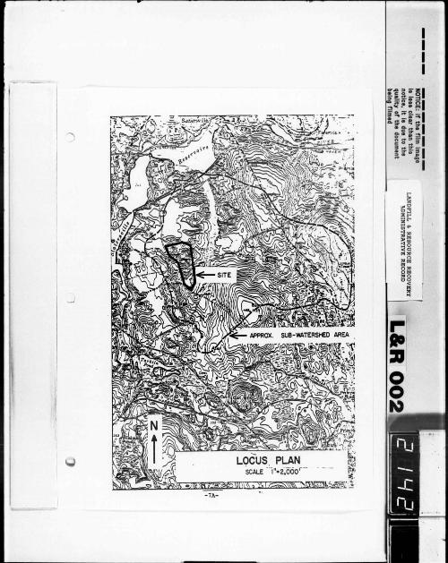
0
Power Transmiaaion Co right-of-way to divide the aite into
two nctiona The norther portion of the d te drainbull into
Trout Brook via a small awale which pauea under the Blackshy
atone Valley Electric co trampru~miaaion line juat aouth of
the point where the line bends and change to a norht-aouth
orientation Thia awal e drains almoat all of the northern
portion of the aite i nc luding a s ubstantial portion of the
exist i ng landfil l mound and aho carriu aome run- of f f rom
the high ground off of and to the north of the landf ill
2 3 Previous Invutiqationa and Aueumenta The LampRR
lite hu been the subject of a conaiderable UDount of
investigation and study over the laat aeveral yeara In
1974 four wells were drilled on the property It b believed
that they were inatalled bullbull part of a pre-purchaae inveatigashy
tion conducted by uJlll Five aore welh were drilled in
1976 In 1977 bulleven aonitoring wellbull were bwtalled u per
the Rul and Requlationa for Operating Solid Wa8te Manaqeshy
aent Facilitiebullbullbull Roy F Webullton Inc inatalled four monitorshy
ing welb adjacent to the property in 1978 bullbull part of the
Statebull 208 invebulltigation Thebullbull were aupled in 1979 by a
firm retained by the Town of North smithfield Reault bull of
theae testa led to the inatallati on of three a ulti-level
monitor ing 11BARCAD11 type welh by OEM earl y in 1980 They
wer e sampled i n March 1980 Teat reaulta led OEM to require
LampRR to inatall four multi- level cluster wella later that
year
- 11shy
In July 1978 Roy F Weston Inc prepared two reports
for the Rhode Island Statewide PlaMing Program Both
reporta addrel8ed iuues pertinent to a plan of regional
water quality One of the reports Detailed Analysis of
Landfill I11pacte on Water Quality 11 studied the potential
impacts of aixteen landfills in the State The LampRR site
wu one of the sixteen aelected A major component of
Wuton 1 bull work was the inetallation and sampling of wells at
theabull aitea Four wellbull were inatalled at LampRRs landfill
surface s ources were also sampl ed and analyzed One o f the
wells located in the swale east of the eite ahowed hydroshy
carbon contamination and a high COD value attributable to
the preaence of leachate 11 In discuing the environmental
tpact of the e1te Weaton concluded that
The landfill baa at pnaent ainillal iJIPact on ita aurroundinqa Problema with leachate volume aay occur in the future if the total property of 36 acres ia filled with refuee then natural attenuation and renovashytion aay not be eufficient
Weaton s eecond report Reco~~U~ended Leachate Control
Alternatives 11 developed a claification ayatem for landfills
bued upon the landfills operational status ampnd its degree
of impact on water quality Impact waa determined by the
analytical reeulte of sampling performed during the first
report Weston claaaified the LampRR aite aa an Active
Landfill having 11inor i11pact In diecuing thb clauiicashy
tion Weston noted that an ample soil zone for attenuation
lllay exist between the baae of the landfill and the water
middotb1e or point of qroundwater diacharqe While classifyinq
-12shy
LampRR u a minor impact lite Weston repeated hia prior
comment relati ve to potential dqnificant impact should the
entire thrity-dx acre aite be landfilled Aleo in completshy
ing his dis cuion on Minor Impact - Aes sment 11 Weston
noted that
a minor impact aa aaseased today may be advenely impacting future water supplies or may become a major i mpact u the leachate gener ating c haracteristics of a l andfill change with time
The Rhode I sland statewi de Planni ng Program 208
r eport iasued in 1979 i dentified the Slatersville aquif~r aa
having 11 soae potential for future municipal water supply
developaent Aa such the report contended that the area
should be considered ttenvironaentally sensitive and protected
frobull degradation noting that the LampRR landfill b located
on the aquifer the report recomended closure of the site
in a aanner that would ainiaize infiltration should leachate
contaaination becou evident The rep~rt als o reco-ended
th8 establishment of vegetative cover and the construction
of be rms and other erosion control measures at the lite
In late 1980 the Town of North Smithf ield contracted
Whitaan amp Boward Inc to conduct and prepare an environmental
impact uaeaament on groundwater integrity as affected by
LampRR 1 s landfill The report has been aubmi t ted to the Town
for their review and comment
The final document pertaining to LampRR s aite ia the
recently released draft of a report entitled Preliminary
site Aaaeaament and Emergency Action Plana for Landfill and
Resource Recovery North Smithfield Rhode Island The
- 13shy
report was prepared by Ecology and Environment Inc for
EPA Ita objective was to determine the nature and extent
of pouible surface and groundwater contamination from the
landfill and to develop draft emergency action plana for
abatement of future environmental damage potentially arising
from the ei te
The apparent thrust of the report were the hazardous
wast es d isposed of at the landfi ll The report noted that
the aite context s eeme d ideal f or l eachat e mi gration of f shy
a te and that the ins tallati on o f the PVC liner coupl8d
with disposal aethods and waste characteristics are probably
alleviating or towing migration of contaminants Addreinq
the aatter of the adequacy of existing monitorin9 wells the
authors atted that they were properly situated and screened
at appropriate levels provided that all hazardoua waatea
were buried in the one location reported by LampRR bull owners
However additional survey and on-site investigation was
recobullended to confirm the location and extent of the hazardous
The value of much of the information and data derived
from teatin9 and monitorinq some of the wells i nstalled on
and around the ai te ia questi onable in the opinion of many
professionals To date tes t i ng haa i ndi cat ed levels of
c ont ami nation principal ly heavy aetah and tot al organic
carbon However the question of the degree of contamination
(ie gross aiqnificant minor etc ) aa well aa its exact
source ia often the subject of considerable debate There are
several reasons for this unfortunate situation
- 14 shy
A prime reason for the debate over the reliability and
authenticity of available data h the lack of a clear
concis e underatanding of the hydrogeologic conditions at
LampRR 1 a a i te The i mportance of thia information wu noted
in an EPA report when the authors s tated that
Determination of the flow rate and direction of ground water are prerequisitea to monitoring well placement Drilling will be required and measurements must be made of the piezometric s urface 11
Under a dbcuuion entitled tiDe f i n tion of the Hydrogeologic
Setting 11 the report noted that
The hydroCJeologic setting of the landfill h probably the bulloat 111portant factor in eetabliehing the need for and deaiqn of a landfill monitoring ayatem Prior to selecting a landfill site information u to eurficial and bedrock geolo9Y depth to the water table and direction and rate of ground water flow ehould be deterained In the past aubaurface conditione have not been well-defined landfillbull have been located on laneS such ae awaapa or abandoned qravel pita tradishytionally considered uaeleee and of low econobullic value Ground water pollution potential ie preeent in theee areae and in the caae of gravel pit the potential ie high For tbeae reaeone the need for monitoring and abatellent procedurebull ie acute
Thie eame report lieted data that a ground water
inveetigation ahould provide The liat contained the following
depth to the water table
b the extent of ground water mounding caueed by an exiat i ng landf ill
c the natural rate and direction of flow
d the degree of influence the landfill has on the rate and direction of flow
Fenn 0 Cocozza E and Isbister J Braida 0 Yare B Proux P Procedurfa Manual for Ground Water Monitoring at Solid waste Oiapoul Facilities U S Environmental Protection Agency Report EPA 530 SW 811 Cincinnati Ohio 1977
-15shy
e the locationa of recharge and ctiacharge areaa
f the types and interconnection of aquifers
g the rate of aite i nfiltration relative to the total ground water flow
Definitive data pertinent to the items liated above
haa not been available for review The abaence of auch data
precludea verification of the exiating moni torinq well
ayatem with reapect to the adequacy of the number of pointa
inatalled point locations and acreen or aampling point
elevationa Alao the identification of an accurate baCkshy
ground well cannot be aade
Other acton affecting the validity of available aubshy
aurface teat raaulta are the condition of the aample pointl
the frequency of taating differencebull in thoda uaed to
gather IUIPlaamp varying laboratory procedureamp aa well aa
are than one aat of atandarda to which the teat raaul ta can
be coparad
Another factor ia the lack of infomation relative to
the type and location of the varioua typea of waatea within
the total landfill not juat under the exiating liner In
eaaence both where to look for contamination aa well aa
what apecific typea of contamination to look for aeem to be
valid queationa that either cannot or have not been poaitively
anawered
24 Exiating conditions and Operations The moat
dominant feature of the landfill ia a large eliptical
-l6
ahaped dome located on middot the northern portion of the property
The dome ia approximately fifty feet high and it coven an
area of about eight and one-half acres About one-half of
the mound ia covered with a liner Assuming elevation 275
aa the bottom of the mound ita estimated volume ia about
three hundred and aixty thouund cubic yarda based on field
aurvey dated June 1980
In January 1980 LampRR covered a portion of the mound
with a 20 mil PVC liner Earthen cover was placed over the
liner and gra baa become established over the majoritY of
this aoil layer However from eight to twelve feet of
liner ia expoaed to aunlight around almoat the entire perimeter
of the DOund probably due to either water or wind eroaion
Water erosion is the ore probable cause and ita effects are
evident over alaoat all of the ateeply eloped uncovered
auracea of the aound Gulliea are co1111on and in soae
places have become deep enough to expose waste materiala
under the aoil cover
currently landfilling h taldng place along the east
and s outheast facea of the mound Refuse h being dumped
apread compacted and covered with aoil in what seems to be
a relatively continuous operation In-dtu soill are being
excavated and uaed for cover This excavation baa created
very ateep eroding slopea along the northwest face of the
site A aimilar condition exists on the west face of the
remains of an existing hill along the eaat edge of the
property
-17
Landfilling around the exilting hazardous waste area is
increasing the potential for leachate development and migrashy
tion As has been mentioned a considerable area of uncovered
landfill embankment exists around the edge of the liner
The active area to the southeast of the liner is fairly
flat A roadway rings the top of the mound and acta aa a
atep or plateau In combination these conditions offer a
liqnificant area for i nfiltration of precipitation Migration
could follow gradients downward and i nto the area under the
liner The pressure of the active dilpoaal area against the
southeast face of the mound would encourage such an ampnCJUlar
flow The function of the liner is bei ng negated by this
condition Also this condition il probably causing a
oundill9 of the groundwater profile under those exposed
areaa
3 0 UVIW and EVALUATION
31 2npound closure doCUJRenta submitted to OEM by
LampRR consist of four plana and a text The plant~ were
prepared by Wehran Engineering and conaiat of (1) Preliminary
Proposed Final Grade (2) Preliminary Ground Water Contour
Map amp Monitoring Well Locations (3) Preliminary Sections
and (4) Detaih The text consists of a materials and
installation specification for a PVC membrane and a narrative
that addressee certain referenced i tema contained in the
Geremia hearings testimony All closure docwnents are
stamped Received RI Dept of Environmen~al Management
Division of Air and Hazardous Materials Nov 17 1980
- 18
The intent and direction of the submittal by LampRR is
expandon rather than closure A major expans ion of the
northern portion of the lite and the complete development of
the southern portion of the property are the dominant elements
of the closure documents
Sectiona taken acrou the plans indicate that about two
hundred and seventy thousand cubic yards of material will be
excavated on the northern portion of the lite and about two
million two hundred and ninety thousand cubic yards of
landfill material will be added This represents approxishy
utely a seven hundred percent increase in the amount of
aaterial currently existing on that portion of the lite On
the southern section about four hundred and ninety thousand
cubic yardl of aaterial will be excavated and nine hundred
and forty thousand cubic yards of aaterial will be landfilled
In collbination with the northern exparulion the total proposed
increaae in landfill is about ten times the current in-
place volWDe
It should be noted that the sections drawn to estimate
the quantity of expansion assumed elevation 260 as the
bott011 of the proposed excavations The closure plans note
that excavation will not be carried closer than five feet
above the seasonal high round water level However
sufficient data does not exist to determine that elevation
Elevation 260 was chosen as a conservative figure Should
groundwater be lower the quantities and proportionbull could
increase liCJilificantly
-19
The propoud expanaion will have a dgnificant impact
on the viaual character of the surrounding landscape As
ahown i n the aections the pr oposed heights ~or both portions
of the property will make them one of the moat dominant l and
forma in the area Aa land forma they will be out of
charact er with their environment with respect to ahape and
contour It 11 very unlike l y that they will suppor t vegetashy
tion consistent vi th their s urroundingbull thereby maki ng
their bulk and shape even more evident
3 2 Restricted Acceu and Activity Separati on LampRR s
pribulle concept o~ restricted acce~s to the hazardous waste
portion of their landfill seeaa to be encapsulation With
the exception of a text statement relative to a cable and
lock preventing vehicular acceSI frobull the front of the ei te
and another reference to inatructions to the landfill a
staff aa to what wastes are not to be accepted it ia the
only concept inherent in their aubaittal A concept of
additional landfilling separate and apart from the hazardous
waate area ia not addressed
Ecology amp Environment Inc a report recociuzed the
potential iJDpact of the hazarctoua vaate portion of the landshy
fill on the environment and recommended i n-the-fi eld survey
and i nves t i gation t o det ermi ne the extent and location of
the hazardoua materials The Geremia hearinga accepted as
fact the testimony that the hazardous wastea were not s eparated
from other materiala The order from theae hearings directed
LampRR to bull aaaume that the hazarctoua vaate will poae such a
- 20shy
-----------N
OnC
E If tho film
Image
11 le11 clear than thl1 notice It 11 dut to the
of the documen
t
(
LA
ND
FIL
L
amp
RE
SO
UR
CE
R
EC
OV
ER
Y
AD
MIN
IST
RA
TIV
E
RE
CO
RD
-
~
(imiddot 0
~ i=
l 0
bull W
jg (f)
~~
0 I bull o
or-
bull
Q
bull i ~ ~~ gt-
(
~ f i I
)
L shy
LMltshy------r LMlWIU- ~--BIMCMILL_L -~
-~
-- middotshyi -~-
VICTOftY HIGHWAY---shy
SECTIONS -208shy
aACXIIUINHILLshy_
WfTANCiaIHO-[
u _ ___
--~~
TMIULN fKWI -shy
11(1110 an___-shy
-~ middot-
SECTIONS - 20Cshy
threat for a substantial although i ndefinite period of
time Both of weston 1 a studi es recognized the potential
of adverse impact from the d te particularly if it waa
developed to its full extend
All of thue opinions and concludona aeem rational
Should significant problema develop that can be traced to
the hazardous wute portion of the landfill remedial action
may entail conatruction activitiea in ancSor around the
exiating wute dhposal area Implementation of LampRR 1 a plan
would hinder auch remedial meaaurea and may in fact n~gate
thbull coapletely Given an extended period of time prior to
either the development or detection of a aource related
pollutant problem LampRR a expanaion could eliainate available
on- aite area needed to illpleaent theae bullbullbullurea In view of
the uncertaintiea of conditiou under the PVC liner and the
extent of profeional opinion that a potential problu doea
exht a rational concept would aeera to be one which conaiden
the entire landfill a potentially hazardoua aite and iaolatea
it from any other propoaed activities The queation or
iaaue of the need for physical barriers auch aa fencea
etc could be examined in an u-needed context given developshy
llent plana for ancillary portiona of the site as well aa the
reaulta of an exteuive ongoing pollutant monitoring program
after a separate cloaure plan for the existing facility ia
aubmitted and approved
-21shy
3 3 Vertical Expansion The 20 mil PVC liner covering
the hazardous waste area of the existing landfill was supplied
by Staff Industries Upper Montclair New Jersey Personnel
at Staff were unable to supply data relative to the performshy
ance of their product under extended burial conditions
Product specification supplied by Staff are standard ASTM
teat results ASTM teatJ performed on 20 mil PVC liner
material are done under controlled laboratory condition~~
which do not reflect actual in-the field aituation For
exuaple in diacuaainq the significance of their Graves Tear
Teat (Dl004) ASTM states
apeciaen geometry and speed of testing in this teat aethod are controlled to produce tearinq in a u area of stress concentration at values far below those usually encountered in service
Research that b been done to 4ate on PVC as a landfill
aaterial baa bean directed acre to ita reaction to leachate
rather than ita ability to withstand loading In 1979
Matrecon Inc Oakland California prepared a study for
EPA antitled Liner Materials Exposed to Municipal Solid
Waste Leachate Alaoat all of the aateriala testing done
for this report was performed under laboratory conditiona
Within these parameters PVC as a material performed well
although it did have the highest permeability to water vapor
of any of the qroups of materials tested
-22shy
One portion of their report that did not rely on
laboratory conditiona was the recovery of a a ample of PVC
liner from a demonstration landfill located in crawford
County Ohio The material had been buried under e i ght to
twelve feet of refuse and cover material for aix years
Testa performed on recovered samples correlated with laborashy
tory testa However the liner had been protected by a
layer of clay and i b degree of exposure to leachate could
only be es t imated The report also noted that the liner had
t aken the s hape o f the soil and that depressions o f aa much
aa aix i nches i n one foot o f area were observed The report
di d not s tate the nature or caus e of the depressions
In 1977 a field s tudy to t eat the behavior of refuse
under controlled loading waa conducted at the Morgantown
West Virginia a unicipal landfill Refuse in this ins t a llatbull
i on had been in place for many years and i ta depth waa ten
f eet A r ec tangular teat cell waa establis he d and loa ded to
approxiaate ly one thous and pounds per s quare f oot The size
o f the teat ce ll waa fifty feet by ninety feet and settlement
platfonu wer e i nstalled in the mi dd l e and at each end
settleent in the center of the cell occurred sooner and
was of a greater magnitude than at the ends due to the fact
that the average atresa in the center waa estimated to be
approximately twice aa much as that on either end At the
Rao SK Moulton L K amp Seals RK Settlement of Refuse Landfilla in Geotechnical Practice for Disposal of solid Waste Materials ASCE 1977 pp 574-598
-23shy
end of three hundred and fifty days the center had settled
just over two feet and each end had settled about one and
one quarter feet In terms of original depth the test cell
had settled from twelve and one half percent to over twenty
percent
It hu been suggested that the bulk of the refuse
landfilled at the LampRR aite ia commercial and that only
North Smithfield uses the facility to dispose of municipal
wastes ldsuming an average weight of five hundred pounds
per cubic yard of waate and that aix inches of soil cover
will be placed over each yard compacted in-place the
total dead load bearing on the center of the existing landshy
fill aound when LampIUl s maximum expanaion plan ia coJII)leted
could be in the range of forty-aix hundred pounda per square
foot LampRR statebull that the PVC liner vas placed over a two
foot deep layer of fine a and or fine ailty sand The ability
of thia bullaterial to withstand theae loads or to apread thu
out evenly enough to avoid liner penetration from solid
objectbull in the landfill cannot be determined All that can
be atated is that there ae to be a very significant
possibility that the integrity of the liner may be destroyed
under the propoaed plan of expansion Penetrations would
probably occur in or near the center of the cover just over
the area designated as containing the hazardous wastes
Penetration of the liner would probably lead to higher
Conversation with Frank B Stevenson Principal Engineer OEM
-24shy
moieture leveh in these areu which could result in an
increase in both leachate generati on and aigration
The probable impact of vertical expansion on leachate
formation within the exieting landfill area is a function of
two factors the density moisture ratio of the existing
refuse and the amount of additional moisture that expansion
may introduce into this area If additional moisture is
prevented frobull entering the existing landfill the quantity
of leachate will not increaae However if compression
increases the densityoiature ratio significantly the
field capacity of the refuse could be reached or exceeded
resulting in the conversion of previously static moisture
into leachate The rate of flow of the leachate would
increase and the flow would start sooner Siailar changes
in the rate and duration of flow frobull active saturated
landfill areas would also occur given sufficient compression
Conversely decompression and resultant expansion of wastes
would reduce flow rates and delay leachate aigration
The concept of any vertical expansion over the existing
landfill area seeaa ill advised Problema auociated with
potential damage to the existing liner in combination with
the almost certain increase in leachate formation and migrashy
tion are likely to create significant increaees in what now
appears to be a minor but growing problem of degradation of
a valuable environmentally sensitive natural resource
-25shy
34 Activity Separation The matter of keeping separate
the solid waste dbpoul activities from the hazardous wute
dbpoul area has been discussed to 1ome extent under section
3 2 above The closure documents do not present a nparate
operational concept except for the development of the
southern portion of the d te LampRR feela that disposal
activit ies cannot be eparated on the northern section of
the landfi ll In their text they contend
11 bullbullbullPleau keep in mind that although the state requires only a closure plan for the hazardous wute portion of the facility it iB very difficult if not impoible to separate that portion of the operation froa the continushying functions of tree harvtinq reforestation sanc1 and gravel excavation and sanitary landfill operation There is no attupt aade in the following plau to wmeceaaarily tie plan for the continuing operation of a aanitary landfill to the plau regarding waate already diapoaed of but rather we a4viae that it ia practically ipoaaible to aeparate th- ror exuple your enginHringly aound requirnt nWiber l d (froa the Gereaia hearingbull) for diverting aurface water draining around and away froa the diapoaal lite could not be acc011pliahed except by filling the aand and gravel excavation areaa via the aanitary landfill bullethod and regrading the entire lite
The contention that the aanitary landfill aethod ia the
only way that proper aurface gradianta can be devel~ped to
divert aurface run-off around and away from the exiatinq
diapoaal aite il falle The atatement that it il difficult
if not iapoaaible to aeparate the hazardoua waate portion of
the lite from the continuing functionbull of a landfill operation
cannot be proven until a closure plan for the hazardous
waate area void of any reference to propoaed expansion
-26shy
I ---
baa been prepared Such a plan will delineate the extent
and limita of the aecurect area and will allow for an examinashy
tion and review of remaing areas of the lite that could be
developed such a plan h not included i n LampRR 1 a submittal
although it waa a specific requirement of the order generated
by the Geremia hearings
35 Leachate Collection s ystem LampRRa cloampure aubshy
mi tta l does not contain a l e achate collect i on system for the
bazardouamp wu te porti on of the f acili ty Drawi ngamp prepared
by their conault i ng engineer do show 14 ABS leachate cOllecshy
tion pipes in aectiona taken through the landfill A
typical iMtallation detail ia alae provided However the
pattern and extent of ampuch a ayatem ia not ahovn in plan
view and there are no details relative to leachate containshy
MDt and treataent
AD acceptable leachate collection ayatu for the huardoua
wute portion of the facility h ahovn on the following
plate IU bullajor coaponenu are two iapervioua cut-off
valla located and angled in a llAJUler ao bullbull to intercept and di vert
potenti ally polluted groundwater to a well which would be
aized to pump the cont ami nated water to the aurface
The l ength and exac t locat ion of the walla would be
de termined after complete and accurate aaaeaament has been
made of the groundwater flow pattern under the aite The
walla would extend from the aurface down to bedrock The
alurry trench or wall construction technique would probably
- 27shy
1
QAAIMMl llltoLI --
I LEACHATE COLLECTION SYSTEM ALTERNATIVE
SCALE Ibull 300
-27Ashy
be ideal for thil installation The well would be acreened
and a ized baaed upon data from the drilling log It would
probably be four inch diameter minimum Detailbull aa to
treatment dhpoaal of the well water would be developed
bued upon it anticipated volume and compoaition a a well u
the location of the well point
36 Groundwater Monitoring LampRRI monitoring procram
ia euentially acceptable if it doea in fact conform to
groundwater condi tiona on-ate However there are acme
exceptioll8 Two additional aulti-level monitoring well
ahould be conatructed One between CW-2 and CW-4 on the
northern aide of the landfill to intercept any leachate
which aight be aoving in a northerly direction and the
other waat of oxford Road in an area aufficiantly r-oved
froa the landfill for a background well
All welh should be pUIIped continuously (at least two
hundred to two hundred and fifty gallons) to remove pouible
pollutant froa drilling water etc Some welh may be too
deep to purge
Samples should be taken once every three montha and
water level bulleuurements should be taken with each water
bullample The next samples which are taken should be analyzed
for Priority Pollutant Standard Anions and Cations Gross
Alpha and Beta radioactivity Asbestos pH Turbidity Total
Organic Carbon Total Organic BaloqinB Chemical OXidation
Demand Biological Oxidation Demand Specific Conductance
and Fecal Coliform The samples taken for the next year
-28shy
should include Volatile orqanica Trace metals Standard
Anions and Cations Total Organic Carbon Biological and
Chemical oxidation Demand pH Specific Conductance aa well
aa any other key indicators which were indicated in the
firat analyaia After the first year of sampling the key
indicators should be sampled every three months and other
parameters once a year for a period of up to ten yeara If
a significant leachate plume b detected a ayatematic qrid
of mul ti-level bullonitoring wella s hould be utabliahed to
accur ately del i neat e and analyze auch a plwae
All clus t er vella ahould be maintained in good wor king
order and i f fo r any r e on any vella are rendered uaeleaa
they should be replaced
Coat Eatiute for Moni torinq
Firat aet of analyaea
$1900 00 each x 12 auplea
Analyaea for next year
$660 00 each x 12 auplea
x 3 aeta
Continuing analyaea
$12 720 per year
To enaure monies for the aamplinq and maintenance of the
monitoring vella OEM and LampRR could enter into an escrow
account
3 7 Earth Cover and Liner Maintenance LampRR bull program
for earth cover and liner maintenance appears to be adequate
However overall gradients on the the alopea of the proposed
-29shy
landfills are excessive These elopes scale two to one and
are in excess of the two and one half to one maximum slope
recommended by Staff Industries the aupplier of the existing
PVC liner Staff a personnel recommend three to one as a
preferred elope for top cover and this recommendation appears
to be rational in light of potential erosion that could
expoae the liner to sunli9ht which over a period of yean
deatroya the i nteg-rity of the material
The total area to be maintained under LampRR a completed
landfill b about thirty-six acrea If we aaaume that middot
annually on the avera9e two percent of thia area will
require aobulle type of re-seeding due to erosion the annual
coat would be about dx thouaand dollars (Thirty-five
hundred aquare yarda at about one dollar and seventy cents
per yard not including topsoil) Should in-situ topsoil
not be available or should the erosion take place in relashy
tively inacceible areas the unit price could 90 as high
as two dollara and fifty cents per yard depending mainly on
the topaoil coat
4 0 FINDINGS and RECOMMENDATIONS
4 1 Findings LampRR a closure aublllittal b unacceptable
It doea not propose or address closure of the hazardous
waste portion of the landfill as a separate issue divorced
from expansion of the site The contention that refuse is
the only material suitable for filling to achieve proper
run-off away from and around the landfill ia incortect It
doea not contain definitive information relative to the
-30shy
direction o f the flow and depths of groundwater below the
landfill It does not contain specific data relative to the
protection of groundwater from contamination by e l ements in
the hazardous waste disposal site The issue of control of
air emission from the site ia not addressed It does not
contain the location of each type of waste disposed of at
the f acility
4 2 Recomme ndations The landfill s hould be closed
Contami nat i on has been detected An adequate groundwater
analysis and plan has not been developed The locatio~ and
elevation of the aonitorinq system h subject to verification
Hazardous wastes have been buried at the ampi te and their
location is questionable The current operation encourages
leachate developMnt LampRlt should be required to prepare
and subait to DDI an acceptable closure plan This plan
should not contain any reference to expansion and it should
conaidbullr the entire landfill area as it now exists as a
potential hazard to the aquifers It should contain a
definitive syste for contaminant rebulloval and treatment It
should assuae that the d te will pose a threat for a sub
stantial although indefinite period of time after clos ure
The following are s uggested details and procedures f or such
a clos ure p l an
accurat e information must be p r e s ented vi th
respect to groundwater Depths t o groundwater as well as
groundwater flows must be determined accurately This
i nformation should be consistent vith the elements recommended
- 31shy
0
for groundwater invutiqation as contained in the EPA document
referenced in 2 3 (Previoue Investigations and Assessments)
b portions of the existing liner that are
exposed should be examined with reepect to ita phylical
condition and integrity If acceptable it should be rolled
back up over the edqe of existing eoil cover and temporarily
held in p l ace
c all exposed aurfacea of the exhting landfill
s hould be f i lled and gr aded ao a1 to provide at l east t wo
fee t of clean cover over any wtu Maximum s l ope s hould
not exceed three to one
d additional quantities of impervious aubrane
aaterial aucb aa 20 ail PVC should be placed on the expod
slopes extending out pt the toe of the ound at let
three feet and up to and be joined vith the edge of the
existing liner The intallation of the liner ehould be
conaiatent with the manufacturer bull recouendationa
e all portiona of expoaed liner bullhould be
covered with at let one foot of protective aoi l Additional
f i ll bull hould be placed around the toe of the mound to facilitate
aurface drainage and run-of f
f all f i l led are aa bull hould receive one foot of
bulloil to be aeeded for erosion protection
g dltation bina bullhould be conatructed enshy
d te to collect bullurface run-off
h a leachate collection system should be
incluC in the plan with provisions for leachate treatment
and dlti -middot al - 32shy
i an acceptable ground and surface water 11onitorshy
inq program should be developed and maintained both on and
off-site
j the applicant should prepare estimates as to
cost of remedial action should gross contamination occur
The applicants ability to cover such costa should be proven
and asbullured Definitive bindinq long-term financial
agreements should be developed for extended maintenance of
the site
A final recommendati on pertains to the advieabili tY of
re-openinq the LamplUl s ite or any other disposal dtes on
areas containinq or aupportinq valuable natural resources
The tera Msecure landfill is tenuous in that the potential
0 for catastrophic events such as earthquakes etc always
ezbta If additional sites which would not endanqer natural
resources are available elsewhere it would ee prudent to
utilize th rather than to risk potential irreversible
environaental dampluqe All other existing disposal facilities
should be reviewed in this sue context
bull -33shy
- barcode 561574
- barcodetext SDMS Doc ID 561574
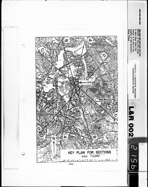
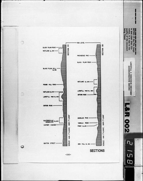