results of h2020 storm project in the assessment of damage
TRANSCRIPT

Results of H2020 STORM project in the assessment of damage to cultural heritage
buildings following seismic events
Abstract— The Corpo Nazionale dei Vigili del fuoco Italian (Italian Fire and Rescue Services) provides the emergency verification of the static safety of buildings in urgent technical assistance and calamities. This activity also concerns cultural heritage and was the subject of a research and development project funded by the European Commission in the Horizon 2020 program. This project (STORM) made it possible to verify, with a positive outcome, the possibility of using Lidar technologies to support safety assessments in emergency conditions.
Keywords: CNVVF, emergency, cultural heritage, historical buildings, laser scanner, lidar, earthquake, temporary works.
1. INTRODUCTIONThe CNVVF, Italian Fire and Rescue Services, represents , in the f ie ld of emergency interventions on historic buildings, an international excellence. Thanks to the wealth and density of cultural heritage present on the national territory, the CNVVF is the only technical rescue body that gained decades of experience on the field and developed intervention techniques and organisational schemes appropriate to the needs. The earthquakes that hit Italy between 2009 and 2017 have shown the ability of the CNVVF to operate in a coordinated way even on a large scale for the safety of damaged buildings, ensuring the presence of specialised personnel and the supply chain necessary to carry out the necessary measures.
The research project H2020 STORM ended in June 2019 and has dealt also with the assessment in an emergency of the stability of buildings damaged by seismic events , gave the opportunity to improve reliability and accuracy of the assessments through the use of laser scanner tools available on the market. Such improvement can be integrated into the procedures adopted by the CNVVF in the stability checks of buildings in emergency situations.
2. THE CNNVF AND THE SAFETY OF HISTORICAL BUILDINGS
2.1. Evolution of interventions on cultural heritage in disasters
The CNVVF has been historically committed in rescue operations on cultural heritage [1]. Over the years, the need to protect cultural heritage has grown more important and, consequently, the regulatory framework has become more complex. The current regulatory framework on disasters states that the CNVVF operates in rescue of cultural heritage buildings and artefacts, must comply with what is indicated by the Administration of Cultural Heritage as part of the general management entrusted to the National Department of Civil Protection. The operational coordination for the protection of cultural heritage, exercised by the Ministry [2] together with the civil protection management, entrusted to the regions and to the national Department of Civil Protection [3], has been one of the most complex issues to be performed, to ensure the CNVVF operations during emergencies. The problem of defining responsibilities in contexts where the operator safety is not
Ing. Stefano Marsella Ministero dell’Interno
Corpo Nazionale dei Vigili del Fuoco [email protected]
Ing. Davide Pozzi Ministero dell’Interno
Corpo Nazionale dei Vigili del Fuoco [email protected]
Ing. Luigi Palestini Ministero dell’Interno
Corpo Nazionale dei Vigili del Fuoco [email protected]
Ing. Marcello Marzoli Ministero dell’Interno
Corpo Nazionale dei Vigili del Fuoco [email protected]
of 1 9
guaranteed - such as scenarios commonly defined as "red areas" - made a long journey necessary, at the end of which the limits and competences of the parties involved were clarified. The issue can be summarised in the difficulty of reconciling the exclusive responsibility of the competent Ministry (MIbaCT) operators, regarding the protection of cultural heritage with that attributed to the CNVVF by the Civil Protection Code [4] relating to the competence, once more exclusive, in the matter of operations in red areas, including those where there are historical and cultural buildings. This contradiction became dramatically evident on October 27, 1997 when, in the Basilica of Saint Francis of Assisi, a collapse induced by a seismic s h o c k k i l l e d t w o t e c h n i c i a n s o f t h e Superintendency of Fine Arts and two friars of the Basilica who were carrying out an inspection to assess the damage due to the shocks of the previous night [5]. The judicial events that followed made clear that the firefighters are responsible for the safety of people entering the buildings at risk, including those of cultural interest. So, it became necessary to define which areas have limited access (the so-called "red areas") which, however, prevent the activity of anyone who is not of the Authorities, including the technicians of the Cultural Heritage, who are the only authorised to operate on historical or artistic value artefacts. In essence, with the event of 1997 the conflict between the rules on the management of the rescue and those on the protection of the Cultural Heritage emerged. The emergencies of recent years have made it possible to gradually find a solution to this problem. In particular, starting from the earthquake of 2009, the precise identification of the limits of activity of the Fire Brigade and the coordination of their activities with the competent Superintendencies and the Department of Civil Protection has allowed all the parties to operate in their own areas of competence. On this occasion, moreover, the CNVVF introduced the use of information technologies to improve the exchange of data with the Superintendencies [6]. A further evolution was recorded with the integration of the figure of the implementing entity into the institutional framework. This figure is responsible for the safety of the buildings in order to guarantee public safety, risk mitigation and the restoration of essential services in the municipalities affected by the earthquake [7]. The responsibilities of the CNVVF, with the new Civil Protection Code [3], concern the interventions on the buildings that make up the national cultural heritage. Article. 10 provides, in this regard, that on the occasion of calamitous
events the CNVVF "ensures, until their fulfilment, the following functions:
• the technical assistance interventions can not be postponed and are urgent;
• search and rescue operations for people, animals and property;
• the direction and responsibility in the immediacy of the events, through technical-operational coordination and connection with the other components and structures involved."
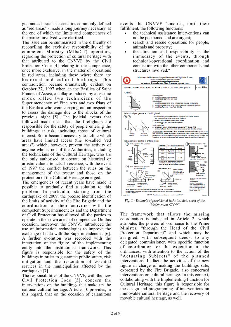
Fig. 1 - Example of provisional technical data sheet of the “Vademecum STOP”.
The framework that allows the missing coordination is indicated in Article 2, which attributes the powers of ordinance to the Prime Minister, “through the Head of the Civil Protection Department” and which may be assigned, with subsequent deeds, to any delegated commissioner, with specific function of coordinator for the execution of the ordinances, with attention to the action of the " A c t u a t i n g S u b j e c t s " o f t h e p l a n n e d interventions. In fact, the activities of the new figure in charge of making the buildings safe, expressed by the Fire Brigade, also concerned interventions on cultural heritage. In this context, collaborating with the Implementing Function for Cultural Heritage, this figure is responsible for the design and programming of interventions on immovable cultural heritage and the recovery of movable cultural heritage, as well.
of 2 9
3. THE “STOP” VADEMECUMIn the event of an earthquake, the necessary assessments must be carried out as quickly as possible, in order to estimate whether the damage suffered by a building is compatible with its use, or whether the property should be prohibited, pending restoration of static safety. Post-earthquake verification of buildings is one of the most demanding operations from an engineering and organisational point of view. In addition to the technical difficulty, these assessments may concern several thousand buildings (of which a significant part of historical and artistic interest) which, in case of high intensity replicas, will have to be largely re-verified. The CNVVF in this context has been operating from the first hours of the calamities, both for rescue needs for people (to assess the safety of operations and the degree of danger of the communication routes threatened by damaged buildings), and to carry out urgent interventions to make buildings and structures of historical and artistic interest safe. Following the 2009 seismic events that hit central Italy, the need for a standardisation tool for the design and construction of temporary works emerged. On the basis of this need, the CNVVF has developed rapid intervention procedures that refer to the creation of support and shoring works that can be carried out on site, starting from standardised project sheets, called STOP - Technical sheets of Provisional Works (Fig. 1). The sheets, created by the CNVVF together with the University of Udine, during the earthquake of 2009, 2012 and 2016 made it possible to carry out several hundred safety operations through a sequence of activities and a standardised work flow. The use of the STOP cards was accompanied, more generally, by the adoption of an engineering approach - survey, design, logistical-operational organisation of the intervention, execution, documentation and reporting – which allowed increasing levels of complexity on large structures that would have been unthinkable even a few years earlier [8] (for example, the Church of the Blessed Souls AQ-2009, Church of Saint Giusta AQ-2009, Church of San Silvestro AQ-2009, Church of Saint Mary ‘Paganica’ AQ-2009, Basilica of Saint Benedict PG-2016 and the Tower of Accumoli RI-2016). The use of these cards, as discussed later in the document, would be improved in the hypothesis of designing the structures starting from precision measurements acquired at a distance, thus limiting the risk exposure of the personnel assigned to perform the reliefs. Furthermore, this work would be easier to be formed, as it is free from uncertainties in the choice of structural solutions and construction materials.
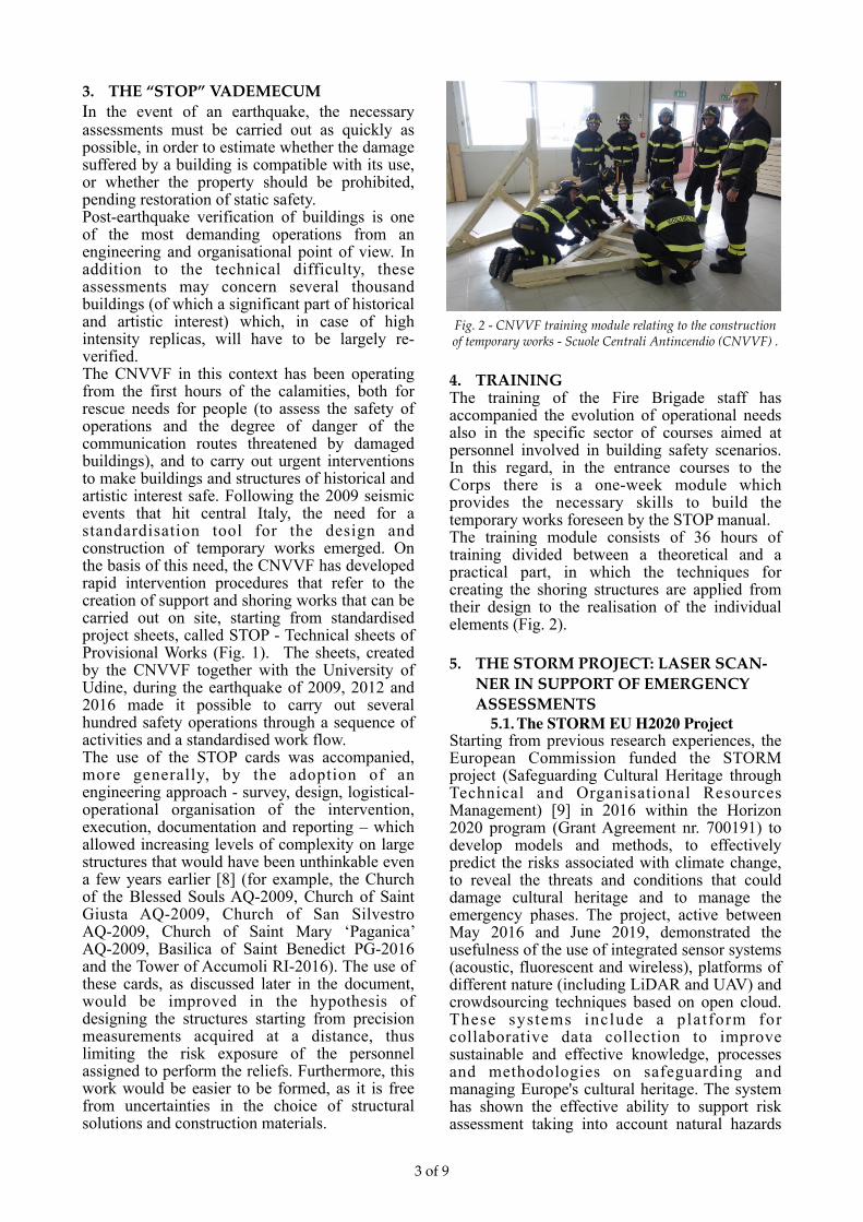
Fig. 2 - CNVVF training module relating to the construction of temporary works - Scuole Centrali Antincendio (CNVVF) .
4. TRAINING The training of the Fire Brigade staff has accompanied the evolution of operational needs also in the specific sector of courses aimed at personnel involved in building safety scenarios. In this regard, in the entrance courses to the Corps there is a one-week module which provides the necessary skills to build the temporary works foreseen by the STOP manual. The training module consists of 36 hours of training divided between a theoretical and a practical part, in which the techniques for creating the shoring structures are applied from their design to the realisation of the individual elements (Fig. 2).
5. THE STORM PROJECT: LASER SCAN-NER IN SUPPORT OF EMERGENCY ASSESSMENTS
5.1. The STORM EU H2020 Project Starting from previous research experiences, the European Commission funded the STORM project (Safeguarding Cultural Heritage through Technical and Organisational Resources Management) [9] in 2016 within the Horizon 2020 program (Grant Agreement nr. 700191) to develop models and methods, to effectively predict the risks associated with climate change, to reveal the threats and conditions that could damage cultural heritage and to manage the emergency phases. The project, active between May 2016 and June 2019, demonstrated the usefulness of the use of integrated sensor systems (acoustic, fluorescent and wireless), platforms of different nature (including LiDAR and UAV) and crowdsourcing techniques based on open cloud. These systems include a platform for collaborative data collection to improve sustainable and effective knowledge, processes and methodologies on safeguarding and managing Europe's cultural heritage. The system has shown the effective ability to support risk assessment taking into account natural hazards
of 3 9
and environmental and anthropogenic risks through case studies in five different countries (Italy, Greece, United Kingdom, Portugal and Turkey) where they have been identified sites capable of adequately representing the rich European cultural heritage.
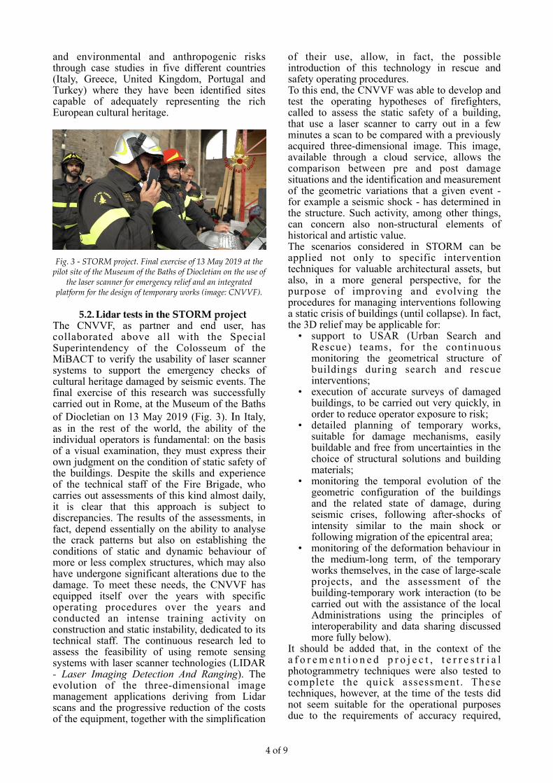
Fig. 3 - STORM project. Final exercise of 13 May 2019 at the pilot site of the Museum of the Baths of Diocletian on the use of
the laser scanner for emergency relief and an integrated platform for the design of temporary works (image: CNVVF).
5.2. Lidar tests in the STORM project The CNVVF, as partner and end user, has collaborated above all with the Special Superintendency of the Colosseum of the MiBACT to verify the usability of laser scanner systems to support the emergency checks of cultural heritage damaged by seismic events. The final exercise of this research was successfully carried out in Rome, at the Museum of the Baths of Diocletian on 13 May 2019 (Fig. 3). In Italy, as in the rest of the world, the ability of the individual operators is fundamental: on the basis of a visual examination, they must express their own judgment on the condition of static safety of the buildings. Despite the skills and experience of the technical staff of the Fire Brigade, who carries out assessments of this kind almost daily, it is clear that this approach is subject to discrepancies. The results of the assessments, in fact, depend essentially on the ability to analyse the crack patterns but also on establishing the conditions of static and dynamic behaviour of more or less complex structures, which may also have undergone significant alterations due to the damage. To meet these needs, the CNVVF has equipped itself over the years with specific operating procedures over the years and conducted an intense training activity on construction and static instability, dedicated to its technical staff. The continuous research led to assess the feasibility of using remote sensing systems with laser scanner technologies (LIDAR - Laser Imaging Detection And Ranging). The evolution of the three-dimensional image management applications deriving from Lidar scans and the progressive reduction of the costs of the equipment, together with the simplification
of their use, allow, in fact, the possible introduction of this technology in rescue and safety operating procedures. To this end, the CNVVF was able to develop and test the operating hypotheses of firefighters, called to assess the static safety of a building, that use a laser scanner to carry out in a few minutes a scan to be compared with a previously acquired three-dimensional image. This image, available through a cloud service, allows the comparison between pre and post damage situations and the identification and measurement of the geometric variations that a given event - for example a seismic shock - has determined in the structure. Such activity, among other things, can concern also non-structural elements of historical and artistic value. The scenarios considered in STORM can be applied not only to specific intervention techniques for valuable architectural assets, but also, in a more general perspective, for the purpose of improving and evolving the procedures for managing interventions following a static crisis of buildings (until collapse). In fact, the 3D relief may be applicable for:
• support to USAR (Urban Search and Rescue) teams, for the continuous monitoring the geometrical structure of buildings during search and rescue interventions;
• execution of accurate surveys of damaged buildings, to be carried out very quickly, in order to reduce operator exposure to risk;
• detailed planning of temporary works, suitable for damage mechanisms, easily buildable and free from uncertainties in the choice of structural solutions and building materials;
• monitoring the temporal evolution of the geometric configuration of the buildings and the related state of damage, during seismic crises, following after-shocks of intensity similar to the main shock or following migration of the epicentral area;
• monitoring of the deformation behaviour in the medium-long term, of the temporary works themselves, in the case of large-scale projects, and the assessment of the building-temporary work interaction (to be carried out with the assistance of the local Administrations using the principles of interoperability and data sharing discussed more fully below).
It should be added that, in the context of the a f o r e m e n t i o n e d p r o j e c t , t e r r e s t r i a l photogrammetry techniques were also tested to complete the quick assessment. These techniques, however, at the time of the tests did not seem suitable for the operational purposes due to the requirements of accuracy required,
of 4 9

tracing the quality of the data and simplicity of acquisition, processing and use of the acquired three-dimensional images.
6. NON-INVASIVE SURVEY METHODS Emergency and rescue operations are favoured by the knowledge of the environment in which they takes place. In the event of disasters affecting large areas, this knowledge is essential to organise and coordinate the deployment of rescuers. Updated data are therefore essential to the rescue and damage limitation activities. Even at the single building level, an updated and complete picture of its geometric shape and state of conservation, based on the documentation of previous and possibly post-disaster state, appears to be one of the first elements that technical assistance needs. In the case of cultural heritage, which constitute a particularly qualifying part of emergency assessments, informations about the state of the artefacts before the event are of great importance, both in order to respond appropriately, and to avoid further damage resulting from operations. Moreover, they’d facilitate the planning of recovery operations. In a future perspective, therefore, the digital representation of buildings can be considered the prerequisite for an higher quality of rescue, in terms of safety, speed and adequacy of actions to reduce structural criticality of buildings. Among the mentioned tools, the scenarios developed in the STORM project tested the use in rescue operations of the laser scanner (TLS, Terrestrial Laser Scanner), considered an active measurement sensor, as opposed to infrared thermography and digital photography, which passively record the wavelength of light, respectively around 8-15 µm and 0.4-0.75 µm.
6.1. Methodology of use of the laser scanner
The instruments used in the STORM project are compact TLS, small in size and sufficiently solid for field-type use, but capable of making accurate measurements. They integrate a pulse laser, whose invisible beam is directed to the surrounding environment by means of a rotating mirror, to measure distances and a motorized system consisting of three calibrated digital cameras, to construct 360 ° spherical panoramic images, coordinated with the measured distances. Among the needs of the CNVVF, ease of use, versatility, speed of acquisition and return of the 3D cloud were also considered. Already during the survey phase, in fact, the data must be able to be loaded onto a tablet, which allows it to be viewed and, with its own software, is able, from a minimum of three points not aligned, to combine the results of successive scans in a
single project, visible as a 360° spherical panoramic image.
6.2. PhotogrammetryPhotography is one of the most important means for the registration and documentation of cultural heritage, for its conservation or reconstruction. In this context, photogrammetry plays an important role, allowing the extraction of metric information from one or from a series of photographs of objects, when some requirements are met. In general, more precision is achieved when multiple images of the same camera can be processed photogrammetrically from different angles. In all cases, the availability of measured ground control points or known metrics is essential. The images of a building, to be captured from different positions and angles, are then processed through programs to determine the exact position from which the photos were taken and to interpolate the 3D shapes of the objects depicted. The emergency use of these systems, however, has not yet been subject to systematic analysis as, on the other hand, it occurred for the terrestrial laser scanner as part of the STORM project.
6.3. Comparison of methodsThe total stations and laser scanners, for their ease of installation and interrogation in real-time or processing and post-processing, can be used in different types of indoor and outdoor environments, are resistant to rain, wind, can be used in a temperature range from -10 °C to 50 °C and, above all, they are not affected by the light conditions. They allow the acquisition and storage of data or their post-processing to assess any structural changes in case of monitoring in buildings or to highlight possible landslide movements. Furthermore, the collected data can be processed in CAD, printed and shared. As for the invasiveness of the method, the survey with the total station and the laser scanner has completely favourable characteristics, as the instrument is characterized by non-contact operating modes. The measurement of the topographic points can be performed with prisms, positioned at the target points or by attaching reflective targets on the artefact. In the case of total stations without reflector, the points are measured without any contact and in this case, the measurements are completely non-invasive. As far as costs are concerned, total station technology requires few tools for detecting structures. The most significant cost is the one associated with the total station itself, with the basic accessories. The cost generally ranges from 5,000 to 20,000 euros. Cost changes depend on the angular precision of the instrument, the
of 5 9

operating range of the distance meter (EDM) and the presence of motorized functionality. Digital photogrammetry, particularly when photographs are collected with the use of devices on aerial support, is particularly suitable for tall structures (e.g. battlements, roofs or entire plots of land) and is often preferred for its high scalability and ease of data collection. Recent trends, however, involve combining digital photogrammetry and laser scanning for comprehensive documentation, particularly for more complex architectures. In any case, to adopt photogrammetry and/or laser scanning in the rescue operating procedures the following questions have to be considered:
• Is there a significant difference between the two methods of cost survey and results? • Can the output be used to detect movements or the overall degradation of buildings and individual structural elements monitored?
• Is it possible to detect the impact of the main dangers or threats by comparing the time-lapse models? • Is it possible to apply this approach for the conservation and analysis of the risk assessment? • How steep is the learning curve related to the use of hardware and software? • how sensitive are the devices to handling and transport? •Are the costs in question accessible within a typical budget for the adoption of a heritage project? •Are data acquisition and model processing time appropriate for the different operational phases of crisis management?
Since laser scanning and digital photogrammetry produce quite similar results in terms of the final output, it is better to illustrate the most evident
of 6 9
Laser scanner Photogrammetry
COST Relatively high price, often proportional to equipment accuracy and software capabilities.
High costs also for maintenance and calibration.
Significantly inexpensive, especially with the recent development and performance of cameras and IT /
software solutions.
ERROR Fixed (related to equipment capabilities) TLS is also less prone to human error, given the high
automation rate of most modern systemsProblems with reflective or transparent surfaces
High precision-High precision
Not consistent over large spacesMore sensitive to input and human experience during
processingProblems in treating reflective or transparent surfaces
Medium / high precision - Low precision
TIMING Each scan is already resized and oriented, so the processing time is often limited to downloading data
(for non-complex surveys)
Less time in the field but normally more processing time for alignment, scaling and orientation
TRACEABILITY / LEGAL VALUE OF
THE SURVEY
Each scan is automatically certified by the instrument itself, therefore the errors per single scan
are certified as lower than the instrumental ones. Point cloud merger software often offers a report
that certifies the estimate of the error committed in the merger operation. Consequently, the 3D survey is easy to defend in court, even in the absence of the
operators who proceeded with the survey and its subsequent processing.
The quality and accuracy of the resulting 3D survey is strongly affected by the experience and commitment of the
operator who processed the data. Consequently, the defence in court of the survey is completely based on the
expertise of the operator himself.
LIGHT CONDITION
S
It can also work in the dark (but without color information for scanned surfaces)
It needs light (preferably diffused) and cannot operate in the dark. Immediateness of the output frame as a result of
the regular fusion of still images. More visual photographic realism
TEXTURE It is still difficult to obtain a uniform texture on the surfaces
Immediacy of the output texture as a result of the smooth merging of still images. More visual photographic realism
OWNER DATA
n/d Only photogrammetry can operate on historical material (on this, see Gruen et al. 2003) which provides the
reconstruction of the previous state (pre-disaster or previous phase) of artifacts or landscapes. Modern
software packages can also easily operate with good results on photographs not collected for photogrammetry
(Agarwal et al. 2010).
Table 1 - The most evident differences between laser scanner and photogrammetry, taken from [11]

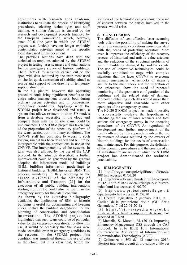
differences according to the scheme indicated in Table 1, taken from [11]. The STORM project platform consists of a tool that provides managers with the information necessary to operate in the best possible way in the preparation, management and recovery from an emergency. In essence, it was conceived as a reservoir of information of different nature, some of which of a static type (procedures, guidelines, regulatory references, etc.) and others of a dynamic type, as they are subject to changes over time (weather conditions, crowding, degradation of a given element etc.). In this context, the hypothesis developed by the CNVVF in the context of the project was to verify the effective feasibility of using the laser scanner in the specific operational context of the emergency assessment (in the specific case, following an action seismic) related to the stability of historic buildings. To achieve this objective, the CNVVF defined the information needs of the platform to support emergency management and deepened the knowledge on the tools available on the market, carrying out tests in the operational scenarios of the earthquake of 24 August 2016 in Norcia. In a nutshell, the hypothesis developed in the project is characterised by an increasing CNVVF operational capacity in safety assessments through the use of Lidar systems and the comparison of scans acquired in an emergency with those previously carried out by the manager of the buildings. The latter should be made available on the platform through a cloud system accessible in an emergency (Fig. 4). This scenario was successfully verified during the test organized at the Terme di Diocleziano Museum on May 13, 2019.
6.4. Management of 3D images in the CNVVF emergency data exchange system
Over the years, the CNVVF has achieved the full internal data exchange capability, which also allows full interoperability with other structures operat ing in the emergency [9] . This functionality is based on the CAP (Common Alerting Protocol), adopted since 2008 to facilitate the exchange of data with all the entities involved in an emergency [17], [18], [19] and [20]. In the wake of the principle of interoperability, in the STORM project, the CNVVF promoted a further strategic hypothesis, that led to carrying out the experimentation on the use of the laser scanners and the capability of use 3D scans made available in the cloud. Applied in a large-scale emergency, the project would allow the CNVVF to compare the scans acquired on the spot with those made before the incidental event, to assess the differential
displacements suffered by significant points from the structures (displacements acquired in the order of the size of millimetres, or in the worst conditions, of centimetres). This hypothesis, already feasible as the technologies are validated and available on the market at affordable costs, presupposes an agreement between the interested parties to define the acquisition and exchange standards of the 3D point clouds, including the documentation necessary to determine the accuracy of 3D images.
Fig. 4: Operating hypothesis developed in the STORM project relating to the use of the laser scanner to support the
assessment of the stability of buildings. The general hypothesis (1) provides for the CNVVF to intervene and use the survey carried out on the scenario for risk assessment and the design of the provisional structure (2). In the event that a scan of the
building acquired in ordinary conditions is available in the cloud (3), the CNVVF could compare it (4) with that scan
acquired on the scenario (1) for a more precise risk assessment and the design of the provisional structure (2).
In this context, the CNVVF has started experimenting with the use of laser scanner systems in the quick assessment of the stability of buildings by inserting, from the first moment, the flow of 3D images acquired in an emergency within a technological platform designed to allow sharing information and data with the other institutions involved in the assessments. The demonstration of the effective operational capacity of this project was demonstrated in the final STORM project exercise, carried out at the Museum of the Baths of Diocletian in Rome. In this context, the scans were also used as a basis for designing the temporary works of the structures for which post-earthquake damage has been simulated [15].
7. DISCUSSIONThe technological evolution and the growing social expectation in relation to rescue of cultural heritage make it essential to analyse how emergency procedures could be improved. As it happened for the development of the STOP vademecum [16], it is necessary to proceed with
of 7 9
agreements with research ands academic institutions to validate the process of identifying procedures, selecting technologies and staff training. A similar function is ensured by the research and development projects financed by the European Commission, which, however, since 2016 (the year in which the STORM project was funded) have no longer explicitly contemplated activities aimed at the specific topic discussed in this document. The previous sections have dealt with the technical assumptions adopted by the STORM project in testing laser scanners and total stations for the emergency survey of historic buildings. Their CNVVF to activities carried out on the spot, with data acquired by the instrument used on-site for quick assessment of stability, aimed at rescue and support to the drawing of temporary support structures. In the big picture, however, this operating procedure could bring significant benefits to the entire safety management process, both during ordinary rescue activities and in post-seismic emergency conditions. Applying what the STORM project have developed and tested, a system that allows rescuers to draw 3D models from a database accessible in the cloud and compare them with the on site scans, could be implemented. The STORM project has taken care of the preparation of the repository platform of the scans carried out in ordinary conditions. The CNVVF staff has been able to access to such system, since it has been designed and built to be interoperable with the applications in use at the CNVVF. The interoperability of the systems, in turn, was also allowed by the use of the CAP protocol. In the situation described, a further improvement could be generated by the gradual adoption the information model of buildings (BIM, building information modelling) to historical buildings (HBIM, historical BIM). This process, mandatory in Italy according to the decree 01/12/2017 of the Ministry of Infrastructure and Transport [21] for the execution of all public building interventions starting from 2025, could also be useful in the emergency survey for the data it contains. As shown by the extensive bibliography available, the application of BIM to historic buildings is useful for documenting and keeping under control the building degradation for the planning of conservation and consolidation interventions. The STORM project has highlighted that such scans could be of particular value for the emergency operations. To allow this use, it would be necessary that the scans were made accessible even in emergency conditions to the rescuers. In the STORM project, this condition was simulated through the use of data in the cloud, but it is clear that, before the
solution of the technological problems, the issue of consent between the parties involved in the process would arise.
8. CONCLUSIONSThe diffusion of cost-effective laser scanning tools offers the possibility of making the survey activity in emergency conditions more consistent with the needs of protecting operators. More over, it improves the efficiency of the recovery process of historical and artistic value artefacts and the reduction of the structural problems of historic buildings damaged by sudden events. The use of innovative technologies could be usefully exploited to cope with complex situations that the faces CNVVF to overcome seismic emergencies. Aftershocks of intensity similar to the main shock and the migration of the epicentres show the need of repeated monitoring of the geometric configuration of the buildings and the related state of damage. Moreover, obtaining such data would make them more objective and shareable with other operators of the emergency system. The H2020 STORM project has made it possible to successfully evaluate the hypothesis of introducing the use of laser scanners and total stations for emergency survey in the operating procedures of the CNVVF. An hypothesis of development and further improvement of the results offered by this approach involves the use by rescuers of scans acquired by the owners of historic buildings for the needs of conservation and maintenance. For this purpose, the definition of the operating procedures and the creation of an IT infrastructure are issues of which the STORM project has demonstrated the technical practicability.
9. BIBLIOGRAPHY[1] http://progettieuropei.vigilfuoco.it/it/node/308 last accessed 01/07/20 [2] http://www.beniculturali.it/mibac/export/MiBAC/ sito-MiBAC/MenuPrincipale/Ministero/index.html last accessed 01/07/20 [3] h t tp : / /www.pro tez ionec iv i le .gov. i t /dipartimento last accessed 01/07/20 [4] Decreto legislativo 2 gennaio 2018, n. , Codice della protezione civile (GU Serie Generale n.17 del 22-01-2018) [ 5 ] h t t p s : / / i t . w i k i p e d i a . o r g / w i k i /Restauro_della_basilica_superiore_di_Assisi last accessed 01/07/20 [6] Marsella, S., Marzoli, M. (2016). Improving Emergency Management DSS through the CAP Protocol. In 2016 IEEE 10th International Conference on Application of Information and Communication Technologies (AICT) [7] Ordinanza n. 393 del 13 settembre 2016: ulteriori interventi urgenti di protezione civile per
of 8 9

l’eccezionale evento sismico che ha colpito le Regioni Lazio, Marche, Umbria e Abruzzo il 24 agosto 2016 - Gazzetta Ufficiale n. 217 del 16 settembre 2016 [8] Grimaz, S. (2011). Management of urban shoring during a seismic emergency: Advances from the 2009 Ĺ’Aquila (Italy) earthquake experience. Bollettino Di Geofisica Teorica Ed Applicata, 52, 341–355. https:// doi.org/10.4430/bgta0005 [9] http://www.storm-project.eu/ last accessed 01/07/20 [10] ht tp: / /www.protezionecivile.gov.i t /resources/cms/ documents/Scheda_AEDES.pdf - Scheda di 1° livello di rilevamento danno, pronto intervento e agibilità per edi- fici ordinari nell’emergenza post-sismica [11] STORM Deliverable - D1.2 Non-invasive and non- destructive methods of surveying and diagnosis – 10 June 2017 [12] https://ec.europa.eu/echo/what/civil-protection/ emergency-response-coordination-centre-ercc_en last accessed 01/07/20 [ 1 3 ] h t t p s : / / e n . w i k i p e d i a . o r g / w i k i /Common_Alerting_Protocol last accessed 01/07/20 [14] http://www.wmo.int/pages/prog/hwrp/flood/ffgs / nwsaffgs /p resen ta t ions /p lann ing /CAP-101.pdf last accessed 01/07/20 [15] http://progettieuropei.vigilfuoco.it/it/node/271 last accessed 01/07/20 [16] Grimaz, S. (2016). Sul tetto del mondo. NoiVVF [17] http://docs.oasis-open.org/emergency/cap/v1.2/ CAP-v1.2-os.html last accessed 01/07/20 [18] http://www.wmo.int/pages/prog/hwrp/flood/ffgs / nwsaffgs /p resen ta t ions /p lann ing /CAP-101.pdf last accessed 01/07/20 [19]https://www.fema.gov/common-alerting-protocol ], [https://www.preparecenter.org/resources/cap-workshop- 2019-italy], [https://www.preparecenter.org/sites/default/ files/cap-workshop-2018- i ta ly_1_0.pdf] , [h t tp : / /conference.ing.unipi.it/vgr2016/images/papers/197.pdf last accessed 01/07/20 [20] Marsella, S., & Marzoli, M. (2014). Interoperability as a Daily Challenge: Enhancing Operational Data Exchange between Rescue Organisations. In 9th Security Research Conference »Future Security. Berlin: Fraunhofer IOSB last accessed 01/07/20 [21] http://www.mit.gov.it/normativa/decreto-ministeria- le-numero-560-del-01122017 last accessed 01/07/20
of 9 9