restoration plan / environmental assessment for morris … · restoration plan / environmental...
TRANSCRIPT

RESTORATION PLAN / ENVIRONMENTAL ASSESSMENT FOR
MORRIS J. BERMAN OIL SPILL SAN JUAN, PUERTO RICO
Prepared for: Trustees National Oceanic and Atmospheric Administration Puerto Rico Department of Natural and Environmental Resources National Park Service April 2007 Prepared by: TETRA TECH, INC. P.O. Box 79192 Carolina, PR 00979
Restoration Plan/Environmental Assessment Morris J. Berman Oil Spill i
TABLE OF CONTENTS Section Page
ACRONYMS AND ABBREVIATIONS ..................................................................................................viii
EXECUTIVE SUMMARY ......................................................................................................................... ix
1.0 PURPOSE........................................................................................................................................ 1
1.1 OVERVIEW OF THE INCIDENT .................................................................................... 1 1.2 SUMMARY OF NATURAL RESOURCES INJURIES AND LOST SERVICES........... 2
1.2.1 Reef Injuries and Lost Services ............................................................................. 5 1.2.2 Lost Recreational Beach Use ................................................................................. 5 1.2.3 Lost Visitor Use of National Historic Site............................................................. 6
2.0 PURPOSE AND NEED FOR RESTORATION ............................................................................. 7
2.1 NATURAL RESOURCE TRUSTEES AND AUTHORITIES.......................................... 7 2.2 SUMMARY OF THE DAMAGE CLAIM SETTLEMENT.............................................. 7 2.3 PUBLIC PARTICIPATION ............................................................................................... 9 2.4 ADMINISTRATIVE RECORD ....................................................................................... 10
3.0 AFFECTED ENVIRONMENT ..................................................................................................... 12
3.1 PHYSICAL ENVIRONMENT......................................................................................... 12 3.2 BIOLOGICAL ENVIRONMENT.................................................................................... 13
3.2.1 Threatened and Endangered Species ................................................................... 13 3.2.2 Species of Special Concern.................................................................................. 14
3.3 CULTURAL RESOURCES ............................................................................................. 14
4.0 RESTORATION PLANNING ...................................................................................................... 16
4.1 RESTORATION STRATEGY......................................................................................... 16 4.2 THRESHOLD AND ADDITIONAL CRITERIA............................................................ 16 4.3 EVALUATION OF RESTORATION ALTERNATIVES............................................... 17
5.0 RESTORATION ALTERNATIVES............................................................................................. 21
5.1 REEF RESTORATION ALTERNATIVES ..................................................................... 21
5.1.1 Proposed Reef Restoration Alternatives .............................................................. 21 5.1.2 Proposed Primary Reef Restoration Alternative (Natural Recovery)
(Proposed Preferred) ............................................................................................ 22
5.1.2.1 Project Description and Background................................................ 22 5.1.2.2 Restoration Objectives ..................................................................... 22 5.1.2.3 Scaling Approach ............................................................................. 23 5.1.2.4 Success Criteria and Monitoring ...................................................... 23
TABLE OF CONTENTS (Continued) Section Page
Restoration Plan/Environmental Assessment Morris J. Berman Oil Spill ii
5.1.2.5 Cost and Timeframe ......................................................................... 23 5.1.2.6 Environmental Consequences .......................................................... 23
5.1.3 Selected Compensatory Reef Restoration Alternatives ....................................... 23
5.1.3.1 Modular Reef Habitat Construction (Shallow Hard Bottom
Project) (Proposed Preferred)........................................................... 25
5.1.3.1.1 Project Description and Background................................... 25 5.1.3.1.2 Restoration Objectives ........................................................ 28 5.1.3.1.3 Scaling................................................................................. 29 5.1.3.1.4 Success Criteria and Monitoring ......................................... 30 5.1.3.1.5 Cost and Timeframe............................................................ 31 5.1.3.1.6 Environmental Consequences ............................................. 31
5.1.3.2 Reef Sedimentation Mitigation (Non-Preferred).............................. 34
5.1.3.2.1 Project Description and Background................................... 34 5.1.3.2.2 Restoration Objectives ........................................................ 34 5.1.3.2.3 Scaling Approach ................................................................ 35 5.1.3.2.4 Success Criteria and Monitoring ......................................... 35 5.1.3.2.5 Cost and Timeframe............................................................ 35 5.1.3.2.6 Environmental Consequences ............................................. 35
5.1.3.3 Acquisition of Equivalent Lost Services (Preferred) ....................... 36
5.1.3.3.1 Project Description and Background................................... 36 5.1.3.3.2 Restoration Objectives ........................................................ 38 5.1.3.3.3 Scaling Approach ................................................................ 39 5.1.3.3.4 Success Criteria and Monitoring ......................................... 39 5.1.3.3.5 Cost and Timeframe............................................................ 39 5.1.3.3.6 Environmental Consequences ............................................. 40
5.1.3.4 Seagrass Restoration Alternative (Preferred) ................................... 42
5.1.3.4.1 Project Description and Background................................... 42 5.1.3.4.2 Restoration Objectives ........................................................ 43 5.1.3.4.3 Scaling Approach ................................................................ 43 5.1.3.4.4 Success Criteria and Monitoring ......................................... 44 5.1.3.4.5 Cost and Timeframe............................................................ 44 5.1.3.4.6 Environmental Consequences ............................................. 44
5.2 PROPOSED RECREATIONAL BEACH USE INJURY RESTORATION ALTERNATIVES ............................................................................................................ 45
5.2.1 Acquisition of Lands for Conservation (Preferred) ............................................. 46
5.2.1.1 Project Description and Background................................................ 46 5.2.1.2 Restoration Objectives ..................................................................... 47

TABLE OF CONTENTS (Continued) Section Page
Restoration Plan/Environmental Assessment Morris J. Berman Oil Spill iii
5.2.1.3 Scaling Approach ............................................................................. 48 5.2.1.4 Success Criteria and Monitoring ...................................................... 48 5.2.1.5 Cost and Timeframe ......................................................................... 48 5.2.1.6 Environmental Consequences .......................................................... 49
5.2.2 Improved Access to Public Beaches (Non-Preferred) ......................................... 50
5.2.2.1 Project Description and Background................................................ 51 5.2.2.2 Restoration Objectives ..................................................................... 51 5.2.2.3 Scaling Approach ............................................................................. 51 5.2.2.4 Success Criteria and Monitoring ...................................................... 51 5.2.2.5 Cost and Timeframe ......................................................................... 51 5.2.2.6 Environmental Consequences .......................................................... 51
5.2.3 Improved Quality of Use of Public Beaches (Non-Preferred) ............................. 52
5.2.3.1 Project Description and Background................................................ 52 5.2.3.2 Restoration Objectives ..................................................................... 52 5.2.3.3 Scaling Approach ............................................................................. 52 5.2.3.4 Success Criteria and Monitoring ...................................................... 52 5.2.3.5 Cost and Timeframe ......................................................................... 52 5.2.3.6 Environmental Consequences .......................................................... 53
5.3 PROPOSED NATURAL RESOURCE INJURY AND LOST VISITOR USE OF
SAN JUAN NATIONAL HISTORIC SITE RESTORATION ALTERNATIVES ......... 53
5.3.1 Improvements to and Extension of Coastal Promenade (Preferred).................... 54
5.3.1.1 Project Description and Background................................................ 54
5.3.1.1.1 Project Options.................................................................... 55 5.3.1.1.2 Features Common to All Options........................................ 56
5.3.1.2 Restoration Objectives ..................................................................... 59 5.3.1.3 Scaling Approach ............................................................................. 60 5.3.1.4 Success Criteria and Monitoring ...................................................... 60 5.3.1.5 Cost and Timeframe ......................................................................... 60 5.3.1.6 Environmental Consequences (Coastal Promenade Project
Phase II, Options 1, 2, and 3) ........................................................... 62
5.3.2 Restoration of El Morro Water (or Floating) Battery (Preferred)........................ 64
5.3.2.1 Project Description and Background................................................ 64 5.3.2.2 Restoration Objectives ..................................................................... 64 5.3.2.3 Scaling Approach ............................................................................. 65 5.3.2.4 Success Criteria and Monitoring ...................................................... 65 5.3.2.5 Cost and Timeframe ......................................................................... 65 5.3.2.6 Environmental Consequences .......................................................... 66

TABLE OF CONTENTS (Continued) Section Page
Restoration Plan/Environmental Assessment Morris J. Berman Oil Spill iv
5.3.3 Clean and Stabilize Exterior Walls of Historic Sites (Preferred)......................... 66
5.3.3.1 Project Description and Background................................................ 66 5.3.3.2 Restoration Objectives ..................................................................... 67 5.3.3.3 Scaling Approach ............................................................................. 67 5.3.3.4 Success Criteria and Monitoring ...................................................... 67 5.3.3.5 Cost and Timeframe ......................................................................... 68 5.3.3.6 Environmental Consequences .......................................................... 68
5.4 SUMMARY OF PREFERRED ALTERNATIVES ......................................................... 69
5.4.1 Preferred Reef Restoration Alternatives .............................................................. 69
5.4.1.1 Funding Allocation........................................................................... 69 5.4.1.2 Modular Reef Habitat Construction (Shallow Hard Bottom
Project) ............................................................................................. 69 5.4.1.3 Acquisition of Equivalent Lost Services .......................................... 70 5.4.1.4 Seagrass Restoration ........................................................................ 71
5.4.2 Preferred Recreational Beach Use Restoration Alternatives ............................... 71 5.4.3 Preferred San Juan Historic Site Resources Restoration Alternatives ................. 72
6.0 COMPLIANCE WITH APPLICABLE LAWS AND REGULATIONS ...................................... 72
6.1 NATIONAL ENVIRONMENTAL POLICY ACT AND FINDING OF NO SIGNIFICANT IMPACT ................................................................................................. 73
6.1.1 Requirements of NEPA ....................................................................................... 73 6.1.2 Finding of No Significant Impact – National Marine Fisheries Service.............. 74 6.1.3 Finding of No Significant Impact – National Park Service ................................. 86
6.2 COASTAL ZONE MANAGEMENT ACT.................................................................... 100 6.3 ENDANGERED SPECIES ACT.................................................................................... 101 6.4 FEDERAL WATER POLLUTION CONTROL ACT (CLEAN WATER ACT) .......... 101 6.5 OCEAN DUMPING—MARINE PROTECTION, RESEARCH, AND
SANCTUARIES ACT.................................................................................................... 102 6.6 PORTS AND WATERWAYS SAFETY ACT .............................................................. 102 6.7 NATIONAL HISTORIC PRESERVATION ACT AND ARCHAEOLOGICAL
RESOURCES PROTECTION ACT............................................................................... 102 6.8 ABANDONED SHIPWRECK ACT OF 1987 ............................................................... 103 6.9 ACT FOR THE PROTECTION, CONSERVATION AND STUDY OF THE
UNDERWATER ARCHAEOLOGICAL SITES AND RESOURCES ......................... 103 6.10 MAGNUSON-STEVENS FISHERY CONSERVATION AND
MANAGEMENT ACT (MAGNUSON-STEVENS ACT) ............................................ 104 6.11 OTHER COMMONWEALTH STATUTES AND REGULATIONS ........................... 105

TABLE OF CONTENTS (Continued) Section Page
Restoration Plan/Environmental Assessment Morris J. Berman Oil Spill v
7.0 LIST OF PREPARERS................................................................................................................ 106
7.1 TRUSTEE REPRESENTATIVES ................................................................................. 106 7.2 TECHNICAL ASSISTANCE......................................................................................... 106
8.0 REFERENCES ............................................................................................................................ 107
APPENDIX TRUSTEE RESPONSES TO PUBLIC COMMENTS

Restoration Plan/Environmental Assessment Morris J. Berman Oil Spill vi
FIGURES Figure Page
1-1 GROUNDING SITE AND SURROUNDING AREA .................................................................... 2
1-2 OVERVIEW OF MORRIS J. BERMAN OIL SPILL IMPACT AREAS....................................... 3
5-1 CONDADO LAGOON WITH PROPOSED CORAL REEF TRAILS......................................... 26
5-2 FRONT AND TOP VIEWS OF TAINO REEF MODULES ........................................................ 27
5-3 MOSAIC RESTORATION AREA: SEAGRASS RESTORATION AND ARTIFICIAL REEF.............................................................................................................................................. 29
5-4 A REEF MODULE FROM THE DNER ARTIFICIAL REEF PROGRAM ................................ 30
5-5 APPROXIMATE BOUNDARY OF PREFERRED PROJECT FOR ACQUISITION OF THE EQUIVALENT LOST REEF SERVICES............................................................................ 37
5-6 SHORELINE OF THE PREFERRED PROJECT FOR THE ACQUISITION OF THE EQUIVALENT LOST REEF SERVICES .................................................................................... 38
5-7 FILL BEING DEPOSITED IN A BLOWHOLE USING A LARGE-DIAMETER FLEXIBLE HOSE ......................................................................................................................... 42
5-8 EXAMPLE OF FILL IN A BLOWHOLE THAT IS LEVEL AND UP TO THE SURROUNDING GRADE............................................................................................................ 43
5-9 THE PREFERRED PROJECT FOR ACQUISITION OF LANDS FOR CONSERVATION CONTAINS 2 KILOMETERS OF UNDEVELOPED BEACH PROPERTY ................................................................................................................................... 47
5-10 PHASE I COASTAL PROMENADE, WATER BATTERY, AND WALL AREA PROPOSED FOR IMPROVEMENT ............................................................................................ 54
5-11 COASTAL PROMENADE PHASE II .......................................................................................... 55
5-12 CLOSE-UP OF EXISTING STONE SEAT WALL AND BOLLARDS AT THE “WATER BATTERY” .................................................................................................................. 55
5-13 VIEW TO THE EAST AT THE END OF THE PROMENADE .................................................. 55
5-14 VIEW TO THE EAST ACROSS THE CEMETERY ................................................................... 56

Restoration Plan/Environmental Assessment Morris J. Berman Oil Spill vii
TABLES Table Page
1-1 DOCUMENTED INJURIES FROM THE MORRIS J. BERMAN OIL SPILL ............................. 4
2-1 SETTLEMENT FUNDS.................................................................................................................. 8
4-1 PROJECTS RATED AGAINST THRESHOLD CRITERIA........................................................ 19
4-2 PROJECTS RATED AGAINST ADDITIONAL CRITERIA ...................................................... 20
5-1 CONSTRUCTED MODULAR REEF COST ESTIMATE........................................................... 31
5-2 REEF SEDIMENTATION MITIGATION COST ESTIMATE ................................................... 35
5-3 COSTS OF LAND ACQUISITION FOR CONSERVATION ..................................................... 40
5-4 ESTIMATED COSTS OF PROJECTS TO IMPROVE QUALITY OF BEACH USE ................ 53
5-5 TOTAL COST FOR INTERPRETIVE IMPROVEMENTS TO AND EXTENSION OF COASTAL PROMENADE ........................................................................................................... 61
5-6 PHASE II EL MORRO PROMENADE PROJECT COMPLETION TIME ESTIMATES.......... 61
5-7 TOTAL COST TO RESTORE EL MORRO WATER BATTERY .............................................. 65
5-8 TOTAL COST TO CLEAN AND STABILIZE EXTERIOR WALLS OF HISTORIC SITES ... 68
5-9 FUNDING ALLOCATION FOR PREFERRED REEF RESTORATION ALTERNATIVE ...... 69
6-1 COMPONENT RESTORATION PROJECTS OF THE PREFERRED/SELECTED ALTERNATIVE............................................................................................................................ 87

Restoration Plan/Environmental Assessment Morris J. Berman Oil Spill viii
ACRONYMS AND ABBREVIATIONS
ACHP Advisory Council on Historic Preservation ACOE Army Corps of Engineers ADA Americans with Disabilities Act Army Corps United States Army Corps of Engineers CCMP Comprehensive Conservation and Management Plan C.F.R. Code of Federal Regulations CITES Convention on International Trade in Endangered Species CWA Clean Water Act (also known as Federal Water Pollution Control Act) Coast Guard U.S. Coast Guard CZMA Coastal Zone Management Act DNER Puerto Rico Department of Natural and Environmental Resources Draft RP/EA Draft Restoration Plan and Environmental Assessment DOI United States Department of the Interior EA Environmental Assessment EIS Environmental Impact Statement ESA Endangered Species Act FONSI Finding of No Significant Impact HSA Habitat Suitability Analysis MOA Memorandum of Agreement MRI Marine Resources, Inc. MPRSA Marine Protection, Research and Sanctuaries Act NEPA National Environmental Policy Act NMFS National Marine Fisheries Service NOAA Fisheries National Marine Fisheries Service NOAA National Oceanic and Atmospheric Administration NRHP National Register of Historic Places NPS National Park Service OPA Oil Pollution Act RP/EA Restoration Plan and Environmental Assessment SHPO State Historic Preservation Office T/B Tank Barge USFWS U.S. Fish and Wildlife Service

Restoration Plan/Environmental Assessment Morris J. Berman Oil Spill ix
EXECUTIVE SUMMARY
This Restoration Plan and Environmental Assessment (RP/EA) was prepared in compliance with the Oil
Pollution Act (OPA) (33 U.S.C. § 2701, et seq.) and National Environmental Policy Act (NEPA)
(42 U.S.C. 4321, et seq.) to address restoration of injured natural resources and lost ecological and
recreational services resulting from the Tank Barge (T/B) Morris J. Berman grounding and oil spill off the
coast of San Juan, Puerto Rico, on January 7, 1994. The RP/EA was drafted by the Federal and
Commonwealth Trustee agencies affected by the oil spill, which include the Commonwealth of Puerto
Rico’s Department of Natural and Environmental Resources (DNER); the National Park Service (NPS),
on behalf of the United States Department of the Interior (DOI); and the National Oceanic and
Atmospheric Administration (NOAA) of the United States Department of Commerce (collectively, the
Trustees).
The purpose of restoration, as outlined in this RP/EA, is to make the environment and public whole for
injuries to natural resources and natural resource services by returning them (through primary restoration)
to their baseline conditions (the level that would have existed if the grounding and spill had not occurred)
and/or compensating for the interim loss of resources and services pending recovery to baseline (through
compensatory restoration). Because primary restoration is infeasible for this spill, the Trustees have
proposed a variety of compensatory restoration projects to compensate the public for injuries to and lost
services from three injured resource types—reef resources, recreational beach use, and recreational use
and enjoyment of historic sites.
The RP/EA sets forth the Trustees’ recommendations for a variety of restoration projects to compensate
the public for injuries to and lost services from the three injured resource types.
The RP/EA describes the proposed restoration projects, evaluates the environmental impacts of the
restoration projects, and estimates the costs of completing the restoration projects. Proposed restoration
projects are evaluated against relevant criteria, and preferred restoration projects are identified.
Restoration alternatives identified as preferred for the lost reef services include Modular Reef Habitat
Construction, Acquisition of Equivalent Lost Services, and Seagrass Restoration. The preferred
restoration alternative identified for lost recreational beach use is Acquisition of Lands for Conservation.
The three restoration alternatives identified as preferred for lost and diminished use of the San Juan
National Historic Site include Improve and Extend the Coastal Promenade, Restore El Morro Water
Battery, and Clean/Stabilize Exterior Walls of the Historic Site.
In addition to presenting the recommendations of the Trustees, the RP/EA includes information on public
comments on the proposed restoration projects and the Trustees’ responses to those comments.
Restoration Plan/Environmental Assessment Morris J. Berman Oil Spill 1
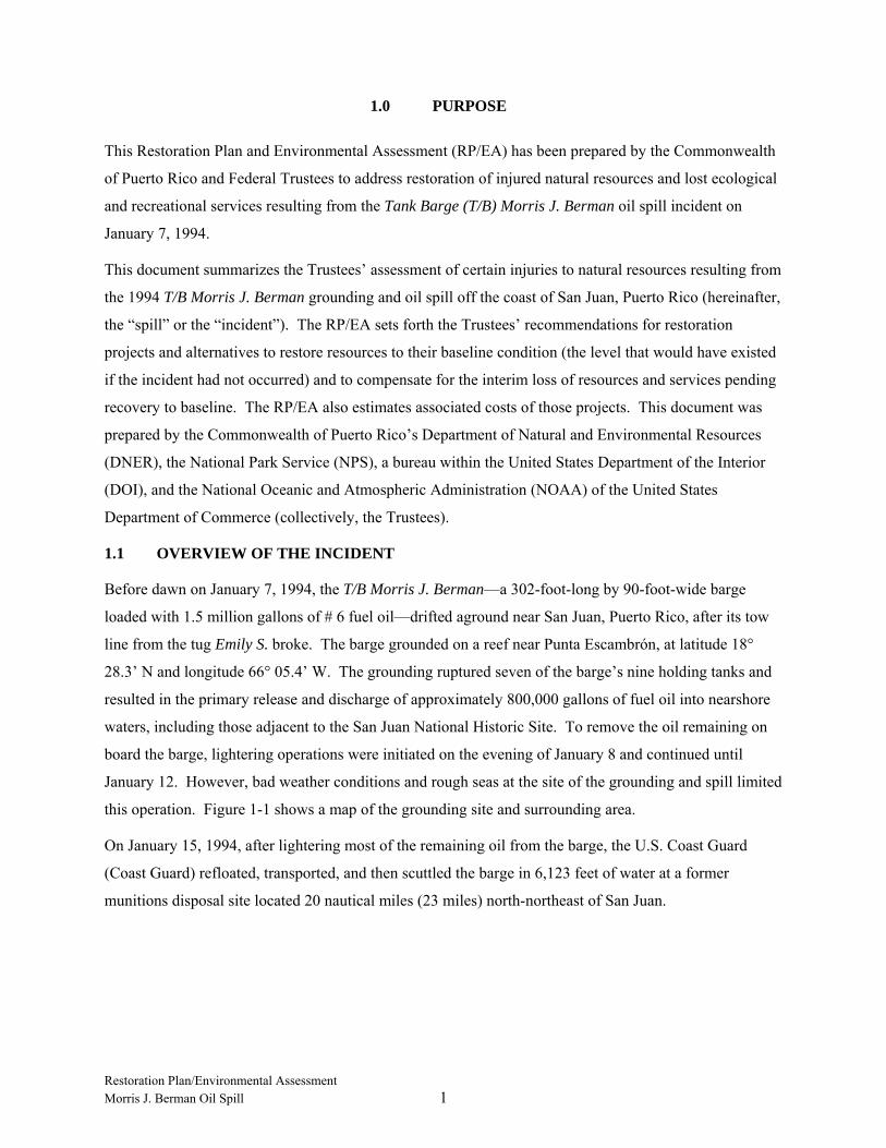
1.0 PURPOSE
This Restoration Plan and Environmental Assessment (RP/EA) has been prepared by the Commonwealth
of Puerto Rico and Federal Trustees to address restoration of injured natural resources and lost ecological
and recreational services resulting from the Tank Barge (T/B) Morris J. Berman oil spill incident on
January 7, 1994.
This document summarizes the Trustees’ assessment of certain injuries to natural resources resulting from
the 1994 T/B Morris J. Berman grounding and oil spill off the coast of San Juan, Puerto Rico (hereinafter,
the “spill” or the “incident”). The RP/EA sets forth the Trustees’ recommendations for restoration
projects and alternatives to restore resources to their baseline condition (the level that would have existed
if the incident had not occurred) and to compensate for the interim loss of resources and services pending
recovery to baseline. The RP/EA also estimates associated costs of those projects. This document was
prepared by the Commonwealth of Puerto Rico’s Department of Natural and Environmental Resources
(DNER), the National Park Service (NPS), a bureau within the United States Department of the Interior
(DOI), and the National Oceanic and Atmospheric Administration (NOAA) of the United States
Department of Commerce (collectively, the Trustees).
1.1 OVERVIEW OF THE INCIDENT
Before dawn on January 7, 1994, the T/B Morris J. Berman—a 302-foot-long by 90-foot-wide barge
loaded with 1.5 million gallons of # 6 fuel oil—drifted aground near San Juan, Puerto Rico, after its tow
line from the tug Emily S. broke. The barge grounded on a reef near Punta Escambrón, at latitude 18°
28.3’ N and longitude 66° 05.4’ W. The grounding ruptured seven of the barge’s nine holding tanks and
resulted in the primary release and discharge of approximately 800,000 gallons of fuel oil into nearshore
waters, including those adjacent to the San Juan National Historic Site. To remove the oil remaining on
board the barge, lightering operations were initiated on the evening of January 8 and continued until
January 12. However, bad weather conditions and rough seas at the site of the grounding and spill limited
this operation. Figure 1-1 shows a map of the grounding site and surrounding area.
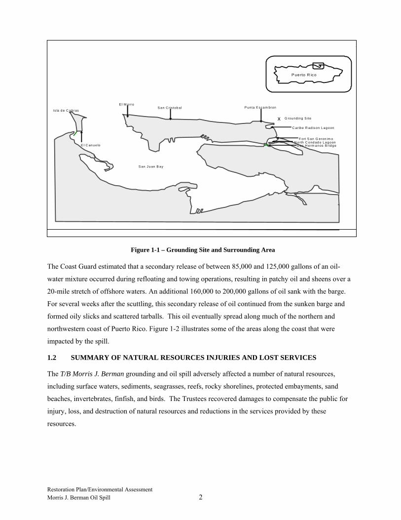
On January 15, 1994, after lightering most of the remaining oil from the barge, the U.S. Coast Guard
(Coast Guard) refloated, transported, and then scuttled the barge in 6,123 feet of water at a former
munitions disposal site located 20 nautical miles (23 miles) north-northeast of San Juan.
Restoration Plan/Environmental Assessment Morris J. Berman Oil Spill 2
The Coast Guard estimated that a secondary release of between 85,000 and 125,000 gallons of an oil-
water mixture occurred during refloating and towing operations, resulting in patchy oil and sheens over a
20-mile stretch of offshore waters. An additional 160,000 to 200,000 gallons of oil sank with the barge.
For several weeks after the scuttling, this secondary release of oil continued from the sunken barge and
formed oily slicks and scattered tarballs. This oil eventually spread along much of the northern and
northwestern coast of Puerto Rico. Figure 1-2 illustrates some of the areas along the coast that were
impacted by the spill.
1.2 SUMMARY OF NATURAL RESOURCES INJURIES AND LOST SERVICES
The T/B Morris J. Berman grounding and oil spill adversely affected a number of natural resources,
including surface waters, sediments, seagrasses, reefs, rocky shorelines, protected embayments, sand
beaches, invertebrates, finfish, and birds. The Trustees recovered damages to compensate the public for
injury, loss, and destruction of natural resources and reductions in the services provided by these
resources.
x G rou nd ing S ite
C arib e R ad is on L ag oon
N orth C ond ad o L ag oonF ort S an G eron im o
D os H erm an os B r idg e
Is la d e C abrasS an C ris tob al
E l M orro
E l C anu e lo
P unta E s c am bron
S an J u an B ay
P uerto R ico
Figure 1-1 – Grounding Site and Surrounding Area
x G rou nd ing S ite
C arib e R ad is on L ag oon
N orth C ond ad o L ag oonF ort S an G eron im o
D os H erm an os B r idg e
Is la d e C abrasS an C ris tob al
E l M orro
E l C anu e lo
P un ta E s c am bron
S an J u an B ay
P uerto R ico

Restoration Plan/Environmental Assessment Morris J. Berman Oil Spill 3
Figure 1-2 – Overview of Morris J. Berman Oil Spill Impact Areas
The Oil Pollution Act (OPA) natural resource damage assessment regulations define “injury” as “an
observable or measurable adverse change in a natural resource or impairment of a natural resource
service” (15 C.F.R. § 990.30). The regulations define “services” as “the functions performed by a natural
resource for the benefit of another natural resource and/or the public” (15 C.F.R. § 990.30).
Table 1-1 summarizes the documented injuries.
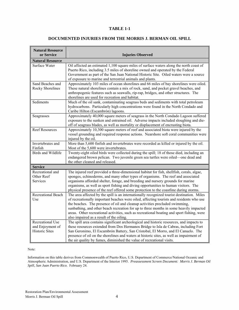
Restoration Plan/Environmental Assessment Morris J. Berman Oil Spill 4
TABLE 1-1
DOCUMENTED INJURIES FROM THE MORRIS J. BERMAN OIL SPILL
Natural Resource or Service Injuries Observed
Natural Resource Surface Water Oil affected an estimated 1,100 square miles of surface waters along the north coast of
Puerto Rico, including 3.5 miles of shoreline owned and operated by the Federal Government as part of the San Juan National Historic Site. Oiled waters were a source of exposure to marine and terrestrial animals and plants.
Sand Beaches and Rocky Shorelines
Approximately 103 miles of ocean shorelines and 66 miles of bay shorelines were oiled. These natural shorelines contain a mix of rock, sand, and pocket gravel beaches, and anthropogenic features such as seawalls, rip-rap, bridges, and other structures. The shorelines are used for recreation and habitat.
Sediments Much of the oil sank, contaminating seagrass beds and sediments with total petroleum hydrocarbons. Particularly high concentrations were found in the North Condado and Caribe Hilton (Escambrón) lagoons.
Seagrasses Approximately 40,000 square meters of seagrass in the North Condado Lagoon suffered exposure to the sunken and entrained oil. Adverse impacts included sloughing and die-off of seagrass blades, as well as mortality or displacement of encrusting biota.
Reef Resources Approximately 10,300 square meters of reef and associated biota were injured by the vessel grounding and required response actions. Nearshore soft coral communities were injured by the oil.
Invertebrates and Finfish
More than 5,600 finfish and invertebrates were recorded as killed or injured by the oil. Most of the 5,600 were invertebrates.
Birds and Wildlife Twenty-eight oiled birds were collected during the spill; 18 of those died, including an endangered brown pelican. Two juvenile green sea turtles were oiled—one dead and the other cleaned and released.
Service Recreational and Other Reef Services
The injured reef provided a three-dimensional habitat for fish, shellfish, corals, algae, sponges, echinoderms, and many other types of organisms. The reef and associated organisms afforded shelter, forage, and breeding and nursery grounds for marine organisms, as well as sport fishing and diving opportunities to human visitors. The physical presence of the reef offered some protection to the coastline during storms.
Recreational Beach Use
The area affected by the spill is an internationally recognized tourist destination. Miles of recreationally important beaches were oiled, affecting tourists and residents who use the beaches. The presence of oil and cleanup activities precluded swimming, sunbathing, and other beach recreation for up to three months in some heavily impacted areas. Other recreational activities, such as recreational boating and sport fishing, were also impaired as a result of the oiling.
Recreational Use and Enjoyment of Historic Sites
The spill area contains significant archeological and historic resources, and impacts to these resources extended from Dos Hermanos Bridge to Isla de Cabras, including Fort San Geronimo, El Escambrón Battery, San Cristobal, El Morro, and El Canuelo. The presence of oil on the shorelines and waters at historic sites, as well as impairment of the air quality by fumes, diminished the value of recreational visits.
Note:
Information on this table derives from Commonwealth of Puerto Rico, U.S. Department of Commerce/National Oceanic and Atmospheric Administration, and U.S. Department of the Interior 1995. Preassessment Screen Document: Morris J. Berman Oil Spill, San Juan Puerto Rico. February 24.
Restoration Plan/Environmental Assessment Morris J. Berman Oil Spill 5
Following the spill and the cleanup efforts, the Trustees evaluated the injuries caused by the grounding
and spill (Table 1-1). After careful consideration of all observed injuries, the Trustees described injuries
to and lost services from three resource types in a natural resource damage assessment—reef resources,
recreational beach use, and recreational use and enjoyment of historic sites. Other resources (surface
waters, rocky shorelines, sediments, seagrasses, invertebrates, finfish, birds, and other wildlife) were all
exposed to oil and injured as a result of the incident. These other resource categories recovered quickly to
pre-incident conditions, and the period of interim lost services was short. The Trustees predicted that the
monetary damages likely to be awarded for the limited duration injuries of these other resource categories
would be less than the cost of assessment; therefore, the injuries to these resources were not evaluated
further.
The Trustees continued with the natural resource damage assessment process for lost use of services
related to reef resources, recreational beach use, and recreational use and enjoyment of historic sites.
Summaries of the injuries for these three resource types are below.
1.2.1 Reef Injuries and Lost Services
The physical disruption of the reef injured by the incident is expected to have significant, and in some
cases irreversible, long-term impacts on the reef ecosystem. Prior to the grounding, the reef provided a
stable, three-dimensional habitat for fish, shellfish, corals, algae, sponges, echinoderms, and many other
types of organisms. The reef provided food, shelter, and breeding and nursery grounds for many
organisms, and supported many recreational activities including sport fishing and diving. The reef also
served as a natural breakwater, protecting the coastline during storms. All of these services have been
impaired by the grounding and subsequent response actions. While biota will recolonize the injured area
once rubble is stabilized or removed, the loss of vertical rock outcrops and the specific services associated
with them is permanent. This is described in more detail in the Habitat Suitability Analysis report
(Marine Resources, Inc. [MRI] 2005).
1.2.2 Lost Recreational Beach Use
Tourists and resident beach users were advised to avoid beaches in the spill zone, and cleanup activities
essentially closed many popular beaches for an extended period following the spill. Prospective users of
affected beaches may have canceled trips to Puerto Rico and/or the beach altogether or may have
substituted with second-best alternative sites outside the spill zone. Other beach users continued to visit
oiled beaches and suffered a loss of enjoyment, especially swimming, due to the oil. In addition, bathing
suits and beach gear were damaged, and oil fumes caused headaches and nausea to some beach users.
Restoration Plan/Environmental Assessment Morris J. Berman Oil Spill 6
Spill zones, identified by the Coast Guard and NOAA for response and assessment purposes, ranged from
Punta Borinquen in the west to Loiza in the east. Due to the presence of oil cleanup crews and
equipment, “de facto” closings occurred at many beaches. In many cases, exclusion tape closed off
access to beach sites, and security personnel only allowed cleanup crews onto the beaches. In the
immediate vicinity of the spill, the de facto beach closings lasted three months. At many of the more
distant beaches, field operations were reduced or halted 5 or 6 weeks after the spill.
1.2.3 Lost Visitor Use of National Historic Site
The San Juan National Historic Site includes Forts San Felipe del Morro (El Morro), San Cristobal, and
San Juan de la Cruz (also known as El Canuelo), the walls of San Juan, bastions, and powder houses.
Interviews with National Park Service personnel indicated that oil vapors at the forts were intense for
3 weeks following the oil spill, to the point of causing headaches. The oil vapors were less intense, but
noticeable, for an additional 3 weeks following the initial 3-week period. Therefore, the Trustees have
calculated a reduction in historic appreciation services for a total of 6 weeks following the oil spill. To
determine the number of visitors affected during this period, the National Park Service records of actual
visitation at the Historic Site were used. Over 123,000 people visited El Morro and San Cristobal during
this six-week period. Because visitation records are maintained only for El Morro and San Cristobal, the
loss of services at El Canuelo has not been quantified.
It is reasonable to expect that some individuals canceled their visits to the Historic Sites as a result of the
oil spill. However, the Trustees have not quantified any reduction in visits to the site as a result of the oil
spill. In addition, the Trustees have not quantified any reduction in use associated with canceled activities
within El Morro and San Cristobal. Due to these various data limitations, the estimate of lost services
used for calculating damages is conservative.

Restoration Plan/Environmental Assessment Morris J. Berman Oil Spill 7
2.0 PURPOSE AND NEED FOR RESTORATION
2.1 NATURAL RESOURCE TRUSTEES AND AUTHORITIES
The Oil Pollution Act, 33 U.S.C. § 2701, et seq. (OPA or OPA 90), establishes a liability regime for oil
spills that injure or are likely to injure natural resources or the services that those resources provide to the
ecosystem or humans. OPA defines "natural resources" to include land, fish, wildlife, water sources and
other such resources belonging to, managed by, held in trust by, appertaining to, or otherwise controlled
by the United States, any State, including the Commonwealth of Puerto Rico, or local government or
Indian tribe, or any foreign government. Pursuant to OPA, Federal and state agencies, the
Commonwealth of Puerto Rico, and Indian tribes act as Trustees on behalf of the public to assess the
injuries, scale restoration to compensate for those injuries, and implement restoration. Assessments are
intended to provide the basis for restoring, replacing, rehabilitating, and acquiring the equivalent of
injured natural resources and services. OPA authorizes the Trustees to assess damages for natural
resources injured under their trusteeship. OPA further instructs the designated Trustees to develop and
implement a plan for the restoration, rehabilitation, replacement, or acquisition of the equivalent of the
natural resources under their trusteeship. The process emphasizes both public involvement and
participation by the responsible parties. For this incident, NOAA, the NPS, and the DNER share the
responsibility as natural resource Trustees. This RP/EA has been prepared jointly by NOAA, NPS, and
DNER.
2.2 SUMMARY OF THE DAMAGE CLAIM SETTLEMENT
OPA allows the Trustees to settle claims for natural resource damages at any time. The settlement must
be fair, reasonable, and in the public interest, with particular consideration given to the adequacy of the
settlement to restore, replace, rehabilitate, or acquire the equivalent of the injured natural resources and
services. Sums recovered in settlements, other than reimbursement of Trustee assessment costs, may only
be expended in accordance with a restoration plan, which is made available for public review and
comment.
A settlement agreement reached on December 28, 2000, among the Federal government, the
Commonwealth of Puerto Rico, and the parties responsible for the spill, resolved the Trustees’ claims for
natural resource damages against the responsible parties. Attached to this settlement agreement was a
preliminary damage assessment restoration plan, which documented the injury assessment and
preliminary restoration planning that occurred prior to the settlement agreement. The settlement
agreement provided the Trustees with funding for primary and compensatory restoration projects of
$9,479,003, including an additional $286,614 for use to plan and oversee the implementation of the
restoration projects identified therein (Table 2-1). A Memorandum of Agreement (MOA) among the

Restoration Plan/Environmental Assessment Morris J. Berman Oil Spill 8
NPS, NOAA, and the DNER allocates the natural resource damages for restoration among the three
categories of natural resource injury described in Section 1.2:
• Reef injury associated with the barge grounding, • Loss of beach recreational use, • Loss of enjoyment of national historic site resources.
Interest accrued on the settlement funds is to be used for the selected restoration projects, including the
costs to plan, implement, oversee and monitor restoration projects, as appropriate.
After the date of settlement, many restoration project-related changes have caused the Trustees to revise
the preliminary restoration project alternatives that originally served as the basis of the settlement. Some
changes occurred between the development of the preliminary damage assessment and restoration plan
and the settlement, and other changes occurred between the settlement and the present. For instance, a
breakwater project designed to protect historic resources was implemented by the U. S. Army Corps of
Engineers (Army Corps) shortly after the settlement, thereby eliminating this project as a potential
compensatory restoration project for this spill. Additionally, the preliminary damage assessment
restoration plan was not formally submitted to the public for review and comment. This RP/EA
incorporates the post-settlement changes and identified preferred restoration projects using the settlement
funds. In the Trustees’ judgment, the settlement is still adequate to meet OPA requirements and restores
the injuries resulting from the spill. The manner and the projects on which the settlement sums are to be
expended were subject to the public participation process during the public notice and comment period
for this RP/EA.
TABLE 2-1
SETTLEMENT FUNDS
RESOURCE CATEGORY FUNDS Reef Injury $5,712,336 Recreational Beach Use and Injury $2,273,063 Lost and Diminished Human Use of the San Juan National Historic Site $1,493,604 Environmental Planning, Oversight and Administration $286,614 Total Fundsa $9,765,617
Note: a The original settlement included an additional $2,811,437 awarded to cover assessment costs. Those
monies were disbursed to the respective agencies as reimbursement for past expenditures due to the incident.

Restoration Plan/Environmental Assessment Morris J. Berman Oil Spill 9
2.3 PUBLIC PARTICIPATION
The Trustees accomplished their restoration planning goals by communicating with the public at each
major step of the restoration planning process, and adapted their restoration approach, based on public
comment. The Trustees developed a public participation plan that served as the guidance document for
meeting their public participation responsibilities.
The Oil Pollution Act (OPA) at 33 U.S.C. § 2706 (c)(5) (the statute under which the response to the 1994
T/B Morris J. Berman oil spill was carried out and damages obtained) requires that the Trustees involve
the public in the restoration planning process. The Trustees are required to provide the public with the
opportunity to comment on a RP/EA restoration plan, and to consider public comments when producing
the final restoration plan (15 C.F.R. § 990.55(c)). The public participation plan describes the method to
inform the public about the incident and the Trustees’ plans and activities, and to solicit comments from
the public on the proposed restoration projects that will address natural resource injuries. The scale and
design of preferred restoration alternatives were adjusted based on public input and/or additional
scientific findings and economic realities.
The Trustees involved citizens, public officials, and stakeholder groups in developing the RP/EA. The
Trustees obtained public input on the merits of individual restoration projects, as well as the effectiveness
of those projects in addressing the resource injuries and service losses arising from the spill. In addition,
the Trustees received and considered many projects that members of the public believed would be more
cost effective or that would better restore the resources injured by the spill or the services lost while
resources were injured or recovering. After evaluating public input, including alternative projects that the
public proposed, the Trustees prepared this RP/EA. Key features of the public participation process
include the following:
• Public Awareness—To share information
• Public Education—To educate citizens and help them make more informed choices
• Public Input—To provide citizens and stakeholder groups with opportunities to contribute ideas to the planning process
• Public Interaction—To exchange views and ideas as a means of reaching consensus
• Public Partnership—To involve citizens in the decision making process The Trustees engaged the public through two public meetings and hearings, issuing written materials and
information in a variety of formats and outlets, and provided opportunities for comments in the following
ways:

Restoration Plan/Environmental Assessment Morris J. Berman Oil Spill 10
• The RP/EA document was made available for review at the Jane Stern Dorado Community Library and the San Juan National Historic Site Headquarters in Fort San Cristobal.
• Notification in both English and Spanish of the availability of the RP/EA and the time/location of public meetings were made in various media outlets, on websites, and through direct mail.
o http://parkplanning.nps.gov/projectHome.cfM?parkID=403&projectId=16335
o http://www.darrp.noaa.gov/berman/
• Presentations, fact sheets, exhibits, translation services, and opportunities to submit comments were provided at two public meetings (in San Juan and Dorado).
• Comments have been compiled and responses prepared and incorporated into this RP/EA. The Trustees established a 60-calendar-day comment period for the Draft RP/EA, but extended this
period by another two weeks. The Trustees considered public comments before completing the RP/EA.
The deadline for comments was given in the public notices issued by the Trustees to announce the
availability of the Draft RP/EA and associated public meetings with opportunity for public comment.
Written comments on the Draft RP/EA were directed to:
National Oceanic and Atmospheric Administration Restoration Center Attn: John Iliff 263 13th Avenue South St. Petersburg, FL 33701 or by email to [email protected]
2.4 ADMINISTRATIVE RECORD
The Trustees have maintained records to document the information considered by the Trustees as they
have conducted restoration planning. These records are compiled in an administrative record available
for public review at the address listed below. The administrative record facilitates public participation in
the restoration planning process and will be available for use in future administrative or judicial review of
Trustee actions to the extent provided by Federal or Commonwealth law. Additional information and
documents, including the settlement agreement, preliminary damage assessment and restoration plan,
Trustee MOA, public comments received on the Draft RP/EA, the RP/EA, and restoration planning
documents, are included in the administrative record.

Restoration Plan/Environmental Assessment Morris J. Berman Oil Spill 11
Documents in the administrative record can be viewed at the location listed below. Arrangements for
reviewing the record or to request copies of documents should be made in advance with the official listed.
Attn: Madeline Yordan Fort San Cristobal Norzagaray Street San Juan, PR 00901 [email protected] (787) 729-6777

Restoration Plan/Environmental Assessment Morris J. Berman Oil Spill 12
3.0 AFFECTED ENVIRONMENT
This section summarizes the environmental setting of the area potentially affected by the proposed
restoration projects.
The natural and cultural environments of the north coast of Puerto Rico are closely intertwined. In
general, the north coast of Puerto Rico is a relatively high-energy, rocky coastline interspersed with sand
beaches. The coastline is backed by small embayments including San Juan Harbor and Condado Lagoon,
which form a productive natural ecosystem with many commercial and recreational uses. The
embayments, nearshore waters, and shoreline host many marine and avian species, including Federally-
listed endangered or threatened species. The marine and shoreline areas surrounding the restoration
project areas are an internationally recognized tourist destination. Puerto Rico’s north coast is popular for
its variety of recreational and commercial activities, and has abundant archaeological and historic
resources.
More detailed descriptions of the physical and biological resources of the area may be found in the
Habitat Suitability Analysis (HSA) report prepared by Marine Resources, Inc. (MRI) on behalf of the
Trustees in August 2005.
3.1 PHYSICAL ENVIRONMENT
Puerto Rico, situated on the leading edge of the Caribbean plate, has a complex northern coastline formed
predominantly of limestone formations and alluvial plains that supported development of beaches and
dunes (Krushensky and Schellekens 2001). The insular shelf along the north coast of Puerto Rico is less
than 1 mile wide and undergoes intense wave action and longshore currents (Glauco A. Rivera &
Associates 2003). Wave heights along the Puerto Rican north coast predominantly generated by the east
trade winds range from 1 to 3 meters (Morelock 1978). These physical conditions, in conjunction with
disproportional erosion of the limestone substrate, create topographically variable localized reef
formations. Lithified beachrock and fossil sand dunes (i.e., eolianites) are nearshore features
characteristic of the San Juan area. Eolianite reefs are submerged, hard-bottom structures composed of
sand deposits cemented together with calcium carbonate; they lie along the northern coastline of Puerto
Rico, oriented west to northwest following a slightly sinuous course (Kaye 1959).
Compensatory restoration projects were proposed for the offshore area, for beaches and other coastal
habitats, and for the San Juan National Historic Site, as described in subsequent sections. Reef projects
would be constructed in the general area of the impact site, but not in the precise location of the
grounding. Projects were considered for areas that avoid the high wave energy that characterizes the
nearshore area. Beach acquisition and restoration projects were proposed for several areas of the Vacia
Restoration Plan/Environmental Assessment Morris J. Berman Oil Spill 13
Talega, Piñones, and Torrecilla Alta ecosystem that were affected by the incident. Restoration projects
focused on lost use of the San Juan National Historic Site will be located at that site.
3.2 BIOLOGICAL ENVIRONMENT
The bays and nearshore waters serve as a nursery for young fish, shrimp, and crabs. Bird species,
including pelicans, herons, egrets, terns, and gulls, feed and nest along these shorelines and embayments.
Bird colonies or rookeries are found on islands within coastal embayments and in coastal environs in the
spill area. Intertidal areas, seagrass beds, and mangroves provide high-quality habitat and productive
ecological services to marine fisheries resources, and feeding areas for resident and migrant shorebirds.
Open oceanic waters are used for feeding by pelagic seabirds such as tropic birds and brown boobies.
Complete listing of species reported to occur off the north coast of Puerto Rico with associated service
category, biological descriptor, and presence/absence by habitat is presented as Appendix B of the Habitat
Suitability Analysis (MRI 2005). A brief summary is included here.
The habitat impacted by the T/B Morris J. Berman grounding event is part of a continuous nearshore reef
feature that extends the length of the San Juan coastline. Mignucci-Giannoni (1999) listed over 152
species of marine organisms affected by the T/B Morris J. Berman grounding event documented by the
Caribbean Stranding Network (1994). Most commonly affected biota groups were echinoderms,
mollusks, and crustaceans respectively comprising 58, 25, and 10 percent of the 152 species. Vertebrates,
primarily fish, accounted for approximately 6% of the marine organisms affected by the incident
(Mignucci-Giannoni 1999). Visual observation indicated that the reef injured by the grounding and spill
was dominated by soft corals, sponges, and macroalgae.
A summary table indicating the presence/absence of species in the injured habitat and the four possible
compensatory restoration habitats (i.e., shallow hard-bottom, deep hard-bottom, mangrove, and seagrass)
is presented as Appendix B of the Habitat Suitability Analysis (MRI 2005). Life-history stage (juvenile,
adult, or spawning) is presented for some of the listed species; life history data were unavailable for most
species. On a broader scale than that reviewed by Mignucci-Giannoni (1999), a total of 478 marine
species are known to occur along the north coast of Puerto Rico, as reported in the literature. Of the
species found along the north coast, 165 were documented as likely injured by the grounding event.
Faunal groups with the most species likely injured by the grounding event were fish (104 species),
sponges (21 species), and hard and soft corals (17 species) (MRI 2005).
3.2.1 Threatened and Endangered Species
The north coast hard-bottom habitat is considered a habitat of concern for the threatened green sea turtle
(Chelonia mydas) and the endangered hawksbill sea turtle (Eretmochelys imbricata) and leatherback
Restoration Plan/Environmental Assessment Morris J. Berman Oil Spill 14
turtle (Dermochelys coriacea). The green sea turtle, with a smooth grey, green, brown, and black
carapace, can be up to 4 feet long and weigh up to 500 pounds. Adult green sea turtles are herbivorous
and eat primarily seagrass and algae. Juvenile green sea turtles are carnivores that consume jellyfish and
other invertebrates. The hawksbill is a small to medium turtle approximately 2-3 ft long and weighs up to
180 pounds (lbs). Adult hawksbills forage on invertebrates, primarily sponges, which are found primarily
on hard-bottom habitats. Juveniles are known to forage and consume algae in coastal areas of northern
Puerto Rico. The north coast of Puerto Rico provides one of the three major nesting sites in the world for
the leatherback turtle, which is the largest living turtle. In 2005, DNER documented 473 leatherback
nests in this area.
The general oceanic locale where the grounding occurred is not critical habitat for any listed species. The
Trustees will complete the consultations required under the Endangered Species Act (ESA) prior to
implementation of any projects.
3.2.2 Species of Special Concern
The following species are afforded special protection under Commonwealth law and are likely to occur in
the affected areas: Epinephelus striatus (Nassau grouper) (Endangered), E. itajara (Goliath Grouper)
(Critically endangered), and Hippocampus spp. (seahorses) (Vulnerable). Additionally, Strombus gigas
(queen conch) are also found in the area and are listed in Appendix II of the Convention on International
Trade in Endangered Species of Wild Flora and Fauna or CITES.
3.3 CULTURAL RESOURCES
Section 106 of the National Historic Preservation Act, 1966, as amended, requires Federal agencies to
take into consideration the effects of their actions on cultural resources that meet the criteria for eligibility
to the National Register of Historic Places (NRHP). Cultural resources include architectural and
archeological resources that may relate to both the prehistoric and historic time periods.
The proposed projects are located at the San Juan National Historic Site and in nearby areas along the
north coast of Puerto Rico that were affected by the T/B Morris J. Berman grounding and oil spill. The
San Juan National Historic Site, nominated in February 14, 1949, for the NRHP, includes forts San Felipe
del Morro, San Cristobal, and San Juan de la Cruz (also known as El Canuelo), the walls of San Juan,
bastions, and powder houses. In 1983, the resources were declared a UNESCO World Heritage Site.
These structures represent the largest and oldest fortifications constructed by the Spanish in the New
World still existing.
Potential cultural resources associated with native Taino occupations, Spanish colonization, and
submerged shipwrecks related to Spain or other entities are possibly located within the project area of

Restoration Plan/Environmental Assessment Morris J. Berman Oil Spill 15
potential effect. In 1493, when Admiral Christopher Columbus arrived in the waters of the island that
became known as Puerto Rico during his second voyage to the New World, the island was inhabited by
native Tainos, descendants of the Arahuacos. Columbus claimed the island as property of Spain.
Subsequently, in 1508, Juan Ponce de Leon arrived on the island with 50 men who began colonization.
Initially, the Tainos were hospitable towards the Spanish colonists. However, relations deteriorated as the
Spaniards treated the native populations as slaves. In reaction to the technological superiority and
assertive treatment by the Spaniards, some of the surviving natives dispersed to other Caribbean Islands.
The Caribbean Sea took on an important role in support of the Spanish expansion of power and prestige
as Spain proceeded with its conquest of Mexico and Peru. Spanish galleons were assisted by Caribbean
trade winds that blew from Africa towards the Caribbean islands. Treasure-laden galleons were targets of
attack by pirates and by traditional enemies of Spain. In light of threats presented by enemies as well as
tropical storms, the harbors of Puerto Rico presented a safe haven of national importance to Spain. The
Spanish Crown recognized the strategic advantage of the island in controlling sea lanes and access to the
Indies and proceeded to fortify the City of San Juan and its harbor, creating a strong and critically placed
naval base. Philip II, King of Spain, declared the fortified city the “Key to the Indies”
(http://www.nps.gov/saju/saw4.html, 3/13/06).

Restoration Plan/Environmental Assessment Morris J. Berman Oil Spill 16
4.0 RESTORATION PLANNING
The goal of restoration is, to the extent feasible, to restore to baseline the reef resources and the biota
using the reef as habitat. In addition, restoration should provide compensation for services lost prior to
recovery of the injured resources.
4.1 RESTORATION STRATEGY
In selecting preferred restoration projects for each category of natural resource injury or loss, the Trustees
identified feasible restoration actions to promote recovery of the resources to baseline (primary
restoration) and to compensate for interim losses of resources or services prior to recovery (compensatory
restoration). Primary restoration actions evaluated include natural recovery and one or more active
restoration actions designed to directly restore natural resources or services to baseline on an accelerated
time frame. The scale of the compensatory restoration actions was chosen to ensure that the public was
compensated for the interim lost use of ecological and recreational services.
Proposed projects were evaluated by the Trustees based on threshold and additional criteria, as described
below.
4.2 THRESHOLD AND ADDITIONAL CRITERIA
In accordance with OPA’s natural resource damage assessment regulations, only restoration alternatives
considered technically feasible and amenable to implementation in accordance with applicable laws,
regulations, and/or permits may be considered for inclusion in a restoration plan (15 C.F.R. § 990.53
(a)(2)). The Trustees evaluated the feasible restoration alternatives for each category of injury or loss
according to the following threshold criteria, which are in 15 C.F.R. § 990.54:
• The cost to carry out the alternative.
• The extent to which each alternative is expected to meet the Trustees’ goals and objectives in returning the injured natural resources and services to baseline and/or compensating for interim losses.
• The likelihood of success of each alternative.
• The extent to which each alternative will prevent future injury as a result of the incident, and avoid collateral injury.
• The extent to which each alternative benefits more than one natural resource and/or service.
• The effect of each alternative on public health and safety.
Restoration Plan/Environmental Assessment Morris J. Berman Oil Spill 17
A restoration alternative must meet all threshold criteria to be considered further. Once a restoration
project was determined to meet or exceed all threshold criteria, these six additional criteria were
considered:
• Relationship to injured resources and services: A project that restores, rehabilitates, replaces, enhances, or acquires the equivalent of the resources and services injured by the spill is preferred over projects that benefit other comparable resources or services. The Trustees consider the types of resources or services injured by the spill, the location, and the connection, or “nexus,” of project benefits to those injured resources.
• Time to provide benefits: The Trustees consider the time required for benefits to be provided to the target ecosystem and/or public. A more rapid response to providing benefits is favorable.
• Duration of benefits: The Trustees consider the expected duration of benefits from the proposed project alternative. Projects that provide long-term benefits are favorable.
• Protection of alternative: The Trustees consider the opportunities to protect the implemented alternative and resulting benefits over time through conservation easements, land acquisition, or other types of resource dedication. Long-term protection of the project site and the benefits it provides are favorable considerations.
• Opportunities for collaboration: The Trustees consider the possibility of matching funds, in-kind services, or volunteer assistance, as well as coordination with other ongoing or proposed projects. External funding and support services that reduce costs or extend benefits are favorable.
• Benefits relative to costs: The Trustees consider the relationship of expected resource and service benefits to the expected project costs for each alternative. Projects with the least costly (i.e., most cost-effective) approach to deliver an equivalent type and amount of benefits are favorable.
In addition to these specific criteria, OPA and the National Environmental Policy Act (NEPA) require
identifying and discussing the environmental consequences of implementing alternative projects with the
aim of minimizing significant environmental impacts and/or justifying unavoidable impacts posed by the
preferred restoration alternative. The environmental consequences for each of the proposed restoration
project alternatives are covered in Section 5.
4.3 EVALUATION OF RESTORATION ALTERNATIVES
The Trustees evaluated each of the proposed restoration alternative projects against the threshold criteria
using a “Yes” or “No” rating to indicate whether they believed the project would meet each criterion.
Restoration Plan/Environmental Assessment Morris J. Berman Oil Spill 18
As shown on Table 4-1, all of the proposed restoration projects were rated “Yes” for every threshold
criterion. Therefore, all proposed restoration projects advanced for further Trustee evaluation.
The Trustees next developed a relative ranking of restoration projects based on the additional criteria
using a 3- point scale. In the Trustees’ judgment, restoration projects receiving a score of 3 have a high
likelihood of meeting a criterion; projects receiving a 2 have a moderate likelihood of meeting a criterion;
and, projects receiving a score of 1 have a low likelihood of meeting a criterion. The averages of the
individual scores assigned by the Trustees are shown on Table 4-2. Restoration alternatives that received
an average score of 1 for any criterion were not selected as a preferred restoration alternative.
As a result of this evaluation the Trustees identified three preferred restoration alternatives for lost reef
services, one preferred restoration alternative for lost recreational beach use, and three preferred
restoration alternatives for lost and diminished use of the San Juan National Historic Site.
Restoration alternatives selected as preferred for the lost reef services included 1) Modular Reef Habitat
Construction, 2) Acquisition of Equivalent Lost Services, and 3) Seagrass Restoration. The preferred
restoration alternative selected for lost recreational beach use was Acquisition of Lands for Conservation.
The three restoration alternatives selected as preferred for lost and diminished use of the National Historic
Site include 1) Improve and Extend the Coastal Promenade, 2) Restore El Morro Water Battery, and
3) Clean/Stabilize Exterior Walls of Historic Site.
Three restoration alternatives, one from the lost reef service category and two from the lost recreational
beach use category, received an average score of 1 for at least one criterion and were not identified as
preferred. Reef Sedimentation Mitigation was not preferred because the Trustees felt the project could
not be sustained long term without addressing the root cause of the sedimentation. Any likely short-term
benefits gained from uncovering the buried reef would be lost as the reef was again covered and
eventually buried with sediment. Improved Access to Public Beaches alternative was not preferred
because the nexus to the injured resources and services was insufficient. The Improved Quality of Use of
Public Beaches alternative was not preferred as a restoration alternative because the nexus to the injured
resources was considered weak and the long-term benefits were considered questionable given the type of
maintenance required for beach infrastructure. Finally, all three of the restoration alternatives considered
not preferred were evaluated as having low benefits relative to the potential costs. The Beach Erosion
Mitigation project (construction of breakwaters to protect Fort El Canuelo)—a fourth compensatory
restoration project for injured historic resources and lost visitor use—is now considered unnecessary
(based on an Army Corps analysis) because shoreline erosion has slowed and is no longer a serious threat.
Restoration Plan/Environmental Assessment Morris J. Berman Oil Spill 19
TABLE 4-1
PROJECTS RATED AGAINST THRESHOLD CRITERIA
THRESHOLD CRITERIA (Scoring: “YES” or “NO”)
Costs
Consistent with
Trustees Restoration
Goals Likelihood of Success
Prevention of Future
Injury
Benefits Multiple
Resources or Services
Public Health and
Safety Proposed Projects for Reef Restoration
Modular Reef Habitat Construction (Shallow Hard Bottom Project)
YES YES YES YES YES YES
Reef Sedimentation Mitigation
YES YES YES YES YES YES
Acquisition of Equivalent Lost Services
YES YES YES YES YES YES
Seagrass Restoration YES YES YES YES YES YES
Propose Projects for Recreational Beach Use
Acquisition of Lands for Conservation
YES YES YES YES YES YES
Improved Access to Public Beaches
YES YES YES YES YES YES
Improved Quality of Use of Public Beaches
YES YES YES YES YES YES
Proposed Projects for San Juan National Historic Site Resources
Improve and Extend Coastal Promenade
YES YES YES YES YES YES
Restoration of El Morro Water Battery
YES YES YES YES YES YES
Clean and Stabilize Exterior Walls
YES YES YES YES YES YES

Restoration Plan/Environmental Assessment Morris J. Berman Oil Spill 20
TABLE 4-2
PROJECTS RATED AGAINST ADDITIONAL CRITERIA
ADDITIONAL CRITERIA (Scoring: 3=High, 2=Moderate, 1=Low)
Relationship to Injured Resources
and Services
Provides Benefits Rapidly
Provides Long-term
Benefits
Alternative and its
Benefits can be Protected Long-term
Provides Opportunities
for Collaboration
Cost- Effectiveness
(benefits relative to
costs)
Proposed Projects for Reef Restoration
Modular Reef Habitat Construction (Shallow Hard Bottom Project) (5.1.3.1)
2.3 2 3 2.3 3 2
Reef Sedimentation Mitigation (5.1.3.2) 2 2 1.7 1 1.7 1
Acquisition of Equivalent Lost Services (5.1.3.3) 2.7 3 3 3 3 2
Seagrass Restoration (5.1.3.4) 2 2.3 3 2.3 2 2.3
Proposed Projects for Recreational Beach Use Restoration
Acquisition of Lands for Conservation (5.2.1) 3 3 3 3 3 2
Improved Access to Public Beaches (5.2.2) 1.7 3 2.7 1.7 1.7 1
Improved Quality of Use of Public Beaches (5.2.3) 1 2 2.3 1 1.7 1
Proposed Projects for San Juan National Historic Site Resources
Improve and Extend Coastal Promenade (5.3.1) 3 3 3 2 2.7 3
Restoration of El Morro Water Battery (5.3.2) 2.3 3 3 2 1.3 2.7
Clean/Stabilize Exterior Walls of Historic Site (5.3.3) 2.3 3 3 2 1.3 2
Restoration Plan/Environmental Assessment Morris J. Berman Oil Spill 21
5.0 RESTORATION ALTERNATIVES
Each of the restoration project alternatives is presented below under the following headings to facilitate
evaluation and comparison:
• Project Description and Background • Restoration Objectives • Scaling Approach (if applicable) • Success Criteria and Monitoring • Cost and Timeframe • Environmental Consequences
NEPA requires that proposed projects be compared not only with one another but also with the effects of
taking no action whatsoever. For the reef injury, the no-action alternative is described in Section 5.1.1,
following the format described above. For the lost recreational beach use and lost visitor use of the San
Juan National Historic Site, the no-action alternative was categorically rejected. The injury to the public
in both of these cases was lost use, and no primary restoration is possible. Because compensatory
restoration is needed, the no-action alternative was not evaluated further. Compensatory restoration
alternatives for lost beach access and lost visitor use are discussed in Sections 5.2 and 5.3, respectively.
5.1 REEF RESTORATION ALTERNATIVES
The physical disruption of the reef had long-term impacts on its ecosystem. Prior to the grounding, the
reef provided a stable, three-dimensional habitat for fish, shellfish, corals, algae, sponges, echinoderms,
and many other types of organisms. The reef provided food, shelter, breeding and nursery grounds for
many organisms, and supported many recreational activities, including sport fishing and diving. The reef
also served as a natural breakwater, protecting the coastline during storms. All of these services were
impaired by the grounding and subsequent response actions. The loss of vertical rock outcrops and other
rocky substrates crushed by the grounding and the specific services associated with them are permanent
losses. The encrusting coral, sponge, and algal communities were destroyed or were dislodged from the
impacted substrates at the grounding site; these communities will never regain their pre-grounding level
of complexity.
5.1.1 Proposed Reef Restoration Alternatives
The Trustees evaluated four potential reef restoration projects for restoring or replacing comparable
ecological services at other nearby sites that would compensate (that is, compensatory restoration
projects) for the lost use of the reef structure following the grounding-induced injuries. In addition,
natural recovery was being considered as a primary restoration alternative at the grounding site itself. The
goal of both restoration types is to restore reef resources as well as the biological services that the reef
Restoration Plan/Environmental Assessment Morris J. Berman Oil Spill 22
provides to associated species. Natural recovery and the four compensatory restoration projects are
described in the following subsections.
Three of the proposed projects for restoring reef services were preferred by the Trustees: (1) modular reef
construction, (2) acquisition of lost services, and (3) seagrass restoration. Any one or a combination of
these projects would be considered to meet the restoration objections identified for the lost reef services.
The Habitat Suitability Analysis is clear that a project that allows replacement of shallow water hard-
bottom habitat combined with a seagrass or mangrove habitat project (or both), represents the best
compensatory habitat choice to replace the lost ecological services provided by the injured eolianite reef.
By choosing a restoration alternative that combines two or more key aspects of the Habitat Suitability
Analysis technical recommendation, the Trustees have relied upon the best available information to meet
both the restoration goals and objectives for injured reef resources.
5.1.2 Proposed Primary Reef Restoration Alternative (Natural Recovery) (Proposed Preferred)
The only primary restoration activity proposed for the Berman site is the no-action alternative, known as
natural recovery.
5.1.2.1 Project Description and Background
The no-action alternative would not involve any direct human intervention to restore, or cause accelerated
recovery of the injured resources.
5.1.2.2 Restoration Objectives
The restoration objectives would be partially met by the no-action alternative, in that lost resources would
be allowed to recolonize the area, and lost services would be provided by the organisms that become
reestablished there. Natural recovery would not meet the objective of returning the resource to its
baseline condition because the loss of the vertical rock outcrops and other rocky substrates crushed by the
grounding are permanent losses. However, the no-action alternative would cause the least amount of
intentional disturbance to recolonization of the grounding site that has occurred in the years since the
incident. This alternative is already 12 years underway.
The no-action primary alternative would be augmented by some compensatory restoration action in
nearby areas. Compensatory actions are discussed in Section 5.1.2.
Restoration Plan/Environmental Assessment Morris J. Berman Oil Spill 23
5.1.2.3 Scaling Approach
No direct scaling of the no-action alternative is necessary, as the grounding and spill site is left alone.
Recovery of resources and services in the area is not expected to be complete, but can occur partially in
areas where rubble is stable enough to sustain recolonization of encrusting biota.
5.1.2.4 Success Criteria and Monitoring
Recolonization of the grounding and spill site by species assemblages typical of pre-incident communities
is expected, but the exact process by which this natural recovery would occur is unknown. The no-action
alternative to primary restoration does not include a monitoring plan.
5.1.2.5 Cost and Timeframe
The no-action primary restoration alternative would cost nothing to implement. Natural recovery is
expected to take essentially forever, because attainment of pre-incident conditions is not expected at the
grounding site. However, a more reasonable approximation is that maximum recovery will occur within
60 to 100 years if no other environmental manipulation of the site occurs (Hudson and Goodwin 1995).
5.1.2.6 Environmental Consequences
Direct Impacts: The encrusting coral, sponge, and algal communities destroyed or dislodged from the
impacted substrates are expected to recover, but not to their full pre-incident complexity and diversity
because of the likely instability of any rubble remaining on-site for a foreseeable period of time.
Indirect Impacts: Natural recovery is not expected to adversely affect any other resource. As the reef
recovers, positive effects of a re-established marine community are expected.
Cumulative Impacts: The natural recovery alternative is not expected to directly or indirectly benefit any
other species. The no-action alternative does not expose divers to any potential danger.
5.1.3 Selected Compensatory Reef Restoration Alternatives
Selection of the primary restoration action described in Section 5.1.2.1 would result in an extended period
of loss of services during a long recovery period. Compensatory restoration alternatives are designed to
compensate for the loss of services during the recovery period. Compensatory restoration alternatives
identified by the Trustees would provide replacement services of the same type and quality as those lost.
According to the OPA natural resource damage assessment regulations, Trustees may evaluate
alternatives that provide services of comparable type and quality as those lost, if necessary, to provide a
range of restoration options for consideration (15 C.F.R. § 990.53(c)(2)).
Restoration Plan/Environmental Assessment Morris J. Berman Oil Spill 24
A Habitat Suitability Analysis was conducted to identify marine habitats that could be used for
compensatory restoration in response to the T/B Morris J. Berman grounding incident. The objective of
the Habitat Suitability Analysis was to evaluate and rank various marine habitats on a service-to-service
basis, as described under Restoration Strategy in Section 4.1, to determine their suitability for providing
ecological compensation for lost resources associated with the injured eolianite reef habitat. Habitats
considered during the Habitat Suitability Analysis and identified in the Habitat Suitability Analysis report
(MRI 2005) included the eolianite reef characteristic of the nearshore coastline and four potential
compensatory habitats:
• Shallow hard-bottom (5- to 10-meter water depth) • Deep hard-bottom (> 10 meters water depth) • Mangroves • Seagrass beds
The four categories of ecological services evaluated by the Habitat Suitability Analysis were primary
producers, structural animals, invertebrate and vertebrate herbivores, and invertebrate and vertebrate
predators.
Potential compensatory habitats were evaluated and ranked based on the eolianite reef species present in
each habitat and the primary services provided by these species. A listing of the species documented on
eolianite reef habitat along the north coast of Puerto Rico was compiled from the primary and
unpublished literature. A data matrix of the species documented on the eolianite reef and their
presence/absence within the potential compensatory habitats was the basis for the Habitat Suitability
Analysis. Ordination of the resemblance data among the habitats was performed using nonmetric
multidimensional scaling. Bray-Curtis similarity distances were used to calculate similarity between the
potential compensatory habitats within each service category. Ordinations or diagrams depicting the
similarity of the habitats by the distances between them were then created from the Bray-Curtis ranks.
Habitats close to one another had more species in common than those farther apart.
A total of 183 species were documented to occur on the eolianite reef habitat; 18 species were unique to
the eolianite reef. When similarity to the eolianite reef in overall services provided was calculated,
shallow hard-bottom had the highest degree of similarity to the reef. Mangrove habitat ranked second,
seagrass ranked third, and deep hard-bottom was the least similar. Four compensatory habitat
configurations are recommended, based on the Habitat Suitability Analysis: (1) shallow hard-bottom,
(2) two-habitat mosaic, (3) three-habitat mosaic, and (4) four-habitat mosaic. The shallow hard-bottom
alternative would consist of placing artificial reefs to mimic the eolianite reef habitat in shallow-water
areas in proximity to the injured habitat. Because the Habitat Suitability Analysis showed that no single
habitat was identical to the injured habitat for all four evaluated services, a mosaic approach (more than

Restoration Plan/Environmental Assessment Morris J. Berman Oil Spill 25
one habitat) may be the best restoration alternative. A two-habitat mosaic of shallow hard-bottom with
seagrass would provide compensatory restoration for 150 eolianite reef species. A three-habitat mosaic of
shallow hard-bottom, seagrass, and mangrove would provide compensatory restoration for 158 eolianite
reef species. All four compensatory habitat types together would provide compensatory restoration for
165 of the 183 identified eolianite reef species.
5.1.3.1 Modular Reef Habitat Construction (Shallow Hard Bottom Project) (Proposed Preferred)
Modular Reef Habitat Construction (Shallow Hard Bottom Project) as a restoration alternative would
consist of using established technology to construct and place cement reef-replication modules in a
manner to provide a range of desirable ecological services. For example, a modular reef can be designed
to maximize vertical profile, surface area for settling organisms, crevices for shelter, foraging habitat for
pelagic organisms, or some combination of services such as these. The reef modules will be installed at
favorable locations some distance from the grounding site.
5.1.3.1.1 Project Description and Background
Trustees evaluated reef-replication modules consisting of prefabricated cement reef-replication modules
to reconstruct the destroyed rock reef. Prefabricated reef modules have been used in the United States to
restore coral reefs impacted by vessel groundings (Bodge 1995, Sheehy and Vik 1992). The creation of an
artificial reef that mimics low relief hard-bottom coral reef would provide a compensatory habitat
identified in the Habitat Suitability Analysis.
The project to construct and place cement reef-replication modules in a shallow environment could be
located in one or more favorable settings off the northern coast of Puerto Rico, where conditions for
module placement and long-term stability are not as harsh as at the grounding site. To compensate for the
loss of reef services, the Trustees propose construction of an appropriately scaled reef in a shallow
environment. To compensate for this permanent loss as well as the loss of reef services pending recovery
of the remaining reef, the Trustees propose construction of an appropriately scaled reef near the
grounding site. In the Trustees’ judgment, the high wave energy and shallow water at the grounding site
would make construction there infeasible.
Implementation of a project called “The Coral Trail and Reef Enhancement Project in Condado Lagoon”,
hereafter “The Condado Coral Trail”, has been identified by the Trustee Council to provide partial
ecological compensation for lost resources associated with the injured eolianite reef. Through the public
comment process, representatives from the Consorcio Del Estuario de la Bahía de San Juan proposed this
modular reef habitat project. As for other projects proposed during the public comment period, the
Trustee Council requested additional specific information from the Consorcio Del Estuario de la Bahía de

Restoration Plan/Environmental Assessment Morris J. Berman Oil Spill 26
San Juan to further evaluate the proposed project against project selection criteria. As a result of the
information provided, the Trustee Council identified The Condado Coral Trail project as preferred.
The proposed location of The Condado Coral Trail is in front of the public bathing beach approximately
15 meters from shore and between the Dos Hermanos bridge and the natural rock barrier that separates
the Condado Lagoon from the Atlantic Ocean (see Figure 5-1). The existing habitat in this part of the
Condado lagoon includes seagrass habitat mixed with unvegetated sand bottom. The three trail sections
will be located only in the unvegetated sand habitat.
Figure 5-1 – Condado Lagoon with Proposed Coral Reef Trails (Shown in Yellow)
The Condado Coral Trail project will create three separate coral trails each consisting of 10 reef modules
for a total placement of 30 modules. Individual modules will be deployed at a depth of about 1.83 m.
The type of module to be used at the site is called a “Taino Reef,” designed by a Puerto Rican company.
Figure 5-2 shows the approximate shape and dimensions of the Taino Reef modules. Each module
weighs approximately 363 kilograms (800 pounds). Module features include surface area for settling
organisms and crevices for shelter which are desirable ecological services based on the Habitat Suitability
Analysis (MRI 2005). Further, the module’s general appearance of low relief hard-bottom may be
supplemented with transplanted corals from the Dos Hermanos Bridge (currently under repair).

Restoration Plan/Environmental Assessment Morris J. Berman Oil Spill 27
Figure 5-2 – Front and Top Views of Taino Reef Modules
In the identification of this project, the Trustee Council considered other important information including
consistency with the San Juan Bay Estuary Program’s Comprehensive Conservation and Management
Plan (CCMP). The CCMP was approved and adopted as part of the Commonwealth and Federal
government’s public policy on October 2000. The Condado Coral Trail is consistent with Actions HW-
17, PI-1, and PI-5 of the CCMP. Additionally, the Condado Coral Trail has received both a Federal
Consistency Certification (CZ-2004-0329-096) from the Commonwealth of Puerto Rico Planning Board
and a nationwide permit (SAJ-2004-3401 (NW-CGR)) from the U.S. Army Corps of Engineers. The
project site is within a “no-take” zone established by Fishing Regulation #6768, under the
Commonwealth Fisheries Law # 278 of 29 Nov. 1998.
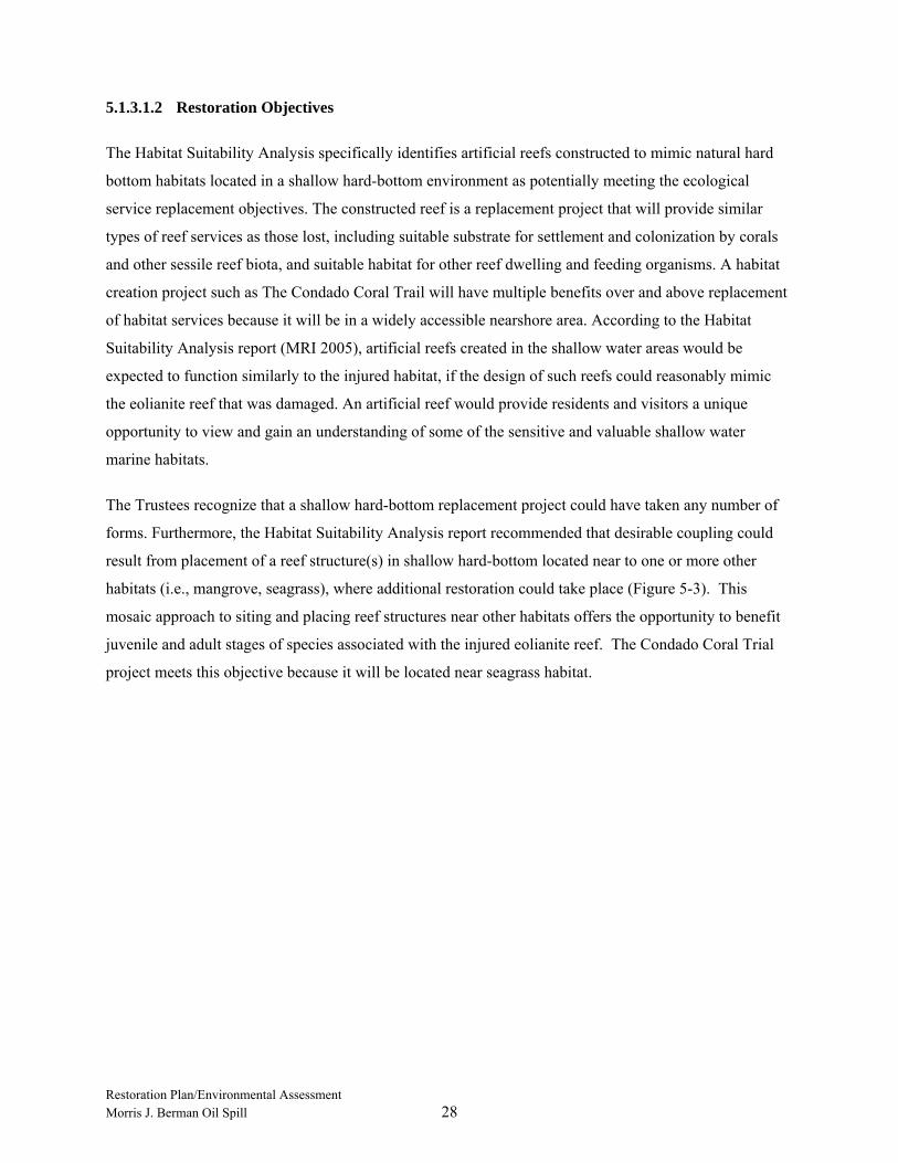
Restoration Plan/Environmental Assessment Morris J. Berman Oil Spill 28
5.1.3.1.2 Restoration Objectives
The Habitat Suitability Analysis specifically identifies artificial reefs constructed to mimic natural hard
bottom habitats located in a shallow hard-bottom environment as potentially meeting the ecological
service replacement objectives. The constructed reef is a replacement project that will provide similar
types of reef services as those lost, including suitable substrate for settlement and colonization by corals
and other sessile reef biota, and suitable habitat for other reef dwelling and feeding organisms. A habitat
creation project such as The Condado Coral Trail will have multiple benefits over and above replacement
of habitat services because it will be in a widely accessible nearshore area. According to the Habitat
Suitability Analysis report (MRI 2005), artificial reefs created in the shallow water areas would be
expected to function similarly to the injured habitat, if the design of such reefs could reasonably mimic
the eolianite reef that was damaged. An artificial reef would provide residents and visitors a unique
opportunity to view and gain an understanding of some of the sensitive and valuable shallow water
marine habitats.
The Trustees recognize that a shallow hard-bottom replacement project could have taken any number of
forms. Furthermore, the Habitat Suitability Analysis report recommended that desirable coupling could
result from placement of a reef structure(s) in shallow hard-bottom located near to one or more other
habitats (i.e., mangrove, seagrass), where additional restoration could take place (Figure 5-3). This
mosaic approach to siting and placing reef structures near other habitats offers the opportunity to benefit
juvenile and adult stages of species associated with the injured eolianite reef. The Condado Coral Trial
project meets this objective because it will be located near seagrass habitat.

Restoration Plan/Environmental Assessment Morris J. Berman Oil Spill 29
5.1.3.1.3 Scaling
The public can be compensated for past losses of natural habitats through replacement projects providing
additional resources of the same type and quality, and of comparable value. To accomplish this, the
method takes into account the amount of services lost over time from the injured habitat and the amount
of replacement services to be provided per unit of the replacement habitat. The size of the replacement
project is selected so that the quantity of services provided by the replacement project is equivalent to the
quantity of services lost due to the injury.
Similarly, the assumption is that the partially impacted area lost 40 percent of its services and will require
30 years to recover. These parameter assumptions are based on the best professional judgment and
experience of the Trustees with reef systems and impacts, and are judged as conservative estimates of reef
recovery times.
Figure 5-3 – Mosaic Restoration Area: Seagrass Restoration and Artificial Reef
Restoration Plan/Environmental Assessment Morris J. Berman Oil Spill 30
The Condado Coral Trail is estimated to generate services in perpetuity. The type of structure proposed
by the Trustees is expected to become more stable with time as the coral and benthic community becomes
established on the reef, as shown in Figure 5-4. After consulting with engineers and reef experts, the
Trustees have concluded that a properly sited and engineered artificial reef should last essentially forever.
The constructed reef is expected to require 50 years to achieve complete biological productivity. The
Trustees’ experience is that created reef habitat is less productive than natural habitat. The Trustees
originally estimated that a prefabricated reef with some 10,200 square meters (2.52 acres) in surface area
was required to accomplish full compensation for the loss in services from the injured rock reef. The
Condado Coral Trail is only 52.61 square meters (0.013 acres). The remaining ecological services are
compensated through other preferred reef restoration alternatives
Figure 5-4 – A Reef Module from the DNER Artificial Reef Program. (Corals and Other Benthic Sessile
Organisms Settle upon Reef Modules after a Short Period of Time). 5.1.3.1.4 Success Criteria and Monitoring
Monitoring the Condado Coral Trail would provide information to the Trustees as to whether the project
is functioning and providing services in a manner consistent with restoration goals. Trustees use
monitoring data to determine if mid-course corrections of the restoration project are necessary. The
design of the monitoring program would permit determination of need, nature, and location of any
physical maintenance of the artificial reef modules.
During the monitoring period, scientists would evaluate species usage to determine if the species
predicted by the HSA to be compensated by nearshore hard bottom habitat are indeed utilizing the
artificial reef modules as nearshore hard bottom habitat. For instance, the HSA revealed that shallow hard
bottom shares 128 species with the eolianite reef habitat, and of those 128 shared eolianite reef species,
42 are found only at the shallow hard bottom habitat (see Table 9 of the HSA). Determining if the 42
species unique to the shallow hard bottom habitat are found on the artificial reef modules would be an
appropriate success criterion.
Restoration Plan/Environmental Assessment Morris J. Berman Oil Spill 31
5.1.3.1.5 Cost and Timeframe
The Trustee Council will provide up to $60,000 to implement the project in partnership with the
Consorcio del Estuario de la Bahía de San Juan. This budget includes anticipated costs shown in
Table 5-1. The general timeframe for implementing the project is anticipated to be late summer of 2007.
TABLE 5-1
CONSTRUCTED MODULAR REEF COST ESTIMATE
CATEGORY COST Fabrication and Installation of Reef - Coral Transplanting - Educational Signage - Public Outreach - Monitoring - Total Cost $60,000
5.1.3.1.6 Environmental Consequences
This subsection describes the nature of the likely impacts associated with the constructed reef project.
Direct Impacts:
The 0.013 acres of seabed where the newly constructed reef will be placed will be permanently altered by
the reef modules. The existing sand substrate will be covered, and the new structure will promote
establishment of a different species assemblage. The new reef will not be productive immediately.
Recruitment of encrusting organisms would occur over time, as planktonic larval forms settle on the
structure and build the complex base of the reef community.
During the installation of the reef modules, there will be a short-term direct impact on the public use of
the public bathing area. Trucks, forklifts, small vessels, and divers using lift bags may be used during the
installation of the Condado Coral Trail. Activity associated with the use of this equipment may interrupt
the public’s use of the bathing area for several consecutive days. Once installed, there will be no further
interruption of the public’s use of the area.

Restoration Plan/Environmental Assessment Morris J. Berman Oil Spill 32
Indirect Impacts:
Modular reefs are expected to benefit numerous other resources as described in the HSA. Once the
encrusting organisms become established, other species that feed on them could be supported by the new
community. Transient species would be expected to use the reef for foraging and shelter, as well.
Effects on public health and safety:
The Trustees do not expect implementation of the reef restoration projects to have any impacts on public
health or safety. The reef will be close to shore and accessible to swimmers and snorklers; however,
because the preferred reef modules are small and will be at a shallow depth, the Condado Coral Trail does
not pose any unique physical hazards to humans. Because the breakwater helps to reduce surge,
recreational use of the reef is expected to be considerably less dangerous than offshore artificial reefs. The
replacement reef would not affect shipping or marine navigation. No pollution discharges would be
associated with reef construction, and the reef materials are nontoxic.
Unique characteristics of the geographic area:
There are no truly unique characteristics of the area being considered for construction of the Condado
Coral Trail. The area consists of relatively uniform, soft-bottom, sand and seagrass habitat.
Controversial aspects of the project or its effects:
The Trustees do not expect any controversy to arise in connection with the reef restoration project.
Artificial reef creation has been implemented by numerous individuals and organizations with no adverse
reaction from the public. Puerto Rico has a long-standing artificial reef program. The proposed reef is an
engineered reef designed to mimic a natural reef, and would not involve use of tires, vessels, chunks of
highway, or other similar materials that have raised objections from the public in other situations. The
Trustees expect that the citizens of Puerto Rico will welcome the reef restoration project.
Uncertain effects or unknown risks:
Given their experience with constructing replacement reefs, the Trustees do not believe uncertain effects
or unknown risks to the environment are associated with implementing this project. The stability of the
selected artificial reef will not be an issue within the shelter of the Condado Lagoon, and such parameters
as biotic colonization rates may vary from those estimated in the assessment.

Restoration Plan/Environmental Assessment Morris J. Berman Oil Spill 33
Precedential effects of implementing the project:
The Federal Trustees have sought damages for construction of replacement reefs to compensate for other
grounding incidents in Puerto Rico and elsewhere. Artificial reefs have been constructed in Puerto Rico’s
coastal waters in the past. The proposed reef is quite small compared to previously constructed projects.
The Trustees therefore do not foresee that this project sets any precedent for future actions of the type that
would significantly affect the quality of the human environment.
Possible significant, cumulative impacts:
The Trustees know of no cumulative impacts on the environment to which the proposed reef would
contribute and constitute a significant impact on the quality of the human environment. The reef site is
accessible to humans, but no additional projects affecting the area are anticipated.
Effects on National Historic Sites or nationally significant cultural, scientific or historic resources:
A review of NPS and State Historic Preservation Office (SHPO) site files and other relevant sources on
submerged cultural resources will be performed to ensure that the proposed reef restoration project will
not affect any previously identified historic properties (that is, cultural resources that are listed in,
determined eligible to, or potentially eligible to the NRHP). Prior to implementation of the restoration
project, a cultural resources survey will be performed to ensure that no sites that meet the criteria for
eligibility to the NRHP will be affected by the proposed activities. Surveys may involve performance of a
combination of complementary survey techniques including side-scan sonar, magnetometer, and
subbottom profiler to provide a picture of potential anomalies that may prove to represent potentially
NRHP eligible cultural resources. Identified anomalies may require further follow-up investigation such
as underwater surveys in order to confirm identification of anomalies. If significant resources are
identified within a modular reef reconstruction area, the Trustees will attempt to alter the proposed
placement so as to avoid the resource. If avoidance is not possible, the Trustees will consult with SHPO
and develop a Memorandum of Agreement that will outline appropriate mitigation of adverse effects.
Effects on endangered or threatened species:
The Trustees know of no direct or indirect impacts of the proposed reef restoration project on threatened
or endangered species, or their designated critical habitats. The locale where the reef will be sited is not
critical habitat for any listed species. The reef may indirectly benefit transient listed species that use the
coastal waters of Puerto Rico (e.g., sea turtles) by adding habitat for prey species to the ecosystem.
Nevertheless, the project will be implemented following all special conditions and regional conditions
associated with Nationwide Permit No. 4 [SAJ-2004-3402(NW-CGR)] that has been issued for the
project by the U.S. Army Corp of Engineers.

Restoration Plan/Environmental Assessment Morris J. Berman Oil Spill 34
Violation of environmental protection laws:
The project does not require, nor do the Trustees anticipate, incidental violation of Federal,
Commonwealth, or local laws designed to protect the environment. The project can be implemented in
compliance with all applicable environmental laws and regulations.
Conclusion:
The Trustees conclude that the Condado Coral Trail project will have no significant impacts on the
quality of the human environment. Few alternative projects are available to meet the Trustees’ restoration
objectives of replacing eoliniate reef services, and these do not necessarily minimize adverse
environmental impacts. For instance, creation of seagrass beds also involves transformation of soft-
bottom habitat.
5.1.3.2 Reef Sedimentation Mitigation (Non-Preferred)
Reef Sedimentation Mitigations as a restoration alternative would consist of rehabilitating an existing
natural reef, Submarine Gardens, located close to shore off Torrecilla Lagoon. The reef has been almost
completely buried by sediments as a result of a human-made marina and associated channels.
Assumptions underlying success of this alternative are that uncovering the rocky reef substrate would
eventually lead to re-colonization by typical reef organisms, and that future re-sedimentation could be
prevented. This restoration alternative was determined to be non-preferred.
5.1.3.2.1 Project Description and Background
The Trustees evaluated rehabilitating the Submarine Gardens natural reef offshore from Torrecilla
Lagoon, which has been smothered by sediments produced by construction of a marina beginning in the
1940s, by dredging and disposing of the sediment cover. The Submarine Gardens, located approximately
7-10 miles east of the barge grounding site, was a popular recreational diving spot for Puerto Ricans
before the demise of the reef. This restoration alternative would require dredging to uncover the rocky
reef substrate, which would eventually lead to re-colonization by typical reef organisms. The restoration
project would include a long-term maintenance task designed to contain and manage sediment loads to
prevent subsequent reburial of the reef.
5.1.3.2.2 Restoration Objectives
Restoration of this impaired reef structure would potentially produce similar ecological services as the
lost reef structure at the grounding site. This alternative could benefit numerous natural resources in the
same way as construction and deployment of a modular reef as described in Section 5.1.2.1.
Restoration Plan/Environmental Assessment Morris J. Berman Oil Spill 35
5.1.3.2.3 Scaling Approach
No scaling was necessary for this proposed project.
5.1.3.2.4 Success Criteria and Monitoring
For a discussion of success criteria and monitoring, see Section 5.1.2.4.
5.1.3.2.5 Cost and Timeframe
No costs or timeframe were determined for this project. Consequently, for this synopsis, the available
funding for the reef restoration category was used as a maximum allowable amount for this action. The
Trustees could choose to use some portion of the available funding to mitigate sediment in a part of
Submarine Gardens while at the same time spending the remainder of the reef restoration funds on other
projects. The categories of cost typically associated with sediment dredging projects are shown in
Table 5-2 to illustrate the cost breakdown.
TABLE 5-2
REEF SEDIMENTATION MITIGATION COST ESTIMATE
CATEGORY COST Site Surveys, Engineering Designs, Construction Management - Dredging and disposal of the sediment cover - Measures to mitigate or prevent resedimentation - Total Cost (using total available reef restoration funds) $5,712,336
5.1.3.2.6 Environmental Consequences
Direct Impacts: Uncovering the buried reef of the Submarine Gardens would result in immediate but
temporary resuspension of sediments in the area. Soft-bottom benthic communities that have become
established in the areas since the reef was buried would be displaced, but other similar habitat is common
nearby. Minimal lost services would result from this community displacement. Colonization of the
newly exposed reef structure by encrusting and reef building organisms would occur gradually, as larval
recruits move into the area. Dredging is an imprecise and physically disruptive operation that would
disturb the natural beauty of the area and interfere with the recreational pursuits of visitors during
implementation.
Indirect Impacts: Dredged material from the area would have to be disposed of somewhere else, causing
a cascade of indirect effects in the disposal area unless a beneficial use could be found for the fill
material, such as replacement sediment for seagrass restoration. The significance of dredging impacts
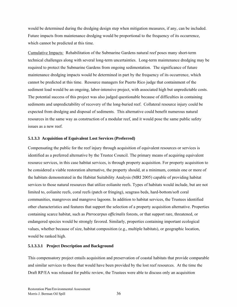
Restoration Plan/Environmental Assessment Morris J. Berman Oil Spill 36
would be determined during the dredging design step when mitigation measures, if any, can be included.
Future impacts from maintenance dredging would be proportional to the frequency of its occurrence,
which cannot be predicted at this time.
Cumulative Impacts: Rehabilitation of the Submarine Gardens natural reef poses many short-term
technical challenges along with several long-term uncertainties. Long-term maintenance dredging may be
required to protect the Submarine Gardens from ongoing sedimentation. The significance of future
maintenance dredging impacts would be determined in part by the frequency of its occurrence, which
cannot be predicted at this time. Resource managers for Puerto Rico judge that containment of the
sediment load would be an ongoing, labor-intensive project, with associated high but unpredictable costs.
The potential success of this project was also judged questionable because of difficulties in containing
sediments and unpredictability of recovery of the long-buried reef. Collateral resource injury could be
expected from dredging and disposal of sediments. This alternative could benefit numerous natural
resources in the same way as construction of a modular reef, and it would pose the same public safety
issues as a new reef.
5.1.3.3 Acquisition of Equivalent Lost Services (Preferred)
Compensating the public for the reef injury through acquisition of equivalent resources or services is
identified as a preferred alternative by the Trustee Council. The primary means of acquiring equivalent
resource services, in this case habitat services, is through property acquisition. For property acquisition to
be considered a viable restoration alternative, the property should, at a minimum, contain one or more of
the habitats demonstrated in the Habitat Suitability Analysis (MRI 2005) capable of providing habitat
services to those natural resources that utilize eolianite reefs. Types of habitats would include, but are not
limited to, eolianite reefs, coral reefs (patch or fringing), seagrass beds, hard-bottom/soft coral
communities, mangroves and mangrove lagoons. In addition to habitat services, the Trustees identified
other characteristics and features that support the selection of a property acquisition alternative. Properties
containing scarce habitat, such as Pterocarpus officinalis forests, or that support rare, threatened, or
endangered species would be strongly favored. Similarly, properties containing important ecological
values, whether because of size, habitat composition (e.g., multiple habitats), or geographic location,
would be ranked high.
5.1.3.3.1 Project Description and Background
This compensatory project entails acquisition and preservation of coastal habitats that provide comparable
and similar services to those that would have been provided by the lost reef resources. At the time the
Draft RP/EA was released for public review, the Trustees were able to discuss only an acquisition
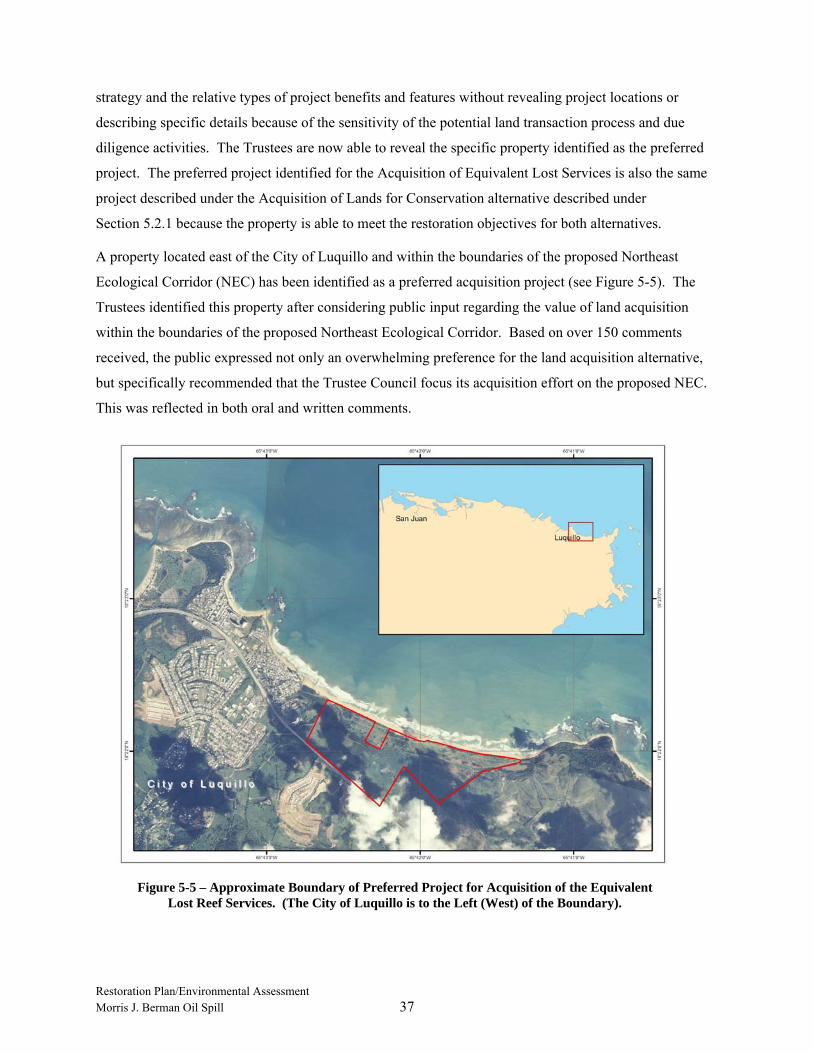
Restoration Plan/Environmental Assessment Morris J. Berman Oil Spill 37
strategy and the relative types of project benefits and features without revealing project locations or
describing specific details because of the sensitivity of the potential land transaction process and due
diligence activities. The Trustees are now able to reveal the specific property identified as the preferred
project. The preferred project identified for the Acquisition of Equivalent Lost Services is also the same
project described under the Acquisition of Lands for Conservation alternative described under
Section 5.2.1 because the property is able to meet the restoration objectives for both alternatives.
A property located east of the City of Luquillo and within the boundaries of the proposed Northeast
Ecological Corridor (NEC) has been identified as a preferred acquisition project (see Figure 5-5). The
Trustees identified this property after considering public input regarding the value of land acquisition
within the boundaries of the proposed Northeast Ecological Corridor. Based on over 150 comments
received, the public expressed not only an overwhelming preference for the land acquisition alternative,
but specifically recommended that the Trustee Council focus its acquisition effort on the proposed NEC.
This was reflected in both oral and written comments.
Figure 5-5 – Approximate Boundary of Preferred Project for Acquisition of the Equivalent
Lost Reef Services. (The City of Luquillo is to the Left (West) of the Boundary).

Restoration Plan/Environmental Assessment Morris J. Berman Oil Spill 38
The preferred project property is approximately 270 acres in size and includes a mosaic of habitat types
including mangrove habitat, which is appropriate for compensating for the lost reef services. Additionally,
the property includes other coastal habitats, including coastal herbaceous wetlands, coastal uplands, beach
and dune habitat, and riverine habitat that provide multiple project benefits (see Figure 5-6). For instance,
the conservation importance of the beaches and dune habitat in the Luquillo area for sea turtle nesting is
identified in Recovery Plans for both Leatherback and Hawksbill sea turtles (National Marine Fisheries
Service [NMFS] 1992, NMFS 1993). The property is privately owned and the owner is under no
obligation to sell the property (i.e., a willing seller). Once the acquisition is complete, title to the property
will be transferred to the Commonwealth of Puerto Rico for use and management as a natural reserve.
5.1.3.3.2 Restoration Objectives
Land acquisition has the potential to meet multiple restoration objectives, such as increasing public access
to beach and dune habitats for recreation (see Section 5.2), as well as protecting sensitive habitat.
Restoration objectives can also be met indirectly by acquiring property likely to be altered by
Figure 5-6 – Shoreline of the Preferred Project for the Acquisition of the Equivalent Lost Reef Services. (The Preferred Project has an Undisturbed Sandy Shoreline with a Mosaic of other
Habitats, including Riverine Habitat with Fringing Coastal Herbaceous Wetlands and Mangroves).

Restoration Plan/Environmental Assessment Morris J. Berman Oil Spill 39
development in the near future. If purchasing the property prevents loss of natural resources and services
currently associated with that property, restoration goals will be met.
For property acquisition to be considered a viable restoration alternative, the property should, at a
minimum, contain one or more of the habitats demonstrated in the Habitat Suitability Analysis
(MRI 2005) capable of providing habitat services to those natural resources that utilize eolianite reefs.
Types of habitats would include, but are not limited to, eolianite reefs, coral reefs (patch or fringing),
seagrass beds, hard-bottom/soft coral communities, mangroves and mangrove lagoons.
5.1.3.3.3 Scaling Approach
In addition to habitat services, the Trustees identified other characteristics and features that would support
a property acquisition alternative. Properties containing scarce habitat, such as Pterocarpus officinalis,
coral habitat, or that support rare, threatened, or endangered species would be strongly favored.
Similarly, properties containing important ecological values, whether because of size, habitat
composition, or geographic location, would be considered favorable.
5.1.3.3.4 Success Criteria and Monitoring
No monitoring of acquired property is recommended in the project plan.
5.1.3.3.5 Cost and Timeframe
The timeframe for this project is dictated by the willing seller’s desire to close the real estate transaction
by March 30, 2007. Settlement funds identified for both reef restoration and lost beach use restoration
will be used to fund the preferred property acquisition project. Table 5-3 illustrates the typical categories
of costs necessary for due diligence related to acquiring coastal land parcels to show the cost breakdown.
Because the exact cost of each due diligence category can vary, the total cost reflected in Table 5-3
represents the total allocation of restoration funds, including interest, for the preferred project property.
The Trustees allocated $5,600,000.00 of settlement and interest from reef restoration funds. Furthermore,
because the natural resource damage assessment process includes incentives for the Trustees to seek out
other sources of funding or in-kind contributions from partnering organizations, the funds that the
Trustees have allocated for this project may only reflect a portion of the total acquisition costs of the
preferred project property, with the balance of funding coming from outside sources.

Restoration Plan/Environmental Assessment Morris J. Berman Oil Spill 40
TABLE 5-3
COSTS OF LAND ACQUISITION FOR CONSERVATION
CATEGORY COST Appraisal Costs - Title Searches - Survey (including a Maritime Terrestrial Zone Delineation - Phase I Environmental Audit - Land Purchase Administration Costs - Acquisition - Total Cost $8,200,000.00 5.1.3.3.6 Environmental Consequences
Nature of likely impacts: A compensatory restoration project, consisting of purchasing property currently in a natural state, entails
no additional habitat creation or rehabilitation work. Acquisition of natural habitat as a restoration project
does not entail any destruction or loss of any structures, facilities, roads, or other amenities in use by the
public. Thus, the immediate and direct impacts of the project consist of transferring ownership to a public
entity and increasing the amount of natural habitat available to the public for use and enjoyment. The
increased public use may be controlled and managed (by use of boardwalks or trails), and is not expected
to degrade the ecological value of the purchased property. Indirect impacts that would follow from
purchase of the property include protecting the property from almost certain development and consequent
loss of ecological value and services due to such development.
Effects on public health and safety:
The property acquisition restoration project is not expected to have any direct effects on public health or
safety.
Unique characteristics of the geographic area:
The coastal property identified is biologically unique and ecologically valuable. It covers approximately
270 acres within the proposed Northeast Ecological Corridor and contains a mosaic of important coastal
habitats including 2.0 kilometers of coastal beach which is important for the recreational opportunities it
will provide to the public as well as its worldwide importance as a leatherback and loggerhead sea turtle
nesting beach. This property has long been identified by the Commonwealth as one of the highest
priority areas for conservation, protection, and enhancement.

Restoration Plan/Environmental Assessment Morris J. Berman Oil Spill 41
Controversial aspects of the project or its effects:
The Trustees know of no controversial environmental issues regarding the proposed property acquisition.
Uncertain effects or unknown risks:
The Trustees know of no uncertain effects or unknown risks to the environment that may result from
implementing the preferred restoration alternative. Purchase and protection of existing natural habitat are
well-established activities.
Precedential effects of implementing the project:
The Trustees know of no precedent that the acquisition of natural habitat as a restoration project may set
for future actions that may significantly impact the quality of the human environment. Purchase and
protection of habitat for conservation are well-established functions of the Trustee agencies.
Possible significant, cumulative impacts:
The Trustees do not foresee any cumulative impacts from implementation of this restoration project, and
similar projects in the future that would constitute significant impacts on the quality of the human
environment. Acquired land will not change in character, as it is currently in a natural state. As discussed
above, the acquisition project will not entail destruction, loss, or conversion of any existing structure,
facility, road, or other publicly-used amenity. While an acquisition strategy does not yield a net increase
in habitat services, it does preserve and protect existing habitat services from development losses. As
future restoration funding opportunities emerge, additional enhancement may be made on any acquired
parcels.
Effects on National Historic Sites or nationally significant cultural, scientific or historic resources:
The acquisition restoration project should have no known direct or indirect impacts on any National
Historic Site or nationally significant cultural, scientific or historic resources.
Effects on endangered or threatened species:
The preferred acquisition project would have no direct adverse impacts on any endangered or threatened
species and will protect and benefit endangered and threatened species. The acquisition project will
protect existing uses of the habitats found within the preferred project property by endangered or
threatened species. The Trustees have completed all required consultations under the Endangered Species
Act.

Restoration Plan/Environmental Assessment Morris J. Berman Oil Spill 42
Figure 5-7 – Fill Being Deposited in a Blowhole using a Large-Diameter Flexible Hose
Violation of environmental protection laws:
The project does not require, nor do the Trustees anticipate, incidental violation of Federal,
Commonwealth, or local laws designed to protect the environment. The preferred project can be
implemented in compliance with all applicable environmental laws and regulations.
Conclusion:
The Trustees conclude that implementation of the acquisition of the equivalent restoration project would
not have any significant impacts on the quality of the human environment. Further, other feasible
restoration alternatives that could achieve the Trustees’ restoration objectives would not have fewer
adverse environmental impacts.
5.1.3.4 Seagrass Restoration Alternative (Preferred)
This alternative would consist of substituting wetland habitat services, such as seagrass habitats, for the
services lost from the injured reef.
5.1.3.4.1 Project Description and Background
This compensatory project entails the beneficial use of dredged marine sediments from San Juan Harbor’s
maintenance dredging activities to fill dredge
holes within the Condado Lagoon,
approximately 1 mile southeast of the
grounding site. According to a Preliminary
Restoration Plan prepared by the United
States Army Corps of Engineers (Army
Corps) in March 2003, an area totaling
approximately 32 acres would be filled from
a maximum depth of 35 feet to a maximum
depth of 15 feet. Figure 5-7 illustrates one
technique for managing the sediment filling
process on similar depressions that resulted
from vessel groundings called “blowholes.”
Once these dredge holes or blowholes are
filled to grade and leveled, natural seagrass recovery and plant succession can proceed unassisted.
Alternatively, planting bundled units of fast growing seagrass species (such as Halodule wrightii or
Syringodium filiforme) within the filled area would likely speed the natural recovery of the seagrass beds.

Restoration Plan/Environmental Assessment Morris J. Berman Oil Spill 43
Figure 5-8 provides an example of a
blowhole’s appearance after placement of
sediment fill.
5.1.3.4.2 Restoration Objectives
In this case, Trustees considered creation
of seagrass habitat that could provide
ecological services comparable to those
lost, such as habitat for adult fish and
invertebrates, and nursery areas for
juvenile marine organisms. However, the
species composition of organisms using
these habitats would be different, perhaps
considerably different, than that using
offshore rock reefs.
Filling holes with native sediments similar to surrounding types can speed the natural recovery of
seagrasses, thus restoring lost resources and services to the area. The Trustees undertook a Habitat
Suitability Analysis in 2005 to determine viable habitats that can be considered to expand the available
restoration options. The Habitat Suitability Analysis (MRI 2005) determined that seagrass habitat was
one of the habitat replacements that would meet Trustee restoration objectives. In fact, seagrasses were
identified as an important recruitment habitat, an added benefit. Finally, restoration of the Condado
Lagoon, specifically filling the dredge holes, is one of the goals of the San Juan Bay Estuary Program
Comprehensive Conservation and Management Plan (CCMP), Action Plan HW-2, completed in
August 2000 (CEBSJ 2000).
5.1.3.4.3 Scaling Approach
Benefits of seagrass restoration can be coupled with restoration gains from other projects, such as shallow
hard-bottom modular reef construction, if modules are placed carefully and locations of both restoration
alternatives are proximate. The mosaic of habitats recommended in the Habitat Suitability Analysis
included seagrass beds. The Habitat Suitability Analysis ranked seagrass habitat as the third-most similar
habitat to the injured eolianite reef—third only to shallow hard-bottom and mangrove habitats—based
upon the similarity in herbivore species in these habitats. The difference between second-ranked
mangrove and third-ranked seagrass was relatively minor, and the Habitat Suitability Analysis concluded
that both were similar in terms of habitat replacement potential (MRI 2005).
Figure 5-8 – Example of Fill in a Blowhole that is Level and Up to the Surrounding Grade

Restoration Plan/Environmental Assessment Morris J. Berman Oil Spill 44
5.1.3.4.4 Success Criteria and Monitoring
A before-after monitoring design would be recommended for this project as a means of documenting the
actual increase in resources and services. The design could be as simple as measuring the acreage of
seagrasses in the area prior to filling the hole and at several time intervals after the hole is filled.
Alternatively, a more complex investigation of primary production and community enhancement could be
undertaken. Several intermediate-level monitoring methodologies could also be considered.
5.1.3.4.5 Cost and Timeframe
The Army Corps would implement the project as part of the San Juan Harbor Maintenance Dredging
using its authority under Section 204 of the Water Resources Development Act of 1992. The Trustees
would use settlement funds to pay the Sponsor cost of the project, a 25 percent non-federal cost share.
The Sponsor cost is $565,000.00 of the total project cost of $2,260,000.00 (Army Corps of Engineers
[ACOE], March 2003). The Trustees have identified up to $750,000 in settlement funds (including
interest) for use as the local sponsor’s (PRDNER) cost share, operation and maintenance costs, and
monitoring expenses. The exact timeframe for the subsequent transfer of the dredged materials to
Condado Lagoon is not certain, but the Army Corps preliminary report estimates up to 57 months to
completion.
There is some uncertainty as to whether the Army Corps will accept the use of settlement funds as the
local sponsor’s cost share as described above. If the Army Corps does not accept the use of settlement
funds for the seagrass project, or if the Sponsor cost would exceed the funds allocated for this project, the
Trustees will use the seagrass funds for the preferred project described in Section 5.2.1, Acquisition of
Lands for Conservation.
5.1.3.4.6 Environmental Consequences
In implementation of the Seagrass Restoration Alternative, the Trustees would rely upon the protocols
followed by the Army Corps to comply with Section 106 of the NHPA. The Trustees would meet their
obligations through collaboration with the Army Corps by providing the sponsor’s cost share to the San
Juan Harbor Maintenance Dredging Project. Anticipated effects are summarized below.
Direct Impacts: In the immediate project area, placing dredged material in the hole would result in a
temporary increase in suspended sediment. However, longer term benefits would be realized. Reducing
the depth of water would result in increased water flow and flushing, more light reaching the seafloor, and
higher levels of dissolved oxygen. Filling the hole and establishing seagrass in a new area would cause
collateral resource injury similar to that caused by reef creation—by converting existing sand or mud

Restoration Plan/Environmental Assessment Morris J. Berman Oil Spill 45
bottoms to a different habitat type. Use of the San Juan Harbor dredge spoils for this fill would eliminate
the need to find and locate or even construct a confined disposal facility, thus reducing dredge disposal
costs and lowering the cost of acquiring fill from another source to supply the replacement sediment.
Indirect Impacts: Growth of seagrasses, whether planted or naturally established, would subsequently
provide structural habitat for other species. This alternative would not likely have any impacts on public
health or safety.
Cumulative Impacts: The overall effect of using dredged material to fill the Condado Lagoon dredge
holes or vessel grounding blowholes is expected to be positive. The actual contribution of this project to
the goals of the restoration plan would depend on the location of other habitat areas being restored,
created, or purchased. The mosaic of habitats described in the Habitat Suitability Analysis provides
variable benefits, depending on the relative locations of each. Use of the San Juan Harbor dredge spoils
for this fill would eliminate the need to place the fill in a confined disposal facility, which would cause
the loss of habitat at the confined disposal facility location somewhere along the northern coast of Puerto
Rico.
5.2 PROPOSED RECREATIONAL BEACH USE INJURY RESTORATION ALTERNATIVES
Approximately 169 miles of coastal shoreline and embayments along the northern coast of Puerto Rico
was affected by the T/B Morris J. Berman oil spill. Oil from the spill contaminated many recreational
beaches in this area during the height of the 1994 winter tourist season. Shoreline cleaning operations
were extensive and lasted until April 8, 1994 on beaches close to the grounding site. In the immediate
vicinity of the spill, the de facto beach closings lasted three months, while at many of the more distant
beaches, field operations were reduced or halted five or six weeks after the spill. Tourists and resident
beach users were advised to avoid beaches in the spill zone, and cleanup activities essentially closed
many popular beaches for an extended period following the spill. The restoration goal for this injury
category is to make the public whole for the lost services of recreational beach use resulting from the
incident.
No primary restoration of lost visitor use of recreational beach use is possible because the lost services
involve time; time cannot be replaced or restored. The Trustees considered compensatory alternatives
that would provide replacement services of comparable type, quality, and value to those lost. Three
compensatory restoration alternatives to address the injury to recreational beach use are considered in this
section: acquisition of lands (preferred), improvement of beach access, and improvement of beach
quality. Each of these is discussed below.

Restoration Plan/Environmental Assessment Morris J. Berman Oil Spill 46
5.2.1 Acquisition of Lands for Conservation (Preferred)
This alternative encompasses the acquisition of one or more parcels or interests in land which include or
border recreational shorelines affected by the spill. Ownership and/or future use of such lands is placed in
the public domain, thereby expanding and preserving public access to or opportunities for use of
shorelines, for such activities as beach recreation, fishing, and nature viewing, in the area where these
resource services were lost due to the spill. Acquired lands would be managed by local, county or
Commonwealth authorities, as appropriate.
5.2.1.1 Project Description and Background
The Acquisition of Lands for Conservation Alternative as a compensatory restoration project involves
acquiring coastal habitats that provide comparable, similar services to those that would have been
provided by the lost recreational beach use. The Trustee Council evaluated a number of sites for which
public acquisition would be consistent with the objectives of this restoration plan and which had evident
public support. Potential acquisition properties with the opportunity to serve multiple restoration
objectives, and with low potential to negatively affect the quality of natural resources, were given a higher
preference. At the time the draft RP/EA was released for public review, the Trustees were able to discuss
only an acquisition strategy and the relative types of project benefits and features without revealing
project locations or describing details because of the sensitivity of the potential land transaction process
and due diligence activities. The Trustees are now able to reveal the specific property identified as the
preferred project.
A property located east of the City of Luquillo, and within the boundaries of the proposed Northeast
Ecological Corridor (NEC), has been identified as a preferred land acquisition project (refer to Figure 5-5
in Section 5.1.3.3.1). The Trustees identified this property after considering public input regarding the
value of land acquisition within the boundaries of the proposed Northeast Ecological Corridor. Based on
over 150 comments received, the public expressed not only an overwhelming preference for this land
acquisition alternative, but specifically recommended that the Trustee Council focus its acquisition effort
on the proposed NEC. This was reflected in both oral and written comments.
The preferred project property is approximately 270 acres in size and includes 2.0 kilometers of sandy
beach appropriate for beach recreation (see Figure 5-9). Additionally, the property includes a mosaic of
coastal habitats, including mangrove habitat, coastal herbaceous wetlands, coastal uplands, riverine
habitat that provide multiple project benefits. The property is privately owned and the owner is a willing
seller. Once the acquisition is complete, Title to the property will be transferred to the Commonwealth of
Puerto Rico for use and management as a natural reserve.

Restoration Plan/Environmental Assessment Morris J. Berman Oil Spill 47
The image below shows the 2.0 kilometers of undeveloped beach property the Trustee Council identified
as the preferred acquisition project. The City of Luquillo is in the background.
5.2.1.2 Restoration Objectives
For the Acquisition of Lands for Conservation Alternative, all potential parcels for acquisition would
likely be privately owned, with little to no public access or use. Private development of potential parcels
for acquisition could also result in construction or other property alterations which detract from public use
of adjacent shorelines, including environmental quality, viewing enjoyment, and access. Some potential
parcels for acquisition may be adjacent to existing public lands, with natural reserve or recreation areas.
Waterfront property acquisition would serve both resource conservation and access enhancement
objectives. New opportunities for the public to access and use natural shorelines for recreation are
provided where property is acquired in areas with limited or no current public access. Acquiring parcels
adjacent to existing public shorelines expands public access while also allowing public recreation to be
spread over a greater area. Spreading recreational use over a greater area decreases the environmental
burden of recreational activities in any one place.
Not all properties for potential acquisition would necessarily provide opportunities for or support multiple
recreational uses. Further, some sites may be more suitable than others for post-acquisition enhancements
Figure 5-9 – The Preferred Project for Acquisition of Lands for Conservation Contains 2 Kilometers of Undeveloped Beach Property (Just East of the City of Luquillo).

Restoration Plan/Environmental Assessment Morris J. Berman Oil Spill 48
which would increase either their utility for public recreation or their benefits to natural resources in these
areas (e.g., such as by creation of dunes, eliminating invasive species of vegetation or planting of native
vegetation). Properties with the potential to serve multiple restoration objectives and with low potential
to negatively affect the quality of natural resources will be given a higher preference. Property
acquisition and planned uses will be coordinated with appropriate local, municipality, Commonwealth or
Federal agencies to ensure consistency with any regional resource management plans or other community
planning documents.
5.2.1.3 Scaling Approach
In this case, the cost of the lands identified as preferred for acquisition equates to the value of the lost
beach use, and the replacement services of the acquired lands are of comparable type and quality.
Consequently, this restoration project alternative has a multifaceted beneficial impact on an extremely
important natural ecosystem and popular coastal recreational areas on the northern coast of Puerto Rico.
The acquisition of conservation lands for recreation addresses public coastal recreation, though not
necessarily in the area directly affected by the oil spill incident, helps preserve existing natural resources,
and contributes to making the public whole for losses suffered.
5.2.1.4 Success Criteria and Monitoring
No monitoring of this project is recommended.
5.2.1.5 Cost and Timeframe
The timeframe for this project, the real estate transaction, is expected to occur on or before March 30,
2007. Settlement funds identified for both reef restoration and lost beach use restoration will be used to
fund the preferred property acquisition project. Table 5-3 (Section 5.1.3.3.5) illustrates the categories of
costs necessary for due diligence related to acquiring coastal land parcels. Because the exact cost of each
due diligence category can vary, the total cost reflected in Table 5-4 represents the total allocation
restoration funds, including interest, to the preferred project property. The Trustees allocated
$2,600,000.00 of settlement and interest from lost beach use restoration funds. Furthermore, because the
natural resource damage assessment process includes incentives for the Trustees to seek out other sources
of funding or in-kind contributions from partnering organizations, the funds that the Trustees have
allocated for this project may only reflect a portion of the total acquisition costs of the preferred project
property, with the balance of funding coming from outside sources.

Restoration Plan/Environmental Assessment Morris J. Berman Oil Spill 49
5.2.1.6 Environmental Consequences
Nature of likely impacts:
The preferred alternative for lost use of beaches is purchasing beach property currently in a natural state;
no additional habitat creation or rehabilitation work is anticipated. The project does not entail any
destruction or loss of any structures, facilities, roads, or other amenities in use by the public. Thus, the
immediate, direct impacts of the project consist of transferring ownership to a public entity and increasing
the amount of natural habitat available to the public for use and enjoyment. The increased public use may
be controlled and managed (by use of boardwalks or trails), and is not expected to degrade the ecological
value of the purchased property. Indirect impacts that would follow from purchase of the property
include protecting the property from almost certain development and consequent loss of ecological value
and services due to such development. Further indirect impacts of the restoration action include improved
quality of the property through long-term management of the site as a natural reserve.
Effects on public health and safety:
The property acquisition project is not expected to have any direct effects on public health or safety.
Unique characteristics of the geographic area:
The coastal property identified is biologically unique and ecologically valuable. It covers approximately
270 acres within the proposed Northeast Ecological Corridor and contains a mosaic of important coastal
habitats including 2.0 kilometers of coastal beach which is important for the recreational opportunities it
will provide to the public as well as its worldwide importance as a leatherback and loggerhead sea turtle
nesting beach. This property has long been identified by the Commonwealth as one of the highest
priority areas for conservation, protection, and enhancement.
Controversial aspects of the project or its effect:
The Trustees know of no controversial environmental aspects of the proposed property acquisition.
Uncertain effects or unknown risks:
The Trustees know of no uncertain effects or unknown risks to the environment that may result from
implementing the preferred restoration alternative. Purchase and protection of habitat for conservation
are well-established functions of the Trustee agencies, and the preferred project property has been
identified in public documents as a high priority for acquisition by the Commonwealth.
Precedential effects of implementing the project:
The Trustees know of no precedent that the acquisition project may set for future actions that may
significantly impact the quality of the human environment. Purchase and protection of habitat for
conservation are well-established functions of the Trustee agencies, and the preferred property has been
identified in public documents as a priority for acquisition by the Commonwealth.

Restoration Plan/Environmental Assessment Morris J. Berman Oil Spill 50
Possible significant, cumulative impacts:
The Trustees do not foresee any cumulative impacts from implementation of this restoration project that
would constitute significant impacts on the quality of the human environment. As discussed above, the
acquisition project will not entail destruction, loss, or conversion of any existing or planned structure,
facility, road, or other publicly-used amenity.
Effects on National Historic Sites or nationally significant cultural, scientific or historic resources:
The acquisition restoration project should have no known direct or indirect impacts on any National
Historic Site or nationally significant cultural, scientific or historic resources.
Effects on endangered or threatened species:
The preferred acquisition project would have no direct adverse impacts on any endangered or threatened
species and will protect and benefit endangered and threatened species. The acquisition project will
protect existing uses of the habitats found within the preferred project property by endangered or
threatened species. The Trustees have completed all required consultations under the Endangered Species
Act.
Violation of environmental protection laws:
The acquisition restoration project does not require, nor do the Trustees anticipate, incidental violation of
federal, Commonwealth, or local laws designed to protect the environment. The project can be
implemented in compliance with all applicable environmental laws and regulations.
Conclusion:
The Trustees conclude that implementation of the conservation lands acquisition project would not have
any significant impacts on the quality of the human environment. Further, other feasible alternatives that
could achieve the Trustees’ restoration objectives would not have fewer adverse environmental impacts.
5.2.2 Improved Access to Public Beaches (Non-Preferred)
Improved Access to Public Beaches, as a restoration alternative, encompasses such projects as the
construction of boardwalks, sidewalks, dune walkovers, and biking or hiking trails. The boardwalk,
sidewalk, or public trail projects under consideration would generally run parallel to and behind public
beaches, facilitating public use and access to the full length of adjacent recreational public shorelines.
Dune walkovers are elevated pedestrian walkways traversing dune habitats, including stabilizing
vegetation. The creation of such public trails or walkways addresses the lost access to recreation
shorelines during the spill event by providing increased or improved opportunities to access recreational
shorelines and beaches in the future. These projects also contribute to the preservation of the natural
habitats associated with these shorelines. This restoration alternative was determined to be non-preferred.

Restoration Plan/Environmental Assessment Morris J. Berman Oil Spill 51
5.2.2.1 Project Description and Background
Improved Access to Public Beaches as a compensatory project would improve the quantity, quality, and
availability to the public of coastal areas in Puerto Rico by completing feasible actions that the
government has identified to improve access to beaches currently ranked as non-accessible. The
Commonwealth of Puerto Rico identified and ranked numerous non-accessible beaches that would be
candidates for improving public access. None of the identified priority beaches is located within the
coastal region directly affected by the oil spill; therefore the Trustees determined that the available
priority projects were too far removed from the area impacted by the spill on Puerto Rico’s north coast.
5.2.2.2 Restoration Objectives
Access to numerous public beaches was impeded by the spill and the cleanup actions during the response
to the spill. However, none of the identified priority beaches identified by the Commonwealth of Puerto
Rico with major access problems is located within the coastal region affected by the oil spill; the Trustees
determined that the available priority projects were too far removed from the area impacted by the spill to
be truly compensatory to the public.
5.2.2.3 Scaling Approach
The Commonwealth study identified major problems with access and use, suggested feasible actions the
government could take to improve public use, and ranked non-accessible beaches in priority order for
action. However, no direct benefit from these priority beaches identified by the Commonwealth to the
areas actually affected by the spill could be realized.
5.2.2.4 Success Criteria and Monitoring
No monitoring of this alternative is recommended.
5.2.2.5 Cost and Timeframe
The costs and timeframe for improving beach access were not investigated, as the Trustees determined
that the available priority projects were too far removed from the area impacted by the spill to be truly
compensatory to the public.
5.2.2.6 Environmental Consequences
Environmental consequences were not evaluated because no actual project was proposed.

Restoration Plan/Environmental Assessment Morris J. Berman Oil Spill 52
5.2.3 Improved Quality of Use of Public Beaches (Non-Preferred)
5.2.3.1 Project Description and Background
Improved Quality of Use of Public Beaches as a compensatory restoration project identified by the
Trustees includes implementing a series of improvements previously identified by other organizations that
would address restoration of desirable beach features and natural resources as well as needed additions or
enhancements to visitor amenities on existing public beaches. More specifically, this project involves
planning and carrying out re-vegetation of 25 miles of beach uplands; design and construction of walks,
decks and maintenance areas; and installation of garbage stations. The series of improvement types that
comprise this project alternative could be carried out at many of the same beaches along Puerto Rico’s
north coast that were affected by the oil spill. This restoration alternative was determined to be non-
preferred.
5.2.3.2 Restoration Objectives
Improvements to beach resources such as reforestation or revegetation, as well as additions or
enhancements to visitor facilities such as walkways, decks, maintenance areas, and garbage stations on
beaches, would compensate the public for lost use of beaches resulting from the incident. Many of these
activities are proposed for the beaches affected by the oil spill. These projects would expectedly enhance
the value of existing use of beaches, and not necessarily increase beach use. Consequently, Trustee
restoration objectives were not met adequately by this project.
5.2.3.3 Scaling Approach
The improvements would be proposed for the beaches affected by the oil spill as a means of enhancing
the value of existing beach use, rather than increasing beach use, which would compensate for the largest
injury caused by the spill. While the location of the projects would be at the formerly impacted beaches,
the relationship of these improvement projects as compensation for the impacts from the spill incident is
less certain than natural resource protection.
5.2.3.4 Success Criteria and Monitoring
No monitoring of this alternative is recommended.
5.2.3.5 Cost and Timeframe
The costs of projects designed to improve the quality of use of the beaches affected by the incident vary
according to the actions included in a proposed package (Table 5-4). Administrative costs—planning and
design, and the costs of upkeep—would have to be added to these estimates. The estimated total costs for
Restoration Plan/Environmental Assessment Morris J. Berman Oil Spill 53
all quality improvement projects identified by the Puerto Rico Coastal Zone Management Program
currently exceed the funding allocation for the recreational beach use restoration category. No timeframe
was developed for this non-preferred restoration alternative.
TABLE 5-4
ESTIMATED COSTS OF PROJECTS TO IMPROVE QUALITY OF BEACH USE
CATEGORY COST Revegetation of 25 miles of beach uplands $2,331,250 Construction of walks, decks, and maintenance areas $1,500,000 Costs of constructing garbage stations $562,500 Planning and design; costs of upkeep TBD Total Cost $4,393,750
5.2.3.6 Environmental Consequences
The restoration alternative to improve beach quality was not selected as a preferred alternative, so no
detailed environmental analysis was performed. General impacts are described below.
Direct Impacts: Any action that increases public use of beaches results in increased in traffic, disturbance
of vegetation, litter, and other typical corollaries of human recreation. During the construction period,
short-term increases in equipment noise and traffic may occur. Following construction, these effects will
decrease.
Indirect Impacts: The indirect impacts of this restoration alternative are difficult to predict because
specific actions and locations are not specified. Use of some beaches may increase while other beaches
may be visited less often.
Cumulative Impacts: The cumulative impacts of this restoration alternative are difficult to predict,
because specific actions and locations are not specified. Overall change in beach use would not be
expected, but the restoration project would enhance the value of the recreational experience. If so, no
cumulative impacts would be expected from the restoration project.
5.3 PROPOSED NATURAL RESOURCE INJURY AND LOST VISITOR USE OF SAN JUAN NATIONAL HISTORIC SITE RESTORATION ALTERNATIVES
The Trustees proposed three projects for San Juan National Historic Site related to compensation for lost
visitor use caused by the spill. The Trustees determined there was a reduction in historic appreciation
services for approximately 6 weeks after the oil spill. During that time more than 123,000 people who
visited El Morro and San Cristobal were impacted. The National Park Service also determined that some
individuals may have canceled their visits to the Park because of the spill. In identifying compensatory
restoration projects, the Trustees considered alternatives that would provide replacement services of

Restoration Plan/Environmental Assessment Morris J. Berman Oil Spill 54
comparable type, quality, and value to those lost. Four compensatory restoration alternatives to address
the injury to the historic site and to lost visitor use were considered: (1) Improving and Extending the
Coastal Promenade, (2) Restoring the El Morro Water Battery (also known as the Floating Battery),
(3) Cleaning and Stabilizing Exterior Walls of El Morro, and (4) Mitigating Beach Erosion. The first
three projects, which were designated as “preferred” based on their evaluation against criteria described in
Section 4 of this RP/EA, are discussed below. The fourth, Beach Erosion Mitigation, was not further
considered because shoreline erosion is no longer a serious threat (based on an Army Corps analysis), and
that project it is now considered unnecessary.
5.3.1 Improvements to and Extension of Coastal Promenade (Preferred)
5.3.1.1 Project Description and Background
The Promenade, a National Recreational Trail, provides access to an area of the historic site adjacent to
the coast. The Promenade enhances visitor appreciation of the forts, the city walls, and their historic
settings as well as the natural resources along the shoreline. As a result of the Improvements to and
Extension of Coastal Promenade restoration project, now inaccessible natural areas with natural
shorelines, vegetation, tide pools with sea life, and birds would become accessible and some resource
protection features would be
installed. The restoration
project would offer
opportunities to view the
geology of the area and
experience the coastal and
marine resources that gave
the El Morro fortifications
their strategic importance.
The Coastal Promenade
Project, originally defined during the damage assessment, consists of two phases. Phase I, constructing
the promenade from the San Juan Gate to the Water Battery (see Figure 5-10) has been completed. Phase
II, which involves improvements to and extension of the existing Promenade is now being proposed as
the first priority restoration project for the Berman restoration. This restoration project consists of the
seven options described below (Figure 5-11):
Figure 5-10 – Phase I Coastal Promenade, Water Battery, and Wall Area Proposed for Improvement
Clean and Stabilize Exterior Wall of El Morro
Restoration of Water Battery
Phase I Coastal Promenade
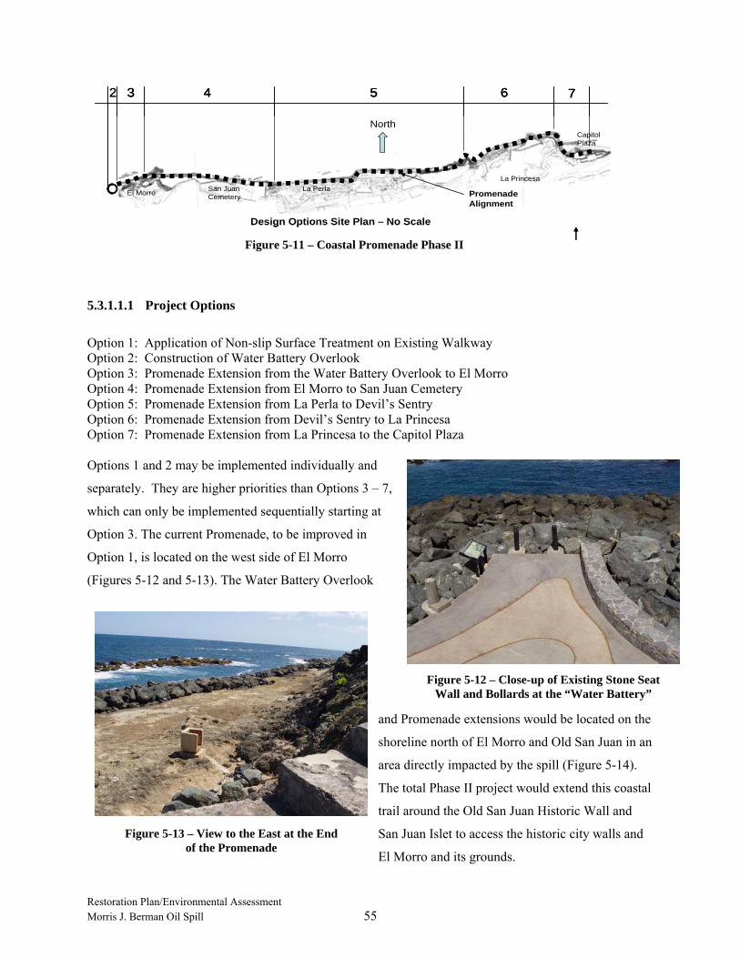
Restoration Plan/Environmental Assessment Morris J. Berman Oil Spill 55
Figure 5-11 – Coastal Promenade Phase II
3 4 5 6 7
Design Options Site Plan – No Scale
La Princesa
2
El Morro La PerlaSan Juan Cemetery
Capitol Plaza
North
Promenade Alignment
3 4 5 6 7
Design Options Site Plan – No Scale
La Princesa
3 4 5 6 7
Design Options Site Plan – No Scale
La Princesa
2
El Morro La PerlaSan Juan Cemetery
Capitol Plaza
North
Promenade Alignment
5.3.1.1.1 Project Options
Option 1: Application of Non-slip Surface Treatment on Existing Walkway Option 2: Construction of Water Battery Overlook Option 3: Promenade Extension from the Water Battery Overlook to El Morro Option 4: Promenade Extension from El Morro to San Juan Cemetery Option 5: Promenade Extension from La Perla to Devil’s Sentry Option 6: Promenade Extension from Devil’s Sentry to La Princesa Option 7: Promenade Extension from La Princesa to the Capitol Plaza Options 1 and 2 may be implemented individually and
separately. They are higher priorities than Options 3 – 7,
which can only be implemented sequentially starting at
Option 3. The current Promenade, to be improved in
Option 1, is located on the west side of El Morro
(Figures 5-12 and 5-13). The Water Battery Overlook
and Promenade extensions would be located on the
shoreline north of El Morro and Old San Juan in an
area directly impacted by the spill (Figure 5-14).
The total Phase II project would extend this coastal
trail around the Old San Juan Historic Wall and
San Juan Islet to access the historic city walls and
El Morro and its grounds.
Figure 5-12 – Close-up of Existing Stone Seat Wall and Bollards at the “Water Battery”
Figure 5-13 – View to the East at the End of the Promenade
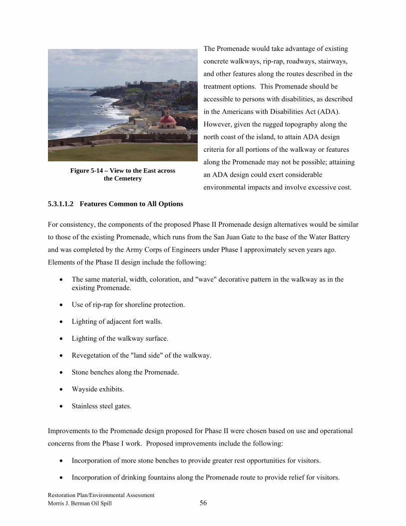
Restoration Plan/Environmental Assessment Morris J. Berman Oil Spill 56
The Promenade would take advantage of existing
concrete walkways, rip-rap, roadways, stairways,
and other features along the routes described in the
treatment options. This Promenade should be
accessible to persons with disabilities, as described
in the Americans with Disabilities Act (ADA).
However, given the rugged topography along the
north coast of the island, to attain ADA design
criteria for all portions of the walkway or features
along the Promenade may not be possible; attaining
an ADA design could exert considerable
environmental impacts and involve excessive cost.
5.3.1.1.2 Features Common to All Options
For consistency, the components of the proposed Phase II Promenade design alternatives would be similar
to those of the existing Promenade, which runs from the San Juan Gate to the base of the Water Battery
and was completed by the Army Corps of Engineers under Phase I approximately seven years ago.
Elements of the Phase II design include the following:
• The same material, width, coloration, and "wave" decorative pattern in the walkway as in the existing Promenade.
• Use of rip-rap for shoreline protection.
• Lighting of adjacent fort walls.
• Lighting of the walkway surface.
• Revegetation of the "land side" of the walkway.
• Stone benches along the Promenade.
• Wayside exhibits.
• Stainless steel gates.
Improvements to the Promenade design proposed for Phase II were chosen based on use and operational
concerns from the Phase I work. Proposed improvements include the following:
• Incorporation of more stone benches to provide greater rest opportunities for visitors.
• Incorporation of drinking fountains along the Promenade route to provide relief for visitors.
Figure 5-14 – View to the East across the Cemetery

Restoration Plan/Environmental Assessment Morris J. Berman Oil Spill 57
• Incorporation of a non-corrosive pavement joint to create the two-tone "wave pattern" rather than the steel joint divider used in the existing walkway.
• Use of water-resistant and vandal-resistant walkway lights in place of the bollard-type walkway lights installed along the existing walkway.
• Use of geotextile engineering fabric to provide a more stable subgrade and minimize erosion and out-washing of walkway sub-base and base materials.
• Construction of trench drains with gratings to preclude puddling and move water away from any low areas.
Option 1: Application of Non-slip Surface Treatment on Existing Walkway:
The exposed aggregate surface of the existing Promenade was mechanically ground and sealed. The
resulting surface is too smooth for the sea-side setting, which is subject to salt spray and high tides, and is
slippery and dangerous for pedestrians when wet. To alleviate this unsafe condition, Option 1 calls for a
non-slip treatment on the entire existing walkway surface. The most cost-effective and long-lasting
treatment is sandblasting. Additionally, several low areas along the existing walkway collect water,
contributing to the slippery conditions. The work of Option 1 includes installation of trench drains across
the width of the walkway, allowing water to drain from the walkway surface and run off into the sea.
Option 2: Construction of Water Battery Overlook:
This option calls for extending the existing Promenade at the Water Battery (also called the “Floating
Battery”) in a circular configuration as depicted in Figure 5-10. The center of the overlook would be a
circular extension of the existing stone seat wall, which demarcates the edge of the existing paving.
Concrete bollards (perhaps similar to those used in the portion of the Promenade constructed by the
Ciudad de San Juan that runs from La Concepcion/Las Palomas to the Gate of San Juan) and low-level
walkway lights would define the outside edge of the overlook.
Construction would require rearranging and adding to the existing rip-rap. Filling over the rip-rap with
compacted sand and a well-graded aggregate would form the base course. Concrete would form the
footings/edging and paving over the base. The overlook is a good location for a drinking fountain and
signage to interpret the Water Battery, harbor development, and the Caribbean.
Option 3: Extension of the Promenade from the Water Battery to El Morro:
This option calls for extending the Promenade following a route generally parallel with the shoreline from
the Water Battery Overlook (Option 2) to the east along the base of the fort and connecting to an existing
stairway built into the wall of El Morro. From the Water Battery Overlook, the Promenade would rise at
a gradient of no more than 5 percent for approximately 300 feet, at which point a walkway would switch
back towards the stairway to access the upper levels of El Morro. The switch-back section would make
Restoration Plan/Environmental Assessment Morris J. Berman Oil Spill 58
up the remaining approximately 25 feet of elevation difference between the Water Battery Overlook and
the existing stairway to El Morro. The walkway would be lighted to provide safe night-time use.
Construction of this portion of the Promenade would involve, where possible, tying into the stone- and
Gunite-reinforced wall of El Morro. The walkway would be built on a base of stone, a well-graded
aggregate base course as well as a sand base. Clean fill would be required in places, as well as rip-rap to
provide protection on the water side of the walkway.
Option 4: Extension of the Promenade from El Morro to San Juan Cemetery:
This option calls for extending the Promenade from the switch-back point in Option 3 so that it runs
easterly along the base of El Morro, past the San Juan Cemetery, at an elevation just above the beach and
parallel with the northern shoreline. At the eastern edge of the cemetery (outside the cemetery wall), a
stairway would connect the Promenade and San Juan Boulevard above in the community of La Perla.
This area between the cemetery and the La Perla community has undergone considerable recent slope
erosion. If no armoring or other protective treatment occurs in this area, continued erosion threatens to
undercut the roadway and the cemetery. The stairway construction would incorporate retaining walls that
protect against erosion as well as support the stairway. This location provides a good opportunity for
introducing wayside exhibits with information on the history of the cemetery, interesting and famous
people buried there, and points of interest within the cemetery. A wayside exhibit could also be devoted
to information pertaining to La Perla.
Option 5: Extension of the Promenade from La Perla Community to Devil’s Sentry:
Option 5 calls for the Promenade to continue east from the stairway described in Option 4 and connect to
Calle San Miguel. At this point, the Promenade would run on the sidewalk and street paving of Calle San
Miguel through La Perla. Continuing east of La Perla, the walkway would parallel the shoreline, slowly
gaining elevation and connecting to the existing path leading to the Devil’s Sentry.
Signage or pavement markings would be required to delineate the Promenade as it runs along Calle San
Miguel. Beyond this street, the walkway would be built on a sandy stretch of beach. Structural fill would
be required to provide a firm foundation for the pavement. Rip-rap along the north side would protect the
walkway from the erosive action of the ocean. Re-vegetation of the landside of walkway would help
stabilize the shoreline topography and blend with the hillside vegetation. The Promenade east of the
beach area would gain elevation en route to the Devil’s Sentry. The alignment would follow along the
existing earthen path that leads to the Devil’s Sentry. A wayside exhibit near Devil’s Sentry could
include mapping, history, and significance of the structure.

Restoration Plan/Environmental Assessment Morris J. Berman Oil Spill 59
Option 6: Extension of the Promenade from Devil’s Sentry to La Princesa:
The Promenade in Option 6 would continue from Devil’s Sentry and extend to the base of La Princesa, a
massive stone battery located at the eastern end of San Cristobal. From the Option 5 Promenade
alignment, the walkway would lead down to the base of Devil’s Sentry, cutting across the existing rip-rap
slope and connecting to the narrow existing concrete walkway along the water’s edge at the base of
Devil’s Sentry. The connection to Option 5 alignment would occur approximately 150 feet west of
Devil’s Sentry and begins to drop down toward the water. From Devil’s Sentry, it would follow the
shoreline, slowly gaining elevation up to the base of La Princesa.
The shoreline from the base of Devil’s Sentry to the base of La Princesa is extremely rugged. It is
composed of long sections of weather-beaten native stone and sections of narrow concrete walkway
constructed at the base of the stone masonry fort walls. Construction of the Promenade in Option 6 would
be more difficult and costly to build because of the rugged terrain and other technical challenges. In the
areas of native rock outcrops and the existing concrete walkway, drilling holes, installing steel reinforcing
bars, and grouting would be necessary to form part of the walkway’s foundation. Additionally, the
walkway would need to gain approximately 20 feet in elevation to reach the base level of La Princesa. As
the Promenade begins to rise, adding a protective handrail on the ocean side may be necessary because
the drop to the water is so severe.
Option 7: Extension of the Promenade from La Princesa to the Capitol Plaza:
Option 7 calls for the Promenade extension to a termination point near the Puerto Rico Capitol. From La
Princesa running easterly, the walkway alignment would drop to just above the shoreline elevation and
continue along the shoreline to a point below the pedestrian plaza across the street from the Capitol. A
lighted stairway would connect the Promenade to the plaza following the alignment of an existing, well-
worn, dirt path. The shore in this area is a combination of sandy beach, native rock outcrops, and rip-rap.
The termination of the Promenade would be an excellent location for a number of wayside exhibits
describing the Promenade, the Capitol, the sea, natural forces along the coastline, or other pertinent
themes.
5.3.1.2 Restoration Objectives
The choice of walkway configuration and connections to surrounding points of interest is based on
providing visitor experiences that focus on interpreting the resources of San Juan National Historic Site
(such as El Morro, San Sebastian, the Devil’s Sentry, San Cristobal, Santa Teresa, El Abanico, and La
Princesa), points of interest of Old San Juan (such as the San Juan Cemetery and the Capitol building),
and neighborhoods (such as La Perla) within the vicinity of the Promenade.
Restoration Plan/Environmental Assessment Morris J. Berman Oil Spill 60
Completing the Promenade options would enhance visitor access to areas where the historic structures
and architectural features of the San Juan National Historic Site meet the adjacent coastal resources.
Enhanced access here would promote greater visitor appreciation of the forts, the city walls, their historic
settings, and the natural resources along the shoreline. The improved access and enhanced visitor
experiences provided by the projects would compensate for the lost and impaired use of these same
resources during the spill incident and spill response period. The restoration alternatives would meet the
restoration objectives of providing replacement services of comparable type, quality, and value to those
lost, and address the injuries to the historic site and lost visitor use.
5.3.1.3 Scaling Approach
The Trustees determined that a reduction in historic appreciation services occurred for a period of
approximately six weeks following the oil spill, during which more than 123,000 people who visited
El Morro and San Cristobal were impacted. NPS also ascertained that some individuals may have
canceled their visits to the Park altogether. For this incident, the Trustees were unable to identify feasible
restoration alternatives that would compensate for the partial lost value of visits to the San Juan National
Historic Site resulting from diminished water and air quality, beyond what the oil spill response actions
and natural recovery processes have done to remove significant sources of oil and oil vapors from the San
Juan National Historic Site and adjacent natural resources. Therefore, in the Trustees’ judgment, only the
interim loss of visitors’ use and enjoyment of the San Juan National Historic Site requires restoration.
The Promenade Extension would provide replacement services of comparable type and quality, and of
comparable value, to those lost during the time of the spill and the post-spill response actions. This
compensatory restoration project would provide improved and safer access of comparable value for future
visitors to this shoreline area of the San Juan National Historic Site, where significant cultural and natural
resources are located that were directly impacted by the spill.
5.3.1.4 Success Criteria and Monitoring
No monitoring is included in this project alternative. Routine management activities carried out by NPS
will be sufficient to document visitor use and appreciation, and functionality of the project elements.
5.3.1.5 Cost and Timeframe
Estimated costs proposed for the project options described above are shown in Table 5-5. The estimates
include construction costs plus 17 percent for design, 8 percent for construction management, and
10 percent for construction contingency. Settlement funds in the amount of $1,493,604 were received for
NPS restoration projects at the San Juan National Historic Site. Available funds for the Resource
Category of “Lost and Diminished Human Use of the San Juan National Historic site” are not sufficient to

Restoration Plan/Environmental Assessment Morris J. Berman Oil Spill 61
implement all options of this proposed alternative; therefore, the Trustees are proposing to use settlement
funds to implement the first three options (Options 1–3). Any remaining settlement funds for this
Resource Category will be applied to the second and third priority proposed alternatives: Restoration of
the El Morro Water Battery and Restoration of El Morro’s Exterior Walls, respectively. However, the
National Park Service is actively seeking additional funding from other sources to eventually fully fund
this alternative including Options 4-7.
Estimates of the time to complete each option are represented in Table 5-6. Schedules for implementing
Options 1 through 3 are independent of each other, while those for Options 4 through 7 would be
sequential. Thus, the completion times estimated for Options 4 through 7 reflect the time to complete
each option as well as the time to complete any prerequisite options. More detailed construction
schedules for each option would be developed along with affiliated engineering and design packages.
Options 4 through 7 would not be constructed using settlement funds from this spill.
TABLE 5-5
TOTAL COST FOR INTERPRETIVE IMPROVEMENTS TO AND
EXTENSION OF COASTAL PROMENADE
OPTION COST Option 1: Non-Slip Surface Treatment $196,594 Option 2: Water Battery Overlook $205,318 Option 3: Promenade Extension from the Water Battery Overlook to El Morro $974,142 Option 4: Promenade Extension from El Morro to San Juan Cemetery $2,274,800 Option 5: Promenade Extension from La Perla to Devil’s Sentry $3,567,957 Option 6: Promenade Extension from Devil’s Sentry to La Princesa $1,889,056 Option 7: Promenade Extension from La Princesa to the Capitol Plaza $1,363,666 Total Cost $10,471,533
TABLE 5-6
PHASE II EL MORRO PROMENADE PROJECT COMPLETION TIME ESTIMATES
PROJECT OPTION ESTIMATED COMPLETION TIME (MONTHS) Option 1: Non-slip Surface Treatment 2 Option 2: Floating Battery Overlook 3 Option 3: Floating Battery to El Morro 10 Option 4: El Morro to San Juan Cemetery 15 (includes Options 3 & 4)a Option 5: La Perla to Devil’s Sentry 25 (includes Options 3, 4, 5)a Option 6: Devil’s Sentry to La Princesa 36 (includes Options 3, 4, 5, 6)a Option 7: La Princesa to Capitol Plaza 48 (includes Options 3, 4, 5, 6, 7)a Note: a Time for completion of the associated option and all prerequisite options.
Restoration Plan/Environmental Assessment Morris J. Berman Oil Spill 62
5.3.1.6 Environmental Consequences (Coastal Promenade Project Phase II, Options 1, 2, and 3)
Nature of likely impacts from Coastal Promenade Project:
Another project located along the same area as the coastal promenade restoration project has undergone a
previous environmental assessment (Army Corps 1979). That information was reviewed and used in part
to produce the following analysis. The Promenade project options would enhance and extend an existing
trail around El Morro, the Old San Juan Historic Wall, and the San Juan Islet. Completion of this project
would improve visitor safety and reduce impacts on surrounding natural and historic resources by
directing visitor traffic into desired areas. Disturbance of wildlife and impacts on sensitive plants by
construction and increased visitation are possible, but would be minimized by careful planning and
design.
No significant impacts on natural resources are expected from construction and installation of the
proposed trail enhancements. Minor, short-term impacts typically associated with construction activities
(noise, dust, etc.) are expected during project implementation. However, these impacts would be
minimized by adhering to standard construction practices for erosion and sediment control, waste
disposal, and site cleanup. While this area would be inaccessible to visitors during construction, other
visitor facilities would remain open. No adverse impacts on cultural or historic resources would result
from implementation of the proposed enhancements. Likewise, no negative impacts on threatened or
endangered species are anticipated.
Effects on public health and safety:
The Trustees know of no likely adverse impacts of the coastal promenade restoration projects on public
health or safety. These projects would improve visitor safety and enhance access.
Unique characteristics of the geographic area:
The coastal promenade restoration project would traverse the Old San Juan Historic Wall and provide
access to the Old San Juan National Historic Site’s junction with the ocean and shoreline areas. The
water battery and external fort walls are part of the fortifications of El Morro and are located at the
interface between the fort architecture and shoreline natural resources. The shoreline, coastal, and
oceanic resources themselves are not unique biologically. Visitor appreciation of the historic sites will
increase as a result of the restoration projects.
Controversial aspects of the project or its effects:
The Trustees know of no controversial aspects of the proposed restoration projects or their likely impacts
on the environment.

Restoration Plan/Environmental Assessment Morris J. Berman Oil Spill 63
Uncertain effects or unknown risks:
The Trustees know of no highly uncertain effects or unknown risks to the environment from
implementation of the proposed coastal promenade restoration projects. Walkway construction is a well-
established, well-regulated activity, based on past experience from the Phase I project, which can guide
implementation in this instance.
Precedential effects of implementing the project:
The Trustees know of no precedent that would be set by implementing the proposed projects which would
lead to future projects that significantly impact the quality of the human environment.
Possible significant, cumulative impacts:
The Trustees know of no cumulative impacts on the environment to which the proposed restoration
projects would collectively contribute and constitute a significant impact on the quality of the human
environment.
Effects on National Historic Sites or nationally significant cultural, scientific or historic resources:
The grounding and oil spill directly and indirectly affected shorelines in and adjacent to units of the San
Juan National Historic Site, and decreased visitor enjoyment of those resources. The proposed projects are
intended to compensate for interim lost human use and enjoyment of the San Juan National Historic Site,
as well as the adjacent marine environment. Projects such as restoration of the floating battery and the
cleaning and stabilization of exterior walls of El Morro would make visitor use and enjoyment of these
structures more certain. Design for restoration and wall cleaning and stabilization should be in
compliance with The Secretary of the Interior's Standards for the Treatment of Historic Properties 1995
(http://www.cr.nps.gov/local-law/arch_stnds_8_2.htm). The projects will be consistent with the
Programmatic Agreement entered into by the NPS, SHPO, and the Advisory Council on Historic
Preservation (ACHP), Puerto Rico Department of Transportation and Public Works and two local
preservation organizations in July 2004. This agreement presented a plan for addressing the appropriate
treatment of the defensive walls that was protective and resulted in minimal visual impacts. Areas where
the project will result in new ground-disturbing effects will undergo a cultural resources survey in
advance of project implementation to determine whether previously unidentified cultural resources that
may qualify as historic properties are present within the project area. If historic properties are identified,
NPS will attempt to avoid these resources or develop, in consultation with SHPO, an appropriate
treatment plan to address project impacts. The treatment plan would be incorporated into a Memorandum
of Agreement for the project and provided to SHPO and other interested parties for their concurrence.
Effects on endangered or threatened species:
The restoration projects will have no affect on threatened or endangered species.
Restoration Plan/Environmental Assessment Morris J. Berman Oil Spill 64
Violation of environmental protection laws:
The restoration project does not require, nor do the Trustees anticipate, incidental violation of Federal,
Commonwealth, or local laws designed to protect the environment. The restoration project can be
implemented in compliance with all applicable environmental laws and regulations.
Preliminary conclusion:
The Trustees conclude that implementation of the coastal promenade projects, specifically Phase II,
Options 1, 2, and 3, will not have any significant impacts on the quality of the human environment.
5.3.2 Restoration of El Morro Water (or Floating) Battery (Preferred)
5.3.2.1 Project Description and Background
The Restoration of Fort El Morro Water (or Floating) Battery restoration project, which was identified by
the Trustees as the second priority at the historic site, would stabilize and preserve the historic interior and
exterior surfaces of the Water Battery area and the adjacent exterior walls that face the shoreline
ecosystem and recreational trails. The Water Battery, sometimes called the Floating Battery, is located
along the natural shoreline of San Juan Bay at the northwest corner of El Morro (Figure 5-10).
The project would correct existing unsafe conditions resulting from deterioration of structures over
hundreds of years because of the tropical climate and wind and wave erosion. To perform the restoration,
preservation teams on scaffolds would use low-pressure washing systems to clean the walls of vegetation
and soil. Patches of inappropriate materials would be removed, cracks filled, and stucco replaced in-kind.
The stairways would be repaired to allow access to portions of the battery now inaccessible to visitors.
All restoration would follow recommendations of the historic site’s General Management Plan and
Historic Structures Report.
5.3.2.2 Restoration Objectives
At the Floating Battery, NPS can interpret cultural and historic resources, and provide visitor access to the
natural shorelines and recreational trails of the site. Although access to this area is now limited, the Water
Battery still attracts thousands of visitors a year. Restoring the battery would repair historic resources that
have been deteriorating for decades and allow safe visitor access to areas currently closed. Access to the
Water Battery area would not only help visitors understand the strategic relationship between the historic
site’s defensive systems and the natural environment, but also provide an area to interpret the shoreline
ecosystem.

Restoration Plan/Environmental Assessment Morris J. Berman Oil Spill 65
5.3.2.3 Scaling Approach
The Trustees determined that historic appreciation services were reduced for a period of approximately
six weeks following the oil spill, during which more than 123,000 people who visited El Morro and San
Cristobal were impacted. NPS also ascertained that some individuals may have canceled their visits to
the Park altogether. For this incident, the Trustees were unable to identify feasible restoration alternatives
that would compensate for the partial lost value of visits to the San Juan National Historic Site resulting
from diminished water and air quality, beyond what the oil spill response actions and natural recovery
processes have done to remove significant sources of oil and oil vapors from the San Juan National
Historic Site and adjacent natural resources. In the Trustees’ judgment, only the interim loss of visitors’
use and enjoyment of the San Juan National Historic Site requires restoration. Restoring portions of the
walls of the Water Battery would provide replacement services of comparable type and quality, and of
comparable value, to those lost during the time of the spill and the post-spill response actions. This
compensatory restoration project would improve access to a portion of the historic fort directly impacted
by the spill, where now access to significant cultural and natural resources is limited.
5.3.2.4 Success Criteria and Monitoring
No monitoring is included in this project alternative. Routine management activities carried out by NPS
will be sufficient to document visitor use and appreciation, and effectiveness of stabilization and
preservation actions.
5.3.2.5 Cost and Timeframe
San Juan National Historic Site in-house staff would restore approximately 5,000 square feet of the
exterior wall of the Water Battery at an estimated cost of $140,000. Project costs are shown in Table 5-7.
TABLE 5-7
TOTAL COST TO RESTORE EL MORRO WATER BATTERY
CATEGORY COST Restoration of El Morro Water Battery $140,000 Total Cost $140,000
The time estimated to complete restoration of the El Morro Water Battery is four months. Lead time for
commencing implementation would be minimal because extensive designs or plans are not required.

Restoration Plan/Environmental Assessment Morris J. Berman Oil Spill 66
5.3.2.6 Environmental Consequences
The general environmental consequences described in Section 5.3.1.6 are applicable to the Water Battery
project as well. Likely impacts are described briefly below.
Nature of Likely Impacts from the Floating Battery Project:
Completion of this restoration project would improve visitor safety and increase visitor access to currently
inaccessible areas. After construction, disturbance of natural areas by additional visitors would be
minimal. No significant impacts on either natural resources or cultural resources from the restoration
work are expected, although minor, short-term impacts associated with cleaning and repair (e.g., noise)
are expected during project implementation. Impacts would be limited by adhering to best management
practices. While the area of the project may be less accessible to visitors during implementation, other
areas would be available for visitation, and the duration of the project would be limited. The project
would, in fact, enhance and preserve important historic resources, while resulting in greater visitor access
to shoreline resources. Moreover, while the waters near El Morro provide habitat for some threatened and
endangered species, this project will have no effect on any threatened or endangered species.
Reconstruction activities of this historic property will be designed to be consistent with in-place
Programmatic Agreements that specify restoration techniques that are protective, visually unobtrusive,
and in harmony with the style and structural characteristics of Fort El Morro. The design for restoration
and stabilization will comply with The Secretary of the Interior's Standards for the Treatment of Historic
Properties 1995 (http://www.cr.nps.gov/local-law/arch_stnds_8_2.htm) and be consistent with the
Programmatic Agreement mentioned in Section 5.3.1.6. Public interpretive signs will indicate those
sections of the resource that are original construction and those that have been restored. Increased access
to Fort El Morro by the public as afforded by the compensatory restoration project could, in the long-
term, result in greater deterioration of the resource. NPS may implement a monitoring plan designed to
measure possible future deterioration or the results of over-use by the public so that a redirection of public
traffic may take place periodically if necessary to prevent impacts to the resource. Areas where the project
will result in new ground-disturbing effects will undergo cultural resources surveys as described in
Section 5.3.1.
5.3.3 Clean and Stabilize Exterior Walls of Historic Sites (Preferred)
5.3.3.1 Project Description and Background
Clean and Stabilize Exterior Walls of Historic Sites restoration project, identified by the Trustees as the
third priority, includes cleaning, stabilizing, and restoring approximately 25,000 square feet of the
exterior wall of El Morro adjacent to the Water Battery. The exterior walls of El Morro proposed for

Restoration Plan/Environmental Assessment Morris J. Berman Oil Spill 67
restoration are the west-facing walls located at the northwest corner of El Morro, adjacent to and just
south of the Water Battery, sometimes called the “Floating Battery” (Figure 5-10).
Cleaning would proceed using a mild, water-soluble solution applied with a low-pressure sprayer to
remove environmental staining, vegetation, and biological growth such as fungi and seagrapes.
Inappropriate patching material would be removed, cracks repaired, and deteriorated brickwork replaced.
Deteriorated historic brickwork and masonry mortar would be replaced in-kind using a historic lime-
based mortar.
5.3.3.2 Restoration Objectives
Biological growth and saltwater intrusion through exposed masonry threaten the long-term stability of the
historic sites. By removing these threats, this restoration project would restore the historic walls and
provide the public continued use and enjoyment of the structures into the future.
5.3.3.3 Scaling Approach
The Trustees determined that a reduction in historic appreciation services occurred for a period of
approximately six weeks following the oil spill, during which more than 123,000 people who visited El
Morro and San Cristobal were impacted. NPS also ascertained that some individuals may have canceled
their visits to the Park altogether. For this incident, the Trustees were unable to identify feasible
restoration alternatives that would compensate for the partial lost value of visits to the San Juan National
Historic Site resulting from diminished water and air quality, beyond what the oil spill response actions
and natural recovery processes have done to remove significant sources of oil and oil vapors from the San
Juan National Historic Site and adjacent natural resources. In the Trustees’ judgment, only the interim
loss of visitors’ use and enjoyment of the San Juan National Historic Site requires restoration. Restoring
portions of the walls of El Morro would provide replacement services of comparable type and quality, and
of comparable value, to those lost during the time of the spill and the post-spill response actions. This
compensatory restoration project would improve the long-term visitor appreciation for a portion of the
historic fort directly impacted by the effects of the spill, thereby assuring future visitors are afforded a
view of walls more representative of historic conditions.
5.3.3.4 Success Criteria and Monitoring
No monitoring is included in this restoration project. Routine management activities carried out by NPS
will be sufficient to document visitor use and appreciation, and effectiveness of the cleaning and
stabilization.
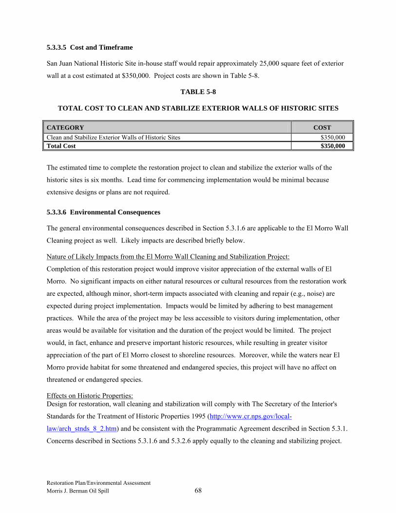
Restoration Plan/Environmental Assessment Morris J. Berman Oil Spill 68
5.3.3.5 Cost and Timeframe
San Juan National Historic Site in-house staff would repair approximately 25,000 square feet of exterior
wall at a cost estimated at $350,000. Project costs are shown in Table 5-8.
TABLE 5-8
TOTAL COST TO CLEAN AND STABILIZE EXTERIOR WALLS OF HISTORIC SITES
CATEGORY COST Clean and Stabilize Exterior Walls of Historic Sites $350,000 Total Cost $350,000
The estimated time to complete the restoration project to clean and stabilize the exterior walls of the
historic sites is six months. Lead time for commencing implementation would be minimal because
extensive designs or plans are not required.
5.3.3.6 Environmental Consequences
The general environmental consequences described in Section 5.3.1.6 are applicable to the El Morro Wall
Cleaning project as well. Likely impacts are described briefly below.
Nature of Likely Impacts from the El Morro Wall Cleaning and Stabilization Project:
Completion of this restoration project would improve visitor appreciation of the external walls of El
Morro. No significant impacts on either natural resources or cultural resources from the restoration work
are expected, although minor, short-term impacts associated with cleaning and repair (e.g., noise) are
expected during project implementation. Impacts would be limited by adhering to best management
practices. While the area of the project may be less accessible to visitors during implementation, other
areas would be available for visitation and the duration of the project would be limited. The project
would, in fact, enhance and preserve important historic resources, while resulting in greater visitor
appreciation of the part of El Morro closest to shoreline resources. Moreover, while the waters near El
Morro provide habitat for some threatened and endangered species, this project will have no affect on
threatened or endangered species.
Effects on Historic Properties: Design for restoration, wall cleaning and stabilization will comply with The Secretary of the Interior's
Standards for the Treatment of Historic Properties 1995 (http://www.cr.nps.gov/local-
law/arch_stnds_8_2.htm) and be consistent with the Programmatic Agreement described in Section 5.3.1.
Concerns described in Sections 5.3.1.6 and 5.3.2.6 apply equally to the cleaning and stabilizing project.

Restoration Plan/Environmental Assessment Morris J. Berman Oil Spill 69
5.4 SUMMARY OF PREFERRED ALTERNATIVES
5.4.1 Preferred Reef Restoration Alternatives
Alternatives selected as preferred for the lost reef services included Modular Reef Habitat Construction,
Acquisition of Equivalent Lost Services, and Seagrass Restoration. Decision-making for selection of the
preferred restoration alternatives for lost reef services was based on the results of the final Habitat
Suitability Analysis report prepared by Marine Resources, Inc. (MRI) on behalf of the Trustees in
August 2005.
The Habitat Suitability Analysis report indicates that a project allowing replacement of shallow water
hard-bottom habitat, especially if combined with a seagrass or mangrove habitat project (or both),
represents the best compensatory habitat choice to replace the lost ecological services provided by the
injured eolianite reef.
5.4.1.1 Funding Allocation
The Trustees did not identify a specific percentage of settlement funds to dedicate to the preferred
Modular Reef Habitat Construction or Acquisition of Equivalent Lost Services; however, recognizing the
premium costs of acquiring coastal mangrove habitat, the Trustees anticipate using most reef restoration
settlement funds for habitat acquisition (Table 5-9). The remaining balance of settlement funds would be
used for one or more shallow hard-bottom restoration and the seagrass project.
TABLE 5-9
FUNDING ALLOCATION FOR PREFERRED REEF RESTORATION ALTERNATIVE
CATEGORY COST Reef Module $60,000 Seagrass $750,000 Land Acquisition* $5,600,000
Note: * There is an additional funding allocation of $2,600,000 coming from the Acquisition of Lands for Conservation for the
Lost Recreational Beach Use category that brings the total to $8,200,000 for the land acquisition project.
5.4.1.2 Modular Reef Habitat Construction (Shallow Hard Bottom Project)
The Trustees recognize that a shallow hard-bottom replacement project could take any number of forms.
The Habitat Suitability Analysis report (MRI 2005) specifically identifies artificial reefs constructed to
mimic natural hard-bottom habitats as the intended recommended project to meet the ecological service
replacement objectives. The Trustees considered this Habitat Suitability Analysis recommendation as

Restoration Plan/Environmental Assessment Morris J. Berman Oil Spill 70
well as others, such as evaluating the proximity of reef placement sites to seagrass habitat in order to
maximize the habitat service potential of the project. Reef modules will be located within sandy patches
of seagrass habitat.
5.4.1.3 Acquisition of Equivalent Lost Services
Mangrove habitat acquisition was identified as the major component of the selected restoration alternative
for reef injuries for many reasons. Coastal mangrove habitat is becoming scarcer due to development.
Lands under government management or lands protected from development through conservation
easements may be currently available for restoration, but private lands not under such protections are
likely to be forever unavailable for acquisition or restoration once developed. The opportunity to restore
mangrove habitat assumes land is available for conservation. The Trustees preferred to protect a parcel of
land under threat of development, and preserve the ecological services currently provided by that habitat,
than to undertake a smaller, but just as expensive, restoration project to replace the lost habitat services.
The preferred project was carefully developed to compensate the public for the reef injury through
acquisition of equivalent resources or services after the Trustee Council had evaluated a number of sites.
Potential acquisition properties with the opportunity to serve multiple restoration objectives and with low
potential to negatively affect the quality of natural resources were given a higher preference. This project
was identified as a preferred alternative by the Trustee Council based on a number of factors including,
but not limited to, the conclusions in the Habitat Suitability Analysis (MRI 2005), widespread public
support for the concept, and the identification of suitable land that has recently become available for
acquisition. The Trustees are now able to identify a specific parcel that has been identified as the
preferred project for the Acquisition of Equivalent Lost Services. A 270 acre privately-owned property
with a willing seller has been proposed for acquisition; it is east of the City of Luquillo and lies within the
boundaries of the proposed Northeast Ecological Corridor (NEC). The property has many favorable
attributes and contains a desirable mosaic of coastal habitats, including riverine areas with fringing
mangroves and herbaceous wetlands, uplands, and undisturbed sandy beaches with dunes. The presence
of the beach and dune habitat in a mosaic of other habitats within a single property is a unique restoration
and conservation opportunity that allows this project to also meet restoration objectives of the alternative
for the Acquisition of Lands for Conservation for lost recreational beach use injuries.
This land acquisition will meet multiple direct and indirect restoration objectives. Its transfer from private
to public hands will potentially increase public access to beach and dune habitats for recreational and
educational use, protect sensitive habitats, preserve an area that likely was going to be altered in the near
future by development, eliminate potential secondary threats related to the deferred development such as
increased motor vessel traffic, demand for docks and boat slips, and dredging for vessel access, and
Restoration Plan/Environmental Assessment Morris J. Berman Oil Spill 71
prevent loss of natural resources and services currently associated with this property. The conservation of
beaches and dune habitat in the Luquillo area is of particular importance for meeting endangered species
recovery objectives for Leatherback and Hawksbill sea turtles, another high priority restoration objective.
While this acquisition will not yield an immediate net increase in habitat services, it does protect existing
habitat services and offers the opportunity to add future enhancements such as habitat restoration projects
and potential acquisition of other nearby threatened areas as future funding opportunities emerge.
5.4.1.4 Seagrass Restoration
Seagrass restoration is identified as a preferred alternative for compensating the public for the loss of reef
resources and services. Seagrass restoration, like mangrove restoration, was identified through the
Habitat Suitability Analysis as a complementary restoration alternative to a shallow water reef project.
While opportunities to restore discrete areas of seagrass habitat, particularly large-scale areas, are rare and
can be extremely costly without funding partnerships, the Trustees did identify a single feasible seagrass
project that is both large-scale and cost-effective. In this restoration project, dredged material from the
San Juan Bay shipping channel would be used to fill in a large dredge hole in the Condado Lagoon. The
Condado Lagoon was impacted by the T/B Morris J. Berman oil spill. In the judgment of the Trustees,
the opportunity to leverage a large amount of Federal funds with a relatively small contribution of
settlement dollars would be a sound investment in the restoration of 32 acres of seagrass habitat within
the Condado Lagoon. Additionally, filling a large dredge hole, regardless of its location, will likely have
other benefits such as eliminating poor water quality conditions, such as low dissolved oxygen, associated
with the dredge hole.
5.4.2 Preferred Recreational Beach Use Restoration Alternatives
The beach use compensatory restoration project consists of purchasing property currently in a natural
state, with no additional habitat creation or rehabilitation work planned. The Trustee Council evaluated a
number of sites as potential acquisition properties with higher preferences given to those that could meet
multiple restoration objectives with low potential for negative effects upon natural resources. The
Trustees are now able to reveal the identity of a specific parcel as the preferred project for the Acquisition
of Lands for Conservation to compensate for lost recreational beach use that meets restoration objectives
and has widespread public support. A 270 acre privately-owned property with a willing seller has been
proposed for acquisition; it is east of the City of Luquillo and lies within the boundaries of the proposed
NEC. This desirable property has 2.0 kilometers of sandy beach appropriate for recreational use and also
includes a mosaic of coastal habitats, including mangroves, coastal herbaceous wetlands, coastal uplands,
and riverine areas that provide multiple resource benefits. The presence of the beach and dune habitat
associated with a mosaic of other preferred habitats within a single parcel is a unique conservation
Restoration Plan/Environmental Assessment Morris J. Berman Oil Spill 72
opportunity that also meets restoration objectives associated with the alternative for the Acquisition of
Equivalent Lost Services to compensate for reef injuries and lost services.
5.4.3 Preferred San Juan Historic Site Resources Restoration Alternatives
The grounding and oil spill directly and indirectly affected shorelines in and adjacent to units of the San
Juan National Historic Site, and the incident decreased visitor enjoyment of those resources. The
preferred restoration projects will compensate for interim lost human use and enjoyment of the San Juan
National Historic Site and the adjacent marine environment during and following the incident. The
Coastal Promenade Project, specifically Phase II Options 1, 2, and 3, will provide new and unique
exterior views of the historic area, affording an appreciation of how the structures as a whole appear on
the coastal horizon, thus providing a sense of the military significance of the San Juan National Historic
Site. Restoration of the El Morro Water Battery will also make visitor use and enjoyment more certain
and correct decades of deterioration. Cleaning and Stabilizing Exterior Walls of the Historic Sites will
improve long-term visitor appreciation and ensure that visitors are afforded a view of walls that are more
representative of historical conditions.
6.0 COMPLIANCE WITH APPLICABLE LAWS AND REGULATIONS
In addition to OPA, implementation of the Trustees’ preferred restoration alternatives is subject to the
requirements of laws and regulations relating to environmental protection and the safe use of waterways,
among other restrictions. This section discusses specific requirements and prohibitions of several laws
likely applicable to the proposed projects, as well as procedures that Trustees are required to follow in
complying with these laws.
Some laws, such as the NEPA and the Coastal Zone Management Act (CZMA), require that the Trustees
certify to appropriate regulatory agencies, prior to reaching a final decision to implement the projects, that
the projects will not violate the law in question. For these laws, the Trustees forwarded the Draft RP/EA
to the relevant oversight agency for evaluation. Comments, questions, or requirements for project
implementation identified by these agencies have been incorporated into the RP/EA.
Requirements for compliance with other laws, such as the Clean Water Act, can only be determined at the
time that the Trustees apply for a restoration construction permit with the applicable regulatory agency.
However, the general policies and prohibitions of these laws are described in following sections.
Restoration Plan/Environmental Assessment Morris J. Berman Oil Spill 73
6.1 NATIONAL ENVIRONMENTAL POLICY ACT AND FINDING OF NO SIGNIFICANT IMPACT
6.1.1 Requirements of NEPA
Pursuant to the National Environmental Policy Act (NEPA), 42 U.S.C. § 4371, et seq., and the
implementing regulations at 40 C.F.R. Part 1500, Federal agencies contemplating implementation of a
major Federal action must produce an environmental impact statement (EIS) if the action is expected to
have significant impacts on the quality of the human environment. Federal agencies may conduct an
environmental assessment (EA) to evaluate the need for an EIS. If the EA determines that the proposed
action will not significantly impact the quality of the human environment, the agency issues a Finding of
No Significant Impact (FONSI), and thus satisfies the requirements of NEPA.
NEPA defines the human environment comprehensively to include the “natural and physical environment
and the relationship of people with that environment” (40 C.F.R. § 1508.14). All reasonably foreseeable
direct and indirect effects of implementing the project, including beneficial effects, must be evaluated by
the Federal agency (40 C.F.R. § 1508.8).
Section 1508.27 of the NEPA regulations describes the minimum factors that federal agencies should
consider in evaluating the potential significance of proposed actions. The regulations explain that
significance embodies considerations of both context and intensity. In the case of site-specific actions,
such as those proposed in this RP/EA, the appropriate context for considering potential significance of the
action is local, as opposed to national or worldwide. However, the national significance of the historic
structures affected by the spill also warrants consideration in evaluating those restoration alternatives and
their potential consequences.
With respect to intensity of the impacts of the proposed action, the NEPA regulations suggest
consideration of 10 factors:
• Likely impacts of the proposed projects.
• Likely effects of the projects on public health and safety.
• Unique characteristics of the geographic area in which the projects are to be implemented.
• Controversial aspects of the project or its likely effects.
• Degree to which possible effects of implementing the project are highly uncertain or involve unknown risks.
• Precedential effect of the project on future actions that may significantly affect the human environment.
Restoration Plan/Environmental Assessment Morris J. Berman Oil Spill 74
• Possible significance of cumulative impacts from implementing this and other similar projects.
• Effects of the project on National Historic Places, or likely impacts on significant cultural, scientific, or historic resources.
• Degree to which the project may adversely affect endangered or threatened species or their critical habitat.
• Likely violations of environmental protection laws. These factors, and the Federal Trustees’ conclusions concerning the likely significance of impacts of the
proposed projects, are discussed in Section 5.0 with respect to each proposed project identified as
“preferred.”
6.1.2 Finding of No Significant Impact – National Marine Fisheries Service
Finding of No Significant Impact for the Restoration Plan / Environmental Assessment for Morris J. Berman Oil Spill San Juan, Puerto Rico
National Marine Fisheries Service
National Oceanic and Atmospheric Administration Administrative Order 216-6 (May 20, 1999) contains
criteria for determining the significance of the impacts of a proposed action. In addition, the Council on
Environmental Quality regulations at 40 C.F.R. 1508.27 state that the significance of an action should be
analyzed both in terms of “context” and “intensity.” Each criterion listed below is relevant to making a
finding of no significant impact and has been considered individually, as well as in combination with the
others. The significance of this action is analyzed based on the NAO 216-6 criteria and CEQ’s context
and intensity criteria. These include:
1) Can the proposed action reasonably be expected to cause substantial damage to the ocean and coastal
habitats and/or essential fish habitat as defined under the Magnuson-Stevens Act and identified in FMPs?
Response:
No. The first of the preferred alternatives (hereafter Proposed Action #1), the construction of Modular
Reef Habitat Construction, specifically the Condado Coral Trail project, will not cause damage to the
ocean and coastal habitats and/or essential fish habitat as defined under the Magnuson-Stevens Act and
identified in FMPs. Likely beneficial impacts of a modular reef habitat construction project are detailed
in the Habitat Suitability Analysis (MRI 2005) commissioned for the Morris J. Berman restoration
planning process. Specifically, coupling a modular reef habitat project with nearby seagrass or mangrove
habitat could help stabilize the seagrass bed from wave action and sediment transport. The likely impact
of proposed action #1 is more fully described in Section 5.1.3.1.6 of the RP/EA.
Restoration Plan/Environmental Assessment Morris J. Berman Oil Spill 75
The second of the preferred alternatives, hereafter Proposed Action #2, is Acquisition of Equivalent Lost
Services. This same action is also proposed for the restoration of Lost Recreational Beach Use.
Accordingly, both preferred alternatives will be addressed as a single project for the remainder of the
FONSI. The specific project is the acquisition of a 270-acre tract of land called the San Miguel parcel
near the City of Luquillo, PR. This acquisition prevents the development of several proposed beach villas
and residential developments that may have otherwise resulted in substantial impacts to ecosystem
function, including adverse impacts to sea turtle nesting habitat. The proposed action itself does not cause
damage.
The third preferred alternative, hereafter Proposed Action #3, involves the beneficial use of dredged
sediments to fill a 32-acre dredge hole to elevations that will support seagrass habitat. This project will
occur in the Condado Lagoon as part of a larger Army Corps of Engineers (ACOE) San Juan Harbor
maintenance dredging project. The ACOE will implement the project under Section 204 of the Water
Resources Development Act of 1992 commonly referred to as the Beneficial Use of Dredged Materials
program. It is outside the scope of this evaluation to address impacts that the dredging activity may have
on the ocean, coastal habitats and essential fish habitat. The ACOE must address such impacts prior to
commencement of dredging activities once specific dredging locations are identified. This evaluation
considers only those impacts that may occur as a result of filling the dredge hole under the Beneficial Use
of Dredged Materials Program. Filling of the dredge hole will not cause damage to the ocean and coastal
habitats and/or essential fish habitat as defined under the Magnuson-Stevens Act and identified in FMPs.
With the exception of these man-made dredge holes, Condado Lagoon is a relatively shallow environment
which supports essential fish habitat (EFH) such as seagrasses and live hard bottom. The dredge hole
itself is not identified as EFH. The benthic communities within the dredge hole that would be damaged
by the placement of sediments include microbial mats. These mats may be dominated by sulfur-reducing
bacteria that often occur at sites of organic pollution, areas with anaerobic conditions and poor water
circulation (see Marine Benthic Resource Survey and Biological Assessment for Condado Lagoon and
San Geronimo Fort. San Juan, Puerto Rico. Marine Resources Inc. 2005). As described in Section
5.1.3.4.6 of the RP/EA, temporary impacts may include suspended sediments in the water column;
however, these impacts will be minimized through the use of turbidity curtains.
The fourth preferred alternative, Improvements to and Extension of Coastal Promenade, hereafter
Proposed Action #4, is not expected to cause damage to the ocean and coastal habitats and/or essential
fish habitat as defined under the Magnuson-Stevens Act and identified in FMPs. Proposed Action #4 will
enhance and extend existing recreational trails that are located above the high water mark, along a rocky
shoreline made of riprap that is largely devoid of vegetation. Consequently, there is no fishery habitat
value associated with the shoreline elevation at which the Coastal Promenade will be enhanced. Standard
Restoration Plan/Environmental Assessment Morris J. Berman Oil Spill 76
construction practices, such as use of turbidity screens, silt screens or hay bales, will prevent the
introduction of construction debris into the water.
The fifth preferred alternative, Restoration of El Morro Water (or Floating) Battery, hereafter Proposed
Action #5, is not expected to cause damage to the ocean or coastal habitats. The Water Battery, part of
the San Juan National Historic Site, is located along the shoreline of San Juan Bay. However, due to its
location above the high tide mark, restoring this historic structure will not affect any coastal habitats or
essential fish habitat. Standard construction practices, such as use of turbidity screens and/or silt screens
will prevent the introduction of construction debris into the water.
The sixth and last preferred alternative, Clean and Stabilize Exterior Walls of Historic Sites, hereafter
Proposed Action #6, is not expected to cause damage to the ocean or coastal habitats. Similar to the
Proposed Action #5, this project is part of the San Juan National Historic Site and the historic walls face
the shoreline. The project will be conducted above the high tide mark and products proposed to clean the
exterior walls of El Morro are water soluble and non-toxic. Therefore, if accidentally released into the
environment these products will not adversely impact adjacent habitats.
2) Can the proposed action be expected to have a substantial impact on biodiversity and/or ecosystem
function within the affected area (e.g., benthic productivity, predator-prey relationships, etc.)?
Response:
No, Proposed Actions #1 and #3 are not anticipated to have substantial impacts on the biodiversity and
ecosystem function within Condado Lagoon. The effects of these actions will be beneficial to the
productivity and ecosystem function of the lagoon as discussed in the Habitat Suitability Analysis (MRI
2005). The beneficial effects of these actions will not be immediate as coral and seagrass recovery may
take a decade or more. Combined, Proposed Action #1 and Proposed Action #3 will have a positive
effect on ecosystem function by design.
Proposed Action #2 will have no substantial impact on biodiversity or ecosystem function. The action
itself involves the transfer of land from private ownership to the Puerto Rico Department of Natural and
Environmental Resources (PRDNER). The land will be protected and managed as a natural reserve. This
acquisition prevents the development of several proposed beach villas and residential developments that
may have otherwise resulted in substantial impacts to ecosystem function, including adverse effects
impacts to sea turtle nesting habitat.
Proposed Actions #4, #5, and #6 consist of access improvements within the San Juan National Historic
Site and rehabilitation of its historic structures. Due to the nature of these Proposed Actions and their
Restoration Plan/Environmental Assessment Morris J. Berman Oil Spill 77
location above the high tide mark, no impacts to the biodiversity and ecosystem function of the affected
area are expected.
3) Can the proposed action reasonably be expected to have a substantial adverse impact on public health
or safety?
Response:
No. Proposed Action #1 is not expected to have any adverse impact on public health or safety. The area
in which this modular reef project will be constructed is an area used for only low impact recreational
activities such as snorkeling and kayaking. This modular reef habitat project will be created several feet
below the surface of the water and will not present any potential navigation hazard. In addition, the site
in which the coral reef trail is proposed is a “No Take Zone” where collection of marine life is prohibited
and the use of combustion engines is not allowed. The likely impact of proposed action #1 is more fully
described in Section 5.1.3.1.6 of the RP/EA.
Proposed Action #2 will not cause any foreseeable adverse impact on public health and safety. The parcel
will become a natural reserve and will provide additional public beach access.
Proposed Action #3 is not expected to cause any adverse impact to public safety and health. Activities of
this project will be conducted away from any shoreline areas and/or completely submerged. The dredge
and fill work will be implemented by the US Army Corps of Engineers and will adhere to their
established safety protocols and standards.
Completion of Proposed Action #4 is expected to improve public safety by helping to better direct visitor
access on site and enhance existing recreational trails. During project construction and implementation,
the public will not have access to these areas in order to protect them from any hazards that may arise
during the restoration activities.
Proposed Action #5 will protect and preserve the existing historic and cultural resources of the Water
Battery. It is anticipated that these efforts will help improve the public safety of visitors by enhancing
and improving existing conditions of the site. The public will not have access to this part of the San Juan
National Historic Site while the Proposed Action is being implemented to help protect the health and
safety of all site visitors.
Proposed Action #6 is not expected to cause substantial adverse impacts on public health or safety.
Restoration activities will be conducted on existing historic and cultural resources. To protect the public
from any hazards that may arise during project implementation, the public will not have access to these
areas. The products proposed to clean the exterior walls of the site are water soluble and non-toxic.

Restoration Plan/Environmental Assessment Morris J. Berman Oil Spill 78
Therefore, if accidentally released into the environment, these products will not adversely affect public
health and safety.
4) Can the proposed action reasonably be expected to adversely affect endangered or threatened species,
their critical habitat, marine mammals, or other non-target species?
Response:
No. Proposed Action #1 will have no effect on endangered or threatened species, their critical habitat,
marine mammals, or other non-target species. The creation of a modular reef habitat project may act as a
productive recruitment area for corals and other reef building (scleractinian) species as well as reef
associated organisms. This project is anticipated to increase coral reef function, structure, and
biodiversity within Condado Lagoon (MRI 2005). Proposed Action #1 results in a no effect
determination pursuant to Section 7 of the Endangered Species Act (ESA) and no consultation is
necessary.
Proposed Action #2 will have no effect on endangered or threatened species, their critical habitat, marine
mammals, or other non-target species. This acquisition prevents the development of several proposed
beach villas and residential developments that may have otherwise resulted in substantial impacts to
critical habitat of threatened and endangered species such as Leatherback and Hawksbill sea turtles. The
Recovery Plan for the Leatherback Sea Turtle (Dermochelys coriacea)
(http://www.nmfs.noaa.gov/pr/pdfs/recovery/turtle_leatherback_atlantic.pdf) and the Recovery Plan for
the Hawksbill Sea Turtle (Eretmochelys imbricata)
(http://www.nmfs.noaa.gov/pr/pdfs/recovery/turtle_hawksbill_atlantic.pdf), both identify conservation of
the beach habitat within the parcel to be acquired. Proposed Action #2 results in a no effect determination
pursuant to Section 7 of the ESA and no consultation is necessary.
Proposed Action #3 will have no effect on endangered or threatened species, their critical habitat, marine
mammals, or other non-target species. Implementation of this project has the potential to create an
additional 32 acres of seagrass habitat. Proposed Action #3 results in a no effect determination pursuant
to Section 7 of the ESA and no consultation is necessary.
Proposed Actions #4, #5 and #6 will have no effect on endangered or threatened species, their critical
habitat, marine mammals, or other non-target species. All projects are located above the high water mark
and are not anticipated to affect the adjacent shoreline, coastal, or ocean habitats. Due to the locations
and elevations at which these Proposed Actions will be implemented, no endangered or threatened
species, their critical habitat, marine mammals, or other non-target species will be impacted.
Consequently, Proposed Actions #4, #5 and #6 result in a no effect determination pursuant to Section 7 of
the ESA and no consultation is necessary.

Restoration Plan/Environmental Assessment Morris J. Berman Oil Spill 79
5) Are significant social or economic impacts interrelated with natural or physical environmental effects?
Response:
No. Proposed Action #1 is not expected to cause any social or economic impacts interrelated with natural
or physical environmental effects. The addition of a modular reef habitat project near a public beach
access and swim area may help encourage visitor usage of the Condado Lagoon and promote awareness
of shallow water marine habitats. While increased usage would be a desirable effect, it is neither a
significant social or economic impact.
Proposed Action #2 is not expected to cause any significant social or economic impacts interrelated with
natural or physical environmental effects. This acquisition protects the property from future development
and associated impacts. Public opinion and comments overwhelmingly supported the acquisition of this
parcel within Puerto Rico’s Northeast Ecological Corridor.
Proposed Action #3 is not expected to cause significant social or economic impacts interrelated with
natural or physical environmental effects. Condado Lagoon is currently available for low impact
recreation activities such as kayaking and bird watching. There is an aesthetic value to the lagoon as
many people live along the shoreline as well as recreate along the water’s edge. The completion of this
project will improve the water quality of the lagoon, but this effect will have no significant social or
economic impacts associated with the lagoon.
Proposed Actions #4, #5, and #6 are not expected to cause significant social or economic impacts
interrelated with natural or physical environmental effects. These Proposed Actions consist of access
improvements for visitors within the San Juan National Historic Site, and restoration and preservation of
existing historic structures. The cultural and historic resources found within the San Juan National
Historic Site are important to the culture and people of Puerto Rico. These Proposed Actions are
anticipated to improve the quality of these resources as well as increase accessibility and enhance visitors
experience and appreciation of the site.
6) Are the effects on the quality of the human environment likely to be highly controversial?
Response:
No. Proposed Actions #1 and #3 are not expected to affect the quality of the human environment in a
highly controversial manner. These Proposed Actions were provided to the public during an open
comment period and two public hearings. The trustees received a number of written, oral, and email
responses. The strong majority of comments were decidedly in favor of the six listed restoration
alternatives and therefore these proposed actions are not anticipated to affect the quality of the human
environment or be considered highly controversial.
Restoration Plan/Environmental Assessment Morris J. Berman Oil Spill 80
Proposed Action #2 is expected to affect the quality of the human environment in a positive and
beneficial manner. The acquisition of the San Miguel parcel will protect the valued habitats for the native
flora and fauna. It will also allow improved access for the public and protect the public’s ability to
participate in low impact recreational activities. This protection status and increased access will help to
improve the quality of the human environment.
Proposed Actions #4, #5 and #6 are not considered to be highly controversial or expected to affect the
quality of the human environment. These Proposed Actions will restore and protect the historic and
cultural resources of the San Juan National Historic Site, increase public safety, and help to improve
visitor experience and appreciation of the site. These Proposed Actions were introduced to the public
during an open comment period and through two public hearings. The trustees received a number of
written, oral, and email responses. None of the responses identified any controversial impacts associated
with these actions. Please refer to the RP/EA for additional information regarding the public’s
involvement throughout the restoration process.
7) Can the proposed action reasonably be expected to result in substantial impacts to unique areas, such as
historic or cultural resources, park land, prime farmlands, wetlands, wild and scenic rivers, essential fish
habitat, or ecologically critical areas?
Response:
No. Proposed Action #1 is not expected to result in significant adverse impacts to the any of the unique
areas described. This Proposed Action will result in the addition of shallow hard-bottom habitat to
Condado Lagoon. This habitat type is most similar to the lost eolianite reef, as detailed in the Habitat
Suitability Analysis (MRI 2005). Likely beneficial impacts of this modular reef project will be the
creation of essential fish habitat and the stabilization of nearby seagrass beds and mangrove habitat
through the reduction of wave action and sediment transport. This proposed action is more fully
described in Section 5.1.3.1.6 of the RP/EA.
Proposed Action #2 will not result in substantial negative impacts to unique areas, such as historic or
cultural resources, park land, prime farmlands, wetlands, wild and scenic rivers, essential fish habitat, or
ecologically critical areas. The acquisition of this land protects and preserves a 270-acre parcel of
undisturbed land, including portions of both the Pitahaya and Sabana Rivers, along the northeast coast of
Puerto Rico. This proposed action prevents the construction of a residential development that may have
otherwise resulted in substantial negative impacts to an ecologically critical area. This area has a very
high scenic value and contains a variety of unique, vulnerable, and sensitive habitats along with a number
of threatened and endangered species. Leatherback sea turtles and Hawksbill sea turtles have been
documented utilizing the beaches for nesting activities, over 133 species of birds have been recorded as
Restoration Plan/Environmental Assessment Morris J. Berman Oil Spill 81
well as critical plants species as described in the Puerto Rico Critical Wildlife Area (Ventosa- Febles, et.
al. 2005). Despite the presence of these ecologically important species, the transfer of land from private
to public ownership will not cause substantial negative impacts.
Proposed Action #3 is not expected to result in substantial impacts to any of the unique areas described
however, some beneficial effects may occur. Once the dredge hole within Condado Lagoon is filled to
grade, natural seagrass recovery and succession will proceed. This proposed action has the potential to
create an additional 32 of seagrass habitat, which will in turn improve water quality, faunal utilization,
and carrying capacity of the ecosystem.
Proposed Actions #4, #5, and # 6 will occur within the San Juan National Historic Site but will not result
in substantial impacts to the historic and cultural resources of the site. All restoration activities
implemented on site at the San Juan National Historic Site will be performed in accordance with The
Secretary of Interior’s Standards for Treatment of Historic Properties (1995) and consistent with the
Programmatic Agreement entered into by the NPS, SHPO, the Advisory Council on Historic Preservation
(ACHP), Puerto Rico Department of Transportation and Public Works, and two local preservation
organizations in July 2004.
8) Are the effects on the human environment likely to be highly uncertain or involve unique or unknown
risks?
Response:
No. Proposed Action #1 should have little or no effect on the human environment. Reef restoration and
creation using coral reef modules has been in practice for a number of decades. Examples of similar coral
reef restoration activities may be found throughout the Florida Keys National Marine Sanctuary
(www.floridakeys.noaa.gov) as well as world wide through a variety of organizations such as Reefballs
(www.reefball.org).
Proposed Action #2 will not cause any effects on the human environment. The Trustees know of no
uncertain effects or unknown risks to the environment that may result from implementing the preferred
restoration alternative. Purchase and protection of existing natural habitat are well-established activities.
Currently, there are no residences or other human activities documented on the site.
Proposed Action #3 is not expected to cause any effects on the human environment. No known human
activity currently occurs within the dredge hole. This Proposed Action will help transition the site into
productive seagrass habitat. Any resulting effects on the human environment are not likely to be highly
uncertain or involve unique or unknown risks.

Restoration Plan/Environmental Assessment Morris J. Berman Oil Spill 82
Proposed Actions #4, #5, and # 6 will occur within the San Juan National Historic Site and should not
result in highly uncertain effects or involve unique or unknown risks on the human environment. All
actions involving the San Juan National Historic Site will be performed in accordance with The Secretary
of the Interior’s Standards for the Treatment of Historic Properties (1995) as well as the Programmatic
Agreement entered into by the NPS, SHPO, ACHP, Puerto Rico Department of Transportation and Public
Works, and two local preservation organizations in July 2004. All methods to be employed through
Proposed Actions #4, #5 and #6 have been previously tested, approved, and conducted under strict
oversight from experts with the National Park Service.
9) Is the proposed action related to other actions with individually insignificant, but cumulatively
significant impacts?
Response:
No. Proposed Actions #1, #2 and #3 are mutually exclusive and will not be cumulative in their action or
impact once completed. They will impact either distinctively separate habitats types or separate
geographic areas and will not have significant cumulative impacts.
Proposed Actions #4, #5, and #6 consist of access improvements and rehabilitation of historic structures
at the San Juan Historic Site. No individually significant or cumulatively significant impacts were
identified to occur as a result of implementation of these actions. These projects will help to protect and
preserve existing historic structures on site, as well as improve the quality and accessibility of these
resources for the public.
10) Is the proposed action likely to adversely affect districts, sites, highways, structures, or objects listed
in or eligible for listing in the National Register of Historic Places or may cause loss or destruction of
significant scientific, cultural or historical resources?
Response:
No. Proposed Actions #1 and #3 are not likely to affect any known districts, sites, highways, structures,
or objects listed in or eligible for listing in the National Register of Historic Places or cause loss or
destruction of significant scientific, cultural, or historical resources.
Proposed Action #2 has no known direct or indirect impacts on historic or cultural resources resulting
from the transfer of land from private to public ownership. The land acquisition is for conservation
purposes and no additional restoration actions or alterations of the land are coupled with the acquisition.
Thus, the Proposed Action itself does not adversely impact cultural or historical resources.
Proposed Actions #4, #5 and #6 will be implemented in accordance with The Secretary of the Interior’s
Standards for the Treatment of Historic Properties (1995) as well as be consistent with the Programmatic

Restoration Plan/Environmental Assessment Morris J. Berman Oil Spill 83
Agreement of July 2004. This Agreement presents a plan for addressing the treatment of the fort’s
historic walls that is both protective and results in minimal visual impacts to the site. Therefore, Proposed
Actions #4, #5, and #6 will not cause loss or destruction of cultural or historic resources or adversely
affect historic structures or objects listed in or eligible for listing in the National Register of Historic
Places.
11) Can the proposed action reasonably be expected to result in the introduction or spread of a non-
indigenous species?
Response:
No. Proposed Action #1 is not expected to result in the introduction or spread of a non-indigenous
species. The coral reef trail will in fact provide a solid substrate and foundation for the recruitment of
native flora and fauna typical of the western Atlantic tropical marine environment. Native organisms
such as hard and soft corals, sponges, tunicates and coralline algae will settle and recruit to these
structures over time. Since monitoring is expected to be conducted on site, the presence of any exotic
organism will be recorded and dealt with under existing management regulations for the Commonwealth
of Puerto Rico’s DNER, Division of Marine Resources.
Proposed Action #2 is not expected to result in the introduction or spread of a non-indigenous species.
Under current management regulations, PRDNER natural reserves are subject to existing invasive exotic
protocols. Monitoring and observation for exotics is a regular and accepted practice and will be
conducted within the acquired property. If the Proposed Action is not completed, this site would be
vulnerable to exotic introduction and would be without any sort of management plan.
Proposed Action #3 will transfer sediments from a nearby lagoon system for use in filling the dredge hole
within Condado Lagoon. These sediments will be from the same watershed and tidal regime and
therefore, the meiofauna as well as sediment types are identical to those found within the Condado
lagoon. This restoration action will not result in the introduction or spread of a non-indigenous species.
No introduction or spread of a non-indigenous species will occur as a result of Proposed Actions #4, #5
and #6. Minor, short-term impacts typically associated with construction activities (noise, dust, etc.) are
expected during project implementation. However, these impacts will be minimized by adhering to
standard construction practices for erosion and sediment control, waste disposal, and site cleanup. These
material control and clean up practices will minimize to risk of introducing invasive exotics into the San
Juan Historic areas.
12) Is the proposed action likely to establish a precedent for future actions with significant effects or
represents a decision in principle about a future consideration?

Restoration Plan/Environmental Assessment Morris J. Berman Oil Spill 84
Response:
No. Proposed Action #1 is not expected to establish a precedent for future actions with significant effects
or represent a decision in principle about a future consideration. Modular reef construction is an
established practice. Modular reefs of varying size and volume have been constructed in many temperate
and tropical marine ecosystems around the world. Artificial reef modules have been used in previous
natural resource damage cases and this is an accepted restoration method.
Proposed Action #2, the purchase and protection of natural habitat will not establish a precedent for future
actions or represent a decision in principle that will affect a future consideration. Acquisition and
conservation of existing natural habitat are well-established restoration activities. The purchase option of
the San Miguel tract was attained through the restoration planning process of the Berman Oil Spill. No
other land acquisition projects are proposed as part of the Barge Berman Restoration Plan/Environmental
Assessment.
Proposed Action #3 involves filling a dredge hole to elevations that will support seagrass habitat. This
project is similar to well established seagrass restoration projects previously completed and currently
employed by NOAA and the State of Florida. The methods have been published in a number of peer
reviewed scientific journals. (For reference, please see Kirsch et al., 2005. The Mini – 312 Program – An
Expedited Damage Assessment and Restoration Process for Seagrasses in the Florida Keys National
Marine Sanctuary. Journal of Coastal Research. 40. 109-119 and Fonseca et al., 1998. Guidelines for the
Conservation and Restoration of Seagrasses in the United States and Adjacent Waters. NOAA Coastal
Ocean Program Decision Analysis Series No. 12. NOAA Coastal Office, Silver Spring, MD. 222 pp.)
Proposed Actions #4, #5, and # 6 will neither establish a precedent for future actions with significant
effects nor will it represent a decision in principle about a future consideration. Methods to be employed
have been previously tested, approved, and conducted under strict oversight from experts within the
National Park Service.
13) Can the proposed action reasonably be expected to threaten a violation of Federal, State, or local law
or requirements imposed for the protection of the environment?
Response:
All Proposed Actions do not require, nor do the Trustees anticipate, violation of Federal, Commonwealth,
or local laws designed to protect the environment. All Proposed Actions can be implemented in
compliance with all applicable environmental laws and regulations.
14) Can the proposed action reasonably be expected to result in cumulative adverse effects that could
have a substantial effect on the target species or non-target species?

Restoration Plan/Environmental Assessment Morris J. Berman Oil Spill 85
Response:
Proposed Action #1 is not expected to result in cumulative adverse impacts that could have a substantial
effect on the target species or non-target species. This modular reef habitat project may act as a
beneficially productive recruitment area for corals, along with other reef building (scleractinian) and reef
associated organisms. In addition, the coral reef trail will provide an excellent education and outreach
opportunity for students, residents, and visitors to the Commonwealth of Puerto Rico.
Proposed Action #2 will not result in cumulative adverse effects that could have a substantial effect on the
target species or non-target species. Parcel acquisition will prevent the development of the San Miguel
tract. The conservation of this land as a natural reserve will protect critical habitat for the endangered
Leatherback and Hawksbill sea turtles as well as 42 additional threatened and endangered species (See
Puerto Rico Critical Wildlife Areas, Commonwealth of Puerto Rico, Department of Natural and
Environmental Resources, Bureau of Fish and Wildlife Terrestrial Resources Division, San Juan, Puerto
Rico, January 2005).
Proposed Action #3 is not expected to result in cumulative adverse effects that could have a substantial
effect on the target species or non-target species. Implementation of this project has the potential to
create an additional 32 acres of seagrass habitat.
Proposed Actions #4, #5 and #6 are not expected to result in cumulative adverse effects that could have a
substantial effect on target species or non-target species. These Proposed Actions will be implemented
within the boundaries of the San Juan National Historic Site. All projects are located above the high
water mark along a rocky shoreline that has been stabilized with riprap over the years. Consequently, no
endangered or threatened species, their critical habitat, marine mammals, or other non-target species are
anticipated to be affected by these Proposed Actions.
DETERMINATION
In view of the information presented in this document and the analysis contained in the supporting
Restoration Plan and Environmental Assessment (RP/EA) for the Barge Berman Oil Spill, it is hereby
determined that the Preferred Restoration Alternatives identified for implementation will not significantly
impact the quality of the human environment as described above and in the Environmental Assessment. In
addition, all beneficial and adverse impacts of the proposed action have been addressed to reach the
conclusion of no significant impacts. Accordingly, preparation of an EIS for this action is not necessary.
Assistant Administrator for Fisheries, NOAA Date
[or Responsible Program Manager, [identify Office]]
Restoration Plan/Environmental Assessment Morris J. Berman Oil Spill 86
6.1.3 Finding Of No Significant Impact – National Park Service
FINDING OF NO SIGNIFICANT IMPACT RESTORATION PLAN/ENVIRONMENTAL ASSESSMENT
FOR MORRIS J. BERMAN OIL SPILL
SAN JUAN, PUERTO RICO BACKGROUND
A Restoration Plan and Environmental Assessment (RP/EA) was prepared by the National Park Service
(NPS) on behalf of the United States Department of the Interior (DOI) and in conjunction with the
Commonwealth of Puerto Rico Department of Natural and Environmental Resources (PRDNER), and the
National Oceanic and Atmospheric Administration (NOAA) of the United States Department of
Commerce (collectively, the Trustees) to address restoration of injured natural resources and lost
ecological and recreational services resulting from the Tanker Barge (T/B) Morris J. Berman oil spill off
the coast of San Juan, Puerto Rico, on January 7, 1994.
The RP/EA was prepared in compliance with the Oil Pollution Act (OPA) (33 U.S.C. § 2701, et seq.) and
National Environmental Policy Act (NEPA) (42 U.S.C. 4321, et seq.)
NEED FOR ACTION
On January 7, 1994, the T/B Morris J. Berman—a 302-foot-long by 90-foot-wide barge loaded with fuel
oil—drifted aground near San Juan, Puerto Rico, after its tow line from the tug Emily S. broke. The barge
grounded on a reef near Punta Escambrón rupturing seven of the barge’s nine holding tanks resulting in
the discharge of approximately 800,000 gallons of fuel oil into nearshore waters, including those adjacent
to the San Juan National Historic Site (Historic Site). In January 1994, after lightering most of the
remaining oil from the barge, the U.S. Coast Guard refloated, transported, and then scuttled the barge in
6,123 feet of water at a former munitions disposal site located 23 miles north-northeast of San Juan. The
Coast Guard estimated that a secondary release of between 85,000 and 125,000 gallons of an oil-water
mixture occurred during refloating and towing operations, resulting in patchy oil and sheens over a 20-
mile stretch of offshore waters. An additional 160,000 to 200,000 gallons of oil sank with the barge. For
several weeks after the scuttling, this secondary release of oil continued from the sunken barge and
formed oil slicks and scattered tarballs. This oil eventually spread along much of the northern and
northwestern coast of Puerto Rico.
The purpose of restoration, as outlined in the RP/EA, is to make the environment and public whole for
injuries to natural resources and natural resource services by returning them (through primary restoration)
to their baseline conditions (the level that would have existed if the grounding and spill had not occurred)
and/or compensating for the interim loss of resources and services pending recovery to baseline (through

Restoration Plan/Environmental Assessment Morris J. Berman Oil Spill 87
compensatory restoration). Because primary restoration is infeasible for this spill, the Trustees have
proposed a variety of compensatory restoration projects to compensate the public for injuries to and lost
services from three injured resource types—reef resources, recreational beach use, and recreational use
and enjoyment of historic sites.
The RP/EA describes the proposed restoration projects, evaluates the environmental impacts of the
restoration projects, and estimates the costs of completing the restoration projects.
This Finding of No Significant Impact (FONSI) covers those projects and actions proposed for
implementation by the Trustees as evaluated in the RP/EA.
PREFERRED/SELECTED ALTERNATIVE
The preferred alternative, which was selected for implementation, is also the environmentally preferred
alternative. It consists of a suite of six restoration projects. The implementation of these projects will
compensate the public for injuries to and lost services from the three injured resource types—reef
resources, recreational beach use, and recreational use and enjoyment of historic sites—without
significant environmental impacts. The preferred/selected alternative with its component restoration
projects are shown in the table below.
TABLE 6-1
COMPONENT RESTORATION PROJECTS OF THE PREFERRED/SELECTED ALTERNATIVE
Injured Resource Types ► Preferred/Selected Alternative Project Components Lost reef services (Lead Agency: NOAA)
► Modular Reef Habitat Construction (Condado Coral Trail Project) ► Acquisition of Equivalent Lost Services (Purchase shoreline property in Northeast Ecological Corridor (NEC))* ► Seagrass Restoration (Fill dredge holes within Condado Lagoon)
Lost recreational beach use (Lead Agency: PRDNER)
► Acquisition of Lands for Conservation (Purchase shoreline property in NEC)*
Lost and diminished use of the Historic Site (Lead Agency: NPS)
► Improve and Extend the Coastal Promenade (Phase II Options 1, 2, and 3) ► Restore El Morro Water Battery ► Clean/Stabilize Exterior Walls of the Historic Site
* This project will address both Acquisition of Equivalent Lost Services (for lost reef services) and Acquisition of Lands for Conservation (for lost recreational beach use).
The restoration projects that make up the preferred/selected alternative were chosen from a set of
proposed projects based on an analysis described and documented in the RP/EA. One restoration project,
purchasing shoreline property within the boundaries of the proposed NEC, will address both Acquisition

Restoration Plan/Environmental Assessment Morris J. Berman Oil Spill 88
of Equivalent Lost Services (for lost reef services) and Acquisition of Lands for Conservation (for lost
recreational beach use).
Evaluation Process
To select the preferred alternative, the Trustees identified feasible restoration actions, or projects,
addressing each of the three types of natural resource injury or loss. Because a proposal compensating the
public for injuries caused by the oil spill is needed, the No Action Alternative was not considered feasible
as the preferred alternative.
In accordance with the OPA’s natural resource damage assessment regulations, only restoration
alternatives considered technically feasible and amenable to implementation in accordance with
applicable laws, regulations, and/or permits may be considered for inclusion in a restoration plan (15
C.F.R. § 990.53 (a)(2)). The Trustees evaluated the feasible restoration alternatives for each type of injury
or loss based on threshold criteria (listed in 15 C.F.R. § 990.54) and described in the RP/EA. The
restoration projects determined to meet or exceed all threshold criteria were then evaluated against these
six specific criteria:
• Relationship to injured resources and services
• Time to provide benefits
• Duration of benefits
• Protection of alternative
• Opportunities for collaboration
• Benefits relative to costs
In addition to these specific criteria, OPA and the NEPA require identifying and discussing the
environmental consequences of implementing alternative projects with the aim of minimizing significant
environmental impacts and/or justifying unavoidable impacts posed by the preferred restoration
alternative. The environmental consequences for each of the selected restoration project elements are
discussed later in this FONSI in the section entitled “Environmental Consequences.”
Preferred Reef Restoration Alternatives
NOAA is the lead Trustee for the restoration project components to address lost reef services. Three
projects were included in the preferred alternative to address the lost reef services: (1) Modular Reef
Habitat Construction, (2) Acquisition of Equivalent Lost Services, and (3) Seagrass Restoration.
Decision-making for selection of these projects was based, in part, on the results of the final Habitat

Restoration Plan/Environmental Assessment Morris J. Berman Oil Spill 89
Suitability Analysis report prepared by Marine Resources, Inc. on behalf of the Trustees in August 2005.
That report indicates that a project allowing replacement of shallow water hard-bottom habitat, especially
if combined with a seagrass or mangrove habitat project (or both), represents the best compensatory
habitat choice to replace the lost ecological services provided by the injured eolianite reef.
Preferred Recreational Beach Use Restoration Alternatives
PRDNER is the lead Trustee for the sole restoration project component to address lost recreational beach
use. One project was included in the preferred alternative to address the lost recreational beach use:
Acquisition of Lands for Conservation defined under Preferred Reef Restoration Alternatives. It consists
of purchasing property currently in a natural state, with no additional habitat creation or rehabilitation
work planned.
Preferred San Juan Historic Site Resources Restoration Alternatives
NPS is the lead Trustee for the restoration project components to address lost and diminished use of the
Historic Site. Three projects were included in the preferred alternative to address the lost and diminished
use of the Historic Site: (1) Improve and Extend the Coastal Promenade (Phase II Options 1, 2, and 3); (2)
Restore El Morro Water Battery; and (3) Clean/Stabilize Exterior Walls of the Historic Site. The
grounding and oil spill directly and indirectly affected shorelines in and adjacent to units of the Historic
Site, and the incident decreased visitor enjoyment of those resources. These proposed restoration projects
are intended to compensate for interim lost human use and enjoyment of the Historic Site and the adjacent
marine environment during and following the incident. The Coastal Promenade Project, specifically Phase
II Options 1, 2, and 3, will provide new and unique exterior views of the historic area, affording an
appreciation of how the structures as a whole appear on the coastal horizon, thus providing a sense of the
military significance of the Historic Site. Restoration of the El Morro Water Battery will correct decades
of deterioration and enhance visitor use and enjoyment. Cleaning and Stabilizing the Exterior Walls of the
Historic Sites will improve long-term visitor appreciation and ensure that visitors are afforded a view of
walls that are more representative of historical conditions.
Additional Alternatives Considered
NEPA requires that proposed projects be compared not only with one another but also with the effects of
taking no action whatsoever. Because a proposal compensating the public for injuries caused by the oil
spill is needed, the No Action Alternative is not considered feasible for selection. Several active
restoration alternatives were considered and evaluated, but not selected for implementation. A project to
address lost reef services, Reef Sedimentation Mitigation, was not selected because the Trustees believe
the project could not be sustained long term without addressing the root cause of the sedimentation. Two
projects to address lost recreational beach use, Improve Access to Public Beaches and Improve Quality of

Restoration Plan/Environmental Assessment Morris J. Berman Oil Spill 90
Use of Public Beaches, were evaluated but not selected. The project to Improve Access to Public Beaches
was not selected because none of the candidate public beaches is within the coastal region directly
affected by the oil spill. The project to Improve Quality of Use of Public Beaches alternative was not
selected because the nexus to the injured resources was considered weak and the long-term benefits were
considered questionable given the type of maintenance required for beach infrastructure. In addition, each
of the aforementioned not-selected projects was evaluated as having low benefits relative to the potential
costs.
All three of the projects considered for Lost and Diminished Use of the Historic Site were evaluated and
selected for implementation. A fourth compensatory restoration project, which was identified early in the
process, Beach Erosion Mitigation, was not considered or evaluated in the RP/EA because it was
determined to be unnecessary based on a recent U.S. Army Corps of Engineers (ACOE) report that
erosion has slowed and is no longer a serious threat.
ENVIRONMENTALLY PREFERRED ALTERNATIVE
The environmentally preferred alternative is the alternative that will promote the national environmental
policy expressed in NEPA (Sec. 101 (b)). This includes alternatives that:
1. Fulfill the responsibilities of each generation as trustee of the environment for succeeding generations.
2. Ensure for all Americans safe, healthful, productive, and aesthetically and culturally pleasing surroundings.
3. Attain the widest range of beneficial uses of the environment without degradation, risk of health or safety, or other undesirable and unintended consequences.
4. Preserve important historic, cultural, and natural aspects of our national heritage and maintain, wherever possible, an environment that supports diversity and variety of individual choice.
5. Achieve a balance between population and resource use that will permit high standards of living and a wide sharing of life’s amenities.
6. Enhance the quality of renewable resources and approach the maximum attainable recycling of depletable resources.
The Trustees identified the preferred alternative, which is also the selected alternative, as the
environmentally preferred alternative. This alternative, which is the suite of projects listed in table 1, best
meets the goals listed above. Under this alternative, important natural, historic, and cultural resources
would be protected and preserved for current and future generations.
ENVIRONMENTAL CONSEQUENCES – SELECTED ALTERNATIVE
Based on analyses of impacts both inside and outside the boundaries of the component projects, the
Trustees have determined that implementing the preferred/selected alternative or any of its component
projects will cause no significant adverse effects on public health and safety; on threatened, endangered,
Restoration Plan/Environmental Assessment Morris J. Berman Oil Spill 91
or special concern species; on visitor experience or visitor safety; on national historic sites or nationally
significant cultural, scientific or historic resources; on the unique characteristics of the geographic area; or
on any other environmental or cultural resources or values.
Documented in the RP/EA and stated below are the environmental consequences of each of the
component projects that make up the preferred/selected alternative. Also stated below are conclusions
regarding whether significant impacts would occur as the result of implementing each of the component
projects. Later in this section there is an evaluation of the preferred/selected alternative with respect to the
significance criteria defined in 40 CFR §1508.27.
Environmental Consequences of Modular Reef Habitat Construction
The Condado Coral Trail Project, a Modular Reef Habitat Construction Project, would use established
technologies to create three separate coral trails each consisting of 10 reef modules for a total placement
of 30 modules.
This project would produce beneficial effects by adding three-dimensional hard substrate habitat features
to the generally flat lagoon bottom. These habitat features should increase productivity of various species
by providing increased settling surface area as well as additional areas for cover, foraging, and spawning.
Construction of the replacement reef would cause incidental (0.13 acres) loss of some sand bottom habitat
and associated biota that will be covered by the footprint of the reef structure. However, sand bottom
resources are extremely common in the area. Shallow water reef fish, as managed under the NMFS
Caribbean Fishery Management Council’s Fishery Management Plan, who use reef habitats as essential
fish habitat would benefit from the proposed restoration action. No impact on feeding abilities of the
managed species or loss of prey is expected.
During the installation of the reef modules, there will be a short term direct impact on the public use of
the public bathing area. Trucks, forklifts, small vessels, and divers using lift bags may be used during the
installation of the Condado Coral Trail. Activity associated with the use of this equipment may disrupt a
portion of the public bathing area for a short period of time. Once installed, there will be no further
disruption of the public’s use of the area from the construction of this project. The construction period
would be fairly short so little if any disruption of marine biota would occur. The approximate area
projected for the reef location was selected by Puerto Rican fisheries biologists and does not encompass
any important fishing or recreational sites. All construction materials would be stable and nontoxic.
The Condado Coral Trail Project will have no significant impacts on the quality of the human
environment. Few alternative projects are available to meet the restoration objectives of replacing
eolianite reef services, and these would not necessarily minimize adverse environmental impacts.
Restoration Plan/Environmental Assessment Morris J. Berman Oil Spill 92
Environmental Consequences of Acquisition of Equivalent Lost Services and the Acquisition of Lands for Conservation
Purchasing shoreline property located east of the City of Luquillo and within the boundaries of the
proposed NEC has been identified as a project that will address both Acquisition of Equivalent Lost
Services (for the Reef Restoration) and Acquisition of Lands for Conservation (for Recreational Beach
Use Restoration).
The beach property to be purchased is currently in a natural state; no additional habitat creation or
rehabilitation work is anticipated. The project does not entail any destruction or loss of any structures,
facilities, roads, or other amenities in use by the public. Thus, the immediate, direct impacts of the project
consist of transferring ownership to a public entity and increasing the amount of natural habitat available
to the public for use and enjoyment. The increased public use may be controlled and managed (by use of
boardwalks or trails), and is not expected to degrade the ecological value of the purchased property.
Indirect impacts that would follow from purchase of the property include protecting the property from
almost certain development and consequent loss of ecological value and services due to such
development. Further indirect impacts of the restoration action include improved quality of the property
through long-term management of the site as a natural reserve by the Commonwealth of Puerto Rico.
Implementation of the acquisition of the equivalent restoration project would not have significant impacts
on the quality of the human environment. Further, other feasible restoration alternatives that could
achieve the restoration objectives would not have fewer adverse environmental impacts.
Environmental Consequences of Seagrass Restoration
The Seagrass Restoration Project would consist of substituting similar shallow water marine habitat
services, such as seagrass habitats, for the services lost from the injured reef. This project entails the
beneficial use of dredged marine sediments from San Juan Harbor’s maintenance dredging activities to
fill dredge holes within the Condado Lagoon, approximately 1 mile southeast of the grounding site.
According to a Preliminary Restoration Plan prepared by ACOE in March 2003, an area totaling
approximately 32 acres would be filled from a maximum depth of 35 feet to a maximum depth of 15 feet.
Once these dredge holes or blowholes are filled to grade and leveled, natural seagrass recovery and plant
succession can proceed unassisted. Alternatively, the option of planting bundled units of fast growing
seagrass species within the filled area would likely speed the natural recovery of the seagrass beds.
Before implementing the Seagrass Restoration Project, NOAA will take the lead for the Trustees and
observe the protocols followed by the ACOE to comply with Section 106 of the National Historic
Preservation Act (NHPA). The Trustees would meet their obligations through collaboration with the
ACOE by providing the sponsor’s cost share to the San Juan Harbor Maintenance Dredging Project.

Restoration Plan/Environmental Assessment Morris J. Berman Oil Spill 93
In the immediate project area, placing dredged material in the hole would result in a temporary increase in
suspended sediments, however these effects would be controlled through the use of turbidity control
barriers. The reduction in water depth would result in increased water flow and flushing, more light
reaching the seafloor and elevated levels of dissolved oxygen. Use of the San Juan Harbor dredge spoils
for this fill would eliminate the need to find and locate or even construct a confined disposal facility, thus
reducing dredge disposal costs and lowering the cost of acquiring fill from another source to supply the
replacement sediment.
The overall effect of using dredged material to fill the Condado Lagoon dredge holes or vessel grounding
blowholes is expected to be positive.
Implementation of the Seagrass Restoration Project will not have any significant impacts on the quality of
the human environment.
Environmental Consequences of Improvements to and Extension of Coastal Promenade
The Promenade Project Options 1, 2, and 3 would enhance and extend an existing trail around El Morro,
the Old San Juan Historic Wall, and the San Juan Islet. Completion of this project would improve visitor
safety and reduce impacts on surrounding natural and historic resources by directing visitor traffic into
desired areas. Disturbance of wildlife and impacts on sensitive plants by construction and increased
visitation are possible, but would be minimized by careful planning and design.
No significant impacts on natural resources are expected from construction and installation of the
proposed trail enhancements. Minor, short-term impacts typically associated with construction activities
(noise, dust, etc.) are expected during project implementation. However, these impacts would be
minimized by adhering to standard construction practices for erosion and sediment control, waste
disposal, and site cleanup. Although this area would be inaccessible to visitors during construction, other
visitor facilities would remain open. No adverse impacts on cultural or historic resources would result
from implementation of the proposed enhancements. Likewise, no negative impacts on threatened or
endangered species are anticipated.
Implementation of the coastal promenade projects, specifically Phase II Options 1, 2, and 3, will not have
any significant impacts on the quality of the human environment.
Environmental Consequences of Restoration of El Morro Water (or Floating) Battery
The Restoration of El Morro Water (or Floating) Battery restoration project would stabilize and preserve
the historic interior and exterior surfaces of the Water Battery area and the adjacent exterior walls that
face the shoreline ecosystem and recreational trails. The Water Battery is located along the natural
shoreline of San Juan Bay at the northwest corner of El Morro.

Restoration Plan/Environmental Assessment Morris J. Berman Oil Spill 94
The project would correct existing unsafe conditions resulting from deterioration of structures over
hundreds of years because of the tropical climate and wind and wave erosion. To perform the restoration,
preservation teams on scaffolds would use low-pressure washing systems to clean the walls of vegetation
and soil. Patches of inappropriate materials would be removed, cracks filled, and stucco replaced in-kind.
The stairways would be repaired to allow access to portions of the battery now inaccessible to visitors.
All restoration would follow recommendations of the historic site’s General Management Plan and
Historic Structures Report.
No significant impacts on either natural resources or cultural resources from the restoration work are
expected, although minor, short-term impacts associated with cleaning and repair (e.g., noise) are
expected during project implementation. Impacts would be limited by adhering to best management
practices. While the area of the project may be less accessible to visitors during implementation, other
areas would be available for visitation, and the duration of the project would be limited. The project
would, in fact, enhance and preserve important historic resources, while resulting in greater visitor access
to shoreline resources. Although the waters near El Morro provide habitat for some threatened and
endangered species, this project would not significantly affect that habitat; therefore, no negative impacts
on threatened or endangered species are anticipated. Nevertheless, before implementation discussions on
possible impacts to listed species will be held with the U.S. Fish and Wildlife Service (USFWS) and
NOAA Fisheries.
Reconstruction activities of this historic property will be designed to be consistent with in-place
Programmatic Agreements that specify restoration techniques that are protective, visually unobtrusive and
in harmony with the style and structural characteristics of El Morro. The design for restoration and
stabilization will comply with The Secretary of the Interior's Standards for the Treatment of Historic
Properties 1995 (http://www.cr.nps.gov/local-law/arch_stnds_8_2.htm) and be consistent with the
Programmatic Agreement. Public interpretive signs will indicate those sections of the resource that are
original construction and those that have been restored.
Restoration of El Morro Water (or Floating) Battery will not have any significant impacts on the quality
of the human environment.
Environmental Consequences of Clean and Stabilize Exterior Walls of Historic Sites
Cleaning and Stabilizing Exterior Walls of Historic Sites includes cleaning, stabilizing, and restoring
approximately 25,000 square feet of the exterior wall of El Morro adjacent to the Water Battery. The
exterior walls of El Morro proposed for restoration are the west-facing walls located at the northwest
corner of El Morro, adjacent to and just south of the Water Battery.

Restoration Plan/Environmental Assessment Morris J. Berman Oil Spill 95
Cleaning would be accomplished using a mild, water-soluble solution applied with a low-pressure sprayer
to remove environmental staining, vegetation, and biological growth such as fungi and seagrapes.
Inappropriate patching material would be removed, cracks repaired, and deteriorated brickwork replaced.
Deteriorated historic brickwork and masonry mortar would be replaced in-kind using a historic lime-
based mortar.
Completion of this restoration project would improve visitor appreciation of the external walls of El
Morro. No significant impacts on either natural resources or cultural resources from the restoration work
are expected, although minor, short-term impacts associated with cleaning and repair (e.g., noise) are
expected during project implementation. Impacts would be limited by adhering to best management
practices. While the area of the project may be less accessible to visitors during implementation, other
areas would be available for visitation and the duration of the project would be limited. The project
would, in fact, enhance and preserve important historic resources, while resulting in greater visitor
appreciation of the part of El Morro closest to shoreline resources. Although the waters near El Morro
provide habitat for some threatened and endangered species, this project would not significantly affect
that habitat; therefore, no negative impacts on threatened or endangered species are anticipated.
Nonetheless, Endangered Species Act consultations with the USFWS and NOAA Fisheries, which would
be held before implementation, would address possible impacts.
Cleaning and Stabilizing Exterior Walls of Historic Sites will not have any significant impacts on the
quality of the human environment.
Significance Criteria
The criteria for significance (as defined in 40 CFR §1508.27) are listed below along with evaluations of
the preferred/selected alternative.
Impacts that may be both beneficial and adverse
The preferred/selected alternative will restore natural resources and ecological and recreational services
injured or lost as a result of the Morris J. Berman oil spill. The impacts that would result from the
implementation of any or all of the projects that make up the preferred/selected alternative, which are
described in the RP/EA, would be, at most, minor. Adverse impacts may occur but they would be short-
term and localized. The impacts resulting from the implementation of the preferred/selected alternative
would be predominantly beneficial.

Restoration Plan/Environmental Assessment Morris J. Berman Oil Spill 96
Degree to which the proposed action affects public health or safety
Implementation of any or all of the projects that make up the preferred/selected alternative would not
adversely affect public health and safety. Several of the component projects will benefit public safety. All
of the component restoration projects will be implemented in a manner that protects public health and
safety.
Unique characteristics of the geographic area such as proximity to historic or cultural resources, park lands, prime farmlands, wetlands, wild and scenic rivers, or ecologically critical areas
The unique characteristics of the geographic areas to be restored will not be adversely affected. As
described in the RP/EA, historic or cultural resources will be restored and not adversely affected by the
preferred/selected alternative. The restoration projects that make up the preferred/selected alternative will
not adversely impact park lands, prime farmlands, wetlands, wild and scenic rivers, or ecologically
critical areas.
Degree to which the effects on the quality of the human environment are likely to be highly controversial
Implementation of the preferred/selected alternative will not be highly controversial. There were no
controversial impacts identified during the analysis done for the RP/EA, and no controversial issues were
raised during the public review of the EA.
Degree to which the possible effects on the quality of the human environment are highly uncertain or involve unique or unknown risks
The risks to the quality of the human environment associated with the preferred/selected alternative will
be negligible. There were no highly uncertain, unique, or unknown risks associated with implementation
of the preferred/selected alternative or any of its component projects.
Degree to which the action may establish a precedent for future actions with significant effects or represents a decision in principle about a future consideration
The preferred/selected alternative neither establishes a precedent for future actions with significant effects
nor will it represent a decision in principle about a future consideration.
Whether the action is related to other actions with individually insignificant but cumulatively significant impacts
As described in the RP/EA, no significant cumulative impacts were identified during the environmental
analysis.
Degree to which the action may adversely affect districts, sites, highways, structures, or objects listed on National Register of Historic Places or may cause loss or destruction of significant scientific, cultural, or historical resources
Several project components of the preferred alternative will restore portions of the El Morro National
Historic Site. The restoration work will be performed in accordance with The Secretary of the Interior's
Restoration Plan/Environmental Assessment Morris J. Berman Oil Spill 97
Standards for the Treatment of Historic Properties (1995) and consistent with the Programmatic
Agreement entered into by the NPS, State Historic Preservation Officer, the Advisory Council on Historic
Preservation, Puerto Rico Department of Transportation and Public Works and two local preservation
organizations in July 2004. Areas where the projects will result in new ground-disturbing effects will
undergo a cultural resources survey in advance of project implementation to determine whether
previously unidentified cultural resources that may qualify as historic properties are present. If necessary,
treatment plans will be developed to ensure that there is no loss or destruction of significant scientific,
cultural, or historical resources.
Degree to which the action may adversely affect an endangered or threatened species or its critical habitat
As described in the RP/EA, the implementation of any or all of the projects that make up the
preferred/selected alternative will have no effect on threatened, endangered, or special concern species.
Whether the action threatens a violation of Federal, State, or local environmental protection law
The implementation of any or all of the projects that make up the preferred/selected alternative will not
violate any Federal, State, or local environmental protection laws.
IMPAIRMENT
In addition to reviewing the list of significance criteria, the NPS has determined that implementation of
the preferred/selected alternative or any or all of its component restoration projects will not result in
impairment to any NPS resources or values. This conclusion is based on an analysis of environmental
impacts described in the RP/EA, public comments, relevant scientific studies, and professional judgment
of the decision-maker in accordance with the National Park Service’s 2006 Management Policies.
PUBLIC INVOLVEMENT
The Trustees involved citizens, public officials, and stakeholder groups in developing the RP/EA. The
RP/EA was completed in July 2006 and a public comment period on the RP/EA was held from July 7 to
September 23, 2006. Public notice of the RP/EA was made and comments solicited through local
newspapers (in both English and Spanish), direct mailings, the NPS environmental planning (PEPC)
website, and the NOAA environmental website. In addition, the RP/EA was made available for review at
the Jane Stern Dorado Community Library and the Historic Site Headquarters in Fort San Cristobal.
Public meetings/hearings were held on August 8 (at Dorado) and August 9 (at Fort San Cristobal), where
presentations, fact sheets, exhibits, translation services, and opportunities to submit comments were
provided.
The Trustees obtained public input on the merits of individual restoration projects and on the
effectiveness of those projects in addressing the resource injuries and service losses arising from the spill.

Restoration Plan/Environmental Assessment Morris J. Berman Oil Spill 98
The Trustees also received and considered comments recommending projects that members of the public
believed would be more cost effective or that would better restore the resources injured by the spill or the
services lost while resources were injured or recovering. After evaluating public input, including
alternative projects that the public proposed, the RP/EA was revised by the Trustees and will be
republished in English and Spanish. Public comments have been compiled and responses prepared and
incorporated into the RP/EA in Appendix A.
The Trustees received 153 individual oral and written public comments during the comment period. The
numbers and type of comments received were:
• Twenty-four oral comments were recorded and three sets of written comments were submitted at the San Juan public hearing;
• No comments were submitted at the Dorado public hearing.
• One hundred sixteen written comments were received by email
• Nine written comments were received by fax
• One written comment was received by U.S. mail.
Comments were compiled and organized according to the method of comment submittal. Comments that
were “in favor of” or “not in favor of” specific projects and alternatives were counted and tallied.
Comments that stated support for proposed projects were noted and acknowledged, but only responded to
if they presented new information or potential new projects, were unique, or required clarification. Those
comments meriting responses were addressed; a summary of the comments and Trustee responses is
included in the RP/EA in Appendix A and attached to this FONSI.
CONCLUSION AND BASIS FOR DECISION
The preferred alternative selected for implementation and described in the Morris J. Berman Oil Spill
Restoration Plan/Environmental Assessment comprises a suite of restoration projects. Implementation of
the preferred alternative or any of its component projects does not constitute a major Federal action
significantly affecting the quality of the human environment pursuant to NEPA. Accordingly, an
Environmental Impact Statement will not be prepared.

Restoration Plan/Environmental Assessment Morris J. Berman Oil Spill 99
SIGNATURES
Based on the foregoing, the preferred alternative will not have a significant impact on the human
environment and, therefore, an EIS is not required for this project and will not be prepared.

Restoration Plan/Environmental Assessment Morris J. Berman Oil Spill 100
6.2 COASTAL ZONE MANAGEMENT ACT
The broad purpose of the CZMA (16 U.S.C. § 1451, et seq.), administered by NOAA, is to preserve,
protect, develop, and, where possible, restore or enhance the resources of the Nation’s coastal zone for
this and succeeding generations. Puerto Rico’s Final Coastal Management Program Plan was approved
by NOAA in 1978. The Plan identifies permissible land and water uses, and their associated impacts on
the regulated coastal zone.
Activities implemented by Federal agencies must comply with the Commonwealth’s Coastal Zone
Management Program and in particular with “enforceable policies” identified in the Commonwealth’s
plan. Generally, final Federal approval cannot come sooner than 90 days following certification by the
Commonwealth of compliance with its plan.
The Puerto Rico Planning Board of the DNER is the agency designated to monitor compliance of
activities in the coastal zone with requirements of Puerto Rico’s Final Coastal Management Program
Plan. DNER has advised the Federal Trustees that consistency determinations are not considered for
review by the Planning Board prior to the permit application stage. At that time, in making the
consistency determination required for the proposed restoration projects, NOAA and DOI will first
analyze whether the projects qualify for any specific exclusions from requirements of Puerto Rico’s
Program.
If any of the proposed projects are not specifically excluded from the requirements of Puerto Rico’s
Program, NOAA and DOI must determine whether the projects may affect the coastal zone by analyzing
which, if any, of the projects are subject to the Program’s enforceable policies. The general enforceable
policies of Puerto Rico’s Coastal Zone Program include the following:
• The policies of the Islandwide Land Use Plan.
• The policy on special protection for mangrove wetlands.
• The policy on appropriate access to federal beaches.
• The policy on public access to beaches.
• Criteria for diking, filling, dredging, and depositing dredged sediments.
• The policy on sites for coastal-dependent development.
• The water quality standards adopted by the Puerto Rico Environmental Quality Board.
• Any additional policies, regulations, and plans—including plans for Special Planning Areas and Natural Reserves that have been incorporated into the Program.
Restoration Plan/Environmental Assessment Morris J. Berman Oil Spill 101
6.3 ENDANGERED SPECIES ACT
The purpose of the Endangered Species Act (ESA) (16 U.S.C. § 1531, et seq.) is to provide the means to
conserve endangered and threatened species, and the ecosystems upon which such species depend. All
Federal agencies are required to ensure that any action authorized, funded, or carried out by such agency
is not likely to jeopardize the continued existence of any endangered or threatened species, or result in the
destruction or adverse modification of habitat designated as critical for such species, unless the agency is
granted an exemption for the proposed action.
The United States Fish and Wildlife Service (USFWS) and the National Marine Fisheries Service
(NOAA Fisheries) have been delegated primary authority to oversee federal compliance with the ESA.
Pursuant to Section 7 of the Endangered Species Act, the Trustees will consult with USFWS and the
NOAA Fisheries, as appropriate, before a project is implemented or a FONSI is issued, to ensure that the
project will not jeopardize the continued existence of a listed species. It has been determined that NPS
projects will have no effect on any threatened and endangered species.
6.4 FEDERAL WATER POLLUTION CONTROL ACT (CLEAN WATER ACT)
The Federal Water Pollution Control Act, which is also known as the Clean Water Act (CWA) (33 U.S.C.
§ 1251, et seq.) was established to restore and maintain the chemical, physical, and biological integrity of
the Nation’s waters. The Act set a goal of eliminating the discharge of pollutants into navigable waters,
and in the interim of attaining water quality that provides for protection and propagation of fish, shellfish,
and wildlife, as well as opportunities for water recreation. The CWA and its amendments comprise a
complex set of programs and regulations for effecting the purpose of the Act, including, among other
things, permitting programs for discharges from facilities and other “point sources”, specific discharge
limitations for certain identified pollutants or categories of pollutants, provision for qualitative and
quantitative water quality standards to be set by the states for their water bodies, and regulation of dredge
and fill operations.
The Act’s definitions of “pollutant”, “discharge,” and “fill” are so broad as to make the Act applicable to
placement of artificial reefs on the ocean bottom and to construction of breakwaters, and thus applicable
to two of the Trustees’ preferred restoration alternatives. The Army Corps’ Nationwide Permit #32
allows the Trustees to implement restoration actions consistent with a final Restoration plan that would
otherwise require an individual dredge and fill permit. The Trustees will coordinate with the local Army
Corps of Engineers office to ensure that Nationwide Permit #32 is issued for applicable restoration
projects.

Restoration Plan/Environmental Assessment Morris J. Berman Oil Spill 102
6.5 OCEAN DUMPING—MARINE PROTECTION, RESEARCH, AND SANCTUARIES ACT
Like Section 404 of the Clean Water Act, applicable sections of the Marine Protection, Research, and
Sanctuaries Act (MPRSA) (33 U.S.C. § 1401, et seq.) prohibiting “unregulated dumping of material” into
the ocean have been interpreted and applied broadly so as to apply to the Trustees’ proposed reef creation
project as well as the seagrass restoration alternative. Compliance with the provisions of this Act requires
a permit from the U.S. Environmental Protection Agency; this permit may be issued upon determination
that the “dumping” will not unreasonably degrade or endanger human health or welfare, the marine
environment, or economic potentialities. Criteria considered in issuing a permit include the need for the
dumping, the effects on human health and welfare (per economic, aesthetic, and recreational values,);
effects on fisheries resources, shorelines, and beaches, and persistence and permanence of effects of the
dumping.
6.6 PORTS AND WATERWAYS SAFETY ACT
Provisions of the Ports and Waterways Safety Act (33 U.S.C. § 1221, et seq.), governing vessel
operations and navigational requirements, will apply to certain aspects of the artificial reef creation
project, given the need to deploy and anchor construction barges and other vessels to implement the
project. The Trustees will consult with the Coast Guard concerning applicable requirements, such as
notices to mariners and the need for any permits.
6.7 NATIONAL HISTORIC PRESERVATION ACT AND ARCHAEOLOGICAL RESOURCES PROTECTION ACT
The San Juan National Historic Site was created under the provisions of the National Historic
Preservation Act (16 U.S.C. § 470, et seq.), and implementations of the proposed shoreline stabilization,
coastal promenade, and water battery projects comply with the broad purposes of the Act to preserve and
promote public use and appreciation of National Historic Places. The National Historic Preservation Act
of 1966, as amended, establishes a program for the preservation of historic properties throughout the
nation. Section 106 of the National Historic Preservation Act, 1966, as amended, requires Federal
agencies to take into consideration the effects of their actions on historic properties, including
archeological, architectural, and Traditional Cultural Properties. It also requires Federal agencies to
consult with respective State Historic Preservation Officers (SHPO) and interested Native American
Tribal Historic Preservation Officers about their proposed projects. When consensus cannot be reached,
the Federal agency is directed to bring the Advisory Council on Historic Preservation into the
consultation process. This Act established the National Register of Historic Places and defines the criteria
for eligibility. The Trustees will comply with the Section 106 requirements and consult with the Advisory
Council on Historic Preservation and the State Historic Preservation Officer.
Restoration Plan/Environmental Assessment Morris J. Berman Oil Spill 103
The Archaeological Resources Protection Act of 1979 (16 U.S.C. § 470aa-mm) protects archaeological
resources on public lands and Indian lands. The Act fosters increased cooperation and exchange of
information among governmental authorities, the professional archaeological community, and private
individuals having collections of archaeological resources and data which were obtained before the date
of the enactment of the Act. Individuals who seek to excavate or remove any archaeological resource
located on public lands or Indian lands and to carry out activities associated with the excavation or
removal must apply to the respective federal land manager for a permit for this activity. Civil penalties
may be assessed against persons who violate prohibitions of a permit or the Act.
The projects at the National Historic Site will be consistent with the Programmatic Agreement entered
into by the NPS, SHPO, and the Advisory Council on Historic Preservation (ACHP), Puerto Rico
Department of Transportation and Public Works and two local preservation organizations in July 2004.
This agreement presented a plan for addressing the appropriate treatment of the defensive walls that was
protective and resulted in minimal visual impacts. Areas where a project will result in new ground-
disturbing effects will undergo a cultural resources survey in advance of project implementation to
determine whether previously unidentified cultural resources that may qualify as historic properties are
present within the project area. If historic properties are identified, NPS will attempt to avoid these
resources or develop, in consultation with SHPO, an appropriate treatment plan to address project
impacts. The treatment plan would be incorporated into a Memorandum of Agreement for the project and
provided to SHPO and other interested parties for their concurrence.
6.8 ABANDONED SHIPWRECK ACT OF 1987
The Abandoned Shipwreck Act of 1987 (43 U.S.C. § 2101-2106) establishes the title of States, the
District of Columbia, Puerto Rico, Guam, the Virgin Islands, American Samoa, and the Northern Mariana
Islands in certain abandoned shipwrecks. States and other territorial governments have management
responsibilities for shipwrecks covered under the Act and are encouraged by the Federal government to
create cultural programs focused on historic preservation and environmental protection. Shipwrecks
located on Indian lands are the property of the Indian tribe owning such lands.
6.9 ACT FOR THE PROTECTION, CONSERVATION AND STUDY OF THE UNDERWATER ARCHAEOLOGICAL SITES AND RESOURCES
The Act for the Protection, Conservation and Study of the Underwater Archaeological sites and
Resources (1987) gives Puerto Rico the responsibility of managing all underwater archaeological sites
and resources in the inland and coastal waters under its jurisdiction as sites of public interest. The law
creates the Council for the Conservation and Study of Underwater Archaeological Sites and Resources
(Council), attached to the Institute of Puerto Rican Culture and is responsible for the protection and

Restoration Plan/Environmental Assessment Morris J. Berman Oil Spill 104
custody of underwater archaeological resources. The Council is also charged with promoting the search to
locate, protect, guard and recommend the acquisition of underwater archaeological sites and resources of
a scientific, educational and cultural value. The Council establishes, updates, and conserves a Register of
Underwater Archaeological Sites and Resources declared to be of public interest, and has the power to
grant permits to conduct studies, explore, excavate, recover or salvage underwater archaeological sites.
The Council is granted power to impose administrative fines for acts determined to be in contempt of this
law (Puerto Rico/Lexis-Nexis, 2005). The Trustees will comply with this Act in implementing the
proposed restoration projects.
6.10 MAGNUSON-STEVENS FISHERY CONSERVATION AND MANAGEMENT ACT (MAGNUSON-STEVENS ACT)
The Magnuson-Stevens Act (16 U.S.C. 1801 et seq.), as amended and reauthorized by the Sustainable
Fisheries Act (Public Law 104-297), established a program to promote protection of essential fish habitat
(EFH) through review of projects conducted under Federal permits, licenses, or other authorities that
affect or have the potential to affect such habitat. The Magnuson-Stevens Act provides for the
conservation and management of the Nation’s fishery resources within the Exclusive Economic Zone
(from the low-water line of every state and the Commonwealth seaward to 200 miles from that baseline).
The resource management goal is to achieve and maintain the optimum yield from U.S. marine fisheries.
The Act also established a program to promote the protection of essential fish habitat in the review of
projects conducted under federal permits, licenses, or other authorities that affect or have the potential to
affect such habitat. The NOAA Fisheries is consulted with respect to any action authorized, funded, or
undertaken, or proposed to be authorized, funded, or undertaken, by such agency that may adversely
affect any essential fish habitat.
The areas in which the reef restoration is planned have been identified as essential fish habitat for species
managed by the Caribbean Fishery Management Council and for highly migratory species managed by
NOAA Fisheries under the federally implemented Fishery Management Plan.
Species managed by the Caribbean Fishery Management Council, for which sand substrate is an element
of essential fish habitat, include juvenile and adult stages of gray (Lutjanus griseus), schoolmaster (L.
apodus), mutton (L. analis), and yellowtail (Ocyurus chrysurus) snappers; red hind (Epinephelus
guttatus), coney (E. fulvus), and Nassau grouper (E. striatus); sand tilefish (Malacanthus plumieri); white
grunt (Haemulon plumieri); spiny lobster (Panulirus argus); and queen conch (Strombus gigus).
Essential fish habitat has also been identified in the project area for highly migratory species of shark,
such as nurse (Ginglymostoma cirratum), blacktip (Carcharhinus limbatus), Caribbean reef (C. perez),
Restoration Plan/Environmental Assessment Morris J. Berman Oil Spill 105
bull (C. leucas), sandbar (C. plumbeus), lemon (Negaprion brevirostris), and Caribbean sharpnose
(Rhizoprionodon porosus) sharks.
These species utilize areas of hard-bottom reef, sand plain bottom, and open water column for feeding.
The Trustees do not believe that the preferred restoration alternatives will have a net adverse impact on
essential fish habitat as designated under the Act. Specifically, any of the reef restoration alternatives
would be expected to have a positive effect in creating, restoring or conserving essential fish habitat. A
determination of this finding has been made with NOAA Fisheries, and correspondence will be included
in the administrative record.
6.11 OTHER COMMONWEALTH STATUTES AND REGULATIONS
The Trustees will ensure that the restoration planning and projects will comply with the following
Commonwealth statutes and regulations:
• Law for the Protection, Conservation, and Management of Puerto Rico Coral Reefs (Law 147 of July 15, 1999)
• Wildlife Law of the Commonwealth of Puerto Rico (Law 241 of Aug. 15, 1999)
• Law for the Conservation and Study of Underwater Archaeological Sites and Resources (Law 10 of Aug. 7, 1987)
• Puerto Rico Environmental Public Policy Law (Law 416 of Sept. 22, 2004)
• Regulation for Threatened and Endangered Species in the Commonwealth of Puerto Rico (Reg. 6766 of Feb. 11, 2004)
Restoration Plan/Environmental Assessment Morris J. Berman Oil Spill 106
7.0 LIST OF PREPARERS
7.1 TRUSTEE REPRESENTATIVES
Mr. John Iliff, NOAA, SE Regional Supervisor, NOAA Restoration Center Mr. Jason Forman, NOAA Office of General Counsel Ms. Daphne Macfarlan, Restoration Specialist, NOAA Restoration Center Mr. Sean Meehan, Restoration Specialist, NOAA Restoration Center Ms. Tamara Whittington, Restoration Program Manager, Environmental Response, Damage Assessment and Restoration Branch, NPS Mr. Joe Carriero, Restoration Project Manager, Restoration Program Unit, NPS Dr. Craig Lilyestrom, Director, Division of Marine Resources, DNER
7.2 TECHNICAL ASSISTANCE
Tetra Tech EM, Inc. June B. Mire, Ph.D., Tetra Tech EM Inc., Senior Ecologist, Project Manager Mark Griswold, Tetra Tech EC, Inc., Deputy Project Manager Fernando Pagés, Tetra Tech, Inc., Public Involvement

Restoration Plan/Environmental Assessment Morris J. Berman Oil Spill 107
8.0 REFERENCES
Bodge, K.R. 1995. Engineering Summary Report: Structural Restoration of The Maitland and Elpis Grounding Site. Olsen Associates, Inc. (Maitland units).
Caribbean Stranding Network. 1994. Preliminary Mortality Assessment, Rescue and Rehabilitation of Wildlife Affected from the Barge Morris J. Berman Oil Spill, San Juan Puerto Rico.
Consorcio del Estuario de la Bahía de San Juan. (CEBSJ). 2000. San Juan Bay Estuary Program Comprehensive Conservation and Management Plan (CCMP), San Juan, Puerto Rico. CEBSJ, P.O. Box 9509, San Juan, Puerto Rico, 00908. http://estuario.org/. August 2000.
Glauco A. Rivera & Associates. 2003. Marine biological assessment: Epibenthic and fish communities. Project: SMITCOMS/SMPR-1 fiber optic submarine cable system. 50 pages.
Hudson, J. H., and B. Goodwin. 1995. Morris J. Berman grounding site, Punta Escambrón, Puerto Rico. Damage assessment information report; site evaluation and recommendations. National Oceanic and Atmospheric Administration. 15 pages.
Kaye, C. A. 1959. Shoreline features and Quaternary shoreline changes, Puerto Rico. Geological Survey Professional Paper 317-B. pp. 49-140
Krushensky, R. D., and J. H. Schellekens. 2001. “Geology of Puerto Rico.” In: Geology, geochemistry, geophysics, mineral occurrences, and mineral resources assessment for the Commonwealth of Puerto Rico. Edited by W. J. Bawiec. U.S. Geological Survey. Open-File Report 98-38, Washington, D.C.
Marine Resources, Inc. (MRI). 2005. Habitat Suitability Analysis: Compensation for Injured Reef in Support of Restoration Planning for the Berman Oil Spill, San Juan, Puerto Rico. Prepared for NOAA under contract to Tetra Tech; Contract No. WC133F-04-CQ-003; Task Order No. 0008. August.
Mignucci-Giannoni, A. A. 1999. “Assessment and rehabilitation of wildlife affected by an oil spill in Puerto Rico.” Environmental Pollution. 104:323-333.
Morelock, J. 1978. Shoreline of Puerto Rico. Coastal Zone Management Program, Department of Natural Resources, Commonwealth of Puerto Rico.
Mulcahy, R. 2005. "Marine Benthic Resource Survey and Biological Assessment for Condado Lagoon and San Geronimo Fort". San Juan, Puerto Rico. Marine Resources Inc. pp 31.
National Marine Fisheries Service (NMFS) and U.S. Fish and Wildlife Service (USFWS). 1992. Recovery Plan for Leatherback Turtles in the U.S. Caribbean, Atlantic and Gulf of Mexico. NMFS, Washington, D.C.
NMFS and USFWS. 1993. Recovery Plan for Hawksbill Turtles in the U.S. Caribbean Sea, Atlantic Ocean, and Gulf of Mexico. NMFS, St. Petersburg, Florida.
National Park Service (NPS). 2006. National Park Service 2006 Management Policies. Washington, D.C.
Secretary of the Interior. 1995. The Secretary of the Interior's Standards for the Treatment of Historic Properties. Washington, D.C. http://www.cr.nps.gov/local-law/arch_stnds_8_2.htm
Restoration Plan/Environmental Assessment Morris J. Berman Oil Spill 108
Sheehy, D.J. and S.F. Vik. 1992. “Developing Prefabricated Reefs: An Ecological Engineering Approach.” In: Restoring the Nation’s Marine Environment. Edited by G.W. Thayer. Maryland Sea Grant, College Park, MD. (Waffle-Crete Unit).
U.S. Army Corps of Engineers (USACE). 2003. Section 204 Beneficial Use of Dredged Material Preliminary Restoration Plan, Condado Lagoon, San Juan, Puerto Rico. Department of the Army, Jacksonville District Corps of Engineers.
USACE. 1979. Environmental Assessment, San Juan National Historic Site Restorative and Protective Works. Jacksonville District.
Ventosa-Febles, Eduardo A., Maria Camacho Rodriguez, Jose L. Chabert Llompart, Jose Sustache Sustache and Daniel Davilla Casanova. 2005. "Puerto Rico Critical Wildlife Areas". Commonwealth of Puerto Rico, Department of Natural and Environmental Resources. pp 394.

APPENDIX
TRUSTEE RESPONSES TO PUBLIC COMMENTS

1
Trustee Responses to Public Comments Morris J. Berman Oil Spill RP/EA
Comment Summary The National Oceanic and Atmospheric Administration (NOAA), the National Park Service (NPS), and the Puerto Rico Department of Natural and Environmental Resources (DNER) (Trustees) held a public comment period on the Draft Restoration Plan / Environmental Assessment for the Morris J. Berman Oil Spill, San Juan, Puerto Rico (Draft Plan) from July 7 to September 23, 2006. The Trustees received 153 individual oral and written public comments during that 78-day period. The numbers and type of comments that were received are summarized below:
Twenty-four (24) oral comments were recorded and three (3) sets of written comments were submitted at the San Juan public hearing.
No comments were submitted at the Dorado public hearing.
One hundred sixteen (116) written comments were received by email.
Nine (9) written comments were received by fax.
One (1) written comment was received by U.S. Mail.
Comments were compiled and organized according to the method of comment submittal. Comments that were “in favor of” or “not in favor of” specific projects and alternatives were counted and tallied. Comments that stated support for proposed projects were noted and acknowledged, but only responded to if they presented new information, potential new projects, were unique, or required clarification. Those issues meriting responses were addressed as specific comments. For informational purposes, a summary of comments is shown in Table A-1.
TABLE A-1
SUMMARY OF COMMENTS
Comments "In Favor of" a Particular Project
Reef Restoration Lost Beach Use Lost Use of Historic
Site Projects
Comments by Method of Submittal
Subtotals by
Submittal Method M
odul
ar R
eef H
abita
t C
onst
ruct
ion
Ree
f Sed
imen
tatio
n M
itiga
tion
Acq
uisi
tion
of E
quiv
alen
t L
ost S
ervi
ces
Seag
rass
Res
tora
tion
Acq
uisi
tion
of L
and
for
Con
serv
atio
n
Impr
ove
Acc
ess t
o Pu
blic
B
each
es
Impr
ove
Qua
lity
of U
se o
f Pu
blic
Bea
ches
Impr
ove
and
Ext
end
Coa
stal
Pro
men
ade
Res
tore
El M
orro
Wat
er
Bat
tery
Cle
an/S
tabi
lize
Ext
erio
r W
alls
of H
isto
ric
Site
ORAL 24 2 – 20 5 20 7 2 1 1 1 WRITTEN HANDED-IN 3 1 – 1 1 1 2 2 – – –
WRITTEN BY FAX 9 – – 9 – 9 – – – – – WRITTEN BY MAIL 1 – – – – – 1 1 – – –
WRITTEN BY EMAIL 116 1 1 115 – 115 – – – – – Total Comments Received 153
Subtotal of "IN FAVOR OF" Comments: 4 1 145 6 145 10 5 1 1 1
Subtotal of "NOT IN FAVOR OF" Comments*: 1 2 * There were so few "not in favor of" comments that those are manually subtotaled without showing the method of submittal.
2
General Comments Comment: The overwhelming majority of commenters supported acquisition of property in the Northeast Ecological Corridor (NEC) to address reef restoration and lost recreational beach use. Response: The Trustee Council acknowledges the widespread support of these alternatives. The alternative was described in general and in concept-only in the Draft RP/EA because of the sensitivity of the ongoing due diligence process at the time, but it is now able to be described in more detail. The Trustee Council was successful in finding a parcel of land with a willing seller in the NEC, and is now able to provide more information about that project in Section of 5.2.1.1 of the RP/EA. Specific Comments Comment: One commenter with the San Juan Bay Estuary Partnership indicated that the Trustee Council should consider using funds to restore natural resources in Candado Lagoon, and specifically identified implementation of a reef restoration project that involved setting underwater habitats or modules attracting marine wildlife species. He also emphasized there were secondary educational and recreational benefits of such projects. Response: The Trustee Council appreciates the specific artificial reef project proposed by the San Juan Bay Estuary Partnership. As a result of this comment, the Trustee Council requested additional information on the project in order to further evaluate the proposal for implementation under the Artificial Reef restoration alternative. Information about the proposed Condado Coral Trail project was provided by the San Juan Bay Estuary Partnership, including a description of the reef modules, proposed location, and permitting information. The Trustee Council accepted it and after evaluation, it was identified as a preferred project. A full description of the project can be found in Section 5.1.3.1.1 of the RP/EA. Comment: For reef restoration, one commenter supported the active restoration projects rather than the acquisition of land as an “equivalent lost service”, which he characterized as merely good public relations by stating how many acres had been deferred from proposed development. He also suggested that projects adding mooring buoys, finger docks, and access ramps would increase beach access for beach goers whose primary access is via small boats along the coast. Finally, he requested that the fund expenditures be in accordance with accounting standards in OMB Circ. A-133. Response: With regard to the comment that land acquisition would do no more than serve as a good public relation, the Trustee Council disagrees. The parcel the Trustee Council now has under contract for acquisition was in an advanced planning stage of development and in an active stage of permitting. The 260± acres of upland and wetlands the Trustee Council intends to purchase were proposed for approximately 275 residential units. These residential units were to have been located on a narrow stretch of upland between the beach and wetlands. Some potential impacts of this project, identified by regulatory agencies, included sea turtle nesting disruption and sea turtle hatchling disorientation from lighting impacts and loss of wetland habitat resulting from development related infrastructure. Even though regulatory agencies have the authority to offset such impacts with mitigation, avoiding the direct and cumulative impacts by acquiring the subject property from a willing seller is a better conservation strategy than mitigation.
The Trustee Council disagrees that installing mooring buoys, finger docks and access ramps as a means to increase beach access is the best means to compensate the public for its lost recreational use of beaches. While mooring buoys, finger docks and access ramps are legitimate means to increase access to recreational beaches; these types of projects are more often associated with other types of recreational service loss, such as fishing or recreational boating. The Trustee Council did not change the preferred alternative based on this comment.

3
Consistent with OMB Circular A-133, if an agency of the Commonwealth of Puerto Rico or a third party non-profit organization implements one or more of the selected restoration projects, and that agency or organization expended more than five hundred thousand dollars of Federal funds a year, then the agency or organization is subject to the Single Audit Act of 184, P.L. 98-502, and the Single Audit Act Amendments of 1996, P.L. 104-156. If an agency of the Commonwealth of Puerto Rico or a third party non-profit organization is not subject to OMB Circular A-133, the Trustee Council will ensure there are adequate safeguards, such as special award conditions, to provide fiscal accountability for the settlement funds. If restoration projects are implemented by a Federal agency, such as the National Park Service, NOAA or the Army Corps of Engineers, then that Federal agency is subject to the Federal Acquisition Regulations, which provide similar financial accountability. Comment: One commenter proposed that private organizations should be engaged to implement restoration actions. Response: In response to the comment that private organizations should be engaged to implement restoration actions, the Trustee Council agrees to a limited extent. For example, the Trustee Council is likely to allow the Consorcio del Estuario de la Bahía de San Juan to implement the artificial reef project this group proposed. Other restoration projects, such as the San Juan Historic Site projects, will be implemented and supervised by the National Park Service to ensure that historic structures are treated appropriately. Comment: One commenter supports restoration that increases opportunities for low impact ecological tourism, such as proposals to create hostels and ecotourism centers to support education and learning in the area. Response: The Trustee Council has the primary goal of compensating the public for the injuries described in the RP/EA. Land acquired for the purposes outline in this RP/EA cannot be used to establish businesses such as those because there is no reasonable nexus between hostels and ecotourism centers and the injury that gave rise to the natural resource damage claim. Other beneficial uses of a land acquisition restoration project, such as ecological tourism and education, may occur as secondary goals, but such secondary goals and benefits must be planned for and administered by the resource agency that ultimately manages the public land. The Trustee Council does not have the authority to utilize the settlement funds for purposes other than those outlined in Sections 2.1 and 2.2 of the RP/EA. Comment: One commenter proposed an amusement park-type center that would focus on youth population. Response: Land acquired for the purposes outline in this RP/EA cannot be used for an amusement park because there is no reasonable nexus between an amusement park project and the injury that gave rise to the natural resource damage claim. Comment: One commenter noted that coastal resources that were injured during the incident are threatened by inland activities particularly from the impacts created by sedimentation. He supported acquisition of land that had a large proportion of wetlands because of the benefits that wetlands provide for the filtration of sediment, which offers an opportunity to protect coastal resources from this threat. Response: The Trustee Council appreciates the comment that land acquisition provides sediment attenuation benefits to adjoining natural resources. The parcel of land identified for acquisition complies with the commenter’s wish for a large proportion of wetlands in any land acquisition.
4
Comment: One commenter supported the concept and efforts to acquire and preserve land along the northeast coast of Puerto Rico. He also offered a new proposal to convert the federal owned land at the Navy Reserve Officers' Club at Escambrón to establish a special new park patterned after the Presidio in San Francisco. Response: The Trustee Council did not further consider acquisition of the Navy Reserve Officers Beach Club in Escambrón, Puerto Rico because no additional information was provided or available. Further, the overwhelming majority of commenters, including the individual who proposed the Navy Reserve Officers’ Beach Club project, supported acquisition of beach property in the NEC. The Trustee Council was successful in finding a parcel of land with a willing seller in the NEC, so no further action was taken with regard to this proposed project. Comment: One commenter suggested that any installed reef restoration modules be supplemented with transplanted corals and recommends setting aside funds for monitoring and research. Response: The Trustee Council points out that the resource injury was an eolianite reef and not a coral reef, although the impact area is populated by soft corals. Nevertheless, the artificial reef project proposed by the Consorcio del Estuario de la Bahía de San Juan does anticipate transplanting live coral onto artificial reef modules. Comment: One commenter supports Historic Site Restoration, but suggests that instead of El Morro, another Historic Site, Fort San Gerónimo, should be restored due to its neglect and partial previous privatization. Response: The settlement funds recovered for the Natural Resource Injury and Lost Visitor Use of San Juan National Historic Site were recovered under the authority of National Park System Resources Protection Act (P.L. 101- 337) Section 19jj (16 U.S.C. 19jj). PSRPA (16 USC 19jj) authorizes recovery of costs associated with injuries to National Park Service resources. Because Fort San Geronimo is under the jurisdiction of the Commonwealth of Puerto Rico and not the National Park Service, settlement funds recovered under PSRPA (16 USC 19jj) cannot legally be used to conduct restoration activities on this site. Comment: One commenter supports investing the funds in projects to preserve the NEC, but wants reassurance that there will be public beach access there for all, including young people. Response: Any land acquired in support of lost recreational beach restoration will be open to the public. It will be up to the Commonwealth agency that has land management responsibility for the acquired parcel to balance the need for public beach recreation and the need to carefully manage the land natural resources for the benefit of the public or threatened and endangered species. For instance, it is reasonable to expect that newly acquired beach property would be accessible during daylight hours for public recreation. It is also reasonable to expect that a resource agency could limit nighttime use of the beach during turtle nesting season to prevent disturbance to nesting sea turtles or to prevent poaching of sea turtle nests. Visitation at night during sea turtle nesting season for educational or research purposes could be managed by special permit or with appropriate supervision. Comment: One commenter supports the use of funds to acquire land to preserve the NEC. He also proposes that it be used to support environmentally friendly projects, such as creating a road through the NEC from El Yunque to San Juan, which, instead of the mega-resort hotels, would have small hotels and hostels that would offer camping, fishing, and surfing areas. It was further recommended that the facilities be powered by solar and wind energy with low impacts. He proposes offering collaboration with a community design workshop that can prepare plans and drawings for such projects and act as a source of information.

5
Response: The Trustee Council has decision-making authority only over the use of the settlement funds to restore the lost natural resources and services described in the RP/EA. Environmentally friendly architecture and building methods as well as sustainable planning are admirable objectives to govern tourist-based development, but fall outside of the scope of the RP/EA. Comment: One commenter supports acquisition of ecological habitat, but wants that to tie to more agricultural production because he suggests that there is a need to preserve land to maintain the rural setting related to agriculture. He also wants to earmark some funds for education. Response: Acquisition of land for the purposes set forth in this RP/EA cannot be used for agricultural-based activities because there is no reasonable nexus between this type of project and the injuries that gave rise to the natural resource damage claim. Using acquired land for environmental educational activities is a reasonable project benefit that the Trustee Council considered. Nevertheless, the Trustee Council will not set aside settlement funds for this purpose because there is no reasonable nexus. The Commonwealth resource agency that ultimately will have land management responsibility for the acquired parcel can and should describe what types of environmental educational activities can occur on the property. Comment: One commenter representing the local municipality of Carolina provided comments supporting artificial reef modules and reef sediment mitigation projects. It was suggested that a sand replenishment project within the municipality could be a component of the Reef Sediment Mitigation project evaluated in the RP/EA. It was also proposed that an artificial reef project being planned within the municipality should be considered for one of the potential placement locations under the Modular Reef Habitat Construction Project. Response: The Trustee Council requested additional specific project information concerning the commenter’s proposals in order to evaluate the projects against project selection criteria. No additional information was produced to support the recommended projects, so the Trustee Council was not able to further evaluate the project for funding consideration. Comments: The Puerto Rico National Parks Company (PRNPC) provided comments on the Lost Recreational Beach Use Projects in the draft RP/EA and supplied some information regarding new potential projects. The comments and potential projects are summarized as follows: PRNPC manages five very heavily used beaches (El Escambrón Beach, Isla de Cabras, Punta Salinas
in Toa Baja, Sardinera Beach in Dorado, and Cerro Gordo in Vega Alta) that were affected by the spill. PRNPC proposes that the Trustees reconsider the issue of improving the quality of beach use and opposes acquiring land, which they suggest needs additional analysis before proceeding. Instead of acquiring land, PRNPC proposes to develop infrastructure – boardwalks, sewerage systems and treatment plants, and access roads, and to create environmental and educational programs to provide an immediate public benefit.
PRNPC strongly objects to the proposed acquisition of beach front property and instead supports improvements to quality of use and access to those five public beaches that it manages. PRNPC further suggests that the acquisition of land is not as cost-effective as development and improvement of infrastructure in achieving goals, and offers recent land appraisal costs to support their analysis.
PRNPC offered some new projects that it believes would improve quality at the five beaches, and which they suggest would meet recreational needs more than land acquisition would. They request that these be considered as possible amendments to the Restoration Plan:
6
o Escambrón Beach – Restroom remodeling, walkways and recycling ways, signage and illumination, lifesaver stations, emergency loudspeaker system - $380,000
o Isla de Cabras – Pollution cleanup at Skeet and Gun Club Range, beach renourishment at breakwater - $800,000
o Punta Salinas in Toa Baja – Restroom remodeling, visitor's center and administration building, children's playgrounds, gazebo reconstruction - $875,000
o Sardinera Beach in Dorado – Erosion control, boardwalk - $325,000
o Cerro Gordo in Vega Alta – Construction of sewage line, camping area development - $1,400,000
Responses: To clarify, the Trustees are not seeking to improve the quality of beach through beachfront acquisition. The purpose of beachfront acquisition is to compensate the public for its lost recreational use of beaches by acquiring the equivalent resource with the same type and quality of recreational services. Once acquired, the public may enjoy the recreational services that flow from a new public beach. The Trustees appreciate the information provided by PRNPC on the considerable administrative and maintenance costs associated with operating public beaches. The Trustees agree that investment of settlement funds in currently operating public beaches, where that investment directly restores or improves the resource or access to it, would enhance a restoration plan for this incident. At the same time, the Trustees cannot use settlement funds to offset operational or routine maintenance expenses of PRNPC or address unfunded infrastructure needs that have no reasonable nexus to the injuries that gave rise to the natural resource damage claim. Trustee Council believes that development and improvement of infrastructure at existing public beach sites does not represent the best means to achieve the goal of restoring lost human use of recreational beaches. The nature of the injury giving rise to the claim for natural resources damages (i.e., the settlement funds) is the impact to the beach resource and the loss of service that flows from the beach. Recreation is a service that flows from an unimpaired beach. The OPA regulations set out a hierarchy of decision-making requiring the Trustees to consider compensatory restoration actions that provide services of the same type and quality, and of comparable value as those injured first. If no such restoration actions can be found, then the Trustees are to consider natural resources of comparable type and quality as those provided by the injured resource. Infrastructure associated with public beaches, such as a children’s playground or a camping area, do provide recreational services. However, the Trustee Council does not regard the recreational services that flow from recreational infrastructure, such as that described in the PRNPC proposal, as the same type or quality as the recreational services that flow from a natural beach. Therefore, development and improvement of recreational infrastructure does not represent the best means to restore lost human use of recreational beaches when compared to acquisition of private beach property for public use. The Trustees reviewed each of the projects proposed by PRNPC and requested additional information on the following five (5) projects:
1) Signage and illumination on Escambrón Beach, San Juan; 2) Walkways and cycling ways on Escambrón Beach, San Juan; 3) Pollution clean-up at skeet and gun club range at Isla de Cabras, Toa Baja; 4) A boardwalk at Sardinera beach in Dorado, and 5) Erosion control at Sardinera beach in Dorado.

7
These five projects have the potential to either increase the quality of the recreational beaches or improve access to the natural resource and thus, its services. Specifically, the Trustee Council requested the following information to allow it to evaluate these projects against the project selection criteria:
1) Detailed description of problem the project is meant to address; 2) Expected benefit to the natural resource (i.e., recreational beach); 3) Expected benefit to the public in terms of recreational service; 4) Potential adverse natural resource impacts (e.g., sea turtle impacts, nesting birds, etc.); 5) Level of planning already completed on proposed project; 6) Specific project location including representative maps and figures; 7) A description of how the project would be undertaken (e.g., contract, in-house personnel,
cooperatively with another government agency); 8) A complete project budget including design, permitting, contracting and contract
administration, materials, mobilization and demobilization, implementation construction, construction oversight, and project signage (to inform the public that the project was implemented using settlement funds from the Barge Berman oil spill); and
9) An estimate on the life expectancy of the projects assuming no operation and maintenance funding from the settlement funds.
PRNPC provided no response to this request for information. Consequently, the Trustee Council is unable to further consider these potential projects. The Trustees considered, but decided not to fund, the following projects proposed by PRNPC:
Restroom remodeling, lifesaver stations, and emergency loudspeaker system at Escambrón Beach, San Juan;
Beach nourishment at breakwater at Isla de Cabras, Toa Baja; Restroom remodeling, visitor’s center and administration building, children’s playgrounds, and
gazebo reconstruction at Punta Salinas, Toa Baja; Erosion control at Sardinera Beach, Dorado; and Construction of sewage line and camping area development at Cerro Gordo, Vega Alta.
The Trustees believe there is insufficient nexus between these projects and the injury that gave rise to the natural resource damage claim. The Trustees did not consider funding the above projects for the following reasons:
Public restrooms are a convenience at public beaches; they do not provide a recreational service in and of themselves.
Remodeling existing restrooms at either Escambrón Beach in San Juan or Punta Salinas in Toa Baja would not provide the same type of quality of recreational service as the beach itself.
Lifesaver stations and emergency loudspeaker systems proposed for Escambrón Beach in San Juan would not improve the natural resources at the beach and would not increase access.
Neither a visitors center nor an administration building at Punta Salinas in Toa Baja has sufficient nexus to the injury. Further, beach users would not derive a recreational service from a trip to a visitor’s center or an administration building that is comparable in type or quality as a trip to the recreational service provided by the beach itself.
Similarly, a children’s playground and gazebo reconstruction at Punta Salinas in Toa Baja would provide some recreational service, but the type and quality are not comparable to the beach itself.
Construction of a sewage line at Cerro Gordo in Vega Alta has no nexus to the injury.