responsible authority report - stirling.wa.gov.au · a refuse management plan indicating the method...
TRANSCRIPT

Page 1
Responsible Authority Report (Regulation 12, 17)
Application Details: PROPOSED SHOWROOMS, OFFICES, RESTAURANTS, MEDICAL CENTRE, TAKE AWAY FOOD OUTLET AND SHOP
Property Location: Lot 5002 (74) and Lot 5001 (86) Delamere Avenue, Currambine
DAP Name: Metro North JDAP
Applicant: Harden Jones Architects
Owner: Currambine District Centre One Pty Ltd Currambine District Centre Two Pty Ltd
LG Reference: DA11/1358
Responsible Authority: City of Joondalup
Authorising Officer: Dale Page Director Planning and Development
Application No and File No: DAP 11/1358
Report Date: 24 February 2012
Application Receipt Date: 07 December 2011 Application Process Days: 57 working days Attachment(s): 1. Location Plan
2. Development Plans 3. Parking Management Strategy Plans 4. Traffic Statement Reports 5. City of Joondalup Environmentally Sustainable Design Checklist
Recommendation: That the Metro North JDAP resolves to: A. Approve DAP Application reference DAP11/1358 and accompanying plans (refer
Attachments 2 and 3) in accordance with Clause 6.9 of the City of Joondalup District Planning Scheme No. 2, subject to the following conditions:
Conditions 1. A Construction Management Plan being submitted and approved prior
to the commencement of construction. The management plan shall detail how it is proposed to manage:
all forward works for the site; the delivery of materials and equipment to the site; the storage of materials and equipment on the site; the parking arrangements for the contractors and
subcontractors; other matters likely to impact on the surrounding
properties;
2. A Refuse Management Plan indicating the method of rubbish collection is to be submitted to and approved by the City, prior to the commencement of construction.
Page 2
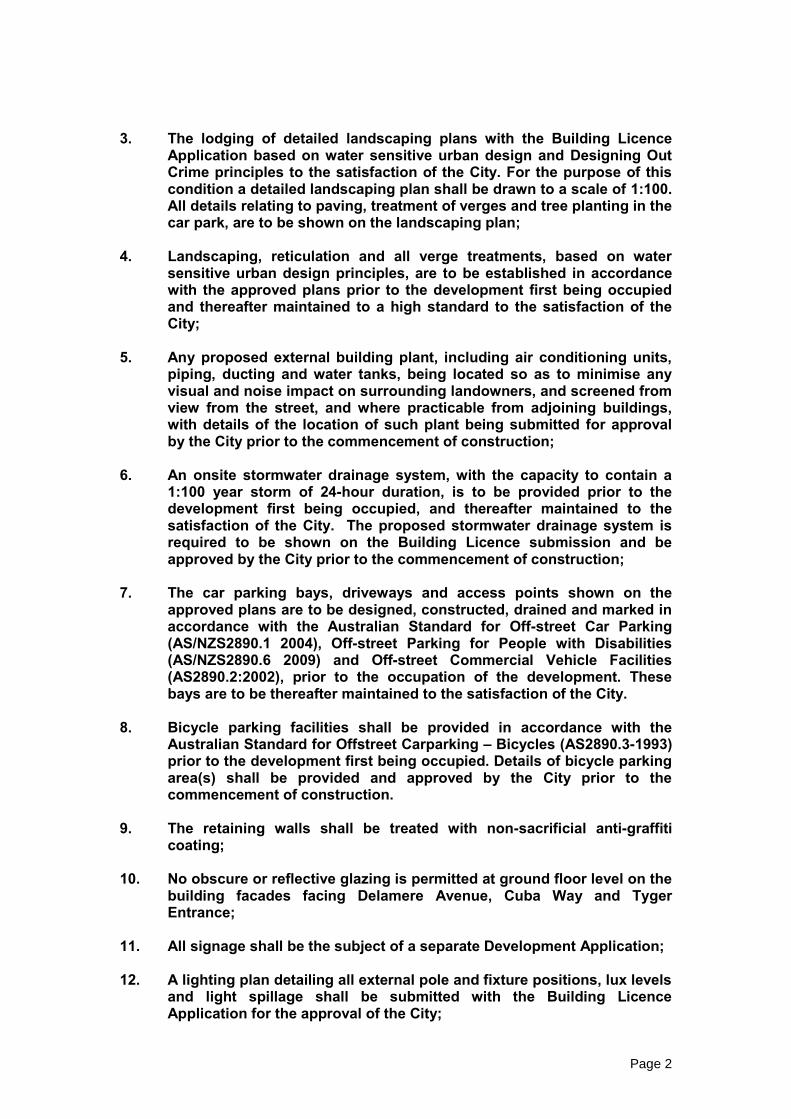
3. The lodging of detailed landscaping plans with the Building Licence
Application based on water sensitive urban design and Designing Out Crime principles to the satisfaction of the City. For the purpose of this condition a detailed landscaping plan shall be drawn to a scale of 1:100. All details relating to paving, treatment of verges and tree planting in the car park, are to be shown on the landscaping plan;
4. Landscaping, reticulation and all verge treatments, based on water
sensitive urban design principles, are to be established in accordance with the approved plans prior to the development first being occupied and thereafter maintained to a high standard to the satisfaction of the City;
5. Any proposed external building plant, including air conditioning units,
piping, ducting and water tanks, being located so as to minimise any visual and noise impact on surrounding landowners, and screened from view from the street, and where practicable from adjoining buildings, with details of the location of such plant being submitted for approval by the City prior to the commencement of construction;
6. An onsite stormwater drainage system, with the capacity to contain a
1:100 year storm of 24-hour duration, is to be provided prior to the development first being occupied, and thereafter maintained to the satisfaction of the City. The proposed stormwater drainage system is required to be shown on the Building Licence submission and be approved by the City prior to the commencement of construction;
7. The car parking bays, driveways and access points shown on the
approved plans are to be designed, constructed, drained and marked in accordance with the Australian Standard for Off-street Car Parking (AS/NZS2890.1 2004), Off-street Parking for People with Disabilities (AS/NZS2890.6 2009) and Off-street Commercial Vehicle Facilities (AS2890.2:2002), prior to the occupation of the development. These bays are to be thereafter maintained to the satisfaction of the City.
8. Bicycle parking facilities shall be provided in accordance with the
Australian Standard for Offstreet Carparking – Bicycles (AS2890.3-1993) prior to the development first being occupied. Details of bicycle parking area(s) shall be provided and approved by the City prior to the commencement of construction.
9. The retaining walls shall be treated with non-sacrificial anti-graffiti
coating; 10. No obscure or reflective glazing is permitted at ground floor level on the
building facades facing Delamere Avenue, Cuba Way and Tyger Entrance;
11. All signage shall be the subject of a separate Development Application; 12. A lighting plan detailing all external pole and fixture positions, lux levels
and light spillage shall be submitted with the Building Licence Application for the approval of the City;

Page 3
13. Lighting shall be installed along all driveways and pedestrian pathways
and in all common service areas in accordance with the approved lighting plan prior to the development first being occupied to the satisfaction of the City;
14. The car parking shade trees as indicated on the approved plans shall be
installed prior to the development first being occupied. The trees shall be located within tree wells and protected from damage by vehicles and maintained to the satisfaction of the City;
15. All awnings shall have a minimum clearance of 2.75 metres above the
level of the footpath; 16. Car parking bay 21 on Lot 5002 (74) Delamere Avenue shall be
constructed, marked and set aside as a small car bay only, as detailed in the Australian Standard for Offstreet Car Parking (AS2890.1 2004) and fully contained within the lot boundary;
17. Adequate sightlines shall be provided at northern egress point of the
undercroft car park at Lot 5001 (86) Delamere Avenue (Advice Note 3 refers);
18. A notification under section 70A of the Transfer of Land Act is to be
prepared at the applicant’s cost and in a form acceptable to the City and lodged with the Registrar of Titles for endorsement on the certificates of title for lot 5002 (74) Delamere Avenue and lot 5001 (86) Delamere Avenue prior to the commencement of any development or works. The notification is to give notice that the approved plans make provision for 41 car parking bays to be provided on lot 5001 (86) Delamere Avenue for the exclusive use of patrons of, and visitors to, and employees of the occupiers of, lot 5002 (74) Delamere Avenue and that if, for any reason, including the sale or redevelopment of lot 5001, the car parking bays to be provided on lot 5001 become unavailable then the use of lot 5002 may be contrary to a condition of the development approval and may constitute an offence under the City of Joondalup District Planning Scheme No. 2.
19. The 41 car parking bays shown on the approved plans, and located on
Lot 5001 (86) Delamere Avenue, as being provided for parking, exclusively by:
(a) patrons of, and visitors to, the development on Lot 5002 (74)
Delamere Avenue; and (b) employees of the occupiers of Lot 5002 (74) Delamere Avenue,
are to be available, at all times for those purposes. 20. The development on Lot 5002 (74) Delamere Avenue is not be used or
occupied if the car parking bays referred to in condition 19 are not available at all times for the purposes referred to in condition 19.

Page 4
21. Condition 20 applies at all times, except in the event that the development on Lot 5001 (86) Delamere Avenue is undergoing construction. This exemption is to only apply for a maximum period of 24 months commencing on the date of issue of a certificate of classification, or certificate of construction compliance (as the case may be) for the development on Lot 5002 (74) Delamere Avenue.
22. Pedestrian access between Lot 5002 (74) Delamere Avenue and Lot 5001 (86) Delamere Avenue shall be constructed in accordance with the approved parking management strategy plans. Proposed pedestrian access routes shall be indicated on the Building Licence submission and be approved by the City prior to the commencement of construction.
23. All car parking bays depicted on the parking management strategy
plans as being for the purposes of customer parking on Lot 5002 shall be marked and permanently set aside for this purpose.
Advice Notes: 1. In reference to condition 2 it is considered the use of 240 litre carts
would be appropriate in this instance due to the limited manoeuvring space for refuse vehicles;
2. In reference to condition 2 a refuse management plan is required which
must consider the total amount of waste that would be expected, the number and type of bins proposed, the frequency of collection, method of collection and other issues affecting the handling of waste.
3. Further to condition 17 the applicant/owner is advised that relocation of
the egress point three bays south will allow for the provision of adequate sightlines upon exit from the undercroft at Lot 5001 (86) Delamere Avenue.
4. In reference to condition 21 above, the applicant is advised that the 41
parking bays required on Lot 5001 (86) Delamere Avenue, shall be provided at the time of commencement of operations for any or all of the development on Lot 5002 (74) Delamere Avenue, until such time as construction substantially commences on Lot 5001 (86) Delamere Avenue. These bays must then be made available permanently, and in perpetuity, within 24 months of the issue of the certificate of classification for the development at Lot 5002 (74) Delamere Avenue.
5. The applicant and the owner are advised that, there is an obligation to
design and construct the premises in compliance with the requirements of the Environmental Protection Act 1986.
6. The development shall comply with the Sewerage (Lighting, Ventilation
and Construction) Regulations 1971. 7. The bin storage areas shall be provided with a concrete floor graded to
a 100mm industrial floor waste gully connected to sewer. A hose cock must be provided to bin store area.
Page 5
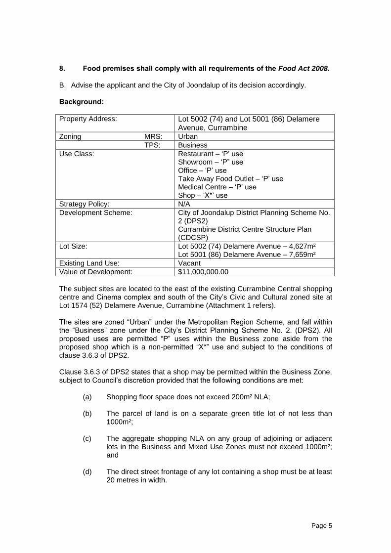
8. Food premises shall comply with all requirements of the Food Act 2008. B. Advise the applicant and the City of Joondalup of its decision accordingly. Background:
Property Address: Lot 5002 (74) and Lot 5001 (86) Delamere Avenue, Currambine
Zoning MRS: Urban
TPS: Business
Use Class: Restaurant – ‘P’ use Showroom – ‘P” use Office – ‘P’ use Take Away Food Outlet – ‘P’ use Medical Centre – ‘P’ use Shop – ‘X*’ use
Strategy Policy: N/A
Development Scheme: City of Joondalup District Planning Scheme No. 2 (DPS2) Currambine District Centre Structure Plan (CDCSP)
Lot Size: Lot 5002 (74) Delamere Avenue – 4,627m² Lot 5001 (86) Delamere Avenue – 7,659m²
Existing Land Use: Vacant
Value of Development: $11,000,000.00
The subject sites are located to the east of the existing Currambine Central shopping centre and Cinema complex and south of the City’s Civic and Cultural zoned site at Lot 1574 (52) Delamere Avenue, Currambine (Attachment 1 refers). The sites are zoned “Urban” under the Metropolitan Region Scheme, and fall within the “Business” zone under the City’s District Planning Scheme No. 2. (DPS2). All proposed uses are permitted “P” uses within the Business zone aside from the proposed shop which is a non-permitted “X*” use and subject to the conditions of clause 3.6.3 of DPS2. Clause 3.6.3 of DPS2 states that a shop may be permitted within the Business Zone, subject to Council’s discretion provided that the following conditions are met: (a) Shopping floor space does not exceed 200m² NLA;
(b) The parcel of land is on a separate green title lot of not less than 1000m²;
(c) The aggregate shopping NLA on any group of adjoining or adjacent
lots in the Business and Mixed Use Zones must not exceed 1000m²; and
(d) The direct street frontage of any lot containing a shop must be at least
20 metres in width.

Page 6
The proposed shop meets the conditions of Clause 3.6.3 and is considered an appropriate land use in this instance. The sites are also subject to the requirements of the Currambine District Centre Structure Plan (CDCSP). The Currambine District Centre is bound by Marmion Avenue to the west, Shenton Avenue to the south, and Delamere Avenue to the north and east. At its meeting held on the 17 March 2009, Council granted conditional approvals for the construction of developments on both the subject sites consisting of showrooms, offices, food hall, convenience store and shop. Those approvals were not acted on and have since lapsed. A further application for development at Lot 5002 (74) Delamere Avenue, Currambine was previously lodged with the City on the 31 June 2011, with that application now superseded by this proposal. Details: The proposed development will be comprised of the following: Lot 5002 (74) Delamere Avenue
A 55 bay undercroft car park immediately adjacent to the western boundary;
A two storey building immediately adjacent to the western boundary above the undercroft, comprising of offices and showrooms;
A two storey restaurant on the northern portion of the site, incorporating both an inside and outside dining area. This is intended to be used as a Dome Cafe;
A single storey building on the street boundary (Delamere Avenue), comprising a take away food outlet, office and medical centre (dental surgery) for two practitioners; and
40 at-grade car parking bays with a shade tree provided for every four car bays.
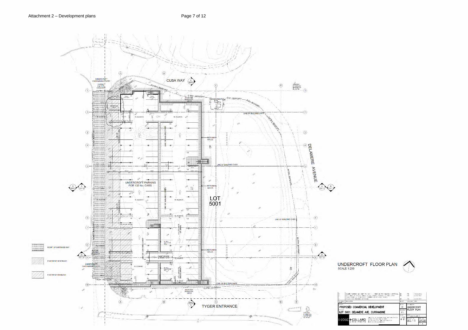
Lot 5001 (86) Delamere Avenue
A 132 bay undercroft car park immediately adjacent to the western boundary;
A two storey building immediately adjacent to the western boundary above the undercroft comprising of offices and showrooms;
A single storey building immediately adjacent to the northern boundary comprising a shop and restaurant;
A single storey building on the southern boundary comprising showrooms and offices; and
75 at-grade car parking bays. Legislation & policy: Legislation
City of Joondalup District Planning Scheme No. 2
3.6 The Business Zone

Page 7
3.6.3 A shop may be permitted in the Business Zone, subject to Council’s
discretion after giving notice in accordance with Clause 6.7, and provided the following conditions have been met:
(a) Shopping floor space does not exceed 200m² NLA; (b) The parcel of land is on a separate green title lot of not less than
1000m²; (c) The aggregate shopping NLA on any group of adjoining or
adjacent lots in the Business and Mixed Use Zones must not exceed 1000m²; and
(d) The direct street frontage of any lot containing a shop must be at
least 20 metres in width.
4.5 Variations to site and development standards and requirements 4.5.1 Except for development in respect of which the Residential Planning
Codes apply and the requirements set out in Clauses 3.7.3 and 3.11.5, if a development is the subject of an application for planning approval and does not comply with a standard or requirement prescribed under the Scheme, the Council may, notwithstanding that non-compliance, approve the application unconditionally or subject to such conditions as the Council thinks fit.
4.5.2 In considering an application for planning approval under this clause,
where, in the opinion of Council, the variation is likely to affect any owners or occupiers in the general locality or adjoining the site which is subject of consideration for the variation, the Council shall:
(a) Consult the affected parties by following one or more of the
provisions for advertising uses pursuant to clause 6.7.1; and (b) Have regard to any expressed views prior to making its decision to
grant the variation. 4.5.3 The power conferred by this clause may only be exercised if the
Council is satisfied that:
(a) Approval of the proposed development would be appropriate having regard to the criteria set out in Clause 6.8; and
(b) The non-compliance will not have any adverse effect upon the occupiers or users of the development or the inhabitants of the locality or upon the likely future development of the locality.
4.8 Car Parking Standards
4.8.2 The number of on-site car parking bays to be provided for specified development shall be in accordance with Table 2. Where development is not specified in Table 2 the Council shall determine the parking

Page 8
standard. The Council may also determine that a general car parking standard shall apply irrespective of the development proposed in cases where it considers this to be appropriate.
6.8 Matters to be considered by Council
6.8.1 The Council when considering an application for Planning Approval shall have due regard to the following:
(a) interests of orderly and proper planning and the preservation
of the amenity of the relevant locality; (b) any relevant submissions by the applicant; (c) any agreed Structure Plan prepared under the provisions of
Part 9 of the Scheme; (d) any planning policy of the Council adopted under the
provisions of clause 8.11 (e) any other matter which under the provisions of the Scheme
the Council is required to have due regard; (f) any policy of the Commission or its predecessors or
successors or any planning policy adopted by the Government of the State of Western Australia;
(g) any relevant proposed new town planning scheme of the Council or amendment or proposed Metropolitan Region Scheme Amendment insofar as they can be regarded as seriously entertained planning proposals;
(h) the comments or wishes of any public or municipal authority received as part of the submission process;
(i) the comments or wishes of any objectors to or supporters of the application;
(j) any previous decision made by the Council in circumstances which are sufficiently similar for the previous decision to be relevant as a precedent, provided that the Council shall not be bound by such precedent; and
(k) any other matter which in the opinion of the Council is relevant.
Currambine District Centre Structure Plan City of Joondalup Local Planning Policies
Environmentally Sustainable Buildings in the City of Joondalup Encouraging the integration of environmentally sustainable design principles rather than mandating them, the policy requires applicants to complete the City’s Environmentally Sustainable Checklist demonstrating that the development has been designed and assessed against a national recognised rating tool. (Attachment 5 refers).
State Government Policies
Nil

Page 9
The proposal generally complies with the aforementioned legislation and polices, with details of where discretion is sought contained in the following sections of this report. Consultation: Public Consultation The proposed development was advertised for a period of 21 days. A total of 128 adjoining and nearby owners were advised in writing, a sign was erected on each of the sites and the details of proposals were placed on the City’s website. Consultation ended on 6 February 2012. A total of 10 responses were received during the consultation period, of which 2 were objections, and the remaining 8 submissions stated no objections to the proposal. It should be noted that the previous development application for Lot 5002 (74) Delamere Avenue was advertised for a period of 21 days ending on the 31 August 2011. A total of 16 responses were received to that proposal, of which 10 were objections, and the remaining 6 submissions stated no objections.
Consultation with other Agencies or Consultants The application was not required to be referred to any other agency or consultant. Planning assessment: The application is for a new development over two lots bounded by Currambine Central shopping centre to the west, a proposed Community Centre and public open space to the north, a vacant lot to the south and Delamere Avenue and existing residential properties to the east. The site is located within the Business Zone of the CDCSP, which guides development within the area. The objectives of the Business Zone are:
To create an active focus for the community with a diversity of non-retail mainstreet uses that generate day and evening activity;
To allow appropriate businesses to locate and develop in close proximity to residential areas for the convenience of the community;
Encourage high standards of “Main Street” built form and an active edge to create an attractive facade to vehicle and pedestrian routes providing visual amenity and interaction;
Provide efficient vehicle access and circulation with pedestrian priority; and
Encourage a high level of passive surveillance of public and private spaces. Land Use The proposed land uses within the development are all permitted land uses; other than the proposed shop land use which is an “X*” use under the City’s District Planning Scheme No 2 and are considered to be compatible with one another and the existing and proposed surrounding uses, including the Currambine residential area.

Page 10
The proposed uses will contribute to the mixture of day time and night time commercial, retail and entertainment services that the Currambine District Centre is expected to provide to the surrounding community and satisfy the objectives of the Business Zone of DPS2 and the CDCSP. Design variations to the CDCSP The proposed development is subject to the provisions of both the Business zone and Commercial zone of the CDCSP. The proposal seeks to vary the following requirements of the CDCSP, with those items of non-compliance summarised below in bold:
Provision Lot 5002 (74) Delamere Avenue
Lot 5001 (86) Delamere Avenue
(ii) Urban edges are to be zero setbacks other than for minor recesses of up to 1.5m deep and a maximum of 3.0m long.
Setbacks of between 1.4m and 6.2m
Setbacks of between nil and 6.0m
(iv) Urban and non-urban edges shall be designed to have active frontages towards vehicle and pedestrian routes and at grade parking areas with continuous awnings and/or colonnades
Active frontages to all edges with differing openings and entrance points. Continuous awnings not provided to external building edges.
Active frontages to all edges with differing openings and entrance points. Continuous awnings not provided to external building edges.
(vi) Loading bays are to be located away from the Urban edge and are to be no more than 15 metres wide or otherwise located in a service yard away from pedestrian use.
Loading bay to the Delamere Avenue frontage.
All loading bays located internally to the site and less than 15.0m in width.
(ix) Other than for areas of blank facade allowed for under previous clauses, building frontages are to comprise a minimum 70% if windows and visually permeable doors. Window sills shall be set no less than 600mm from the ground floor level, open shop fronts are encouraged
Delamere Avenue frontage = 34.5% glazing Cuba Way frontage = 20% glazing Sill heights set to the ground
Delamere Avenue frontage = 26.5% glazing Cuba Way frontage = 24% glazing Tyger Entrance frontage = 25% glazing Sill heights set to the ground
(x) Access and circulation shall reinforce the creation of sub blocks akin to a fine grain town centre. Urban edges and non-urban
Delamere Avenue access 42.5m wide Cuba Way access 15.0m
Delamere Avenue access 14.4m wide Cuba Way access 14.0m wide

Page 11
edges may include breaks for access of up to 15m wide. These shall be no closer than 40 metres apart.
Tyger Entrance access 14.0m wide
(xi) A continuous footpath (3m minimum) shall be provided along the building edge other than where a loading bay abuts the building or vehicle crossover is present.
No continuous footpath to external building edges. 3.0m wide footpaths provided internally.
No continuous footpath to external building edges. 3.0m wide footpaths provided internally.
Design variations to the DPS2 The proposal also seeks to vary the following requirements of DPS2, with those items of non-compliance summarised in bold below:
Provision Lot 5002 (74) Delamere Avenue
Lot 5001 (86) Delamere Avenue
Total
4.8.2 The number of on-site car bays in accordance with Table 2
95 bays provided with 136 bays required
208 bays provided with 168 bays required
303 bays provided with 304 bays required.
4.12.1 A minimum of 8% of an area of a development site shall be designed, developed, maintained as landscaping
8.9% 5.4% N/A
4.12.2 When a proposed development includes a car parking area abutting a street, an area no less than 3.0 metres wide within the lot along the street boundaries shall be designed, developed and maintained as landscaping
Landscaping strip of nil, increasing to 6.0m at Delamere Avenue Minimum landscaping strip provided for the remainder.
Landscaping strip of 0.7m at Tyger Entrance. Minimum landscaping strip provided for the remainder.
N/A
4.12.3 Landscaping shall be carried out on all those areas of a development site which are not approved for buildings, accessways, storage purposes or car parking with the exception that shade trees shall be planted and maintained by
Landscaping provided as required. Shade trees provided.
Landscaping provided as required. No shade trees provided to the western at grade portion of car parking.
N/A

Page 12
the owners in car parking areas at the rate of one tree for every four (4) car parking bays to the Council’s satisfaction.
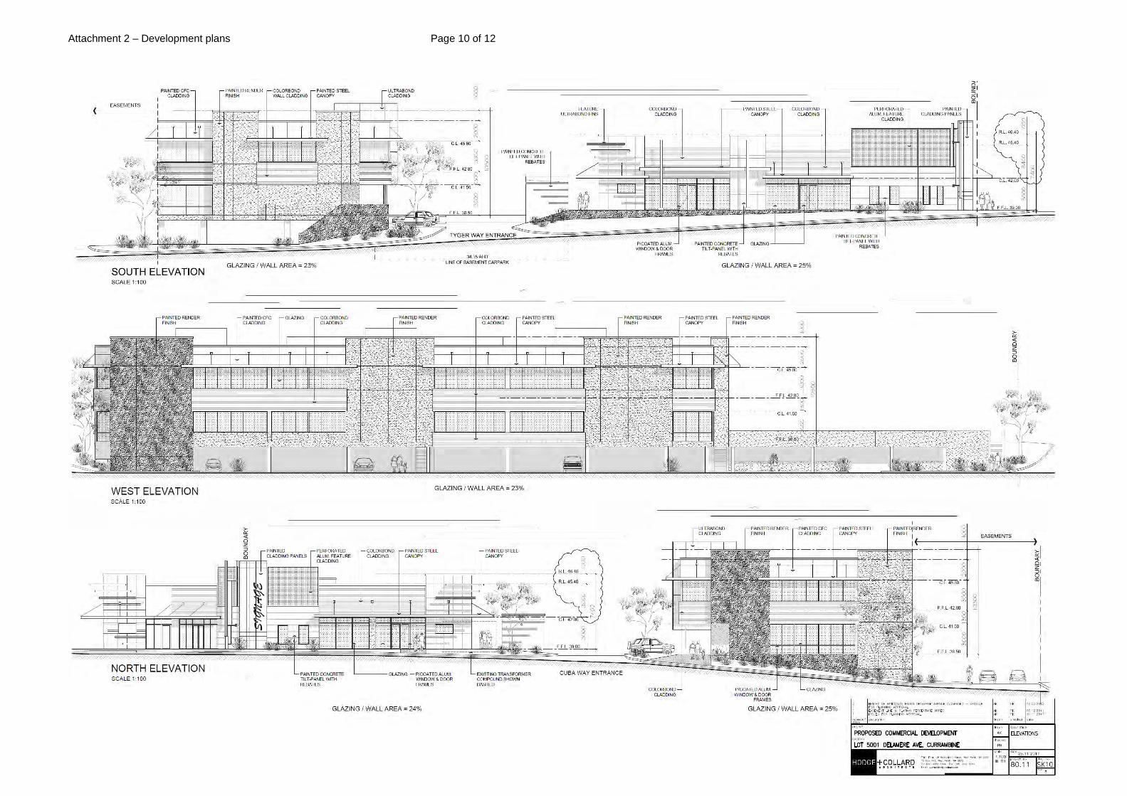
Setback to urban edges The CDCSP requires buildings to have a nil setback to the front property where that boundary is designated as an ‘urban edge.’ This is to provide for interaction with the streetscape in order to encourage and frame street activity. In the case of Lot 5002 (74); Delamere Avenue and Cuba Way are dedicated urban edges. The applicant proposes setbacks of between 1.4 and 6.2 metres to these frontages. In the case of Lot 5001 (86); Delamere Avenue, Cuba Way and Tyger Entrance are dedicated urban edges. The applicant proposes setbacks of between nil and 6.0 metres to these frontages. It is noted that the urban edge frontages proposed are not consistent with the objectives of the CDCSP, however, the developments still generally provide an attractive and interactive frontage through the use of glazing and pedestrian entry points, with visual exposure maintained on both sites to those buildings located at the western boundaries. Building Frontages with less than 70% glazing
Required Proposed Complies Lot 5002 (74) Delamere Avenue frontage
70% 34.5% No
Cuba Way frontage 70% 20% No
Lot 5001 (86) Delamere Avenue frontage
70% 26.5% No
Cuba Way frontage 70% 24% No
Tyger Entrance 70% 25% No
The applicant seeks approval for reduced glazing to the dedicated urban edge building frontages of both developments as required under the CDCSP. Where the structure plan requires 70% glazing, the majority of the glazing provided accumulates to less than 30% per frontage. The glazing provided however does still allow for surveillance onto all urban edge boundaries, with large ground floor windows and pedestrian entry points. The structure plan also requires all windows to be a minimum of 600 millimetres above ground floor level. This proposal incorporates a number of windows on both sites which begin at ground level. Whilst this is a variation to CDCSP requirements, this is consistent with other developments approved in the Currambine District Centre.

Page 13
Loading bay adjacent to the urban edge Approval is sought for a screened loading bay at Lot 5002 (74) Delamere Avenue located adjacent to the Delamere Avenue frontage and nearby pedestrian footpath. The loading bay is considered acceptable as it is screened from view from the pedestrian foot path by a solid wall and landscaping area along Delamere Avenue. Footpaths The CDCSP requires all developments to have footpaths with a minimum width of three metres surrounding the proposed building. 3.0 metre paths have been provided internally to both sites; however no footpaths have been proposed surrounding the buildings. The development has been designed for the majority of entry points to be internal to the developments. Existing footpaths are currently in place along the Delamere Avenue frontages and along the Cuba Way frontage of Lot 5002 (74) Delamere Avenue. The applicant proposes to extend pedestrian paths at Lot 5001 (86) Delamere Avenue towards the Currambine Central shopping centre to the east on the Tyger Entrance verge. It is considered that the existing and proposed extensions to the pedestrian network are sufficient in this instance, providing a safe and efficient route for pedestrian traffic. Access and Circulation Urban and non-urban edges may include breaks for vehicles up to 15.0 metres wide. In this instance discretion is sought for a break of 42.5m at the Delamere Avenue, urban edge frontage of Lot 5002 (74) Delamere Avenue. It is considered that despite a break of 42.5 metres, commercial exposure is maintained, with visual exposure provided additionally to the two storey building to the western boundary, heightening interest. Pedestrian priority is still maintained with an existing 2.4m shared footpath providing access within the break. No continuous awnings to external building frontages The applicant seeks to vary the CDCSP requirement for continuous awnings to the external building frontages. This is considered a minor variation which is appropriate given that canopies are proposed within the development to those areas where there is expected to be a high volume of pedestrian traffic. The proposed locations of the canopies are sufficient in providing adequate weather protection, encouraging pedestrian priority. Landscaping The proposal includes a variation to the 3.0m landscaping strip that is required by DPS2 where a car parking area abuts a street. This variation occurs on Lot 5002 (74) Delamere Avenue where the car park abuts the Delamere Avenue frontage and on Lot 5001 (86) Delamere Avenue where the car park abuts Tyger Entrance. Both are considered minor variations to the requirement of DPS2, with sufficient landscaping strips provided to the remainder of the development.

Page 14
A variation is also sought for Lot 5001 (86) Delamere Avenue with approval sought for total landscaping to 5.4% of the site in lieu of the DPS2 requirement of 8%. It is considered that sufficient landscaping has been provided to soften the development as seen from all frontages, with a large amount of landscaping to be provided within the existing verge. Lot 5001 (86) Delamere Avenue also seeks to vary the DPS2 requirement for trees to be provided within the car park area at a rate of one per every four car parking bays. Whilst shade trees have been provided for the at grade car park which has access to Delamere Avenue as well as within a portion of the at grade car park with access to both Cuba Way and Tyger Entrance, no trees are proposed to the western portion of this car park. It is considered that due to the undercroft car park being constructed underneath this car park, it would be difficult for the planting of shade trees to occur and as such it is appropriate to vary this requirement. Car Parking Car parking is calculated based on the individual land uses proposed in accordance with Table 2 in DPS2. The following table sets out the car parking requirements of DPS2:
No 74 (Lot 5002) Delamere Avenue Proposed Use Required by DPS2
Restaurant (Greater of 1 per 5m² of dining room or one per four guests)
312m² dining area = 62.4 (63) bays
Take Away Food Outlet (One per four guests in seated area plus seven per 100m² NLA for non seating service areas)
66m² = 7 bays
Showroom/Office (One bay per 30m² of NLA)
1655m² NLA = 55.16 (56) bays
Medical Centre (Five bays per practitioner)
2 practitioners = 10 bays
Total Bays Required 136 bays
Total Bays Provided 95 bays
No 86 (Lot 5001) Delamere Avenue Proposed Use Required by DPS2
Shop (7 bays per 100m² NLA)
200m² NLA = 14 bays
Restaurant (1 Per 5m² of dining)
260m² = 52 bays
Showroom/Office (One bay per 30m² of NLA)
3040m² = 101.3 (102) bays
Total Bays Required 168 bays
Total Bays Provided 208 bays
Overall Bays Required 304 bays Overall Bays Provided 303 bays

Page 15
A combined car parking shortfall of 0.3% is sought with 303 bays provided in lieu of the required 304 bays. A shortfall of 30.14% or the equivalent of 41 bays is sought for Lot 5002 (74) Delamere Avenue, however it is proposed that any car parking shortfall will be addressed through the surplus of car parking available at Lot 5001 (86) Delamere Avenue. A parking management strategy has been included as part of this submission (Attachment 3 refers), which indicates that staff parking for those employed to work on Lot 5002 will be provided, for the most part, within the undercroft of Lot 5001. Twenty six staff bays are proposed to be provided within the undercroft of Lot 5002, effectively leaving 69 bays remaining for customer parking. A condition has been recommended by the City for all staff parking bays to be marked and permanently set aside to ensure parking is sufficiently managed. Pedestrian links between the two sites have been incorporated into the design of the development, with pedestrian access between the lots defined by the inclusion of indicative bollards at pedestrian crossing points and raised plateau paving (Attachment 3 refers). It is considered that the proposed modes of crossing are satisfactory in ensuring the pedestrian priority objective of the structure plan is maintained as well as completed in a safe manner for both pedestrian and vehicle access. The City also recommends a condition of approval requiring a section 70a notification to be placed on the titles of the two properties, and any resulting strata titles. The notification is to give notice to the owners and prospective purchasers that the approved plans make provision for 41 car parking bays to be provided on Lot 5001 (86) Delamere Avenue. The reciprocity between the two sites is considered sufficient in justifying the proposed car parking shortfall at Lot 5002 (74) Delamere Avenue and ensuring that potential spill over effects onto Delamere Avenue are minimised. A condition of approval is recommended to ensure that the reciprocity between the two sites is maintained in perpetuity. Public Consultation Public consultation was undertaken as part of the assessment process (refer to the Consultation details section of this report). The following outlines concerns raised by the objectors: Key issues arising from public consultation
The proposed take away food outlet is in close proximity to residential dwellings. These uses would promote odours, littering and anti-social behaviour;
City response: Take away food outlets are a permitted “P” use under DPS2 within the Business zone. The City cannot require that takeaway food outlets not be developed on this site.

Page 16
Concerns that it is difficult to ensure that overflow parking from Lot 5002 (74) Delamere Avenue would be adequately addressed within Lot 5001 (86) Delamere Avenue given the distance between the two sites; and
City response: Refer to car parking section of this report for a detailed response on this issue.
Whether a 250 seat Dome Cafe is necessary on the site?
City response: A restaurant is a permitted “P” land use for the site. The proposal has been assessed against DPS2 and the City has used this to determine the appropriateness of the scale of the proposed restaurant.
An application which was previously submitted for Lot 5002 (74) Delamere Avenue was subject to the same consultation process in August 2011. The following outlines additional concerns raised by those objectors: Key issues arising from previous public consultation
Take away food outlets would be more appropriate along Marmion Avenue, alongside existing food outlets;
City Response: Take away food outlets are a permitted “P” use under DPS2 within the Business zone. The City cannot require that takeaway food outlets not be developed on this site.
Insufficient car parking on site may lead to parking along Delamere Avenue, impacting on the safety of the area for vehicles and pedestrians; City Response: A car parking shortfall on Lot 5002 (74) Delamere Avenue has now been addressed through a car parking surplus on Lot 5001 (86) Delamere Avenue.
The development would lead to an increase in traffic along Delamere Avenue and potential hoon behaviour;
City response: At the time of development of the CDCSP, a traffic impact study conducted by Jonathan Riley Consulting Engineers accounted for the increase in traffic that would eventuate as a result of developments throughout the district centre. The existing road network was determined to have sufficient capacity to accommodate increases in traffic.
The proposed undercroft car park may become an unsafe area promoting anti-social behaviour; and
City response: Visual surveillance to the undercroft car parks is only available from Cuba Way, Tyger Entrance and the Currambine Central shopping centre. It is anticipated that Cuba Way and Tyger Entrance would be used infrequently during the evening, providing access only to the proposed loading bay at the subject site, and access to the loading dock at Currambine Central Shopping Centre.

Page 17
Property values would be significantly impacted by the proposed development.
City response: Property values are not able to be taken into consideration as part of a planning assessment of a development application.
Conclusion: The proposed development generally complies with the requirements of DPS2 and the CDCSP with the exception of the matter discussed in this report. It is considered that the design variations should be supported as the proposal meets the objectives of the Currambine District Centre Structure Plan and the variations requested will not have an adverse impact on the amenity of adjoining or nearby properties, or the locality. The subject sites are an appropriate and acceptable location for the development of the uses proposed, with street activity to the urban edge frontages provided for in an acceptable way which is sensitive to the proximity of the development to the existing residential area. The proposed uses will contribute to the mixture of commercial and retail services that the Currambine District Centre is expected to provide to the surrounding community. It is therefore recommended that the application be approved, subject to conditions.

Attachment 1 – Location plan Page 1 of 1
Currambine Marketplace and Cinema Complex
Proposed Currambine Community Centre
location
Lot 5002 (74) Delamere Avenue
Lot 5001 (86) Delamere Avenue

Attachment 2 – Development plans Page 2 of 12

Attachment 2 – Development plans Page 3 of 12

Attachment 2 – Development plans Page 4 of 12

Attachment 2 – Development plans Page 5 of 12

Attachment 2 – Development plans Page 6 of 12
Attachment 2 – Development plans Page 7 of 12

Attachment 2 – Development plans Page 8 of 12

Attachment 2 – Development plans Page 9 of 12
Attachment 2 – Development plans Page 10 of 12

Attachment 2 – Development plans Page 11 of 12
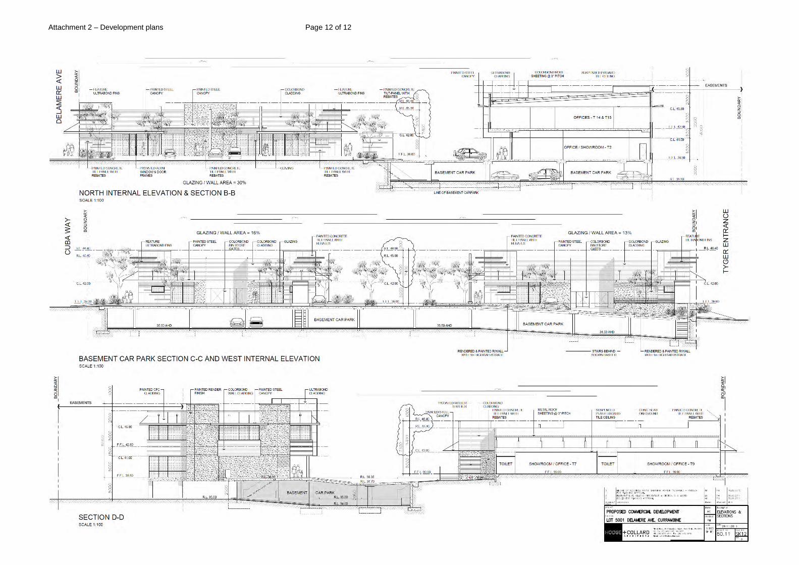
Attachment 2 – Development plans Page 12 of 12

Attachment 3 – Parking management strategy plans Page 1 of 7

Attachment 3 – Parking management strategy plans Page 2 of 7

Attachment 3 – Parking management strategy plans Page 3 of 7

Attachment 3 – Parking management strategy plans Page 4 of 7

Attachment 3 – Parking management strategy plans Page 5 of 7

Attachment 3 – Parking management strategy plans Page 6 of 7

Attachment 3 – Parking management strategy plans Page 7 of 7

Attachment 4 – Traffic statement reports

CONSULTING CIVIL & TRAFFIC ENGINEERS, RISK MANAGERS
Project: Transport Statement
OFFICE / COMMERCIAL DEVELOPMENT Delamere Avenue, Currambine
Client: HARDEN JONES ARCHITECTS
Author Geoff Miles. BE CPEng ME Dip LG(Clerk) MIEA FIPWEA, SRSA
Signature:
Date: 21 December 2011
1 ST. FLOOR, 908 ALBANY HIGHWAY, EAST VICTORIA PARK WA 6101. PHONE +61 8 9355 1300 FACSIMILE +61 8 9355 1922 EMAIL [email protected]

Consulting Civil and Traffic Engineers, Risk Managers
Page 2
Document Status
Rev No. Author Reviewed by Date Issued for Signature Date
A G Miles Client Review
21/12/11
SHAWMAC PTY LTD
ABN 51 828 614 001
PO BOX 937
SOUTH PERTH WA 6951
T: + 61 8 9355 1300
F: + 61 8 9355 1922
© Shawmac Pty. Ltd. 2011 \\Server\shawmac\Jobs Active 2011\T&T - Transport & Parking Studies\Harden Jones Architects - Delamere Ave Currambine\Report\Delamere Ave TS.doc

Consulting Civil and Traffic Engineers, Risk Managers
Page 3
CONTENTS 1. Summary ......................................................................................................................... 4
2. Introduction and Background .......................................................................................... 5
3. Proposed Development .................................................................................................... 8
4. Vehicle Access and Parking .......................................................................................... 11
4.1. Access Location ..................................................................................................................... 11
4.1.1. Delamere Avenue Accesses ........................................................................................... 11
4.1.2. Tyger Entrance Access ................................................................................................... 14
4.1.3. Cuba Way Accesses ....................................................................................................... 14
4.2. Access Pedestrian Sight Distance .......................................................................................... 16
4.3. Parking Bay Dimensions ........................................................................................................ 16
4.4. Number of Parking Bays ........................................................................................................ 18
4.5. Internal Car Park Movements ................................................................................................ 19
5. Provision for Service Vehicles ...................................................................................... 19
6. Hours of Operation ........................................................................................................ 20
7. Daily Traffic Volumes and Vehicle Types .................................................................... 20
8. Traffic Management on Frontage Streets ...................................................................... 21
9. Public Transport Access ................................................................................................ 21
10. Pedestrian Access .......................................................................................................... 22
11. Cycle Access ................................................................................................................. 22
12. Site Specific Issues ........................................................................................................ 23
13. Safety Issues .................................................................................................................. 23
14. Conclusions ................................................................................................................... 24
Attachment 1. Assessment Criteria ..................................................................................... 25
Attachment 2. Development Plans ..................................................................................... 28

Consulting Civil and Traffic Engineers, Risk Managers
Page 4
1. SUMMARY
This report provides a transport statement for the proposed development of the presently vacant sites
at Lot 5001 and Lot 5002 Delamere Avenue, Currambine. The development comprises six new
buildings across the two lots with some being single storey and some multi-storey to best utilise the
natural ground conditions and contours.
The report was commissioned by the Harden Jones Architects on behalf of Currambine District
Centre One Pty Ltd as the developer and was prepared by Shawmac Pty Ltd.
The key transport focus is on how the traffic generated by the temporary development interacts with
the existing transport network.
The transport statement concluded that:
The development would generate an increase of 759 vehicle movements around the site and
they would be distributed over the eight proposed access locations.
The greatest increase in vehicular traffic is expected on Delamere Avenue in the section to
Shenton Avenue with an increase of 440vpd.
In the evening peak period some queuing can be expected internally for exiting the site
depending upon the future development on other vacant sites within the entire precinct.
The public road infrastructure can accommodate the calculated increase in traffic volume.
The proposed parking off-street could cater for the generated maximum parking demand taht
is calculated to be 237 vehicles for the daytime land uses.
The night-time land uses have a calculated peak parking demand of 120 vehicles.
The parking was designed to comply with the Australian Standards. Some small matters of
clearance around bays in the basement car park areas need to be reconsidered.
The proposed redevelopment would not adversely affect traffic movements on the adjacent
road network.

Consulting Civil and Traffic Engineers, Risk Managers
Page 5
2. INTRODUCTION AND BACKGROUND
The statement considers the impact that the development of the mixed office and commercial use
facility on Lot 5001 and Lot 5002 Delamere Avenue, Currambine will have on the road network
through increased traffic and parking demands.
The report is prepared in response to a request from Harden Jones Architects as the architect of the
building on behalf of the owner of the site, Currambine District Centre One Pty Ltd.
The development location in relation to the major road network is shown in Figure 1.
Figure 1 - Site Locality
The development site is in Delamere Avenue at the intersection with Oakland Hills Boulevard and
Cuba Way as shown on Figure 2. The intersection has traffic control in the form of a four way
roundabout.
The site comprises a two vacant properties being Lot 5002 to the north of Cuba Way and Lot 5001
between Cuba Way and Tyger Entrance as shown in Figure 3. The land area totals 12,286m². The
site has been cleared and has some previous earthworks commenced however it is presently
undeveloped.
Along the western side of the properties are easements for three different purposes. A right-of-
carriageway exists along the full length of both lots. A drainage easement and a sewerage easement
also exist along the length of Lot 5001.

Consulting Civil and Traffic Engineers, Risk Managers
Page 6
Figure 2 - Development Location
Figure 3 - Cadastral Property Identification
The site is in an area identified by the City of Joondalup in the District Planning Scheme No.2 as
being part of a business zone. The DPS No.2 describes the intent of the business zone:

Consulting Civil and Traffic Engineers, Risk Managers
Page 7
Figure 4 - Town Planning Zoning
The surrounding land use zones are:
to the north - ‘civic and cultural’ purposes
To the west - commercial purposes
To the east - residential - part R40 and part R20
To the south - business purposes
Direct vehicular access to Delamere Avenue is not permitted from the residential properties along the
east side in the proximity of this development however on-street parking is permitted with designated
embayed areas provided for that purpose.
This statement’s purpose is to identify specific transport issues with respect to this site and is not to
access the overall transport impacts generated by the other land uses close to this property.
Consulting Civil and Traffic Engineers, Risk Managers
Page 8
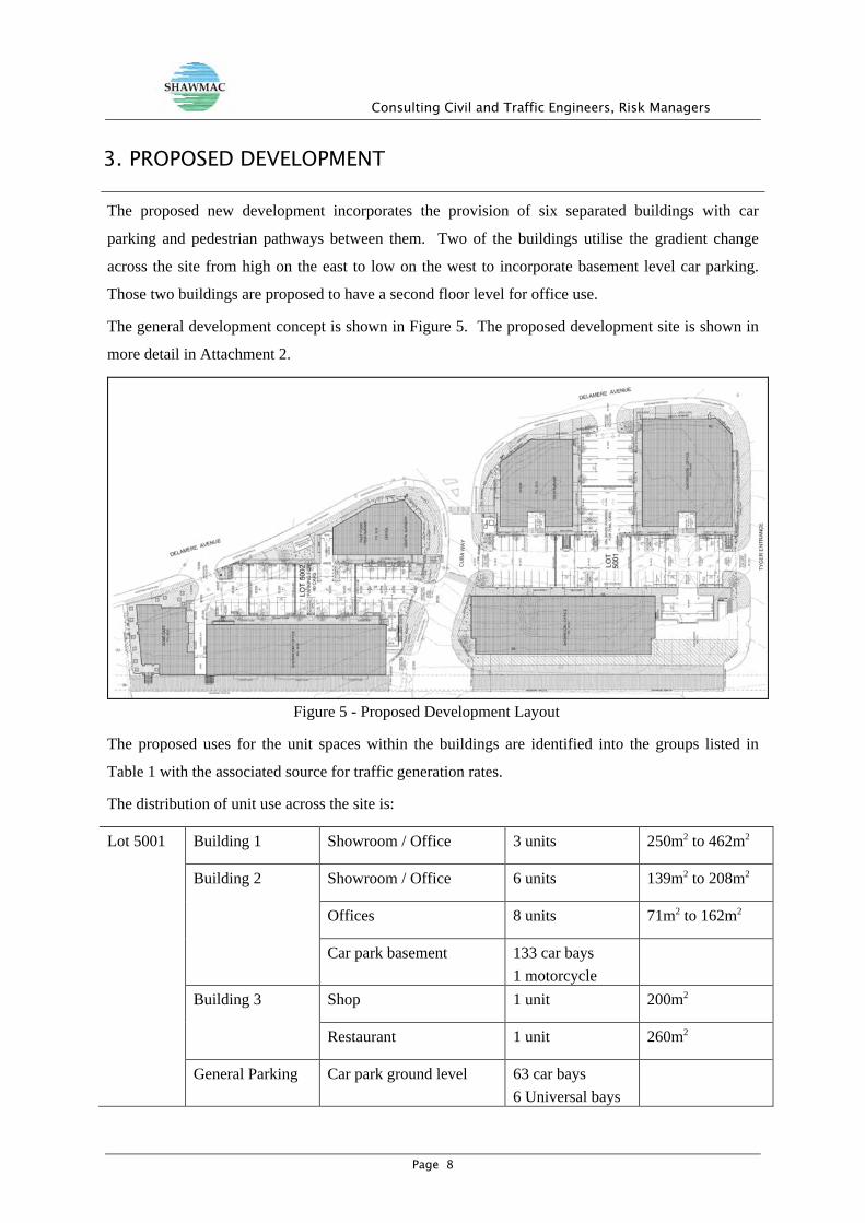
3. PROPOSED DEVELOPMENT
The proposed new development incorporates the provision of six separated buildings with car
parking and pedestrian pathways between them. Two of the buildings utilise the gradient change
across the site from high on the east to low on the west to incorporate basement level car parking.
Those two buildings are proposed to have a second floor level for office use.
The general development concept is shown in Figure 5. The proposed development site is shown in
more detail in Attachment 2.
Figure 5 - Proposed Development Layout
The proposed uses for the unit spaces within the buildings are identified into the groups listed in
Table 1 with the associated source for traffic generation rates.
The distribution of unit use across the site is:
Lot 5001 Building 1 Showroom / Office 3 units 250m2 to 462m2
Building 2 Showroom / Office 6 units 139m2 to 208m2
Offices 8 units 71m2 to 162m2
Car park basement 133 car bays 1 motorcycle
Building 3 Shop 1 unit 200m2
Restaurant 1 unit 260m2
General Parking Car park ground level 63 car bays 6 Universal bays

Consulting Civil and Traffic Engineers, Risk Managers
Page 9
Lot 5002 Building 1 Office 1 unit 80m2
Fast Food / Take-away restaurant
1 unit 197m2
Dental Surgery 1 unit 133m2
Building 2 Showroom / Office 5 units 135m2 to 215m2
Offices 8 units 60m2 to 107m2
Car park basement 44 car bays
Building 3 Dome Restaurant / Cafe 1 unit - 2 storey 483m2
Car park basement 11 car bays 1 turning area/bay
General Parking Car park ground level 37 car bays 3 Universal bays
Applying the generation rates identified produced the estimated total traffic volumes shown in Figure
6 and the estimated morning and evening peak hour movements shown in Figure 7.
Use Type Traffic Generation Rate Source / Comments
Office NSW RTA Guide to Traffic Generating Developments Identified as Office and Commercial
Office / Showroom NSW RTA Guide to Traffic Generating Developments Identified as Office and Commercial
Dental Surgery NSW RTA Guide to Traffic Generating Developments Identified as Professional consulting Rooms Only evening hourly rate provided in RTA reference
Prefer to use ITE with daily and peak hour rates.
Institution of Transportation Engineers - Trip Generation Identified as Medical Dental Office
Coffee Shop / Cafe (Dome) NSW RTA Guide to Traffic Generating Developments No survey data rates identified for coffee shop Rates for restaurant can be applicable
Lunch Bar / Evening Take-Away
NSW RTA Guide to Traffic Generating Developments No survey data rates identified for small take-away unit in RTA document Apply restaurant rate to lunch time demand having consideration of survey rates for franchised fast food outlets
Shop NSW RTA Guide to Traffic Generating Developments Survey results most applicable to shopping centres of 10,000m2 to 40,000m2 GLA
Prefer to use ITE with daily and peak hour rates for retail/showroom type use.
Institution of Transportation Engineers - Trip Generation Identified as Retail Furniture Store with lower patronage than a full sized shopping centre/ shopping mall unit.
Restaurant NSW RTA Guide to Traffic Generating Developments Rates for restaurant for evening use can be applied
Table 1 - Traffic Generation Rate Sources for Land Use Type

Consulting Civil and Traffic Engineers, Risk Managers
Page 10
Figure 6 - Estimated Traffic Generation
Figure 7 - Estimated Peak Hour Movements

Consulting Civil and Traffic Engineers, Risk Managers
Page 11
4. VEHICLE ACCESS AND PARKING
4.1. Access Location
The proposed vehicle access is for 5 crossover accesses to the public roads from the ground level car
parks, 1 crossover access to one basement car park and two accesses from the right-of carriageway
into the second basement car park. The crossover access widths are proposed to be 6.5m.
The right of carriageway, sewerage and drainage easement areas will be used directly as a car park
aisle and bays at the basement car park level creating multiple access points along the side of Lot
5001.
4.1.1. Delamere Avenue Accesses
There are two accesses proposed along Delamere Avenue. One would be between Tyger Entrance
and Cuba Way and the second would be north of Cuba Way.
Southern Access
The separation between Tyger Entrance and Cuba Way is 110m and the proposed access is half way
between the intersections at those two roads. Delamere Avenue is a divided carriageway with a
single lane in each direction in this section. It is not proposed to have a median island break as the
roundabout at Cuba Way about 45m away allows for traffic to easily travel towards the south from
this location.
Photo 1 - Proximity to Roundabout at Cuba Way
Delamere Avenue has traffic flows recorded in 2005 at a location north of the Shenton Avenue
intersection of 2,015vpd northbound and 2,065vpd southbound. This includes a portion of traffic that

Consulting Civil and Traffic Engineers, Risk Managers
Page 12
is expected to be moving to / from the shopping centre and petrol station that exist to the west of this
development site.
The ability for the crossover to be used safely to merge into the traffic flow can be assessed from the
available sight distances and the probability of there being available gaps in the traffic flow. The
Austroads documents AGRD04A-09 Guide to Road Design - Part 4A: Unsignalised and Signalised
Intersections and AGTM02-08 Guide to Traffic Management - Part 2: Traffic Theory contains the
reference information by which sight distance and gap availability can be assessed.
The gap acceptance theory indicates that there is a 28% probability of vehicles exiting from this
access will be delayed. However the delay would average 1.1seconds. The access would have the
capacity to operate with no impact on most vehicles.
The safety of entering the road is related to the available sight distance. For vehicles travelling from
Shenton Avenue there is a clear line of sight for 125m to the proposed access location. For vehicles
travelling at 50km/h the recommended minimum gap sight distance is 69m and the safe intersection
sight distance is 97m.
For vehicles turning from Tyger Entrance left into Delamere Avenue the sight distance available is
about 47m to the access location. The turning vehicles would begin moving along Delamere Avenue
at 15 to 20km/h. For vehicles travelling at 20km/h the recommended minimum gap sight distance is
42m and the safe intersection sight distance is 40m.
There is suitable sight distance and available gaps in existing traffic flows for this access to operate
satisfactorily.
The level difference between the existing road at RL39.00 and the car park at RL38.40 indicates a
fall into the site. The crossover would have to be vertically curved to prevent water runoff from the
road in the typical rainfall event. The gradient of the access across the boundary is expected to be
7.8% or 1 in 12.8 instead of the AS2890.1 recommended 1 in 20. The internal car park level could
have minor adjustment to reduce the gradient along the access.
Northern Access
The proposed access is about 90m north of Cuba Way and just north of the existing median island.
Delamere Avenue is a two-lane two-way road at that location. The road width is 8.4m and a 20m
long parking embayment exists on the east side of the road.
Delamere Avenue has traffic flows recorded in this section in 2005 0f 1,105vpd northbound and
1,224vpd southbound.
The gap acceptance theory indicates that there is a 14% probability of left turning vehicles and 23%
of right turning vehicles exiting from this access will be delayed. However the delay would average
0.4second for left turns and 1.2seconds for right turns. Similarly for the right turn entry movement

Consulting Civil and Traffic Engineers, Risk Managers
Page 13
the delay would be related to gaps in the approaching traffic so less than 12% of turning traffic would
be delayed and the average delay time would be 0.25seconds.
The access would have the capacity to operate with no impact on most vehicles.
Photo 2 - Access Location approximately position of vehicle
Sight distance to the south from this proposed access location is satisfactory towards the roundabout
at Cuba Way. To the north the curve in Delamere Avenue in conjunction with the street landscaping
appears to limit the sight distances. Photo 3 and Photo 4 show the view from and to the north side of
the access location.
Photo 3 - View to north from Northern Delamere Avenue Access Location

Consulting Civil and Traffic Engineers, Risk Managers
Page 14
Photo 4 - View to the Northern Delamere Avenue Access Location
The available sight distance is estimated to be between 85m and 90m for the approach to the rear of a
stopped vehicle doing a right turn. That is near but below the recommended minimum SISD.
The proposed location of the access could not be practically moved and retain the building and car
park layout. The option to be considered would be the removal of the turning vehicle from the
through vehicle’s path. Within the existing 8.4m wide carriageway, three lanes could not be created,
however if the City would permit a small widening on the west side by 1.2m northwards from the
proposed access location then three lanes of 3.2m width could be accommodated.
The gradient of the crossover is to be 2.8% with the car park to be slightly higher than the road. The
crossover shape is designed so that car park rain runoff waters would not flow onto the road in most
rainfall events.
4.1.2. Tyger Entrance Access
The proposed access is to be located about 60m from the Delamere Avenue intersection so
compliance exists for sight distances for traffic turning from that intersection.
The gradient of the access is noted on the design to be at the 1 in 20 recommended as a maximum in
AS2890.1.
4.1.3. Cuba Way Accesses
There are three accesses proposed from Cuba Way. One would be to Lot 5001 on the south side and
two to Lot 5002 on the north side.

Consulting Civil and Traffic Engineers, Risk Managers
Page 15
Southern Access
The access is to be about 30m from Delamere Avenue and 40m from the right of carriageway
intersection. The possibility exists for vehicles slowing to turn left into the access will require a
following vehicle to slow. The fact that following vehicles have just left a roundabout where the
circulation and turning speeds are safe at 20km/h there is adequate stopping distance available.
The design levels show the gradient would be a slight fall into the car park. The fall along Cuba Way
is steeper and that would be the direction of water flow therefore only shallow vertical curves in the
access would be necessary for drainage purposes.
Northern Central Access
The access is proposed to be located about 25m from the right-of carriageway intersection. Sight
distances of 40m will exist in both directions due to the horizontal alignments. That would comply
with the required minimum of 40m for vehicles turning at the intersections at 20km/h.
The gradient of the access is noted on the design to be at the 1 in 20 recommended as a maximum in
AS2890.1. The internal car park drainage generally falls towards this access therefore the access
would have to have minimal vertical curves to reduce the potential runoff of rainfall waters onto the
road.
Northern Basement Car Park Access
The access forms a four-way intersection with Cuba Way, the existing pavement along the easement
across Lot 5001 and the service road at the rear of the shopping centre. Clear sight distances exist
relevant to the different approach speeds along the different legs.
The design level show a slight fall from the car park to the road. As this is a basement car park
mostly covered by a building the rainfall catchment is small and little or no runoff onto the road is
expected.
Relative Positions
The separation of the basement car park access from the other two accesses is sufficient to reduce
potential interaction of traffic flow between them. A left turning vehicle exiting the basement car
park may have to wait for vehicles entering the other northern access to clear Cuba Way. There is
internal queuing length in the basement so that would not create a hazard.
The separation of the Northern Central Access and the carriageway along the easement is sufficient
that compliant drivers can make turning movements and remain lane correct. There is a potential for
non-compliant drivers to attempt to travel ‘straight line’ between the two T-junctions. That is a
hazard and could be reduced by incorporating short median splitter islands in Cuba Way and in the
easement. As Cuba Way is over 8.2m wide two lanes of 3.2m and a 1.8m wide median island could
be designed.

Consulting Civil and Traffic Engineers, Risk Managers
Page 16
The separation of the Northern Central Access and the Southern Access is about 10m at the closest
kerb lines. There is the hazard that non-compliant drivers will drive diagonally across Cuba Way.
The location is indicated on the design as being part of the pedestrian desire line for walking between
the two properties. The conflict is recognised and requires treatment to reduce the potential risk.
Treatments such as a pedestrian refuge island that also separates the traffic flows and blocks the
diagonal movement may be considered.
4.2. Access Pedestrian Sight Distance
The Australian Standard AS2890.1:2004 provides details for sight lines and distances for pedestrian
movements across an access to a car park. Those details are shown in the AS2890.1 Figure 3.3
extract. All access locations have the exit left side clearance and do not require the exit right side
clearance as they are two-lane two-way accesses.
4.3. Parking Bay Dimensions
The classification of the off-street car park in accordance with AS2890.1 is a combination of User
Class 1A and 3A as some use of the parking is to be allocated for employee use while the majority of
the parking will be for patrons of the commercial businesses. For this assessment the parking design
has been considered as needed to comply with Class 3A.
The parking bay dimensions recommended in AS2890.1 for 90° bays are 5.4m deep and 2.6m wide
with an aisle width of 6.6m.
For parking near obstacles AS2890.1:2004 in its Figure 5.2 provides dimensions for clear zones to be
provided around a parked car. This is relevant when columns or walls occur near the sides of the
bays.

Consulting Civil and Traffic Engineers, Risk Managers
Page 17
The designed 90° parking bays dimensions are 5.5m by 2.6m and the aisles are to 6.5m. The total
provided distance across two bays and one aisle would be 17.5m where AS2890.1 recommends a
minimum of 17.4m. Therefore while the precise balance between bay length and aisle width is not
numerically the same the intent of AS2890.1 has been complied with.
The majority of basement level car parking is expected to be reserved for parking allocated with the
lease of the office units above. The use of that type of parking is usually for senior employee parking
and as such the width requirement of AS2890.1 would be 2.4m. Most of bays are 2.6m wide and
would provide the clear zones sufficient for manoeuvring and opening of doors. It is noted that some
bays at 2.3m wide have been notated for use by small cars only. That can be acceptable in
accordance with AS2890.1 section 2.4.1(a)(iii) however the clear zone adjacent to walls / stairs may
not be provided in every location.
The Australian Standards AS2890.6:2009 Parking Facilities - Off-Street Parking for People with
Disabilities requires the width of the parking bay to be 2.4m dedicated as the parking bay with a
further 2.4m shared area adjacent to the dedicated area. The shared area can include pathways

Consulting Civil and Traffic Engineers, Risk Managers
Page 18
provided there if no uneven change of grade in surface across the areas. The total width for use by
persons with a disability is to be 4.8m.
The design for the Universal Bays is in excess of that width and therefore complies with AS2890.6.
4.4. Number of Parking Bays
The City of Joondalup DPS No.2 in Table 2 lists the minimum parking to be:
Consulting Rooms 5 bays per practitioner
Office 1 bay per 30m2 NLA
Restaurant Greater of 1 per 5m2 of dining area or 1 per four guests
Showroom 1 bay per 30m2 NLA
Take-away fast food outlet 1 per 4 guests in seated areas plus 7 per 100m2 NLA for non
seating serving areas
The DPS No.2 car parking calculation for the total development is then:
Quantum Daytime Bays Evening Bays
Office 1,010m2 + 780m2 60
Office / Showroom 2,030m2 + 875m2 97
Dental Surgery 1 5
Shop (isolated) 200m2 7
Restaurant - evening use 260m2 52
Restaurant - Dome cafe 312m2 or 249 seats 63 Same 63
Fast Food Restaurant 66m2 serving area 5 Same 5
Maximum Parking Provision 237 120
The parking provided in the design comprises 288 car bays, 9 universal bays and 1 motorcycle bay
for a total vehicle parking provision of 298 bays.
Recognising that the main restaurant use is in the evening with patrons arriving after the normal
office and shopping hours means that 52 bays utilised during the day for office use will be available
for the restaurant use.
Therefore adequate parking is provided in the design.

Consulting Civil and Traffic Engineers, Risk Managers
Page 19
4.5. Internal Car Park Movements
The basement car parking from internal aisles is expected to mostly be employee parking with
reserved bays therefore the drivers expect the bays to be available. The provision has been designed
for reversing vehicles out of bays and turning so that they can be driven forwards out of all aisles.
In the basement car park on Lot 5002 there is an advantage to having some public parking under the
Dome Cafe to increase the number of customer bays near that single high demand facility. If that is
allocated then an area previously identified as a car bay would have to be provided as a clear zone for
turning vehicles in when all other bays are utilised and more public drivers attempt to find parking at
the end of a long aisle.
In the ground level car park most accesses and aisles are continuous and aisles meet at right angles.
Car parking off aisles start close to the property boundaries and use of the first bays from the
boundary could result in stopping a following vehicle. There is sufficient length on the access /
crossover to have one vehicle queue clear of the through traffic along the public roads. It is unlikely
though possible that at some time more than two vehicles will want to enter the car park by the same
access and the queuing will interrupt through traffic along the road for less than a minute.
By the Delamere Avenue northern access the aisles meet the access at an oblique angle and corner
cutting could adversely affect safety at that junction and stop vehicles before they are clear of the
through traffic along Delamere Avenue. The defining of the intended traffic lanes by the use of flush
islands would reduce the unintended corner cutting.
The definition of entry from exit lanes at all accesses could benefit by the use of flush islands.
5. PROVISION FOR SERVICE VEHICLES
The demand for access by service vehicles is expected to include the regular collection of domestic
and office waste and the delivery of supplies to the restaurants / food preparation units.
Several dedicated storage areas for mobile bins are identified on the site. Waste collection from
these bin areas will be collected by trucks operating within loading bays or car park areas. Waste
collection will not be from along the public roads.
Vehicle access for the movement of goods using medium / large rigid commercial vehicles can be
through the car parks. The use of semi-trailers is possible though undesirable as they would have to
operate from within the car park aisles for parking and moving loads in that environ is a hazard.
The manoeuvring into the bin and loading bay adjacent to the Dome Cafe will require the use of part
of the nearby crossover for aligning trucks to allow for reversing movements.
Consulting Civil and Traffic Engineers, Risk Managers
Page 20
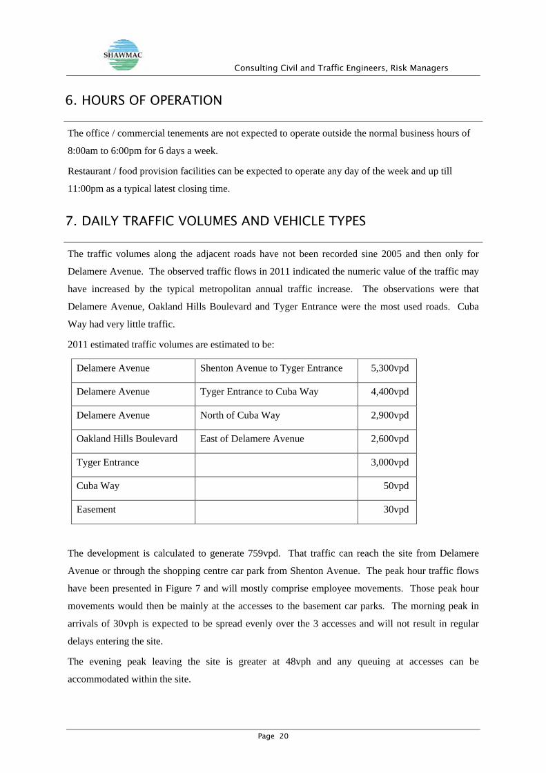
6. HOURS OF OPERATION
The office / commercial tenements are not expected to operate outside the normal business hours of
8:00am to 6:00pm for 6 days a week.
Restaurant / food provision facilities can be expected to operate any day of the week and up till
11:00pm as a typical latest closing time.
7. DAILY TRAFFIC VOLUMES AND VEHICLE TYPES
The traffic volumes along the adjacent roads have not been recorded sine 2005 and then only for
Delamere Avenue. The observed traffic flows in 2011 indicated the numeric value of the traffic may
have increased by the typical metropolitan annual traffic increase. The observations were that
Delamere Avenue, Oakland Hills Boulevard and Tyger Entrance were the most used roads. Cuba
Way had very little traffic.
2011 estimated traffic volumes are estimated to be:
Delamere Avenue Shenton Avenue to Tyger Entrance 5,300vpd
Delamere Avenue Tyger Entrance to Cuba Way 4,400vpd
Delamere Avenue North of Cuba Way 2,900vpd
Oakland Hills Boulevard East of Delamere Avenue 2,600vpd
Tyger Entrance 3,000vpd
Cuba Way 50vpd
Easement 30vpd
The development is calculated to generate 759vpd. That traffic can reach the site from Delamere
Avenue or through the shopping centre car park from Shenton Avenue. The peak hour traffic flows
have been presented in Figure 7 and will mostly comprise employee movements. Those peak hour
movements would then be mainly at the accesses to the basement car parks. The morning peak in
arrivals of 30vph is expected to be spread evenly over the 3 accesses and will not result in regular
delays entering the site.
The evening peak leaving the site is greater at 48vph and any queuing at accesses can be
accommodated within the site.

Consulting Civil and Traffic Engineers, Risk Managers
Page 21
The greatest increase in traffic flow is expected along Delamere Avenue towards Shenton Avenue. If
that increase represented 60% of the traffic generated it would be 455vpd or an 8% increase in that
traffic flow.
That increase in traffic volume is within the capacity of the road infrastructure.
The vehicle types generated from this proposed redevelopment will be mostly passenger cars with the
occasional commercial vehicle.
8. TRAFFIC MANAGEMENT ON FRONTAGE STREETS
The site is located on access roads. Shenton Avenue is the closest distributor road.
The speed limit along all adjacent roads is the default built-up area limit of 50km/h.
The observed traffic behaviour was of general compliance to the speed limit in this area due to the
geometry of the roads and the number of intersections in proximity to this site.
Specific additional treatments for the control of vehicle speed along the public roads was not
identifiable from the existing road conditions and the proposed development.
9. PUBLIC TRANSPORT ACCESS
The site is serviced by three bus services along the one route being Shenton Avenue about 200m
from this development site.
Figure 8 - Public Bus Routes
Pedestrian and cycle access is available to the bus services by existing footpaths.

Consulting Civil and Traffic Engineers, Risk Managers
Page 22
10. PEDESTRIAN ACCESS
Pedestrian movement is accommodated with existing footpaths along the public roads.
At the western end of Tyger Entrance and Cuba Way there are no direct pathway links for safe
pedestrian movement into the shopping centre site.
At Tyger Entrance the pathways actually direct movement across a busy intersection. That is a
deficiency in the shopping centre pedestrian linkage.
Pedestrian access to the proposed redeveloped site is via at-grade accesses from the public streets and
the ground level car parks.
Access from the basement car park is via several sets of stairs or by using the public roads and
pathways.
Pedestrian links to the existing pathway facilities the public streets are identified in the designs to be
made.
The designs do not indicate every kerb ramp that will need to be installed along the pedestrian desire
lines for movement around the sites.
At Cuba Way the design indicates the preferred pedestrian crossing locations by the use of regulatory
crosswalk line marking. The warrants do not exist for those line markings so approval from Main
Roads WA is not expected. The crossing locations should be delineated with kerb ramps and median
refuge islands.
11. CYCLE ACCESS
Cycle accessibility is available from all public streets via the vehicle accesses and potentially via the
pedestrian pathway links.
Cycling is possible on-road along the local streets and a shared pathway along Delamere Avenue.
The Perth Bike Network plans show the site is served by good riding environments.

Consulting Civil and Traffic Engineers, Risk Managers
Page 23
Figure 9 - Perth Bike Plan Extract
The proposed development incorporates three bicycle rack parking areas to encourage alternate
transport to motorised vehicles.
12. SITE SPECIFIC ISSUES
This development site is on local access roads and is close to a major distributor road.
The development of this site would have no traffic issues that are different to those on the other
commercial / business properties in the precinct.
Vehicle noise is generated from the vehicle engine/exhaust, tyre squeal while manoeuvring and
travelling noise dependant upon the speed of vehicles. The proposed vehicle access and parking
areas being partially undercover has the potential to dampen general distribution of noise. The
nearest residential properties are screened by fencing and landscaping along Delamere Avenue.
13. SAFETY ISSUES
A review of the road network in the vicinity of the development site did not indicate any
unacceptable risks that may arise from the increased traffic flows associated with the development.
Consulting Civil and Traffic Engineers, Risk Managers
Page 24
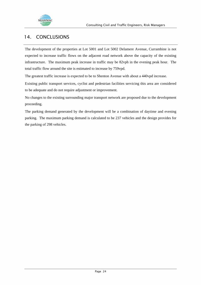
14. CONCLUSIONS
The development of the properties at Lot 5001 and Lot 5002 Delamere Avenue, Currambine is not
expected to increase traffic flows on the adjacent road network above the capacity of the existing
infrastructure. The maximum peak increase in traffic may be 82vph in the evening peak hour. The
total traffic flow around the site is estimated to increase by 759vpd.
The greatest traffic increase is expected to be to Shenton Avenue with about a 440vpd increase.
Existing public transport services, cyclist and pedestrian facilities servicing this area are considered
to be adequate and do not require adjustment or improvement.
No changes to the existing surrounding major transport network are proposed due to the development
proceeding.
The parking demand generated by the development will be a combination of daytime and evening
parking. The maximum parking demand is calculated to be 237 vehicles and the design provides for
the parking of 298 vehicles.

Consulting Civil and Traffic Engineers, Risk Managers
Page 25
Attachment 1. ASSESSMENT CRITERIA

Consulting Civil and Traffic Engineers, Risk Managers
Page 26
Checklist for a transport statement of a development
Item Status Comments / Proposals Summary
Introduction/Background
name of applicant and consultant
development location and context
brief description of development
key issues
background information
Development proposal
proposed land uses
existing land use
context with surrounds
Vehicular access and parking
access arrangements
public, private, disabled parking
set down / pick up
Service vehicles (non-residential)
access arrangements
on/off-site loading facilities
Service vehicles (residential) Not applicable
rubbish collection and emergency vehicle access
Hours of operation (non-residential only)
Traffic volumes
daily or peak traffic volumes
type of vehicles (eg cars, trucks)
Traffic management on frontage streets
Public transport access
nearest bus/train routes
nearest bus stops/train stations
pedestrian/cycle links to bus stops/train station
Pedestrian access/facilities
existing pedestrian facilities within the development (if any)
proposed pedestrian facilities within development

Consulting Civil and Traffic Engineers, Risk Managers
Page 27
existing pedestrian facilities on surrounding roads
proposals to improve pedestrian access
Cycle access/facilities
existing cycle facilities within the development (if any)
proposed cycle facilities within development
existing cycle facilities on surrounding roads
proposals to improve cycle access
Site specific issues
Safety issues
identify issues
remedial measures
Proponent’s name Company Signature Date
Transport assessor’s name Company Signature Date
Geoff Miles Shawmac Pty Ltd
21/12/11
Western Australian Planning Commission - Transport Assessment Guidelines for Developments - Volume 4 – Developments

Consulting Civil and Traffic Engineers, Risk Managers
Page 28
Attachment 2. DEVELOPMENT PLANS

Consulting Civil and Traffic Engineers, Risk Managers
Page 29

Consulting Civil and Traffic Engineers, Risk Managers
Page 30

Consulting Civil and Traffic Engineers, Risk Managers
Page 31

Consulting Civil and Traffic Engineers, Risk Managers
Page 32

Consulting Civil and Traffic Engineers, Risk Managers
Page 33

Consulting Civil and Traffic Engineers, Risk Managers
Page 34

�
����������� ������������������������ � �����
������������������� � �!"# ��� ���$���� �% ����&��'�����
%�('�����)**��)������('������)**���++�����" #, �-�.� # ���,�
/01!/��2��.��312��.��31������%��4����1+���5�)����� ,����6����*������*��+1�789:6��8�91�����;�1��,�����+��+�<���
�
���7��82:���
��0� =����! �<���/�����
���,0�� >���= �����
2 ��0� ��?�+?�+�
9��4���0� 2�� ,���������������� ,�����
Giles,
1) The vehicle access off Cuba Way was checked for access and vertical clearance with the road
pavement modified to provide a plateau surface approximately 150mm above existing
pavement level. No issues were identified with access.
The driveway pavement crossfall should be modified to provide a uniform one-way crossfall.
This would require the proposed drainage gully adjacent to the first parking bay being
relocated to the western side of the driveway.
2) The swept path for an 8.8m service vehicle was checked for the vehicle access off Cuba Way
and this is shown on the attached sketches. Vehicle movements can be made but not lane
correct. This is not an atypical situation for parking area access but may result in conflict with
vehicles moving in the opposite directions.
3) The access at the northern end of the parking area was checked for the service vehicle and as
shown on the attached sketch the entry manoeuvre cannot be completed without conflict with
a number of parking bays opposite.
4) The swept path for a standard passenger vehicle was checked for access to the one-way entry
off the lane along the western side of Lot 5001. As shown on the attached sketch the
manoeuvre cannot be achieved without conflict with the adjoining parking bays.
� � � � � � � � � � � � � � � � � � � � � � � � � � � � � � � � � � � � � � � � � � � � � � � �PDF processed with CutePDF evaluation edition www.CutePDF.com

5) Sight distance along Delamere Avenue are satisfactory for a posted speed zone of 60km/h.
The following is an extract from the Transport Statement for this development: -
The safety of entering the road is related to the available sight distance. For vehicles
travelling from Shenton Avenue there is a clear line of sight for 125m to the proposed access
location. For vehicles travelling at 50km/h the recommended minimum gap sight distance is
69m and the safe intersection sight distance is 97m.
For vehicles turning from Tyger Entrance left into Delamere Avenue the sight distance
available is about 47m to the access location. The turning vehicles would begin moving along
Delamere Avenue at 15 to 20km/h. For vehicles travelling at 20km/h the recommended
minimum gap sight distance is 42m and the safe intersection sight distance is 40m.


Clie
nt
Sca
le
Da
te
Dra
win
g N
o.
Jo
b N
o.
Title
SH
AW
MA
C P
TY
. LT
D.
P.O
. B
ox 9
37
. S
OU
TH
P
ER
TH
Ph
. 9
35
5 1
30
0 F
ax. 9
35
5 1
92
2
Em
ail sh
aw
ma
c@
up
na
wa
y.co
m


Attachment 5 – Environmentally sustainable design checklist Page 1 of 3

Attachment 5 – Environmentally sustainable design checklist Page 2 of 3

Attachment 5 – Environmentally sustainable design checklist Page 3 of 3