resolution seismic the exmouth,cretaceousflertiary tie study proposes to address this issue by...
TRANSCRIPT

AUSTRALIAN GEOLOGICAL SURVEY ORGANISATION
Marine, Petroleum and Sedimentary Resources Program
AGSO RECORD 1994153
HIGH RESOLUTION SEISMIC SURVEY OF THE EXMOUTH, BARROW, AND DAMPIER SUB-BASINS, NORTH WEST SHELF,
AUSTRALIA
CRUISE PROPOSAL

DEPARTMENT OF PRIMARY INDUSTRIES AND ENERGY
Minister for Resources: Hon. David Beddall, MP Secretary: Greg Taylor
11
AUSTRALIAN GEOLOGICAL SURVEY ORGANISATION
Executive Director: Harvey Jacka
O Commonwealth of Australia 1994
ISSN: 1039-0073 ISBN: 0 642 22172 3
This work is copyright. Apart from any fair dealings for the purposes of study, research, criticism or review, as permitted under the Copyright Act, no part may be reproduced by any process without written permission. Copyright is the responsibility of the Executive Director, Australian Geological Survey Organisation. Inquiries should be directed to the Principal Information Officer, Australian Geological Survey Organisation, GPO Box 378, Canberra City, ACT, 2601.

CONTENTS
EXECUTIVE SUMMARY .................................................................................. 1
INTRODUCTION ................................................................................................ 2
EXPLORATION HISTORY ................................................................................ 3
STRUCTURE.. .................................................................................................... 3
................................................................................ TECTONIC FRAMEWORK 5
STRATIGRAPHY .......................................................................................... 7
............................................................. HYDROCARBONACCUMULATIONS 9
GENERAL OBJECTIVES ................................................................................. 9
PROPOSED PROGRAM ...................................................................................... 10
ACKNOWLEDGEMENTS. ................................................................................. 13
REFERENCES ..................................................................................................... 14
0 Australian Geological Survey Organisation 1994

APPENDICES
1. Northern Carnarvon Basin - Oil and Gas Fields ............................................... 17
2. Wells to be tied ............................................................................................. 19
3. Waypoints ..................................................................................................... 22
. . . . . 4. Seismc acquisibon parameters. .. .. .. ....... .... . .... . .. .. .. . . . . . . . . . . . . . . . . . . 26
. . 5. Equipment to be unlised ............................................................................... 27
FIGURES
1. Location map showing the northern Carnarvon Basin and North West Shelf ... 28
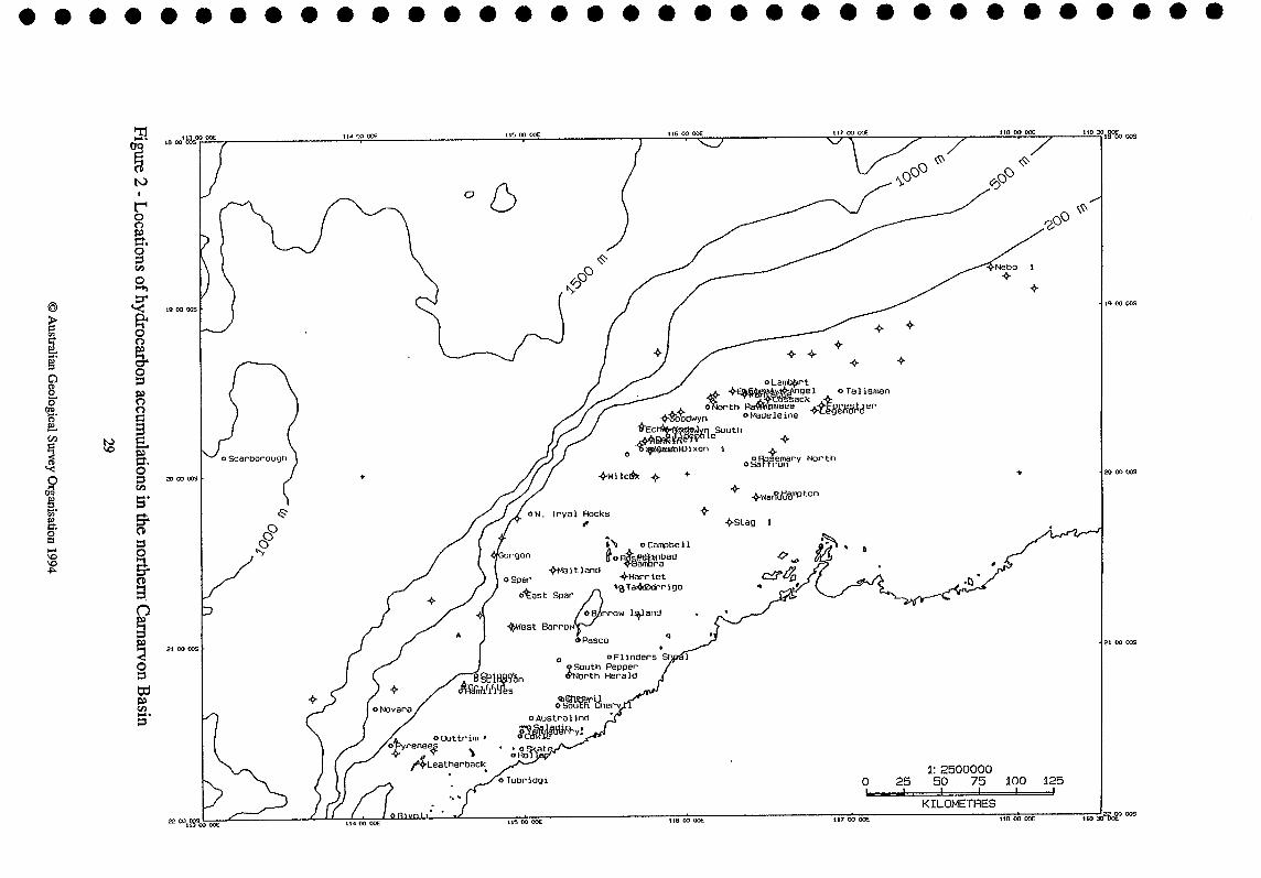
2. Locations of hydrocarbon accumulations in the northern Carnarvon Basin ....... 29
3 Location of sub-basin depocentres of the northern Carnarvon Basin ................. 30
4. Tectonic elements of the northern Carnarvon Basin ................................... 31
5. Stratigraphy of the southern North West Shelf. .............................................. 32
6. Proposed seismic lines, wells and bathymetry .................................................. 33
7. Proposed seismic lines and tie wells .................................................................. 34
8. Proposed seismic lines, well locations and tectonic elements ............................ 35
9. Proposed seismic lines, well locations, and existing AGSO deep seismic lines. 36
O Australian Geological Survey Organisation 1994

EXECUTIVE SUMMARY
Exploration in the offshore northern Carnarvon Basin during the last two decades has resulted in a number of major oil and gas discoveries. Recent discoveries in the Dampier (di Toro, 1994; Delfos, 1994), Exmouth (Bauer et al., 1994; Lawry & Carter, 1994; Mitchelmore & Smith, 1994) and Barrow (Beacher et al., 1994; Sit et al., 1994) sub-basins ensure that exploration activity is likely to remain high in these areas for the near future. However, some of these discoveries have been small fields or individual wells with residual oil columns, indicating that still greater quantities of hydrocarbons have escaped from the traps. Recent work on oil-filled fluid inclusions (Lisk & Eadington, 1994) indicates that the loss of hydrocarbons from pre-Cretaceous reservoirs and traps occurred during the past 20 million years, beginning in the Miocene. These hydrocarbons may have been lost, but could potentially have been trapped in younger Cretaceous and Tertiary reservoirs. The Carnarvon Cretaceousflertiary Tie study proposes to address this issue by collecting and interpreting a regional high-resolution seismic survey, within the broad structural and tectonic framework provided by the Continental Margins Program Northwest Shelf Project. The main objectives are:
construction of a regional, sequence-based chronostratigraphic framework for the Cretaceous and Tertiary within which the occurrence and distribution of potential seal and reservoir facies may be analyzed and predicted;
assessment of the post-Valanginian fault reactivation history of the northern Carnarvon Basin and the implications for: (a) the migration of hydrocarbons from pre-Cretaceous traps and (b) the integrity of potential Cretaceous and Tertiary seals;
determination of the probability of secondary migration and entrapment of hydrocarbons within Cretaceous and Tertiary strata.
Approximately 4240 krn of high-resolution seismic data has been proposed for acquisition by AGSO's RV Rig Seismic. The data set will comprise 23 seismic lines tying 107 wells in the Exrnouth, Barrow, Dampier and Beagle Sub-basins. These data will tie with and complement the deep-seismic grid previously acquired by AGSO in the Carnarvon Basin.
The seismic survey will be acquired using the latest high-resolution seismic technology. Data will be recorded using bubble-free GI air guns and with the following parameters: 3000m streamer; 12.5m group interval, 18.75m shot interval, recording frequency bandwidth of 4- 180Hz; 2ms sample interval; 5.5 second record length; and 80-fold CDP multiplicity. The program layout includes 5 strike lines linking the Exrnouth, Barrow, Dampier and Beagle sub- basins and 18 dip lines orthogonal to the principal Mesozoic sub-basin fault systems.
1
O Australian Geological Survey Organisation 1994

INTRODUCTION
Western Australian sedimentary basins and, in particular, those of the North West Shelf offer the best prospects for hydrocarbon discoveries that will allow Australia to maintain a high level of energy self-sufficiency into the 21st century (Purcell & Purcell, 1994). Since 1988, exploration success in the northern Carnarvon Basin (Fig. 1) has ~ m a s e d Australia's estimated reserves by 35%, providing the most significant discoveries since those of the Gippsland Basin. At the recent West Australian Basins Symposium (Perth, August, 1994), presentations were made on several discoveries and fields in the northern Carnarvon Basin, e.g. Waneaea and Cossack (di Toro, 1994); Leatherback (Bauer et al., 1994); West Muiron (Mitchelrnore & Smith, 1994); Maitland (Sit et al., 1994); Wandoo (Delfos, 1994); Rivoli (Lawry & Carter,1994); Nebo (Osborne, 1994); and several others. Some of these fields are small, or underfiilled (e.g., West Muiron; Mitchelrnore & Smith, 1994), and other discoveries sampled only residual oil columns (e.g. Leatherback; Bauer et al., 1994). In each example, a Miocene-age tectonic compressional event is invoked to explain the reactivation of faults and subsequent migration and leakage of hydrocarbons. Similarly, Woodside (1988) suggested that the main period of oil migration in the Barrow-Dampier Sub-basins was in the Middle to Late Miocene due to a "tectonic pulse" that reactivated many of the older faults.
Residual oil accumulations also have been documented in the Timor Sea (Whibley & Jacobson, 1990). In the Cartier Trough of the Vulcan Sub-basin, analysis of oil-filled fluid inclusions (Lisk & Eadington, 1994) has demonstrated that the most recent phase of oil migration was initiated in the Miocene, as in the northern Carnarvon Basin.
The compressional tectonic event responsible for reactivation of faults and oil migration has been related to collision and subduction along the northern boundary of the Australian continent during the Miocene (O'Brien et al., 1993). This event is the most recent in a series of tectonic events which have governed the sedimentary and structural history of the North West Shelf basins (AGSO North West Shelf Study Group, 1994). As part of its research program on the North West Shelf, the Marine, Sedimentary and Petroleum Resources Program of AGSO has acquired regional deep seismic data across and between the major sedimentary basins, in an effort to determine the linkages between the major structural elements and to facilitate the development of a regionally integrated structural and tectonic history for the region. Interpretation of these data demonstrate that the reactivation history of structures in North West Shelf basins has had a fundamental impact on the distribution of hydrocarbons. In the northern Carnarvon Basin, the proposed high-resolution seismic data will provide the basis for a study that will build on the tectonic and structural framework provided by the deep seismic data to address the following objectives:
construction of a regional, sequence-based chronostratigraphic framework for the Cretaceous and Tertiary within which the occurrence and distribution of potential seal and reservoir facies may be analyzed and predicted;
assessment of the post-Valanginian fault reactivation history of the northern Camarvon Basin and the implications for: (a) the migration of hydrocarbons from pre-Cretaceous traps and (b) the integrity of potential Cretaceous and Tertiary seals;
e determination of the probability of secondary migration and entrapment of hydrocarbons within Cretaceous and Tertiary strata.
2
O Australian Geological Survey Organisation 1994

EXPLORATION HISTORY'
The initial oil exploration permits on the North West Shelf were granted to Arnpol Petroleum Ltd in 1946. While these leases were primarily onshore, they did cover the offshore Carnarvon Basin out to a water depth of 100 fathoms (-183 m). In 1952, Ampol combined with Caltex to form West Australian Petroleum Pty Ltd (Wapet), and the new company drilled its first well (Cape Range 1) on a surface anticline in 1953. This well flowed oil from a small pool and provided a major impetus to exploration on the southern North West Shelf.
The first offshore seismic work was carried out by Wapet in 1961. In 1964, Wapet drilled a wildcat well on Barrow Island that discovered oil in Upper Jurassic sands. Subsequent appraisal drilling on Barrow Island showed the presence of a major oil field, principally reservoired in Cretaceous sands. In 1965, Wapet was granted acreage west of Barrow Island. At about the same time, Woodside (Lakes Entrance) Oil Co. (subsequently to become Woodside Petroleum) and associated companies were granted leases to the north and offshore from the Wapet leases. This general delineation of operations has persisted since the 1960's, with Wapet being considered the principal explorer in the Barrow Sub-basin, while Woodside is considered to be the prime explorer in the Darnpier Sub-basin.
In 1968, Woodside made a non-commercial oil discovery at Legendre 1 on the landward flank of the Darnpier Sub-basin. The major Woodside successes came in 1971, with major discoveries of gadcondensate at North Rankin 1, Goodwyn 1, and Angel 1 within or overlying fault blocks of the Rankin Platform (Fig. 2). Wapet continued the run of success on the Rankin Platform with the discovery of a major gas/condensate field in the Gorgon structure at the southwestern extremity of the platform in 1980.
Since the early 1970s, as the full potential of the North West Shelf has become apparent, exploration lease sizes have been steadily reduced and more players have become involved in exploration. During the 1980s, there has been a number of small- to medium-scale commercial and sub-commercial oil discoveries in both the Barrow and Dampier Sub-basins (eg Harriet, Talisman, Saladin, Roller, Wanaea, Cossack, Ramillies, Wandoo), and the former distinction between an "inner oil trend" and an "outer gas trend has become blurred.
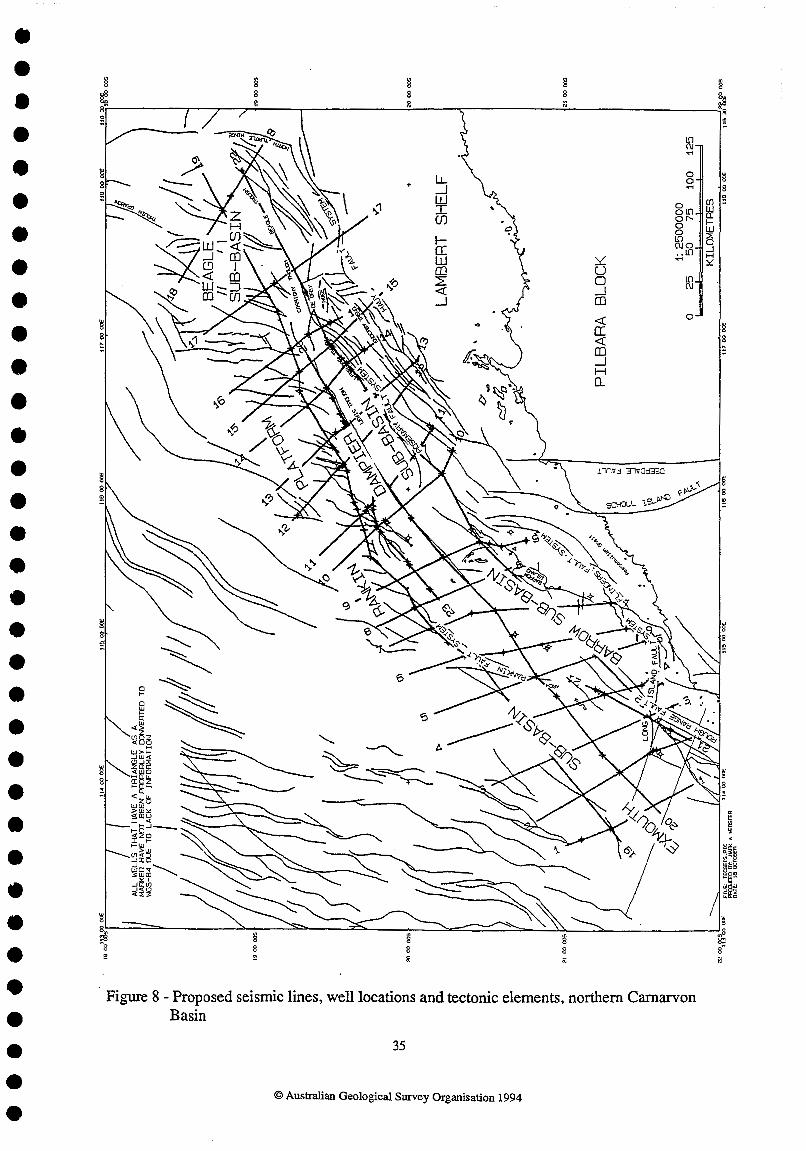
The gross structure of the North West Shelf comprises a series of generally NE-SW trending rifted Mesozoic depocentres overlying Palaeozoic NW-SE trending basins that may have constituted failed arms of an incipient rift system (Veevers, 1988). Within the northern Carnarvon Basin, the four principal shelf and upper slope depocentres - the Exmouth, Barrow, Dampier, and Beagle Sub-basins (Fig. 3) - accumulated most of their sedimentary fill in the Triassic and Jurassic, before the rift system aborted with the separation of Australia from (?)Greater India along a parallel rift system along the northwest and northern margins of the Exmouth Plateau. Although the four sub-basins have frequently been treated as separate entities in the literature, this is largely due to the concentration of individual exploration
Excerpted and modified from Stagg, 1992. 3
O Australian Geological Survey Organisation 1994

companies in one or other of the sub-basins. In fact, the sub-basins are very closely related, particularly in the case of the Barrow and Darnpier Sub-basins, and any analysis of the basin- forming mechanisms of the area should consider all of them together.
BOUNDARIES BETWEEN SUB-BASINS
The boundaries between the sub-basins of the southern North West Shelf are complex and not well-imaged or well-understood. In the southwest, the Exmouth Sub-basin is in en echelon arrangement with the Barrow Sub-basin (e.g., see figure 2 in Barber, 1988), with the boundary between the two usually being taken as the southern extension of the Rankin Trend (Alpha Arch) and the E-W trending Long Island Fault System (Fig. 4). The junction between the Barrow and Dampier Sub-basins, northeast of Barrow Island, is defined largely on the basis of a change in strike of the main depocentres, from NNE-SSW in the Barrow Sub-basin to NE- SW in the Dampier Sub-basin. This complex junction is not imaged at depth, but probably overlies a broad NW-SE trending transfer fault zone.
In the northeast, the boundary between the Dampier and Beagle Sub-basins is taken at a feature that has been referred to as the 'De Grey Nose'. This feature is probably also a complex transfer fault zone that truncates the northeastern end of the Dampier Sub-basin. To the northeast, the Beagle Sub-basin, as with the Exmouth Sub-basin, is relatively poorly known, mainly because of the lack of exploration success and the commensurate lack of modern high-quality seismic data. It appears from published tectonic elements maps and papers that the Mesozoic trend of the Beagle Sub-basin is strongly influenced by underlying orthogonal trends of the Offshore Canning Basin (the Roebuck Basin of Hocking, 1994), and in some reports it has been considered to be a Mesozoic sub-basin of the Canning Basin, as with the Rowley and Bedout Sub-basins. The Beagle Sub-basin is separated from the Bedout Sub-basin, Bedout High, and Rowley Sub-basin to the east and northeast by the N-S trending North Turtle Hinge.
INTERNAL SUB-BASIN STRUCTURES (Fig. 4)
To the southeast, the main depocentres of the rift are bomd by the Flinders Fault System in the south and the en echelon Rosemary Fault System in the north. However, the main rift- bounding faults are more properly the Scholl Island Fault in the south and the Hauy Fault System in the north. Between these two fault systems (Flinders-Rosemary and Scholl Island- Hauy), is a complex fault zone which principally includes Triassic and Permo-Carboniferous sediments. This area of the North West Shelf is one of the few areas where the Triassic- Jurassic section is thin enough that basin-forming structures can be distinguished with conventional seismic data.
Oceanwards of the Flinders and Rosemary Fault Systems, and partially overlying them, is a complex zone where Cretaceous reactivation of pre-existing structures has caused extensive faulting and buckling of the Mesozoic section. This zone hosts the Saladin, Roller, and Yamrnaderry Fields in the Barrow Sub-basin and includes the oil-prone Legendre Trend in the Dampier Sub-basin.
The major Mesozoic depocentres include the sinuous and generally NNE-SSW trending Barrow Depocentre in the Barrow Sub-basin and the more linear NE-SW trending Lewis Trough in the Dampier Sub-basin. Both depocentres are deep (-3 km Tertiary-Cretaceous and
O Australian Geological Survey Organisation 1994

>5 km Jurassic, underlain by an unknown thickness of Triassic and Palaeozoics) and relatively unfaulted downwarps.
The seaward boundary of the Barrow-Dampier rift is formed by the structurally high Rankin Platform. The Rankin 'Trend' follows the southeastern edge of the Exmouth PlateauBankin Platform megacrustal block (Woodside, 1988). The Rankin Platform has the strongest gravity signature on the southern North West Shelf and is a fundamental structure of the rift system, as well as being host to the largest hydrocarbon reservoirs. For much of its length, the Rankin Platform is strongly fault-segmented, consisting of a series of NNE-trending pivotal Triassic horsts and grabens in an en echelon arrangement, suggesting that the trend formed in response to strike-slip movements (Woodside, 1988).
In the southwest, offshore from the Barrow Sub-basin, the Rankin Platform swings round to the south, where it becomes known as the Alpha Arch (which includes the large Gorgon gas field). While the deep structure of the Alpha Arch is probably less well-known than that of the Rankin Trend, its gravity expression is as strong as that of the Rankin Platform, and it also appears to represent a fundamental basin-forming structure.
The southeast boundary of the Exmouth Sub-basin is formed by the Rough Range Fault, while the northwest boundary is ill-defined, due to the scarcity of seismic data northwest of Northwest Cape. The deep structure of the Exmouth Sub-basin consists of a series of east- tilted fault blocks that are down-thrown to the west by as much as 3000 m in the pre- Cretaceous and show evidence of some reverse movement in the late Miocene (Parry & Smith, 1988).
As with the Exmouth Sub-basin, the Beagle Sub-basin is inadequately defined and mapped. The sub-basin is a transitional area between the northern Carnarvon Basin and the Offshore Canning Basin, and contains trends that are common to both of these basins (Crostella & Barter, 1980). In the west, the two principal elements are the ENE-trending Cossigny and Beagle Troughs and the NNE-trending fault blocks of the Beagle Platform (Blevin et al., 1994), which are analogous to the Lewis Trough and Rankin Platform, respectively. In the eastern half of the sub-basin, the dominant trend becomes N-S, as represented by the Thouin Graben and North Turtle Hinge.
TECTONIC FRAMEWORK
The evolution of the northern Carnarvon Basin was influenced by a series of tectonic events that controlled both the shape of the basin and the geometry and distribution of the basin fill. The basin's history can be subdivided into phases that are defined by these events (AGSO North West Shelf Study Group, 1994):
1) Late Devonian - Initiation of a major phase of intra-continental, upper-crustal extension that continued into the Early Carboniferous - In the northern Camarvon, this event is expressed by growth on faults on the Candace Terrace.
2) Middle Carboniferous - Extension and the initiation of the Westtalian Superbasin (Yeates & others, 1987) - Crustal extension primarily along NE-trending normal faults separated by NW- trending transfer faults. These faults have probably determined the structural grain of the North
O Australian Geological Survey Organisation 1994

West Shelf for the remainder of its history. The Scholl Island Fault is an example of an extensional fault of this age (e.g. see figures 5 & 7 in Bentley, 1988).
3) Late Permian - Bedout Movement - A regional structuring event that gave rise to a varied set of structural styles in various parts of the northern Carnarvon. Extensional, transtensional and transpressional features are all observed.
4) Late Triassic - Fitzroy Movement - Late Triassic to Early Jurassic faulting is widespread, particularly on the Rankin Trend and the Exmouth Plateau. This faulting has traditionally been interpreted as extensional and has been referred to frequently as 'rift onset'; however, the steep dips on these faults, the non-systematic fault block rotations on the Rankin Trend, and fault discontinuity indicate strike-slip faulting, interpreted to be in a left-lateral sense. This was the period of initiation of the major Jurassic depocentres of the northern Carnmon, the Exmouth, Barrow, Dampier and Beagle Sub-basins. Rapid subsidence regionally led to the deposition of source rocks in many basins and sub-basin depocentres on the North West Shelf at this time, including the northern Carnarvon. Structures formed at this time serve as traps for most of the large gas fields of the North West Shelf (North Rankin, Goodwyn, West Tryal Rocks, Gorgon).
5) Mid - Late Jurassic (Callovian - Oxfordian) - Argo Breakup - This event is associated with the initiation of sea-floor spreading in the Argo Abyssal Plain and is expressed in the northern Carnarvon Basin by minor compression and erosion. The formation of a regional unconfonnity referred to as the 'Main Unconformity' (MU) occurred at this time.
6) Early Cretaceous (Valanginian) - Cuvier-Gascoyne Breakup - Sea-floor spreading in the Gascoyne and Cuvier Abyssal plains began at this time. Compression and erosion occurred in the Exmouth Sub-basin, but elsewhere the effects of this tectonic event are indistinct.
7) Mid-Cretaceous (Cenomanian) - Middle to Late Cretaceous faulting is largely restricted to NE-trending high-angle zones that are complexly structured. This phase of faulting has formed many of the structures on the oil-rich trend from Saladin to Talisman. Fault geometries again indicate dominantly left-lateral wrench motion.
8) Miocene - Collision along the northern margin of Australia commenced in the Mid- Oligocene, but the effects of that event began to be manifest along the southern half of the North West Shelf in the Miocene. A final episode of wrench movement and fault reactivation occurred in response to the collision of Australia with Timor. This activity is still evident today, particularly in the Tirnor Sea, where some faults reach seabed. Intraplate stresses within the Australia-India plate had some influence on fault reactivation in the Late Miocene. In both the Tirnor Sea basins and in the northern Carnarvon Basin, these tectonic events are thought to be responsible for initiating periods of fault reactivation with associated hydrocarbon leakage and migration that resulted in residual oil columns in several fields.
During each phase of the basin's history, reactivation of pre-existing structures is an important consequence of the basin-forming tectonic events. The impact on timing of formation and modification of traps and fluid migration pathways is of critical importance to the petroleum exploration industry. The proposed high-resolution survey will provide the quality and resolution necessary to investigate this problem.
0 Australian Geological Survey Organisation 1994

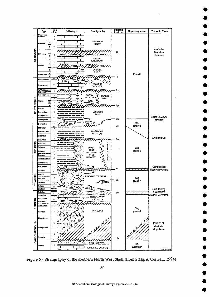
A summary of general stratigraphy is provided in Figure 5. The North West Shelf is well- explored by Australian standards, and the stratigraphy is relatively well-documented, particularly in the Barrow and Dampier Sub-basins. This following section is based upon the studies of Parry & Smith (1988) and Woodside (1988).
PALAEOZOIC
Because of the great thickness of Mesozoic sediments beneath much of the northern Carnarvon Basin, Palaeozoic sediments have only been sampled infrequently. Carboniferous and Devonian rocks have been penetrated in Rough Range-1 and at shallower depth in wells on the Peedamullah Shelf, between the Flinders Fault System and the Scholl Island Fault. The Permian Byro Group has been documented in several wells on the Peedamullah Shelf and to the south, where it includes dark shale and siltstone with some sandstone. Parry & Smith (1988) believe that this sequence deserves more attention, given that there is a distinct possibility that shales in the group have generated hydrocarbons at some time and the fact that good-quality reservoir sandstones are present in the overlying Upper Permian Chinty Formation.
MESOZOIC-CAINOZOIC
Mesozoic sedimentation commenced with the deposition of the Scythian to Ladinian Locker Shale. This sequence consists of a basal transgressive coarse paralic sandstone and a thin shelfal limestone overlain by sandy shales. The bulk of this sequence consists of a thick marine section of interbedded claystone and minor siltstone with a thin regressive sandy sequence at the top.
The Locker Shale grades upwards into the Late Triassic Mungaroo Formation, a dominantly fluvial sandstone sequence, with some coals. This sequence is the principal reservoir for the major gas accumulations of the Rankin Trend. The coarse clastics in the sequence were probably deposited in a braided channel or fluvio-estuarine environment, whereas the interbedded claystones and coals represent flood-plain deposits with minor marine influences. At the top of the Mungaroo Formation there appears to be a return to a more marine environment, and there are widespread Rhaetian shelf carbonates along the northern margin of the Exrnouth Plateau (von Rad, Haq, et al., 1992).
Overlying the Mungaroo Formation across most of the Dampier Sub-basin is a widespread Hettangian-Sinemurian sandstone sequence (North Rankin Beds; Woodside, 1988). These consist of marginal marine and fluvial sandstones interbedded with minor marginal marine and estuarine claystone, and was deposited in a nearshore/shoreline environment.
During most of the Jurassic, the thick Dingo Claystone was deposited across the southern North West Shelf. This formation is divided by Woodside (1988) into three sub-units - the lower, middle, and upper Dingo Claystone. Lateral equivalents include the more coarse- grained siliciclastic Biggada, Dupuy, Legendre, and Angel Formations. The base of the lower Dingo Claystone is marked by a transgression and an abrupt lithologic change from clastics to carbonates; this generated a basin-wide seismic marker. With deepening of the basin, the carbonates were succeeded by inner shelf calcareous claystones. In the Bajocian-Bathonian, a regional regression led to the deposition of westwards-prograding deltaic sediments across the
O Australian Geological Survey Organisation 1994

northern Barrow-Dampier Sub-basins. This regression reached its maximum extent towards the end of the Middle Jurassic, coincident with a major phase of tectonic movement. This led to the formation of the ubiquitous 'Main Unconfonnity' 0, separating the middle and upper Dingo Claystones, which has historically been interpreted as the expression of final continental breakup in the Argo Abyssal Plain. Much of the southern North West Shelf was emergent at this time; marine conditions persisted only in the rapidly-subsiding areas of the Lewis Trough and the Madeleine Trend.
The remainder of the Jurassic was characterized by sedimentation in a true divergent margin setting with predominantly fine-grained mixed clastic sediments (upper Dingo Claystone) being rapidly deposited in the Lewis Trough. Within the uppermost part of the Dingo Claystone, a marine sandstone unit (Dupuy Sandstone Member) was deposited in moderate to deep water in the vicinity of Barrow Island and possibly also around the edges of the R& Platform.
The Dingo Claystone is disconformably overlain by the Barrow Group, a generally northwards- prograding regressive sequence of clastics of mainly Neocomian age. Three units have been named within the Barrow Group - the Malouet and Flacourt Formations, respectively comprising the bottomsets and foresets/topsets of the delta, and the Flag Sandstone (Kopsen & McGann, 1985), a massive submarine fan sandstone that is a facies equivalent of the Malouet Formation. The relationship between these three formations is shown diagrammatically in Howell (1988, figure 8) and Barber (1988, figure 7).
A major transgression beginning in the late Valanginian initiated the deposition of the units of the Winning Group (successively, the Birdrong Sandstone, Muderong Shale, Windalia Sandstone Member, Windalia Radiolarite, Gearle Siltstone and Haycock Marl). It is likely that this transgression was in response to margin breakup adjacent to the Perth Basin. The basal transgressive unit consists of the Birdrong Sandstone along much of the Peedamullah Shelf, and the mid- and outer-shelf Mardie Greensand to the south of Barrow island. Both units consist of quartzose sandstone; the Birdrong also contains minor interbedded siltstone, while the Mardie Greensand is heavily glauconitic. The basal sands were succeeded by the Muderong Shale, a widespread unit of marine claystones which provides a regional seal for most of the hydrocarbon accumulations in the Barrow and Dampier Sub- basins. A minor regressive phase is indicated by the deposition of the Windalia sandstone Member, a storm-winnowed shelf sand, at the top of the Muderong Shale.
In the Aptian, a marked environmental change and a rise in sea level led to the deposition of the widespread Windalia Radiolarite, composed of radiolarite grading basinwards to radiolarian claystone, siltstone, and chert. The Windalia Radiolarite was succeeded by the Gearle Siltstone in the Barrow area and the Haycock Marl in the Dampier Sub-basin, with these units being deposited in open ocean settings.
Extensive carbonate sedimentation commenced in the Turonian with the deposition of the Toolonga Calcilutite. During the remainder of the Cretaceous, sedimentation was fairly evenly split between open marine carbonates and claystones (Korojon Calcarenite, Withnell Formation, and Miria Marl). Most of the Tertiary sequences on the North West Shelf are the result of out- and up-building of the continental shelf during a series of transgressive/regressive sea-level pulses, with the dominant sediment type being carbonate (Cardabia Group, Giralia Calcarenite, Cape Range Group).
O Australian Geological Survey Organisation 1994

HYDROCARBON ACCUMULATIONS*
The hydrocarbon fields of the northern Carnarvon Basin fall into two categories (Vincent & Tilbury, 1988) - those reservoired in the pre-'Main Unconformity' @re-MU) section (Argo Breakup, Fig. 5), and those reservoired in the post-MU section (Appendix 1).
The pre-MU fields are characterised by the fault blocks of the southeastern edge of the Rankin Platform (Rankin Trend), which host several giant gas/condensate fields - most notably North Rankin, Goodwyn, and Gorgon. These fields are sub-unconfonnity traps and have in common reservoirs of the fluviatile Mungaroo Formation and are sealed by the Cretaceous Muderong Shale (much of the intervening Jurassic-Cretaceous section is absent through non-deposition or erosion). Sourcing is interpreted to be from the immense thickness of lower Dingo Claystone in the Lewis Trough, and possibly also from the Triassic (Pre-Mungaroo Formation) Locker Shale. The fault blocks are hquently tilted or triangular in outline, with varying degrees of rotation and, as discussed previously, appear to be wrench reactivations of older structures.
The post-MU hydrocarbon fields are generally much more subtle than the Rankin Trend fault blocks and they tend to be oil-prone. With some exceptions (Barrow Island and, more recently, Wanaea-Cossack) the field sizes have tended to be quite small. There is a greater variety of traps than with the pre-MU fields, with trap types including drape, anticlines (some faulted), rollover into faults, and fault-controlled (Appendix 1). As with the pre-MU fields, most, if not all of these fields are the result of reactivation of older structures. Hydrocarbons are primarily reservoired in three sections - Jurassic Angel Formation, Cretaceous Barrow Group (including Flag Sandstone), and Cretaceous Winning Group (particularly Windalia Sandstone Member and Mardie Greensand). In general, the Jurassic reservoirs are gas-rich and found on the Rankin Trend and in adjacent structures, while the Cretaceous reservoirs are oil-rich and found within the basins (eg Barrow Island) or along the southeast basin flank. As with the pre-MU fields, sourcing is probably from the Dingo Claystone.
In the literature, until recently, there has typically been reference to an 'inner oil trend' and an 'outer gas trend'. Until the late 1980's this was generally true, with hydrocarbon discoveries on the outer flank of the rift (Rankin Trend) being predominantly gaslcondensate, while oil was the principal discovery within the rift or on the inner flank. However, with the successes at Chinook/Griff~amillies and Wanaedcossack, on the Alpha Arch and the Madeleine Trend, the distinction between oil and gas trends is breaking down.
GENERAL OBJECTIVES
Acquisition of a regional, high-resolution seismic survey is required to achieve the objectives of this program:
construction of a regional, sequence-based chronostratigraphic framework for the Cretaceous and Tertiary within which the occurrence and distribution of potential seal and reservoir facies may be analyzed and predicted,
assessment of the post-Valanginian fault reactivation history of the northern Carnarvon Basin and the implications for: (a) the migration of hydrocarbons from pre-Cretaceous traps and (b) the integrity of potential Cretaceous and Tertiary seals;
O Australian Geological Survey Organisation 1994

determination of the probability of secondary migration and entrapment of hydrocarbons within Cretaceous and Tertiary strata.
The existence of residual oil columns in the Tirnor Sea basins and the northern Carnawon has been recognized for some time. However, there has been little effort spent investigating where the missing portions of the original hydrocarbon accumulations have gone. Studies presented recently provide evidence for migration of older hydrocarbons through Jurassic and Cretaceous strata (Lisk & Eadington, 1994; Ellis et al., 1994). In fact, the recent discovery of hydrocarbons in the lowermost Tertiary (Sit et al., 1994) has provided a new play concept for the northern Cmawon Basin, and has highlighted the potential for hydrocarbon accumulations in younger-than-traditional targets. This discovery provided the impetus for the proposed survey to investigate the potential of younger traps to reservoir hydrocarbons after secondary migration.
PROPOSED PROGRAM
The proposed lines for the high-resolution survey are shown in Figures 6-8. The survey is regional with an average line spacing over most of the area of less than 30 km. These lines total 4240 km and tie 107 wells (Appendix 2). The seismic grid has been designed to cover the area as evenly as possible, given the distribution of wells. Eighteen of the lines are perpendicular to structural strike; three long lines form regional strike transects. Two additional lines, 21 and 23, infii and tie some of the critical wells.
The seismic data will be acquired during a 30-day survey, weather conditions and equipment reliability permitting.
A summary of each line follows; way points for each line are included in Appendix 3:
LINE 1 (110 km) Dip line - NNW-SSE, crosses the southern end of the Exmouth Sub-basin intersecting AGSO deep seismic @S) lines 110/11,101/16 and 10115. Ties 2kewulf 1 and Resolution 1 and high- resolution seismic (HIREZ) lines 19 and 20.
LINE 2 (135 krn) Dip line - Southern Exmouth Sub-Basin. Intersects AGSO DS lines 101116, 110111 and 10114. Ties Novara 1, West Muiron 2,3, and 4 and HIREZ lines 19,20 and 2 1.
LINE 3 (155 krn) Dip line - Central Exmouth Sub-basin; southern end of line crosses Long Island Fault System and Rough Range Fault. Intersects AGSO DS lines 101116, 110112, 10114 and 11011 1. Ties Outtrim 1 and Hawksbill 1, and HIREZ lines 19,20, and 21.
LINE 4 (170 km) Dip line - Northern Exmouth Sub-basin, crosses the Alpha Arch and the southern end of the Barrow Sub-basin. Intersects AGSO DS lines 110/08,101/6,101/4 and 110/12. Ties Zeepaard 1, Ramillies 1, Somerville 1 and Anchor 1, and HIRJ3Z lines 19,20,21 and 22.
O Australian Geological Survey Organisation 1994

LINE 5 (175 km) Dip line - From northern end of Exmouth Sub-basin, crosses the Alpha Archl'ankin Fault System and the southern Barrow Sub-basin. Intersects AGSO DS lines 1 1018, 101/7, 101/4 and 101/6. Ties Minden 1, Rosily 1A and Cowle 1, and HIREZ lines 19,20 and 22.
LINE 6 (1 80km) Dip line - Southern end of the Rankin Platform, across the Rankh Fault System and the Barrow Sub-basin. Intersects AGSO DS lines 11018, 101/7 and 10114. Ties North Gorgon 1, Spar 1, Kurrajong 1, Koolinda 1, and Saladin 1, and HIREZ lines 19,20 and 22.
LINE 7 (1 80 km) Dip line - Southern Rankin Platform, across the Rankin Fault System and central Barrow Sub- basin. Intersects AGSO DS lines 110/8,110/9,101/3, loll2 and 10117. Ties West Tryal Rocks 2 and 3, Tryal Rocks 1, Maitland 1, West Pepper 1 and Chervil 3 and HIREZ lines 19, 20 and 22.
LINE 8 (115 km) Dip line - From the Rankin Platform across the northern Barrow Sub-basin, ending just north of Barrow Island. Intersects AGSO DS lines 11018, 110/9 and 10112. Ties Sultan 1 and HIREZ lines 19,20,22 and 23.
LINE 9 (140 km) Dip line - From the Rankin Platform, crosses the possible accommodation zone that separates the Barrow and Darnpier Sub-basins. Intersects AGSO DS line 11018. Ties Forrest lA, Flag 1, Harriet 1 and Georgette 1, and HIREZ lines 19,20,22 and 23.
LINE 10 (135 km) Dip line - From the Rankin Platform across the southern end of the Dampier Sub-basin. Intersects AGSO DS lines 11018 and 10112. Ties Rankin 1, Dixon 1, Mawby 1A and Stag 1, and HIREZ lines 19,20,22 and 23.
LINE 11 (130 km) Dip line - From the Rankin Platform across the southern Dampier Sub-basin and southern Enderby Trend. Intersects AGSO DS lines 11018 and 101l2. Ties Goodwyn 3 and 6, Dampier 1, Montebello 1 and Enderby 1, and HIREZ lines 19,20,22 and 23.
LINE 12 (140 km) Dip line - From the Rankin Platform, across the central Dampier Sub-basin and Enderby Trend. Intersects AGSO DS lines 11018 and 10112. Ties Gandara 1, North Rankin 5 and 6, Miller 1 and Orion 1, and H[REZ lines 19,20 and 22.
LINE 13 (134 km) Dip line - From the Rankin Platform, across the central Dampier Sub-basin and Enderby Trend. Intersects AGSO DS lines 11018 and 10112. Ties Montague 1, Wanaea 5, Baleena 1, Lewis 1A and Kanji 1, and HIREZ lines 19,20 and 22.
LnvE 14 (125 km) Dip line - From the Rankin Platform, crosses the northern Darnpier Sub-basin and Enderby Trend. Intersects AGSO DS lines 11018 and 11012. Ties Angel 2, Forestier 1 and Cygnus 1, and HIREZ lines 19,20 and 22.
11
O Australian Geological Survey Organisation 1994

LINE 15 (140 krn) Dip line - Northern Rankin Platform, crosses the northern end of the Dampier Sub-basin and Enderby Trend, and ends on the Lambert Shelf. Intersects AGSO DS lines 11018 and 11012. Ties Finucane 1, Talisman 1 and Hauy 1, and HIREZ lines 19,20 and 22.
LINE 16 (105 km) Dip line - Northern end of Rankin Platform, crosses possible accommodation zone between the Darnpier and Beagle Sub-basins, and ends on the southern flank of De Grey Nose. Intersects AGSO DS lines 11018 and 11011. Ties Sable 1, Aurora 1 and De Grey 1, and HlREZ lines 19 and 22.
LINE 17 (155 krn) Dip line - Western Beagle Sub-basin, crosses Cossigny Trough and ends on the Larnbert Shelf. Intersects AGSO DS lines 110/8, 11011 and 11014. Ties Jarman 1 and HIREZ lines 19 and 22.
LINE 18 (120 km) Dip line - NW-SE across the Beagle Sub-basin, crosses the Beagle Trough and ends west of the North Turtle Hinge. Intersects AGSO DS lines1 1018, 110/4 and 11011. Ties Nebo 1 and Depuch 1, and HIREZ lines 19 and 22.
LINE 19 (570 km) Strike line - Along the northwestern flank of the Exmouth Sub-basin, the southeastern edge of the Rankin Platform, the northwestern flank of the Darnpier Sub-basin and into the Beagle Sub- basin along the northern flank of the Cossigny and Beagle Troughs. Intersects AGSO DS lines 110/11, 110/12, 101/6, '101/7, 110/9, 10118, 101/9, 101/10, 11013, 11012 and 110/7. Ties Resolution 1, Zeepaard 1, Central Gorgon 1, North Gorgon 1, Bluebell 1, West Tryal Rocks 3, Sultan 1, North Tryal Rocks 1, Malus 1, Echo 1, Goodwyn 2,7 and 8, North Rankin 1, Miller 1, Eaglehawk 1, Bounty 1, Finucane 1, Sable 1, Ronsard 1 and Nebo 1. Ties HIREZ dip lines 1 through 18.
LINE 20 (440 km) Strike line - Follows the southeastem flank of the Exmouth Sub-basin, crosses the Alpha Arch into the northwestern Barrow Sub-basin, and continues along the northwestern flank of the Lewis Trough (Dampier Sub-basin). Intersects AGSO DS lines 10115, 110111, 110112, 10116, 10117, 10113, 101/2, 10118, 10119 and 101/10. Ties Novara 1, Vlarning Head 1, York 1, Minden 1, East Spar 2, Maitland 1, Forrest 1 A, Withnell 1, Dampier 1, Madeleine 1, Wanaea 1, 2 and 3, Cossack 1, Angel 1A and 2, and HIREZ lines 1 through 15.
LINE 21 (90 km) Strike line - Between the Exmouth and Barrow Sub-basins. Intersects AGSO DS lines 110J11, 1 10112 and 101/4. Ties Leatherback 1, Outtrim 1, Griffh1 1 and Hilda 1 A, and HIREZ lines 2, 3 and 4.
LINE 22 (490 km) Strike line - Parallel to the Barrow Sub-basin depositional axis, passing on the northwest side of Barrow Island, along the southeastern flank of the Dampier and Beagle depocentres (troughs). Intersects AGSO DS lines 110112, 10116, 10117, 10118, 101/9, 101/10, 11013, 110/2, 11014 and 11011. Ties Rosily lA, Flag 1, Campbell 2, Mawby lA, Rosemary 1, Rosemary North 1,
O Australian Geological Survey Organisation 1994

Baleena 1, Samson 1, Legendre 1, Legendre 2, Forestier 1, Nelson Rocks 1, Talisman 2, Talisman 1, AIpha North 1, Cossigny 1 and North Turtle 1. Ties HIREZ dip lines 4 through 18. LINE 23 (100 km) Strike line - Northeast flank of the southern Dampier Sub-basin. Intersects AGSO DS lines 110/9 and 10118. Ties Venture 1, Wilcox 1, Wilcox 2, Lowendal 1, Fisher 1, Rankin 1, Dockrell 1, Pueblo 1 and Tidepole 1, and HIREZ dip lines 8 through 11. .
Acquisition parameters and equipment to be used on this cruise are included in Appendices 4 and 5.
ACKNOWLEDGEMENTS
I would Like to express my appreciation for the advice, assistance and speedy reviews provided by members of the North West Shelf team, especially Howard Stagg, Phil Symonds, Barry Wilcox, Jenny Bedford and Mark Webster.
13
O Australian Geological Survey Organisation 1994

REFERENCES
AGSO North West Shelf Study Group, 1994 - Deep reflections on the North West Shelf: changing perceptions of basin formation. h P.G. & R.R. Purrcell (eds), The Sedimentary Basins of Western Australia: Proceedings of Petroleum Exploration Society of Australia Symposium, Perth, 1994,63-76.
Barber, P.M., 1988 - The Exmouth Plateau deep water frontier: a case history. In P.G. & R.R. Purcell (eds) The North West Shelf Australia: Proceedings of Petroleum Exploration Society Australia Symposium, Perth, 1988, 173-88.
Bauer, J.A., Hooper, E.C.D., & Crowley, J., 1994 - The Leatherback discovery, Carnarvon Basin. In P.G. & R.R. Purcell (eds), The Sedimentary Basins of Western Australia: Proceedings of Petroleum Exploration Society of Australia Symposium, Perth, 1994,573-582.
Beacher, G.J., McLerie, M.K., & Miller, N.W., 1994 - Recent WAPET discoveries near Thevenard Island, southeast Barrow Sub-basin. In P.G. & R.R. Purcell (eds), The Sedimentary Basins of Western Australia: Proceedings of Petroleum Exploration Society of Australia Symposium, Perth, 1994,639-642.
Bentley, J., 1988 - The Candace Terrace - a geological perspective. P.G. & R.R. Purcell (eds) The North West Shelf Australia: Proceedings of Petroleum Exgloration Society AustraIia Symposium, Perth, 1988, 157-72.
Blevin, J.E., Stephenson, A.E., & West, B.G., 1994 - Mesozoic structural development of the Beagle Sub-basin -- implications for the petroleum potential of the northern Carnarvon Basin. J& P.G. & R.R. Purcell (eds), The Sedimentary Basins of Western Australia: Proceedings of Petroleum Exploration Society of Australia Symposium, Perth, 1994,479-496.
Cockbain, A.E., 1989 - The North West Shelf. APEA J., 29(1), 529-545.
Crostella, A. & Barter, T., 1980 - Triassic-Jurassic depositional history of the Dampier and Beagle Sub-basins, Northwest Shelf of Australia. APEA J., 20 (I), 25-33.
Delfos, E., 1994 - Wandoo Oil Field: A formation evaluation case history. In P.G. & R.R. Purcell (eds), The Sedimentary Basins of Western Australia: Proceedings of Petroleum Exploration Society of Australia Symposium, Perth, 1994,615-632.
Di Toro, G.A.E., 1994 - The reservoir geology of the Wanaea and Cossack oil fields. In P.G. & R.R. Purcell (eds), The Sedimentary Basins of Western Australia: Proceedings of Petroleum Exploration Society of Australia Symposium, Perth, 1994,557-572.
Ellis, G., Tait, A.M., & Gibson, P.J., 1994 - Mid-Cretaceous concretionary carbonate reservoirs at Barrow Island, Western Australia. &J P.G. & R.R. Purcell (eds), The Sedimentary Basins of Western Australia: Proceedings of Petroleum Exploration Society of Australia Symposium, Perth, 1994,459-478.
Hocking, R, Mory, A.J., & Williams, I.R., 1994 - An atlas of Neoproterozoic and Phanerozoic basins of Western Australia. In P.G. & R.R. Purcell (eds), The Sedimentary Basins of Western
14
O Australian Geological Survey Organisation 1994

Australia: Proceedings of Petroleum Exploration Society of Australia Symposium, Perth, 1994,21-44.
Howell, E.A., 1988 - The Harriet oilfield. In P.G. & R.R. Purcell (eds) The North West SheEf Australia: Proceedings of Petroleum Exploration Society Australia Symposium, Perth, 1988, 391-401.
Kopsen, E. & McGann, G., 1985 - A review of the hydrocarbon habitat of the eastern and central Barrow-Dampier Sub-basin, Western Australia. APEA J., 25(1), 154-76.
Lawry, P.J. & Carter, P.A., 1994 - The Rivoli Gas Field, Exmouth Sub-basin. P.G. & R.R. Purcell (eds), The Sedimentary Basins of Western Australia: Proceedings of Petroleum Exploration Society of Australia Symposium, Perth, 1994,649-652.
Lisk, M. & Eadington, P., 1994 - Oil migration in the Cartier Trough, Vulcan Sub-basin. h P.G. & R.R. Purcell (eds), The Sedimentary Basins of Western Australia: Proceedings of Petroleum Exploration Society of Australia Symposium, Perth, 1994,301-314.
Mitchelmore, L. & Smith, N., 1994 - West Muiron discovery, WA-155-P ---- new life for an old prospect. In P.G. & R.R. Purcell (eds), The Sedimentary Basins of Western Australia: Proceedings of Petroleum FJrploration Society of Australia Symposium, Perth, I994,583-596.
O'Brien, G.W., Etheridge, M.A., Willcox, J.B., Morse, M., Symonds, P.A., Norman, C., & Needham, D.J., 1993 - The structural architecture of the Timor Sea, north-western Australia: implications for basin development and hydrocarbon exploration. APEA J., 33(1), 258-278.
Osbome, D.G., 1994 - Nebo oil discovery, Beagle Sub-basin. P.G. & R.R. Purcell (eds), The Sedimentary Basins of Western Australia: Proceedings of Petroleum Exploration Society of Australia Symposium, Perth, 1994,653-656.
Parry, J.C. & Smith, D.N., 1988 - The Barrow and Exmouth Sub-basins. In P.G. & R.R. Purcell (eds) The North West Shelf Australia: Proceedings Petroleum Exploration Society Australia Symposium, Perth, 1988, 129-45.
Purcell, P.G. & R.R. (Eds), The Sedimentary Basins of Western Australia: Proceedings of Petroleum Exploration Society of Australia Symposium, Perth, 1994.
Sit, K.H., Hillock, P.M., & Miller, N.W.D., 1994 - Maitland gas discovery --- a geologicaVgeophysica1 case history. h P.G. & R.R. Purcell (eds), The Sedimentary Basins of Western Australia: Proceedings of Petroleum Eploration Society of Australia Symposium, Perth, 1994,597-614.
Stagg, H.M.J., 1992 - Deep structure of the southern North West Shelf: cruise proposal. Bureau of Mineral Resources Geology & Geophysics Record 1992/28.
Stagg, H.M.J., & Colwell, J.B., 1994 - The structural foundations of the northern Camarvon Basin. In P.G. & R.R. Purcell (eds), The Sedimentary Basins of Western Australia: Proceedings of Petroleum Exploration Society of Australia Symposium, Perth, 1994,349-364.
O Australian Geological Survey Organisation 1994

Veevers, J.J., 1988 - Morphotectonics of Australia's northwestern margin: a review. h P.G. & R.R. Purcell (eds) The North West Shelf Australia: Proceedings Petroleum Exploration Sociefy Australia Symposium, Perth, 1988, 19-27.
Vincent, P. & Tilbury, L., 1988 - Gas and oil fields of the Rankin Trend and northern Barrow- Dampier Sub-basin. P.G. & R.R. Purcell (eds) The North West ShelfAustralia: Proceedings Petroleum Exploration Society Australia Symposium, Perth, 1988,341-70.
Von Rad, U., Haq, B.U., & others, 1992 - Proceedings of the Ocean Drilling Program, Scientific Results, 122. College Station, Texas (Ocean Drilling Program), 934pp.
Whibley, M. & Jacobson, E., 1990 - Exploration in the northern Bonaparte Basin, Tirnor Sea - WA-199-P. APEA J., 30(1), 7-27.
Woodside Offshore Petroleum, 1988 - A review of the petroleum geology and hydrocarbon potential of the Barrow-Darnpier Sub-basin and environs. In P.G. & R.R. Furcell (eds) The North West Shelf Australia: Proceedings Petroleum Exploration Society Australia Symposium, Perth, 1988, 115-28.
Yeates, A.N., Bradshaw, M.T., Dickins, J.M., Brakel, A.T., Exon, N.F., Langford, R.P., Mulholland, S.M., Totterdell, J.M., & Yeung, M., 1987 - The Westralian Superbasin: an Australian link with Tethys. Ln K.G. McKenzie (ed.) Shallow Tethys 2: International Symposium on Shallow Tethys 2. Wagga Wagga, Proceedings, 199-21 3.
O Australian Geological Survey Organisation 1994

APPENDIX 1
NORTHERN CARNARVON BASIN - OIL & GAS FIELDS (Surnmarised from Cockbain, 1989)
PRE-BREAKUP FIELDS
Basin Year Comuanv - - Aee TQ$
Barrow Deep Dockrell Eaglehawk Goodwyn Goodwyn South Gorgon Nebo* North Rankin N Rankin West Rankin Tidepole West Tryal Rocks wilcox
Wapet Woodside Woodside Woodside Woodside Wapet Kufpec Woodside Woodside Woodside Woodside Wapet Woodside
Ju Tr Tr Tr, Ju Tr Tr Ju Tr, Ju Ju Tr Tr Tr Tr
A TiFB HB TiFB TrFB HB F-C,A HB FB TiFB TiFB HB FB
POST-BREAKUP FIELDS
Basin Year Comuanv - - Age ~d
Angel 1972 Bambra 1982 Barrow Island 1964 Campbell 1986 Chervil 1983 Cossack* 1990 Cowle* Dixon 1984 Egret 1973 Harriet 1983 Lambert 1974 Legendre 1968 Macedon-Pyrenees* 1992 North Herald 1983 Rivoli* 1989 Roller* Rosette 1987 Saladin 1985 Scarborough 1979 Skate* Sinbad* 1990
Woodside Bond Wapet Bond WMC Woodside Wapet Woodside Woodside Bond Woodside Woodside BHP/Ampol WMC Minora Wapet Bond Wapet Esso Wapet Hadson
Ju D Cret A Ju, Cret A Cret A Cret FA Ju A Cret? F-C Ju D JU F-C Cret F-C Ju R Cret FA Cret FA Cret FA Cret FA Cret A Cret A Cret F-C Cret Dome Cret A Cret F-C
17
0 Australian Geological Survey Organisation 1994

Basin Year Com~anv - .
South Chervil South Pepper spar Stag* Talisman Tanami* Tubridgi Ulidia* Wandoo* Wanaea* Yammaderry*
WMC WMC Wapet Hadson Marathon Hadson Otter Hadson Ampolex Woodside Wapet
Aee
Cret Cret Cret Cret Cret Cret Cret Cret Cret Ju Cret
FA FA R A F-C A A A D A F-C
Notes
1 rap types as follows - A Anticline TiFB Tilted fault block HB Horst block TrFB Triangular fault block Fl3 Fault block D Drape FA Faulted anticline F-C Fault-controlled R Rollover
* Discoveries post Cockbain, 1989
18
O Australian Geological Survey Organisation 1994

WELLNAME OPERATOR
ALPHA NORTH 1 ANCHOR 1 ANGEL 1A ANGEL 2 AURORA 1 BALEENA 1 BLUEBELL 1 BOUNTY 1 CAMPBELL2 CENT. GORGON 1 CHERVIL 3 COSSACK 1 COSSIGNY 1 COWLE 1 CYGNUS 1 DAMPIER 1 DE GREY 1 DEPUCH 1 DEON 1 DOCKRELL, 1 EAGLEHAWK 1 EAST SPAR 2 ECHO 1 ENDERBY 1 r n C A N E 1 FISHER 1 FLAG 1 FORESTIER 1 FORREST 1A GANDARA 1 GEORGETIE 1 GOODWYN2 GOODWYN3 GOODWYN6 GOODWYN7 GOODWYN8 GRIFFIN1 HARRIET 1 HAUY 1 HAWKSBILL 1 HILDA 1A JARMAN 1 KANJI 1 KOOLINDA 1 KUIXRAJONG LEATHERBACK WENDRE 1 LEGENDRE 2
MARATHON WAPET BURMAH OIL B U ' OIL MARATHON PHILLIPS WAPET MARATHON BOND CORP WAPET WESMINCO WOODSIDE WOODSIDE WAE'ET ARC0 AUST BURMAH OIL BURMAH OIL WOODSIDE WOODSIDE WOODSIDE WOODSIDE WMC WOODSIDE BURMAH OIL WOODSI.DE WOODSIDE WAPET WOODSIDE PHILLIPS HUDBAY OCCIDENTAL BURMAH OIL WOODSIDE WOODSIDE WOODSIDE WOODSIDE BHP OCCIDENTAL WOODSIDE W S O N WAPET WOODSIDE AMPOLEX WAPET AMPOLEX LASMO OIL BURMAH OIL BURMAH OIL
APPENDIX 2
WELLS TO BE TIED
DATE
O Australian Geological Survey Organisation 1994
AGE AT TD
u. JURASSIC L. JURASSIC
U. TRIASSIC u. JURASSIC tXErACEOUS
E. CRETACEOUS JURASSIC M. TRIASSIC CRETACEOUS
u. JURASSIC TRTASSIC L. JURASSIC u. TRIASSIC U. TRIASSIC u. TRIASSIC
TRIASSIC PERMIAN M. JURASSIC U. TRIASSIC JURASSIC u. JURASSIC u. JURASSIC u. TRIASSIC M. JURASSIC M. TRIASSIC u. TRIASSIC u. TRIASSIC u. TRIASSIC U. TRIASSIC
U. TRIASSIC M. JURASSIC
TRIASSIC M. JURASSIC L. JURASSIC

WELLNAME
LEWIS 1A LOWENDL 1 MADmINE 1 h u n L w D 1 MALUS 1 MAWBY 1A MILLER 1 MINDEN 1 MONTAGUE 1 MONTEBELL0 1 NEB0 1 NELSON ROCKS 1 N. GORGON 1 N.RANKIN 1 N.RANKIN5 N. RANKIN 6 N. TRYAL RCKS 1 N. TURTLE 1 NOVARA 1 ORION 1 ouTlluM1 PUEBLO 1 RAMILLIES 1 RANKIN 1 RESOLUTION 1 RONSARD 1 ROSEMARY 1 ROSEMARY N. 1 ROSILY 1A SABLE 1 SALADIN 1 SAMSON 1 SOMERVILIE 1 SPAR 1 STAG 1 SULTAN 1 TALISMAN 1 TALISMAN 2 TANAMI 2 TIDEPOLE 1 TRYAL ROCKS I VENTURE1 VLAMING HEAD WANAEA 1 WANAEA 2 WANAEA 3 WANAEA 5 W. MUIRON 2 W. MUIRON 3 W. MUIRON 4 W. PEPPER 1 W. TRYAL RKS 2
OPERATOR
BURMAH OIL WOODSIDE BURMAH OIL WMC WOODSIDE WOODSIDE WOODSIDE BHP WOODSIDE BHP KUFPEC WOODSIDE WAPET BURMAH OIL WOODSIDE WOODSIDE WAPET BP ESSO EX WOODSIDE ESSO EX WOODSIDE BHP BURMAH OIL ESSO WOODSIDE WOODSIDE WOODSIDE WAPET WOODSIDE WAPET WOODSIDE BHP WAPET HADSON WAPET MARATHON MARATHON HADSON B U M OIL WAPET WAPET CANADA NW WOODSIDE WOODSIDE WOODSIDE WOODSIDE WAPET BHP BHP WMC WAPET
DATE
0 Australian Geological Survey Organisation 1994
AGE AT TD
M. JURASSIC
JURASSIC mss1c u. TRIASSIC TURASSIC u. TRIASSIC L. CRETACEOUS u. TRIASSIC M. JURASSIC M. JURASSIC u. JURASSIC TRIASSIC M. TRIASSIC u. TRIASSIC u. TRIASSIC
u. TRIASSIC (?) L. CRETACEOUS M. JURASSIC u. JURASSIC u. TRIASSIC
TRIASSIC TRLASSIC L. JURASSIC JURASSIC u. JURASSIC L. CRETACEOUS U. TRIASSIC u. JURASSIC M. JURASSIC L. CRETACEOUS L. CRETACEOUS
u. TRIASSIC
u. TRIASSIC u. JURASSIC
L. CRETACEOUS M. TURASSIC ~ S S I C JURASSIC U. JURASSIC
JURASSIC
u. TRIASSIC

WELLNAME
W.TRYALRKS 3 WlLCOX 1 WILCOX 2 WITHNELL 1 YORK 1 ZEEPAARD 1 ZEEWULF 1
OPERATOR
WAPET WOODSIDE WOODSIDE BURMAH OIL BHP Esso Esso
DATE TD AGE AT TD
12/81 4035 U. TRIASSIC 2/83 4024 U. TRIASSIC 8/85 4117 U. TRIASSIC 6/76 4650 M. JURASSIC 6/93 10/80 4215 U. TRIASSIC 5/79 3500 U. TRIASSIC
O Australian Geological Survey Organisation 1994

APPENDIX 3
WAY P O N S CARNARVON HIGH RESOLUTION SURVEY
LINE SHOT LATITUDE LONGITUDE TIE NO. POINT POINTS
1 1 21 00.70833 113 34.8367E SOL 2 21 06.46003 113 37.2933E ZEEWULF 1 3 21 17.85833 113 41.4817E RESOLUTION 1 4 21 49.64003 113 59.7233E EOL
2 1 20 49.64503 113 44.7283E SOL 2 21 21.35438 114 045825E NOVARA 1 3 21 32,49503 114 12.1750E WEST MUIRON 4 4 21 34.17673 114 13.2050E WEST MUIRON 3 5 21 35.5650s 114 135917E WEST MUIRON 2 6 21 48.97838 114 18.7600E EOL
3 1 20 32.49003 113 59.2217E SOL 2 21 3 1.79933 114 27.12335 OUTIRIh4 1 3 21 41.49003 114 31.7383E HAWKSBILL 1 * 4 21 43.69333 114 32.7533E EOL
4 1 20 15.45663 114 15.5400E SOL 2 20 44.15003 1 14 25.4400E ZEEPARD 1 3 21 15.42503 114 36.1717E RAMIL,LIES 1 4 21 29.83503 114 40.0867E SOMERVILLE 1 5 21 32.8500s 114 42.6167E ANCHOR 1 * 6 21 36.2650s 114 45.6133E EOL
5 1 20 10.0930s 114 28.1750E SOL 2 20 49.4228s 114 43.3750E MINDEN 1 3 21 12.09838 114 52.0783E ROSILY 1A 4 21 31.33175: 114 58.1750E COWLE 1 5 21 33.08173 114 58.5533E EOL
6 1 20 00.52173 114 44.0900E SOL 2 20 22.99033 114 51.77 10E NORTH GORGON 1 3 20 36.78333 114 53.1800E SPAR 1 4 20 51.10173 114 56.5850E KURRAJONG 1 * 5 21 23.68173 115 03.2983E KOOLINDA 1 6 21 26,41833 115 03.2633E SALADIN 1 7 21 28.46173 115 03.1133E EOL
SOL WEST TRYAL ROCKS 3 WEST TRY& ROCKS 2 TRYALROCKS 1 MAITLAND 1 WEST PEPPER 1 * CHERVIL 3 EOL
O Australian Geological Survey O~ganisation 1994

SOL SULTAN 1 EOL
SOL FORREST 1A FLAG 1 HARRTET 1 GEORGE'ITE 1
SOL RANKIN 1 DZXON 1 MAWBY 1A STAG 1 EOL
SOL GOODWYN 6 GOODWYN 3 DAMPIER 1 MONTEBELLO 1 ENDERBY 1 EOL
SOL GANDARA 1 NORTH RANKIN 6 NORTH RANKIN 5 MILLER 1 ORION 1 EOL
SOL MONTAGTJE 1 WANAEA 5 BALEENA 1 * LEWIS 1A KANJI 1 * EOL
SOL ANGEL 2 FORESTIER 1 CYGWS 1 EOL
SOL FINUCANE 1 TALISMAN 1 HAUY 1 EOL
O Australian Geological Survey Organisation 1994

116 37.3505E SOL 116 55.0650E SABLE 1 1 17 00.7620E AURORA 1 11705.2117E DEGREY 1 1 17 07.7613E EOL
117 00.5528E SOL 117 20.7705E JARMAN 1 1 17 47.5238E EOL
117 21.0657E SOL 117 49.7217E NEBO 1 117 55.3940E DEPUCH 1 118 15.3848E EOL
SOL RESOLUTION 1 ZEEPARD 1 CENTRALGORGON 1 NORTHGORGON 1 BLUEBELL 1 WEST TRYAL ROCKS 3 SULTAN 1 NORTH TRYAT., ROCKS I* MALUS 1 ECHO 1 GOODWYN 2 GOODWYN 8 GOODWYN 7 NORTH RANKIN 1 MILLER 1 EAGLEHAWK 1 BOUNTY 1 FINUCANE 1 SABLE 1 RONSARD 1 NEBO 1 EOL
SOL NOVARA 1 VLAMINGHEAD 1 YORK 1 MINDEN 1 EAST SPAR 2 * MAITL,AND 1 FORREST 1A wlTHNmL1 DAMPIER 1 MADELEINE 1 WANAEA 2 * WANAEA 1 WANAEA 3 COSSACK 1 ANGEL 1A ANGEL 2 EQL
O Australian Geological Survey Organisation 1994

21 1 21 48.78823 114 17.6778E SOL 2 21 41.05253 114 21.9888E LEATHERBACK 1 3 21 31.79933 114 27.1237E O m 1 4 21 14.05903 114 37.2788E GRIFF'IN 1 5 21 11.91273 114 38.2990E HILDA 1A 6 21 07,96183 114 40.0493E EOL
SOL ROSILY 1A FLAG 1 CAMPBELL 2 MAWBY 1A ROSEMARY 1 ROSEMARY NORTH 1 BALEENA 1 * SAMSON 1 LEGENDRE 1 LEGENDRE 2 FORESTIER 1 NELSONROCKS 1 TALISMAN 2 TALISMAN 1 ALPHA NORTH 1 COSSIGNY 1 NORTH TURTLE 1 EOL
SOL VENTURE 1 =ox 1 m o x 2 LOWENDAL 1 FISHER 1 RANKIN 1 DOCKRELL 1 PUEBLO 1 TIDEPOLE 1 EOL
* WELLS WITH A STAR ARE NOT CONVERTED TO WGS-84
25
O Australian Geological Survey Organisation 1994

APPENDIX 4
SEISMIC ACQUISITION PARAMETERS
Seismic Configuration
Streamer length 3000 m Group length 12.5 m No. of groups 240
seismic Source
Airgun capacity 1200 cu. in. Airgun pressure 1800 psi No. of guns 8 Shot interval 18.75m
Standard 8000%
Recording Parameters
Record length 5.5 sec Sample interval 2.0 msec
O Australian Geological Survey Organisation 1994

APPENDIX 5
EQUIPMENT TO BE UTILISED
FJORD Instruments seismic receiving array: 6.25 m, 12.5 m, 18.75 m, or 25 m group lengths; up to 288 channels; up to 6000 m active streamer length.
S yntron RCL-3 cable levelers; individual remote control and depth readout
Sodera GI Guns, 8 x 150 cubic inch airguns giving a total of 1200 cubic inches normal operating volume
Air compressor system: 6 x A-300 Price compressors, each providing 300 scfm at 2000 psi (62 litres/min at 14 MPa)
Digital seismic acquisition system designed and built by AGSO: 16-bit floating point, SEG-Y output on cartridge tape
Raytheon echo-sounders: 3.5KHz (2 kW) 16-transducer sub-bottom profiler, and 12 KHz (2 kW) precision echo-sounder
Bodenseewerk Geosystem KSS-31 marine gravity meter
Racal 'Skyfix' differential GPS
Magnavox T-Set stand-alone GPS receiver
Magnavox MX 610D and Raytheon DSN 450 dual axis sonar dopplers; Ben paddle log
O Australian Geological Survey Organisation 1994

1. Location map showing the northern Carnarvon Basin and North West Shelf (from Stagg & Colwell, 1994).
28
O Australian Geological Survey Organisation 1994

&%&& Shallow or exposed %%% Precambnan rocks
Sedimentary basin of predominantly - . - Continent - Ocean boundary Mesozoic age underlain by indeterminate ffIic/mess of Palaeozoic strata
B H Bedout High
Sedimentary basin of E T Enderby Terrace
L T Lewis Trough Major late Mesozoic
R P Rankin Platform
Figure 3 - Location of sub-basin depocentres of the northern Carnarvon Basin (from Stagg & Colwell, 1994).
30
O Australian Geological Survey Organisation 1994

Figure 4 - Tectonic elements of the northern Carnarvon Basin
31
O Australian Geological Survey Organisation 1994
LYONS GROUP
-
Figure 5 - Stratigraphy of the southern North West Shelf (from Stagg & Colwell, 1994)
32
O Australian Geological Survey Organisation 1994

Figure 6 - Proposed seismic lines, wells, and bathymetry
O Australian Geological Survey Organisation 1994
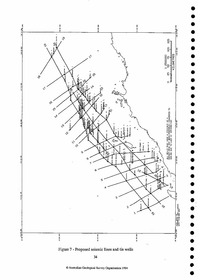
Figure 7 - Proposed seismic lines and tie wells
O Australian Geological Survey Organisation 1994
U!SEg uomure~ uxaqvou 'suaruap quor~~ pue suog~~o~ RaM 'saug 3pus1as pasodoq - 8 am%~g
