research institute for housing america …€¦ · a review of existing parking occupancy studies...
TRANSCRIPT
housingamerica.org
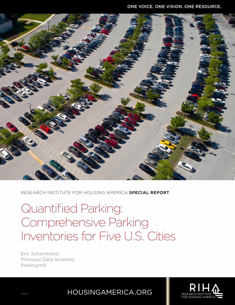
ONE VOICE. ONE VISION. ONE RESOURCE.
RESEARCH INSTITUTE FOR HOUSING AMERICA SPECIAL REPORT
Quantified Parking: Comprehensive Parking Inventories for Five U.S. CitiesEric Scharnhorst Principal Data Scientist Parkingmill
18806
RESEARCH INSTITUTE FOR HOUSING AMERICA SPECIAL REPORT
Quantified Parking: Comprehensive Parking
Inventories for Five U.S. Cities
Eric ScharnhorstPrincipal Data Scientist
Parkingmill
Copyright © May 2018 by Mortgage Bankers Association. All Rights Reserved. Copying, selling or otherwise distributing copies and / or creating derivative works for commercial purposes is strictly prohibited. Although significant efforts have been used in preparing this report, MBA makes no representations or warranties with respect to the accuracy and completeness of the contents. If legal advice or other expert assistance is needed, competent professionals should be consulted.
RESEARCH INSTITUTE FOR HOUSING AMERICA
Board of TrusTees
Michael Fratantoni MBA Senior Vice President & Chief Economist
Helen Kanovsky MBA General Counsel
Lisa Haynes MBA Chief Financial Officer
TrusT adminisTraTor
Michael Fratantoni MBA Senior Vice President & Chief Economist
QUANTIFIED PARKING: COMPREHENSIVE PARKING INVENTORIES FOR FIVE U.S. CITIES Iv © Mortgage Bankers Association May 2018. All rights reserved.
Table of Contents
Executive Summary . . . . . . . . . . . . . . . . . . . . . . . . . . . . . . . . . . . . . . . . . 1
Introduction . . . . . . . . . . . . . . . . . . . . . . . . . . . . . . . . . . . . . . . . . . . . . 3
Background. . . . . . . . . . . . . . . . . . . . . . . . . . . . . . . . . . . . . . . . . . . . . . 5
Method and Data . . . . . . . . . . . . . . . . . . . . . . . . . . . . . . . . . . . . . . . . . . 8
Parking Inventories . . . . . . . . . . . . . . . . . . . . . . . . . . . . . . . . . . . . . . . . . 10
New York, New York . . . . . . . . . . . . . . . . . . . . . . . . . . . . . . . . . . . . . . . 10
Philadelphia, Pennsylvania . . . . . . . . . . . . . . . . . . . . . . . . . . . . . . . . . . . 14
Seattle, Washington . . . . . . . . . . . . . . . . . . . . . . . . . . . . . . . . . . . . . . .18
Des Moines, Iowa . . . . . . . . . . . . . . . . . . . . . . . . . . . . . . . . . . . . . . . . .22
Jackson, Wyoming . . . . . . . . . . . . . . . . . . . . . . . . . . . . . . . . . . . . . . . . 26
Conclusion . . . . . . . . . . . . . . . . . . . . . . . . . . . . . . . . . . . . . . . . . . . . . .30
Appendix A: Availability of Parking, Housing, Jobs and Public Transit by Land Price Deciles. . . . . . . . . . . . . . . . . . . . . . . . 31
Appendix B: Detailed Methodology . . . . . . . . . . . . . . . . . . . . . . . . . . . . . . .36
References . . . . . . . . . . . . . . . . . . . . . . . . . . . . . . . . . . . . . . . . . . . . . .38
QUANTIFIED PARKING: COMPREHENSIVE PARKING INVENTORIES FOR FIVE U.S. CITIES 1 © Mortgage Bankers Association May 2018. All rights reserved.
Executive Summary
Comprehensive parking inventories have never existed for U.S. cities. Because of this, many parking-related questions have never been answered. This uncertainty — not knowing how much parking there is near a site or in a city — is the motivation for this report. By presenting the first complete parking inventories for five U.S. cities, this research reveals an investment in parking that is out of balance with the current demand for parking in almost all cases, and even less in tune with what appears to be declining future demand.
This is not merely scientifically interesting, it also has great practical significance for planners, property developers, investors and lenders. It uncovers an opportunity to build more efficient cities that contain fewer unused parking spaces and more of everything else.
Three trends make this research timely. First, transporta-tion preferences are changing, especially in urban areas, and a smaller share of Americans drive today than in the recent past. Second, policymakers are starting to relax their parking minimums and in some cases replace them with parking maximums. Third, datasets related to parking are becoming more accessible.
Exhaustive high-resolution parking inventories can identify parking shortages, and expose parking surpluses. These inventories can support developers who cannot afford to build extra parking at the expense of the other parts of their projects, or policymakers who are ready to relax minimum parking requirements for new construction, or who are concerned about spending public works money on free parking. Either way, the research presented here suggests that future developments should provide fewer parking spaces than past developments. And today’s empty parking spaces can be seen as a land bank in some of the most convenient city locations.
The parking inventories developed in this paper for New York, Philadelphia, Seattle, Des Moines, and Jackson, Wyoming reveal a lavish amount of parking. Parking spaces outnumber homes 27 to one in Jackson. Seattle’s population density of 13 people per acre is less than half its parking density of 29 parking stalls per acre. Philadelphia’s parking density is 3.7 times greater than that of homes. Des Moines has 83,141 households and 1.6 million parking
spaces. New York is the only city in the study with more homes than parking, an outcome partially explained by the greater provision of public transit.
The parking inventories reveal monumental investments in parking. By calculating the median price of a square foot of land within each cell of a 500-meter hexagonal overlay, and making conservative assumptions about the construction costs of surface and structured parking, I am able to estimate the replacement cost of all of the parking in each city. This is explained in more detail in Appendix B. The 1.6 million parking spaces in Seattle’s inventory have an estimated value, or a “replacement cost,” of $35.8 bil-lion, which is $118,000 per Seattle household. Jackson is home to over 100,000 parking spaces that would cost $711 million to replace, or $192,000 per household. The per-household share of the parking inventory in Des Moines and Philadelphia is $77,000 and $30,000 respectively. New York’s per-household cost is $6,570, a fraction of that of the other cities.
The amount of parking varies widely within cities and between cities. There is no “normal” amount of parking, but New York stands out as unique. New York’s parking is worth $20.6 billion, or $15.2 billion less than Seattle’s, even though New York has a population 12 times greater than Seattle. Seattle’s per-household parking cost burden is 18 times greater than New York’s.
Another difference between New York and the other inven-toried cities is in the distribution of parking spaces across the map. The prominence of on-street parking in New York’s mixture of parking types has a smoothing effect on parking access that contrasts with uneven parking distributions in the other cities. For example, in Seattle, Des Moines, and
QUANTIFIED PARKING: COMPREHENSIVE PARKING INVENTORIES FOR FIVE U.S. CITIES 2 © Mortgage Bankers Association May 2018. All rights reserved.
Philadelphia, substantial investments in structured and off-street surface parking contributed to downtown areas with more than 100 parking spaces per acre, and surrounding areas having a fraction of that amount.
The study also provides a description of the mixture of parking types which is further explored by using a decile analysis of land prices and parking supply. Where land is less expensive, there is more likely to be surface parking. And where land is more expensive, there is less likely to be surface parking. But what was surprising is that as land increases in price and surface parking begins to dissolve, the amount of parking in an area may still increase as parking spaces take shelter in new buildings. In a seeming paradox, parking is more pervasive where it is less visible.
These parking inventories are all dependent on available data. Data availability is improving but the inconsistency
of schemas across cities is challenging. On-street parking data were available from the transportation department of just one city, Seattle. New York street parking data came from combining signage data with streets, a task that required skills in computer programming and database architecture. For the other three cities, on-street parking inventories were derived from the geometries of street linework. Parcel data was publicly available for all five cities, but each tax assessor recorded parking differently, making off-street structured parking inventories a custom job for each city. Almost all of the off-street surface park-ing data came from satellite or aerial imagery, yet these data differed in resolution and kind for each city. Despite the source data inconsistencies, the method used to build parking inventories for the five cities in this study can also generate parking inventories for other cities in the future. These inventories are just a start, and many questions will need to be asked — and answered — in future research.
QUANTIFIED PARKING: COMPREHENSIVE PARKING INVENTORIES FOR FIVE U.S. CITIES 3 © Mortgage Bankers Association May 2018. All rights reserved.
Introduction
Comprehensive parking inventories have never existed for U.S. cities. Because of this, many parking-related questions have never been answered. This uncertainty — not knowing how much parking there is near a site or in a city — is the motivation for this report. By presenting the first complete parking inventories for five U.S. cities, this research reveals an investment in parking that is out of balance with the current demand for parking in almost all cases, and even less in tune with what appears to be declining future demand.
This is not merely scientifically interesting, it also has great practical significance for planners, property developers, investors and lenders. It uncovers an opportunity to build more capitally efficient buildings and cities that contain fewer unused parking spaces and more of everything else.
The parking “problem” in cities has been misunderstood for years, partly because comprehensive parking inventories weren’t available. In Jackson, Wyoming, for example, the Town’s website boasts of the public parking garage that was built in 2008:
“A true success story for the downtown area and a homerun by our City Council. Mayor Mark Barron can be credited for his vision and hard work at finding a common sense solu-tion to a long-time Jackson problem… too little parking.” (“Town of Jackson Parking Garage Challenges to Success.”)
But was there really a shortage of parking in Jackson? Without an inventory it was difficult to put numbers to the question. The parking structure cost the town $17.4 million, and each of its 283 parking stalls are now provided free of charge. When a preconception of too little parking infects policymakers, more parking tends to get built and provided to everyone for free. But when housing is in short supply, as it is in Jackson, home prices go up. In Jackson, the median 2017 home sale price of $897,000 was out of reach for the median income household that made $70,517.
Exhaustive high-resolution parking inventories can identify parking shortages, and expose parking surpluses. These inventories can support lenders and developers who cannot afford to build extra parking at the expense of the other parts of their projects and policymakers who are ready to relax minimum parking requirements for new construction
or who are concerned about spending public works money on free parking. Either way, the research presented here suggests that future developments should provide fewer parking spaces than past developments. And today’s empty parking spaces can be seen as a land bank in some of the most convenient city locations.
A review of existing parking occupancy studies in each of the five cities revealed ample available parking. In Jackson, empty parking stalls made up 68 percent of the supply in the residential core and 61 percent in the midtown area. In Des Moines, 92 percent of the parking spaces were empty in a major public parking garage, and overall peak occupancy in the downtown area was about 65 percent (Rich and Associates 2012). Parking utilization has been falling in Seattle for at least ten years, with daily occupancy ranging between 43 and 64 percent in the seven Seattle neighborhoods where data were available. Public parking occupancy rates have been declining in the City Center of Philadelphia since 2005. Spot counts in New York found parking occupancy to range between 66 percent to 100 percent depending on the day, the price of parking, and the location. The New York data suggests that price was a more efficient control of parking availability than was supply because the least expensive parking had the high-est occupancy.
The parking inventories developed for New York, Phila-delphia, Seattle, Des Moines, and Jackson reveal a lavish amount of parking. Parking spaces outnumber homes 27 to one in Jackson, swiftly answering the question posed earlier: “was there really a shortage of parking in Jackson?” Seattle’s population density of 13 people per acre is less than half its parking density of 29 parking stalls per acre. Philadelphia’s parking density is 3.7 times greater than
QUANTIFIED PARKING: COMPREHENSIVE PARKING INVENTORIES FOR FIVE U.S. CITIES 4 © Mortgage Bankers Association May 2018. All rights reserved.
that of homes. Des Moines has 83,141 households and 1.6 million parking spaces. New York is the only city with more homes than parking.
The parking inventories reveal monumental investments in parking. By calculating the median price of a square foot of land for each cell of a 500-meter hexagonal overlay, and making some conservative assumptions about the construction costs of surface and structured parking, I was able to estimate the replacement cost of all of the parking in each city. This is explained in more detail in Appendix B. The 1.6 million parking spaces in Seattle’s inventory have an estimated value, or a “replacement cost,” of $35.8 bil-lion, which is $118,000 per Seattle household. Jackson is home to more than 100,000 parking spaces that would cost $711 million to replace, or $192,000 per household. The per-household share of the parking inventory in Des Moines and Philadelphia is $77,000 and $30,000 respec-tively. New York’s per-household cost is $6,570, a fraction of that of the other cities.
The amount of parking varies widely within cities and between cities. There is no normal amount of parking, but New York stands out as unique. New York’s parking is worth $20.6 billion, or $15.2 billion less than Seattle’s, even though New York has a population 12 times greater than Seattle. Seattle’s per-household parking cost burden is 18 times greater than New York’s.
Another difference between New York and the other inven-toried cities is in the distribution of parking spaces across the map. The prominence of on-street parking in New York’s mixture of parking types has a smoothing effect on parking access that contrasts with uneven parking distributions in the other cities. For example, in Seattle, Des Moines, and Philadelphia, substantial investments in structured and off-street surface parking contributed to downtown areas with more than 100 parking spaces per acre, and surrounding areas having a fraction of that amount.
As land prices increase developers often replace surface parking with buildings full of other uses, and basements full of parking. Apartments, condos, and dorms began filling in parking lots in Seattle’s University District neighbor-hood, for example, after plans for the light rail to extend north were announced. This scenario repeats itself in other neighborhoods and other cities as land prices increase to a point where it isn’t rational to hold developable land as surface parking.
The transition from parking lots to structures happens one parcel at a time, and an example is the 2014 development
on the southwest corner of 47th Street and 12th Avenue NE in Seattle, where the amount of on-site parking increased by 26 percent after a 150 stall parking lot was replaced by apartments and retail, along with 211 structured parking stalls. This example helps illustrate how Seattle came to have the largest investment in structured parking of the cities in this report.
The theory that an area’s land prices drive its mixture of parking types is buttressed by a decile analysis of land prices and parking supply later in this report. Where land is less expensive, there is more likely to be surface parking. And where land is more expensive, there is less likely to be surface parking. But what was surprising, and touched upon in the Seattle example above, is that as land increases in price and surface parking begins to dissolve, the amount of parking in an area may still increase as parking spaces take shelter in new buildings. In a seeming paradox, park-ing is more pervasive where it is less visible.
These parking inventories were dependent on available data. Data availability is improving but the inconsistency of schemas across cities is challenging. On-street parking data were available from the transportation department of just one city, Seattle. New York street parking data came from combining signage data with street linework, a task that required skills in computer programming and database architecture. For the other three cities, on-street parking inventories were derived from the geometries of street linework. Parcel data was publicly available for all five cities, but each tax assessor recorded parking differently, making off-street structured parking inventories a custom job for each city. Almost all of the off-street surface park-ing data came from satellite or aerial imagery, yet these data differed in resolution and kind for each city. Despite the source data inconsistencies, the method used to build parking inventories for the five cities in this study can also generate parking inventories for other cities in the future. These inventories are just a start, and many questions will need to be asked — and answered — in future research.
This rest of this paper provides a review of the existing literature and parking trends and then describes a method to develop what I believe is the first set of comprehensive parking inventories for a collection of U.S. cities. This approach to original data development introduces an automated protocol based on the available land cover, street, and parcel data. After describing the method, I use the new database to compare the parking supply in five U.S. cities. This parking database can serve as a tool to help manage the amount of land and structures assigned to parking.
QUANTIFIED PARKING: COMPREHENSIVE PARKING INVENTORIES FOR FIVE U.S. CITIES 5 © Mortgage Bankers Association May 2018. All rights reserved.
Background
OVERVIEW
The main problem with parking is that it is routinely required alongside new construction even though “no city collects data on its total parking supply” (D. Shoup, 2017). This is like a doctor prescribing surgery without first diagnosing her patient. And it makes parking the only highly regulated real estate asset that is not subject to standard monitoring metrics.
The lack of parking supply knowledge should not be surprising. Even well-meaning journalists readily criticize shared bicycles but think nothing of the car parking that dominates development budgets and decorates city streets (Rushe). Because parking is overlooked by the press, as well as by most property tax assessors, it has become a sort of invisible foreground of everyday life in U.S. cities.
Without comprehensive parking inventories from official sources, past parking estimates came from first guessing how many parking stalls there were per car or person, and then extrapolating. These estimates haven’t been useful for anyone who plans, lends, designs or makes buildings because the numbers are too rough and spread too thinly across vast areas. Estimates of the number of parking spaces in the United States range from 162 million to two billion (Chester et al.).
Dubious parking estimates are in harmony with a culture that overlooks parking, but at odds with the care taken to track the other parts of U.S. cities. Databases like real estate multiple listing services and business directories such as InfoUSA are maintained to serve business development; land uses like housing and retail are monitored for taxa-tion; even street trees are accounted for and classified for preservation and replacement purposes.
While some cities inventory some of their parking, the lack of comprehensive parking data misaligns with the urban planning traditions of monitoring the land supply, assess-ing its development capacity, and even controlling the environmental impact of impervious surfaces (Delucchi; Davis et al.; Chester et al.).
Scarce parking data also clashes with the abundant private and public investments made directly in the land and struc-tures for parking. Shoup suggested that the U.S. parking
supply was worth twice the value of the U.S. vehicle stock, and as much as the depreciated construction value of all roads in the country (Shoup). At the building level, at least 35 percent of the cost of a steel-frame office building goes to supplying the required parking (Shoup).
Researchers claim that structured parking spaces can cost $60,000 or more, each, to build. This matches closely with the low end of per-stall costs in Philadelphia, Seattle, and Jackson (Beekman; Shoup). In New York, a survey of eight parking garages found that the average per-stall construction price for a structured parking space was $205,552 and ranged from $370,227 to $150,733 (Nelson \ Nyggard). In Philadelphia, the per-stall cost of parking for the Convention Center parking garage was $50,000 (Saffron). The 1,200 space parking garage at Seattle’s Pacific Place shopping center recently sold for $87 million, or $72,500 per parking space (Seattle Times Staff). The cost of Jackson’s 283 parking garage spaces was $61,590 per stall (Koehler).
Off-street surface parking is perhaps the most visible and influential type of parking, yet it is the hardest to find in city data. It gets a property tax break in most U.S. cities because the land has not been “improved” with a structure. When surface parking is ancillary to other primary uses, it does not enter most tax assessor databases even though it cost something to construct, occupies buildable land, and has a direct impact on property values and there-fore collectible property taxes. The popular Marshall and Swift methodology for assessing property, for example, does not consider ancillary surface parking or driveways an “improvement” so this type of parking does not get recorded in assessor data (Core Logic).
Lower development densities caused by abundant off-street surface parking bear development opportunity costs. The
QUANTIFIED PARKING: COMPREHENSIVE PARKING INVENTORIES FOR FIVE U.S. CITIES 6 © Mortgage Bankers Association May 2018. All rights reserved.
presence of sizeable at-grade parking lots in commercial areas or around transit stations introduce longer distances between activities through blighted landscapes that dis-courage walking and transit use (Sallis et al.; Pucher et al.). Large areas of surface parking were the number-two deterrent to transit ridership, after low residential density, and ahead of low employment density (Moudon et al.). With land selling for around $200 per square foot in Downtown Seattle, and ten times that in Manhattan, surface parking lots in cities can be worth much more than the cars parked on them (Redfin).
After decades of requiring parking for new construction, car storage has become the primary land use in many city areas. In parts of Seattle, for example, with low hous-ing inventory and high housing demand, 40 percent of households are car-free, yet parking covers 40 percent of the land area (U.S. Census Bureau). Half of these parking spaces were empty during the peak parking utilization hour, and past parking occupancy studies showed that parking has been underutilized, or oversupplied there, for many years (Data at PSRC).
PARKING AVAILABILITYParking utilization studies that were conducted inde-pendently from this research revealed an abundance of parking throughout the surveyed cities. A 2017 study in Jackson found that on average, 64 percent of parking spaces in the Residential Core and Midtown areas were vacant throughout the day during peak season. During the peak parking hour, parking occupancy maxed out at 43 percent in Midtown and 51 percent in the Residential Core (Kimberly Horn).
Twenty-five years of parking studies in the City Center of Philadelphia show that public parking occupancy rates have been declining since 2005, despite infill develop-ment reducing the overall amount of parking in the area. A 110 space parking lot that was converted to a 540-space above-ground public parking garage with ground floor retail recorded just 56 percent parking occupancy in 2015, or 302 empty parking spaces (Philadelphia City Planning Commission).
An NYC DOT study of the on-street parking near Barclays Center showed that more than half of metered parking spaces were vacant on non-events days and 30 percent of these stalls were still available during a Nets game (New York City Department of Transportation).
The market’s demand for parking might be less than what regulations have required, leaving developers — who have the most skin in the game when it comes to deciding how much parking to provide alongside new construction — to ask local governments to relax parking minimums for
new construction, petition for parking variances for new projects, creatively decouple the cost of parking from the price of a home, and when all else fails, build less parking than required and ask forgiveness later. Because off-street parking is produced — or not — by developers, this behavior hints at future trends related to parking.
THREE TRENDSThree trends make this research particularly timely. First, transportation preferences are changing, especially in urban areas, and a smaller share of Americans drive today than in the recent past. Second, policymakers are starting to relax their parking minimums and in some cases replace them with parking maximums. Third, datasets related to parking are becoming more accessible. I will take these trends one at a time.
Less DrivingPeople in U.S. cities are driving less than they used to. The share of Americans with a driver’s license is shrinking (Sivak and Schoettle). Aging Americans are planning to get rid of their cars (Alsnih and Hensher). And the percent-age of high school seniors who have a driver’s license is at a record low (Henderson). For the first time in at least 40 years, the percentage of Seattle households that own a car is declining (Balk). It is hard to imagine a scenario where the demand for parking won’t decrease, and where ridesharing, autonomous vehicles, and smartphone sup-ported taxi operations won’t contribute to the decrease in parking demand. Lyft’s 2017 Economic Impact Report claimed that its services were responsible for taking 250,000 cars off the road (Lyft). Even if services like Lyft and Uber impact traffic because drivers must drive across town after dropping off one fare and heading to another without a passenger, these vehicles circulate the street network without as much need for parking.
Relaxed Parking RegulationsMany city districts are also relaxing or even removing their parking requirements (Manville; Strong Towns). Perhaps because of this, builders across the U.S. are providing less parking per bedroom than they have in the past (Scharn-horst). Some new homes are sold without any included parking, and dedicated parking spaces can be purchased for an additional fee. The trend is for city planning depart-ments to stop legally sanctioning minimum amounts of parking alongside new construction, and to let builders and the real estate market decide how much parking is worth building.
More Accessible Parking DataCities are also opening up datasets that either didn’t exist in the past or were difficult to find. More available data combines a cultural trend from the “open data” movement with improved technology that creates new datasets. The
QUANTIFIED PARKING: COMPREHENSIVE PARKING INVENTORIES FOR FIVE U.S. CITIES 7 © Mortgage Bankers Association May 2018. All rights reserved.
best example of this is multispectral satellite imagery that can be used to detect parking lots based on their visible and heat signatures, just as it can be used in agricultural areas to see if a crop is corn or soybeans (Huang et al.). This imagery is becoming more readily available, and its quality is increasing as government agencies are buying the data, processing it in-house, and then releasing the processed imagery to the public. Property tax assessors and transportation departments are also sharing more data. The research presented here combines these public data sets.
PARKING’S TRAJECTORYThere is another way of looking at these trends: a future is arriving where builders will be able to provide more of everything else and fewer parking spaces. It seems likely that cities and their real estate will operate more efficiently if parking inventories were available at a fine grain and
across large extents, and if an understanding of parking came from numbers on a map instead of from folklore and tradition (Shoup).
Data plays a role in this, and the benefits extend beyond individual sites. Even transportation models would ben-efit from parking supply data since parking affects car ownership rates and mode choice (Guo; Willson). In older cities with comparatively little off-street surface parking, the portion of commuters traveling by automobile was associated with more parking and fewer homes (McCahill and Garrick). If parking is to function efficiently and as it’s intended — for storing cars — then each new development must consider the available data and then allocate just the right amount of land and capital to parking so that parking doesn’t dominate the project’s budget and buildable land area, and so that each site can provide the most efficient mixture of other uses along with the parking.
QUANTIFIED PARKING: COMPREHENSIVE PARKING INVENTORIES FOR FIVE U.S. CITIES 8 © Mortgage Bankers Association May 2018. All rights reserved.
Method and Data
To develop comprehensive parking inventories, I combined datasets from property tax assessors, city departments, large institutions, and satellite imagery providers. These data form three categories of parking: on-street, off-street surface, and off-street structured. Appendix B explains the data protocol for each city in more detail.
STUDY AREASI developed parking inventories for five U.S. cities of varied sizes: New York, New York; Philadelphia, Pennsylvania; Seattle, Washington; Des Moines, Iowa; and Jackson, Wyoming. City extents came from the U.S. Census 2017 places geometries (Census Shapefiles). City selection was based on city size and available data. Table 1 lists the cit-ies in this study.
TABLE 1: SIZES OF THE INVENTORIED CITIES
CITY SUMMARIES
POPULATIONLAND AREA
(Mi2)
Jackson 10,529 3
Des Moines 215,473 89
Seattle 704,352 84
Philadelphia 1,567,872 134
New York 8,537,673 303
On-street ParkingStreet geometries and some on-street parking data came from the Seattle Department of Transportation, New York City Department of Planning, Open Data Philadelphia, Polk County, and Teton County GIS File Archives.
TABLE 2: THE SHARE OF PRIMARY AND SECONDARY DATA SOURCES FOR ON-STREET PARKING
ON-STREET PARKING
PRIMARY DATA
SOURCES %
SECONDARY DATA
SOURCES %
Jackson 0% 100%
Des Moines 0% 100%
Seattle 100% 0%
Philadelphia 0% 100%
New York 100% 0%

QUANTIFIED PARKING: COMPREHENSIVE PARKING INVENTORIES FOR FIVE U.S. CITIES 9 © Mortgage Bankers Association May 2018. All rights reserved.
Off-street StructuredParcel-level structured parking data came from the property tax assessors’ offices in King County, Washington; New York City, New York; Teton County Wyoming; Philadelphia County, Pennsylvania and Polk County, Iowa. Supplemen-tal data covering some tax-exempt parcels came from the University of Washington, the Philadelphia Parking Authority and Parkopedia.
TABLE 3: THE SHARE OF PRIMARY AND SECONDARY DATA SOURCES FOR OFF-STREET STRUCTURED PARKING
OFF-STREET STRUCTURED PARKING
PRIMARY DATA
SOURCES %
SECONDARY DATA
SOURCES %
Jackson 100% 0%
Des Moines 100% 0%
Seattle 100% 0%
Philadelphia 100% 0%
New York 100% 0%
Off-street SurfaceLandcover data came from processed satellite imagery. Parking areas were either traced by hand on top of high-resolution imagery, or came from a landcover analysis of multispectral imagery. The King County GIS Center, New York City Open Data, Open Data Philadelphia, and Teton County GIS File Archives provided the data.
TABLE 4: THE SHARE OF PRIMARY AND SECONDARY DATA SOURCES FOR OFF-STREET SURFACE PARKING
OFF-STREET SURFACE PARKING
PRIMARY DATA
SOURCES %
SECONDARY DATA
SOURCES %
Jackson 100% 0%
Des Moines 100% 0%
Seattle 100% 0%
Philadelphia 100% 0%
New York 100% 0%
FIGURE 1: TRACED SURFACE PARKING LANDCOVER IN PHILADELPHIA (LEFT), SURFACE PARKING LANDCOVER PROCESSED FROM MULTISPECTRAL IMAGERY IN SEATTLE (RIGHT)
QUANTIFIED PARKING: COMPREHENSIVE PARKING INVENTORIES FOR FIVE U.S. CITIES 10 © Mortgage Bankers Association May 2018. All rights reserved.
Parking Inventories
NEW YORK, NEW YORK
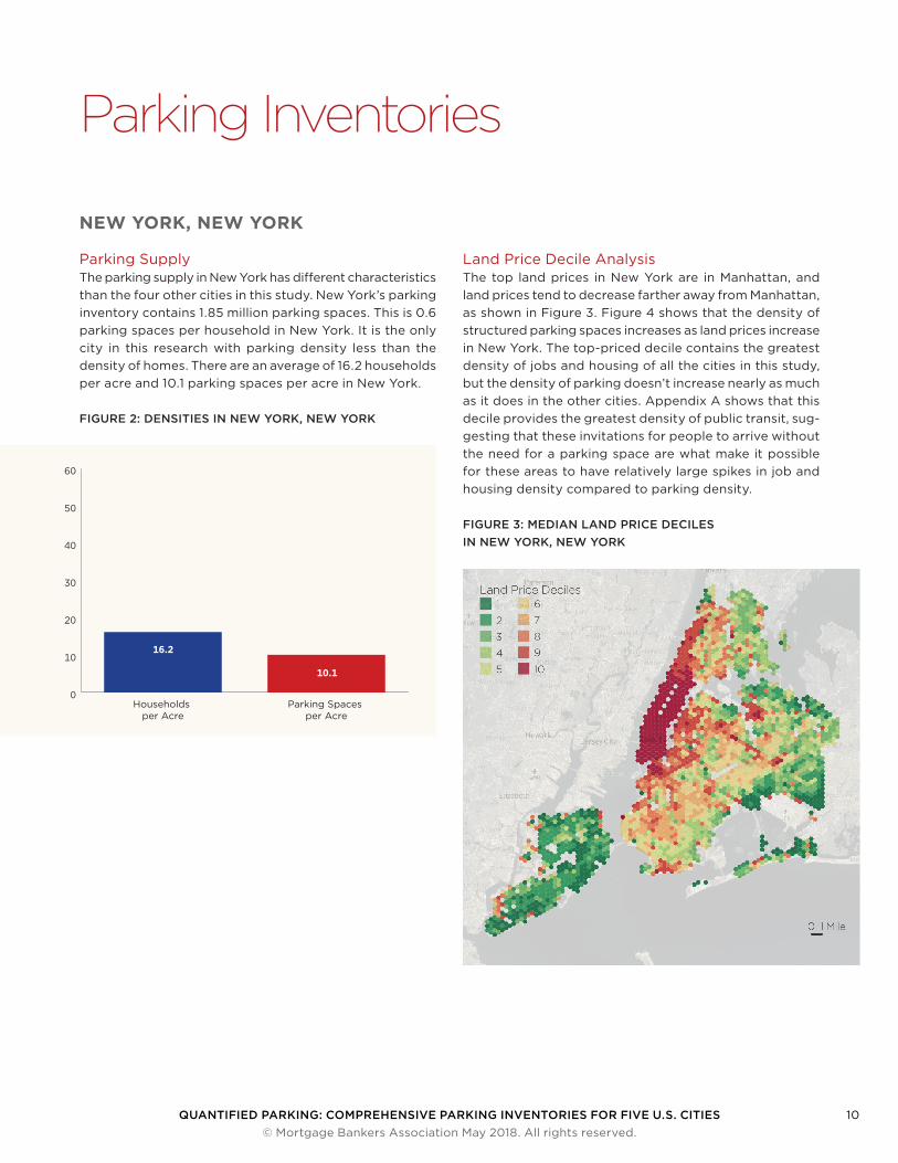
Parking SupplyThe parking supply in New York has different characteristics than the four other cities in this study. New York’s parking inventory contains 1.85 million parking spaces. This is 0.6 parking spaces per household in New York. It is the only city in this research with parking density less than the density of homes. There are an average of 16.2 households per acre and 10.1 parking spaces per acre in New York.
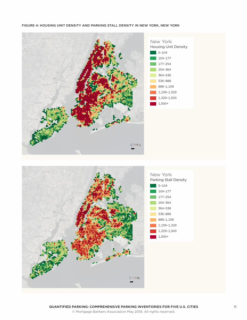
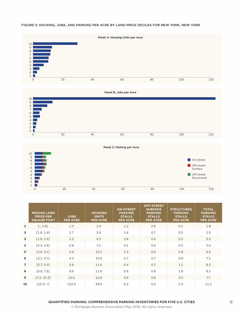
Land Price Decile AnalysisThe top land prices in New York are in Manhattan, and land prices tend to decrease farther away from Manhattan, as shown in Figure 3. Figure 4 shows that the density of structured parking spaces increases as land prices increase in New York. The top-priced decile contains the greatest density of jobs and housing of all the cities in this study, but the density of parking doesn’t increase nearly as much as it does in the other cities. Appendix A shows that this decile provides the greatest density of public transit, sug-gesting that these invitations for people to arrive without the need for a parking space are what make it possible for these areas to have relatively large spikes in job and housing density compared to parking density.
0
10
20
30
40
50
60
Parking Spaces per Acre
Households per Acre
16.2
10.1
FIGURE 2: DENSITIES IN NEW YORK, NEW YORK
FIGURE 3: MEDIAN LAND PRICE DECILES IN NEW YORK, NEW YORK
QUANTIFIED PARKING: COMPREHENSIVE PARKING INVENTORIES FOR FIVE U.S. CITIES 11 © Mortgage Bankers Association May 2018. All rights reserved.
FIGURE 4: HOUSING UNIT DENSITY AND PARKING STALL DENSITY IN NEW YORK, NEW YORK
New YorkHousing Unit Density
0–104
104–177
177–254
254–364
364–536
536–888
888–1,159
1,159–1,329
1,329–1,500
1,500+
New YorkParking Stall Density
0–104
104–177
177–254
254–364
364–536
536–888
888–1,159
1,159–1,329
1,329–1,500
1,500+
QUANTIFIED PARKING: COMPREHENSIVE PARKING INVENTORIES FOR FIVE U.S. CITIES 12 © Mortgage Bankers Association May 2018. All rights reserved.
FIGURE 5: HOUSING, JOBS, AND PARKING PER ACRE BY LAND PRICE DECILES FOR NEW YORK, NEW YORK
Panel A: Housing Units per Acre
0 20 40 60 80 100 12012345678910
Panel B: Jobs per Acre
0 20 40 60 80 100 12012345678910
Panel C: Parking per Acre
0 20 40 60 80 100 120123456789
10
On-street
O�-street Surface
O�-street Structured
MEDIAN LAND PRICE PER
SQUARE FOOTJOBS
PER ACRE
HOUSING UNITS
PER ACRE
ON-STREET PARKING STALLS
PER ACRE
OFF-STREET SURFACE PARKING STALLS
PER ACRE
STRUCTURED PARKING STALLS
PER ACRE
TOTAL PARKING STALLS
PER ACRE
1 [-, 1.6] 1.0 1.4 1.2 0.6 0.1 1.8
2 [1.6, 1.9] 1.7 2.6 1.6 0.7 0.3 2.5
3 [1.9, 2.3] 2.2 4.2 2.8 0.6 0.2 3.5
4 [2.3, 2.6] 2.8 7.1 4.1 0.6 0.3 5.0
5 [2.6, 3.1] 4.6 10.2 5.3 0.6 0.8 6.6
6 [3.1, 3.7] 4.3 10.5 5.7 0.7 0.9 7.2
7 [3.7, 5.0] 5.8 11.6 6.4 0.7 1.1 8.2
8 [5.0, 7.3] 9.6 11.9 5.6 0.8 1.8 8.1
9 [7.3, 15.3] 13.0 12.8 4.9 0.8 2.0 7.7
10 [15.3, +] 122.9 29.9 5.2 0.6 5.3 11.1
QUANTIFIED PARKING: COMPREHENSIVE PARKING INVENTORIES FOR FIVE U.S. CITIES 13 © Mortgage Bankers Association May 2018. All rights reserved.
Estimated Replacement Cost
TABLE 5: THE ESTIMATED REPLACEMENT COST OF NEW YORK’S INVENTORIED PARKING
Population in 2016 8,537,673
Total Parking Replacement Cost $20.55 billion
Total Parking Stalls 1,965,377
Parking Cost per Household $6,570
Parking Stalls per Household 0.6
New York’s parking would cost an estimated $20.6 billion to replace. The per-household parking cost is $6,570, the lowest of any city in this study.
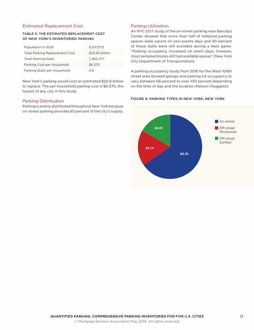
Parking DistributionParking is evenly distributed throughout New York because on-street parking provides 65 percent of the city’s supply.
Parking UtilizationAn NYC DOT study of the on-street parking near Barclays Center showed that more than half of metered parking spaces were vacant on non-events days and 30 percent of these stalls were still available during a Nets game. “Parking occupancy increased on event days; however, most sampled blocks still had available spaces” (New York City Department of Transportation).
A parking occupancy study from 2016 for the West 108th street area showed garage and parking lot occupancy to vary between 66 percent to over 100 percent depending on the time of day and the location (Nelson \ Nyggard).
16.2
On-street
O�-street Structured
O�-street Surface
65.3%
16.6%
18.1%
FIGURE 6: PARKING TYPES IN NEW YORK, NEW YORK
QUANTIFIED PARKING: COMPREHENSIVE PARKING INVENTORIES FOR FIVE U.S. CITIES 14 © Mortgage Bankers Association May 2018. All rights reserved.
PHILADELPHIA, PENNSYLVANIA
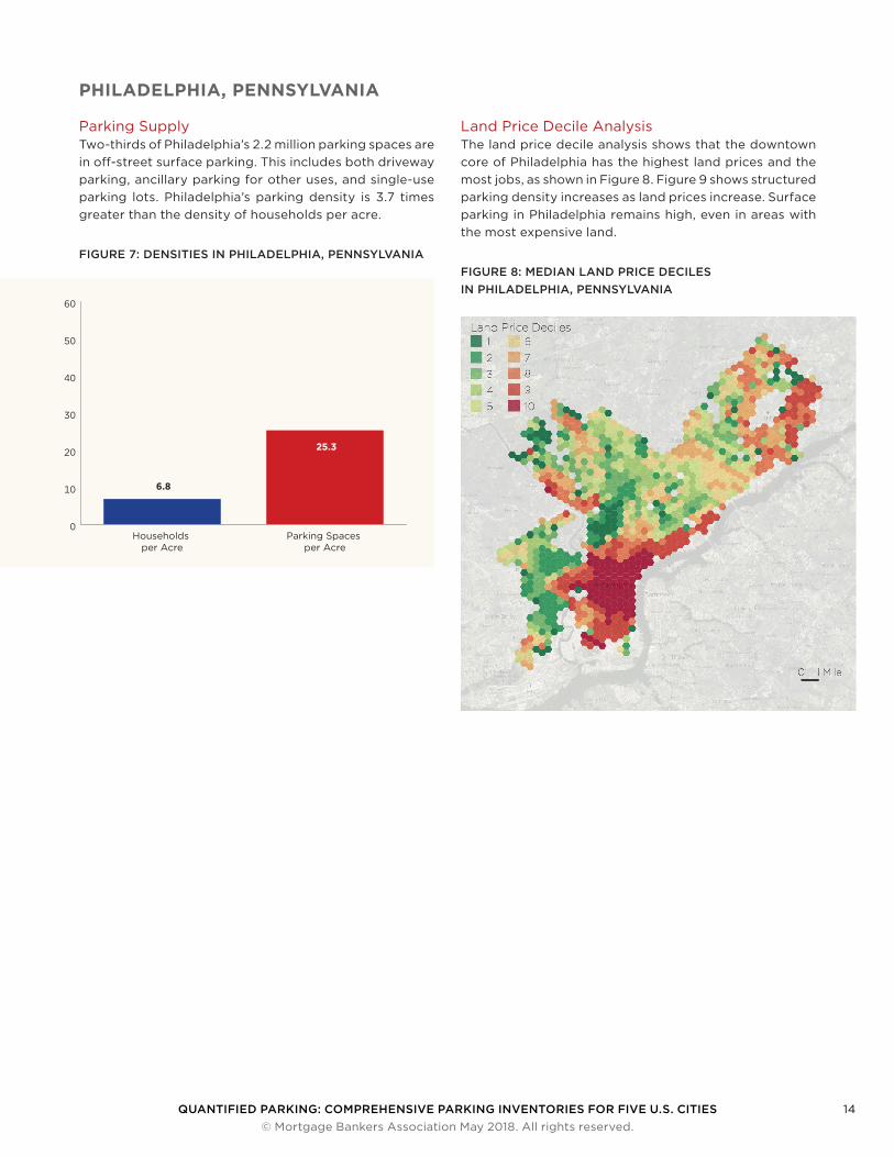
Parking SupplyTwo-thirds of Philadelphia’s 2.2 million parking spaces are in off-street surface parking. This includes both driveway parking, ancillary parking for other uses, and single-use parking lots. Philadelphia’s parking density is 3.7 times greater than the density of households per acre.
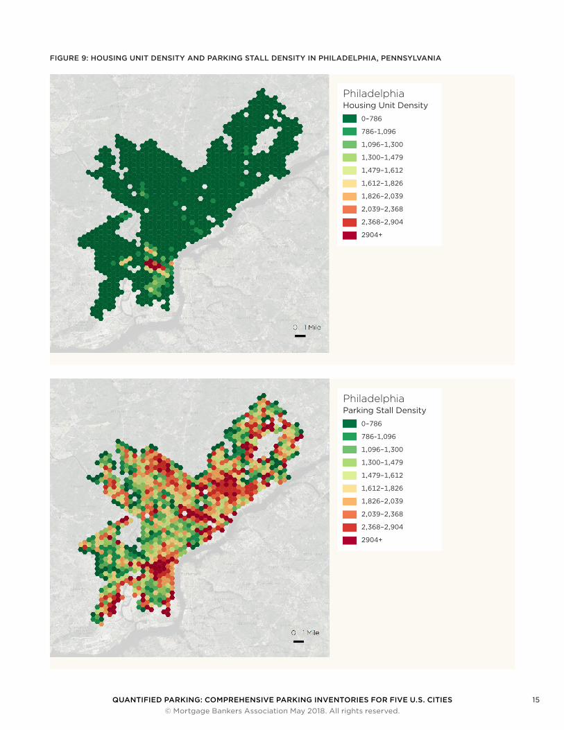
Land Price Decile AnalysisThe land price decile analysis shows that the downtown core of Philadelphia has the highest land prices and the most jobs, as shown in Figure 8. Figure 9 shows structured parking density increases as land prices increase. Surface parking in Philadelphia remains high, even in areas with the most expensive land.
0
10
20
30
40
50
60
Parking Spaces per Acre
Households per Acre
6.8
25.3
FIGURE 7: DENSITIES IN PHILADELPHIA, PENNSYLVANIAFIGURE 8: MEDIAN LAND PRICE DECILES IN PHILADELPHIA, PENNSYLVANIA
QUANTIFIED PARKING: COMPREHENSIVE PARKING INVENTORIES FOR FIVE U.S. CITIES 15 © Mortgage Bankers Association May 2018. All rights reserved.
FIGURE 9: HOUSING UNIT DENSITY AND PARKING STALL DENSITY IN PHILADELPHIA, PENNSYLVANIA
PhiladelphiaHousing Unit Density
0–786
786-1,096
1,096–1,300
1,300–1,479
1,479–1,612
1,612–1,826
1,826–2,039
2,039–2,368
2,368–2,904
2904+
PhiladelphiaParking Stall Density
0–786
786-1,096
1,096–1,300
1,300–1,479
1,479–1,612
1,612–1,826
1,826–2,039
2,039–2,368
2,368–2,904
2904+

QUANTIFIED PARKING: COMPREHENSIVE PARKING INVENTORIES FOR FIVE U.S. CITIES 16 © Mortgage Bankers Association May 2018. All rights reserved.
FIGURE 10: HOUSING, JOBS, AND PARKING PER ACRE BY LAND PRICE DECILES FOR PHILADELPHIA, PENNSYLVANIA
Panel A: Housing Units per Acre
0 5 10 15 20 25 30 35 40 45123456789
10
Panel B: Jobs per Acre
0 5 10 15 20 25 30 35 40 45123456789
10
Panel C: Parking per Acre
0 5 10 15 20 25 30 35 40 45123456789
10
On-street
O�-street Surface
O�-street Structured
MEDIAN LAND PRICE PER
SQUARE FOOTJOBS
PER ACRE
HOUSING UNITS
PER ACRE
ON-STREET PARKING STALLS
PER ACRE
OFF-STREET SURFACE PARKING STALLS
PER ACRE
STRUCTURED PARKING STALLS
PER ACRE
TOTAL PARKING STALLS
PER ACRE
1 [-, 4.1] 3.1 0.7 1.5 12.0 0.2 13.7
2 [4.1, 5.4] 2.2 2.1 3.3 7.2 0.8 11.4
3 [5.4, 6.2] 1.8 2.4 3.3 7.4 1.2 11.9
4 [6.2, 6.9] 2.9 2.4 3.3 9.9 2.1 15.2
5 [6.9, 7.9] 1.8 2.0 3.0 9.4 2.2 14.7
6 [7.9, 9.0] 2.3 2.2 3.2 9.1 2.4 14.7
7 [9.0, 11.5] 2.2 2.3 3.1 9.5 1.7 14.3
8 [11.5, 15.6] 2.9 2.4 3.1 10.5 1.3 14.9
9 [15.6, 32.8] 4.4 3.7 3.8 9.6 1.3 14.7
10 [32.8, +] 45.8 7.8 4.9 8.4 6.5 19.8
QUANTIFIED PARKING: COMPREHENSIVE PARKING INVENTORIES FOR FIVE U.S. CITIES 17 © Mortgage Bankers Association May 2018. All rights reserved.
Estimated Replacement Cost
TABLE 6: THE ESTIMATED REPLACEMENT COST OF PHILADELPHIA’S INVENTORIED PARKING
Population in 2016 1,567,872
Total Parking Replacement Cost $17.46 billion
Total Parking Stalls 2,172,896
Parking Cost per Household $29,974
Parking Stalls per Household 3.7
Philadelphia’s 2.2 million parking spaces have an estimated replacement cost of over $17 billion. This equates to about 3.7 parking stalls per household with a total per-household share of the cost of just under $30,000. Seventy percent of Philadelphia’s estimated parking replacement cost sits in structured parking, even though this type of parking repre-sents only 11 percent of the parking supply in Philadelphia.
Parking DistributionParking spaces in the Philadelphia parking inventory are distributed evenly throughout the city. The best example of this is the ample supply of off-street surface parking where the spatial analysis found the median off-street surface parking density to be eight spaces per acre with a standard deviation of ten stalls per acre. Most of Phila-delphia’s structured parking is provided downtown.
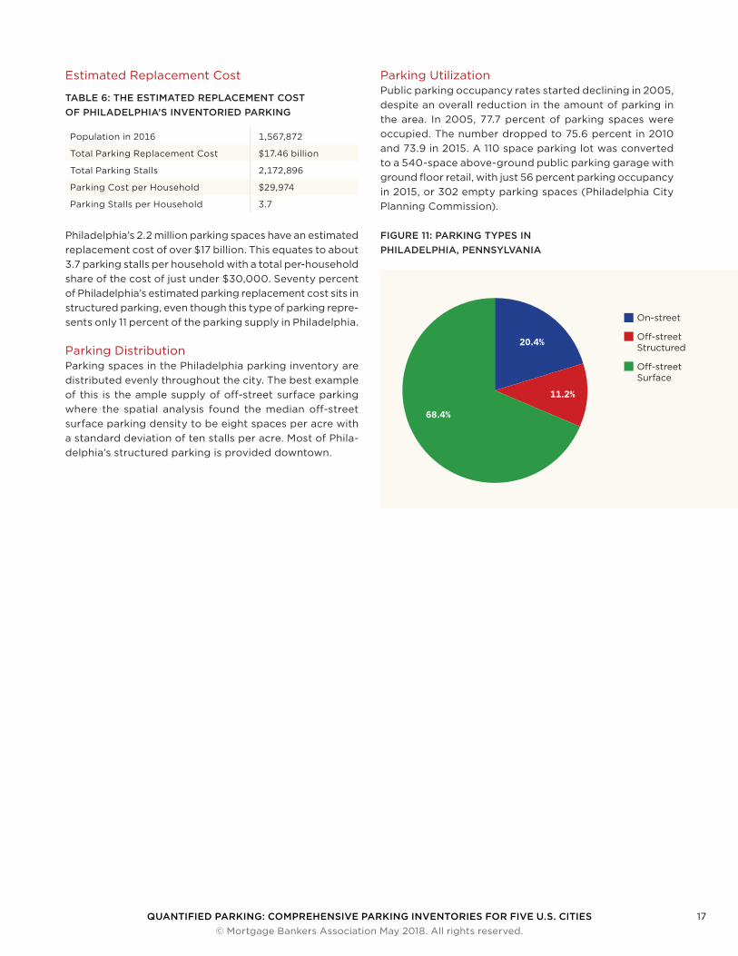
Parking UtilizationPublic parking occupancy rates started declining in 2005, despite an overall reduction in the amount of parking in the area. In 2005, 77.7 percent of parking spaces were occupied. The number dropped to 75.6 percent in 2010 and 73.9 in 2015. A 110 space parking lot was converted to a 540-space above-ground public parking garage with ground floor retail, with just 56 percent parking occupancy in 2015, or 302 empty parking spaces (Philadelphia City Planning Commission).
16.2
On-street
O�-street Structured
O�-street Surface
20.4%
68.4%
11.2%
FIGURE 11: PARKING TYPES IN PHILADELPHIA, PENNSYLVANIA
QUANTIFIED PARKING: COMPREHENSIVE PARKING INVENTORIES FOR FIVE U.S. CITIES 18 © Mortgage Bankers Association May 2018. All rights reserved.
SEATTLE, WASHINGTON
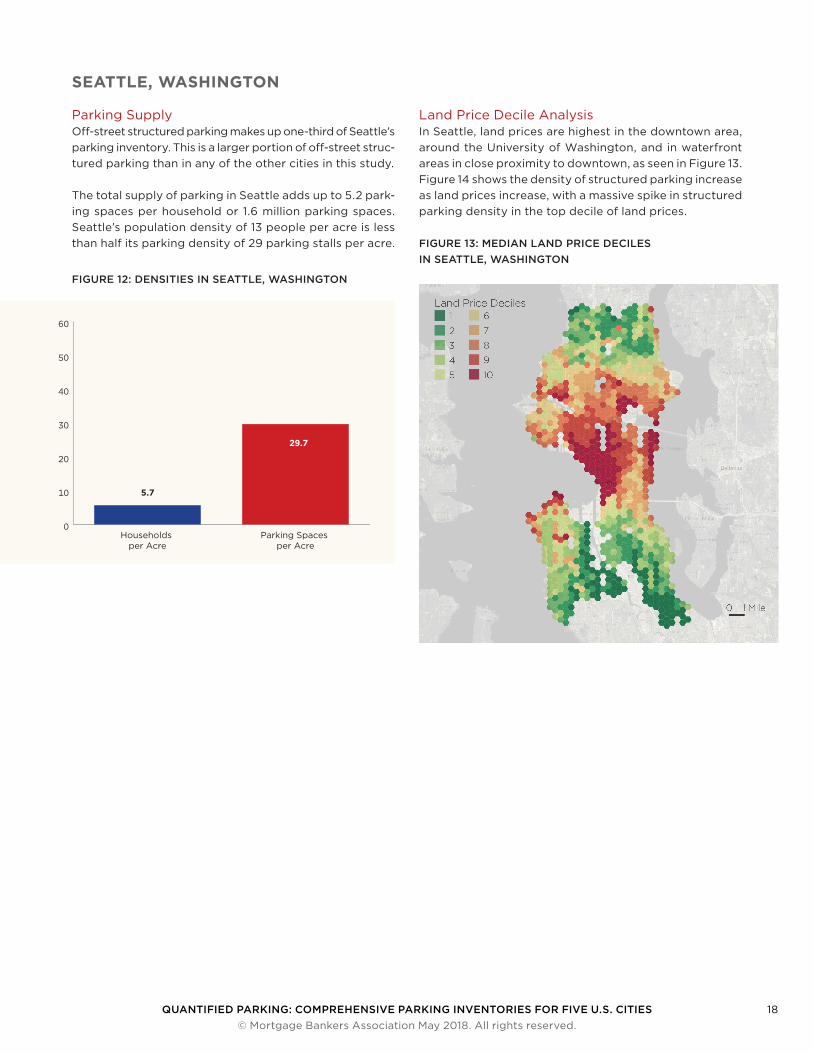
Parking SupplyOff-street structured parking makes up one-third of Seattle’s parking inventory. This is a larger portion of off-street struc-tured parking than in any of the other cities in this study.
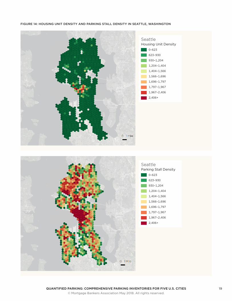
The total supply of parking in Seattle adds up to 5.2 park-ing spaces per household or 1.6 million parking spaces. Seattle’s population density of 13 people per acre is less than half its parking density of 29 parking stalls per acre.
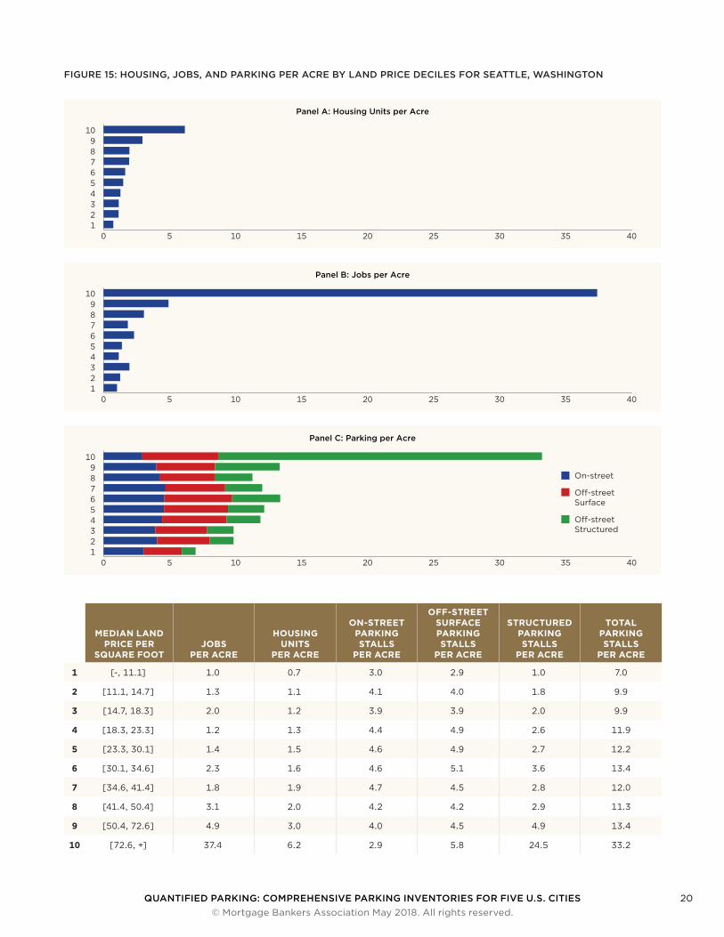
Land Price Decile AnalysisIn Seattle, land prices are highest in the downtown area, around the University of Washington, and in waterfront areas in close proximity to downtown, as seen in Figure 13. Figure 14 shows the density of structured parking increase as land prices increase, with a massive spike in structured parking density in the top decile of land prices.
0
10
20
30
40
50
60
Parking Spaces per Acre
Households per Acre
5.7
29.7
FIGURE 12: DENSITIES IN SEATTLE, WASHINGTON
FIGURE 13: MEDIAN LAND PRICE DECILES IN SEATTLE, WASHINGTON
QUANTIFIED PARKING: COMPREHENSIVE PARKING INVENTORIES FOR FIVE U.S. CITIES 19 © Mortgage Bankers Association May 2018. All rights reserved.
FIGURE 14: HOUSING UNIT DENSITY AND PARKING STALL DENSITY IN SEATTLE, WASHINGTON
SeattleHousing Unit Density
0–623
623–930
930–1,204
1,204–1,404
1,404–1,566
1,566–1,696
1,696–1,797
1,797–1,967
1,967–2,406
2,406+
SeattleParking Stall Density
0–623
623–930
930–1,204
1,204–1,404
1,404–1,566
1,566–1,696
1,696–1,797
1,797–1,967
1,967–2,406
2,406+
QUANTIFIED PARKING: COMPREHENSIVE PARKING INVENTORIES FOR FIVE U.S. CITIES 20 © Mortgage Bankers Association May 2018. All rights reserved.
FIGURE 15: HOUSING, JOBS, AND PARKING PER ACRE BY LAND PRICE DECILES FOR SEATTLE, WASHINGTON
Panel A: Housing Units per Acre
0 5 10 15 20 25 30 35 40123456789
10
Panel B: Jobs per Acre
0 5 10 15 20 25 30 35 40123456789
10
Panel C: Parking per Acre
0 5 10 15 20 25 30 35 40123456789
10
On-street
O�-street Surface
O�-street Structured
MEDIAN LAND PRICE PER
SQUARE FOOTJOBS
PER ACRE
HOUSING UNITS
PER ACRE
ON-STREET PARKING STALLS
PER ACRE
OFF-STREET SURFACE PARKING STALLS
PER ACRE
STRUCTURED PARKING STALLS
PER ACRE
TOTAL PARKING STALLS
PER ACRE
1 [-, 11.1] 1.0 0.7 3.0 2.9 1.0 7.0
2 [11.1, 14.7] 1.3 1.1 4.1 4.0 1.8 9.9
3 [14.7, 18.3] 2.0 1.2 3.9 3.9 2.0 9.9
4 [18.3, 23.3] 1.2 1.3 4.4 4.9 2.6 11.9
5 [23.3, 30.1] 1.4 1.5 4.6 4.9 2.7 12.2
6 [30.1, 34.6] 2.3 1.6 4.6 5.1 3.6 13.4
7 [34.6, 41.4] 1.8 1.9 4.7 4.5 2.8 12.0
8 [41.4, 50.4] 3.1 2.0 4.2 4.2 2.9 11.3
9 [50.4, 72.6] 4.9 3.0 4.0 4.5 4.9 13.4
10 [72.6, +] 37.4 6.2 2.9 5.8 24.5 33.2
QUANTIFIED PARKING: COMPREHENSIVE PARKING INVENTORIES FOR FIVE U.S. CITIES 21 © Mortgage Bankers Association May 2018. All rights reserved.
Estimated Replacement Cost
TABLE 7: THE ESTIMATED REPLACEMENT COST OF SEATTLE’S INVENTORIED PARKING
Population in 2016 704,352
Total Parking Replacement Cost $35.79 billion
Total Parking Stalls 1,596,289
Parking Cost per Household $117,677
Parking Stalls per Household 5.2
Seattle’s 1.6 million parking spaces have an estimated replacement cost of over $35 billion. Seventy-three percent, or more than $26 billion, of Seattle’s parking is provided in off-street parking structures. Most of this off-street structured parking is distributed in Seattle’s downtown core. The 5.2 parking stalls per household in Seattle adds up to a per-household parking cost of $117,677. The per-car cost of parking for the 435,000 cars in Seattle is $82,281.
Parking DistributionAlthough Seattle’s parking inventory has an equal mixture of on-street, off-street surface, and structured parking, the parking supply is unevenly distributed throughout the city. The best example of this is off-street structured parking where spatial analysis found that the median amount of structured parking in a city area is 2.7 structured parking spaces per acre, with a standard deviation of 8.9 parking spaces per acre. The maximum was 95 structured parking stalls per acre. Sixteen of the 20 neighborhoods with the most structured parking in this research were in Seattle.
Parking UtilizationParking utilization has been declining in Seattle for at least ten years (PSRC). The Puget Sound Regional Council’s parking utilization studies of seven Seattle neighborhoods found that the average daily occupancy rate ranged from 43 percent in Lower Queen Anne to 64 percent in the Central Business district.
16.2
On-street
O�-street Structured
O�-street Surface
32.2%35.1%
32.7%
FIGURE 16: PARKING TYPES IN SEATTLE, WASHINGTON
QUANTIFIED PARKING: COMPREHENSIVE PARKING INVENTORIES FOR FIVE U.S. CITIES 22 © Mortgage Bankers Association May 2018. All rights reserved.
DES MOINES, IOWA
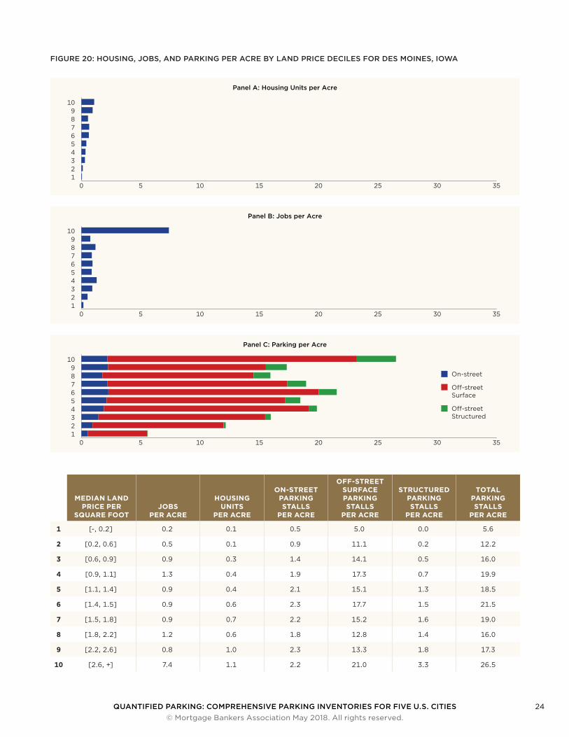
Parking SupplyThere are more than nine times as many parking spaces per acre in Des Moines, Iowa as there are homes: 1.5 households per acre compared to 28 parking spaces — up to 19.4 park-ing spaces per household. There are 83,141 households in Des Moines and 1.6 million parking spaces in the inventory.
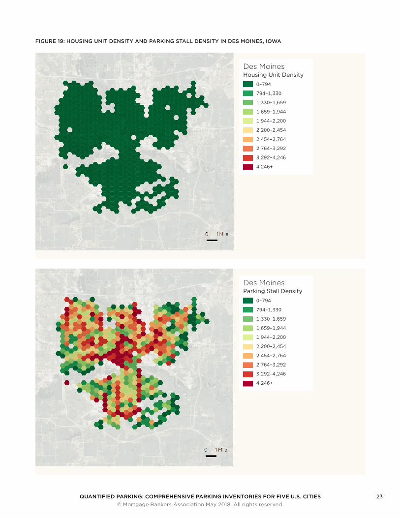
Land Price Decile AnalysisIn Des Moines, the land price decile analysis reveals a mosaic of land prices, with the downtown core and some high-end residential areas sharing the top decile (Figure 18). Figure 19 shows structured parking density increases as land prices increase. Throughout Des Moines, parking density is greater than the density of homes or jobs.
0
10
20
30
40
50
60
Parking Spaces per Acre
Households per Acre
1.5
28.4
FIGURE 17: DENSITIES IN DES MOINES, IOWAFIGURE 18: MEDIAN LAND PRICE DECILES IN DES MOINES, IOWA
QUANTIFIED PARKING: COMPREHENSIVE PARKING INVENTORIES FOR FIVE U.S. CITIES 23 © Mortgage Bankers Association May 2018. All rights reserved.
FIGURE 19: HOUSING UNIT DENSITY AND PARKING STALL DENSITY IN DES MOINES, IOWA
Des MoinesHousing Unit Density
0–794
794–1,330
1,330–1,659
1,659–1,944
1,944–2,200
2,200–2,454
2,454–2,764
2,764–3,292
3,292–4,246
4,246+
Des MoinesParking Stall Density
0–794
794–1,330
1,330–1,659
1,659–1,944
1,944–2,200
2,200–2,454
2,454–2,764
2,764–3,292
3,292–4,246
4,246+
QUANTIFIED PARKING: COMPREHENSIVE PARKING INVENTORIES FOR FIVE U.S. CITIES 24 © Mortgage Bankers Association May 2018. All rights reserved.
FIGURE 20: HOUSING, JOBS, AND PARKING PER ACRE BY LAND PRICE DECILES FOR DES MOINES, IOWA
Panel A: Housing Units per Acre
0 5 10 15 20 25 30 35123456789
10
Panel B: Jobs per Acre
0 5 10 15 20 25 30 35123456789
10
Panel C: Parking per Acre
0 5 10 15 20 25 30 35123456789
10
On-street
O�-street Surface
O�-street Structured
MEDIAN LAND PRICE PER
SQUARE FOOTJOBS
PER ACRE
HOUSING UNITS
PER ACRE
ON-STREET PARKING STALLS
PER ACRE
OFF-STREET SURFACE PARKING STALLS
PER ACRE
STRUCTURED PARKING STALLS
PER ACRE
TOTAL PARKING STALLS
PER ACRE
1 [-, 0.2] 0.2 0.1 0.5 5.0 0.0 5.6
2 [0.2, 0.6] 0.5 0.1 0.9 11.1 0.2 12.2
3 [0.6, 0.9] 0.9 0.3 1.4 14.1 0.5 16.0
4 [0.9, 1.1] 1.3 0.4 1.9 17.3 0.7 19.9
5 [1.1, 1.4] 0.9 0.4 2.1 15.1 1.3 18.5
6 [1.4, 1.5] 0.9 0.6 2.3 17.7 1.5 21.5
7 [1.5, 1.8] 0.9 0.7 2.2 15.2 1.6 19.0
8 [1.8, 2.2] 1.2 0.6 1.8 12.8 1.4 16.0
9 [2.2, 2.6] 0.8 1.0 2.3 13.3 1.8 17.3
10 [2.6, +] 7.4 1.1 2.2 21.0 3.3 26.5
QUANTIFIED PARKING: COMPREHENSIVE PARKING INVENTORIES FOR FIVE U.S. CITIES 25 © Mortgage Bankers Association May 2018. All rights reserved.
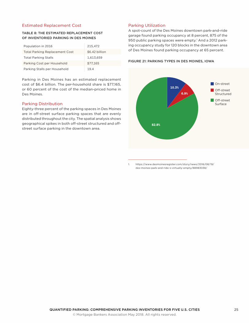
Estimated Replacement Cost
TABLE 8: THE ESTIMATED REPLACEMENT COST OF INVENTORIED PARKING IN DES MOINES
Population in 2016 215,472
Total Parking Replacement Cost $6.42 billion
Total Parking Stalls 1,613,659
Parking Cost per Household $77,165
Parking Stalls per Household 19.4
Parking in Des Moines has an estimated replacement cost of $6.4 billion. The per-household share is $77,165, or 60 percent of the cost of the median-priced home in Des Moines.
Parking DistributionEighty-three percent of the parking spaces in Des Moines are in off-street surface parking spaces that are evenly distributed throughout the city. The spatial analysis shows geographical spikes in both off-street structured and off-street surface parking in the downtown area.
Parking UtilizationA spot-count of the Des Moines downtown park-and-ride garage found parking occupancy at 8 percent, 875 of the 950 public parking spaces were empty.1 And a 2012 park-ing occupancy study for 120 blocks in the downtown area of Des Moines found parking occupancy at 65 percent.
1. https://www.desmoinesregister.com/story/news/2016/08/19/des-moines-park-and-ride-s-virtually-empty/88983038/
16.2
On-street
O�-street Structured
O�-street Surface
10.3%
82.8%
6.9%
FIGURE 21: PARKING TYPES IN DES MOINES, IOWA
QUANTIFIED PARKING: COMPREHENSIVE PARKING INVENTORIES FOR FIVE U.S. CITIES 26 © Mortgage Bankers Association May 2018. All rights reserved.
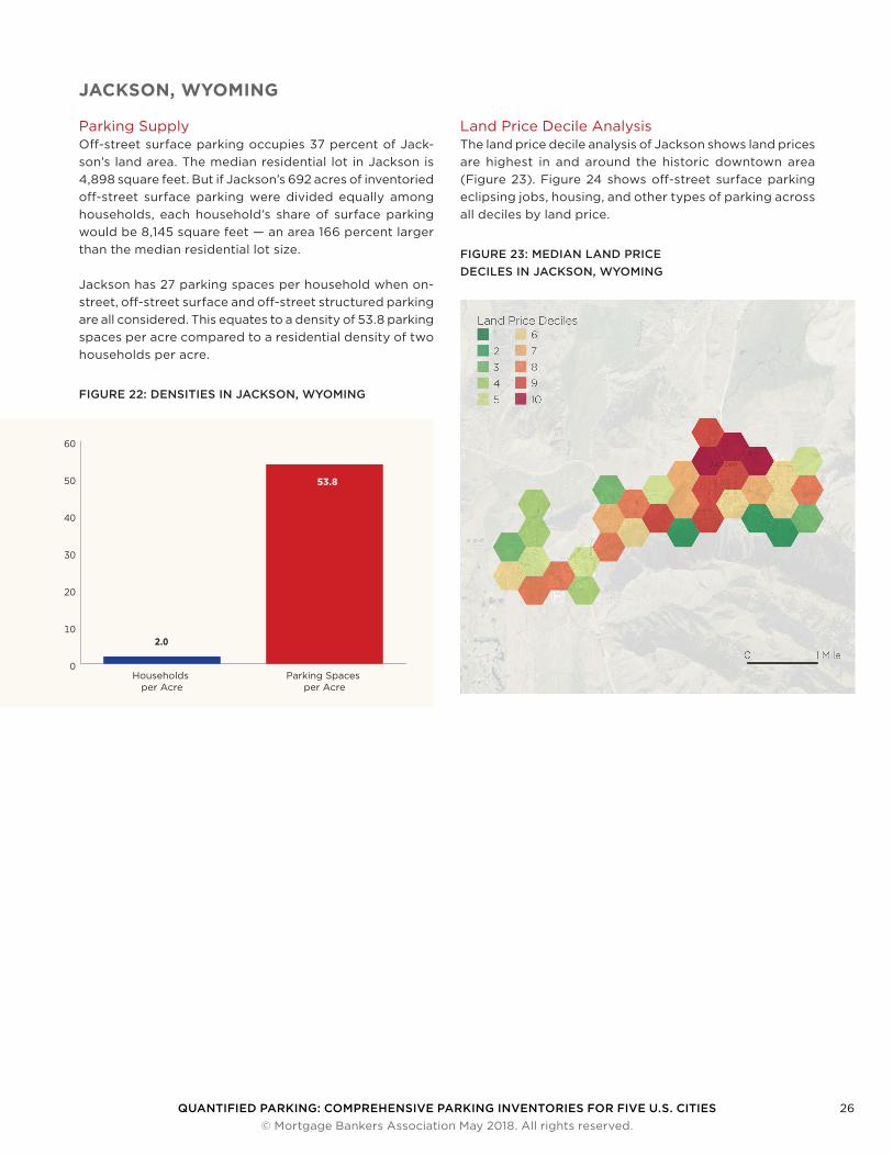
JACKSON, WYOMING
Parking SupplyOff-street surface parking occupies 37 percent of Jack-son’s land area. The median residential lot in Jackson is 4,898 square feet. But if Jackson’s 692 acres of inventoried off-street surface parking were divided equally among households, each household’s share of surface parking would be 8,145 square feet — an area 166 percent larger than the median residential lot size.
Jackson has 27 parking spaces per household when on-street, off-street surface and off-street structured parking are all considered. This equates to a density of 53.8 parking spaces per acre compared to a residential density of two households per acre.
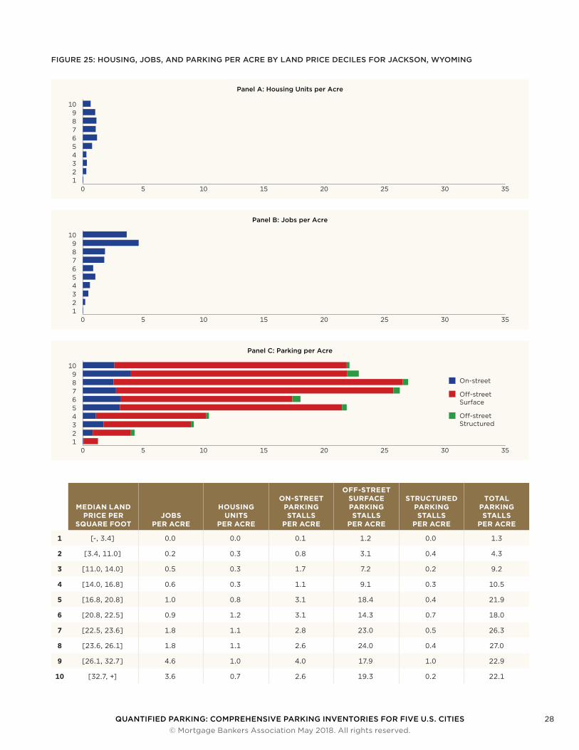
Land Price Decile AnalysisThe land price decile analysis of Jackson shows land prices are highest in and around the historic downtown area (Figure 23). Figure 24 shows off-street surface parking eclipsing jobs, housing, and other types of parking across all deciles by land price.
0
10
20
30
40
50
60
Parking Spaces per Acre
Households per Acre
2.0
53.8
FIGURE 22: DENSITIES IN JACKSON, WYOMING
FIGURE 23: MEDIAN LAND PRICE DECILES IN JACKSON, WYOMING

QUANTIFIED PARKING: COMPREHENSIVE PARKING INVENTORIES FOR FIVE U.S. CITIES 27 © Mortgage Bankers Association May 2018. All rights reserved.
FIGURE 24: HOUSING UNIT DENSITY AND PARKING STALL DENSITY IN JACKSON, WYOMING
JacksonHousing Unit Density
0–791
791–1,157
1,157–1,444
1,444–2,071
2,071–2,757
2,757–3,147
3,147–3,478
3,478–4,131
4,131–4,747
4,747+
JacksonParking Stall Density
0–791
791–1,157
1,157–1,444
1,444–2,071
2,071–2,757
2,757–3,147
3,147–3,478
3,478–4,131
4,131–4,747
4,747+
QUANTIFIED PARKING: COMPREHENSIVE PARKING INVENTORIES FOR FIVE U.S. CITIES 28 © Mortgage Bankers Association May 2018. All rights reserved.
FIGURE 25: HOUSING, JOBS, AND PARKING PER ACRE BY LAND PRICE DECILES FOR JACKSON, WYOMING
Panel A: Housing Units per Acre
0 5 10 15 20 25 30 35123456789
10
Panel B: Jobs per Acre
0 5 10 15 20 25 30 35123456789
10
Panel C: Parking per Acre
0 5 10 15 20 25 30 35123456789
10
On-street
O�-street Surface
O�-street Structured
MEDIAN LAND PRICE PER
SQUARE FOOTJOBS
PER ACRE
HOUSING UNITS
PER ACRE
ON-STREET PARKING STALLS
PER ACRE
OFF-STREET SURFACE PARKING STALLS
PER ACRE
STRUCTURED PARKING STALLS
PER ACRE
TOTAL PARKING STALLS
PER ACRE
1 [-, 3.4] 0.0 0.0 0.1 1.2 0.0 1.3
2 [3.4, 11.0] 0.2 0.3 0.8 3.1 0.4 4.3
3 [11.0, 14.0] 0.5 0.3 1.7 7.2 0.2 9.2
4 [14.0, 16.8] 0.6 0.3 1.1 9.1 0.3 10.5
5 [16.8, 20.8] 1.0 0.8 3.1 18.4 0.4 21.9
6 [20.8, 22.5] 0.9 1.2 3.1 14.3 0.7 18.0
7 [22.5, 23.6] 1.8 1.1 2.8 23.0 0.5 26.3
8 [23.6, 26.1] 1.8 1.1 2.6 24.0 0.4 27.0
9 [26.1, 32.7] 4.6 1.0 4.0 17.9 1.0 22.9
10 [32.7, +] 3.6 0.7 2.6 19.3 0.2 22.1
QUANTIFIED PARKING: COMPREHENSIVE PARKING INVENTORIES FOR FIVE U.S. CITIES 29 © Mortgage Bankers Association May 2018. All rights reserved.
Estimated Replacement Cost
TABLE 9: THE ESTIMATED REPLACEMENT COST OF JACKSON’S INVENTORIED PARKING
Population in 2016 10,529
Total Parking Replacement Cost $711 million
Total Parking Stalls 100,119
Parking Cost per Household $192,138
Parking Stalls per Household 27.1
Jackson has a parking supply of 27.1 stalls per-household, which would cost an estimated $192,138 per household to replace. This per household cost is 2.7 times Jackson’s median household income of $70,517.
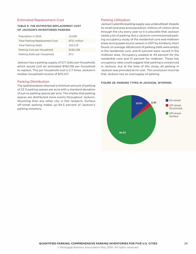
Parking DistributionThe spatial analysis returned a minimum amount of parking of 22.3 parking spaces per acre with a standard deviation of just six parking spaces per acre. This implies that parking spaces are distributed more evenly throughout Jackson, Wyoming than any other city in this research. Surface off-street parking makes up 84.5 percent of Jackson’s parking inventory.
Parking Utilization Jackson’s plentiful parking supply was underutilized. Despite its small land area and population, millions of visitors drive through the city every year so it is plausible that Jackson needs a lot of parking. But a Jackson-commissioned park-ing occupancy study of the residential core and midtown areas during peak tourist season in 2017 by Kimberly-Horn found, on average, 68 percent of parking stalls were empty in the residential core, and 61 percent were vacant in the midtown area. Occupancy peaked at 43 percent for the residential core and 51 percent for midtown. These low occupancy rates could suggest that parking is overpriced in Jackson, but at the time of this study, all parking in Jackson was provided at no cost. The conclusion must be that Jackson has an oversupply of parking.
16.2
On-street
O�-street Structured
O�-street Surface
13.0%
84.5%
2.4%
FIGURE 26: PARKING TYPES IN JACKSON, WYOMING
QUANTIFIED PARKING: COMPREHENSIVE PARKING INVENTORIES FOR FIVE U.S. CITIES 30 © Mortgage Bankers Association May 2018. All rights reserved.
Conclusion
Due to a lack of comprehensive parking data, city planners have been prescribing parking as part of new construction for decades without first diagnosing the nearby parking supply. Developers and lenders have followed suit. This resulted in builders providing on-site parking, making construction more expensive and reducing the floor area of the non-parking portion of new buildings. And all the while much of the parking has gone unused.
The luxurious amount of parking inventoried in this research was built at great expense, with a value of $81 billion for just five cities. Future projects can use an exhaustive parking inventory to locate potential sites that are oversupplied with nearby parking, and allocate capital to non-parking uses.
Having citywide parking data at the site level would, for the first time, also serve city agencies during the building permit process. Attaching parking data to real property data will allow for direct consideration of land use and housing economics. Tying the parking inventory to parking occupancy studies will help builders and lenders mitigate financial risk.
Each city in this study has a unique parking inventory and a distinct opportunity rising from its parking supply. New York’s inventory shows that public transit plays a role in tempering parking density which then enables higher hous-ing and jobs density. Philadelphia’s abundant off-street surface parking, even in the most expensive areas, is an opportunity for developers to transform parking lots into other uses in convenient locations. Seattle’s abundance of structured parking, especially in the areas with the most
expensive land, provides an opportunity to reduce future construction costs by providing less structured parking in new buildings. Des Moines has enough parking of all types, and low enough parking utilization, to encourage developers to provide less parking in future projects which would reduce construction costs. Jackson planners can encourage property developers to provide fewer parking spaces and more housing, thereby addressing the local housing crunch. And finally, Jackson, Des Moines, Seattle and Philadelphia can all work to increase their public transit offerings, thereby inviting people to arrive at their destinations without the need to park.
In short, we are just starting to learn more about how much parking cities have. But the complexity of decisions to come is unknown. We don’t know exactly how parking demand will change with coming technological, economic and social change. It’s also not clear if providing too little parking is riskier than providing too much. What is clear is that a better understanding of our parking infrastructure will be essential to effectively and efficiently navigate these changes.
QUANTIFIED PARKING: COMPREHENSIVE PARKING INVENTORIES FOR FIVE U.S. CITIES 31 © Mortgage Bankers Association May 2018. All rights reserved.
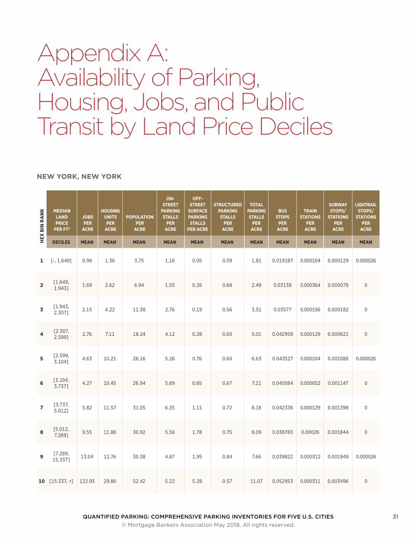
Appendix A: Availability of Parking, Housing, Jobs, and Public Transit by Land Price Deciles
NEW YORK, NEW YORK
HEX
BIN
RA
NK MEDIAN
LAND PRICE
PER FT2
JOBS PER
ACRE
HOUSING UNITS
PER ACRE
POPULATION PER
ACRE
ON-STREET
PARKING STALLS
PER ACRE
OFF-STREET
SURFACE PARKING STALLS
PER ACRE
STRUCTURED PARKING STALLS
PER ACRE
TOTAL PARKING STALLS
PER ACRE
BUS STOPS
PER ACRE
TRAIN STATIONS
PER ACRE
SUBWAY STOPS/
STATIONS PER
ACRE
LIGHTRAIL STOPS/
STATIONS PER
ACRE
DECILES MEAN MEAN MEAN MEAN MEAN MEAN MEAN MEAN MEAN MEAN MEAN
1 [-, 1.649] 0.98 1.36 3.75 1.16 0.05 0.59 1.81 0.019187 0.000104 0.000129 0.000026
2 [1.649, 1.943] 1.69 2.62 6.94 1.55 0.26 0.68 2.49 0.03138 0.000364 0.000078 0
3 [1.943, 2.307] 2.15 4.22 11.38 2.76 0.19 0.56 3.51 0.03577 0.000156 0.000182 0
4 [2.307, 2.599] 2.76 7.11 18.24 4.12 0.28 0.60 5.01 0.042958 0.000129 0.000621 0
5 [2.599, 3.104] 4.63 10.21 26.16 5.26 0.76 0.60 6.63 0.043527 0.000104 0.001088 0.000026
6 [3.104, 3.737] 4.27 10.45 26.94 5.69 0.85 0.67 7.21 0.045084 0.000052 0.001147 0
7 [3.737, 5.012] 5.82 11.57 31.05 6.35 1.11 0.72 8.18 0.042336 0.000129 0.001398 0
8 [5.012, 7.289] 9.55 11.86 30.92 5.56 1.78 0.75 8.09 0.038783 0.00026 0.001844 0
9 [7.289, 15.337] 13.04 12.76 30.38 4.87 1.95 0.84 7.66 0.039822 0.000312 0.001948 0.000026
10 [15.337, +] 122.93 29.86 52.42 5.22 5.28 0.57 11.07 0.052953 0.000311 0.003496 0
QUANTIFIED PARKING: COMPREHENSIVE PARKING INVENTORIES FOR FIVE U.S. CITIES 32 © Mortgage Bankers Association May 2018. All rights reserved.
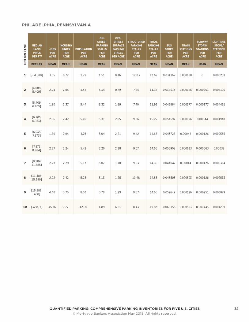
PHILADELPHIA, PENNSYLVANIAH
EX B
IN R
AN
K MEDIAN LAND PRICE
PER FT2
JOBS PER
ACRE
HOUSING UNITS
PER ACRE
POPULATION PER
ACRE
ON-STREET
PARKING STALLS
PER ACRE
OFF-STREET
SURFACE PARKING STALLS
PER ACRE
STRUCTURED PARKING STALLS
PER ACRE
TOTAL PARKING STALLS
PER ACRE
BUS STOPS
PER ACRE
TRAIN STATIONS
PER ACRE
SUBWAY STOPS/
STATIONS PER
ACRE
LIGHTRAIL STOPS/
STATIONS PER
ACRE
DECILES MEAN MEAN MEAN MEAN MEAN MEAN MEAN MEAN MEAN MEAN MEAN
1 [-, 4.088] 3.05 0.72 1.79 1.51 0.16 12.03 13.69 0.031162 0.000188 0 0.000251
2 [4.088, 5.409] 2.21 2.05 4.44 3.34 0.79 7.24 11.36 0.038513 0.000126 0.000251 0.008105
3 [5.409, 6.205] 1.80 2.37 5.44 3.32 1.19 7.40 11.92 0.045864 0.000377 0.000377 0.004461
4 [6.205, 6.933] 2.86 2.42 5.49 3.31 2.05 9.86 15.22 0.054597 0.000126 0.00044 0.001948
5 [6.933, 7.873] 1.80 2.04 4.76 3.04 2.21 9.42 14.68 0.043728 0.00044 0.000126 0.000565
6 [7.873, 8.984] 2.27 2.24 5.42 3.20 2.38 9.07 14.65 0.050908 0.000633 0.000063 0.00038
7 [8.984, 11.485] 2.23 2.29 5.17 3.07 1.70 9.53 14.30 0.044042 0.00044 0.000126 0.000314
8 [11.485, 15.589] 2.92 2.42 5.23 3.13 1.25 10.48 14.85 0.048503 0.000503 0.000126 0.002513
9 [15.589, 32.8] 4.40 3.70 8.03 3.78 1.29 9.57 14.65 0.052649 0.000126 0.000251 0.003079
10 [32.8, +] 45.76 7.77 12.90 4.89 6.51 8.43 19.83 0.068356 0.000503 0.001445 0.004209
QUANTIFIED PARKING: COMPREHENSIVE PARKING INVENTORIES FOR FIVE U.S. CITIES 33 © Mortgage Bankers Association May 2018. All rights reserved.
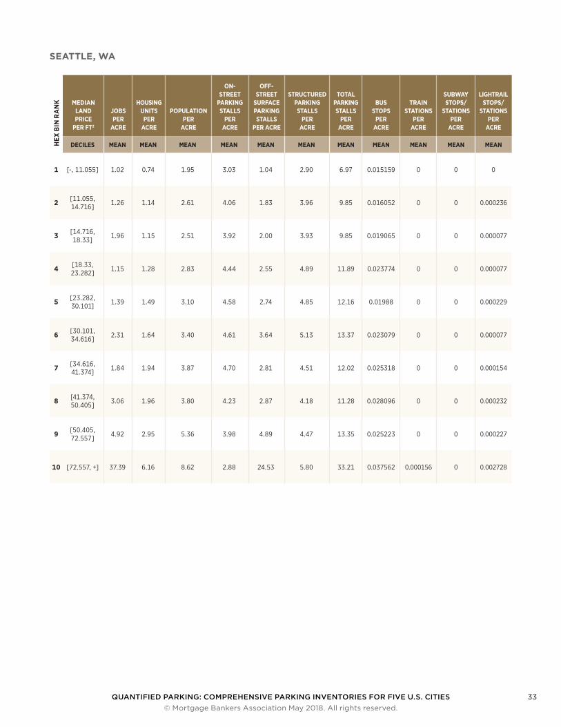
SEATTLE, WAH
EX B
IN R
AN
K MEDIAN LAND PRICE
PER FT2
JOBS PER
ACRE
HOUSING UNITS
PER ACRE
POPULATION PER
ACRE
ON-STREET
PARKING STALLS
PER ACRE
OFF-STREET
SURFACE PARKING STALLS
PER ACRE
STRUCTURED PARKING STALLS
PER ACRE
TOTAL PARKING STALLS
PER ACRE
BUS STOPS
PER ACRE
TRAIN STATIONS
PER ACRE
SUBWAY STOPS/
STATIONS PER
ACRE
LIGHTRAIL STOPS/
STATIONS PER
ACRE
DECILES MEAN MEAN MEAN MEAN MEAN MEAN MEAN MEAN MEAN MEAN MEAN
1 [-, 11.055] 1.02 0.74 1.95 3.03 1.04 2.90 6.97 0.015159 0 0 0
2 [11.055, 14.716] 1.26 1.14 2.61 4.06 1.83 3.96 9.85 0.016052 0 0 0.000236
3 [14.716, 18.33] 1.96 1.15 2.51 3.92 2.00 3.93 9.85 0.019065 0 0 0.000077
4 [18.33, 23.282] 1.15 1.28 2.83 4.44 2.55 4.89 11.89 0.023774 0 0 0.000077
5 [23.282, 30.101] 1.39 1.49 3.10 4.58 2.74 4.85 12.16 0.01988 0 0 0.000229
6 [30.101, 34.616] 2.31 1.64 3.40 4.61 3.64 5.13 13.37 0.023079 0 0 0.000077
7 [34.616, 41.374] 1.84 1.94 3.87 4.70 2.81 4.51 12.02 0.025318 0 0 0.000154
8 [41.374, 50.405] 3.06 1.96 3.80 4.23 2.87 4.18 11.28 0.028096 0 0 0.000232
9 [50.405, 72.557] 4.92 2.95 5.36 3.98 4.89 4.47 13.35 0.025223 0 0 0.000227
10 [72.557, +] 37.39 6.16 8.62 2.88 24.53 5.80 33.21 0.037562 0.000156 0 0.002728
QUANTIFIED PARKING: COMPREHENSIVE PARKING INVENTORIES FOR FIVE U.S. CITIES 34 © Mortgage Bankers Association May 2018. All rights reserved.
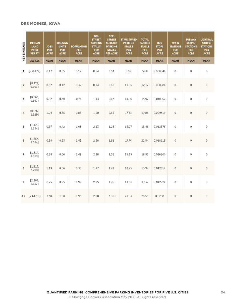
DES MOINES, IOWAH
EX B
IN R
AN
K MEDIAN LAND PRICE
PER FT2
JOBS PER
ACRE
HOUSING UNITS
PER ACRE
POPULATION PER
ACRE
ON-STREET
PARKING STALLS
PER ACRE
OFF-STREET
SURFACE PARKING STALLS
PER ACRE
STRUCTURED PARKING STALLS
PER ACRE
TOTAL PARKING STALLS
PER ACRE
BUS STOPS
PER ACRE
TRAIN STATIONS
PER ACRE
SUBWAY STOPS/
STATIONS PER
ACRE
LIGHTRAIL STOPS/
STATIONS PER
ACRE
DECILES MEAN MEAN MEAN MEAN MEAN MEAN MEAN MEAN MEAN MEAN MEAN
1 [-, 0.179] 0.17 0.05 0.12 0.54 0.04 5.02 5.60 0.000648 0 0 0
2 [0.179, 0.563] 0.52 0.12 0.32 0.94 0.18 11.05 12.17 0.000986 0 0 0
3 [0.563, 0.897] 0.92 0.30 0.74 1.44 0.47 14.06 15.97 0.010952 0 0 0
4 [0.897, 1.129] 1.29 0.35 0.85 1.90 0.65 17.31 19.86 0.009419 0 0 0
5 [1.129, 1.354] 0.87 0.42 1.03 2.13 1.26 15.07 18.46 0.012376 0 0 0
6 [1.354, 1.514] 0.94 0.63 1.48 2.28 1.51 17.74 21.54 0.018619 0 0 0
7 [1.514, 1.819] 0.88 0.66 1.49 2.18 1.58 15.19 18.95 0.016867 0 0 0
8 [1.819, 2.208] 1.19 0.56 1.30 1.77 1.42 12.75 15.94 0.012814 0 0 0
9 [2.208, 2.617] 0.75 0.95 1.99 2.25 1.76 13.31 17.32 0.012924 0 0 0
10 [2.617, +] 7.38 1.08 1.93 2.20 3.30 21.03 26.53 0.0268 0 0 0
QUANTIFIED PARKING: COMPREHENSIVE PARKING INVENTORIES FOR FIVE U.S. CITIES 35 © Mortgage Bankers Association May 2018. All rights reserved.
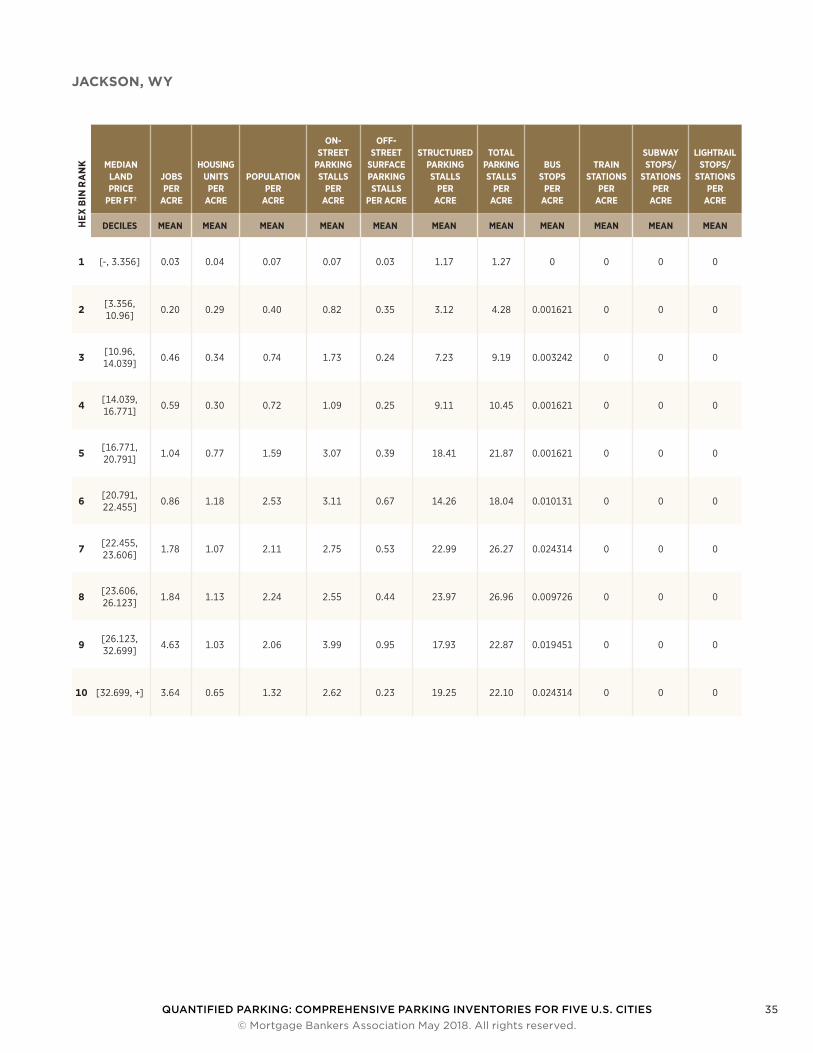
JACKSON, WYH
EX B
IN R
AN
K MEDIAN LAND PRICE
PER FT2
JOBS PER
ACRE
HOUSING UNITS
PER ACRE
POPULATION PER
ACRE
ON-STREET
PARKING STALLS
PER ACRE
OFF-STREET
SURFACE PARKING STALLS
PER ACRE
STRUCTURED PARKING STALLS
PER ACRE
TOTAL PARKING STALLS
PER ACRE
BUS STOPS
PER ACRE
TRAIN STATIONS
PER ACRE
SUBWAY STOPS/
STATIONS PER
ACRE
LIGHTRAIL STOPS/
STATIONS PER
ACRE
DECILES MEAN MEAN MEAN MEAN MEAN MEAN MEAN MEAN MEAN MEAN MEAN
1 [-, 3.356] 0.03 0.04 0.07 0.07 0.03 1.17 1.27 0 0 0 0
2 [3.356, 10.96] 0.20 0.29 0.40 0.82 0.35 3.12 4.28 0.001621 0 0 0
3 [10.96, 14.039] 0.46 0.34 0.74 1.73 0.24 7.23 9.19 0.003242 0 0 0
4 [14.039, 16.771] 0.59 0.30 0.72 1.09 0.25 9.11 10.45 0.001621 0 0 0
5 [16.771, 20.791] 1.04 0.77 1.59 3.07 0.39 18.41 21.87 0.001621 0 0 0
6 [20.791, 22.455] 0.86 1.18 2.53 3.11 0.67 14.26 18.04 0.010131 0 0 0
7 [22.455, 23.606] 1.78 1.07 2.11 2.75 0.53 22.99 26.27 0.024314 0 0 0
8 [23.606, 26.123] 1.84 1.13 2.24 2.55 0.44 23.97 26.96 0.009726 0 0 0
9 [26.123, 32.699] 4.63 1.03 2.06 3.99 0.95 17.93 22.87 0.019451 0 0 0
10 [32.699, +] 3.64 0.65 1.32 2.62 0.23 19.25 22.10 0.024314 0 0 0
QUANTIFIED PARKING: COMPREHENSIVE PARKING INVENTORIES FOR FIVE U.S. CITIES 36 © Mortgage Bankers Association May 2018. All rights reserved.
Appendix B: Detailed Methodology
ON STREET PARKING DATANew YorkOpen Data New York provided street line geometries and point locations of parking regulation signs (“NYC Open Data”). I combined these two datasets to estimate the number of available on-street parking spaces along each street segment in the five boroughs of New York.
PhiladelphiaThe City of Philadelphia provided street line geometries (“OpenDataPhilly”). I split these lines at intersections and conservatively assigned 25 percent of each non-highway street side as parking.
SeattleThe Seattle Department of Transportation provided the geometry of street lines encoded with parking information that did not require additional processing (“City of Seattle Open Data Portal”). I summarized on-street parking at the block-face level.
Jackson and Des MoinesI downloaded street line geometries for Teton County, Wyoming from the Teton County website (“Teton County GIS Data Archive”), and for Des Moines from the Des Moines, Iowa GIS website (“Des Moines Data Download”). All lines were clipped to the city extents and then split into segments no longer than 100 meters. Parking was then assigned to twenty-five percent of each side of the street for non-highway sections to account for the curb cuts along city streets in Jackson and Des Moines that limit on-street parking.
OFF-STREET STRUCTUREDNew YorkFor New York, parcel data contained the shape, land use, and garage area of each parcel. I linked parcel geometries to garage information from the MapPLUTO database (“PLUTO and MapPLUTO”). I summarized the amount of garage parking at the parcel level.
PhiladelphiaPhiladelphia County, Pennsylvania parcel data came as points with garage and parking lot information. I joined Philadelphia parcel polygons from The City of Philadelphia
Department of Records to property assessment data from the City of Philadelphia Office of Property Assessment that included the number of garage spaces (“Department of Records Property Parcels — OpenDataPhilly”). I sum-marized garages at the parcel level.
I added parking for large parking structures that were not in the assessor’s data by referencing The Philadelphia Park-ing Authority map (“The Philadelphia Parking Authority”).
SeattleFor King County, separate parcel extract tables covered commercial, residential, condominium and apartment properties (“King County GIS Data Hub”). Each of these tables contained some parking information like the number of garage or underground parking stalls. Land price data also came from an Assessor’s extract table.
The King County, Washington tax assessor provided parcel geometries and parcel extract tables for different land uses. I linked the parcel extract tables to the parcel geometries and summarized structured parking information for each Seattle parcel like the number of garage spaces or the gross area of underground parking.
I added parking for large institutions like the University of Washington to the database later after inquiring through email.
Des MoinesThe Polk County, Iowa property tax assessor provided parcel geometries and parcel extract tables for different land uses (“Des Moines Data Download”). These extract tables contained some parking information, for example, the gross area of basement parking.
Many large parking structures did not have parking stalls registered by the tax assessor, so I added them by hand after referencing parkopedia (“Parkopedia”).
JacksonTeton County, Wyoming parcel data came with an “improve-ments” table with information about carports and garages. I combined parcel geometries and parcel improvement details from the Teton County, Wyoming property tax
QUANTIFIED PARKING: COMPREHENSIVE PARKING INVENTORIES FOR FIVE U.S. CITIES 37 © Mortgage Bankers Association May 2018. All rights reserved.
assessor (“Teton County GIS Data Archive”). I rolled up the improvement details to each parcel to get the area of carports and garages. Then I selected parcels from Teton County that were situated within the Jackson city boundary.
The parking spaces in Jackson’s large public parking garage were not registered by the tax assessor, so I added them to the database by hand.
OFF-STREET SURFACENew YorkThe New York City Department of Parks and Recreation provided high-resolution landcover data with a category for “other paved surfaces” (City of New York). I clipped this to each parcel geometry to summarize the amount of on-grade pavement on a parcel.
Land-use-specific coefficients adjusted the parking por-tion of paved surfaces for different uses.
PhiladelphiaThe City of Philadelphia Office of Property Assessment provided the number of off-street parking spaces for some parcels (City of Philadelphia, “City of Philadelphia: Office of Property Assessment”). The rest of the off-street surface parking data came from the city’s GIS Services Group and their categorized impervious surface geometries with categories for driveways and parking lots (City of Philadelphia, City of Philadelphia: CityGeo). I summarized off-street surface parking at the parcel level.
SeattleThe King County Tax Assessor provided single-use park-ing lots at the parcel level. But, off-street surface parking was not recorded in the parcel data if it was ancillary to another use like a shopping center. To estimate the amount of unassessed surface parking, King County provided landcover data with a category for impervious surfaces. The City of Seattle contributed building footprint polygons, and I clipped the impervious portion of the landcover data to each parcel and then subtracted the building footprint to return an estimate of the parking area for each parcel in Seattle.
Land-use-specific coefficients adjusted the parking por-tion of impervious areas for different uses.
Des MoinesThe City of Des Moines provided landcover data with geometries of driveways and parking lots that were traced from high-resolution digital orthophotos.
JacksonTeton County landcover data had a category for parking lots and another category that combined driveways and
buildings. I corrected one large condo parking area that was misclassified as a wetland. Then I trimmed the data to the Jackson city extent. I extracted building footprints from Openstreetmap and subtracted them from the geom-etries of the combined driveways and buildings landcover category to isolate the driveway portion (Openstreetmap Contributors). Then I summarized off-street surface park-ing at the parcel level.
HEXAGON BINNINGLand values and Estimating Replacement CostTo estimate the value of land for each parcel in each city, I first combined parcel geometries with their assessed land value. Then I summarized prices within an overlay of 0.5 square kilometer hexagons. Hexagons have a nice property for analysis because they are the closest single shape to circles — commonly used for density analyses — that can be tessellated edge-to-edge across a map surface. I used the median price per square meter within each hexagon after intersecting the parcel centroids with the hexagons. Then, I applied that value to each inven-toried parking space within each hexagon. This step was necessary to give land values to tax-exempt properties that did not have a land value in any assessor’s data. For on-street surface parking spaces, I used a surface area of 20 square meters, and off-street parking spaces were all assumed to be 30 square meters.
Surface parking spaces were assigned a per-stall construc-tion cost of $5,000 (Litman). All structured parking spaces were given a conservative replacement cost of $50,000 in total, a number meant to include each stall’s share of buildable land. The variable price of land was ignored for structured parking stalls.
Census DataThe population and number of housing units per block group came from the 2015 American Community Survey, accessed through their public Application Program Interface (API). I intersected block group geometries with the 500-meter hexagonal overlay to first compute coefficients for each block group or sliver of a block group based on the por-tion of a block group that was within each hexagon. These coefficients were then applied to the block-group-hexagon intersection geometries to adjust for the population or number of housing units within a hexagon. A block group, for example, with 10 housing units that was situated half inside one hexagon, and half inside another, was assigned 5 housing units each for the parts of the block group that were split by the hexagon’s boundary.
Public Transit DataPublic transit data came from Google Maps. The number of bus stops, light rail stations, subway stations, and train stations were summed within each hexagon.
QUANTIFIED PARKING: COMPREHENSIVE PARKING INVENTORIES FOR FIVE U.S. CITIES 38 © Mortgage Bankers Association May 2018. All rights reserved.
References
Alsnih, Rahaf, and David A. Hensher. “The Mobility and Accessibility Expectations of Seniors in an Aging Population.” Transportation Research Part A: Policy and Practice, vol. 37, no. 10, Dec. 2003, pp. 903–16.
Balk, Gene. “Seattle Has Reversed a Decades-Long Trend of Rising Car Ownership — and Millennials Are the Reason.” The Seattle Times, 12 May 2017, https://www.seattletimes.com/seattle-news/data/seattle-has-reversed-a-decades-long-trend-of-car-ownership-and-millennials-are-the-reason/.
Beekman, Daniel. “City Council Oks Sale of Pacific Place Garage to Mall’s Owner.” The Seattle Times, 11 July 2016, https://www.seattletimes.com/seattle-news/ politics/city-council-oks-sale-of-pacific-place- garage-to-malls-owner/.
“Census Shapefiles.” Census Shapefiles, https://www.census.gov/cgi-bin/geo/ shapefiles/index.php. Accessed 26 Jan. 2018.
Chester, Mikhail, et al. “Parking Infrastructure and the Environment.” ACCESS Magazine, vol. 1, no. 39, 2011, http://escholarship.org/uc/item/16r4t7p7.pdf.
City of New York. “Landcover Raster Data (2010) — 3ft Resolution.” NYC Open Data, https://data.cityofnewyork.us/Environment/ Landcover-Raster-Data-2010-3ft-Resolution/ 9auy-76zt. Accessed 26 Jan. 2018.
City of Philadelphia. “City of Philadelphia.” Office of Property Assessment, http://www.phila.gov/opa/pages/default.aspx. Accessed 26 Jan. 2018.
---. “City of Philadelphia.” CityGeo, http://www.phila.gov/it/aboutus/units/Pages/GISServicesGroup.aspx. Accessed 26 Jan. 2018.
“City of Seattle Open Data Portal.” City of Seattle Open Data Portal, https://data.seattle.gov/. Accessed 26 Jan. 2018.
Core Logic. Program Reference Marshall & Swift® SwiftEstimator® Residential Estimator Program. June 2016, https://www.swiftestimator.com/pdf/ SE_RE_Program_Reference_0616.pdf.
“Data at PSRC.” Puget Sound Regional Council, 28 Feb. 2017, https://www.psrc.org/ data-and-resources/data-psrc.
Davis, Amélie Y., et al. “The Environmental and Economic Costs of Sprawling Parking Lots in the United States.” Land Use Policy, vol. 27, no. 2, Apr. 2010, pp. 255–61.
Delucchi, Mark A. “The Annualized Social Cost of Motor-vehicle Use in the US, 1990-1991: Summary of Theory, Data, Methods, and Results.” University of California Transportation Center, 1997, http://escholarship.org/uc/item/43s6n28v.pdf.
“Department of Records Property Parcels.” Open Data Philadelphia, https://www.opendataphilly.org/dataset/property-parcels. Accessed 26 Jan. 2018.
“Des Moines Data Download.” Des Moines Data Download, 2010, https://maps.dmgov.org/apps/mapcenter/GetDSMData.aspx.
Guo, Zhan. “Residential Street Parking and Car Ownership: A Study of Households With Off-Street Parking in the New York City Region.” Journal of the American Planning Association. American Planning Association, vol. 79, no. 1, Taylor & Francis, 2013, pp. 32–48.
Henderson, Tim. “Why Many Teens Don’t Want to Get a Driver’s License.” PBS NewsHour, 7 Mar. 2017, https://www.pbs.org/newshour/nation/many-teens-dont-want-get-drivers-license.
Huang, X., et al. “Classification and Extraction of Spatial Features in Urban Areas Using High-Resolution Multispectral Imagery.” IEEE Geoscience and Remote Sensing Letters, vol. 4, no. 2, Apr. 2007, pp. 260–64.
QUANTIFIED PARKING: COMPREHENSIVE PARKING INVENTORIES FOR FIVE U.S. CITIES 39 © Mortgage Bankers Association May 2018. All rights reserved.
Kimberly Horn. Jackson Parking Management Study Draft v2.0. 2017.
“King County GIS Data Hub.” King County, https://www.kingcounty.gov/services/gis/ ISData.aspx. Accessed 26 Jan. 2018.
Koehler, Jack. 9 Aug. 2017.
Litman, T. “Parking Costs, Pricing and Revenue Calculator.” Victoria Transport Policy Institute, 2012.
Lyft. Lyft 2017 Economic Impact Report. 2017, https://take.lyft.com/economic-impact/ Lyft-Drives-Economy.pdf.
Manville, Michael. “Parking Requirements and Housing Development: Regulation and Reform In Los Angeles.” Journal of the American Planning Association. American Planning Association, vol. 79, no. 1, Taylor & Francis, 2013, pp. 49–66.
McCahill, Christopher, and Norman Garrick. “Automobile Use and Land Consumption: Empirical Evidence From 12 Cities.” Urban Design International, vol. 17, no. 3, Palgrave Macmillan UK, Aug. 2012, pp. 221–27.
Moudon, Anne vernez, et al. “Transportation-Efficient Land Use Mapping Index (TELUMI), a Tool to Assess Mul-timodal Transportation Options in Metropolitan Regions.” International Journal of Sustainable Transportation, vol. 5, no. 2, Taylor & Francis, Jan. 2011, pp. 111–33.
Nelson \ Nyggard. West 108th Street Development Parking Study. 2016.
New York City Department of Transportation. Barclays Center On‐Street Parking Impact Study. 2013, http://www.nyc.gov/html/dot/downloads/pdf/ 2013-09-barclays-parking-impact-presentation.pdf.
“NYC Open Data.” NYC Open Data, https://opendata.cityofnewyork.us/. Accessed 26 Jan. 2018.
“OpenDataPhilly.” OpenDataPhilly, https://www.opendataphilly.org/. Accessed 26 Jan. 2018.
Openstreetmap Contributors. “OpenStreetMap.” OpenStreetMap, http://www. openstreetmap. org, 2012, https://www.openstreetmap.org/.
“Parkopedia.” Parkopedia.com, https://www.parkopedia.com/. Accessed 26 Jan. 2018.
Philadelphia City Planning Commission. 2015 Parking Study. https://www.phila.gov/ CityPlanning/aboutus/planningservices/ Documents/2015_Parking_Study.pdf.
“PLUTO and MapPLUTO.” NYC Planning, https://www1.nyc.gov/site/planning/data-maps/ open-data/dwn-pluto-mappluto.page. Accessed 26 Jan. 2018.
PSRC. “Parking Inventory.” Puget Sound Regional Council, 23 Nov. 2016, https://www.psrc.org/ parking-inventory.
Pucher, John, et al. “Walking and Cycling in the United States, 2001–2009: Evidence from the National Household Travel Surveys.” American Journal of Public Health, vol. 101 Suppl 1, Dec. 2011, pp. S310–17.
“Redfin.” Redfin, Dec. 2017, www.redfin.com.
Rushe, Dominic. “Why We Can’t Have Nice Things: Dockless Bikes and the Tragedy of the Commons.” The Guardian, 5 Nov. 2017, http://www.theguardian.com/politics/2017/ nov/05/why-we-cant-have-nice-things- dockless-bikes-and-the-tragedy-of-the-commons.
Saffron, Inga. “Changing Skyline: Lifeless Parking Garage Slows City’s Pulse.” Philly.com, 1 Mar. 2013, http://www.philly.com/philly/home/ 20130301_Changing_Skyline__Lifeless_ parking_garage_slows_city_s_pulse.html.
Sallis, James F., et al. “An Ecological Approach to Creating Active Living Communities.” Annual Review of Public Health, vol. 27, 2006, pp. 297–322.
Scharnhorst, Eric. “Have U.S. Cities Reached Peak Parking?” Redfin Real-Time, 9 Dec. 2016, https://www.redfin.com/blog/2016/12/ peak-parking.html.
Seattle Times Staff. “Seattle Sells Pacific Place Garage for $87 Million, Paving Way for Mall Remodel.” The Seattle Times, 29 Sept. 2016, https://www.seattletimes.com/business/ real-estate/seattle-sells-pacific-place-garage- for-87-million-paving-way-for-mall-remodel/.

QUANTIFIED PARKING: COMPREHENSIVE PARKING INVENTORIES FOR FIVE U.S. CITIES 40 © Mortgage Bankers Association May 2018. All rights reserved.
Shoup, Donald. The High Cost of Free Parking: Updated Edition. Routledge, 2017.
Sivak, Michael, and Brandon Schoettle. “Recent Decreases in the Proportion of Persons with a Driver’s License across All Age Groups.” Transportation Research Institute Report, UMTRI-2016-4, University of Michigan, Ann Arbor, 2016, http://umich.edu/~umtriswt/PDF/UMTRI-2016-4_Abstract_English.pdf.
Strong Towns. “A Map of Cities That Got Rid of Parking Minimums.” Strong Towns, 2015, https://www.strongtowns.org/journal/2015/11/18/ a-map-of-cities-that-got-rid-of-parking-minimums.
“Teton County GIS Data Archive.” Teton County GIS Data Archive, http://tetonwy.greenwoodmap.com/gis/download/. Accessed 26 Jan. 2018.
“The Philadelphia Parking Authority.” The Philadelphia Parking Authority, http://www.philapark.org/. Accessed 26 Jan. 2018.
“Town Of Jackson Parking Garage Challenges to Success.” Town Of Jackson, http://townofjackson.com/services/police/pr/parking-garage-challenges-success/. Accessed 20 Feb. 2018.
U.S. Census Bureau. American Community Survey (ACS). 2017, https://www.census.gov/ programs-surveys/acs/.
Willson, Richard W. “Suburban Parking Requirements: A Tacit Policy for Automobile Use and Sprawl.” Journal of the American Planning Association. American Planning Association, vol. 61, no. 1, Routledge, Mar. 1995, pp. 29–42.