requested commission action: quasi-judicial...
TRANSCRIPT

Meeting Date: October 27, 2015 Agenda Item
REQUESTED COMMISSION ACTION: QUASI-JUDICIAL
Consent X Ordinance Resolution Consideration __ Workshop
SHORT TITLE AN ORDINANCE OF THE CITY OF POMPANO BEACH, FLORIDA, ABANDONING A CERTAIN TWENTY EIGHT FOOT WIDE PORTION OF THE RIGHT-OF-WAY FOR POWERLINE ROAD LYING EAST OF POWERLINE ROAD AND NORTH OF SOUTHWEST 15TH STREET (W. MCNAB ROAD); PROVIDING FOR SEVERABILITY; PROVIDING AN EFFECTIVE DATE.
Summary of Purpose and Why:
The Petitioner is requesting to abandon a 28-foot portion of the Right-of-Way located at 1400-1442 S. Powerline Road. In 1985, the subject property was dedicated by the Powerline/McNab Commercial Plat. There is an FPL easement that is being retained on the property. In 1989, the Broward County Engineering Division made a reduction to the amount of required Right of Way necessary for Powerline Road from 200 feet to 144 feet for this area. If this request is approved, the applicant intends to use the area for additional parking. This request was recommended for approval unanimously by the Planning & Zoning Board with conditions that have been met prior to placement on this agenda.
QUESTIONS TO BE ANSWERED BY ORIGINATING DEPARTMENT: (1) Origin of requestforthis action: 1400 Investments LLC -------------------------------------------------(2) Primary staff contact: Maggie Barszewski 1 Robin Bird Ext. 7921 (3) Expiration of contract, if applicable: NIA
----------------------------------------------~ (4) Fiscal impact and source of funding: _____ N_'_A ____________________________ _
DEPARTMENTAL COORDINATION
Dev. Services City Attorney
DATE 8/14/2015 9/17/2015
~ Planning & Zoning Board
x City Manager ~ ACTION TAKEN BY COMMISSION:
DEPARTMENTAL RECOMMENDATION Approval
Ordinance 1st Reading 10/13/15
Resolution 1st Reading
Approved 2nd Reading 10/2 7/15
DEPARTMENTAL HEAD SIGNATURE
P&Z # 15-433 ~A;L..7* CAC#2015-164~ ----
Consideration Results:
Workshop Results:
G:lZoning 2009IVacation- AbandonmentsI201S\IS-18000001 - 1400-1442 S. Powerline Rd\CC\CC Agenda Form Memo # IS-487.doc

TO:
FROM:
RE:
City Attorney's Communication #2015-1644 September 17,2015
Maggie Barszewski, AICP, Planner
Mark E. Berman, City Attorney
Ordinance to Vacate a Portion of a Platted Right-of-Way for Powerline Road
As requested in your memorandum of September 17, 2015, Department of Development Services Memorandum #15-512, the following form of Ordinance, relative to the abovereferenced matter, has been prepared and is attached:
AN ORDINANCE OF THE CITY OF POMPANO BEACH, FLORIDA, ABANDONING A CERTAIN TWENTY EIGHT FOOT WIDE PORTION OF THE RIGHT-OF-WAY FOR POWERLINE ROAD LYING EAST OF POWERLINE ROAD AND NORTH OF SOUTHWEST ISTH STREET (W. MCNAB ROAD); PROVIDING FOR SEVERABILITY; PROVIDING AN EFFECTIVE DATE.
Please feel free to contact me if I may be of further assistance.
MEB/jrm l:cor/dev-srv/20 15-1644
Attachment
ORDINANCE NO. 2016-__ _
CITY OF POMPANO BEACH Broward County. Florida
AN ORDINANCE OF THE CITY OF POMPANO BEACH, FLORIDA, ABANDONING A CERTAIN TWENTY EIGHT FOOT WIDE PORTION OF THE RIGHT-OF-WAY FOR POWERLINE ROAD LYING EAST OF POWERLINE ROAD AND NORTH OF SOUTHWEST 15TH STREET (W. MCNAB ROAD); PROVIDING FOR SEVERABILITY; PROVIDING AN EFFECTIVE DATE.
WHEREAS, pursuant to law, ten (10) days' notice has been given by publication in a
paper of general circulation in the City notifying the public of this proposed Ordinance and of a
public hearing in the City Commission Chambers of the City of Pompano Beach; and
WHEREAS, a public hearing before the City Commission was held pursuant to the
published notice described above, at which hearing the parties in interest and all other citizens so
desiring had an opportunity to be and were, in fact, heard; and
WHEREAS, the City Commission has received a request for the abandonment of a
twenty eight foot wide portion of the right-of-way for Powerline Road lying east of Powerline
Road and north of Southwest 15th Street (W. McNab Road); and
WHEREAS, the Planning and Zoning Board has made its recommendation upon said
request; now, therefore,
BE IT ENACTED BY THE CITY OF POMPANO BEACH, FLORIDA:
SECTION 1. It is hereby found and determined by the City Commission that the public
health, welfare, safety and necessity no longer require retention of any interest by the public in
that certain portion of the right-of-way as more fully described below.

SECTION 2. It is hereby further found and determined that abandonment and vacation
of that certain portion of the right-of-way will not have a detrimental effect upon the surrounding
property or area.
SECTION 3. That the City of Pompano Beach does hereby abandon and vacate the
following described right-of-way:
See Exhibit "A" attached hereto and incorporated herein as if set forth in full.
SECTION 4. That the City Clerk is hereby instructed to record this Ordinance in the
Public Records of Broward County, Florida.
SECTION 5. The City of Pompano Beach reserves for its own purposes, and for the
purposes of all recognized public utility companies offering public utility services in the City to
its customers including, but not limited to, Florida Power & Light Company, AT&T, TECO
Peoples Gas, and Comcast Cable, the reservation of an easement forever for the construction,
operation and maintenance of overhead and underground electric facilities (including wires,
poles, guys, cables, conduits, buried cables, cable terminals, markers, splicing boxes and
pedestals, manholes, amplifier boxes, pipes, gas transmission lines, water and sewer lines and all
appurtenant devises and equipment) to be installed from time to time; with the right to construct,
reconstruct, improve, add to, enlarge, change the voltage, change pressure, as well as the size of,
and to remove such facilities or any of them, together with the right to permit any other person,
firm or corporation to attach wires to any facilities hereunder and lay cable and conduit within
the easement and to operate the same for communication purposes, the right of ingress and egress
to said premises at all times; the right to clear the land and keep it cleared of all trees,
undergrowth and obstructions within the easement area; the right to trim and cut and keep
trimmed and cut, all dead, weak, leaning or dangerous trees or limbs outside of the easement area
2

which might interfere with or fall upon the lines of systems of communication or power or
telephone or gas transmission or distribution; and further reserves to the fullest extent, the right
and power to grant, if at all, the rights herein granted on the land heretofore described, over,
along, under and across the roads, streets or highways adjoining or through said property. The
easement is described on Exhibit "A" attached hereto and incorporated herein by reference as if
set forth in full.
SECTION 6. If any provision of this Ordinance or the application thereof to any person
or circumstances is held invalid, such invalidity shall not affect any provisions or applications of
this Ordinance that can be given effect without the invalid provision or application, and to this
end the provisions of this Ordinance are declared to be severable.
SECTION 7. This Ordinance shall become effective upon passage.
PASSED FIRST READING this ___ day of _________ , 2015.
PASSED SECOND READING this ___ day of ________ , 2015.
LAMAR FISHER, MAYOR
ATTEST:
ASCELETA HAMMOND, CITY CLERK
MEB/jrm 9/17/15 L:ordi20 15-487
3

FOR: 1400 Investments, LLC
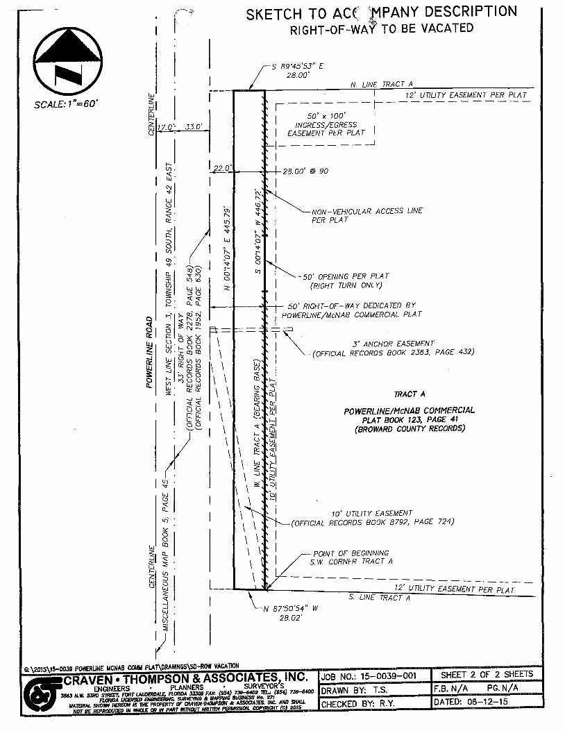
LEGAL DESCRIPTION:
Exhibit A
DESCRIPTION T ,ACCOMPANY SKETCH RIGHT-OF~WAY TO BE VACATED
A PORTION OF THE 50.00 FOOT RIGHT-OF-WAY FOR POWERLINE ROAD DEDICATED BY POWERLINE/McNA8 COMMERCIAL, ACCORDING TO THE PLAT THEREOF, AS RECORDED IN PLAT BOOK 123, PAGE 41, OF THE PUBLIC RECORDS OF BROWARD COUNTY, FLORIDA. BEING MORE PAR TlCULARL Y DESCRIBED AS FOLLOWS: -- -..... '",:.-~
BEGINNING A T THE SOUTHWEST CORNER OF TRACT A, OF SAID POWERLlNE/McNAB COMMERCIAL; THENCE NORTH 87"50'54" ~ST, ALONG THE WESTERL Y EXTENSION OF THE SOUTH LINE OF SAID TRACT A. A DISTANCE OF 28.02 FEET; THENCE NORTH 00'14'07" EAST, ALONG A LINE 28.00 FEET WEST OF, AND PARALLEL WITH. WHEN MEASURED AT RIGHT ANGLES TO THE WEST LINE OF SAID TRACT A, A DISTANCE OF 445.79 FEET; THENCE SOUTH 89'45'53" EAST, ALONG THE WESTERLY EXTENSION OF THE NORTH LINE OF SAID TRAQT A, A DISTANCE OF 28.00 FEET; THENCE SOUTH 00·14'07" WEST, ALONG THE WEST LINE OF SAID TRACT A. A DISTANCE OF 446.72 FEET TO THE POINT OF BEGINNING.
SAID LANDS SITUA TE, LYING AND BEING IN THE CITY OF POMPANO BEACH, BROWARD COUNTY, FLORIDA. CONTAINING 12,495 SQUARE FEET OR 0.287 ACRES MORE OR LESS.
NOTES:
BEARINGS SHOWN HEREON ARE BASED ON AN ASSUMED BEARING AND ARE REFERENCED TO THE WEST LINE OF TRACT A. POWERLINE/McNAB COMMERCIAL, PLA T BOOK 123. PAGE 41, OF THE PUBLIC RECORDS OF BROWARD COUNTY, FLORIDA. WHICH BEARS NORTH 00'14'07" EAST.
THIS SKETCH AND DESCRIPTION CONSISTS OF 2 SHEETS AND EACH SHEET SHALL NOT BE CONSIDERED FULL. VALID AND COMPLETE' UNLESS A TTACHED TO THE OTHER.
ALL DOCUMENTS ARE RECORDED IN THE PUBLIC RECORDS OF BROWARD COUNrft FLORIDA.
OERTIFICATE: WE HEREBY CERTIFY THAT mls DESCRIPTION AND SKETCH CONFORMS TO THE STANDARDS OF PRACTICE FOR LAND SURVEYING IN THE STATE OF FLORIDA, AS OUTUNED IN RULES 5J-17.052(5). (FLORIDA ADMINISTRATIVE: CODE), AS ADOPTED BY THE DEPARTMENT OF AGRICULTURE AND CONSUMER SERVICES, BOARD OF PROFESSIONAL SURVEYORS AND MAPPERS IN SEPTEMBER, 1981, AS AMENDED, PURSUANT TO CHAPTER 472.027 OF THE FLORIDA STA TUT£S, AND IS TRUE ANO CORRECT TO THE BEST OF MY KNOWLEDGE AND BEUEF.
G:\2015\15-00J9 POMRUNE MCNAB COIlt.! PLAT\DRAI\INGS\SO-ROW VACAllDN
CRAVEN THOMPSQW'& Asso'6IATES, INC. LICENSED BVSINESS NUMBtR #271
·<>~S',: '-, , , , .': .: ," ,.,. ..
TH~SHA~Rm~J;RM PROFESSIONAL SURVEYOR AND' -K1'APP, R NO 4387
STAlE OF FLORIDA' -,
THE SKETCH OF SURVEY AND REPORT OR THE COPIES THEREOF ARE NOT VALID WITHOUT THE SIGNATURE AND RAISED SEAL OF A
FLORIDA LICENSED SURVEYOR AND MAPPER.
nils IS tmt A SKETCH OF SURVEY, but cnly Q 9tophl~ depictIon of the deacrilltion ahewn nareon. There ........ UP ... D""A .... TE .... S ... · c ... nd;o/,V,.cor;.,,;,;;RE ... VI .... S;,o;IO=NS .................... "'!-D;;;,;A,;,;,TE=-:......,By ......... CK ... ·0=t bal. bDon no field work, ~ewlnll of the 8ubject property. cr monuments eet In connectfon with ther preparation of the informatIon shown hareon. The undlll'lllgn.d and CRA IJEN 'THOMJ>SON " ASSOCIATES. INC. make no nlpresentatlons or guarQlltee& as to thia Infonnollon reflected hereon partalnln9 to easements, rIghts-of-way. lIet back lines. r ••• rvotrone ............. """"' ...... ==-==== ............ ==_-t-"""""_I--+""""' ..... agreement. and 01/181' sImilar mattere. and further. this Inslnlment I. not Intendeel to refleot or eet forth oUeuCl\ motters. SUch informatIon ebOl.l/d be obtained and confirmed by others through Clpproprlato'I--=_-=_ .............. ====-__ -+=_~I==""""'-..... title verlflcatloll. tonds ahown herl!on Wflll not obatrocted for right-of-way and/or eaaamenta of record.
fIICRAVEN" THOMPSON & ASSOCIATESlINC. JOB NO.: 15-0039-001 SHEET 1 OF 2 SHEETS ,.. •. ENGINEERS' PLANNERS • . SURVEYOR's
J5U N.W. ~a S1I!ET. FORT IAUDDlDAL£ FLORIDA 333119 FAX: {954} 7:Jg;.6«19 JELl (S54) 7.39-SfDO a.;D;.;.R ... A;.;;W ... N ... B;.,Y;.;.: ... T;,;..S;;;,;."""'"' ....... """""-,pF.;,;;;B,;,.;. N.;.:./..;.A,;.....,~P,.;;;G;..;. N.;.:./..;.,A ...... ==-t FLORIDA lJCEHSED ENGlNEERI1It:. SUh\£lW1l .. IIA1'1'IN~ BIJSINESS No. 271 ....
. ' &f~.~~~~.l'~.ff!R.!~~t~~~'!~~l!fV"~~~:!!f~~~.L~~~M~~~.1,LL CHECKED BY: R.Y. DATED: 06-12-15

SCALE: 1"=60' ~I I ~ ~ 17.0'II .
33.0'
SKETCH TO AC( ,MPANY DESCRIPTION RIGHT-Of-WAY TO BE VACATED
S 89"45'53" E 28.00'
N. UN£ TRACT A 12' UTIUTf" EASEMENT PER PLAT
,-------l----------~-I 50' x 100' I
INGRESS/EGRESS I EASEMENT PER PLAT \
I-----~-~ I
~='__IJ.__---<.:u.-..t-28.00' @ 90
I I I
"i- I
NON-VEHICULAR.ACCESS LINE PER PLAT
§ I ~ ~I 50' OPENING PER PLA T
(RICH T TURN ONt Y)
I--_I--_~-!- 50' RIGHT-OF-WAY DEDICATED BY I POWERLlN£/McNAB COMMERCIAL PLA T
I
T ~ 3' ANCHOR EASEMENT \ ~(OFFICIAL RECORDS BOOK 2363, PAGE 432)
I r\ \ \
~ QI ~l
TRACT A \ \ \ \ \ \ \ \
<{ ~I ~I ~\
POWERLlN£lMcNAf3 COMM£RCfAL PLAT BOOk 123, PAGE 41
(BROWARD COUNTY RECORDS)
\ \ \ \ \ \
\ . \ \ ~ \ \ \ \ \ \ \ \ \ \
kJ\ ~ ~I ~l
~I I 10' UTILITY EASEMENT
(OFFICIAL RECORDS BOOK 8792, PAGE 724)
POINT OF BEGINNING S. W. CORNER TRACT A
LI ___ ''''-~\~~ __________ ~1W[7~1~2~'u~n~L~/T!Y1£~A~S£~M~EN~T~P~£~R~p~L~A~r~ \ S. LiNE TRACT A
"--N 87'50'54" W 28.02'

PLANNING AND ZONING BOARD/ LOCAL PLANNING AGENCY MEMORANDUM #15-060
DATE: September 1,2015
TO: City Commission
FROM: Planning and Zoning Board/ Local Planning Agency
SUBJECT: RIGHT-OF-WAY ABANDONMENT 1400-1442 S POWERLINE RD P & Z # 15-1800000 1 1400 Investments, LLC Abandonment
At the meeting of the Planning and Zoning Board/ Local Planning Agency held on August 26, 2015, the Board considered the request by the 1400 Investments, LLC requesting ABANDONMENT OF THE EAST TWENTY-EIGHT (28)-FOOT PORTION OF A FIFTY (50)-FOOT RIGHT-OF-WAY on the above referenced property.
It is the unanimous recommendation of the Board that the RIGHT-OF -WAY ABANDONMENT request be approved with conditions for City Commission placement and to retain the bus stop.
A . erry Mills Vice Chairman Planning and Zoning Board/ Local Planning Agency
kern G:\Zoning 2009\Vacation- Abandonments\2015\15-18000001 - 1400-1442 S. Powerline Rd\P&Z\P&Z Approval Memo 15-060.doc

\\l'~ P.mpano MEMORAN UM beach~
Florida's Warmest Welcome Development Services MEMORANDUM NO. 15-433
DATE:
TO:
VIA:
FROM:
RE:
August 14,2015
Planning & Zoning Board
Robin M. Bird, Development Services Director ~ Maggie Barszewski, AICP, Planner ')1'/1!;J Request for Abandonment of a 28-foot portion of R.O.W. on Powerline Road
dedicated on the Powerline McNab Commercial Plat located at 1400-1442 s. Powerline Road
P & Z # 15-18000001
The Applicant is requesting the abandonment of the eastern 28-foot portion of a 50-foot platted right-ofWay (R.O.W.) for Powerline Road (see Attachment 1). In 1989, the Broward County Engineering Division made a reduction to the amount of required R.O. W. necessary for Powerline Road from 200 feet to 144 feet in total width for this area. The subject property was dedicated by the PowerlinelMcNab Commercial Plat located at 1400-1442 S. Powerline Road.
Hoo -1442 s. Powerline Rd ••••••• ptl
• • • . " • • •
pompano beachfl.9 0V
• • .. • • • • • • • . . • • • • • • • •
954-786-46 100 West Atlantic Boulevard I Pompano Beach, FL 33060 I Phone.
*
FOR LAND USE PLAN Symbol Classification Units! Acre
Gross Residential Density
Residential
E Estate
L Low LM Low- Medium
M Medium MH Medium-High
H High
C Commercial
DPTOC Downtown Transportation Oriented '
CR Commercial Recreation
Industrial
T Transportation
U Utilities
CF Community Facilities
OR Recreation & Open Space
W Water
RAC Regional Activity Center
Boundaries
City of Pompano Beach
13 Number
, , \ \
Reflects the maximum total number of units permitted within the dashed line of Palm Aire & Cypress Bend being 9,724 and 1,998
* >
Existing Proposed
LEGEND
FOR ZONING MAP Symbol District
RS-1 One-Family Residence
RS-2 One-Family Residence
RS-3 One-Family Residence
RS-4 One-Family Residence
RD-1 Two- Family Residence
RM-12 Multi-Family Residence
RM-20 Multi-Family Residence
RM-30 Multi-Family Residence
RM-45 Multi-Family Residence
RM-45!HR Overlay
TO Transportation Oriented Overlay
RPUD Residential Planned Unit Dev,
ADD Atlantic Boulevard Overlay District
MH-12 Mobile Home Park
B-1 Limited Business B-2 Neighborhood Business
* B-3 General Business
B-4 Heavy BUsiness
RO Residence Office
M-1 Marina Business M-2 Marina Industrial
1-1 General Industrial
1-1X Speciallndustria·1
O-IP Office Industrial Park
BP Business Parking
BSC Planned Shopping Center
PCI Planned Commercial!
Industrial Overlay PR Parks & Recreation
CR Commerical Recreation CF Community Facilities
T Transportation
PU Public Utility
G:lZoning 20091Rezonings LUPA's12014114-13000004 - Residences at Palm AirelPG:lZoning 2009lVacetion- AbandonmentsI2014114-27000003 - Amy Sanders (1433 SE 3 ST)IPz\114-
13000004 PG:lZoning 2009lVacelion- Abandonmenls12014114-27000003 - Amy Sanders (1433 SE
CITY OF POMPANO BEACH OFFICIAL LAND USE MAP
N
A RAe
OR
1 in = 600 ft 3
8/13/2015 MacKer \IGISDBSVRlarcgisserverldirectorieslarcgisPlanninglAll_MapslP&Z Packels12015115-18000001
PREPARED BY: DEPARTMENT OF
DEVELOPMENT SERVICES

1 in = 600 ft
MacKer
CITY OF POMPANO BEACH OFFICIAL ZONING MAP
4
N
A
PREPARED BY: DEPARTMENT OF
EVELOPMENT SERVI

CITY OF POMPANO BEACH AERIAL MAP
5 8/13/2015 MacKer IIGISDBSVRlarcgisserverldireclorieslarcgisPlanninglAlI_MapslP&Z PacketsI201S11S-18000001_PZMaps.
N
A
PREPARED BY: DEPARTMENT OF
LOPMENT SERVICES

EXCERPT FROM THE CITY OF POMPANO BEACH PLAT MAP
GOLF SE)
CANAL (C-14)
It/W ,"· ...... 1 ...... _
--- f'R<lI'£R-T-¥-- ------ --- -------:-
,:;- -- --JO'U,I.-- ---
C!!!D
OATE'NA.Y INDUSTRIAL CENTER NO.9
P.1.1I4 P.8
PARCEL A
In .. i)',
...
6
& D- z:. ~ <::i
i I
Ill!
--::!
~ F. ~ i
T NORTH
REVIEW AND SUMMARY
DRC Dates: Note that Vacation! Abandonment Requests do not go to DRC.
Zoning Department: No Objection
Community Redevelopment Agency No Objection
Code Compliance
Fire Department:
Engineering Department:
Public Works Department:
Utilities Department:
AT&T:
TECOGas:
Department of Transportation:
FP&L:
Comeast Cable:
No Objection
No Objection
No Objection
No Objection
No Objection
Awaiting Comment
No Objection
No Objection
No Objection with retention of the easement
Awaiting Comment
G:\Zoning 2009\v acation- Abandonments\20 15\15-1800000 1 - 1400-1442 S. Powerline Rd\P&Z\P&Z Report.doc 7
ZONING DEPARTMENT RECOMMENDATION Given the information provided to the Board, staff provides the following alternative motions for the Board's review.
Alternative Motions
1- Approve with conditions
Recommend approval to the City Commission with the following conditions:
1. The request cannot be placed on a City Commission agenda until comments are received from AT&T and Comcast; and
2. The existing Broward County bus stop shall be retained.
11- Table
Table this abandonment request to allow time for the Applicant to address any objections raised by the affected parties
111- Denial
Recommend denial to the City Commission as the Board finds that the easement serves a public purpose and should not be abandoned.
G:\Zoning 2009Wacation- Abandonments\2015\15-18000001 - 1400-1442 S. Powerline Rd\P&Z\P&Z Report doc 8

SCALE: 1"=60' '-<J
~I I ~ ~ 17.0" u .
33.0'
Attachment I
SKETCH TO ACCOMPANY DESCRIPTION RIGHT-Of-wAy TO BE VACATED
S 89'45'53" E 28.00'
N. LINE TRACT A
12' UTILITY EASEMENT PER PLAT ,-------1------------50' x 100' /
/ INGRESS/EGRESS / EASEMENT PER PLA T /
/-------~ )
122.0 , ..o=.:'~J---..-Jo,-I- 28. 00' @ 90
I
I I
;... I ~ I
NON-VEHICULAR ACCESS LINE PER PLAT
g I
~ ~I 50' OPENING PER PLAT (RIGHT TURN ONL Y)
I I---I----'l~- 50' RIGHT-OF-WAY DEDICATED BY
n-\ \ \ \ \ \ \ \
I \
1\\ \ \ \ \
\
/ POWERLINE/McNAB COMMERCIAL PLA T
T ~ . 3' ANCHOR EASEMENT
/ ~(OFFICIAL RECORDS BOOK 2363, PAGE 432)
Q
~ / t;c/ t:> -.J
~ Q/ W ~/ ~
" ~/ t; ~, ~ ~I Lu ~/ 5 ~I
f:::
TRACT A
POWERLINElMcNAB COMMERCIAL PLAT BOOK 123, PAGE 41
(BROWARD COUNTY RECORDS)
\ \ \ \
::s; :::JI
~ / \
\ \ \ \ \ \ \
la' UTILITY EASEMENT (OFFICIAL RECORDS BOOK 8792, PAGE 724)
POINT OF BEGINNING S. W CORNER TRACT A
LI---.&...\\~_--s:LiN,fTi?Al~2'fP7i~~~~~ IL(TY EASEMENT PER PLA T S. LiNE TRACT A
G: \2015\15-:-0039 POv.rnUNE MCNAB COMM PLAi\DRA'MNGS\SD-ROW VACA1l0N
_CRAVEN • THOMPSON & ASSOCIATES, INC. JOB NO.: 15-0039-001 SHEET 2 OF 2 SHEETS ;r ENGINEERS" PLANNERS • SURVEYOR S
3563 ",.W. SJRD SIIIE£l; FClRT U,UDEJiOAIE, flORIDA 33309 FAX: (954) 739-6409 lEL: (954) 739-6-100 R..:D:;;,R,;;,A.;,;,W.;,;,N,;"",;;B~Y.;.: _T;.;,,;:.S,~_~=-I~F.:;;.8;;;.,.:.:N:k/.:.:A~....:.P.,;G;;;.,.;,.;N~/.;.;A;,.....=__I FLORIDA UCENSED ENGINEERING. 5UR~NG d: t.lAPPING BUSINESS No. 27/ r
AI~~~='%aggO::/~iJ!i:O::f'f,~flllr:,~'.ff7,::,c/!t~%t~::~~/~D :;'1tL CHECKED BY: R.Y, DATED: 06-12-15

CR~EN lFtOMPSON
&. ASSOCI~ES INC. Engineers Planners Surveyors Landscape Architects
3563 N.W. 53rd Street Fort Lauderdale, FL 33309-6311 (954)739-6400 Fax (954) 739-6409
July 9, 2015
US Certified Mail No. 700407500003 45&5 8239 Return Receipt Requested
Mr. Dennis Beach, City Manager Town of Pompano Beach 100 West Atlantic Boulevard Pompano Beach, FL 33060
RE: PETITIONER'S INTENT to APPLY for VACATION
o ..., .." o ~ -p
~ C)
G) fT'\ ROW Vacation - portion of Powerline Road ;::-
Sec 3-49-42, PowerlinelMcNab Commercial, PB 123-41, BCRg CT &A PROJECT NO. 15-0039-001-01
Dear Mr. Beach:
On behalf of 1400 Investments, LLC, Craven Thompson & Associates, Inc. anticipates submitting an Application for Vacation to Broward County Board of Commissioners to release a portion of Powerline Road north of McNab Road. Specifically, we would like to vacate a 28' wide portion of the platted road right-of-way, located at the west plat limits, that is no longer necessary for roadway purposes, per the Broward County Trafficways Plan. A copy of the sketch and legal description for this vacation is attached.
As required by Section 25.100 of the Broward County Administrative Code, Craven Thompson & Associates, Inc. is required to notify you of its intent to file an Application for Vacation and Abandonment with Broward County Board of Commissioners. This letter serves as Notice of Intent to the city of Pompano Beach. Any questions pertaining to the Application for Vacation and Abandonment should be directed to:
Broward County Government Center Public Works and Transportation Department Real Property Section - Vacations 115 South Andrews Avenue, Ste 326 Fort Lauderdale, FL 33301
Sincerely, CRAVEN THOMPSON & ASSOCIATES, INC.
Catherine A. Donn Planner
Enclosures
-(.!'

. ,{ r, ~.~ t ( \k?~~
-==-======-=========~==~ ~==-=======---=---==-====~
DESCRIPTION TO'ACCbMPANY SKETCH " FOR: 1400 Investments, LLC
RIGHT-Of-WAY TO BE VACATED
LEGAL DESCRIPTION:
A PORTION OF THE 50.00 FOOT RIGHT-OF-WAY FOR POWERLINE ROAD DEDICATED BY POWERLINE/McNAB COMMERCIAL, ACCORDING TO THE PLAT THEREOF, AS RECORDED IN PLAT BOOK 123, PAGE 41, OF THE PUBLIC RECORDS OF BROWARD COUNTY, FLORIDA, BEING MORE PAR TlCULARL Y DESCRIBED AS FOLLOWS:
BEGINNING AT THE SOUTHWEST CORNER OF TRACT A, OF SAID POWERLINE/McNAB COMMERCIAL; THENCE NORTH 87"50'54" WEST, ALONG THE WESTERLY EXTENSION OF THE SOUTH LINE OF SAID TRACT A, A DISTANCE OF 28.02 FEET; THENCE NORTH 0074'07" EAST, ALONG A LINE 28.00 FEET WEST OF, AND PARALLEL WITH, WHEN MEASURED AT RIGHT ANGLES TO THE WEST LINt OF SAID TRACT A, A DISfANCE OF 445.79 tEET; THENCE SOUTH 89'45'53" EAST, ALONG THE WESTERLY EXTENSiON OF THE NORTH LINE OF SAID TRACT A, A DISTANCE OF 28.00 FEET; THENCE SOUTH 00'14'07" WEST, ALONG THE WEST LINE OF SAID TRACT A, A DISTANCE OF 446.72 FEET TO THE POINT OF BEGINNING.
SAID LANDS SITUA T£, LYING AND BEING IN THE CITY OF POMPANO BEACH, BROWARD COUNTY, FLORIDA. CONTAINING 12,495 SQUARE FEET OR 0.287 ACRES MORE OR LESS.
NOTES:
BEARINGS SHOWN HEREON ARE BASED ON AN ASSUMED BEARING AND ARE REFERENCED TO THE WEST LINE OF TRACT A, POWERLINE/McNAB COMMERCIAL, PLAT BOOK 123, PAGE 41, OF THE PUBLIC RECORDS OF BROWARD COUNTY, FLORIDA, WHICH BEARS NORTH 00'14'07" EAST.
THIS SKETCH AND DESCRIPTlON CONSISTS OF 2 SHEETS AND EACH SHEET SHALL NOT BE CONSIDERED FULL, VALID AND COMPLtTE UNLESS A TTACHED TO THE OTHER.
ALL DOCUMENTS ARE RECORDED IN THE PUBLIC RECORDS OF BROWARD COUNTY, FLORIDA.
CERTIFICATE:
WE HEREBY CERTlFY THAT THIS DESCRIPTlON AND SKETCH CONFORMS TO THE STANDARDS OF PRACTICE FOR LAND SURVEYING IN THE STATE OF FLORIDA. AS OUTLINED IN RULES 5J-17.052(5), (FLORIDA ADMINISTRATlVE CODE), AS ADOPTED BY THE DEPARTMENT OF AGRICULTURE AND CONSUMER SERVICES, BOARD OF PROFESSIONAL SURVEYORS AND MAPPERS IN SEPTEMBER, 1981, AS AMENDED, PURSUANT TO CHAPTER 472.027 OF THE FLORIDA STA TUTES, AND IS TRUE AND CORRECT TO THE BEST OF MY KNOWLEDGE AND BELIEF.
G:\2015\15-0039 POWERUNE MCNAB COMM PLA1\DRAI'IINGS\SD-ROW VACATION
CRAVEN THOMPSRN~.~:&,:~§'s6~ClME~.e INC. LICENSED .. .' ';NLHStBERJ#27t-
til". -":~" ?;:~ b'r) (:- _~, t,.{ ... -"li
~: .CJ. ~
PROFESSIONAL,$PRW.YOR,;A.!'lD;J~t~f6F,';E-R ,NO 4387 " STATE>OPFLQRID~'t',;c"
. ," :'/~" . ~.!' :'.;.,.;;():~' •••• ~1;.::·:.'·· . THE SKETCH OF SURVEY AND REPORT/OR THE COPIES THEREOF
ARE NOT VALID WITHOUT THE SIGNATURE AND RAISED SEAL OF A FLORIDA LICENSED SURVEYOR AND MAPPER.
THIS IS tIQI A SKETCH OF SURVEY. but only a graphic doplctlon of the d •• crlptlon shown hereon. There,~U;,.;PD_A,mTE ... S;;;..,;;a __ nd~/ ... o ... r .;,,;R.;;;,EV;.;.IS_IO;;.;N,;.;;S;...,._~-+...:D;;.:,A;;,TE;;...,~B;.:.Y-+C;;;;K~'D;;zt has b •• n no field work. viewing of the subject prOperty. or monuments set In connoctron with th • .-preparation 01 the Infonnatlon .hown hereon, The undersigned and CRAVEN'THOMPSON & ASSOCIAlES. INC, make no repre.entatrons or guarantee. as·F=-=---..... =-==-~""""""""""~ ...... =.."..,~-l to the Infonnatlon reflected hereon pertaining to easement., rights-of-way. set back Jlne., reservatlons.: ...... __ """" ____ ...... _=--="""""=-~=J..-....... - .... agr •• ments and other similar matters, and' further, this Inetrument I. not Intendsd to refl.ct or .et forth all such malters, Such Infonnatlon should be obtained and conflnn.d by othe ... through approprlat.' .... __ .................. _-=-""""""""' ........ _-+a""""'=,.",.. ....... .-+""""'''"''' title verification, Lands shown h.reon w.re not ab.tracted for righi-of-way and/or ea.ements of r.cord.
(lJCRAVEN e THOMPSON & ASSOCIATES, INC. JOB NO.: 15-0039-001 SHEET 1 OF 2 SHEETS
iT ENGINEERS' PLANNERS ' SURVEYOR'S JS6J N,W. 5JRD STR£ET. FIlRTLAUDERDALE; FLC1RlDA .m09 FAX: (9S-f) 739-6409 Ta: (9S-f) 739-6400 DRAWN BY: T.5. F.B, N/A PG. N/A
FLORIDA UCENSED ENGINEERiNG, SURIIEl7NC; oil: MAPPING BUSINESS No. 271 . ......_~..;;;..;.,;"",.~~~~-+_""'=:...... ....... ...,;".....,;~.;...,==II . M~ft"~ r:oo~%:o:J '~~ 1::/fr"rl/f'MrJ'OO~:,~SO::~/;:J::''g:y,//ffiT ~~ ::''f CHECKED BY: R. Y. DATED: 06-12-15

,- ' Attachment I (~ r
__ =-== __ -=-===---=---===~ i-----=-=====-====-===-=-==~ =-==-==-------=-=-=-===--SKETCH TO ACCOMPANY DESCRIPTION
-. ~
SCALE: 1 "=60' iJJ
~I § ~ 17.0'-() -
lr). ~
~I
33.0'
RIGHT-Of-WAY TO BE VACATED
S 89'45'53" E 28.00'
N. LINE TRACT A
12' UTILITY EASEMENT PER PLAT ,-------,------------50' x 100' 1
1 INGRESS/EGRESS 1 EASEMENT PER PLA T 1
I-------~ 1
122.0 , -+=::..:::<.11---....... -+-- 28. 00' @ 90
I
a a ~
1
s: 1
f.-. 1
~ 1
NON-VEHICULAR ACCESS LINE PER PLAT
8 I V1 ~I 50' OPENING PER PLA T
(RIGHT TURN ONLY)
1
I--.JI----'l-+- 50' RIGHT-OF-WAY DEDICATED BY
r\= \ \ \ \ \ \ \ \
I \
I \ \ \ \ \ \
\
1 POWERLINE/McNAB COMMERCIAL PLAT
i ~ . ]' ANCHOR EASEMENT
1
~(OFFICIAL RECORDS BOOK 2363, PAGE 432) L;J'
~ 1
~I ~ -..J n: 0..1
L:5 ~I ~ "C ~I t; ~I .~ ~I !;g >-1 :J :JI
TRACT A
POWERLINEIMcNAB COMMERCIAL PLAT BOOK 723, PAGE 41
(BROWARD COUNTY RECORDS)
\ \ :s:: i==: ::::.1
~I \ \ \ \ \ \ \ \ \ \
1 10' UTILITY EASEMENT (OFFICIAL RECORDS BOOK 8792, PAGE 724)
POINT OF BEGINNING S. W. CORNER TRACT A
\ ---LI---.a.-~~~ ____________ ~~~~~12~'~U~r,~7L1IT~Y~EA~S~~~M~EN~T~P£~R~P~LA~T~~
S. LINE TRACT A
G: \2015\15c-0039 POWERUNE MCNAB COMM PLAT\DRA\\INGS\SD-ROW VIIClIlION
~. . . CRAVEN. THOMPSON & ASSOCIATES" INC. JOB NO.: 15-0039-001 SHEET 2 OF 2 SHEETS
J56J N.W. SJRD s7RE£r. FlJRT LAUDEROALE.. FLCNlIO. It 33309 FAX: .(954) 7J9-54D.illEl-: (954) 739-6'100 DRAWN BY' T S F B N/ A PG N/ A V- EN(;INEERS .• PLANNERS " SURVEYOR S
. ... IJATcRtAL SH~£~~g:/YfMf~~Hf¢ :W~·~:;f:nl~S:="'f£s. ~~~ J.ND SHALL F-· .;",;.;,,;...;;..;;.,;,.' "';';'·';';·=~=~F=D';;;;·A;";'T'';'E· D~·_";';"'0=6_"""";1·2";_;;";'·1~5J,,;,,;,=-=4 NOT BE: REPROOIJCED IN MHotE OR IN PARt 11171IooT I'r!!ITlCN PERI/ISS/ON. COP'IRIGHT C 2015 CHECKED BY: R. Y.
I CatllY Donn
From: Sent: To: Cc: Subject:
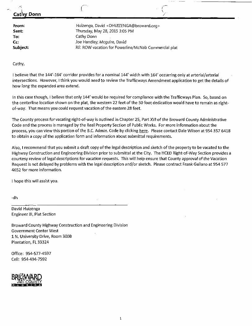
Cathy,
Huizenga, David <[email protected]> Thursday, May 28, 2015 3:05 PM Cathy Donn Joe Handley; Mcguire, David RE: ROW vacation for Powerline/McNab Commercial plat
I believe that the 144'-164' corridor provides for a nominal 144' width with 164' occurring only at arterial/arterial intersections. However, I think you would need to review the Trafficways Amendment application to get the details of how long the expanded area extend.
In this case though, I believe that only 144' would be required for compliance with the Trafficways Plan. So, based on the centerline location shown on the plat, the western 22 feet of the 50 foot dedication would have to remain as rightof-way. That means you could request vacation of the eastern 28 feet.
The County process for vacating right-of-way is outlined in Chapter 25, Part XVI ofthe Broward County Administrative Code and the process is managed by the Real Property Section of Public Works. For more information about the process, you can view this portion of the B.C. Admin. Code by clicking here. Please contact Dale Wilson at 954 357 6418 to obtain a copy of the application form and information about submittal requirements.
Also, I recommend that you submit a draft copy of the legal description and sketch of the property to be vacated to the Highway Construction and Engineering Division prior to submittal at the City. The HCED Right-of-Way Section provides a courtesy review of legal descriptions for vacation requests. This will help ensure that County approval of the Vacation Request is not delayed by problems with the legal description and/or sketch. Please contract Frank Guilano at 954 577 4652 for more information.
I hope this will assist you.
-dh
David Huizenga Engineer III, Plat Section
Broward County Highway Construction and Engineering Division Government Center West 1 N. University Drive, Room 300B Plantation, FL 33324
Office: 954-577-4597 Cell: 954-494-7592
1

c
From: Cathy Donn [mailto:[email protected]] Sent: Thursday, May 28, 2015 11:25 AM To: Huizenga, David Cc: Joe Handley Subject: ROW vacation for PowerlinejMcNab Commercial plat
Dave, Attached please find the subject plat, and an aerial of the site. Cary Goldberg has asked us prepare and process the ROW vacation, since there is 200' of ROW existing, and the Trafficways Plan shows the ROW varies from 144'-164'. Can you please let us know how much ROW we can vacate? Our client would like to vacate as much as possible, of course. We know this is a state road, but we understand there has been some discussions with the county already, so we are reaching out to you.
Thanks Cathy
Catherine A. Donn, Planner CRAVEN THOMPSON & ASSOC., INC. 3563 NW53 ST FT LAUDERDALE, FL 33309-6311 954-739-6400 x 379 [email protected]
~ Please consider th~ environment before printing this email
Under Florida law, most e-mail messages to or from Broward County employees or officials are public records, available to any person upon request, absent an exemption. Therefore, any e-mail message to or from the County, inclusive of e-mail addresses contained therein, may be subject to public disclosure.
2

FOR: 1400 Investments, LLC
LEGAL DESCRIPTION:
DESCRIPTION T(ACCOMPANY SKETCH RIGHT-Of-WAY TO BE VACATED
A PORTION OF THE 50.00 FOOT RIGHT-OF-WAY FOR POWERL/NE ROAD DEDICATED BY POWERLINE/McNAB COMMERCIAL ACCORDING TO THE PLAT THEREOF, AS RECORDED IN PLAT BOOK 123, PAGE 41, OF THE PUBLIC RECORDS OF ' BROWARD COUNTY, FLORIDA, BEING MORE PARTICULARL Y DESCRIBED AS FOLLOWS:
BEGINNING AT THE SOUTHWEST CORNER OF TRACT A, OF SAID POWERLINE/McNAB COMMERCIAL; THENCE NORTH 87'50'54" WEST, ALONG THE WESTERLY EXTENSION OF THE SOUTH LINE OF SAID TRACT A, A DISTANCE OF 28.02 FEET; THENCE NORTH 00'14'07" EAST, ALONG A LINE 28.00 FEET WEST OF, AND PARALLEL WITH, WHEN MEASURED AT RIGHT ANGLES TO tHE WEST LINE OF SAID TRACT A, A DISTANCE OF 445.79 FEET; THENCE SOUTH 89'45'53" EAST, ALONG THE WESTERLY EXTENSION OF THE NORTH LINE OF SAID TRACT A, A DISTANCE OF 28.00 FEET,' THENCE SOUTH 00'14'07" WEST, ALONG THE WEST LINE OF SAID TRACT A, A DISTANCE OF 446.72 FEET TO THE POINT OF BEGINNING.
SAID LANDS SITUA TE, LYING AND BEING IN THE CITY OF POMPANO BEACH, BROWARD COUNTY, FLORIDA. CONTAINING 12,495 SQUARE FEET OR 0.287 ACRES MORE OR LESS.
NOTES:
BEARINGS SHOWN HEREON ARE BASED ON AN ASSUMED BEARING AND ARE REFERENCED TO THE WEST LINE OF TRACT A, POWERLINE/McNAB COMMERCIAL, PLAT BOOK 123, PAGE 41, OF THE PUBLIC RECORDS OF BROWARD COUNTY, FLORIDA, WHICH BEARS NORTH 00'14'07" EAST.
THIS SKETCH AND DESCRIPTION CONSISTS OF 2 SHEETS AND EACH SHEET SHALL NOT BE CONSIDERED FULL, VALID AND COMPLETE UNLESS A TTACHED TO mE OTHER.
ALL DOCUMENTS ARE RECORDED IN THE PUBLIC RECORDS OF BROWARD COUNTY, FLORIDA.
CERTIFICATE:
WE HEREBY CERTIFY THA T THIS DESCRIPTION AND SKETCH CONFORMS TO THE STANDARDS OF PRACTICE FOR LAND SURVEYING IN THE STATE OF FLORIDA, AS OUTLINED IN RULES 5J-17.052(5), (FLORIDA ADMINISTRATIVE CODE), AS ADOPTED BY THE DEPARTMENT OF AGRICULTURE AND CONSUMER SERVICES, BOARD OF PROFESSIONAL SURVEYORS AND MAPPERS IN SEPTEMBER, 1981, AS AMENDED, PURSUANT TO CHAPTER 472.027 OF mE FLORIDA STA TUTES, AND IS TRUE AND CORRECT TO THE BEST OF MY KNOWLEDGE AND BELIEF.
G:\2015\15-0039 POWERUNE MCNAB COMM PLAl\DRAYt1NGS\SD-ROW VACAllON
CRAVEN THOMPS,QN'\~c\"ASSb'cIATES; INC. LlCENSED~,~$Il'!&.~SNU'AA~E:R,,'.#271
l?c:,~,·*~{rc:';.~~; .. - ---. . -./ j :.",:
. ';'\ ~(;tf~,: :,~,,<~'~~i,:~~:,,; THiiJlsi#HA~f~o'R :J~"iE~fjfR~t?
PROFESSIONAlfSURVE-VOR ,AND'~tV1ARI,?£R NO 4387 , ST A tE~ ,9~ ,: i="[qR'fd;(;'~r
,:'\."f .. ,-5't'
THE SKETCH OF SURVEY AND REPORT,'OR THE COPIES THEREOF ARE NOT VALID WITHOUT THE SIGNATURE AND RAISED SEAL OF A
FLORIDA LICENSED SURVEYOR AND MAPPER.
lHlS IS till!. A SKETCH OF SURVEY. but only a graphic depiction of the description shown hereon. Therea..,;;;;UP_D_A_TE_S;;..;;an_d ... /(or ....... RE_V_IS_IO;.;,N;.;;S;.... __ -I-.:;D;,:,;Ao:.:TE;;...,j~B.:.Y~C::.:K.:;·D~ has been no field work. viewing of the sub ,/ect property. or monuments set In connection with ther preparation of tho Infonnatlon shown hereon.
The undersIgned and CRAVEtHHOMPSON '" ASSOCIAlES. INC. make no representations or guarantees as to the Information reflected hereon pertaining to easements, rights-of-way, set back lines. reservatlons ...... ___________ -t-__ +_+_ ... agreements and other similar matters, and further. this Instrument Is not Intended to reflect or 8et '-forth all such matters. Such Information should be obtained and confirmed by others through appraprlate' ..... ___________ -t-__ +_+_-I title verification. Lands shown hereon were not abstracted for right-of-way and/or easements of record.
,.CRAVEN • THOMPSON & ASSOCIATES, INC. JOB NO.: 15.J0039-001 SHEET 1 OF 2 SHEETS
iT ENGINEERS ' PLANNERS ' SURVEYOR'S JS6J N.W. SJRD SJ1l£[T, FIlIITLAUDEROALE, FLORIDA ;m09 FAX; (954) 7J9-6409 1EL: (954) 7J9-64OO DRAWN BY: T.S. F.B."N/A PG. N/A FLORIDA UCENSED ENGINEERiNG, SURI£YING .It /.lAPPING SUSINESS ND. 271 ..... ________ ..... __ ...... _______ -1
/.I~~::::o~~~/~~:~s:.~rltl~::t:~~~~ss::'~~T_1/:f:,~U. CHECKED BY: R.Y. DATED: 06-12-15
SCALE: 1 "=60' Lu
51 § ~ 17.0" II .
J v).
I L5.
:1 ~. 0::'
§I V)
lI).
"" ~I
33.0'
SKETCH TO AC( :t1PANY DESCRIPTION RIGHT-Of-WAY TO BE VACATED
S 89'45'53" E 28.00'
N. LINE TRACT A
. 12' UTILITY EASEMENT PER PLAT ,-------1------------
50' x 100' I I INGRESS/EGRESS I EASEMENT PER PLAT I I-------~ I
122.0 , ....."O:'=-I------"'--l- 28. 00' @ 90
I
, r-.. .0
""
NON-VEHICULAR ACCESS LINE PER PLAT
8 I V) ~I 50' OPENING PER PLA T
(RIGHT TURN ONL Y)
I 1---+--......... ,..-+- 50' RIGHT-Or-WAY DEDICATED BY
I POWERLINE/McNAB COMMERCIAL PLA T
r\= r ~ 3' ANCHOR EASEMENT
I ~(OFrICIAL RECORDS BOOK 2363, PAGE 432)
\ \ \ \ \ \ \ \
I \
Q
~ I ~I t:l ....J
~ QI L5 ~I ~ ......
I \ \ <:( ~I I- lui ~ ~I g: L5 \ \
\ \ Lu >-1
\ 5 ~I i:::
\ \ \ \ \
:s:: ~I
\ \ \ \ \ \ \
~I
I
TRACT A
POWERLlNE/McNAB COMMERCIAL PLAT BOOK 123, PAGE 41
(BROWARD COUNTY RECORDS)
10' UTILITY EASEMENT (OFFICIAL RECORDS BOOK 8792, PAGE 724)
POINT or BEGINNING S. W CORNER TRACT A
IL ___ "--\\~~ ____________ ~~~~EI2~'~U~r,~7L{IT~Y~E~A~S~E~M~EN~T~P~£~R~PL~A~T~~
S. LINE TRACT A
G:\2015\15-0039 POWERUNE MCNAB COldM PLAT\DRAWlNGS\SD-ROW VACATION
_
CRAVEN. THOMPSON & ASSOCIATESI.INC. JOB NO.: 15-0039-001 SHEET 2 OF 2 SHEETS
.
J5C N.W. SJRD S1R£ET. RlRT LAUDERDALE; FLCJRIDA .JJJDS FAX: (954) 739-6409 TEL: (954) 739-6400 DRAWN BY: T.S. F.B. N/ A PG. N/ A J ENGINEERS' PLANNERS • SURVEYOR S
MAmIlAi. SHfi::,£:"~::/,lfTlJrtr;:= :'k~.:"Af= :~s:~~ fN~ AND SHAIJ. .... .-..----------I~D-A-TE-D.:.·.-06---1-2---1;.;5~-....... NDT IE RfPRODUCED IN MIIOtE OR IN PART III1HDUT III!ITlEN PERMISSION. COPYRIGHT C 2DI5 CHECKED BY: R. Y.

P rnpano ··;beach
Florida's Warmiist Welcome
City of Pompano Beach Department of Development Services
Planning & Zoning Division
100 W. Atlantic Blvd Pompano Beach, FL 33060 Phone: 954.786.4634 Fax: 954.786.4666
Request for Vacation
OWNERS CERTIFICATE
This is to certify that I am the owner of the subject lands described in this PETITION FOR VACATION and that I have authorized the filing of the aforesaid petition for vacation.
Owner's Name: (Print or Type)
Address:
Phone:
Email address:
1400 INVESTMENTS LLC, c/o Cary Goldberg
6300 NE 1 AVE, SUITE 100
FT LAUDERDALE, FL 33334
(Zip Code)
(954) 776-1005
ED before me this ~ day of =;} U 1'1 -L ,2012.
'"'''''''''' /~~A~"···"···~<-'C:\ H H MY COMMISSION #FF081120 s~. .:~::
\;t"ii ........ '~~/ EXPIRES January 6, 201 a ··'·'''~~l~;··'',\ .
(Name of Notary Public: Print, stamp, or Type as Commissi
~ersonallY know to me, or [] Produced identification: ____________________ _
(Type of Identification Produced)
G:\Zoning 2009\Fonns and documents\Website Documents\Planning & Zoning\Fonns Modified: 2.11.2014 Page 2 of2