republic of mozambique ministry of mineral resources · republic of mozambique ministry of mineral...
TRANSCRIPT

IINNPP IInnssttiittuuttoo NNaacciioonnaall ddee PPeettrróólleeoo
Mozambique Technical Data Page 1 of 27 November 2014
REPUBLIC OF MOZAMBIQUE
MINISTRY OF MINERAL RESOURCES
MOZAMBIQUE FIFTH LICENSING ROUND
TECHNICAL DATA
Please send / deliver your
application to:
(See Guidance Notes)
INSTITUTO NACIONAL DE PETRÓLEO Av. Fernão de Magalhães nº 34 1º Andar
CP nº 4724 Maputo – Mozambique

IINNPP IInnssttiittuuttoo NNaacciioonnaall ddee PPeettrróólleeoo
Mozambique Technical Data Page 2 of 27 November2014
MOZAMBIQUE FIFTH LICENSING ROUND
TECHNICAL DATA
1 INTRODUCTION ................................................................................................. 3
2 AREAS IN MOZAMBIQUE FIFTH LICENSE ROUND .................................... 4
3 TECHNICAL DATA ............................................................................................. 6
3.1 INP GEOTECHNICAL DATA ...................................................................... 7
3.1.1 TECHNICAL REPORTS ........................................................................ 7
3.1.2 WELL DATA .......................................................................................... 8
3.1.3 SEISMIC DATA .................................................................................... 10
3.1.4 WORKSTATION PROJECTS .............................................................. 11
3.1.5 GRAVITY AND MAGNETIC DATA .................................................. 11
3.1.6 RELEASED DATA GIS PROJECT ...................................................... 12
3.1.7 MOZDA PROJECT (See Appendix 1) ................................................. 14
3.2 NON EXCLUSIVE TECHNICAL DATA ................................................... 16
3.2.1 Schlumberger – See Appendix 2 for more details ................................. 16
3.2.2 ION – See Appendix 2 for more details................................................. 16
3.2.3 BGP ........................................................................................................ 17
3.2.4 ARKeX .................................................................................................. 17
3.2.5 CORELAB REGIONAL STUDY ......................................................... 17
3.3 DATA ROOM ............................................................................................... 18
4 FURTHER INFORMATION .............................................................................. 19
5 APPENDICES ..................................................................................................... 20
5.1 Appendix 1 Contents for MOZDA 2014 Release ......................................... 20
5.2 Appendix 2 Details of Schlumberger-WesternGeco Multiclient Seismic .... 22
5.3 Appendix 3 Details of ION Multiclient Seismic ........................................... 25
5.4 Appendix 4 Details of CoreLab Study .......................................................... 26
IINNPP IInnssttiittuuttoo NNaacciioonnaall ddee PPeettrróólleeoo
Mozambique Technical Data Page 3 of 27 November2014
1 INTRODUCTION
The Government of the Republic of Mozambique, through the Ministry of Mineral
Resources and the Institute of National Petroleum (INP) invites Oil & Gas Companies
for the onshore competitive bidding round to explore for hydrocarbons in the offshore
Rovuma, offshore Zambezi and Angoche, and onshore Pande-Temane and Palmeira
areas.
In the Fifth Licensing Round, companies may apply for an Exploration and
Production Concession Contract (EPCC).
This document provides more detail about the technical data available to license in
support of applications.
DATA LICENSE AGREEMENT
All INP released data is available to license subject to signature of a standard
Master Licensing Agreement (MLA) with INP. The MLA can be downloaded
from www.inp-mz.com or requested from the contacts listed in section 4.
Data is also available to license from a number of multi-client service
companies, as detailed in section 3.2.
The cost of the Technical Data licensed can be offset against the exploration
expenditure obligations of the EPCC.
The technical database (that an applicant company has) forms a key part of the
evaluation criteria.
DATA ROOM
The INP technical database is available to view in a Data Room.
INP is hosting a Data Room at its offices in Maputo and ERCL is hosting a data room
in UK (details included in section 3 of this document).
The INP website (http://www.inp-mz.com) includes general information about the
Fifth Licensing Round and the availability of technical data.
If you have any further queries, clarification or additional information please see
contact information at http://www.inp-mz.com, email [email protected] or contact
the representatives listed in section 4.

IINNPP IInnssttiittuuttoo NNaacciioonnaall ddee PPeettrróólleeoo
Mozambique Technical Data Page 4 of 27 November2014
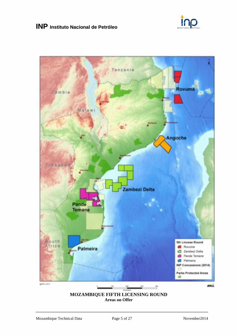
2 AREAS IN MOZAMBIQUE FIFTH LICENSE ROUND
INP has grouped the blocks in to fifteen (15) separate defined blocks as follows:
Rovuma offshore (R5-A, R5-B and R5-C),
Angoche offshore (A5-A and A5-B)
Zambezi offshore (Z5-A to Z5-F)
Pande - Temane area (PT5-A, PT5-B and PT5-C)
Palmeira area (P5-A)
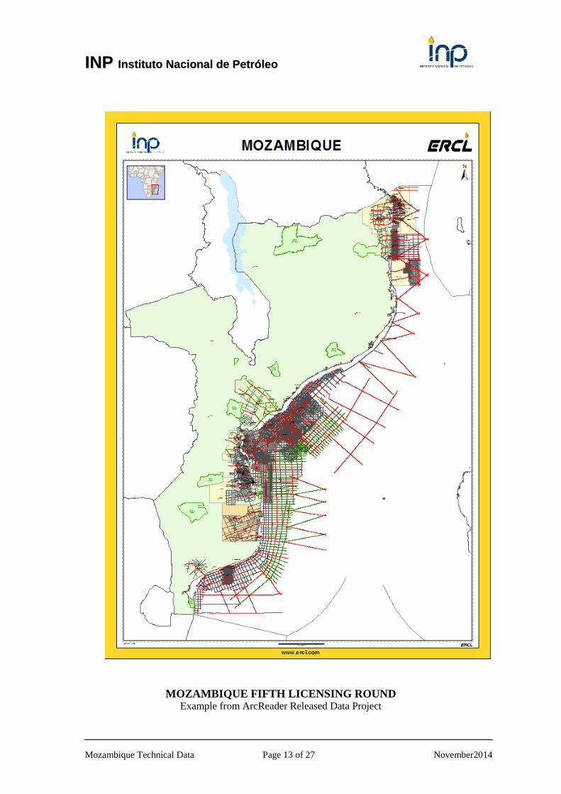
Areas on offer in the Fifth Licensing Round are shown overleaf. In total, some 74,700
sq kms of acreage is being made available for licensing throughout the territory of
Mozambique.
Areas that adjoin each other maybe linked and combined in to a single application.
Applicants can only apply for the whole of the defined area and present a work
program that evaluates all the blocks. Minimum work programmes have been defined
for the various blocks.
Further details on the blocks on offer in the Fifth Licensing Round are provided on
the following website - http://www.inp-mz.com/.
IINNPP IInnssttiittuuttoo NNaacciioonnaall ddee PPeettrróólleeoo
Mozambique Technical Data Page 5 of 27 November2014
MOZAMBIQUE FIFTH LICENSING ROUND Areas on Offer

IINNPP IInnssttiittuuttoo NNaacciioonnaall ddee PPeettrróólleeoo
Mozambique Technical Data Page 6 of 27 November2014
3 TECHNICAL DATA
INP, with assistance from ERCL, has compiled a comprehensive technical database,
using all the released technical data, and these data are available for licensing by
companies applying in the Mozambique Fifth License Round.
The available data are described in detail in this section 3 and further information can
be downloaded from www.inp-mz.com and www.ercl.com/multi-client/mozambique.
There are also a number of other datasets including regional seismic, gravity,
magnetic and geological data available to license from other parties. These data and
sources are referenced in section 3.2.
The available technical data demonstrate the Exploration History of Mozambique and
are available to license to assist companies evaluate the Petroleum Potential and
Prospectivity of the Mozambique Basins both onshore and offshore.
Mozambique Basins Technical Data;
All available onshore technical data can be licensed directly from INP and other third
party entities.
Master License Agreement
All INP data is licensed subject to signature of a standard Master Licensing
Agreement (MLA) with INP.
The MLA can be downloaded from www.inp-mz.com or requested from the contacts
listed in section 4.
Note:
The cost of licensing the technical data can be offset against the
exploration expenditure obligations of the EPCC.
The technical database (an applicant company has) forms a key part of the
evaluation criteria.
IINNPP IInnssttiittuuttoo NNaacciioonnaall ddee PPeettrróólleeoo
Mozambique Technical Data Page 7 of 27 November2014
3.1 INP GEOTECHNICAL DATA
The INP technical database has been prepared from all the available from within it
archives and includes:
INP – Technical Reports
INP – Well Data
INP – Seismic Data
INP – Gravity & Magnetic Data
INP-ERCL – Mozambique Digital Atlas (MOZDA)
The available technical data reflect the exploration activities that have been
undertaken in Mozambique. A Price List is available from INP/ERCL on request.
ERCL has used the released technical data to prepare a regional review of the
Zambezi Delta and also in the preparation of the Mozambique Digital Atlas
(MOZDA) as described below in section 3.1.7.
The data are available to license from INP to assist companies evaluate the Petroleum
Potential and Prospectivity of the Mozambique Basins both onshore and offshore.
3.1.1 TECHNICAL REPORTS
For the Mozambique Fifth Round INP has identified a number of key regional
technical reports that have been prepared by various companies. These key regional
reports are listed below:
The Petroleum Geology and Hydrocarbon Prospectivity of
Mozambique, ENH/ECL, 2000
The Hydrocarbon Potential of Mozambique, Alconsult International
Ltd, 1996
The Source Rock Potential of Mozambique, Robertson Research, 1986
Offshore Mozambique Sedimentary Basins, ENH, 1994
Petroleum Potential in the Southern Mozambique Basin, CANOP,
1997
Surface Geochemical Exploration, Offshore Zambezi, Petronas - TDI
Brookes, 2007
An Evaluation of Prospectivity – PSA Offshore Zambezi, BP, 1999
(full report available with licensing of the BP98 2D survey)
Interpretation Report, TEA Mozambique Channel, Elf 2000 (available
as a package including c. 1,500 kms of 2D seismic data)
Evaluation of the remaining Hydrocarbon Potential, Limpopo Block,
Sasol, 1997
Assessment of Hydrocarbon Potential, Cretaceous Plays, SW Offshore,
Shell 1990

IINNPP IInnssttiittuuttoo NNaacciioonnaall ddee PPeettrróólleeoo
Mozambique Technical Data Page 8 of 27 November2014
GIS versions of the technical reports have been prepared and are available in ArcMap,
ArcReader and QGIS format. A common structure has been used to create the GIS
versions of the reports, such that the reports can be merged into a single GIS project.
For companies that have already licensed the above reports, the GIS version is
available to license for a fee detailed on the Price List.
Under its agreement with INP, ERCL has recently completed a technical review of the
offshore Zambezi Delta, and this study is also available:
Review of the Petroleum Geology & Prospectivity of the Zambezi
Delta, 2014
The regional reports provide a definitive technical reference for hydrocarbon
exploration in Mozambique.
3.1.2 WELL DATA
Data for over 100 wells have been released by INP. INP has created a digital well data
base of this data which is summarized in a spreadsheet which can be downloaded
from www.inp-mz.com.
For the Fifth Round, INP has defined some 22 key regional wells, as tabulated below.
Key Offshore Wells – South Mozambique
Well name Year drilled Operator
Nemo-1X 1969 Gulf Oil
Njika-1 2008 Sasol Petroleum
Njika-2 2009 Sasol Petroleum
Sangussi Marin-1 1971 Aquitaine
Sengala-1 2000 Sasol Petroleum
Sengo Marin-1 1971 Aquitaine
Sofala-1 1970 Gulf Oil
Sofala-2 2000 Sasol Petroleum
Zambezi-1 1970 Hunt Petroleum
Zambezi-3 1971 Hunt Petroleum
Z-DE-1 2007 Petronas Carigali
Key Offshore Wells – Rovuma
Well name Year drilled Operator
Buzio-1 2013 Statoil
Cachalote-1 2013 Statoil

IINNPP IInnssttiittuuttoo NNaacciioonnaall ddee PPeettrróólleeoo
Mozambique Technical Data Page 9 of 27 November2014
Key Onshore Wells
Well name Year drilled Operator
Chite-1 2010 DNO Mozambique
Corone-1 2004 DNO ASA
Inhaminga High-1 2011 DNO ASA
Micaune-1 1966 Gulf
Mocimboa-1 1986 Esso/Shell
Nhamura-1 1971 Aquitaine
Rio Nhanguazi-1 1971 Aquitaine
Sangussi-1 2008 DNO ASA
Savane-1 2004 DNO ASA
For the key wells tabulated above oil companies can license either a basic well
package (including standard well information such as digital LAS files, well
summary, well logs, time depth information and formation tops) of a full well
package (to include additional well reports as available on well by well basis).
Added value products available in addition include:
New well summary sheets
New well composites
Qc’d LAS/LIS
Input log headers details from FWRs
Well CAD Projects
Petrophysical reports for key wells
Pre-loaded IP (software) project
Petrophysical Interpretation reports and CPIs
Well License Fee Costs
For the historic wells, individual well folders are available on a single
well basis. Packages for the purchase of multiple wells are available (as
detailed on the Price List).
For the more recent key wells there is a price for a basic well package
and an uplift for the full well package. The ERCL petrophysical results
are available for an additional uplift.
Note:
The well database is being regularly updated to include further information that
is currently being retrieved from INP archives.
IINNPP IInnssttiittuuttoo NNaacciioonnaall ddee PPeettrróólleeoo
Mozambique Technical Data Page 10 of 27 November2014
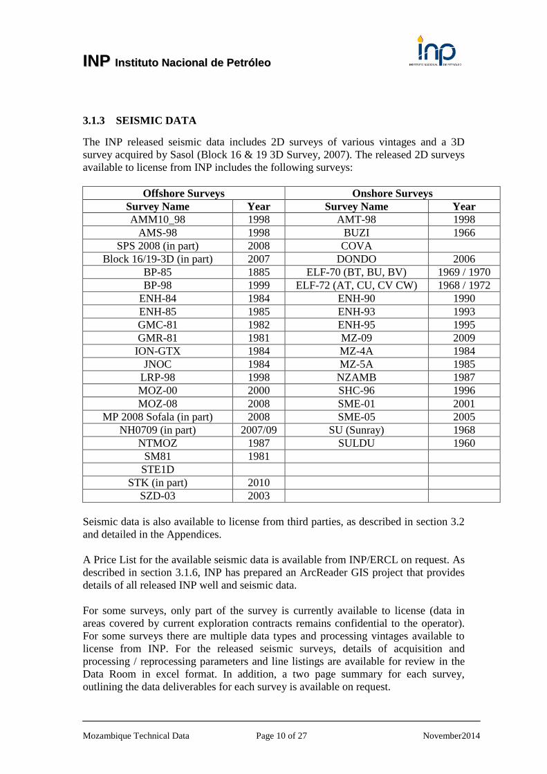
3.1.3 SEISMIC DATA
The INP released seismic data includes 2D surveys of various vintages and a 3D
survey acquired by Sasol (Block 16 & 19 3D Survey, 2007). The released 2D surveys
available to license from INP includes the following surveys:
Offshore Surveys Onshore Surveys
Survey Name Year Survey Name Year
AMM10_98 1998 AMT-98 1998
AMS-98 1998 BUZI 1966
SPS 2008 (in part) 2008 COVA
Block 16/19-3D (in part) 2007 DONDO 2006
BP-85 1885 ELF-70 (BT, BU, BV) 1969 / 1970
BP-98 1999 ELF-72 (AT, CU, CV CW) 1968 / 1972
ENH-84 1984 ENH-90 1990
ENH-85 1985 ENH-93 1993
GMC-81 1982 ENH-95 1995
GMR-81 1981 MZ-09 2009
ION-GTX 1984 MZ-4A 1984
JNOC 1984 MZ-5A 1985
LRP-98 1998 NZAMB 1987
MOZ-00 2000 SHC-96 1996
MOZ-08 2008 SME-01 2001
MP 2008 Sofala (in part) 2008 SME-05 2005
NH0709 (in part) 2007/09 SU (Sunray) 1968
NTMOZ 1987 SULDU 1960
SM81 1981
STE1D
STK (in part) 2010
SZD-03 2003
Seismic data is also available to license from third parties, as described in section 3.2
and detailed in the Appendices.
A Price List for the available seismic data is available from INP/ERCL on request. As
described in section 3.1.6, INP has prepared an ArcReader GIS project that provides
details of all released INP well and seismic data.
For some surveys, only part of the survey is currently available to license (data in
areas covered by current exploration contracts remains confidential to the operator).
For some surveys there are multiple data types and processing vintages available to
license from INP. For the released seismic surveys, details of acquisition and
processing / reprocessing parameters and line listings are available for review in the
Data Room in excel format. In addition, a two page summary for each survey,
outlining the data deliverables for each survey is available on request.
IINNPP IInnssttiittuuttoo NNaacciioonnaall ddee PPeettrróólleeoo
Mozambique Technical Data Page 11 of 27 November2014
On behalf of INP, ERCL has made considerable efforts to provide a high degree of
QC to the SEGY data deliverables. Thus INP will deliver to Licensee high quality
(HQ) SEGY files will full header information for the majority of the released seismic
data.
The HQ released seismic SEGY data includes:
Navigation details
Acquisitions details
Processing details
Amplitude Balancing
Reference to input data files
Well synthetic ties and new time depth charts for a number of key wells are also
available as part of the Mozambique Digital Atlas (MOZDA) as described below in
section 3.1.7.
INP Regional Composite Lines
INP has worked with ERCL in the preparation of a series of over 50 regional
composite seismic profiles (totaling over 16,500 line kms of seismic data) to provide a
regional framework for Mozambique. The profiles link different vintages of seismic
data, and a number provide onshore – offshore sections.
The Composite Lines are available to license as part of the Mozambique Digital Atlas
(MOZDA) as described below in section 3.1.7.
3.1.4 WORKSTATION PROJECTS
Providing that the seismic data has been licensed, INP will issue the final SEGY data
directly to the Licensee, and ERCL can provide the seismic data in the following
workstation formats:
Kingdom
Petrel
GeoGraphix
DUG Insight
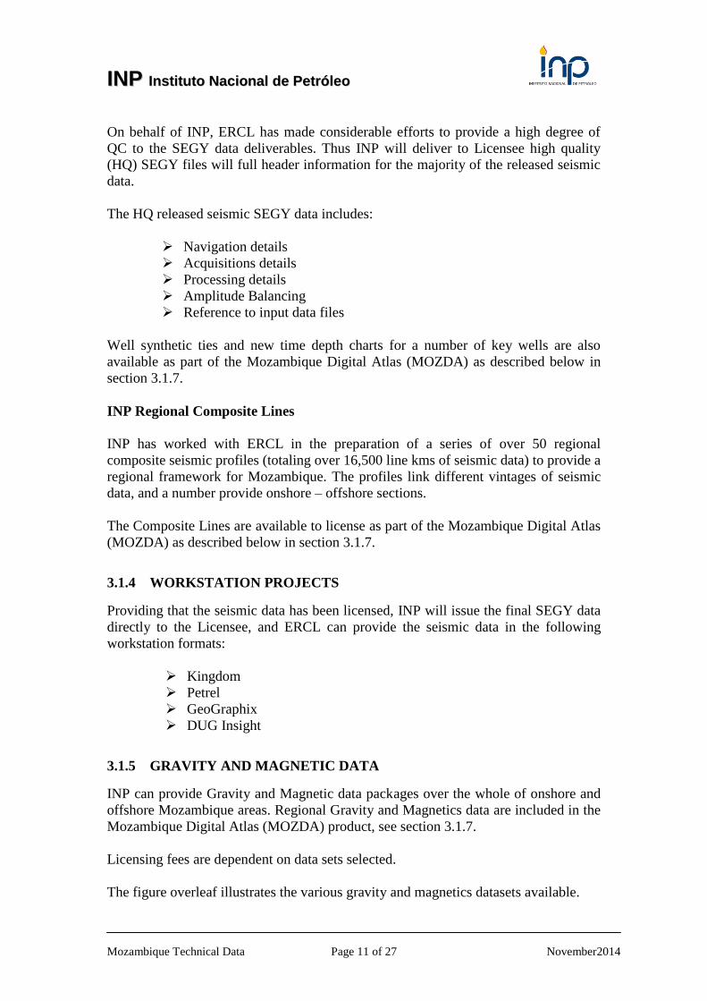
3.1.5 GRAVITY AND MAGNETIC DATA
INP can provide Gravity and Magnetic data packages over the whole of onshore and
offshore Mozambique areas. Regional Gravity and Magnetics data are included in the
Mozambique Digital Atlas (MOZDA) product, see section 3.1.7.
Licensing fees are dependent on data sets selected.
The figure overleaf illustrates the various gravity and magnetics datasets available.
IINNPP IInnssttiittuuttoo NNaacciioonnaall ddee PPeettrróólleeoo
Mozambique Technical Data Page 12 of 27 November2014
MOZAMBIQUE FIFTH LICENSING ROUND Illustration of Gravity and Magnetics Database and
Mozambique Magnetic Grid
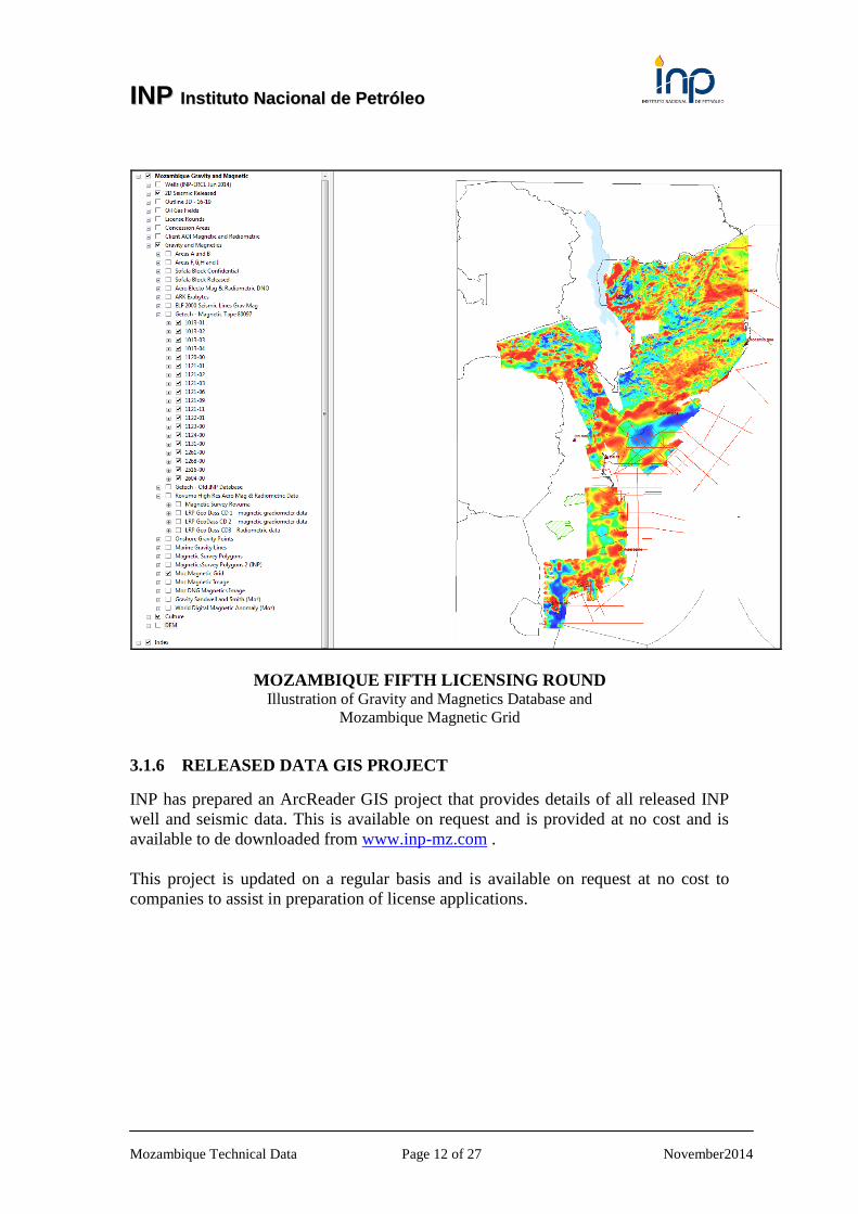
3.1.6 RELEASED DATA GIS PROJECT
INP has prepared an ArcReader GIS project that provides details of all released INP
well and seismic data. This is available on request and is provided at no cost and is
available to de downloaded from www.inp-mz.com .
This project is updated on a regular basis and is available on request at no cost to
companies to assist in preparation of license applications.
IINNPP IInnssttiittuuttoo NNaacciioonnaall ddee PPeettrróólleeoo
Mozambique Technical Data Page 13 of 27 November2014
MOZAMBIQUE FIFTH LICENSING ROUND Example from ArcReader Released Data Project
IINNPP IInnssttiittuuttoo NNaacciioonnaall ddee PPeettrróólleeoo
Mozambique Technical Data Page 14 of 27 November2014
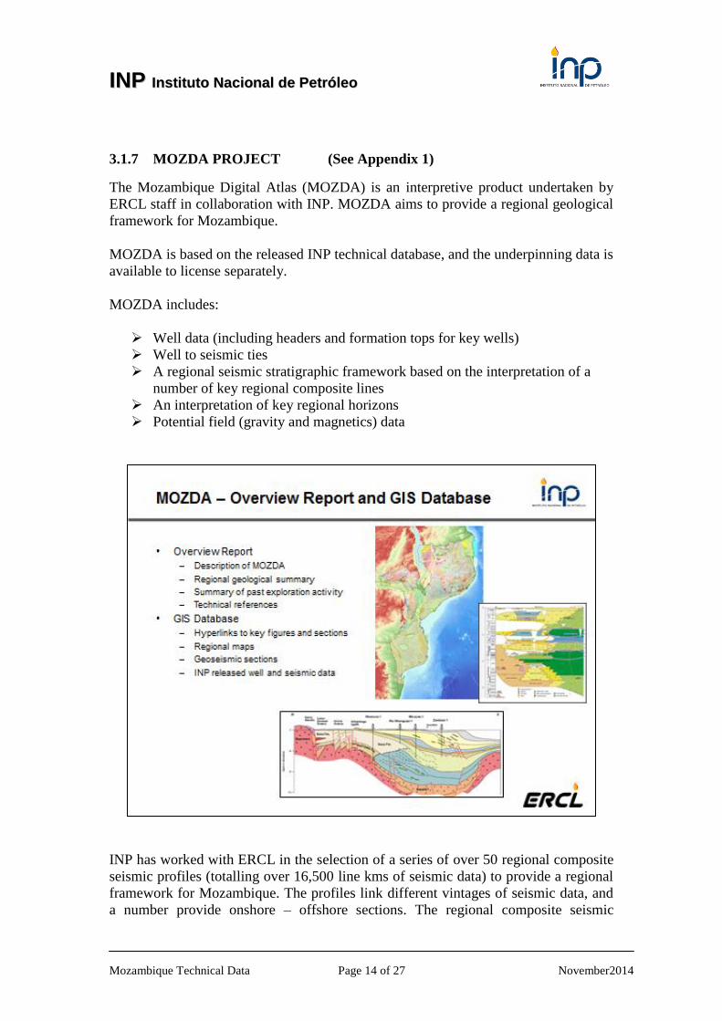
3.1.7 MOZDA PROJECT (See Appendix 1)
The Mozambique Digital Atlas (MOZDA) is an interpretive product undertaken by
ERCL staff in collaboration with INP. MOZDA aims to provide a regional geological
framework for Mozambique.
MOZDA is based on the released INP technical database, and the underpinning data is
available to license separately.
MOZDA includes:
Well data (including headers and formation tops for key wells)
Well to seismic ties
A regional seismic stratigraphic framework based on the interpretation of a
number of key regional composite lines
An interpretation of key regional horizons
Potential field (gravity and magnetics) data
INP has worked with ERCL in the selection of a series of over 50 regional composite
seismic profiles (totalling over 16,500 line kms of seismic data) to provide a regional
framework for Mozambique. The profiles link different vintages of seismic data, and
a number provide onshore – offshore sections. The regional composite seismic
IINNPP IInnssttiittuuttoo NNaacciioonnaall ddee PPeettrróólleeoo
Mozambique Technical Data Page 15 of 27 November2014
profiles vary from 50 to 734 kms in length and a SEGY file for each composite profile
has been generated. In addition to final stack/migrations, 3D Amplitude Summation
processing has been applied to the lines, and is available to license.
Regional wells included within MOZDA have been tied to the regional composite
seismic profiles. Well montages, well summary sheets, formation tops and time depth
data are included, with additional well correlation panels. (Note that the underpinning
well data are available for licensing separately).
The following regional horizons have been picked on the composite profiles and
mapped across the main basins, using additional INP seismic data where necessary:
seabed,
top Pliocene,
mid Miocene,
base Tertiary,
top Lower Domo Shale,
lower Cretaceous (Aptian) unconformity,
basement
MOZDA is available to license via the INP Master License Agreement. The first
release for MOZDA is expected to be end October 2014, with a further update by end
December 2014. It is envisaged that MOZDA will evolve, and companies will be
offered the opportunity to subscribe to an online portal to access developments to the
study through 2015 and beyond.
In the 2014 releases, which will be issued on USB with components provided in
industry standard format (ArcGIS / ArcMap / maps in grid files etc), there will be two
options:
“MOZDA Light” – excludes seismic SEGY data
“MOZDA Full” – includes SEGY data for INP composite profiles selected by
licensee
Companies will be able to select which regional composite lines they wish to license
in full (for access to the SEGY files), with lines priced individually and discounts
available subject to volume licensed.
The contents listing for the 2014 release is included in Appendix 1.

IINNPP IInnssttiittuuttoo NNaacciioonnaall ddee PPeettrróólleeoo
Mozambique Technical Data Page 16 of 27 November2014
3.2 NON EXCLUSIVE TECHNICAL DATA
3.2.1 Schlumberger – See Appendix 2 for more details
Schlumberger has over 110,000 km of exclusive 2D seismic data available for
licensing, including more than 36,000 km of new broadband seismic data acquired in
2013 and 2014 using the ObliQ* sliding-notch broadband acquisition and imaging
technique. In preparation for the 5th License Round, Schlumberger has also
reprocessed approximately 15,800 km of the existing surveys.
Added to recent reprocessed seismic data in the region, the new high-quality seismic
data is available to assist in reducing exploration risk for the upcoming licensing
rounds. The clarity and scope of the new survey, complementing the reprocessed data,
enables exploration companies to, identify and map geological structures and
potential traps for a better understanding and evaluation of the basin’s potential.
Further details of seismic data available to license from Schlumberger are provided in
Appendix 2.
For additional information please contact:
Guillaume Mouscadet: +44 7881840899
Sandra Lane +447717346651
Email: [email protected]
www.slb.com/multiclient
3.2.2 ION – See Appendix 2 for more details
In support of the Government of Mozambique’s 5th Licensing Round, ION is pleased
to offer, as part of its East Africa Geological Study, six lines of long offset, long
record, pre-stack depth migrated SPAN data within the open acreage being promoted
by INP. Some 2,477 kms of SPAN data have been acquired in Mozambique.
The East Africa BasinSPAN™ project consists of 20,000 km of SPAN data recently
complemented by a further 8,000 km of new data in the Comoros, providing extensive
regional coverage in the margin to evaluate this license opportunity. SPAN Data is
characterized by regional lines of long offset (10 kms) and long record (18 seconds)
data. Pre stack time and pre stack depth migration, angle stacks and gathers, plus
gravity and magnetic data are available.
Further details are provided in Appendix 3. For additional information please contact:
Dave Baker, Manager Africa Governmental Affairs, ION-Geoventures
Phone +44 1784 497 630
Email [email protected]
IINNPP IInnssttiittuuttoo NNaacciioonnaall ddee PPeettrróólleeoo
Mozambique Technical Data Page 17 of 27 November2014
3.2.3 BGP
BGP was awarded rights to undertake a multi-client onshore 2D seismic survey of
some 3,100 line kms in Area C (tender T4, onshore Zambezi and southern
Mozambique Basin). At the current time, these data have not been acquired.
For additional information please contact:
Qiang Zhu, Chief Economist of BGP International, [email protected]
Jicheng Shi, General Manager of BGP East Africa, [email protected] or
Simon Bowen, Project Development Manager - AME, [email protected]
3.2.4 ARKeX
ARKeX Ltd was awarded a number of multi-client tenders for the acquisition of
airborne gravity and magnetics data by INP in 2011. These awards included rights to
acquire data onshore northern Mozambique (GM1, around Lago Niassa), onshore
southern Mozambique (GM2) and offshore around the Beira High. At the current
time, these surveys have not been acquired.
For additional information please contact Anne-Marie Liszczyk, Sales Geophysicist
EAME, [email protected].
3.2.5 CORELAB REGIONAL STUDY
Under an agreement with INP, Core Laboratories is planning to undertake a Regional
Reservoir and Seal study of the basins of Mozambique. This study will provide a
detailed evaluation of reservoir, source and seal rocks within a correlative
stratigraphic and structural framework, from c. 40 wells across the coastal region of
Mozambique.
Further details are provided in Appendix 4 and are available from:
Firoze Din, Vice President, Integrated Reservoir Solutions
Phone +44(0)1737 859660
Email [email protected]

IINNPP IInnssttiittuuttoo NNaacciioonnaall ddee PPeettrróólleeoo
Mozambique Technical Data Page 18 of 27 November2014
3.3 DATA ROOM
Data rooms are available to allow companies to view the INP released database in the
offices of INP (Mozambique) and ERCL (UK). The data available to view in the data
rooms includes:
INP Digital Library
- Technical Reports
- Well Folders
Hardcopy of Key Technical Reports (supplied as pdf in data packages) and
GIS versions.
Regional Seismic Composites
Mozambique Digital Atlas (MOZDA)
Kingdom Workstation Project – all released data
- INP seismic data
- INP well data
Entry to the data room will require signature of the “data room rules” (available on
request from data room coordinators). This requires that the name, title and company
of each visitor viewing the Information be disclosed in writing at the time the
appointments are made, and any changes thereto should be notified in writing before
entry to the respective Data Room. A small charge for attending the Data Room at
INP / ERCL offices is made. The purpose of the Data Room is to give oil companies
the opportunity to review the data before committing to purchase of data packages.
Companies may take away information on the available INP technical database in the
form of screen captures (usually released by the data room coordinator as an Acrobat
format presentation), restricted to internal use within their company, to enable them to
review the data quality at their home offices.
Once the data package has been purchased the Master Licensing Agreement (MLA)
and relevant Supplement Agreement governs the use and copying of the data.
MOZAMBIQUE DATA ROOM
INP Maputo – Mozambique (9.00 a.m. and 5.00 p.m.) Monday to Friday.
Coordinator – Inocencia Maculuve
Appointments should be made via email to [email protected]
UK DATA ROOM
ERCL – Henley-on-Thames (9.00 a.m. and 5.00 p.m.) Monday to Friday.
Coordinator – Richard Heath
Appointments should be made via email to [email protected]
IINNPP IInnssttiittuuttoo NNaacciioonnaall ddee PPeettrróólleeoo
Mozambique Technical Data Page 19 of 27 November2014
4 FURTHER INFORMATION
For further information about the Mozambique 5th
Licensing Round please email
[email protected] or visit www.inp-mz.com
Carlos Zacarias Exploration Manager [email protected]
National Petroleum Institute
Montepio Building, 34, 1st Floor
Fernão Magalhães Ave.
Maputo, Mozambique
Tel.: +258 21 320 935
www.inp.gov.mz
Huw Edwards Director ERCL [email protected]
Richard Heath Director ERCL [email protected]
ERCL - Exploration Reservoir Consultants
Dragon Court
15 Station Road
Henley-on-Thames
Oxon, RG9 1AT
Tel: +44 1491 578117
www.ercl.com
IINNPP IInnssttiittuuttoo NNaacciioonnaall ddee PPeettrróólleeoo
Mozambique Technical Data Page 20 of 27 November2014
5 APPENDICES
5.1 Appendix 1 Contents for MOZDA 2014 Release
MOZDA is a joint project between INP and ERCL.
The first release will be 31st October 2014 and this release will focus on the digital
deliverables which will be in ESRI ArcGIS software. A second release will be issued
at end December 2014.
The first release text volume release (contents as listed below) will contain a short
introduction and description of methodology along with the text from the last major
integrated regional study (by ENH/ECL in 2000). Additionally a newly completed
synthesis by ERCL of the regional geology of the offshore Zambezi delta area will be
provided in Chapter 5, and the 2014 ERCL Zambezi report will be incorporated in full
within the MOZDA release.
In Chapters 6 to 8, there will be a number of new figures which have been created to
aid data management as well as to summarise available well and seismic data from the
legacy database. The main deliverables include over 50 newly created regional
profiles, and key well and regional well summary sheets which will be provided as
hard copy as well as being linked to the GIS project deliverable. A number of well
correlations and well synthetics will be included, again linked to the GIS. Summary
sheets will be provided for all released seismic surveys, detailing both acquisition and
processing parameters as well as figures illustrating their location.
Appendices contain published volumes which summarise projects completed through
the Geological Survey of Finland and the World Bank.
Future text volume deliveries will update the remaining onshore and offshore basins
of Mozambique (for example the Angoche and Rovuma Basins) with the results of
recent exploration activities (update to section 3).
Following the end December 2014 update, in which we plan to include results of 2D
gravity/ seismic modelling for some key regional profiles, the aim is to release annual
updates thereafter.
IINNPP IInnssttiittuuttoo NNaacciioonnaall ddee PPeettrróólleeoo
Mozambique Technical Data Page 21 of 27 November2014
MOZDA CONTENTS (Release 1)
1. Introduction
2. Overview of MOZDA
2.1 Summary of INP Technical Database
2.2 Methodology Used
2.3 MOZDA Outputs and Data Format
2.4 Planned Future MOZDA Releases
3. Summary of Oil & Gas Exploration in Mozambique
3.1 Exploration History
3.2 Gas Field Developments
3.3 Petroleum Exploration Database
3.4 Previous Licensing Rounds
3.5 Current Approach to Licensing
4. Regional Geological Overview. Based on ENH/ECL Report, “The Petroleum
Geology and Hydrocarbon Prospectivity of Mozambique. 2000”
5. Petroleum Geology of the Zambezi Delta. Based on ERCL report “Review of
the Petroleum Geology and Prospectivity of the offshore Zambezi Delta, 2014”
6. Regional Composite Profiles. A3 size copies of un-interpreted seismic (final
stack / migration and 3D Amplitude Summation) and interpreted geoseismic profiles
covering both onshore and offshore Mozambique. These will have a legend but text
describing the regional geology. Electronic copies in Acrobat format.
7. Well summary sheets for all released wells in Mozambique. There is an
ongoing program to update all these into a standard format. At present you will get a
mixture of styles.
8. Seismic Survey details. These standalone sheets describe the acquisition,
processing and where applicable re-processing parameters for all released surveys
9. Appendices-Published Reports
Appendix 1: GTK Consortium Geological Surveys in Mozambique 2002-
2007. Geological Survey of Finland Special Paper 48. 2008
Appendix 2: Explanation of the Geological Map of Mozambique 1:
1,000,000. Direcção Nacional De Geologoca, Mozambique. 2011
IINNPP IInnssttiittuuttoo NNaacciioonnaall ddee PPeettrróólleeoo
Mozambique Technical Data Page 22 of 27 November2014
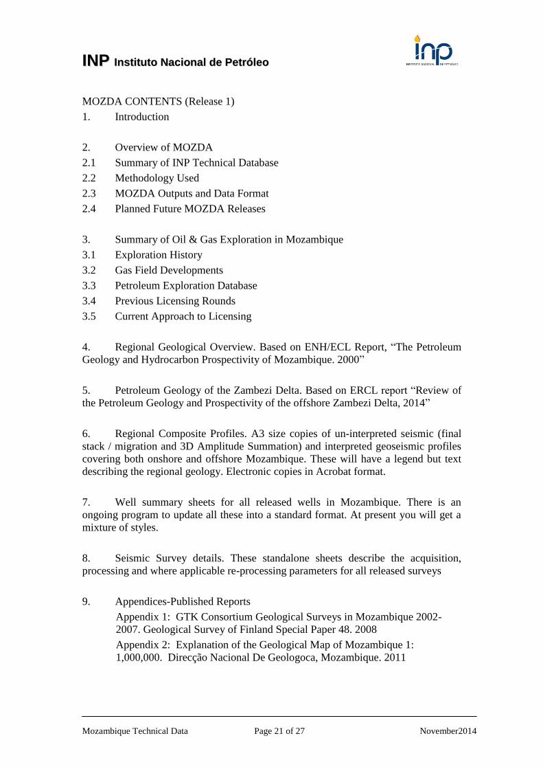
5.2 Appendix 2 Details of Schlumberger-WesternGeco Multiclient Seismic
Schlumberger has over 110,000 km of exclusive 2D seismic data available for licensing,
including more than 36,000 km of new broadband seismic data acquired in 2013 and 2014
using the ObliQ* sliding-notch broadband acquisition and imaging technique. In preparation
for the 5th License Round, Schlumberger has also reprocessed approximately 15,800 km of
the existing surveys.
Added to recent reprocessed seismic data in the region, the new high-quality seismic data is
available to assist in reducing exploration risk for the upcoming licensing rounds. The clarity
and scope of the new survey, complementing the reprocessed data, enables exploration
companies to, identify and map geological structures and potential traps for a better
understanding and evaluation of the basin’s potential.
Data available exclusively from Schlumberger Multiclient
IINNPP IInnssttiittuuttoo NNaacciioonnaall ddee PPeettrróólleeoo
Mozambique Technical Data Page 23 of 27 November2014
Recently acquisition highlights
36,000 km of Seismic Offshore Mozambique, covering the areas offered in the 5th Licensing
Round: Rovuma, Angoche, and Zambezi Delta:
ObliQ acquisition and imaging technique
Long-offset 10-km streamer
Anisotropic Kirchhoff prestack time migration (PSTM)
Gravity and magnetics
Advanced reprocessing highlights
The reprocessing focuses on the Zambezi Delta area and consists of approximately 15,800 km
of the MBWG surveys acquired in 1998, 1999, and 2000. The ongoing reprocessing also
includes a 9,200 km subset of the BP-98, SM-81, and GMC81 surveys
Anisotropic Kirchhoff prestack time migration (PSTM)
Dense SCVA Velocity Analysis.
Pre and Post Stack Gathers
Angle Gathers
Schlumberger has a comprehensive coverage of seismic data in each of the 5th licensing
round blocks.
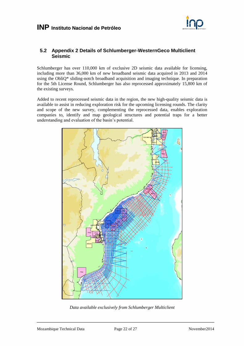
Rovuma Area
In the Rovuma blocks, we have over 800 km of recently acquired broadband data available,
complemented by the unique regional ‘Zig-Zag’ 2000 survey lines recently reprocessed.

IINNPP IInnssttiittuuttoo NNaacciioonnaall ddee PPeettrróólleeoo
Mozambique Technical Data Page 24 of 27 November2014
Angoche Area
Over the Angoche blocks, we have approximately 1,200 km of seismic data available,
including lines from the 2013 broadband survey, the regional ‘Zig-Zag’ 2000 survey and the
GMR81.
Zambezi Delta Area
Over the Zambezi Delta blocks, we have over 10,000 km of seismic data available.
In this area, we have the newly acquired broadband survey, the recent reprocessed surveys
(MBWG 1998, 1999, 2000) and over the shallow water, we have the BP-98 GMC-81 and
SM-81 surveys.

IINNPP IInnssttiittuuttoo NNaacciioonnaall ddee PPeettrróólleeoo
Mozambique Technical Data Page 25 of 27 November2014
5.3 Appendix 3 Details of ION Multiclient Seismic
IINNPP IInnssttiittuuttoo NNaacciioonnaall ddee PPeettrróólleeoo
Mozambique Technical Data Page 26 of 27 November2014
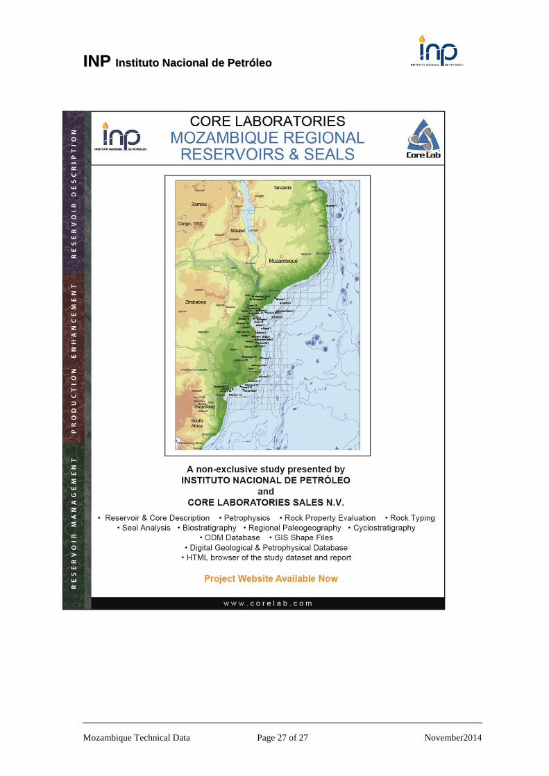
5.4 Appendix 4 Details of CoreLab Study
Core Laboratories is pleased to announce a significant new addition to our series of rock based
geological studies in East Africa, which will provide new dataset generation and detailed evaluation
of reservoir, source and seal rocks from a suite of wells across the coastal region of Mozambique.
The National Institute of Petroleum (INP) have provided access to the cuttings, sidewall cores,
electric logs and technical geological well reports from these selected exploration wells. A total of
c.50 wells have been released for inclusion in this new study.
The primary objective of the project is to undertake a full evaluation of reservoir quality of all major
reservoir intervals penetrated in the study wells, integrated with an evaluation of associated seal rock
lithologies, set in a correlative stratigraphic framework.
The key components of the study are as follows:
• Reservoir Description and Rock Property Evaluation of all major reservoirs:
• Rock Typing of uncored sections;
• Seal Atlas of major seal lithologies;
• Regional Correlative Stratigraphy
• Regional Paleogeography
• Digital Database of laboratory and well data
• ODM database
• GIS Shape files
• HTML browser of the study dataset and report.
Specific objectives include:
• Establish the stratigraphic framework within the wells and provide correlation to previous
published schemes;
• Provide detailed reservoir description in order to establish the depositional and tectonic
setting of the reservoirs and to provide detailed evaluation of reservoir quality. This will allow
evaluation of the sedimentological, tectonic and diagenetic controls on reservoir quality and seal
effectiveness;
• Provide analytical data on the sealing capacity of seals and potential seal rocks in order to
facilitate improved seal rock quality and prospect risk assessment. The dataset will provide
critical parameters for determining seal capacity of oil and gas seal rocks in their depositional
context.
IINNPP IInnssttiittuuttoo NNaacciioonnaall ddee PPeettrróólleeoo
Mozambique Technical Data Page 27 of 27 November2014