republic of kenya ministry of environment and … materials/neaps/lugari.pdf · development plans...
TRANSCRIPT

i
LUGARI DISTRICTENVIRONMENT ACTION PLAN
2009-2013
REPUBLIC OF KENYAMINISTRY OF ENVIRONMENT AND MINERAL RESOURCES
LUGARI DISTRICTENVIRONMENT ACTION PLAN
2009-2013

i
EXECUTIVE SUMMARYThe Environmental Management and Coordination Act (EMCA) 1999 provides for the
preparation of District Environment Action Plans every five years. This is the first District
Environment Action Plan (DEAP) for Lugari district. Preparation of this DEAP was done
through a participatory process involving the civil society, private and public sectors. The
document has incorporated salient issues from the divisions and it highlights priority themes
and activities for the district towards attaining sustainable development. It is divided into
eight chapters.
Chapter one covers the preamble that highlights provisions for environmental planning as
provided for under EMCA, Environmental Acton Planning process that discusses the
methodology used in preparation of the DEAP. It also stipulates objectives, scope of this
DEAP and challenges for environmental management in the district. It further describes
district profile, climate and physical features, population size and distribution and social
economic characteristics.
Chapter Two discusses the district’s environment and natural resources such as soils; land
and land use changes; agriculture, livestock and fisheries; water sources; forest and wildlife
resources and Biodiversity conservation.
Chapter Three addresses the human settlements and infrastructure. It covers human
settlements and planning; human and environmental health; pollution and wastes generated
from human settlements; communication networks; socio-economic services and
infrastructure and energy supply.
Chapter Four discusses industry trade and services in the district. It highlights major
industrial sector that covers agro-based industries, engineering, chemical and mineral
industries; trade; service sector; tourism sector; mining and quarrying.

ii
Chapter Five discusses environmental hazards and disasters. It gives a definition of hazard
and disaster, the extent and trend of environment hazards and disasters. The major hazards
and disasters covered include; drought floods and fire.
Chapter Six covers environmental information, networking and technology. Issues
discussed include status of formal and non-formal environmental education; public
awareness and participation; technologies; environmental information systems and
indigenous knowledge. The chapter thus highlights the need for sustainable environmental
management through environmental education and information, awareness raising and
enhancing public participation at all levels.
Chapter Seven covers environmental governance and institutional framework. It discusses
status of environmental governance and institutional arrangements, regulatory and
management tools and multilateral environmental agreements. The key issue addressed is the
need for strengthened collaboration among lead agencies and stakeholders in environmental
management.
Chapter Eight provides an implementation strategy in a matrix form for addressing key
environmental issues and proposed actions highlighted in chapters two to seven. The
implementation matrix is divided into issue category, problem statement, action needed,
stakeholders involved and the time frame.
The respective lead agencies and stakeholders are expected to be involved at all stages in the
implementation of the district environmental action plan. Secondly, they are required to
monitor and evaluate environmental management indicators identified in the matrix for the
annual reporting for the District State of Environment Report.

iii
FOREWORD
The 1992 Earth Summit held in Rio de Janeiro came up with various recommendations,
among them Agenda 21, a Global Environmental Action Plan. The theme of the Summit
focused on how nations could attain sustainable development. The Government of Kenya
embraced this idea by developing the first National Environment Action Plan (NEAP) in
1994.
Since independence, Kenya has continued to demonstrate her commitment to
environmental management through various initiatives, among them the National
Development Plans of 1974 and the National Environment Action Plan of 1994. Further,
there have been a number of sectoral policies on environment in fields such as Agriculture,
Livestock, Water, Energy, Food, Land, Wildlife, Forest, Industry, Trade, Arid Lands,
Disaster Management and the Draft Sessional Paper No. 6 of 1999 on Environment and
Development.
The Environmental Management and Coordination Act (EMCA), 1999 provides for the
integration of environmental concerns in national policies, plans, programmes and projects.
In this regard, EMCA 1999 provides for the formulation of National, Provincial and District
Environment Action Plans every five years.
Environmental Action Planning is a tool that aims at integrating environmental concerns
into development planning. The process followed in preparing this DEAP was participatory,
involving various stakeholders from institutions and sectors, including the public, private,
NGOs and local communities at Location, Divisional and District levels. These consultative
meetings provided the basis also for formulation of the PEAP and finally the National
Environment Action Plan.
The DEAP addresses environmental issues from various sectors in an integrated manner
and discusses their significance in development planning. It proposes a strategy for achieving
sustainable development in line with Kenya’s quest to meet the Millennium Development
Goals (MDGs), Vision 2030 and Medium Term Plan (MTP). The Plan has brought out a
number of proposed interventions, legal and institutional framework to be incorporated into

iv
sectoral development plans and programmes. Its implementation will be monitored by the
DEC and will be reflected in the State of the Environment Reports.
I wish to underscore that the 2009-2013 DEAP report is a broad-based strategy that will
enable the District attain sustainable development as envisaged in the Vision 2030.
Dr. Ayub Macharia (PhD),DIRECTOR GENERAL (Ag),NATIONAL ENVIRONMENT MANAGEMENT AUTHORITY

v
ACKNOWLEDGEMENT
On behalf of the National Environment Management Authority (NEMA), I would like to
thank the Lugari District Commissioner, who is also the Chairman of the District
Environment Committee (DEC) for spearheading the preparation process for this District
Environment Action Plan,(2009-2013). I also wish to thank most sincerely the District
Environment Committee and the District Environmental Action Plan Technical Committee
for their invaluable inputs and approval of this environmental action plan.
NEMA also acknowledges the contribution of the members of the local communities, who
actively participated in the identification and prioritization of the environmental issues in
their location which formed part of this document. Our sincere thanks goes to the District
Officers (DOs), Chiefs and Assistant Chiefs who were instrumental in mobilizing the local
communities and civil society organizations. Special thanks go to the civil society
organizations that were drawn from entire the district who were instrumental in the
identification of the environmental issues across the district.
We particularly appreciate the technical support provided by officers from the
Environmental Planning and Research Coordination Department, NEMA Headquarters for
their insights and dedication to this process.
Last but not least, I extend my gratitude to all those who contributed towards the finalization
of this District Environmental Action Plan.
Dr. Kennedy I. OndimuDIRECTOR, DEPARTMENT OF ENVIRONMENTALPLANNING & RESEARCH CO-ORDINATION

vi
TABLE OF CONTENTS
EXECUTIVE SUMMARY .............................................................................................................. iFOREWORD .................................................................................................................................... iiiACKNOWLEDGEMENT ............................................................................................................. vTABLE OF CONTENTS .............................................................................................................viACRONYMS ...................................................................................................................................viiiCHAPTER ONE .............................................................................................................................. 1INTRODUCTION .......................................................................................................................... 1
1.1 Preamble......................................................................................................................................11.2 EMCA, 1999 provision on environmental planning ............................................................ 31.3 The Environmental Action Planning Process .......................................................................3
1.3.1 Objectives of District Environment Action Plan .......................................................... 31.4 Scope............................................................................................................................................ 41.5 District Profile ............................................................................................................................ 4
1.5.2 Physiographic Features and Natural Conditions ............................................................ 51.5.3 Climatic Conditions ............................................................................................................ 51.5.4 Population size and distribution ....................................................................................... 5
CHAPTER TWO .............................................................................................................................. 62.0 ENVIRONMENT AND NATURAL RESOURCES ..................................................... 6
2.1 Soils and land use ....................................................................................................................... 62.1.1 Soils .......................................................................................................................................6
2.2 Agriculture, livestock and fisheries.......................................................................................... 72.2.1 Agriculture............................................................................................................................ 7
2.3 Water sources ...........................................................................................................................102.4 Forestry and wildlife resources .............................................................................................. 122.5 Wildlife ......................................................................................................................................142.6 Biodiversity consideration ......................................................................................................152.7 Energy........................................................................................................................................16
CHAPTER THREE ......................................................................................................................193.0 HUMAN SETTLEMENT AND INFRASTRUCTURE......................................19
3.1.1 Physical development plans.............................................................................................193.1.2 Rural and urban housing types........................................................................................193.1.3 Factors influencing types of shelter................................................................................193.1.4 Demographic trends .........................................................................................................19
CHAPTER FOUR ..........................................................................................................................234.0 INDUSTRY, TRADE AND SERVICES ..........................................................................23
4.1 Types of industries...................................................................................................................234.2 Trends in industrial development..........................................................................................234.3 Industries in the district ..........................................................................................................234.4 Tourism .....................................................................................................................................234.5 Service industry ........................................................................................................................234.6 Markets ......................................................................................................................................244.7 Mining and quarrying ..............................................................................................................25
4.7.1 Mining.................................................................................................................................254.7.2 Quarrying ...........................................................................................................................254.7.3 Sand harvesting .................................................................................................................26

vii
4.7.4 Brick making/surface soil mining...................................................................................26CHAPTER FIVE ............................................................................................................................285.0 ENVIRONMENT HAZARDS AND DISASTERS ......................................................28CHAPTER SIX................................................................................................................................ 306.0 ENVIRONMENTAL INFORMATION, NETWORKING ANDTECHNOLOGY .............................................................................................................................30
6.1 Status..........................................................................................................................................306.2 Public awareness and participation........................................................................................316.3 Status of environmental information management ............................................................326.4 Technologies.............................................................................................................................33
CHAPTER SEVEN .......................................................................................................................347.0 GOVERNANCE, LEGAL FRAMEWORK, INSTITUTIONALARRANGEMENTS AND POLICIES .....................................................................................34
7.1 Overview ...................................................................................................................................347.2 EMCA structures for environmental management ............................................................347.3 Regulatory and Management Tools.......................................................................................36
CHAPTER EIGHT........................................................................................................................398.0 IMPLEMENTATION STRATEGY ..................................................................................39
8.1 Overview ...................................................................................................................................398.2 Monitoring and evaluation......................................................................................................40
APPENDIX ......................................................................................................................................55REFERENCES ............................................................................................................................... 57
LIST OF TABLESTable 1: Crop production trends/yield per hectare ......................................................................................... 7Table 2: Livestock Production Trend ............................................................................................................. 9Table 3: Main water uses...............................................................................................................................11Table 4: Forest Cover ....................................................................................................................................12Table 5: Population distribution by gender ...................................................................................................20Table 6: Waterborne Disease incidences .......................................................................................................20Table 7: Market Centres in the District. ........................................................................................................24Table 8: Schools participation in Environmental Education .........................................................................30Table 9: Environmental Programmes ............................................................................................................31Table 10: Priority issues and interventions....................................................................................................31Table 11: Types and sources of environmental information .........................................................................32Table 12: Implementation Matrix..................................................................................................................41
LIST OF FIGURES:Figure 1: Administrative, Geographic and Physical Description ................................................................... 5

viii
ACRONYMS
ACU Aids control Unit
AIDS Acquired Immune-Deficiency Syndrome
ASALs Arid and Semi-arid Lands
CACC Constituency AIDS control Committee
CAP Community Action Plans
CBOs Community Based Organizations
CHWs Community health workers
CPDA Christian partnership Development Agency
DACC District AIDS control Committee
DALEO District Agricultural, Livestock and Extension Officer
DC District Commissioner
DDOs District Development Officers
DDPs District Development Plans
DEAPs District Environment Action Plans
DEO District Education Officer
DEOs District Environment Officers
DFID Department for International Development
DFO District Forest Officer
DHMT District Health Management Teams
DIDC District Information and Documentation centre
DIMS District Information Management System
DMOH District Medical Officer of Health
DPHO District Public health officer
DPT District Planning Team
DPU District Planning Unit
DVO District veterinary officer
EA Cumulative Environment Assessment
EMCA Environment Management and Coordination Act
EMS Environment Management System
ERSW&EC Economic Recovery Strategy for Wealth and Employment Creation

ix
GDP Gross Domestic Product
GIS Geographical information System
GMOs Genetically Modified Organisms
GOK Government of Kenya
GTZ Germany Technical Assistance
HHC Primary Health care
HIS Health Information System
HIV Human Immune Deficiency Virus
ICE Information Communication and Education
ICIPE International Centre of Insect Physiology and Ecology
ICRAF International Centre for Research in Agro forestry
ICT Information Communication Technology
IDA International Development Agency
IEC Information Education and communication
IIRR International Institute of Rural Reconstruction
IT Information Technology
JICA Japan International Cooperation Agency
KARI Kenya Agricultural Research Institute
KARI Kenya Agricultural Research Institute
KEMFRI Kenya Marine and Fisheries Research Institute
KIFCON Kenya Indigenous Forests Conservation Program
KP&LC Kenya Power and Lighting Company
KWS Kenya Wildlife Service
LBDA lake Basin Development Authority
LDP Livestock Development Program
LIS Status of Land Information System
LPG Liquidified Petroleum Gas
LTC Luanda Town Council
MCH/FP Maternal Child Health/Family planning
MDGs Millennium Development Goals
MEAs Multilateral Environmental Agreements
Mkts Markets

x
MOEST Ministry of Education, Science and Technology
MOFP Ministry of Finance and planning
MSE Medium small Enterprises
MTEF Medium term expenditure Framework
NACC National AIDS control Council
NALEP National Agricultural and Livestock Extension Program
NCD New Castle Disease
NCPD National Council for Population and Development
NDP National Development Plan
NDPs National Development Plans
NEAP National Environment Action Plan
NEAPC National Environment Action plan Committee
NEMA National Environment Management Authority
NEPAD New Partnership for Africa Development
NGOs Non-Governmental Organizations
NGOs Non-Governmental Organization
NII National Information Infrastructure
NPEP National Poverty Eradication Program
OI Opportunistic Infections
OPD Outpatient Department
PDEs Provincial Directors of Environment
PDPs Part development plan
PEAPs Provincial Environment action Plans
PHT Public Health Technician
PLWA Persons Living with AIDS
PMEC Provincial Monitoring and Evaluation Committee
PRA Participatory Rural Appraisal
PRSP Poverty Reduction Strategy Papers
RD Rural Development
Rd. Road
REFIP Research Farmers Interaction program
RHTC Rural Health Training Centre

xi
SACCOs Saving and Credit Co-operative Societies
SEA Strategic Environment Assessment
SEAs Strategic Environment Assessments
SIDA Swedish International Development Agency
SoE State of the Environment
STIs Sexually Transmitted Diseases
TAC Technical Advisory Committee
UNCED United Nation Conference on Environmental and Development
UNDP United Nations Development program
UNESCO United Nations Educational, Scientific and cultural Organization
UNIDO United Nations Industrial Development Organization
USAIDUnited States Agency for International Development
VCT Voluntary counseling and testing
VIP Ventilated Improved Pit latrine
WSSD World Summit on Sustainable Development
YFCK Young Farmers Club of Kenya

1
CHAPTER ONEINTRODUCTION1.1 PreambleThe United Nations Conference on Environment and Development (UNCED) commonly
known as the Earth Summit held in Rio de Janeiro in 1992 aimed at improving the global
environment, while ensuring that economic and social concerns are integrated into
development planning. The Conference underscored the need to plan for sustainable socio-
economic development by integrating environmental concerns into development through
adopting and preparing appropriate policies, plans, programmes and projects. The
Conference agreed on the guiding principles and a global plan of action (Global Environmental
Action Plan) for sustainable development commonly called Agenda 21.
Sustainable development is commonly defined as “development that meets the needs of the present
generation without compromising the ability of future generations to meet their own needs”. Development is
also said to be sustainable if it meets ecological, economic and equity needs. The process of
attaining sustainable development calls for the integration of environmental considerations
at all levels of decision making in development planning and implementation of programmes
and projects.
The people in the district fundamentally depend on the natural systems and resources for
existence and development. Particular attention needs to be paid to the dynamics of the
global system, the importance of watershed in microclimates and the natural ecosystems, the
natural vegetation including forests in maintaining its equilibrium, the importance of soil
quality and agriculture in ensuring basic human security among others should also be
considered. There is need to use non-renewable resources efficiently and ensure that
renewable resources are used sustainably.
The District Environmental Action plan (DEAP) aims at integrating environmental
concerns in the District Development processes noting that the linkage between socio–
economic development and environmental sustainability is closely intertwined. DEAP will

2
also strive to propose and promote low cost but efficient environmental interventions that
reduce vulnerability to poverty, recognizes indigenous knowledge, observe socio-cultural
concerns and improve livelihood production options.

3
1.2 EMCA, 1999 provision on environmental planningThe EMCA provides that every District Environment Committee shall every five years
prepare a District Environment action plan in respect of the district for which it’s appointed
and shall submit such plan to the chairman of the provincial environment action plan
committee for incorporation into provincial environment action plan as proposed under
section 39.
1.3 The Environmental Action Planning ProcessDEAP MethodologyThe process started by holding regional workshops, during which the DEAP Secretariat was
appointed by the Director General in 2004. The team comprised of District Water Officer,
District Development Officer (DDO) and District Environment Officer (DEO) to attend
an induction course on the DEAP methodology. The District Environment Committee
(DEC) members gazetted in 2003 were further requested to form a District Environment
Action Planning Committee (Technical Committee comprising lead agencies and
representatives from other stakeholders), chaired by the DDO while the DEO is the
secretary. Once the draft DEAP is prepared, the DEC approves and submits to the
Provincial Environment Committee for inclusion in the Provincial Environment Action
Plan.
1.3.1 Objectives of District Environment Action PlanThe objectives of District Environment Action Plan include the following:
To determine the major environmental issues and challenges facing the districts
To identify environmental management opportunities
To create synergy and harmony in environmental planning
To integrate environmental concerns into social, economic planning anddevelopment of the district
To formulate appropriate environmental management strategies specific to thedistrict

4
1.4 ScopeThe preparation of the Lugari DEAP has been realigned with Vision 2030, Midterm Plan
2008-2012 as directed by the government. The current DEAP covers the period of 2009-
2013 and as per EMCA, 1999 shall be revised after every five years. The DEAP will be
monitored by the annual preparation of the State of Environment Reports. The
environmental indicators that have been developed in the implementation matrix will be
monitored by the respective lead agencies on an annual basis and incorporated in the annual
State of Environment Report. The National Steering Committee and the National
Environment Action Planning Committee have approved the indicators. The DEAP has
been subjected to stakeholder meetings at Sub Location and District levels.
The District Environment Action Planning Committee spearheaded the preparation of the
Lugari DEAP. The committee requested for Sectoral environment reports from the various
lead agencies to assist in the compilation of the DEAP. The Lugari District Environment
Action Plan was further enriched through participatory planning approach in the subsequent
consultative workshops at the district and location levels. Local communities consultations
were held and focused on the location that rank the poorest in the poverty index (PI scale,
CBS) in the district. This helped in linking poverty to environmental degradation at the
lowest levels. The Community Development Environmental Management Programme
(CDEMP) supported these workshops both at District and location levels.
1.5 District ProfileThis section provides summary information on Lugari district in terms of the geographical
position, physiological features, settlement patterns, socio-economic profile and the district
fact sheet. The data mentioned are gathered from different government departments and
agencies and reports of periodic surveys conducted by the Kenya National Bureau of
statistics the latest being The Kenya integrated household budget survey of 2005/06

5
Figure 1: Administrative, Geographic and Physical Description
Lugari district was curved out of Kakamega district in 1998 and occupies an area of 670.2
km² and is divided into three administrative divisions namely: Likuyani, Lugari and Matete.
1.5.2 Physiographic Features and Natural ConditionsThe district lies between altitude 1300 –1800m above sea level it is hilly and rocky towards
the east but gradually becomes plain as it progresses to the south. The main rivers traversing
the district are Nzoia & Kipkarren.
1.5.3 Climatic ConditionsClimate and rainfall pattern are largely equatorial type with temperatures between 6 –24
degrees centigrade. The rainfall pattern is bimodal and averages are 1000-1600mm annually.
1.5.4 Population size and distribution
Division Population (1999) Density
Likuyani 99,074 328
Lugari 87,041 327
Matete 48,421 475
Total 234,536 350.

6
CHAPTER TWO
2.0 ENVIRONMENT AND NATURAL RESOURCES2.1 Soils and land use2.1.1 Soils
Soil types, Characteristics and DistributionThe major soil types in the district include Rhodic feral soils with feralo chronic agri-soils.
The soils are well-drained deep red to dark red, sandy loams to sandy clays, which are not
very fertile but deep and well drained.
A long river Nzoia there is a complex of imperfectly drained to poorly drained very deep
dark grey to dark grayish brown sandy to clay in higher areas while some patches of
regosils lithosoils are found around Mwamba characterized by being shallow and rocky.
Current Potential Uses of Soils
The major soil use in the District is crop production and pasture for livestock rearing. There
is maize cultivation for both commercial and subsistence, pockets of coffee growing, bean,
sunflower & Sugarcane for commercial purposes.
The soils here have great potential for enhanced maize production, horticultural crops and
fruits and development of irrigation facilities. This potential can only be realized if water is
available for irrigation.

7
Key Environmental Issues
Farm inputs and methods of farming e.g. use of synthesis fertilizers that affect the
soil PH and soil composition.
Soil and water erosion.
Farming system (i.e. lack of farming diversification resulting in low fertility input e.g.
use of un-calibrated machines that cause hardpan leading to low yield per capital.
Change of Land use
Proposed intervention
Construct soil conservation structures
Destocking
Gazettement of the forest areas
Training on soil fertility enhancement
Water harvesting for improved moisture retention.
Promotion of agro forestry activities.
Rehabilitation of degraded areas.
2.2 Agriculture, livestock and fisheries2.2.1 Agriculture
Table 1: Crop production trends/yield per hectare
1998 1999 2000 2001 2002 2003 2004 2005 2006 2007
Maize 49 44 42 43 23 43 35 45 -
Beans 5.5 6.6 5.5 4.1 - 5.5 8.75 5.3 5.6 -
SweetPotatoes
12 9 10 12 10 12 6.2 - - -
LocalVegetables.
2.9 3 3.3 3 2.7 3 3 2.7 2.1 -
Bananas 12 12 10 10 10 10 10 14 14 -

8
1998 1999 2000 2001 2002 2003 2004 2005 2006 2007
sugarcane 65 60 70 70 65 60 102 55 55 -
coffee 3.5 3.0 3.5 3.0 4.2 3.0 4.5 1.5 1.1 -
sunflower 1 1.1 1 1 0.8 9.8 0.84 - - -
Food Security -2006 Production Perspective
Major Food CropsMaize 29,966ha 1,361,680bags
Beans 22,425ha 13,800 bags
Sweet potatoes 2,786ha 19,000 tonnes
Vegetables 384ha 2,833 tonnes
Fruits 862 ha 16,227 tonnes
Major Cash CropsCoffee 789 ha 968 tonnes
Milled cane 1,052 ha 23,144 tonnes
Sunflower 632 ha 632 tonnes
New CropsMushrooms, vanilla, artemesia, jatropha
The crop production trends in yields per hectare show an averagely constant trend. There is
need to intensify, diversify and introduce more high value crops to meet the demand for the
rising population.
Crop Projects in the District
NALEP SIDA-Which covers one focal area (location) per division per financial year
NALEP GOK-this is a specific crop project in certain designated area per fiscal year
NJAA MARUFUKU KENYA-, which is district wide common interest group, based
support project.
9
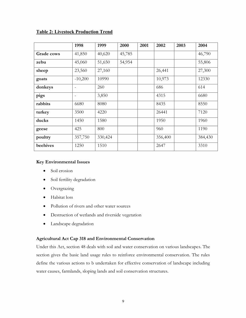
Table 2: Livestock Production Trend
1998 1999 2000 2001 2002 2003 2004
Grade cows 41,850 40,620 45,785 46,790
zebu 45,060 51,650 54,954 55,806
sheep 23,560 27,160 26,441 27,300
goats -10,200 10990 10,973 12330
donkeys - 260 686 614
pigs - 3,850 4315 6680
rabbits 6680 8080 8435 8550
turkey 3500 4220 26441 7120
ducks 1450 1580 1950 1960
geese 425 800 960 1190
poultry 357,750 330,424 356,400 384,430
beehives 1250 1510 2647 3310
Key Environmental Issues
Soil erosion
Soil fertility degradation
Overgrazing
Habitat loss
Pollution of rivers and other water sources
Destruction of wetlands and riverside vegetation
Landscape degradation
Agricultural Act Cap 318 and Environmental ConservationUnder this Act, section 48 deals with soil and water conservation on various landscapes. The
section gives the basic land usage rules to reinforce environmental conservation. The rules
define the various actions to b undertaken for effective conservation of landscape including
water causes, farmlands, sloping lands and soil conservation structures.

10
Soil conservation and promotion of Conservation agriculture
Soil fertility improvements
River bank protection
Safe use of chemicals and promotion of organic farming
Agro forestry
Rain water harvesting
Control livestock numbers
Enhance communities education programs and veterinary services
Construct watering points
Protect springs and wells
Baseline survey to determine carrying capacity
Advice communities on safe use and handling of drugs and chemicals
2.3 Water sourcesMain Water CatchmentsAll the major rivers in Lugari originate from Cherang’ani hills, Kaptagat forest and local
seepage points.
Status and Trend of Water SourcesSurface Water is mainly from the rivers in the district. Surface water compromise ofrivers, dams, ponds and wetlands
The other sources of water in the district are the springs. About 35% have been protected.
Other sources are boreholes and hand dug wells. The government has developed 90% of the
boreholes and 45% of the hand-dug wells. Most of the hand-dug wells are individually
owned.
Roof catchment is yet another source of water in the district. This has not been well
developed but due to the abundant rainfall 25% of the population use storage tanks for roof
catchment.

11
Main water usesThe various types of water use in the district include;
Table 3: Main water uses
Source Usage ManagementSystem
Challenges Proposed Intervention
Dams DomesticandAgriculture(irrigation)
CommunityOwned
Siltation Pollution Encroachment by
Settlement andUrbandevelopment
Monitoring Pollution control Afforestation Desiltation Land
redesignation Integrated
landUse Recreation
Boreholes Domestic Individual Reducedaquifer
Rain catchmentsAfforestation
Springs Domestic Local Group ReducedQuantity
Spring protectionIntegrated land use
Issue CurrentImplementation
Proposed Responsible Remark
SpringsProtection
ProtectionGroupmanagement
Increased NoExpandcatchment
NEMAWRMAMOHLCCKAMADEPMOA
Water is thecenter for mostactivities

12
Key Environmental Issues
Pollution of the surface water
Destruction of catchment areas
Water borne diseases
Siltation of dams and wells
Proposed interventions Rehabilitation and completion of all stalled water projects.
Institutional support and capacity building.
Improve water and sanitation conditions in the district
Inventorize of all water resources
Map and gazette water catchments for conservation.
Promote community based catchment management
Education and awareness programmes on water management
Law enforcement on river frontage cultivation
Carry out survey on water pollution sources and enforce pollution laws.
2.4 Forestry and wildlife resourcesTypes of Forests and Area under Forestry
Forest in the Lugari District can be categorized as Riverine forest /High forests and
Transitional Zone forest (bush lands).
Table 4: Forest Cover
Forest Type Area (HA) Distribution Location Uses: %degradation
Gazzetted High forest 7,242.5 86.3 % Lugari pulpwood 35.9%
Bush lands 532.7 6.3% Nzoia timber
Grassland 619.1 7.4 % Turbo fuel wood
Private farm forest 152 28.0% Districtwide
poles &posts
72%

13
Key Environmental Issues in forests Logging for timber and charcoal burning
Persistent drought
Unreliable and unpredicted weather patterns
Traditional burning of swampy areas and forest fires
Free ranch grazing of livestock which roam and damage vegetation especially along
the rivers;
Inadequate forest products
High levels of poverty, which lead to environmental degradation
Disappearance of valuable timber tree species.
Inadequate awareness on Environmental /forest management plans for continuous
implementation to realise positive results for livelihood sustenance.
Conflicting legislations which lead to confusion among natural resource users and
enforcers
Inadequate incentives and motivation for natural resource keepers in terms of
investment to boost natural resource base
Low understanding levels of natural resource users on sustainable management of
natural resource to enhance sustainable development.
Proposed Intervention
Enhance public awareness on the need to conserve and protect the forest resources
Support community/other stakeholders action plans in forestry or related
operations/activities- participatory forest management programmes
Enforcement of environmental legislations e.g. Regulate movement of forest
produce through the issuance of movement permits/licenses
extensive afforestation and re-afforestation programmes
forest zoning
Involve the public in proper land use plans, and incorporation of woodlot
establishment.
Encourage local authorities and other stakeholders in setting aside a piece of land for
tree planting.

14
Introduction of non-timber projects such as apiaries, sericulture, mushroom farming
Introduction of highly valuable timber species
Establishment of water pans which can assist in sustainability of enterprising projects
such as tree nurseries and irrigation horticulture.
Training farmers to adopt modern technologies in farming e.g. establishment of
demonstrations plots.
Intensify patrols for fires and other illegal operations in the forest
Strategies to conserve indigenous vegetation Protection of fragile lands for natural vegetation regeneration through organized
patrols
Rehabilitation of degrade areas (re-afforestation).
Patrols for fires
Gazettement of new forest effective management
Promote seedling production of other tree species as an alternative
Commercialize tree seedling production where the seedlings raised are sold to boost
the domestic budgets at household or community level.
2.5 WildlifeArea under Wildlife and wildlife TypesThere is no gazetted park in the district. The major issue in the area of wildlife management
is the farmers/monkeys conflict. Vegetation clearance and wetlands destruction has greatly
affected wildlife occurrence and distribution in the district.
WildlifeVarious fauna exists in Lugari district these include squirrels, antelopes, rabbits and snakes.
Most of them are however disappearing as most land cover is being cleared for cultivation
Key environmental issues
Destruction of wildlife habitats.
Wild forest fires
Poaching.

15
Human- wildlife conflict
Proposed interventions
Establishment of wildlife protected areas.
Afforestation and re-afforestation
Promotion of wetlands conservation
Promoting underground crops
Sensitizations Programme for the locals to appreciate the wildlife
Collaboration with CBOs and the public
Increased security and Surveillance,
Disease control
2.6 Biodiversity considerationBiodiversity and Environmentally Significant areasThe district has a wide array of ecosystems such as hilltops and hillsides, forests and bush
lands, wetlands, rivers and riverside vegetation. These ecosystems support a wide variety of
wildlife species.
Hill RemarksMaturu Deforested due to encroachment and grazing
Mawe tatu hills Deforested due to settlement and cultivation
Rare, Threatened, Invader and vulnerable speciesInvasive species-None exists in the District intervention measures are to keep monitoring.

16
Key Environmental Issues affecting Biodiversity
Droughts Water and pasture shortages Fires Poaching The deforestation has led to the loss of habitat The human- wildlife conflict
Proposed Interventions Reforestation Programme on the hills
Riverine protection
Develop water infrastructure.
Create awareness on the dangers of lighting fires around the park and forests
Community participation in the biodiversity conservation and application of
indigenous knowledge in biodiversity conservation
2.7 EnergyTypes and SourcesThere are various sources of energy in the district. These include fossil fuel, wood fuel, solar
energy and the hydroelectric power.
Fossil fuels include:
Petrol for vehicles, motor cycles, motor boats
Paraffin: used for lighting and cooking
Diesel used by vehicles, generators, coffee industries and posho mills
8.5%of households use kerosene, and gas. LPG gas is used on a small scale for cooking.

17
Solar energySolar energy is used traditionally for drying firewood and foodstuffs like maize, beans;
cassava etc. A few homes in rural areas use solar energy. This is a potential source of energy,
which is under exploited in the district.
Wood fuelThe district energy source is mainly firewood. 83.9% of the district’s population relies on the
firewood for their domestic use. They use it directly as firewood while some use it in the
form of charcoal. The demand for wood fuel due to increased population has put a lot of
pressure on the forests and bush land in the district leading to deforestation and loss of
vegetation cover.
ElectricityThe number of households with electricity is about 4,000. These are mainly in the
urban/market centers. 70 trading centers in the district are connected to the electricity grid.
WindWind energy is untapped.
BiogasAnimal waste and crop residue/bargasse largely un-exploited
Key environmental issues
Population growth
Pollution through emissions
Lead bio-accumulation in plants along the main track highway.
Deforestation and loss of vegetation cover
Indoor pollution from use of fuel wood.
High cost of energy technologies

18
Proposed interventions
Enforcement of regulation on air quality standards
Enhance planting of trees on hill tops and other suitable areas
Promote agro-forestry and/or farm forestry practices
Design houses with adequate ventilation
Mainstream gender issues in energy related interventions
Introduction of efficient affordable energy technologies e.g. use of improved jikos
and energy saving fixture/bulbs
Promote use of wind, solar and Biogas energy

19
CHAPTER THREE
3.0HUMAN SETTLEMENT AND INFRASTRUCTURE
3.1.1 Physical development plansThere is no approved physical plan for the district nor is there any planning framework to
guide development in the various urban centers in the district. There is haphazard expansion
of towns and market centers due to high demand for human settlement and commercial
premises. There are no sewerage systems, licensed waste disposal facilities are non-existence,
no provisions for car wash facilities and other environmental protection amenities.
3.1.2 Rural and urban housing typesMost building is made of iron sheet roofed with mud walls. 2% of the populations have
permanent houses
3.1.3 Factors influencing types of shelterFactors Influencing types of Shelter ranges from economic to socio-cultural issues Adults
with strong economic base will build stone walled houses with iron-sheeted roofs while the
very poor will settle for mud walled and grass thatched roof houses. The cultural practice
that sons have to build a cottage(Simba) in their parents homestead before they migrates to
their own home has made youths who are economically endowed go for this cheap building
materials just to conform to this cultural requirement
3.1.4 Demographic trendsPopulation density has been increasing at a rate of 4.13% as reflected at 322 person’s per
square km in 1999 to 364 person’s per square km in 2004.

20
Table 5: Population distribution by gender
Division Males Females Total Households Area Density
Likuyani 44, 499 46,711 91,210 17,846 302 302
Lugari 39,217 40,915 80,132 15,197 266.3 301
Matete 21,557 23,021 44,578 8,766 101.9 437
Rural and Urban PopulationRural population 228, 174
Urban population
Migration rate Females 14.8%, males 10.8%
Poverty level57.37% (mainly squatters, landless and female/children headed households)
Water and SanitationWater borne diseases in Lugari district 1993-2004
Table 6: Waterborne Disease incidences
Disease 1993 1999 2002 2004
Diarrhea 285 5359 6160 7400
Malaria 3413 59515 66190 93341
typhoid 213 540 550 1323
Bilharzias 0 11 41 12
Cholera 0 0 0 0

21
No. of households with access to piped water 3,377. No. of household with access to portable water 17, 728. No. of permanent rivers 2 No. of wells 13. No. of protected springs 68. No. of boreholes 6. No. of dams 43. No. of households with roof catchment 140 Average distance to nearest portable water point 500m Number of VIP latrines 22, 472 Labor force 17, 071.
Population and waste generated from human settlement:
Slaughter houses and slabs
Jaggery bargasse.
Agro based
Sanitation related waste.
Education/Schools No. of pupils in primary schools. 61,190.
No of students in secondary schools 26,403.
Average land parcels ……………2.5 ha
Key Environmental Issues
Lack of physical development plan and/or land use planning framework
Poor drainage systems and soil erosion
Poor disposal of waste (solid wastes and sewer)
High population growth within the urban centers
Poor sanitation
Lack of trees in most schools to act as wind-brakes
Poor landscaping in schools
Pollution

22
Proposed InterventionsDevelopment of Physical Development Plan
Establishment of sewerage works and waste disposal facilities
Establishment of domestic water treatment facility and promote rain water harvesting and
storage.
Encourage school to establish tree-nurseries and woodlots
Improve road infrastructure in the district
Establish emergency Fund for disaster management.
Promote landscaping in schools

23
CHAPTER FOUR
4.0 INDUSTRY, TRADE AND SERVICES4.1 Types of industriesIndustries, trade and services can benefit a lot by adopting environmental management
systems that not only address production processes but also promote waste minimization.
Lugari district does not enjoy presence of industrial establishments and is largely a service
dependant district except for sugarcane jaggeries.
4.2 Trends in industrial development
4.3 Industries in the districtThe main factories are in sugarcane sector, they are mainly the jagery factories andthey include:
i. Chimoi jagery factory (harry lamp jagery)
ii. Shajanand industries
iii. Chetambe jageries
iv. Chabadiya jagery
v. Chabadiya quarry plant
4.4 TourismThe tourism industry is heavily dependent on the vast and abundant natural resources in the
country. This includes wildlife, beaches, landscapes and diversity of cultural, historical and
archeological reserves. Lugari has no known tourist attraction and is not on the main tourist
circuit. However, there are potentials in ecotourism and recreation.
4.5 Service industryTrade in agricultural inputs/produce is an activity for generating incomes and employment
reducing poverty and promoting food security through extensive land use and input use.

24
The district is agriculture dependent and therefore a suitable hub for such services as
banking and trading in agricultural produce, which will contribute to wealth being retained in
the region. With a labor force of approximately 17, 071 people, related potentials include
demand for housing, which then generates an opportunity for investment in housing and
related development.
The district has a number of other attractive entrepreneurial opportunities in the service
industry supported by services such as banking, health facilities, government services and
other social amenities.
4.6 MarketsThere are a number of market places in the district. These include.
Table 7: Market Centres in the District.
1 MWAMBA2 LWANDETI2 MATETE3 LUGARI4 LUMAKANDA5 KOROMAITI6 MUGUNGA7 MAUTUMA8 MLIMANI9 LUKUYANI10 KILIMANI11 BINYENYA12 KONA-MBAYA13 NZOI-MARKET14 HEAD-QUATER15 MACHINE16 NUMBER-ONE17 SHANGO18 NANGILI19 MATUNDA20 FAFARO21 LUMANI22 MAKHUKHUNI23 LUMANI

25
Key Environmental Issues Poor solid waste and waste water management
Odour
Noise pollution due to hawking
The district lacks a sewerage plant
Mushrooming of informal settlement
Health hazard to livestock due to ingestion of polythene bags
Destruction of scenic beauty
Air and water pollution
Proposed interventions Proper management, recycling and management of polythene bags
Phasing out scheme of the polythene bags
Incineration of waste
Establish and enforce physical Development planning
Enforce relevant legislations
Construction of sewerage treatment plant
Construction of planned waste disposal sites
4.7 Mining and quarrying4.7.1 MiningMining has some potential adverse on the environment. There are no reported mineral
deposits in the District and therefore no mining activity.
4.7.2 QuarryingThere are pockets of building stone quarrying in the District. However, there is a lot of
Murram excavation all over the district mainly for road maintenance. This is usually carried
out by the Ministry of Roads.
The quarries usually leave open pits with high cliffs which a danger to the public and
livestock. Rehabilitation/restoration attempts and after use planning is wanting.

26
4.7.3 Sand harvestingThere is isolated small-scale sand harvesting sites.
4.7.4 Brick making/surface soil miningThere is significant brick making in the district resulting into destruction of wetlands and
landscape degradation.
Key Environmental Issues
Unsafe quarrying operations-the presence of high vertical cliffs, undercutting,tunneling and risky material conveyance practices.
Lack of Personal Protective Equipment-the workers does not have the necessaryprotective gear and other basic welfare facilities such as water and sanitaryconveniences.
Quarry sites in close proximity to homesteads, schools, roads, rivers, and shoppingcenters exposing them to danger and inconveniences.
Nuisance and danger posed by high-unfenced cliffs, uncontrolled and illegal blasting,dust emissions and water ponding in the quarry pits.
Encroachment into ecologically sensitive environments and deposition of quarrywaste in some waterways.
Negative landscape effects due to the presence of abandoned quarries pits and heapsof quarry wastes
Lack of quarry pit rehabilitation/restoration plan and/or after-use plans.
Exploitation of workers by middlemen leading to low wages
Notable negative effects such as illicit brews, drug abuse, and HIV /AIDSprevalence.

27
Proposed Intervention
Enforce relevant legislation
Implement the recommendations of Taskforce on Management of quarrying
activities in Kenya
Apply safe quarrying practices such as benching/terracing, open cast operations for
removal of the soil overburden,
Warnings signs of appropriate font size and in the appropriate language should be
erected in all quarry entries and in areas with high cliffs
Establish safety distances/buffer zones between quarry sites and other incompatible
land uses.
formation of community based groups that shall enable them easy access to devolved
funds, training, and market outlets and be able to negotiate for better prices for their
products.
Establish sub-committees to ensure regular inspection of quarries and sand mines in
the District.
Quarrying activities within the forested land should be in accordance with section 42
of the Forest Act 2005.
Establish quarry pit rehabilitation and/or after use plan. The after use plan should
identify suitable alternative land uses for the disused pits e.g. land restoration for
agriculture; Land restoration for recreation; Land restoration for forestry and apiary
(bee keeping); exploitation for aquaculture; Exploitation of the pits as water
reservoir; and if suitable exploitation for sanitary land filling.
Promote progressive quarrying operations and therefore progressive restoration
and/or reclamation.

28
CHAPTER FIVE
5.0 ENVIRONMENT HAZARDS AND DISASTERSMost environmental disasters in the district are mainly climatic and weather related with
cases of tectonic movements reported. The common hazards and disasters reported in the
district include droughts, floods, landslides, lightening, fire, hailstorms, and environmental
related diseases.
HailstormsHailstorms are an important form of precipitation in Lugari. Depending on the size of the
ice pellet, intensity and the growth stage of crops, hailstorms cause a lot of damage to crops.
LighteningLightening is a common phenomenon in this part of Kenya, which causes damage to
property, animals and human beings.
FloodsBecause of the topography of the district, minor river floods are experienced in the lowlands
along the major rivers like Nzoia, and adjacent areas.
Environmental Related DiseasesDiseases such as Malaria are common during floods.
Key environmental issuesLoss of human lives
Loss of biodiversity
Manifestation of invasive species
Fluctuating water levels
Water pollution
Oil spills into the water bodies
Destruction of farmlands
Disease outbreaks

29
Emergency of conflict over natural resources
Accidents on the roads
Proposed intervention measures
Conduct disaster risk assessment
Undertake disaster mapping
prohibit settlement in landslide prone areas
Develop disaster contingency measures and risk reduction
Develop early warning systems
Enforce relevant regulations
Enhance awareness and coping mechanisms
Strategic environment assessment
Incorporate traditional coping mechanisms
Promotion of water harvesting techniques

30
CHAPTER SIX
6.0 ENVIRONMENTAL INFORMATION, NETWORKINGAND TECHNOLOGY
6.1 StatusThe Ministry of Education Science and Technology has developed a Curriculum in Primary,
Secondary and tertiary institutions on Environmental Conservation. Pupils from class one is
taught about their surroundings and the curriculum develops to upper primary as a science
subject. The topics covered are water, agriculture, and air and soil conservation and are
examinable in national examinations. After theory in class, the students are taken through
demonstration activities like soil conservation, good land use, waste disposal, recycling of
materials, water conservation and tree planting.
Other non-examinable areas are:
Environmental education programs including 4K-Clubs in primary schools,
afforestation programs, debate on environmental issues.
Secondary environmental programs including Wildlife Clubs, Presidential Award
Scheme and Science Congress
Eco-schools and environmental programs
Quality Assurance officers to sensitize teachers and pupils on environmental
conservation.
Table 8: Schools participation in Environmental Education
No of schools Type of EnvironmentalProgramme
Remarks
Primary
14
Secondary
4
4k clubs, wildlife clubs,
Agenda 21, club Miti Mingi
Society.
They are mainly
active in secondary
boarding schools.

31
Table 9: Environmental Programmes
EnvironmentalProgramme
Key Players Challenges ProposedIntervention
Nursery
Establishment,
Organic Farming
and
Awareness creation
CBOs
NGOs
Environmental office
Forest
Funds
Enforcement
Sustainability
Follow-ups
Source for funds
e.g. CDF
6.2 Public awareness and participationLead Agencies and some CSOs and NGOs do public awareness on environment and
community participation. The channels of information dissemination and awareness creation
include; public barazas, demonstration and field days, CBOs, Environmental clubs in schools,
Electronic and the print media.
Key players in environmental awareness and public participation
National Environment Management Authority
CARE Kenya
Plan Kenya
Office of the President (Provincial Administration)
Ministry of agriculture
Forest department
Ministry of Information
Ministry of health
Fisheries department
Table 10: Priority issues and interventions
Issue Currentintervention
Proposed Institution Remarks
Awarenesscreation
Schools lecturePublic barazas
Pamphletsenforcementawards
NEMAGOKdepartmentsNGO’sCBO’s
This should bedone as teamwork. Thecompanies tosponsor awards

32
6.3 Status of environmental information management
Table 11: Types and sources of environmental information
Data Formats and AccessibilityThe available data formats in the district are purpose specific and vary from one source to
another. Most of the available information is in narrative form while a few are depicted in
quantitative formats. Maps and electronic formats of presentation of information are very
rare. Some institutions charge a fee for information access.
Status of Environmental Information Management Systems
The available information is scattered in various institutions in form of reports.
There is inadequate information sharing between various institutions.
Inadequate institutional capacity in information management
Some information is obsolete and inaccurate
There are quite a number of newsletters and magazines in the district.
Local publications are few.
Data types available in thedistrict
Sources of environmentaldata/information
Custodian of thedata/information
Climate Natural resources Pollution Infrastructure Demography Diseases
Annual reports Research studies and
journals Projects progress
reports Population censuses Registers and files District state of
environment report
Governmentdepartments and localauthorities
Non governmentOrganizations
Special governmentprojects and programs
District informationdocumentation center
District environmentinformation center

33
Indigenous knowledgeLugari has varied ethnic groups. The cultural diversity offers potential information that can
be exploited to contribute positively to national development and environmental
sustainability. Information on IK has not been well documented and properly packaged to
allow, effective dissemination, hence contributing to the massive loss of IK from one
generation to the next.
There are various types of indigenous knowledge, innovations, and practices in Lugari
district. The level of their applications in environmental management is low. Food
production using organic farming is one such knowledge so is the preservation and storage
of harvested crops. However, the consumption of indigenous food is being overlooked, the
myth that was originally used to protect fragile ecosystems are not encouraged and Shrines
hitherto protected have been cleared to pave way for settlement and agriculture. Population
explosion and cultural erosion are major challenges hindering the application of IK in the
district.
6.4 TechnologiesThe following are some of the technologies being applied to manage natural resources and
environment in the district.
Grafting in tree planting
Use of oil receptacles at petrol stations
Energy saving technology
Food preservation

34
CHAPTER SEVEN
7.0 GOVERNANCE, LEGAL FRAMEWORK,INSTITUTIONAL ARRANGEMENTS AND POLICIES
7.1 Overview
Environmental governance in Kenya is through various Legislations, Standards and
Regulations together with institutions that implement them. Before the enactment of
EMCA in 1999 as on over-arching framework law, environmental management was
scattered in various sectoral legislations and some were conflicting. Environmental
Management and Coordination Act (EMCA), 1999 devolve administration of a number of
environmental and natural resources management issues to communities. It recognizes
community rights, benefit sharing, pastoral land tenure and equitable and sustainable access
to land.
Environmental Management and Coordination Act addresses land use management issues
including sustainable land use, land use planning, and ecosystems protection and
management. The law identifies structures that oversee the equitable distribution of benefits
and devolution of decision making on natural resources. EMCA has provision for the
establishment of the District Environment committee, which is the lead organ for the
management of environment in the District. Furthermore, EMCA empowers organized
communities to formulate environmental actions and conservation and management plans,
through NEAPC, PECs and DECs.
7.2 EMCA structures for environmental managementEnvironmental governance in Kenya involves major players who are coordinated by
National Environment Management Authority. There are also lead agencies, which are
sectors of the government who have aspects of environmental management in their
programmes as recognized by EMCA, 1999. Environmental Impact Assessment and
Environmental Audit are tools used for planning and monitoring of upcoming and existing
projects respectively.

35
Some of the Lead Agencies in the district
Ministry of Water and Irrigation
The Kenya Forest Service
Water Resources Management Authority and related Companies and Boards
Ministry of Works
Ministry of Trade Ministry of Industrialization Ministry of Planning, National Development and Vision 2030 Ministry of Home Affairs and National Heritage Ministry of Housing
Ministry of Labour and Human Development
Mines and Geology Department
Ministry of Education, Science and Technology Development
Ministry of Medical Services
Ministry of Public Health and Sanitation
Ministry of Energy
Ministry of Agriculture
Ministry of Local Government
Kenya Wildlife Services
Ministry of Livestock Development
Ministry of Fisheries development

36
Committees under EMCA
Public Complaints Committee
National Environment Council
National Environment Tribunal
District and Provincial Environment Committees
Standards and Enforcement Review Committee
Environmental NGOs/CBOsThe NGOs and CBOs addressing environmental issues in Lugari district are KAMADEP,
ANASS etc.
7.3 Regulatory and Management ToolsThere are various mechanisms in the district that ensure that the environment is conserved.
National LegislationSome of the environmental tools being enforced in the district include:
Environmental Management and Coordination Act of 1999
Environmental (Impact Assessment and Audit) Regulations, 2003
Environmental Management and Coordination (Water Quality) Regulations, 2006
Environmental Management and Coordination (Waste Management) Regulations,
2006
Environmental Management and Coordination (Wetlands, River Banks, Lake shores
and Sea shores Management) Regulations, 2009
Environmental Management and Coordination (Conservation of Biological Diversity
and Resources, Access to Genetic Resources and Benefit Sharing) Regulations, 2006
Environmental Management and Coordination (Noise and Excessive Vibration
Pollution) (Control) Regulations, 2009

37
Public Health regulations
Local Authority Regulations and by-laws
Water Act, 2002
Forest Act, 2005
Regional Agreements Bamako Convention on the hazardous wastes in Africa
African Convention on the Conservation of Nature and Natural Resources
The Nile Basin Treaty of 1929
International Agreements Convention on Biological Diversity (CBD)
Cartagena Protocol on Bio-Safety
United Nations Framework Convention on Climate Change (UNFCC)
The Vienna Convention on the Ozone Layer Protection
The Montreal Protocol of the Vienna Convention on Ozone Layer Protection
Kyoto Protocol to the UNFCC
United Nations Convention to Combat Desertification (UNCCD)
Convention on International Trade in Endangered Species (CITES)
Convention for the Protection of the World Cultural and National Heritage
Convention on Wetlands of International Importance especially as Waterfowl
Habitats (Ramsar Convention)
Convention on the Conservation of Migratory Species of Wild Animals (Bonn
Convention)
United NATIONS Convention on the Law of the Sea (UNCLOS)
Convention on the Control of Transboundary Movement of Hazardous Wastes and
their Disposal (Basel Convention)

38
Key Environmental Issues Inadequate capacity to interpret and enforce environmental legislation
Conflict of environmental legislation and institutional mandates
Undefined pre-existing ownership rights and utilization of natural resources
Use of incentives to strengthen compliance for environmental management
Introduction and acceptance to pay for ecosystem service and goods
Over reliance on elaborate and lengthy court cases
Formal institution in deliberating environmental cases
Inadequate capacity to domesticate MEAs
Proposed Intervention Build capacity on interpretation and enforcement of environmental legislation
Incorporation of community pre-existing rights in natural resource utilization
Raise awareness on environmental legislation
Devolve court systems up to the village council level and local environmental courts
to help in fast tracking environmental decisions/cases
Devolve funds for environmental management
Build capacity to domesticate MEAs
Institutionalize democratic, transparent, accountable and enforceable environmental
management rules and Regulations
Build synergies in institutional partnership

39
CHAPTER EIGHT
8.0 IMPLEMENTATION STRATEGY
8.1 OverviewThis chapter focuses on the monitoring and evaluation system that will be used to assess the
project implementation process during the plan period. It also presents implementation,
monitoring and evaluation matrix, that the district will put in place to ensure that the
implementation of the plan is carried out to achieve the objectives.
The District Implementation and Monitoring Action Plans were developed from intensive
consultation workshops at district level. The range of consultation levels resulted in two
action matrices for the Location and District level as follows:
i) The District Action Plan derives its information from Civil Society Consultation
Workshops (CSCW) and the Technical Planning Committee (TPC), and additional input
from the Review Technical Team from NEMA Headquarters,
ii) The Location Action Plan derives its information from the Community Consultative
Workshops (CCW) where the Project is focused on poverty reduction strategies.
Implementation of the Action Plan as mentioned in the preceding sections will not be a
preserve of NEMA but all Kenyans and non-Kenyans. It is everybody’s duty to identify any
environmental intervention activity or activities in this report and implement. This will
involve resource mobilization from within the district, Province, nationally and even
internationally.
The donor community through registered NGOs and CBOs can support some of the
intervention strategies identified for addressing the challenges in the district. The
Government of Kenya through various programmes in other ministries will play an active
role in addressing the many challenges. Sectors like water, energy, forest, Mining, fisheries,
roads, housing, local authority, education, research and disaster management, agriculture and
livestock may individually or collectively through allocation of funds implement
environmental remedial measures.

40
8.2 Monitoring and evaluationMonitoring and evaluation will be carried out using participatory approaches where
stakeholders are involved at all stages. It will be undertaken on continuous basis through
meetings and field visits. Reports will be discussed at all stages while quarterly reports will be
prepared and reviewed. Evaluation will be undertaken periodically preferably on annual basis
in the line with the performance-contracting period in the public service. The purpose of
evaluation is to ensure efficient and effective implementation as well as ensuring that
environmental concerns have been addressed and integrated in development process. It will
involve documentation of best practices for the purpose of replication. The implementation
strategy will be evaluated using the matrices as shown in table 8.1 below.

41
Table 12: Implementation Matrix
Division Location Issue Category ProblemStatement
ActionNo.
Actions Needed Stakeholders Timeframe2009-2013
DistrictWide
DistrictWide
Air Air pollution 1. Control burning garbage Min. of Public Healthand Sanitation, LocalAuthorities
2. Promote recycling of waste Local Authorities
3. Apply and enforce Public Healthand Sanitation Act on disposal ofdead animals
Min. of Public Healthand Sanitation, LocalAuthorities
4. Sensitize communities on wastemanagement
Min. of Public Healthand Sanitation, LocalAuthorities
5. Afforestation and Reafforestation KFS
Highprevalence ofT.B
6. Improve housing ventilation andcontrol indoor pollution arisingfrom cooking stoves/jikos
Min. of Public Healthand Sanitation, LocalAuthorities
7. Conduct ambient and air qualitymonitoring
Min. of Public Healthand Sanitation, LocalAuthorities
Climate & relatedenvironmentalhazards
FrequentDrought/Famine
8. Irrigate crops where possible WRMAMin. of Agriculture
9. Plant drought tolerant crops Min. of Agriculture

42
Division Location Issue Category ProblemStatement
ActionNo.
Actions Needed Stakeholders Timeframe2009-2013
Division Location Issue Category ProblemStatement
ActionNo.
Actions Needed Stakeholders Timeframe2009-2013
10. Plant early maturing crops Min. of Agriculture
FrequentDrought/Famine
11. Afforestation and Reafforestation KFS
12. Promote storm water harvesting e.g.construct water pans
WRMA
14. Promote fish farming Min. of Fisheries
DistrictWide
DistrictWide
Climate & relatedenvironmentalhazards
Flooding 15. Promote storm water harvesting e.g.construct dams and/or water pans
WRMA
16. Afforestation and Reafforestationand farm forestry
KFS
17. Initiate appropriate soil conservationmeasures
Min. of Agriculture
18. Improve farming methods Min. of Agriculture
19. Peg and protect river banks Min. of Agriculture
20. Construct drainage channels Min. of Agriculture
21. Introduce new crops such as rice Min. of Agriculture
Crop Production &Soils
High rate ofsoil erosion
22. Initiate appropriate soil conservationmeasures
Min. of Agriculture

43
Division Location Issue Category ProblemStatement
ActionNo.
Actions Needed Stakeholders Timeframe2009-2013
23. Afforestation and Reafforestation KFS
24. Construct waterways WRMA
25. Construct proper drainage onroads
Min. of Roads
26. Build gabions Min. ofAgriculture
27. Plant cover crops Min. ofAgriculture
28. Promote roof water catchment Min. ofAgriculture
29. Promote use of mulching Min. ofAgriculture
Poor crop yields 30. Promote use of certified seeds Min. ofAgriculture
31. promote timely land preparationand planting
Min. ofAgriculture
32. Initiate appropriate soilconservation measures
Min. ofAgriculture
33. Plant early maturing crops Min. ofAgriculture
DistrictWide
DistrictWide
Crop Production &Soils
Poor crop yields 34. Promote use of idle fertile land forfarming
Min. ofAgriculture
35. Practice crop rotation Min. ofAgriculture
36. Plant drought tolerant crops Min. ofAgriculture

44
Division Location Issue Category ProblemStatement
ActionNo.
Actions Needed Stakeholders Timeframe2009-2013
37. Promote use of farm yard manures Min. of Agriculture
38. Promote irrigation Min. of Agriculture,WRMA
39. Promote Agroforestry Min. of Agriculture
40. Promote indigenous crops Min. of Agriculture
41. Sensitize communities to abandoncultural beliefs that contribute lowcrop production
Min. of Culture andsocial Services
42. Conduct frequent soil sampling Min. of Agriculture
43. Use push pull technology toreduce striga weeds
Min. of Agriculture
44. Diversify crops Min. of Agriculture
Energy Shortage of woodfuel
45. Promote planting of quickmaturing trees, woodlots and farmforestry
KFS
46. Promote use of energy savingdevices
Min. of Energy
47. Promote use of alternativesources of energy eg biogas, solar
Min. of Energy
EnvironmentalEducation &Awareness
Low level ofawareness onenvironmentaleducation
48. Educate the public throughelectronic and print media, dramaand songs
Min. of Information

45
Division Location Issue Category ProblemStatement
ActionNo.
Actions Needed Stakeholders Timeframe2009-2013
DistrictWide
DistrictWide
EnvironmentalEducation &Awareness
Low level ofawareness onenvironmentaleducation
49. Promote public participation inenvironmental plans, programmes andactivities
ProvincialAdministration,Min. of PublicHealth andSanitation, LocalAuthorities, Min.of Social Services
50. Sensitize communities/opinion leads toabandon cultural beliefs that inhibitenvironmental conservation
Min. of Cultureand socialServices
51. Disseminate environmental information Min. of PublicHealth andSanitation, LocalAuthorities
52. Integrate environmental issues inSchools & Adult/Public Institutions andliteracy Centers
Min. Education
53. Increased awareness on environmentallaws through Barazas, seminars,workshops
ProvincialAdministration,Min. of PublicHealth andSanitation, LocalAuthorities

46
Division Location Issue Category ProblemStatement
ActionNo.
Actions Needed Stakeholders Timeframe2009-2013
Districtwide
Districtwide
Fish and Fisheries Shortage of fish 54. Promote fish farming Min. Fisheries
55. Afforestation and Reafforestation KFS
56. Monitor and ban use of chemicals forfishing
Min. of Fisheries
57. Rehabilitate and restore water catchmentareas
WRMA, Min.Agriculture
60. Apply and enforce Public Health andSanitation Act to control pollution
Min. of PublicHealth andSanitation, LocalAuthorities
61. Provide incentives for fish farmingincluding fish markets and better prices
Min. of Fisheries
62. Construct ice plants and/or preservationfacilities
Min. Fisheries,min ofCooperatives
DistrictWide
DistrictWide
Forests & Trees Deforestation 63. Afforestation and ReafforestationPromote agro forestry and farm forestry
KFS
64. Conserve herbal medicinal plants KFS
65. Promote use of energy saving devices Min. of Energy,Min. ofAgriculture
66. Promote community education andawareness on good forestry practices
KFS
67. Sensitize communities against traditionalbeliefs that hinder environmentalconservation
KFS, Min. ofSocial Services
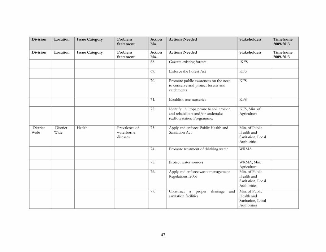
47
Division Location Issue Category ProblemStatement
ActionNo.
Actions Needed Stakeholders Timeframe2009-2013
Division Location Issue Category ProblemStatement
ActionNo.
Actions Needed Stakeholders Timeframe2009-2013
68. Gazette existing forests KFS
69. Enforce the Forest Act KFS
70. Promote public awareness on the needto conserve and protect forests andcatchments
KFS
71. Establish tree nurseries KFS
72. Identify hilltops prone to soil erosionand rehabilitate and/or undertakereafforestation Programme.
KFS, Min. ofAgriculture
DistrictWide
DistrictWide
Health Prevalence ofwaterbornediseases
73. Apply and enforce Public Health andSanitation Act
Min. of PublicHealth andSanitation, LocalAuthorities
74. Promote treatment of drinking water WRMA
75. Protect water sources WRMA, Min.Agriculture
76. Apply and enforce waste managementRegulations, 2006
Min. of PublicHealth andSanitation, LocalAuthorities
77. Construct a proper drainage andsanitation facilities
Min. of PublicHealth andSanitation, LocalAuthorities
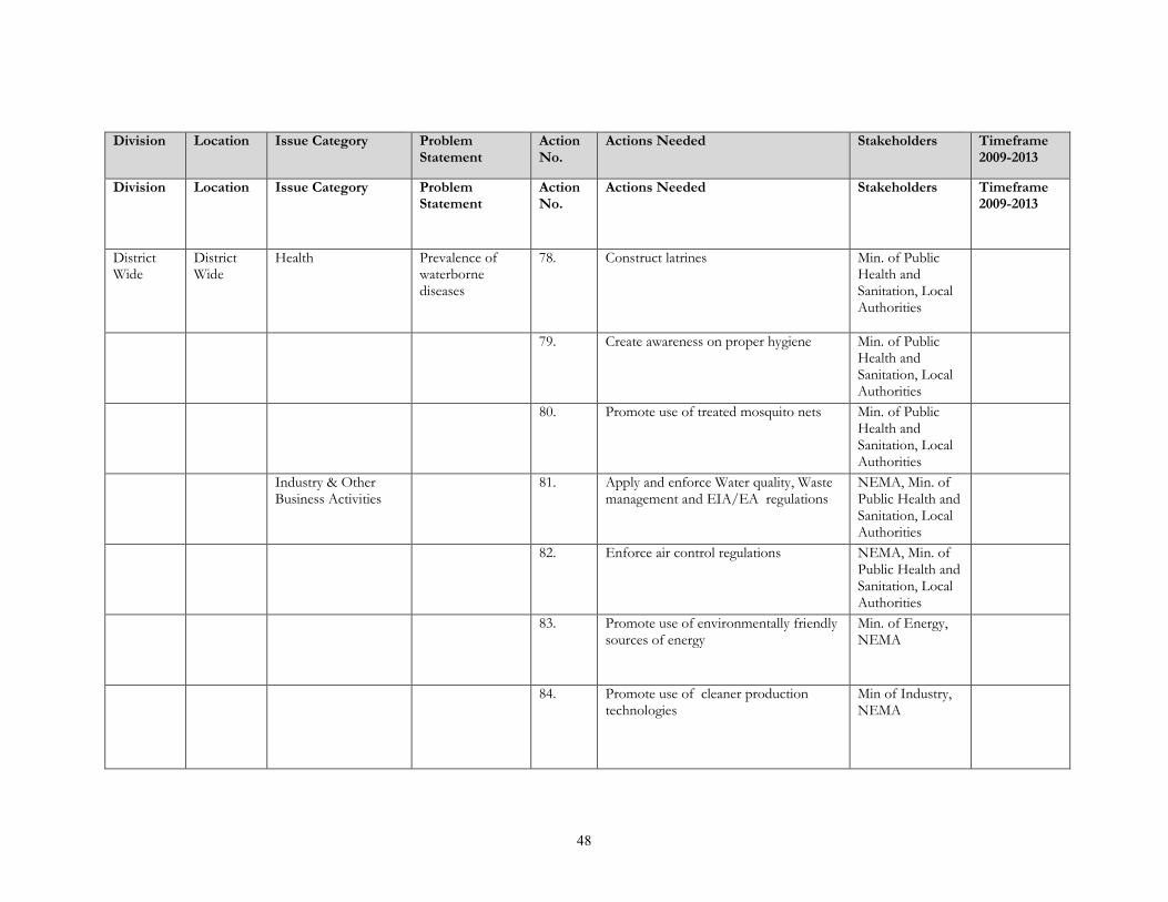
48
Division Location Issue Category ProblemStatement
ActionNo.
Actions Needed Stakeholders Timeframe2009-2013
Division Location Issue Category ProblemStatement
ActionNo.
Actions Needed Stakeholders Timeframe2009-2013
DistrictWide
DistrictWide
Health Prevalence ofwaterbornediseases
78. Construct latrines Min. of PublicHealth andSanitation, LocalAuthorities
79. Create awareness on proper hygiene Min. of PublicHealth andSanitation, LocalAuthorities
80. Promote use of treated mosquito nets Min. of PublicHealth andSanitation, LocalAuthorities
Industry & OtherBusiness Activities
81. Apply and enforce Water quality, Wastemanagement and EIA/EA regulations
NEMA, Min. ofPublic Health andSanitation, LocalAuthorities
82. Enforce air control regulations NEMA, Min. ofPublic Health andSanitation, LocalAuthorities
83. Promote use of environmentally friendlysources of energy
Min. of Energy,NEMA
84. Promote use of cleaner productiontechnologies
Min of Industry,NEMA

49
Division Location Issue Category ProblemStatement
ActionNo.
Actions Needed Stakeholders Timeframe2009-2013
Division Location Issue Category ProblemStatement
ActionNo.
Actions Needed Stakeholders Timeframe2009-2013
85. Promote 3R oriented society- wasteReduction, Reuse and Recycling
Properly manage and Recycle polythenematerials
Local Authorities,Min of Industry
86. Promote use of EFB Min of Industry
DistrictWide
DistrictWide
Livestock & Grazing Low livestockproductivity
87. Control animal diseases Min of Livestock
88. Upgrading of indigenous cattlebreeds/crossbreeding
Min. of Livestock
89. Train farmers on good animal husbandry Min. of Livestock
90. Plant fodder crops/trees Min. of Livestock
91. Construct water points Min. of Livestock
92. Make hay for use during the dry season Min. of Livestock
93. Reduce the stocking rate Min. of Livestock
94. Promote zero grazing Min. of Livestock

50
Division Location Issue Category ProblemStatement
ActionNo.
Actions Needed Stakeholders Timeframe2009-2013
Division Location Issue Category ProblemStatement
ActionNo.
Actions Needed Stakeholders Timeframe2009-2013
DistrictWide
DistrictWide
Mining & Quarrying Unsafe quarryingoperation
95. Promote safe quarrying practices such asbenching/terracing and open castoperations.
Mines andGeology Dept.Local Authorities,DOHSS
96. Establish buffer zones and fence miningareas/pits and erect appropriatewarnings signs/notices
Mines andGeology Dept.Local Authorities
NegativeLandscape effects(Open miningpits)
97. Establish quarry pit rehabilitation and/orafter use plan to ensure restoration ofmined areas
Mines andGeology Dept.Local Authorities
98. Enforce relevant legislation andimplement the recommendations ofTaskforce on Management of quarryingactivities in Kenya
Mines andGeology Dept.Local Authorities,
DistrictWide
DistrictWide
Settlements &Infrastructure
Poor sanitation &Diseases
99. Construct latrines and/or seweragesystem
Local Authorities
100. Apply and enforce Waste Managementand Water Quality regulations
NEMA, Min. ofPublic Health andSanitation, LocalAuthorities
101. Promote community education on goodhygiene and sanitation
Min. of PublicHealth andSanitation, LocalAuthorities

51
Division Location Issue Category ProblemStatement
ActionNo.
Actions Needed Stakeholders Timeframe2009-2013
102. Apply and enforce Public Health andSanitation Act
Min. of PublicHealth andSanitation, LocalAuthorities
Unplannedsettlements
103. Improve existing roads Local Authorities,Min. of Roads
Division Location Issue Category ProblemStatement
ActionNo.
Actions Needed Stakeholders Timeframe2009-2013
104. Promote land use planning Min of lands,local Authorities
105. Prepare urban development plans Min of Lands,local Authorities,NEMA
106. Apply and enforce Physical Planning Actand Council Bylaws
Min. of PublicHealth andSanitation, LocalAuthorities
107. Construction of sewerage system Min. of PublicHealth andSanitation, LocalAuthorities
108. Designate waste disposal sites NEMA, Min. ofPublic Health andSanitation, LocalAuthorities
DistrictWide
DistrictWide
Water Resources Inadequate cleandrinking water
109. Treat drinking water and preventpollution of water sources
Water ServiceProviders, Min. ofPublic HealthWRMA
110. Drill boreholes/shallow wells WRMA

52
Division Location Issue Category ProblemStatement
ActionNo.
Actions Needed Stakeholders Timeframe2009-2013
111. Protect and conserve water sources,Afforestation & Reafforestation of watercatchments including hill tops
WRMA, KFS
112. Promote roof water catchments WRMA
113. Regulate river water abstractions WRMA
Division Location Issue Category ProblemStatement
ActionNo.
Actions Needed Stakeholders Timeframe2009-2013
114. Promote proper waste management Local Authorities,Min of PublicHealth andSanitation
115. Promote safe application ofagrochemicals
Min. ofAgriculture
DistrictWide
DistrictWide
Water Resources Water pollution 116. Undertake appropriate soil conservationmeasures
Min. ofAgriculture
117. Divert run offs far from the boreholes Min. of PublicWorks, WRMA
118. Construct sewage systems Local Authorities,
119. Designate waste disposal sites Local Authorities,Min of PublicHealth andSanitation
120. Protect water sources e.g. Plant trees onthe water catchment areas
WRMA, KFS

53
Division Location Issue Category ProblemStatement
ActionNo.
Actions Needed Stakeholders Timeframe2009-2013
121. Provide piped water WRMA, ServiceProviders
122. Apply and enforce Waste Managementand Water Quality regulations
NEMA, LocalAuthorities,
Division Location Issue Category ProblemStatement
ActionNo.
Actions Needed Stakeholders Timeframe2009-2013
DistrictWide
DistrictWide
Wetlands Degradation ofwetlands
123. Regulate the usage of wetlands resources NEMA, WRMA,Min. Agriculture
124. Educate communities on the importanceof conserving wetlands
NEMA, WRMA,Min. Agriculture
Map and protect wetlands and other fishspawning areas
NEMA,WRMA,Min. Agriculture,Min of Lands,Min of Fisheries
125. Draw management plans for wetlands NEMA,WRMA,Min. Agriculture,Min of Lands
126. Apply and enforce wetlands, RiverBanks, Lake Shores and Sea ShoresManagement Regulations, 2009
NEMA,WRMA,Min. Agriculture,Min of Lands
Wildlife, Biodiversity& Tourism
Human – wildlifeconflict
127. Establish wildlife buffer zones andprotected areas
KWS

54
Division Location Issue Category ProblemStatement
ActionNo.
Actions Needed Stakeholders Timeframe2009-2013
128. Strengthen District CompensationCommittee
KWS
129. Sensitize communities to appreciate theimportance of conserving wildlife
KWS
130. Involve the communities in wildlifemanagement
KWS
Division Location Issue Category ProblemStatement
ActionNo.
Actions Needed Stakeholders Timeframe2009-2013
Loss ofbiodiversity
131. Plant and preserve indigenous trees KFS
132. Control invasive plant species KFS, Min ofAgriculture
133. Protect natural ecosystems KFS, KWS,WRMA
Untapped eco-tourism potential
134. Carry out an inventory ofexisting/potential tourism sites
Min. of Tourism
135. Promote and market existing tourismactivities
Min. of Tourism
136. Use media to promote local tourism Min. of Tourism,Min ofInformation

55
APPENDIX(Extract from EMCA)
PART IV OF THE ENVIRONMENTAL MANAGEMENT AND COORDINATION ACT (1999)– ENVIRONMENTAL PLANNING
(National Environment Action Plan Committee)
1. There is established a committee of the Authority to be known as the National Environmental
Action Plan Committee and which shall consist of:
a) the Permanent Secretary in the Ministry for the time being responsible for national economic
planning and development who shall be the chairman;
b) the Permanent Secretaries in the Ministries responsible for the matters specified in the First
Schedule or their duly nominated representatives;
c) four representatives of the business community to be appointed by the Minister;
d) representatives of each of the institutions specified in the Third Schedule;
e) five representatives of non-governmental organizations nominated by the National Council of
Non-Governmental Organizations;
f) representatives of specialized research institutions that are engaged in environmental matters as
may be determined by the Minister; and
g) A Director of the authority who shall be the secretary.
2. The National Environment Action Plan Committee shall, after every five years, prepare a national
environment action plan for consideration and adoption by the National Assembly.
38. Provisions of the National Environment Action Plan
The national environment action plan shall: -
a) contain an analysis of the natural resources of Kenya with an indication as to any pattern of change
in their distribution and quantity over time;
b) contain an analytical profile of the various uses and value of the natural resources incorporating
considerations of intergenerational equity;

56
c) recommend appropriate legal and fiscal incentives that may be used to encourage the business
community to incorporate environmental requirements into their planning and operational
processes;
d) recommend methods for building national awareness through environmental education on the
importance of sustainable use of the environment and natural resources for national development;
e) set out operational guidelines for the planning and management of the environment and natural
resources;
f) identify actual or likely problems as may affect the natural resources and the broader environment
context in which they exist;
g) identify and appraise trends in the development of urban and rural settlements, their impacts on the
environment, and strategies for the amelioration of their negative impacts;
h) propose guidelines for the integration of standards of environmental protection into development
planning and management;
i) identify and recommend policy and legislative approaches for preventing, controlling or mitigating
specific as well as general adverse impacts on the environment;
j) prioritize areas of environmental research and outline methods of using such research findings;
k) without prejudice to the foregoing, be reviewed and modified from time to time incorporate
emerging knowledge and realities; and
l) Be binding on all persons and all government departments’ agencies, state corporations or other
organs of Government upon adoption by the National assembly.
39. Provincial Environment Action PlansEvery Provincial Environmental Committee shall, every five years, prepare a provincial environment action
plan in respect of the province for which it is appointed, incorporating the elements of the relevant district
environment action plans prepared under section 40 and shall submit such plan to the chairman of the
National Environment Action Plan Committee for incorporation into the national environment action plan.
40. District Environment Action PlansEvery District Environmental Committee shall, every five years, prepare a district environment action plan
in respect of the district for which it is appointed and shall submit such plan to the chairman of the
Provincial Environment Action Plan committee for incorporation into the provincial environment action
plan proposed under section 39

57
41. Contents of Provincial and District Environmental Action Plans.Every provincial environment action plan and every district environment action plan prepared under section
30 and 40 respectively shall contain provisions dealing with matters contained in section 38 (a), (b), (c), (d),
(e), (f), (g), (h), (i), and (j)in relation to their respective province or district.
REFERENCES
GoK: Vision 2030, Government Printer, Nairobi, 2008.
GoK: Medium Term Plan, Government Printer, Nairobi, Kenya. 2008
GoK: The National Development Plan, Government Printer, Nairobi, Kenya. 2002.
Lugari District Strategic Plan 2005-2010 for Implementation of the National Population
Policy for Sustainable Development, National Coordination Agency for Population and Development,
Ministry of Planning and National Development, Nairobi
Lugari District Development Plan 2008-2012 Government Printer, Nairobi