report to planning & zoning commission
TRANSCRIPT
REPORT TO PLANNING & ZONING COMMISSION ———————————————————————————————————————————————————————————————————————————————————————————————————————————————————————————————————————————————————————————————————————-
CITY OF MARYLAND HEIGHTS
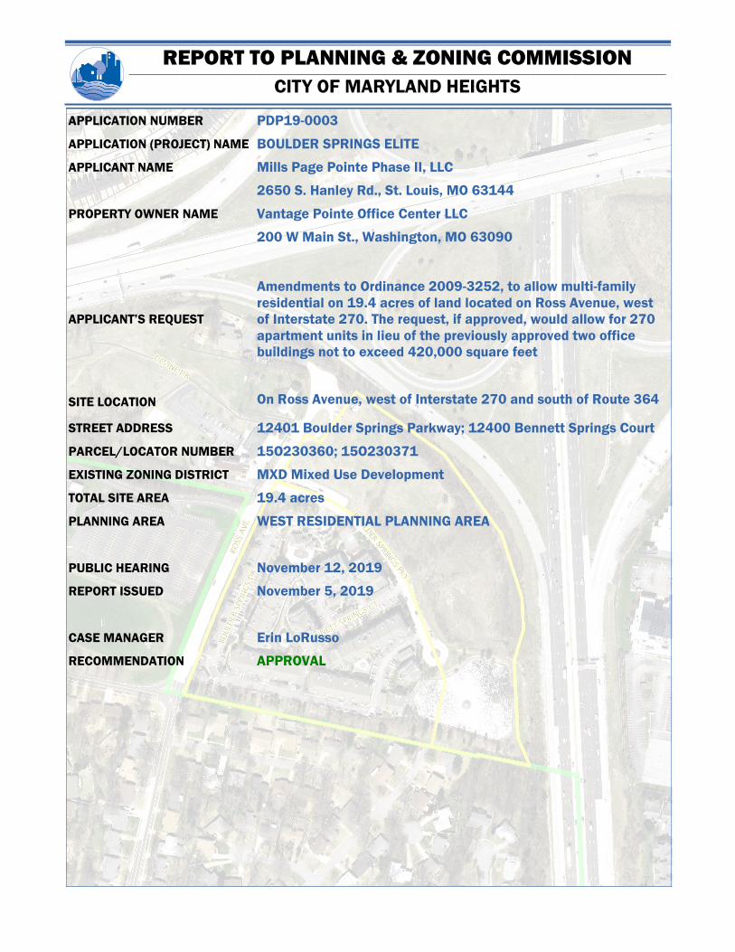
APPLICATION NUMBER PDP19-0003
APPLICATION (PROJECT) NAME BOULDER SPRINGS ELITE
APPLICANT NAME Mills Page Pointe Phase II, LLC
2650 S. Hanley Rd., St. Louis, MO 63144
PROPERTY OWNER NAME Vantage Pointe Office Center LLC
200 W Main St., Washington, MO 63090
APPLICANT’S REQUEST
Amendments to Ordinance 2009-3252, to allow multi-family
residential on 19.4 acres of land located on Ross Avenue, west
of Interstate 270. The request, if approved, would allow for 270
apartment units in lieu of the previously approved two office
buildings not to exceed 420,000 square feet
SITE LOCATION On Ross Avenue, west of Interstate 270 and south of Route 364
STREET ADDRESS 12401 Boulder Springs Parkway; 12400 Bennett Springs Court
PARCEL/LOCATOR NUMBER 15O230360; 15O230371
EXISTING ZONING DISTRICT MXD Mixed Use Development
TOTAL SITE AREA 19.4 acres
PLANNING AREA WEST RESIDENTIAL PLANNING AREA
PUBLIC HEARING November 12, 2019
REPORT ISSUED November 5, 2019
CASE MANAGER Erin LoRusso
RECOMMENDATION APPROVAL

REPORT TO PLANNING & ZONING COMMISSION ———————————————————————————————————————————————————————————————————————————————————————————————————————————————————————————————————————————————————————————————————————-
CITY OF MARYLAND HEIGHTS
PAGE 2 Amendment to Ordinance 2009-3252
November 6, 2019
The site is a 19.4 acre tract located on the east side of Ross Avenue, just west of
Interstate 270. At the most northwestern portion of the site sits a freestanding
monopole wireless communications tower, erected in 2010. Southeast of the
wireless communications tower are 9.01 acres of undeveloped land. The 9.01 acres
have been undeveloped for over 20 years but were previously approved in 1999 for
the development of two office buildings not exceeding 420,000 square feet of gross
floor area. The remaining 10.3 acres are developed with Phase I of Boulder Springs
Apartments.
DESCRIPTION OF EXISTING SITE CONDITIONS
Abutting the site to the north and east is Interstate 270. To the west, across Ross
Avenue, are a child care facility (The Westport School), one single-family residential
home, and a church (St. Mary & St. Abraam Coptic Orthodox Church). South of the
site is St. Louis County Unincorporated single family residential. To the southwest of
the site is Moolah Ballroom, an event venue owned by the Moolah Shriners.
NEIGHBORHOOD CONDITIONS/LAND USE
The subject site is zoned “MXD”, Mixed Use District. To the north, east, and west the
sites are zoned as “R-3”, Single Family Residential. In 2016, in anticipation of a
proposed nursing care facility, the six acres to the west of the properties zoned as
“R-3” were re-zoned to “PD-R” Planned District - Residential. The nursing care
facility has yet to be constructed.
ZONING CONTEXT
REFER TO APPENDIX—SUPPLEMENTAL MAPS AND EXHIBITS
REFER TO FIGURE 1
REFER TO FIGURE 2
REFER TO FIGURE 3
EXISTING CONDITIONS MATRIX
DIRECTION EXISTING LAND USE ZONING DISTRICT COMMENTS
North Rte. 364; I-270 “R-3”
East I-270 “R-3”
South Single Family Homes ST. LOUIS COUNTY
UNINCORPORATED
West Child care; church; and a
single-family home “R-3”; “PD-R”
The Westport School; St. Mary & St. Abraam
Coptic Orthodox Church

REPORT TO PLANNING & ZONING COMMISSION ———————————————————————————————————————————————————————————————————————————————————————————————————————————————————————————————————————————————————————————————————————-
CITY OF MARYLAND HEIGHTS
PAGE 3 Boulder Springs Elite/PDP19-0003
November 6, 2019
BACKGROUND
In April of 1997, the City of Maryland Heights adopted Ordinance 97-1166, amending the official zoning
map of the City of Maryland Heights. The ordinance enacted a “MXD” Mixed Use Development District for
19.4 acres of land located on Ross Avenue, west of interstate 270. The permitted uses under this
ordinance were an office, hotel, and multi-family residential. The ordinance stated that the most western
portion of the site, ‘Area A’ (adjacent to Ross Avenue), would be dedicated to no more than 165 apartment
units. ‘Area B’, the most northern portion of the site, would permit the use of one hotel, with no more than
120 rooms or an office building of not more than 70,000 square feet. ‘Area C’, the southern portion of the
site, would be limited to office uses not exceeding 260,000 square feet and a maximum of two buildings.
Additionally, ‘Area C’ permitted one restaurant as an accessory use. Lastly, two towers for wireless
communication were permitted, with one tower constructed as a ground mounted freestanding unit. See
Exhibit E in the appendix for the original site plan and proposed renderings. Ordinance 97-1166 regulated
the concept plan & site improvement submittal requirements, listed specific development requirements,
verification prior to approval, guarantee of improvements, and listed all limitations associated with the
ordinance. A traffic impact study was conducted, finding that the permitted uses would require the
surrounding road system to be modified to withstand the amount of forecasted traffic associated with the
development.
In February of 1999, Vantage Pointe Associates, L.L.P., requested an amendment to Ordinance 97-1166
to permit additional office space as well as increase the permitted maximum height. Ordinance 97-1166
restricted the apartment building height to 42 feet. The petition was approved, enacting Ordinance 99-
1630, which permitted residential structures to achieve a maximum height of no more than three stories,
or 47 feet. More importantly, Ordinance 99-1630 allowed for the development of two office buildings not
exceeding 420,000 square feet (GFA), or 380,000 square feet of net rentable area excluding the parking
garage area. This is currently the approved use for the undeveloped portion of the site. Ordinance 99-1630
did not mention the use of a hotel or restaurant as previously mentioned in Ordinance 97-1166.
In June 2009, Ordinance 99-1630 was repealed and Ordinance 2009-3252 was enacted. Ordinance 2009-
3252 retained the previously approved office space development but allowed for an increase in the
maximum height of wireless communication towers. Previous ordinances allowed for a maximum wireless
communication tower height of 60 feet. Ordinance 2009-3252 allows for a maximum cell tower height of
120 feet.
In September of 2019, Mills Page Pointe Phase II, LLC, submitted a Preliminary Development Plan to begin
the process of amending the governing ordinance. Bruce Mills, Founder and Chairman of Mills Page Pointe
Phase II, LLC, wishes to amend Ordinance 2009-3252 to allow multi-family residential on the undeveloped
portion of the 19.4 acre tract. More specifically, the applicant wishes to amend the ordinance by allowing
270 units of multi-family residential in lieu of the previously approved two office buildings.
REPORT TO PLANNING & ZONING COMMISSION ———————————————————————————————————————————————————————————————————————————————————————————————————————————————————————————————————————————————————————————————————————-
CITY OF MARYLAND HEIGHTS
PAGE 4 Amendment to Ordinance 2009-3252
November 6, 2019
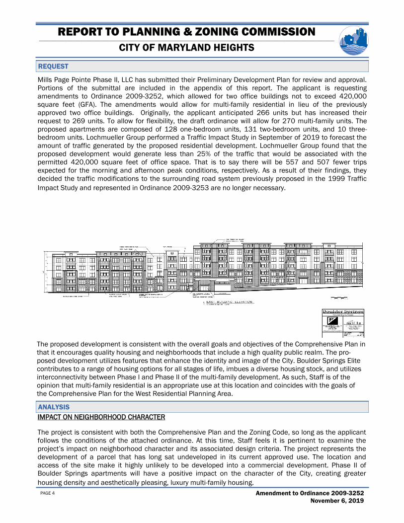
REQUEST
Mills Page Pointe Phase II, LLC has submitted their Preliminary Development Plan for review and approval.
Portions of the submittal are included in the appendix of this report. The applicant is requesting
amendments to Ordinance 2009-3252, which allowed for two office buildings not to exceed 420,000
square feet (GFA). The amendments would allow for multi-family residential in lieu of the previously
approved two office buildings. Originally, the applicant anticipated 266 units but has increased their
request to 269 units. To allow for flexibility, the draft ordinance will allow for 270 multi-family units. The
proposed apartments are composed of 128 one-bedroom units, 131 two-bedroom units, and 10 three-
bedroom units. Lochmueller Group performed a Traffic Impact Study in September of 2019 to forecast the
amount of traffic generated by the proposed residential development. Lochmueller Group found that the
proposed development would generate less than 25% of the traffic that would be associated with the
permitted 420,000 square feet of office space. That is to say there will be 557 and 507 fewer trips
expected for the morning and afternoon peak conditions, respectively. As a result of their findings, they
decided the traffic modifications to the surrounding road system previously proposed in the 1999 Traffic
Impact Study and represented in Ordinance 2009-3253 are no longer necessary.
ANALYSIS
IMPACT ON NEIGHBORHOOD CHARACTER
The project is consistent with both the Comprehensive Plan and the Zoning Code, so long as the applicant
follows the conditions of the attached ordinance. At this time, Staff feels it is pertinent to examine the
project’s impact on neighborhood character and its associated design criteria. The project represents the
development of a parcel that has long sat undeveloped in its current approved use. The location and
access of the site make it highly unlikely to be developed into a commercial development. Phase II of
Boulder Springs apartments will have a positive impact on the character of the City, creating greater
housing density and aesthetically pleasing, luxury multi-family housing.
The proposed development is consistent with the overall goals and objectives of the Comprehensive Plan in
that it encourages quality housing and neighborhoods that include a high quality public realm. The pro-
posed development utilizes features that enhance the identity and image of the City. Boulder Springs Elite
contributes to a range of housing options for all stages of life, imbues a diverse housing stock, and utilizes
interconnectivity between Phase I and Phase II of the multi-family development. As such, Staff is of the
opinion that multi-family residential is an appropriate use at this location and coincides with the goals of
the Comprehensive Plan for the West Residential Planning Area.

REPORT TO PLANNING & ZONING COMMISSION ———————————————————————————————————————————————————————————————————————————————————————————————————————————————————————————————————————————————————————————————————————-
CITY OF MARYLAND HEIGHTS
PAGE 5 Boulder Springs Elite/PDP19-0003
November 6, 2019
Multi-family developments typically involve less traffic, activity, and noise than commercial developments
and therefore have less of an adverse impact on the adjoining residential uses along Ross Avenue and Fee
Fee Road. Staff feels that multi-family residential is an appropriate use for the property, especially
considering the previously approved use for the Property (two Class A Office buildings) and the established
multi-family residential use of the remainder of the 19.4 acre site.
DESIGN CRITERIA
Staff has prepared a draft ordinance for the Planning Commission’s consideration. The ordinance would
regulate the previous and proposed phases of the Boulder Springs development. This section explains the
ordinance’s approach to critical planning issues.
Permitted and Accessory Uses
The draft ordinance permits 270 units of multi-family residential. The project will have many amenities
for the benefit of its residents. Therefore, the draft ordinance attempts to clarify that these amenities
are allowed as accessory uses, such as a fitness center, pool, and a dog park.
Building Design
Article 13, Building Design Standards, of the Zoning Code contains design requirements for new
development. After reviewing the renderings provided by the applicant, the proposed design is
consistent with these standards. The draft ordinance requires that the building be designed in a
manner generally consistent with the exhibits contained in the appendix of this report. Substantial
deviations require the review and approval of the Planning Commission.
Access and Parking
The proposed means of access to the new development are three separate entry drives along Boulder
Springs Parkway. One of the three entry drives would serve a proposed parking structure. According to
the Traffic Impact Study prepared by Lochmueller Group, the drive serving the parking structure will
carry the majority of the proposed development’s traffic. The study performed by Lochmueller Group
determined that Ross Road, Fee Fee Road, and nearby intersections would continue to operate at
acceptable levels of service and that the project would be less intense from a traffic standpoint than
the previously approved 420,000 GFA of Class A office space. This study was included in the City
Planner’s memo to the Planning Commission dated October 16, 2019. Furthermore, the study found
that the proposed residential development would not dictate the need for signalization of the
intersection of Fee Fee Road at Ross Road, the widening of Bennington Place for a second southbound
left turn lane nor the widening of Fee Fee Road to provide one westbound and two eastbound lanes
between Benning Place and Ross Road, as previously required by Ordinance 97-1166. The draft
ordinance regulates all access to the District.
The draft ordinance requires parking to be provided in accordance with Article 14, Parking and Loading
Regulations, of the Zoning Code. The code requires 1.5 parking spaces per one-bedroom unit and 1
additional parking space per additional bedroom. The code requires a total of 473 parking spaces. The
plan provides a total of 486 parking spaces between surface parking, garages connected to the
detached building on the south side of the site, and the multi-level parking garage.
The Preliminary Development Plan submitted by the applicant shows the removal of a cul-de-sac at the
ANALYSIS (CONT.)

REPORT TO PLANNING & ZONING COMMISSION ———————————————————————————————————————————————————————————————————————————————————————————————————————————————————————————————————————————————————————————————————————-
CITY OF MARYLAND HEIGHTS
PAGE 6 Amendment to Ordinance 2009-3252
November 6, 2019
terminus of Boulder Springs Parkway, to allow for a stand-alone building in the southern portion of the
site. The removal of said cul-de-sac is subject to the approval of Creve Coeur Fire District to ensure that
adequate circulation can still be achieved.
Landscaping and Screening
Article 16, Landscaping Design Standards, of the Zoning Code requires a quantity of landscaping based
on the total square footage of the site. At this time, the proposed landscaping plan does not satisfy the
requirements of the code. Per the code, the applicant is required a total of 785 landscaping points. The
landscaping plan shows the planting of 165 trees, 338 shrubs and ornamental grasses, and a variety of
173 perennials, annuals, and flowers. Even with said plantings, the applicant is well below the 785
point requirement. However, Staff is of the opinion the proposed landscaping plan is of quality and
provides a sustainable, ecologically balanced environment for the development and surrounding
properties. Furthermore, once a tree survey and tree preservation plans are provided, it is expected the
applicant will be within reach of their 785 point requirement. While the landscaping will likely be refined
further as the project moves through the approval process, the draft ordinance requires all landscaping
to be designed in a manner generally consistent with the exhibits contained in the appendix of this
report. Substantial deviations from the exhibits included in this report are to be reviewed and approved
by the Planning Commission.
As the development of the site is to be completed in two phases, walkability and connectivity are of
concern to Staff. The draft ordinance establishes connectivity between Phase I and Phase II of the
development, as well as accessibility to public sidewalks, by ensuring pedestrian walkways be
developed in a manner to encourage their use.
Lighting and Signs
The applicant’s Preliminary Development Plan doesn’t address lighting or signs. Exterior lighting is
controlled by Article 18, Lighting Design Standards, of the Zoning Code. The regulations contained in
this code section will ensure that the site is adequately lit while avoiding adverse impacts. Signs are
governed by Article 15, Sign Regulations, of the Zoning Code. These regulations allow a monument sign
as well as a sign attached to the building. The applicant may apply for a comprehensive sign package
for the review and approval of the Planning Commission prior to the issuance of sign permits, if they
wish to use a more creative approach with their signage.
Stormwater and Sanitary Sewers
The applicant’s Preliminary Development Plan doesn’t address stormwater or sanitary sewers. MSD
provided review and comment on the proposed development. Comments included the requirement of
flood protection volume as the site is in a release rate watershed, as well as the requirement of channel
protection storage volume. Most notable, the existing sanitary system downstream of the development
appears to have limited capacity to serve a high density development. The developer will be required to
provide a hydraulic model of the sanitary system from manhole 15O4-124S to the 24-inch sewer at
manhole 16O1-177S. MSD feels strongly that offsite sewer upgrades will likely be required. The draft
ordinance requires all sanitary sewer facilities and stormwater provisions be made in accordance with
the specifications and standards of MSD and the City of Maryland Heights.

REPORT TO PLANNING & ZONING COMMISSION ———————————————————————————————————————————————————————————————————————————————————————————————————————————————————————————————————————————————————————————————————————-
CITY OF MARYLAND HEIGHTS
PAGE 7 Boulder Springs Elite/PDP19-0003
November 6, 2019
IMPACT ON NEIGHBORHOOD CHARACTER
1. The City Planner finds that the proposed development is consistent with the vision of the West
Residential Planning Area as well as the goals and objectives of the Comprehensive Plan.
IMPACT ON NEIGHBORHOOD CHARACTER
2. The City Planner finds that the proposed development, subject to the limitations set forth in the draft
ordinance, will not result in a substantial adverse impact on neighborhood character.
SITE DESIGN
3. The City Planner finds that the overall approach to site design is consistent with the intent and purpose
of the Zoning Code.
BUILDING DESIGN
4. The City Planner finds that the proposed building design is consistent with the Building Design
Standards of the Zoning Code.
RECOMMENDATION
The City Planner recommends that PDP19-0003 be approved via adoption of the attached draft ordinance.
The draft ordinance repeals Ordinance 2009-3252 and enacts a new ordinance in lieu thereof.
____________________________________
Erin LoRusso
Planner/Case Manager
FINDINGS AND RECOMMENDATION

REPORT TO PLANNING & ZONING COMMISSION ———————————————————————————————————————————————————————————————————————————————————————————————————————————————————————————————————————————————————————————————————————-
CITY OF MARYLAND HEIGHTS
APPENDIX
SUPPLEMENTAL MAPS AND EXHIBITS

REPORT TO PLANNING & ZONING COMMISSION ———————————————————————————————————————————————————————————————————————————————————————————————————————————————————————————————————————————————————————————————————————-
CITY OF MARYLAND HEIGHTS
PAGE 9 Boulder Springs Elite/PDP19-0003
November 6, 2019
FIGURE 1: AERIAL PHOTOGRAPH

REPORT TO PLANNING & ZONING COMMISSION ———————————————————————————————————————————————————————————————————————————————————————————————————————————————————————————————————————————————————————————————————————-
CITY OF MARYLAND HEIGHTS
PAGE 10 Amendment to Ordinance 2009-3252
November 6, 2019
FIGURE 2: EXISTING LAND USE PATTERN

REPORT TO PLANNING & ZONING COMMISSION ———————————————————————————————————————————————————————————————————————————————————————————————————————————————————————————————————————————————————————————————————————-
CITY OF MARYLAND HEIGHTS
PAGE 11 Boulder Springs Elite/PDP19-0003
November 6, 2019
FIGURE 3: ZONING MAP
MXD
PD-R
R-3
M-1
R-6
PD-R
STL COUNTY UNINCORPORATED
REPORT TO PLANNING & ZONING COMMISSION ———————————————————————————————————————————————————————————————————————————————————————————————————————————————————————————————————————————————————————————————————————-
CITY OF MARYLAND HEIGHTS
PAGE 12 Amendment to Ordinance 2009-3252
November 6, 2019
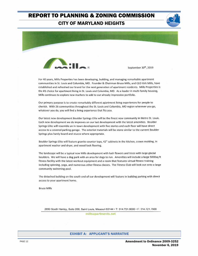
EXHIBIT A: APPLICANT’S NARRATIVE
REPORT TO PLANNING & ZONING COMMISSION ———————————————————————————————————————————————————————————————————————————————————————————————————————————————————————————————————————————————————————————————————————-
CITY OF MARYLAND HEIGHTS
PAGE 13 Boulder Springs Elite/PDP19-0003
November 6, 2019
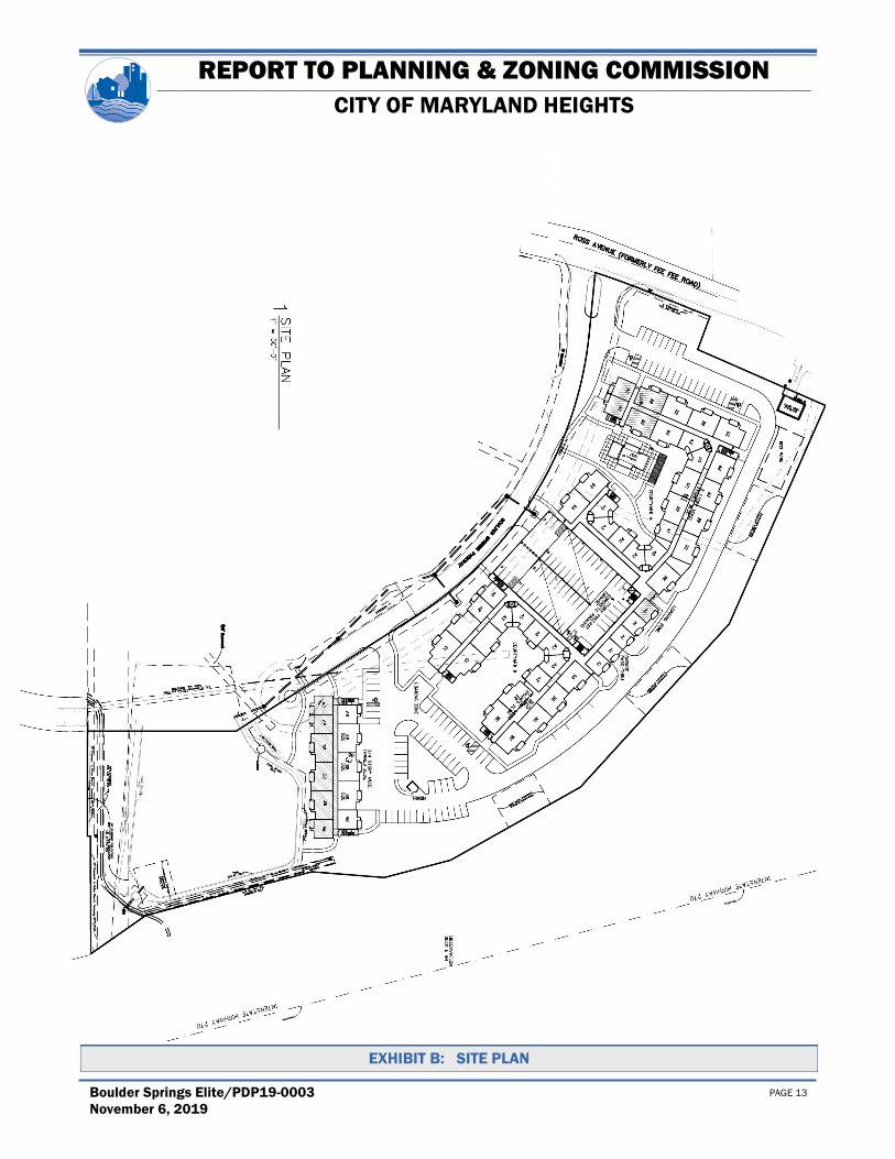
EXHIBIT B: SITE PLAN

REPORT TO PLANNING & ZONING COMMISSION ———————————————————————————————————————————————————————————————————————————————————————————————————————————————————————————————————————————————————————————————————————-
CITY OF MARYLAND HEIGHTS
PAGE 14 Amendment to Ordinance 2009-3252
November 6, 2019
EXHIBIT C: EAST BUILDING ELEVATION

REPORT TO PLANNING & ZONING COMMISSION ———————————————————————————————————————————————————————————————————————————————————————————————————————————————————————————————————————————————————————————————————————-
CITY OF MARYLAND HEIGHTS
PAGE 15 Boulder Springs Elite/PDP19-0003
November 6, 2019
EXHIBIT D: UNIT PLANS

REPORT TO PLANNING & ZONING COMMISSION ———————————————————————————————————————————————————————————————————————————————————————————————————————————————————————————————————————————————————————————————————————-
CITY OF MARYLAND HEIGHTS
PAGE 16 Amendment to Ordinance 2009-3252
November 6, 2019
EXHIBIT D: UNIT PLANS (CONT.)

REPORT TO PLANNING & ZONING COMMISSION ———————————————————————————————————————————————————————————————————————————————————————————————————————————————————————————————————————————————————————————————————————-
CITY OF MARYLAND HEIGHTS
PAGE 17 Boulder Springs Elite/PDP19-0003
November 6, 2019
EXHIBIT E: LANDSCAPING PLAN

REPORT TO PLANNING & ZONING COMMISSION ———————————————————————————————————————————————————————————————————————————————————————————————————————————————————————————————————————————————————————————————————————-
CITY OF MARYLAND HEIGHTS
PAGE 18 Amendment to Ordinance 2009-3252
November 6, 2019
EXHIBIT E: LANDSCAPING PLAN (CONT.)

REPORT TO PLANNING & ZONING COMMISSION ———————————————————————————————————————————————————————————————————————————————————————————————————————————————————————————————————————————————————————————————————————-
CITY OF MARYLAND HEIGHTS
PAGE 19 Boulder Springs Elite/PDP19-0003
November 6, 2019
EXHIBIT F: SITE PLAN OF PREVIOUSLY APPROVED OFFICE BUILDINGS (ORD. 97-1166)

REPORT TO PLANNING & ZONING COMMISSION ———————————————————————————————————————————————————————————————————————————————————————————————————————————————————————————————————————————————————————————————————————-
CITY OF MARYLAND HEIGHTS
PAGE 20 Amendment to Ordinance 2009-3252
November 6, 2019
EXHIBIT G: RENDERINGS OF PREVIOUSLY APPROVED OFFICE BUILDINGS (ORD. 99-1630)

Recommendation of Planning Commission
BILL NO. 4540 ORDINANCE NO. 2019- 4477
AN ORDINANCE REPEALING ORDINANCE 2009- 3252 AND ENACTING A NEW PLANNEDDISTRICT ORDINANCE IN LIEU THEREOF TO ALLOW MULTI-FAMILY RESIDENTIAL
DWELLINGS ON 19. 4 ACRES OF LAND LOCATED ON ROSS AVENUE WEST OF INTERSTATE 270Petition of Mills Page Pointe Phase II, LLC)
WHEREAS, a Public Hearing was held before the Planning Commission regarding the proposedamendment; and
WHEREAS, the Planning Commission has found that the Preliminary Development Plan of the proposedamendment is consistent with the Comprehensive Plan; and
WHEREAS, the Planning Commission has found the proposed regulations contained in this Ordinance areconsistent with the purposes of the Zoning Code; and
WHEREAS, the Planning Coinmission has recorrunended approval of the regulations contained in thisOrdinance; and
WHEREAS, the City Council has reviewed the recommendation of the Commission and has deternlinedthat the proposed ardinance is in the best interest of the City.
NOW THEREFORE, BE IT ORDAINED BY THE CITY COUNCIL OF THE CITY OF MARYLAND
HEIGHTS, MISSOURI, AS FOLLOWS:
Section 1: Ordinance 2009- 3252 is hereby repealed.
Section 2: The zoning of real estate in the City of Maryland Heights for approximately 19. 4 acres of land locatedon Ross Road west of Interstate 270, as more specifically described in Exhibit A, attached hereto, is zoned° MXD"Mixed Used District on the condition that said development is carried out in accordance with this Ordinance. Thiszoning shall be recorded on the Official Zoning Map of the City.
Section 3: Purpose
The purpose of this Planned District is to regulate the Boulder Springs development which features high qualitymulti- family dwellings including associated amenities. This ordinance is intended to provide flexibility in thedevelopment of the property while encouraging the use of design features to improve the overall character of thearea.
Section 4: This zoning is subject to all applicable City ordinances, and the conditions that follow:
I. PERMITTED AND ACCESSORY USES
A. Multi-Family Residential( Land Use Code# 1540) subject to the following limitations:
1. A maximum of 4 6 units ( 166 units in Phase I aud 270 units in Phase II) shall be permitted.
B. The following uses shall be authorized as accessory uses to the principal use of the property asmulti- family residential ( for the benefit of this development' s residents, rather than the generalpublic):
City of Maryland HeightsOrdinance No. 2019- 4477
Page 1 of 6

1. Convenience Stores( LUC# 445120).
2. Motion Picture and Video Exhibition( LUC# 51213).
3. Real Estate Property Managers ( LUC# 53131).4. Private Mail Centers( LUC# 561431).
5. Privately- Owned Parks ( LUC# 712191).6. Fitness and Recreational Sports Centers ( LUC# 713940).
7. Snack and Nonalcoholic Beverage Bars ( LUC# 722515).
8. Other related accessory uses, subject to the review and approval of the City Planner.
C. One freestanding monopole wireless communications tower not to exceed 120' above grade andassociated equipment shelter/screen wall.
II. PLAN SUBMITTAL REQUIREMENTS
A. Final Development Plan
1. Within ninety ( 90) days of approval of this Planned District and prior to the issuance of abuilding permit, the Final Development Plan shall be submitted to the City Planner for reviewand approvaL Where due cause is shown by the applicant, the time interval may be extendedby the City Planner.
2. The Final Development Plan shall meet the requirements of Section 25- 6. 10, Final
Development Plan, and Section 25- 16. 5, Landscape Plan Requirements, of the Zoning Code.
3. Recordin- Within fifteen( 15) days from the approval of the Final Development Plan, and
prior to the issuance of any building permit, the property owner shall record a copy of theapproved Final Development Plan, and any subsequent amendments thereto, with the St.Louis County Recorder of Deeds. Upon written request, this time period may be extended bythe City Planner. An electronic copy of the recorded plan shall also be provided to theDeparhnent of Coinmunity Development.
B. Site Improvement Plans
1. Prior to issuance of a building or grading permit, Site Improvement Plans shall be submittedfor the review and approval of the City Planner and City Engineer prior to, or concurrent with,the Building Permit application submittaL
2. Prior to approval of the Site Improvement Plans, verification of necessary approvals from theMetropolitan St. Louis Sewer District ( MSD), Missouri Department of Transportation
MoDOT), St. Louis County Department of Transportation, and Creve Coeur Fire ProtectionDistrict shall be received by the City Planner and City Engineer.
III. SPECIFIC DEVELOPMENT REQUIREMENTS
A. BuildingHei ht- The building shall be a maximum of five( 5) stories in height above grade.
B. Structure Setbacks - No structures, except dumpster enclosures, fences, walls, light standards,
signage or other structures as otherwise approved on the Final Development Plan shall be located
within the following setbacks:
1. Sixty- five( 65) feet of the Ross Road right- of-way.
2. Ninety( 90) feet of the south property line.
City of Maryland HeightsOrdinance No. 2019- 4477
Page 2 of 6

3. Thirty( 30) feet of all other external property lines.
4. Twenty( 20) feet of the internal primary access street.
5. All carports shall be a minimum of twenty( 20) feet from any property line.
6. Wireless communications towers and associated equipment shall be setback from property lines i
as shown on the Preliminary Development Plan prepared by Selective Site Consultants, dated9/ 10/ 2008 ( revised 11/ 03/ 2008). Revisions to properiy lines resulting from, but not limited toroadway improvements and boundary adjustments shall not affect the legal placement of saidstructures relative to boundary lines existing at the time of ordinance approvaL
C. Parking Setbacks- No parking or internal access drive excluding points of ingress and egress, shallbe located within the following setbacks:
1. Fifteen( 15) feet of the Ross Road right-of-way.
2. Fifty( 50) feet of the south property line.
3. Thirty( 30) feet of all other exterior property lines.
4. Fifteen( 15) feet of any internal roadway.
D. Access and Roadwa Improvements
1. Access to this District shall be limited to one( 1) primary bi- directional drive, one( 1) servicedrive, and one ( 1) secondary emergency access drive on Ross Road as directed by the CityEngineer.
2. Access to the wireless communications tower facilities compound shall be limited to one( 1)private driveway which traverses MODOT right-of-way to Ross Road. Provision of a fully-executed access easement or similar instrument shall be required prior to the issuance ofbuilding permits.
3. All mud, dust, dirt, and debris shall be contained on site and kept off streets, curbs, sidewall< s,
ar any other areas within right- of-way. Any instances where this does not occur shall berectified immediately.
4. The Developer shall be held liable for unusual wear and tear or damage to the streets, curbs,
sidewalks, or any other areas within right- of-way resulting from such usage. Use of the right-of-way by the Developer or those under their direction shall constitute an agreement on theirpart to pay the reasonable cost of restoring the areas in question to their original condition.
5. Construction entrances shall be constructed in accardance with City of Maryland Heightsstandards. A washdown area may also be required at the sole direction of the City of MarylandHeights.
E. Building Desi n — Building design shall be in accordance with Article 13, Building Desi nStandards, of the Zoning Code. Additionally:
1. The buildings in Phase II shall be designed in a manner generally consistent with the exhibitsincluded in the City Planner' s Report to the Planning Commission for Application PDP19-0003 dated October 17, 2019. Substantial deviations shall be subject to the review and
approval of the Planning Commission.
City of Maryland HeightsOrdinance No. 2019- 4477
Page 3 of 6

2. The freestanding monopole wireless communications tower be maintained with a neutralcolor, be unlit, unmarked, and not be equipped with flags or any attention- getting device.
3. All antennae shall be enclosed within the monopole wireless communications tower.
F. Parking& Loadin- Off-street parking and loading spaces shall be provided in accordance withArticle 14, Parkin and Loading Retulations, except as follows: I
1. Phase one of Boulder Springs Apartments shall allow for 1. 5 parking spaces per residentialunit.
G. Signs- Signs shall be in accordance with Article I5, Si n Regulations, of the Zoning Code.
H. Landscaping— Landscaping shall be provided in accordance with Article 16, Landscapin DesignStandards, of the Zoning Code except as follows:
1. Landscaping shall be designed in a matter generally consistent with the exhibits included inthe City Planner' s Report to the Planning Commission for Application PDP19- 0003 datedOctober 17, 2019. Substantial deviations shall be subject to the review and approval of the
Planning Commission.
2. Walkway System— The Planned District shall have pedestrian trails or walkways connectingthe buildings and open spaces to public sidewalks, designed in such a inanner to encouragetheir use.
I. Environmental Standards- Every use, activity, process or operation on the site shall comply withArticle 17, Environmental Standards, of the Zoning Code.
J. Exterior Li_ g — Exterior lighting shall be in accardance with Article 18, Li htinQ Desi nStandards, of the Zoning Code.
K. Screening
1. Any new permanent electrical, telephone, data transmission and distribution lines shall beinstalled underground within the Plaimed District.
2. Dumpsters, recycling areas, mechanical equipment, emergency generators, above ground
utility boxes or meters, and similar functional elements shall be screened in accordance withthe provisions of Section 25- 25. 4, Screening of Outdoor Storaee, Mechanical Equipment,and Above Ground Utilities, of the Zoning Code.
L. Stormwater
1. Adequate provisions shall be made for the disposal of stormwater, in accordance with the
specifications and standards of MSD and the City of Maryland Heights.
2. A 5WPPP( Stormwater Pollution Prevention Plan) approved by the CiTy of Maryland Heightsis required prior to commencing work.
3. No grading shall be completed on any property which will adversely affect neighboringproperties by discharging, directing, or obstructing water flow in such a way that it causesdamage to any neighboring properties. All stormwater shall be discharged at an adequate naturaldischarge point.
City of Maryland HeightsOrdinance No. 2019- 4477
Page 4 of 6
4. The parking garage shall be properly connected to the sewer system in accordance with MSDRules and Re ulations. Stormwater shall not enter the sanitar s stem through the parkingg Y Y
garage drainage systems.
5. Flood protection volume shall be required for this site. The site is in a release rate watershed.
i
The release rates shall be in effect for this project.
6. Channel protection storage volume shall be required.
M. Sanitarv Sewers
1. Sanitary sewer facilities shall be provided in accordance with the requirements of MSD.
2. The Developer shall provide a hydraulic model of the sanitary system from manhole 1504-124S to the 24- inch sewer at manhole 1601- 1775. Offsite sewer upgrades are expected to berequired.
3. MSD prohibits new encroachments into public sewer easements.
4. BMP' s shall not be located in easement areas. Public sewers shall be prohibited in BMP reserveareas. All areas disturbed since 2006 shall be included.
IV. MAINTENANCE
A. The building and site shall be maintained in accordance with the Property Maintenance Code.
I 1 ndsca ed areas shall be maintained in accardance with landsca in delineated on the FinalB. The a P gP
Development Plan. Plant inaterials shall be replaced or replanted as determined by annual inspection
of the site by the City Planner or his assigns.
V. PLANNED DISTRICT LIMITATIONS
Limitations regarding failure to commence construction, abandonment, and extension of developmentschedule shall be in accordance with the provisions of Section 25- 6. 14, Limitations, of the Zoning Code.
VI. RIGHTS OF APPEAL
In the event of a disagreement between any Developer and the City Planner and/ or the City Engineer as toin this ordinance and/ or the Zonin Code such disa reement shall bethe criteria or conditions set forth g , g
submitted to the Plannin Commission for recommendation to the City Council, which shall make theg
decision on such disagreement, provided the Developer shall have the right to appeal such decision
pursuant to the City of Maryland Heights Zoning Code and to pursue any other available legal or equitableremedy.
City of Maryland HeightsOrdinance No. 2019- 4477 i
Page 5 of 6 I
Section 5: This Ordinance shall be in full force and effect from and after its passage and approval.
PASSED BY THE CITY COUNCIL THIS Sth DAY OF DECEMSER 2019.
it/1 L' r c-
MI bR/ PRESIDING OFFIECR
APPROVED BY THE MAYOR THIS DAY OF DECEMBER 2019.
wt G,l-`-MAYOR
ATTEST:
ILPN
yFCI Y LERK P i'„
c! yO
p
O °•- F
cqC` SEP-``
City of Maryland HeightsOrdinance No. 2019- 4477
Page 6 of 6