report on the activities of the hydrographic and … cuba... · report on the activities of the...
TRANSCRIPT
Report on the activities of the
Hydrographic and Geodetic Service
of the Republic of Cuba
National Hydrography and Geodetic Office2011
Organización Hidrográfica Internacional Comisión Hidrográfica Mesoamericana y del
Mar Caribe

I. INTRODUCTION:
As part of the accomplishment of actions derived from
previous meetings of the Mesoamerican and Caribbean
Hydrographic Commission (MACHC), a request was sent
out to all the member States related to the need for: a)
“…Continue to pursue the completion, in the
shortest time, the questionnaire of Publication S-55,
with the purpose of knowing the actual needs of the
Region, through the analysis of the information
therein contained and make it available to the
International Hydrographic Bureau…...” and b)
“.…prepare the national presentations taking into
account the questions from Publication S-55, thus
making possible the updating of the information
…..”. Taking this work directive as a proposal, the SHGC
has prepared this presentation for this MACHC meeting.

II. BASIC DATA:
The Republic of Cuba is a State member of the
International Hydrographic Organization since 1952, it
owns an Exclusive Economic Zone of 362 900 Km2
and a coastline of 2500 km determined according to
the regulations of the United Nations Convention on
the Law of the Sea of 1982 (UNCLOS III), which in our
particular case was calculated through the longitude of
a straight baselines system, from which the width of
the officially recognized territorial sea is measured.

III. HYDROGRAPHIC RESOURCES.
In Cuba the hydrographic resources are concentrated
in The Cuban Hydrographic and Geodetic Service,
which has 37 vessels involved in hydrographic,
oceanographic and navigational aids activities. 86% of
this fleet have length of 25 meters and the remaining
14% have lengths between 25 and 100 meters. The
specialist human resources in hydrography have been
trained in national institutions, but in order to improve
and update their skills they have been attended several
courses provided and funding by the IHO, Trieste
Maritime International Academy, The Brazilian
Hydrography Service and the UKHO.
III. HYDROGRAPHIC RESOURCES.
At present, the staff from the SHGC dedicated to hydrographic activities
consists of 30 experts with University degrees, 60 assistants for whom a
curricular design was created that will allow them to become hydrographic
experts of a higher level in the mediate and long future, through their
participation in different courses in a national institution created for this
purpose. We have more than 20 masters in related fields.
The hydrographic research in the whole national territory is carried out
through the use of DGPS, using clasic receptors for navigation, surveying
and using OEM cards integrated to the PC´s during the national surveying
campaigns.
During the year, new hydrographic surveys were executed in 20 areas that
cover important ports and waterways of the national territory, as well as
thehydrographic compilation for the new edition of 6 nautical charts.
IV. HYDROGRAPHIC RESOURCES.
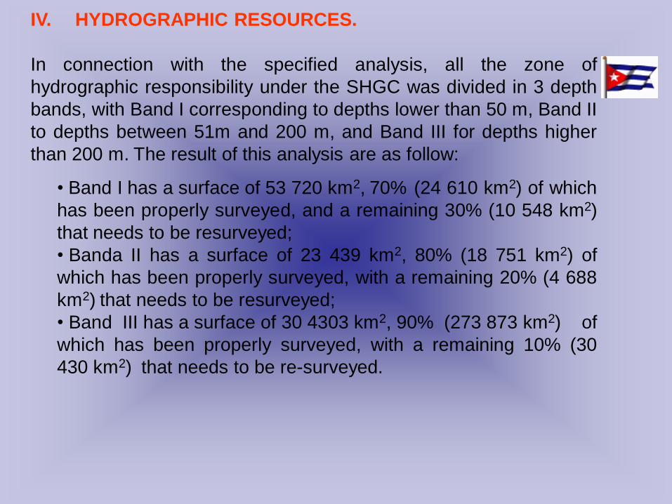
In connection with the specified analysis, all the zone of
hydrographic responsibility under the SHGC was divided in 3 depth
bands, with Band I corresponding to depths lower than 50 m, Band II
to depths between 51m and 200 m, and Band III for depths higher
than 200 m. The result of this analysis are as follow:
• Band I has a surface of 53 720 km2, 70% (24 610 km2) of which
has been properly surveyed, and a remaining 30% (10 548 km2)
that needs to be resurveyed;
• Banda II has a surface of 23 439 km2, 80% (18 751 km2) of
which has been properly surveyed, with a remaining 20% (4 688
km2) that needs to be resurveyed;
• Band III has a surface of 30 4303 km2, 90% (273 873 km2) of
which has been properly surveyed, with a remaining 10% (30
430 km2) that needs to be re-surveyed.

V. CARTOGRAPHIC RESOURCES, NAUTICAL CHARTS AND
PUBLICATIONS.
In relation to cartographic activities, the SHGC has experimented a reduction of
its human resources, a situation that has been solved with the integration of
new technologies, in compliance with a transfer processed that started 2 years
ago with the use of products and services from CARIS, which included new
cartographic production schemas which get updated with the acquisition of
new modules for surveying, processing and managing of the data under one
single line of production to the cartographic creation. Under this current
technology we have completed 20 nautical charts in paper format.
With regards to ENC´s we have been facing problems due to the lack of
updated modules from Seven Cs, which were acquired by the country in 1996
and have not been updated. Several errors have been detected when
validations are conducted using more modern tools. This has caused delays in
their publication. Currently, using CARIS tools, we have completed 2 ENC cells.
In addition, we have established a new estrategy to be able to make available to
the international community, before the end of 2013, our charts for the bands 1,
2, 3 and in bands 4 and 5 those corresponding to ports access and most
important waterways of the country.

V. CARTOGRAPHIC RESOURCES, NAUTICAL CHARTS AND
PUBLICATIONS. Cont.
The official nautical charts catalogue is comprised by 144
titles, of which 13% (5 Titles) are represented at scales lower
than 1: 300 000, 19% (27 Titles) are represented at scales
between 1: 300 000 and 1:100 000, 59% (85 Titles) are
represented at scales between 1: 100 000 and 1: 25 000; and
19% (28 Titles) are represented at scales larger than
1: 25 000.
Besides that, we have more than 10 official nautical
publications which are updated periodically with data
obtained from the hydrographic information workflows, from
survey to edition and compilation; as well as with the use of
Notices to Mariners, published monthly.

VI. CONCLUSIONS.
To conclude with the analysis of the accomplishments of the SHGC of
the parameters established in the Special Publication of the IHO S-55,
we can establish the following:
1. The zone of hydrographic responsibility of Cuba is of 362 900
km2 and it does not contain non-surveyed areas.
2. 83 % of the zone of hydrographic responsibility, equivalent to
300 528 km2, has been properly surveyed in compliance with the
current requirements for the different depths bands established
by the IHO; 17% of the total area needs to be resurveyed
according to the new requirements. The zones requiring new
surveys are mostly grouped in areas of new constructions and
hydrotechnical facilities.
3. The Hydrographic and Cartographic Capacity Indicator of the
Republic of Cuba es de 4.85, lo cual evidencia el grado de desarrollo
de la actividad en la Región.
VII. RECOMMENDATIONS
SHGC recognizes the importance of using national
reports with the questionnaire from Publication
S-55 of the IHO, due to the fact that it constitutes a
guide and tool to assess the true needs of our
hydrographic services and establish more efficient
projections to achieve higher safety of navigation in
the areas of hydrographic responsibility for each of
the States of our Region.

ANEXO No. 1
DATOS BÁSICOS
No. Columna Datos Actualización
1 Nación / Área Marítima. Cuba Cuba
2 Código ISO de la Nación / Área
Marítima.
CU CU
3 ID. Región NC NC
4 Nación o Área Marítima N N
5 ZEE (km2 x 1000) 362.9 362.9
6 Longitud de línea de costa 0 2500 km
8 Última Actualización Septiembre 2007 Noviembre 2011
9 Membresía de la OHI S S
Organización Hidrográfica Internacional Comisión Hidrográfica Mesoamericana y del
Mar Caribe
Organización Hidrográfica Internacional Comisión Hidrográfica Mesoamericana y del
Mar Caribe
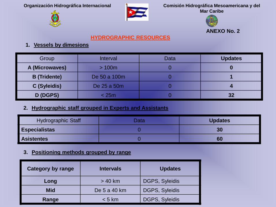
ANEXO No. 2
HYDROGRAPHIC RESOURCES
1. Vessels by dimesions
Group Interval Data Updates
A (Microwaves) > 100m 0 0
B (Tridente) De 50 a 100m 0 1
C (Syleidis) De 25 a 50m 0 4
D (DGPS) < 25m 0 32
2. Hydrographic staff grouped in Experts and Assistants
Hydrographic Staff Data Updates
Especialistas 0 30
Asistentes 0 60
3. Positioning methods grouped by range
Category by range Intervals Updates
Long > 40 km DGPS, Syleidis
Mid De 5 a 40 km DGPS, Syleidis
Range < 5 km DGPS, Syleidis

Organización Hidrográfica Internacional Comisión Hidrográfica Mesoamericana y del
Mar Caribe
ANEXO No. 3
HYDROGRAPHIC SURVEYS
The following table represents the coverage of the depths bands 1) < 50m; 2) 50 – 200m and 3) > 200m
Depths
bands. (Z)Intervals Area (km2) Description Data Updates
1 Z < 50m 53 720
% Properly surveyed0 70
% requires to be re-surveyed0 30
% Never been surveyed 0 0
250m <
200m23 439
% Properly surveyed0 80
% requires to be re-surveyed0 20
% Never been surveyed 0 0
3 Z > 200m 285 741
% Properly surveyed0 90
% requires to be re-surveyed0 10
% Never been surveyed 0 0

Organización Hidrográfica Internacional Comisión Hidrográfica Mesoamericana y del
Mar Caribe
ANEXO No. 4
HYDROGRAPHIC RESOURCES
No.National
CharacteristicsDescription Data Updates
1 Cartographic staff Cartographers 0 7
Editors 0 11
Printing 0 0
2 Printing method for
the Nautical charts
Black and white 0 No
In color 0 Yes
Others 0Print on demand
3 Conversion to AO
Format
Yes/NoYes
4 Maximum
Dimensions
mm x mm1189 x 841

Organización Hidrográfica Internacional Comisión Hidrográfica Mesoamericana y del
Mar Caribe
ANEXO No. 5
NAUTICAL CHARTS
Producing Nation: Yes: __X__ No: _____
Printing Nation: Sí: __X__ No: _____
No.Scale
(E)Description Data Updates
1. E < 300 kPlanned 0 5
Published 0 5
2. 300 k < E < 100 kPlanned 0 27
Published 0 27
3. 100 k< E < 25 kPlanned 0 85
Published 0 85
4. E> 25 kPlanned 0 28
Published 0 28
5. OtrasPlanned 0 10
Published 0 0

Organización Hidrográfica Internacional Comisión Hidrográfica Mesoamericana y del
Mar Caribe
ANEXO No. 6
NAUTICAL PUBLICATIONS
No. Publication Update
1. Nautical Charts S
2. Nautical Charts Catalogue S
3. Notices to Mariners S
4. Radio Warnings S
5. Routes S
6. Maritime Signals Book S
7. Symbol Manual S
8. Tide Tables S
9. Cuban Nautical Calendar S
10. Others S

Organización Hidrográfica Internacional Comisión Hidrográfica Mesoamericana y del
Mar Caribe
ANEXO No. 7
SUMMARY OF THE CALCULATION OF THE HYDROGRAPHIC AND CARTOGRAPHIC CAPACITY
1. Indicator of the capacity per hydrographic vessel
(150 V1) + (75 V2) + (37.5 V3) + (12.5 V4) = VEMB …………………………….. (1)
(0) + (75) + (150) + (400) =VEMB =625
Where:
V1 Group A vessels with size > 100m
V2 Group B vessels with size from 50 to 100m
V3 Group C vessels with size from 25 to 50m
V4 Group D vessels with size < 25m
VEMB Indicator of capacity for each hydrographic vessel

Organización Hidrográfica Internacional Comisión Hidrográfica Mesoamericana y del
Mar Caribe
ANEXO No. 7
SUMMARY OF THE CALCULATION OF THE HYDROGRAPHIC AND CARTOGRAPHIC CAPACITY
2. Indicator of the hydrographic capacity.
(1 HN) + (1 EN) + (0.01 A1) = CHID …………………………….. (2)
(1) + (1) + (0.7) CHID 2.7
Where:
HN 1, if national hydrographers
0, if non-national hydrographers
EN 1, if national hydrographic vessels
0, if non-national hydrographic vessels
A1 % Properly surveyed for depths shallower than 50m (Z 50m).
CHID Indicator of the hydrographic capacity

Organización Hidrográfica Internacional Comisión Hidrográfica Mesoamericana y del
Mar Caribe
ANEXO No. 7
SUMMARY OF THE CALCULATION OF THE HYDROGRAPHIC AND CARTOGRAPHIC CAPACITY
3. Indicator of the hydrographic capacity.
(1 CN) + (1 IN) + (0.01 P1) = CCAR …………………………….. (3)
(1) + (1) + (0.7) CCAR 2.15
Where:
CN
1, if national cartographers
0, if non-national cartographers
P1 Total of official nautical publications
IN 1, if national capacity for printing
0, if incapable of national printing
CCAR Indicator of cartographic capacity

Organización Hidrográfica Internacional Comisión Hidrográfica Mesoamericana y del
Mar Caribe
ANEXO No. 7
SUMMARY OF THE CALCULATION OF THE HYDROGRAPHIC AND CARTOGRAPHIC CAPACITY
4. Indicator of combined hydro-cartographic capacity.
CHID + CCAR KHID-CAR …………………………….. (4)
2.7 + 2.15 KHID-CAR 4.85
Where:
CHID Indicator of the hydrographic capacity
CCAR Indicator of the cartographic capacity
CHID-CAR Indicator of the hydro-cartographic capacity
No. Indicators Data Updates
1 Vessel capacity 0 625
2 Hydrographic capacity 0 2.7
3 Cartographic capacity 0 2.15
NATIONAL HYDROGRAPHIC AND
CARTOGRAPHIC CAPACITY 0 4.85

OFICINA NACIONAL DE HIDROGRAFÍA Y GEODESIA
2011
Organización Hidrográfica Internacional Comisión Hidrográfica Mesoamericana y del
Mar Caribe
Report on the activities of the
Hydrographic and Geodetic Service
of the Republic of Cuba