report on selection of 30 cities/towns for ring roads and
TRANSCRIPT

Ring Road Development in Madhya Pradesh
Page
RING ROAD DEVELOPMENT IN
MADHYA PRADESH
Report
Atal Bihari Vajpayee Institute of Good Governance
and Policy Analysis

Ring Road Development in Madhya Pradesh
Page
November 2020
Identification of towns in Madhya Pradesh
for Ring Road Development & Probable
Financial planning for Implementation of
the project
Project Report
ATAL BIHARI VAJPAYEE INSTITUTE OF GOOD
GOVERNANCE AND POLICY ANALYSIS

Ring Road Development in Madhya Pradesh
Page
Submitted by:
Centre for Urban Governance, AIGGPA
Guidance:
Mr. Girish Sharma, IAS
Principal Advisor, Centre for Urban Governance
Project Coordinator:
Mrs. Jalaja Saji
Advisor, Centre for Urban Governance
Project Team:
Mrs. Priyanka Pawar, Consultant, Centre for Urban Governance
Mr. Parag Somwanshi, KPMG India
Ms. Samridhi Chaurasia, Research Associate, Centre for Urban Governance

Ring Road Development in Madhya Pradesh
Page i
Executive Summary
The towns in Madhya Pradesh are urbanizing rapidly which presents both opportunities as well as challenges for
the policy makers as well as the society. One of the challenges associated with growing urbanization is the heavy
traffic congestion. One of the measures to decongest the traffic load could be development of ring roads. It can
decongest the cities from heavy traffic load for which it is advisable to plan for bypass/ring road development well
in advance to reduce future repercussions.
Looking into the advantages of developing the ring road, Government of Madhya Pradesh decided to consider few
Ring Roads projects in the select towns of Madhya Pradesh. In order to identify such towns a quick study to shortlist
the towns was taken up by Atal Bihari Vajpayee Institute of Good Governance and Policy Analysis (AIGGPA),
Bhopal. The focus was to shortlist the towns based on identified parameters and to suggest probable financial
models to implement the project. The study was conducted mainly through secondary research and stakeholder
consultations in a short span of three months.
As per census 2011, there are 427 towns in Madhya Pradesh out of which, 378 are Urban Local Bodies. Owing to
the large number of ULBs, few assumptions were made to reduce the number of towns for further analysis of Ring
Roads. The two assumptions made in this study were:
1. Towns with Development Plans: The first assumption made in this study was to consider only such
towns of Madhya Pradesh whose Development Plan is already prepared by Department of Town and
Country Planning. As on March 2020, there were 96 towns in Madhya Pradesh whose Development Plans
were prepared.
2. Towns with more than 1 Lakh Population: The second assumption made in this study was to analyze
only those towns, which have more than 1 Lakh population (based on projected population for 2019).
There are 36 towns in Madhya Pradesh, which have more than 1 Lakh population as per projected
population for 2019. Out of 36 towns, development plan and landuse map was not available for
Ashoknagar, Dhar, Shahdol and Gwalior SADA area, so they were excluded in Ring Road analysis.
After shortlisting 36 towns, seven parameters were identified which were assigned points on the scale of 0-5 based
on various sub categories. The identified parameters were simultaneously assigned weightages on the scale of
10. The parameters were judiciously assigned weightages to select towns where Ring Road could be developed
with ‘Least Level of Difficulties’ as in large cities land availability is limited and cost of acquisition is also higher
which will result in higher project development cost. Hence it was purposely eliminated from the list. . The table
below shows list of identified parameters along with assigned weightage.
Table 1: Table showing list of identified parameters along with their weightages
S.No. Parameter Weightage (on the scale of 10)
1 Population 0.5
2 Population Growth Rate between 2011-2019 2.0
3 Proximity to National Highway 2.0
4 Average Annual Vehicle Registration 0.5
5 Economic status of the town – Number of medium and large scale industries 1.0
6 Length of Ring Road/Bypass yet to be developed 2.5
7 Percentage of Ring Road/Bypass left to be constructed out of total proposed length 1.5
Total 10.0
Post assigning points and weightages, a town wise matrix was developed, which ranked the towns in the order of
priority of developing Ring Road according to their total weighted score. Towns with higher weighted score were
recommended to be considered for Ring Road development. Based on data analysed from the development plans
and information collected from Regional Office of NHAI and MPPWD, few towns were eliminated in the study since
these towns have either initiated the construction activities or is in pipeline of MPPWD. Few towns were eliminated
as they have been selected under Bharatmala scheme for development of Ring Road/Bypass.

Ring Road Development in Madhya Pradesh
Page ii
Table 2: Table showing list of eliminated towns in the study
S.No Town Study Recommendation Remark
1 Sehore Town eliminated from study Sehore has already developed 17 Km bypass as per DP and there is no separate proposal for Ring Road
2 Gwalior Town eliminated from study Gwalior has already developed 79 Km circular bypass as per DP
3 Betul Town eliminated from study Betul has already developed 13 Km bypass as per DP and there is no separate proposal for Ring Road
4 Katni Town eliminated from study Katni has already developed 17.8 Km bypass as per DP and there is no separate proposal for Ring Road
5 Satna Town eliminated from study Satna has already developed 30 Km circular bypass as per DP
6 Indore
Town eliminated from study Indore is selected under Bharatmala scheme for development of Ring Road
7 Shivpuri Town eliminated from study Shivpuri is selected under Bharatmala scheme for development of Ring Road
8 Sagar Town eliminated from study Sagar is selected under Bharatmala scheme for development of Bypass
9 Vidisha Town eliminated from study Vidisha is selected under Bharatmala scheme for development of Bypass
After eliminating above nine towns, the study recommends following towns should be considered for development
of Ring Road.
Table 3: Table showing list of towns with higher weighted score
S.No. Name of the Town Weighted Score
1 Rewa 40
2 Guna 36
3 Ratlam 35
4 Singrauli 32
5 Damoh 30
6 Mandsaur 30
Table 4: Table showing weighted score of all the towns analysed for ring road development in the study
S.No. Town Total Weighted
Score
Study Recommendation Remarks
1 Dewas 42 Town not considered NHAI has already awarded work for construction of another bypass which is just parallel to the missing part of proposed Ring Road
2 Jabalpur 41 Town not considered Bids for preparation of DPR & Feasibility Report for Jabalpur Ring Road of about 112 Km. length has been invited at NHAI-HQ, New Delhi.
3 Rewa 40 Town may be considered No proposal by NHAI/PWD
4 Guna 36 Town may be considered No proposal by NHAI/PWD
5 Itarsi 36 Town not considered No Ring Road is proposed for Itarsi. However, combined bypass for Itarsi & Hoshangabad is under construction, which is 33.5 Km length.
6 Ratlam 35 Town may be considered No proposal by NHAI/PWD
7 Hoshangabad 33 Town not considered A combined bypass for Itarsi & Hoshangabad is under construction, which is 33.5 Km in length.
8 Singrauli 32 Town may be considered Singrauli is under consideration by PWD for development of Ring Road/Bypass
9 Bhopal 31 Town not considered Case dropped due to anticipated high cost of land acquisition
10 Morena 30 Town not considered Bypass sanctioned under NHAI (DPR already submitted by consultant on 20.08.2018)
11 Damoh 30 Town may be considered Half of the Ring Road is already constructed in the form of Bypass, remaining half could be developed. Damoh is under consideration by PWD for development of remaining RR

Ring Road Development in Madhya Pradesh
Page iii
12 Mandsaur 30 Town may be considered No proposal by NHAI/PWD
13 Datia 29 Town may be considered No proposal by NHAI/PWD
14 Chhatarpur 29 Town not considered NHAI is already constructing 3 bypasses, which will make a ring road for Chhatarpur town.
15 Chhindwara 27 Town may be considered No proposal by NHAI/PWD
16 Bhind 23 Town not considered Bypass sanctioned under NHAI (DPR already submitted by consultant on 20.08.2018).
17 Neemuch 23 Town may be considered No proposal by NHAI/PWD
18 Seoni 22 Town may be considered No proposal by NHAI/PWD
19 Ujjain 20 Town may be considered No proposal by NHAI/PWD
20 Nagda 19 Town may be considered No proposal by NHAI/PWD
21 Khargone 16 Low weighted score, town not considered
No proposal by NHAI/PWD
22 Burhanpur 14 Low weighted score, town not considered
No proposal by NHAI/PWD
23 Khandwa 11 Low weighted score, town
not considered
No proposal by NHAI/PWD
Land Assembly Models and Funding Options of Ring Road Development Land assembly and development mechanism are undertaken for achieving the optimum social use of Land and to ensure adequate availability of land to public authority and individuals. Public private participation is achieved in land development through various techniques. Some of the land assembly techniques also promote flexibility in land utilization in response to changes resulting from the growing city. The various mechanisms to assemble land are enlisted below:
Traditional Land Acquisition Methods (Not covered here) Land Readjustment Transfer of Development Rights Guided Land Development (GLD)
Availability of land is the first step towards creating a robust network of ring road. The other crucial factor is the finance. The state and its municipalities need funds to finance the acquisition of the available land. Raising finance for any sort of urban infrastructure (ring road development or others) has been a challenge for several municipal bodies that are plagued by weak finances and their operational structure. Several municipal bodies do not have adequate resources to acquire the land for infrastructure development proposals laid down under the Master Plans/Development. The 2017 Economic Survey of India reveals that Indian cities tap only 5-20 per cent of the property tax potential. Fiscal effort and discipline on the part of urban local bodies are badly needed. At the current stage of India’s urban evolution, an all-out effort is needed to enable ULBs and other urban infrastructure authorities to mobilize resources, enhance fiscal discipline, generate seed money to leverage debt funds and improve credit-rating. Apart from the fiscal discipline, it is imperative to look at innovative instruments such as:
Tax Incentives Soft Loan from Multilateral and Bilateral Sustainable Infrastructure Development Fund Land Swap Model Air Rights Development Road Re-alignment Model Swiss Challenge Method
The above innovative models would assist the state and its municipalities for meeting the costs of land assembly, which will assist in smooth and speedy ring road development.
It is highly recommended as a way forward to conduct detailed Techno – Economic Feasibility Study of
the identified towns and develop detailed project report to further decide on the implementing strategy.
The identified towns may not be feasible for construction due to challenges like land availability, terrain of
the land, approvals, financial costing etc. Therefore, the way forward would be to conduct other relevant
study like feasibility study, land availability study, financial costing etc. before reaching to execution stage.

Ring Road Development in Madhya Pradesh
Page iv
CONTENTS
CHAPTER 1. PROJECT BACKGROUND ....................................................................................... 1
1.1. INTRODUCTION ............................................................................................................................. 1
1.2. OBJECTIVE OF THE STUDY ........................................................................................................ 1
1.3. APPROACH AND METHODOLOGY .......................................................................................... 2
1.4. STAKEHOLDER CONSULTATIONS .......................................................................................... 3
CHAPTER 2. PARAMETERS & WEIGHTAGES .......................................................................... 5
2.1. TOWNS IN MADHYA PRADESH ................................................................................................ 5
2.2. STUDY ASSUMPTIONS ................................................................................................................. 5
2.3. STUDY LIMITATIONS ................................................................................................................... 6
2.4. PARAMETERS & WEIGHTAGE .................................................................................................. 7
2.4.1. POPULATION OF THE TOWN ................................................................................................... 7
2.4.2. POPULATION GROWTH RATE REGISTERED BY THE TOWN ..................................... 7
2.4.3. PROXIMITY TO NATIONAL HIGHWAY ................................................................................. 8
2.4.4. AVERAGE ANNUAL VEHICLE REGISTRATIONS ............................................................... 9
2.4.5. ECONOMIC STATUS OF THE TOWN - NUMBER OF MEDIUM AND LARGE SCALE INDUSTRIES .................................................................................................................................... 9
2.4.6. LENGTH OF RING ROAD/BYPASS YET TO BE DEVELOPED ........................................ 9
2.4.7. PERCENTAGE OF RING ROAD/BYPASS ROAD YET TO BE CONSTRUCTED OUT OF TOTAL PROPOSED ............................................................................................................... 10
2.5. RANKING MATRIX ...................................................................................................................... 10
CHAPTER 3. TOWNWISE ANALYSIS OF WEIGHTED SCORE ............................................ 14
CHAPTER 4. FINANCIAL PLANNING ........................................................................................ 44
4.1. INTRODUCTION .......................................................................................................................... 44
4.2. CURRENT SCENARIO ................................................................................................................ 44
4.3. FUTURE OUTLOOK .................................................................................................................... 45
4.4. LAND ASSEMBLY AND FUNDING TECHNIQUES: AN OVERVIEW ........................... 45
4.5. INNOVATIVE LAND ASSEMBLY TECHNIQUES ............................................................... 46
4.5.1. LAND READJUSTMENT ............................................................................................................. 47
4.5.2. TRANSFER OF DEVELOPMENT RIGHTS ............................................................................ 50
4.5.3. GUIDED LAND DEVELOPMENT (GLD) ............................................................................... 54

Ring Road Development in Madhya Pradesh
Page v
4.6. LAND FUNDING TECHNIQUES .............................................................................................. 57
4.6.1. LAND SWAP MODEL .................................................................................................................. 58
4.6.2. ROAD RE-ALIGNMENT METHOD (RRM) ........................................................................... 58
4.6.3. SOFT LOAN FROM BILATERAL/ MULTILATERAL AGENCIES.................................. 59
4.6.4. AIR RIGHTS DEVELOPMENT .................................................................................................. 60
4.6.5. TAX INCENTIVE FINANCING (TIF) ...................................................................................... 62
4.6.6. SWISS CHALLENGE METHOD (SCM) .................................................................................. 63
4.6.7. SUSTAINABLE INFRASTRUCTURE DEVELOPMENT FUND (SIDF) ........................ 64
4.7. CONCLUSION ................................................................................................................................ 66
CHAPTER 5. WAYFORWARD ..................................................................................................... 67

Ring Road Development in Madhya Pradesh
Page vi
LIST OF TABLES
TABLE 1: TABLE SHOWING LIST OF IDENTIFIED PARAMETERS ALONG WITH THEIR WEIGHTAGES ......................... i
TABLE 2: TABLE SHOWING LIST OF ELIMINATED TOWNS IN THE STUDY ......................................................................ii
TABLE 3: TABLE SHOWING LIST OF TOWNS WITH HIGHER WEIGHTED SCORE ...........................................................ii
TABLE 4: TABLE SHOWING WEIGHTED SCORE OF ALL THE TOWNS ANALYSED FOR RING ROAD DEVELOPMENT IN THE STUDY .........................................................................................................................................................................ii
TABLE 5: TABLE SHOWING PROJECT PHASES AND SCOPE OF WORK ......................................................................... 1
TABLE 6: TABLE SHOWING PROJECTS STAGES AND APPROACH ADOPTED ............................................................... 2
TABLE 7: TABLE SHOWING SUMMARY OF STAKEHOLDER CONSULTATION CONDUCTED FOR THE PROJECT ...... 3
TABLE 8: TABLE SHOWING CLASSIFICATION OF TOWNS BASED ON PROJECTED POPULATION FOR 2019 ........... 5
TABLE 9: TABLE SHOWING LIST OF TOWNS WITH MORE THAN 1 LAKH POPULATION ............................................... 5
TABLE 10: TABLE SHOWING LIST OF IDENTIFIED PARAMETERS FOR RANKING OF TOWNS ..................................... 7
TABLE 11: TABLE SHOWING POINTS ASSIGNED TO VARIOUS POPULATION CATEGORIES ....................................... 7
TABLE 12: TABLE SHOWING POINTS ASSIGNED TO VARIOUS GROWTH RATE CATEGORIES ................................... 8
TABLE 13: TABLE SHOWING POINTS ASSIGNED FOR NATIONAL HIGHWAY AVAILABILITY ........................................ 8
TABLE 14: TABLE SHOWING POINTS FOR VARIOUS CATEGORIES OF AVERAGE VEHICLE REGISTRATIONS ......... 9
TABLE 15: TABLE SHOWING POINTS FOR PRESENCE OF MEDIUM AND LARGE-SCALE INDUSTRIES ...................... 9
TABLE 16: TABLE SHOWING POINTS ASSIGNED FOR VARIOUS CATEGORIES OF LENGTH OF RING ROAD/BYPASS YET TO BE DEVELOPED .......................................................................................................................... 10
TABLE 17: TABLE SHOWING POINTS ASSIGNED FOR VARIOUS PERCENTAGE OF RING ROAD/BYPASS YET TO BE CONSTRUCTED .............................................................................................................................................................. 10
TABLE 18: TABLE SHOWING LIST OF TOWNS NOT CONSIDERED IN THE STUDY ...................................................... 10
TABLE 19: TABLE SHOWING TOWN WISE WEIGHTED SCORE AS PER IDENTIFIED PARAMETERS ......................... 12

Ring Road Development in Madhya Pradesh
Page vii
LIST OF FIGURES
FIGURE 1: FIGURE SHOWING METHODOLOGY ADOPTED FOR IDENTIFICATION OF RING ROAD ............................. 2
FIGURE 2: MAP SHOWING TOWNS WITH MORE THAN 1 LAKH POPULATION IN MADHYA PRADESH ........................ 6
FIGURE 3: MAP SHOWING TOWNS WHICH DO NOT HAVE NATIONAL HIGHWAY CONNECTIVITY ............................. 8
FIGURE 4: PROPOSED LANDUSE OF DEWAS AS PER DEWAS DEVELOPMENT PLAN 2031 ...................................... 14
FIGURE 5: SATELLITE IMAGE OF DEWAS SHOWING STATUS OF RING ROAD/BYPASS ROAD ................................. 14
FIGURE 6: PROPOSED LANDUSE OF JABALPUR AS PER JABALPUR DEVELOPMENT PLAN 2031 ........................... 15
FIGURE 7: SATELLITE IMAGE OF JABALPUR SHOWING STATUS OF RING ROAD/BYPASS ROAD ........................... 15
FIGURE 8: PROPOSED LANDUSE OF REWA AS PER DEVELOPMENT PLAN 2031 ...................................................... 16
FIGURE 9: SATELLITE IMAGE OF REWA SHOWING STATUS OF RING ROAD/BYPASS ROAD ................................... 16
FIGURE 10: PROPOSED LANDUSE OF ITARSI AS PER ITARSI DEVELOPMENT PLAN 2031 ....................................... 17
FIGURE 11: SATELLITE IMAGE OF ITARSI SHOWING STATUS OF RING ROAD/BYPASS ROAD ................................ 17
FIGURE 12: PROPOSED LANDUSE FOR GUNA AS PER GUNA DEVELOPMENT PLAN 2031 ....................................... 18
FIGURE 13: SATELLITE IMAGE OF GUNA SHOWING STATUS OF RING ROAD/BYPASS ROAD ................................. 18
FIGURE 14: PROPOSED LANDUSE OF RATLAM AS PER RATLAM DEVELOPMENT PLAN 2031 ................................. 19
FIGURE 15: SATELLITE IMAGE OF RATLAM SHOWING STATUS OF RING ROAD/BYPASS ROAD ............................. 19
FIGURE 16: : PROPOSED LANDUSE OF SAGAR AS PER SAGAR DEVELOPMENT PLAN 2031 ................................... 20
FIGURE 17: SATELLITE IMAGE OF SAGAR SHOWING STATUS OF RING ROAD/BYPASS ROAD ............................... 20
FIGURE 18: PROPOSED LANDUSE OF HOSHANGABAD AS PER HOSHANGABAD DEVELOPMENT PLAN 2031 ...... 21
FIGURE 19: SATELLITE IMAGE OF HOSHANGABAD SHOWING STATUS OF RING ROAD/BYPASS ROAD ................ 21
FIGURE 20: PROPOSED LANDUSE OF SINGRAULI AS PER SINGRAULI DEVELOPMENT PLAN 2031 ....................... 22
FIGURE 21: SATELLITE IMAGE OF SINGRAULI SHOWING STATUS OF RING ROAD/BYPASS ROAD ........................ 22
FIGURE 22: PROPOSED LANDUSE OF BHOPAL AS PER BHOPAL DEVELOPMENT PLAN 2031 ................................. 23
FIGURE 23: SATELLITE IMAGE OF BHOPAL SHOWING STATUS OF RING ROAD/BYPASS ROAD ............................. 23
FIGURE 24: PROPOSED LANDUSE OF MORENA AS PER MORENA DEVELOPMENT PLAN 2031 ............................... 24
FIGURE 25: SATELLITE IMAGE OF MORENA SHOWING STATUS OF RING ROAD/BYPASS ROAD ........................... 24
FIGURE 26: PROPOSED LANDUSE OF DAMOH AS PER DAMOH DEVELOPMENT PLAN 2031 ................................... 25
FIGURE 27: SATELLITE IMAGE OF DAMOH SHOWING STATUS OF RING ROAD/BYPASS ROAD .............................. 25
FIGURE 28: PROPOSED LANDUSE OF MANDSAUR AS PER MANDSAUR DEVELOPMENT PLAN 2031 ..................... 26
FIGURE 29: SATELLITE IMAGE OF MANDSAUR SHOWING STATUS OF RING ROAD/BYPASS ROAD ...................... 26
FIGURE 30: PROPOSED LANDUSE OF DATIA AS PER DATIA DEVELOPMENT PLAN 2031 ......................................... 27
FIGURE 31: SATELLITE IMAGE OF DATIA SHOWING STATUS OF RING ROAD/BYPASS ROAD ................................. 27
FIGURE 32: PROPOSED LANDUSE OF CHHATARPUR AS PER CHHATARPUR DEVELOPMENT PLAN 2031 ............ 28
FIGURE 33: SATELLITE IMAGE OF CHHATARPUR SHOWING STATUS OF RING ROAD/BYPASS ROAD .................. 28
FIGURE 34: PROPOSED LANDUSE OF CHHINDWARA AS PER CHHINDWARA DEVELOPMENT PLAN 2031 ............. 29
FIGURE 35: SATELLITE IMAGE OF CHHINDWARA SHOWING STATUS OF RING ROAD/BYPASS ROAD ................. 29
FIGURE 36: PROPOSED LANDUSE OF VIDISHA AS PER VIDISHA DEVELOPMENT PLAN 2031 ............................... 30
FIGURE 37: SATELLITE IMAGE OF VIDISHA SHOWING STATUS OF RING ROAD/BYPASS ROAD ............................. 30
FIGURE 38: PROPOSED LANDUSE OF BHIND AS PER BHIND DEVELOPMENT PLAN 2031 ........................................ 31
FIGURE 39: SATELLITE IMAGE OF BHIND SHOWING STATUS OF RING ROAD/BYPASS ROAD ................................ 31
FIGURE 40: PROPOSED LANDUSE OF NEEMUCH AS PER NEEMUCH DEVELOPMENT PLAN 2031 .......................... 32

Ring Road Development in Madhya Pradesh
Page viii
FIGURE 41: SATELLITE IMAGE OF NEEMUCH SHOWING STATUS OF RING ROAD/BYPASS ROAD .......................... 32
FIGURE 42: PROPOSED LANDUSE OF SEONI AS PER SEONI DEVELOPMENT PLAN 2031 ........................................ 33
FIGURE 43: SATELLITE IMAGE OF SEONI SHOWING STATUS OF RING ROAD/BYPASS ROAD ................................. 33
FIGURE 44: PROPOSED LANDUSE OF UJJAIN AS PER UJJAIN DEVELOPMENT PLAN 2031 ...................................... 34
FIGURE 45: : SATELLITE IMAGE OF UJJAIN SHOWING STATUS OF RING ROAD/BYPASS ROAD .............................. 34
FIGURE 46: PROPOSED LANDUSE OF NAGDA AS PER NAGDA DEVELOPMENT PLAN 2031 ..................................... 35
FIGURE 47: SATELLITE IMAGE OF NAGDA SHOWING STATUS OF RING ROAD/BYPASS ROAD ............................... 35
FIGURE 48: PROPOSED LANDUSE OF KHARGONE AS PER KHARGONE DEVELOPMENT PLAN 2031 ..................... 36
FIGURE 49: SATELLITE IMAGE OF KHARGONE SHOWING STATUS OF RING ROAD/BYPASS ROAD ....................... 36
FIGURE 50: PROPOSED LANDUSE OF BURHANPUR AS PER BURHANPUR DEVELOPMENT PLAN 2031 ................. 37
FIGURE 51: SATELLITE IMAGE OF BURHANPUR SHOWING STATUS OF RING ROAD/BYPASS ROAD ..................... 37
FIGURE 52: PROPOSED LANDUSE OF KHANDWA AS PER KHANDWA DEVELOPMENT PLAN 2031 ......................... 38
FIGURE 53: SATELLITE IMAGE OF KHANDWA SHOWING STATUS OF RING ROAD/BYPASS ROAD ......................... 38
FIGURE 54: PROPOSED LANDUSE OF SEHORE AS PER SEHORE DEVELOPMENT PLAN 2031 ................................ 39
FIGURE 55: SATELLITE IMAGE OF SEHORE SHOWING STATUS OF RING ROAD/BYPASS ROAD ............................. 39
FIGURE 56: PROPOSED LANDUSE OF GWALIOR AS PER GWALIOR DEVELOPMENT PLAN 2031 ............................ 40
FIGURE 57: SATELLITE IMAGE OF GWALIOR SHOWING STATUS OF RING ROAD/BYPASS ROAD .......................... 40
FIGURE 58: PROPOSED LANDUSE OF BETUL AS PER BETUL DEVELOPMENT PLAN 2031 ....................................... 41
FIGURE 59: SATELLITE IMAGE OF BETUL SHOWING STATUS OF RING ROAD/BYPASS ROAD ............................... 41
FIGURE 60: PROPOSED LANDUSE OF KATNI AS PER KATNI DEVELOPMENT PLAN 2031 ......................................... 42
FIGURE 61: SATELLITE IMAGE OF KATNI SHOWING STATUS OF RING ROAD/BYPASS ROAD ................................ 42
FIGURE 62: PROPOSED LANDUSE OF SATNA AS PER SATNA DEVELOPMENT PLAN 2031 ...................................... 43
FIGURE 63: SATELLITE IMAGE OF SATNA SHOWING STATUS OF RING ROAD/BYPASS ROAD ............................... 43
FIGURE 64: FIGURE SHOWING ROAD CONSTRUCTION UNDER PMGSY (IN KM) ........................................................ 44
FIGURE 65: FIGURE SHOWING DISTRIBUTION OF LAND POST LAND POOLING ........................................................ 49
FIGURE 66: AN ILLUSTRATION OF SEGMENTATION OF LAND UNDER LAND POOLING ............................................ 50
FIGURE 67: CONCEPT OF GUIDED LAND DEVELOPMENT IN DIAGRAM ....................................................................... 55
FIGURE 68: PROPOSED SURAT MULTI-MODAL TRANSPORT HUB ............................................................................... 61

Ring Road Development in Madhya Pradesh
Page ix
LIST OF ANNEXURES
ANNEXURE 1: DATA COLLECTION TEMPLATE FOR RING ROAD DEVELOPMENT ...................................................... 69
ANNEXURE 2: DIVISION WISE, TOWN WISE PROJECTED POPULATION AND POPULATION MARKS ....................... 72
ANNEXURE 3: DIVISION WISE, TOWN WISE POPULATION GROWTH RATE AND GROWTH RATE MARKS .............. 73
ANNEXURE 4: DIVISION WISE, TOWN WISE NH AND NH AVAILABILITY MARKS ......................................................... 74
ANNEXURE 5: LENGTH OF RING ROAD/BYPASS YET TO BE CONSTRUCTED MARKS............................................... 75
ANNEXURE 6: DIVISION WISE, TOWN WISE MARKS FOR % OF RING ROAD/BYPASS ROAD LEFT TO BE CONSTRUCTED ................................................................................................................................................................... 76
ANNEXURE 7: DIVISION WISE, TOWN WISE VEHICLE REGISTRATION MARKS ........................................................... 77
ANNEXURE 8: DIVISION WISE, TOWN WISE NUMBER OF MEDIUM AND LARGE SCALE INDUSTRIES MARKS........ 78
ANNEXURE 9: ACTION PLAN .............................................................................................................................................. 82

Ring Road Development in Madhya Pradesh
Page x
ABBREVIATIONS
1 AIGGPA Atal Bihari Vajpayee Institute of Good Governance and Policy Analysis
2 CBD Central Business District
3 CRZ Coastal Regulation Zone
4 DPR Detailed Project Report
5 DRM Disaster Risk Management
6 EMI Earthquake and Mega Cities Initiative
7 GLD Grid Land Development
8 GoI Government of India
9 GoMP Government of Madhya Pradesh
10 LR Land Readjustment
11 LVC Land Value Capture
12 MD Managing Director
13 MoU Memorandum of Understanding
14 MPPWD Madhya Pradesh Public Work Department
15 MPRDC Madhya Pradesh Road Development Corporation
16 MRTS Mass Rapid Transit System
17 NGO Non-Government Organization
18 NH National Highway
19 NHAI National Highway Authority of India
20 NTPC National Thermal Power Corporation
21 PPP Public Private Partnership
22 PS Principal Secretary
23 RR Ring Road
24 RTO Regional Transport Office
25 SCM Swiss Challenge Method
26 SPV Special Purpose Vehicle
27 TDR Transfer of Development Rights
28 TIF Tax Increment Financing
29 TPS Town Planning Scheme
30 UDHD Urban Development and Housing Department
31 ULB Urban Local Bodies
32 UNDP United Nations Development Programme

Ring Road Development in Madhya Pradesh
Page 1
CHAPTER 1. PROJECT BACKGROUND
1.1. INTRODUCTION
The towns in Madhya Pradesh are urbanizing rapidly which brings both opportunities as well as challenges for
the policy makers as well as society. The enhancement of economic and social activities in the urban areas are
associated with many human development challenges like population growth, infrastructure challenges like over
burden road, water & power shortages, poor sanitation etc and heavy traffic congestions. One of the challenges
associated with growing urbanization is the heavy traffic congestion. One of the measures to decongest the traffic
load could be development of ring roads. It can decongest the cities from heavy traffic load for which it is advisable
to plan for bypass/ring road development well in advance to reduce future repercussions.
Development of Ring Road will have many advantages such as:
Reduce the time of travel for inter-city traffic that need not enter the town.
Help reduce congestion on main arterial roads by providing an alternate bypass option for heavy and
light commercial vehicles.
Facilitate opening of new areas outside
Unlock the potential of land on either side of a new ring road and open lands further on for the town’s
growth and expansion
Looking into the advantages of developing the ring road, Government of Madhya Pradesh decided to consider
few Ring roads projects in the select towns of Madhya Pradesh. The towns where there is requirement as well as
feasible for implementing the project. In order to identify such towns in the state, it was decided by Madhya
Pradesh Public Work Department (MPPWD) that a quick study to shortlist the towns can be taken up by Atal
Bihari Vajpayee Institute of Good Governance and Policy Analysis (AIGGPA), Bhopal. The focus was to shortlist
the towns based on identified parameters and to suggest probable financial models to implement the project. The
study was conducted mainly through secondary research and stakeholder consultations.
1.2. OBJECTIVE OF THE STUDY
The objective of the study was divided into two phases, which is mentioned in the table below:
Table 5: Table showing project phases and scope of work
Phases Scope of Work
Phase 1 – Conceptualization and Finalization of Selection Criteria
Conceptualization based on prevalent criteria if any and best practices elsewhere.
Development of tentative parameters for identification of towns.
Stakeholder consultations on the concept and draft parameters.
Prepare a tentative list of towns based on the identified parameters.
Obtain department’s approval on the parameters and finalize the criteria for
selection
Prepare a list of identified towns based on the criteria.
Identify list of towns where ring road/bypass could be developed in Madhya
Pradesh
Prepare Short Report for 5 towns which can implement ring road with least level of
difficulties
Phase 2 - Financial Planning Phase
Identify options and methods for mobilization of fiscal resources for the projects.
Prepare indicative project development models to undertake the project

Ring Road Development in Madhya Pradesh
Page 2
1.3. APPROACH AND METHODOLOGY
The step-by-step approach and methodology adopted for conducting the study is shown below:
Figure 1: Figure showing methodology adopted for identification of Ring Road
The table below details out the approach adopted to conclude the study.
Table 6: Table showing projects stages and approach adopted
Stages Head Approach
Stage 1 Identification of Parameters for identification of towns/cities
Out of 378 ULBs in Madhya Pradesh, it was important to identify parameters based on which 30 towns could be identified and prioritized for development of Ring Road/Bypass with Level of Difficulties.
Example of such parameters include Population of Town, Population Growth Rate, Vehicle Registration Number etc.
Case Studies of towns which have either implemented or are planning to implement ring road project – Various case studies through secondary sources were made to understand Ring Road and Bypass development projects implemented in India
Stage 2 Assigning Points and Weightages to the parameters
Once the parameters were identified, they were assigned points on the scale of 0-5 based on various sub categories.
The identified parameters were simultaneously assigned weightages on the scale of 10. The parameters, which have high impact on Ring Road development, were assigned higher weightages and the parameters, which have low impact on Ring Road, were assigned lower weightages.
Stage 3 Development of matrix for ranking/prioritizing the probable list of cities/towns
Post assigning points and weightages, a town wise matrix was developed, which ranked the towns in the order of priority of developing Ring Road according to their total weighted score. Towns with higher weighted score were recommended to be considered for Ring Road development.
Stage 4 Options and methods for mobilization of fiscal resources for the projects
Recommendations on the various options and methods for mobilization of finances were to be identified.
Stage 5 Submission of Final Report
After incorporating suggestions received from authorities and other stakeholders, final report was submitted.

Ring Road Development in Madhya Pradesh
Page 3
1.4. STAKEHOLDER CONSULTATIONS
During the course of study, various meetings were held at with government officials to collect relevant data and
to understand ongoing as well as status of the proposed Ring Road/Bypass projects in Madhya Pradesh. Below
table summarizes all such meetings held.
Table 7: Table showing summary of stakeholder consultation conducted for the project
S.No. Date of
Meeting
Name of officials Key discussion points
1. 18.09.2019 Mr Malay Shrivastava, Principal
Secretary, Madhya Pradesh
Public Work Department
(MPPWD)
Inception meeting to discuss on broad strategy to be
adopted for identification of the cities for Ring Road
development.
Guidance to finalize the action plan for implementing the
projects including financial planning
2. 23.10.2019 Mr Malay Shrivastava, Principal
Secretary, MPPWD
Draft Survey format to collect relevant information from
field was shared to the department and informed to
Principal Secretary for the guidance and necessary
support.
3. 08.11.2019 Mr Sudam Khade, Managing
Director, MPPWD
Meeting to discuss and decide on the survey format
Discuss on the parameters to selected the cities and took
guidance on the way forwards
4. 13.12.2019 Mr. Sudam Khade, MD MPPWD It was informed to AIGGPA that the project planning
henceforth will be taken up by Madhya Pradesh Urban
Development and Housing Department
Project will be implemented by MPPWD/MPRDC after
finalization from UDHD.
5. 21.01.2020 Mr Sanjay Dubey, Principal
Secretary, Urban Development
and Housing Department
A brief presentation was made before the PS on the
expected task and current status of the project with a
request for the support from the department on the
information/data from ULBs. In this regard, PS UD&HD
suggested following action points, which can help
department on aligning the project in future.
i. Institute may identify top 30 towns based on identified
parameters however out of those at least 5 towns field
level detailing is required to determine the level of
difficulties in implementing the project like status of land
availability, railway line crossing, bridge and also to work
out approximate project cost for 5 shortlisted towns.
ii. PS advised to identify various funding option and project
development model to take up this project.
6. 29.01.2020 Mr Shriram Mishra, SE, National
Highway, MPPWD
Gave an insight on the upcoming projects of
MPPWD/MPRDC and shared PCU data. The cities which
may be eliminated from the list as per Mr Shriram Mishra
due to already being considered in the pipeline projects of
MPPWD is as follows:-
i. Sagar – Already in Bharatmala Scheme and NHAI is
planning
ii. Guna – Half road stretch has been taken up, remaining
half may be considered (to be discussed with NHAI).
iii. Singrauli – Check with MPRDC
iv. Hoshangabad & Itarsi – NHAI has already planned for
combined bypass for both the cities and hence may be
dropped from the list of Ring Road/Bypass development
v. Damoh – Half road stretch may be taken up.

Ring Road Development in Madhya Pradesh
Page 4
S.No. Date of
Meeting
Name of officials Key discussion points
vi. Vidisha – NHAI is taking up in Bharatmala scheme
vii. Mandsaur – May be considered as one of the city
viii. Chhatarpur – NHAI has already planned
ix. Neemuch – May be considered after discussion with NHAI
x. Ratlam – Check with NHAI
xi. Bhind – Half road stretch has been taken up, remaining
may be considered (to be discussed with NHAI)
xii. Morena - Half road stretch has been taken up; Remaining
may be considered (to be discussed with NHAI)
Advised to meet officers from National Highway Authority
of India (NHAI) also to review the NHAI pipeline projects.
7. 04.02.2020 Mr. Suresh Sejkar, SE &
Engineer n Chief, (Additional
Charge) UDHD
Discussion to understand the costing and financial
planning of engineering projects of UDHD
Discussion on probable list of cities for Ring Road
development based on Master plan suggestions
8. 25.02.2020 Tour to Dewas [Tour report is
annexed]
It was informed by the collector office that NHAI has
already appointed a contractor for development of bypass
road which is just parallel to road proposed as ring road as
per DP 2031. The road proposed by the NHAI is of 15 km
stretch, which connects NH-3 to SH-18. It is at a distance
of 12 km approximately from the existing settlement. The
distance of proposed bypass from the proposed ring road
ranges from 6 km- 12 km.
Dewas has to be dropped from the shortlisted list as NHAI
has already taken up the project development activities.
9. 04.03.2020 Mr. Chadhvani & Mr Avneet
Siddhartha, Deputy Manager,
NHAI, Regional Office, Bhopal
Discussion on the probable list of cities for ring road
development. The officers informed that they will
consolidate the data from the field on the cities where
NHAI pipeline projects are listed.
10. 16.03.2020 Mr. Avneet Siddhartha, Deputy
Manager, NHAI, Regional Office,
Bhopal
Shared to confirm the list of towns where there is no
provisions or is in pipeline projects of NHAI. [Enclosed as
Annexure-9 ]
11. 15.09.2020 Ms Ruchika Chauhan, Additional
Commissioner, Urban
Development & Housing
Department
It was explained that due to Covid lockdown field visit to
sites were restricted and hence based on the secondary
research the study has been conducted and concluded. In
any case, a detailed feasibility report and detailed project
report is required to reach to conclusion for
implementation.

Ring Road Development in Madhya Pradesh
Page 5
CHAPTER 2. PARAMETERS & WEIGHTAGES
2.1. TOWNS IN MADHYA PRADESH
As per census 2011, there are 427 towns in Madhya Pradesh out of which, 378 are Urban Local Bodies. Owing
to the large number of ULBs, few assumptions were made to reduce the number of towns for further analysis of
Ring Roads. The assumptions made in this study are discussed below.
2.2. STUDY ASSUMPTIONS
1. Towns with Development Plans: The first assumption made in this study was to consider only such towns of
Madhya Pradesh whose Development Plan is already prepared by Department of Town and Country Planning,
since the Development Plans generally have proposals for Ring Roads and Bypasses. As on March 2020, there
were 96 towns in Madhya Pradesh whose Development Plans were prepared.
2. Towns with more than 1 Lakh Population: The second assumption made in this study was to analyze only
those towns, which have more than 1 Lakh population (based on projected population for 2019). These towns are
urbanizing rapidly and facing the issues associated with increasing population and traffic, hence they have more
requirement for development of Ring Road compared to smaller towns. Following table shows classification of 96
towns (towns whose development plan is prepared) based on population:
Table 8: Table showing classification of towns based on projected population for 2019
S.No. Town Classification No. of Towns
1 Towns with < 10,000 population 5
2 Towns with 10,001 – 20,000 population 8
3 Towns with 20,001 – 50,000 population 20
4 Towns with 50,001 – 1 Lakh population 27
5 Towns with 1 Lakh – 5 Lakh population 31
6 Towns with 5,00,001 – 10 Lakh population 1
7 Towns with > 10 Lakh population 4
There are 36 towns in Madhya Pradesh, which have more than 1 Lakh population as per projected population for
2019. Out of 36 towns, development plan and landuse map was not available for Ashoknagar, Dhar, Shahdol and
Gwalior SADA area, so they were excluded in Ring Road analysis. In subsequent sections, further analysis has
been done for remaining 32 towns which have more than 1 Lakh population and whose Development Plan and
Land Use Map were available for analysis.
Table 9: Table showing list of towns with more than 1 Lakh population
S.No. Division District ULB's Name ULB Type Projected Population 2019
Availability of Development Plan and Landuse Map
1 Bhopal Bhopal Bhopal Municipal Corporation 20,85,933 Available
2 Bhopal Sehore Sehore Municipal Council 1,23,236 Available
3 Bhopal Vidisha Vidisha Municipal Council 1,80,903 Available
4 Chambal Bhind Bhind Municipal Council 2,07,225 Available
5 Chambal Morena Morena Municipal Council 2,29,660 Available
6 Gwalior Gwalior Gwalior Municipal Corporation 12,23,127 Available
7 Gwalior Shivpuri Shivpuri Municipal Council 2,05,271 Available
8 Gwalior Datia Datia Municipal Council 1,12,098 Available
9 Gwalior Guna Guna Municipal Council 2,06,329 Available
10 Hoshangabad Hoshangabad Hoshangabad Municipal Council 1,36,860 Available
11 Hoshangabad Hoshangabad Itarsi Municipal Corporation 1,11,256 Available
12 Hoshangabad Betul Betul Municipal Council 1,17,372 Available

Ring Road Development in Madhya Pradesh
Page 6
13 Indore Indore Indore Municipal Corporation
23,13,500 Available
14 Indore Burhanpur Burhanpur Municipal Corporation 2,33,417 Available
15 Indore Khandwa Khandwa Municipal Corporation 2,24,546 Available
16 Indore Khargone Khargone Municipal Council 1,31,412 Available
17 Jabalpur Jabalpur Jabalpur Municipal Corporation 12,54,745 Available
18 Jabalpur Chhindwara Chhindwara Municipal Council 1,98,636 Available
19 Jabalpur Katni Katni Municipal Corporation 2,51,969 Available
20 Jabalpur Seoni Seoni Municipal Council 1,14,714 Available
21 Rewa Rewa Rewa Municipal Corporation 2,73,359 Available
22 Rewa Satna Satna Municipal Corporation 3,33,144 Available
23 Rewa Singrauli Singrauli Municipal Corporation 2,55,498 Available
24 Sagar Sagar Sagar Municipal Corporation 3,07,854 Available
25 Sagar Chhatarpur Chhatarpur Municipal Council 1,62,611 Available
26 Sagar Damoh Damoh Municipal Council 1,55,976 Available
27 Ujjain Ujjain Ujjain Municipal Corporation 6,03,636 Available
28 Ujjain Dewas Dewas Municipal Corporation 3,31,415 Available
29 Ujjain Ratlam Ratlam Municipal Corporation 2,97,156 Available
30 Ujjain Mandsaur Mandsaur Municipal Council 1,58,807 Available
31 Ujjain Neemuch Neemuch Municipal Council 1,44,620 Available
32 Ujjain Ujjain Nagda Municipal Council 1,16,045 Available
Figure 2: Map showing towns with more than 1 Lakh population in Madhya Pradesh
2.3. STUDY LIMITATIONS
This study had few limitations owing to time constraint (3 months study duration), which are listed below:
This study was primarily intended to be based on data collected from various secondary sources and
stakeholder consultations.
Though it is well, understood, that to reach to a strong justification it requires additional information like traffic
surveys but owing to time constraint, the same was interpreted by taking average vehicle registration data from
RTO offices.

Ring Road Development in Madhya Pradesh
Page 7
Ideally, assessment of land ownership requires superimposition of proposed ring road/bypass alignment as per
development plan on the Khasra map, but in the study it was found that many towns did not have khasra based
landuse maps where such analysis could be done. For the towns which had khasra based landuse map, their
data did not match with the land ownership data available on Madhya Pradesh Land records database. Hence,
land ownership and cost of land acquisition were to be evaluated based on site visit and discussion with Patwari
or Revenue Inspector of given area for the selected town.
2.4. PARAMETERS & WEIGHTAGE
To rank towns in the order of priority, seven parameters were identified which may have an impact on Ring Road development. The identified parameters were also assigned with weightage on the scale of 10 to arrive at final rank of the towns.
Table 10: Table showing list of identified parameters for ranking of towns
S.No. Parameter Weightage (on the scale of 10)
1 Population 0.5
2 Population Growth Rate between 2011-2019 2.0
3 National Highway Availability 2.0
4 Average Annual Vehicle Registration 0.5
5 Economic status of the town – Number of medium and large scale industries 1.0
6 Length of Ring Road/Bypass yet to be developed 2.5
7 Percentage of Ring Road/Bypass left to be constructed out of total proposed length 1.5
Total 10.0
2.4.1. Population of the town
Population of town was considered the primary parameter to categorize the 96 towns into different categories. As
a thumb rule, higher population can generally be related to higher economic activities, higher movement of goods
and traffic, higher developmental activities etc. Therefore, population of town was considered the first parameter
for the study. To assess current scenario of population of towns in Madhya Pradesh, the census 2011 population
was projected for the year 2019. The towns with more than 1 Lakh population were further classified into 5
categories. Highest 5 points were assigned to towns with more than 10 Lakh population i..e. Indore, Bhopal,
Jabalpur and Gwalior and similarly remaining towns were assigned the points based on population category as
following.
Table 11: Table showing points assigned to various population categories
S. No. Population Category Points Number of Towns
1 Greater or equal to 10 Lakh 5 04 (Indore, Bhopal, Jabalpur and Gwalior)
2 5 Lakh to 10 Lakh 4 01 (Ujjain)
3 3 Lakh to 5 Lakh 3 03 (Dewas, Sagar and Satna)
4 2 Lakh to 3 Lakh 2 10
5 1 Lakh to 2 Lakh 1 14
As mentioned above, population is a very crucial parameter for deciding development of Ring Road and
accordingly marks were assigned to towns based on their population. However, it is pertinent to mention here that
towns with ‘Least Level of Difficulties will be the towns with less population’. In bigger towns, the land availability
is limited and cost of land acquisition is also higher which will result in higher project development cost. Moreover,
in large cities, there are multiple agencies and schemes from central government to develop road projects through
Public Private Participation (PPP) mode. Hence, population was assigned low weightage in the study.
2.4.2. Population growth rate registered by the town
The population growth rate measures how fast the size of population is changing. Rapid population growth can
place strain on available infrastructure. This holds true in case of many towns of Madhya Pradesh which are
growing at a fast pace putting high pressure on existing road infrastructure, parking requirement etc. The

Ring Road Development in Madhya Pradesh
Page 8
population growth rate for the towns under consideration was calculated on projected 2019 based on population
for 2011. The rating system for town’s growth rate was categorized into five heads as shown below.
Table 12: Table showing points assigned to various growth rate categories
S. No. Growth Rate (%) Points Number of Towns
1 >=30% 5 04 (Morena, Guna, Indore, Chhatarpur)
2 25% to 30% 4 07 (Bhopal, Gwalior, Chhindwara, Satna, Rewa, Singrauli and Dewas)
3 20% to 25% 3 11
4 15% to 20% 2 07 (Vidisha, Khandwa, Seoni, Katni, Sagar, Neemuch and Jabalpur)
5 <15% 1 03 (Itarsi, Burhanpur and Nagda)
Due to strong reason to consider for ring road development, the population growth rate was assigned higher
weightage of 2.0 in the study.
2.4.3. Proximity to National Highway
One of the criteria to plan a bypass is it’s proximity on the National Highway route. However, it does not have
direct co-relation with the development of ring road, as the purpose of ring road is to decentralize traffic movement
from the existing, heavily congested roads within the city center by providing alternate routes for traffic flows,
which is not impacted by the presence of National Highway in the town.
But, in the study an attempt has been made to select and prioritize such towns where ring roads and bypass
earmarked in the development plans overlaps. In the development plan of a town, if a part of proposed Ring Road
also acts a bypass for the town and if the town is located along National Highway, then there are more chances
that the bypass is either constructed or it will be constructed by NHAI which will eventually reduce the project cost
and increase the financial viability of the project for state government. Considering this aspect, this parameter
was assigned weightage of 2.0.
The towns, which are located on the National Highway, were assigned with five marks and the towns, which are
not located on the National Highway, were assigned zero marks. There are only five towns with more than one
Lakh population in Madhya Pradesh, which are not located on National Highways namely Ujjain, Nagda,
Khandwa, Burhanpur and Khargone.
Table 13: Table showing points assigned for National Highway availability
S. No. Whether located on NH Rating No. of Towns
1 Yes 5 30
2 No 1 06 (Ujjian, Nagda, Khandwa, Burhanpur, Khargone)
Ashoknagar is also not located on NH but it is excluded from
the analysis due to non-availability of its development plan
Figure 3: Map showing towns which do not have National Highway connectivity

Ring Road Development in Madhya Pradesh
Page 9
2.4.4. Average annual vehicle registrations
Number of vehicles registered for a given year for a given town can represent the traffic intensity. Higher the
number of vehicular registrations, higher could be the traffic. Higher the traffic, higher would be the need for ring
road for growing traffic and movement of people. Considering this aspect, vehicular registration data was collected
from RTO office for all the districts of Madhya Pradesh during 2014-2018. Since the RTO maintains vehicular
registration data at district level, for a given town, district level data was corresponded to town level in the same
proportion in which town shares its population w.r.t. district population. Since, this parameter is derived
considering population, its weightage is also kept similar to population weightage i.e. 0.5.
The four most populous cities of Madhya Pradesh have highest no. of vehicle registration annually. Indore,
Bhopal, Jabalpur and Gwalior have average 90,385, 79,430, 29,180 and 26,470 average annual vehicle
registrations respectively. The only city scoring 4 rating is Ujjain followed by Dewas and Ratlam scoring 3. Satna,
Rewa, Sagar, Neemuch and Burhanpur scoring 2 and rest of the towns scoring 1.
Table 14: Table showing points for various categories of average vehicle registrations
2.4.5. Economic Status of the Town - Number of medium and large scale industries
Economic activities in the town have a major impact on the travel and transportation needs of any given town.
Presence of industries in a town can lead to increased vehicular movement. Hence, presence of medium and
large scale industries was considered as one of the parameter for identification of town for development of Ring
Road and it was assigned a weightage of 1.5.
Table 15: Table showing points for presence of medium and large-scale industries
2.4.6. Length of Ring road/Bypass yet to be developed
Out of 32 towns with more than 1 lakh population, few towns were further eliminated which have already
developed 100% Ring Road/Bypass as per the provision of their respective development plans. There are 5 such
towns namely Betul, Sehore, Gwalior, Katni and Satna. Apart from these 5 towns, Indore, Shivpuri, Sagar and
Vidisha were not considered in the analysis as they are already selected under Bharatmala Scheme for
development of Ring Road. Remaining 23 towns were further given rating based on the length of the proposed
ring road/ bypass left to be constructed. The towns with lesser length left to be constructed were given higher
rating and the towns with higher length left to be constructed were giver lower rating. It was assumed that it would
be easier to construct smaller length of ring road/bypass with lower financial implications. Hence, this parameter
was assigned the highest weightage of 2.5.
S. No. No. of vehicles registered annually (Average of 5
years 2014-2018)
Rating Number of Towns
1 >20,000 5 4 (Gwalior, Indore, Jabalpur and
Bhopal)
2 10,000-20,000 4 1 (Ujjain)
3 5,000-10,000 3 2 (Dewas and Ratlam)
4 3,000-5,000 2 5 (Satna, Rewa, Sagar,
Neemuch and Burhanpur)
5 <3,000 1 20
S. No. No. of registered medium and large scale
industries
Rating No. of Towns
1 >25 5 1 (Dewas)
2 15-25 4 4 ( Jabalpur, Bhopal and Ratlam)
3 10-15 3 3 (Chhindwara and Ujjain)
4 15-25 2 6 (Rewa, Guna, Morena and
Khargone)
5 >25 1 12

Ring Road Development in Madhya Pradesh
Page 10
Table 16: Table showing points assigned for various categories of length of ring road/bypass yet to be developed
2.4.7. Percentage of ring road/bypass road yet to be constructed out of total proposed
Another parameter considered for ranking of towns was the percentage of Ring Road/Bypass road left to be
constructed out of total proposed length as per Development Plan. Lower the percentage of Ring Road/Bypass
left to be constructed higher was the rating assigned to it and vice versa. This parameter was assigned weightage
of 1.5. Table 17: Table showing points assigned for various percentage of ring road/bypass yet to be constructed
S.No. Length of Ring Road/Bypass yet to be developed (in kms)
Rating No. of Towns
1 0-5 5 1 (Itarsi)
2 5-10 4 06 (Jabalpur, Dewas, Rewa, Datia, Hoshangabad and Nagda)
3 10-15 3 05 (Ratlam, Guna, Mandsaur, Burhanpur and Damoh)
4 15-20 2 06 (Khargone, Seoni, Singrauli, Chhatarpur, Neemuch and Ujjain)
5 Above 20 1 05 (Bhopal, Morena, Bhind, Khandwa and Chhindwara)
2.5. RANKING MATRIX
A detailed matrix was prepared to consider the towns for development of Ring Road in Madhya Pradesh. Based
on data analysed from the development plans and information collected from Regional Office of NHAI and
MPPWD, few towns were eliminated in the study since these towns have either initiated the construction activities
or is in pipeline of MPPWD. Few towns were eliminated as they have been selected under Bharatmala scheme
for development of Ring Road/Bypass. The remaining towns could be considered according to their weighted
score.
Table 18: Table showing list of towns not considered in the study
Towns which have not been considered in the study since they have already developed ring road/bypass as per the provision of their respective Development Plan
S.No Division District Town Remark
1 Bhopal Sehore Sehore Sehore has already developed 17 Km bypass as per DP and there is no separate proposal for Ring Road
2 Gwalior Gwalior Gwalior Gwalior has already developed 79 Km circular bypass as per DP
3 Hoshangabad
Betul Betul Betul has already developed 13 Km bypass as per DP and there is no separate proposal for Ring Road
4 Jabalpur Katni Katni Katni has already developed 17.8 Km bypass as per DP and there is no separate proposal for Ring Road
5 Rewa Satna Satna Satna has already developed 30 Km circular bypass as per DP
Towns which have not been considered in the study since they are already going to develop ring road/bypass under Bharatmala scheme
S.No Division District Town Remark
6 Indore Indore Indore
Indore is selected under Bharatmala scheme for development of Ring Road
7 Gwalior Shivpuri Shivpuri Shivpuri is selected under Bharatmala scheme for development of Ring Road
S. No. Percentage of ring
road/bypass yet to be
constructed (in Km)
Rating No. of Towns
1 0-20 5 03 (Jabalpur, Rewa and Itarsi)
2 20-40 4 02 (Dewas and Singrauli)
3 40-60 3 06 (Ratlam, Guna, Hoshangabad, Damoh, Mandsaur and
Neemuch)
4 60-80 2 04 (Datia, Vidisha, Chhatarpur, Nagda and Bhind)
5 80-100 1 08 (Bhopal, Ujjain, Seoni, Morena, Chhindwara, Burhanpur,
Khandwa and Khargone)

Ring Road Development in Madhya Pradesh
Page 11
8 Sagar Sagar Sagar Sagar is selected under Bharatmala scheme for development of Bypass
9 Bhopal Vidisha Vidisha Vidisha is selected under Bharatmala scheme for development of Bypass
After eliminating above nine towns, the study recommends following towns should be considered for development
of Ring Road.
S.No. Name of the Town Weighted Score
1 Rewa 40
2 Guna 36
3 Ratlam 35
4 Singrauli 32
5 Damoh 30
6 Mandsaur 30

Ring Road Development in Madhya Pradesh
Page 12
Table 19: Table showing town wise weighted score as per identified parameters
S.No. Name of Town Population Weighted
Score
Growth Rate Weighted
Score
NH Availability Weighted
Score
Registered Vehicle
Weighted Score
Industrial Weighted
Score
Length of RR yet to be developed Weighted
Score
% of RR yet to be developed
Weighted Score
TOTAL WEIGHTED
SCORE
Remarks
1 Dewas 1.5 8 10 1.5 5 10 6 42 NHAI has already awarded work for construction of another bypass which is just parallel to the missing part of proposed Ring Road
2 Jabalpur 2.5 4 10 2.5 4 10 7.5 41 Bids for preparation of DPR & Feasibility Report for Jabalpur Ring Road of about 112 Km. length has been invited at NHAI-HQ, New Delhi.
3 Rewa 1.5 8 10 1 2 10 7.5 40 No proposal by NHAI/PWD
4 Guna 1 10 10 0.5 2 7.5 4.5 36 No proposal by NHAI/PWD
5 Itarsi 0.5 2 10 0.5 3 12.5 7.5 36 No Ring Road is proposed for Itarsi. However, combined bypass for Itarsi & Hoshangabad is under construction, which is 33.5 Km length.
6 Ratlam 1.5 6 10 1.5 4 7.5 4.5 35 No proposal by NHAI/PWD
7 Hoshangabad 0.5 6 10 0.5 1 10 4.5 33 A combined bypass for Itarsi & Hoshangabad is under construction, which is 33.5 Km in length.
8 Singrauli 1.5 8 10 0.5 1 5 6 32 Singrauli is under consideration by PWD for development of Ring Road/Bypass
9 Bhopal 2.5 8 10 2.5 4 2.5 1.5 31 Case dropped due to anticipated high cost of land acquisition
10 Morena 1 6 10 0.5 2 7.5 3 30 Bypass sanctioned under NHAI (DPR already submitted by consultant on 20.08.2018)
11 Damoh 0.5 6 10 0.5 1 7.5 4.5 30 Half of the Ring Road is already constructed in the form of Bypass,

Ring Road Development in Madhya Pradesh
Page 13
remaining half could be developed. Damoh is under consideration by PWD for development of remaining RR
12 Mandsaur 0.5 6 10 0.5 1 7.5 4.5 30 No proposal by NHAI/PWD
13 Datia 0.5 4 10 0.5 1 10.0 3 29 No proposal by NHAI/PWD
14 Chhatarpur 0.5 10 10 0.5 0 5 3 29 NHAI is already constructing 3 bypasses, which will make a ring road for Chhatarpur town.
15 Chhindwara 1 8 10 0.5 3 2.5 1.5 27 No proposal by NHAI/PWD
16 Bhind 1 6 10 0.5 0 2.5 3 23 Bypass sanctioned under NHAI (DPR already submitted by consultant on 20.08.2018).
17 Neemuch 0.5 4 10 1 1 5 1.5 23 No proposal by NHAI/PWD
18 Seoni 0.5 4 10 0.5 0 5 1.5 22 No proposal by NHAI/PWD
19 Ujjain 2 6 0 2 3 5 1.5 20 No proposal by NHAI/PWD
20 Nagda 0.5 2 0 0.5 3 10 3 19 No proposal by NHAI/PWD
21 Khargone 0.5 6 0 0.5 2 5 1.5 16 No proposal by NHAI/PWD
22 Burhanpur 1 2 0 1 1 7.5 1.5 14 No proposal by NHAI/PWD
23 Khandwa 1 4 0 0.5 1 2.5 1.5 11 No proposal by NHAI/PWD

Ring Road Development in Madhya Pradesh
Page 14
CHAPTER 3. TOWNWISE ANALYSIS OF WEIGHTED SCORE
Dewas- Dewas is the headquarter town of Dewas district with a population of 2,89,550 according to Census 2011.
It is an industrialized city and houses a government bank note press. Dewas is situated on NH-86 connecting
Indore and Bhopal.
Remarks - Dewas scored highest weighted score (42/60) for Ring Road development in the study but was not
considered in the final list as NHAI has already initiated the project development work. It was informed during the
site visit that the construction work of the remaining bypass, which is just parallel to the missing part of proposed
Ring Road, is already in progress.
Figure 4: Proposed landuse of Dewas as per Dewas
Development Plan 2031
TOWN NOT CONSIDERED
Parameter wise weighted score of Dewas
S. No. Parameters Value Weighted Score
1 Projected Population 2019 3,73,519 1.5
2 Population Growth Rate 29% 8
3 NH Availability Yes 10
4 Average Number of Vehicle Registered Annually
5110 1.5
5 Number of medium & large scale industries
48 5
6 Length Ring Road/Bypass left to be constructed
6.8 Km 10
7 Percentage of Bypass Ring Road left to be constructed
25.56 6
Total Weighted Score 42
Figure 5: Satellite image of Dewas showing status of Ring Road/Bypass Road
Yet to be developed bypass/ring road (6.8 Km)
Existing bypass/ring road (19.8 Km)

Ring Road Development in Madhya Pradesh
Page 15
Jabalpur- Jabalpur is the headquarter town of Jabalpur district with a population of 10,81,677 as per Census 2011. According to the 2011 census, it is the third-largest urban agglomeration in Madhya Pradesh. The headquarters of the West Central Railway, Madhya Pradesh Electricity Board, Tropical Forest Research Institute (TFRI), and Army headquarters of five states, viz. Madhya Pradesh, Chhattisgarh , Orissa, Bihar and Jharkhand, are all located in Jabalpur.
Remarks - Jabalpur scored second highest weighted score (41/60) for Ring Road development in the study but
was not considered in the study as NHAI has already invited bids for preparation of DPR & Feasibility Report for
Jabalpur Ring Road of about 112 Km length.
Figure 6: Proposed landuse of Jabalpur as per
Jabalpur Development Plan 2031 TOWN NOT CONSIDERED
Parameter wise weighted score of Jabalpur
S. No.
Parameters Value Weighted Score
1 Projected Population 2019 12,78,560 2.5
2 Population Growth Rate 18.2% 4
3 NH Availability Yes 10
4 Average Number of Vehicle Registered Annually
29180 2.5
5 Number of medium & large scale industries
17 4
6 Length Ring Road/Bypass left to be constructed
9 Km 10
7 Percentage of Bypass Ring Road left to be constructed
19.46 7.5
Total Weighted Score 41
Figure 7: Satellite image of Jabalpur showing status of Ring Road/Bypass Road
Yet to be developed bypass/ring road (9 Km)
Existing bypass/ring road (37.25 Km)

Ring Road Development in Madhya Pradesh
Page 16
Rewa- Rewa is the headquarter town of Rewa district with a population of 2,35,654 as per Census 2011. The
Rewa Ultra Mega Solar Power Project is one of the largest single-site solar power plants in India and the world.
Remarks – Rewa received a weighted score of (40/60) and may be considered for Ring Road development based
on the study parameters. As informed by NHAI and MPPWD office, presently, there is no proposal for construction
of Ring Road.
Figure 8: Proposed landuse of Rewa as per Development
Plan 2031
Parameter wise weighted score of Rewa
TOWN MAY BE CONSIDERED
S. No.
Parameters Value Weighted Score
1 Projected Population 2019
3,01,617 1.5
2 Population Growth Rate 27.99% 8
3 NH Availability Yes 10
4 Average Number of Vehicle Registered Annually
3025 1
5 Number of medium & large scale industries
6 2
6 Length Ring Road/Bypass left to be constructed
6.8 Km 10
7 Percentage of Bypass Ring Road left to be constructed
19.4 7.5
Total Weighted Score 40
Figure 9: Satellite image of Rewa showing status of Ring Road/Bypass Road
Yet to be developed bypass/ring road (6.8 Km)
Existing bypass/ring road (28.25 Km)

Ring Road Development in Madhya Pradesh
Page 17
Itarsi- Itarsi is the headquarter town of Itarsi district with a population of 99,330 as per Census 2011.Itarsi is a
key hub for agricultural goods and is the biggest railway junction in Madhya Pradesh. Rail services from all 4
major metropolitan cities of India namely Mumbai to Calcutta and Delhi to Chennai pass through Itarsi. Itarsi has
large number of agro-based industries and warehouses.
Remarks – Itarsi has a high weighted score of 36/60. 80% of the proposed Ring Road is already under
construction and additionally a combined bypass for Itarsi & Hoshangabad is under construction, which is 33.5
Km length. Hence, the town may be not be considered as already the project is under consideration by NHAI.
Figure 10: Proposed landuse of Itarsi as per Itarsi
Development Plan 2031
Parameter wise weighted score of Itarsi
S.No. Parameters Value Weighted Score
1 Projected Population 2019 1,12,850 0.5
2 Population Growth Rate 13.61% 2
3 NH Availability 5 Km 10
4 Average Number of Vehicle Registered Annually
> 3000 0.5
5 Number of medium & large scale industries
Data not available
3* assumed
6 Length Ring Road/Bypass left to be constructed
4.9 Km 12.5
7 Percentage of Bypass Ring Road left to be constructed
20.00% 7.5
Total Weighted Score 36 TOWN NOT CONSIDERED
Figure 11: Satellite image of Itarsi showing status of Ring Road/Bypass Road
Yet to be developed bypass/ring road (4.9 km)
Existing bypass/ring road (19.6 km)

Ring Road Development in Madhya Pradesh
Page 18
Guna: Guna is the headquarter town of Guna district with a population of 1,80,935 as per Census 2011. It is strategically located on National Highway 3. It is a famous agricultural town. Though, Guna is very small town it is still an important industrial center.
Remarks - Guna has weighted score of (36/60) and could be considered for Ring Road development. Presently,
there is no proposal by NHAI/PWD for road construction of proposed part of Ring Road.
Figure 12: Proposed landuse for Guna as per Guna
Development Plan 2031
Parameter wise weighted score of Guna
S.No. Parameter Value Weighted Score
1 Population 2019 2,35,258 1
2 Population Growth Rate
30.2% 10
3 NH Availability Yes 10
4
Average annual vehicle registration
2600 0.5
5
Number of medium & large scale industries
6 2
6
Length of RR/bypass yet to be constructed
12.5 Km 7.5
7
% of RR/bypass yet to be constructed
51.65 4.5
Total Weighted Score
36
TOWN MAY BE CONSIDERED
Figure 13: Satellite image of Guna showing status of Ring Road/Bypass Road
Yet to be developed bypass/ring road (12.5 Km) Existing bypass/ring road (11.7 Km)

Ring Road Development in Madhya Pradesh
Page 19
Ratlam- Ratlam is the headquarter town of Ratlam district with a population of 2,64,914 as per Census 2011.
Ratlam is connected to Indore and Neemuch via National Highway 79. This four-lane highway, which runs from
Indore to Chittorgarh to join the Golden Quadrilateral. Ratlam Junction is a major junction on Delhi-Mumbai and
Ajmer-Khandwa Rail routes and rail division of Indian Railways on broad gauge lines on Western Railways Zone.
Ratlam junction is Divisional headquarters of Western Railway Zone. It has several industries, which manufacture
copper wire, plastic ropes, chemicals and artificial oxygen, among other products.
Remarks - Ratlam has high weighted score of 35/60 and could be considered for Ring Road development in the
study. Presently, there is no proposal by NHAI/PWD for road construction of proposed part of Ring Road.
Figure 14: Proposed landuse of Ratlam as per Ratlam
Development Plan 2031
Parameter wise weighted score of Ratlam
S.No. Parameters Value Weighted Score
1 Projected Population 2019
3,17,920 1.5
2 Population Growth Rate 20.01% 6
3 NH Availability Yes 10
4 Average Number of Vehicle Registered Annually
5235 1.5
5 Number of medium & large scale industries
21 4
6 Length Ring Road/Bypass left to be constructed
14.1 Km 7.5
7 Percentage of Bypass Ring Road left to be constructed
55.08 4.5
Total Weighted Score 35
TOWN MAY BE CONSIDERED
Figure 15: Satellite image of Ratlam showing status of Ring Road/Bypass Road
Yet to be developed bypass/ring road (14.1 Km)
Existing bypass/ring road (11.5 Km)
Ring Road Development in Madhya Pradesh
Page 20
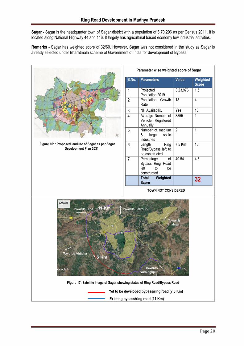
Sagar - Sagar is the headquarter town of Sagar district with a population of 3,70,296 as per Census 2011. It is
located along National Highway 44 and 146. It largely has agricultural based economy low industrial activities.
Remarks - Sagar has weighted score of 32/60. However, Sagar was not considered in the study as Sagar is
already selected under Bharatmala scheme of Government of India for development of Bypass.
Figure 16: : Proposed landuse of Sagar as per Sagar
Development Plan 2031
S.No. Parameters Value Weighted Score
1 Projected Population 2019
3,23,976
1.5
2 Population Growth Rate
18
4
3 NH Availability Yes 10
4 Average Number of Vehicle Registered Annually
3855
1
5 Number of medium & large scale industries
2
1
6 Length Ring Road/Bypass left to be constructed
7.5 Km
10
7 Percentage of Bypass Ring Road left to be constructed
40.54
4.5
Total Weighted Score
32
Parameter wise weighted score of Sagar
TOWN NOT CONSIDERED
Figure 17: Satellite image of Sagar showing status of Ring Road/Bypass Road
Yet to be developed bypass/ring road (7.5 Km)
Existing bypass/ring road (11 Km)

Ring Road Development in Madhya Pradesh
Page 21
Hoshangabad - Hoshangabad is the headquarter town of Hoshangabad district with a population of 1,17,988 as
per Census 2011. The economy largely depends on agriculture. Hoshangabad is one of the largest producer of
Soya Bean.
Remarks - Hoshangabad has weighted score of 30/60. Half of the proposed Ring Road/Bypass is already
developed but the town was not considered in the study as a combined bypass for Itarsi & Hoshangabad is already
under construction, which is 33.5 Km in length.
Figure 18: Proposed landuse of Hoshangabad as per
Hoshangabad Development Plan 2031
Parameter wise weighted score of Hoshangabad
TOWN NOT CONSIDERED
S.No. Parameters Value Weighted Score
1 Projected Population 2019
145220
0.5
2 Population Growth Rate
23.08
6
3 NH Availability Yes 10
4 Average Number of Vehicle Registered Annually
2250
0.5
5 Number of medium & large scale industries
2
1
6 Length Ring Road/Bypass left to be constructed
8.15 Km
10
7 Percentage of Bypass Ring Road left to be constructed
45.53 4.5
Total Weighted Score
33
Figure 19: Satellite image of Hoshangabad showing status of Ring Road/Bypass Road
Yet to be developed bypass/ring road (8.15 Km)
Existing bypass/ring road (9.75 Km)

Ring Road Development in Madhya Pradesh
Page 22
Singrauli- Singrauli is a city in Singrauli district with a population of 2,20,257 as per Census 2011. It is an
important industrial town of the state. All major companies operating in Singrauli belongs to Indian Energy
Industry. The operations of companies include mining of coal for power generation. In recent past, several private
companies have also joined the league of companies operating in Singrauli.
Major companies operating or coming up at Singrauli are NTPC Limited, Coal India Limited, Reliance Power
Limited, Essar Power Limited, DB Power Limited (1320 MW).
Remarks - Singrauli has weighted score of 32/60 and could be considered for Ring Road development as half of
the proposed Ring Road is already constructed and remaining half needs to be developed. Singrauli is under
consideration by PWD for development of remaining Ring Road.
Figure 20: Proposed landuse of Singrauli as per
Singrauli Development Plan 2031
Parameter wise weighted score of Singrauli
TOWN MAY BE CONSIDERED
S.No. Parameters Value Weighted Score
1 Projected Population 2019
2,76,423 1
2 Population Growth Rate 25.5% 8
3 NH Availability Yes 10
4 Average Number of Vehicle Registered Annually
2290 0.5
5 Number of medium & large scale industries
2 1
6 Length Ring Road/Bypass left to be constructed
19.7 Km 5
7 Percentage of Bypass Ring Road left to be constructed
23.76 6
Total Weighted Score 32
Figure 21: Satellite image of Singrauli showing status of Ring Road/Bypass Road
Yet to be developed bypass/ring road (19.7 Km)
Existing bypass/ring road (63.2 Km)

Ring Road Development in Madhya Pradesh
Page 23
Bhopal- Bhopal is the headquarter town of Bhopal district with a population of 17,98,218 as per Census 2011. It
is the capital city for the state. It is the 16th largest city in India. It has excellent road and railway connectivity with
other cities in the state. Being the capital city, it has many important offices. It is hub of business, education, and
health care services for many small towns in the state.
It has industrial giant like Bharat Heavy Electrical Limited along with many other small and medium industries.
Mandideep is an industrial suburb of Bhopal. It is located to the south of the city on the NH 12.
Remarks – Bhopal has weighted score of 31/60 but it was not considered for Ring Road development anticipating
very high cost of land acquisition.
Figure 22: Proposed landuse of Bhopal as per Bhopal
Development Plan 2031
Parameter wise weighted score of Bhopal
TOWN NOT CONSIDERED
S.No. Parameters Value Weighted Score
1 Projected Population 2019
22,85,933 2.5
2 Population Growth Rate
27.12% 8
3 NH Availability Yes 10
4 Average Number of Vehicle Registered Annually
79430 2.5
5 Number of medium & large scale industries
19 4
6 Length Ring Road/Bypass left to be constructed
45 Km 2.5
7 Percentage of Bypass Ring Road left to be constructed
90 1.5
Total Weighted Score
31
Figure 23: Satellite image of Bhopal showing status of Ring Road/Bypass Road
Yet to be developed bypass/ring road (45 Km)
Existing bypass/ring road (5 Km)

Ring Road Development in Madhya Pradesh
Page 24
Morena – Morena is the headquarter town of Morena district with a population of 2,00,483 as per Census 2011.
It is connected by rail and National Highway 3 with Gwalior and Agra. It does not have significant industrial
activities.
Remark: Morena has a weighted score of 30/60 but NHAI has already sanctioned DPR for development of bypass
(DPR already submitted by consultant on 20.08.2018), so the town was not considered for Ring Road
development.
Figure 24: Proposed landuse of Morena as per Morena
Development Plan 2031
Parameter wise weighted score of Morena
S.No. Parameters Value Weighted Score
1 Projected Population 2019
2,40,578 1
2 Population Growth Rate
20.00% 10
3 NH Availability Yes 10
4 Average Number of Vehicle Registered Annually
2315 0.5
5 Number of medium & large scale industries
8 2
6 Length Ring Road/Bypass left to be constructed
14.5 Km 7.5
7 Percentage of Bypass Ring Road left to be constructed
69.21 3
Total Weighted Score
30
TOWN NOT CONSIDERED
Figure 25: Satellite image of Morena showing status of Ring Road/Bypass Road
Yet to be developed bypass/ring road (14.4 Km)
Existing bypass/ring road (6.45 Km)

Ring Road Development in Madhya Pradesh
Page 25
Damoh – Damoh is the headquarter town of Damoh district with a population of 1,39,561 as per Census 2011.
The town does not have any significant medium or large scale industries but has number of small industries such
as weaving, dyeing and pottery making.
Remark: Damoh has weighted score of 30/60 and could be considered for Ring Road development as half of the
proposed Ring Road is already constructed in the form of Bypass and remaining half needs to be developed.
Damoh is under consideration by PWD for development of remaining part of Ring Road.
Figure 26: Proposed landuse of Damoh as per Damoh
Development Plan 2031
Parameter wise weighted score of Damoh
TOWN MAY BE CONSIDERED
S.No. Parameters Value Weighted Score
1 Projected Population 2019 1,68,866 0.5
2 Population Growth Rate 21% 6
3 NH Availability Yes 10
4 Average Number of Vehicle Registered Annually
1750 0.5
5 Number of medium & large scale industries
2 1
6 Length Ring Road/Bypass left to be constructed
11 Km 7.5
7 Percentage of Bypass Ring Road left to be constructed
42.55 4.5
Total Weighted Score 30
Figure 27: Satellite image of Damoh showing status of Ring Road/Bypass Road
Yet to be developed bypass/ring road (11 Km)
Existing bypass/ring road (14.85 Km)

Ring Road Development in Madhya Pradesh
Page 26
Mandsaur – Mandsaur is the headquarter town of Mandsaur district with a population of 1,41,667 as per Census
2011. The ancient Pashupatinath temple is situated here. Mandsaur is situated on Ajmer-Lebad (Indore) NH-79
as well as Mhow-Neemuch SH-31 4 Lane road. It is industrially backward town.
Remark: Mandsaur has weighted score of 30/60 and could be considered for Ring Road development. Presently,
there is no proposal by NHAI/PWD for road construction of proposed part of Ring Road.
Figure 28: Proposed landuse of Mandsaur as per
Mandsaur Development Plan 2031
Parameter wise weighted score of Mandsaur
S.No. Parameters Value Weighted Score
1 Projected Population 2019
1,71,435 0.5
2 Population Growth Rate 21.01% 6
3 NH Availability Yes 10
4 Average Number of Vehicle Registered Annually
2520 0.5
5 Number of medium & large scale industries
5 1
6 Length Ring Road/Bypass left to be constructed
13.6 Km 7.5
7 Percentage of Bypass Ring Road left to be constructed
49.64 4.5
Total Weighted Score 30
TOWN MAY BE CONSIDERED
Figure 29: Satellite image of Mandsaur showing status of Ring Road/Bypass Road
Yet to be developed bypass/ring road (13.6 Km)
Existing bypass/ring road (13.8 Km)

Ring Road Development in Madhya Pradesh
Page 27
Datia- Datia is the headquarter town of Datia district with a population of 1,00,284 as per Census 2011. Datia is
best known for the Pitambara Peeth, a famous Shaktipitha located at the entrance of Datia. It is not agriculturally
or industrially rich town.
Remark: Datia has weighted score of 29/60. Presently, there is no proposal by NHAI/PWD for road construction
of proposed part of Ring Road.
Figure 30: Proposed landuse of Datia as per Datia
Development Plan 2031
Parameter wise weighted score of Datia
S.No. Parameters Value Weighted Score
1 Projected Population 2019
1,19,338 0.5
2 Population Growth Rate 19.00% 4
3 NH Availability Yes 10
4 Average Number of Vehicle Registered Annually
1185 0.5
5 Number of medium & large scale industries
1 1
6 Length Ring Road/Bypass left to be constructed
9 Km 10
7 Percentage of Bypass Ring Road left to be constructed
77.92 3
Total Weighted Score 29 TOWN MAY BE CONSIDERED
Figure 31: Satellite image of Datia showing status of Ring Road/Bypass Road
Yet to be developed bypass/ring road (9 Km)
Existing bypass/ring road (2.54 Km)

Ring Road Development in Madhya Pradesh
Page 28
Chhatarpur- Chhatarpur is the headquarter town of Chhatarpur district with a population of 1,42,128 as per
Census 2011.The city is very strategically located at the intersection of two major National Highways, NH 86 and
NH 75.
Remarks - Chhatarpur has the weighted score of 29/60. NHAI is already constructing three bypasses, which will
make a ring road for the town.
Figure 32: Proposed landuse of Chhatarpur as per
Chhatarpur Development Plan 2031
Parameter wise weighted score of Chhatarpur
S.No. Parameters Value Weighted Score
1 Projected Population 2019 1,96,136 0.5
2 Population Growth Rate 38% 10
3 NH Availability 5 Km 10
4 Average Number of Vehicle Registered Annually
1720 0.5
5 Number of medium & large scale industries
0 0
6 Length Ring Road/Bypass left to be constructed
16.65 Km
5
7 Percentage of Bypass Ring Road left to be constructed
61.67 3
Total Weighted Score 29 TOWN NOT CONSIDERED
Figure 33: Satellite image of Chhatarpur showing status of Ring Road/Bypass Road
Yet to be developed bypass/ring road (16.65 Km)
Existing bypass/ring road (10.35 Km)

Ring Road Development in Madhya Pradesh
Page 29
Chhindwara - Chhatarpur is the headquarter town of Chhindwara district with a population of 1,75,052 as per
Census 2011.The city is very strategically located at the intersection of two major National Highways NH 86 and
NH 75. Chhindwara is an industrial town, it is home to brands like Raymond’s and Hindustan Unilever. Apart from
this, Parasia area is known for its coalfields and majority of population in this region is associated with Western
Coalfields Limited for their employment.
Remarks – Chhindwara has weighted score of 27/60. Majority of the proposed Ring Road for the town as per
development plan 2031 needs to be developed.
Figure 34: Proposed landuse of Chhindwara as per
Chhindwara Development Plan 2031
Parameter wise weighted Score of Chhindwara
S.No Parameters Value Weighted Score
1 Projected Population 2019
2,24,066 1
2 Population Growth Rate 28% 8
3 NH Availability Yes 10
4 Average Number of Vehicle Registered Annually
2875 0.5
5 Number of medium & large scale industries
10 3
6 Length Ring Road/Bypass left to be constructed
27.14 Km
2.5
7 Percentage of Bypass Ring Road left to be constructed
87.35 1.5
Total Weighted Score 27 TOWN MAY BE CONSIDERED
Figure 35: Satellite image of Chhindwara showing status of Ring Road/Bypass Road
Yet to be developed bypass/ring road (27.73 km)
Existing bypass/ring road (3.84 km)

Ring Road Development in Madhya Pradesh
Page 30
Vidisha – Vidisha is the headquarter town of Vidisha district with a population of 1,55,959 as per Census 2011.
It is located on National Highway 146. Vidisha is an agricultural trade centre.
Remarks - Vidisha has weighted score of 27/60. The case of Vidisha was not considered in the study as it is
already selected under Bharatmala scheme of Government of India for development of Bypass.
Figure 36: Proposed landuse of Vidisha as per Vidisha
Development Plan 2031
S.No. Parameters Value Weighted Score
1 Projected Population 2019
180903
0.5
2 Population Growth Rate
16
4
3 NH Availability Yes 10
4 Average Number of Vehicle Registered Annually
2130
0.5
5 Number of medium & large scale industries
2
1
6 Length Ring Road/Bypass left to be constructed
11.75 Km
7.5
7 Percentage of Bypass Ring Road left to be constructed
69.21
3
Total Weighted Score
27
Parameter wise weighted score of Vidisha
TOWN NOT CONSIDERED
Figure 37: Satellite image of Vidisha showing status of Ring Road/Bypass Road
Yet to be developed bypass/ring road (11.75 Km)
Existing bypass/ring road (6 Km)

Ring Road Development in Madhya Pradesh
Page 31
Bhind- Bhind is the headquarter town of Bhind district with a population of 1,80,935 as per Census 2011. The
city is located near the important industrial town named Malanpur via NH 92.
Remarks - Bhind has weighted score of 23/60. The town was not considered in the study as it already has partial
Ring Road in the form of Bypass and remaining Bypass is also sanctioned under NHAI (DPR already submitted
by consultant on 20.08.2018).
Figure 38: Proposed landuse of Bhind as per
Bhind Development Plan 2031
Parameter wise weighted Score of Bhind S.No. Parameters Value Weighted
Score
1 Projected Population 2019 2,18,930 1
2 Population Growth Rate 21% 6
3 NH Availability Yes 10
4 Average Number of Vehicle Registered Annually
2015 0.5
5 Number of medium & large scale industries
0 0
6 Length Ring Road/Bypass left to be constructed
22.25 Km 2.5
7 Percentage of Bypass Ring Road left to be constructed
70.63 3
Total Weighted Score 23 TOWN NOT CONSIDERED
Figure 39: Satellite image of Bhind showing status of Ring Road/Bypass Road
Yet to be developed bypass/ring road (22.25 km)
Existing bypass/ring road (9.25 km)
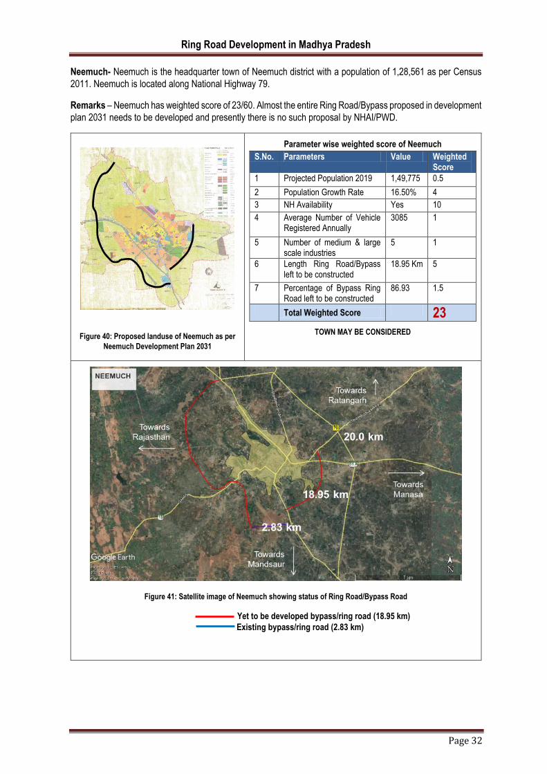
Ring Road Development in Madhya Pradesh
Page 32
Neemuch- Neemuch is the headquarter town of Neemuch district with a population of 1,28,561 as per Census
2011. Neemuch is located along National Highway 79.
Remarks – Neemuch has weighted score of 23/60. Almost the entire Ring Road/Bypass proposed in development
plan 2031 needs to be developed and presently there is no such proposal by NHAI/PWD.
Figure 40: Proposed landuse of Neemuch as per
Neemuch Development Plan 2031
Parameter wise weighted score of Neemuch
TOWN MAY BE CONSIDERED
S.No. Parameters Value Weighted Score
1 Projected Population 2019 1,49,775 0.5
2 Population Growth Rate 16.50% 4
3 NH Availability Yes 10
4 Average Number of Vehicle Registered Annually
3085 1
5 Number of medium & large scale industries
5 1
6 Length Ring Road/Bypass left to be constructed
18.95 Km 5
7 Percentage of Bypass Ring Road left to be constructed
86.93 1.5
Total Weighted Score 23
Figure 41: Satellite image of Neemuch showing status of Ring Road/Bypass Road
Yet to be developed bypass/ring road (18.95 km)
Existing bypass/ring road (2.83 km)

Ring Road Development in Madhya Pradesh
Page 33
Seoni- Seoni is the headquarter town of Seoni district with a population of 1,02,343 as per Census 2011. It is
located along National Highway 44 (North–South corridor). It is not an industrial town, it act an entry point for
tourist visiting Pench National Park.
Remarks – Seoni has a low weighted score of 22/60. It has a fully developed Ring Road which is actually a
Bypass road but it is located away from the town. The proposed Ring Road for the town as per development plan
2031 needs to be developed.
Figure 42: Proposed landuse of Seoni as per Seoni
Development Plan 2031
Parameter wise weighted score of Seoni
S.No. Parameters Value Weighted Score
1 Projected Population 2019 1,22,750 0.5
2 Population Growth Rate 19.94% 4
3 NH Availability Yes 10
4 Average Number of Vehicle Registered Annually
1120 0.5
5 Number of medium & large scale industries
NA -
6 Length Ring Road/Bypass left to be constructed
16.55 Km
5
7 Percentage of Bypass Ring Road left to be constructed
100 1.5
Total Weighted Score 22 TOWN MAY BE CONSIDERED
Figure 43: Satellite image of Seoni showing status of Ring Road/Bypass Road
Yet to be developed bypass/ring road (16.55 km)
Existing bypass/ring road

Ring Road Development in Madhya Pradesh
Page 34
Ujjain- Ujjain is the headquarter town of Ujjain district with a population of 5,15,215 as per Census 2011. It is the
fifth largest city in Madhya Pradesh. It is an important Hindu pilgrimage destination. Ujjian is not located on any
of the National Highway. The Government of Madhya Pradesh has allotted 1,200 acres for the development of
an industrial area on the Dewas-Ujjain Road near Narwar village.
Remarks – Ujjain has weighted score of 20/60. The entire Ring Road/Bypass proposed as per development plan
2031 lies undeveloped. Presently there is no proposal by NHAI/PWD for the development of Ring Road/Bypass
road.
Figure 44: Proposed landuse of Ujjain as per Ujjain
Development Plan 2031
Parameter wise weighted score of Ujjain
S.No. Parameters Value Weighted Score
1 Projected Population 2019
6,41,442 2
2 Population Growth Rate
24.5% 6
3 NH Availability No 0
4 Average Number of Vehicle Registered Annually
10530 2
5 Number of medium & large scale industries
11 3
6 Length Ring Road/Bypass left to be constructed
17.2 Km 5
7 Percentage of Bypass Ring Road left to be constructed
100 1.5
Total Weighted Score
20
TOWN MAY BE CONSIDERED
Figure 45: : Satellite image of Ujjain showing status of Ring Road/Bypass Road
Yet to be developed bypass/ring road (17.2 km)
Existing bypass/ring road

Ring Road Development in Madhya Pradesh
Page 35
Nagda - Nagda is an industrial town and became the district in March 2020. The town has a population of 1,00,039
as per Census 2011. Nagda is a major industrial town with a manufacturing unit of Viscose Fiber, a Thermal
Power Plant and a Chemical Plant. Nagda is not located on National Highway.
Remarks – Despite being an industrial town, Nagda has low weighted score of 22/60, as it is not located on any
National Highway. Presently, there is no proposal by NHAI/PWD for road construction of proposed part of Ring
Road.
Figure 46: Proposed landuse of Nagda as per
Nagda Development Plan 2031
Parameter wise weighted score of Nagda
TOWN MAY BE CONSIDERED
S.No. Parameters Value Weighted Score
1 Projected Population 2019 1,12,045 0.5
2 Population Growth Rate 12% 2
3 NH Availability No 0
4 Average Number of Vehicle Registered Annually
< 3000 0.5
5 Number of medium & large scale industries
Data not available
3 (assumed)
6 Length Ring Road/Bypass left to be constructed
8.5 Km 10
7 Percentage of Bypass Ring Road left to be constructed
60.5 3
Total Weighted Score 19
Figure 47: Satellite image of Nagda showing status of Ring Road/Bypass Road
Yet to be developed bypass/ring road (8.5 km)
Existing bypass/ring road (5.55 km)

Ring Road Development in Madhya Pradesh
Page 36
Khargone- Khargone is the headquarter town of Khargone district with a population of 1,16,150 as per Census
2011. Khargone is the famous agricultural mandi town of the region. It is one of biggest cotton producing districts
in India. Several industries are also now developing in the area.
Remarks – Khargone has weighted score of 16/60 since it is not located on any National Highway and the entire
Ring Road/Bypass road proposed as per development plan 2031 lies undeveloped.
Figure 48: Proposed landuse of Khargone as per Khargone
Development Plan 2031
Parameter wise weighted score of Khargone
S.No. Parameters Value Weighted Score
1 Projected Population 2019
1,42,399 0.5
2 Population Growth Rate
22.6% 6
3 NH Availability 0 0
4 Average Number of Vehicle Registered Annually
1845 0.5
5 Number of medium & large scale industries
9 2
6 Length Ring Road/Bypass left to be constructed
15.65 Km
5
7 Percentage of Bypass Ring Road left to be constructed
100% 1.5
Total Weighted Score
16
LOW WEIGHTED SCORE, TOWN NOT CONSIDERED
Figure 49: Satellite image of Khargone showing status of Ring Road/Bypass Road
Yet to be developed bypass/ring road (15.65 km)
Existing bypass/ring road

Ring Road Development in Madhya Pradesh
Page 37
Burhanpur- Burhanpur is the headquarter town of Burhanpur district with a population of 2,10,886 as per Census
2011. Burhanpur is known for its textile industry. It is not located on any National Highway but is well connected
by rail and road with other cities in the state.
Remarks – Burhanpur has weighted score of 14/60 since it is not located on any National Highway and the entire
Ring Road/Bypass road proposed as per development plan 2031 lies undeveloped. There is no proposal by
NHAI/PWD for development of Ring Road/Bypass road.
Figure 50: Proposed landuse of Burhanpur as per Burhanpur
Development Plan 2031
Parameter wise weighted score of Burhanpur
S.No. Parameter Value Weighted Score
1 Projected Population 2019
2,33,417 1
2 Population Growth Rate
10.68% 2
3 NH Availability No 0
4 Average Number of Vehicle Registered Annually
3025 1
5 Number of medium & large scale industries
4 1
6 Length Ring Road/Bypass left to be constructed
11.65 Km
7.5
7 Percentage of Bypass Ring Road left to be constructed
100 1.5
Total Weighted Score
14
LOW WEIGHTED SCORE, TOWN NOT CONSIDERED
Figure 51: Satellite image of Burhanpur showing status of Ring Road/Bypass Road
Yet to be developed bypass/ring road (11.63 km)
Existing bypass/ring road
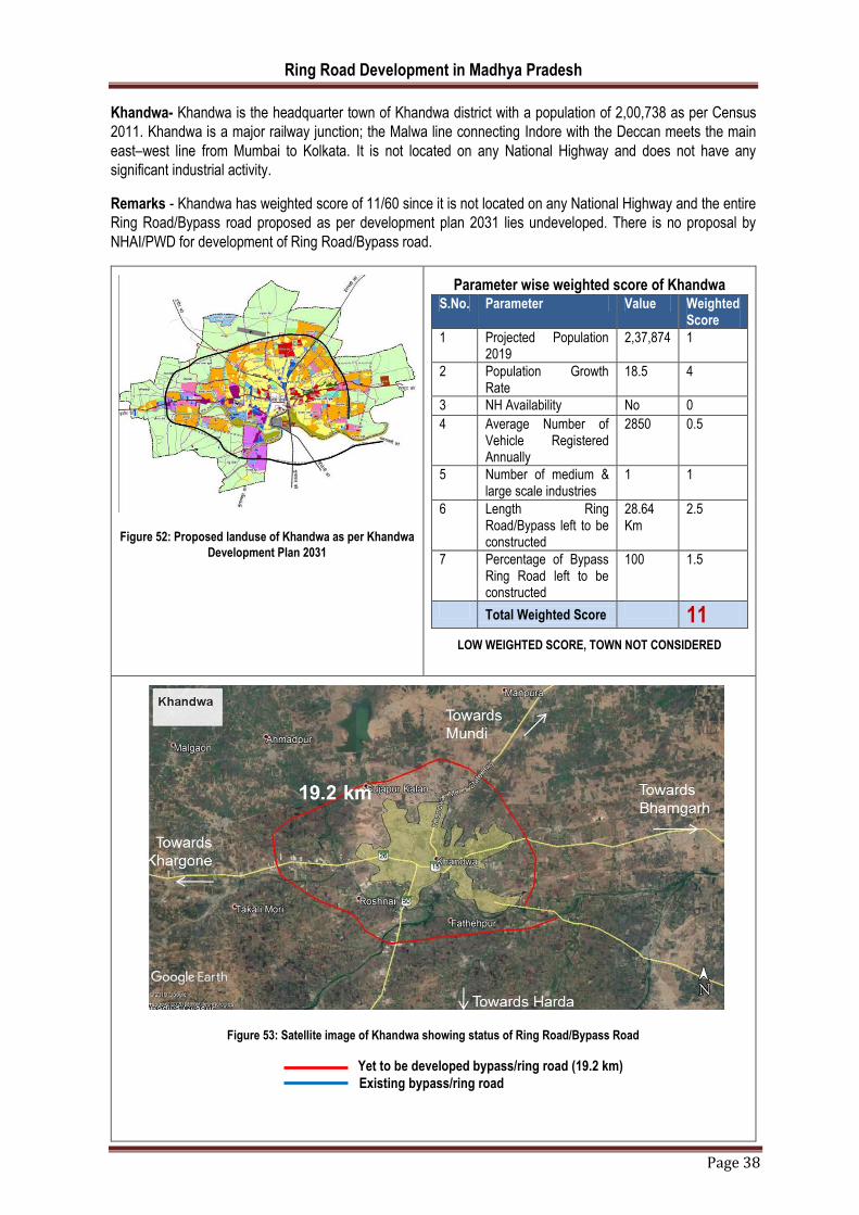
Ring Road Development in Madhya Pradesh
Page 38
Khandwa- Khandwa is the headquarter town of Khandwa district with a population of 2,00,738 as per Census
2011. Khandwa is a major railway junction; the Malwa line connecting Indore with the Deccan meets the main
east–west line from Mumbai to Kolkata. It is not located on any National Highway and does not have any
significant industrial activity.
Remarks - Khandwa has weighted score of 11/60 since it is not located on any National Highway and the entire
Ring Road/Bypass road proposed as per development plan 2031 lies undeveloped. There is no proposal by
NHAI/PWD for development of Ring Road/Bypass road.
Figure 52: Proposed landuse of Khandwa as per Khandwa
Development Plan 2031
Parameter wise weighted score of Khandwa S.No. Parameter Value Weighted
Score
1 Projected Population 2019
2,37,874 1
2 Population Growth Rate
18.5 4
3 NH Availability No 0
4 Average Number of Vehicle Registered Annually
2850 0.5
5 Number of medium & large scale industries
1 1
6 Length Ring Road/Bypass left to be constructed
28.64 Km
2.5
7 Percentage of Bypass Ring Road left to be constructed
100 1.5
Total Weighted Score 11 LOW WEIGHTED SCORE, TOWN NOT CONSIDERED
Figure 53: Satellite image of Khandwa showing status of Ring Road/Bypass Road
Yet to be developed bypass/ring road (19.2 km)
Existing bypass/ring road
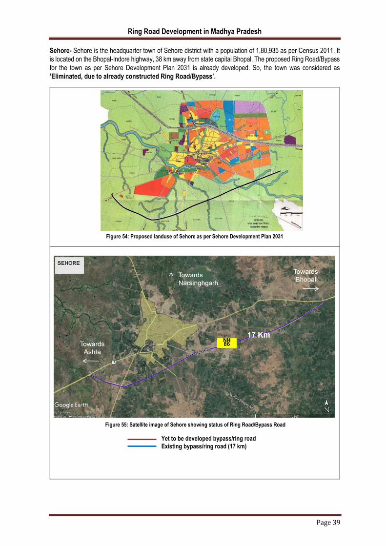
Ring Road Development in Madhya Pradesh
Page 39
Sehore- Sehore is the headquarter town of Sehore district with a population of 1,80,935 as per Census 2011. It
is located on the Bhopal-Indore highway, 38 km away from state capital Bhopal. The proposed Ring Road/Bypass
for the town as per Sehore Development Plan 2031 is already developed. So, the town was considered as
’Eliminated, due to already constructed Ring Road/Bypass’.
Figure 54: Proposed landuse of Sehore as per Sehore Development Plan 2031
Figure 55: Satellite image of Sehore showing status of Ring Road/Bypass Road
Yet to be developed bypass/ring road
Existing bypass/ring road (17 km)

Ring Road Development in Madhya Pradesh
Page 40
Gwalior- Gwalior is the headquarter town of Gwalior district with a population of 10,54,420 as per Census
2011. Gwalior is fairly well connected to other parts of Madhya Pradesh and India by national and state highways.
The proposed North-South Corridor of the Golden Quadrilateral Highway project passes through the city. The
Agra-Bombay National-Highway (NH3) passes through Gwalior, connecting it to Shivpuri on one end and Agra
on the other. Gwalior is surrounded by three industrial areas – Sitholi, Banmore and Malanpur. All three of these
sectors are on NH 75, NH-3 and NH 92 respectively, with Malanpur being the largest.
Remarks - The proposed Ring Road/Bypass for the town as per Gwalior Development Plan 2031 is already
developed. So, the town was considered as ’Eliminated, due to already constructed Ring Road/Bypass’.
Figure 56: Proposed landuse of Gwalior as per Gwalior Development Plan 2031
Figure 57: Satellite image of Gwalior showing status of Ring Road/Bypass Road
Yet to be developed bypass/ring road
Existing bypass/ring road (79 km)

Ring Road Development in Madhya Pradesh
Page 41
Betul- Betul is the headquarter town of Betul district with a population of 1,03,330 as per Census 2011. Betul is
serviced by National Highway 46 and National Highway 47, also connecting it with Bhopal and Nagpur.
Remarks - The proposed Ring Road/Bypass for the town as per Betul Development Plan 2031 is already
developed. So, the town was considered as ’Eliminated, due to already constructed Ring Road/Bypass’.
Figure 59: Satellite image of Betul showing status of Ring Road/Bypass Road
Yet to be developed bypass/ring road
Existing bypass/ring road (13 km)
Figure 58: Proposed landuse of Betul as per Betul Development Plan 2031

Ring Road Development in Madhya Pradesh
Page 42
Katni- Katni is the headquarter town of Katni district with a population of 2,21,883 as per Census 2011. Katni is
an industrial town located along NH-78.
Remarks - The proposed Ring Road/Bypass for the town as per Katni Development Plan 2031 is already
developed. So, the town was considered as ’Eliminated, due to already constructed Ring Road/Bypass’.
Figure 60: Proposed landuse of Katni as per Katni Development Plan 2031
Figure 61: Satellite image of Katni showing status of Ring Road/Bypass Road
Yet to be developed bypass/ring road
Existing bypass/ring road (17.8 km)

Ring Road Development in Madhya Pradesh
Page 43
Satna- Satna is the headquarter town of Satna district with a population of 2,89,977 as per Census 2011. It is
located along National Highway 75. Satna is in the limestone belts of India. As a result, it contributes around 8%–
9% of India's total cement production. There is an abundance of dolomite and limestone in the area and the city
has many cement factories producing and exporting cement to other parts of the country.
Remarks - The proposed Ring Road/Bypass for the town as per Satna Development Plan 2031 is already
developed with slight change in alignment. So, the town was considered as ’Eliminated, due to already
constructed Ring Road/Bypass’.
Figure 62: Proposed landuse of Satna as per Satna Development Plan 2031
Figure 63: Satellite image of Satna showing status of Ring Road/Bypass Road
Yet to be developed bypass/ring road
Existing bypass/ring road (30 km)

Ring Road Development in Madhya Pradesh
Page 44
CHAPTER 4. FINANCIAL PLANNING
4.1. INTRODUCTION
The study explored the possibility of adopting self-financing schemes and financial models to support in
development of ring road and bypasses in selected cities/towns in Madhya Pradesh. The objective of the
government was to adopt models, which uses the available land bank without putting major financial implication
on the government.
4.2. CURRENT SCENARIO
Physical Roads Infrastructure in Madhya Pradesh
The State has national highways of 8,772 km and state highways of 11,389 km as of March 2019.
For the construction of roads through M.P. Road Development Corporation, allocation of US$ 42.92
million has been proposed by the state Government in State Budget 2019-20.
As per State Budget 2019-20, provision of US$ 200 million under Mukhyamantri Gram Sadak Yojana
and that of US$ 28.62 million for State Rural Road Connectivity Scheme, have been made.
Under State Budget 2019-20, Government has allocated INR 2,500 Crore (US$ 357.70 million) for
Pradhan Mantri Gram Sadak Yojana.
Road type Road length (kms)
National highways 8,772
State highways 11,389
Major district roads 22,129
Village roads 23,395
Road length 64,719
Figure 64: Figure showing road construction under PMGSY (in Km)
The state boasts a wide road network of 64,719 kms and has a consistent construction of approximately 5000
kms per year under PMGSY.
5222.45
5081.97
4543.23
5180.92
3006.27
0 1000 2000 3000 4000 5000 6000
2017-18
2016-17
2015-16
2014-15
2013-14
Ring Road Development in Madhya Pradesh
Page 45
4.3. FUTURE OUTLOOK
To further the development of Madhya Pradesh’s economy and make it an economic powerhouse due to its
strategic central location in India, Madhya Pradesh Public Works Department [MPPWD] intend to develop new
Ring roads or bypass in select cities/towns of Madhya Pradesh.
Developing Ring Road and its Challenges
Despite a well laid down legislation for land acquisition, land assembly, R&R policy for determining benefits,
development of ring road projects is often faced with difficulty in project execution on time and within the estimated
costs.
For developing a ring road, multiple stretches of road are required to be acquired. Lack of systematic approach
to acquisition to take place at once for various stretches is a major challenge. The fragmented nature of land
acquisition for ring road raises the following issues:
Legal Issues such as title disputes, share-farming, legal heir, etc. and wrangles led to lack of progress
in land acquisition in majority of areas.
Inefficient compensation determination and its release to affected parties created future complications.
Additionally, change of alignment of ring road several times makes the whole process messy not only to
public agencies but even for public.
To achieve the above vision of the state government, it is imperative to use the available land optimally and extract
additional value from the existing available land pool (developed or undeveloped). However, before discussing
possible ways of intervention, it is useful to note some characteristics of the land both urban and in rural setting.
4.4. LAND ASSEMBLY AND FUNDING TECHNIQUES: AN OVERVIEW
Municipalities play a critical role in planning and investing in urban infrastructure. They assist the state government
in selection of infrastructure projects to be executed at municipality level. Previously, the government and
municipality have used traditional land acquisition techniques for urban development. Off late, due to factors like
limited availability of land, soring land prices due to speculation and hoarding, delay in land acquisition, delay in
environmental and other clearances, government has started
Challenges with Land Assembly Techniques:
Private property owners may be unwilling/ uninterested to sell their land due to lack of understanding, monetary
or non-monetary reasons.
Funding Land Assembly gets challenging because of long term gestation period and lack of demonstrable short-
term revenue stream
Soring land prices due to speculation and hoarding improper land records and imperfect land information system
create the problem of identification.
Inflexible zoning / regulatory environment such as limited time period to get the site assembled, entitled, zoned,
platted and approved
Public opposition, which gains strength in the event of an organized resistance.
Problems like escalation of land acquisition cost, particularly interest burden, due to delay in settlement
Despite the above-mentioned challenges, modern land assembly techniques score brownie points over the
traditional land acquisition method. Due to financial unfeasibility of developmental projects, governments and
municipalities are forced to think of alternative ways of land assembly, which helps to maximize the usage of
government land for developmental purposes.

Ring Road Development in Madhya Pradesh
Page 46
4.5. INNOVATIVE LAND ASSEMBLY TECHNIQUES
Traditional land value capture (LVC) mechanisms, such as Land Readjustment (LR) and Transfer of Development
Rights (TDR) are used to manage urban growth in several countries with different resources, technical capacities
and governance systems. Often, they can be complex to design and implement especially where land
management capacity is poor. To effectively use LR and TDR in implementing land use plans for Disaster Risk
Management (DRM), local governments must improve existing land management capacity by: i) combining LR
and TDR with supporting municipal tools in a `basket of tools’, ii) strengthening municipal capacity in land
administration and work with real estate markets, and iii) supporting community-based organizations.
Basket of Tools
LR and TDR are not `silver bullets for the challenges in public finance and land protection in DRM programs.
Municipal tools can sometimes work at cross-purposes to LR and TDR mechanisms. Local governments must
identify tools that will complement LR and TDR such as, integrating with the master plan and supporting land
management tools, enabling legislation and institutional coordination, and adopt risk resilient land use and
building regulations.
1. Integrating with the Master Plan
LR and TDR are not stand-alone tools but complement other land management tools, such as, land register/
cadaster, land use planning, land and property valuation and taxation. They must be incorporated with city master
plan (as in Brazil, Japan, and the US) for hazard zoning, density management and housing supply (including
rental) and environmental protection plans. TDR programs must designate clear sending areas and receiving
areas that have adequate infrastructure. LR and TDR are opportunities to create compact, dense, well-serviced
neighborhoods and increase overall supply of affordable housing in the city while avoiding development in
hazardous sites. Wipeouts due to hazard buffer zones can be managed by designating no-build zones for eco-
system services for hazard mitigation and amenity values as in Curitiba. In the US, local governments facilitate
TDR to develop greenways. Restoration, rehabilitation and management of mangroves along Vietnam’s coast
reduced substantial disaster risks and provided additional income to coastal communities through aquaculture
products etc. Where local governments lack the capacity to execute large-scale master/ disaster resilience plans,
LR projects can be implemented in an integrated orderly sequence according to the master plan and at a
manageable scale. A TDR program is most effective when used in conjunction with other land management tools
such as zoning, purchase of development rights, land acquisition and development impact fees, land register/
cadaster, property valuation and taxation. Since gentrification due to increased property taxes after
redevelopment is possible, property tax holiday as in Bhuj and Mumbai (India) can ease the impact of higher fees.
2. Enabling Legislation & Institutional Coordination
LVC mechanisms depend on land markets and land markets are not regulated in many countries by appropriate
legislation. LVC works best when there is a strong legal framework. Fragmented, inadequate and complex laws
increase project costs. Instituting legislation that can enable local governments to use LVC mechanisms for quick
recovery after a disaster is paramount. Supporting legislation must enable planning at local level, unlike in India
in the past, where state mandates suppressed local planning possibilities for revising development regulations.
Selective use of eminent domain has worked well to avoid holdouts, as in Kobe and Bhuj. Implementing LR and
TDR can be time consuming and complicated and poor institutional coordination at different levels can delay or
stall LVC projects. Approval procedures for LR and TDR project approvals must be streamlined. In locations
where LR and TDR are planned for increased density, coordination with sector agencies is required to provide
adequate transportation networks, water supply and sewage and other amenities. Where TDR is used to
implement hazard buffer zones extending over several municipalities, inter-jurisdictional cooperation must be
strengthened.
3. Risk resilient land use and building regulations
Disaster reconstruction projects often overlook existing risks. LVC projects are opportunities to review land use
and building regulations and demarcate hazardous pockets, reserve land for emergency shelters and operations
or open spaces for DRR related ecosystem services. In Istanbul, Turkey, LR has been used to provide for public

Ring Road Development in Madhya Pradesh
Page 47
squares, parks, playground, green areas, police/ fire stations and hospitals. LR projects must incorporate
rebuilding using hazard resistant building codes and materials.
4.5.1. Land Readjustment
Land Readjustment (or land pooling / sharing) works on the principle that potential increase in land value after
development will provide incentive to landowners to contribute and pool land for public amenities. LR has been
applied globally to create serviced plots in the periphery, optimize land use through densification, acquire land for
infrastructure projects, regularize tenure, slum upgrading and inner city revitalization apart from post disaster
reconstruction. In an LR project, a portion of land is deducted from all landowners to provide a) amenities, and b)
market sale of surplus plots to recover part or all of development costs. Neighborhood layout is rationalized to
carve space for public amenities such as roads, schools, hospitals and open spaces. Plots are reshaped and
resized to accommodate existing landowners who receive smaller but regular, serviced plots that are equivalent
or greater than the former value. Additional plots for renters and informal residents may be provided. Land use
may be optimized for densification and mixed use. LR projects rely on voluntary or mandatory community
cooperation. LR is a useful tool in post-disaster reconstruction to `build back better’ on safe pockets with hazard-
resilient building regulations. The Earthquakes and Mega Cities Initiative (EMI) promotes LR as a tool to
incorporate DRM in urban development.
Key benefits of LR projects:
continued land ownership
recognition of different land tenure arrangements
stronger consensus and cooperation amongst residents, community organizations, private developers
and the government
bargaining power offered to low-income residents through community consensus prior to project
approval, and
increased municipal revenues through property taxes from serviced land
Key challenges of LR projects:
A number of preconditions have to be met such as
landowners must believe that final profits will justify project and value improvements in neighbourhood
amenities and public infrastructure
land ownership is not scattered, and affected landowners want to stay in the neighbourhood
destruction allows for readjusted plot boundaries and residents are equally impacted and willing to
cooperate; where some houses are not damaged, individuals are likely to not want to lose some of their land for
readjustment project
technical skill is available for designing project incentives
ownership records (cadasters) are updated and reliable, and
potential disputes can be resolved through agreement or legislation
Implementation of LR in India
Gujarat (India)
Locally called Town Planning Schemes (TPS), LR is used as a mechanism for land assembly and plot adjustments
in about 1/3rd of urban projects (Ahmedabad ring road, public spaces in unauthorized and peri-urban
developments) in Gujarat state. LR has been used for rebuilding severely affected urban centers after the 2001
earthquake.
Project Design and Implementation
TPS projects are voluntary and must conform to the master plan. Legislation was established in Maharashtra and
Gujarat states in 1915. Community engagement is not effective. TPS is an elaborate multi-stakeholder exercise

Ring Road Development in Madhya Pradesh
Page 48
with legislative to technical departments involving more than 30 steps. Landowners transfer up to 40% of their
land to the government in return for serviced plots. Only registered landowners are allowed to participate; renters
and informal residents are excluded. Landowners can either build new homes or sell the sites. The government
builds roads and public facilities and reserves a portion of land for sale by auction to recover infrastructure costs.
The process is slow as local governments have no authority to sanction plans, manage land auctions or revise
land use rules and regulations and state government approvals are required.
Bhuj Land Readjustment Project
Objectives: Bhuj town endured severe damages during the 2001 earthquake. In the densely populated inner city,
buildings collapsed on narrow streets/ cul-de-sacs and hindered rescue efforts. TPS was undertaken in the inner
city as part of comprehensive citywide planning initiatives that included significant investments in social amenities
at the periphery and trunk infrastructure to three relocation sites
Actions: TPS was used in eight inner-city sites to optimize density, control non-conforming land uses, ensure
minimum lot size and plot access to roads and basic infrastructure in the inner city. Residents had the option to
relocate voluntarily or participate in the TPS. Many households preferred to move out of the congested walled city
to the well-serviced and well-connected relocation sites in the periphery and the overall number of plots in the TP
schemes reduced by 20%. Voluntary relocation reduced resistance to TPS in the inner city. Neighborhood
committees were formed for micro planning tasks. Eminent domain was used for compulsory surrender of plots
and houses that were either severely damaged or obstructed the TPS layout. Plot access was ensured by
widening streets where buildings had collapsed while maintaining the original street pattern and avoid disturbing
built properties. Wide loop roads connected the walled city to the rest of the urban area and amenities38.
Preparing the new layout was challenging since base maps were lacking, no accurate data was available for
underground utilities and it was difficult to work around standing structures. Absence of updated property records
caused delays in plot transfers. TPS was sensitive to very small plot owners. There were no deductions for plots
< 30sq.m. while plots > 300 sq. had to contribute 35%. Further, to ease the burden on low-income residents, a 5-
year moratorium on property tax was declared. Land use regulations and development controls were revised to
allow uniform height across all wards for seismic resilience.
Bhuj Inner-city Land Readjustment Project
Narrow streets and cul-de-sacs before disaster Wider and continuous streets after LR
Results: The Bhuj TPS project decongested parts of the walled city by ensuing minimum lot sizes and plot
access; but it did not minimize relocation. Although the process was expedited to be completed in half the time
during post-disaster reconstruction, compared to a convention TPS in Gujarat, it cost the government almost a
third more. The significant expansion of serviced land in the periphery along with LR in the walled city appears to
have moderated real estate price increase in the periphery; and the overall supply of safe, serviced and affordable
land sites for the urban poor increased in Bhuj.

Ring Road Development in Madhya Pradesh
Page 49
Lessons from Gujarat Land Readjustment Projects: The projects have been successful given their:
integration with the master plan,
selective use of eminent domain ensures project implementation, and
combination with other LVC tools, such as tax holiday in Bhuj.
Drawbacks include:
Focus on landowners only - renters and informal residents are excluded
Weak community engagement, and
Delays caused by bureaucratic state government procedures for local development.
Figure 65: Figure showing distribution of land post Land Pooling
The method is based on the reassembling of land parcels by a new layout plan together with the development of
new urban infrastructure. Land contribution by each landowner is essential to utilize for the site of newly
established infrastructures, and to cover the project cost fully or partially.
Under land pooling, public infrastructure is provided at a shared cost to the landowners and the public authority.
In the urban context, the process enables the urban authorities to develop new areas by financing the
infrastructure through the increase in land values. Once infrastructure is in place, the land value rises. The
landowners receive a property of at least the same value near their original property after the development of the
area. Thus, the cost recovery mechanism coupled with the absence of purchasing land outright eliminates the
need of the government in making a large up-front investment in infrastructure development. The strategy on the
other hand is to shift the burden to the landowners by inviting them to contribute their land in exchange for a
participating interest in the value created by the development project. The landowners benefit by remaining in the
same area, preventing significant social and emotional issues associated with displacement and relocation. The
public authorities on the other hand are much benefited, as they do not require substantial upfront capital in paying
compensation to the existing landowners.

Ring Road Development in Madhya Pradesh
Page 50
Figure 66: An illustration of segmentation of land under Land Pooling
4.5.2. Transfer of Development Rights
What is a Transfer Development Rights?
TDR (or density transfers / air rights) works on the principle that absolute property rights can be considered as a
`bundle’ of different rights, such as the right to build, to mine, to farm, among others and that these `partial’ rights
are available for market transactions. The concept of severance of rights is used in several countries for programs:
farmland and environmental conservation, urban growth management, transit-oriented development (TOD),
heritage preservation and social housing. The owner of a property with considerable public amenity
(infrastructure, low-income housing etc.) value can trade `development rights from a designated `sending zone’
to a buyer for use in a designated `receiving zone’ resulting in a `transfer of development rights’. The landowner
in the sending zone loses his right to develop but is compensated for the development potential of his land at
market value. The buyer, usually a private developer, is given density bonuses to provide public amenities.
Developers may also trade development rights in the open market. TDR balances `wipeouts for property owners
in preservation areas where land values drop and windfalls for property owners in growth areas where land values
increase. The design of a TDR program can be complex and is based on a city’s comprehensive plan and real
estate market. TDR programs can be mandated or voluntary. Although municipal TDR programs are common,
TDR programs are also planned to guide regional development.
How does Transfer of Development Rights Work
CREATION
There are four elements in successful TDR programs:
1. Designate a preservation zone (Sending Area): Identify target areas that the community desires to protect (i.e. contiguous blocks of productive farmland or sensitive natural resources).
2. Designate an urban growth zone (Receiving Area): Identify target areas in the community where development is desirable (i.e. near businesses, existing urban services, along a transportation corridor).
3. Determine a market for development rights: TDRs only work when a demand exists for development rights. It is important that long-term growth expectations exist for receiving areas to assure landowners in the sending areas that their development rights have value. Adequate incentives must be provided to landowners before they will sell development rights.
4. Define TDR Procedures and Transfer Ratio: TDR procedures include establishing what will be used to determine the number of development credits received (i.e. acres protected, amount of prime agricultural soil, dollar value of the land) and determining how many additional units a developer will receive per credit. Guidelines should also be set up to aid staff in their role as liaison between landowners and developers.
ADMINISTRATION
Establishing a TDR bank, run by a local government, can help the program run smoothly. Instead of developers,
purchasing development rights directly from landowners, the local government acts as a middleman to buy and

Ring Road Development in Madhya Pradesh
Page 51
then sell available development rights. A TDR bank makes the program more predictable and manageable for
landowners and developers.
A well-trained staff person is needed to manage development right transfers either by running the TDR bank, or
by negotiating the transactions between landowners and developers. Staff will need to monitor the market for
development rights and recommend adjustments to their value as needed. Staff also plays a large role in
educating local officials, landowners, and developers about the program. Staff must ensure that the municipality’s
capital improvement program and ordinances continue to support the program as development transfers occur.
Source: Huron River Watershed Council New York City Department of City Planning
Key benefits of TDR projects
Economic equity for the landowners;
Preserved amenity (environmental/ cultural) value of land,
New development guided into designated zones, and
Government can plan for public amenities at minimal cost without land acquisition.
Key challenges for TDR projects
Information on TDR sellers, buyers and prices is not available, and landowners find it difficult to find
buyers (if the prices fluctuate a lot, landowners may speculate and not sell TDRs),
Land market values are high enough for developers to make enough profit from the additional
development they can sell, even after paying for the services the city wants them to provide,
Large public subsidies reduce land market price differentials essential to make TDR viable,
Restricted technical skills available to design the program incentives;
Limited demand for additional density in receiving areas, and
Complex program design and approval procedures.
Report Card: Transfer of Development Rights
Cost Money or staff resources required to implement tool.
C A TDR program will likely require dedicated staff to set up and manage the program. Start-up money
will be needed if a TDR Bank is created. Money to purchase development rights comes from
developers rather than tax money.
Public Acceptance The public’s positive or negative perception of the tool.
B The public likes the fact that money to purchase development rights comes from the private sector,
not taxpayers. Property owners in the receiving area however, may have a problem with the
increased density if existing utilities cannot support it and building design isn‛t accepted.
Political
Acceptance
Politician’s willingness to implement tool.

Ring Road Development in Madhya Pradesh
Page 52
C Local officials approve of the market financing the program. Intergovernmental agreements that
transfer development from one municipality to another must contend with tax-base transfer issues.
Determining appropriate standards and prices for development credits may be difficult.
Equity Fairness to stakeholders regarding who incurs costs and consequences.
A Rural landowners voluntarily sell their development rights and are compensated for them.
Developers get density bonuses for purchasing development rights, so costs are not handed down
to homebuyers.
Administration Level of complexity to manage, maintain, enforce, and monitor the tool.
D TDR is one of the most difficult land management techniques to establish. Administration of TDR
programs is complex and costly and maintaining a market may be difficult.
Scale The geographic scale at which tool is best implemented.
Local to Regional The program can be run on any scale but works best over an area that includes both rural and urban
areas. The scale will also be dependent on the ability of the managing agency or organization to
create a successful program with enough credits to buy and corresponding need for development.
GRADING EXPLANATION
A – Excellent; B - Above Average; C – Average; D - Below Average; F – Failing
Comments and grades were derived from a Delphi process conducted with practicing planners and educators in 2005
TDR in India
TDR has been used in Mumbai since 1991 to supplement finance for infrastructure, slum redevelopment and
heritage preservation. Following the Mumbai program, several Indian cities are adopting TDR, especially for
transportation and slum redevelopment, and to manage disaster risks. Zoning regulations in Mangalore
incorporate TDR to appropriately compensate for private property acquired as part of the GOI-UNDP Urban
Earthquake Vulnerability Reduction Project, a sub-component of the Disaster Risk Management (DRM (program
in 38 cities located in Seismic Zones III, IV and V with a population of half million and above.
Program Design and Implementation
The program, for slum redevelopment, serves as a model in India. It has one coordinating planning agency and
multiple executing agencies that include private developers, public bodies, NGOs and cooperative housing
societies of slum dwellers. The program designates the relatively dense Mumbai CBD (island city) as a sending
area. All TDR generated from plots within the island city are to be used in the suburbs. Suburbs can serve as
sending and receiving areas. TDR generated in the suburbs can be used in the same ward or in another ward
north of the plot. Incentive Floor Space Index (FSI) is offered to cover costs of construction costs and private land,
transit camps, offsite infrastructure, maintenance corpus fund, servicing of loans, and for adequate developer
profits. Incentive FSI varies with land value (lower in high-value island city and higher in the suburbs) and can be
used in the same plot or as TDR in receiving sites, or mortgaged. However, uncontrolled generation of TDR from
the three programs has created a glut in the TDR market several times thereby reducing TDR market price and
making TDR projects financially not viable.
Community organizations play a crucial role in explaining the benefits of the TDR program. Consent of 70% of
slum residents is mandatory. The program is sensitive to the needs of informal residents, renters and particularly
vulnerable sections within the urban poor. All pavement and slum dwellers who establish that their names were
on the electoral roll before a cut-off date are eligible. Women are organized into cooperative self-help groups to
access funds from credit institutions. Older and special needs residents are allotted ground floor units.
Cooperatives of slum dwellers receive leasehold title to the land. Municipal taxes are pegged at 20% to reduce
burden on slum families with a provision to increase them gradually over time. Apart from slum redevelopment,
the TDR program was used to minimize displacement while clearing land of slums for the Mumbai Urban
Transportation Project.
Mumbai TDR in the Coastal Regulation Zone
Objective: The rapidly urbanizing coastline of Mumbai has high-value real estate and large number of slums
located in flood-prone stretches. The 1991 Coastal Regulation Zone (CRZ) under notification by the Ministry of
Environment and Forests controls development along the coast. The CRZ restricts all developments within 500

Ring Road Development in Madhya Pradesh
Page 53
meters of the high tide line. Being flood-prone, the CRZ, especially CRZ II is home to many slum dwellers who
cannot afford safer housing. The Slum TDR was modified to prevent additional development in the CRZ.
Actions: Although the government offers incentive FSI to promote slum redevelopment in less expensive areas,
program imposes restrictions on incentive FSI in the CRZ. TDR is not allowed within and from this zone, making
slum redevelopment with TDR financially not viable. Public share of 51% has been permitted to make it attractive
for private developers, but incentive details are unclear. Government committees have argued for permitting
increase in FSI for slum redevelopment within the CRZ, and to reduce the CRZ in zones with high population
density and built up areas. Revisions to the CRZ have reduced the no-build zone and freed up several slum
clusters for redevelopment.
Results: The state government lacks the funding to enforce the federal government CRZ notification. Violations
are rampant: Navi Mumbai satellite town that was planned to decongest the city was constructed by destroying
mangroves directly in violation of the CRZ. TDR is a tool that has been successful in preserving environmentally
sensitive areas in many countries. In Mumbai, even though it has been used to clear large parcels of land required
for expansion of road and suburban railway network, and metro, monorail and river development projects, its
potential to enforce the CRZ regulations and provide financial incentives to direct development away and relocate
slums from the CRZ has not been explored. Unfortunately, environmentalists consider Slum TDR in the CRZ as
environmentally irresponsible while proponents of slum redevelopment consider it socially irresponsible.
Lessons from Mumbai (India) TDR Program
The Mumbai TDR has been successful as it:
Increased the overall housing stock through incentive FSI in high value lands, even slums,
Legitimized the residency rights of large numbers of pavement and slum dwellers,
Combines tax rebates and deferment along with TDR to make the program more accessible to the urban
poor, and
Allows TDR certificates to be mortgaged by developers, it provides much needed development finance
for private developers who are known to otherwise mix funds from one project to another and delay
deliveries.
TDR in Madhya Pradesh
The Madhya Pradesh government has notified in Madhya Pradesh Gazette, Madhya Pradesh Transferable
Development Rights Rules, 2018 on 20th July 2018. The rules specify the following in detail:
Definition of generating, receiving and influencing area and TDRs.
The formula for determining the amount at which Additional Buildable Area can be purchased from the
implementing agency in the influencing area. The formula goes as:
Amount of Additional Buildable Area to be
purchased for a plot in the Influencing Area (in Rs.)
Collector guideline rate * Buildable Area * 0.5
The formula for calculation of value of entitlement for any area under acquisition for a Public Project for
which the owner will be entitled for TDR is as follows:
Value of Transfer of Development Rights in terms of
Additional Buildable Area (in sqm)
Y * Area surrendered under the Public Project (in sqm)
Y = Multiplication factor as decided by the Government on the recommendation of the Implementing Agency, which
shall not be less than two.
General Terms and Conditions for Issuance of Development Right Certificate
Transfer of Development Right Certificate
Utilization of Transfer Development Rights

Ring Road Development in Madhya Pradesh
Page 54
The formula for calculation of equivalent quantum Transfer of Development Rights to be permitted on
receiving plot shall be governed as under:
A = (Rg/Rr) * B
Where, A= The equivalent quantum Transfer of Development Rights to be permitted on
receiving plot
Where, Rg = Rate in Rs/ sq meter in Generating Area as per collector guideline in generating
area.
Where, Rr = Rate in Rs/ sq meter in Receiving Area as per collector guideline in receiving
area.
Where B = Transfer of Development Rights debited from Development Rights Certificate in sq
m.
Conditions for Utilization of Transfer of Development Rights
Vesting of Land
Development of the online DRC transaction
Cancellation of TDR certificate
4.5.3. Guided Land Development (GLD)
Guided land development (GLD) is a land management technique for guiding the conversion of privately-owned
land parcels in the urban boundary from rural to urban uses through the infrastructure systems. It is undertaken
in the partnership with landowners, who can be participated by donating their land for the better levies. To facilitate
the arc with Infrastructure planning, this process is the best way to achieve the necessary targets.1
It creates a legal/planning framework within which popular (identified/chosen) settlements can proliferate. It seeks
to reinforce the most workable and effective (in) formal land developments by increasing their effectives and
technical standards. 2
GLD schemes arc initiated by the local government. It selects suitable land, and plans for infrastructure development like roads/footpaths, water supply lines and the rights-of-way - in consultation with the local landowners and village heads. Subsequently, an implementation and financing plan is drafted for incremental provision of infrastructure. This plan should enable and partly determine the development of the new settlement. 3
GLD concentrates on providing a cost-efficient layout of roads and basic services on sparsely developed land in urban fringe areas. The residents of the areas, landowners in GLD areas are not compensated for providing land to be used for infrastructural development. The increasing value of their land (caused by the provision of infrastructure) is considered sufficient compensation in itself.
4
Benefits of GLD
The GLD technique is cost-effective since land development is planned, designed, and implemented with the
landowners of the designated area, who donate land for roads and right of way for infrastructure, and public
spaces, as well as pay a betterment levy to meet the costs of the project. The betterment levy is justified because
of the increase in the value of land from the provision of infrastructure and from conversion to urban land us from
rural land use.
As landowners are to donate land, as well as, pay betterment levies, the infrastructure development plan is
prepared using both topographical and land cadastre maps, ensuring that wherever possible roads and
infrastructure follow the existing plot boundaries. To finance the scheme, a loan is initially taken out to build the
1 HTTPS://ENGINEERINGPLANNING.BLOGSPOT.EOM/2016/04/GUIDED-LAND-DEVELOPMENT.HTML 2HTTPS://WWW.IHS.NL/SITES/EORPORATE/FILES/IHS_WP_001_LAND_MANAGEMENT_AND_GUIDED_LAND_DEVELOPMENT_IN_JAKARTA_1991.PDF 3HTTPS://WWW.IHS.NL/SITES/EORPORATE/FILES/IHS_WP_001_LAND_MANAGEMENT_AND_GUIDED_LAND_DEVELOPMENT_IN_JAKARTA_1991.PDF 4HTTPS://WWW.IHS.NL/SITES/EORPORATE/FILES/IHS_WP_001_LAND_MANAGEMENT_AND_GUIDED_LAND_DEVELOPMENT_IN_JAKARTA_1991.PDF

Ring Road Development in Madhya Pradesh
Page 55
infrastructure, which is paid from betterment levies provided by landowners either on annual installments or in
lump sum upon sale of land.
Individual landowners are to subdivide or service their own lands. In cask of subdivision of land, adherence to
subdivision regulations is strongly imposed in the designated area.
Although quite attractive on paper, GLD is often fraught with difficulties on the ground. First, as with LP/LR
approaches, it requires the consent of landowners, so it cannot be applied in areas with fragmented
landownership. Too many landowners mean that greater time and effort is needed in building consensus. It is
very likely that those landowners who have access to roads will refuse to participate voluntarily. Landowners may
also want to continue the rural use of land.
Second, collection of betterment levies, particularly on an annual basis, may not be acceptable to landowners. Or
even if it is acceptable, they may for various reasons default on the payments. The option of holding a land parcel
as collateral against default of payment may not be feasible. Judicial proceedings in civil cases in most developing
countries take several years to complete. This would mean that the particular parcel of land will be out of the
market until the civil case is settled. Moreover, it may be politically undesirable to repossess lands of small
landowners who are most likely to default.
The advantages and disadvantages of guided land development are in fact very similar to those of land
readjustment and land pooling. The only advantage that guided land development has over land pooling/land
readjustment is that the government does not need to decide on the amount of land to be returned to the
landowners at the end of the project
How does GLD work?
Each Guided Land Development (GLD) project can be seen as a form of compulsory participation and partnership
agreement between the landowners and the local government (planning authority). Generally, the landowners
contribute a portion of their land for financing the cost of the project. The amount of land contribution is proportional
to the expected land value increase due to the implementation of the project. The planning authority provide the
necessary technical expertise for the planning and implementation of the project.
Figure 67: Concept of guided land development in diagram

Ring Road Development in Madhya Pradesh
Page 56
Source: Land Management and Guided Land Development for private residential areas in Dhaka city: A case study of Senpara Parabata
at Mirpur by MD. Rafiul Karim
Key Success Factors
The first and foremost required for GLD to work is, availability of fragmented pieces of non-government
land
It is important to have the consensus and willingness of all landowners to part their land for combined
urban development
To develop the infrastructure, availability of loan and funding from financial institution/ bilateral helps to
cover the initial project cost
Key Challenges
It is challenging to convince all landowners agree to part their land for combined urban land development.
This technique’s suitable is largely limited for land located on the fringes of existing towns with land
commanding good prices

Ring Road Development in Madhya Pradesh
Page 57
Advantages of GLD
It is a very useful technique to increase the supply of land for low-income housing
It improves spontaneous urban settlements by providing public amenities repaid through user charges
and municipal taxes
Use Case in India/Abroad
Haryana, India: The Haryana government has permitted developers to negotiate direct purchase from
farmers for large scale land assembly for urban development where the land parcels are generally located on the
fringes of existing towns and the negotiated prices are three to six times higher than the government rates.
Jakarta, Indonesia: GLD has been backed by Master Plan in Jakarta with development of area of 50
ha for 1,00,000 households.
Summary
In addition to the traditional land acquisition method, government and municipalities have now resorted to
innovative land assembly techniques to overcome the shortcomings of the traditional method. With these newer
methods, government is able to reduce the time and cost of acquisition, eliminate the delays and also shift the
development from highly densely populated areas to less populated areas thus ensuring holistic and sustainable
development with minimal cash outflow.
4.6. LAND FUNDING TECHNIQUES
In addition to land assembly methods, governments may also use alternative and innovative land funding
techniques, which will help governments reduce/ eliminate the finance cost for development of ring roads. Below
are the techniques, which can be used by the government in conjunction to achieve its purpose of minimizing the
cost of land acquisition and other related costs and to maximize the speed of construction and clearances. While
others may be exclusively applied to achieve the purposes of municipalities.
Challenges with Funding Options
Lack of policy in place for such tool to be executed
Changes required in Regulatory Framework with reference to: Land Assembly, Land Management, Land
Use and Development Norms
Negotiations will be lengthy and prolonged
Making all landowners agree to part away their land for developmental purposes is a tedious and difficult
task

Ring Road Development in Madhya Pradesh
Page 58
For re-alignment, master plan will need to be amended including additional work/ rework to be done for
undertaking survey work for re-aligned route
While applying for soft loan past loan servicing history is checked and if there is any default/ delay, it
makes the sanctioning of new loan difficult
A detailed feasibility report regarding use of funds, repayment of loan needs to be prepared to initiate
the discussion for soft loan which may be a time-consuming process
4.6.1. Land Swap Model
What is Land Swap Model?
It is a method by which the government agrees for a land swap deal with a dissenting party on who’s land the
proposed ring road/ bypass or road widening scheme is planned. In this scheme, the landowner hands over
the land to the government free from all encumbrances and accepts another piece of land either by accepting
government land in the near vicinity of the road alignment by simply swapping the land with same value or
by accepting government land somewhere else either in the city or outside the city for a land of same value.
Key Success Factor
It is best suited when the compulsory acquisition is not possible, or it will take lot of time and delays will
hamper completion and escalate costs and,
Alternative piece of land is available for swapping which if done will expedite the process of efficient and
timely infrastructure development.
Key Implementation Challenges
Multiple alternative land pieces may need to be proposed for successful land swap deal
Finding exact match of property for land swap may be difficult and,
In such a scenario, negotiations will be lengthy and prolonged
Advantages of Land Swap Model
No/ minimal changes is required to be made to the existing alignment plan if a suitable land swap deal
is struck
No/ minimal monetary land acquisition cost will be incurred as it is land or land deal
It reduces the number of clearances and delays in construction as there is no dissenting party due to
land or compensation issues
Use Cases in India
Nagpur: Central Jail gave Nagpur Metro possession of 15,326 sqm land inside the jail to construct
metro. Jail will get an alternative land parcel from the govt.
Bihar: The central government has cleared swapping of land between Bihar government and Airports
Authority of India for the expansion and development of Patna airport.
4.6.2. Road Re-Alignment Method (RRM)
Key Success Factors
RRM is best suited when the cost land acquisition is very high
There are delays and litigation due to acquisition of private land
Further delays arise due to environmental clearances or forest/ wildlife/ tribal encroachment
Huge rehabilitation cost is involved to resettle the displaced

Ring Road Development in Madhya Pradesh
Page 59
Key Implementation Challenges
For re-alignment, master plan will need to be amended
Additional work/ rework will be needed to do the survey of re-aligned route
Advantages of RRM
It encourages use of government parcel
It reduces the land acquisition and other costs
It reduces the number of clearances and delays in construction
It maintains environmental and socioeconomic balance
It helps in stimulating local economy
It maintains economic competitiveness
Use Case in India
Delhi, Mumbai Expressway: The Expressway of 1250 kms had to undergo realignment to reduce the
acquisition cost of rising land prices.
Problem with the expressway
There was rising Land Cost lead to increased land acquisition cost and delay in negotiation
lead to increased construction cost
Huge displacement and rehabilitation cost
Utility shifting clearance and approval
Solution using RRM
The new alignment from Ring Road of Delhi to Jaipur to Alwar to Sawai Madhopur to
Mumbai reduced land acquisition cost by INR 16000 to 20000 Cr
Newer route goes from backward areas with low land acquisition cost and helped in
economy of backward regions by improving infrastructure and poverty alleviation
Benefits of RRM
It helped in reducing land acquisition cost, construction cost arising due to delay in
clearances
The new route ensured it followed sustainable pattern of development and urban
revitalization
It became a means of expanding urban infrastructure with least amount of compulsory land
acquisition from private owners
Finally, it led to speedy and hassle-free construction
Jabalpur- Bhopal four laning: For the four laning of NH, land alignment required for widening was
changed to reduce social impact, as 13% of the land was forestland.
Pathankot- Mandi four laning: For the four laning of NH, NHAI agreed for realignment to avoid
environmental degradation and cutting of hills which is a costly process
4.6.3. Soft Loan from Bilateral/ Multilateral Agencies
What is Soft Loan?
Soft Loans are below-market rate of interest including other concessions to borrowers, such as long
repayment periods or interest holidays
World Bank and other institutions like ADB, NDB provide soft loans to developing countries for the
projects they think are worthwhile

Ring Road Development in Madhya Pradesh
Page 60
It is given for purposes such as infrastructural development of roads, highways, ports, airports, schools,
universities, hospitals, sports facilities etc.
Repayment of such loan can be done through revenue earned by municipality such a toll, municipal
taxes, water charges, user fees
Key Success Factors
Loan is based on the social impact of the developmental activity
If the purpose of seeking loan is developmental such as infrastructural development of roads, highways,
ports, airports, hospitals, schools, universities, sports facilities, there are high chances of loan sanction.
Key Implementation Challenges
New loan depends upon the past loan servicing history
A detailed feasibility report regarding use of funds, repayment of loan needs to be prepared to initiate
the discussion
Advantages of Soft Loan
It is a below market interest rate loan where repayment comes with a moratorium
Government can collect toll, user charges, municipal taxes to repay the loan
Use Case in India
Madhya Pradesh: Asian Development Bank (ADB) in 2014 granted Rs 6000 Cr loan at 2/3 % interest
for strengthening and building road network in MP.
Chhattisgarh: ADB has granted a $350m loan for the rehabilitation and modernization of state highways
and major district roads.
Maharashtra: ADB has granted a loan of $200m to enhance road infrastructure in Maharashtra to
improve rural roads in 34 districts spanning 2100 km
4.6.4. Air Rights Development
What is Air Rights Development?
Air rights are defined as the ‘right to control, occupy or use vertical space (airspace) above a property, subject to
necessary and reasonable use by neighbors and other persons (such as aircraft). Ownership generally
includes the right to use and develop this space above ground without interference.
A basic definition of ARD is the development of air space above or below a parcel of land’s primary use. In other
words, new ‘land’ is created where the space around an asset is utilized as buildable space. Typically, air-
rights buildings are constructed above existing infrastructure such as roads or railways, or over buildings
such as low-rise shopping centres that may have been developed when space was at less of a premium.
As mentioned previously, the development above/below assets typically involve railways and expressways,
but can include streets, parking lots, canals, or public buildings (i.e. stations, libraries, schools, offices).
Key Success Factors
It is best suited for places with Land scarcity and high density, commercial places
It requires places with open spaces on either side of proposed development
Space available only for compact development pattern
Key Implementation Challenges
Limited to commercial and high footfalls area
May require re-alignment of road to make it viable

Ring Road Development in Madhya Pradesh
Page 61
Lack of policy in place for such tool to be executed
Cannot be implemented where central govt plans to notify the highway for emergency landing
Advantages of ARD
Stakeholder Benefits
Municipality • Accommodates new growth within existing areas that have constrained land supplies
• Achieves several Smart Growth principles • Increases connectivity of transportation networks • Generates new tax revenues • Generates revenues through land value capture for ARD above municipal assets
Government Agency
(i.e. Transit, Utilities)
• Generates revenues through land value capture • Increases access to service (e.g. increase ridership base) • Decking reduces maintenance costs and increases service reliability
Community Residents • Reconnects surrounding areas • Increases safety of crossing transportation routes • Stimulates growth and revitalizes surrounding areas • Integrated access to employment opportunities • Creates new amenities in the area
Developer • Development opportunity in a desirable area • Easy land acquisition and assembly • High visibility of structures • Proximity to transportation infrastructure
Use Case in India
Smart Railway Stations, India: Government of India has signed MoUs to redevelop 10 stations
leveraging commercial development of land & air space in and around stations
Chennai: Right for the development of air space above 9 stations in MRTS Phase II or in the land
adjoining the stations for commercial exploitation.
Surat: Railway station in Surat is proposed to use utilize Air Rights
Figure 68: Proposed Surat Multi-Modal Transport Hub

Ring Road Development in Madhya Pradesh
Page 62
4.6.5. Tax Incentive Financing (TIF)
What is TIF?
TIF is a popular economic development tool by which the local governments use incremental property tax to fund
the public costs of economic revitalization and growth. It is a tool used across the United States and Europe from
1980’s and is still one of the most used tools for enhancing funds for infrastructure financing.
Tax Increment financing uses increased property taxes that is generated by new development that can
be of urban infrastructure such as underground drainage, water supply or storm water drainage or a hike
in Land Value due to a provision of a state of art construction in a designated “blighted” area.
This increased infrastructure and better facility attract development in form of office buildings, retail
industry or housing development, which would otherwise not take place, which increase the social value
of the area as well creating a job for the people.
IF is a flexible tool as it can be used to: i) Acquire property ii) Provide infrastructure iii) Pay for consultant,
engineering, attorney and other applicable soft costs.
It is part of local planning and it advances comprehensive land use goals.
TIF advances Comprehensive Land Use Goal
How is Tax Increment Financing Used?
The basic notion behind TIF is as follows:
Step 1: The state government passes the Tax Increment Financing Statutes which enables the urban local bodies
across different districts to improve the condition of the infrastructure.
Step 2: The urban local bodies which intend to revitalize the city’s urban infrastructure, determines the
areas/zones/pockets across the city that lack or have deteriorated infrastructure. These pockets are
identified using the “but-for” test.
But-For Test: Before an authority may create a TIF district, the urban local body is required to make a
“but-for” findings that
The development “cannot” occur without TIF assistance
The market value of the TIF development will be higher (after deducting the value of the TIF
initiation) that what would be received on the site if TIF were not used.
Step 3: Once areas/pockets/zones have been determined, the urban local body divided these pockets into
districts, which are then known as Tax Increment Districts or District Improvement Financing.
Step 4: The urban local body then formulates a base valuation of all property in the TIF district, which is then
utilized to determine the amount of incremental property tax values over time.
Step 5: The urban local body may secure the funding of the infrastructure through different means, such as
floating a bond. In most cases from the US, a bond is floated, and repayment is done from the incremental funds
collected.

Ring Road Development in Madhya Pradesh
Page 63
Step 6: Once the infrastructure development comes towards a completion the repayment of the bond starts. The
repayment is a central feature and the main notion, which separates Tax Increment Financing from public debt.
How is Tax Increment Financing used to pay Initial Costs?
When Tax Increment financing is adopted by an urban local body, the main issue, which arises, is how the initial
costs are going to be paid, as the increments shall be received after the development beings or a certain phase
of the same is covered. In this scenario, three financing tools are used to cover these upfront costs, namely:
Bonds: The urban local body may issue municipal bonds to cover up these upfront costs and use increments to
pay for the same. In some cases, it has been observed that the “incremental” funds are received at a much later
stage, due to the nature of the infrastructure provided; the urban local body may issue extra bonds to pay interest
on the bonds until the “increments” begin to be received.
Interfold Loans: In some cases, the authority or city may advance money from its own funds and use the
increments to recover the income used of the urban local body.
Pay-as-you-go Financing: In the case where the urban local body employees a developer in a public
participation mode, the arrangement could be such that the developer would have to pay the entire cost and the
developer is then the “incremental value” is then used to repay for these costs. This type of developer-based
financing is known as “Pay-as-you-go Financing”.
Key Success Factor:
Preferential where there is a possibility of change in land use due to redevelopment
Useful if meets the “but for” test i.e. development would not have taken place “but for” (without) these
expenditures
Key Implementation Challenges:
A detailed “but for” test needs to be done before implementing TIF
Prior to implementing TIF, a forecast of real estate appreciation attributable to TIF implementation needs
to be undertaken
Advantages of TIF
Sustainable sources of growth
Address affordable and social housing needs
Improves infrastructure and environmental conditions through new building practices
Use Case in India/ Abroad
Hyderabad, India: Greater Hyderabad Municipal Corporation (GHMC) has applied TIF to fund capital
improvements via bank loans; these are recovered as annual tax increments accruing from real estate
value appreciation.
Dublin, Ohio, USA: City of Dublin has used TIF as an economic development and financing tool for the
past 25 years to provide key infrastructure funding for the (re) development of targeted economic
development projects
4.6.6. Swiss Challenge Method (SCM)
What is Swiss Challenge Method?
A method of bidding, often used in public projects, in which an interested party initiates a proposal for a
contract or the bid for a project. On receiving such proposal, govt. then makes such project details public
and invites proposals from other interested parties.
On receipt of these bids, the original contractor gets a chance to match the best bid.

Ring Road Development in Madhya Pradesh
Page 64
Govt. in return, will have to reimburse ‘reasonable costs’ incurred by the initial company in preparing the
proposals, if they end up losing the contract
It allows a seller to mix-and-match the features of both an open auction and a closed tender to discover
the best price for an asset
Key success factors
Allows fast track awarding and project implementation
Project gets developed in PPP mode
Government requires private sector to drive and implement the project
Key Implementation Challenges
By allowing a bidder to initiate an idea and giving him the first right of refusal, SCM can promote
favouritism (corruption) in the award of public projects
Advantages of SCM
Certainty of as at least one willing private partner is available right from the beginning.
Time and cost saving on pre project activities and feasibility studies
Fosters innovation
Source: Madhya Pradesh Infrastructure Development (Swiss Challenge) Guidelines ‐ 2014
Use Case in India
East Coast Railways, India: East Coast Railways has initiated development of 13 railway stations by
through commercial development of spare land/air space in the station using Swiss Challenge Method
Haryana, India: Haryana govt has decided to adopt SCM for auctioning 3,000 acres of land for a $10Bn
industrial park proposed by the Chinese Wanda group
Green Maritime Board, India: Green Maritime Board has opted for SCM route for the sole bid for its
proposed maiden LNG port terminal project.
4.6.7. Sustainable Infrastructure Development Fund (SIDF)
What is Sustainable Infrastructure Development Fund (SIDF)?
It is a method by which the state government creates a Special Purpose Vehicle (SPV), which acts as a land bank
and all the land in the name of the state government and its various departments is then transferred to this SPV.

Ring Road Development in Madhya Pradesh
Page 65
The SPV then acts as a single nodal agency maintaining the record of the government land. All the future
development plans can then be prepared easily after accessing the government land data from the SPV.
Salient Features of the SPV:
SPV will ensure seamless coordination between land allotment, assembly, management, planning and
developmental activities.
SPV will act as institutional mechanism for steering and guiding the process bringing together various
government departments.
Empowered committee on SPV will be the Nodal Authority for sanctioning projects for expenditure out
of SPV’s funds.
The funds of SPV should be invested in suitable fiscal instruments to generate optimum return with
assured safety and liquidity
SPV should submit annual report on the management of land and funds to the government.
Objective of SPV:
To encourage socially and economically efficient allocation of Urban Land so that Urban Development
is done in a resource conserving manner and the magnitude of land used for urban settlements is
optimal.
To make government land available in adequate quantities at the right time and on reasonable prices to
both developmental authorities and individuals
To provide for an effective and efficient institutional mechanism for coordinating the efforts of various
departments and agencies in implementing of developmental activities.
Key Tools and Measures:
Timely transfer of government land to development authorities and allotment of services land and
properties by development authorities.
SPV will allocate land to the development authority for development plans and projects which are
approved by the Empowered Committee
Setting up of Institutional Mechanism
Changes in Regulatory Framework with reference to:
Land Management
Land Assembly
Land Use and Development Norms
Land to be transferred free of cost and on free hold basis for the purpose of urban infrastructure projects
such as roads, parks, drainage, sewerage systems, electricity installation, solid waste management,
transport terminal etc.
75% of the surplus generated by disposal of land on PPP model or auction shall be credited to the SPV
Key Success Factor:
Single Nodal Agency with all government land data in one place
Easy to create future master/development plans
A tool for expediting urban development in declining/ neglected areas of the state
Fosters easier and faster redevelopment of the city and state at large
It will be self-sustaining as it will surplus from disposal of land on PPP model or auction
Key Implementation Challenges:
One-time effort to collate all the government land data under SPV
Will be beneficial for all master plans/development plans prepared after SPV is operational
For master plans/development plans prepared before the SPV is operational, re-alignment will need to
be done which will be time consuming

Ring Road Development in Madhya Pradesh
Page 66
Advantages of SIDF
No need to change the alignment
No monetary land acquisition cost will be incurred
Reduces the number of clearances and delays in construction
Use Case in India
Odisha: Odisha has created a Policy Manual Guidelines on Land Implementation Policy 2015 for optimal
land allotment, assembly, management, planning for developmental activities.
4.7. CONCLUSION
Madhya Pradesh has immense capability to be a developmental hub for India due to its strategic location
advantage of being in central India. The state has strong road network with untanned potential. With the state
government envisioning the development of ring roads, it is imperative for the state to explore the new and
innovative land assembly and funding options to bridge the demand and supply gap in as short as possible. These
techniques are well proven techniques enabling implementing agencies save time, cost and increase their
efficiency by providing the desired results in an efficient manner. These techniques when combined ensures faster
an inorganic growth as compared to traditional and organic growth trajectory.

Ring Road Development in Madhya Pradesh
Page 67
CHAPTER 5. WAYFORWARD
The study has identified towns in Madhya Pradesh, which may be considered for Ring Road development based
on the identified parameters and assigned weightages. However, it is pertinent to mention here that the study
may be considered at incubation stage only and will require other activities to be taken up for reaching to execution
stage. To be more specific, the entire project development cycle may be divided into four stages: -
Stages Few activities [Not exhaustive] *
Initiation / Incubation stage Project Concept /rationale development
Major stakeholder consultations
Approvals from Government
Broad parameters for identifying the project area
Justifications/ case studies for benchmarking
Shortlisting of cities based on few parameters
Planning stage Preparation of tender document for consultant appointment – Eligibility, project cost etc
Detailed Techno economic Feasibility study of shortlisted cities with all survey work
Land availability details
Land acquisition process/ Land clearance report
Environmental clearances/other approvals/NOCs
Recommendations & finalization of cities
Detailed Project Report with design & Specification
Fiscal resource mobilization
Approval on Financial and project from the Government
Execution stage Appointment of contractor/concessionaire & Independent Engineer
Project management unit for project monitoring
Appointment of Supervision Quality Control Consultant (SQC)
Project closure Project review and financial closure
Asset Management
The detailed action plan is enclosed as Annexure 9 for kind perusal. It is highly recommended as a way forward
to conduct detailed Techno – Economic Feasibility Study of the identified towns and develop detailed project
report to further decide on the implementing strategy. The identified towns may not be feasible for construction
due to challenges like land availability, terrain of the land, approvals, financial costing etc. Therefore, the way
forward would be to conduct other relevant study like feasibility study, land availability study, financial costing etc.
before reaching to execution stage.

Ring Road Development in Madhya Pradesh
Page 68
ANNEXURES

Ring Road Development in Madhya Pradesh
Page 69
Annexure 1: Data collection template for Ring Road Development
Atal Bihari Vajpayee Institute of Good Governance and Policy Analysis
Data Collection for selection of towns for Ring Road Development
CITY INFORMATION
S. N.
Data Point Criteria Unit of Measurement
Department Fill up the Details
Details of City Profile and Traffic Data Census
1 Name of the City ULB
2 Population of the city as per 2011 census
Total Population Number ULB
3 Estimated Population for 2019 Total Population growth rate
Percentage ULB
4 City's Livability Index, if available
Livability Index Range ULB
5 USP of the city/City Specialty (pilgrimage, Tourism, Cantonment area, Commerce, Mandi, District HQ etc.)
ULB
6 Status of City Master Plan Available Online/Not Available/ Share link if available online
Town Planning
7 Primary reasons to be considered for ring road to be developed in that city(Decongestion, Economic Growth, Tourism, Part of Master Plan, Area Development or any other(please specify))
ULB
8 Vehicle registration data for last 3 years(PCU for multi axle, trucks and LMV)
No. of multi axle Number RTO
No. of trucks Number RTO
No. of LMV Number RTO
9 Data Collection of Traffic census from MP road development
No. of multi axle Number MPRDC
No. of trucks Number MPRDC
No. of LMV Number MPRDC
10 Data Collection of Traffic census from Rural road development
No. of multi axle Number RRDC
No. of trucks Number RRDC
No. of LMV Number RRDC
11 Data Collection of Traffic census from NHAI/MPRDC/PWD
No. of multi axle Number NHAI
No. of trucks Number NHAI
No. of LMV Number NHAI
Details of Existing By Pass
12 What is the length of existing bypass (in kms)
Length of the bypass Area in Sq km Town Planning Department
13 What is the width of the existing bypass (in meters)
Width of the bypass Area in Sq metre Town Planning Department
14 Distance between existing bypass and nearest NH (in kms)
Distance in km Distance in km Town Planning Department
15 Distance between existing bypass and proposed ring road as per master plan (in kms)
Distance in km Distance in km Town Planning Department

Ring Road Development in Madhya Pradesh
Page 70
Details of Proposed Ring Road Alignment (as per Development Plan)
16 Total proposed length of ring road
Length of the ring road Area in Sq km Town Planning Department
17 Total proposed width of ring road
Width of the ring road Area in Sq metre Town Planning Department
18 Area of land required Total Area of land to be procured
Area in Sq km Town Planning Department
19 Govt Land Parcel available near proposed road (size in sq kms)
Total Area of government land already available near proposed ring road
Area in Sq km Town Planning Department
20 Tentative Private Land to be acquired for construction of proposed ring road (size in sq kms)
Total Area of private land to be acquired near proposed ring road
Area in Sq km Town Planning Department
21 Average Govt. circle rate/ collector guideline rate per square meter near the proposed ring road
Govt. circle rate/ collector guideline rate per sq m for proposed ring road
Average Rate per Sq metre
Town Planning Department
22 Average Agriculture Land Rate (in sq mts)
Govt. circle rate/ collector guideline rate per sq m for agricultural land
Average Rate per Sq metre
Town Planning Department
23 Distance of proposed ring road from major Mandis/Bazaars
Distance in km Distance in km Town Planning Department
24 Name of Villages adjoining proposed ring road
Town Planning Department
Details of NH passing through the city
25 How many points does NH pass through the city
ULB
26 How many NHs are adjoining/ abutting the city limits
ULB
27 Total Length of Overlap of NH and By pass
ULB
Details of Industrial and Growth Corridor
28 Number of Existing Large Scale Industries in and around the ULB
Number of existing industries and name of industrial area
Number ULB
29 What are the type of Existing Large Scale Industries
ULB
30 Number of Existing Medium Scale Industries
Number of medium scale industries
Number ULB
31 What are the type of Existing Medium Scale Industries
ULB
32 Number of Existing Small-Scale Industries
Number of small-scale industries
Number ULB
33 What are the type of Existing Small Scale Industries
ULB
34 Number of Proposed Industrial Parks
Number of proposed industries
Number ULB
35 What are the different types of proposed industrial parks
ULB
36 Proximity (in kms) of the proposed ring road (as per master plan) to the existing industrial belt or corridor
ULB

Ring Road Development in Madhya Pradesh
Page 71
37 Size of the total existing industrial area ( in Sq km) in proximity of proposed ring road (as per master plan)
Total Area of existing industrial area
Area in Sq km ULB
Details of Other Key Parameters
38 habitations to be connected with the proposed ring road project
Number of habitation Number ULB
39 Name of villages to be connected with the proposed ring road project
ULB
40 No. of Schools and Colleges to be connected with the proposed ring road project
Number of schools and colleges
Number ULB
41 Name of Schools and Colleges to be connected with the proposed ring road project
ULB
42 No. of tourist centers to be connected with the proposed ring road project
Number of tourist centers
Number ULB
43 Name of tourist centers to be connected with the proposed ring road project
ULB
44 No. of Pilgrimages to be connected with the proposed ring road project
Number of pilgrims centers
Number ULB
45 Name of Pilgrimages to be connected with the proposed ring road project
ULB
Details of Economic, Social and Environmental
46 Key contributor to the city's economic eg: Tourism, Educational Institutions, Defence, Trade etc
ULB
47 Current average travel time (in hours) from the closest 3 major cities
ULB
48 Expected reduction in average travel time (in hours) ) from the closest 3 major cities due to proposed ring road construction
ULB
49
GST/ Tax/Revenue collection data
Amount of tax collected/revenue
Number Revenue Department
Sources of Revenue Details Revenue Department
50 Current annual accident data of the city
Average of last 5 years Number RTO
51 Area of forest land to be acquired, if any (as per the alignment of proposed road as per master plan)
Number of pockets Number Town Planning Department
Size of each pocket Area in Sq km Town Planning Department

Ring Road Development in Madhya Pradesh
Page 72
Annexure 2: Division wise, town wise projected population and population marks
S.No. Division District Town Population
Census 2011 Projected
Population 2019 Population
Marks
1 Bhopal Bhopal Bhopal 17,98,218 22,85,933 5
2 Bhopal Vidisha Vidisha 1,55,951 1,80,903 1
3 Bhopal Sehore Sehore 1,09,118 1,31,941 1
4 Chambal Morena Morena 2,00,482 2,40,578 2
5 Chambal Bhind Bhind 1,80,935 2,18,930 2
6 Gwalior Gwalior Gwalior 10,54,420 13,44,385 5
7 Gwalior Guna Guna 1,80,935 2,35,258 2
8 Gwalior Shivpuri Shivpuri 1,79,977 2,24,750 2
9 Gwalior Datia Datia 1,00,284 1,22,850 1
10 Hoshangabad Hoshangabad Hoshangabad 1,17,988 1,45,220 1
11 Hoshangabad Betul Betul 1,03,330 1,26,062 1
12 Hoshangabad Hoshangabad Itarsi 99,330 1,12,850 1
13 Indore Indore Indore 19,94,397 25,93,652 5
14 Indore Khandwa Khandwa 2,00,738 2,37,874 2
15 Indore Burhanpur Burhanpur 2,10,886 2,33,417 2
16 Indore Khargone Khargone 1,16,150 1,42,399 1
17 Jabalpur Jabalpur Jabalpur 10,81,677 12,78,560 5
18 Jabalpur Katni Katni 2,21,883 2,57,853 2
19 Jabalpur Chhindwara Chhindwara 1,75,052 2,24,066 2
20 Jabalpur Seoni Seoni 1,02,343 1,22,750 1
21 Rewa Satna Satna 2,89,977 3,76,950 3
22 Rewa Rewa Rewa 2,35,654 3,01,617 3
23 Rewa Singrauli Singrauli 2,20,257 2,76,422 2
24 Sagar Sagar Sagar 2,74,556 3,23,976 3
25 Sagar Chhatarpur Chhatarpur 1,42,128 1,96,136 1
26 Sagar Damoh Damoh 1,39,561 1,68,866 1
27 Ujjain Ujjain Ujjain 5,15,215 6,41,442 4
28 Ujjain Dewas Dewas 2,89,550 3,73,519 3
29 Ujjain Ratlam Ratlam 2,64,914 3,17,920 3
30 Ujjain Mandsaur Mandsaur 1,41,667 1,71,435 1
31 Ujjain Neemuch Neemuch 1,28,561 1,49,775 1
32 Ujjain Ujjain Nagda 1,00,039 1,12,045 1
Source: Study Team’s Projection

Ring Road Development in Madhya Pradesh
Page 73
Annexure 3: Division wise, town wise population growth rate and growth rate marks
S.No. Division District Town Population Growth Rate
(in %) Population Growth
Rate Marks
1 Bhopal Bhopal Bhopal 27.12 4
2 Bhopal Sehore Sehore 20.92 3
3 Bhopal Vidisha Vidisha 16.00 2
4 Chambal Morena Morena 20.00 3
5 Chambal Bhind Bhind 21.00 3
6 Gwalior Guna Guna 30.02 5
7 Gwalior Gwalior Gwalior 27.50 4
8 Gwalior Shivpuri Shivpuri 24.88 3
9 Gwalior Datia Datia 22.50 3
10 Hoshangabad Hoshangabad Hoshangabad 23.08 3
11 Hoshangabad Betul Betul 22.00 3
12 Hoshangabad Hoshangabad Itarsi 13.61 1
13 Indore Indore Indore 30.05 5
14 Indore Khargone Khargone 22.60 3
15 Indore Khandwa Khandwa 18.50 2
16 Indore Burhanpur Burhanpur 10.68 1
17 Jabalpur Chhindwara Chhindwara 28.00 4
18 Jabalpur Seoni Seoni 19.94 2
19 Jabalpur Jabalpur Jabalpur 18.20 2
20 Jabalpur Katni Katni 16.21 2
21 Rewa Satna Satna 29.99 4
22 Rewa Rewa Rewa 27.99 4
23 Rewa Singrauli Singrauli 25.50 4
24 Sagar Chhatarpur Chhatarpur 38.00 5
25 Sagar Damoh Damoh 21.00 3
26 Sagar Sagar Sagar 18.00 2
27 Ujjain Dewas Dewas 29.00 4
28 Ujjain Ujjain Ujjain 24.50 3
29 Ujjain Mandsaur Mandsaur 21.01 3
30 Ujjain Ratlam Ratlam 20.01 3
31 Ujjain Neemuch Neemuch 16.50 2
32 Ujjain Ujjain Nagda 12.00 1
Source: Study Team’s Projection

Ring Road Development in Madhya Pradesh
Page 74
Annexure 4: Division wise, town wise NH and NH availability marks
S.No. Division District Town National Highway NH
availability Marks
1 Bhopal Sehore Sehore NH 86 5
2 Bhopal Bhopal Bhopal NH 12, NH 86 5
3 Bhopal Vidisha Vidisha NH 86 5
4 Chambal Morena Morena NH 3 5
5 Chambal Bhind Bhind NH 92 5
6 Gwalior Gwalior Gwalior NH 3, NH 75, NH 92 5
7 Gwalior Shivpuri Shivpuri NH 3, NH 25 5
8 Gwalior Guna Guna NH 3 5
9 Gwalior Datia Datia NH 75 5
10 Hoshangabad Betul Betul NH69 5
11 Hoshangabad Hoshangabad Hoshangabad NH 12, NH 69 5
12 Hoshangabad Hoshangabad Itarsi NH 69 5
13 Indore Indore Indore NH 3
14 Indore Burhanpur Burhanpur NH 6 lies at a distance of 40 km from town
0
15 Indore Khargone Khargone Nil, NH 3 lies at 45 km distance away from the town
0
16 Indore Khandwa Khandwa Nil 0
17 Jabalpur Katni Katni NH 7, NH 78 5
18 Jabalpur Jabalpur Jabalpur NH 7, NH 12A 5
19 Jabalpur Chhindwara Chhindwara NH 26B 5
20 Jabalpur Seoni Seoni AH 43 (NH 7) 5
21 Rewa Satna Satna NH 75 5
22 Rewa Rewa Rewa NH 7 5
23 Rewa Singrauli Singrauli NH 75 5
24 Sagar Sagar Sagar NH 86, NH 26A 5
25 Sagar Damoh Damoh NH 12A 5
26 Sagar Chhatarpur Chhatarpur NH 75 and NH 86 5
27 Ujjain Dewas Dewas NH 3 and NH 86 5
28 Ujjain Ratlam Ratlam NH 79, NH 927 A 5
29 Ujjain Mandsaur Mandsaur NH 79 5
30 Ujjain Ujjain Ujjain Nil, NH 3 lies at a distance of 50 km from city
0
31 Ujjain Neemuch Neemuch NH 79 5
32 Ujjain Ujjain Nagda Nil 0

Ring Road Development in Madhya Pradesh
Page 75
Annexure 5: Length of ring road/bypass yet to be constructed marks
S.No. Division District Town Length of Ring Road/Bypass proposed in DP
Length of Ring Road/Bypass already constructed ( in Km)
Length of Ring Road/Bypass yet to be constructed (in Km)
Length of Ring Road/Bypass yet to be constructed Marks
1 Bhopal Sehore Sehore 17.00 17.00 0 NA
2 Bhopal Bhopal Bhopal 50.00 5.00 45.00 1
3 Chambal Morena Morena 20.95 6.45 14.50 3
4 Chambal Bhind Bhind 31.50 9.25 22.25 1
5 Gwalior Gwalior Gwalior 78.00 78.00 0 NA
6 Gwalior Guna Guna 24.20 11.70 12.50 3
7 Gwalior Datia Datia 11.55 2.55 9.00 4
8 Hoshangabad Betul Betul 13.00 13.00 0 NA
9 Hoshangabad Hoshangabad Hoshangabad 17.90 9.75 8.15 4
10 Hoshangabad Hoshangabad Itarsi 24.50 19.6 4.90 5
11 Indore Burhanpur Burhanpur 11.65 0 11.65 3
12 Indore Khargone Khargone 15.65 0 15.65 2
13 Indore Khandwa Khandwa 28.64 0 28.64 1
14 Jabalpur Katni Katni 17.80 17.80 0 NA
15 Jabalpur Jabalpur Jabalpur 46.25 37.25 9.00 4
16 Jabalpur Chhindwara Chhindwara 31.07 6.22 24.85 1
17 Jabalpur Seoni Seoni 16.55 0 16.55 2
18 Rewa Satna Satna 30.10 30.10 0 NA
19 Rewa Rewa Rewa 35.05 28.25 6.80 4
20 Rewa Singrauli Singrauli 82.9 63.20 19.70 2
21 Sagar Damoh Damoh 25.85 14.85 11.00 3
22 Sagar Chhatarpur Chhatarpur 27.00 10.35 16.65 2
23 Ujjain Dewas Dewas 26.60 19.80 6.80 4
24 Ujjain Ratlam Ratlam 25.60 11.50 14.10 3
25 Ujjain Mandsaur Mandsaur 27.40 13.80 13.60 3
26 Ujjain Ujjain Ujjain 17.20 0 17.20 2
27 Ujjain Neemuch Neemuch 21.80 2.85 18.95 2
28 Ujjain Ujjain Nagda 14.05 5.55 8.50 4
Source: Development Plans of respective towns, Department of Town and Country Planning, Madhya Pradesh

Ring Road Development in Madhya Pradesh
Page 76
Annexure 6: Division wise, town wise marks for % of ring road/bypass road left to be constructed
S.No. Division District Town % of ring road/bypass road
left to be constructed out of
total proposed
% of ring road/bypass road left to be constructed out
of total proposed Marks
1 Bhopal Sehore Sehore 0.00 NA
2 Bhopal Bhopal Bhopal 90.00 1.00
3 Chambal Morena Morena 69.21 2.00
4 Chambal Bhind Bhind 70.63 2.00
5 Gwalior Gwalior Gwalior 0.00 NA
6 Gwalior Guna Guna 51.65 3.00
7 Gwalior Datia Datia 77.92 2.00
8 Hoshangabad Betul Betul 0.00 NA
9 Hoshangabad Hoshangabad Hoshangabad 45.53 3.00
10 Hoshangabad Hoshangabad Itarsi 20.00 5.00
11 Indore Burhanpur Burhanpur 100.00 1.00
12 Indore Khargone Khargone 100.00 1.00
13 Indore Khandwa Khandwa 100.00 1.00
14 Jabalpur Katni Katni 0.00 NA
15 Jabalpur Jabalpur Jabalpur 19.46 5.00
16 Jabalpur Chhindwara Chhindwara 79.98 2.00
17 Jabalpur Seoni Seoni 100.00 1.00
18 Rewa Satna Satna 0.00 NA
19 Rewa Rewa Rewa 19.40 5.00
20 Rewa Singrauli Singrauli 23.76 4.00
21 Sagar Damoh Damoh 42.55 3.00
22 Sagar Chhatarpur Chhatarpur 61.67 2.00
23 Ujjain Dewas Dewas 25.56 4.00
24 Ujjain Ratlam Ratlam 55.08 3.00
25 Ujjain Mandsaur Mandsaur 49.64 3.00
26 Ujjain Ujjain Ujjain 100.00 1.00
27 Ujjain Neemuch Neemuch 86.93 1.00
28 Ujjain Ujjain Nagda 60.50 2.00
Source: Study Team’s Analysis based on development plan and satellite imagery
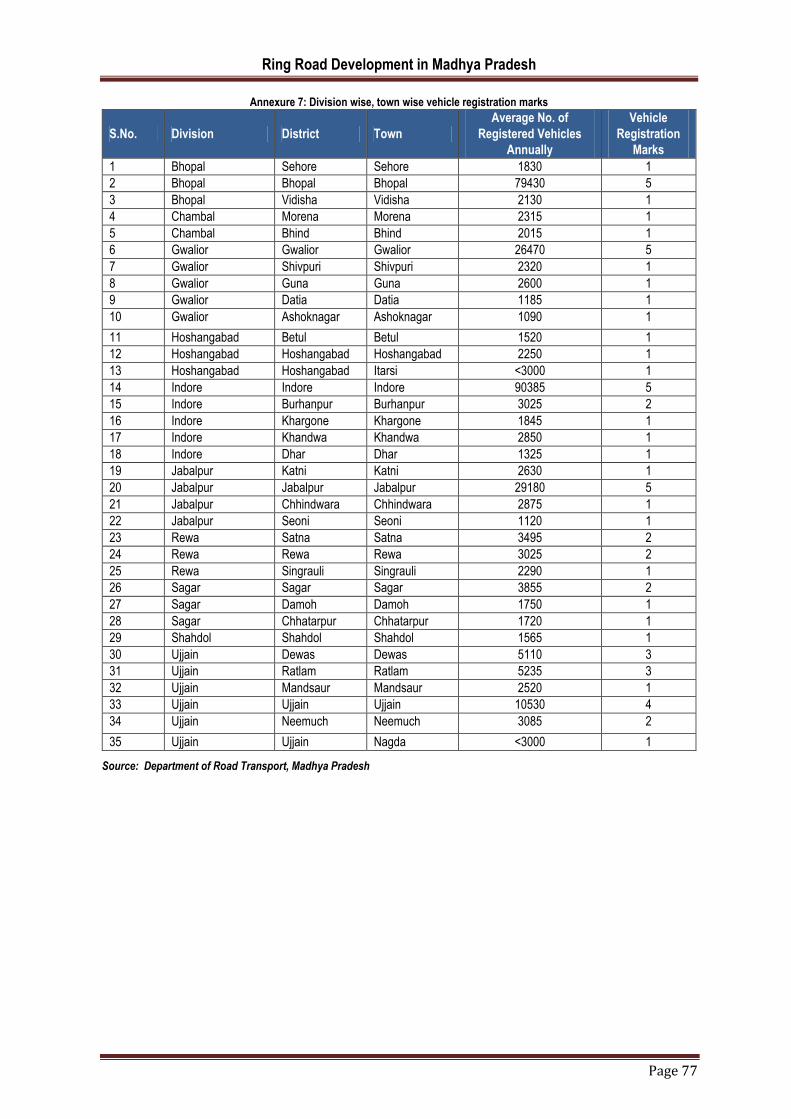
Ring Road Development in Madhya Pradesh
Page 77
Annexure 7: Division wise, town wise vehicle registration marks
S.No. Division District Town
Average No. of
Registered Vehicles
Annually
Vehicle
Registration
Marks
1 Bhopal Sehore Sehore 1830 1
2 Bhopal Bhopal Bhopal 79430 5
3 Bhopal Vidisha Vidisha 2130 1
4 Chambal Morena Morena 2315 1
5 Chambal Bhind Bhind 2015 1
6 Gwalior Gwalior Gwalior 26470 5
7 Gwalior Shivpuri Shivpuri 2320 1
8 Gwalior Guna Guna 2600 1
9 Gwalior Datia Datia 1185 1
10 Gwalior Ashoknagar Ashoknagar 1090 1
11 Hoshangabad Betul Betul 1520 1
12 Hoshangabad Hoshangabad Hoshangabad 2250 1
13 Hoshangabad Hoshangabad Itarsi <3000 1
14 Indore Indore Indore 90385 5
15 Indore Burhanpur Burhanpur 3025 2
16 Indore Khargone Khargone 1845 1
17 Indore Khandwa Khandwa 2850 1
18 Indore Dhar Dhar 1325 1
19 Jabalpur Katni Katni 2630 1
20 Jabalpur Jabalpur Jabalpur 29180 5
21 Jabalpur Chhindwara Chhindwara 2875 1
22 Jabalpur Seoni Seoni 1120 1
23 Rewa Satna Satna 3495 2
24 Rewa Rewa Rewa 3025 2
25 Rewa Singrauli Singrauli 2290 1
26 Sagar Sagar Sagar 3855 2
27 Sagar Damoh Damoh 1750 1
28 Sagar Chhatarpur Chhatarpur 1720 1
29 Shahdol Shahdol Shahdol 1565 1
30 Ujjain Dewas Dewas 5110 3
31 Ujjain Ratlam Ratlam 5235 3
32 Ujjain Mandsaur Mandsaur 2520 1
33 Ujjain Ujjain Ujjain 10530 4
34 Ujjain Neemuch Neemuch 3085 2
35 Ujjain Ujjain Nagda <3000 1
Source: Department of Road Transport, Madhya Pradesh

Ring Road Development in Madhya Pradesh
Page 78
Annexure 8: Division wise, town wise number of medium and large scale industries marks
S.No. Division District ULB's Name No. of medium and large scale industries
Industrial Activity Marks
1 Bhopal Sehore Sehore NA NA
2 Bhopal Bhopal Bhopal 19 4
3 Chambal Morena Morena 8 2
4 Chambal Bhind Bhind 0 0
5 Gwalior Gwalior Gwalior NA NA
6 Gwalior Guna Guna 6 2
7 Gwalior Datia Datia 1 1
8 Hoshangabad Betul Betul NA NA
9 Hoshangabad Hoshangabad Hoshangabad 2 1
10 Hoshangabad Hoshangabad Itarsi NA 3
11 Indore Burhanpur Burhanpur 4 1
12 Indore Khargone Khargone 9 2
13 Indore Khandwa Khandwa 1 1
14 Jabalpur Katni Katni NA NA
15 Jabalpur Jabalpur Jabalpur 17 4
16 Jabalpur Chhindwara Chhindwara 10 3
17 Jabalpur Seoni Seoni NA NA
18 Rewa Satna Satna NA NA
19 Rewa Rewa Rewa 6 2
20 Rewa Singrauli Singrauli 2 1
21 Sagar Damoh Damoh 2 1
22 Sagar Chhatarpur Chhatarpur 0 0
23 Ujjain Dewas Dewas 48 5
24 Ujjain Ratlam Ratlam 21 4
25 Ujjain Mandsaur Mandsaur 5 1
26 Ujjain Ujjain Ujjain 11 3
27 Ujjain Neemuch Neemuch 5 1
28 Ujjain Ujjain Nagda 0 0
Source: District Industrial Profile (2014-15) , MSME Development Institute, Indore

Ring Road Development in Madhya Pradesh
Page 79
Annexure 8 - Minutes of Meeting – Dewas Site Visit
Project- Selection of cities/towns for ring roads and bypass development in Madhya Pradesh
Place- Dewas, M.P.
Date- 25th February 2020
Time- 11:00 A.M.- 3:00 P.M.
Members in Attendance-
Mr. Arvind Chauhan
Mr. Lakhan Singh (Revenue Inspector)
Mr. Shekhar Solanki (Patwari)
Mr. K.K. Sheikh
Agenda-
Site visit for shortlisting Dewas town for ring road/ bypass development
Findings about Proposed Ring Road/Bypass as per Development Plan for Dewas 2031
The DP 2031 for Dewas has
proposed ring road/bypass as
shown in the map. The road
marked with blue colour in the
map is already constructed but
the road marked in red colour
is yet to be developed. The yet
to be developed road is
approx. 6.8 Km. The site visit
was made to explore the
ownership of land and land
acquisition rate falling under
land development.
The yet to be developed ring road passes through three villages Chandana, Mendki and Nagukhedi
The land falling under the proposed ring road is mostly agricultural. The land owned by the private owners
is 80% whereas the land owned by government is 20%
The land cost ranges from INR 1,76,00,000/hectare (towards the main road) to INR 35,00,000/hectares
(towards the village).
Presently, there is no action plan for development of missing part of ring road/bypass by any authority.
New Finding - Proposed Bypass by National Highway Authority of India
As stated by the authorities NHAI has already appointed a contractor for development of bypass road which is just
parallel to road which is missing part of ring road as per DP 2031. The road proposed by the NHAI is of 15 km
stretch which connects NH-3 to SH-18. It is at a distance of 12 km approximately from the existing settlement. The
distance of proposed bypass from the proposed ring road ranges from 6 km- 12 km.

Ring Road Development in Madhya Pradesh
Page 80
60% of the land falling under the proposed
bypass is under private ownership and
remaining 40% under the government
ownership
The cost of land ranges from 2
Crore/Hectare (towards main road) to 15-
35 Lakhs/Hectare (towards villages)
Presently, NHAI has acquired the land and
the work will start in a month’s time
Site Visit Pictures
Photo from point A Photo from point B Photo from point C
Photo from point D Photo from point E

Ring Road Development in Madhya Pradesh
Page 81
Annexure 9 – Information provided by NHAI, Regional Office, Bhopal
1. S. No. Name of Town Status of Ring Road
1 Ratlam No provisions of Ring Road at present by NHAI.
2 Neemach
3 Mandsaur
4 Dewas
5 Guna
6 Vidisha
2. S. No. Name of Town Status of Ring Road
1 Itarsi No Ring Road is proposed for Itarsi & Hoshangabad. However, combined bypass for Itarsi & Hoshangabad is under construction which is 33.5 Km length.
2 Hoshangabad
3. S. No. Name of Town Status of Ring Road
1 Jabalpur Bids for preparation of DPR & Feasibility Report for Jabalpur Ring Road of about 112 Km. length has been invited at NHAI-HQ, New Delhi. DPR Consultant is yet to be appointed.
4. S. No. Name of Town Status of Ring Road
1 Chhindwara Work of Rehabilitation and Up-gradation to 2-lane with paved shoulders and maintenance of Multai-Chhindwara-Seoni Section of NH-69A and Narsinghpur-Chhindwara-Saoner Section of NH-26B in Madhya Pradesh and Maharashtra including construction and maintenance of Ring Road and Connection Roads in Chhindwara Town has been completed in March, 2015 and currently under O&M Phase.
5. S. No. Name of Town Status of Ring Road
1 Morena Bypass in Morena Town has been proposed under 6-laning of Piprai to Nirwali Section of NH-3 under Bharatmala Pariyojana.
6. S. No. Name of Town Status of Ring Road
1 Sagar DPR for Bhopal-Sagar Road is under progress. Which is at Feasibility Stage, in which package-III (Starting near Berkheri @ Chainage 155+700 to Terminating point on NH-26 near Gadhphera @ Chainage 186+393) bypassing the Sagar Town towards left side of Bhopal-Sagar Section of NH-146.
7. S. No. Name of Town Status of Ring Road
1 Chhatarpur (i) At present on NH-39 i.e. Jhansi-Khajuraho 4 lane project is under implementation with a provision of Nowgaon-Chhatarpur bypass towards East direction, which covers half ring road. (ii)On North-East side another bypass is proposed in the Sagar-Kabrai 4 lane project on NH-34, which is under DPR stage. (iii) Further, the leftover South - West quarter bypass is also proposed by the PWD NH Division-Sagar for development of a two lane highway with paved shoulders, funded by MoRT&H. For this Land Acquisition is also taken up under section-3A of NH Act 1956. These three bypasses connectivity will make a ring road for Chhatarpur town.
8. S. No. Name of Town Status of Ring Road
1 Damoh No provisions of Ring Road at present by NHAI.
2 Rewa
3 Singrauli

Ring Road Development in Madhya Pradesh
Page 82
Annexure 9: Action Plan
Background
M/s KPMG and AIGGPA have prepared an Action Plan about the whole process and timelines.
Key Stakeholders
S. No
Deliverable / Stages
Description Contents of the deliverable Time T 0=letter
day
A - STAGE – 1 Selection of Consultant
1
Selection of
Consultant based
on QCBS.
Consultant to be
appointed for determining
the most feasible option
Preparation of RFP Document
Assist for Pre-bid meeting, Addendum, Corrigendum
Bid evaluation
Shortlisting of Consultant
T+30
B - STAGE – 2 Deliveries by Consultant 1) Inception Report
2 Inception Report
Inception report includes
the methodology,
development plans, Quality
Assurance
Project Appreciation
Approach Methodology
Task Assignment and Manning Schedule
Performa for data collection
Indicative design standards & cross section
Development Plans
Draft design standards
T+60
2) Feasibility Report
3
Feasibility Report
Feasibility report includes the methodology adopted and various kinds of necessary survey to be undertaken.
Overview of client organization/ activities
Methodology adopted for feasibility study
Socioeconomic profile of the project areas
Indicative design standards, methodologies, and specifications
Traffic surveys and analysis
Reconnaissance survey
Geotechnical Survey
Hydraulic and Hydrological Survey
T+130

Ring Road Development in Madhya Pradesh
Page 83
Materials Survey
Environmental screening/ preliminary environmental assessment
Initial social assessment/ preliminary land acquisition (LA) resettlement plan
Cost estimates
Most feasible ring road option study and Multi criteria Assessment Matrix.
Economic and financial analysis
Strip plan and Alignment
Alignment Options Study
Technical Specifications
Rate Analysis
Cost Estimates
Bill of quantities
3) LA and Clearances Report
4 Land Acquisition and Clearance Report
LA and clearance report includes various types of clearances required for the execution of the project.
Strip Plan: additional details added
Forest Clearance
Wildlife Clearance
Utility Clearances (Electricity, Water, Others)
Railway Clearances
Other clearances
Land Acquisition
T+165
STAGE – 3 1. Selection of Concessionaire
5 Selection of Concessionaire
The consultant shall prepare all required bid documents and technical schedules required for the bidding of the project to select the Concessionaire
Separate documents for each type of contract
Model Concession/Contract Agreements for PPP/ EPC projects,
Pre-bid meeting for the project
Signing of Concession Agreement with respective concessionaire
T+210
2. Detailed Project Report
6 Detailed Project Report
DPR would be used during project implementation by undertaking cost- benefit analysis.
Main Report
Introduction and Project background
Social analysis of the project
Reconnaissance survey
Traffic studies and demand forecast designs
Cost Estimates
Environmental Aspects
Economic and Commercial Analysis
T+315
3. Technical Schedules Report
7
Technical Schedules Report
Technical Schedules Report includes the type of bid documents and mode and terms of project execution.
Bid documents- EPC
Bid documents- BOT/PPP
Bid documents- other, if any
Draft concession agreement
Schedule D: Specifications & standards
T+315
4. Land Possession Report
8 Land Possession Report
It includes the details of the area where land is procured.
Village Level Summary Total private and public land being
acquired Status of disbursement on date of
receipt of land possession certificate Key issues being faced in completing
land acquisition, if any
Update land acquisition tracker with status of Notification
T+395

Ring Road Development in Madhya Pradesh
Page 84
Approach for Selection of 30 cities/towns
Department needs to follow the below mentioned methodology for the selection of 30 cities/towns:
Currently there are 378 ULBs in Madhya Pradesh and out of which 96 cities have master plan in place.
There needs to be a proper selection criteria/methodology to select 30 cities/town for further study and
survey. To ensure right cities/towns are selected, following enumerated steps should be followed:
Data Collection of Traffic census from MP road development, rural road development, NHAI
should be done to understand the current traffic scenario.
A detailed analysis of city’s/town’s master plan should be undertaken to understand the current
and upcoming industrial corridors, current and proposed greenfield and brownfield projects, city’s
current and projected growth, its connectivity with the highways and bypasses. Additionally, a
detailed analysis of future growth potential of cities should be undertaken keeping in mind the
following:
Livability: There are five fundamental aspects of great, livable cities: robust and
complete neighborhoods, accessibility and sustainable mobility, a diverse and resilient
local economy, vibrant public spaces, and affordability.
Industrial Development: Industrialization leads to urbanization by creating economic
growth and job opportunities that draw people to cities. Urbanization typically begins
when a factory or multiple factories are established within a region, thus creating a high
demand for factory labor.
NHAI passing through city: It is an important thing to note and demarcate the area
within the city which overlaps with the NHAI. In such areas city can develop bypasses
and the cost of development is shared with the NHAI thus reducing the burden.
Award Disbursement
Copies of notification published land possession certificate
Conclusions and Recommendations
GIS Map containing digitalized details of land parcels acquired with all relevant details
5. Construction of Ring Road
9 Financial Closure and Construction of Ring Road
Completion of Condition precedent of Authority and Concessionaire
Financial Closure of project
Signing of the Substitution Agreement between Concessionaire, Lender and the Authority
Construction of Road as per DPR submitted by Concessionaire
T+755
STAGE – 4
1. Appointment of Independent Engineer (IE) ( to be appointed after selection of Concessionaire)
10
Submission of Bid documents for Selection of Independent Engineer
RFP and Agreement
General terms of bidding
Criteria for Evaluation
Scope of Independent Engineer (IE)
Role of IE in Development period
Role of IE in Construction period
Reporting schedule
Inspection
Payment Structure and Schedule of Payment
Monthly Progress Report
T+240

Ring Road Development in Madhya Pradesh
Page 85
City Growth Corridors: A city growth corridor consists of two perspectives to develop
a city:
Neighborhood Development: It is done by identifying the potential areas for
development near to an already developed city thus decongesting the main city
and also enabling the nearby areas to grow, flourish and prosper.
Development around Core Strength: Developing a ring road and bypasses
keeping in mind the core strength of the city, say: tourism, IT hub, agriculture,
natural resources will ensure a long term holistic development.
Economic Impact Analysis: To support the aforesaid growth potential analysis, an Economic
Impact Analysis may also be undertaken. This analysis would help identify the key parameters
against which a city’s economic value-added may be assessed. A detailed analysis of the
following parameters may be undertaken:
Current Pucca Road Length
Current Contribution of City Revenue to State Revenue
Average Daily Migration from City to Bigger nearby City.
Current Level of Public Amenities available in the city/town like Sanitation, Water Supply,
Sewerage facilities and Septage management.
A detailed projection of Savings in Accidental Cost, Vehicle Operating Cost (VOC) Savings,
and Passenger Time Savings vis- a vis Social and Environmental Costs should be
undertaken in case a ring road comes up in that city/town.
Current Distance between habitable areas and Schools, Colleges, Hospitals should be
undertaken.
Land Assembly Models
In pursuit of spatial development, the government should not always be expected to spend money, or participate directly in building activities and development programmes. Private sector resources should also be appropriately mobilized for investment in development of urban centers. The role of private sector in the development process has been duly recognized nationally. As a general fiscal policy on resource mobilization, it would be desirable to have a proper mix of public and private sectors participation, both playing a symbiotic role in such a way that the public infrastructure programme is implemented through budgetary sources, while the facilities could be provided through private sector. A joint venture could also be explored where practical. Land Mobilization Land is most essential resource required for infrastructure development and service delivery. To play its role as service provider (/facilitator), the government requires land for developing new infrastructure projects or expansion of old ones to cater the needs of the increasing population. One of the ways government achieves this is through land assembly by from private land owners. Land assembly and development mechanism are undertaken for achieving optimum social use of urban land and to ensure adequate availability of land to public authority and individuals. Public private participation is achieved in land development through various techniques. Land assembly techniques prevent concentration of land in few hands and promote its efficient social and economic allocation. Some of the land assembly techniques also promote flexibility in land utilization in response to changes resulting from growing city. The various mechanisms to assemble and/or develop land are enlisted below:

Ring Road Development in Madhya Pradesh
Page 86
Land Acquisition: “Land Acquisition” means the acquisition of land for some public purpose by a government agency from individual landowners, as authorized by the law, after paying a government-fixed compensation to cover losses incurred by landowners from surrendering their land to the concerned government agency. The land acquisition process can be undertaken by the State or through private initiatives.
Bulk land acquisition method as a State Initiative: In this method, Master Plan is prepared for the entire area for different land uses and various urban activities. Land is developed in accordance to the planning norms for various uses/activities and is disposed-off accordingly. Bulk land is acquired from farmers by the development agency and compensation is paid to farmers/owners based on the provision of prevailing act.
Bulk land acquisition method with Private Initiative: To defray the cost of land acquisition some state governments and ULBs have developed models in which private sector acquire land by directly paying compensation to the affected families. A variety of models are in existence through which land is acquired for planning urban growth with the private partnership. The following alternate methods could be used to make the land acquisition more flexible and responsive to people in order to reduce the burden and conflict between landowner and government.
Private developers could be allowed to acquire land directly from landowners for township development. A joint venture financial model of urban development can be adopted as alternate to land development to fund
the acquisition and provision of facilities in new parcel of land. Separate set of compensations could be decided for acquisition of land for public or private projects.
Land Pooling: The land pooling technique is a mechanism for temporary pooling of different land for a unified planning and thereafter sub-dividing and collecting betterment charges to finance the infrastructure works. In addition, the local authority can secure land free of cost for public purposes and EWS housing after returning part of the developed land to original landowners. The reconstituted plots are allotted to the land owners in proportion to their original land holdings.
Land Reservations: The concept of Accommodation Reservation allows the land owners to develop the sites reserved for an amenity in the development plan using full permissible FSI/FAR on the plot subject to agreeing to entrust and hand over the built-up area of such amenity to the local authority free of all encumbrances and except full FAR/FSI as compensation in lieu thereof. The area utilized for the amenity shall not form part of FAR/FSI calculation. Reservations such as retail markets, dispensaries, etc. can be implemented in this way wherein local authority is not required to acquire the land by incurring expenditure on payment of compensation. In case of road widening and construction of new roads, the local authority can grant additional FSI on 100 % of the area required for road widening or for construction of new roads proposed under the development plan, provided the owner surrenders the land for widening or construction of new roads to the local authority free of all encumbrances and accept the additional FAR/FSI as the compensation in lieu thereof. This mechanism has considerably relieved local authorities from incurring huge expenses for the purpose of acquisition of such lands.
Transferable Development Rights: TDR is a technique of land development, which separates the development potential of a particular parcel of land from it and allows its use elsewhere within the defined zones of the city. It allows the owner to sell the development rights of a particular parcel of land in exchange of another land parcel. This entitlement is over and above the usual FSI available for the receiving plot in accordance with the prevailing laws and regulations, which entitles a landowner to construct additional built-up area on his existing building or vacant land. TDR is taken away from the zone and it is tradable which makes it different from Accommodation reservation. This is also generally used as a technique for redevelopment of inner-city zones and for reconstruction. TDR is a useful tool for re-development of land. However, it has its prospects and consequences as understood from the implementation experience in various cities in India. Hence it should be used carefully.
Transferable Development Rights (TDR): TDRs, primarily used in Greater Mumbai involves separating development rights from the ownership of land. Given the extremely high land prices, the housing supply in Mumbai can be increased and profits multiplied only if more habitable space can be built on less land. TDRs means a development right to transfer the potential of a plot designated for a public purpose in a plan (expressed in terms of total permissible built space calculated on the basis of Floor Space Index or Floor Area Ratio allowable for that plot) for utilization by the owner himself or by way of transfer by him to someone else from the present location to a specified area in the plan, as additional built space over and above the permissible limit in lieu of compensation for the surrender of the concerned plot free from all in cumbrances to the planning and development authority. With TDR, one can sell the rights of development of a specific land with exchange

Ring Road Development in Madhya Pradesh
Page 87
of money to another person. The developer can get additional built-up area to development in the zone of development. In Mumbai, a landowner whose land is acquired gets a TDR or monetary compensation. He can use this in his remaining land, on any other land owned by him or trade TDR in the open market. While the amount of TDR granted is equal to the plot area surrendered; if the amenity for which the plot is intended is also built and handed over free to the municipal corporation by the landowners, an additional TDR to the extent of the built up area of the amenity is allowed. TDRs can however only be used in designated receiving zones. These zones exclude sensitive and congested zones. The Government of Maharashtra extended the concept of TDRs to slum redevelopment schemes. The private developer re-houses the slum-dwellers free of cost in self-contained tenements of 269 sq.ft carpet area in multi-storied buildings. In return, the developer gets to construct a built up area equivalent to that constructed on the balance plot of land previously occupied by the slum and can sell it in the market. While the mechanism effectively reduces the land availability per slum dweller, it provides them formal housing with ownership, better housing conditions and in effect increases the total housing stock. About one lakh slum dwellers have been rehabilitated through such schemes. TDRs can be a viable option only under a stable and growing property market where the value of TDR would be greater than compensation. Extremely high land prices, limited land availability and vertical pattern of city development are the potential factors for implementing the TDRs.
Guided Land Development: The mechanism is used for the conversion of privately- owned land in the urban periphery from rural to urban uses. The approach is seen as a solution for adhoc, uncontrolled urban development in which informal housing and other development occurs with no regard to formal planning. It is also a response to the limited availability of urban land for Economically Weaker Sections (EWS) in urban areas. It is done in partnership with landowners who pay for the cost of servicing their land through donation of land for public infrastructure and payment of a betterment levy. The government can thus select the area for development and provide for the essential infrastructure. This paves the way of the entry of private developers in the area. Unlike the land pooling mechanism, the government need not decide the amount of land to be returned to the landowners at the end of the project. The approach is cost effective as the landowners of the designated area donate land for roads and right of way for infrastructure and public spaces, as well as pay a ‘betterment levy’ to meet the costs. The increase in the value of land due to the provision of infrastructure and conversion of land use from rural to urban justifies the imposition of betterment levy from the landowners. In areas with fragmented landownership, this method may need considerable time for building consensus. There is also a great deal of potential for default of the betterment levies by the land owners. This approach was applied in Chennai, under the World Bank-assisted Tamil Nadu Urban Development Project with Chennai Metropolitan Development Authority (CMDA) as the nodal agency. The Guided Urban Development Scheme in Tamil Nadu was a noteworthy effort to provide for housing supply for the marginalized sections. According to the approach, the private sector developer/land owner affected by the Urban Land Ceiling Act was encouraged to provide serviced sites for the EWSs for exemption from the Act. While acquisition of private land has its cost implications, there are several land based financing mechanisms4 that help use the land values to finance infrastructure development. Given the limited financial capability of the government, this is now becoming an important element of urban infrastructure finance in developing countries especially where cities are growing rapidly. Extensive literature has also developed on unlocking land values for financing infrastructure development. According to a recent Study by McKinsey (2014), that here is no land for affordable housing is a myth and the need is to unlock land at appropriate locations in the cities. The Study highlights six mechanisms that have been used around the world to unlock urban land for affordable housing. A judicious choice of innovative methods of urban land assembly mechanisms along with the financing mechanisms will be critical for achieving urban infrastructure development in general and meeting the housing sector targets in particular.
Fiscal Resource Mobilization
Availability of fiscal resources play an important role in providing quality and seamless social, civic, physical and economic infrastructure services to the public. Municipal finances are critical in initiating many urban and local governance projects, as financial resources’ strategic management plays a vital role in ensuring long-term sustainability of local services and infrastructure.

Ring Road Development in Madhya Pradesh
Page 88
There are diverse options of source finance available for developmental projects these days. These traditional and innovative sources of financing for projects at State and ULB level through funding and revenue sources are detailed below:
Taxes: State government authorises local governments by law, to collect taxes. Taxes are major source of revenue of urban local bodies. Property tax, profession tax and advertisement tax are major sources of revenue in local governments.
Charges and fees: Local bodies levy charges and fees for the services provided to citizens. These charges, for water supply, solid waste management, parking and other such services to cover the cost of undertaking the provision of services.
Grants and Subsidies: Grants and subsidies are generally given by central government to state/ local government or State to local government for development and provision of services to citizens.
Public Private Partnership: PPP is an agreement between public and private entity for providing services or infrastructure to citizens. It helps municipal authorities to shed some of its functions and evolve alternative institutional arrangement for the performance of such functions.
Loans from financial institutions: Public and private organisations come together to pool funds from public and investing it in financial assets. Such loans are for long term.
Funding by Bilateral and Multilateral Agencies: These are developmental agencies which provide soft loans for infrastructural projects. Almost all such loans are backed by sovereign guarantee and take long process to access.
Foreign Direct Investment: FDI is direct investment from company or entity into a foreign country.
Pooled Finance Development Fund (PFDF) Scheme of Government of India: PFDF is meant to provide credit enhancement grants to enable ULBs to access market borrowings to facilitate development of municipal infrastructure.
Municipal Bonds and Debentures: Municipal bonds and debentures are issued by ULBs and Infrastructure Funds, to general public or specific institutional investors to raise finance for developing physical infrastructure.
Deployment of PMU
Department need to establish PMU, This team would act as project support units for MPPWD.
Scope of Project Management Unit (PMU) as per below:
Prioritization of city for undertaking study on Ring road development through PPP ( A&M as per point no 5)
Assist Department in preparation of Tender document for Appointment of Consultant
Assist MPPWD in Review of Feasibility Reports submitted by the consultant
Assistance in approval of Feasibility Report.
Assistance in approval of Project by Directorate of Institutional Finance, Government of Madhya Pradesh
Preparation of Tender Document for appointment of concessionaire with the help of the selected Consultant
Preparation of RFP & draft CA for appointment of Concessionaire for development of the project.
Assist Consultant for Bid process management
Arrange the pre bid meeting on behalf of MPPWD
Prepare corrigendum and addendum for the respective projects.
Facilitating in bid management and post bid management services.
Assist consultant for Preparation of Tender Document for Appointment of Independent Engineer
Arrange the Pre bid Meeting on behalf of MPPWD

Ring Road Development in Madhya Pradesh
Page 89
Facilitating in bid management and post bid management services.
Progress Review of Ring road project by selected Concessionaire, Independent Engineer and ULBs
Address issues, if any, of ULBs and other stakeholders, Concessionaire and Independent Engineer at the time of implementation of project
Finalization of Timeline with the help of Monitoring toolkit of Project.
Guide MPPWD to review financial closure document submitted by Concessionaire.
Assist MPPWD by drafting letters for seeking environmental clearance and other Government approvals.
Assist stakeholders by calculating desired VGF from GoI and GoMP, where needed.
Assist MPPWD on day-to-day correspondences with stakeholders, GoI, ULBs, Concessionaire and Independent Engineer.
Next Steps for implementing the proposed Project
A) Support would be needed from the Department in arranging the following
documents/information: Report of Traffic census from MP road development, rural road development, NHAI
Master Plan of all 96 cities
List of Government Land available near Ring road ,Land data, land records, land use and FSI details to be provided by MPPWD (in enclosed format)
Payment for all survey of site to locate the land boundaries and also the extent of redevelopment work required as well as details of encroachment or any alternative survey cost to be incurred by MPPWD; payments if any to be made in future for cost of land use change or cost for additional FSI or any other amount payable to Development Authority to be paid by MPPWD.
Periodic Reviews with senior officers.
B) Resource Deployment For this work, a dedicated team of up to four resources would be required. This team would act as
PPP support units and would be deployed for 6 months for undertaking a gamut of activities including feasibility studies, tender documentations, followed by for implementation support & coordination with concessionaires and PMC over a period of 16 months. Required resources for PMU as per below:
PPP Expert
Finance Expert
Urban Planner
Senior nodal officer from MPPWD to be appointed to coordinate with the deployed resources
Logistical support for PPP support team (office space, local transport etc.)
The assigned resources will work on a Time and Material (T&M) model wherein they will support MPPWD (the ‘client’) with the ring road project. The team will work under the supervision and strict control of the client. However, the team will not sign any document on behalf of the client (including bid evaluation report).
Selection of Consultant
A consultant would need to be appointed who will assist the Department in undertaking the initial ground work. The
consultant would be expected to conduct a feasibility study which would include at least the following areas:
Background
Current traffic conditions leading to proposals for a [CITY] Ring road /by-pass

Ring Road Development in Madhya Pradesh
Page 90
Status of the current feasibility study
Study of master plan of ( CITY) and realignment of ring road as per availability of Government land
Primary objectives of the feasibility study
To determine the most feasible ring road option for improving conditions for through transit travel around
[CITY]
To secure funding assistance for the proposed by-pass
Secondary objectives of the feasibility study
To reduce traffic congestion within [CITY]
To open up more land for urban development
Potential role of the private sector under PPP arrangements
Structure of the refined feasibility study report
Tender document Appointment of concessioner
Tender document for appointment of IE
The following specific qualifications should be demonstrated in the feasibility study team
Strong team leader with proven management skills in rural and urban road feasibility studies.
Highway design engineering
Urban traffic management
Traffic modeling
Urban land development planning
PPP concession design for road projects
Environmental, social, and cultural heritage impact specialists.
Legal (especially for concessions and impact assessment requirements).

Ring Road Development in Madhya Pradesh
Page 91
References:
1. Saransh Rajeev Jain, Sandeep Verma (August 2018), “Analysis of construction in terms of Sustainability in Sagar city ring road project”, International Research Journal of Engineering and Technology (IRJET), Volume: 05 Issue: 08
2. Various Development Plans prepared by Department of Town and Country Planning, Madhya Pradesh retrieved from
http://mptownplan.nic.in/map.html
3. Ministry of Road and Transport (2017), Bharatmala Pariyojna, retrieved from https://archive.pib.gov.in/documents/rlink/2017/oct/p2017102503.pdf
4. District wise various industrial profiles prepared by MSME Development Institute, Indore
5. Manav Thadani, Karan Kapoor (2019) India State Rankings Survey, Hotelivate
6. Ministry of Urban Development, Government of India (2018), Liveability Standards in Cities