report on identification and geographical information
TRANSCRIPT

1
Report on Open Spaces for Humanitarian Purposes in Gosainkunda Rural Municipality
Updated Report on 83 Open Spaces Identified for Humanitarian Purposes in Kathmandu Valley
Report on Identification and Geographical Information System (GIS) Mapping of Open Spaces for Humanitarian Purposes in Gosainkunda Rural Municipality
2
Chapter 1: Introduction
The opinions expressed in this report are those of the authors and do not necessarily reflect the views of the International Organization for Migration (IOM). The designations employed and the presentation of material throughout the report do not imply the expression of any opinion whatsoever on the part of IOM concerning the legal status of any country, territory, city or area, or its authorities, or concerning its frontiers or boundaries.
IOM is committed to the principle that humane and orderly migration benefits migrants and society. As an international organization, IOM acts with partners in the international community to; assist in meeting the operational challenges of migration; advance understanding of migration issues; encourage social and economic development through migration; and uphold the human dignity and well-being of migrants.
Publisher: International Organization for Migration 768/12 Thirbam Sadak, Baluwatar – 5 P.O. Box 25503 Kathmandu, Nepal Tel.: +977-1-4426250 Fax: +977-1-4435223 Email: [email protected] Website: http://nepal.iom.int
Research team: Uttam Pudasaini, Project Lead Madan Acharya, GIS Analyst Anil Kumar Mandal, Photogrammetry and Remote Sensing Officer Neelam Thapa Magar, Research and Documentation Officer Yeshwant P.B. Pariyar, Graphic and Web Designer Roniksh Budhathoki, GIS Officer Megharaj Neupane, GIS Officer
Editors: Louise Jönsson Andersson, IOM Nepal Tripura Oli, IOM Nepal
Technical review team: Dipina Sharma Rawal, IOM Nepal Jitendra Bohara, IOM Nepal
This publication has been issued without formal editing by IOM.
© 2020 International Organization for Migration
All rights reserved. No part of this publication may be reproduced, stored in a retrieval system, or transmitted in any form or by any means, electronic, mechanical, photocopying, recording, or otherwise without the prior written permission of the publisher.

3
Report on Open Spaces for Humanitarian Purposes in Gosainkunda Rural Municipality
Report on Identification and Geographical Information System (GIS) Mapping of Open Spaces for Humanitarian Purposes in Gosainkunda Rural Municipality

4
Chapter 1: Introduction
i
Report on Open Spaces for Humanitarian Purposes in Gosainkunda Rural Municipality
FOREWORD
I am pleased to present the publication, “Report on Identification and Geographical Information System (GIS) Mapping of Open Spaces for Humanitarian Purposes in Gosainkunda Rural Municipality,” funded by
the people of Thailand through the Government of Thailand.
IOM – the United Nations Migration Agency – has been supporting the Government of Nepal with the
identification, mapping and protection of open spaces to be used for humanitarian purposes since 2013.
Floods, earthquakes and landslides are some of the natural hazards that have resulted in the loss of lives,
and damage to properties in the Rural Municipality. Open spaces are identified and mapped with the aim
to strengthen emergency preparedness and provide the initial response planning framework for local
governments and partner agencies. This gives a starting point from which to provide life-saving assistance
to those in immediate need of support, including displaced populations.
IOM is also supporting in creating a module on open spaces into the Building Information Platform Against
Disaster (BIPAD), owned by the Government of Nepal. BIPAD will display information on all open spaces,
including the spaces of Gosaikunda Rural Municipality identified and verified by IOM in coordination with
local levels and the federal government. I am also glad to announce the launch of Open Space Nepal, which
is available in Google Play Store for Android phones and AppStore for the iOS version, developed with the
purpose of providing guidance for the public in the event of a disaster.
I express sincere gratitude to the Gosaikunda Rural Municipality for providing strong leadership that
supported in achieving the objectives of the project. Lastly, IOM stands ready to support all three tiers of
government to reduce disaster risks and assist vulnerable communities and migrants in building a disaster-
resilient society.
Lorena Lando
Chief of Mission of Nepal
International Organization for Migration (IOM)
FOREWARD
I am pleased to present the publication, “Report on Identification and Geographical Information System (GIS) Mapping of Open Spaces for Humanitarian Purposes in Neelakantha Municipality,” funded by the people of Thailand through the Government of Thailand.
IOM – the United Nations Migration Agency – has been supporting the Government of Nepal with the identification, mapping and protection of open spaces to be used for humanitarian purposes since 2013. Floods, earthquakes and landslides are some of the natural hazards that have resulted in the loss of lives, and damage to properties in the Municipality. Open spaces are identified and mapped with the aim to strengthen emergency preparedness and provide the initial response planning framework for local governments and partner agencies. This gives a starting point from which to provide life-saving assistance to those in immediate need of support, including displaced populations.
IOM is also supporting in creating a module on open spaces into the Building Information Platform Against Disaster (BIPAD), owned by the Government of Nepal. BIPAD will display information on all open spaces, including the spaces of Neelakantha Municipality, identified and verified by IOM in coordination with local levels and the federal government. I am also glad to announce the launch of Open Space Nepal, which is available in Google Play Store for Android phones and AppStore for the iOS version, developed with the purpose of providing guidance for the public in the event of a disaster.
I express sincere gratitude to the Neelakantha Municipality for providing strong leadership that supported in achieving the objectives of the project. Lastly, IOM stands ready to support all three tiers of government to reduce disaster risks and assist vulnerable communities and migrants in building a disaster-resilient society.
Lorena Lando Chief of Mission of Nepal International Organization for Migration (IOM)

ii
Chapter 1: Introduction

iii
Report on Open Spaces for Humanitarian Purposes in Gosainkunda Rural Municipality
FOREWORDFOREWORD

iv
Chapter 1: Introduction
iv

v
Report on Open Spaces for Humanitarian Purposes in Gosainkunda Rural Municipality
ACKNOWLEDGEMENTS
The "Identification and Geographical Information System (GIS) Mapping of Open Spaces for Humanitarian Purposes in Gosainkunda Rural Municipality”l report is produced as a part of the “People to People Support for Building Community Resilience through Recovery and Reconstruction in Nepal” project, funded by the people of Thailand through the Government of Thailand.
First and foremost, we would like to extend our gratitude to the elected representatives and municipal officials of Gosainkunda Rural Municipality, Rasuwa who actively participated and supported the team in the preparation and validation of this report. Special thanks goes to Kaisang Nurpu Tamang, Chairperson, Gosainkunda Rural Municipality, Rasuwa and ward chairpersons of all six wards for their support and guidance throughout the study period. Similarly, we would like to thank the Project Steering Committee (PSC) members at the federal level represented by the high level officials of the Ministry of Federal Affairs and General Administration, Ministry of Home Affairs and Ministry of Urban Development as well the Local Project Steering Committee (LPSC) members at the municipal level for their valuable inputs and comments during the entire study period.
Equally, we would also like to thank all the individuals from Gosainkunda Rural Municipality and the humanitarian actors representing different agencies who took time to share their views and gave their valuable feedback continuously during the consultations, via phone and email, for the validation of the report which greatly helped us in improving the content of the report.
Lastly, we would also like to thank the team of Naxa for the collection and analysis of data, maps and photos of each identified open space. This report would not be possible without the tireless efforts of the team involved.

vi
Chapter 1: Introduction
vii
Report on Open Spaces for Humanitarian Purposes in Gosainkunda Rural Municipality
TABLE OF CONTENTS
Foreword i
Acknowledgements v
List of figures viii
List of tables viii
List of acronyms and abbreviations ix
Executive summary xi
CHAPTER 1. INTRODUCTION 1
1.1.Background 1
1.2. Objectives 2
1.3. Survey location 2
1.4. Open-space selection criteria 3
1.5. Limitations 4
CHAPTER 2. OPEN-SPACE IDENTIFICATION PROCESS 5
CHAPTER 3. SURVEY OUTPUTS 9
3.1. High-resolution map products 9
3.2. Open Space Map Atlas 9
3.3. Open spaces for humanitarian assistance 9
3.4. Critical facilities 11
3.5. Other locations 12
3.6. Open space platform for humanitarian assistance 12
3.7. Open space mobile application 13
CHAPTER 4. CONCLUSION 15
4.1. Conclusion 15
CHAPTER 5. ANNEXES 17
References 27

viii
Table of contents
LIST OF FIGURES
Figure 1: Location map of Gosainkunda Rural Municipality 3
Figure 2: Synopsis of open-space identification process 5
Figure 3: Interaction with local stakeholders in Gosainkunda Rural Municipality 6
Figure 4: Detailed topographical survey using a drone 7
Figure 5: Location map of open spaces in Gosainkunda Rural Municipality 10
LIST OF TABLES
Table 1: Specifications of the drone survey 7
Table 2: Generic information of humanitarian open spaces in Gosainkunda Rural Municipality 10
Table 3: Available critical facilities near humanitarian open spaces in Gosainkunda Rural Municipality 11

ix
Report on Open Spaces for Humanitarian Purposes in Gosainkunda Rural Municipality
LIST OF ACRONYMS AND ABBREVIATIONS
BIPAD Building Information Platform Against Disaster
CCCM camp coordination and camp management
DIMS disaster information management system
DSM Digital Surface Model
DTM Digital Terrain Model
GIS geographic information system
GPS Global Positioning System
IDP internally displaced person
IOM International Organization for Migration
MoFAGA Ministry of Federal Affairs and General Administration
MoHA Ministry of Home Affairs
MoUD Ministry of Urban Development
VDC Village Development Committee
WASH water, sanitation and hygiene

x
Chapter 1: Introduction

xi
Report on Open Spaces for Humanitarian Purposes in Gosainkunda Rural Municipality
EXECUTIVE SUMMARY
In 2015, the Constitution of Nepal was promulgated, and the country initiated its federalization process which divided the Government into three tiers: federal, provincial, and local. Before the federalization, 83 identified open spaces were a national-level responsibility and protected through the publishing of a national gazette in 2013 that listed all open spaces. The national gazette also includes provisions for monitoring of 83 open spaces to prevent encroachment of the sites. Since the federalization, the local government is also responsible for the protection of such areas in their urban or rural municipalities.
In this context, IOM – the UN Migration Agency – as co-lead of the Camp Coordination and Camp Management cluster and with support from the Ministry of Urban Development, Ministry of Home Affairs and Ministry of Federal Affairs and General Administration, undertook a survey to identify suitable open spaces in five municipalities of five earthquake affected districts from Bagmati and Gandaki Provinces. The project aims to enhance the decision-making process at a municipal level to mitigate possible losses during a disaster by identifying and updating open spaces. Identification and mapping of open spaces in Gosainkunda Rural Municipality of Rasuwa District is one of the components of the project.
The scope of this study covers a detailed topographical survey of all identified open spaces, collection of attribute information, environmental checklist, collection of data on critical infrastructures around each identified open space and development of various maps. The scope also includes dissemination of the maps through both digital and hard copy platforms as well as installation of map boards at prominent locations within the Municipality. Further, the study promotes the preparation and use of open data for disaster preparedness as the datasets collected during the survey will also be uploaded to the national disaster information management system or Building Information Platform Against Disaster platform developed by the Government of Nepal.
43 locations were suggested as suitable open spaces by local representatives, from which five open spaces have been finalized after a detailed field study and series of interactions with elected local representatives, municipal officials, local stakeholders and humanitarian actors. Most of the suggested locations were not considered suitable due to small area, high gradient and difficult access. The five identified open spaces have a total area of 23,265.80 m2 and total usable area of 9,650 m2. As per the Sphere Standards (3.5 m2 per person), the total usable area can accommodate at least 2,757 displaced persons. The selection of these open spaces is based on the total area with a slope of 0-5°, road accessibility, distance from settlements, availability of water, sanitation and hygiene facilities, market access and availability of other critical facilities near the open spaces. Besides these five finalized open spaces, 12 other locations as suggested by the local population were also surveyed and details on their current land use practice and total usable flat area were collected.
This assessment was conducted as a part of the “People to People Support for Building Community Resilience through Recovery and Reconstruction in Nepal” project, financially supported by the People of Thailand through the Government of Thailand. The project is being implemented in the eight worst 2015 earthquake affected rural and urban municipalities of Bagmati and Gandaki Provinces.

xii
Structure of the report
STRUCTURE OF THE REPORT
This report is divided into four chapters. The first chapter is the introductory part of the project which includes details on the background on project development, survey objectives, survey location, the description of open-space selection criteria as per the Sphere Standards and limitations of the study. The second chapter details the open-space identification process for the collection of relevant data and geographic information system (GIS) mapping. The third chapter contains the survey outputs with details of finalized and surveyed open spaces. Conclusion is included in the fourth chapter followed by Annexes.

1
Report on Open Spaces for Humanitarian Purposes in Gosainkunda Rural Municipality
CHAPTER 1 iNTRODUCTiON
1.1. Background
Nepal is prone to a multitude of disasters that cause loss of lives, property and infrastructure. Globally, Nepal ranks fourth, eleventh and thirtieth in terms of its vulnerability to climate change, earthquake and flood risk respectively (United Nations Development Programme, 2019). The 2015 earthquakes and subsequent aftershocks resulted in loss of lives, physical infrastructures and cultural monuments, and left thousands of people homeless. 597 people were reported dead and 7,949 were reported as injured in Rasuwa (National Planning Commission, 2015). Most fatalities resulting from the earthquake were due to an avalanche that buried inhabitants of Langtang village including tourists in the guesthouses.
Rasuwa is one of the worst affected districts by the 2015 earthquakes. It was also estimated that more than 82 per cent of the population in Rasuwa were affected and around 8,000 buildings were destroyed due to 2015 earthquakes (OSOCC Assessment Cell, 2015).
2,732 people were displaced in Rasuwa (IOM Nepal, 2016), most of whom took shelter on open lands or grounds near their houses and in temporary displacement sites. The earthquakes also triggered several landslides in Rasuwa District. The landslide was mainly due to the District's rugged topography, complex geography and improper land use. Around 1,400 landslides were detected in Rasuwa since the 2015 earthquakes (Pokharel & Thapa, 2019). Several villages in the district are exposed to a series of disaster risks such as landslides and avalanches. Haku, Dandagaun and Thulogaun regions of Rasuwa District are the most susceptible areas for landslides distributed along the roadways and near the river streams.
With realization of the significance of open spaces during emergency situations, especially in the remote mountain region like Gosainkunda, IOM decided to identify and document open spaces that could be used for humanitarian purposes.
The open-space mapping in Gosainkunda involved a detailed topographical mapping of all the identified spaces using a drone.1 The high-resolution images have been useful in the preparation of detailed geographic information system (GIS) maps. Moreover, both the aerial images and the maps can be used as baseline data during camp management and effectively plan the construction of temporary shelters during a disaster. This project, the first of its kind in Gosainkunda, also focuses on digitally recording and disseminating the data of both the open spaces and critical facilities through static community map boards and digital tools. The datasets will then be made available to all users in an open data format through the disaster information management system (DIMS) or the Building Information Platform Against Disaster (BIPAD)2 platform, the open space platform for humanitarian assistance and the open space mobile application. The data of open spaces and critical facilities can serve as strong evidence resources to enhance the preparedness of Gosainkunda Rural Municipality to plan before, during and after a disaster.
1 A drone, in technological terms, is an unmanned aircraft. Essentially, a drone is a flying robot that can be remotely controlled or fly autonomously through software-controlled flight plans in their embedded systems, working in conjunction with onboard sensors and GPS. https://internetofthingsagenda.techtarget.com/definition/drone
2 BIPAD plarform can be assessed at https://bipad.gov.np/np/

2
Chapter 1: Introduction
1.2. Objectives
One of the primary objectives of this project is to identify and map the most appropriate open spaces in Gosainkunda Rural Municipality that can be used for humanitarian purposes during a disaster. In this respect, the scope of work is designed to achieve following objectives:
(a) Topographical surveying and mapping of open spaces in Gosainkunda Rural Municipality:
(i) Drone based topographical survey of identified open spaces in Gosainkunda Rural Municipality.
(ii) High-resolution aerial images of each identified and finalized open spaces showing natural and man-made resources as well as structures within the periphery.
(iii) Collection of Global Positioning System (GPS) datasets on critical facilities around the open spaces.
(b) Collection of attribute data and general environmental assessment:
(i) Collection of attribute details (access to market and critical facilities, land use types, and so on) of all open spaces.
(ii) Collect cadastral and property information as per land records for each identified open space (if available).
(iii) Assess different environmental aspects for each open space to study the implications of the interventions during a disaster and in the camp management.
(c) Dissemination of open-space data and GIS maps
(i) Preparation of GIS maps of each finalized open space along with vicinity maps showing critical facilities around.
(ii) Development of a web-based open space platform for humanitarian assistance and an open space mobile application which allows users to locate the nearest open space during an emergency.
(iii) Installation of community maps with details of open spaces and critical facilities at specific locations in Gosainkunda Rural Municipality.
(iv) Dissemination of open spaces and critical facilities data to a wider audience and stakeholders by integrating these datasets in the national DIMS or BIPAD platform.
1.3. Survey location
Gosainkunda Rural Municipality is situated in Rasuwa District of Bagmati Province. The Rural Municipality was established in 2017 as a local government body and it consists of six wards: Thuman, Timure, Briddhim, Langtang, Syaphru and Dhunche. This Rural Municipality has a total area of 987.77 km2 and 2,017 households. The total population is 7,143 out of which 3,697 are male and 3,446 are female.

3
Report on Open Spaces for Humanitarian Purposes in Gosainkunda Rural Municipality
Figure 1: Location map of Gosainkunda Rural Municipality
The 2015 earthquakes affected 31 districts of which 14 were categorized as severely affected. Rasuwa is one of these severely affected districts in Nepal. Besides earthquakes, several villages in Rasuwa District are also vulnerable to landslides, avalanches and floods. As this district is vulnerable to various disasters and anticipating the impacts of such disasters, IOM, as co-lead of the Camp Coordination and Camp Management (CCCM) cluster, undertook a study to identify open spaces in Gosainkunda of Rasuwa District as well as in four other earthquake affected districts in Bagmati and Gandaki Provinces. Disaster management requires a determined and integrated national effort which needs to be well coordinated at all levels of government: local, provincial and federal. The major reason behind considering the municipalities of the worst affected districts for this project is to reduce risks by mainstreaming disaster management by the concept of open-space identification and protection in these areas. Hence, identification of open spaces in Gosainkunda Rural Municipality is primarily to ensure adequate disaster preparedness and effective response by the Municipality and the local community.
1.4. Open-space selection criteria
Identifying a site as an open space signifies a long-term commitment from the concerned authority and the public to preserve and promote these spaces for future use. The project team thus followed international standards as well as national standards developed by IOM for the selection of a site as an open space for humanitarian purposes. As per the Sphere Standards, there are certain criteria to consider for the selection of a suitable open space (Sphere Association, 2018). The area of an open space, availability of water, sanitation and hygiene (WASH) facilities, distance from critical facilities, accessibility and security are some important parameters for selecting an open space. The environmental suitability of an open space and social and cultural values of different groups of people are also to be taken into consideration during the site selection. Details of these parameters are found in Annex 1 of this document.

4
Chapter 1: Introduction
However, in the context of a geographically diverse country like Nepal, the international standards may not be feasible for selecting a location as an open space in rural locations. Nepal is extensively diverse in terms of geography and is varied in landscapes. Human settlements in rural areas can be found in the terraced hillsides, nearby the rivers, mountains or in the plains. With such villages or settlement clusters in varied topography, it is not practical for people to find an open space which has a large area (more than 3,500 m2) but also located at a distance from their settlements during a disaster. Therefore, it is paramount that the selection of a location as an open space be contextualized as per the geography, area and land surface, population as well as settlement patterns of the region. This survey has included the open spaces which are at least 3,000 m2 in area and other locations which can be used during an emergency.
1.5. Limitations
There are a number of limitations of the study which are mentioned below.
(a) The finalization of open spaces was mainly decided by considering the proximity to the population density in the area.
(b) There were more open spaces in the Municipality, but the survey was limited to spaces with an area larger than 3,000 m2.
(c) Limited resources during the field survey narrowed the primary data collection as critical facilities could be located nearby the open spaces only and not in the entire Municipality.
(d) Most of the datasets on critical facilities are based on the inputs provided by respective offices and review of available secondary sources.
(e) As there is no system for digital record keeping in the Municipality, past studies on open spaces after disasters (if any) might have been missed in this survey.
(f) Regarding mapping, the evacuation route mapping does not involve extensive GIS analysis and rather it includes the mapping of possible routes based on the available secondary and open-space datasets.
(g) This survey has only identified and mapped open spaces. No further plans have been formulated regarding the construction of any camps or temporary shelters for IDPs in Gosainkunda Rural Municipality.
(h) Due to the COVID-19 pandemic and travel restrictions to curb the spread of COVID-19, the team could not travel to the District Survey Office of Gorkha for the collection of cadastral information of each of the identified open spaces. Thus, the details of land ownership (public or private), type of tenure and current title holders, cadastral maps, boundary data and parcel numbers could not be included in the report.

5
Report on Open Spaces for Humanitarian Purposes in Gosainkunda Rural Municipality
CHAPTER 2 OPEN-SPACE iDENTiFiCATiON PROCESS
The project involved the collection of both primary and secondary data. The primary data collection involved field-based surveys in all identified open spaces and examinations of available critical facilities located near the open spaces. The secondary datasets included review of existing municipal profile and other relevant literature on open-space mapping. Secondary data on risk and hazards, data on disaster occurrence from existing local level and vulnerability and capacity assessment (VCA) reports were also intended for review but were not available in the survey location. Further, applicable datasets such as administrative boundary of project location and settlement location from the Survey Department were also collected. Considering all the specific requirements in the survey, deliverables expected and time frame, this study was implemented in the following five phases:
Figure 2: Synopsis of open space identification process
Note: This infographic is made by Naxa based on the data from the 2019 survey.
Step 1. Preparatory phase and desk study
The first step included a desk study and review of relevant past work done by IOM in Kathmandu and the municipalities in the western region of Nepal. The technical team also consulted with IOM for better understanding of the methodologies applied and the outcomes from the previous open-space identification and mapping works. All the relevant datasets including the shapefile of open spaces, attribute data and reports from all relevant past works were collected. Sphere camp standards were used as the baseline for planning further steps. An inception report detailing the scope of work and a detailed work plan to achieve the deliverables was prepared and submitted to IOM.

6
Chapter 2 : Open-space identification process
Step 2. identification of open spaces
The identification of open spaces involved preliminary identification of all open spaces and finalization of the most suitable open spaces through the interaction with locals and a detailed field study.
(a) Preliminary listing of open spaces
The municipal officials shared the preliminary list of all public and private lands which were being used as community gathering spaces, playgrounds and local parks as open spaces available in their community to the technical survey team. The locations mentioned were based on the current use practice of such locations by the public and included several types of locations including community gathering spaces (resting places, chowks), small playgrounds, grazing lands and open areas within office premises as well as other open lands available within and nearby their community.
(b) Interaction with locals and finalization of open spaces
A sensitization workshop was organized in Gosainkunda Rural Municipality to introduce the concept of open-space mapping, importance of camp management and the need for identification and preservation of open spaces for disaster preparedness. Based on the criteria for the selection of an open space as explained by the survey team, the local officials ranked the previously shared list of open spaces. 38 participants worked in different groups and assigned certain weight value to different open spaces based on the selection criteria. The open spaces with a total weight value of 13 and more were selected for further field inspection and mapping. The list of preliminarily identified open spaces along with standard weights given to each open space based on standard criteria are listed in Annex 2 of this document.
Figure 3: interaction with local stakeholders in Gosainkunda Rural Municipality
Note: All photos used in this report are owned by IOM Nepal, unless otherwise indicated.
Step 3. Field Survey & Data Collection
(a) Field observations and aerial survey
The technical field survey team in coordination with the municipal officials visited all the open spaces with a weight value of 13 and greater. Based on the observations during the field inspection and the standard open-space criteria, the survey team finalized the open spaces and conducted detailed

7
Report on Open Spaces for Humanitarian Purposes in Gosainkunda Rural Municipality
topographical mapping of each site. An aerial survey using a drone was carried out to capture high-resolution images of each finalized location. In addition to the spatial data collection, the survey team also collected major attribute details such as land type, current land use, nearby settlements/catchment areas, critical facilities, significant features near the site and ownership status of each identified open space. The template used for collection of detailed attribute datasets for each open space is found in Annex 3.
Figure 4: Detailed topographical survey using a drone
The specifications of the drone survey are listed in the table below.
Table 1: Specifications of the drone survey
Seria
l nu
mbe
r
Specification Parameters
1 Altitude above ground surface 70-80 m
2 Forward overlap between adjacent images 75%
3 Lateral (sidewise) overlap between adjacent images 70%
4 Spatial resolution of image captured 3 cm
(b) Development of environmental checklist
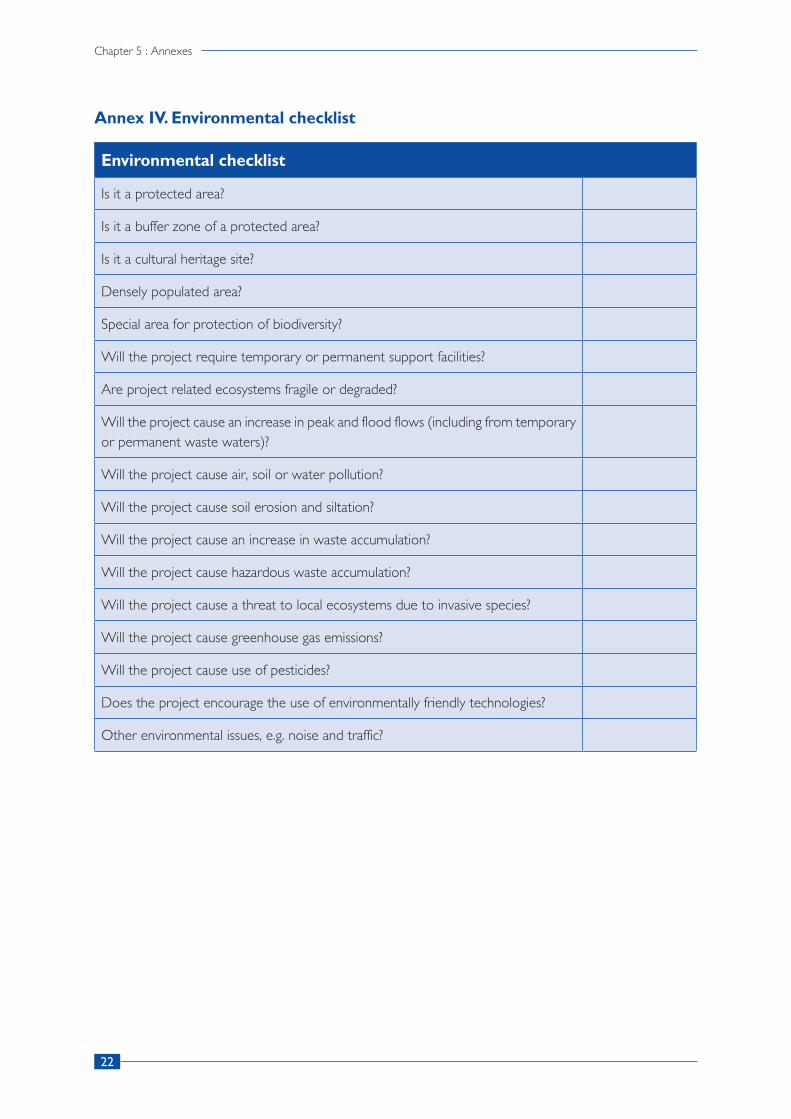
Finalization of open spaces also requires a proper understanding of the environmental components and potential risks associated with a location selected as an open space. In this regard, a general environmental checklist was used based on the previously prepared questionnaire to understand the context, ecosystems, ecological impact and vulnerability of project sites due to construction of project infrastructure. The checklist is found in Annex 4. The checklist helps to ensure that environmental considerations are included in decisions regarding projects that may impact the environment.
8
Chapter 2 : Open-space identification process
Step 4. Data processing and GiS mapping
The collection of attribute data on critical facilities and infrastructures from sectoral office, census department and municipal profile and primary field survey was followed by multi-source data integration. The team of GIS analysts carried out data cleaning, combining spatial datasets with attribute data and conversion of all spatial data layers from different sources to a single standard data system.
(a) Preparation of geodatabase and topographical maps
The project team had collected datasets of critical facilities, local infrastructures such as road networks from both the primary and secondary sources. A municipal geodatabase was prepared with all major datasets. The captured aerial images were processed to form a single georeferenced orthophoto image map for each open space using a high configuration computing device and licensed digital photogrammetry software. The image processing was carried out to generate outputs like contour maps, orthophoto maps and digital surface models. After the generation of map outputs from images, the map features were digitized from the high-resolution georeferenced image in a GIS environment. Standard symbology and appropriate color codes were applied to the generalized data to form a detailed topographical map. The information regarding map projection and coordinate system is found in Annex 5 of this document.
(b) Calculation of usable open-space area
The technical team calculated the usable area of each open space by deducting the area occupied by the existing ground objects like trees and vegetation, building structures and slope below 5° from the total area of identified open spaces.
Step 5. Output validation, finalization and dissemination
Due to the COVID-19 pandemic and rise in the number of positive cases, the project was unable to organize face to face programs for disseminating the final reports on open spaces. Alternatively, the draft datasets, open-space report, atlas and final maps were shared with the Municipality. Feedback and comments from municipal officials and other relevant stakeholders were incorporated and the project deliverables was finalized accordingly.
The datasets on the open spaces and critical facilities are being integrated to the BIPAD platform after data validation and finalization from the local stakeholders. A physical GIS map has also been installed in the Municipality premises for sensitizing people on the open spaces and critical facilities. The major outputs of the project include an Open Space Map Atlas and report, mobile application, an open space platform for humanitarian assistance and a physical hard copy map of the Municipality which has been shared and disseminated to the Municipality and all other relevant stakeholders of the project.

9
Report on Open Spaces for Humanitarian Purposes in Gosainkunda Rural Municipality
CHAPTER 3 SURVEY OUTPUTS
3.1. High-resolution map products
The aerial images captured from the drone were utilized to generate different kinds of map outputs. At the end of the data processing, the following outputs were generated: high spatial resolution (3 cm) georeferenced orthophoto, digital surface model (DSM),3 digital terrain model (DTM),4 contour lines of 1 m interval, 3D model and point cloud. These high-resolution map outputs can be utilized by planners and emergency responders during the camp management related activities, but also use as a major resource for development planning at a municipal level.
3.2. Open space map atlas
The topographical maps of each finalized open space were prepared and compiled as an Open Space Map Atlas along with other details like description of each open space, photographs captured from the ground and a vicinity map where the nearby critical facilities are presented. A map board of the entire Municipality highlighting the detailed information of each finalized open space was also designed for installation within the Municipality.
3.3. Open spaces for humanitarian assistance
A preliminary list of 43 open spaces in Gosainkunda was shared by the local and municipal officials. The technical team visited 17 locations which were assigned a total weight value of 13 and more during the preliminary workshop. Five locations were finalized as the most suitable open spaces for humanitarian assistance based on the standard selection criteria (minimum area 3,000 m2), slope (less than 5°), access, security and safety, availability of critical facilities and other resources, social and cultural values and environmental suitability. The total usable open-space area is 9,650 m2 which can accommodate 2,757 displaced persons during a disaster as per the Sphere Standards which estimate 3.5 m2 per person. Of the five finalized open spaces, Briddim Dong Chokla Kang has the largest usable area with the capacity to accommodate 915 displaced persons during a disaster followed by Khel Maidan in ward no. 6, Syamewangefel School in Ward number 5, Baal Mandir (Shabha Hall) in Ward number 6 and Chinese camp in Ward number 2.
3 The DSM represents the elevation of ground surface features which is generated by the software itself but is not recommended for representing ground elevation.
4 DTM represents the elevation of bare earth surface excluding the ground features.

10
Chapter 3 : Survey outputs
Figure 5: Location map of open spaces in Gosainkunda Rural Municipality
Note: This figure is made by Naxa on a GIS platform and is based on the data from the 2019 survey.
The list of finalized open spaces in Gosainkunda Rural Municipality is mentioned in the table below:
Table 2: Generic information of humanitarian open spaces in Gosainkunda Rural Municipality
Seria
l nu
mbe
r
Name of open spaceAddress (ward
number)Coordinates
Total area (m2)
Total usable area (m2)
Approximate capacity (3.5. m2
per person)
1 Chinese Camp 228.2416992°85.3585968°
3,646.51 1,420 405
2Briddim Dong Chokla Kang
328.2005005°85.3684998°
3,985.21 3,205 915
3 Syamewangfel School 528.1618004°85.3320007°
9,317.91 1,675 478
4 Khel Maidan 628.1105995°85.2956009°
3,633.88 1,800 514
5Baal Mandir (Shabha Hall)
628.1119995°85.2979965°
2,682.29 1,550 442
Details of all finalized open spaces, topographical maps, vicinity maps, environmental checklist and relevant attribute information are included in the Open Space Map Atlas.

11
Report on Open Spaces for Humanitarian Purposes in Gosainkunda Rural Municipality
The remaining locations in the preliminary list were rejected as these locations did not meet the standard criteria. In addition, it is extremely difficult to find a suitable open space in a rugged topography of this Rural Municipality. Hence, the open spaces for humanitarian purposes are also identified based on the location of clustered settlements in the region.
3.4. Critical facilities
The technical team collected location data and names of critical facilities within the vicinity of each finalized open space. Following is a summary of collected datasets:
• Health facilities (5)
• Educational institutions (7)
• Security forces (2)
• Evacuation centres (1)
Table 3: Available critical facilities near humanitarian open spaces in Gosainkunda Rural Municipality
Seria
l nu
mbe
r
Name of open space
List of critical facilitiesWASH facilities
Health facilities
Educational institutions
Market Security Helipad
1Chinese Camp
Available
Health post with birthing centre at Timure (20 m)
Not availableThuman (500 m)
Border police (500 m), Border army (500 m)
Army helipad (500 m)
2Briddim Dong Chokla Kang
AvailableBriddim health post (300 m)
Not availableNot available
Not availableNot available
3Syamewangfel School
Available
Health post and birthing centre at Syafru (500 m)
Syamewangfel School
Syafrubesi (250 m)
Local police station (500 m), Army camp (550 m)
Army helipad (550 m)
4 Khel Maidan AvailableDistrict health post (250 m)
Rasuwa Campus, Shree Rasuwa Secondary School
Dhunche
District police (250 m), Army Camp (20 m)
Army helipad (50 m)
5Baal Mandir (Shabha Hall)
Available District health post (100 m)
Shree Rasuwa Secondary School, Highland Higher Secondary School
Dhunche
District police (200 m), Army camp (200 m)
Army helipad (550 m)
A list of emergency contacts in Gosainkunda rural municipality is found in Annex 7 of this document.

12
Chapter 3 : Survey outputs
3.5. Other locations
In the immediate aftermath of the earthquakes in 2015, local people in Gosainkunda used private and public lands and other open areas near their houses and communities as temporary shelters. Some of the open areas were also used by relief distribution agencies. The technical team visited 12 locations identified by the Municipality and measured the total available flat area, collected GPS coordinates, attribute details and photographs for each location during the project period. These locations do not fulfill all the criteria required to consider for humanitarian open spaces, however, they can be used during an emergency. These 12 locations observed during the field survey were broadly grouped into four major categories based on the current land use practice by the local community:
• Category 1: Playgrounds
• Category 2: Picnic spots and parks
• Category 3: Community gathering spots (Chautara, temple, garden, open public land)
• Category 4: Periphery of hospitals, schools, public institutions and other public places
As the finalized major open spaces may not be easily accessible for all scattered communities in the rural wards of the Municipality during a disaster, the nearby school compounds, the periphery of the ward offices, health institutions and various other community buildings' premises near the settlement areas have also been considered for its utilization during an emergency.
The identified locations based on the current land use are listed in Annex 7 of this document.
3.6. Open space platform for humanitarian assistance
Upon finalization, all open-space datasets will be handed over by IOM to the Government of Nepal and also be published in a public GIS based data platform where the datasets will be stored and updated. This includes the datasets from Gosainkunda. The platform mainly consists of the following features:
(a) Provides information through text as well as audiovisuals regarding the identified open spaces, camp sites, logistics, distribution areas, medical assistance areas and other details.
(b) Contains an interactive mapping feature where users can select the respective municipalities and find details of each open space like attribute tables, nearest critical facilities and photographs.
(c) Allows the system admins to view reports regarding open-space encroachment submitted by the public and forward it to the concerned authority for necessary action. The report function contains GPS location, photographs and report messages.
(d) Allows users to download and view publications regarding camp management, open spaces and its importance, open-space mapping reports, other useful reports and publications related to the open spaces and their role in disaster preparedness and management.
(e) A humanitarian assistance tab in the web platform and in the mobile app which is enabled only in the event of a disaster. This tab is mainly for various humanitarian agencies to upload details of emergency supplies or relief distribution in a location and notify the public about their humanitarian efforts during and after a disaster.
13
Report on Open Spaces for Humanitarian Purposes in Gosainkunda Rural Municipality
3.7. Open space mobile application
The open space mobile application was developed to provide the general public with information regarding open spaces and the nearest critical facilities so that they can promptly use it during an emergency. The app contains location data of all open spaces in Gosainkunda Rural Municipality and users can navigate to each of these open spaces from their locations at the push of a button in the app. The app works both online and offline and can provide multiple routes from user locations to the nearest open space during an emergency.


15
Report on Open Spaces for Humanitarian Purposes in Gosainkunda Rural Municipality
CHAPTER 4 CONCLUSiON
4.1 Conclusion
This report identifies the open spaces suitable for humanitarian purposes in an event of a disaster in Gosainkunda Rural Municipality. The surveys and related activities have been implemented as per the plan of action along with necessary consultations and interactions with the ward and municipal officials, local communities, humanitarian actors and relevant stakeholders of the project. IOM supported Gosainkunda Rural Municipality to conduct a detailed study on the five most suitable open spaces: Chinese Camp in Ward number 2, Briddim Dong Chokla Kang in Ward number 3, Syamewangfel School in Ward number 5, and Khel Maidan and Baal Mandir (Shabha Hall) in Ward number 6. The five identified open spaces in Gosainkunda Municipality could be used for accommodating an estimate of 2,757 displaced individuals with basic WASH facilities, easy access to all five open spaces, health and educational facilities and proximity to market and nearby security forces. The national disaster response framework includes specific provisions for security forces and local governments that include evacuation of local populations to safer locations. This report includes open spaces which are at least 3,000 m2 in area and are nearby major settlements that could be used for humanitarian purposes.
Based on the past experience of the 2015 earthquakes and landslides, it was found that displaced persons took shelters in these open spaces irrespective of public or private ownership. Therefore, in an event of a disaster, these spaces can be usable for IDPs provided that they are well preserved by the concerned authority. Identification and preservation of open spaces is important as most of the existing infrastructures could be destroyed and human settlements could be damaged in a catastrophic event such as earthquake or landslide. Moreover, the humanitarian efforts to accommodate and support displaced populations post-disaster is likely to be difficult. Besides humanitarian services, open spaces can also be used for a variety of purposes such as cultural events, community activities and sports. Thus, pre-identifying and locating nearby open spaces can strengthen disaster preparedness and management.
The Constitution of Nepal was promulgated in 2015 which led the country to initiate its federalization process, dividing the Government into three tiers: federal, provincial and local. As a result, 753 local governments were formed, allowing for more resources to be allocated to the local level, and the formulation of local disaster management plans and strategies is now among the prioritized local government plans. Disaster preparedness at a local level is crucial to inform and raise public awareness about disaster vulnerability and emergency response. Activities and initiatives for disaster preparedness include the identification, mapping, promotion and protection of open spaces, all of which are crucial initiatives in disaster prone areas of Gosainkunda Rural Municipality, Rasuwa.


17
Report on Open Spaces for Humanitarian Purposes in Gosainkunda Rural Municipality
CHAPTER 5 ANNExES
Annex I. Open-space selection criteria
(a) Accessibility
(i) Accessibility is a critical factor for open-space identification. Some open spaces have restricted road access which impacts the establishment of camps, movement of IDPs to the camps, ensuring food supplies and other camp necessities. Therefore, it is critical in the selection phase that the accessibility of the open spaces in all seasons is considered.
(ii) The mobility of displaced populations, supply of goods and services, access to critical services (such as hospitals, markets, schools) in the surroundings are ensured while selecting an open space.
(iii) Access to livelihoods is also considered for open-space identification.
(b) Security
(i) Security is likely to be a key issue in high density camp. Existing security features are explained as these will assist with open-space identification and camp management.
(ii) Natural and human induced hazards. Example: Existence of industrial areas in the proximities of the open spaces are avoided.
(iii) Extreme climatic conditions. Example: Open spaces at risk of flooding, strong winds or landslides are avoided. Similarly, open spaces with high intensity electric wires are also avoided.
(iv) Environmental and health conditions. Example: Health risks typical for the open spaces are assessed. Malaria zones and cholera high risk areas are avoided.
(v) Evacuation routes are considered while identifying open spaces.
(c) Access to resources and water
(i) Availability of and accessibility to water is considered.
(ii) Water needs to be available in sufficient quantity in all seasons, taking into consideration the level of water during the dry season, as well as the basic needs of the displaced population (calculated as 7.5-15 liters per person per day).
(d) Land availability and topography
(i) Selection of open spaces considers the Sphere standard, which defines the minimum surface area is 35-45 m2 per person.
(ii) The possibility of site expansion is considered.
(iii) A gentle terrain slope of 1-5° is considered.
(iv) Open spaces that could become marshy and waterlogged during rainy seasons should be avoided.
(v) Open spaces that are excessively rocky should be avoided as they hamper toilet or camp construction.
18
Chapter 5 : Annexes
(e) Environmental concerns
(i) Open space with sufficient ground cover is suitable for setting up camps as the vegetation provides shade, protects soil erosion and reduces dust.
(ii) The negative impact of turning an open space into a camp is also considered while selecting an open space.
(iii) A general environment checklist is filled during the open-space selection process.
(f) Size
The size of the open space and area per capita are important factors in planning for camps. The Sphere Project outlined the Humanitarian Charter and set minimum standards in disaster response. The standards include spaces that should be made available for camp functions such as accommodation, cooking, hygiene, agriculture and schools. The total area required for all camp functions is 45 m2 per person. While this should remain the objective for camp density, it is important that the humanitarian community be prepared for a higher influx of displaced population immediately following the disaster. The covered living area is 3.5 m2 per person.

19
Report on Open Spaces for Humanitarian Purposes in Gosainkunda Rural Municipality
Annex II. Preliminary list of identified open spaces with scored weights in Gosainkunda Rural Municipality by the local and rural municipal officials
Seria
l nu
mbe
r
Name of open space
War
d nu
mbe
r
Are
a
Acc
ess
Secu
rity
Sour
ce
avai
labi
lity Social
cultural values
Environmental perspectives
Total
1 Nagthali 1 3 1 2 1 3 3 13
2 Thuman Gumba 1 1 3 3 3 3 3 16
3 Nepal Rashtriya School 1 3 3 3 3 3 2 17
4 Thuman Tashigaun 1 3 3 3 3 3 3 18
5 Tarsa Mendo 1 1 3 1 3 2 1 11
6 Dalphedi 1 1 2 2 3 2 2 12
7 Deshegaun 1 2 2 0 3 2 1 10
8 Timure 2 1 1 1 1 1 1 6
9 Rauwa Gadhi 2 1 1 1 1 1 1 6
10 Chinese Camp 2 2 3 3 3 3 2 16
11 Gumbaling Khaidi 2 3 1 2 3 3 3 15
12 Pelko Ling Ling 3 1 3 2 2 2 2 12
13Briddim Dong Chokla Kang
3 1 3 2 2 2 2 12
14 Briddim Chhorangmu 3 2 3 3 3 3 3 17
15 Briddim Gotegaun 3 3 3 2 3 2 2 15
16Khamjing Bejang School
3 1 3 3 3 2 2 14
17 Sherpa Gaun School 3 1 1 2 2 2 3 11
18Bangal Samudayik Bhawan
3 1 1 1 1 1 1 6
19Surke Gaun Samudayik Bhawan
3 1 3 2 1 2 3 12
20 Kyanging 4 2 1 2 2 2 2 11
21 Langtang 4 2 1 2 2 2 2 11
22 Gumba Dada 4 1 2 1 2 2 2 10
23 Ghoda Tabela 4 1 1 1 2 1 1 7
24 Mindu 4 1 1 1 2 2 1 8

20
Chapter 5 : Annexes
25 Yangsyap 4 1 1 1 1 1 1 6
26 Thulo Syfu School 5 3 3 3 3 3 3 18
27 Syamewangfel School 5 1 3 3 3 3 1 14
28Tholo Bharkhu Tashi Gumba
5 3 2 3 3 3 3 17
29 Mu Kharka 5 1 1 1 1 1 3 8
30Bhimsen Aadharbhoot School
5 1 1 1 2 3 3 11
31 Phoprang Kharka 5 3 1 2 1 2 3 12
32 Gosaikunda 5 3 1 1 1 3 3 12
33 Syfru Bazar 5 2 3 3 3 3 3 17
34 Kalijung Gan 6 3 3 3 3 3 3 18
35 Khel Maidaan 6 3 3 3 3 3 3 18
36 Dhunche sabha Hal 6 3 3 3 3 3 3 18
37Tamang Cultural Red Panda Park
6 3 3 3 3 3 3 18
38Tulku Chhyoling Gumba
6 3 3 3 3 3 3 18
39 Saraswati Prabi 6 3 3 3 3 3 3 18
40 Rasuwa Secondary 6 3 3 3 3 3 3 18
41 Chhangam Bokejhunda 6 3 3 3 3 3 3 18
42 Charan Bikas 6 2 3 3 2 3 3 16
43 Machha Palan 6 2 3 3 3 2 2 15

21
Report on Open Spaces for Humanitarian Purposes in Gosainkunda Rural Municipality
Annex III. Attribute checklist for open space in Gosainkunda Rural Municipality
General site assessment
Site name
District Municipality Ward
GPS coordinates Area
Gradient (1 – 5%) Proximity to Helipad
Proximity to Nepal Army Proximity to Nepal Police Proximity to Armed Police Force
Special feature of site
Significant feature near site (within 500 metres)
Ownership
Security
Access to site
Access to market
Trees and vegetation
WASH facilities
Health facilities
Educational infrastructures
Implementation issues
22
Chapter 5 : Annexes
Annex IV. Environmental checklist
Environmental checklist
Is it a protected area?
Is it a buffer zone of a protected area?
Is it a cultural heritage site?
Densely populated area?
Special area for protection of biodiversity?
Will the project require temporary or permanent support facilities?
Are project related ecosystems fragile or degraded?
Will the project cause an increase in peak and flood flows (including from temporary or permanent waste waters)?
Will the project cause air, soil or water pollution?
Will the project cause soil erosion and siltation?
Will the project cause an increase in waste accumulation?
Will the project cause hazardous waste accumulation?
Will the project cause a threat to local ecosystems due to invasive species?
Will the project cause greenhouse gas emissions?
Will the project cause use of pesticides?
Does the project encourage the use of environmentally friendly technologies?
Other environmental issues, e.g. noise and traffic?

23
Report on Open Spaces for Humanitarian Purposes in Gosainkunda Rural Municipality
Annex V. Map projection and coordinate system used for the detailed topographical mapping
Serial number
Projection and coordinate system Parameters
1 Coordinate system WGS_1984_UTM_Zone_45N
2 Projection Transverse Mercator
3 False easting 500000 metres
4 False northing 0.0 metre
5 Central meridian 84° East
6 Scale factor 0.9996
7 Latitude of origin 0.0
8 Linear unit Metre
9 Angular unit Degree (°)
10 Prime meridian Greenwich (0.0)
11 Datum D_WGS_1984
12 Spheroid WGS_1984
13 Semi major axis 6378137.0
14 Semi minor axis 6356752.314245179
15 Inverse flattening 298.257223563
Annex VI. Emergency contacts
Serial number
Emergency service Name of organization Phone number
1 Health Office District Health Office 010-540188
2 SecurityDistrict Police Office 010-540199/200
Armed Police Force 010-540037

24
Chapter 5 : Annexes
Ann
ex V
II. D
etai
ls o
f oth
er lo
cati
ons
in G
osai
nkun
da R
ural
Mun
icip
alit
y:Serial
number
Nam
eIm
age
War
d N
o.C
ateg
ory
Coo
rdin
ates
App
roxi
mat
e fla
t ar
ea (
m2 )
Elev
atio
n (m
)Re
mar
ks
1N
agth
ali
1C
omm
unity
ga
ther
ing
spot
28.2
0610
05°
85.3
1590
27°
2,20
03,
216
Larg
e ar
ea w
ith a
gen
tle
slope
, diff
icul
t to
acc
ess,
loca
ted
at 1
.5 h
ours
w
alki
ng d
istan
ce fr
om t
he
sett
lem
ents
, the
onl
y op
en
spac
e ne
arby
Thu
man
villa
ge,
whi
ch is
agg
lom
erat
ed b
y ar
ound
239
hou
seho
lds,
suita
ble
loca
tion
for
near
by
com
mun
ities
onl
y
2N
epal
Ras
triy
a Sc
hool
, Thu
man
1Pe
riphe
ry o
f sc
hool
28.2
0990
6°
85.3
3533
2°29
02,
435
Smal
l are
a w
ithin
the
sc
hool
pre
mise
s, no
acc
ess
of v
ehic
le, l
ocat
ed n
ear
Thum
an v
illage
, can
be
used
for
gath
erin
g du
ring
an
emer
genc
y
3Ti
mur
e2
Com
mun
ity
gath
erin
g sp
ot28
.256
7997
° 85
.365
9973
°15
,145
1,70
5
A la
rge
sized
pub
lic la
nd
area
loca
ted
besid
es t
he
river
, a d
ry p
ort
unde
r co
nstr
uctio
n an
d th
e m
ost
part
s of
the
site
is o
ccup
ied
by t
empo
rary
str
uctu
res

25
Report on Open Spaces for Humanitarian Purposes in Gosainkunda Rural Municipality
4Ra
suw
a G
adhi
2C
omm
unity
ga
ther
ing
spot
28.2
7199
94°
85.3
7809
75°
1,35
01,
774
A h
istor
ical
fort
rui
n lo
cate
d at
the
bor
der
to T
ibet
5Su
rke
Gau
n Sa
mud
ayik
Bh
awan
3Pe
riphe
ry o
f co
mm
unity
bu
ildin
g
28.1
7134
9°
85.3
6219
4°
No
rem
arka
ble
flat
area
2,44
6
A s
mal
l siz
ed a
rea
in t
he
perip
hery
of S
amud
ayik
Bh
awan
, loc
ated
nea
r Su
rke
Gau
n
6Br
idim
Hea
lth
Post
3Pe
riphe
ry o
f he
alth
pos
t28
.199
685°
85
.366
582°
105
2,17
3Sm
all a
rea
with
in t
he h
ealth
po
st p
rem
ises
7Kh
amjin
g Be
jang
Sc
hool
3Pe
riphe
ry o
f sc
hool
28.1
7325
3°
85.3
5759
2°22
02,
263
Smal
l are
a w
ithin
the
sch
ool
prem
ises,
no s
ettle
men
ts
near
by, c
onne
cted
to
an
eart
hen
road
, diff
icul
t to
ac
cess
dur
ing
the
mon
soon
se
ason
8Th
ulo
Syaf
ru
Scho
ol5
Perip
hery
of
scho
ol28
.142
054°
85
.359
947°
130
2,23
5Sm
all a
rea
with
in t
he s
choo
l pr
emise
s, lo
cate
d ne
ar S
yafru
m
arke
t

26
Chapter 5 : Annexes
9Ta
man
g C
ultu
ral
Red
Pand
a Pa
rk6
Picn
ic s
pot
and
park
28.1
0689
93°
85.3
1120
3°6,
420
1,88
7
Ong
oing
con
stru
ctio
n of
th
e Re
d Pa
nda
Park
, few
se
ttle
men
ts n
earb
y, n
ot
a su
itabl
e lo
catio
n fo
r hu
man
itaria
n pu
rpos
es
durin
g a
disa
ster
10Tu
lku
Chh
olin
g G
umba
6Pe
riphe
ry o
f G
umba
28.1
1254
7°
85.2
9648
7°55
2,02
5Sm
all a
rea
in t
he p
erip
hery
of
Gum
ba, l
ocat
ed n
ear
to
Dhu
nche
11C
hara
n Bi
kas
6Pe
riphe
ry o
f bu
ildin
g28
.112
550°
85
.302
493°
120
1,87
5Sm
all a
rea,
few
set
tlem
ents
lo
cate
d ne
arby
12M
achh
a Pa
lan,
D
hunc
he6
Perip
hery
of f
ish
farm
ing
area
28.1
1014
0°
85.3
0521
9°19
01,
870
Smal
l are
a w
ithin
the
pe
riphe
ry, l
ocat
ed n
ear
Pasa
ng L
ham
u ro
ad
Not
e: Th
e ae
rial i
mag
es u
sed
in th
e ab
ove
tabl
e ar
e ex
trac
ted
from
the
Goo
gle
Eart
h. T
he d
etai
ls of
oth
er lo
catio
ns in
this
rura
l mun
icip
ality
is b
ased
on
the
data
fro
m t
he 2
019
surv
ey.

27
Report on Open Spaces for Humanitarian Purposes in Gosainkunda Rural Municipality
REFERENCES
international Organization for Migration
2016 Displacement Tracking Matrix: Nepal Earthquakes 2015. Available at https://displacement.i om . i n t / s y s tem/ td f / repor t s /01_ IOM%20DTM_Nepa l_Round%208_20160830 .pdf?file=1&type=node&id=761
Nepal, National Planning Commission
2015 Nepal Earthquake 2015: Post Disaster Needs Assessment. Government of Nepal: Kathmandu. Available at https://www.npc.gov.np/images/category/PDNA_volume_BFinalVersion.pdf
OSOCC Assessment Cell
2015 Nepal Earthquake District Profile - Rasuwa. Available from https://reliefweb.int/report/nepal/nepal-earthquake-district-profile-rasuwa-10052015
Petal, M., Baral, S., Giri, S., Rajbanshi, S., Gajurel, S., Green, R. P., Shoaf, K.
2017 Causes of Deaths and Injuries in the 2015 Gorkha (Nepal) Earthquake. Save the Children: Kathmandu
Pokharel, B., & Thapa, P. B.
2019 Landslide susceptibility in Rasuwa District of central Nepal after the 2015 Gorkha Earthquake. Journal of Nepal Geological Society , 59, 79–88. Available from https://doi.org/103126/jngs.v59i0.24992
Sphere Association
2018 The Sphere Handbook: Humanitarian Charter and Minimum Standards in Humanitarian Response. Switzerland: Geneva. Available from https://spherestandards.org/wp-content/uploads/Sphere-Handbook-2018-EN.pdf
United Nations Development Programme
2019 Energy, environment, climate and disaster-risk management. Available from http://www.np.undp.org/content/nepal/en/home/energy-environment-climate-and-disaster-risk-management/in-depth.html


30
Chapter 1: Introduction
INTERNATIONAL ORGANIZATION FOR MIGRATION768/12 , Thirbam Sadak, Baluwatar-5,
Kathmandu, NepalTel : +977 1 4426250Fax: +977 1 4434223
Email: [email protected]: www.iom.int