report for consideration toll free: 1-800-667-1959
TRANSCRIPT

Main Office: 155 George Street, Prince George, BC V2L 1P8 Telephone: (250) 960-4400 / Fax: (250) 563-7520 Toll Free: 1-800-667-1959 / http://www.rdffg.bc.ca
TO: Chair and Directors File No.: REZ 5676/23447/1
FROM: Heather Meier RPP, MCIP, Planning Leader
DATE: October 6, 2020
SUBJECT SUMMARY:
PREVIOUS REPORTS: None
ATTACHMENT(S): 1. Backgrounder2. Conceptual Lot Plan and Drainage Assessment Report3. Bylaw No. 3195
ISSUE(S):
An application has been made to amend Zoning Bylaw No. 2892 to facilitate subdivision of a 32.5 hectare property into rural residential lots. The property is located in the Pilot Mountain and North Kelly area.
Board is being asked to consider: • first reading of Zoning Bylaw No. 2892, Amendment Bylaw No. 3195, 2020• second reading Bylaw No 3195; and• authorization of a public hearing for Bylaw No. 3195.
RELEVANT POLICIES:
1. Salmon River-Lakes Official Community Plan Bylaw No. 1587:• the proposal is consistent with the Rural Residential (RR) designation• supports expansion of rural residential development into the undeveloped lands designated RR to the
north and west of the existing North Kelly settlement area• a portion of the subject land is within a Development Permit Area designated for Ferguson Lake
Item: Zoning Bylaw No. 2892, Amendment Bylaw No. 3195, 2020 Purpose: Consider First Reading, Second Reading and Authorize a Public Hearing Location: Pilot Mountain Road Area – Electoral Area ‘A’ Owner: 1216590 BC Ltd. Inc. No. BC1216590 Agent: Adrian Vander-Velden and Larry Rowe
RECOMMENDATION(S): ENTITLEMENT HOW VOTE COUNTED
1. THAT the report, conceptual lot plan, and drainage assessment report be received. All 1 Director/1 vote
Majority
2. THAT Zoning Bylaw No. 2892, Amendment Bylaw No. 3195, 2020 be now introducedand read for the first time.
All 1 Director/1 vote
Majority
3. THAT Zoning Bylaw No. 2892, Amendment Bylaw No. 3195, 2020 be given secondreading.
All 1 Director/1 vote
Majority
4. THAT a public hearing on Zoning Bylaw No. 2892, Amendment Bylaw No. 3195, 2020be held with the chairing of the hearing delegated to Director Wilson, or his Alternate,or any other Director as a delegate of the Board.
All 1 Director/1 vote
Majority
GM: _____________
REPORT FOR CONSIDERATION

Report to Regional Board Page 2
2. Zoning Bylaw No. 2892• the proposal is not consistent with zoning• minimum lot size that may be created by subdivision in the Rural 1 (Ru1) zone is 15 hectares• zoning amendment is required• proposed Rural Residential 2 (RR2) zone permits a 1.6-hectare minimum lot size
3. Local Government Act:• outlines requirements for consideration of amendments to a zoning bylaw and public hearing procedure• requires a notice of public hearing to be placed in two consecutive issues of a newspaper not less
than 3 and not more than 10 days before the public hearing
4. Development Services Applications Procedures Bylaw No. 2776:• notice of a public hearing is to be sent to owners of land within 200 m on the subject property• details requirements for a notification of application sign, alternative form of notification or waiving of
notification requirements prior to a public hearing• delegates approval of notification requirements to the General Manager of Development Services
STRATEGIC ALIGNMENT:
SERVICE RELEVANCE:
Regional District Land Use Services is a region wide service and fulfils the obligations of land use planning under Part 14 of the Local Government Act.
FINANCIAL CONSIDERATION(S):
N/A
OTHER CONSIDERATION(S):
N/A
DECISION OPTIONS:
Approve recommendations. • Bylaw No. 3195 will be given first and second reading and will proceed to public hearing
Other Options:
a. hold Bylaw No. 3195 at first reading pending receipt of further information• bylaw will return for consideration when information is available• bylaw may be amended after first reading• Board authorization is required to hold a public hearing
b. defeat Bylaw No. 3195 at first reading• bylaw cannot be considered further• property will remain zoned Rural 1
COMMENTS:
An application has been made to rezone the 32.5 hectare subject property to facilitate subdivision into rural residential lots. The property is currently vacant land located in the Pilot Mountain and North Kelly area, directly west of the City of Prince George municipal boundary and Ferguson Lake.
Climate Action Economic Health Indigenous Relations Strong Communities
None – Statutory or Routine Business

Report to Regional Board Page 3
The land is designated Rural Residential (RR) by the Salmon River-Lakes Official Community Plan (OCP). The OCP rural communities policies for North Kelly support the expansion of rural residential subdivision into area. Zoning Bylaw No. 2892, Amendment Bylaw No. 3195 proposes to rezone the property from Rural 1 (Ru1) to Rural Residential 2 (RR2). The RR2 zone will allow subdivision into residential lots with a 1.6 ha minimum lot size. The applicant submitted the conceptual lot plan and drainage assessment attached to the report; however, final subdivision layout will depend on the subdivision approval process through the Ministry of Transportation and Infrastructure. Subdivision must also meet all Regional District subdivision servicing requirements for proof of sewage disposal and water supply and the park land dedication requirements of the Local Government Act.
Should the proposed zoning amendment bylaw proceed, the next step will be to hold a public hearing where the public will have an opportunity to comment. Notice of a public hearing is advertised in the newspaper, delivered to property owners within 200 metres of the subject property and posted on the Regional District website and notice board. In addition, Administration will evaluate the requirement to post a notification sign, an alternative form of notification or waiving of the sign requirements. Further notification beyond the requirements of the Development Services Applications Procedures Bylaw requires a Board resolution.
Respectfully submitted, Heather Meier RPP, MCIP Planning Leader
HM:lh
Heather Meier
Report to Regional Board Page 4
BACKGROUNDER
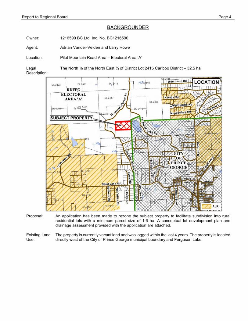
Owner: 1216590 BC Ltd. Inc. No. BC1216590
Agent: Adrian Vander-Velden and Larry Rowe Location: Pilot Mountain Road Area – Electoral Area ‘A’ Legal Description:
The North ½ of the North East ¼ of District Lot 2415 Cariboo District – 32.5 ha
Proposal: An application has been made to rezone the subject property to facilitate subdivision into rural residential lots with a minimum parcel size of 1.6 ha. A conceptual lot development plan and drainage assessment provided with the application are attached.
Existing Land Use:
The property is currently vacant land and was logged within the last 4 years. The property is located directly west of the City of Prince George municipal boundary and Ferguson Lake.

Report to Regional Board Page 5
Official Community Plan:
The subject land is designated Rural Residential (RR) by the Salmon River-Lakes Official Community Plan (OCP). The RR designation supports creation of residential parcels based on a minimum 1.6 ha parcel size. The OCP contains the following Rural Communities policy for the North Kelly area:
3.3.12 North Kelly has developed as a substantial rural residential settlement area and is designated RR in the Plan. This area will be able to accommodate much of the demand for new residential construction as many of the existing parcels are undeveloped. There should not be a need to expand on rural residential subdivision within the time frame of this Plan, however, if demand warrants expansion into the undeveloped designated RR areas to the north-west could be considered.
The OCP was adopted in 1996. The subject property is located within the north-west expansion area of the North Kelly area. An OCP amendment is not required for this proposal.
Development Permit Area:
A Development Permit Area is designated by the OCP over lakes in the Plan area with the objectives of ensuring lake water quality and aesthetic scenic qualities of the lakeshore. A portion of the subject land is within a Development Permit Area due to proximity to Ferguson Lake. Issuance of a Development Permit is required for development of this area including subdivision, land clearing, and construction. Issuance of Development Permits for subdivision requires approval of the Regional District Board.

Report to Regional Board Page 6
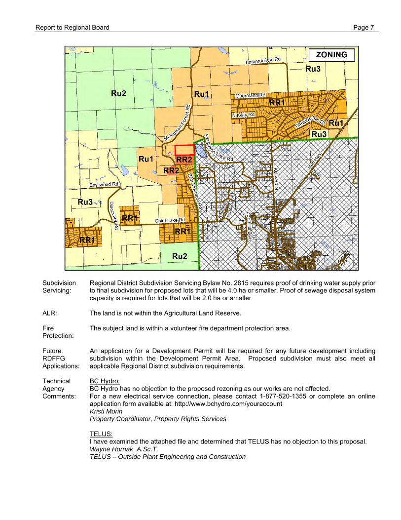
Zoning: The subject land is zoned Rural 1 (Ru1) within Zoning Bylaw No. 2892. The application proposes to rezone the land to the Rural Residential 2 (RR2) zone to allow subdivision into residential lots with a minimum 1.6 ha parcel size. The following table contains a general summary of permitted uses in both zones, however, other regulations in the zoning bylaw also apply. For example, a Secondary Suite use must be a minimum of 200 metres from a lake.
Rural 1 (Ru1) zone Rural Residential 2 (RR2) zone
• Residential-Single Familyo Secondary Suiteo Home Occupationo Homecraft
• Agriculture• Forestry• Intensive Agriculture (4 ha)• Kennel (2 ha)• Cannabis Production (25 9ha)• Open Space Recreation• Riding Stable (2 ha)• Veterinary Clinic (2 ha)• General Permitted uses• Accessory buildings and structures
• Residential-Single Familyo Secondary Suiteo Home Occupation
• Agriculture• Open Space Recreation• General Permitted uses• Accessory buildings and structures
Minimum area of lot to be created by subdivision: 15.0 ha
Minimum area of lot to be created by subdivision: 1.6 ha
Report to Regional Board Page 7
Subdivision Servicing:
Regional District Subdivision Servicing Bylaw No. 2815 requires proof of drinking water supply prior to final subdivision for proposed lots that will be 4.0 ha or smaller. Proof of sewage disposal system capacity is required for lots that will be 2.0 ha or smaller
ALR: The land is not within the Agricultural Land Reserve. Fire Protection:
The subject land is within a volunteer fire department protection area.
Future RDFFG Applications:
An application for a Development Permit will be required for any future development including subdivision within the Development Permit Area. Proposed subdivision must also meet all applicable Regional District subdivision requirements.
Technical Agency Comments:
BC Hydro: BC Hydro has no objection to the proposed rezoning as our works are not affected. For a new electrical service connection, please contact 1-877-520-1355 or complete an online application form available at: http://www.bchydro.com/youraccount Kristi Morin Property Coordinator, Property Rights Services TELUS: I have examined the attached file and determined that TELUS has no objection to this proposal. Wayne Hornak A.Sc.T. TELUS – Outside Plant Engineering and Construction
Report to Regional Board Page 8
RDFFG Building Inspection No concern Blaine Harasimiuk Manager of Inspection Services Sustainability Practices
Ministry of Forests, Lands, Natural Resource Operations and Rural Development – Water Stewardship The zoning amendment itself doesn’t appear to involve use of water or changes in and about a stream. However, development of the property has the potential to involve changes in and about a stream. As documented in the Triton report, there are two streams (as defined by the Water Sustainability Act) within the property. If any changes are proposed to occur within or adjacent to the streams, the applicant may be required to apply for a change notification or change approval through FrontCounterBC. Advice can be sought from FrontCounterBC or myself at Water Stewardship.
If development of the property will involve water use, the owners will require an authorization for water use (i.e. use approval or water licence). Application can be made through FrontCounter BC. The owners should be aware that an authorization can take a minimum of 140 days to process. There is an application fee and yearly water rental fees.
Ministry of Transportation and Infrastructure: The Ministry of Transportation & Infrastructure (MoTI) has received the above noted referral from the Regional District of Fraser-Fort George regarding an application from for a zoning amendment for residential subdivision. The application has been reviewed, and MoTI has the following comments:
• It does not appear that the subject property has existing legal access. The Applicant shouldbe aware that Section 75 of the Land Title Act requires legal access to all new and existinglots. Should the Applicant wish to subdivide this parcel in the future, legal means of accessmust be established prior to subdivision approval.
• Should the Applicants proceed with subdivision they must apply to MoTI for subdivisionapproval by the Provincial Approving Officer appointed under the Land Title Act;
• Any future subdivision must meet MoTI’s subdivision guidelines and/or conditions identifiedduring the subdivision process, and it is the Applicant’s responsibility to adhere to all relevantlegislation;
• The proposed layout as submitted is not guaranteed as it is dependent on review and approvalby the Provincial Approving Officer
Emily Lynch Development Officer, Fort George District
Ministry of Forests, Lands, Natural Resource Operations and Rural Development – Water Stewardship I have reviewed the zoning amendment application to facilitate the subdivision of the subject property into rural residential lots. I have included some comments below for consideration regarding future development, with regards to the information provided with the application. • As noted in the stream assessment, the southern-most watercourse on the property is
considered default fish-bearing and has been assessed to provide good potential rearinghabitat for salmonids. This stream is connected to Ferguson Lake which is fish-bearing. Thestream assessment included with the application recommends a 15 m setback for this streamwhich is incorporated into the conceptual lot design provided. In general, maintaining riparianbuffers and ensuring sediments and other contaminants (resulting from land clearing, roadconstruction and residential development etc.) do not enter streams are the best methods ofprotecting fish and fish habitat. The conceptual lot design contains existing and proposedcrossings of this stream. Development in and about a stream, including maintenance orreplacement of existing infrastructure, will require notification or approval under Section 11 ofthe Water Sustainability Act.
• The northern-most watercourse on the property runs through the middle of several conceptuallots with front only access, therefore there is potential for residential development to impact tothe stream. The stream assessment included with the application recommends a 15 m

Report to Regional Board Page 9
setback for this stream, which is consistent with watercourse setbacks in Zoning Bylaw No. 2892. If works are undertaken in and about a stream, the proponent will require notification or approval under Section 11 of the Water Sustainability Act.
• If the proponent plans to conduct additional land clearing, it is also recommended that they arereminded about the Wildlife Act. Specifically, Section 34(a) of the Wildlife Act which protectsall birds and their eggs, and Section 34(c) which protects their nests while they are occupiedby a bird or egg. Nesting periods can be identified by a qualified professional, and in theOmineca they are generally from April 30th through August 1st, although some raptors maystart nesting as early as February. Section 34(b) of the Wildlife Act protects the nests ofeagles, peregrine falcons, gyrfalcons, ospreys, and herons year-round. This means that a treeor other structure containing such a nest must not be felled, even outside of the breedingseason for these species.In planning the removal of vegetation, the proponent will need to avoid the removal of nestssubject to Sec 34(b) and buffer nest trees with surrounding forest. Best ManagementPractices can be found at: https://www2.gov.bc.ca/assets/gov/environment/natural-resource-stewardship/best-management-practices/raptor_conservation_guidelines_2013.pdf
Sherri Elwell M.Sc. R.P.Bio. Ecosystems Biologist / Habitat Officer Landbase Stewardship | Omineca Region

OPT - 2
NOT FOR CONSTRUCTION
LEGEND
Meters
0 37.5 75
- - - -,m DATE RFVISIC1N RY
(DIM/Y)
( ~
I&~ ENGINEERING LIMITED
I I CONSULTANTS PR:JJECT No.: 1724-01 l.lRAWN· mJA
CHECKED: J8D
FNGINFFR ,JRR
DATE: 20/D8/20
SCALES HOR7 1175[
SC\LES VERT.
ADRIA!~ VANDER-VELDEN
CONSLLTING
~W~E4 DL, 2415
PILOT MOU~ITt,1~1 :;,0110
CONCEPTUA.L DEVE_OP'v1ENT
OPTION 2
[ ""·'""' " l
3990 22nd Avenue, Prince George, BC V2N 3A1 | tel 250 562 9155 | fax 250 562 9135 | triton-env.com
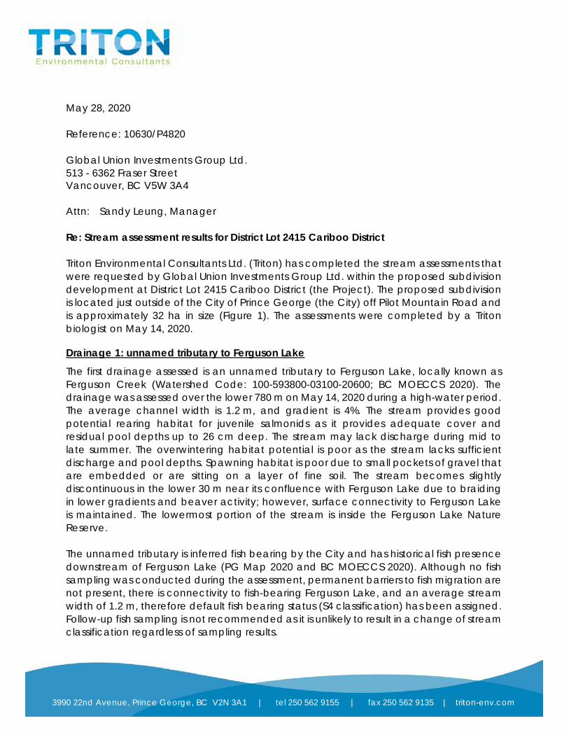
May 28, 2020 Reference: 10630/P4820 Global Union Investments Group Ltd. 513 - 6362 Fraser Street Vancouver, BC V5W 3A4 Attn: Sandy Leung, Manager Re: Stream assessment results for District Lot 2415 Cariboo District Triton Environmental Consultants Ltd. (Triton) has completed the stream assessments that were requested by Global Union Investments Group Ltd. within the proposed subdivision development at District Lot 2415 Cariboo District (the Project). The proposed subdivision is located just outside of the City of Prince George (the City) off Pilot Mountain Road and is approximately 32 ha in size (Figure 1). The assessments were completed by a Triton biologist on May 14, 2020.
Drainage 1: unnamed tributary to Ferguson Lake
The first drainage assessed is an unnamed tributary to Ferguson Lake, locally known as Ferguson Creek (Watershed Code: 100-593800-03100-20600; BC MOECCS 2020). The drainage was assessed over the lower 780 m on May 14, 2020 during a high-water period. The average channel width is 1.2 m, and gradient is 4%. The stream provides good potential rearing habitat for juvenile salmonids as it provides adequate cover and residual pool depths up to 26 cm deep. The stream may lack discharge during mid to late summer. The overwintering habitat potential is poor as the stream lacks sufficient discharge and pool depths. Spawning habitat is poor due to small pockets of gravel that are embedded or are sitting on a layer of fine soil. The stream becomes slightly discontinuous in the lower 30 m near its confluence with Ferguson Lake due to braiding in lower gradients and beaver activity; however, surface connectivity to Ferguson Lake is maintained. The lowermost portion of the stream is inside the Ferguson Lake Nature Reserve. The unnamed tributary is inferred fish bearing by the City and has historical fish presence downstream of Ferguson Lake (PG Map 2020 and BC MOECCS 2020). Although no fish sampling was conducted during the assessment, permanent barriers to fish migration are not present, there is connectivity to fish-bearing Ferguson Lake, and an average stream width of 1.2 m, therefore default fish bearing status (S4 classification) has been assigned. Follow-up fish sampling is not recommended as it is unlikely to result in a change of stream classification regardless of sampling results.
T N Environmental Consultants

Pi lo t Mountain
Ro
ad
M
o ldow
anFSR
F e r g u s o nL a k e
Ar l i ne Rd
Block Dr
Na
zare
ne
Rd
Fergu so n LakeRd
Franc a Rd
DL 2113
DL 2421
DL 2415
DL 2416
508875
508875
509375
509375
509875
509875
510375
510375
5986
800
5986
800
5987
300
5987
300
5987
800
5987
800
5988
300
5988
300
Legend"! Redtail Nest
Non-classified Drainage
Watercourse
District Lots
Ferguson Lake Nature Reserve
Municipality
Propoerty Boundary
Waterbody
Wetland
Figure 1 - Project Location
Pilot Mountain Stream Assessments
0 80 160 240 32040
Meters
Scale:Map Projection:
Date:Project No: 10630
May 28, 2020
UTM Zone 9 (NAD 1983)
File Path:
N:\ACTIVE\10630_PilotMountainStreamAssessments\MXD\10630_PL_20200527.mxd.1:10,000
!
!
!
!
!
!
Prince George
Fort St. John
Kamloops
VancouverVictoria
PrinceRupert
U.S.A.
Alaska(U.S.A.)
Project Location
1:30,000,000
Sources and Disclaimer1. Base map Source: ESRI World Imagery2. Inset Base map Source: ESRI World Imagery3. Base map Data: DataBC Data Catalogue (https://catalogue.data.gov.bc.ca)4. Disclaimer: This map is a visual aid only to be used together with the accompanying report, including and incorporating anydisclaimer contained therein. This map has been prepared to illustrate the results of Triton Environmental Consultants Ltd. work,and is not intended to be used for navigational purposes. Information displayed on this map is based, in whole or in part, ongeographic information that may have been provided by third parties, including government data. Triton EnvironmentalConsultants Ltd. disclaims (without limiting the generality of the foregoing) all responsibility for the accuracy of any such thirdparty information, regardless of the source.
City ofPrince George

Page 3
Drainage 2
An assessment of this entire drainage (approximately 660 m) was completed on May 14, 2020. There were intermittent sections of poorly defined stream channel present, but the drainage consisted primarily of unchannelized surface flow through perennial vegetation. Based on the presence of terrestrial vegetation throughout, it is likely that surface flows are ephemeral. Given that no continuously defined channel over 100 m in length is present, it has been designated as a non-classified drainage (NCD). A machine free zone (MFZ) has been left during recent harvesting activities, suggesting that the drainage was also considered to be an NCD on these silviculture prescriptions. NCD status is assigned to streams that do not satisfy the definition of a “stream” provided in the Fish Stream Crossing Guidebook (BC MFLNRO et al. 2012), and therefore does not receive Riparian Management Area classifications. The drainage does not provide potential fish habitat, although the lowermost 30 m (located inside of Ferguson Lake Nature Reserve) may become backwatered from Ferguson Lake at high water levels and is designated as a fisheries sensitive zone (FSZ). The drainage ends abruptly approximately 650 m up from Ferguson Lake at a seepage upwelling. This drainage is considered a stream under the provincial Water Sustainability Act (WSA) as the definition of a “stream” in the Fish-stream Identification Guidebook and the WSA differ.
Summary
Both drainages identified within the Project area are considered streams under the provincial WSA and any development will need to take that into consideration. A minimum leave strip of 15 m is recommended for both streams within the proposed subdivision development (Chilibeck 1993). Any works “in and about a stream” will require approval from the Ministry of Forests, Lands, Natural Resource Operations and Rural Development under Section 11 of the WSA. As the unnamed tributary has been defaulted fish-bearing, referral to Fisheries and Oceans Canada may also be necessary if any proposed works will impact that drainage.
Closure
This report was prepared by Reece Legault and it was reviewed by Neal Foord, R.P. Bio., and found to be consistent with Triton’s Quality Management System. Please do not hesitate to contact the author should you have any questions or concerns regarding this report.
Regards, Triton Environmental Consultants Ltd.
Reece Legault, B.A. Environmental Technician

Page 4
References
[BC MOECCS] British Columbia Ministry of Environment and Climate Change Strategy. 2018b. Fisheries Inventory Data Queries. Fisheries Information Summary System – Fish Distribution Query. Accessed May 2020 from:http://a100.gov.bc.ca/pub/fidq/welcome.do
[BC MOF and BC MOE] BC Ministry of Forests and BC Environment. 2012. Fish-stream identification guidebook, Revised Edition. Forest Practices Code of British Columbia Guidebook. Accessed May 2020 from: https://www2.gov.bc.ca/assets/gov/farming-natural-resources-and-industry/natural-resource-use/resource-roads/fish-stream_crossing_web.pdf
Chilibeck, Barry. 1993. Land development guidelines for the protection of aquatic habitat. Department of Fisheries and Oceans and the Ministry of Environment, Lands and Parks, Victoria, BC. 129 pp.
[PGMap] City of Prince George. 2020. PGMap. Accessed May 2020 from: https://pgmappub.princegeorge.ca/Html5Viewer/?viewer=PGMapMobile

Page 5
APPENDIX 1 SITE PHOTOGRAPHS
Photo 1. Typical streambed composition in drainage 1.
Photo 2. Downstream view of drainage 1. Overview of the drainage gully.

Page 6
Photo 3. Downstream view of drainage 1, showing a typical channel.
Photo 4. Upstream view of drainage 1 from the boardwalk at Ferguson Lake.
Page 7
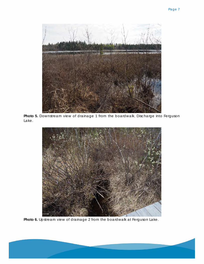
Photo 5. Downstream view of drainage 1 from the boardwalk. Discharge into Ferguson Lake.
Photo 6. Upstream view of drainage 2 from the boardwalk at Ferguson Lake.
' I , I
' I '.1

Page 8
Photo 7. Upstream view of drainage 2. Typical undefined surface water through vegetation.
Photo 8. Upstream view of drainage 2. Typical short section of channel in organic fine substrate.

BYLAW NO. 3195
A BYLAW TO AMEND REGIONAL DISTRICT OF FRASER-FORT GEORGE ZONING BYLAW NO. 2892, 2014
WHEREAS the Regional Board of the Regional District of Fraser-Fort George has adopted Regional District of Fraser-Fort George Zoning Bylaw No. 2892
AND WHEREAS the Regional Board intends to amend aforesaid Bylaw No. 2892 by passage of this bylaw, having due regard to the requirements of the Local Government Act;
NOW THEREFORE the Board of Directors of the Regional District of Fraser-Fort George, in open meeting assembled, enacts as follows:
1. Regional District of Fraser-Fort George Zoning Bylaw No. 2892 is hereby amended at Schedule ‘B’ – Map90 by rezoning The North ½ of the North East ¼ of District Lot 2415 Cariboo District from Rural 1 (Ru1) toRural Residential 2 (RR2).
2. This bylaw may be cited for all purposes as “Zoning Bylaw No. 2892, Amendment Bylaw No. 3195, 2020.”
READ A FIRST TIME ON THE DAY OF , 2020
READ A SECOND TIME ON THE DAY OF , 2020
A PUBLIC HEARING IN RESPECT OF THIS BYLAW WAS HELD ON THE DAY OF , 2020
READ A THIRD TIME ON THE DAY OF , 2020
ADOPTED THIS DAY OF , 2020
________________________________ Chair
________________________________ General Manager of Legislative and Corporate Services
,.!, REGIONAL DISTRICT
of Fraser-Fort George