report author jenny elphinstone, senior planning officer
TRANSCRIPT
48 of 226
Ordinary Council Meeting - 3 December 2019
5.2. RECONFIGURING OF A LOT (1 INTO 15 LOTS) 20-30 LANGLEY ROAD, PORT DOUGLAS
REPORT AUTHOR Jenny Elphinstone, Senior Planning Officer
MANAGER Paul Hoye, Manager Environment and Planning
DEPARTMENT Planning
PROPOSAL Reconfiguring a Lot
APPLICANT KS3 Pty LtdC/ Flanagan Consulting GroupPO Box 5820Cairns Qld 4870
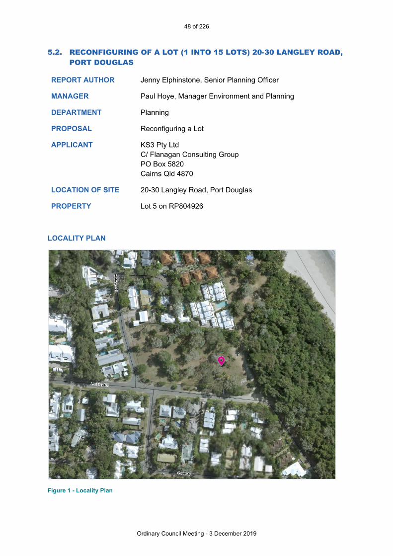
LOCATION OF SITE 20-30 Langley Road, Port Douglas
PROPERTY Lot 5 on RP804926
LOCALITY PLAN
Figure 1 - Locality Plan

49 of 226
Ordinary Council Meeting - 3 December 2019
ZONE Tourist Accommodation
LOCAL PLAN Port Douglas / Craiglie
PLANNING SCHEME 2018 Douglas Shire Planning Scheme
REFERRAL AGENCIES Department of State Development, Manufacturing, Infrastructure and Planning
NUMBER OF SUBMITTERS
Not Applicable
STATUTORY ASSESSMENT DEADLINE
10 December 2019
APPLICATION DATE 26 March 2019
RECOMMENDATION
That Council issues a Development Permit for the development application for the reconfiguration of a lot, over land described as Lot 5 on RP804926, located at 20-30 Langley Road, Port Douglas, subject to the following:APPROVED DRAWING(S) AND / OR DOCUMENT(S) The term ‘approved drawing(s) and / or document(s)’ or other similar expressions means generally the following plans together with any amendments as required by the Conditions of the approval:
Drawing or Document Reference Date
Proposal Plan Flanagan Consulting Group Drawing 6038-SK01 F (Council Document ID 912385).
13 September 2019
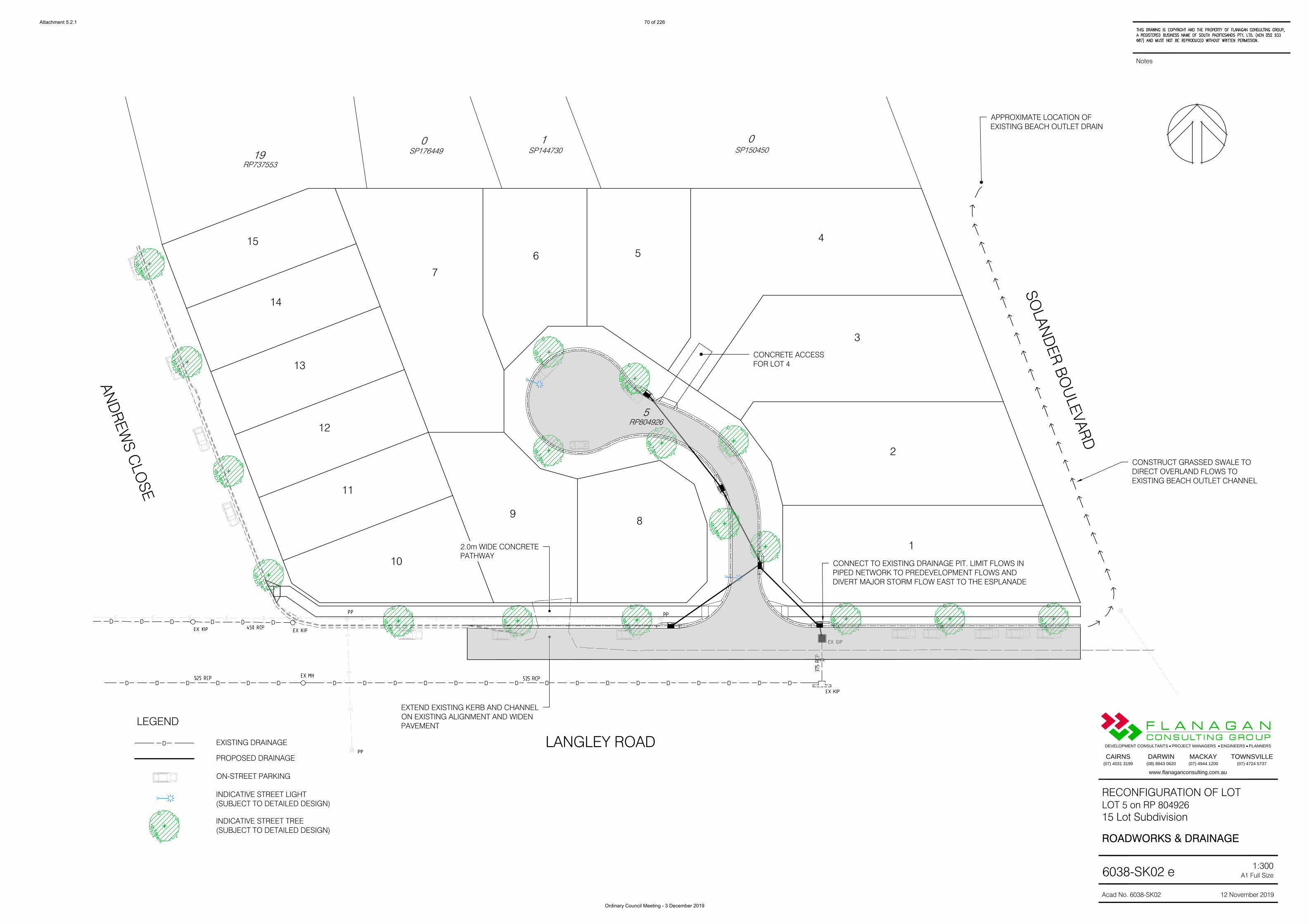
Roadworks and Drainage Plan
Flanagan Consulting Group Drawing 6038-SK02 e (Council Document ID 928437).
12 November 2019.
Concept Site Grading Flanagan Consulting Group Drawing 6038-SK05 e (Council Document ID 928437).
12 November 2019.
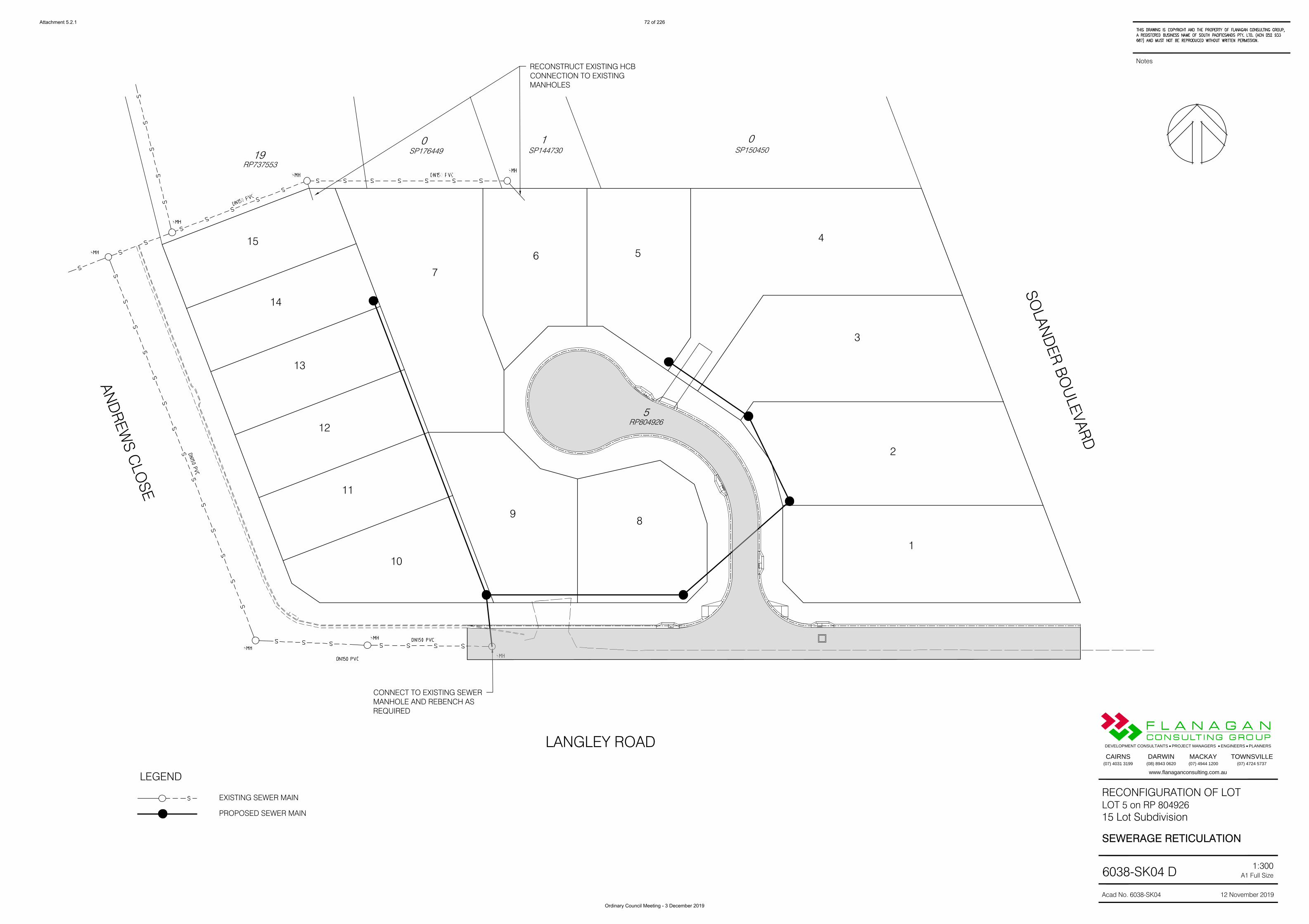
Sewerage Reticulation Plan
Flanagan Consulting Group Drawing 6038-SK04 D (Council Document ID 928437).
12 November 2019.
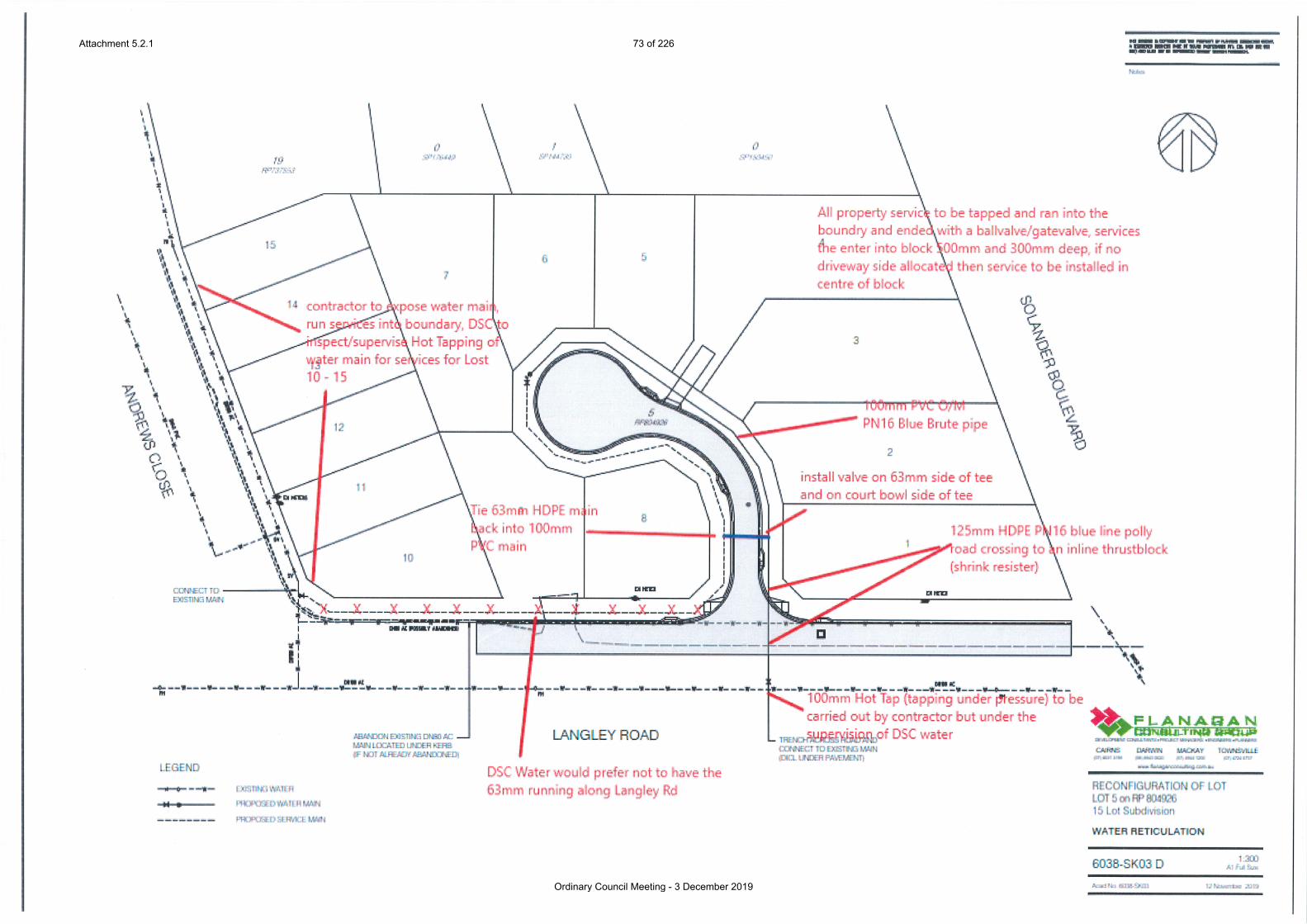
Water Reticulation Plan
Flanagan Consulting Group Drawing 6038-SK03 E dated 19 December 2019 and as annotated by Council (Council Document ID 930021)
26 November 2019.

50 of 226
Ordinary Council Meeting - 3 December 2019
ASSESSMENT MANAGER CONDITIONS AND ADVICESAssessment Manager Conditions and Advices1. Carry out the approved development generally in accordance with the approved
drawing(s) and/or document(s), and in accordance with:a. The specifications, facts and circumstances as set out in the application
submitted to Council; andb. The following conditions of approval and the requirements of Council’s
Planning Scheme and the FNQROC Development Manual. Except where modified by these conditions of approval.
Timing of Effect2. The conditions of the Development Permit must be effected prior to the lodgement
of the Survey Plan for signing and dating, except where specified otherwise in these conditions of approval.
Access 3. a. No lot is to have vehicle access to or from Solander Boulevard.
b. Vehicle Access to proposed Lot 9 is limited to Langley Road. No vehicle access to and from Lot 9 is permitted to the internal cul-de-sac.
Building and Structure setbacks4. No buildings or structures are to be located within 3 m of the Solander Boulevard
frontage of the site on Lots 1-4 unless otherwise approved by the Chief Executive Officer.
Street Layout and Design5. The street layout and design is to be generally in accordance with Flanagan
Consulting Group Proposal Plan 6038-SK02e dated 19 November 2019 and must comply with Queensland Streets and the FNQROC Development Manual, to the satisfaction of the Chief Executive Officer. In particular:a. The new internal road must have a minimum road reserve width of 14.5
metres; b. Langley Road must be upgraded to reflect the road form and geometry of
the existing constructed Langley Road west from Andrews Close for the full frontage of the site. Unless otherwise approved, the road upgrade must include new kerb and channel, subsoil drains and road pavement to the crown of the road;
c. The upgrade of Langley Road must include the provision of a two (2) metre wide concrete footpath along the frontage of the site including a new kerb ramp on Andrews Close;
d. The upgrade of Langley Road must be designed to ensure that the intersection with Solander Boulevard is designed to suitable enable Council vehicle access and public pedestrian access onto Solander Boulevard;
e. Detail of proposed retaining structure along the Solander Boulevard frontage of the site that may include a single pedestrian access for each lot fronting Solander Boulevard and must be provided prior to seeking a Development Permit for Operational Work. The retaining structure is to have regard to protection from future storm tide inundation and amenity to the neighbouring Solander Boulevard. These works are to be undertaken at the time of other civil work associated with the development.

51 of 226
Ordinary Council Meeting - 3 December 2019
f. Provision of a fill on each lot whereby:i. Fill areas for the lots are at a level to provide an immunity to a 1% storm
tide event (having regard to a 0.8m sea level rise for the year 2100 or a lower level if nominated under a State Planning Policy at the time of lodgement of the application for Operational Work) and a 1% flood event. The nominated fill level to provide immunity to the 1% AEP stormtide event is to be as per the Cairns BMT-WMB Cairns Region Storm Tide Inundation Study, Final Report and Mapping January 2013 (Council reference Doc ID: 462510) or another superseding report or individual study approved or found satisfactory to the satisfaction of the Chief Executive Officer.Where the freeboard applied relevant to the BMT WMB report (Page 45 of the Study report) is less than the report recommendation, such lesser height must be qualified by the study author as suitable for the land to the satisfaction of the Chief Executive Officer. Alternatively, the qualification maybe provided by a peer coastal engineer to the satisfaction of the Chief Executive Officer;
ii. All fill is to drain to lawful point of discharge and must not detrimentally impact on upstream, downstream or surrounding land and/or proposed lots;
iii. Fill areas must be suitably retained with suitably revetment protection from coastal erosion and impacts of storm tide inundation;
v. Where the minimum fill results in an increase of ground level of 1m or greater to the neighbouring northern boundary for proposed lots 4, 5, 6 and 7, section and site plans are to be provided, for each of the adjacent lots and at least at the highest point, detailing the proposed height and proposed treatment(s) including landscaping to ensure the continued amenity of the neighbouring lots. The design is to ensure no ponding occurs to neighbouring properties and all drainage received from the neighbouring land is adequately catered for. These works are to be undertaken at the time of other civil work associated with the development;
vi. Where the minimum fill results in an increase of ground level of less than 1m, to the neighbouring northern boundary for proposed lots 4, 5, 6 and 7, the fill may be constructed to the boundary provided no ponding occurs to neighbouring properties and all drainage received from the neighbouring land is adequately catered for;
g. All lots must provide for suitable vehicle access. An amended plan incorporating the above requirements must be submitted prior to the issue of a Development Permit for Operational Work.All works must be carried out in accordance with the approved plans, to the requirements and satisfaction of the Chief Executive Officer prior to the lodgement of a Survey Plan for signing and dating.

52 of 226
Ordinary Council Meeting - 3 December 2019
Water Supply and Sewerage Works Internal 6. Undertake the following water supply and sewerage works internal to the subject
land generally in accordance with Flanagan Consulting Group Sketches 6038-SK03D and 6038-SK04D:a. Provide a single internal sewer connection to each lot in accordance with
the FNQROC Development Manual;b. If any existing sewer connections or property connection branches are
proposed to be retained, further detail is to be provided to support the condition and capacity of the connection. CCTV footage is required to confirm the suitability of the existing connections for reuse. Existing sewer connections not retained must be decommissioned.
c. Provide a minimum 100mm (PN16, Blue Brute) diameter water main in the new cul-de-sac with a 63mm (HDPE, PN16 blueline) OD loop main in accordance with the FNQROC Development Manual requirements;
d. Provide a minimum 125mm HDPE SDR11 PN 16 road crossing connecting to the 100mm main on the southern side of Langley Road connected with Hot Tap (tapping under pressure) and under DSC water supervision. The 100mm road crossing must be on the eastern side of the new cul-de-sac;
e. Services to be installed and tapped during the main laying, bring service into property boundary 500mm and 300mm deep, If driveways/cross overs have not been allocated then service is to be installed in the middle of block, this avoids the chance of the service being under a driveway,
f. Provide all fittings and valving in accordance with the FNQROC Development Manual requirements; and
g. Decommission and remove the existing AC water main along the Langley Road frontage of the site and any existing water meters or water supply connections into the site.
All the above works must be designed and constructed in accordance with the FNQROC Development Manual and generally as the annotated water reticulation plan. Engineering design plans incorporating the above requirements must be submitted prior to the issue of a Development Permit for Operational Work.All works must be carried out in accordance with the approved plans, to the requirements and satisfaction of the Chief Executive Officer prior to the lodgement of the Survey Plan for signing and dating.
Damage to Infrastructure7. In the event that any part of Council’s existing sewer / water infrastructure is
damaged as a result of construction activities occurring on the site, including but not limited to, mobilisation of heavy earthmoving equipment, stripping and grubbing, the applicant / owner must notify Council immediately of the affected infrastructure and have it repaired or replaced by Council, at the developer’s cost, prior to the lodgement of the Survey Plan for signing and dating.
Acid Sulfate Soil Management Plan8. a. Undertake an Acid Sulfate Soil sampling, investigation and analysis in the
area to be affected by this development in accordance with:i. the Queensland Acid Sulfate Soil Technical Manual Soil Management
Guidelines version 4.0 (2014);

53 of 226
Ordinary Council Meeting - 3 December 2019
ii. the Acid Sulfate Soils - Laboratory Methods Guidelines (version. 2.1, June 2004; and
iii. the State Planning Policy 2017.b. Provide a statement to Council that
i. present Acid Sulfate Soils and/or Possible Acid Sulfate Soils are not present; or
ii. that management of present Acid Sulfate Soils and/or Possible Acid Sulfate Soils has been incorporated into an Acid Sulfate Soils Environmental Management Plan prepared in accordance with the abovementioned documents.
Identification of soils with a pyrite content in excess of the action levels will trigger a Acid Sulfate Soil Environmental Management Plan which must be prepared to the satisfaction of the Chief Executive Officer. Where earthworks are undertaken without a Development Permit for Operational Work, the results of this investigation must be submitted to Council for approval, ten (10) business days prior to any earthworks or clearing being commenced on the site.Where earthworks are undertaken in association with a Development Permit for Operational Work, the results must accompany such application lodged to Council.
Drainage Study of Site and drainage Design Plan9. Undertake a local drainage study of the site to determine the drainage impacts on
upstream and downstream properties and the mitigation measures required to minimise such impacts. In particular, the study must address the following:a. The contributing catchment boundaries, including specifically the drainage
from northern properties entering the site and discharging via surface drainage and pipe systems through proposed lot 4 and within Solander Boulevard to the east of proposed lot 4;
b. The extent of the 100 year ARI flood event in relation to the site both pre- and post-development;
d. Primary and secondary flow paths for the 5 and 100 year ARI flood events, including external flows currently discharging through the site;
e. Identify any requirement for drainage easements;f. Identify the need and tenure for flood detention areas to ensure a no-
worsening impact on downstream properties for the entire development; g. In the absence of flood detention, the drainage study provides a concept
design to limit the primary piped drainage flows entering the existing drainage system that drains to the west to no more that the pre-development flows and ensure that all overland flows are able to be conveyed to Langley Road east to Solander Boulevard to the existing drainage swale outlet near the northern property boundary on Solander Boulevard. Depth and width of flows in Langley Road east from the cul-de-sac in the minor event are to be provided in the supporting calculations for the operational works submission;
h. Information on the proposed works and any impacts proposed at the drainage outlet from the proposed development; and
i. Lawful point of discharge.

54 of 226
Ordinary Council Meeting - 3 December 2019
A plan of proposed drainage works must then be prepared to show the study outcomes and include the following considerations:i. Drainage infrastructure in accordance with FNQROC Development Manual
except as modified under (g) above.ii.. All new allotments shall have immunity from flooding associated with the
ARI 100 year rainfall event and the 100 year storm tide event;iii. Where practical, all new allotments must be drained to the road frontages,
drainage easements or drainage reserves and discharged to the existing drainage system via stormwater quality device(s);
iv. Existing surface drainage along the northern property boundary must be addressed in the plan of drainage works unless otherwise approved by Council following review of the outcomes of the drainage study; and
v. The underground drainage network to the west is to be limited to the predevelopment flows and any additional runoff is to be conveyed overland in Langley Road east to Solander Boulevard
The study and the proposed drainage works plan must be endorsed by the Chief Executive Officer prior to the issue of a Development Permit for Operational Work.
Access Construction 10. Construct a concrete driveway or other approved surface to the nominated
building area located in Lot 4.All works must be carried out in accordance with the approved plans and must be to the requirements and satisfaction of the Chief Executive Officer prior to the lodgement of the Survey Plan for signing and dating.
Demolish Structures11. All structures not associated with the approved development (including disused
services and utilities) must be demolished and/or removed from the subject land prior to the lodgement of the Survey Plan for signing and dating.
Stockpiling and Transportation of Fill Material12. Soil used for filling or spoil from the excavation is not to be stockpiled in locations
that can be viewed from adjoining premises or a road frontage for any longer than one (1) month from the commencement of works. Transportation of fill or spoil to and from the site must not occur within:a. peak traffic times; or b. before 7:00 am or after 6:00 pm Monday to Friday; or c. before 7:00 am or after 1:00 pm Saturdays; ord. on Sundays or Public Holidays.
13. Dust emissions or other air pollutants must not extend beyond the boundary of the site and cause a nuisance to surrounding properties.
Storage of Machinery and Plant 14. The storage of any machinery, material and vehicles must not cause a nuisance
to surrounding properties, to the satisfaction of the Chief Executive Officer.

55 of 226
Ordinary Council Meeting - 3 December 2019
Construction Access
15. Vehicular access to the site for construction and demolition purposes must be provided from Langley Road only, unless authorised by the Chief Executive Officer.
Sediment and Erosion Control 16. A sediment and erosion control plan must be submitted prior the issue of a
Development Permit for Operational Works. Such plans must be installed / implemented prior to discharge of water from the site, such that no external stormwater flow from the site adversely affects surrounding or downstream properties (in accordance with the requirements of the Environmental Protection Act 1994, and the FNQROC Development Manual).
Existing Services17. Written confirmation of the location of existing services for the land must be
provided. In any instance where existing services are contained within another lot, the following applies, either:a. Relocate the services to comply with this requirement; orb. Arrange registration of necessary easements over services located within
another lot prior to, or in conjunction with, the lodgement of a Survey Plan for signing and dating to create a lot.
Electricity Supply18. Written evidence from Ergon Energy advising if distribution substation/s are
required within the development must be provided. If required, details regarding the location of these facilities must be submitted to the Chief Executive Officer accompanied by written confirmation from Ergon Energy. Details regarding electricity supply must be provided prior to the issue of a Development Permit for Operational Work.
Electricity and Telecommunications19. Written evidence of negotiations with Ergon Energy and the telecommunication
authority must be submitted to Council stating that both an underground electricity supply and telecommunications service will be provided to the development prior to the lodgement of a Survey Plan for signing and dating.
Street Lighting20. The following arrangements for the installation of street lighting within the
proposed subdivision must be prior to the lodgement of a Survey Plan for signing and dating:a. Prior to the issue of a Development Permit for Operational Work a Rate 2
lighting scheme is to be prepared by an Ergon Energy approved consultant and submitted to the Chief Executive Officer for approval. The Rate 2 lighting scheme is to be designed in accordance with the relevant Road Lighting Standard AS/NZS 1158 and the FNQROC Development Manual. The applicable lighting category is to be determined from the Road Hierarchy Table D1.1 and the corresponding applicable Lighting Categories Table D8.1 as identified in the FNQROC Development Manual.

56 of 226
Ordinary Council Meeting - 3 December 2019
The lighting scheme must show light pole locations that align with property boundaries that represent the permitted design spacing and demonstrates no conflicts with stormwater, kerb inlet pits and other services.
The design must provide the applicable illumination level specified in the Road Lighting Standard AS/NZS 1158 at the following road elements:i. Intersectionsii. Pedestrian Refugesiii. Cul-de-sacsiv. LATM Devices
LATM Devices are to be shown on the civil layout design, the electrical services and street lighting design must be submitted in accordance with Ergon Energy’s latest Distribution Design Drafting Standard.
b. Prior to the issue of a Compliance Certificate for the Plan of Survey written confirmation that the relevant capital contribution required by Ergon Energy has been paid must be submitted, to ensure that the street lighting will be constructed.
c. Where a new intersection is formed on an existing roadway for the purpose of accessing a new subdivision development, the intersection and existing road approaches must be provided with street lighting for a distance equivalent to at least two (2) spans either side of the intersection to the relevant Lighting Category.
d. Where an existing intersection is required to be upgraded as part of a development approval, the intersection and existing road approaches must be provided with street lighting for a distance equivalent to at least two (2) spans either side of the intersection to the relevant Lighting Category.
Damage to Council Infrastructure21. In the event that any part of Council’s existing infrastructure is damaged as a
result of construction activities occurring on the site, including but not limited to; mobilisation of heavy construction equipment, stripping and grubbing, the applicant/owner must notify Council immediately of the affected infrastructure and have it repaired or replaced at the developer’s/owners/builders cost, prior to the lodgement of the Survey Plan for signing and dating.
Landscape Plan22. Undertake landscaping of the street frontages of new roads, Langley Road and
Andrews Close in accordance with FNQROC Development Manual and in accordance with a landscape plan. Where Solander Boulevard is disturbed for drainage purposes, the area is to be grassed and in a mowable condition with a maximum profile of 1:4.The landscape plan must be to the satisfaction of the Chief Executive Officer prior to the issue of a Development Permit for Operational Work. In particular, the plan must show:a. Planting of the footpath with trees, using appropriate species with regard to
any overhead powerline constraints;

57 of 226
Ordinary Council Meeting - 3 December 2019
b. The revegetation of cut and fill batters;
c. Species to have regard to the Planning Scheme Landscaping Policy;d. Remediation and revegetation works to be undertaken within the both the
major drainage line and the drainage reserve, including any works in Solander Boulevard;
e. Inclusion of all requirements as detailed in other relevant conditions included in this Approval, with a copy of this Development Approval to be given to the applicant’s Landscape Architect / Designer.
The landscape plan must be endorsed by the Chief Executive Officer prior to the issue of a Development Permit for Operational Work. Areas to be landscaped must be established prior to lodgement of the survey Plan for signing and dating. Landscaping must be maintained for the duration of the on-maintenance period to the satisfaction of the Chief Executive Officer.
Construction Signage 23. Prior to the commencement of any construction works associated with the
development, a sign detailing the project team must be placed on the road frontage of the site and must be located in a prominent position. The sign must detail the relevant project coordinator for the works being undertaken on the site, and must list the following parties (where relevant) including telephone contacts:a. Developer;b Project Coordinator;c. Civil Engineer; andd. Civil Contractor.
ADVICE1. This approval, granted under the provisions of the Planning Act 2016, shall lapse
four (4) years from the day the approval takes effect in accordance with sections 85(1)(b) and 71 of the Planning Act 2016.
2. This approval does not negate the requirement for compliance with all relevant Local Laws and statutory requirements.
3. For information relating to the Planning Act 2016 log on to www.dsdmip.qld.gov.au. To access the FNQROC Development Manual, Local Laws and other applicable Policies, log on to www.douglas.qld.gov.au.
4. The Commonwealth Environment Protection and Biodiversity Conservation Act 1999 applies to action that has, will have or is likely to have a significant impact on matters of national environmental significance. Further information on the EPBC Act can be obtained from the Department of the Environment, Water, Heritage and the Arts website www.environment.gov.au/epbc EPBC Act Policy Statement 1.1 Significant Impact Guidelines Matters of National Environmental Significance (Oct. 2009).
Infrastructure Charges Notice5. A charge levied for the supply of trunk infrastructure is payable to Council
towards the provision of trunk infrastructure in accordance with the Infrastructure Charges Notice, a copy of which is attached for reference purposes only. The original Infrastructure Charges Notice will be provided under cover of a separate letter.

58 of 226
Ordinary Council Meeting - 3 December 2019
The amount in the Infrastructure Charges Notice has been calculated according to Council’s Infrastructure Charges Resolution.Please note that this Decision Notice and the Infrastructure Charges Notice are stand-alone documents. The Planning Act 2016 confers rights to make representations and appeal in relation to a Decision Notice and an Infrastructure Charges Notice separately.The amount in the Infrastructure Charges Notice is subject to index adjustments and may be different at the time of payment. Please contact the Development Assessment Team at council for review of the charge amount prior to payment.The time when payment is due is contained in the Infrastructure Charges Notice.
REASONS FOR DECISIONNon Compliance with Assessment Benchmarks
Benchmark Reference Alternative Measure/Comment
Tourist Accommodation Zone Code: PO10-PO12:
New lots contain a minimum area of 1,000m2.New lots have a minimum road frontage of 20 metres.New lots contain a 25m x 20m rectangle.
Some of the proposed lots do not meet the Performance Outcomes. The development meets the Code Purpose (3)(a) providing for “a range of accommodation activities, with an emphasis on short-term accommodation is established at a scale and density to service tourist needs.” The layout provides a range of lot sizes that can provide for a range of accommodation activities including self-assessable dwelling houses and code assessable short-term accommodation, both activities that meet the Code Purpose. The development complies with the code.
Local Plan Code:AO2.1 Development provides for the
retention and enhancement of existing mature trees and character vegetation that contribute to the lush tropical character of the town.
PO2 Development retains and enhances key landscape elements including character trees and areas of significant vegetation contributing to the character and quality of the local plan area and significant views and vistas and other landmarks important in the context of the Port Douglas/ Craiglie Township Plan map contained in Schedule 2).
The development is unable to retain mature vegetation that currently exists on the land due to the need to fill to achieve suitable ground heights respective to coastal processes (storm tide inundation). The vegetation was reviewed and found to not be of state significance. The land is not at a gateway. The vegetation on the nearby road and Reserve provides a physical and aesthetic buffer to the coastline. The development meets the Performance Outcome.

59 of 226
Ordinary Council Meeting - 3 December 2019
Benchmark Reference Alternative Measure/Comment
Reconfiguring of a Lot CodePO1 Lots comply with the lot
reconfiguration outcomes of the applicable Zone Code.
Despite the non achievement of the lot configuration outcomes, the development achieves many of the ROL Code Purposes, namely(a) development results in a well-designed
pattern of streets supporting walkable communities;
(b) lots have sufficient areas, dimensions and shapes to be suitable for their intend use taking into account environmental features and site constraints;
(c) road networks provide connectivity that is integrated with adjoining existing or planned development while also catering for the safe and efficient access for pedestrians, cyclists and for public transport;
(d) lots are arranged to front all streets and parkland such that development enhances personal safety, traffic safety, property safety and security; and contributes to streetscape and open space quality;
(f) people and property are not placed at risk from natural hazards;
The development complies with the Code.
Vegetation Management CodeAO1 An acceptable outcome
provides for vegetation damage where the removal facilitates an approved development.
PO1 (includes) Vegetation is protected to ensure that:
(a) the character and amenity of the local area is maintained;
(b) vegetation damage does not result in fragmentation of habitats;
(c) vegetation damage is undertaken in a sustainable manner;
The development is supported despite the conflict with the vegetation management code. The development meets the State Planning Policy (SPP) regarding Natural Hazards of Storm Tide Inundation. Under section 1.5 of the Planning Scheme, the Overlay Code and the State Planning Policy prevail over the Vegetation Management Code.

60 of 226
Ordinary Council Meeting - 3 December 2019
Benchmark Reference Alternative Measure/Comment
(d) the Shire’s biodiversity and ecological values are maintained and protected;
Code Purpose includes:(a) vegetation is protected from
inappropriate damage; (b)where vegetation damage
does occur it is undertaken in a sustainable manner; c)
significant trees are maintained and protected;
(d) biodiversity and ecological values are protected and maintained;
(e) habitats for rare, threatened and endemic species of flora and fauna are protected and maintained;
(f) landscape character and scenic amenity is protected and maintained;
Concurrence Agency Conditions & Requirements
Concurrence Agency Concurrence Agency Reference Date
Council Electronic Reference
State Department Manufacturing, Infrastructure and Planning
1904-10894 SRA 30 May 2019 904465
Refer to Attachment 2: Concurrence Agency Requirements. (Please note that these conditions / requirements may be superseded by subsequent negotiations with the relevant referral agencies).
EXECUTIVE SUMMARY
The land is located on the northeast corner of Langley Road and Andrews Close, Port Douglas. To the east, the property also fronts an unconstructed part of Solander Boulevard.
The land was developed as the Whispering Palms resort. The resort was abandoned, all buildings thereon removed and the land is currently vacant. A Development Permit issued in 2009 for Holiday Accommodation and Multi-Unit Housing and remains current over the land.

61 of 226
Ordinary Council Meeting - 3 December 2019
The applicant seeks an alternative approval being the reconfiguration of the lot into residential lots.
The proposal is not greenfield development. The reconfiguration creates lots as an infill construction within an existing developed urban area and surrounding streets.
Within the Tourist Accommodation Zone the development for residential purposes is an expected outcome. The purpose of the Tourist Accommodation Zone seeks to provide for a range of accommodation activities with an emphasis on short-term accommodation. Accommodation Activities includes all accommodation types. Half of the developable land will comprise lots each approximately 1000m2 in size and suitable for higher density accommodation developments. The proposed layout reflects a consistency with existing development fronting Andrews Close and the surrounding area that is included in the Low-Medium Density Residential Zone.
The land is also constrained by proximity to the coast and the expected future impact of storm tide inundation. The planning consideration for the safety for individuals and property, in respect to coastal processes, is an integral assessment benchmark. A fill level to 3.87m AHD, within the wave run-up area is proposed. The applicant contends the 1.0m freeboard, identified as necessary under the BMT WBM Storm Tide Inundation Study is only relevant to green field development. A condition of the approval requires clarification for the relevant freeboard height to be provided.
Filling is necessary to achieve the required storm tide immunity, the impact of which does not sustain the vegetation currently on the land. A review of the onsite vegetation identified the removal of vegetation is consistent with the State code.
The report supports the granting of a Development Permit subject to conditions.
TOWN PLANNING CONSIDERATIONS
Background - site
Under the original subdivision that created Andrews Close, the land comprised three (each of 800m2site area) fronting this street with the remainder of the site on a separate title. Through an Interim Development approval, issued in 1973, the eastern part of the land was developed as the Whispering Palms Resort.
The 1981 Douglas Shire Council Planning Scheme included the land in the Residential Zone. The resort expanded in 1982 and again in 1985 with holiday cabins, self-contained units, motel units, a caretaker’s residence and a swimming pool. By 1984 the resort included the residence on the corner of Langley Road and Andrews Close which was then used as the caretaker’s residence. Concurrently, the resort land was rezoned from Residential to Resort Business. The resort acquired the neighbouring two lots in Andrews Close, and in 1992 all land parcels were amalgamated into one lot. In 1994 the additional (amalgamated) lots fronting Andrews Close were also rezoned Resort Business. The 1996 Planning Scheme included the land in the Resort Business zone.

62 of 226
Ordinary Council Meeting - 3 December 2019
A Development Permit issued in 2002 for the redevelopment of part of the resort. The redevelopment was not pursued and the resort was abandoned. In 2003 the buildings were demolished and the majority of the infrastructure, associated with the former resort removed. The land remains vacant.
The 2006 Douglas Shire Council Planning Scheme (as amended) included the land in the Tourist and Residential Planning Area. In 2009 a Development Permit issued by the former Douglas Iconic Panel for Holiday Accommodation and Multi-Unit Housing. The proposal plan included a basement car parking areas with single and double storey construction above. The currency period was extended and the approval remains valid. The approval includes a condition to accommodating the impact to the expected 0.8m AHD sea level rise for the year 2100.
Under the 2018 Douglas Shire Planning Scheme the land is currently included in the Tourist Accommodation Zone.
Part of the eastern portion of the land has endemic, local vegetation, which is also subject to State Planning Policy consideration. The State originally mapped the land as a protected wetland with remnant vegetation and essential habitats. The initial vegetation mapping was developed from online data without a specific field survey. Biotropic Australia Pty Ltd was engaged to undertake a detailed vegetation assessment and through an application, an Amended Map of Referable Wetlands was issued under the Environment Protection Act 1994 on the 21 February 2019. The full detail of the environmental constraints analysis prepared by Biotropic Pty Ltd was included as part of the development application.
Background – surrounding area
The surrounding residential area contains a mix of dwelling houses, short-term accommodation and multiple dwellings. These constructions developed under various planning schemes. Vehicle access to the eastern end of Langley Road is physically blocked inhibiting connection to Little Reef Street. This traffic control was established when the Whispering Palms resort was frequented by tour buses to limit the impact of the resort to Langley Road.
Two resorts lie further to the west: Oaks Lagoons located at the corner of Langley Road and Port Douglas Road; and the Ramada Resort by Wyndham, fronting Port Douglas Road.
A pathway on the adjacent Solander Boulevard provides a connection between Langley Road to the northern, constructed section of Solander Boulevard and to a small local park with a playground and picnic facilities. Beyond Solander Boulevarde is Crown Reserve on which dense vegetation remains. Pedestrian access to Solander Boulevarde and the foreshore area can be achieved either from the eastern end of Langley Road or from the pedestrian pathway at the eastern end of Andrews Close.
Proposal
The application proposes the development of fifteen (15) residential lots and new road. Four large lots, each being 1,000m2 or greater will front Solander Boulevard. Under future code assessable approvals these larger lots can support higher density accommodation such as short-term accommodation. These larger lots will have vehicles access to a new internal cul-

63 of 226
Ordinary Council Meeting - 3 December 2019
de-sac. Five other lots ranging in size from 579m2 to 989m2, face the cul-de-sca and two of these lots also have frontage to Langley Road. Six smaller lots ranging in size from 455m2 to 532m2 front Andrews Close.
While some of the lots are to have frontage to the adjacent Solander Boulevard, there is no intention to open solander boulevard or the adjacent lots to have vehicle access to this road. The requirement to fill these lots to address storm tide inundation limits vehicle access.
The proposed layout plan is included in Attachment 1.
State Planning Requirements
The land is within the urban footprint of the Far North Queensland Regional Plan 2009-2031. The development of the land for urban purposes is consistent with the Regional Plan.
The development is subject to State code requiring referral to the Department of Environment and Science for consideration of impact on a wetland protection area. The Department of State Development, Manufacturing, Infrastructure and Planning has issued a co-ordinated State decision requiring conditions be included in any subsequent approval. Due to an agreed change of vegetation status, the state has raised no issue with the removal on vegetation. The State requirements are included in Attachment 2 and form part of the development approval.
Douglas Shire Planning Scheme Assessment
Table 1.
Douglas Shire Planning Scheme Compliance
Zone Tourist Accommodation Zone Code
PO6 Development is located, designed, operated and managed to respond to the characteristics, features and constraints of the site and surrounds.
Complies through the conditions of the approval in particular regarding minimum ground level necessary for future storm tide inundation.
PO7 Development does not adversely affect the tropical, tourist and residential character and amenity of the area in terms of traffic, noise, dust, odour, lighting or other physical or environmental impacts.
The layout has appropriate consideration for traffic movements thereby addressing this benchmark. The impacts of the higher ground level, due to the storm tide inundation considerations are addressed through building setback conditions.
PO10-PO12:New lots contain a minimum area of 1,000m2.New lots have a minimum road frontage of 20 metres.New lots contain a 25m x 20m rectangle.
Some lots do not achieve the minimum area, road frontage or internal dimensions. Refer to comment below.

64 of 226
Ordinary Council Meeting - 3 December 2019
Douglas Shire Planning Scheme Compliance
Local Plan Mapped within the Port Douglas / Craiglie Local Plan but not included in any precinct. AO2 Retain and enhance existing
mature trees and character vegetation that contribute to the lush tropical character of the town.
PO2 Development retains and enhances key landscape elements including character trees and areas of significant vegetation contributing to the character and quality of the local plan area and significant views and vistas and other landmarks important in the context of the Port Douglas/ Craiglie Township Plan map contained in Schedule 2).
The development is unable to retain mature vegetation that currently exists on the land due to the need to fill to achieve suitable ground heights respective to coastal processes (storm tide inundation). The vegetation was reviewed and found to not be of state significance. The land is not at a gateway. The vegetation on the nearby road and Reserve provides a physical and aesthetic buffer to the coastline. The development meets the Performance Outcome.
Overlay Codes
Acid Sulfate Soils Code All of the land is mapped as ASS and part of the land is mapped as PASS 5-20m AHD. Where land needs to be filled with a compaction rating, this type of activity can give rise to the pushing out and activation of acid sulfate soils. The extent of earthworks required will be determined at operational work stage and standard conditions can address this matter and achieve satisfactory compliance.
Bushfire Hazard Code The western part of the land is mapped as Potential Impact Buffer. The eastern part of the land is mapped as High Potential Bushfire Intensity. The nature of the classification is due to the current vegetation on the land. The vegetation will need to be removed to meet new ground levels required for storm tide inundation. This reduces the bushfire hazard to a satisfactory level.
Coastal Environment Overlay Code The land is not within the Coastal Management District as mapped by the Planning Scheme. The north-eastern part of the land is mapped as within the area of coastal erosion. The development is to be filled and conditions require revetment works which will address coastal erosion.
Flood And Storm Tide Hazard Overlay Code
The land is not mapped as affected by flood.The whole of the land is affected by medium storm tide hazard. Conditions of approval require minimum new ground levels and revetment works to address this constraint.

65 of 226
Ordinary Council Meeting - 3 December 2019
Douglas Shire Planning Scheme ComplianceOverlay Codes
Natural Areas Overlay Code AO1.2 A report is prepared by an appropriately qualified person demonstrating to the satisfaction of the assessment manager, that the development site does not contain any matters of state and local environmental significance.
Part of the land is mapped as MSES - Regulated Vegetation, which reflects the state position relative to desktop data. Details were provided by the Applicant clarifying the lack of significance of the existing vegetation on the site. This issue can be addressed through the referral to the Cairns SARA
Transport Network Code Complies through conditions of approval.
Access, Parking And Servicing Code Complies through conditions of approval.
Other Development Codes
Environment Performance Code Conditions of the approval address stormwater. The road layout is sufficient for refuse collection.
Filling And Excavation Code Complies through conditions.Excavation and filling is required to facilitate the development and is subject to conditions of this approval and the associated operational work. All filling and excavation work is required to be engineered to enable lots to achieve suitable storm tide inundation immunity and the secondly, ensure that the impacts of any work does not detrimentally affect the surrounding, upstream or downstream land or the amenity of neighbouring land.
Infrastructure Works Code Particular details were provide for the original proposed layout for all service infrastructure. While the design has slightly changed, it has been sufficiently demonstrated the development can be conditions to comply to meet FNQROC Development Manual standards.
Landscaping Code Complies through conditions if the approval with further details to be provided at the operational work stage.
Reconfiguring A Lot Code The development does not meet the reconfiguration outcomes of the Zone. Refer to the comment below. The remainder of outcomes is achieved through the conditions of the approval, in particular the need to provide safety to persons and property from natural hazards (storm tide inundation).
Vegetation Management Code AO1 An acceptable outcome
provides for vegetation damage where the removal facilitates an approved development.
The requirements of the Code conflict with the need to develop safe land having regard to future storm tide inundation levels. Refer to comments below.

66 of 226
Ordinary Council Meeting - 3 December 2019
Douglas Shire Planning Scheme Compliance
PO1 (includes) Vegetation is protected to ensure that:
(a) the character and amenity of the local area is maintained;
(b) vegetation damage does not result in fragmentation of habitats;
(c) vegetation damage is undertaken in a sustainable manner;
(d) the Shire’s biodiversity and ecological values are maintained and protected;
Code Purpose includes:(a) vegetation is protected from
inappropriate damage; (b) where vegetation damage
does occur it is undertaken in a sustainable manner;
(c) significant trees are maintained and protected;
(d) biodiversity and ecological values are protected and maintained;
(e) habitats for rare, threatened and endemic species of flora and fauna are protected and maintained;
(f) landscape character and scenic amenity is protected and maintained;
Compliance Issues – Proposed Planning Scheme
Lot Reconfiguration Outcomes: Tourist Accommodation Zone and ROL Codes
The purpose of the Tourist Accommodation Zone Code (3)(a) states an overall outcome is “a range of accommodation activities, with an emphasis on short-term accommodation is established at a scale and density to service tourist needs.” Some of the proposed lots do not meet the Performance Outcome for minimum lot size, road frontage and internal dimensions. The Code The layout provides a range of lot sizes that can provide for a range of accommodation activities including self-assessable dwelling houses and code assessable short-term accommodation, both activities that meet the Code Purpose. The development complies with the Code.
Under the Reconfiguration of a Lot Code (PO1) lots are to meet the lot configuration outcomes of the Tourist Accommodation Zone Code. Despite the non achievement of the performance outcomes, the development complies with the Code by achieving many of the Code Purposes namely:

67 of 226
Ordinary Council Meeting - 3 December 2019
a. a well-designed pattern of streets that supports a walkable community;
b. lots are suitable for a range of residential activities (self and code assessable uses);
c. the development is integrated with the existing surrounding area; and
d. lots are arranged to front all available streets and park areas.
New Ground Levels: Storm Tide Inundation Overlay, Vegetation Management and ROL Codes
Achieving personal and property safety from coastal processes, such as storm tide inundation and coastal erosion, are planning considerations under the State Planning Policy and under the Planning Scheme Reconfiguring of a Lot Code. These considerations override the retention of vegetation under the Planning Scheme Vegetation Management Code.
Part of the land is within 200m of the front dune and Council’s current modelling, based on the BMT WBM Storm Tide Inundation Study report prepared under Cairns Regional Council, requires a 3.87m AHD finished site level. The report also recommends a 1.0m freeboard to wave run-up areas (200m setback from frontal dune) and a 0.5m freeboard for areas without wave run-up (beyond 200m from coastline). A land survey identifies the Solander Boulevard frontage to be at about 2.8m AHD with minimal areas of western part of the site to be 3.5m AHD.
The applicant contends BMT WBM freeboards are conservative and are relevant only to green field development sites. On this basis, the applicant’s design nominates fill levels to 3.87m AHD.
Council acknowledges the BMT WBM requirements are conservative. Council is undertaking a storm tide inundation methodology study, through the State Government’s Innovation and Improvement Fund, to refine these requirements. Until the outcome of the Study is completed, including an appropriately peer review, the BMT WBM requirements remain applicable. A condition of the approval states the 3.87m AHD level is acceptable on the basis the Study report author supports the reduced freeboard.
Given the current monitoring of sea level rise exponentially increasing at a rate higher than anticipated, the condition requires consideration of a variable minimum sea level rise, where a different height maybe adopted by the State of Queensland prior to the lodgement of an application for Operational Work.
Infrastructure Works
The conditions require construction of Langley Road to meet FNQROC Development Manual Standard. Conditions require no further impact to stormwater and this will necessitate the developer changing the current storm water infrastructure.

68 of 226
Ordinary Council Meeting - 3 December 2019
ADOPTED INFRASTRUCTURE CHARGES
The proposed development triggers Adopted Infrastructure Charges. Refer to Attachment 3 to view calculations.
COUNCIL’S ROLE
Council can play a number of different roles in certain circumstances and it is important to be clear about which role is appropriate for a specific purpose or circumstance. The implementation of actions will be a collective effort and Council’s involvement will vary from information only through to full responsibility for delivery.
The following area outlines where Council has a clear responsibility to act:
Regulator: Meeting the responsibilities associated with regulating activities through legislation or local law.
Under the Sustainable Planning Act 2009 and the Sustainable Planning Regulation 2009, Council is the assessment manager for the application.
ATTACHMENT
1. Attachment 1 Proposal Plans [5.2.1 - 5 pages]2. Attachment 2 SARA Response for conditions [5.2.2 - 6 pages]3. Attachment 3 Infrastructure charges notice [5.2.3 - 1 page]

5RP804926
0SP150450
1SP144730
0SP17644919
RP737553
13
12
14
AND
REW
S CLO
SE
LANGLEY ROAD
NE
W R
OA
D14.5m
RO
AD
RE
SE
RVE
SOLAN
DER
BOU
LEVARD
15
11
6
1001m²
1
1001m²2
1023m²3
45
10
654m²9
7579m²
989m²
532m²
1158m²457m²
455m²
8614m²
608m²
455m²
455m²
455m²
7.00
28.6
5
22.4
0
38.38
22.01
44.50
48.19
22.01
20.43
50.22
20.08
53.41
10.00
9.86
8.75
14.7
5
5.66
30.22
50.37
13.20
13.00
13.00
6.59
11.37
33.49 16.14
13.00
5.12
35.00
35.00
14.57
13.00
4.70
35.00
8.03
11.2
3
5.66
23.8
6
22.12
13.00
24.4
4
12.1
9
26.5
2
12.01
15.21
35.00
35.00
7.45 3.03
11.33
8.03
16.30
21.02
9.83
20.0028.55 20.00
7.46
7.81
4.34
A1 Full Size
13 September 2019Acad No. 6038-SK01
6038-SK01 F
Notes
1:300
DEVELOPMENT CONSULTANTS · PROJECT MANAGERS · ENGINEERS · PLANNERS
(07) 4031 3199
CAIRNS
(07) 4944 1200
MACKAY
(08) 8943 0620
DARWIN
(07) 4724 5737
TOWNSVILLE
www.flanaganconsulting.com.au
LOT 5 on RP 80492615 Lot Subdivision
RECONFIGURATION OF LOT
PROPOSAL PLAN
Attachment 5.2.1 69 of 226
Ordinary Council Meeting - 3 December 2019
E E E E E E E E
E
E
E
E
E
E
E E E E E E
0SP150450
1SP144730
0SP17644919
RP737553
EE
E
AND
REW
S CLO
SE
LANGLEY ROAD
EXTEND EXISTING KERB AND CHANNELON EXISTING ALIGNMENT AND WIDENPAVEMENT
CONNECT TO EXISTING DRAINAGE PIT. LIMIT FLOWS INPIPED NETWORK TO PREDEVELOPMENT FLOWS ANDDIVERT MAJOR STORM FLOW EAST TO THE ESPLANADE
SOLAN
DER
BOU
LEVARD
CONCRETE ACCESSFOR LOT 4
5RP804926
13
12
14
15
11
6
1
2
3
45
10
9
7
8
APPROXIMATE LOCATION OFEXISTING BEACH OUTLET DRAIN
CONSTRUCT GRASSED SWALE TODIRECT OVERLAND FLOWS TOEXISTING BEACH OUTLET CHANNEL
2.0m WIDE CONCRETEPATHWAY
A1 Full Size
12 November 2019Acad No. 6038-SK02
6038-SK02 e
LOT 5 on RP 80492615 Lot Subdivision
RECONFIGURATION OF LOT
Notes
1:300
ROADWORKS & DRAINAGE
DEVELOPMENT CONSULTANTS · PROJECT MANAGERS · ENGINEERS · PLANNERS
(07) 4031 3199
CAIRNS
(07) 4944 1200
MACKAY
(08) 8943 0620
DARWIN
(07) 4724 5737
TOWNSVILLE
www.flanaganconsulting.com.au
LEGEND
EXISTING DRAINAGE
PROPOSED DRAINAGE
INDICATIVE STREET TREE(SUBJECT TO DETAILED DESIGN)
ON-STREET PARKING
INDICATIVE STREET LIGHT(SUBJECT TO DETAILED DESIGN)
Attachment 5.2.1 70 of 226
Ordinary Council Meeting - 3 December 2019

0SP150450
1SP144730
0SP17644919
RP737553
AND
REW
S CLO
SE
LANGLEY ROAD
SOLAN
DER
BOU
LEVARD
3.87
||
||
||
||
||
|||||||
|
|
|
|
|
EX 2.60
3.87
3.87
3.87
3.87
EX 2.90
EX 3.003.8
7
3.87
3.87
4.00
4.00
3.87
4.11
3.95
3.87
3.87
3.20
3.20
3.42
3.39
3.30
3.87
3.87
RETAINING WALL 800mm HIGH
3.21
3.08
RETAIN
ING
WALL 800m
m H
IGH
WITH
PEDESTR
IAN AC
CESS STEPS FO
R LO
TS 1 - 4
3.95
2.90
3.13
3.87
3.87
4.04
4.04
4.00
4.04
3.00
4.00
3.99
4.07
3.72
5RP804926
13
12
14
15
11
6
1
2
3
45
10
9
7
8
3.87 3.8
7
3.87
||
|
|
|
| || | |
| || |
| ||
|
|
|
||
||
||
|
|
||||||||||||||||||||||||||||||||||
| | | | | | | | | | | | | | | | | | | | |
|
||
||
||
||
||
||
||
||
||
||
||
||
||
||
||
||
||
||
||
||||||||||||||||||||||||
||
||
||
||
||
||
||
|
|
|
|
||
|
|
||
||
||
3.87
A1 Full Size
12 Novembert 2019Acad No. 6038-SK05
6038-SK05 E
LOT 5 on RP 80492615 Lot Subdivision
RECONFIGURATION OF LOT
Notes
1:300
CONCEPT SITE GRADING
DEVELOPMENT CONSULTANTS · PROJECT MANAGERS · ENGINEERS · PLANNERS
(07) 4031 3199
CAIRNS
(07) 4944 1200
MACKAY
(08) 8943 0620
DARWIN
(07) 4724 5737
TOWNSVILLE
www.flanaganconsulting.com.au
LEGEND
4.06
|||| PROPOSED TOP OF BATTER (ALL BATTERSSHOWN INDICATIVELY AT 1:4 UNO)
PROPOSED RETAINING WALL
FINISHED SURFACE LEVEL
DIRECTION OF FALL
CHANGE OF GRADE
MINIMUM ALLOTMENT FILL LEVELS3.87 AHD < 200m SETBACK FROM COASTLINE2.70 AHD > 200m SETBACK FROM COASTLINE(REF: Cairns Region Storm Tide InundationStudy - 2017 prepared by BMT WBM )
EXISTING SURFACE CONTOURS
Attachment 5.2.1 71 of 226
Ordinary Council Meeting - 3 December 2019
0SP150450
1SP144730
0SP17644919
RP737553
AND
REW
S CLO
SE
LANGLEY ROAD
CONNECT TO EXISTING SEWERMANHOLE AND REBENCH ASREQUIRED
RECONSTRUCT EXISTING HCBCONNECTION TO EXISTINGMANHOLES
SOLAN
DER
BOU
LEVARD
5RP804926
13
12
14
15
11
6
1
2
3
45
10
9
7
8
PROPOSED SEWER MAIN
A1 Full Size
12 November 2019Acad No. 6038-SK04
6038-SK04 D
LOT 5 on RP 80492615 Lot Subdivision
RECONFIGURATION OF LOT
Notes
1:300
SEWERAGE RETICULATION
DEVELOPMENT CONSULTANTS · PROJECT MANAGERS · ENGINEERS · PLANNERS
(07) 4031 3199
CAIRNS
(07) 4944 1200
MACKAY
(08) 8943 0620
DARWIN
(07) 4724 5737
TOWNSVILLE
www.flanaganconsulting.com.auLEGEND
EXISTING SEWER MAIN
Attachment 5.2.1 72 of 226
Ordinary Council Meeting - 3 December 2019
Attachment 5.2.1 73 of 226
Ordinary Council Meeting - 3 December 2019

RA6-N
Page 1 of 6
Far North Queensland regional officeGround Floor, Cnr Grafton and Hartley Street, CairnsPO Box 2358, Cairns QLD 4870
SARA reference: 1904-10894 SRACouncil reference: ROL 3061/2019Applicant reference: 6038/01-L-EC2114
30 May 2019
Chief Executive OfficerDouglas Shire CouncilPO Box 723Mossman Qld [email protected]
Attention: Jenny Elphinstone
Dear Sir/Madam
SARA response—20-30 Langley Road, Port Douglas (Referral agency response given under section 56 of the Planning Act 2016)
The development application described below was confirmed as properly referred by the Department of State Development, Manufacturing, Infrastructure and Planning on 30 April 2019.
Response
Outcome: Referral agency response – with conditions.
Date of response: 30 May 2019
Conditions: The conditions in Attachment 1 must be attached to any development approval.
Advice: Advice to the applicant is in Attachment 2.
Reasons: The reasons for the referral agency response are in Attachment 3.
Development details
Description: Development permit Reconfiguring a lot (1 lot into 13 lots)
SARA role: Referral Agency
SARA trigger: Schedule 10, Part 20, Division 4, Table 2, Table 1 (Planning Regulation 2017)
Wetland protection area
SARA reference: 1904-10894 SRA
Assessment Manager: Douglas Shire Council
Attachment 5.2.2 74 of 226
Ordinary Council Meeting - 3 December 2019

1904-10894 SRA
Department of State Development, Manufacturing, Infrastructure and Planning Page 2 of 6
Street address: 20-30 Langley Road, Port Douglas
Real property description: Lot 5 on RP804926
Applicant name: KS3 Pty Ltd
Applicant contact details: PO Box 891TOWNSVILLE QLD [email protected]
RepresentationsAn applicant may make representations to a concurrence agency, at any time before the application is decided, about changing a matter in the referral agency response (s.30 Development Assessment Rules)
Copies of the relevant provisions are in Attachment 4.
A copy of this response has been sent to the applicant for their information.
For further information please contact Joanne Manson, Principal Planning Officer, SARA Far North QLD on 40373228 or via email [email protected] who will be pleased to assist.
Yours sincerely
Brett NancarrowManager (Planning)
cc KS3 Pty Ltd, c/- Flanagan Consulting, [email protected]
enc Attachment 1 - Referral agency conditionsAttachment 2 - Advice to the applicant Attachment 3 - Reasons for referral agency response Attachment 4 - Change representation provisions
Attachment 5.2.2 75 of 226
Ordinary Council Meeting - 3 December 2019

1904-10894 SRA
Department of State Development, Manufacturing, Infrastructure and Planning Page 3 of 6
Attachment 1—Referral agency conditions(Under section 56(1)(b)(i) of the Planning Act 2016 the following conditions must be attached to any development approval relating to this application)
No. Conditions Condition timing
Reconfiguring a lot
Schedule 10, Part 20, Division 4, Table 2, Table 1 - Wetland protection area —The chief executive administering the Planning Act 2016 nominates the Director-General of the Department of Environment and Science to be the enforcement authority for the development to which this development approval relates for the administration and enforcement of any matter relating to the following conditions:
1. Erosion and sediment control measures which are in accordance with the Best Practice Erosion and Sediment Control (BPESC) guidelines for Australia (International Erosion Control Association), are to be installed and maintained to prevent the release of sediment to the HES wetland as shown on the map of referable wetlands as defined in the Environmental Protection Regulation 2008.
Note: HES referable wetlands are wetlands shown on the map of referrable wetlands as defined in the Environmental Protection Regulation 2008.
For the duration of the works
2. Stormwater discharge must be treated in accordance with the Queensland Best Practice Environmental Management Guidelines before stormwater flow enters the HES wetland as shown on the map of referable wetlands as defined in the Environmental Protection Regulation 2008.
Note: HES referable wetlands are wetlands shown on the map of referrable wetlands as defined in the Environmental Protection Regulation 2008.
At all times
3. (a) A Fauna Spotter Catcher (an authorised person who holds a rehabilitation permit with a spotter catcher endorsement under the Nature Conservation Act 1992), must be present on site to monitor earthworks and to respond to any situations that may arise from the discovery of native wildlife.
(b) If any native wildlife are identified onsite, work must cease. The Fauna Spotter Catcher must supervise the relocation of any identified wildlife prior to clearing and earthwork operations recommencing and relocate any found wildlife species at an appropriate location in close proximity of the subject site.
(a) Prior to works commencing
(b) While clearing/earthworks are occurring
Attachment 5.2.2 76 of 226
Ordinary Council Meeting - 3 December 2019

1904-10894 SRA
Department of State Development, Manufacturing, Infrastructure and Planning Page 4 of 6
Attachment 2—Advice to the applicant
General advice
1. Terms and phrases used in this document are defined in the Planning Act 2016 its regulation or the State Development Assessment Provisions (SDAP) [v2.4]. If a word remains undefined it has its ordinary meaning.
Tampering with an Animal Breeding Place of a Protected Species
2. Under the Nature Conservation (Wildlife Management) Regulation 2006, in order to tamper with the breeding place of a protected species (identified in the Nature Conservation Act 1992) appropriate authorisation is required. For further guidance on this please see the Species Management Program information on the Department of Environment and Science’s website.
Protected plants
3. A clearing permit under the Nature Conservation Act 1992 will be required to remove any protected plants from the premises.More information on the clearing of protected plants can be found on the Department of Environment and Science’s website.It is recommended you meet with the Department of Environment and Science prior to applying for a permit under the Nature Conservation Act 1992.The completed pre-design conference application form should submit to [email protected].
The Department of Environment and Science can be contacted via email at [email protected] or by contacting 1300 130 372 (option 4) for information regarding clearing requirements under the Nature Conservation Act 1992.
Attachment 5.2.2 77 of 226
Ordinary Council Meeting - 3 December 2019
1904-10894 SRA
Department of State Development, Manufacturing, Infrastructure and Planning Page 5 of 6
Attachment 3—Reasons for referral agency response(Given under section 56(7) of the Planning Act 2016)
The reasons for the department’s decision are: The department carried out an assessment of the development application against the relevant state
codes and complies with the relevant performance outcomes. The proposed development is not located in a high ecological significance wetland. The proposed development avoids adverse impacts on the adjacent high ecological significance
wetland. With conditions the proposed development does not impact on matters of state environmental
significance.
Material used in the assessment of the application:
The development application material and submitted plans Planning Act 2016 Planning Regulation 2017 The State Development Assessment Provisions (version 2.4), as published by the department The Development Assessment Rules SARA DA Mapping system State Planning Policy mapping system
Attachment 5.2.2 78 of 226
Ordinary Council Meeting - 3 December 2019

1904-10894 SRA
Department of State Development, Manufacturing, Infrastructure and Planning Page 6 of 6
Attachment 4—Change representation provisions(page left intentionally blank – attached separately)
Attachment 5.2.2 79 of 226
Ordinary Council Meeting - 3 December 2019

ADOPTED INFRASTRUCTURE CHARGES NOTICE
Port Douglas
SUBURB
VALIDITY PERIOD (year)
1
VERSION No.
Charge per
Use rate
Floor area/No.
Amount Amount Paid
Locality
Port Douglas
Proposed Demand
Residential Lots Separate house Per House lot 19,491.00 15 292,365.00
Total Demand 292,365.00
Existing Credit
Residential Lot Vacant Lot Per House lot 19,491.00 1 19,491.00
Total Credit 19,491.00
Required Payment or Credit TOTAL $272,874.00
Prepared by 26-Sep-19 Amount Paid
Checked by 30-Sep-19 Date Paid
Date Payable
Prior to endorsement of survey plan Receipt No.
Amendments Date
Cashier
Note:
2018 Douglas Shire Planning Scheme version 1.0 Applications
ROL 2019_3061
LOT & RP No.s
Receipt Code & GL Code
J Elphinstone
0
COUNCIL FILE NO.
4
DSC Reference Doc . No.
KS3 Pty Ltd 0
Code 895GL 07500.0135.0825
Doc ID: 921611
20-30 Langley Road
STREET No. & NAME
L5 RP804926
ROL 15 lots
Payment prior to lodgmentof survey plan for endorsement
1528
DEVELOPERS NAME
PARCEL No.
DEVELOPMENT TYPE
STAGEESTATE NAME
Adopted Charges as resolved by Council at the Ordinary Meeting held on 5 June 2018, Local Government Infrastructure Plan, Planning Scheme Amendment (effect on and from 2 July 2018)
Charge rates under the current Policy are not currently subject to indexing. Any Infrastructure Agreement for trunk works must be determined and agreed to prior to issue of Development Permit for Operational Work.
The Infrastructure Charges in this Notice are payable in accordance with Sections 119 and 120 of the Planning Act 2016as from Council's resolution from the Ordinary Meeting held on 5 June 2018.
Charges are payable to: Douglas Shire Council. You can make payment at any of Council’s Business Offices or by mail with your cheque or money order to Douglas Shire Council, PO Box 723, Mossman QLD 4873. Cheques must be made payable to Douglas Shire Council and marked 'Not Negotiable.' Acceptance of a cheque is subject to collection of the proceeds. Post dated cheques will not be accepted
Any enquiries regarding Infrastructure Charges can be directed to the Development & Environment, Douglas Shire Council on 07 4099 9444 or by email on [email protected]
D Lamond
Attachment 5.2.3 80 of 226
Ordinary Council Meeting - 3 December 2019