report and recommendations of the environmental protection ... 1477 western... · report and...
TRANSCRIPT

Report and recommendations of the Environmental Protection Authority
Report 1477
May 2013
Hamersley Iron Pty Limited
Western Turner Syncline Stage 2 – B1 and Section 17 deposits
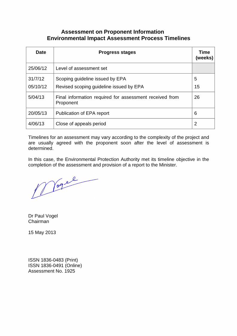
Assessment on Proponent Information Environmental Impact Assessment Process Timelines
Date Progress stages Time (weeks)
25/06/12 Level of assessment set
31/7/12 05/10/12
Scoping guideline issued by EPA Revised scoping guideline issued by EPA
5 15
5/04/13 Final information required for assessment received from Proponent
26
20/05/13 Publication of EPA report 6
4/06/13 Close of appeals period 2
Timelines for an assessment may vary according to the complexity of the project and are usually agreed with the proponent soon after the level of assessment is determined. In this case, the Environmental Protection Authority met its timeline objective in the completion of the assessment and provision of a report to the Minister.
Dr Paul Vogel Chairman 15 May 2013 ISSN 1836-0483 (Print) ISSN 1836-0491 (Online) Assessment No. 1925
1
Contents
Page 1 Introduction and background 2
2 The proposal 3
3 Consultation 7
4 Key environmental factors 7
4.1 Flora and vegetation and hydrological processes 7
4.2 Rehabilitation and closure – integrating factor 11
4.3 Offsets – integrating factor 14
5 Recommended conditions 14
6 Other advice 14
7 Conclusions 15
8 Recommendations 15
Tables
1. Summary of key proposal characteristics 3 Figures
Figure 1 Regional locality map 5
Figure 2 Development envelope and indicative infrastructure layout 6
Figure 3 B1 groundwater drawdown and dewatering discharge 11
Appendices
1. References 2. Recommended Environmental Conditions 3. Preliminary key factors not requiring further evaluation in the EPA
report

2
1 Introduction and background This report provides the Environmental Protection Authority’s (EPA’s) advice and recommendations to the Minister for Environment on the proposal to develop the Western Turner Syncline Stage 2 - B1 and Section 17 (S17) deposits located approximately 30 kilometres (km) west of Tom Price in the Shire of Ashburton. The proposal involves open-pit mining of the B1 and S17 iron ore deposits, transport of ore to the existing Western Turner Syncline Section 10 mine (approximately 12 km east of the B1 deposit) and construction/operation of associated infrastructure. Hamersley Iron Pty Limited (a wholly-owned subsidiary of Rio Tinto) is the nominated proponent for the proposal. Section 44 of the Environmental Protection Act 1986 (EP Act) requires the EPA to report to the Minister for Environment on the outcome of its assessment of a proposal. The report must set out:
• the key environmental factors identified in the course of the assessment; and
• the EPA’s recommendations as to whether or not the proposal may be implemented, and, if the EPA recommends that implementation be allowed, the conditions and procedures to which implementation should be subject.
The EPA may include in the report any other advice and recommendations as it sees fit. The proponent has submitted an Assessment on Proponent Information (API) document setting out the details of the proposal, potential environmental impacts and proposed commitments to manage those impacts. The EPA considers that the proposal, as described, can be managed to meet the EPA’s environmental objectives, and can be implemented subject to the EPA’s recommended conditions being made legally binding. This report provides the EPA advice and recommendations in accordance with section 44 of the EP Act.

3
2 The proposal The Western Turner Syncline Stage 2 Proposal (the proposal) involves open-pit mining at the B1 and S17 iron ore deposits located 30 km west of Tom Price in the central Pilbara region of Western Australia as shown in Figure 1. Proposed infrastructure is located on current and pending tenure under the Iron Ore (Hamersley Range) Agreement Act 1963 (State Agreement Act), the Mining Act 1978, and the Land Administration Act 1997. The project will be integrated into the current Rio Tinto Greater Tom Price mining operation. The proposal to develop the B1 and S17 deposits includes a transport corridor to the existing Western Turner Syncline Section 10 (WTS S10) mine (approximately 12 km east of the B1 deposit). Ore will then be transferred via the existing transportation corridor to the Tom Price mine for further processing, and subsequently to port facilities at Cape Lambert and Dampier via the existing Rio Tinto rail network. The proposal will operate at production rates of up to approximately 32 million tonnes per annum for at least 15 years. The total expected disturbance footprint is 2,700 hectares (ha) within a development envelope of 8,430 ha (Figure 2). Detailed environmental surveys have been undertaken in the development envelope. The main characteristics of the proposal are summarised in the table below. Table 1: Summary of key proposal characteristics Element Description Mine pits and associated infrastructure
Clearing of no more than 2,700 ha within the development envelope of 8,430 ha.
Dewatering at B1 deposit Abstraction of no more than 11 gigalitres per annum.
Dewatering at Section 17 Deposit
Minor dewatering at pits 3 and 8, with no groundwater drawdown impacts beyond the development envelope.
Dewater disposal Dewater disposal through water use hierarchy including: • Use on site; • Transfer to other assets for beneficial
use; • Controlled discharge to surface
drainage, including the local watercourse to the north of B1 and the Beasley River.

4
Dewater discharge to extend no further than 20 km along the designated watercourses from the discharge point.
Backfilling of mine pits 3 and 8 at Section 17
Mine pits are to be backfilled so that the final surface levels are at a higher elevation than the predicted post development groundwater levels to prevent the formation of pit lakes.
The potential impacts of the proposal are discussed by the proponent in the environmental review document (Hamersley Iron Pty Limited, 2013).

5
Figure 1 Regional locality map

6
Figure 2 Development envelope and indicative infrastructure layout

7
3 Consultation During the preparation of the API, the proponent has undertaken consultation with government agencies and key stakeholders. The agencies and organisations consulted, the topics discussed and outcomes are detailed in Section 2 (page 15) of the proponent’s API document (Hamersley Iron Pty Limited, 2013). The EPA considers that the consultation process has been appropriate and that reasonable steps have been taken to inform the stakeholders on the proposed development.
4 Key environmental factors It is the EPA’s opinion that the following key environmental factors relevant to the proposal requires evaluation in this report: (a) Flora and vegetation; (b) Hydrological processes (c) Rehabilitation and closure – integrating factor; and (d) Offsets – integrating factor. The key environmental factors are discussed in Section 4.1. The description of the factor shows why it is relevant to the proposal and how it will be affected by the proposal. The assessment of a factor is where the EPA decides whether or not a proposal meets the environmental objective set for that factor. Appendix 3 describes preliminary key environmental factors identified in the scope of the API which, at the conclusion of the assessment, were not considered to be key environmental factors warranting discussion and evaluation in the EPA’s assessment report.
4.1 Flora and vegetation and hydrological processes
Description The proposal has the potential to impact on flora and vegetation through direct clearing, groundwater drawdown impacts to groundwater dependent vegetation, dewater discharge impacts to riparian vegetation, changes to surface water flows, and the spread of weeds. The proposal would require clearing of up to 2,700 ha of vegetation within the 8,430 ha proposal development envelope. The proposal area lies within the Pilbara bioregion and Hamersley subregion as defined by the Interim Biographic Regionalisation for Australia. The vegetation of this province is typically open and frequently dominated by Triodia, Acacia, and occasional Eucalyptus species. The proposal area intersects two of Beard’s (1975) vegetation units, both of which are widespread in the Pilbara region. The vegetation is ranked as being in ‘very good’ condition.
8
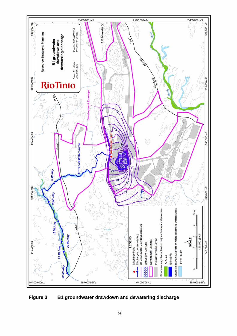
The proponent undertook six flora and vegetation surveys in the Western Turner Syncline (WTS) study area from 2007-2011, covering more than 26,000 ha (Table 3-2 of the proponent’s API document, Hamersley Iron Pty Limited, 2013). No Threatened Ecological Communities or Threatened flora species protected under the Wildlife Conservation Act 1950 or Priority Ecological Communities listed by the Department of Environment and Conservation (DEC) were identified in the development envelope. Five communities were considered to have local conservation significance. The potential clearing of these vegetation communities is up to 575 ha (Appendix 1, Table 2 of the proponent’s API document, Hamersley Iron Pty Limited, 2013). More than 85% of the mapped area of these communities occur outside the indicative infrastructure layout. The proponent submits that all of these communities and/or the habitat in which they occur are relatively widespread regionally. Thirteen Priority flora species were recorded in the WTS study area. The proponent has amended the proposal design to exclude three locations of the Priority 1 species Hibiscus sp. Mt Brockman from the development envelope. This species is now identified at three locations in the development envelope and one location within the indicative infrastructure layout. Eleven other locations of this species are known within 50 km of the proposal. Eight Priority 3 and Priority 4 species were recorded within the development envelope. Some locations of these species are likely to be impacted by clearing; however all of these species have been recorded at other locations in the Pilbara. Further information on the proposal impacts and the local and regional distribution of all Priority species are presented in Appendix 1 of the proponent’s API document (Hamersley Iron Pty Limited, 2013). Mine dewatering is required at the B1 main pit to enable mining below the water table. Figure 3 shows the modelled cone of depression from dewatering. The Department of Water has reviewed the groundwater modelling data and advised the Office of the EPA (OEPA) that the modelling is acceptable for this stage of assessment. Located within the predicted area of 5 – 10 metre (m) drawdown, in a gully to the southwest of the B1 pit at an elevation of 640 to 700 m relative level (mRL), is 4.3 ha of potential groundwater dependant vegetation (E.Vitrix, Coolabah within the community EvMgERIt, Riparian eucalypt woodland on major ephemeral watercourses). The groundwater table where this vegetation occurs is considered to be greater than 100 m below ground level. E. victrix is a facultative phreatophyte, therefore may utilise shallow groundwater but can also inhabit areas without access to permanent groundwater, relying on stored soil water recharged by rainfall and episodic stream flows.
9
Figure 3 B1 groundwater drawdown and dewatering discharge

10
The proponent proposes to follow the hierarchy below to manage surplus dewater water: • maintain supply for WTS Stage 2 operations; • transfer to other assets for beneficial use, i.e. Section 10; and possibly
Tom Price; and • controlled discharge to surface drainage, a local watercourse to the north
of B1 and to the Beasley River. Discharge modelling predicts that, from 2015–2017, potential discharge of up to 30 megalitres per day (ML/day) will extend approximately 18 km downstream from the discharge point. From 2018–2027, potential discharge of approximately 14 ML/day will extend approximately 13 km downstream of the discharge point. Two vegetation units of localised significance (EcEvAci, Riparian eucalypt woodland and EvAciTeCEc, Scattered riparian eucalypts) occur along the watercourses that will be affected by dewater discharge. These communities represent 17% (70 ha) and 6% (52.5 ha) respectively of the total surveyed study area (Appendix 1, Table 2 of API document, Hamersley Iron Pty Limited, 2013). The proponent submits that detrimental impacts to these communities are unlikely but if they were to occur, would likely be contained to the 10 km local watercourse and approximately 3 km of the Beasley River. Modelling predicts that discharged water would be contained within the local flow channel, hence overtopping of the creek banks in dry conditions is not anticipated. The condition of the vegetation along the discharge watercourses is described as good to very poor due to weeds and cattle impacts from the Rocklea pastoral station.
Assessment The EPA’s environmental objectives for flora and vegetation and hydrological processes are to: • maintain representation, diversity, viability and ecological function at the
species, population and community levels; and • maintain hydrological regimes of groundwater and surface water so that
existing and potential uses, including ecosystem maintenance, are protected.
The EPA notes that while some Priority flora would be directly impacted by the proposal, the proponent has altered the proposal layout to minimise these impacts. The EPA acknowledges that all recorded Priority species also occur outside the development. The EPA agrees that it is unlikely that E. victrix is accessing groundwater at depths greater than 100 m and therefore considers that the potential for it to be impacted by groundwater drawdown is minimal. In the unlikely event that drawdown was to impact this community, the EPA considers that impacts to 4.3 ha of this community would be acceptable given its broader occurrence locally and regionally.

11
The EPA has recommended Condition 6 to ensure that the discharge of surplus water from the proposal does not cause long term impacts to the environmental and conservation values of the Beasley River. As the riparian vegetation associated with the discharge watercourses is of conservation significance, the proponent should attempt to avoid or minimise any potential impacts. The EPA has recommended Condition 7 to ensure that impacts to riparian vegetation from dewater discharge are monitored and managed appropriately. The vegetation types identified within the proposal area are known to exist across the Pilbara region. The EPA recommends that the location and authorised extent of clearing be limited to a total disturbance of 2,700 ha within the development envelope as described and spatially defined in Schedule 1 and 2 of the recommended statement. The EPA acknowledges that the proponent has minimised potential impacts to vegetation and flora by amending the proposal design and the EPA has recommended conditions 6 and 7 to ensure that impacts are managed over time. However, it is the EPA’s opinion that a significant residual impact relating to the clearing of up to 2,700 ha of ‘good to excellent’ condition native vegetation remains when considering this proposal in the context of cumulative impacts from other proposals (including approved proposals) in the Pilbara (see Section 4.3 Offsets).
Summary Having particular regard to:
• the proponent’s redesign of the proposal to avoid impacts to Priority flora; • recommended Condition 6 to ensure that the discharge of surplus water
does not cause long term impacts to the environmental and conservation values of the Beasley River;
• recommended Condition 7 to ensure that the discharge of surplus water does not cause long term impacts to the significant riparian vegetation of the Beasley River System; and
• recommended Condition 9 to counterbalance the significant residual impacts of the proposal,
it is the EPA’s opinion that the proposal can be managed to meet the EPA’s environmental objectives for these factors.
4.2 Rehabilitation and closure – integrating factor
Description The proposal would result in clearing of vegetation for mine pits, waste dumps, and associated infrastructure. The potential risks associated with rehabilitation and closure include:
• erosion; • altered groundwater and surface water regimes; • contamination of surface and groundwater; • failure to establish a safe, non-polluting landform;

12
• failure to establish self-sustaining vegetative cover; and • rehabilitation that falls short of agreed completion criteria..
The proposal area is located on current and pending tenure under the Iron Ore (Hamersley Range) Agreement Act 1963 (State Agreement Act), Mining Act 1978, and the Land Administration Act 1997. The majority of the proposal, and in particular the higher risk aspects such as pits, waste dumps and low grade stockpiles, will be located on State Agreement Act tenure. Acid and metalliferous drainage The proponent has undertaken static testing of waste materials and identified a moderate risk of acid and metalliferous drainage (AMD) for the B1 deposit, and a low to moderate AMD risk for the S17 deposit. This assessment was based primarily on the presence of unoxidised black Mount McRae Shale in proximity to the deposits. Additionally, some elevated sulphur percentages were recorded above water table (AWT) in other rock types that may contain alunite, that can release low levels of acid. Mineral waste that may pose an AMD risk comprises less than 3% of the B1 waste (samples having sulfur values greater than 0.1%), and less than 2% of the S17 waste. Geochemical test work is ongoing to better define the potential impacts of the mine wastes that will remain at the site after mine closure. This includes:
• static and kinetic testing of samples from B1 and S17; • leaching under highly saline conditions; and • leaching under lower contact ratios.
Mine pit voids and water quality The B1 main pit will be mined to a maximum depth of approximately 195 m below watertable (BWT), which is at approximately 40 m below ground level in the centre of the pit. A pit lake will form in the B1 main pit void, with water level recovery to approximately 50 m below current ground level after 60 years, resulting in a maximum pit lake depth of approximately 185 m. The proponent predicts that the B1 pit lake will form a groundwater sink, minimising potential for impacts beyond the immediate vicinity of the pit lake. The pit lake is expected to salinise after approximately 450 years, with pH declining from 8.3 to 5.5 over 1000 years. While concentration of a limited suite of elements may reach ANZECC/ARMCANZ (2000) trigger levels (including nutrients), a preliminary assessment suggests that the pit lake is likely to pose a low ecological risk (Equinox Environmental, 2012).
Assessment The EPA’s environmental objective for this factor is to: • ensure that premises can be closed, decommissioned and rehabilitated in an
ecologically sustainable manner, consistent with agreed outcomes and land uses, and without unacceptable liability to the State.
The proponent has developed a draft Mine Closure Plan in accordance with the DMP/EPA Guidelines for Preparing Mine Closure Plans (2011) which provides management measures regarding closure and rehabilitation. The draft plan has been

13
included as an Appendix to the API document (Hamersley Iron Pty Limited, 2013). The proponent intends to update the Mine Closure Plan over the life of the project to ensure that it reflects the changes to the project status, research outcomes and stakeholder expectations. The proponent submits that waste dumps are considered unlikely to have significant environmental impacts based on the following considerations: • Waste dump designs have considered the physical and chemical properties of
waste material; • Substantial volumes of competent waste are available, enabling
design/construction of waste dumps that are stable and not susceptible to excessive erosion;
• A substantial volume of inert waste material is available, enabling design/construction of waste dumps that encapsulate the low volumes of waste rock that pose a potential AMD risk.
The DEC has provided technical advice and has noted that, in general, the procedures used to assess the leaching potential of waste rock materials were appropriate, as was the methodology used to model the likely range of contaminant concentrations in the pit lake that may remain at the site after mining ceases. The DEC supported the conclusions from the proponent’s preliminary risk assessment that mining at the site is likely to have a low impact on the environment. The DEC supports further geochemical test work during mining operations to better define potential impacts of the mine wastes that will remain and recommends additional work to better define how contaminant concentrations in water in the pit lake will change with time. In particular, work to better characterise the surface chemistry of iron oxyhydroxide minerals that are likely to be exposed in pit lakes, and the behaviour of oxyanionic metal and metalloid species (particularly selenium) that are likely to be absorbed on these minerals and desorbed under conditions where the alkalinity and sulphate concentrations in the pit lake increases with time. Results from the test work should then be used to refine estimates of how contaminant concentration will change with time after mine closure. The proponent has committed to incorporating these recommendations in future phases of pit lake water quality modelling where appropriate. The proponent will undertake periodic reviews of the preferred closure strategy for the B1 pit lake (no backfill, potentially with implementation of additional management measures) based on ongoing improvements in geological, hydrogeological, geotechnical and environmental knowledge, to ensure the pit lake closure strategy will achieve closure objectives. The four B1 satellite pits are AWT and will be progressively backfilled where practical. At S17, pits 3 and 8 will be mined to approximately 15 m BWT. These two pits will be preferentially backfilled to a level sufficient to prevent the formation of pit lakes. The EPA notes that due to the naturally elevated nutrient levels in the B1 aquifer groundwater, the B1 pit lake has the potential to become eutrophic which may result in algal blooms. The EPA expects that the proponent will maintain appropriate water

14
quality in the pit after closure and amend the closure strategy if this can not be achieved. The EPA has recommended Condition 8 to ensure that the proponent develops and reviews a mine closure plan in accordance with the DMP/EPA Guidelines for Preparing Mine Closure Plans with ongoing input from the Department of Minerals and Petroleum (DMP).
4.3 Offsets – integrating factor
Description Following the implementation of all mitigation measures, the proposal would have the following significant residual impact: • clearing of up to 2,700 ha of ‘good to excellent’ condition native vegetation,
which comprises up to 575 ha of vegetation of local conservation significance.
Assessment The EPA’s environmental objective for this factor is to: • counterbalance any significant residual impacts or uncertainty through the
application of offsets.
The clearing of native vegetation in ‘good to excellent condition’ in the Pilbara IBRA bioregion is considered to be significant when considered in a cumulative context. This proposal is in the Hamersley IBRA subregion, which is fairly well represented (12.6%) within the conservation reserve system, however, this is still below the target of 15%. To counterbalance the significant residual impacts of the proposal, the EPA has recommended Condition 9. The condition provides for a contribution to a strategic regional conservation initiative that has been agreed to by the proponent.
5 Recommended conditions Having considered the information provided in this report, the EPA has developed a set of conditions which the EPA recommends be imposed if the proposal by Hamersley Iron Pty Limited to develop an iron ore mine located approximately 30 km west of Tom Price in the central Pilbara region is approved for implementation. These conditions are presented in Appendix 2.
6 Other advice Management of mine dewater discharge quality can be adequately managed under Part V of the EP Act, administered by the DEC, therefore a condition has not been recommended by the EPA. The EPA would like to draw to the attention of the DEC that, due to naturally elevated concentrations of nitrogen and phosphorus in the groundwater sampled to date, the nutrient load to the Beasley River and downstream

15
receiving waterbodies could be significant and the Part V licence conditions for this proposal should provide for nutrient load management. The EPA acknowledges that the management of pit lakes is a significant environmental issue. The EPA understands that the OEPA is working with the DoW and the DMP to develop specific guidance on management of pit lakes to support the DMP/EPA mine closure guidelines. The intent of the guidance will be to define regulatory requirements in terms of technical investigations required for environmental impact assessment, appropriate data and models and water-based closure criteria. This will enable the EPA to give consistent advice on the environmental outcomes that proposals must achieve.
7 Conclusions The EPA has considered the proposal by the proponent to develop an iron ore mine and associated infrastructure approximately 30 km west of Tom Price. The EPA has concluded that the proposal can be managed to meet the EPA’s environmental objectives, and can be implemented provided there is satisfactory implementation by the proponent of the recommended conditions (Appendix 2) noting that the extent of clearing is spatially defined and limited to a maximum of 2,700 ha.
8 Recommendations The EPA submits the following recommendations to the Minister for Environment: 1. That the Minister notes that the proposal being assessed is for the
development of an iron ore mine located approximately 30 km west of Tom price in the central Pilbara region.
2. That the Minister considers the report on the key environmental factors as set out in Section 4.
3. That the Minister notes that the EPA has concluded that the proposal can be managed to meet the EPA’s environmental objectives, provided there is satisfactory implementation by the proponent of the recommended conditions set out in Appendix 2.
4. That the Minister imposes the conditions and procedures recommended in Appendix 2 of this report.

16

Appendix 1
References

Australian and New Zealand Environment and Conservation Council and Agriculture and Resource Management Council of Australia and New Zealand (ANZECC/ARMCANZ) (2000). Australian and New Zealand Guidelines for Fresh and Marine Water Quality, Australian Water Association, Sydney. Beard, J (1975). Pilbara Explanatory Notes and Map Sheet, 1:1,000,000 Series, Vegetation Survey of Western Australia, University of Western Australia Press, Nedlands. Department of Mines and Petroleum and the Environmental Protection Authority (DMP/EPA) (2011). Guidelines for Preparing Mine Closure Plans, Department of Mines and Petroleum, Perth. Equinox Environmental (2012). Western Turner Syncline Stage 2 Project Ecological Risk Assessment, unpublished report for Rio Tinto, RTIO-HSE-0168076, Perth. Hamersley Iron Pty Limited (2013). Western Turner Syncline Stage 2 B1 and Section 17 Deposits – Assessment on Proponent Information, Environmental Review Document, April 2013. Rio Tinto Iron Ore (2013a). Western Turner Syncline Stage 2 – B1 and S17 Deposits Environmental Review - Response to OEPA and DMA Comment, April 2013. Rio Tinto Iron Ore (2013b). Western Turner Syncline Iron Ore Project: Stage 2 – Draft Environmental Offset Package for WA State (OEPA), March 2013.

Appendix 2
Identified Decision-making Authorities and
Recommended Environmental Conditions

Identified Decision-making Authorities
Section 44(2) of the Environmental Protection Act 1986 (EP Act) specifies that the EPA’s report must set out (if it recommends that implementation be allowed) the conditions and procedures, if any, to which implementation should be subject. This Appendix contains the EPA’s recommended conditions and procedures. Section 45(1) requires the Minister for Environment to consult with decision-making authorities, and if possible, agree on whether or not the proposal may be implemented, and if so, to what conditions and procedures, if any, that implementation should be subject. The following decision-making authorities have been identified for this consultation:
Decision-making Authority Approval
1. Minister for State Development Iron Ore (Hamersley Range) Agreement Act 1963
2. Minister for Water Rights in Water and Irrigation Act 1914 Water extraction licence Bed and banks permit
3. Minister for Mines and Petroleum
Mining Act 1978 Petroleum Pipelines Act 1969
4. Minister for Aboriginal Affairs Aboriginal Heritage Act 1972 - s18 approval
5. Minister for Environment Wildlife Conservation Act 1950 Taking of protected flora and fauna on Crown land
6. Director General Department of Environment and Conservation
Environmental Protection Act 1986 - Works Approval and licence (category 5 and 6 premises under the Environmental Protection Regulations 1987)
7. CEO, Department of Mines and Petroleum
Mines Safety and Inspection Act 1994 Dangerous Goods Safety Act 2004 Storage and handling of hazardous materials and mines safety
Note: For this proposal, agreement is only required with DMAs #1 to 5 inclusive since these DMAs are Ministers.

Statement No. XXX
RECOMMENDED ENVIRONMENTAL CONDITIONS
STATEMENT THAT A PROPOSAL MAY BE IMPLEMENTED (PURSUANT TO THE PROVISIONS OF THE ENVIRONMENTAL PROTECTION ACT 1986)
Western Turner Syncline Stage 2 – B1 and Section 17 Deposits
Proposal: The proposal is to develop an open-cut iron ore mine and associated infrastructure at the Western Turner Syncline Stage 2 – B1 and Section 17 deposits, located approximately 30 kilometres west of Tom Price in the central Pilbara Region, Western Australia.
The Proposal is further documented in Schedule 1 of this statement
Proponent: Hamersley Iron Pty. Limited Australian Company Number 004 558 276
Proponent Address: Level 22 152-158 St Georges Terrace PERTH WA 6000
Assessment Number: 1925
Report of the Environmental Protection Authority Number: 1477
This Statement authorises the implementation of the Proposal described and documented Table 2 of Schedule 1. The implementation of the Proposal is subject to the following implementation conditions and procedures and Schedule 2 details definitions of terms and phrases used in the implementation conditions and procedures. 1 Proposal Implementation 1-1 When implementing the proposal, the proponent shall not exceed the
authorised extent of the proposal as defined in Column 3 of Table 2 in Schedule 1, unless amendments to the proposal and the authorised extent of the Proposal has been approved under the EP Act.
2. Contact Details 2-1 The proponent shall notify the CEO of any change of its name, physical
address or postal address for the serving of notices or other correspondence within 28 days of such change. Where the proponent
is a corporation or an association of persons, whether incorporated or not, the postal address is that of the principal place of business or of the principal office in the State.
3 Time Limit for Proposal Implementation 3-1 The proponent shall not commence implementation of the proposal
after the expiration of 5 years from the date of this statement, and any commencement, within this 5 year period, must be substantial.
3-2 Any commencement of implementation of the proposal, within 5 years from the date of this statement, must be demonstrated as substantial by providing the CEO with written evidence, on or before the expiration of 5 years from the date of this statement.
4 Compliance Reporting 4-1 The proponent shall prepare and maintain a compliance assessment
plan to the satisfaction of the CEO.
4-2 The proponent shall submit to the CEO the compliance assessment plan required by condition 4-1 at least six months prior to the first compliance assessment report required by condition 4-6, or prior to implementation, whichever is sooner. The compliance assessment plan shall indicate: (1) the frequency of compliance reporting; (2) the approach and timing of compliance assessments; (3) the retention of compliance assessments; (4) the method of reporting of potential non-compliances and
corrective actions taken; (5) the table of contents of compliance assessment reports; and (6) public availability of compliance assessment reports.
4-3 The proponent shall assess compliance with conditions in accordance
with the compliance assessment plan required by Condition 4-1. 4-4 The proponent shall retain reports of all compliance assessments
described in the compliance assessment plan required by Condition 4-1 and shall make those reports available when requested by the CEO.
4-5 The proponent shall advise the CEO of any potential non-compliance within seven days of that non-compliance being known.
4-6 The proponent shall submit to the CEO the first compliance assessment report 15 months from the date of issue of this Statement, or as otherwise agreed by the CEO, addressing the 12 month period from the date of issue of this Statement and then annually from the date of submission of the first compliance assessment report.

The compliance assessment report shall: (1) be endorsed by the proponent’s Managing Director / General
Manager / Chief Executive Officer or a person delegated to sign on the Managing Director’s / General Manager’s / Chief Executive Officer’s behalf;
(2) identify all potential non-compliances and describe corrective and preventative actions taken;
(3) be made publicly available in accordance with the approved compliance assessment plan; and
(4) indicate any proposed changes to the compliance assessment plan required by condition 4-1.
5 Public Availability of Data 5-1 Subject to condition 5-2, within a reasonable time period approved by
the CEO of the issue of this statement and for the remainder of the life of the proposal the proponent shall make publicly available, in a manner approved by the CEO, all validated environmental data (including sampling design, sampling methodologies, empirical data and derived information products (e.g. maps)) relevant to the assessment of this proposal and implementation of this Statement.
5-2 If any data referred to in condition 5-1 contains particulars of:
(1) a secret formula or process; or (2) confidential commercially sensitive information;
the proponent may submit a request for approval from the CEO to not make this data publically available. In making such a request the proponent shall provide the CEO with an explanation and reasons why the data should not be made publically available.
6 Discharge of water to local watercourse and Beasley River 6-1 The proponent shall ensure that the discharge of surplus water from the
Western Turner Syncline Stage 2 site as a result of mining does not cause long term impacts to environmental and conservation values of the Beasley River System.
6-2 To verify that condition 6-1 is being met, the proponent shall develop an Environmental Values Statement for the Beasley River System that defines the environmental values of the Beasley River System to the satisfaction of the CEO.
6-3 The proponent shall ensure that dewatering discharge from the Western Turner Syncline Stage 2 site does not cause water flow or pooling further than the extent identified in Schedule 1, Table 2.
6-4 Prior to discharging water from the Western Turner Syncline Stage 2 site, the proponent shall develop a Water Discharge Monitoring and

Management Plan in consultation with the DoW, to the satisfaction of the CEO, to ensure that the environmental and conservation values associated with the Beasley River and any downstream ecosystems are maintained. This plan shall:
(1) describe the water discharge program; (2) when implemented, demonstrate, by monitoring, whether
conditions 6-1 and 6-3 are being met; (3) when implemented, require the proponent to manage the
implementation of the proposal to meet the requirements of conditions 6-1 and 6-3.
(4) detail management actions and strategies to be implemented should the monitoring required by condition 6-4 (2) indicate that condition 6-1 may not be met.
6-5 The proponent shall implement the Water Discharge Monitoring and Management Plan and any subsequent approved revisions from the commencement of discharge of excess water from the Western Turner Syncline Stage 2 site until advised otherwise by the CEO.
7 Riparian Vegetation 7-1 The proponent shall ensure that the discharge of surplus dewater does
not cause long term impacts on the health and abundance of riparian vegetation associated with the Beasley River System.
7-2 To verify that condition 7-1 is being met, prior to discharging water from the Western Turner Syncline Stage 2 site the proponent shall develop a Riparian Vegetation Monitoring and Management Plan to the satisfaction of the CEO. The Riparian Vegetation Monitoring and Management Plan shall include: (1) identification of monitoring and control sites; (2) the design of a survey to acquire baseline data, including health
and abundance parameters; (3) definition of health and abundance parameters; (4) definition of environmental parameters to be monitored, including
discharge rates and extent; (5) definition of monitoring frequency and timing; (6) identification of criteria to measure decline in health; (7) definition of trigger levels for ‘no irreversible impact’; and (8) details of management actions and strategies to be implemented
should the ‘no irreversible impact’ trigger levels be exceeded. 7-3 The proponent shall implement the Riparian Vegetation Monitoring and
Management Plan required by condition 7-2 and any subsequent

approved revisions prior to the commencement of dewatering until advised otherwise by the CEO.
7-4 Prior to the commencement of dewatering, the proponent shall implement the baseline monitoring survey required by condition 7-2 (2) for all sites identified in condition 7-2 (1) and submit the results to the CEO.
7-5 In the event that monitoring required by condition 7-2 indicates that a trigger level required by condition 7-2 (7) has been exceeded, the proponent shall provide a report to the CEO within 21 days of the decline being identified which: (1) describes the decline or change; (2) provides information which allows determination of the likely root
cause of the decline or change; and (3) if considered likely to be the result of activities undertaken in
implementing the proposal, proposes the actions and associated timelines to remediate the decline or change.
7-6 The proponent shall implement the actions identified in condition 7-5 (3) until the CEO determines that the remedial actions may cease.
8 Rehabilitation and closure 8-1 Within 6 months following commissioning of the first Western Turner
Syncline Stage 2 pit, or as otherwise agreed by the CEO, the proponent shall prepare a Western Turner Syncline Stage 2 – B1 and Section 17 Deposits Mine Closure Plan in accordance with the Guidelines for Preparing Mine Closure Plans, June 2011, in consultation with the DMP, and undertake any updates of the Mine Closure Plan to the requirements of the CEO on advice of the DMP.
8-2 The Mine Closure Plan required by condition 8-1 shall ensure that closure planning and rehabilitation are carried out in a coordinated, progressive manner and are integrated with development planning, consistent with current best practice, and the agreed land uses.
8-3 Within 12 months following commissioning of the first Western Turner Syncline Stage 2 pit, or as otherwise agreed by the CEO, the proponent shall implement the Western Turner Syncline Stage 2 – B1 and Section 17 Deposits Mine Closure Plan required by condition 8-1 and any subsequent approved revisions and continue implementation until otherwise agreed by the CEO.
9 Residual Impacts and Risk Management Measures 9-1 In view of the significant residual impacts and risks as a result of
implementation of the proposal, the proponent shall contribute funds for the clearing of good to excellent condition native vegetation calculated pursuant to condition 9-2. This funding shall be provided to the Strategic

Regional Conservation Initiative for the Pilbara as determined by the Minister on advice from the EPA.
9-2 The proponent’s contribution to the initiative identified in condition 9-1 shall be paid biennially, the first payment due by 31 May of the second year following the commencement of ground disturbance. The amount of funding will be made on the following basis and in accordance with the approved Impact Reconciliation Procedure: (1) $750 AUD (excluding GST) per hectare of ‘good-to-excellent’
condition native vegetation cleared within the area delineated in Figure 1; and
(2) $1,500 AUD (excluding GST) per hectare of vegetation of conservation significance cleared within the area delineated in Figure 3.
9-3 The proponent shall prepare an Impact Reconciliation Procedure and submit it for approval of the CEO prior to ground disturbance.
9-4 The Impact Reconciliation Procedure required pursuant to condition 9-3 shall: (1) include details of a methodology to identify clearing; (2) include a methodology for calculating the amount of clearing
undertaken during each biennial time period; (3) state the biennial time period commences on the last 1 March
prior to commencing ground disturbance and the due date for submitting the results of the Impact Reconciliation Procedure for approval of the CEO as 31 March two years after commencement of the biennial time period.
9-5 The real value of contributions described in condition 9-2 will be maintained through indexation to the Perth Consumer Price Index (CPI), with the first adjustment to be applied to the first contribution.

Schedule 1 Table 1: Summary of the Proposal Proposal Title Western Turner Syncline Stage 2 – B1 and Section 17
Deposits Short Description The proposal is to develop and operate an iron ore mine
approximately 30 km west of Tom Price, Western Australia. The proposal involves open-pit mining of the B1 and Section 17 iron ore deposits, transport of ore to the existing Western Turner Syncline Section 10 mine (approximately 12 km east of the B1 deposit) and the construction/operation of associated infrastructure.
Table 2: Location and authorised extent of physical and operational elements
Column 1 Column 2 Column 3 Element Location Authorised Extent
Mine pits and associated infrastructure
Figure 1 and Schedule 2 Clearing of no more than 2,700 ha within the development envelope of 8,430 ha.
Dewatering at B1 Deposit
Figure 2 Abstraction of no more than 11 GL/annum.
Dewatering at Section 17 Deposit
Figure 2 Minor dewatering at pits 3 and 8, with no groundwater drawdown impacts beyond the development envelope.
Dewater disposal Figure 2 Dewater disposal through water use hierarchy including: • Use on site; • Transfer to other assets
for beneficial use; • Controlled discharge to
surface drainage, including the local watercourse to the north of B1 and the Beasley River.
Dewater discharge to extend no further than 20 km along the designated watercourses from the discharge point.
Backfilling of mine pits 3 and 8 at Section 17
Figure 1 Mine pits are to be backfilled so that the final surface levels are at a higher elevation than the predicted post development groundwater levels to prevent the formation of pit lakes.

Table 3: Abbreviations Abbreviation Term CEO The Chief Executive Officer of the Department of the Public
Service of the State responsible for the administration of section 48 of the Environmental Protection Act 1986, or their delegate.
EP Act Environmental Protection Act 1986 DEC Department of Environment and Conservation DoW Department of Water DMP Department of Mines and Petroleum EPA Environmental Protection Authority AUD Australian dollars GST Goods and Services Tax km kilometres ha hectares GL/annum gigalitres per annum
Figures Figure 1 Development envelope and indicative infrastructure layout Figure 2 B1 Groundwater drawdown and dewater discharge extent Figure 3 Vegetation of conservation significance

Figure 1 – Development envelope and indicative infrastructure layout

Figure 2 - B1 Groundwater drawdown and dewater discharge extent

Figure 3 Vegetation of conservation significance
Schedule 2

Western Turner Syncline Stage 2 – B1 and S17 Deposits Co-ordinates defining Area 1 (development envelope Figure 1) Reference "Western Turner Syncline Stage 2 B1 and S17 Deposits spatial data" submitted to OEPA 24 April 2013.

Notes The following notes are provided for information and do not form a part of the implementation conditions of the Statement: 1. The proponent for the time being nominated by the Minister for Environment
under section 38(6) of the Environmental Protection Act 1986 is responsible for the implementation of the proposal unless and until that nomination has been revoked and another person is nominated.
2. If the person nominated by the Minister, ceases to have responsibility for the proposal, that person is required to provide written notice to the Environmental Protection Authority of its intention to relinquish responsibility for the proposal and the name of the person to whom responsibility for the proposal will pass or has passed. The Minister for Environment may revoke a nomination made under section 38(6) of the Environmental Protection Act 1986 and nominate another person.
3. To initiate a change of proponent, the nominated proponent and proposed proponent are required to complete and submit Post Assessment Form 1 – Application to Change Nominated Proponent.
4. The General Manager of the Office of the Environmental Protection Authority was the Chief Executive Officer of the Department of the Public Service of the State responsible for the administration of section 48 of the Environmental Protection Act 1986 at the time the Statement was signed by the Minister for Environment.


Appendix 3
Preliminary key factors not requiring further evaluation in the EPA report.

Preliminary key factors not requiring further evaluation in the EPA report.
The EPA identified the following preliminary key environmental factors in the scope of the API which, at the conclusion of the assessment, were not considered to be key environmental factors warranting discussion and evaluation in the EPA’s assessment report.
Factor and
EPA objective Activities and
potential impacts Relevant
legislation and policy
Assessment, management and mitigation of impacts
Terrestrial Fauna To maintain representation, diversity, viability and ecological function at the species, population and assemblage level
Clearing of 2,700ha potential fauna habitat. Two habitats of conservation significance identified as ‘gorges and gullies’ and ‘eucalypt woodlands on major watercourses’. The indicative infrastructure layout intercepts 10% and 0% respectively of mapped extent within the WTS study area. Two conservation significant fauna species were recorded in the development envelope, the Western Pebble-mound mouse and Rainbow Bee-eater. Potential direct impacts to fauna from vehicle strikes. Potential indirect impacts by introduction of feral species, altered fire regimes, dust, noise and light.
Wildlife Conservation Act 1950
Impacts to habitats of higher conservation significance value will be avoided or minimised. Fauna habitats potentially impacted by the proposal are well represented outside the proposal boundary, on a local and regional scale. Management actions proposed: • appropriate vehicle speed limits
imposed. • any sightings and/or deaths of
conservation significant fauna will be registered.
• food wastes will be appropriately disposed of in bins/waste facilities.
Fencing of dams/turkeys nests to prevent access to permanent water sources. Installation of fauna egress mats in lined water storage facilities. DEC advised proposal is unlikely to raise significant issues in relation to the department’s Conservation and Land Management Act 1984 and Wildlife Conservation Act 1950 responsibilities.
Subterranean Fauna To maintain representation, diversity, viability and ecological function at the species, population and assemblage level
Mining operations and groundwater drawdown has the potential to remove and impact subterranean fauna and habitat. No significant populations or species of stygofauna were
Wildlife Conservation Act 1950
A single specimen of troglomorphic Blattodea Lineage BNR is unlikely to be restricted to a single site based on the continuity of habitat and that previous genetic studies on Blattodea in the Pilbara have found that short-range endemism is not characteristic of this order. The EPA is satisfied that given the
Factor and EPA objective
Activities and potential impacts
Relevant legislation and policy
Assessment, management and mitigation of impacts
recorded during subterranean fauna surveys. Troglofauna collected during surveys comprised troglophiles (e.g. are not obligated to live in subterranean environments) rather than true troglobites. Biota submits that troglophiles are generally at minimal risk of conservation impacts due to local scale development proposals.
information in the API document, the potential impacts to subterranean fauna at the species, population and assemblage level are not likely to be significant.
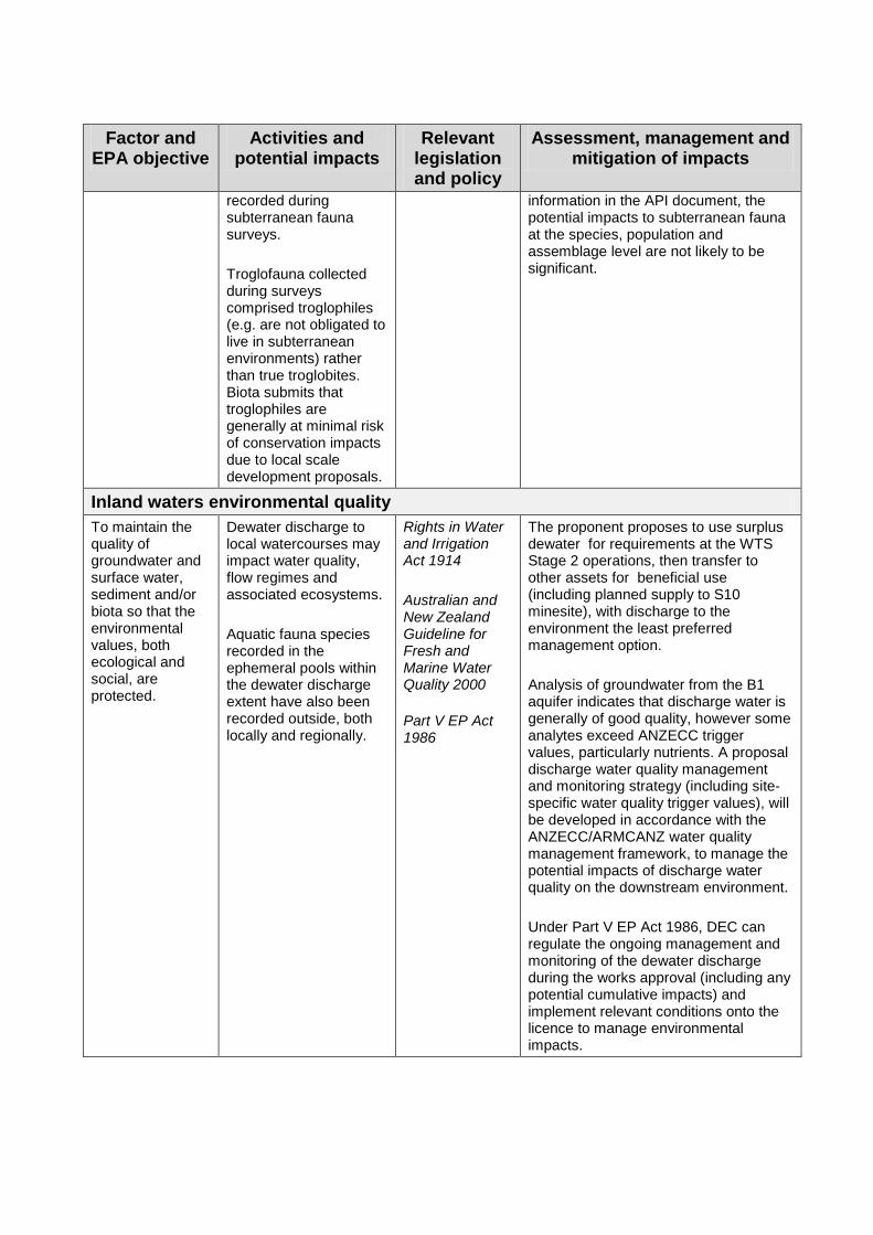
Inland waters environmental quality To maintain the quality of groundwater and surface water, sediment and/or biota so that the environmental values, both ecological and social, are protected.
Dewater discharge to local watercourses may impact water quality, flow regimes and associated ecosystems. Aquatic fauna species recorded in the ephemeral pools within the dewater discharge extent have also been recorded outside, both locally and regionally.
Rights in Water and Irrigation Act 1914 Australian and New Zealand Guideline for Fresh and Marine Water Quality 2000 Part V EP Act 1986
The proponent proposes to use surplus dewater for requirements at the WTS Stage 2 operations, then transfer to other assets for beneficial use (including planned supply to S10 minesite), with discharge to the environment the least preferred management option. Analysis of groundwater from the B1 aquifer indicates that discharge water is generally of good quality, however some analytes exceed ANZECC trigger values, particularly nutrients. A proposal discharge water quality management and monitoring strategy (including site-specific water quality trigger values), will be developed in accordance with the ANZECC/ARMCANZ water quality management framework, to manage the potential impacts of discharge water quality on the downstream environment. Under Part V EP Act 1986, DEC can regulate the ongoing management and monitoring of the dewater discharge during the works approval (including any potential cumulative impacts) and implement relevant conditions onto the licence to manage environmental impacts.