remote sensing figaro final - figaro irrigation … of remote sensing in irrigationmanagement •...
TRANSCRIPT
FLEXIBLEANDPRECISEIRRIGATIONPLATFORMTOIMPROVEFARM‐SCALEWATERPRODUCTIVITY
FIGARO
RemotesensinginFIGARO
FinalMeeting,Brussels19/09/2016TechnicalUniversityofValencia
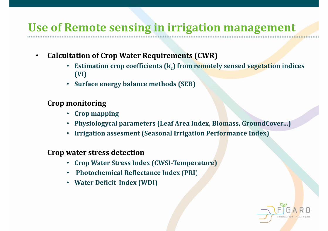
UseofRemote sensing inirrigation management
• Calcultation ofCropWater Requirements (CWR)• Estimationcropcoefficients(kc)fromremotelysensedvegetationindices(VI)
• Surfaceenergy balancemethods (SEB)
– Cropmonitoring• Cropmapping• Physiologycal parameters (Leaf Area Index,Biomass,GroundCover…)• Irrigation assesment (Seasonal Irrigation PerformanceIndex)
– Crop water stressdetection• CropWater StressIndex (CWSI‐Temperature)• PhotochemicalReflectanceIndex (PRI)• WaterDeficitIndex(WDI)

• CalcultationofCropWater Requirements (CWR)– Estimationcropcoefficients(kc)fromremotelysensedvegetationindices(VI)
; ; ;
Crop Kcb Parameter Reference
Vine (wine) Kc = 1.44*NDVI ‐ 0.10 Kc = 1.79*SAVI ‐ 0.08
NDVI;SAVI Campos et al 2010
Vine(Table grape) Kc = 0.008 + 0.017*GC GC(%) Williams et al(2005)
Citrus Kc= 0.0283 + (0.0203 *GC) ‐ (0.00017*GC2)
GC(%) Castel (2000)
Potato Kc = 0.0504+1.085 SAVI SAVI Jayanthi et al (2007)
Cotton Kc = 1.49 NDVI ‐ 0.12 (early vegetative)Kc=2.80 NDVI ‐1.17 (Afterfull cover)
NDVI Hunsaker et al (2003)
Corn (Irrigated) Y = 1.317 NDVI + 0.023 NDVI Singh and Imak(2009)
Processing Tomato Kc = 0.126 + (0.0172)*GC‐(0.0000776*GC2)
GC(%) Hanson and May(2006)
Remote sensing inFIGARO
Ground cover is the physiologic parameter used by Aquacrop
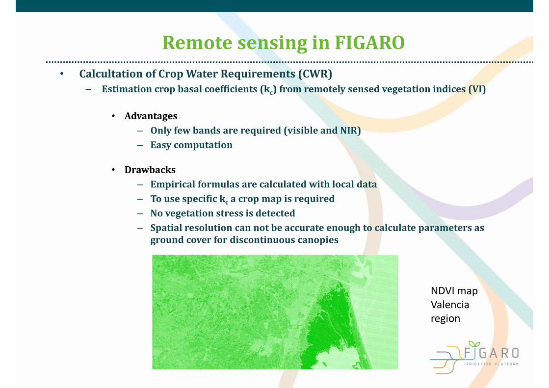
• CalcultationofCropWater Requirements (CWR)– Estimationcropbasalcoefficients(kc)fromremotelysensedvegetationindices(VI)
• Advantages– Onlyfewbandsarerequired(visibleandNIR)– Easycomputation
• Drawbacks– Empiricalformulasarecalculatedwithlocaldata– Tousespecifickc acropmapisrequired– Novegetationstressisdetected– Spatialresolutioncannotbeaccurateenoughtocalculateparametersasgroundcoverfordiscontinuouscanopies
NDVI mapValencia region
Remote sensing inFIGARO
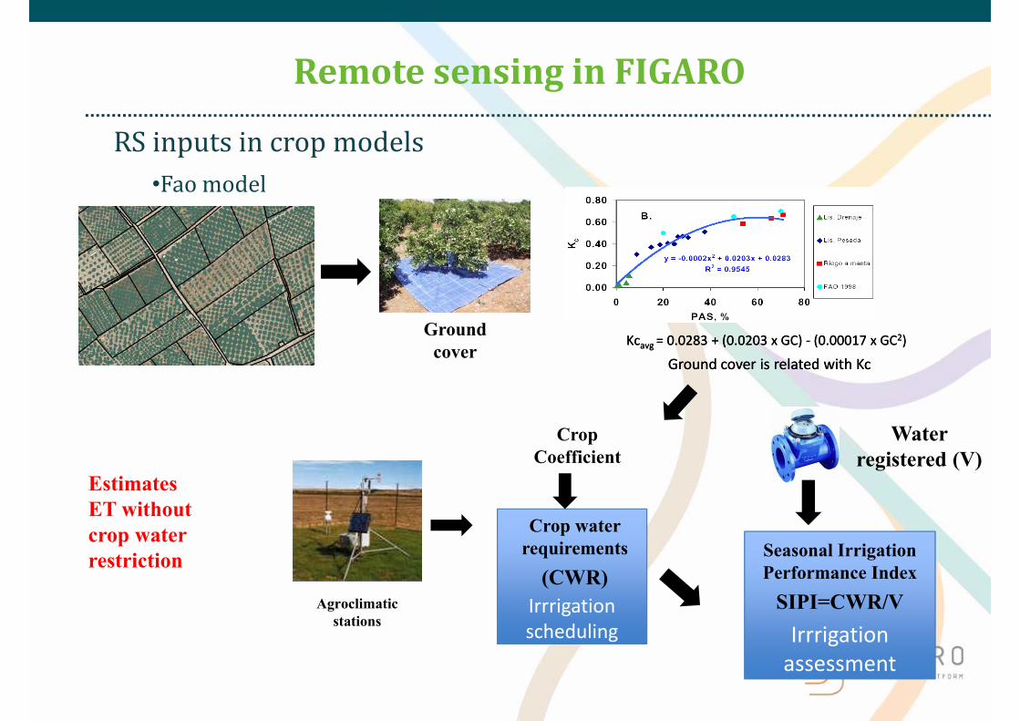
IrrrigationassessmentIrrrigationassessment
IrrrigationschedulingIrrrigationscheduling
RSinputsincrop models•Fao model
Ground cover is related with KcGround cover is related with Kc
Ground cover
Agroclimaticstations
Crop waterrequirements
(CWR)
Kcavg = 0.0283 + (0.0203 x GC) ‐ (0.00017 x GC2)Kcavg = 0.0283 + (0.0203 x GC) ‐ (0.00017 x GC2)
CropCoefficient
Water registered (V)
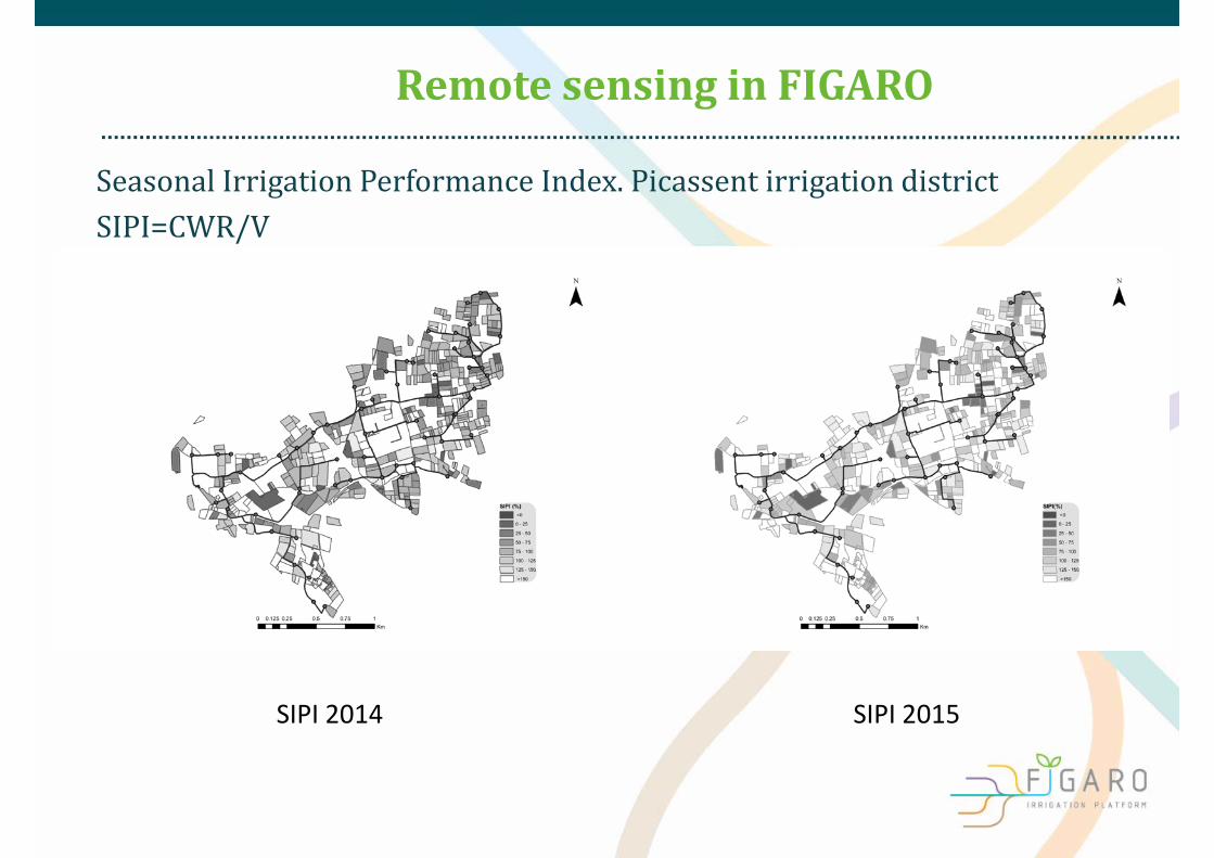
Seasonal IrrigationPerformance Index
SIPI=CWR/V
EstimatesET withoutcrop waterrestriction
Remote sensing inFIGARO
Remote sensing inFIGARO
Seasonal Irrigation PerformanceIndex.Picassentirrigation districtSIPI=CWR/V
SIPI 2014 SIPI 2015
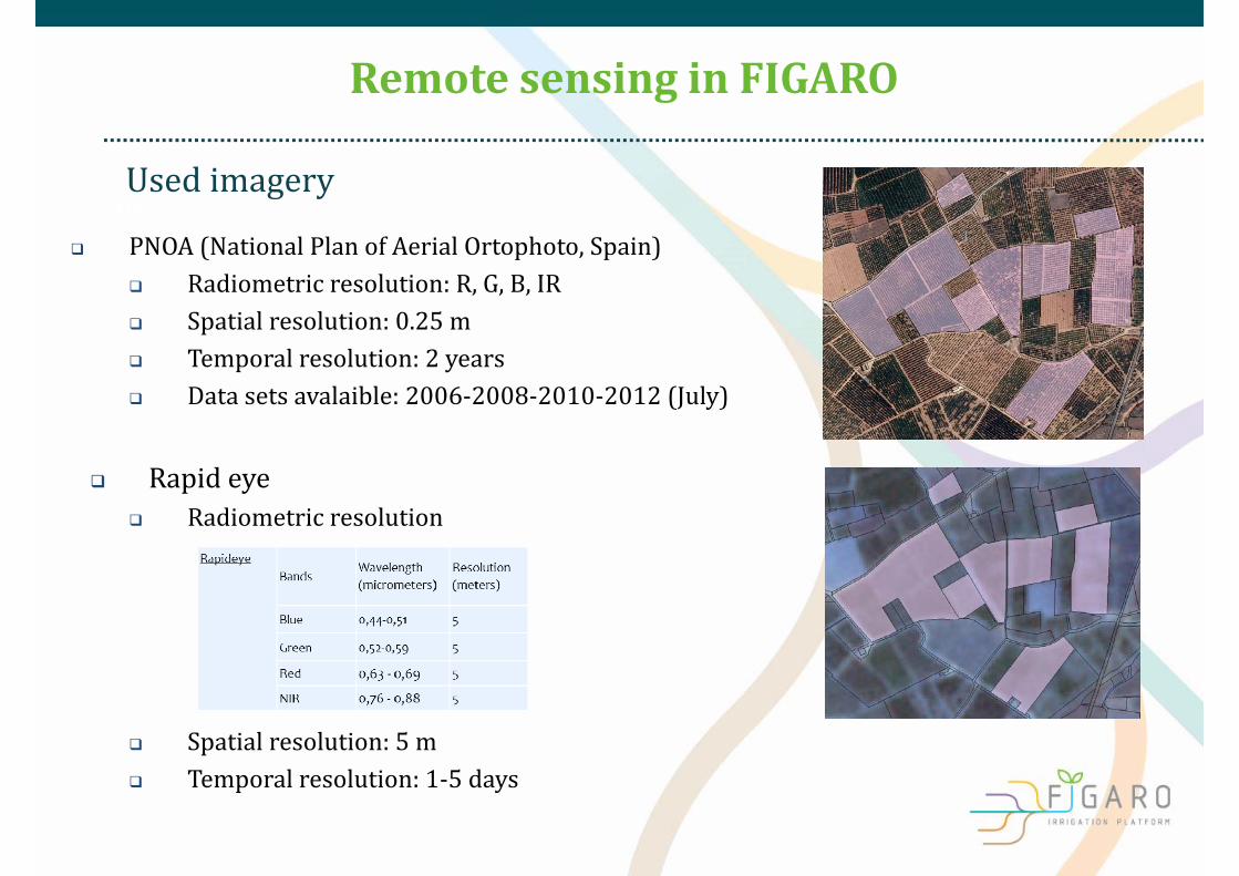
Usedimagery
Remote sensing inFIGARO
• USed PNOA(National PlanofAerial Ortophoto,Spain)
Radiometric resolution:R,G,B,IR Spatial resolution:0.25m Temporalresolution:2years Datasetsavalaible:2006‐2008‐2010‐2012(July)
Rapideye Radiometric resolution
Spatial resolution:5m Temporalresolution:1‐5days

60mspatial resolution bands
• Usedimagery
Remote sensing inFIGARO
Sentinel 2(Images avaliable from January 2016)
10mspatial resolution bands
20mspatial resolution bands
10mSentinel 2 10 m
Band number Central wavelength
(nm)
Bandwidth(nm)
2 490 65
3 560 35
4 665 30
8 842 (NIR) 115
Band number Central wavelength
(nm)
Bandwidth(nm)
5 705 15
6 740 15
7 783 20
8a 865 (NIR) 20
11 1 610 90
12 2 190 180
Band number
Central wavelength
(nm)
Bandwidth(nm)
1 443 20
9 945 20
10 1 375 30
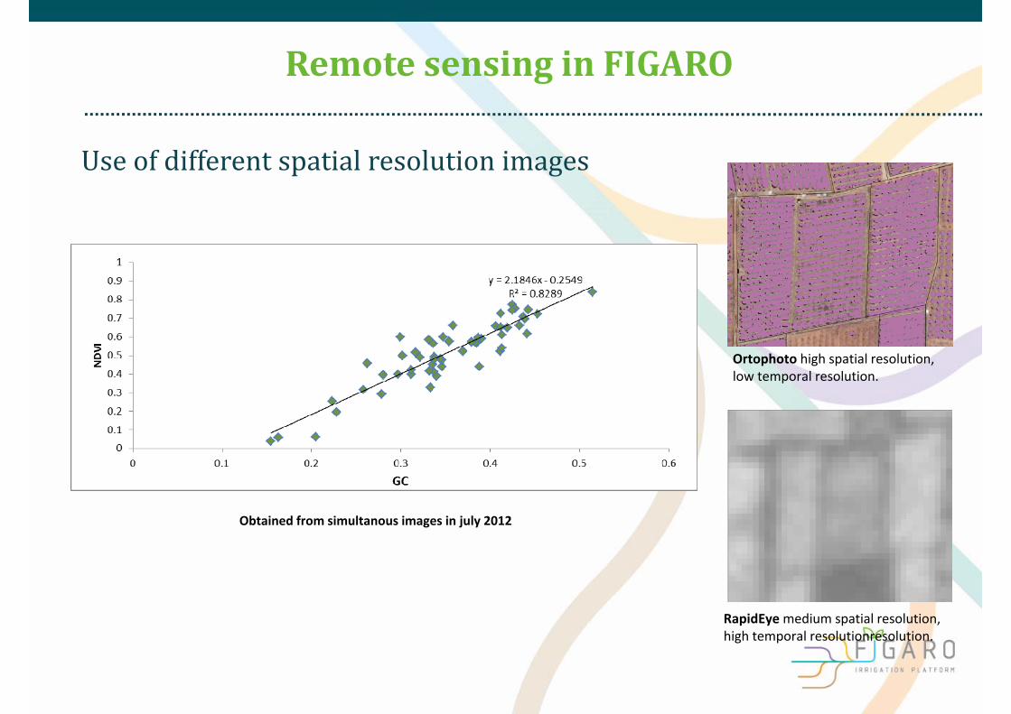
Useofdifferentspatialresolutionimages
Remote sensing inFIGARO
Ortophoto high spatial resolution, low temporal resolution.
RapidEyemedium spatial resolution, high temporal resolutionresolution.
Obtained from simultanous images in july 2012
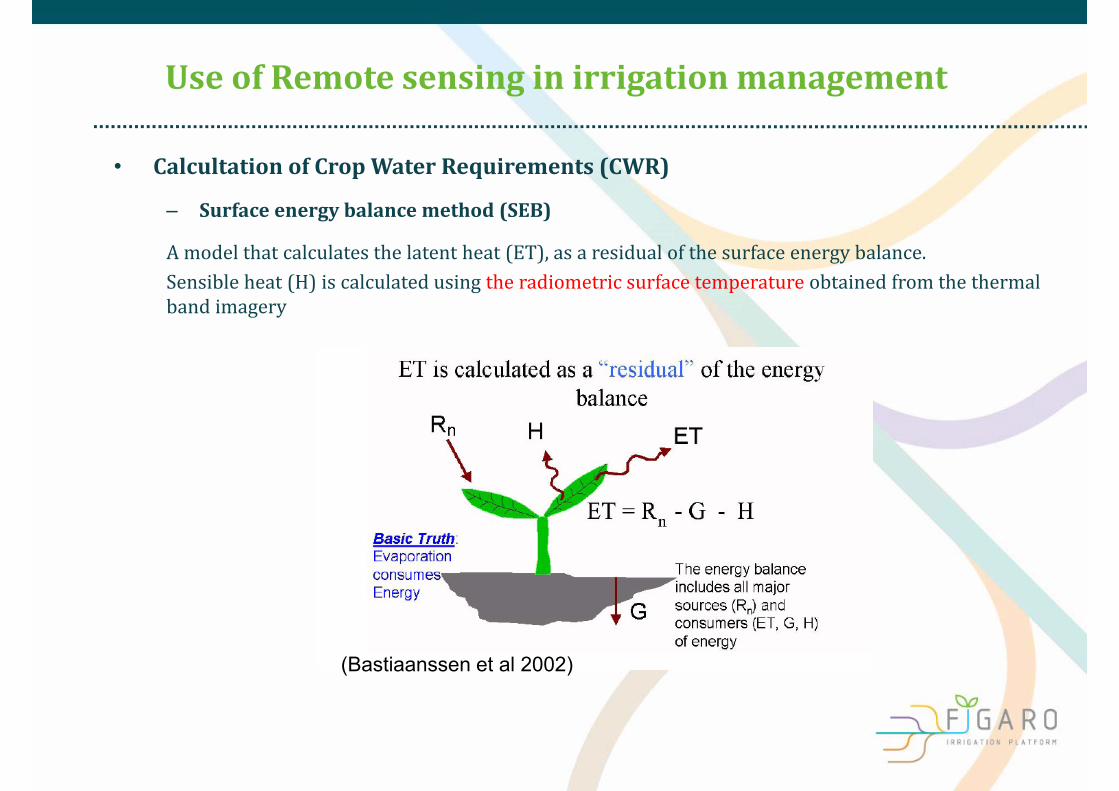
• CalcultationofCropWater Requirements (CWR)
– Surfaceenergy balancemethod (SEB)
Amodelthatcalculatesthelatentheat(ET),asaresidualofthesurfaceenergybalance.Sensibleheat(H)iscalculatedusingtheradiometricsurfacetemperatureobtainedfromthethermalbandimagery
UseofRemote sensing inirrigation management
(Bastiaanssen et al 2002)
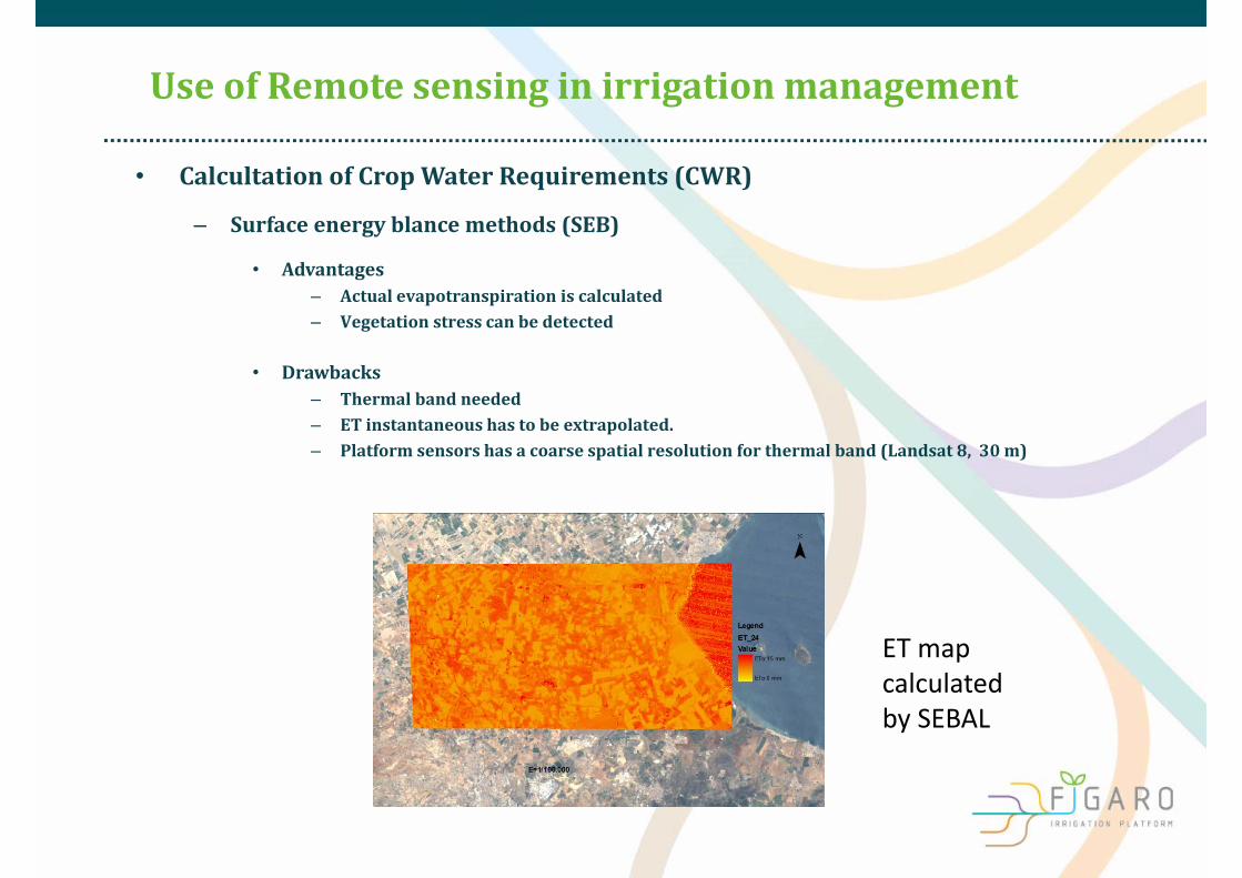
• Calcultation ofCropWater Requirements (CWR)
– Surfaceenergy blance methods (SEB)
• Advantages– Actualevapotranspirationiscalculated– Vegetationstresscanbedetected
• Drawbacks– Thermalbandneeded– ETinstantaneoushastobeextrapolated.– Platformsensorshasacoarsespatialresolutionforthermalband(Landsat8,30m)
UseofRemote sensing inirrigation management
ET mapcalculatedby SEBAL
Remote sensing inFIGARO
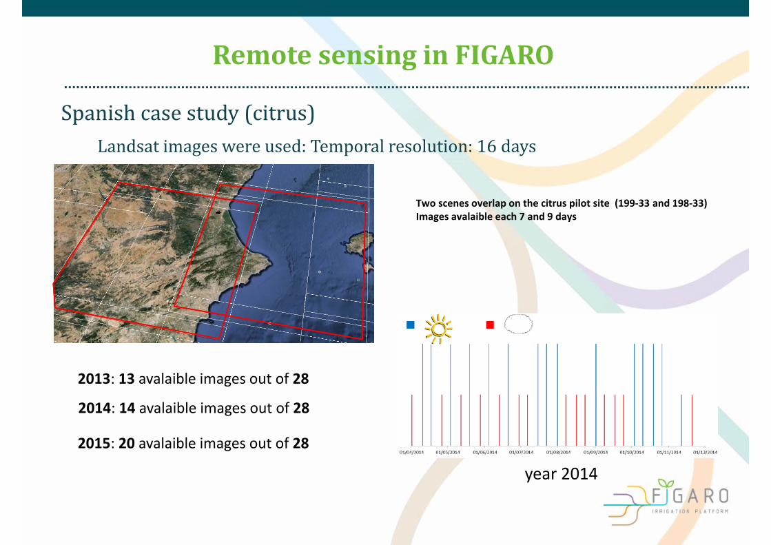
2013: 13 avalaible images out of 28
2015: 20 avalaible images out of 28
2014: 14 avalaible images out of 28
year 2014
Spanishcasestudy(citrus)Landsatimageswereused:Temporalresolution:16days
Two scenes overlap on the citrus pilot site (199‐33 and 198‐33) Images avalaible each 7 and 9 days

• Irrigation procedure– Each timeaLandsat 8image freeofclouds is avalaible,actualETis
estimated anddownscaled todaily values.
– ETFAO Vol‐1>1,it is assumed that crop is irrigated less than required– ETFAO Vol‐1<1 ,it is assumed that crop is irrigatedmorethan required
– ETSEBALETFAO‐1>1,actualETis higher than potential– ETSEBALETFAO‐1<1, actualETis lower than potential
Citrustestsite
Flexible and precIse irriGation plAtform to improve faRm scale water prOductivity Slide13

• Irrigation procedure
Citrustestsite
Flexible and precIse irriGation plAtform to improve faRm scale water prOductivity Slide14
22 plots were selected(0,3‐3,5 ha)

• SEBAL is amethodology that canbeused for irrigationscheduling atirrigation district level
• It is able todetect those plots that sufferwater stressdue toitestimates theactualevapotrasnpiration instead ofpotentialevapotrasnpiration
• Along with models based on the vegetation indices (Castel,2000)andvolume readings,it allows performwater stressmaps forlarge areas
• The disadvantges arethecloudy days andthesmall spatialresolution by now
Remote sensing inFIGARO

• Architecture
Remote sensing inFIGARO
U‐Manage

III Jornada sobre Gestión Eficiente del Agua de Riego 17
Rapid Eye Deimos Spot 7
Spot 6
Landsat 8Sentinel 2
Landsat 7