regionalization of the studied area & its...
TRANSCRIPT

116
CHAPTER-5
REGIONALIZATION OF THE STUDIED AREA & ITS
GEOMORPHIC CHARACTERISTICS
“Things which we see are not by themselves what we
see….. it remains completely unknown to us what the
objects may be by themselves and apart from the
receptivity of our senses. We know nothing but our
manner of perceiving them”. (Aristotle)
Little Rann of Kutch, roughly triangular in shape is a monotonously
saline flat surface with annual inundation, have executed the Rann a
mysterious piece of terrain. Lyell (1855) has portrayed the Rann as a
singularly flat region which is neither land nor sea which dries up during
some part of a year and again inundated by saline water from the sea side
and fresh water from the adjoining land area during monsoon. The Rann of
Kutch was a gulf of the sea with surrounding coastal towns (Frere, 1870).
Rann of Kutch, a marshy plain, without a equivalent in the globe has been
previously associated with the channels of Indus giving existence &
richness to the region in the history have left no alive trace of the
numerous generations that once settled and it owes its present relief
because of the geological process of the Pleistocene. Geological
stratification (from top to bottom) is: 1) Quaternaries & Tertiaries, 2)
Mesozoic & 3) Pre Cambrian. Little Rann of Kutch is the southward
extension of the great Rann and is similar in Physiography, edaphic
conditions, ecoclimatic and vegetation but differs in inundation regime. The
Little Rann act as a dry land and wet land in different period of the year i.e.

115
the area experiences a seasonal reversal of geomorphic process. Though
the Rann considered being a single unit but still there is variation in terms
of its geomorphology and surface configuration and land cover. The tidal
mud flat and salt marshy tract of Little Rann of Kutch is encompassed from
all sides by well formed ridges.
“The earliest attempt to comprehend all landforms over a wide area
into a general classification seems to have been that of Passarges, S.
(1919). His scheme was hierarchical and remains one of the most
comprehensive produced. It includes (category level; Types (coastal, fluvial
landforms etc.) Class (forms suffering from aggradations, erosion etc.),
Order (identified main type of process such as tectonic, volcanic etc.),
Families (e.g. faulted, fractured) & Kind (degree of family, symmetrical,
asymmetrical etc.)”49.
In line with the Passarges classificatory scheme and looking to geo-
ecological balance of the area, considering prevailing climatic,
geomorphological and ecological condition, four geomorphic regions has
been identified in and around (two miles of buffer and extending upto gulf
of kutch) the Little Rann of Kutch .viz, 1) Fringe Area, two miles of frontier
around the study area 2) Dry Rann, Eastern and Central part, 3) Wet Rann
with numerous creeks, western part & 4) Islands. (Table- 5.1 & Map-5.1)
49
Colin W. Mitchal, (1991) “Terrain Evaluation” Longmans, London (2nd Edition), p-50.

115
5.1 FRINGE ZONE, TWO MILES OF FRONTIER AROUND THE LITTLE RANN OF KUTCH
This geomorphic region encompasses parts of seventy eight villages
of twelve talukas of Kachchh, Patan, Surendranagar, Rajkot and Jamnagar.
The entire area act as a transition zone between the main land and the
Rann, where both mingle together, loosing their characteristics. However
there is great deal of variation in terms of the relief of the Rann and the
fringe area and thereby giving a different color altogether to vegetation
type, soil characteristics and as a whole to ecology of the area. There is not
much change in the climatic characteristics but unavailability of the
vegetation resulting out of relief and soil type, imparts extreme climate to
the Rann. Rivers flowing in the entire surrounding area ultimately drains
itself into the centrally lying depression that is the Little Rann of kutch. The
rivers draining this area from north to east and towards south and south
west are Banas, Saraswati, Rupen, Okaro, Umai, Chandrabhaga, Phulka,
Godra, Kankavati, Brahmini, Machchhu and many more minor streams
(PlateNo.12-14). The entire fringe area has been rilled (Map-5.2) by these
streams and is severely affected by water erosion (Map-5.3). This
geomorphic region contrasts more with the Rann than inland area lying out
of its boundary. Fringe zone has sharp contrast in terms of land cover as
compared with the Rann. Within this fringe zone again there are
differences up to some extent in terms of soil type and drainage systems
which ultimately gave rise to different type of land cover. The water divides
that is Wagad, Radhanpur-Barmer and Saurashtra (Map-5.4) lying in the
north-west, east and south respectively reveals that the entire fringe area
slopes towards the Little Rann of Kutch but with varying degree (Map-5.5),
guiding the perpendicular orientation of the streams. The entire boundary
of Rann is almost evenly breached by streams from all sides. However, the
major rivers draining this area join Rann only along its eastern and

115
southern boundary. Fringe zone to the east of Rann has more of
biodiversity as compared to its counter part to the south and north-west.
Southern part of fringe is moderately covered with the vegetation whereas
the north western has least vegetative cover. The eastern part is mainly
drained by river Rupen and Banas and the southern part is drained by river
Phulka and Bambhan, other streams in this area are very minor.
The entire area has similar geological history, the present surfacial
configuration owes to the sub-recent (Holocene) that is prehistoric period
between 20,000 to 50,000 years ago, during which area was deposited
with newer alluvium. Whatsoever may be the past, at present the surface
patterns differ from one area to other. The southern fringe area is
characterized by unconsolidated sediments. In the south eastern and along
the eastern marginal area, coastal dune dominates. Further in the north
eastern area silty sand can be well seen. The entire fringe area is either
unconsolidated or is loosely compacted with an exception of Dhrangdhara.
Etymologically, ‘Dhrang’ means strong or tough, ‘Dhara’ means earth, it
means Dhrangdhara is an area of tough rocks. The availability of sand
stone may have lead to such nomenclature. Strong Solid rock is often not
always solid. Sandstone of Dhrangdhara might have started out as a sand
dune or a beach, which got buried and compressed to form hard
sandstone. Sandstone of this area is of red colour.
As per the Gujarat Hazard Risk and Vulnerability assessment atlas,
this fringe zone share three type of classification on the basis of peak
ground acceleration. It is to be noted that the intensity of peak ground
acceleration decreases away from the coastal area. Since this earthquake
hazard risk zonation was done on taluka level and therefore the fringe area
lying within the talukas of Rapar, Bhachau, Maliya are seismically very
active while the area lying within Santalpur, Sami, Halvad and

115
Dhrangadhra is moderate while areas lying within Dasada is less
seismically active. The same atlas also divides the area into various cyclone
hazard risk zone. Inline with the seismicity, the wind speed is also
maximum along the coastal area and decreases further towards the inland
area. Here speed of wind ranges from 34 to more than 55 m/sec. The
variation in the wind speed guides the intensity of aeolian processes.
The fringe area receives rainfall ranging between 625 mm to 375
mm. The entire patch lying in the south and south east receives relatively
higher amount of rainfall than its counterpart lying in the west and north
east. Owing to meager amount of rainfall in the area the probability of dam
flow recorded is less than 20 percent. As per the flood hazard risk zonation
map, only the area lying under Sami taluka falls under the flood prone
area. However, the area lying within the Dasada and Dhrangadhra taluka
also faces the problem of flood. The situation of flood arises not because of
the excessive rainfall in the area but rather spasmodic rainfall and the flat
topography with shallow, wide and ill defined channel character. As it is
evident from the map showing the streams (Map-5.2) and map showing
the area affected by water erosion (Map-5.3), there are numerous streams
which dissect the area, and this is just because of the relief less
topography of the entire fringe zone. Erosional work associated with
running water is comparatively maximum in the eastern and southern part
of fringe area while it is almost absent in the western fringe zone.
However, as per the planning atlas, intensity of fluvial erosion is moderate
throughout the fringe area (Map-5.6). The maximum erosional work
associated with fluvial action can be seen in the Sami Taluka followed by
Santalpur taluka, both of Patan district. This is the area which is drained by
two rivers Banas and Saraswati aligning in the direction from north to
south. Particularly the Banas branches of into distributaries before entering

115
into the Little Rann of Kutch. There are some twelve villages in this taluka
which adjoins the Little Rann.
District Surendranagar offers a maximum boundary to the Little Rann
of Kutch with twenty three villages, extending into three talukas, i.e,
Dasada, Dhrangadhra and Halvad. This entire patch is drained by eight
streams. Of these three talukas, Halvad and Dhrangadhra is drought prone
(Map-5.7).
The condition of non availability of water is not so grim in Dasada
largely because of the River Rupen and resultant ground water availability.
There are many ponds also in this area. Village Degam gets disconnected
from the surrounding area only to become an island during monsoon
season. Similarly the area lying within the Maliya and Jodiya of Rajkot and
Jamnagar district do not have crunch of water because of the availability of
rivers such as Machchhu (Maliya); Jhijhoda, Demi, Aji, Dhadhiaria, Und and
Kankavati in Jodiya and this is the reason why intensity of fluvial erosion is
high to very high in this area (Map-5.6). The adjoining villages of Rapar
and Bhachau, to the north west of Little Rann also comes under drought
prone area (Map-5.7). Virtually there are no streams of significance in
the area also the catchment area lying to the north of it is too small in its
dimension. The entire Little Rann of Kutch including the western fringe
shows a high aridity, whereas northern, eastern and southern fringe
exhibits semi-arid (medium) climatic condition (Map-5.8). The Bio-climatic
zones (Map-5.9) also overlaps over aridity map, showing the Rann and
western fringe to be a part of Desert (Kutch) and rest of the study area as
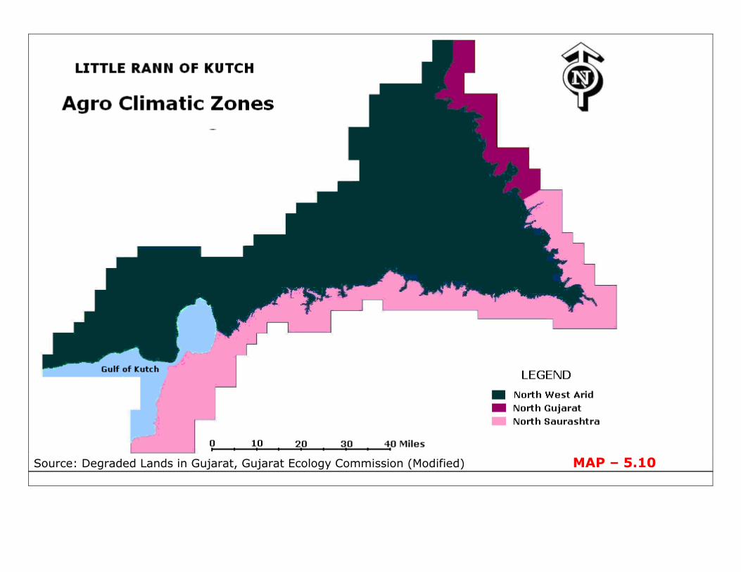
a part of Semi Arid Gujarat. On the basis of agro-climatic zones, as
devised by Gujarat Ecology Commission (Map-5.10), the fringe area can be
divided into three zones that is North West Arid (area lying in Kachchh

115
district), North Gujarat (area lying in Patan district) and North Saurashtra
(area lying within Surendranagar, Rajkot and Jamnagar districts).
Geo-Environmentally, the triangular Little Rann of Kutch and its three
fringes (along the sides) are identified into four different regions (Map-
5.11) i.e, the Rann (Little Rann of Kutch), the Kutch (western fringe), the
Northern alluvial plain (eastern fringe) and the Saurashtra (southern
fringe). Geomorphological character (Map-5.12) of the fringe area reveals
that in its northern part, elevated and uninundated silty sand nonsaline is
available. The south eastern fringe is dominated by old coastal dunes. The
southern fringe is identified by the availability of unconsolidated sand, silt
and clay in most of the area except in the Dhrangadhra, where sandstone
dominates its surfacial configuration. Along the northern fringe of the gulf
younger tidal flat and saline flat waterlogged geomorphic character can be
well seen. In the northwestern fringe the area shows a rolling surface.
There is an acute problem of soil salinity in the entire surrounding area
(Map-5.13), except in some patches that is in the area where there is
relatively less moisture available in the soil profile. The groundwater
salinity in the area is also as high as 2000 parts per million (Map-5.14).
The problem of soil salinity is sever in the entire northern, eastern,
western, southwestern and southeastern part of the fringe. Salinity in the
southern central part is restricted because of the presence of hard sand
stone rock surface.
Salinity is one of the most prevalent soil degradation processes on
the Earth. Globally, the total area under salt affected is about one billion
hectares. Problem of salinity crop up mainly in the arid–semiarid regions of
the world. Salt affected soils often have a white or grey salt crust on the
ground. The pH of the soil is around 8.5 and the salt interferes with the
growth of almost all types of plants.

115
Following are the factor identified, which are the cause for
accumulation of salt in the sediment:
(i) Poor and limited vertical or horizontal drainage conditions
(ii) Dynamic force regulating movement of water;
(a) Imperceptible Relief element that regulates the surface
runoff.
(b) Dimension of pores that accomplishes Capillary action.
(iii) Negative water balance that is, when evapo-transpiration surpasses
the amount of precipitation.
The climatic condition (aridity) and the morphology of the Rann and
fringe area up to some extent have favored accumulation of salts in many
different forms. Salt accumulation in the fringe area is in scattered patches.
Several types of salt were identified during the field visit, of which the most
common is efflorescence. Such salts are characterized by the deposition of
the thin layer of salt as a result of evaporation of moisture brought to the
surface through the available pores by capillary action. Needle like salt
crystals are also present beneath the surface layer. Such phenomenon is
more conspicuous in the fine grained sediments of the Rann and
surrounding areas of the Rann having fine grained sediments, which favors
moisture rise through capillary action. Efflorescence is very often affected
by deflation winds and is easily carried for miles through strong gale. Also,
sometimes, they themselves are covered by the layers of fine loessic
deposits as a result of erosion and deposition processes by the wind. The
thin covering of salt crumbles easily even under little pressure.
Profile wise description:
ZAINABAD

115
Location: zainabad, a village, 8 km north of Patri town.
Geomorphology:
The area exhibits a flat surface characteristic with slight disruption
locally, mainly in the form of many minor shallow streamlets which
otherwise remains dry during most part of the year. The streams draining
this region discharge their water in the Little Rann of the Kutch, north of
Kharghoda. The streams in the region do not have a well defined channel
and therefore during rainy seasons the area gets flooded and water
remains stagnant in the depression areas. To the north and west of this
village, a large part of the area remains a wet land for four to five months
after monsoon. During the dry season the area gets veiled under the thin
layer of inland sebkhas and efflorescence. The denudational process is
negligible in the area because of imperceptible relief. However, on a
microlevel erosional processes during rainy season and aeolian deposits in
the form of loess and salt cannot be ruled out.
Vegetation:
The geomorphology of the area and water availability supports
relatively adequate amount of vegetation, even in this extreme climatic
condition. The area shows sharp contrast with the surrounding barren
Rann. The density of the vegetal cover decreases westward. Types of
vegetation in the area are low rise tufted thorny shrubs with numerous
arms, covering a larger part of area. Such physiological adaptation reduces
the direct loss of soil moisture. Other vegetations are small cactus plants,
grasses (along the water bodies, resembling to the other marginal
grassland areas), sankhpuspi, Accasia etc.
Description of soil profile:

115
The soil profile of the area indicates mixed characteristics of soil
owing to the work of different depositional agents during different period.
The soil profile is not very consolidated and shows thin layers of varying
characteristics. Merely a visual inspection revels that the concentration of
sand particles are more in the area then in the Rann. The top soils of the
relatively lowlying area is encrusted with thin film of salt and exhibits minor
cracks when dried.
The sample of Soil profile collected in the specified location was taken
at an interval of 10 inches, including top soils; total 3 samples were
collected for all tests except for mechanical analysis where 4 samples were
collected at an interval of 6 inches, including one of the surface, usually a
thin salt encrusted layer. Laboratory test shows the percentage of moisture
content increases with increasing depth. The moisture content increased to
almost three times at a depth of 20 inches. However, water content was
slightly low in the top profile. Water holding capacity does not show a
particular trend, it was maximum at a depth of 10 inches and decreased
further below, it was minimum in top profile. The sediment analysis shows
there is a presence of coarse sand even at 20 inches though at a very less
amount. The fineness of the texture increases with increasing depth. The
percentage of silt and clay increases with increasing depth whereas sand
particles decreased with depth. Overall, the soil type is loam with plastic
index of 17 %. Natural volume decreases with increasing depth. Natural
volume and compact volume is maximum at the top profile. Porosity in
percentage was maximum (35.6) at a depth of 20 inches. Porosity reduced
to one sixth for the top profile. The figures of bulk density reveal the
relatively more compactness of the upper soil profile.
RIGHT BANK OF RUPEN

115
Location: Close to bank of river Rupen, 5 km. north of Visnagar
Geomorphology:
The area is plain with rolling imperceptible slope from Visnagar town
towards the west and merges with Rann. The surrounding area is
adequately drained by river Rupen and many streamlets. The streams in
this area are numerous and are very shallow, wide and without any
particular stream line. Roads in this area are so designed that there is no
need of bridge. The roads are made depressed in order to drain the water
of streams during rainy seasons, which other wise remains dry through out
the year. Apart from the Rann in continuum in the west, there are many
small patches of saline waste to the north of river Rupan. The maximum
and minimum height in the vicinity ranges from 79 feet in the south east to
42 feet in the northwest. There is sharp decrease in the height towards
west because after a few Km. the river merges to the Rann. Here the
boundary of Little Rann is very irregular. A good volume of water remains
in the river through out the year. Volume of water depends upon the
amount of rainfall received and the water stored in the reservoir at
upstream area. The fine sediments brought by the river during flash floods
get deposited in the surrounding area along the both bank of river in the
form of very thin layer above the loamy sand, which gets separated during
dry season forming thin flakes of clay. The river bed and bank is usually
sandy with a thin layer of mud on the top, which makes the water turbid
(muddy) even with the little disturbance. Looking to the soil characteristics
it is apparent that infiltration rate will be much pronounced in the area.
Owing to the presence of loamy sand, cracks do not develop at all. During
the rainy season the percolation of the water is uniform from top to
bottom. Processes of deposition and erosion is limited by its low relief,
however, there is an exchange of finer particles through channel water
during rainy season.

115
Vegetation:
With the availability of water and moisture present in the area, there
is ample coverage of vegetation. The xerophytes in the area show luxuriant
growth. There are various layers of vegetation in the area. There is sharp
contrast in terms of land-cover of this area and the Rann.
Description of soil profile:
The soil profile of the area does not show much variation with the
depth. Merely with visual identification one can say that the soil is sandy.
The soil in this area is of loamy sandy type with a very high percentage of
fine sand. The top soil is encrusted with thin film of salt but in patches. The
salt formed here are coarser than that of found in the Rann.
The sample of soil profile collected in the specified location was taken
at an interval of 10 inches, including top soil; total 3 samples were
collected for all tests except for mechanical analysis where 4 samples were
collected at an interval of 5 inches. Laboratory test shows the percentage
of moisture content was higher in the area and shows a very slow
decreasing trend. The higher moisture content may be attributed to the
water holding capacity of the finer sediment. Water holding capacity also
shows a similar trend, it was maximum on top and decreased further
below. The percentage of coarser sand was maximum on the top of the
profile and decreased very high in this sample. Overall, the percentage of
sand in the entire sample is around 80 % which is highest amongst the
sample. There was no substantial variation in the sediment size properties
at different depths. The soil type here is loamy sand with plastic index of
14 %. Natural volume is highest of upper section of the profile and
decreases further below and is because of the superincumbent load.
Porosity in percentage was maximum (38.7) at a depth of 20 inches.

115
Porosity reduced to one sixth at upper section of the profile. The water
holding capacity was maximum at top layer and therefore moisture was
also higher. The figures of bulk density reveal the relative less
compactness of the soil. The hygroscopic absorbing capacity of the sample
of the similar areas remained low at varied level of humidity percentage.
Hygroscopic absorbing capacity ranges from 5.23-7.73 % with changes in
humidity from 40-80%.
Photographs covering various aspect of the fringe area have been
shown in Plate no. 1-5.
5.2 DRY RANN, EASTERN AND CENTRAL PART OF LITTLE RANN OF KUTCH
Dry Salt Rann accounts for maximum area running from eastern part
of Little Rann of Kutch to the central and even upto some extent the
western parts too. This part of Little Rann of Kutch is largely affected by
the extreme of aridity. The area remain dry and barren with high ambient
temperature reaching upto 48°C leading to the aeolian geomorphic process
at large in the summer season. “At least two generations of buried Aeolian
deposits alternating with marine (beach) sediments are inferred” (Wardha,
S.K.). Lithologically the areas top most layer is comprises of fine wind
blown pale brown sand (Aeolian origin) followed by the coarse to medium
grained reddish brown sand with Quartz and Calcareous rocks (Fluvio-
marine origin), which implies the transgression & regression of sea level in
sub recent era. Peninsular India witnessed the fluctuation in the sea level
in the coastal areas during Jurassic, Lower Cretaceous & Miocene times.
Drifting may have caused the temporary incursion of sea. The general
Characteristics of this part of Little Rann are not different to that of the
north and northwest of Khavada hill of great Rann of Kutch. This is the
reason why at certain point of discussion, the Great Rann of Kutch is being
referred. The extreme of high temperature in this area leads to the

115
occurrence of storm leading to upliftment and movements of sand particles
further towards the eastern side resulting to the geomorphic processes like
attrition, abrasion, deflation and desertification. Whereas during monsoon
season numerous minor & major streams discharge there water into the
Rann depression.
The worked out aridity Index of Kutch (1970-1994) is 2.86, which is
significantly low but not so low as in case of extreme desert climate
(Relation: Lower the Aridity index higher is the absolute aridity). The
Humidity index for the same period is 19.48 (Agricultural Handbook,
Gujarat, 2000) again it is significantly high but not so high as in case of
extreme desert (Relation: higher the humidity index lower is the absolute
Humidity) and that is why a combined process of fluvial as well as aeolian
that is fluvio-aeolian process are very much active giving a characteristics
of fluvio-aeolian origin to the lithology. The whole area is affected by
strong winds and occasional rain from May to October and frequently
flooded to the depth of 60 cm (Report on Wild Ass Sanctuary, Gujarat
Ecological Society) on an average. Most of this water is inland water from
the rivers like Rupan, Saraswati, Banas, Jhijhora, Machhu, Godadhroi and
local streams and also marine water driven by the south west wind,
relatively lesser in its volume and extent (Map-5.15, 5.16). The flood water
when they dry up leaves a hard flat surface covered with gravels, pebbles,
sand and salt. The fineness of the debris increases with the distance from
the fringe towards the Rann. With the onset of summer the ground is
baked and blistered by the sun and shines with dazzling whiteness of the
salt as the heat increases. Eastern margin is dotted by several isolated
permanent sand dunes known locally as Thali i.e. heap of sand.
In the interior of Rann, the surface exhibits itself in terms of dark
brown surface configuration with wide and deep cracks with veneer of salt.

115
Generally in the semi arid regions of the tropics and sub tropics, there is
pre dominance of deep dark coloured clay soil, particularly in the flat
topographical areas. Such deep and dark coloured clay are called Vertisols.
Dark colour of soil is related to either parent material or presence of
manganese oxides. The dark brown-black color of the Rann sediment is
attributed to the parent material lying in its catchment area of basaltic
geological structure.
Vertisols are formed under multiple genetic processes which are
multifaceted. In general, soil forming processes that lead to the formation
of Vertisols are those which manage the development and stability of
expansion in the soil. However, secondary processes, such as fluctuations
in the moisture condition, accretion of organic matter, carbonates, gypsum
or soluble salts and acidification processes through leaching, result in the
variability within the Vertisols.
The cracks of the Rann remain open for more than 90 cumulative
days per year and hence are known as Usterts (based on the classificatory
scheme considering duration of open cracks and soil structure). Globally,
this suborder is the most extensive of the Vertisols order, encompassing
the Vertisols of the tropics and monsoonal climates in India, U.S., Australia
and Africa.
The shrinking and swelling of vertisols can damage buildings and
roads, leading to extensive subsidence, and therefore inspite of huge traffic
engaged in the salt mining, road connectivity is in poor shape. Areas
characterized by availability of vertisols are generally used for grazing of
cattle or sheep. Many a time, livestock get injured through falling into cracks
in dry periods. However, the shrink-swell activity allows rapid recovery
from compaction.
The surface of the Rann ranges from granular to dense massive, with
angular blocky structures. Such surface configuration is the result of the

115
pressure developed as a result of expansion and contraction of the clay
with response to drying and wetting of the soil. With the increase in the
wetness, peds develops slickensides i.e, shiny surface which appears as
one ped slips over another during expansion. The contraction, resulting out
of loss of moisture in the soil results to the contraction and thereby leads
to the formation of wide and deep cracks.
The more interior area of the Little Rann of Kutch has proportionately
very high content of clay and at the same time becomes very dry during
the summer and excessively wet during the monsoon season. Such
extremity in the weather phenomenon around the year is absent in the
fringe area.
The Rann sediment also underwent self mulching or self swallowing
through the process of pedoturbation or churning, a process which
homogenizes the soil profile through the infilling of the cracks by surfacial
material during dry season.
The lateral swelling pressures in the Rann is much larger than
vertical swelling pressures, as the latter is substantially reduced by the
overburden pressure.
The distinctive microrelief features of the Little Rann of Kutch are the
presence of knolls (mounds) and basins (depressions). The moisture
content in the basins is always higher comparatively because of the
accumulation of water during rainy season. These basins often exhibit
higher salinity and organic content. These microbasins and microknolls
show a repetitive but irregular pattern on the Rann surface. Such
topography related to clayey soil with higher plasticity is called ' Gilgai
micro-topography.

115
The occurrence of flooding in the Rann leads to a complex
combination of the dampness of the Rann sediments, surface movement
and the sub surface movement of water over them. Whatever the source,
surface water, sea, river or rain, the conduct of the Rann sediment is really
fascinating. However, the transfer of water horizontally or vertically leading
to the wetness of the Rann is regulated by two important properties, that is
field moisture capacity (infiltration capacity) and permeability of the
sediment.
Talking on the absorption capacity of the sediment at given condition,
Horton (1933) suggested that infiltration capacity would decrease
exponentially in time from a maximum initial value to a constant rate. This
movement or hydraulic conductivity has also been defined by Buckman and
Brady (1967). They were in the opinion that as the difference in moisture
content varies from one area to another area, the moisture adjustment
starts working in order to equate them, and this process increases in terms
of rapidity within the area with greater variation. The hydraulic conductivity
or the ability to transmit water through sediment was found to be highly
variable and is in relation to the available field moisture.
Also, the same above process is directly related to the sediment
characteristics and property, as for example, well sorted gravels and sand,
allows a very higher conductivity, whereas the conductivity is absolutely
low in case of heavy fine grained compact sediment like as those of the
sediments of the Little Rann of Kutch.
Factors that emerge to control the infiltration capacity of Rann
sediment includes:
(i) Amount of water applied
(ii) Available field moisture capacity

115
(iii) Infiltration capacity of sediment
(iv) Moisture conductivity of the upper and subsequent lower
horizon of the profile and thereafter
(v) Texture and structure of the various sediment horizon
All the above factors influence the percolation of moisture down the
sediment profile. Sediments having fine texture, as that of the Little Rann
of Kutch, have very low percolation rates. Infiltration rate in the Rann
sediment is exceedingly high initially because the deep and wide cracks
holds enormous amount of water. However gradually the infiltration rate
slows down and ultimately made to almost halt because those cracks are
choked by the swelling loose sediments lying on the surface (Figure- 5.1).
Moreover, infiltration rate is slower in the clay dominant sediments.
Water infiltration is the movement of water from the soil surface into
the soil profile. Soil texture, soil structure, and slope have the largest
impact on infiltration rate. Water moves by gravity into the open pore
spaces in the soil, and the size of the soil particles and their spacing
determines how much water can flow in. Wide pore spacing at the soil
surface increases the rate of water infiltration, so coarse soils have a
higher infiltration rate than fine soils but they can not hold water for long.
Soil texture refers to the comparative proportions of sand, silt, and
clay. As for example; A loamy sand soil contains larger amount of sand as
compared to the content of silt and clay when combined together. loam soil
contains these three types of soil particles in roughly equal proportions.
Where as silty clay loam contains a larger amount of silt followed by clay
and a very small amount of sand. Other types of texture can be referred
from the table 5.2
Table-5.2 Soil texture designations ranging from coarse to fine at various identified Geomorphic Regions:

115
Texture Designation Geomorphic Regions
Coarse-textured
Fine-textured
Sand Along the fringe zone,
coarseness increases towards northern and
western part
Loamy Sand
Sandy loam
Fine Sandy loam
Loam
Silty loam
Silt
Silty Clay loam Rann sediment, clay content increases towards center Clay loam
Clay
Soil structure is distinct from soil texture in a way that it refers to the
clumping together or "aggregation" of sand, silt, and clay particles into a
still bigger secondary cluster. When a handful of the soil crumbles easily in
the hand then it is considered to be a good soil. Such behavior indicates
that the sand, silt, and clay particles are aggregated into granules.
Both soil texture and soil structure determine pore space for air and
water circulation, erosion resistance, looseness, ease of tillage, and root
penetration. Texture is related to the minerals in the soil and does not
change with agricultural or other anthropogenic activities; whereas
structure can be altered by human interferences.
With increases in moisture, compactibility and bulk density of the
sediment increases, as that of Rann sediment at lower horizon, till the
moisture content is approximately at the field capacity point, than a
condition known as the optimum moisture content for compaction is
reached. Nevertheless, compactibility of the lower horizon Rann sediment
is also attributed to the pressure of overlying sediment. At still higher

115
moisture content, the soil becomes increasingly incompactible as water fills
ever more pore space. The compaction of an overloaded wet soil becomes
minimal and thus plastic flow may result in the complete destruction of soil
structure and macro-pores. However, referring to the latter case, even if
there is appreciable increase in the moisture, plastic flow is limited only
upto the filling of cracks and not the mud flow from one area to another in
the Little Rann of Kutch, largely because of its flat topography.
It was observed that the dimension of the cracks were proportional
to the amount of clay present in the sediments. Sediments with heavy clay
had deeper cracks and vice versa in case of medium to low clay sediments.
In the sandy loam, and loamy sand, cracks were completely absent. The
rate of infiltration was found to be rapid in the horizon upto the depth of
cracks while infiltration rate decreased quickly further below owing to the
characteristics of the sediment (clayey and compaction) and also greater
moisture content of the sediment below.
The infiltration rate of a given sample at given point of time is also
the function of moisture content of the sediment prior to its exposure to
the rain or subjected to wetting. Hence infiltration rate is slowed down in
accordance with the field storage capacity. Similar relationship between
available field moisture and infiltration phenomenon can be well seen in the
works of Blake, Hartge, Brasher, Davidson, Cresswell and Mc. Kenzie. It
was observed that the sediments showing higher field moisture takes
relatively more time in the infiltration processes as compared to the
sediments having lesser field moisture. This relationship was revealed
through the lab test after adding water to the same samples with varied
amount of moisture content within them.
One more reason for the slow infiltration is the puddling of the Rann
sediment owing to the falling drops of rainfall which strikes on the bare

115
ground, resulting into churning and increases in the turbidity, which chokes
up the opening, which allows downward movement of water. Bennet
(1955) has stated that clear water penetrates into the sediment much
faster than muddy water because of the fine suspended material which
tends to choke the openings and impedes downward movement. This
phenomenon is ideally seen in the Little Rann of Kutch where the climatic
condition does not allows growth of vegetation, and therefore the barren
ground is adversely affected by falling drops of rain, which in turn do not
allow surface water to percolate downward. The above discussions also
throws light on why the dry Little Rann of Kutch gets inundated even with
very scanty amount of rainfall.
Though the tests for permeability is not carried out, however looking
to the nature, composition and porosity of sediments a clear picture can be
deduced. Soil porosity refers to the space between soil particles, which
consists of various amounts of water and air. Porosity depends on both soil
texture and structure. For example, a fine soil has smaller but more
numerous pores than a coarse soil. A coarse soil has bigger particles than a
fine soil, but it has less porosity, or overall pore space. Water can be held
tighter in small pores than in large ones, so fine soils can hold more water
than coarse soils. However, the rate of permeability in the fine soil will be
much slower as compared to the coarse soil.
Permeability depends upon the grain size of sediments and therefore
the permeability is low to very low, often designate as impervious for the
samples taken from the Little Rann (Eastern, central and western wet
zone). The sediment sample collected from the fringe zone shows more
porosity and permeability, which increases with the depth. However, the
top section of the profile shows a very low porosity, owing to the
availability of the fine wind blown particles veiling the fringe area. The

115
pudding, as discussed in the above paragraph, also reduces the porosity
and thus permeability.
It is also apparent from the works of Davis (1967), that the
suspended clay particles makes a coating on the surface when settles,
interceding the gaps of sediments and thereby rendering imperviousness to
the sediments. The permeability within the sediments reduces with the
increase in the clay. And thus, the abundance of clay in the Rann
sediments increases the imperviousness.
The sample analysis also reveals that the porosity of the dark
coloured clay is very less, as for example the samples collected from west
of Kharaghoda, near Surajbari Bridge and Gagodar shows relatively very
less porosity and is true with permeability. Since the amount of clay in the
soil is lesser in case of the fringe area and bet and therefore, the porosity
is very high and so is permeability. There is a fundamental relationship in
between the abundance of clay and stagnation of water in the depression
area. The water could not find its way down quickly because clay chokes
the gaps, at the same time stagnation of water fastens the clay forming
processes. Roy (1973), in his work also mentioned the absence of seepage
in the sediments of Great Rann of Kutch. Roy observed that even though
standing water was present less than 200mtrs away, a pit dug showed dry
base.
Photographs covering various aspect of the eastern dry Rann have
been shown in Plate no. 6-8.
Lack of permeability coupled with imperceptible gradient, poor
drainage and runoff enables the water of varied sources to remain stagnant
for long, especially in the depression area and shallow channels.

115
The results of the various test conducted with the sample sediments
are as follows:
(i) The proportion of Clay is dominantly very high as compared to
other.
(ii) The plasticity index is very high
(iii) High Water holding capacity.
(iv) Low Porosity.
(v) Higher surface salinity
(vi) There is no significant difference in Natural volume and Compact
volume.
(vii) Higher hygroscopic absorption capacity.
Properties of the sediments of the Little Rann of Kutch thus inferred are:
(i) The soil is compact and firm.
(ii) The field moisture is higher and it increases with the depth.
(iii) Process of infiltration is much slow as compared to the sediments
of the fringe zone.
(iv) The sediment is impermeable.
(v) Rann sediment shows hyper sensitivity to the humidity present in
the air. It is evident from the field and laboratory test that the Rann soil
becomes moist even with the slightest of moisture in the air, through
hygroscopic absorption. Hygroscopic absorption for a given relative
humidity increases with increasing amount of clay associated with salt.
Profile wise study:
KHARAGHODA
Location: 7 km west of Khadaghoda old station/ town towards the Rann.
Geomorphology:

115
The area is monotonously plain. There is a rolling imperceptible slope
from Kharaghoda town and other surrounding marginal area towards the
Rann. Small streams drain their water in the Rann from all marginal areas
around. Infact the entire Rann gets inundated with water, coming from
inland area and sea. However, this part of Rann is relatively at higher
height than that of its counter parts lying west of it and therefore remains
drier during most part of the year. By and large this area gets inundated
only through river water during rainy season. There are a few mounds of
low height scattered around. Inter bet channels were relatively wet during
field visit (October, 2008). Fresh foot prints of birds; barely a week old was
testimony to it. With the onset of summer season, the rising temperature
dries up the soft mud to brittle state passing through plastic state and solid
state, forming huge deep cracks. Development of cracks indicates the
characteristics of soil that is, presence of clay in higher amount and also its
plastic behavior owing to the presence of clay. These cracks are later filled
by the fine loose material through winds. During the rainy season the
percolation of the water is not uniform from top to bottom. The deep crack
portion gets saturated faster than the top. Processes of deposition and
erosion is limited by its flat topography, however, there is an exchange of
finer particles through wind. Because of the moisture content in the area,
weathering process is pronounced. During the rainy season the area gets
flooded even with a very small quantity of rain because of slow percolation
rate in the clayey soil. Also, hygroscopic behavior of the soil is as such that
it absorbs water from the air and therefore, the area becomes soggy even
with increase in the humidity in the air.
Vegetation:
Though the area is not to far from the surrounding mainland but the
area is absolutely barren with no vegetation at all, and is because of the
saline character of soil and lack of moisture during most part of the year.

115
There is sharp contrast in terms of land-cover of the Rann and the
surrounding area of the Rann.
Description of soil profile:
The soil profile of the area indicates different depositional agents and
period. The top soil exhibits the properties of vertisols, with huge deep
cracks. The top soil is encrusted with thin film of salt which easily cracks
down while walking. Physically the surface appears to be dissected
hexagonally as far as one can see.
The sample of Soil profile collected in the specified location was taken
at an interval of 10 inches, including top soil; total 3 samples were
collected for all tests except for mechanical analysis where 4 samples were
collected at an interval of 6 inches, including one of the surfaces, usually a
thin salt encrusted layer. Laboratory test shows the percentage of moisture
content increases with increasing depth. The moisture content increased to
almost three times at a depth of 20 inches. However, water holding
capacity does not show a particular trend, it was medium on top maximum
at a depth of 10 inch and decreased further below. The percentage of
coarse sand was nil beyond 12 inches. The fineness of the texture
increases with increasing depth. The percentage of silt and clay increases
with increasing depth whereas sand particles decreased with depth.
Overall, the soil type is clay with plastic index of 58 %. Natural volume is
low at the middle and deepest part of profile. Porosity in percentage was
maximum (22.8) at a depth of 10 inches and so the water holding
capacity; porosity reduced to one forth at a depth of 20 inches; whereas it
was 14.7 % at the top soil. The figures of bulk density reveal the
compactness of the soil. The hygroscopic absorbing capacity of the sample
remained high at varied level of humidity percentage, of all the samples.
Hygroscopic absorbing capacity ranges from 10.30-14.85 % with changes
115
in humidity from 40-80%. During the month of December to April The
visibility even during day time is brought to zero because of the fine dust
resulted out of vehicular movement during salt mining, Vehicles has to use
fog light even during day time. The entire area remains veiled under fine
dust, as far as it can reach.
GAGODAR
Location: Saline inorganic clay, Approx. 5 km east of Gagodar village
Geomorphology:
The area is dismally plain. There is a rolling imperceptible slope from
north and west towards the Rann. Small streams drain their water in the
Rann from all marginal areas around. There is relatively wider stream to
the south of Gagodar which also discharges its water in the Rann, south of
the location of the sample. To the north of the location, there is a hill rising
upto a height of 104 feet. This part of Rann is relatively at lower height
than that of its counter parts lying east of it and therefore remains wet
during most part of the year. This area gets inundated even during spring
tides. The area remains inundated upto a greater depth and for longer
duration of time during monsoon and post monsoon respectively. Foot
prints of birds, barely a few week old can seen. With the onset of summer
season, the rising temperature dries up the soft mud to brittle state
passing through plastic state and solid state, forming huge deep cracks.
Development of cracks indicates the characteristics of soil that is, presence
of clay in higher amount and also its plastic behavior owing to the presence
of clay. These cracks are later filled by the fine loose material through
winds. During the rainy season the percolation of the water is not uniform
from top to bottom. The deep crack portion gets saturated faster than the
top. Processes of deposition and erosion is limited by its flat topography,
however, there is an exchange of finer particles through wind. Because of

115
the moisture content in the area, weathering process is pronounced.
During the rainy season the area gets flooded even with a very small
quantity of rain because of slow percolation rate in the clayey soil. Also,
hygroscopic behavior of the soil is as such that it absorbs water from the
air and therefore, the area becomes soggy even with increase in the
humidity in the air.
Vegetation:
Though the area is not to far from the surrounding mainland but still
it is absolutely barren with no vegetation at all, and is because of the saline
character of soil and lack of moisture during most part of the year. There is
sharp contrast in terms of land-cover of the Rann and the surrounding area
of the Rann.
Description of soil profile:
The soil profile of the area indicates different depositional agents and
period. The top soil exhibits the properties of vertisols, with huge deep
cracks. The top soil is encrusted with thin film of salt which easily cracks
down while walking. Physically the surface appears to be dissected
hexagonally as far as one can see.
The sample of Soil profile collected in the specified location was taken
at an interval of 10 inches, including top soil; total 3 samples were
collected for all tests except for mechanical analysis where 4 samples were
collected at an interval of 6 inches, including one of the surfaces usually a
thin salt encrusted layer. Laboratory test shows the percentage of moisture
content increases with increasing depth. The moisture content increased to
almost twice at a depth of 20 inches. However, water holding capacity also
shows a similar trend, it increases from top to bottom. The percentage of
coarse sand was nil beyond 12 inches. The fineness of the texture
increases with increasing depth. The percentage of silt and clay increases

115
with increasing depth whereas sand particles decreased with depth.
Overall, the soil type is clay with plastic index of 45 %. Natural volume is
low at the deepest part of profile. Porosity in percentage was maximum
(21.06) at a depth of 20 inches and so the water holding capacity; porosity
reduced to more than half at the top soil. The figures of bulk density reveal
the compactness of the soil at upper layer, which is maximum at top where
as it reduces further below. The hygroscopic absorbing capacity of the
sample remained high at varied level of humidity percentage, of all the
samples. Hygroscopic absorbing capacity ranges from 8-10.57 % with
changes in humidity from 40-80%.
It has been observed that the humidity along the ground level even
during the dry season is high in the Rann area as compared to the barren
fringe area. Moister along the ground level is increased by the capillary rise
in the area. Moreover the fate of water falling on the surface under arid
and semi-arid climatic condition is as such that either it is absorbed by the
plant root, if any or becomes the part of runoff, which directly evaporates
or penetrates only upto a minimum depth only to come out again in the
form of capillary rise, thereby, causing an increase in the overall moisture
values of the soil.
Puri (1949) has equated the sediments with a bundle of capillary
tubes to which the law of surface tension and capillary could be applied.
The capillary pull exerted by a sediment column to raise water, or the
negative pressure required to pull water from a saturated column, is
approximately equal to the reciprocal of the diameter. This notion is very
much applicable to the larger part of study area, which shows fineness of
grain size and thereby high capillary action. Though the extent of capillary
rise has not been calculated in the laboratory, the field study has
sufficiently confirmed the fact.

115
The calculated values of capillary rise in sediments given by Millar
and Turk (1949)50, shown in the table-(5.3) gives an idea of the connection
that exists between the sediment size and capillary rise.
The work of Hogentogler (1937) also states that “below water table,
in the case of sand the moisture content is 20.4 % by weight of dry sand
and above the water-table the capillary fringe has a moisture content of
0.6 %. Whereas in silts the moisture content below water table is 40 %
and the capillary fringe extends upward from the water table to a distance
of 4 meters with a moisture content of 36 %”51.
Table-5.3 Capillary rise in sediments
Time Height of rise in inches
Sand Silt loam Clay
½ hour 13.5 7.3 5.4
1 hour 14.3 11.2 8.0
6 hour 16.6 26.6 15.5
12 hour 17.2 35.3 18.5
1 days 18.4 46.4 21.0
3 days 20.3 65.4 24.7
6 days 21.8 78.5 27.3
9 days 23.0 86.3 28.8
18 days 25.3 99.2 33.2
50
Millar, C.E. and Turk, L.M., (1949) Fundamentals of Soil Science. John Wiley and Sons,
Chapman & Hall, P-165. 51
Hogentogler, C.A., (1937), Engineering properties of soil. Mc. Graw Hill book company,
p-122.

115
The above discussed works gives an idea about the intensity of
capillary rise in fine grained sediments. In the Rann and adjacent
surrounding area, the presence of salt encrustation proves the very extent
of capillary rise. These salt deposits are generally known as efflorescence
deposits, which results out of the evaporation of subsurface water brought
to the surface through capillary action.
Consequently, in view of the various factors acknowledged and
discussed above to explain the moisture content of Rann sediments, it is
likely that because of the fineness of the sediments, the customary field
moisture content is high even during the driest period. Rise of water
through Capillary action is very extensive in the Rann sediments and there
by increasing the already high soil moisture value. Thus, the whole profile
from the surface downwards remains relatively moist even under natural
dry conditions.
5.3 WET RANN WITH NUMEROUS CREEKS, WESTERN PART
This region is an intertidal and transitional zone between Gulf of
Kutch and the Little Rann of Kutch. This region is exposed to diurnal tides.
This region is characterized by the medium fine sediments, with dominating
characteristics of fluvio-marine origin. The area remains covered by thin
sheet of water or remain damp and wet throughout the year with no
significant growth of mangroves particularly in the eastern part of this

115
region. Its coastal front in the west is dominated by shoreline of
submergence characterized by tidal mud flat with scanty mangroves
swamps and network of creeks. Rivers like Sui, Jhijhora drains the area
while the major portion is drained by Chach creek and Sonsaria creek
during the time of tide. Total length of the creek channel in the area is
around 25 miles. The northern periphery of this region is badly rilled and
gullied by the local small seasonal streams. Since the area is almost
covered throughout the year by salt water and hence there is no traces of
aeolian activities.
The major tributaries draining the Little Gulf of Kutch are Kandla,
Nakti and Hanstal creeks. The three desert rivers, Banas, Rupen and
Saraswati, carry annually 140 Cubic Mm water to the Little Rann of
Kachchh. The Little Rann of Kutch set up short term connection with the
creeks at the head of the Gulf during the south west monsoon, when it gets
flooded. The creek receives negligible freshwater inflow during the dry
season. Hence, the evaporation exceeds precipitation leading to salinities
higher than that of typical seawater (35- 36 ppt). The higher salinities may
also result due to the drainage of brine from saltpans and higher
evaporation rates in the adjoining creeks. Thus salinities upto 50 ppt have
been recorded in the Little Gulf of Kachchh. The mudflat is composed of
thick deposits of soft marine clay, which get inundated during high tide.
The coastline along the Gulf of Kutch is highly dissected by the
creeks which further have a good criss-cross and jumbled network of creek
channels throughout the inland area. From all along the coast, the salt
water enters into the area to give a character of wet Rann (wetland). The
area is overflowed at spring tide and regularly flowed by the normal durinal
tides. The major creeks are Nakti creek, Khori creek, Kandla, Navi, Morwali
115
and Kuta Phuri creek. Again, the coastal fronts are dominated by shoreline
of submergence characteristics.
The amount of sediment derived from the catchment area is very
small because of the extremely low run-off and the reason being is the
dams constructed on the rivers draining this area. The major source of
sediment in the gulf is considered to be the sediments brought by the River
Indus.
Saltpans present here are enclosed system adjoining to creek
environment filled with tide water. Saltpans are naturally exposed to a
extensive range of environmental stress which manifest itself through
salinity changes. Simplicity and stability being the characteristic feature of
saline ecosystem makes it a more reliable ecosystem with a very less
dynamism.
The salinity increases or decreases with reference to the amount of
rainfall received. With excessive rain the salt particles are leached down
the soil. Whereas, regular exposure to tidal water brings and adds to the
salt content of the soil leading to the thickening of the salt crust.
The tidal mud flats are dominated by mangroves and grasses in the
extreme west where coastal low lying area merges with the tidal flat.
Mangrove supports to the marine food web through the making of debris
by litter fall. They also prevent soil erosion and act as a shield for the
mainland from storms to protect the coast from erosion. The mangrove
species found in this area are relatively dwarfed in their pattern. The
amount of rainfall received is a decisive factor for the deferential growth of
mangrove in the tidal zone.

115
General lithology of this area is also of subrecent sediments with
coarse and very coarse sands to gritty pebbles, sands quartzose with shell
clastic of fluvio-marine origin. Major Rivers draining in this area are
Churwa, Sakra and many other small local channels during rainy season.
The constructions of breakwaters and jetties for development of ports
and harbors have resulted in the significant change in the shorelines. It
would prevent the erosion of the protected coastline thereby depriving the
littoral currents of adequate supply of sand and sediments and thus they
change the beach morphology. Also, poorly planned coastal, urban and
industrial developments, including indiscriminate exploitation of coastal
resources as for example, Mangroves and development of harbor and
aquaculture facilities has resulted in change of the natural coastline and
have changed the landcover.
Owing to the proximity to the Gulf of Kutch, the western most study
area has a complex network of tidal creeks and tidal channels. There is a
presence of numerous and extensive brackish water bodies. The coastal
zone of this region is narrow because of the non availability of any major
river draining this area. The mangrove forests in this area is of good
height, because of the submerged type of environment, they are diverse
and have developed in an environment of extremely arid climate. The
average annual rainfall is about 470 mm, which occurs only within the
months of July to August, rest of the period is undisputedly dry season. As
per the information of Space Application Centre, marine processes are
dominant through out the year due to insignificant fresh water discharge in
the Gulf. Photographs covering various aspect of the western wet Rann
have been shown in Plate no. 9-10.

115
MARSHY CREEK AREA
Location: Marshy creek area (Saline inorganic clay), south east of
Surajbaari Bridge.
Geomorphology:
The area seems to be dissected by numerous veins of back water
channels i.e, creeks. The creeks varies much from one another in terms of
dimension, there are shallow creeks disbranching from the still larger
creeks and some are as large as a wide river valley with considerable
volume of saline water. These creeks have imparted the area with the
characteristics to remain wet through out year irrespective of seasons.
There is virtually no mixing of fresh water in the area except in the
monsoon season. This area is predominantly modified by marine forces in
its natural form. However, there is much alteration by anthropogenic
forces, largely in the form of construction of numerous salt pans scattered
through out this inter tidal zone. Such action has tremendously reduced the
number of biodiversity in the area. Even the mangroves have been choked
to death because of excessive salinity in the enclosed salt pans, not to
mention about the other micro flora and fauna. Except for small halophyte
grasses, which grow on the bunds of salt pan, nothing can be seen as far
as one can see. The entire area along both sides of the bridge makes a
band of salt pans. The aerial photograph of the area reveals that These salt
pans also extend further east and west along the northern and southern
limit of Little Rann of Kutch and the Hudson creek in the form of concavely
alignment along both side of the bridge. Infact this bridge (Surajbari, with
a length of 1235 m.) is built over Hudson creek, connecting Kutch to
Saurashtra. The Hudson creek is shallower in the southern part and

115
deepens further to north of the bridge and thereby allowing salt mining
more prominent in the southern margins. The soil of this area is
dominantly clay with very insignificant amount of sand. This soil may
develop huge cracks if allowed to dry but such environment is never met in
the area. Though the salinity in the area is very high one can not see
efflorescence on the soil because of huge moisture content. The
efflorescence appears to the far east of bridge where eventually the
moisture reduces.
Vegetation:
There is absolutely no vegetation except for some grasses which
grows either along the levees of creeks or on the small embankment made
enclosing the salt pan. These halophyte grasses grow in the area where
there is salinity upto there tolerance limit. The salinity within the salt pans
increases so much so that the plants are choked to death and therefore
there is less of vegetation. There is sharp contrast in terms of land-cover of
this part and the surrounding area to the north and south.
Description of soil profile:
The soil profile of the area indicates single dominant depositional
agents. The top soil exhibits the properties of vertisols, with huge deep
cracks when allowed to dry. There was enormous shrinkage of the sample
when it was dried in the laboratory. There is no encrustation of salt on the
surface. Actually the surface seems to be molten plastic with bulging
appearance.
The sample of Soil profile collected in the specified location was taken
at an interval of 10 inches, including top soil; total 3 samples were
collected for all tests except for mechanical analysis where 4 samples were
collected at an interval of 5 inches. Laboratory test shows a very high

115
percentage of moisture content which remains more or less same for each
and every sample at different depth. The maximum moisture content in
percentage within this profile is 30.86. Similarly, water holding capacity
does not show much variation, however, it was maximum at a depth of 20
inches. The percentage of coarse sand was nil beyond 5 inches. The
fineness of the texture increases with increasing depth. The percentage of
silt also ranges from 2.33 on the top to 0.87 at the bottom of profile.
Whereas, the percentage of silt and clay (combined) increased from top to
bottom of the profile. Overall, the soil type is clay with plastic index of 61
%. Again there is no much change in the natural volume; it ranges from
3.2 on the top to 3.1 at the bottom of profile. Comparatively, Porosity in
percentage is very low in this profile to that of its counter parts. The top
sample exhibits maximum porosity of only 7.9 whereas it decreases to 3.4
at a depth of 20 inches. Water holding capacity of this sample is maximum
i.e, ranging between 0.825 – 0.852 for all three samples. The figures of
bulk density reveal the relative compactness of the soil. Lower bulk density
reveals more amount of moisture content within them. The hygroscopic
absorbing capacity of the sample remained high at varied level of humidity
percentage. Hygroscopic absorbing capacity ranges from 7.85-9.80% with
changes in humidity from 40-80%.
5.4 ISLANDS (BET)

115
The 23 islands can be construed so because of the two facts that is
firstly these isolated highlands (though of less height) resembles islands in
the mid of salt waste when the Rann is dry and secondly when the area is
inundated then the same highlands becomes the islands in the true sense.
These islands do not have significant height as it ranges from 30 feet to
179 feet. Nearly all the highlands are steep and scarped on the north
slopes. The highest point is 179 feet at Murdakh bet. All the islands are
composed of sandstone with flat top covered by columns of basalt. These
islands resemble the monadnocks or Inselberg which are the result of
differential erosion in an extensive plain area. The main bets of Little Rann
of Kutch are Wasraj and its chain islands, Andheri Wen, Khijadiya,
Maharajawali, Miyan, Pancham, Pung (largest bet), Dhut, Mardak,
Jhilandar, Shedwa and Nanda (Map-5.17).
This Geomorphic unit is of basaltic and sedimentary formation
consist of rugged surface with steep slope, subdued hills with smooth
surface and gently undulating structural hill of low relief respectively. The
horizon of bet gets excessively drained owing to the relative flat
topography. Slope of the bet has been divided into freely drained, owing to
the free flow of water along the gentler slope; poorly drained,
characterized by very steep slope along which waterfalls. To the down of it
is coarse sediment accumulation, which remains waterlogged for much of
the period and then the spread of fine sediment (Figure- 5.2). Photographs
of various aspect of the bet have been shown in Plate no. 11.
Formation of Gypsum Salts is seen in the area of coarse sediments,
because coarse sediments provides with the more space for the growth.
Infact, there is direct relation in between size of grains and the size of salt
crystals. Formations of such salts are the result of evaporation of saline

115
interstitial water in the relatively less moist soil in the dry season. The
required environment is present around the bet.
JALANDAR/ JHILANDAR BET (JHINJHUVADA)
Location: Jalandar, an island in the midst of surrounding Rann, 3 miles
south west of Jhinjhuvada village.
Geomorphology:
As it is a bet, it has its own geomorphic identity. Relatively it is a
highland with a triangulation height of 112 feet in the east to 60 feet in the
west. This bet is in elongated shape running east-west in direction. Side of
the bet rises abruptly from floor to top, giving a character of vertical cliff.
The top of the bet resembles to the plateau, with undulating
characteristics, where the depressions are occupied by water bodies. The
bet is also known as Jhilandar owing to the numerous jhil. The
impermeable nature of the rocks does not allow water percolation and
therefore, water (fresh water) remains in the lake through out the year,
with fluctuation in the quantity. Processes of denudation can be well seen
here. Both physical and chemical weathering is dominant owing to the
vegetal cover, water availability and diurnal fluctuation of temperature.
Sides of the bet were rilled by the rain water. Within the bet there were
variations in the top soil cover, in some parts soil existed up to more than
20 inches and in some cases the surface configuration was of broken
sandstone, mostly on the summit. The bet area never gets submerged
fully. Water marks along the margin of bet indicates that the water during
the rainy season stagnates up to a height of 2 feet.
Vegetation:
The geomorphology of the bet and water availability supports
adequate amount of vegetation, even in this extreme climatic condition.

115
The area shows sharp contrast with the surrounding barren Rann. The
density of the vegetal cover decreases outward from the lake vicinity.
Types of vegetation on the bet are low rise tufted thorny shrubs with
numerous arms, covering a larger part of area. Such physiological
adaptation reduces the direct loss of soil moisture. Other vegetations are
small cactus plants, grasses (along the water bodies), resembling to the
type present in the marginal grassland areas, sankhpuspi, Accasia etc.
Description of soil profile:
The soil profile of the area indicates the activities of physical,
chemical and biological weathering in its formation. The soil exhibits the
properties of sandy soil with a considerable amount of silt. The top surface
is characterized by soil and broken sandstone, availability of salt is
completely absent on the bet.
The colour of bet sediment is lighter, which reveals the different
depositional environment from that of the Rann sediments. The organic
content in the bet sediment is relatively more.
The sample of Soil profile collected in the specified location was taken
at an interval of 10 inches, including top soil; total 3 samples were
collected for all tests except for mechanical analysis where 4 samples were
collected at an interval of 5 inches. Laboratory test shows the percentage
of moisture content increases with increasing depth upto a depth of 10
inches and further reduced at a depth of 20 inches. However, water holding
capacity does not show a particular trend, it was maximum on top
minimum at a depth of 10 inch and medium further below. The percentage
of fine sand was maximum for all the samples followed by silt and clay.
Percentage of coarse sand was minimum with decreasing trend from top.
The presence of clay also had decreasing trend from top. Overall, the soil

115
type is silty sand with plastic index of 17%. Natural volume decreases with
increasing depth. Porosity in percentage was maximum (20.1) at a depth
of 10 inches and so the water holding capacity; porosity reduced to half on
the top soil, whereas it was 18-2 % at the depth of 20 inches. The figures
of bulk density reveal that the sample is relatively less compact than any
other sample. The hygroscopic absorbing capacity of the sample remained
lowest at varied level of humidity percentage, of all the samples.
Hygroscopic absorbing capacity ranges from 1-4.02 % with changes in
humidity from 40-80%.
FIGURE- 5.1

115

116

116
5.5 FACTORS PROCESSES AND FORMS OF DESERTIFICATION
The entire area under study is either in the process of desertification
or is already a desert, with a climatic condition varying from arid to semi-
arid. Fringe zone and the bet zone is the vulnerable zone while the Ranns
have all the characteristics of desert. The difference in the factors,
processes and forms of desertification in different locations are as follows:
Fringe area
Types of landuse: it is purely a semi desert area and is to the verge
of attaining a state of arid condition especially in the western fringe of the
study area.
Factors: The area suffers with seasonal unevenness of precipitation,
with a very high degree of variability, often in the form of spasmodic
rainfall and flow. Elimination of vegetation through prolonged drought and
overgrazing, cutting of tree for firewood and for making charcoal on a large
scale, irrational use of resource.
Processes involved: Rapid erosion through fluvial processes most
extensive in eastern and southern fringe. Wind blown sediments gets
deposited on the surface, on the leaves and canopy of the shrubs. Capillary
action has also advanced the process of desertification by making the area
saline. There has been considerable depletion of soil resulting into the
reduction of biological activities and thinning of vegetation.
Forms: The area has a characteristic of degraded soil with erosional
network of gullies and widespread area of saline waste land along the
western fringe and mosaic vegetation in the eastern and southern fringe.

115
BET/ISLAND
Types of landuse: Desiccated land with semi-desertic type of landuse.
Factors: Deficiency of precipitation with spasmodic type of rainfall and flow,
destruction of vegetation through excessive grazing and cutting of shrubs
and trees of domestic and commercial use.
Processes involved: process of erosion in this area is more rapid
because of the relative relief. Rate of formation of soil is slow because
either it is drained during the rainy season or is blown away with the wind
during dry period. Though laying in the midst of the salt desert it is not
affected by salinity. Thinning of the vegetation has also accelerated the
process of erosion.
Forms: The bets are sedimentary in nature with basaltic top exposed
at some places. The surface configuration ranges from stony waste to thin
soil. Overall vegetation is also scanty, on the bet except for Jhilandhan bet.

Table: 5.1 - The Classification of study area on the basis of prevailing climate,
geomorphological and ecological conditions
SR.
NO.
GEOMORPHIC
DIVISIONS
CATEGORIES
LEVELS CLASS ORDER FAMILIES KIND
1 Fringe Area Fluvial
dominant
Degradation
Tectonic
Faulted
Asymmetrical
2 Dry Rann Fluvio-aeolian dominant
Agradation
Tectonic
Faulted
Symmetrical
4 Wet Rann Western part
Fluvio-marine Agradation
Tectonic
Faulted
Symmetrical
5 Islands Fluvio-aeolian
dominant
Degradation
Tectonic
Faulted
Asymmetrical

MAP – 5.1

MAP – 5.2

Source:SEAP Report, Ranns & Desertification, GUIDE, Bhuj, April, 2000 (Modified) MAP – 5.3

MAP -5.4

Source: Planning Atlas, Directorate of Economics & Statistics, 1987 (Modified) MAP –5.5

Source: Planning Atlas, Directorate of Economics & Statistics, 1987 (Modified) MAP – 5.6

Source: Department of Agriculture, Gujarat State (Modified) MAP – 5.7

Source: Gujarat Ecology Commission (Modified) MAP – 5.8

Source:Wetland International South Asia, (2000), State Environment Programme, wetland, GEC, Vadodara (Modified) MAP – 5.9
Source: Degraded Lands in Gujarat, Gujarat Ecology Commission (Modified) MAP – 5.10

Source:SEAP Report, Ranns & Desertification, GUIDE, Bhuj, April, 2000 (Modified) MAP – 5.11

Source: Planning Atlas, Directorate of Economics & Statistics, 1987 (Modified) MAP – 5.12

Source: National Bureau of Soil Survey & Land use Planning (ICAR), Nagpur (Modified) MAP – 5.13

Source: GWRDC, Gandhinagar (Modified) MAP – 5.14

MAP – 5.15

MAP – 5.16

MAP – 5.17