regional workshop for promoting the asia-pacific
TRANSCRIPT

Regional Workshopfor Promoting the Asia-Pacific Geospatial Information Platform:AOGEO Data Hub progress
Dr David Hudson, Australia
Coordination Board Co-Chair, AOGEOOctober 2020 / Canberra, Australia

AOGEO’s structures
AOGEO Annual Statement
Task 11. Data Hubs and Cubes
Task 12. Users Engagement and Communication
Asian
Water C
ycle In
itiative
Asia-Oceania Caucus(GEO Principals)
AOGEO Coordination Board
Secretariat
Applications and services
Task 10. Data Sharing
Foundational tasks
Integrated Priority Studies 2: Small Island States
Integrated Priority Studies 3: Himalayan Mountains
Integrated Priority Studies 1: Mekong River Basin
Integrated Priority Studies
Task1.
Asia-P
acific Bio
diversity
Ob
servation
Netw
ork
Task2.
Carb
on
and
GH
G
Initiative
Task3.O
ceans, C
oasts an
d
Island
s
Task4.
Agricu
lture an
d Fo
od
Secu
rity
Task5.
Dro
ugh
t mo
nito
ring
and
evaluatio
n
Task6.
Enviro
nm
ental
Mo
nito
ring an
d
Pro
tection
Task7.
Disaster R
esilience
Task8.
Him
alayan G
EOSS
Task9.
AO
GEO
Symp
osiu
m
AO
GEO
Wo
rksho
p
Governance mechanisms● AO Caucus (GEO Principles)
● AOGEO Coordination Board
● Task Groups
Our forums● AOGEO Symposium (formerly GEOSS Asia-Pacific Symposium)
● AOGEO Workshop (formerly International AOGEOSS Conference)
11th GEOSS-AP Symposium (Oct 2018, Kyoto)
2nd AOGEO Workshop (Apr 2019, Jakarta)

AOGEO’s strong commitment to
open data and open platforms
Data Policy
GEOSS Data Sharing Principles
encourage to make data, metadata and products available as Open Data by default;
with minimal restrictions on use and at no more than the cost of reproduction and
distribution; and with minimum time delay.
AOGEO Data Management Priority
• Analysis Ready Data (ARD)
• Standardised License to enact the GEO data such as Creative Commons
Continued progress in enhancing and sharing data platforms
• China’s MuSyQ and GEOSS Data Sharing Network (China GEOSS DSNet)
• Japan’s Tellus and Data Integration and Analysis System (DIAS)
• Open Data Cube (ODC)

Identification
Policy-makingCommunity of
Practice
1. Data
Archiving
2. Model
Development
3. Societal
Benefit
Creation
Societal Change
(land use , population)
Climate Change
Monitoring
Prediction
Tra
nsdis
cip
linary
Inte
rdis
cip
linary
Capacity
Build
ing
Integrated Risk Assessment
future
present
past
Damage Hazard Socio-Economic
International Cooperation
DIAS:
Our model for Co-Design and Co-Production
• Implementations
• Pakistan
• Myanmar
• Philippines
• Sri Lanka
• Indnesia

Data Cube: Platform for gridded data
analysis and integration
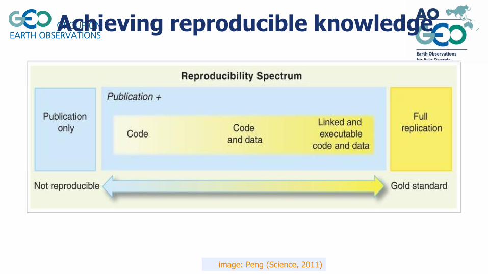
Achieving reproducible knowledge
image: Peng (Science, 2011)
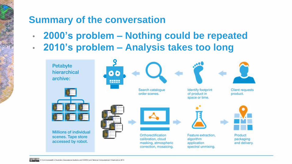
Summary of the conversation
• 2000’s problem – Nothing could be repeated
• 2010’s problem – Analysis takes too long

❑ Committee on Earth Observation Satellites Analysis Ready Data for Land (CARD4L)
definition:
CARD4L are satellite data that have been processed to a minimum set of requirements
and organized into a form that allows immediate analysis with a minimum of additional
user effort, and, interoperability both through time and with other datasets
❑ CARD4L is a framework for establishing ‘minimum requirements’ for products that:
- Are ready for ‘immediate analysis’
- Require minimal additional user effort to prepare
- Interoperable with other CARD4L datasets
Background of Analysis Ready Data

So we thought…
Get X then process it to inform Y

PartnersConsortiumSupporting
• In 2015, GA lead the establishment of a
consortium to download the new European
Sentinel satellites
• 2 x radars, 2 x 10m optical capturing
globally every week until at least 2030
• Current data holdings 1.9 PB growing
at 108 TB per month
• Open - No login
One of today’s problems – Surely getting the data is easy?

The Asia Oceania Data Hub Concept

What is it?
“The AOGEO Asia-Oceania Data Hub will be a partnership of like-minded Earth observation agencies
cooperatively storing Analysis Ready Earth observations in a open, commercial cloud environment.”
Definitions:
● Partnership: Signed MoUs in which you agree to contribute money and time
● Like-minded: Agreed set of common principles
● Cooperatively storing Analysis Ready Earth Observations: Common approaches to ARD generation, storage
and access
● Open: Anyone, anytime, anywhere can access the data directly - no logins are mandatory
● Commercial cloud: We pay for a defined scalable storage/compute service and others can also pay for
additional scalable storage/compute service with access to our data/services

AODH Any platform (ODC, DIAS or nil)

National Regional Global
Data analysis
platform
Digital Earth Australia
(ODC Deployment),
SpectrumEarth
Japan DIAS, Digital
Earth Africa (ODC
Deployment)
EC DIAS, Google Earth
Engine
Climate focused
data hubJapan DIAS, ECMWF
Earth observation
focused data hub
Digital Earth Australia
(ODC Deployment)
Asia Oceania Data
Hub
EC DIAS, USGS Earth
Explorer
Metadata database data.gov.(many)GEO Discovery and
Access Broker
Primary mission
archiveJMA HimawariCloud EC DIAS
Open code base Open Data Cube

● Letters of Support: 7○ Non-financial Letters of Support: 1
■ Australian Bureau of Meteorology
○ Potential financial partner 8
■ Proposing agencies: 2● Geoscience Australia (GA)
● Commonwealth Scientific and Industrial Research Organisation (CSIRO)
■ Letters of Support: 6● Australian National Space Agency (ASA)
● Korea Aerospace Research Institute (KARI)
● New Zealand Centre for Space Science Technology (NZ CSST)
● United Kingdom Space Applications Catapult (UK SA Catapult)
● United States Geological Survey (USGS)
● Vietnam National Space Center (VNSC)
Letters of Support

Capability staging
● The role out of the AODH can be managed using staged in geography, data
collections and other dimensions, for example:
● Initial Operating Capability (IOC)○ Geographic area: AOGEO Integrated Priority Studies: Himalayas, Mekong Basin and Pacific
○ Data collections: Existing open land imaging ARD and related ancillary
● Full Operating Capability (FOC)○ Geographic area: All of Asia-Oceania
○ Data collections: All open ARD available over Asia-Oceania

AOGEO’s strong links to users
via our Integrated Priority Studies
Integrated Priority Studies (IPS)1. Mekong River Basin
2. Small Island States
3. Himalayan Mountains
Pilot region1. Mekong River Delta
2. Samoa
3. Kanchenjunga Landscape
Our IPS were founded using the
concepts of co-design and co-production
such as the EO for Pacific Workshop held
in Brisbane October 2018.

Creating a data inventory
Collection ID Collection Overview Collection parameters
ID Collection titleCollection data
range
Source
countryDescribe parameters
1 Moderate resolution Optical: Landsat Collection 1 ARD 1987 - ongoing USVegetation cover, sea-surface temperature
(Landsat-8), water color
2 Moderate resolution Optical: Sentinel 2 ARD 2014 - ongoing EC Vegetation cover, water color
3 Moderate resolution RADAR: Sentinel 1 ARD 2010 - ongoing EC water-area detection, land cover change detection
4 Satellite processing ancilary data 1987 - ongoing VariousDEM, atmosphere parameters (air temp. pressure
heights, water vapor, ozone..)
5 High resolution Optical: Kompsat ARD 2008~2019 ROK Vegetation cover, water color
6 High resolution RADAR: Kompsat ARD 2014~2019 ROK water-area detection, land cover change detection
7 Data-driven GPP and NEE across Asia 2000 - 2015 Japan CO2 flux
8 Rice crop map by Japan's SAR 2015 - ongoing Japan Rice production
9 Global PALSAR-2/PALSAR/JERS-1 Forest/Non-Forest map 1992 - ongoing Japan Forest classifications
10 Moderate resolution RADAR: PALSAR-2/PALSAR/JERS-1 ARD Mosaics 1992 - ongoing Japan Forest-area detection
11 Moderate Optical Satellite data(16m) 2012-ongoing China Vegetation cover, water color
12 Moderate Optical Satellite data(16m) 2019-ongping China Vegetation cover, water color
13 Global Land Cover with Fine Classification System at 30m in 2015 ARD 2015 China 30 land cover types
14 MuSyQ Normalized Difference Vegetation Index(1km) ARD 2010-2015 China Vegetation index
15 MuSyQ Leaf Area Index(1km) ARD 2010-2015 China Leaf area Index
16 MuSyQ Fractional Vegetation Coverage(1km) ARD 2010-2015 China Vegetation coverage
17 MuSyQ Land Surface Reflectance(1km) ARD 2010-2015 China Reflectance
18 MuSyQ Land Surface Albedo(1km) ARD 2010-2015 China Albedo
19MuSyQ Photosynthetic Active Radiation/ Downward Short
Radiation(5km) ARD2010-2015 China Short wave radiation

Timelines for the pilot
• Asking for help 61 days from launch
• Creating a data inventory 36 days from launch
• Pulling the data together 5 days from launch
• Sharing the data 2 days from launch

Pulling the data together
http://aogeo-ips.s3-website-ap-southeast-2.amazonaws.com/

Sharing the data
Kangchenjunga Landscape
GF1 WFV
Thank you China
Mekong Delta
ALOS PALSAR 2007/2008
Thank you Japan
Samoa
KOMPSAT-3
Thank you South Korea

How we will operate
IPS datasets in single
Postgress DB in GA
All in GA
All users access to GA’s
ODC via Jupyter
IPS
project
portal
Australia Korea
ChinaJapan
AODH long term Current focus
Analysis remotely
by using
ODC/jupyter
First access
Analysis remotely
by using
ODC/Jupyter

Next steps
• Build the community working on the IPS pilots (AOGEO Task Groups,
GEO community research call, presenting in regional meetings like
APRSAF and APSCO etc)
• Index the data within the hub and prepare an open data cube
• Provide training on the data hub and tools to use our data
• Report on the IPS findings in a special issue of
the Journal Remote Sensing (https://www.mdpi.com/journal/remotese
nsing) on Earth Observations in Asia-Oceania in late 2020
• National demonstrators
• Discuss at the upcoming AOGEO Workshop being organised by
China, 27 – 31 October

© GEO Secretariat
Asia Oceania’s open collaborative network and platform for Earth observations
Thank you!