regional habitat monitoring support: tools and services ... · page 2 regional habitat monitoring...
TRANSCRIPT

Regional Habitat Monitoring Support:
Tools and Services Available to BPA Collaborators
June 28, 2010
Introduction
The Bonneville Power Administration (BPA) is working with regional fish management agencies to imple-
ment a tributary‐habitat action effectiveness strategy that includes monitoring the status and trends of fish
habitat as required by the 2008 FCRPS Biological Opinion (BiOp) in at least one population per major
population group. Efforts to standardize this work have been assisted by the Integrated Status and Effec-
tiveness Monitoring Program (ISEMP), a BPA-funded and NOAA-sponsored program, which was tasked
with developing regional habitat monitoring approaches through the development and field testing of rec-
ommended protocols, data capture, storage, and dissemination tools; and analysis. Given the recent pro-
posed expansion in habitat sampling, some of these tools may be of interest to co-managers, contractors,
and others wishing to implement habitat sampling in a consistent manner.
ISEMP has been coordinating and conducting the testing and development of habitat monitoring protocols
and tools in several watersheds within the Upper Columbia, Salmon, and John Day subbasins since 2004.
In cooperation with numerous agencies and contractors this work has enabled the side-by-side comparisons
of numerous commonly employed habitat monitoring approaches and novel techniques across a diversity
of Columbia River Basin ecoregions. These efforts recently culminated in the development of a core suite
of habitat metrics and associated study design and data collection approach (a protocol). Importantly, this
protocol is supported by data capture and data storage tools. The protocol is expected to undergo continued
refinement as testing continues; however, we propose to coordinate this evolution such that changes are
made globally across all participating projects, are based on data analysis, and occur at a rate that maintains
a consistent core data set that can be fully supported by data capture, data storage, and data reduction tools.
The goal of this document and today’s conference call is improved collaboration among habitat monitoring
proponents in advance of the July BPA proposal deadline to support regional habitat monitoring. If inter-
ested, agencies may take advantage of the protocol and associated tools and study design support, with the
goal of developing a large-scale regionally coordinated habitat monitoring program, one that is not ham-
pered by gaps in data collection, independent and divergent habitat monitoring methods, disparate or hard-
to-retrieve data, or redundant efforts.
The following are brief descriptions of the tools and services which could be provided to habitat monitor-
ing collaborators. These tools and services fall into three categories: (1) sampling design support, (2) field
sampling support, and (3) data management support. The extent to which these tools and services are pro-
vided will be determined through collaborative agreements between ISEMP, BPA, and cooperating habitat
monitoring contractors.

Page 2 Regional Habitat Monitoring Support: Tools and Services
Sampling Design Support
GRTS Sample Design Documentation, Tools, and Application Guidance
A generalized random tessellation stratified (GRTS) survey design was recommended by Crawford and
Rumsey (2009) for monitoring habitat status and trend in the Columbia River Basin. GRTS is a probabilis-
tic sampling design that has been shown to be advantageous for generating habitat condition parameters
with known statistical characteristics. Implementing a GRTS survey design correctly is critical to produc-
ing a final dataset with known statistical characteristics; however, doing so requires the implementation of
strict procedures during the site evaluation and selection process. ISEMP has developed a GRTS Site Se-
lection Protocol and Tool (Figure 1) to support field crews with efficiently completing the process while
strictly enforcing requirements. Standard data layers (described below) will be available to assist collabo-
rators in developing GRTS sample draws that are consistent across the Columbia River Basin. Addition-
ally, statistical support will be made available to assess the rigor of proposed GRTS sample draws over the
three year duration of the current proposal cycle. The desktop tool, technical training, and future enhance-
ments are available for use by collaborating agencies.
Figure 1. An example of the Site Evaluation Form from ISEMP’s GRTS Site Selection Tool.
Standard GIS Layers to Support Sample Design and Data Reduction
The GRTS-based sampling approach is dependent upon compiling and processing GIS layers consistent
with sampling decisions. For example, in order to select sites within a subbasin that have habitat available
to steelhead and a gradient of less than 12%, a set of GIS data must be compiled that describes these areas
(steelhead extent within a basin, barriers, and streams with a gradient less than 12%). ISEMP can assist
cooperators in assimilating, managing, and processing GIS data to support sampling design needs as well
as assisting groups that may have GIS support but are unfamiliar with this sampling process.

Page 3 Regional Habitat Monitoring Support: Tools and Services
Budget Guidance
ISEMP has developed and administered budgets for numerous private and agency contractors who have
conducted habitat monitoring using ISEMP habitat monitoring protocols through funds provided by BPA
and is offering to share this experience with collaborating agencies. This direct experience in scoping per-
sonnel needs, equipment needs and costs, and other associated costs may be invaluable for BPA contrac-
tors who are new to this work. At the same time, the contribution of ISEMP’s experience in fitting the
necessary monitoring work within BPA’s contracting requirements would benefit BPA by helping to im-
prove the cost efficiency of this work and ease the contracting process.
Figure 2. GRTS-based sampling sites in the
Methow River subbasin.
GIS Data Management and Geoprocessing
Because regional monitoring programs cover large spatial scales, assimilating and managing spatial
datasets in GIS, accounting for the geomorphic context of sampling, and performing watershed or subbasin
-scale analyses are important features of these programs. Collaborators will have support assimilating spa-
tial datasets across multiple basins, including managing data and metadata within geodatabases and on web
-accessible GIS servers. Also supported is the exploration and development of geospatial models, the use
of remote sensing technologies to collect continuous GIS datasets, such as LIDAR and aerial photos, and
integrating field-based tabular data within a geospatial context. The results and products from these devel-
opmental monitoring programs and assistance in implementing promising technologies will also be pro-
vided.

Field Sampling Support
Habitat Sampling Protocols
ISEMP has recently conducted a review of fish habitat requirements, interactions of processes that influ-
ence fish habitat, the spatial scales for the context of these interactions, and current monitoring programs
(ISEMP 2010). This review culminated in the development of a protocol that we believe has the greatest
probability of being comparable to other protocols and perhaps most relevant to salmonids. This protocol
was designed to be applied across varying spatial contexts depending on the logistical constrains of the
sites. In areas where GPS signals can be obtained, along with aerial photos, habitat units within reaches
can be superimposed onto aerial photos with a map grade GPS. In situations, where a GPS signal is not
obtainable units can be referenced to aerial photos and supplemented with on the ground measurements.
Finally, in situations where a GPS signal and aerial photos cannot be obtained a stick and tape method can
be employed to delineate the reach into habitat units. These approaches are described in the habitat proto-
col document (see Appendix 5 of ISEMP 2010). ISEMP will be testing and refining these methods this
summer and will provide a revised protocol in the fall of 2010.
Standardized Crew Training: Sampling and Data Capture Tool
Along with ISEMP’s experience in implementing habitat monitoring protocols comes several years of de-
velopment of field crew training. Trained and experienced field crew leaders would be available to pro-
vided coordinated, standardized training in application of the protocol. Such a standardized approach
would promote crew efficiency and improve standardization across the region.
In addition to agency-specific safety and other training, ISEMP would provide the following training to
support cooperating agencies that implement the habitat protocol:
1. Three days of GIS training for cooperators’ GIS and sampling design coordinators to explain how to
perform GRTS sample draws and allocate sample sites using a priori filters. By the end of this training,
cooperators could expect to have sample draws completed, mapped, and listed in field-ready forms.
2. Three days of in-office training on data loggers, data flow management, and QA/QC.
3. Five days of in-field training for field crew leaders and technicians using the ISEMP protocol. Crews
would be trained to measure habitat and record data with data loggers.
4. Five days of “as-needed” support throughout the field season for common questions involving data log-
gers and sampling methodologies.
5. Five days of post-season assistance with data capture and management issues.
As previously described, this protocol is based upon the statistical evaluation of numerous habitat protocols
implemented throughout the Columbia River Basin. The protocol will be expected to evolve as standard-
ized data are collected and analyzed from cooperating programs. Evolution of the protocol will be sup-
ported through annual meetings of cooperating agencies and changes to the protocol will be implemented
globally, thus enabling the necessary modifications to data capture and storage utilities. It is expected that
some level of training effort will be required annually to maintain consistency among collaborators and to
assist cooperating agencies in employing updated versions of data capture utilities.
Page 4 Regional Habitat Monitoring Support: Tools and Services

Coordinated Habitat and Fish Sampling
Ultimately one of the goals of habitat monitoring is the identification of fish and habitat relationships, the
identification of mechanisms through which habitat quality and quantity and natural processes contribute to
freshwater productivity. As such, all habitat monitoring programs should capitalize to the extent possible,
on existing fish monitoring activities and/or incorporate a fish monitoring component to supplement habitat
monitoring information. In short, using fish vital rates (life stage specific survival and growth, and distri-
bution as a function of habitat quality and availability) might constitute the most transferable and applica-
ble suite of habitat characteristics. Methods and guidance are available from the ISEMP website (http://
www.nwfsc.noaa.gov/research/divisions/cbd/mathbio/isemp/documents.cfm). At the very least, we urge
cooperators to identify and summarize fish monitoring that coincides with proposed habitat sampling.
Page 5 Regional Habitat Monitoring Support: Tools and Services
QA/QC crews to do repeat sampling across all participating watersheds
Repeated sampling of habitat monitoring sites within the same sampling season has proven to be an impor-
tant component of GRTS-based, watershed-scale habitat monitoring. Repeat sampling assists with 1) qual-
ity assurance/quality control, 2) the assessment of crew variability as a component of variation, and 3) pro-
viding improvements to temporal variability recognition (i.e., trend detection). Furthermore, repeat sam-
pling will be important to ISEMP’s research goals of testing the performance of the recommended protocol
across the Columbia Basin. To achieve these objectives, ISEMP proposes conducting repeat sampling vis-
its for all watersheds in this program at 10 percent of all sampling sites during the same low-flow index
period.

Data Collection Support
Database Schema, Data Dictionary, Meta Data Support and Tool
For a monitoring program at the scale of the Columbia River Basin to be successful, a robust data manage-
ment system must be in place before initiating data collection. Monitoring habitat in 20 watersheds will
generate a massive volume of data. Without properly documented metadata the context that provides
meaning to these data would be inaccessible and most likely lost. To insure against that scenario, a system
of data processing, storage, analysis, reporting, and distribution to meet the crucial needs of a large-scale
monitoring program has been developed (see pages 8 and 9). These needs include: (a) documenting moni-
toring objectives, study design and intended analysis; (b) summarizing how, when, and where the monitor-
ing data were collected, (c) supporting a range of analytical methods, such as hypothesis testing, time se-
ries analysis, structural equation modeling, and GIS support; and (d) adapting to changing requirements in
the future.
Collaborating agencies will have the use of a data system that includes a centralized data warehouse and
web-based data discovery tool (Status Trend and Effectiveness Monitoring, STEM Databank); data ex-
change and loading procedures; a database schema that defines data storage format (Aquatic Resources
Schema, ARS); metadata tools; data capture, validation, and summary tools (Automated Template Module,
ATM); quality control and assurance procedures; and data stewards who support the system.
Field Data Capture Tools: Hand Held Loggers or ATMs and Paper Forms
Field crews need applications to support data capture, review, summarization, and reporting. A handheld
data-logger program has been developed for the purpose of capturing data in the field. The current software
application is transferable to any data logger device that uses Windows 6.1 Mobile and has a screen size of
320x240 (support for other screen sizes will follow). The application includes some on-the-fly quality con-
trol by enforcing user established minimum and maximum values for each of the individual data entry
fields. Drop down values minimize data entry errors and increase the speed of data entry. The program
supports USB or Bluetooth GPS to enable quick documentation of sample coordinates and allows data to
be immediately integrated into a GIS program providing instant functionality for mapping.
After sampling and before leaving the site, the habitat application runs a data check to identify any poten-
tially missing data. Once the user finishes the data check process, the data are stored in three locations
within the logger to ensure multiple backups exist for the data. Users can define the time span for auto-
saving the data based upon their preferences.
The data are stored in an XML file format, which is then processed through a conversion script. This proc-
ess makes the data instantly compatible with the ARS Access database. Uploading data is a simple one-
step electronic process, which avoids data entry errors that typically occur when transcribing paper data
forms into a database. It also bypasses the data entry process, thus saving time and money.
Page 6 Regional Habitat Monitoring Support: Tools and Services
While field-based handheld computers increase efficiency by reducing data entry effort and eliminating
transcription errors, desktop applications have also been developed to perform quality assurance reviews,
to derive metrics and
summarize data, and to
generate reports or sub-
mit data for archiving.
Additionally, the desk-
top applications provide
a backup data entry
mechanism in the event
that data-loggers fail.
The field-based and
desktop applications
have XML-based
mechanisms to synchro-
nize data. Thus transit-
ing between data entry
using handheld data-
loggers and paper forms is not accompanied by a synchronization burden.
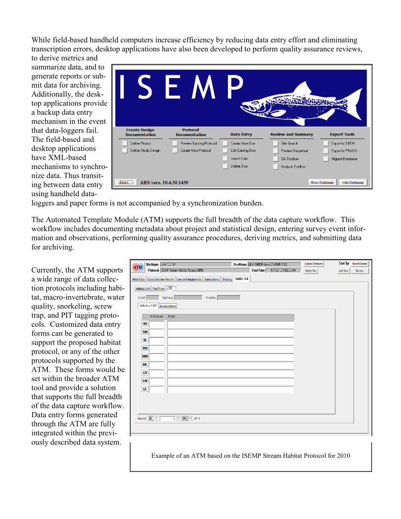
The Automated Template Module (ATM) supports the full breadth of the data capture workflow. This
workflow includes documenting metadata about project and statistical design, entering survey event infor-
mation and observations, performing quality assurance procedures, deriving metrics, and submitting data
for archiving.
Currently, the ATM supports
a wide range of data collec-
tion protocols including habi-
tat, macro-invertebrate, water
quality, snorkeling, screw
trap, and PIT tagging proto-
cols. Customized data entry
forms can be generated to
support the proposed habitat
protocol, or any of the other
protocols supported by the
ATM. These forms would be
set within the broader ATM
tool and provide a solution
that supports the full breadth
of the data capture workflow.
Data entry forms generated
through the ATM are fully
integrated within the previ-
ously described data system.
Example of an ATM based on the ISEMP Stream Habitat Protocol for 2010
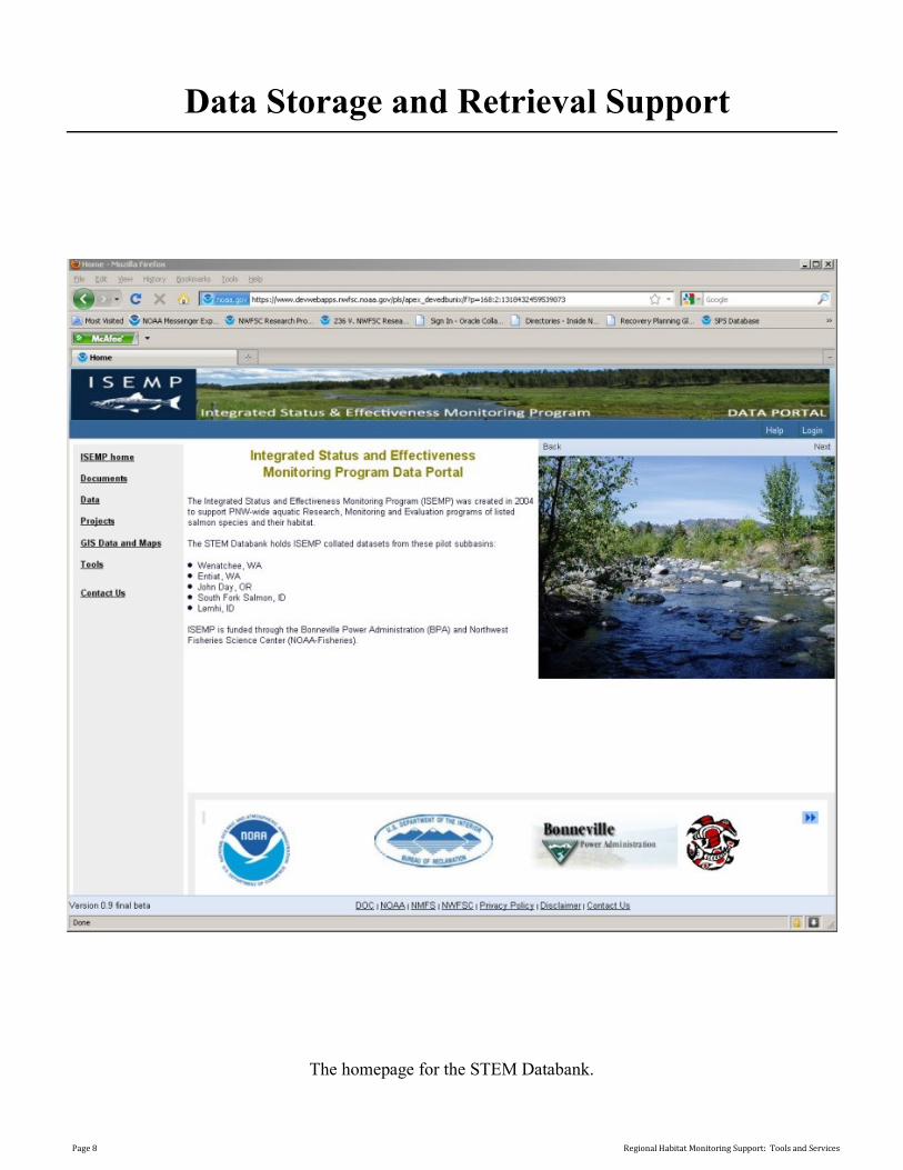
Data Storage and Retrieval Support
The homepage for the STEM Databank.
Page 8 Regional Habitat Monitoring Support: Tools and Services

The STEM Databank
Document Searching
Page.
The data viewing page
in the STEM Databank.
Page 9 Regional Habitat Monitoring Support: Tools and Services