red river diversion information guide information guide-1.pdf · the fargo-moorhead metro flood...
TRANSCRIPT
The Fargo-Moorhead Metro Flood Study Group
has recommended a 36-mile channel with a
54,000 acre dam and reservoir to protect
Fargo and Moorhead from a 500-year flood.
This plan will lead to the destruction of farms,
communities and businesses south of the
diversion channel in Clay and Cass counties
and northern Richland and Wilkin counties.
The fully-funded cost of the project, with
contingencies, is currently estimated to be $2
billion dollars. $1.1 billion of this amount
will need to be raised by Fargo and
Moorhead.
Sales taxes are projected to raise only $420
million over 20 years and protection provided by
the diversion is 10 years away at minimum, or
may never happen.
Federal deficits are at record levels and
Minnesota has its own deficit problem. All of
this casts serious doubt on how much funding
is truly available.
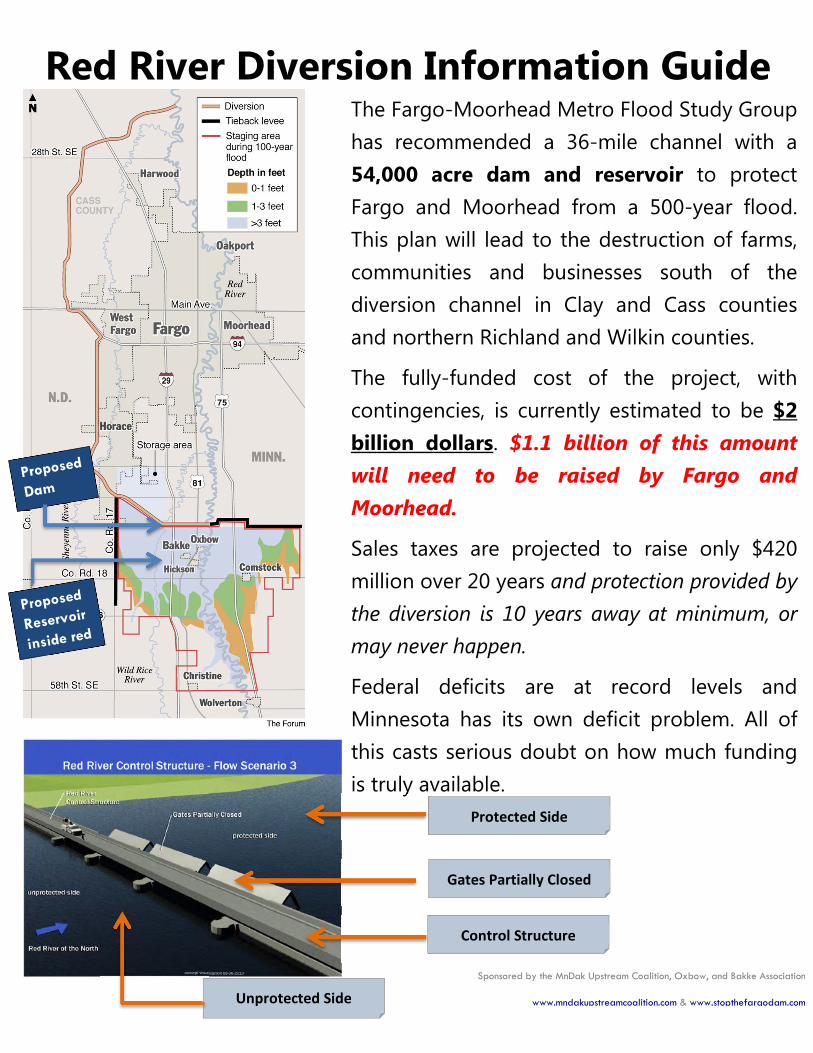
Unprotected Side
Red River Diversion Information Guide
Control Structure
Protected Side
Gates Partially Closed
Sponsored by the MnDak Upstream Coalition, Oxbow, and Bakke Association
www.mndakupstreamcoalition.com & www.stopthefargodam.com
What Is the Impact?
• 1,100 structures are affected, including 400 residences affected. A majority of these homes will be eliminated to hold water in the upstream Dam, located just south of the Fargo school district boundary.
• 54,000 Acres dammed up and under water including mature communities. The dam shifts ponded water from the current flood plain south to the new reservoir and dam area. The result is an expansion of Fargo’s available growth area at the expense of those in the newly formed (and currently dry)reservoir area.
PEOPLE
• Financial institutions are reluctant to extend financing for property purchases and improvements in and around the proposed reservoir. Property owners in this area are uncompensated captives of an artificially destroyed real estate market.
• Economic impact to schools. 20% enrollment and 25% taxable revenue reduction in Kindred. 19% enrollment and 23% taxable revenue in Richland.
ECONOMICS
• Under U.S. Army Corps guidelines, purchases of farm structures are not based on replacement value, but on "market" value. The difference is quite substantial.
• The Federal crop insurance program provides no coverage for losses caused by manmade structures that are designed to hold water.
FARM COMMUNITY
• Extreme project design complexity. Five rivers intersect with the diversion,including the Wild Rice, Sheyenne, Maple, Rush and Lower Rush Rivers.
• This complicates fish passage, migration and mortality while increasing overall environmental stress.
• 19 Highway and 4 Railroad bridges require re-building to heights above the diversion, including I-29 and Highway 75 in MN.
• When asked at public meetings, the Army Corps of Engineers cannot identify another project in the U.S. with this level of complexity.
ENVIRONMENT
Sponsored by the MnDak Upstream Coalition, Oxbow, and Bakke Association
www.mndakupstreamcoalition.com & www.stopthefargodam.com

What will the Diversion Cost You? The chart below shows the relationship between contributions and costs of the
diversion over a 20 year period – which is the length of time for the sales tax.
Are protected residents ready to pay for this revenue shortfall?
� Fargo/Moorhead responsibility: Local Share + Unplanned Costs = $1.52 Billion
� Revenue Sources: Fargo Tax + Cass County Tax + MN Share + ND Share = $830 Million
� Shortfall: Local Share – Revenue Sources = $690 Million**
** This value does not include costs for current levee work, public relations firm and
lobbyist firm in Washington DC Note: Interest = Bonds estimated at 4%
The only way to pay for this project is to impose massive taxes on the
properties located inside the diversion.
Funding
Shortfall
Total Cost is $2.34 Billion with Revenue only $830 Million
Sponsored by the MnDak Upstream Coalition, Oxbow, and Bakke Association
www.mndakupstreamcoalition.com & www.stopthefargodam.com
Fargo-Moorhead can be protected without
destroying Red River Basin communities.
A Dam & Reservoir is not needed!
The Red River Basin Commission recent study shows:HOW
• Managing floodwater across the Red River Basin can eliminate upstream and downstream impacts of a diversion, and reduce flooding throughout the entire Red River Valley, preserving all our communities and economic growth for everyone.1
Do our local leaders insist on destroying communities and businesses with a dam when there are other viable options?
WHY• WE DON'T KNOW! The sponsors appear to be more interested in a
quick fix for THEIR problem, instead of a permanent Red River Basin wide solution.
You Can Do!WHAT• Request your local leaders and Congressional Representatives to work
together TO SAVE EVERYONE in the Red River Valley from floodwaters. It’s an opportunity to do what’s right for the states of North Dakota and Minnesota, not what’s best for ONLY Fargo!
All Data is sourced from the U.S. Army Corps of Engineers FEIS Study at their website:
http://www.internationalwaterinstitute.org/feasibility 1 http://www.redriverbasincommission.org/ FINDING LONG TERM FLOOD SOLUTIONS TOGETHER Report to State and
Federal Officials on a Comprehensive Plan of Flood Strategies for the Basin of the Red River of the North 2009-2011
Draft 8-29-2011. Table D-16
www.mndakupstreamcoalition.com www.stopthefargodam.com Sponsored by the MnDak Upstream Coalition, Oxbow, and Bakke Association