red lake river state water trail mapfiles.dnr.state.mn.us/maps/canoe_routes/redlake.pdf219 219 1 1 1...
TRANSCRIPT
75
75
75
75
2
2
2
2
59
59
59
220
220
220
219
219
1
1
1
1
89
89
89
32
32
32
32
92
32
32
9
9
102
102
15
99
11
1
1
1
5
33
33
21
1117
57
11
11
18
13
3
13
13
13
57
9
12
2
2
7
17
2
7
22
22
24
23
27
27
2
89
89
58
223
59
16
61
61
18
214
217
248 46
212
112
108
63 63
84
85
58
88
6
62
23
58
24
294
96
51
1
97
63
5
10
15
20
25
30 35 40 45
50 5560 65
70
75
80 85
90
95100
105
110
115
120
125
130
135140
145 150
155
160165
170
175
180
185 190
195
Fisher Landing
Highway 75 Central Park
Huot Park
Sportsmen’s Park
City Park
Voyageur’s View
LaFaveBeach
Centennial ParkHwy 59
SmileyBridge
KratkaCrossing
HighLanding
Co. Rd. 3Bridge
NeptuneBridge
East Grand Forks
Climax
NielsvilleBeltrami
Fertile
POLK CO.MAHNOMEN CO.
Crookston
Huot
Red LakeFalls
Mentor
St. Hilaire
Plummer
PENNINGTON CO.RED LAKE CO.
RED LAKE CO.POLK CO.
PENNINGTON CO.RED LAKE CO.
POL
K C
O.
MARSHALL CO.
POL
K C
O.
PEN
NIN
GTO
N C
O.
MARSHALL CO.PENNINGTON CO.
BE
LTR
AM
I CO
.
BELTRAMI CO.CLEARWATER CO.
Thief RiverFalls
Hazel
Viking
Warren
GoodridgeRed
Lake
Indian
Reservation
Agassiz
National
Wildlife
Refuge
Elm LakeW.M.A.
Adger W.M.A.
SnowshoeW.M.A.
Elm CreekW.M.A.
Red RiverState
RecreationArea
PembinaW.M.A.
BelgiumW.M.A.
HiginbothamW.M.A.
EldredTympanuchus
W.M.A.
KertsonvilleW.M.A.
Old MillState Park
Adolph ElsethW.M.A.
New FoldenW.M.A.
NewFolden
MoranW.M.A.
HoutW.M.A.
StipaW.M.A.
MarcouxW.M.A.
PembinaTrail
ReserveS.N.A.
DougdaleW.M.A.
TildenW.M.A.
Oak RidgeMarsh W.M.A.
ShypokeW.M.A.
TrailW.M.A.
BurnhamW.M.A.
MapleMeadowsW.M.A.
GodfreyW.M.A.
ChicogW.M.A.
OnstadW.M.A.
LibertyW.M.A.
Agassiz-OlsonW.M.A.
Agassiz DunesS.N.A.
RanumW.M.A.
WoodsideW.M.A.
RydellNationalWildlifeRefuge
DaleaW.M.A.
GervaisW.M.A.
JacksnipeW.M.A.
GryglaW.M.A.
ValleyW.M.A.
MoylanW.M.A.
MoylanW.M.A.
SharpW.M.A.
EspelieW.M.A.
GoodridgeW.M.A.
OriniakW.M.A.
EmmardvilleW.M.A.
CraneW.M.A. Gully
W.M.A.
SemW.M.A.
Willow RunW.M.A.
CarmeleeW.M.A.
Wolf TrailW.M.A.
LeeW.M.A.
HamreW.M.A.
Saw-WhetW.M.A.
Grygla
Benville W.M.A.
GryglaW.M.A.
WapitiW.M.A.
Red Lake W.M.A.
BeltramiIsland
StateForest
FireweedW.M.A.
Gun-dogW.M.A.
SteenersonW.M.A.
Grand
Marais
CreekRED
LAKERIVER
RED
RIVER
LAKE
Red
River
of
theNorth
Burnham
Creek
Gentilly
River
Kripple CreekFisher
MalmbergPrairie S.N.A.
L.Black
R.
Sand
Hill
River
BurnhamCreek
Maple Creek
Sand Hill
River
Kittleson
Creek
KittlesonLake
RaffLake
UnionLake
HalversonLake
LakeArthur
MapleLake
Beau
Gerlot
Creek
Lower
Badger
Creek
Clearwater
River
TerrebonneCr.
Cyr
Creek
Black
River
Browns Creek Clearwater River
Snak
e
River
MiddleRive
r
Agassiz
Pool
GreenStumpPool
Thief
Rive
r
Snake
South
Branch
River
Thief BayPool
EckvollW.M.A.
Mud
River
Lost
River
CahillLake Roosevelt
Lake
LowerRedLake
Moose River W.M.A.
NORTHDAKOTA
POLK CO.
CrookstonMunicipalAirport
FertileMunicipalAirport
Red LakeFalls
MunicipalAirport
Thief RiverFalls Regional
Airport
II
III
Red Lake Reservation DNR
permit and guide are
required to paddle this
section(RM 193 - RM 175.1)
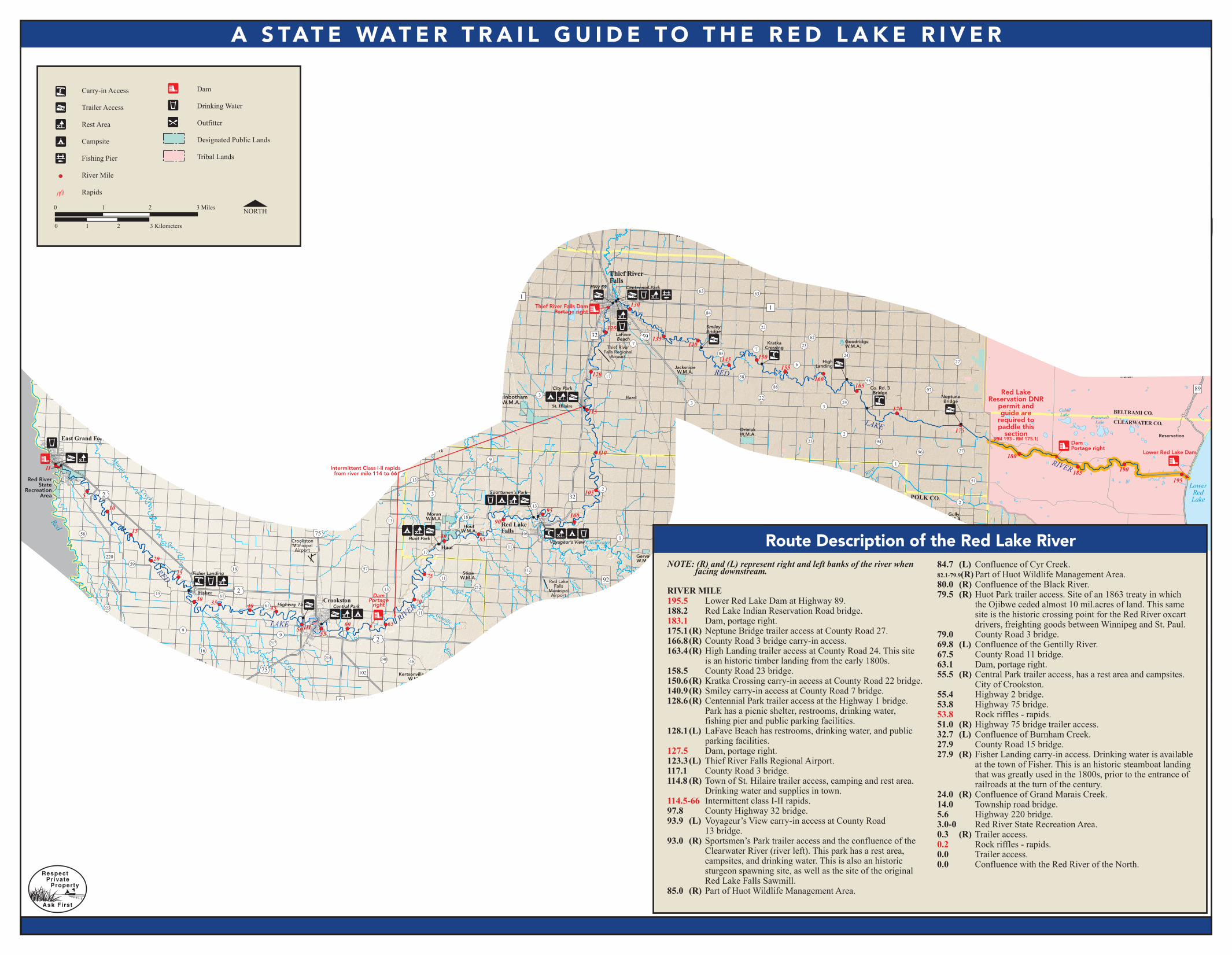
A S TAT E WAT E R T R A I L G U I D E T O T H E R E D L A K E R I V E R
Carry-in Access
Trailer Access
Rest Area
Campsite
Fishing Pier
River Mile
Rapids
Dam
Drinking Water
Outfitter
Designated Public Lands
Tribal Lands
NORTH1 2 3 Miles0
1 2 3 Kilometers0
NOTE: (R) and (L) represent right and left banks of the river when facing downstream.
RIVER MILE 195.5 Lower Red Lake Dam at Highway 89.188.2 Red Lake Indian Reservation Road bridge.183.1 Dam, portage right.175.1 (R) Neptune Bridge trailer access at County Road 27.166.8 (R) County Road 3 bridge carry-in access.163.4 (R) High Landing trailer access at County Road 24. This site is an historic timber landing from the early 1800s.158.5 County Road 23 bridge.150.6 (R) Kratka Crossing carry-in access at County Road 22 bridge.140.9 (R) Smiley carry-in access at County Road 7 bridge.128.6 (R) Centennial Park trailer access at the Highway 1 bridge. Park has a picnic shelter, restrooms, drinking water, fishing pier and public parking facilities.128.1 (L) LaFave Beach has restrooms, drinking water, and public parking facilities.127.5 Dam, portage right.123.3 (L) Thief River Falls Regional Airport.117.1 County Road 3 bridge.114.8 (R) Town of St. Hilaire trailer access, camping and rest area. Drinking water and supplies in town.114.5-66 Intermittent class I-II rapids.97.8 County Highway 32 bridge.93.9 (L) Voyageur’s View carry-in access at County Road 13 bridge.93.0 (R) Sportsmen’s Park trailer access and the confluence of the Clearwater River (river left). This park has a rest area, campsites, and drinking water. This is also an historic sturgeon spawning site, as well as the site of the original Red Lake Falls Sawmill.85.0 (R) Part of Huot Wildlife Management Area.
84.7 (L) Confluence of Cyr Creek.82.1-79.9(R) Part of Huot Wildlife Management Area.80.0 (R) Confluence of the Black River.79.5 (R) Huot Park trailer access. Site of an 1863 treaty in which the Ojibwe ceded almost 10 mil.acres of land. This same site is the historic crossing point for the Red River oxcart drivers, freighting goods between Winnipeg and St. Paul.79.0 County Road 3 bridge.69.8 (L) Confluence of the Gentilly River.67.5 County Road 11 bridge.63.1 Dam, portage right.55.5 (R) Central Park trailer access, has a rest area and campsites. City of Crookston.55.4 Highway 2 bridge.53.8 Highway 75 bridge.53.8 Rock riffles - rapids.51.0 (R) Highway 75 bridge trailer access.32.7 (L) Confluence of Burnham Creek.27.9 County Road 15 bridge.27.9 (R) Fisher Landing carry-in access. Drinking water is available at the town of Fisher. This is an historic steamboat landing that was greatly used in the 1800s, prior to the entrance of railroads at the turn of the century.24.0 (R) Confluence of Grand Marais Creek.14.0 Township road bridge.5.6 Highway 220 bridge.3.0-0 Red River State Recreation Area.0.3 (R) Trailer access.0.2 Rock riffles - rapids.0.0 Trailer access.0.0 Confluence with the Red River of the North.
Route Description of the Red Lake River
Intermittent Class I-II rapidsfrom river mile 114 to 66
Thief River Falls DamPortage right
DamPortage
right
Lower Red Lake Dam
DamPortage right

The Red Lake River
Marshy wilderness, flat farmland, towering eroded cliffs and steep, wooded banks characterize the Red Lake River.
One of the few canoeing rivers in northwest Minnesota, the Red Lake flows westward to join the Red River in East Grand Forks.
Above the dam at river mile 181 the Red Lake flows through marshland in the Red Lake Indian Reservation. White and yellow water lilies, wild rice and cattails thrive here; blackbirds, snipes, wrens, gulls, great blue herons and many ducks inhabit the marsh.
Below the dam, the river is flanked by a prairie that is at times bright with wildflowers. Trees are sparse and small on the low grassy banks. Near High Landing the trees become larger and the river meanders through farmland; stands of willow, elm and cottonwood are interspersed with open fields. Residential development is extensive along the banks at Thief River Falls.
Below St. Hilaire the banks steepen and are heavily wooded to Red Lake Falls. A chain of boulder-field rapids and pools interrupts the Red Lake in this 17-mile stretch where the river drops 110 feet.
High, nearly vertical, eroded cliffs and the first of many huge slump areas are encountered near Red Lake Falls. Entire hillsides have moved down to the river. The natural process of flood and drought cycles changes the landscape quickly.
Just downstream from Huot is the Old Crossing Treaty State Historical Wayside Park, where in 1868 the Ojibway Indians ceded almost 10 million acres of land for white settlement of the Red River Valley. This also was an important crossing of
the Red River Oxcart Trails, the tracks of which are still partially visible.
In its lower reaches the river meanders through farmland, often screened from the river by stands of elm, willow and cottonwood.
Wildlife along the Red Lake River is varied and abundant. Wooded bottomlands provide excellent habitat for wood duck and deer. Fox, grouse, beaver, mink, muskrat, weasel, coyote, squirrel, rabbit and raccoon range through the region. Bottomlands and scattered oxbows attract mallards, blue-winged teal, great blue herons, shorebirds, owls and numerous species of songbirds. Otters and fishers make the riverway their home.
The river supports several species of game fish, including northern pike walleye and channel catfish. The Red Lake River is particularly noted for its channel catfish angling. Some of the most popular fishing areas are located below the Ottertail power dams in both Crookston and Red Lake Falls, and near the junctions of the Red Lake with the Thief, Clearwater and Black rivers. Smallmouth bass may be found in the upper reaches.
According to the most recent Minnesota Department of Health Advisory, children under six and women of child-bearing years should eat no fish from this river. Others may eat one meal a month.
Planning A Safe River Trip
A successful river trip is safe. To enjoy a safe journey, you should be prepared by doing the following:
• Get acquainted with your route. Plan your tripwith a map before you depart and advisesomeone of your plans including planneddeparture and arrival times.
• Travel with a companion or group.• Choose a distance that is comfortable for you,
most people paddle two to three river miles perhour.
• Wear a U. S. Coast Guard approved personalflotation device that state law requires be onboard the boat for each person.
• Bring a first aid kit that includes waterproofmatches.
• Be cautious of river obstructions, such asoverhanging and dead trees.
• Bring an extra paddle in your canoe.• You must pack out all trash.• Leave only footprints; take only photographs!
u e te, at
e d
CLASS V. Long, violroutes and steep dropslife in the event of a experts in decked boat CLASS VI. Cannot risk to life.
Water levels can speed or slow you down. Yocan get information about water levels from thregional DNR office, or check the DNR websior the DNR Information Center. Remember thmuch of the shorelands are privately owned. Respect and protect the water and shorelands.
Boating Information
• Register your watercraft. All watercraft morthan 9 feet in length, including nonmotorizecanoes and kayaks, must be registered inMinnesota or your state of residence.
• Few portions of this water trail are suitablefor motor use.
Rating Whitewater
Rivers and rapids are rated according to the International Scale of River Difficulty. Ratings
are estimates based on observations at low or moderate water levels or on secondhand reports.
CLASS I. Easy rapids with small waves and few obstructions.CLASS II. Rapids with waves up to three feet high. Some maneuvering is required. CLASS III. Difficult rapids with high, irregular waves capable of swamping an open canoe. Narrow chutes may require extensive maneuvering. Usually considered the limit for an experienced paddler in an open canoe.CLASS IV. Long, turbulent rapids with high, irregular waves, constricted passages, and blind drops. Decked canoes and kayaks only; open canoes should be portaged.
ent rapids with complex or waterfalls. Hazard to
mishap. Runnable only by s.
be attempted without great
Rest Areas and Camping Sites
• Public rest areas are available along the route to
are
t a
communities are attractishoreline habitat for bird
Natural Shorelands
40% evaporation
10% runoff
50% infiltration
Altered Shorelands
30% evaporation
55% runoff
15% infiltration
rest, picnic and explore.
• Camp only in designated campsites, whichavailable on a first-come, first-serve basis.
• Bring drinking water. It is only available alimited number of rest areas. Drinking riverwater is not recommended, but if you do itmust be treated.
• Respect private property. Stop only atdesignated sites; much of the shoreland isprivate property.
• Be sanitary! Use designated toilet facilities orbury human waste away from the river.
Sustainable Ecosystems Outdoor recreation is dependent on a healthy and attractive natural environment. Sustainable outdoor recreation enables people to enjoy the outdoors without negative impacts on the environment. Communities working together can improve water resources by promoting environmentally sensitive land use practices along rivers and throughout watersheds. Natural shoreline buffers improve water quality by filtering out pollutants and sediments. Healthy and diverse native shoreline plant
ve and provide important s and wildlife.
Red Lake River Corridor Enhancement Group
© 2016 Minnesota Department of Natural Resources
Minnesota State Parks and TrailsRegional Unit
“The Minnesota Department of Natural Resources is an Equal Opportunity Employer”
This information is available in alternativeformat upon request.
Online water trail information and maps can be found at mndnr.gov/watertrails
The river holds a variety of secrets just waiting for you to explore. Bring your binoculars, a field guideor just your curiosity and enjoy the river’s magic.
BLU
E V
ER
VA
IN; D
AV
ID A
RSC
OT
DAVID
DA
VID
AR
SCO
T
CE
NTR
AL
PAR
K; D
AV
ID A
RSC
OT
MA
RIA
ALB
Y
OLD
TR
EA
TY C
ROSS
ING
PA
RK
; DA
VID
AR
SCO
T
A STATE WATER TRAIL GUIDE TO THE RED LAKE RIVER
123 Main Ave NorthThief River Falls, MN 56701
218-681-0889
2Lower Red
Lake
Warroad
2
71
71
59
59
75
75 52
10
10
Upper RedLake
LeechLake
Red
Lake
Nor
th
Red
Rive
rof
the
Mississippi
Roseau
Snake
Clearwater
Thief
Sand Hill
Wild
Buffalo
OtterTail
Red Eye Cro
w W
ing
Pine
Rice
RapidRainyBaudette
ThiefRiverFalls
MahnomenBemidji
DetroitLakes
Walker
DNR Information CenterThe DNR’s Information Center is available to provide free
publications of facilities and services as well as answers questions pertaining to DNR recreational opportunities in Minnesota.
500 Lafayette RoadSt. Paul, MN 55155-4040651-296-6157 Metro Area1-888-646-6367 MN Toll-Free
mndnr.gov
Red Lake River
STATE WATER TRAIL MAP