recognizing and addressing risk ambiguity in sea level
TRANSCRIPT

Portland State University Portland State University
PDXScholar PDXScholar
Dissertations and Theses Dissertations and Theses
Winter 1-9-2019
Recognizing and Addressing Risk Ambiguity in Sea Recognizing and Addressing Risk Ambiguity in Sea
Level Rise Adaptation Planning: a Case Study of Level Rise Adaptation Planning: a Case Study of
Miami-Dade County, Florida Miami-Dade County, Florida
Mary Ann Rozance Portland State University
Follow this and additional works at: https://pdxscholar.library.pdx.edu/open_access_etds
Part of the Environmental Policy Commons, and the Urban Studies Commons
Let us know how access to this document benefits you.
Recommended Citation Recommended Citation Rozance, Mary Ann, "Recognizing and Addressing Risk Ambiguity in Sea Level Rise Adaptation Planning: a Case Study of Miami-Dade County, Florida" (2019). Dissertations and Theses. Paper 4673. https://doi.org/10.15760/etd.6557
This Dissertation is brought to you for free and open access. It has been accepted for inclusion in Dissertations and Theses by an authorized administrator of PDXScholar. Please contact us if we can make this document more accessible: [email protected].

Recognizing and Addressing Risk Ambiguity in Sea level Rise Adaptation Planning:
A Case Study of Miami-Dade County, Florida
by
Mary Ann Rozance
A dissertation submitted in partial fulfillment of the
degree requirements for the degree of
Doctor of Philosophy
in
Urban Studies
Dissertation Committee:
Vivek Shandas, Chair
Connie Ozawa
Thaddeus Miller
Amy Lubitow
Portland State University
2019

© 2018 Mary Ann Rozance

i
Abstract
As coastal cities around the world identify and implement adaptations to sea level
rise, they are faced with competing interests around what should be done and how to
prioritize actions. Often, environmental problems—like confronting the challenge of sea
level rise—are posed as requiring expert driven, technical solutions to identify and
mitigate risks across the landscape. This framing, however, ignores the way in which
diverse knowledge can help inform long-term planning horizons that address complex
ways that sea level rise affects communities. The failure to integrate diverse knowledge
into sea level rise adaptation can result in barriers to implementation and outcomes that
can reproduce inequities.
In environmental planning, knowledge integration challenges can stem from
ambiguity around the construction of environmental risk knowledge, as well as
institutional arrangements that inhibit diverse involvement. Ambiguity refers to a context
in which there are different and sometimes conflicting views on how to understand the
problem or system to be managed, for example, conflicts around what risks to measure
and how to measure them. This manifests in the ways that different groups construct and
use knowledge about risks. Often ignored in planning contexts and research on sea level
rise adaptation, ambiguity—particularly around social risks—are critical to address, since
they can determine whether diverse knowledge about risks are integrated or ignored in
planning.
This dissertation uses a case study of Miami-Dade County, Florida and is guided
by the question: how do different groups understand risk within sea level rise, and what
planning and governance factors influence the way diverse dimensions of risk are

ii
integrated into adaptation strategies? Findings from this case study suggest that
baselines, projections, and the focus of risk rooted in an economic discourse based on
short-term planning horizons and technical constructions of risk have more authority as
compared with counter arguments around ecological and social risks. Recommendations
include the need for transparent adaptation decisions and the inclusion of diverse
stakeholders in the production of regional climate science, sea level rise assessments, and
adaptation planning. A more integrated approach can better address diverse risks and
facilitate long-term planning.

iii
Acknowledgements
I am thankful to the hard-working and committed people in Miami-Dade County,
Florida and across the country who took time out of their busy lives to share their stories
with me. Thank you for your work preparing communities for climate challenges and
striving for a better climate future and thank you for your generosity towards this
dissertation and my life.
I am thankful to my committee who have been supportive guides during this
entire process. I am grateful to my dissertation chair, Vivek Shandas, for his guidance as I
encountered challenges, questions, and difficulties. The encouragement, enlightened
conversations, and pathways he provided helped me overcome these obstacles and will
stay with me throughout my career. To Connie Ozawa for her support and pointing me
towards methods and approaches for bringing people together and building more
collaborative planning environments. To Thad Miller for his support and encouragement
to push boundaries and explore different approaches to research and thinking about
infrastructure. To Amy Lubitow for her valuable insight and enthusiasm for this work.
The collective input and encouragement from my committee brought me through
challenging times of this process.
Over the past five years I was a part of incredible teams at Portland State
University that influenced my work and supported me throughout the process. Thank you
to the Ecosystem Services Supporting Urbanizing Regions IGERT program. The
generous funding from the National Science Foundation and the Institute for Sustainable
Solutions gave me the opportunity to pursue research topics meaningful to me, which will
shape my future work and career. Thank you to the Urban Studies and IGERT faculty

iv
who opened my mind to different ways of thinking about urban and environmental
problems and encouraged me to find my own path forward. Thank you to all the Urban
Studies and IGERT students, the discussions we have had over the years have shaped my
perspectives and research. Thank you to Diana Denham and Melanie Malone who have
been great collaborators and beacons of inspiration. Thank you to the
Restoration/Infrastructure crew—Ashlie Denton, Marissa Matsler, Sarah Kidd, and
Zbigniew Grabowski—for the exciting conversations and collaborations and constantly
raising the bar on research, I look forward to seeing what we do next!
A warm thank you to my family for your love and support. To my parents who
have been with me since the beginning and watched me go through over 25 years of
schooling—I promise, this is the end! Thank you for always reminding me that I can do
whatever I set out to do. Thank you to my siblings and friends for helping me stay
grounded and providing often needed comic relief. Finally, my deepest thank you to my
husband David, who I met two months prior to starting this journey. He has been with me
through all the ups and downs, the self-doubt and excitement, I could not have done this
without your endless enthusiasm and support. You deserve an award for everything
you’ve done to support me along the way—running to get me an emergency power cord
during my exams, driving me from Seattle to Portland during a blizzard for my proposal
defense, and reading early versions of this dissertation—thank you for being my number
one fan.

v
Table of Contents
Abstract ............................................................................................................................... i
Acknowledgements .......................................................................................................... iii
List of Tables ................................................................................................................... vii
List of Figures ................................................................................................................. viii
List of Abbreviations ....................................................................................................... ix
Chapter 1: Dissertation Introduction...............................................................................1
Chapter 2: Using Risk Ambiguity to Examine Sea Level Rise Adaptation Planning
............................................................................................................................................13
2.1 Introduction ..............................................................................................................13
2.2 Research Questions ..................................................................................................25
Chapter 3: Literature and Theoretical Review .............................................................27
3.1 Overview of Sea Level Rise Adaptation Science and Planning ...............................27
3.2 Knowledge Co-production and Constructions of Risk ............................................31
3.3 Knowledge Integration .............................................................................................33
3.4 Connecting Literature and Theory to Sea Level Rise Adaptation Planning in
Miami-Dade County, Florida .........................................................................................51
Chapter 4: Research Design and Methods ....................................................................53
4.1 Research Design .......................................................................................................53
4.2 Case Study Description ............................................................................................55
4.3 Methods ....................................................................................................................67
Chapter 5: Constructing Risk Knowledge in Sea Level Rise Adaptation Planning in
Miami-Dade County, Florida ..........................................................................................79
5.1 Introduction ..............................................................................................................79
5.2 A relational Approach to Risk in Sea Level Rise Adaptation Planning ...................82
5.3 Scientific Reticence, Political Uncertainty, and Confronting Denialism—Agreeing
on 81 Inches in 2100 ......................................................................................................89
5.4 Risk Constructions of the Physical Landscape that Support an Economically Viable
Future ..........................................................................................................................102
5.5 Prioritization and the Creation of Vulnerability and Adaptive Capacity ..............117
5.6 Discussion .............................................................................................................126
5.7 Conclusion ..............................................................................................................134
Chapter 6: Pathway for Change or Business as Usual? Discourses in Sea Level Rise
Adaptation Governance in Miami-Dade County, Florida .........................................135
6.1 Introduction ............................................................................................................135
vi
6.2 Institutional Discourse Analysis to Unpack Sea Level Rise Risk, Problem
Framings, and Solutions .............................................................................................. 139
6.3 Institutions and Sea level Rise Adaptation in Miami-Dade County, Florida ........ 143
6.4 Sea Level Rise Adaptation Storylines Discourses ................................................ 150
6.5 Discussion ............................................................................................................. 201
6.6 Conclusion ............................................................................................................. 195
Chapter 7: Miami-Dade Case Study Conclusions, Theoretical and Planning
Contributions, and Recommendations........................................................................ 203
7.1 Summary of Findings from Miami-Dade County, Florida ................................... 203
7.2 Situating Case Study Findings in Risk and Planning Theory and Practice ........... 204
7.3 Strategies to Address Risk Ambiguity Challenges in Climate Change Adaptation
Planning ....................................................................................................................... 211
7.4 Conclusion ............................................................................................................. 221
Chapter 8: Re-Scaling the Black Box of Decision-making: Global to Local
Knowledge Practices of Sea level Rise Risk in Coastal Adaptation Planning ......... 223
8.1 Introduction ........................................................................................................... 223
8.2 Scalar Politics of Risk in Sea Level Rise Adaptation Planning ............................ 227
8.3 Applying Scalar Politics of Risk ........................................................................... 236
8.4 Discussion ............................................................................................................. 247
8.5 Conclusion ............................................................................................................. 248
References ...................................................................................................................... 250
Appendix A: Timeline of events related to sea level rise adaptation planning in
Miami-Dade County ..................................................................................................... 270
Appendix B: Key Documents ....................................................................................... 273
Appendix C: Interview Guide ...................................................................................... 278
Appendix D: Codebook Used in Atlas.ti ..................................................................... 282
Appendix E: Events Attended During Field Research .............................................. 285

vii
List of Tables
3.1: Planning orientation overview ....................................................................................43
4.1: Key actions outlined in the preliminary resilience assessment from the 100 Resilient
Cities project .....................................................................................................................66
4.2: Summary of methods used in dissertation research ...................................................69
4.3: Institutions involved in sea level rise adaptation efforts in Miami-Dade County,
Florida ...............................................................................................................................71
4.4: Interviews conducted by type .....................................................................................75
4.5: Interviews conducted by focus ...................................................................................75
5.1: Risk construction summary table .............................................................................129
6.1: Rationality claims and implications for adaptation governance ...............................142
6.2: Adaptation Pathways in Miami-Dade County, Florida ............................................150
6.3: Summary of four emerging discourses within sea level rise adaptation governance in
Miami-Dade County, Florida ...........................................................................................192
8.1: Summary of definitions, processes, and key tensions within the five arenas of scalar
politics of risk ..................................................................................................................229
8.2: Pacific Island case study scalar work processes and key tensions ...........................241
8.3: Miami-Dade County, Florida case study scalar work processes and key tensions ..247

viii
List of Figures
2.1: Risk, uncertainty, and ambiguity ............................................................................... 16
2.2: Dimensions of risk in sea level rise adaptation planning ......................................... 17
2.3: Institutional positionality around risk focus ............................................................. 18
2.4: Governance, planning, and knowledge networks that address ambiguity ................. 23
3.1: Social science theories of risk ................................................................................... 34
4.1: Map of Miami-Dade County, Florida ........................................................................ 62
5.1: Two types of ignorance: nonknowledge and negative knowledge ........................... 87
5.2: Sea level rise projections adopted by Southeast Florida Regional Climate Change
Compact in 2015 ............................................................................................................... 90
5.3: Representation of sea level rise trend in Miami-Dade County GreenPrint document
............................................................................................................................................93
5.4: Map of sea level rise impacts, created by Miami-Dade County .............................. 108
5.5: Map of percentage of individual poverty for Arch Creek project ........................... 112
5.6: Map created by Dr. Hugh Gladwin with community organizers to show climate
gentrification in high elevation neighborhoods in Miami-Dade County, Florida .......... 114
5.7: Image of sea level rise impacts from Miami-Dade County’s website ..................... 125
5.8: Construction of risk knowledge in sea level rise adaptation planning in Miami-Dade
County, Florida ............................................................................................................... 127
8.1: Distribution of the five scalar arenas across spatial, biophysical, and administrative
time ................................................................................................................................. 228
ix
List of Abbreviations
Compact Southeast Florida Regional Climate Change Compact
EPA Environmental Protection Agency
FEMA Federal Emergency Management Agency
GHG Greenhous gas
IGERT Integrative Graduate Education Research Traineeship
IPCC Intergovernmental Panel on Climate Change
LiDar Light Detection and Ranging
NFIP National Flood Insurance Program
NOAA National Oceanic and Atmospheric Administration
SETs Social, Ecological, and Technical Systems
SFWMD South Florida Water Management District
SLR Sea level rise
USACE United States Army Corps of Engineers
USGS United States Geological Survey

1
Chapter 1: Dissertation Introduction
On March 29, 2018 climate activist Maggie Fernandez addressed the City of
Miami Sea Level Rise Committee in Coconut Grove at City Hall. Asking the committee
and the city to discuss the possibility of joining the Miami Climate Alliance’s effort in
holding energy companies accountable for the cost of climate change impacts, the
situation erupted into an argument over whether greenhouse gas emissions and mitigation
efforts are under the purview of the committee (Harris 2018). Architect and Sea Level
Rise Committee member, Reinaldo Borges, the most vocally opposed to Fernandez,
argued to maintain the focus of the committee’s efforts on adaptation solutions and not
tap into the politics of responsibility. Fernandez argued back and pointed to the lack of
diverse representation on the committee and the need to build a more inclusive planning
arena in which more peoples’ concerns could be addressed. The outfall of this outburst,
which included personal attacks, ended in Mayor Suarez calling for Borges’ resignation
and potential reorganization of the Sea level Rise Committee into a resiliency committee
to broaden its scope.
Like most outbursts in public settings, this one has multiple layers. There is the
feeling of a lack of representation on a formal committee, boundaries that exclude topics
that some view as relevant, as well as uneven power structures between a climate activist
and a prominent architect. Debates surrounding the risks, or the anticipated dangers
associated with sea level rise, are at the core of these issues. Contestations emerging from
different views of what is considered relevant for sea level rise adaptation planning can
be explored by examining how different groups (e.g. the development community and
environmental organizations) construct and frame risk in the planning process. A climate

2
activist, such as Fernandez for example, may be focused on a broad set of impacts from
climate change and concerned with reducing emissions to mitigate all these impacts.
While an architect may also be concerned with those things, they may be relatively more
concerned with the impacts sea level rise will have on development and future growth
within Miami. Neither Fernandez nor Borges are right or wrong in their views and
priorities, yet some priorities carry more authority and political motivation than others,
and may be embedded in assessments, policies, and planning documents. Within the
planning context surrounding the existential threat of sea level rise in Miami, Florida,
such dynamics emerge out of and simultaneously produce and construct the way in which
risks are understood and addressed in the planning process. Finding ways to balance
shifting priorities in this planning context around risk is a complex challenge.
This dissertation examines the way institutions, and individuals acting within
those institutions, construct knowledge about risks and the social and governance
processes surrounding the ways in which those different risk constructions are or are not
embedded in planning activities. Broadly defined, the construction of risk encompasses
the social process of selecting dangers for attention (Douglas and Wildavsky 1983).
Though risks are often considered to be something that can be measured and formally
assessed as a function of probability and consequence of a potential outcome, there is no
one “correct” way to identify risks (Lupton 1999). The process of defining and assessing
risks takes place in social settings by which people make decisions about what
probabilities to assign and how to assign them, and what consequences to measure and
how to measure them, among other factors that determine risk (Douglas and Wildavsky
1983; Lupton 1999). Often, guidelines and baselines surrounding these decisions are
3
formalized in laws and policies. Uncertainty is a key component of risk because a world
with perfect information about the future would suggest straightforward decision-making
where outcomes of all decisions would be known, without the need to examine
probabilities, unintended consequences, or risks (Gross 2010). The desire to reduce
uncertainty is often paramount when managing risks, and how uncertainties are assessed
and addressed are shaped by and shape our processes for how we deal with risks (Gross
2010). Since there is no one way to define risk, we must understand different planning
contexts and the systems that determine and reinforce dominant narratives around risk.
The problem of risk construction and knowledge integration is not new to the
topic of sea level rise because societies have long examined and managed different risks
(Douglas and Wildavsky 1983; Wildavsky 1988; Winner 1989). For example, cities
examine and attempt to reduce risks from crime, economic activities, and human and
environmental health. Assessing risks and identifying strategies to mitigate those risks is
ubiquitous to many urban environmental planning challenges (Gottlieb 1993; Fischer
2000). This is largely because we live in a society in which the risks resulting from
industrialization often outstrip the benefits, and the dark sides of progress increasingly
come to dominate social and political debates (Beck 1992). While cities have always
grappled with risk management, modernization has transformed this relationship and new
risks continue to emerge out of activities that are simultaneously viewed as technological,
industrial, and urban achievements (Beck 1992; Latour 2012). Many modern risks are
both more pervasive and harder to detect, requiring science and expertise to understand
and interpret (Winner 1989; Beck 1992). Given the highly technical and invisible nature
of risks, knowledge politics contested through expertise and counter expertise emerge

4
from managing modern risks (Beck 1992; Fischer 2000). This serves to elevate the
expertise and status of knowledge professions to a prime political position in the
discourse of risk— often experts control the discourse around risk, leaving little or no
room for the layperson (Wynne 1996). The central fault of the risk society is the growing
tension between those with and those without formalized risk knowledge (Beck 1992).
Understanding risk, science, and politics is complex, as is the way in which these
knowledges become embedded in decision-making. While citizens depend on the
knowledge produced by expert institutions, they can be simultaneously concerned that
these institutions construct that knowledge to obscure or mystify them (Wynne 1996;
Fischer 2000). Sometimes, knowledge about risks can be controlled and determined by
certain policies, pre-existing goals, and decisions, which may benefit some while harming
others (Tenenbaum and Wildavsky 1984).
From a theoretical standpoint, conventional work around risks has neglected two
basic dimensions of the social processes that surround them. First, the social context in
which risks are embedded is often ignored (Wynne 1992). Secondly, assumptions about
the character of risk are often removed from the experiences of those at the actual site of
the risk (Wynne 1992). For example, while institutions may conduct formal risk
assessments, they may not be culturally relevant or reflect the risks that people
experience in their daily lives (Wynne 2003). The danger of failing to recognize the
social processes that construct and embed risk knowledge is that some knowledge—
particularly lay knowledge—can be left out, and risk management solutions can overlook
critical knowledge to the problem at hand.

5
Increasingly, we have multiple institutions, both formal and informal, governing
knowledge production and implementation around risks (Leach et al. 2007). Each of
these institutions has their own way of understanding risks. Institutions that govern
decisions about risks shape risk knowledge in accordance with their own missions,
priorities, ways of knowing, and boundaries (Douglas and Wildavsky 1983; Hilgartner
1992). Those institutions and individuals closest to decision-making, often adopt risk
knowledge that most closely aligns with their cultural practices and preferences, which
can differ from other institutions more removed from decision-making (Douglas and
Wildavsky 1983). When not recognized and addressed, divergent and conflicting ways of
constructing risk—known as risk ambiguity—can lead to barriers to implementation,
communication, and knowledge integration (van den Hoek 2014). These processes can
also reproduce social inequities (Adger et al. 2005; Adger and Jordan 2009; Wisner et al.
2014).
The way that risk knowledge is produced and governed in modern risk societies
can hide who serves to benefit and who might be burdened by planning outcomes (Beck
1992; Wisner et al. 2014). Ultimately, risks are shaped by priorities, and within urban
systems, priorities connected to both formalized and informalized systems of power and
authority can shape planning outcomes in their favor (Fischer 2000; Leach et al. 2007).
This can be either intentional or unintentional. The unintentional creation of risk
knowledge that fails to address diverse dimensions of risk can be the result of
institutional blindness to different problem framings and ways of measuring or knowing
risks (Miller and Muñoz-Erickson 2018). Risks can also intentionally be ignored or
misrepresented (Fischer 2000). This can occur when private interests dominate the policy

6
design and evaluation around how risks are measured and managed (Fischer 2000). For
example, United States policies on toxicants place most of the burden of proof on the
public to demonstrate they are a risk, rather than on the companies producing toxicants to
demonstrate safety (Fischer 2000).
This complicates planning for risk and suggests that modern societies managing
risks are now trapped: risks are increasing but those responsible for their management are
often blind to the complexity of those risks, and producers of risks are able to either avoid
regulatory measures or possibly benefit from the ways that risks are constructed. The
public must live with the obvious threats of uncontrolled technical industrial development
and they often have little ability to account for the existence of threats or accurately
identify the culpable individuals. However, such power dynamics and outcomes around
winners and losers within a risk society are not guaranteed. Individual actors within
different institutions and the community can change the system and ways in which risks
are understood and managed. This has happened throughout history as communities have
rallied against toxins in their neighborhoods, work environments, and food products
(Gottlieb 1993; Fischer 2000). The environmental justice movement emerged out of the
recognition that environmental harms are disproportionately experienced by communities
of color and low-income communities (Gottlieb 1993).
So, while trends in modern risk societies present a gloomy image of those in
power obfuscating risk in their favor, individuals can act within the system and
institutions do change. The first step to changing top-down risk management practices is
to create systems with a more complex understanding of the public’s relationship to
expertise and broader understandings of how multiple risks are understood and serve to

7
be integrated into decision-making contexts (Fischer 2000). Expert’s reductionist
framings of both biophysical risks and evaluations of citizens responses to risks often fall
short of achieving the necessary foundation for knowledge integration practices (Slovic
1992). We see an increasing recognition that ordinary people have valuable risk
knowledge (Wynne 2003) and that city planning efforts seek out this knowledge for
decision-making (Innes and Booher 2010). A restructuring of professional expertise
towards a more reflexive approach to science (Wynne 2003), and a more democratic and
integrative approach to measuring and addressing risks (Beck 1992; Fischer 2000; Innes
and Booher 2010), can open-up knowledge practices around risk and create a more
integrative approach to assessing and addressing environmental risk (Miller and Muñoz-
Erickson 2018).
This dissertation applies this planning challenge around assessing and addressing
risks in the context of sea level rise adaptation planning. Impacts from climate change,
including sea level rise, presents new emerging risks that are being understood and
planned for by institutions governing the urban environment. Research on climate change
risks, particularly the science to policy interface, demonstrate existing power structures
around climate change mitigation and adaptation policies (Hulme 2009; Hulme 2010;
Hulme 2013). Global climate knowledge and the institutions representing that knowledge
come into conflict with local knowledge, sovereignty, and local power and authority
(Jasanoff and Long-Martello 2004; Hulme 2009; Denton 2017). Researchers have also
examined the uneven distribution of climate risks (Wisner et al. 2014) and community
pushback and/or acceptance to different climate change policies and adaptation strategies
(Humle 2009). While uneven distributions of risks are explored, the role of knowledge

8
practices that result in those distributions is frequently unexamined, particularly in North
America.
The risk of sea level rise is predominantly considered in future contexts and
understood by climate models that both serve to reconstruct the past and project into the
future. At the same time, decisions surrounding what to do about sea level rise impacts
are affecting people now, and the way in which risk knowledge is constructed and
integrated into the planning process can show us who may serve to benefit and who may
be burdened by these planning choices. Ultimately it comes down to whose knowledge
matters in terms of how risks are measured, and how is that knowledge used. The
governance and production of risk knowledge is not static, people can work outside of the
norms determined by their institutions and institutions can change in response to
community and political pressure.
Sea level rise adaptation planning in Miami-Dade County, Florida is used as a
key-case study for how knowledge about risks posed from sea level rise are both
constructed and integrated into planning processes. In Miami-Dade County, planners and
scientists have been examining sea level rise risks for decades and have begun to
implement solutions to address inundation from changes to the sea level. The purpose of
this dissertation research is to better understand how risks from sea level rise are
constructed within a local planning context and the challenges and opportunities current
governance processes present in integrating diverse knowledge about those risks. This
will allow us to more closely examine risk challenges and how they are being reproduced
and challenged in a real-world example. This dissertation is organized as follows:

9
Chapter 2, titled, “Using risk ambiguity to examine sea level rise adaptation
planning,” applies the concept of risk ambiguity to the topic of sea level rise adaptation
planning by emphasizing the way that risk knowledges are constructed in the planning
process. Knowledge constructions around risk reflect institutional priorities,
epistemologies, and boundaries in adaptation governance. This chapter provides a
theoretical framework and research questions that guide the dissertation.
Chapter 3, “Literature and theoretical review” presents a literature review
extending the theoretical frame around knowledge co-production, the social construction
of risk, and knowledge integration theories around governance and planning. The purpose
of this chapter is to connect these theoretical frameworks to the issue of sea level rise
adaptation planning to provide more context for research gaps examined in this
dissertation.
Chapter 4 “Research design and methods,” offers an overview of the research
design and methods. A single case study research design is used to understand the
multiple, complex factors that shape how risks from sea level rise are constructed and
integrated in planning systems. The case study was informed by document analysis and
interviews. Interviews were transcribed and coded. Thematic analysis was used to
identify emerging themes and discourses. Literature and theoretical reviews are also used
to contextualize findings that emerge out of the case study.
Chapter 5, titled, “Constructing risk knowledge in sea level rise adaptation
planning in Miami-Dade County, Florida” examines the process of how institutions select
or ignore dangers for attention. I apply Gross's (2010) theory on the two types of
ignorance—the uncertainties that get measured and further evaluated, and the

10
uncertainties that are ignored—to understand how some risk knowledge is used in the
planning process and uncertainties further examined while other risk knowledge is
ignored. This chapter includes three findings of how sea level rise risks are constructed.
First, that determining the physical hazards of sea level rise (i.e. rates, projections, and
physical geographies) is a negotiated and contested process. Second that risk knowledge
that supports an economically viable future is favored over knowledge that either
threatens that future or is seen as insignificant to that future. Third, the production of
knowledge about biophysical hazards shaped by certain economic and political framings
are reinforced and reconstructed in the planning process as hazards are translated to their
interaction with social, technological, ecological, and economic vulnerabilities. This
research contributes to cultural theories of risk by identifying points of ambiguity among
stakeholder groups in sea level rise adaptation planning. Findings from this research can
be used to understand political processes around how constructions of risk are emerging
in the context of climate adaptations in urban environments.
Chapter 6 titled, “Pathway for change or business as usual? Discourses in sea
level rise adaptation governance in Miami-Dade County, Florida” examines institutional
arrangements around adaptation governance through emerging narrative networks and
storylines around problem framing and solutions to sea level rise adaptation planning.
This chapter provides the interpretive planning context of sea level rise adaptation
governance in Miami-Dade County, including an overview of roles and responsibilities of
institutions involved or affected by sea level rise adaptation planning and the associated
adaptation pathways. Four discourses around sea level rise adaptation planning in Miami-
Dade County emerge within the community. The first is a focus on the economic core of

11
development and tourism, aligned primarily with the business community. The second
discourse emphasizes infrastructure and is closely aligned with local governments and the
desire to sustain a regional tax base to fund adaptation actions. Thirdly, a discourse
around ecological impacts from sea level rise emerged among environmental non-
governmental organizations, some government employees, and private interest groups,
primarily underpinned by scientific rationality. Finally, considerations for the people
using infrastructure and that people also matter emerged out of cultural rationality with
community organizations and others purporting initiatives that recognize distributive
justice and the unevenness of socio-economic vulnerabilities. This research contributes to
planning theory by opening-up governance processes around adaptations to climate
change shape and are shaped by the ways different groups define and interpret risks to
sea level rise. The planning and governance contexts are used to examine how these
discourses interact with each other.
Chapter 7, “Miami-Dade County, Florida case study conclusions, theoretical and
planning contributions, and recommendations” concludes the Miami-Dade County case
study. This chapter draws on lessons learned from risk construction and governance in
the Miami-Dade County case study to articulate principles for creating inclusive
adaptation science and planning activities. Findings from chapters 5 and 6 suggest that
baselines, projections, and the focus of risk rooted in economic principles have more
authority as compared with counter arguments around ecological, social and cultural
risks. Recommendations include the need for transparent adaptation decisions and the
inclusion of diverse stakeholders in the production of regional climate science, sea level
rise assessments, and adaptation planning. This work informs climate change adaptation

12
science and planning practice by identifying barriers and opportunities for diverse
knowledge integration in the planning process. These findings illuminate points within
the planning system that can better facilitate the creation of shared meaning, trust, and
relationships among different stakeholder groups.
Chapter 8 is a co-authored chapter titled, “Re-scaling the black box of decision-
making: Global to local knowledge practices of sea level rise risk in coastal adaptation
planning.” As part of my National Science Foundation Integrative Graduate Education
Research Traineeship (IGERT), I am required to co-author a dissertation chapter with
other IGERT Fellows. We developed a framework that can be used to examine scalar
issues of knowledge practices in identifying and planning for risks from sea level rise. As
sea level rise risk knowledge is translated from global to site-specific scales, we identify
five key moments in which politics of scale around risk knowledge emerge in adaptation
work: 1) the construction of the global climate; 2) the regional downscaling of climate
impacts; 3) the local definition of risks; 4) the transformation of on-the-ground social-
ecological-technical systems and infrastructures; and, 5) the evaluation of intervention
efficacy. We apply this framework to findings from two case studies in the coastal areas
of Florida, United States, and the Pacific Islands to exemplify scalar issues at work in
adaptation governance.

13
Chapter 2: Using Risk Ambiguity to Examine Sea Level Rise Adaptation Planning
2.1 Introduction
Impacts from climate change put pressure on cities’ social, ecological, and
technological systems (IPCC 2012; IPCC 2014). In response, cities around the world are
transforming urban infrastructure to adapt to future climatic regimes and assuage
potential threats posed to urban life. Across the country, coastal cities are developing and
implementing a range of strategies to protect populations from the impacts of sea level
rise. For example, the City of Miami Beach is currently raising street levels (Flechas
2015) and across the San Francisco Bay Area, groups are focused on restoring tidal
wetlands in anticipation of climate impacts (King 2016). Planners in Seattle have begun
working with community groups to better understand the ways in which sea level rise
will affect urban residents (Stowe 2016).
Within these and other climate adaptation contexts, planners are confronted with
the challenge of integrating diverse knowledge systems into adaptation strategies (Adger
et al. 2009; van den Hoek 2014). Knowledge integration is particularly important to the
ways in which risks surrounding sea level rise are understood relative to different
stakeholder groups (van den Hoek 2014). Often, solutions to environmental problems—
like confronting the challenge of sea level rise—are unproblematized and posed as
requiring expert driven, technical solutions (Winner 1989; Jasanoff 2006). This framing,
however, ignores the way in which the knowledge behind these solutions is produced and
situated in political, economic, and cultural contexts (Jasanoff 2004; Shapin and Schaffer
1985; Miller 2008), and overlooks other knowledge systems relevant to the problem at
hand (van den Hoek 2014; Brugnach and Ingram 2012). The failure to integrate diverse

14
knowledge systems and constructions of risk into sea level rise adaptation strategies can
result in barriers to implementation (Adger et al. 2005; Adger et al. 2009; Sabatier 2005)
and outcomes that can reproduce social inequities (Adger et al. 2005; Adger and Jordan
2009; Wisner 2014).
In environmental planning, knowledge integration challenges can stem from
several sources, including ambiguity and contestations around how environmental risks
and solutions are framed (Brugnach and Ingram 2012; Fischer 2000) and institutional
arrangements that may inhibit diverse involvement (Leach et al. 2007; Jasanoff and Long
Martello 2004; Bogason and Musso 2006). This dissertation examines knowledge
integration barriers in sea level rise adaptation planning and is guided by the question:
how do different groups understand risk within sea level rise, and what planning and
governance factors influence the way diverse dimensions of risk are integrated into
adaptation strategies?
The climate change literature generally defines adaptation as the “adjustment in
natural or human systems in response to actual or expected climate stimuli or their
effects, which moderates harm or exploits beneficial opportunities” (McCarthy et al.
2001, p. 982). Sea level rise adaptation planning is predicated on predicting real world
impacts and designing and implementing an adaptation strategy. In the wake of uncertain
future conditions, cities depend on models, simulations, and expert opinions to make
decisions about what adaptation measures to take and how to design and implement
strategies. Knowledge claims about risks posed by climate change impacts are used to
understand and promote climate adaptation (Hilgartner 1992), and the way risks are
understood is ultimately linked to the design, planning, and implementation of proposed

15
solutions (Sarawitz et al. 2000). These different knowledge claims are prioritized, ranked
and privileged in the planning process (Gross 2010).
In environmental planning, risk is often conceived of as a function of the physical
components of the hazard (i.e. rate of sea level rise), the vulnerability of the social and
ecological system (e.g. topography, socio-demographic data), and the system’s adaptive
capacity—or ability to respond to shock (e.g. evaluated in terms of institutions and
governance, information and resources, etc.) Planners conduct risk assessments which
stem from a tradition of technical, scientific, and objectively rational approaches (Fischer
2000; Wisner 2014). The focus is on minimizing risks and it is often assumed that more
information about the potential impacts of climate change on social, economic, and
biophysical systems will result in better decision-making, and that the lack of information
about risks is the main limitation in adaptation action (Adger et al. 2009; van der Hoek et
al. 2014). This line of reasoning is understandable, given that predicting uncertain futures
and impacts is at the core of many debates around how and when to take political action
(Adger et al. 2009). However, scholars have identified multiple dimensions of uncertainty
and while the focus tends to be on “not knowing enough” in terms of incomplete
knowledge and unpredictability, ambiguity or “knowing differently” is equally important
(see Figure 2.1) (Weick 1995; van den Hoek et al. 2012; Brugnach and Ingram 2012).

16
Figure 2.1 Risk, uncertainty, and ambiguity: Modified and expanded from van den Hoek 2014, depiction of
how ambiguity, or “knowing differently” differs from incomplete knowledge and unpredictability, or “not
knowing enough.”
Ambiguity refers to a context in which there are different and sometimes
conflicting views on how to understand the problem or system to be managed (Dewulf et
al., 2005; Brugnach et al., 2008; Renn et al., 2011). Groups may have differing ideas of
what to put as the focus, how to interpret information about the system, or how to bound
a system (Brugnach et al. 2008; van den Hoek 2014). Often ignored in planning contexts
and research on sea level rise adaptation, ambiguity—particularly around social risks—
can be far more important for decision-making than the knowledge gaps of natural
systems, since ambiguities can hamper project development and lead to conflicts over the
facts (van den Hoek 2012). Within sea level rise adaptation, issues of ambiguity can take
multiple forms: discretionary decisions resulting from the focus or problem framing,
epistemological conventions or how knowledge is understood, and system boundaries
that can restrict what knowledge is used.
17
Figure 2.2 Within social-ecological systems, different contexts of risk emerge relative to the institution
defining and making claims to those risks.
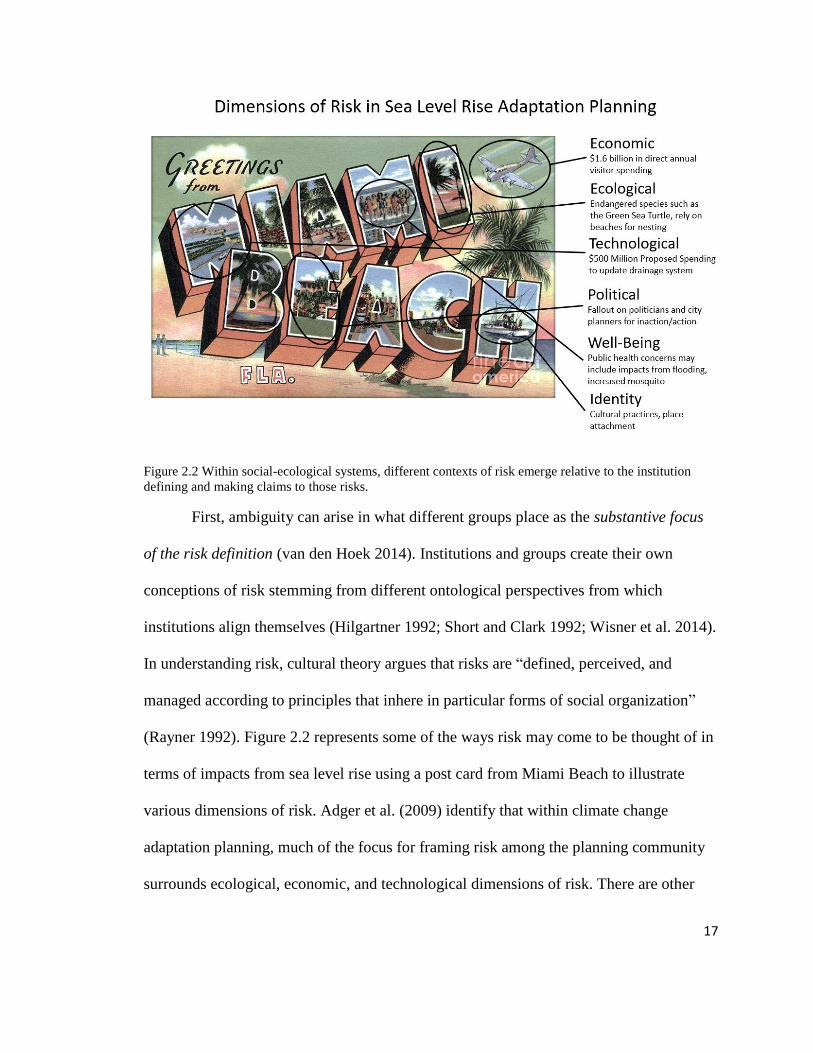
First, ambiguity can arise in what different groups place as the substantive focus
of the risk definition (van den Hoek 2014). Institutions and groups create their own
conceptions of risk stemming from different ontological perspectives from which
institutions align themselves (Hilgartner 1992; Short and Clark 1992; Wisner et al. 2014).
In understanding risk, cultural theory argues that risks are “defined, perceived, and
managed according to principles that inhere in particular forms of social organization”
(Rayner 1992). Figure 2.2 represents some of the ways risk may come to be thought of in
terms of impacts from sea level rise using a post card from Miami Beach to illustrate
various dimensions of risk. Adger et al. (2009) identify that within climate change
adaptation planning, much of the focus for framing risk among the planning community
surrounds ecological, economic, and technological dimensions of risk. There are other

18
risks, however, related to sea level rise. There may be political risks involved in either
addressing or failing to address sea level rise in a particular way (Giddens 2009; Adger et
al. 2009). Environmental changes, such as those resulting from sea level rise, may impact
community and individual identities (Clayton 2003) as well as elements of human well-
being such as public health and livability (Fischer 2000). The way in which institutions
come to define and interpret risk is shaped by their position in social, cultural, political
and economic systems (Hilgartner 1992; Douglas and Wildavsky 1983). This institutional
positionality can influence the focus of a groups definition of risk. Figure 2.3
demonstrates how different dimensions of risk may come to be important as the focus for
different groups. The relationship between positionality and risk definitions are apparent
in that people will often select those dimensions of risk that help to reinforce the social
solidarity of their institutions (Douglas and Wildavsky 1983).
Figure 2.3 Institutional positionality around risk focus: Groups have different priorities that cause them to
focus on different dimensions of risk. The first group on the left, representing engineers, may be more
focused on technological risks to infrastructure. A community organization represented on the right may be
primiarily focused on risks that threated well-being and identity.

19
The second way ambiguity can manifest in sea level rise adaptation planning are
in the ways groups interpret information about risk. Epistemological differences among
institutions can create conflict around what knowledge is considered valid. As the
conflict between the architect and the climate activist in the beginning of Chapter 1
demonstrated, the planning process can become political as different groups interact,
determining the focus of sea level rise adaptation strategies (Sarewitz et al. 2000) It is not
only important to consider the way knowledge claims around risk are constructed, but
also how they are contested and used among different institutions in the planning context.
These disagreements may emerge in public settings, such as the outburst at the City of
Miami Sea Level Rise Committee meeting previously described. Sources of disagreement
can stem from differences in methodological practices and different ways of measuring
an unknowable future (Ozawa 1996). Constructions of risk are embedded in climate
models (Edwards 2001), public policies (Fischer 2000), heuristics (Stirling 2009),
organizational and individual behaviors (Short and Clark 1992), and lay knowledge
(Wynne 1992). The process by which knowledge about risk is constructed in part lends it
credibility in many planning arenas. For example, scientific representations of risk, such
as those used by climate scientists, hydrologists, and geomorphologists may be
considered more credible sources of information through a knowledge production system
integrating testable and defensible biophysical laws (Latour and Woolgar 1986; Gieryn
2006). Rational and technical approaches to constructing knowledge around risk differ
from other knowledge constructions. Community activists may use knowledge of place-
based experiences, linking outcomes from previous climatic events within their
communities to a changing climate as well as social, economic and political histories

20
(Fischer 2000). As such, community groups may think of risk from climate change in
terms of the complex arrangements surrounding their daily lives and worry about
housing, future employment, health, and asserting their rights (see Stowe 2016).
Ultimately, diverse ways of knowing risk are related to priorities of different groups.
These priorities can be defined by and reinforced through institutional policies, laws, and
social norms and help determine what types of information matters to whom. Disparate
ways of knowing and ideas around what constitutes valid forms of knowledge within sea
level rise adaptation planning may create conflicts among groups and impede the
integration of diverse knowledge systems in proposed solutions. At the same time,
conflicts can push against ideas of what is considered at risk from sea level rise.
Depending on how conflicts are handled, they can benefit the planning process and push
things towards more integration. The outcome of the conflict between the architect and
the climate activist, for example, called for the Sea Level Rise Committee to broaden its
scope and begin addressing risks and solutions.
The third way issues of ambiguity emerge in sea level rise adaptation planning are
in decisions surrounding how to bound the system (van den Hoek 2014). This could
manifest in terms of scalar differences and in the way groups may emphasize different
constraints on scope and project planning. Governing institutions have their own
jurisdictional boundaries which may be related to borders (e.g. municipal, county, and
state governments) or components of the social, ecological and technical system (e.g.
United States Fish and Wildlife have jurisdiction over habitat, while the EPA may have
jurisdiction over contaminants). Groups may bound the system differently in terms of
both spatial and temporal scales, these differences may not only emerge in different
21
constructions of risk, but also impact the planning process and knowledge integration.
The perceived need to act quickly with sea level rise may result in actions that stem from
narrow constructions of risk as opposed to taking the time to produce a more integrated
approach, as time constraints can be barriers to collaborative and integrated processes. In
addition to differences in scale boundaries of a system, groups may have different
interpretations of political, environmental, and fiduciary constraints regarding the scope
of possibilities. Some groups may bound the system based on limitations from historical
trajectories and historical lock-in, while other groups may consider ideas outside of these
boundaries. There may also be specific types of analysis and probabilities that groups use
to bound the system (Kunreuther et al. 2013). In many widely-used systems for risk
management policy analysists often focus on a narrow set of sources of uncertainty, and a
narrow scoping of probabilities can influence how they bound the system (Kunreuther et
al. 2013).
In addition to knowledge practices that create risk constructions, it is important to
pay attention to the way in which diverse knowledge about risk are integrated into
decision-making. Climate adaptation governance surrounding the decision-making
context may help or hinder the integration of diverse constructions of risk into adaptation
strategies. While some governance arrangements allow for creative linkages among
institutional actors to help solve environmental problems, scholars have also identified
several challenges. For example, decentralized environmental decision-making can lack
transparency and blur the public participation processes, making it difficult for
integrating local knowledge in decision-making (Leach et al. 2007; Jasanoff and Long
Martello 2004; Bogason and Musso 2006). Further, rules and regulations may serve to

22
reinforce certain ontologies, epistemologies, and system boundaries inhibiting knowledge
integration (Jasanoff and Long Martello 2004).
In addition to examining governance, it is important to consider the planning
process because it can help determine the degree to which views, values and interests of
diverse communities are represented in the formulation of a problem and the
development of its solution (Brugnach and Ingram 2012). While institutions may always
differ in terms of where they place the substantive focus of risk, what information they
use, and how they bound the system, conflict and uncertainty around ambiguity can be
resolved through relationship building, trust, and creating shared meanings (see Figure
2.4) (Lengwiler 2008; van Asselt and Renn 2011). The planning process—and how the
public and different stakeholders are included in particular— can help determine how
diverse knowledge systems are integrated into planning outcomes and reduce barriers to
implementation.

23
Figure 2.4 Issues of ambiguity emerge from and can be reinforced by the governance, planning, and
knowledge network process. Issues of ambiguity can also be addressed through these processes with
adaptation strategies that address diverse dimensions of risk in the outcome and produce a more holistic
view.

24
Finally, knowledge networks of different institutions (both formal and informal)
may determine what types of knowledge—including lay knowledge—flow through the
system and influence decision-making (Muñoz-Erickson 2014). Connectivity and
information sharing can indicate a system in which there may be trust among
organizations potentially leading to the creation of shared meanings around risks to sea
level rise (Pietri et al. 2015). How connected different groups are may result in how their
constructions of risk are integrated into adaptation strategies.
To summarize, within sea level rise adaptation planning there are several factors
that may shape the way ambiguity is addressed. Addressing ambiguity can lead to the
integration of diverse constructions of risk into climate adaptation strategies. The
ontological focus of risk definitions and epistemological differences in how risk is
understood are wrapped up in political dimensions of the decision-making arena. As
such, knowledge politics surrounding different definitions of risk and adaptation
strategies may in and of itself limit the integration of diverse knowledge systems.
Different groups may bound the system in different ways and these boundaries may shape
the way they construct risk around phenomena (van den Hoek 2014). Aspects of the
planning process, governance mechanisms, and knowledge networks can negatively
impact relationships, create distrust, restrict the creation of shared meanings, and
ultimately, limit diverse knowledge integration. Conversely, these dynamics can also
serve as an opportunity to foster relationships, build trust, create shared meanings, and
result in diverse knowledge integration.

25
2.2 Research Questions
This dissertation identifies how risk is being constructed among different groups
within the sea level rise adaptation planning community in Miami-Dade County, Florida,
and how those constructions of risk are embedded in design, planning, and
implementation of adaptation strategies.
How do different groups understand risk related to sea level rise, and what planning and
governance factors influence the way diverse dimensions of risk are integrated into
adaptation strategies?
Risk Construction
1. What do different institutions (both formal and informal) place as the substantive
focus of risk and how do they generate knowledge claims and interpret
information about risk surrounding the planning, implementation, and design of
climate adaptation strategies? How are these knowledge claims contested? What
shared meanings emerge out of these contestations?
2. How do different groups bound the system when considering risk of sea level rise
and possible solutions? How do these boundaries shape how diverse dimensions
of risk are both understood by different groups and integrated into adaptation
strategies?
Knowledge Integration
3. What characteristics of climate adaptation governance help or hinder the
integration of diverse dimensions of risk into climate change adaptation planning,
implementation, and design?
26
4. How does the planning process shape the way diverse dimensions of risk are
integrated into adaptation strategies?
5. What are the knowledge networks surrounding how institutions (both formal and
informal) currently sharing knowledge in the knowledge production, planning,
and or implementation phase? How do different types of knowledge— including
lay knowledge— flow through the system?
Sea level rise adaptation is emerging in coastal cities across the United States and
are transforming the built environment in Miami-Dade County, Florida, yet little is
known about the political process, decisions, and knowledge systems going into their
design, and the actors involved in planning. This dissertation contributes to the
understanding of how sea level rise adaptation planning is being carried using a key case
study of adaptation planning Miami-Dade County, Florida focusing on the political
process and ambiguity around risk. By considering the way in which risks are constructed
in sea level rise adaptation planning, this dissertation offers insight into how we can
improve climate change adaptation science and planning and draws attention to the need
to integrate the public at all stages of the planning process.

27
Chapter 3: Literature and Theoretical Review
3.1 Overview of Sea Level Rise Adaptation Science and Planning
Sea level rise is the change of the height of the ocean relative to the coastline. It is
caused by increases to the volume of the global ocean which come from warming of the
ocean (thermal expansion), loss of ice by glaciers and ice sheets, and reduction of liquid
storage on land (Church et al. 2013; Hine et al. 2016; Pilkey et al. 2016). Localized
atmospheric conditions, tectonic land shifts and other hydrogeologic conditions of
coastlines determine how sea level rise will impact specific regions (Hine et al. 2016;
Sweet et al. 2017). And while sea levels change daily, global and regional mean sea
levels have shifted drastically in the earth’s history (Church et al. 2013; Hine et al. 2016;
Pilkey et al. 2016). For example, 14,000 years ago geologists estimate that sea levels in
Florida were 125 meters lower than they are today (Jarrett et al. 2005; Hine et al. 2016).
In recent history, there is evidence that suggests global mean sea level rates are
increasing (Sweet et al. 2017), with rates increasing by about 21-24 cm since 1880, with
around 8cm occurring since 1993 (Church and White 2011; Hay et al. 2015; Nerem et al.
2010; Sweet et al 2017). Since 1900, the global mean sea level rise rate has been faster
than during any comparable period over the last 2800 years (Kopp et al. 2016). Even if
society were to drastically decrease greenhouse gas emissions, many scientists agree that
sea level will most likely continue to rise for centuries based on persistent trends
(Golledge et al. 2015; DeConto and Pollard 2016).
While benchmarks such as mean sea level and historical trends enable societies to
monitor and assess potential threats posed by shifting conditions, mean sea level is not
something that exists, it is a social construct (Hine et al. 2016). “Sea level” is never level,

28
it slopes in different places and varies among ocean basins at any one time (Hine et al.
2016). Like measuring the global climate, the measurement of mean sea level is a
modeled phenomenon comprised of multiple sources of data (Edwards 2001; Hine et al.
2016). Scientists come to “know” mean sea level and sea level rise through different
ways. Because sea level rise only exists in relation to past conditions, understanding
today’s sea level requires reconstructing the past over long geological time periods. To do
this, scientists use both direct and indirect indicators. Scientists rely on direct
measurements of geological features that they know formed very close to sea level, such
as elevated notches, shallow-water coral reefs, marshes, and preserved paleoshorelines
(Hine et al. 2016). They use indirect proxy measures including chemical signals in rocks,
sediments, and fossils (Hine et al. 2016).
To understand shifts in sea level, including past, current, and future projections,
climate scientists look to the three main sources of increased oceanic volume: thermal
expansion of water, loss of ice by glaciers and ice sheets, and loss of liquid storage on
land, as well as various localized current and atmospheric conditions to assess historic
changes and project future conditions (Church et al. 2013). For example, the 2013 IPCC
Report on sea level rise, scientists have high confidence in the use of the earth’s energy
budget to model heat transfers to the ocean with physics to calculate thermal expansion of
water (Church et al. 2013). They have varying degrees of confidence around different
glaciers and ice melt and around potential feedbacks of accelerating land ice melt
(Church et al. 2013). There are tradeoffs among different types of sea level rise models
and decisions made during model construction which complicate sea level rise adaptation
planning.

29
Decisions regarding what resolution to use for collecting data and modeling, data
differences from computing resources, the level of modeling complexity, and what
duration (time-scale) to model are all made by those producing sea level rise knowledge
with limited public oversight and involvement. These decisions are built on disciplinary
conventions and “schools of thought” (Kuhn 1970; Edwards 2001). Different epistemic
values, or values about knowledge, factor into these decisions around tradeoffs as well as
other modeling choices that influence outcomes (Alder and Hadorn 2014). Sometimes the
epistemic value choices that scientists make can be ethically relevant (Tuana 2013 and
2015; Alder and Hadorn 2014). For example, research around Antarctic and Greenland
ice melt models suggest potential earth systems feedbacks that could drastically raise sea
level and result in significant impacts to societies around the world (Hansen 2007). While
these feedbacks are dynamic, they are represented as static in existing models because of
the uncertainty around how those feedbacks will affect the system. Such a discretionary
epistemic choice for modeling prudency has ethical implications around how best or
worst-case sea level rise scenarios should be developed and presented by the scientific
community and integrated in the policy arena (Hansen 2007). Because of the large scope
of potential impacts the findings from climate change and sea level rise science poses to
governments around the world, this knowledge can be suppressed, debated and
politicized (Hulme 2009).
Issues of values and politics are relevant to the production of global climate
knowledge. This political process becomes even more complex as knowledge moves
from global to regional to local scales and how these projections are interpreted and used.
The way that sea level rise projections are provided as ranges and with different carbon

30
scenarios can create challenges for regional and local decision makers. For example, the
most recent IPPC report on global mean sea level rise projects that the years 2081-2100
compared to baseline years of 1986-2005 will be 0.4 [0.26-0.55] m for RCP2.6 and 0.63
[0.45-0.82] m for RCP8.5 (Church et al. 2013). Information provided in this way leaves it
to local decision makers to determine which rate to adopt and how to integrate that into
planning. This process can be political as different actors will have different beliefs as to
which projection to adopt. For example, local decision makers often interpret sea level
rise as a slow process and can be dealt with in the future, but scientists suggest that it
occurs in uneven and dramatic shifts (Hine et al. 2016). Further, scientists regularly point
out that and even small changes to the sea level can have dramatic impacts on storm
surge, high tides, and wave actions (Theuerkauf et al. 2014). Global sea level rise
knowledge can intersect with local experiences, localized geographies and tide data that
makes it difficult to apply at local scales.
The challenge of planning for sea level rise is like the challenge for planning for
other climate change stressors in that local governments need down scaled climate data
that are created in the context of regional and local conditions. The need for downscaled,
and localized sea level rise projections have resulted in governments creating localized
projections. For example, two United States Federal government agencies, NOAA and
the USACE, have integrated local and regional data sets and processes to produce
regional scale projections. Regional projections include the use of historical data from
local tide gages, regional atmospheric processes, tectonic uplifting, and other processes
(Sweet et al. 2017). Coastal regions must make decisions about what to do within this
context around the state of knowledge about sea level rise. These decisions are

31
commensurate with the way in which governing institutions understand the risks
associated with unknown changing climatic and oceanic conditions. This understanding
of risk is constructed by and reinforces planning decisions around how to deal with sea
level rise impacts.
3.2 Knowledge Co-Production and Constructions of Risk
To better understand how risks are measured, understood and used in sea level
rise adaptation planning, this dissertation uses the theory of co-production of knowledge
from Science and Technology Studies and constructivist theories of risk to understand the
way knowledge about risks from sea level rise are constructed by institutions and used in
adaptation planning. The technical complexity of environmental challenges and reliance
on scientific expertise to solve environmental problems creates barriers to public
involvement and the integration of non-technical, lay knowledge in planning decisions
(Fischer 2000). This knowledge integration barrier is problematic in how risk is
understood in climate change adaptation planning (van den Hoek 2014). Using a co-
production lens offers “ways of thinking about power, highlighting the often invisible
role of knowledge, expertise, technical practices, and material objects in shaping,
sustaining, subverting, and transforming relations of authority” (Jasanoff 2004, p. 4).
Because all organizations are “knowing” organizations (Choo 2007) and the way
institutions know things shapes the material world (Jasanoff 2004), understanding how
different institutions—both formal and informal—construct ideas about risk and how this
knowledge shapes plans, designs, and implementation of climate change adaptation
strategies is fundamental to unpacking barriers to diverse knowledge integration.

32
We live in a time in which science and technology increasingly shapes our
political system and daily life (Jasanoff 2004). More and more, science is called upon to
predict occurrences that cannot easily be inferred from experiences and judgements alone
(Sarewitz et al. 2000). Science and technology studies opens up the knowledge co-
production process— how the ways in which we understand the world and are
inseparable from the ways we choose to live in it (Jasanoff 2004). When viewed through
a co-production lens, all knowledge—including scientific knowledge—is produced
through systems of social and material relationships and in turn that knowledge shapes
the social and material world (Miller and Edwards 2001; Jasanoff and Wynne 1998;
Jasanoff 2004). Sheila Jasanoff defines this relationship, “Knowledge and its material
embodiments are at once products of social work and constitutive of forms of social life;
society cannot function without knowledge any more than knowledge can exist without
appropriate social support” (Jasanoff 2004, p. 2-3).
Knowledge refers to claims made by actors—either individuals or institutions—
that either serve to tell us something factual about the world (with varying degrees of
certainty and consensus) or are taken by actors to tell us something factual about the
world (Miller et al. 2010). It is an idea or belief that someone takes to be true, or at least
relatively truer than other kinds of statements (Miller et al. 2010). As Miller (2008, p.
1898) defines it, “Knowledge is comprised not of simple statements of truth or fact but
rather of complex judgments regarding how to identify multiple forms of evidence, assess
their credibility and meaning, and integrate them together, based on appropriate
evidentiary standards and weighting.” These judgments are often shaped by tacit skills
and values (Collins 1974), problem framings (Miller 2000), and styles of reasoning

33
(Hacking 2002). The forms of evidence are then accepted or rejected based on different
disciplines and schools of thought (Kuhn 1970).
Knowledge claims are wrapped up in a decision-making context through a
knowledge-action-system (Muñoz-Erickson 2014). A knowledge system is a suite of
interconnected individual, social, and/or institutional practices by which knowledge
claims get formulated, validated, circulated, and used in making decisions (Miller et al.
2010). While science plays an important role in knowledge systems, there are many other
actors, institutions, and networks which also play significant roles (Cornell et al. 2013;
Irwin 1995; Irwin and Wynne 1996; Leach et al. 2005). Scholars have studied the ways
knowledge systems relate to environmental decision-making and governance institutions.
Knowledge systems determine what institutions know and what they do not know, based
on what kinds of questions get asked, the methods used to gather information, and the
standards by which to evaluate evidence.
For more than thirty years, social and cultural theorists have examined the way
risk is understood in a knowledge co-production process (Schwing and Albers 1980), this
work is summarized on Figure 3.1. Initially in this field, Mary Douglas and Aaron
Wildavsky (1982) demonstrated that risk perceptions—once thought to be entirely
created at the individual level—are socially and culturally mediated. In their work, they
examined how community consensus relates some natural disasters to moral defects and
how particular kinds of dangers come to be selected for attention. Risks that matter,
therefore, are those seen as a threat to community order, and the social production of
risks is a means of maintaining cultural boundaries.

34
Figure 3.1 Social science theories of risk. Adopted from Lupton 1999, Fox 1999, and Krimsky and Golding
1992. In her assessment of the three-main contribution of social and cultural theories of risk, Lupton (1999)
suggests that Giddens and Beck’s understandings while constructivist, are sometimes realist. Douglas
offers a relativist view and Foucault has the most constructivist view.

35
Following the work of anthropologists Douglas and Wildavsky, sociologist Ulrich
Beck published his work on ‘risk society’ which examines the process by which modern
society has come to be encompassed by risk because of technological innovation. His
work on modern instrumental rationality suggests that modern society seeks solutions to
every problem through technology. But with this development of technology, there is also
accumulation of risks in undesirable abundance because of technology. For example, the
development of nuclear energy creates risks around accidents and how to deal with by-
products of the energy process. Risks, Beck argues, “only exist in terms of the (scientific
or anti-scientific) knowledge about them. They can be changed, magnified, dramatized or
minimized within knowledge, and to that extent they are particularly open to social
definition and construction” (p. 23 in Beck 1992). Because of the uneven distribution of
risks, Beck argues that the control of risk definitions and knowledge about risks becomes
paramount in terms of how power is linked to knowledge in a risk society (Beck 1992).
Around the same time Beck was publishing his work, French philosopher Michel
Foucault introduced his theory on governmentality and how the state and other
governmental approaches work to govern (i.e. manage and regulate) populations via risk
reduction discourses and strategies (Foucault et al. 1991). This work is the most
constructivist of all three of these contributions to social and cultural theories of risk (see
Figure 3.1). While Beck accepts the reality of hazards though views risks as socially
constructed, Foucault is squarely constructivist, with both risks and hazards being
mediated through social processes (Fox 1999). As Deborah Lupton writes about those
who have followed Foucault’s constructivist path, they are “not interested in investigating
the nature of risk itself, but rather the forms of knowledge, the dominant discourses and
36
expert techniques and institutions that serve to render risk calculable and knowable,
bringing it into being” (Lupton 1999, p. 6).
While the work of Douglas and Wildavsky, Beck, and Foucault did not
necessarily build off each other, these social and cultural theories are in clear contrast to
techno-scientific approaches to risk by considering broader social, cultural, and historic
contexts in which risk derives its meaning (Lupton 1999). Non-cultural theories of risk,
such as those in economics and psychology, often begin with a statement of probability
and consequences of an event or activity, followed by an assumption of an appropriate
human response (Lupton 1999). Risk is largely treated as a taken for granted objective
reality (Lupton 1999). In these realist theories of risk, the “focus is on identification of
risks, mapping their causal factors, building predictive models of risk relations and
people’s responses to various types of risk and proposing ways of limiting the effects of
risks” (Lupton 1999, 7). For example, in psychometric studies of risk people are often
viewed as responding individually to risks per various ‘heuristics’, or frames of
perception and understanding that structure judgement (Lupton 1999). In this line of
research, lay people’s judgments are often considered biased or ill-informed compared to
expert, scientific assessments and very little attention is paid to the broader social,
cultural, and historical contexts in which these heuristics are developed (Lupton 1999).
Cultural theories of risk differ in that they assume an active rather than a passive
perceiver of risk (Rayner 1992). This could be an individual or institution driven by their
own cultural imperatives to select risks for management attention, or to suppress them
from view (Douglas and Wildavsky1982). Institutional structure becomes the ultimate
cause of risk perception, and risk management becomes the stimulus for risk rather than

37
the outcome of risk (Rayner 1992). The focus, is therefore on “the forms of knowledge,
dominant discourse, and expert techniques and institutions that serve to render risk
calculable and knowable, bringing it into being” (Lupton 1999, p. 7).
Cultural studies of risk have spanned a variety of topics. Researchers have
examined the organizational aspects of risk (Perrow 1984), analyzed risk distribution
among classes and populations (Beck 1992), analyzed media coverage of risk
(Lichtenberg and MacLean 1991), and followed the way knowledge about risk becomes
legitimized (Jasanoff 1987). Institutions have their own ways of constructing knowledge
about risks and part of the challenge in integrating diverse knowledge systems into
climate adaptation planning rests in underlying assumptions of these disparate and
sometimes conflicting knowledge systems. As Brugnach and Ingram (2012, p. 61)
suggest, “Ambiguity is often the result of unrecognized contextual, methodological, and
substantive differences among knowledge systems… Even when different knowledge
systems share facts, there can be differences in the meaning and implications of the
shared information.” In cultural theory, risk communication, becomes more about the
creation of shared meaning and trust to overcome the challenges of ambiguity (Rayner
1992).
Risk is a concept that when used to describe a population or situation can obscure
who is bearing the costs and who is benefiting (Beck 1992). It is often a “black-boxed”
term, where, although fundamental to how decisions are made regarding managing risks,
the way risk is constructed in the planning process is often hidden from public attention
(Lupton 1999). Planning processes often allude to straightforward measurements of risk
and risk assessments. For example, the risk of harm from sea level rise can be

38
geographically, biophysically, and socio-economically defined, and as such, solutions can
be strait forward. In this realist perspectives, the risk of sea level rise, maps directly onto
the hazard of increased flooding from sea level rise (Fox 1999). Yet, another argument
would be that both risks and hazards are constructed through political and institutional
processes. From a constructivist perspective, “hazards may be understood as the
reifications of moral judgements about the ‘riskiness’ of choices, evoked discursively to
support estimations of risk and those assessed to be ‘at risk’” (Fox 1999, p. 15). This
could mean that solutions to sea level rise, grounded solely in realist perspectives of risk,
may be blind to other ways of thinking about risk, and unpacking how risk is come to be
understood can draw out the way these understandings are intentionally or
unintentionally overlooking other perspectives.
3.3 Knowledge Integration
In addition to the need to understand risk knowledge construction practices,
different governance, planning and network processes shape whether diverse
understandings are integrated into decision-making contexts. Planners are confronted
with the challenge of integrating diverse understandings of risk into sea level rise
adaptation planning. There are several reasons why incorporating multiple knowledge
systems—including non-western scientific knowledge— into integrated assessments of
environmental and governance issues can be beneficial (Warren, Slikkenveer, and
Brokensha, 1995; MA 2003; Pahl-Wostl 2003). The integration of local knowledge in
decision-making can help overcome some of the limitations of science (Fabricius 2006)
and increase the quality and amount of information available (Agarwal 1995). It can also
contribute to understanding the relevance of a problem and how it is framed to an
39
affected party, and it helps to empower groups that hold knowledge (Agarwal 1995).
Despite a variety of integrative approaches in the planning literature that consider
multi-policy domains and stakeholder participation or adaptive management becoming
increasingly common, changes in the substance of real-world decisions have remained
elusive (Medema et al. 2008). Often, planning processes and policy choices fail to reflect
the diversity of meaning and interpretations that the inclusion of multiple actors brings
(Feldman and Ingram 2009). Several factors within contemporary knowledge production
processes are inherently contradictory to knowledge integration (Brugnach and Ingram
2012). For example, the way that problems are framed may privilege credentialed experts
that use formal scientific procedures (Brugnch and Ingram 2012). The subsequent
technical solutions—like many climate adaptation strategies—are often considered
objective, rational, scientific, and engineered solutions (Winner 1989; Jasanoff 2006).
There are three mechanisms that can affect the way in which diverse knowledge is
integrated into adaptation strategies: governance, planning processes that incorporate
public involvement, and knowledge networks.
Governance
First, governance, or broadly political processes and institutions, shape the future
trajectory of social, ecological, and technological systems (Leach et al. 2007). In both
intentional and unintentional ways, governance determines how scientific and
technological processes are directed; how environmental and health issues are defined
and addressed; and how social consequences become distributed (Leach et al. 2007).
Governance can be thought of in different ways. Broadly, it can be considered as
rules and institutions for the authoritative organization of collective life (Donahue 2002).

40
It is also considered as a way that different actors arrive at decisions by negotiating with
each other and collaboratively implementing these decisions—or a multi-institutional
networked decision-making frame (Schmitter 2001). Within sea level rise adaptation
planning, governance processes such as funding streams, project selection criteria, and
policies can shape the planning process and physical outcomes of adaptation strategies. It
encompasses the system of institutions, including laws, norms, policies, organizations,
and regulations involved in decisions surrounding the environment (Chaffin et al. 2014;
Lemos and Agrawal 2006). The knowledge systems that shape and support governance
processes—particularly surrounding how risk is defined, measured, and bounded—can
serve to limit diverse knowledge integration (Miller et al. 2010).
In climate change adaptation, governance processes place much of the focus for
identifying and framing risk surround ecological, economic, and technological
dimensions (Adger et al. 2009). This framing can overlook local and lay understandings
of risk that fall outside of these domains, which may matter to the public. Scholars have
critiqued the dominant framings of risk prevalent in planning and policy in that they are
narrowly defined, embed biases, overlook risks not easily captured within the accounting
format, and ignore other risk factors which may matter to groups not involved in the risk
assessment (Short and Clarke 1992; Fischer 2000; Wisner et al. 2014). Traditional risk
framings are regarded through formal assessments of the hazard, vulnerability, and
adaptive capacity. However, different groups and individuals construct their own
knowledge about risk outside of these traditional framings (Douglas and Wildavsky
1983; Fischer 2000; Wisner et al. 2014). Yet, there is a widely-held assumption that the
lay public does not possess the adequate amount of scientific knowledge needed for

41
democratic processes around environmental governance (Miller 2008). Local knowledge
bridging is not merely an epistemological challenge, but it is also wrapped up in a
struggle over power and control (Agrawal 1999; Brosius 2006).
Governance mechanisms surrounding sea level rise adaptation planning tends to
favor scientific knowledge, because it’s considered objective and value neutral and can
help provide credibility and authority to support institutional decision-making (Sarewitz
et al. 2000). However, the argument that science is a translocally valid language through
which to mediate normative policy conflicts has met increased scrutiny (Jasanoff 1998;
Gupta 2001; Gupta 2004). The claim to value neutrality implies that science can be set
apart from normative conflicts (Gupta 2004). Yet science can “camouflage” peoples’
values, perspectives, and preferences (Sarewitz 2004). Although scientists claim to be
value neutral, their efforts in defining concepts to draw attention to their interests and
causes place them in the role of advocates for various agendas (Kuhn 1970; Takacs 1996;
Miller and Edwards 2001; Reid et al. 2006).
In addition to governance mechanisms that bolster expertise, scale decisions
impact the knowledge being created and can have implications on the governance
outcomes from the use of such knowledge. Choice of scale in scientific assessments of
environmental change, for example, may hide impacts experienced locally by lumping
them in a bigger global picture (Wilbanks 2006). Scale choices are often wrapped up in
governance processes and can be politically motivated (Lebel 2006). The “politics of
scale” can be reproduced in environmental assessments, emerging in issue framing, use,
and shaping of the analysis (Cox 1998; Swyngedouw 2000; Brenner 2001; Meadowcroft
2002; Lebel 2006). Knowledge constructions of risk cannot be disassociated with the
42
governance arrangements surrounding sea level rise adaptation planning. Governance
arrangements can shape whether diverse knowledge systems—including lay
knowledge—can be integrated into the planning process.
Planning Process
The planning process is the second mechanism that can impact how knowledge is
integrated into decision-making. This process is shaped by different planning approaches,
how people are represented within plans, and levels of public involvement. Planning is a
technical and political process concerned with the establishment of goals, policies and
procedures for a social unit (Berke et al. 2006). When it comes to municipal activities, the
planning process usually follows these steps: analysis and characterizing the state of the
community; setting the direction, goals and objectives; preparing a plan; implementing a
plan; and monitoring or evaluating the plan (Berke et al. 2006).
There are several different planning orientations articulated in planning theory,
covering rational (e.g. McCarthy et al. 2001), consensus building/participation (e.g.
Healey 1997), and urban design techniques (e.g. Barnett 2003). Each of these approaches
has benefits and drawbacks for integrating diverse perspectives. Rational planning is
premised on analytical thinking applied by social scientist and engineers and is often
considered top-down. Consensus-based approaches incorporate more public participation,
information sharing, and negotiation, which if done well can integrate many perspectives
into decision-making. Planning processes utilizing urban design techniques often rely on
a set of a priori design principles to guide planning and decision-making which may or
may not integrate diverse perspectives. Planning orientation—whether it be rational,

43
consensus, design focused, or something else—can influence different stages of the
planning process (see Table 3.1).
Table 3.1 Planning orientation overview. Adapted from Berke et al. 2006, this table highlights different
stages of the planning process and how they might be shaped by three commonly used planning
orientations: rational planning, consensus planning, and urban design. Both the stage of the planning and
the planning orientation can impact the way different types of knowledge are used.
Phase of Planning Rational Techniques Consensus Building
and Participation
Techniques
Urban Design
Techniques
State of the
Community: Identify
issues and
opportunities
• use demographic info
to identify population
groups
• access existing
conditions and trends
• establish organizing
committee
• create and execute
outreach plan
• council member as a
neighborhood liaison
• translate vision into
hand-sketched
images of place
• use photographs to
visualize current
conditions of place
Setting the direction,
goals and objectives • analyze and prioritize
problems
• measure level of
citizen participation
• use committee and
public involvement
• run neighborhood
charrettes
Preparing a plan • generate and test
alternative solutions
• measure level of
citizen participation
• gather feedback from
community to
validate the plan
• coordinate with city
departments
• use conflict
resolution
• prepare annotated
maps of future land
use in group
brainstorming
• use illustrations of
verbal design policies
in plan
Implementing a plan • create action matrix to
prioritize, set timeline,
funding and assign
responsibility
• use action matrix as a
negotiating tool with
city to amend city
plan
• establish design
review board
Monitoring or
evaluating the plan • create indicators
• track changes in
outcomes/compare
objectives
• dissemination of
reports
• graphic display of
indicator trends
Understanding planning processes is important because they shape the physical
designs and outcomes of urban form. When plans become “fixed” they can determine and
limit future trajectories. For example, in some cities past stormwater planning may have
resulted in systems that transport stormwater to urban rivers and waterbodies, carrying

44
contaminants into waterbodies. This planning process for dealing with urban flooding
issues may have made sense at the time it was implemented, but later creates challenges
for preventing urban pollution from entering waterways. Further, this existing
infrastructure is now embedded in the urban form and subsequent stormwater plans are
limited by the design and management of the existing infrastructure.
More recent planning strategies, such as adaptive management, have sought to
overcome the challenge of “fixed” outcomes of plans. With adaptive management,
planning strategies become implemented, monitored, evaluated, and adapted/altered to
integrate findings from the monitoring and evaluation process (Holling 1978). With
regards to stormwater management, for example, an adaptive management approach
might include monitoring new approaches and continually updating the planning and
implementation strategy. The flexibility, community involvement, and social learning
components of adaptive management are increasingly called upon in planning for
uncertainty in climate change (Lee 1999; Thompkins and Adger 2004).
In addition to adaptive management, other planning strategies have incorporated
social and economic factors into risk and vulnerability assessments (Solecki et al. 2011;
Wisner et al. 2014). Expanding the definition and analysis of how people become
“vulnerable” and “at risk” to natural disasters has compelled many cities to integrate
social and economic factors into their analyses for risk to flooding, sea level rise, extreme
heat events, and other environmental hazards. These strategies seek to expand definitions
of vulnerability, from purely geographical and environmental determinants, to
incorporate social vulnerabilities—for example, income, access to emergency services,
etc.

45
While cities may have plans preparing for environmental hazards, such as
adapting to sea level rise, these plans may be limited by not having direction for what to
do following an extreme event. Post disaster recovery planning is a new area that seeks to
overcome this planning horizon limitation. This emerging area of planning examines
what visions people have for their communities post environmental disaster (Berke and
Campanella 2006). It offers another way to expand the conversation around risk beyond
preparing to manage immediate risks and towards a conversation of regional goals for a
longer-term vision of the community.
Efforts to create “actionable science” through co-producing science with
managers and stakeholders is another approach some regions take with the use of
boundary organizations connecting climate scientists to decision-makers (Vogel et al.
2016; Kjellström et al. 2016; Beier et al. 2017). There are varied ways in which this
occurs, with some efforts primarily focused on formal managers and decision-makers and
some projects integrating broader groups. Co-produced science with decision-makers
may primarily serve to reinforce existing institutional knowledge structures while
integrating broader stakeholder groups may serve to expand institutional knowledge
structures (Innes and Booher 2010; Miller and Muñoz-Erickson 2018). This emerging
style of planning can impact how diverse knowledge systems are integrated in sea level
rise adaptations.
Procedural planning processes based on public participation techniques can
impact the way in which different stakeholder groups are involved and ultimately shape
planning outcomes. Public participation and involvement in planning, including
environmental planning, emerged in the 1960s in response to conflict and challenges with

46
top-down rational planning (Healey 1997). Scholars have studied the way in which the
public can influence the planning process and shape outcomes through different public
engagement strategies (Healey 1997; Fischer 2000; Innes and Booher 2010).
Opportunities for public involvement in planning processes include public meetings,
public comment, budget hearings, community advisory panels, and other mechanisms.
The way the public engages in planning processes can draw out social contexts,
diverse interests, values, forms of reasoning and uneven distribution of power, which in
some planning settings can help shape outcomes which recognize and address these
issues (Healey 1997). However, not all forms of public participation achieve full
recognition and integration of diverse public experiences. The type of public engagement
practices used and how they are carried out can impact the ability of planners to integrate
diverse knowledge systems (Healey 1997). As Arnstein (1969) argues, public
participation can play a “token” role to justify previously determined state action. In this
way, public participation does not necessarily equate to influence in decision-making
(Arnstein 1969). With environmental planning, this can get caught up in a struggle
between state and scientific expertise claiming legitimacy over what actions to take, and
public concerns over other issues overlooked by the state (Healey 1997).
Debates around how to define and implement public participation are wrapped up
in normative ideas of who should have decision-making authority. For example, Arnstein
(1969) argues that true participation achieves a high level of empowerment of the public
and direct input into the decision process. Yet, Rowe and Frewer (2004, p. 515) argue
that, “whether public information is elicited is an a priori characteristic of different
mechanisms, though whether that information is used (to empower the public) depends as

47
much on sponsor motives as intrinsic mechanism characteristics and may be determined
only some period after the event.” In this sense, any attempt on behalf of decision-makers
to gather input from the public can be considered as public participation and as such
evaluated on the basis of how that effort integrates diverse perspectives into those
decisions.
There are many issues to evaluating public participation. Mentioned earlier is that
public participation is a value-laden concept (Rosener 1981). From a democratic
perspective, the most effective participation may be “fair” while decision-making
perspective might focus on the quality of the decision outcome and how it addresses
issues raised by multiple parties in the process. There are ongoing debates around the use
of either process-oriented criteria and outcome oriented criteria (Rowe and Frewer 2004).
Outcomes of participation are also relative to those participating—some people involved
may consider the process very fair while others may consider it as disproportionately
benefiting some groups over others (Fainstein 2000). One important debate within public
participation literature is identifying the public and how affected parties are represented
(Innes and Booher 2004). A representative participating on a panel representing a larger
community of affected parties may or may not be able to capture all of the diverse
opinions of that public (Innes and Booher 2004).
In considering aspects of public participation related to sea level rise adaptation
planning and knowledge there are several evaluation dimensions worth considering.
These can determine whether diverse perspectives are integrated in the decision-making
process and outcomes. First, participants should comprise a representative sample of the
affected population to achieve representation (Rowe and Frewer 2000; Fincher and

48
Iverson 2008). The public should also be involved as early as possible, particularly when
value judgements become salient (Rowe and Frewer 2000; Innes and Booher 2004).
Public participation and planning procedures should be transparent, so the population can
see what is going on and how decisions are being made (Rowe and Frewer 2000). Public
participation should allow for genuine influence on policy outcomes and participants
should have access to the appropriate resources to enable them to successfully contribute
to the process (Rowe and Frewer 2000). During public participation processes,
participants should be made aware of the nature and scope of the participation task as
well as the structure of the decision-making and where participation fits in to the process
(Rowe and Frewer 2000). What happens during public participation activities is an
important component to understanding how diverse constructions of risk may—or may
not be—integrated into the planning process (Rowe and Frewer 2000).
Tracking the planning process—particularly the role of the public—is important
for understanding how sea level rise adaptation planning strategies are seeking input from
diverse knowledge systems. Participation is not the same as influence and understanding
the role of the public and planning procedures needs to be understood within the context
of power dynamics, histories, and local complexities. Planning procedures that create
opportunities for groups to construct shared meanings and build trust may result in more
diverse knowledge integration into the adaptation strategy.
Knowledge Networks
The third knowledge integration mechanism surrounds the knowledge networks
which may create formal and informal opportunities for groups to build shared meaning
and trust. Transforming social-technological-environmental systems requires coordinated

49
efforts and changes among different actors, institutions and artifacts (Elzen et al. 2005;
Leach et al. 2007; Meadows 1999). The rise of knowledge networks has been well
documented both within general environmental governance and in climate change
adaptation (Juhola and Westerhoff 2011). Knowledge networks are the actors and
institutions that comprise a knowledge action system (using a related definition from the
work of Muñoz-Erickson 2014). Planning and policy for various environmental
activities—such as planning for sea level rise adaptation—can be represented by a
constellation of different institutions working towards sometimes similar and sometimes
conflicting goals (Leach et al. 2007). The way different types of knowledge flow through
these networks shapes the decision-making process.
Sometimes, knowledge networks connect diverse types of institution, leveraging
different types of information and can more flexibly and creatively solve environmental
problems (Borzel 1998; Pietri 2014). Some decentralized knowledge networks have been
shown to build trust, foster communication, information and knowledge dissemination,
and mobilize resources (Bogason and Musso 2006; Borzel 1998; Pietri 2014). Such
outcomes are not a given and uneven power within and among different knowledge
networks can limit the integration of diverse knowledge systems (Ernston et al. 2008).
Knowledge politics and boundary work are one possible outcome of various knowledge
networks that can limit knowledge sharing and integration. Scholars examine knowledge-
power systems in natural resource management, and the flow of knowledge can impact
governance and planning (Crona and Bodin 2010; Muñoz-Erickson et al. 2010; Muñoz-
Erickson 2014). In her study of knowledge action systems in San Juan, Muñoz-Erickson
(2014) found that institutions that dominate the knowledge about land use also make

50
most of the land use decisions, suggesting that much of what we know about land use
dynamics is filtered by the values and beliefs of the actors controlling city resources. This
makes it difficult for alternative knowledge systems to influence decision-making as they
are both outside the knowledge network controlling most knowledge and decision-
making power (Muñoz-Erickson 2014).
Organizations tend to share information and connect with other similar
organizations, for example, government organizations tended to work mostly with other
government organizations, and private with private (Muñoz-Erickson 2014). Similarly,
Ernston et al. (2008) found in their analysis of urban green areas in Stockholm, that
garden collectives holding traditional ecological knowledge were outside of and
disconnected to the dominant knowledge networks controlling most of the information
and decision-making authority for urban green spaces.
Understanding knowledge networks and how it connects to decision-making is
important because the decentralized nature may make them less democratic and
accountable to the public (Bogason and Musso 2006). Lemos and Agrawal (2006) argue
that in decentralized arrangements, those who are better able to integrate themselves into
the network are better able to derive power from them. In practice the ability of the lay
public and marginalized communities to exert power and influence is often limited
because of this. This has implications for implementing climate adaptation strategies that
serve both the powerful and marginalized members of the community. The inability to
integrate diverse publics into climate adaptation invites a more nuanced and careful
examination of how knowledge and governance networks take shape (Berkes 2007).

51
3.4 Connecting Literature and Theory to Sea Level Rise Adaptation Planning in
Miami-Dade County, Florida
The social construction of risk, or the process by which institutions and people
select dangers for attention, risk theories from sociology and other fields suggest that risk
knowledge is controlled by those with power and decision-making authority (Beck 1992),
and that this knowledge is shaped by their own institutional positionality—or ways in
which they understand and prioritize information (Douglas and Wildavsky1982). At the
same time, however, this is a negotiated and contested process as multiple institutions are
involved in climate science, adaptation planning, and urban governance, each shaping the
way those risks are understood and constructed (Adger et al. 2009). The way in which
institutions, both formal and informal, are connected to the governance process and what
forms of knowledge are used to understand risks shape planning outcomes (Lupton
1999). While climate change research points to political and financial barriers to climate
adaptation planning (Pilkey et al. 2016), some regions have been able to overcome these
barriers and adopt adaptation strategies to mitigate the impacts from climate change.
Miami-Dade County, Florida, is one area that has overcome some of these
challenges and adopted sea level rise adaptation planning as a key strategy for managing
risk in the urban environment. Little is known about the political and planning process
around how risk knowledge is used and constructed under these conditions and whose
knowledge counts in adaptation decisions. Within Miami-Dade County, this includes how
local decision-makers and planners determined what sea level rise rates to plan for, the
process of determining what infrastructure to prioritize, and how they integrated multiple
ways of understanding risks in the planning process. The lack of research on these social
52
processes is in part due to the way in which the climate adaptation literature assumes that
risks are “real” and can be understood and managed through scientific and technological
assessments (Adger et al. 2009 ; Hulme 2009; van der Hoek et al. 2014). In general, the
climate change literature fails to recognize how knowledge about risk is socially
constructed and produced through social processes (Douglas and Wildavsky1982).
There is a need to open-up these processes, especially in Miami-Dade County,
where local governments and other institutions have been examining and planning for sea
level rise adaptation for over a decade. Within the City of Miami Beach, for example,
planners have been able to implement major stormwater management projects that
involve raising the roads three feet and installing expensive pumps, even with some local
opposition from private landowners and businesses, and lack of support from State
government. This puts the region ahead in terms of implementing sea level rise
adaptation strategies. Miami-Dade County is an important case to examine because it
represents a place where local planners are working to overcome political and economic
barriers to be able to implement sea level rise adaptation planning, and where we can
observe risk construction and knowledge integration processes.

53
Chapter 4: Research Design and Methods
4.1 Research Design
This research was conducted using a case study of sea level rise adaptation
planning in Miami-Dade County, Florida to examine how risk is constructed in the
planning process and how diverse constructions of risk are integrated through the
governance system. A case study is “an in-depth exploration from multiple perspectives
of the complexity and uniqueness of a particular project, policy, institution, program or
system in a “real life” context” (Simons 2009, p. 21). It offers a research design frame
that incorporates different methods, rather it is “not a methodological choice but a choice
of what is to be studied” (Stake 2005, p. 443). Compared with multiple case studies or
other social science approaches that examine a few variables in multiple places, the single
case study examines the complex interactions of many factors in a single place (Ragin
1992; Thomas 2011). While there is an analytical tradeoff for generalizing across a large
sample, the single case is better suited for understanding complexity and contributing to
theory around how social systems operate in relation to their political, economic, and
social contexts (Thomas 2011).
Using Thomas’ (2011) case study classification, the Miami-Dade County case
study on how risk is constructed in sea level rise adaptation planning and governance is a
“key-case” because of its ability to exemplify the analytical object of inquiry for
examining the process of how regions construct knowledge about sea level rise and
embed those into planning practice. Risks are being negotiated across scales and
embedded in plans, designs, and physical adaptations. In addition, Miami is considered
one of the country’s most vulnerable regions to sea level rise and has a multi-decade

54
history of related planning activities (see Appendix A for planning timeline of relevant
sea level rise activities). Understanding the political and contextual dimensions that result
in the way that risks are constructed requires a case in which this is occurring. The object
for this case study are all the institutions involved or affected by sea level rise adaptation
planning. This is a theory-seeking case study that uses the experience of institutions
governing adaptations to sea level rise to understand how risk knowledge is produced and
interpreted in this planning context.
Qualitative data is used to analyze how risk is understood by different groups
involved or impacted by sea level rise adaptation planning. Qualitative methods are well
suited to reveal a range of behavior and the perspectives that drive it. This fits the
research questions which are focused on how groups construct risk and how these risk
constructions are wrapped up in procedural elements of why they take this form and how
these diverse constructs are integrated into planning. Qualitative methods allow
researchers to draw out the diversity and richness of explanation, allowing for a “thick”
description of actors, activities, and phenomena.
The case study is developed using multiple sources of evidence. I used content
analysis for documents of sea level rise adaptation planning, policy, and programmatic
documents, as well as meeting minutes, public testimony, and newspaper articles.
Emergent themes from the document review was augmented with in-depth interviews
with multiple stakeholders. Discourse analysis was used to understand the different ways
sea level rise risks are understood and framed. Knowledge system dynamics around the
construction of risks were paired with institutional and planning practices and outcomes
(such as the creation of new programs, policies, or projects). In addition to the Miami-
55
Dade County case study, Chapter 8 was developed using literature and theoretical
reviews.
4.2 Case Study Description
A case study is used to analyze ambiguities around risk and the governance,
planning, and knowledge networks surrounding planning for adaptation to sea level rise.
This case studies follows “an empirical inquiry that investigates a contemporary
phenomenon in depth and within its real-world context” (Yin 2014, p. 16). Case study
research is useful for analyzing “how and why questions” when the researcher has little
or no control over behavioral events and the study focuses on a contemporary issue (Yin
2014). Because knowledge around risks to sea level rise are constructed and articulated in
a contemporary real-world setting, other methods such as purely conducting interviews or
surveys, are inappropriate because they would fail to account for the diverse ways in
which these constructions are made and interact in planning, governance, and knowledge
networks.
Case study research is highly relevant in situations where the boundaries between
the phenomenon and the context may not be evident. Context surrounding the research
question is important in case study research (Yin 2014). It is not only the contemporary
processes that are important, but historical, political, and social context becomes a part of
the case study research in shaping the “richness” of how decisions come to be made in
the real world. In the proposed research, the context of both how sea level rise has grown
to be a concern, as well as the context of other challenges regions face, is important to
understand these research questions within the “bigger picture.”
56
The unit of analysis for this case study research includes all the institutions, both
formal and informal, that are involved in or affected by sea level rise adaptation planning
in Miami-Dade County. This research is bounded geographically, to include those
activities within Miami-Dade County, Florida. This case study inquiry uses multiple
sources of evidence, with data converging in a triangulating fashion (Yin 2014). Using
discourse analysis, the case study development relies principally on document analysis
and in-depth semi-structured interviews. Using multiple sources of evidence helps
increase internal validity of these findings (Singleton and Straights 2010; Yin 2014).
Miami-Dade County, Florida
Miami-Dade County is on the southernmost portion of the East Coast of the State
of Florida, covering approximately 2,400 square miles (see Figure 4.1 for a map). The
coastal region is surrounded by barrier islands, including the City of Miami Beach, and
Biscayne Bay to the south. Most of the inland portion of the county is in the Everglades
National Park, a slow-moving river that drains from Lake Okeechobee around 100 miles
to the north, to Biscayne Bay and other parts of the coast along south Florida.
When Florida was established as a state in 1845, it was primarily an agriculture
economy with most of its residents living within 50 miles of the Georgia border. The
establishment of railroads and the draining of the Everglades lead to broader expansion
into southern Florida and present-day Miami-Dade County. Following the Great Freeze
that struck the southeastern United States in the winter of 1894-1895 and ruined crops
across the southeastern United States, the crops in Miami were unaffected (Dunn 1997;
Grunwald 2006). Julia Tuttle, a prominent landowner, offered Henry Flagler half of her
land holdings to convince him to expand the Florida East Coast Railway to Miami (Dunn

57
1997). Flagler, Tuttle, and other wealthy speculators from the north established resorts in
Miami-Dade County that could easily be reached when the railroad arrived in 1896. The
City of Miami was incorporated in 1896 and following its establishment, many farmers
and farmworkers whose livelihoods were ruined by the Great Freeze settled in south
Florida (Dunn 1997).
In addition to the railroad, land clearing and drainage of the Everglades took place
first for agriculture and later for urban expansion. Settlers had hopes to drain the
Everglades during the agriculture and homestead era of the 19th century, but many
farmers had issues with ongoing flooding (Grunwald 2006). Following the Civil War,
privately funded efforts to drain large portions of the Everglades began in earnest with
the construction of canals, but winter flooding continued to make this difficult. State
driven efforts to drain the Everglades began in the early 1900s with the development of
plans (Grunwald 2006). This coincided with the development and expansion of Miami-
Dade County. Though more canals were built to allow for development and agriculture,
the Miami Hurricane of 1926 and the 1928 Hurricane caused enormous devastation to the
areas early inhabitants. The 1928 Hurricane killed thousands of poor African Americans
who were trapped by the rising waters of Lake Okeechobee, to the north of Miami-Dade
County (Kleinberg 2003). This destruction supported already existing efforts for massive
drainage and engineering control around the Everglades (Grunwald 2006). At this point,
the federal government intervened and established the Okeechobee Flood Control District
in 1929 in partnership with the State of Florida, marking a large transformation of the
Everglades with over 60 miles of dike built along the southern edge of Lake Okeechobee
in response to the flood devastation of the 1928 Hurricane (Grunwald 2006). These and

58
other projects had major ecological impacts to the Everglades by restricting the flow of
water and environmentalists, including the Audubon Society, fought for its protection and
restoration (Grunwald 2006). At the same time, however, these drainage projects allowed
for more agriculture and more urban growth in Miami-Dade and surrounding counties
(Grunwald 2006). Sugar production soared in Palm Beach County and continues to this
day. In response, environmental organizations fought to see the establishment of the
Everglades National Park in 1947 to protect some of the ecosystem (Grunwald 2006).
The final period of major transformation of the Everglades ecosystem took place
following hurricanes in 1947, when Congress approved the Central and Southern Florida
Project for Flood Control and Other Purposes. This effort spanned roughly thirty years in
which over 1,000 miles of canals, build pumping stations and levees were constructed
(Grunwald 2006). This allowed for more growth and development in Miami-Dade
County which further impacted the Everglades ecosystem and the region experienced its
largest growth boom between the 1950s and 1970s (Grunwald 2006). Environmental
movements strengthened in response to the sweeping growth and expansion of flood
control (Grunwald 2006). Today, the region is undergoing both flood management and
restoration efforts overseen by the United States Army Corps of Engineers and the South
Florida Water District, in partnership with the National Park and environmental
organizations. Environmental challenges such as flood management in the Everglades,
restoration, challenges from climate change, and pollution runoff from agriculture—
primarily the sugar industry—continue to be political issues to this day (Grunwald 2006).
In addition to the development and environmental patterns of Miami-Dade
County, there are important race relations that affect the present day (Bush 2016). Race

59
relations between whites and the African American community have a tenuous history
within Miami-Dade County and the State of Florida. Between 1890-1930, Florida had the
highest rates of lynching in the country and many African Americans were given the
most difficult and dangerous jobs with low wages and limited opportunity (Bush 2016).
Early in the regions settlement, African Americans and black Caribbean immigrants
cleared the land and built the railroad into Miami, jobs that many white settlers did not
want to perform. Because of this, they largely settled along both sides of the railroad
(Dunn 1997). The railroad corridor runs along some of the highest elevations within
Miami-Dade County. During the 1896 incorporation of the City of Miami, African
Americans who were living there had no political power, recognition, or influence (Dunn
1997). Yet, they were used as “pawns of Flager’s interest” to make sure there were
enough registered male voters to incorporate the city (Dunn, 1997, p. 57). Of the 367
voters who incorporated the city, 162 were black, and following the city’s incorporation,
these voting rights were removed (Dunn 1997). Racial covenants and redlining began in
the early 1900s and continued up until the civil rights movement. Though the names of
the neighborhoods have changed over the years, predominantly African American
communities includes present day Liberty City and Overtown neighborhoods. These
neighborhoods exist at some of the highest elevations in the county because African
Americans were not allowed to live near the beaches and other desirable waterfront
property. In 1955, the Miami City Planning Department routed the construction of
Interstate 95 deliberately through the middle of Overtown, which displaced thousands of
African Americans in that community and has had lasting impacts on the urban design,
growth and development of the community (Dunn 1997). Up until desegregation laws,

60
African Americans were only allowed in the City of Miami Beach, and other beach
communities, if they were going there to work and they had to have special passes to
enter the beach communities (Dunn 1997; Bush 2016). In addition, they were restricted
from most city parks and the beaches until 1960 (except Virginia Key which was
designated for African Americans) (Bush 2016). Resulting from these injustices, racial
tensions have led to civil rights and other demonstrations over the years, including race
riots. In many ways, Miami continues to remain a highly racially divided city (Bush
2016)
In addition to the hurricanes discussed above that intersect with development
patterns in Miami-Dade County, Hurricane Andrew in 1992 transformed county building
codes. Hurricanes Hurricane Andrew in 1992, landed as a Category 5 hurricane in south
Miami-Dade County. Across the entire path, the hurricane destroyed more than 60,000
homes, and resulted in $27.3 billion in damage and 65 deaths. In response to the
hurricane’s destruction in the southern part of the county, Miami-Dade County and
several other counties across Florida adopted stricter building codes to withstand
Category 4 hurricane wind speeds.
Florida is nicknamed, the “sunshine state” and known for its warm climate and
sunny weather. Today, Miami-Dade County has 2.7 million residents and is the seventh
largest county in terms of population in the country. With the different landscape changes
the county land use is now roughly 70% Everglades National Park, 20% urban, and 10%
agriculture. The top three industries are tourism, development and agriculture. Culturally,
Miami-Dade County is very diverse. Following World War II Cuban and other
immigrants began settling in Miami between the 1950s and 1970s. Different waves of

61
immigrants from the Caribbean and South and Central America, make Miami-Dade
County a highly diverse region. Several of the neighborhoods and regions within the
county are known for the settlement of different immigrants, for example the Little
Havana and Little Haiti neighborhoods in the City of Miami. From the 2010 United
States Census, Miami-Dade County is comprised of 65% Hispanic or Latino, 17.1%
Black, 15.4% White, and the remainder other races.

62
Figure 4.1 Map of Miami-Dade County, Florida. County boarder outlined in red. (Google 2018).
Geologically, Miami-Dade County is on porous limestone, which means that both
surface water and groundwater travel quickly through the ground. Because the region is
so flat, has a high groundwater table, and has the porous limestone the water systems
have been heavily altered through engineered dikes, canals, and filling projects to allow
for growth and development. Currently, the hydrologic system in Miami-Dade County is

63
intensively managed with several canals, salinity controls, and pumps. The region is also
highly susceptible to hurricanes and tropical storms, having experienced over thirty
hurricanes since its incorporation as a county. Even with the efforts to drain the landscape
for flood protection, Miami-Dade County and the municipalities within it regularly
experience flooding challenges due to low elevations and porous limestone geology. In
the past, these issues primarily occurred because of rain events, but now, it is increasingly
common for them to take place during high tide events as water gets pushed up through
storm drains and the porous limestone creating “sunny day flooding.” Today, this occurs
in different low elevation communities approximately 20 days per year (Sweet et al.
2014).
Climate projections suggest that Miami-Dade County will experience increased
flooding from sea level rise as well as higher frequency and severity of extreme weather
events. Despite this, the State of Florida has banned the terminology “climate change”
from planning and policy. However, the State’s comprehensive planning does allow local
governments to consider sea level rise in planning (Florida Statutes 163.3178.2.f and
Section 163.3177(6)(g)(10)). Miami-Dade County, municipalities within the county, and
other non-governmental institutions have undertaken a variety of activities to mitigate
current sunny day flooding and other anticipated impacts from sea level rise (Table 4.1
for a summary of activities by Miami-Dade County, City of Miami, and the City of
Miami Beach). The City of Miami Beach, for example uses funding from stormwater
bonds to install pumps and raise roads, as well as updating zoning codes and developing
building requirements. The City of Miami recently passed the Miami Forever Bond,
allocating funds to update stormwater management and planning. Due to a consent decree

64
from the EPA, Miami-Dade County has made changes to their wastewater treatment
facilities to account for future sea level conditions. In addition, the county, City of
Miami, and the City of Miami Beach are a part of Rockefeller Foundation’s 100 Resilient
Cities initiative with sea level rise adaptation being a prominent component to that
planning effort. There are additional examples of sea level rise adaptation efforts in this
region, with many different institutions—both formal and informal—involved in the
planning process.
Within this planning context, newspapers, planning websites, and other
documents focus a lot of the attention around protecting real estate and other valuable
assets. Yet, ecologists and environmental groups claim that pumping stormwater runoff
into Biscayne Bay has deleterious impacts to the ecosystem (Flechas and Staletovich
2015). In addition, businesses complain that this new infrastructure is increasing the risk
of flooding on their properties, forcing them to install expensive pumps to move the new
source of water, and community members call for more thought out planning efforts
rather than what seems to be a hastened approach (Flechas 2015, Flechas and Staletovich
2015). Part of this reaction may be in response to a lack of transparency and public
accountability based on the city’s decision to skip public bidding on the Sunset Harbor
project. What originally started as a $2 million awarded to Lanzo Construction, as a
publicly bid project in May 2013, has since been expanded twice (once in 2014 and again
in 2015) for an additional $10.4 million with some questioning why these proposed
project expansions were not open for either public input or a competitive bidding process
(Flechas 2015).

65
On the national and international stage, much of the commentary around climate
change impacts to Miami-Dade County centers around impacts to affluent residents, in
comparison to more disadvantaged low-laying coastal communities around the world.
This framing of Miami-Dade County’s climate change challenges overshadows
discussions of vulnerable and marginalized communities. In February 2016 Catalyst
Miami, a social justice organization that operates county wide, recently held their very
first summit meeting around the issue of climate change adaptation planning. New claims
suggest that it will not only be the low laying coastal neighborhoods that will experience
inundation from sea level rise, but some of the inland communities will also be impacted
due to the porous structure of the land (Weiss 2016). In response, Miami Commissioner
Ken Russell announced at the end of May 2016 that he is introducing a resolution in early
June that would mandate a representative from Miami’s low-income and socio-
economically vulnerable population serve on the city’s seven-person Sea level Rise
Committee (Weiss 2016). He is quoted in the newspaper as saying, “The new member
could be a liaison to low-income communities while at the same time influencing the
city’s planning, policy development, and implementation” (Weiss 2016). Prior to this the
committee was comprised of representatives from real estate development, science,
emergency management, and business. These and other dynamics have been occurring in
Miami-Dade County on the topic of sea level rise adaptation planning for several years.
Examining the way in which risks from sea level rise are understood can illuminate some
of the underlying political processes and disagreements in this case and shed light on how
this may take place in other regions as they undergo their own adaptation planning.

66
Table 4.1 Key Actions Outlined in the Preliminary Resilience Assessment from the 100 Resilient Cities
project (Resilient Cities Assessment 2017).
Key Actions
Miami-Dade County
• Vulnerability assessment of key infrastructure and capital investments
• Water and Sewer Dept. investing billions on improving critical infrastructure with sea level rise part
of design
• Work with SFWMD and USACE on Comprehensive Everglades Restoration Plan
• Partner with Urban Land Institute on pilot Adaptation Action Area for Arch Creek drainage basin
• Rand Corporation to visualize how sea level rise and future land use decisions will affect flooding
risks
• Working with SFWMD to understand how sea level rise will impact regional canal network
• Actively monitoring and managing saltwater intrusion into the aquifer
• Created sea level rise Task Force who recommended that the county prepare an Enhanced Capital
Plan for county’s infrastructure
City of Miami
• Established sea level rise Advisory Committee in 2015 and an interdepartmental Resilient
Infrastructure Committee in 2017
• Partnering on a Resilient Redesign for Shorecrest
• Updating stormwater master plan while implementing stormwater upgrades in highly vulnerable
areas
• Strengthening flood risk mitigation in the Future Land Use and Coastal Management elements of the
City’s Comprehensive Neighborhood Plan
• Miami Forever General Obligation Bond ($193 mill for flood risk)
• City’s zoning code contains several standards aimed at maximizing natural infiltration of stormwater
directly in the ground
City of Miami Beach
• Est. Mayor’s Blue-Ribbon Panel on Flooding and sea level rise and a Commission on Sustainability
and Resiliency
• $500 million to raise roads and improve stormwater drainage
• Updated the land use and development code to incorporate climate adaptation and resilience,
including increased freeboard, base flood elevation, roadway, ground, and seawall heights
• Recently completed a vulnerability assessment for City infrastructure
• Constructing green living shorelines to complement sea walls
• Maintaining extensive sand dunes that minimize risk from storm surge and provide habitat
• Developing design guidelines for historic preservation with sea level rise
• Developing “unique and creative” ways to help the community learn more, including an Adaptation
Calculator and dynamic Resilience Open Houses
• Conducting dynamic surface/groundwater modeling
• Recently hosted the United States Conference of Mayors and is internationally recognized for
adaptation projects

67
4.3 Methods
Discourse Analysis
This case study uses discourse analysis, incorporating document analysis and
interviews. Discourse analysis is an interpretation of how social practices construct and
contest shared meanings that constitute social reality (Howarth 2000). A discourse is a
shared way of apprehending the world, which are embedded in language and “enables
those who subscribe to it to interpret bits of information and put them together into
coherent stories or accounts” (Dryzek 2013, p. 9). A discourse helps groups make sense
of the world by constructing meanings and definitions while also legitimating knowledge
(Dryzek 2013). Discourses, “rests on assumptions, judgments, and contentions that
provide the basic terms for analysis, debates agreements, and disagreements” (Dryzek
2013, p. 9). They are bound up with political practices and power (Hajer and Versteeg
2005), and dominant discourses shape the physical reality through policy choices and
implementation (Dryzek 2013).
Discourse theory begins with the assumption that all objects and actions are
meaningful, and that their meaning is a product of historically specific systems of rules
(Howarth 2000). Discourse analysis examines how social practices construct and contest
the discourses that constitute social reality (Howarth 2000). This is well suited to research
on constructions of risk in that it will help develop an understanding and interpretation of
socially produced meanings (Howarth 2000). A discourse analysis will provide a “thick
description” of understanding and explanation (Howarth 2000). As Howath explains:
“Discourse theorists are concerned with how, under what conditions, and for what
reasons, discourses are constructed, contested and change” (Howarth 2000, p. 131).

68
Discourse analysis problematizes how certain topics and ideas are “closed off” to “open”
them up. Discourse theorists must modulate and articulate their concepts to suit the
problems they are addressing (Howarth 2000). This is relevant to this research on sea
level rise adaptation planning, where there are many assumptions about risk, and these
assumptions result in planning contexts and decisions that embed certain ways of
knowing and priorities in the process. Discourse analysis can help unpack the discursive
articulations of risk, for example if someone describes risk as being a calculation that is
being made, it can help unpack the relations of power and assumptions embedded in such
a definition of risk. Within discourse analysis, the theoretical framework must be
sufficiently ‘open’ and flexible enough to be ‘stretched’ and restructured in the process of
application (Howarth 2000). This conception therefore excludes essentialist and
reductionist theories of society, which tend to predetermine the outcomes of research
(Howath 2000). The overall aim of social and political analysis from a discursive
perspective is to describe, understand, interpret, and evaluate carefully constructed
objects of investigation (Howarth 2000). For this case study, there was no a priori
understanding of what a “real” or “true” calculated sea level rise rate or risk, rather it was
interpreted in the planning contexts and how different institutions articulated meaning
around what they considered “risks.”
Methods used in this study are summarized on Table 4.3 with a definition of the
method and the purpose. Qualitative methods are used to generate and collect empirical
material like historical, ethnographic, and anthropological forms of research. This
includes a process of gathering information from a range of possible sources, including
newspapers, official reports, unofficial documents such as pamphlets, organizational

69
minutes and agendas, and supplementing document review with interviews and
observation.
Table 4.2 Summary of methods used in dissertation research.
Method Definition Purpose
Discourse
Analysis
Interpretation of how social
practices construct and contest
shared meanings that constitute
social reality (Howarth 2000)
To develop an understanding and interpretation of
socially produced meanings
Document
Analysis
Systematic review of relevant
planning, policy, and other
documents (Yin 2014)
To examine how risk is being constructed in different
planning documents and media; to triangulate
observations from interviews and observation; to
support discourse analysis and case study
development.
Interviews Guided conversations that
follow a line of inquiry (Yin
2014)
To examine how individual actors (who are a part of
organizations) construct knowledge about risk to sea
level rise and how these constructions interact with
planning, governance and knowledge network
processes; to triangulate findings from document
review and field observation; to support discourse
analysis and case study development
Thematic
Analysis
Method for the systematic
identification, organization, and
providing insight to patterns of
meanings (themes) across a data
set (Braun and Clark 2006)
To systematically identify patterns across documents
and interviews. To inform discourse analysis.
Document Analysis
This research used document analysis to inform case development. Document
analysis is the systematic review of relevant planning, policy, and other documents (Yin
2014). It is important in both case study development and discourse analysis because
documents can represent how organizations think and convey knowledge. This case study
was informed by project and planning documents, vulnerability assessments, meeting
agendas, newspaper articles, formal studies, and other documents relevant to sea level
rise adaptation planning. Appendix B includes key planning and policy documents
identified and used for this research. Documents were identified via institutional
websites, through interviews, and as referenced in other documents. These documents

70
were reviewed for historical context of how risk knowledge has changed overtime, how
risks from sea level rise are measured and characterized, how assessment limitations are
framed, and to identify who was involved in document production. In addition, news
articles, organizational websites, meeting minutes, and other articles were reviewed to
provide planning context. Document relevance was determined by how often it was
referenced and used in the planning process. In some cases, documents with high
relevance informed interviews. When documents were referenced during interviews as
being contentious, further questions were asked about the process and sources of
disagreement.
In-Depth Interviews
Interviewees were selected from institutions involved and/or affected by sea level
rise adaptation planning, identified through an iterative process using expert opinions,
semi-structured interviews, snowball sampling, document analysis and participant
observation. Early in the research process I identified key documents used by the
Southeast Florida Regional Climate Change Compact (Compact), Miami-Dade County,
the City of Miami, and the City of Miami Beach from their organizations’ websites.
These documents include meeting minutes from different climate change and sea level
rise committee advisory panels, proposed and analyzed sea level rise adaptation
strategies, news articles, and other organizational websites of groups within the county
that have information about sea level rise and/or climate change on their websites. I then
identified institutions and individuals (when possible) who were involved in the
document or activity. I also went to Miami-Dade County and met with some researchers
at Florida International University and local contacts before beginning this research to

71
learn more about the planning context. These informal meetings were used to learn more
about the planning context and what organizations are viewed as key to the planning
process. I compiled a list of organizations, summarized on Table 4.3, and identified their
role in sea level rise adaptation planning as stated in the different documents and through
formal interviews. I selected my interviewees based on this list, which also expanded
during the interview process.
Table 4.3 Institutions involved in sea level rise adaptation efforts in Miami-Dade County, Florida
Type of Institution Name of Institution Role in Sea Level Rise Adaptation
Community-Based
Organizations
The CLEO Institute, New
Florida Majority, Catalyst
Miami, Urban Impact Lab,
Neighborhood Associations,
Miami Climate Alliance
Organizations focus on community
education and organizing. Limited
participation on advisory panels, design
charrettes, and comprehensive planning,
though recent community organizing and
education programs have put pressure on
formal governing bodies to be more
inclusive.
Foundations,
Institutes
Kresge Foundation,
Rockefeller Foundation,
Miami Foundation, Urban
Lands Institute, MacArthur
Foundation, First Street
Foundation, Rand
Corporation, Organizations
from the Netherlands (e.g.
Deltares)
Support and fund analyses, design
charrettes, provide resources to community
organizations for education and outreach.
Share best practices in conferences, reports,
newsletters, and analysis.
Environmental
Organizations
The Nature Conservancy, The
Everglades Foundation, Sea
Turtle Conservancy, Miami
Waterkeepers, Miami Climate
Alliance, The Audubon
Society, Florida Wildlife
Federation, Sierra Club, Urban
Paradise Guild
Participate in collaborative processes and
serve on advisory committees. Work in
environmental education (including on
climate change) and advocacy organizing
around environmental issues. Some
purchase land and easements, conduct
restoration projects and monitoring.
Academic Florida International
University, University of
Florida, University of Miami,
Florida Atlantic University,
University of Florida
Extension, Sea Level
Solutions Center, Sea Grant
Serve on advisory committees, conduct
research on sea level rise and climate
change, provide expertise that influence
decisions, monitor changes to sea level rise
and updates to science, monitor water
quality and other impacts of sea level rise.
Work with government and non-
governmental orgs to educate on climate
change.
Private Firms (many,
listed a few)
AECOM, Taylor Engineering,
CHM2Hill, David Mancini
Hired by governments to produce
vulnerability assessments and other reports.
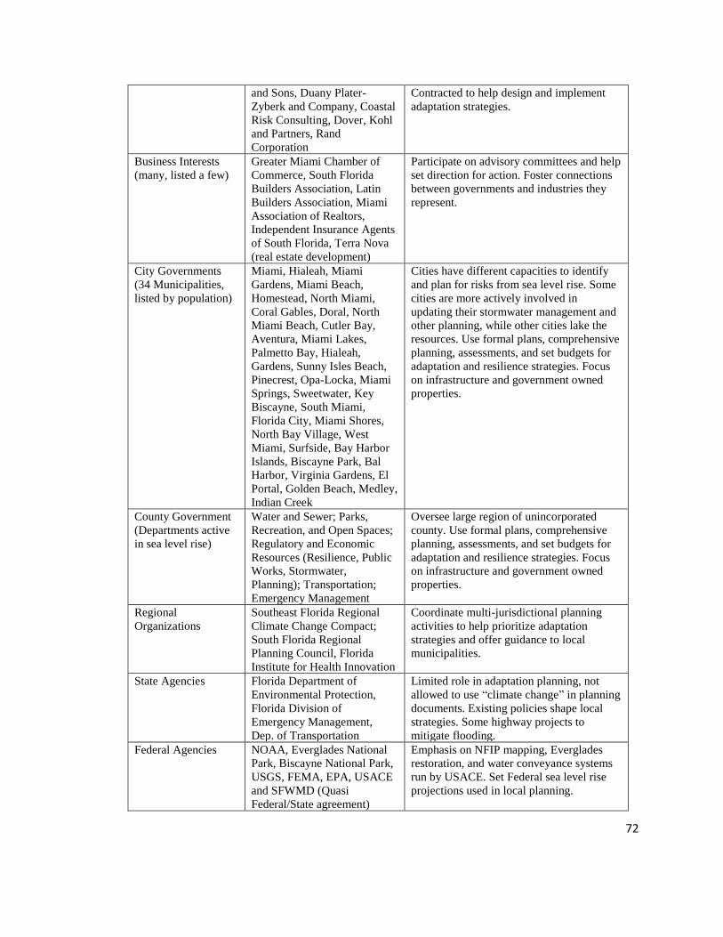
72
and Sons, Duany Plater-
Zyberk and Company, Coastal
Risk Consulting, Dover, Kohl
and Partners, Rand
Corporation
Contracted to help design and implement
adaptation strategies.
Business Interests
(many, listed a few)
Greater Miami Chamber of
Commerce, South Florida
Builders Association, Latin
Builders Association, Miami
Association of Realtors,
Independent Insurance Agents
of South Florida, Terra Nova
(real estate development)
Participate on advisory committees and help
set direction for action. Foster connections
between governments and industries they
represent.
City Governments
(34 Municipalities,
listed by population)
Miami, Hialeah, Miami
Gardens, Miami Beach,
Homestead, North Miami,
Coral Gables, Doral, North
Miami Beach, Cutler Bay,
Aventura, Miami Lakes,
Palmetto Bay, Hialeah,
Gardens, Sunny Isles Beach,
Pinecrest, Opa-Locka, Miami
Springs, Sweetwater, Key
Biscayne, South Miami,
Florida City, Miami Shores,
North Bay Village, West
Miami, Surfside, Bay Harbor
Islands, Biscayne Park, Bal
Harbor, Virginia Gardens, El
Portal, Golden Beach, Medley,
Indian Creek
Cities have different capacities to identify
and plan for risks from sea level rise. Some
cities are more actively involved in
updating their stormwater management and
other planning, while other cities lake the
resources. Use formal plans, comprehensive
planning, assessments, and set budgets for
adaptation and resilience strategies. Focus
on infrastructure and government owned
properties.
County Government
(Departments active
in sea level rise)
Water and Sewer; Parks,
Recreation, and Open Spaces;
Regulatory and Economic
Resources (Resilience, Public
Works, Stormwater,
Planning); Transportation;
Emergency Management
Oversee large region of unincorporated
county. Use formal plans, comprehensive
planning, assessments, and set budgets for
adaptation and resilience strategies. Focus
on infrastructure and government owned
properties.
Regional
Organizations
Southeast Florida Regional
Climate Change Compact;
South Florida Regional
Planning Council, Florida
Institute for Health Innovation
Coordinate multi-jurisdictional planning
activities to help prioritize adaptation
strategies and offer guidance to local
municipalities.
State Agencies Florida Department of
Environmental Protection,
Florida Division of
Emergency Management,
Dep. of Transportation
Limited role in adaptation planning, not
allowed to use “climate change” in planning
documents. Existing policies shape local
strategies. Some highway projects to
mitigate flooding.
Federal Agencies NOAA, Everglades National
Park, Biscayne National Park,
USGS, FEMA, EPA, USACE
and SFWMD (Quasi
Federal/State agreement)
Emphasis on NFIP mapping, Everglades
restoration, and water conveyance systems
run by USACE. Set Federal sea level rise
projections used in local planning.

73
Fifty-nine people were interviewed in-person and on the phone between
September 2016 and June 2017. In person interviews were primarily conducted in
Miami-Dade County, though some were conducted in Broward and Palm Beach
Counties. Some of these interviews were conducted jointly for people who worked
together responsibilities requested to be interviewed together. This resulted in a total of
50 independent interviews. Forty-seven out of fifty of these interviews were recorded and
transcribed and for three of these interviews detailed notes were taken as interviewees
declined to be recorded. The average length of interview was 63.5 minutes with a range
from 25 minutes to 214 minutes. Interviewees were purposefully selected and intended to
cover the broad range of institutions active in this arena. This includes individuals from
local and federal government, private consulting firms, environmental and community
organizations, and research institutions (see Table 4.4 for a breakdown of interviewees by
type). In some cases, a convenience sample was used to draw out groups who may be
peripherally involved or impacted by sea level rise adaptation planning. The interviewees
represent several different dimensions of sea level rise adaptation including: coastal and
civil engineering, planning, public health, geophysical sciences, community
development, ecological processes, agriculture, insurance, and development (see Table
4.5 for a breakdown of interviewees by focus). “Focus” is related to the institutions
primary motivation. For example, the South Florida Water Management District is a
regional governing body primarily concerned with managing water for municipal,
agricultural, and other uses—their focus is “Water.” A private business that has been
hired to implement adaptation strategies is Type: “Private Sector—Consulting” and
Focus: “Climate”. The ten types of Focus were selected using both the literature and

74
preliminary analysis of the different interests of institutions involved or impacted by sea
level rise adaptation planning.
In case studies, interviews are guided conversations rather than structured queries
(Yin 2014). While I followed a general set of core questions through a naturalistic
conversation flow, I adjusted this interview guide as time went by (for interview guide,
see Appendix C). After each interview, I reviewed my notes and reflected on emerging
themes. I did not hesitate to ask follow-up questions that would lead me down
unanticipated paths, and I made some changes to my guide following most interviews. I
also asked specific subsets of questions that varied according to roles and experiences of
each interviewee. For example, a subset of questions to scientists were different from
those asked to community organizations. Often these subsets were uniquely tailored to
learn about a committee, assessment, or plan an interviewee had experience with. I aimed
to maintain a thread of common experiential and perception-oriented questions
throughout. Interviews are semi-structured and open-ended with some more specific
questions developed from document review. Interviews were transcribed and coded using
Atlas.ti software (for code book, see Appendix D).
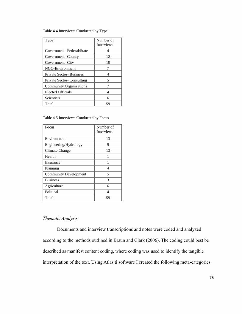
75
Table 4.4 Interviews Conducted by Type
Type Number of
Interviews
Government- Federal/State 4
Government- County 12
Government- City 10
NGO-Environment 7
Private Sector- Business 4
Private Sector- Consulting 5
Community Organizations 7
Elected Officials 4
Scientists 6
Total 59
Table 4.5 Interviews Conducted by Focus
Focus Number of
Interviews
Environment 13
Engineering/Hydrology 9
Climate Change 13
Health 1
Insurance 1
Planning 4
Community Development 5
Business 3
Agriculture 6
Political 4
Total 59
Thematic Analysis
Documents and interview transcriptions and notes were coded and analyzed
according to the methods outlined in Braun and Clark (2006). The coding could best be
described as manifest content coding, where coding was used to identify the tangible
interpretation of the text. Using Atlas.ti software I created the following meta-categories

76
(parent codes): Focus of Risk; Interpret Information About Risk; Risk Boundary;
Planning Process; Governance; Knowledge Networks; Solutions; and Other. These parent
codes were determined a priori and based on the research questions around risk
construction and knowledge integration. From there, I created 93 sub-categories (or child
codes). Some of these child codes were identified in literature and preliminary document
review a priori, and some of them were identified during the coding process. I used codes
mainly as a system of indexing to sort and retrieve data for future analysis. This kind of
coding is common in many techniques of qualitative analysis including thematic analysis,
as schematized by Braun and Clarke (2012). My process mirrored their suggested steps: I
immersed myself in the data, coded, identified themes (identifying themes throughout
data collection, not just following transcription), refined and finalized themes and then
began writing. A specific description of how codes were used, organized, and interpreted
for analysis are included under the analytical approach for each chapter.
Field Observation
Some field observation was used to contextualize case study development and
identify interviewees. This dissertation defines field observation as the witnessing of real-
world activities taking place that are relevant to the case study. I attended fourteen events
for field observation to contextualize case study development and identify interviewees.
These events include public workshops on sea level rise adaptation planning, a community-
based course, and public meetings (for a full list with descriptions see Appendix E).
Analytical Approach for Chapter 5:
This chapter is primarily concerned with how risk knowledge is constructed in the
planning process. Thematic analysis was primarily inductive with the identification of

77
emerging themes around formal assessments that address sea level rise. Planning
documents were reviewed with the purpose of identifying how sea level rise rates and
projections, knowledge of the physical geography, infrastructure vulnerability, and
knowledge about social and economic contexts were produced. Interviews provided more
information as to the process of how these studies were put together, the contestations
among different authors and participants, and how they have been used to inform
decision-making. Early on during document review and interviews it became clear that
identifying a baseline for sea level rise was an important and political issue. In addition,
both experts and planners discussed the challenge of interpreting sea level rise risks
across the physical landscape. These themes identified early in the research process were
explored in greater detail using thematic analysis. This chapter primarily relied on the
codes that fell under Focus of Risk; Interpret Information About Risk; Risk Boundary;
and Planning Process. Child codes under these categories were compared across groups.
Codes were then compared across themes to construct the planning history and use of
different key ideas around the way risks are understood in sea level rise adaptation
planning.
Analytical Approach for Chapter 6:
This chapter addresses research questions related to knowledge integration.
Documents and interviews were used to determine the institutional context and roles and
responsibilities of institutions involved or affected by sea level rise adaptation planning. I
also identified the different adaptation pathways, which organizations are involved, how
are they are involved, how the institutions and adaptation pathways relate to each other.
This chapter also used thematic analysis to characterize the four emerging discourses

78
shaping sea level rise adaptation governance. These discourses were identified
inductively as emerging themes from the data. Sub codes from the Focus of Risk;
Interpret Information About Risk; Governance; Knowledge Networks; and Solutions
were primarily used for this chapter. Using Atlas.ti I first identified emerging themes
around the four discourses. I then examined the codes using co-occurrence tables and
based on the different types of institutions to understand patterns around the emerging
discourses, what types of rationalities and authority they draw on, and how they interact
with other discourses. This analysis helps identify the dominant narratives and where
they sit in terms of adaptation planning strategies.
Analytical Approach for Chapter 8:
This chapter uses a literature and theoretical review to propose a framework of
how sea level rise risk knowledge and expertise is negotiated and enacted across scales
through the science policy interface. We developed the framework through literature and
theoretical reviews. We then applied two case examples from South Florida, United
States, and the Pacific Islands, to contextualize this scalar framework.

79
Chapter 5: Constructing Risk Knowledge in Sea Level Rise Adaptation Planning in
Miami-Dade County, Florida
5.1 Introduction
Sea level rise adaptation planning is predicated on understanding risks from
changing and uncertain future conditions and identifying strategies to mitigate those risks
(McCarthy et al. 2001). Risk knowledge is wrapped up in sea level rise discourses,
projections, regional assessments, maps, and other planning tools created and used by
governments, private firms, NGOs, and other organizations. These adaptation planning
efforts often follow a hazards assessment and approach to determine risks, in which risks
are considered a function of the physical components of the hazard (i.e. rate of sea level
rise) and their interaction with social, ecological and technological vulnerabilities and
adaptive capacity (e.g. topography, infrastructure, human life) (Wisner et al. 2014).
Because there would be no risks without incomplete knowledge of future outcomes,
knowledge gaps are often addressed through improving measurements and techniques to
predict and identify uncertainties in anticipation of modeled future conditions (Gross
2010). Indeed, planning requires some idea of what that future might look like, and such
future knowledge around risks are primarily focused on the physical, economic, and
ecological impacts of climate change (Adger 2005). At the same time, however,
knowledge about climate risks do not represent objective “facts”; the process of
identifying and measuring risks is constructed, produced, and situated in political,
economic, and cultural contexts (Shapin and Schaffer 1985; Jasanoff 2004; Miller 2008).
The emphasis placed on physical and economic future conditions can create a planning

80
arena that overlooks other risks and knowledge relevant to the problem at hand
(Brugnach and Ingram 2012; van den Hoek 2014).
Scholars point to risk construction challenges of hazards assessments and
anticipatory planning, required for sea level rise adaptation planning. Identifying how
risks from climate change are likely to emerge and implementing presumably—though
not guaranteed—effective responses inherently “picks winners” where decisions made
based on how risks are understood can favor some people while causing harm to others
(Wildavsky 1988; Barnett 2001). While uneven impacts of climate change are widely
recognized (O’Brien and Leichenko 2000; Shi et al. 2016), uneven knowledge practices
and problem framings which affect planning outcomes are often unexamined. The way
that knowledge around climate risks is constructed shapes decision processes. As
McCubbin et al. (2015) found in their study on sea level rise planning in Tuvalu, the
emphasis on modeling and scenario-based climate impacts draws attention away from
pressing challenges on livelihoods in the community and ignores effective points for
adaptation. Climate change planning can emphasize physical hazards that are related to
economic and political interests, rather than vulnerabilities that matter to the community,
and by focusing on future conditions can potentially distract from current challenges
(Kelman 2014; McCubbin et al. 2015). Additionally, constructions of biophysical hazards
and their relation to social and technological systems, may favor technocratic and
economic styles of reasoning and embed these value structures in risk knowledge while
excluding and/or ignoring social and cultural values that may also be at risk (Adger et al.
2009; Brugnach and Ingram 2012; van der Hoek et al. 2014).

81
Risk knowledge about sea level rise is at the core of how decisions are made
regarding prioritizing and implementing adaptation strategies, yet the knowledge
production practices around how those risks are determined is often left unexamined in
the climate change adaptation planning literature, particularly in North America. This
chapter addresses the call for research to open-up knowledge practices around identifying
risks in climate change adaptation planning (Adger et al. 2009; Brugnach and Ingram
2012; van der Hoek et al. 2014). Using a case study of sea level rise planning in Miami-
Dade County, Florida, this chapter addresses the first part of my research question by
unpacking the social process of how particular dangers come to be selected for attention
(Douglas and Wildavsky 1983). I do this by uncovering the dominant framings, styles of
reasoning, and political context that are embedded in the way risks are understood
(Lupton 1999). Building off the work of Gross (2010), Ignorance and Surprise, I open-up
planning and knowledge practices that create two types of ignorance: nonknowledge and
negative knowledge. Nonknowledge is the knowledge gaps around what is considered
relevant. Negative knowledge is blind spots, or knowledge that is unknown and
considered unimportant, often thought of as “undone science.” In this chapter, I connect
Gross’s work on ignorance to the concept of “risk ambiguity” as used by Brugnach and
Ingram (2012) and van der Hoek et al (2014) to understand how contestations around the
focus, interpretations, and boundaries of risk shape knowledge practices. Through this
analysis, this chapter articulates three findings around knowledge constructions of risk in
sea level rise climate adaptation planning:
1. Determining “objective” knowledge around the hazards (i.e. calculated rates,
projections, and physical geographies) of sea level rise in Miami-Dade County

82
is a negotiated and contested process. Sea level rise rates and projections are
shaped by political debates surrounding relevant science and processes, which
are enrolled to justify minimizing risks at the local scale.
2. Sea level rise risk knowledge that supports an economically viable future is
favored over knowledge that either threatens that future or is seen as
insignificant to achieving goals of that future. This creates knowledge
practices that address ignorance within those arenas (e.g. through
improvements to modeling accuracy around physical hazards) and precludes
planners from other ways of thinking about risk.
3. Problem closure around risk knowledge occurs to drive action and decision-
making, specifically around infrastructure and the economy. Actors more
closely connected with decision-making subscribe to problem framings
around infrastructure that serve to reinforce bureaucratic and “expert driven”
institutional path dependency around knowledge and decision-making. The
outcome is the reproduction of a system in which some communities gain
more attention and authority over risk knowledge and adaptation solutions,
over others.
5.2 A Relational Approach to Risk in Sea Level Rise Adaptation Planning
Applying theories from Society and Technology Studies and cultural approaches
to risk can open-up the knowledge production of risk and ground that process in social
reality (Latour 2004). While non-cultural theories of risk, such as those in economics,
psychology, and hazards planning, largely treat risk as a taken for granted objective
reality (Lupton 1999; Fox 1999; Wisner et al. 2014), cultural theories of risk differ in that

83
they assume an active rather than a passive perceiver of risk (Rayner 1992). This could be
an individual or institution driven by their own cultural imperatives to select risks for
management attention, or to suppress them from view (Douglas and Wildavsky1983).
Institutional structure becomes the ultimate cause of risk perception, and risk
management becomes the stimulus for risk rather than the outcome of risk (Rayner 1992).
Risks, therefore, are determined by the process of how an individual or institution comes
to define, measure, understand, and construct knowledge about associated dangers in
relation to what they care about (Douglas and Wildavsky 1983; Fox 1999). In this way,
even hazards—or measured physical impacts associated with the changing
environment—are determined in relation to what an institution values and how the
institution constructs and validates knowledge (Fox 1999).
In this framing, knowledge refers to claims made by actors—either individuals or
institutions—that either serve to tell us something factual about the world (with varying
degrees of certainty) or are taken by actors to tell us something factual about the world
(Miller et al. 2010). It is an idea or judgement that someone takes to be true, or at least
relatively truer than other kinds of statements (Miller et al. 2010) and are often shaped by
tacit skills and values (Collins 1974), problem framings (Miller 2000), and styles of
reasoning (Hacking 2002).
Knowledge about risks are co-produced in the planning process by individuals
and institutions, where those involved in adaptation planning shape knowledge about
risks, and that risk knowledge shapes the social and material world (Jasanoff 2004). The
way risks are understood is ultimately linked to the design, planning, and implementation
of proposed solutions (Sarawitz et al. 2000). To build an analysis around risks, the focus,

84
is therefore on “the forms of knowledge, dominant discourse, and expert techniques and
institutions that serve to render risk calculable and knowable, bringing it into being”
(Lupton 1999, 7). Risks that matter are those seen as a threat to community—or
institutional— order (Douglas and Wildavsky 1983), and, because of the uneven
distribution of risks, the process of determining risk definitions and knowledge, and
adopting those into formalized governance processes is inherently political (Beck 1992).
Ultimately, knowledge practices around risk determine what institutions know and what
they do not know, what kinds of questions get asked, the methods used to gather
information, and the standards by which to evaluate evidence (Lupton 1999).
Gross’s (2010) classification of ignorance offers a particularly useful approach to
understanding how knowledge is constructed in sea level rise adaptation planning in
Miami-Dade County, Florida (Figure 5.1). Sea level rise adaptation planning is
predicated on multiple forms of knowledge produced at different spatial, temporal, and
administrative scales, with variegated actors involved in different contexts (addressed in
Chapter 8 on knowledge politics of scale). Scientific knowledge is the primary means by
which global and regional sea level rise rates and impacts are understood, and the
emphasis of scientific uncertainty often becomes the focus of where to produce new
knowledge. Gross offers another way of thinking about this process using the concept of
ignorance which points to the limits of knowing, including the intentional and
unintentional bracketing out of information (Gross 2010). He points to two forms of
ignorance: nonknowledge and negative knowledge.
The first type of ignorance is called nonknowledge, which encompasses
uncertainties around scientific knowledge where actors lack sufficient knowledge about a

85
certain problem, however, they know the point of reference of that uncertainty. Within
sea level rise, future conditions can never be fully knowable and actors from different
institutions work toward identifying knowledge about those uncertainties. For example,
sea level rise is understood as a process that is affected by currents, thermal expansion of
water, tectonic activity, glacial ice melt, and other factors (Hine et al. 2016). While
scientists recognize glacial ice melt as a crucial factor, they lack complete certainty and
confidence as to how fast glaciers will melt with climate change (Hansen 2007).
Therefore, under Gross’s classifications of ignorance, rates of ice melt acceleration are
characterized as “nonknowledge” and scientists work to better understand those
processes. This practice makes up knowledge claims that are recognized and debated in
the institutional and planning structure. The development of new or extended knowledge,
results from further assessments, planning, tinkering, or acting in the face on
nonknowledge. New knowledge connects back to ignorance, by addressing some of the
initial ignorance and uncertainties and also creating new forms of ignorance and
uncertainties (Gross 2010). To address issues of scientific uncertainty in sea level rise
adaptation planning, scientists and planners continue to explore known uncertainties born
out of climate modeling, ecological and geological science, and other knowledges that are
used in decision-making (Hine et al. 2016). The uncertainties are known and identified,
and new knowledge seeks to address those uncertainties.
The second type of ignorance is negative knowledge which is the active
consideration that to think further in a certain direction will be unimportant. This occurs
as some consequences of an activity might be anticipated but are deemed unimportant or
unlikely to be severe. This is also related to Tannert, Elvers, and Jandrig’s (2007) idea of

86
the Galileo effect which refers to Bertolt Brecht’s play during which a cardinal refuses to
look through a telescope to avoid having to accept the knowledge that the planets revolve
around the sun. Negative knowledge can lead to what Hess (2007) calls “undone science”
where knowledge could be produced based on clearly defined ignorance, but it is not
pursued further (e.g. science is driven towards results that are patentable, and away from
other pursuits). Hess goes so far to argue that there is a “systematic nonexistence of
selected fields of research” (Hess 2007, p. 2). Frickel (2008) applies this thinking to the
term knowledge gaps to situate organizational outcomes of undone science in his work on
the social determinants and effects of Hurricane Katrina on New Orleans. Such undone
science may result in social movement organizations lacking potentially helpful research
results because they are undone, a consequence of lack of funding based out of
knowledge avoidance practices by funders and planners who would have the capacity to
support this research (Hess 2007; Frickel 2008).

87
Complementary to Gross’s work on ignorance, the concept of institutional
positionality can be used to explain these two forms of ignorance. Applied to risk,
institutional positionality determines what institutions place as the substantive focus of
risk, how institutions interpret information about the system, and how institutions bound
a system regarding climate risks (Brugnach et al. 2008; van den Hoek 2014). Risk
constructions stem from different ontological perspectives from which institutions align
themselves and what values they prioritize on the landscape (Hilgartner 1992; Short and
Clark 1992; Rayner 1992; Wisner et al. 2014). Different institutions come to understand,
validate, and interpret risks and those epistemological differences can create conflict
around what knowledge is considered valid (Bocking 2004). For example, there are
Figure 5.1 Two types of ignorance: nonknowledge and negative knowledge. Nonknowledge results in the
production of new knowledge to try and reduce the ignorance. However, negative knowledge is ignored by
the system and no new knowledge is created to address this form of ignorance. (Figure adapted from Gross
(2010) Ignorance and Surprise)

88
different scientific representations of risk, such as those used by climate scientists,
hydrologists, versus geomorphologists. These representations are often considered
credible sources because of their knowledge production system integrates testable and
defensible biophysical laws (Latour and Woolgar 1986; Gieryn 2006). At the same time,
however, these “facts” may be contested based on the epistemic choices made during
their production (Ozawa 1996). Finally, risk knowledge encounters different system
boundaries which can shape which knowledge is used and integrated in a planning
system, and which knowledge is ignored or discarded (van den Hoek 2014). Institutions
may bound the system differently in terms of both spatial and temporal scales and these
differences may not only emerge in different constructions of risk, but also impact the
planning process and knowledge integration (Adger 2005). Each of these risk knowledge
construction processes related to institutional positionality can determine which form of
ignorance is produced in the planning system.
Communities facing risks from climate change, such as Miami-Dade County,
address those risks by first creating knowledge about them. In Miami-Dade County, this
knowledge process primarily follows a format of a combination of the physical hazard,
the vulnerability and adaptive capacity. The following three sections discuss the
knowledge practices and contestations within the way risk has been understood in Miami-
Dade County with a discussion of how sea level rise rates were adopted locally (physical
hazard), how this interacts with conditions on the landscape emphasizing knowledge that
supports economic growth (vulnerability), and how this is understood in a vulnerability
and adaptive capacity context.

89
5.3 Scientific Reticence, Political Uncertainty, and Confronting Denialism—
Agreeing on 81 Inches in 2100
To plan for sea level rise risk, governments adopt regionally relevant rates and
projections. Currently, Miami-Dade County and municipal governments within the
county recognize and plan for sea level rise projections up to 81 inches by 2100 (Figure
5.2 shows projections currently used in adaptation planning in Miami-Dade County).
Determining the use and application of different sea level rise rates and projections has
been a contested process with scientists from academic institutions, federal agencies, and
local governments interacting with planners, policymakers, and other stakeholders to
identify relevant global processes and knowledge to apply to Miami’s context. Three
processes underscore the contestations around which rates and projections to apply
locally: scientific reticence surrounding the role of ice melt acceleration, political
uncertainty, and climate change denialism.

90
Figure 5.2 Sea level rise projections adopted by Southeast Florida Regional Climate Change Compact in
2015.

91
The local government’s first formal instance of identifying sea level rise
projections in the county was in 2006 when the Board of County Commissioners
established the Miami-Dade County Climate Change Advisory Task Force which
included a Science and Technology Committee.1 Collectively this committee produced
and signed the Science and Technology Committee’s Statement on Sea Level in the
Coming Century.2 This statement presented an argument that the 2001 and 2007 IPCC
sea level rise projections, recommended for use by the US Government and project 1-3
feet of sea level rise over the coming century, underrepresented the risk by failing to
incorporate the accelerated melting of the Greenland and Arctic Ice Sheets. Building their
own sea level rise model that integrated Arctic and Greenland ice melt, the committee
projected a 1.5-foot increase in the coming 50 years and a total of at least 3-5 feet by the
end of the century, and formally presented their recommendations to the county
government in report published in 2008 (Recommendations 2008).
The incorporation of ice melt acceleration in this projection was questioned by
county planners and policymakers, discussed by interviewees from both the scientific
community and local government planners. Although the county formally adopted the
Climate Change Advisory Task Force Recommendations (Resolution: R-48-15) two key
planning documents produced following this adoption, the Comprehensive Development
1 Legislation number 06-113 sponsored by commissioners Seijas (lead), Diaz, Gimenez, Edmonson,
Jordon, Rolle, and Sosa. The committee included 10 scientists (specializing in oceanography,
sedimentology, coastal processes, chemistry, ocean-atmosphere interaction, paleoecology, hydrology, and
ecology), two county employees (including the Deputy Director of Miami-Dade County Water and Sewer),
and a biodiesel and public policy specialist. 2 Drawing on oceanography, geology, and other sciences to reconstruct thousands of years of coastal
history and use contemporary data to identify ongoing shifts and changes in sea level rise in recorded
history (e.g. Dr. Hal Wanless Presentation April 22, 2008—Wanless 2008)

92
Master Plan 2010 Evaluation and Appraisal Report and the sustainability plan called,
“GreenPrint: Our Design for a Sustainable Future” did not include sea level rise
projections and instead reference incremental changes of sea level rise observed by the
Key West Tide Gauge since the early 1900s (see Figure 5.3). While some scientists
shared that knowledge about accelerating ice melt is disregarded as an extremist
perspective, others expressed that the disagreement stems from scientific uncertainty
around ice melt acceleration having never been recorded or documented in human
history. Because there is no baseline, scientists are learning about this as it is happening
and using geological indicators to reconstruct the past. While many geologists focusing
on sea level rise agree on the importance of ice melt acceleration, there is disagreement as
to how much to include and how well the instruments are measuring the rate of ice melt.
Additionally, challenges with global datasets and measurement instruments and
technologies creates debates around how to model and predict sea level rise. This
scientific reticence around ice melt acceleration and other gaps in sea level rise processes
playing out among climate scientists at the global scale (see Hansen 2007) is called into
question by planners at the local scale; while some scientists may be more comfortable
with a wider band of possibility—or nonknowledge— surrounding rates and projections,
planners wanted a narrower target.
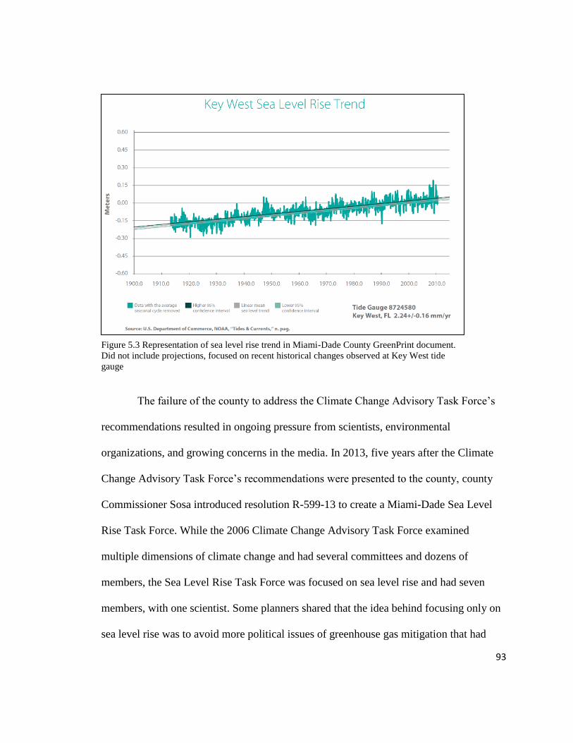
93
The failure of the county to address the Climate Change Advisory Task Force’s
recommendations resulted in ongoing pressure from scientists, environmental
organizations, and growing concerns in the media. In 2013, five years after the Climate
Change Advisory Task Force’s recommendations were presented to the county, county
Commissioner Sosa introduced resolution R-599-13 to create a Miami-Dade Sea Level
Rise Task Force. While the 2006 Climate Change Advisory Task Force examined
multiple dimensions of climate change and had several committees and dozens of
members, the Sea Level Rise Task Force was focused on sea level rise and had seven
members, with one scientist. Some planners shared that the idea behind focusing only on
sea level rise was to avoid more political issues of greenhouse gas mitigation that had
Figure 5.3 Representation of sea level rise trend in Miami-Dade County GreenPrint document.
Did not include projections, focused on recent historical changes observed at Key West tide
gauge

94
slowed down the Climate Change Advisory Task Force and the GreenPrint. The scientist
selected for the Task Force was met with skepticism as other scientists expressed that the
committee chair purposefully selected a scientist who was not vocal about ice melt
acceleration and higher projections. As one scientist shared in talking about the hurricane
scientist selected for the second task force, “You know, one of the first things he said on
the committee was, ‘I’m not a sea level scientist,’ yet he was in charge of it. But the
whole thing in fact was a total farce of a committee, the second task force.” Another
scientist commented on the reluctance of this scientist to view ice melt acceleration as a
factor for determining rates of sea level rise:
So now the second committee was a problem because of David Enfield.
And a few others… And like I said, David's a hurricane guy that sees
everything as decadal and other cycles. Even today, and he said ‘We don't
know until it's already past if something really changed.’ Because he's so
dedicated to that.
While scientists discussed how their knowledge around ice melt acceleration was
discarded and ignored, planners shared that during the early years of determining
projections there was reluctance to incorporate projections into planning and share the
information with the public because of political uncertainty as to how the public would
respond. As one interviewee expressed when talking about the county planner in charge
of the Climate Change Advisory Task Force and Sea Level Rise Task Force Committee
Chair:
Harvey had in his mind from day one the need for a major vision on how it
needed to be instilled that was commensurate with his view of the
risk…The numbers started the pile up, the different projections… There
were a couple really key reports that Harvey said look, we’re
underestimating the potential of sea level rise. We could be looking at two
or three feet… In fact, we’re now [today] looking at numbers of six feet… I

95
think if we look back honestly everybody was afraid to say that. We didn’t
know what the reaction would be to saying 6 feet.
Part of this reluctance to adopt higher rates was wrapped up in planners stating
they were ill-prepared to plan for and deal with the impacts of sea level rise. As
one planner shared,
They were starting to see these tools that you can look at it in a computer, I
said show me three feet on Miami beach. All of a sudden Ocean Drive
buildings are, water is up there, up to the top bar stool… So, you know they
were fairly elementary tools. But they are not talking about a storm surge,
they are talking inundation that doesn’t go away. That’s scary because
there is frankly no known experience for dealing with this. People have had
tidal waves they’ve had what do you call the big waves, coming from
tsunamis. We’ve seen those pictures. But they always recede.
In talking about why sea level rise experts were left off the second county task
force, one scientist expressed that the drive for individuals to want to create positive
environmental change in the county requires the idea that it is possible to save the
environment and region, and high sea level rise projections could limit action. As one
scientist expressed frustration about an influential local planner that blocked the adoption
of higher projections:
He's been an environmentalist from before there was any environmental
stuff, in the 70's… he wants his life to be success, that's why I'm
convinced of this… he wants us to plant a tree and buy a Prius and maybe
in a few years it will all be okay. Well the problem is, that 93% of global
warming heat is transferred to the ocean. We're not turning this around,
there is no way. Almost all the heat of global warming is in the ocean.
And that's with us for centuries. And the residence time of carbon dioxide
in the atmosphere is something like 4,000 years. You know, we're in for
this. We've really done something. And [he] just can't buy that. He feels
he's been a failure… And they're almost more problem than a denier,
because they're coming to you as one of the people involved in climate
change and sea level rise, and then they don't want to face the reality.

96
Similarly, several shared that rates and projections are shaped by the possibility of
adapting. Smaller sea level rise rates are favored to allow for an economy to grow around
building those adaptations. If the rates are too high, it will be impossible to plan to adapt
to those risks.
While Miami-Dade County was trying to reach agreement on sea level rise rates
and projections, similar debates around which sea level rise rates to adopt were taking
place in neighboring counties and cities. Philip Levine had just been elected to serve as
the Mayor of Miami Beach, running on a campaign to save Miami Beach from sea level
rise and sunny day flooding. Broward, Monroe, Palm Beach and Miami-Dade County
were all referencing different sea level rise projections for State and Federal lobbying and
funding proposals. In response, these county governments formed a four-county regional
effort beginning in 2009, called the Southeast Florida Regional Climate Change Compact
(Compact) to create a unified projection and recommendations for addressing
vulnerability. The Compact’s science and technical committee oversees reviewing current
government projections and scientific research to determine which projections to use. The
first unified projection was published in 2012 used USACE guidance and projected 9-24”
of sea level rise by 2060 (Compact 2012). Following the publication of NOAA and
updated USACE regional projections for planning guidance for federal agencies, the
Compact reevaluated this initial unified projection. The second unified projection—
currently being used—was published in 2015 and projects up to 6.6 feet of sea level rise
by the end of the century, much greater than the original 1-3 feet the federal government
was recommending in 2006 (Compact 2015).

97
While there was Federal precedence for determining rates of sea level rise at the
regional scale, the effort for adopting projections was interrupted by local politics and
climate change denial. Several people involved in this effort pointed to representatives
from Palm Beach County as being the primary barriers to adopting higher projections. As
one scientist expressed, “That was a fight… Again, it was scientists in Palm Beach, we
got a few. One of the guys from Palm Beach… said, ‘I’m not authorized to project more
than two feet [by the end of the century].’” Several sea level rise scientists expressed that
they would have pushed for higher projections, however, they saw a “big fight” with
climate change deniers in Palm Beach County and internally with some of the scientists
on the committee and instead pushed for the United States Government projections, even
though they expressed these projections were too conservative. For example, one scientist
expressed an interaction they had with another scientist who did not agree that Arctic and
Greenland ice melt acceleration models should be included in sea level rise projections
early in the Compact’s effort to unify projections:
He came up to me the first meeting and he said… Because we were
talking right off, this was the second time we had the compact see over it.
And he said ‘Are you agreeable not to go above 6.6 feet?’ And I said
‘Yeah. I mean I think it's going to be more, but I think for planning 6.6
feet is so severe for coastal communities that it drives home the reality and
you start planning.’ That's been my goal. And if we get on our high horse
and say ‘It's going to be 25 feet’… Then they're just going to buy a bottle
of Jack Daniels and forget it. Which, they can't. The government's
supposed to be Protecting their people. And you can't protect your people
by ignoring this.
Some scientists stated that the decision to have a smaller projection for the county
was in the political expedience of a lower rate. As one shared,
The politicians, most of them, are interested in reducing the projections. In
fact, the Four-County Climate Compact was too aggressive, so, Harvey

98
Ruvin, who's an environmental guy who's on the Dade county… and he's
been involved in sea level rise and things of that kind for a very long time.
He suspected, or he hypothesized, that if the rate of rise was too
aggressive, the people on the County Commission would just tune the
whole thing out and not do anything. And so, he started another sea level
rise group in order to moderate the forecast by the Four-County Climate
Compact so he could get by the Dade County Commission.
When the Compact was trying to adopt unified projections, many on the
committee wanted to at least suggest a sea level rise projection of 100 years because
infrastructure projects are expensive and built to last longer than 60 years. Several
interviewees involved in this process indicated that this was a struggle, but attributed
agreement to a USACE employee who shared that USACE planners are required by law
to plan to the 100-year mark to make sure that infrastructure projects will last their
lifetime. While the science committee used refereed publications, IPCC reports, and other
scientific and credible data to suggest rates of sea level rise, some shared that the USACE
was viewed as being the most politically expedient. As one scientist shared,
… politically, it's easier for the people in Palm Beach to acquiesce to
something that a military group puts forward because they're heavily
Republican, and if a military group like the US Army Corps of Engineers
says that something is happening that gives it credibility, whereas if a
scientist were to say it, even though the Corps of Engineers projections are
based on what the scientists have said, it's the politics of the whole thing.
The people in Palm Beach were always holding out for minimal projected
rises.
Currently, the county, city, and local governments use the agreed upon Compact
projections published in 2015 which include the NOAA High, USACE High, and IPCC
AR5 Median, for a projected sea level rise range of 6-12” by 2030, 14-34” by 2060, and
31-81 inches by 2100 (Figure 5.2) (Compact 2015). While some sea level rise adaptation
planning took place within the county prior to the Compact finalizing their projections

99
(e.g. City of Miami Beach3), presently, nearly all locally produced plans and assessments
that include sea level rise reference the Compact’s unified projections. At the same time,
the range of projected rates of sea level rise do not provide an exact number for
municipalities to plan for, rather the suggestion is for planners to use this information to
determine the specific level of risk their project can support. For excessive cost
infrastructure upgrades, for example waste water treatment facilities, the idea is that
erring on the side of caution and aiming for the higher projection makes fiscal sense as
those systems are expensive and built to last a long time. Although this flexibility is by
design so that municipalities have guidelines for determining design standards, some
view these guidelines as a mechanism to focus attention on short-term adaptation
strategies while avoiding longer-term challenges. For example, the City of Miami-Beach
is planning stormwater infrastructure adaptations for 2 feet above the current hightide
mark, which corresponds to roughly a 30-year planning horizon. Several critics shared
that they consider this a “band-aid” solution and that local governments are using the
short-term projections to avoid discussing longer term strategies.
Sea level rise scientists and environmental organizations continue to be active in
the community, sharing both the Compact projections and higher projections from
scientific publications at different community meetings and with the public. Many of
these scientists as well as environmental organizations and community activists expressed
3 When determining how high to raise roads for the initial stormwater projects, the City of Miami Beach decided to use
current high tide as a baseline and add a foot (later two feet) on top of that baseline to use for the design standard for
road elevation. The reason being that they shared they could not wait around for the compact to agree so adopted their
own rates

100
concern that the adopted projections from the federal government and recent IPCC should
be looked at as a minimum, as one scientist explained in an interview:
But those are government projections, and they do not incorporate either the
accelerating feedbacks, mostly accelerating feedbacks we're seeing with ice melt.
There are about 15 of them that are really important. That are speeding up ice
melt beyond what the models are projecting. And those aren't in those models. So,
those have to be really looked at, at the low end. This is where people that don't
take the time to truly understand this, sort of blow off any of us that are projecting
higher rates as extremist. But we're not. We're taking the models that they use and
say “Okay, but it's gonna be faster than that, because you don't have these things
in the models.” Somebody last year, put out a publication adding three of the
models. Three of the feedbacks. Just looking at Antarctica, and they added
another meter or two.
These individuals expressed that local governments are not doing enough to
communicate the projections and the risks of climate change to the public. Some of these
scientists call on local government to initiate transparent planning. For example, as one
shared:
Let's take the high projection, and let's not put a date on it, but let's realize
this may well happen this century. And what you do is, you say ‘Okay.
These are the things we're going to have to do at six inch more sea level
rise, or a foot, or a foot and a half, to maintain the integrated
infrastructure. All these things. And then to keep the water sort of out of
the way and stuff. And then you figure out how much each part of that
costs, and then when you do that, all of the sudden you're going to realize
that a foot and a half, this whole part of your city, you won't be able to
afford maintaining the infrastructure… You're going to be on your own
with your infrastructure.’ That would be really nice to know, if you're
buying down here. Or if you're trying to sell, I mean it would be nice to
know this.
Several scientists shared that governments are afraid to be transparent about sea level rise
projections because of the tax base and not wanting to scare people. Many were vocally
opposed to this lack of transparency. As one scientist shared,

101
But what I'm trying to do is just get people to honestly, transparently plan.
Because I truly believe that the only purpose of government is to protect
your safety, your welfare, your health, your risk, you know… Reducing
risk for you. One of the problems with sea level rise is storm surges are
gonna become exponentially more devastating as they push farther in.
Because they're a horizontal horror of water pushing in. And those are the
things that are gonna move us on, but it's going to be devastating at some
point… Just figure out what's going to happen, because it will happen. At
each step and figure out what it's going to cost to maintain the
infrastructure.
Some of the scientists actively involved in aiding local governments with their modeling
and project planning shared that they communicate to managers and planners that the
highest government rate may be a bottom line. In addition to rates of sea level rise,
several scientists and planners pointed to unknowns around climate change impacts to
rainfall and storm surges, which will also create future inundation and flooding
challenges. As one government planner shared,
I think we have a very good handle on the sea level rise projections
although there is some more work needed for storm surge projection. The
biggest science gap is this climate model for rainfall, highly uncertain for
this region because a lot of models… they cannot capture the kind of
dynamics of climate like sea breeze and other things. In terms of extreme
rainfall there's a big gap in what will happen to like hundred-year rainfall
for example. The other issue is that even the average rainfall the question
is if rainfall averages go down or go up what are the implications for the
Everglades Restoration?
Further examining rainfall and other biophysical climate dynamics that
may worsen the impacts of sea level rise appears to be the next frontier of
nonknowledge and new knowledge. The emphasis on ignorance surrounding
biophysical hazards emerges out of interviews and documents as key uncertainties
or unknowns surrounding sea level rise risks.

102
5.4 Risk Constructions of the Physical Landscape that Support an Economically
Viable Future
Part of the drive for local governments to present rates and projections that
minimize risks is wrapped up in the desire to portray an economically viable future for
the region to investors, residents, insurance brokers, and others. Many scientists and
interviewees expressed that part of what shaped the adoption lower projections and rates
of sea level rise over those that incorporate ice melt acceleration and result in higher
rates, is the focus on the way different projections affect buildable land in the county. As
one scientist expressed:
And from my view, 6.6 feet by the end of the century is catastrophic for a
place like south Florida. If you wanted to build houses at 6.6 feet … Sea
level rise in areas that were say, more than two feet above just normal high
tide, not the king tide, just normal high tide, you're down to less than 10%
of Miami-Dade County that's still buildable. We're so low, we're just
ridiculously low. This is a real problem. And let's say sea levels at five
feet by the end of the century. With this accelerating ice melt. It will be
rising at a foot per decade and accelerating.
By adopting a smaller sea level rise projection, several planners suggested that private
companies can innovate building, design, and engineering techniques to address the issue
and make a profit. Many scientists and practitioners shared that private, economic
interests shaped adopted rates and projections. Planning for projections of more than a
few feet means that adaptation work would be prohibitively expensive, and it would not
attract economic growth.
This idea of constructing risks that commensurate with a viable economic future
is reinforced in knowledge about the physical geography and how projections will
interact with the landscape and infrastructure. Several interviewees expressed that in the

103
early years of the planning process the county and local governments were hesitant to
acknowledge and share information about sea level rise because of the threat to property
values. For example, despite this being a formal recommendation from the county’s
Climate Change Advisory Task Force4 there was a reluctance on part of the county to
produce high resolution elevation maps to identify impacts of sea level rise projections.5
And today, contestation occurs between actors that seek to minimize the location of
where sea level rise risks occur and those that try to determine hyper-local risk
knowledge for planning solutions, despite having somewhat similar goals of maintaining
developable property and allowing for economic growth to continue.
Generally, a modified bathtub model6 is used to assess where sea level rise
inundation will occur. The county, the Compact, and other municipalities acknowledge
4 In 2008 the Climate Change Advisory Task Force Science and Technology Committee made a second
recommendation to the County to get high resolution elevation maps, stated: “The County should
commission detailed maps for all Miami-Dade County created from calibrated LiDAR (Light Detection and
Ranging) surveys (or other elevation survey technology that employs best known practices). These maps
will show mean high, with water (MHHW) levels for 1-foot through 6-foot rises in sea level. (MHHW level
is the spring high tide level which occurs every 14 days around full moon and new moon.) The maps will
allow identification of which areas will become flooded in association with different sea levels and will
provide a basis for assessing risk to the County’s development and infrastructure.” (Recommendations
2008). The rational provided for this recommendation is to obtain higher resolution elevation data to
determine vulnerability to infrastructure, roadway elements, the susceptibility of coastal, wetland, and
artificial fill areas to erosion, areas of potential pollution and contamination release, changing drainage and
storm surge risks, assess structural viability of buildings and levees with changing groundwater levels and
saline water intrusion, and assess future fresh potable water sources. 5 One scientist shared that there was opposition within the local government to create those maps, as
expressed: “And there was a commissioner… that made sure those maps never appeared.” In response to
the County’s reluctance one FIU scientist used the State’s LiDAR data to produce and share maps showing
inundation across the county up to 12 feet of sea level rise (Harlem 2008). Several people shared that the
scientist’s maps strongly influenced public opinion on sea level rise and resulted in more action and
awareness, particularly in the environmental community for calling for GHG emissions reduction, concerns
over sea level rise risks to a nuclear power plant, and natural systems restoration and protection. And while
by 2010, the county did update a digital elevation model using 2003 LiDAR data, they were not made
publicly available. 6 The bathtub approach consists of overlaying current high-tide levels and different increments of sea level
rise on existing water and elevation maps, simulated by intersecting the land surface with a water surface
that includes the added water of a given sea level rise scenario linearly superimposed over the baseline
reference (0-ft sea level rise tidal water surface).

104
the limitations of bathtub modeling because it assumes that land geomorphology, tidal
surface variability and other conditions remain constant as the landscape is “inundated”,
and it does not consider additional hydrodynamic effects during storm surges. For
example, though they show future conditions of sea level rise projections, bathtub models
fail to account for land use changes, higher groundwater levels, coastal barrier island
migration, changes in sedimentation rates and deposition patterns, changes in tidal
hydraulics due to land geomorphology changes and physical barriers, and other
weather/ocean factors (e.g. storm surge, wave activity and anomalous events)
(Vulnerability Assessment 2012; NOAA CSC August 2010b; NOAA NOS September
2010).
Based on these limitations, several managers shared that the bathtub modeling
completed for the first sea level rise vulnerability assessment for the Compact,
underrepresented the risk and pointed to known areas of flood complaints that were not
showing up as flooded in assessment. One modeler associated these complaint areas with
older housing stock, in an area considered higher elevation but that still floods due to
precipitation, land use, and other factors. Shortly following the Compacts initial
vulnerability assessments in 2012 different modelers from county government, City of
Miami Beach, agencies and others began expanding their practices to ameliorate bathtub
model limitations. Both Miami-Dade County and the City of Miami Beach, are working
on dynamic groundwater/surface water model and well monitoring to address this
uncertainty. For Miami-Dade County, this took place with a plan to integrate sea level
rise into updates to the Stormwater Master Plan as well as modeling in the Water and
Sewer Department.

105
Within the county, part of this focus on groundwater came from a top-down
mandate from the South Florida Water Management District, an agency that oversees
water resources in the region. When the county sought to increase their municipal water
supply to allow for more regional growth through additional drawdown of the Biscayne
Aquifer, the South Florida Water Management District required the county to prove this
would not impact canal water (i.e. surface water) and water flow in the region
(assessment published in Hughes and White 2016). The county applied this groundwater
and surface water model to sea level rise bathtub models and more locations became
flooded based on this additional information. While county stormwater and water and
sewer managers utilize modeling that incorporates this model of groundwater and surface
water interactions, getting these updated maps in the county’s comprehensive land use
plan to inform land use policies, building codes, and published for the public to view has
been an ongoing challenge. As one interviewee shared,
So the problem is, is that some internal departments aren't comfortable with
releasing information, because it could be wrong. And because … so, part
of it's really valid, in that… so when you do the bathtub model, you
inundate the coast. But that's underestimating the risk, because our ground
water also rises, and there will be areas on the west, and on the canals, and
then the south, that also are soggy. They're like, the ground water's so high
that basically, they're not that livable. So when you do just the coastal
bathtub model, you miss this other component. So from, like, a very valid
science perspective, they say like “You know, that's not really a great map,
cause you're missing these other pieces”…
But then what we have is just different departments that are in charge of
different things, and seaming those together is difficult. And then, truth be
told, there are people within the department that are deniers, that don't want
to publish this information… even the bathtub one. And so, they use all
their excuses to say why we can't publish it, and it's confusing to
everybody, and no one understand why… really it's a moot point. [Other]
maps are publicly available, you know, they're on TV, they're in the news,
it's whatever. But we haven't been able to get all of the departments to

106
agree on, sort of our uniform… like, what we want to present [the bathtub
model]… Which is, again, it's gonna underestimate the risk. But you gotta
start somewhere. [Others] may object to our map. But, you know, we've
gotta start somewhere.
One of the primary concerns for publishing comprehensive maps that show the full extent
of where sea level rise inundation may occur is connected to the risk of these sea level
rise maps devaluing property. As one informant shared, “The real fear, from one person,
is that providing this information we may devalue homes, it may devalue property by
releasing this information.” While the threat of devaluing land is at the core, this gets
wrapped up in debates over other uncertainties of mapping, as another informant shared,
The problem is, is that you can't really map out into the future. Because…
so let's just take for example, we go to 2060, we've two more feet of water.
So then we could do, okay, well if the sea is this much higher than the
ground level will be this much higher, but then that's assuming that the
canals are operating the same way. But they'll be flowing… they won't be
flowing anymore, to the sea, and so that's not really a valid assumption. So
then what do you map for 2060? Depends on what the district does, and
how they manage the system, and… so it loses, sort of, meaning as you go
out that far.
While there is no local government produced map that is publicly available map
that shows where inundation from sea level rise might occur given ground water and
surface water dynamic modeling, the county does present a map using bath tub modeling
(Figure 5.3). In this online interactive map made in partnership with NOAA and the
county, areas in blue are considered hydrologically connected, either by the coastline or
the canal system, whereas areas in green are low-lying areas in relation to a 3-foot mark
of sea level rise, but not considered hydrologically connected using the bath tub modeling
approach. The green areas on this map represent much of the regions that several

107
interviewees were concerned are not being addressed in current sea level rise
assessments.
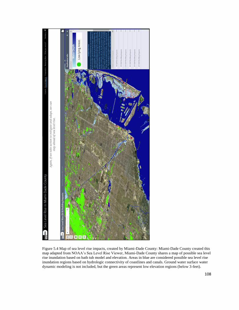
108
Figure 5.4 Map of sea level rise impacts, created by Miami-Dade County: Miami-Dade County created this
map adapted from NOAA’s Sea Level Rise Viewer, Miami-Dade County shares a map of possible sea level
rise inundation based on bath tub model and elevation. Areas in blue are considered possible sea level rise
inundation regions based on hydrologic connectivity of coastlines and canals. Ground water surface water
dynamic modeling is not included, but the green areas represent low elevation regions (below 3-feet).

109
To lessen the risk of economic impacts to the region, many interviewees
discussed the need to support projects that will help keep insurance costs down and
protect continued investment in the region. Several planners and interviewees shared
efforts designed to “get ahead of the issue” of risk from sea level rise by focusing on
infrastructure vulnerability and adaptation solutions. Because local governments are
responsible for supporting infrastructure the link between infrastructure vulnerability and
property is not surprising. In 2012, the Compact was one of the first organizations to
publish a vulnerability assessment, publishing “Analysis of the Vulnerability of Southeast
Florida to Sea Level Rise”7. The physical features identified for vulnerability include:
ports and airports, railroads, miles of road, water and wastewater treatment plants,
landfills, hospitals, schools, emergency shelters, evacuation routes, and marine facilities.
In addition, analysis was conducted to determine taxable value of property8, acres of
future land use, and acres by habitat type/land use that would be impacted by sea level
rise. The link between infrastructure and property values is underscored by vulnerability
assessments that emphasize property values as a driving force to measure risk in the
region. Part of this is shaped by the need to maintain local property taxes to support
infrastructure upgrades, and another component of this is driven by external policies,
7 This document used 1, 2, and 3-foot sea level rise scenarios and a bathtub model to identify where sea
level rise would intersect with infrastructure. The Compact facilitated discussions and used surveys and
workshops to develop planning parameters that would be part of the regional sea level rise vulnerability
assessment. While this assessment was based on land and sea elevations only and does not consider
flooding related to existing drainage issues, associated with rain or tropical storm surge, they suggest that
additional analysis and more sophisticated models is needed to better understand the hydrologic
connections and surface water response to rising sea levels 8 When putting together this report, Miami-Dade County would not include property value information. It
was shared by several interviewees that this was because bathtub modeling underrepresented the risks,
other interviewees expressed that there may have been internal pushback within the county to not want to
publish those maps to scare developers.

110
development investments, and insurance priorities. The emphasis gets placed on design
standards and building codes around how the region builds, without discussions of where
growth should happen. As one insurance expert shared,
[Building standards] are not a bad thing to discuss. My quibble would be
that it's the only thing we discuss, and that's the problem. The analogy in
coastal management from my perspective is… and resilience in the built
environment, is that we spend all this time talking about how we build.
The sacred cow, or the elephant in the room, whatever you want to call it,
is that we will not discuss where we build. That's the real problem. It's not
just how, and that's because legally, it's really easy to just keep increasing
building standards. Comparatively speaking, I mean, sure you get pushed
back from the building industry, but that's nothing compared to the
property rights implications of starting to look at serious, where we build.
The importance of property value as a proxy for vulnerability shows up in
assessments that address socio-economic conditions. For example, the “Sea level Rise
and Health Vulnerability Assessment” published in 2016 provides another example of
how the focus of risk knowledge is underscored by physical and economic conditions.
This planning document, produced by the Florida Institute for Health Innovation used
bath tub modeling, state LiDAR, and socio-demographic data to measure vulnerability to
sea level rise from a public health perspective. This technical, expert driven assessment
looked at vulnerability and income in two, competing ways. It addressed low-income
communities of color as socio-economically vulnerable, while at the same time factored
property values into the assessment—where high-valued assets on the landscape are
considered more vulnerable. The assessment found that low-income communities of
color are less vulnerable to sea level rise than high income areas, because those
communities are at higher elevations. Similar logic was used by several interviewees that
acknowledged low-income communities and historically marginalized communities of

111
color will experience impacts from sea level rise based on their socio-economic status,
but that these impacts are no different or less so than those experienced by wealthier
communities, because wealthy communities have financial assets at risk. Community
organizations contest this idea and contend that low-income and marginalized minority
populations are at greater risk of displacement from climate gentrification, storm surge
and hurricane events, and public health and economic impacts of climate change. Yet,
aside from limited assessments being conducted by academic institutions, the risks these
organizations are concerned about are largely un-recognized in formalized risk
assessments used for planning purposes.
It could be argued that socio-economic vulnerability should be examined on a
more local scale, during project specific planning and design. Several planners shared
that it is more appropriate to consider social factors in the hyper-local scale that they
exist. In this way, socio-economic vulnerabilities are considered during pilot case studies
and design charrettes. In the Arch Creek Adaptation Action Area design charrette
organized in partnership with the Compact in 2016, for example, Census block data is
used to look at poverty rates (see Figure 5.4). Yet this and other design charrettes serve as
pilot assessments and have been completed with little involvement of local communities
and assessing other information related to priorities and risk understandings experienced
by those within these communities. Instead, a limited number of stakeholders and experts
examine things like municipal codes, ecological functions, planning tools, and
infrastructure projects that could be used in this region. What we see are contradictions
surrounding how some planners view integrating communities— including socio-
economically marginalized communities—into planning. On the one hand, interviewees

112
shared the importance of this when it comes to developing comprehensive plans, and on
the other hand, some of these same planners expressed that it may not be appropriate for
the public to comment specific technological roles of governing infrastructure, such as
stormwater management planning.
Figure 5.5 Map of percentage of individual poverty for Arch Creek project: Included in assessments for
Arch Creek Adaptation Action Area design charrette in addition to other sources of information around
stormwater, sea level rise inundation, and planning and zoning. The design charrettes are often pilot studies
and done in a short period of time with little community involvement.

113
While issues of poverty, public health statistics, and other formal assessments can
tell part of the story of socio-economic vulnerability, they fail to capture the diverse ways
in which those communities themselves frame the problem. For example, many
community organizers brought up their concern over climate gentrification, where they
are experiencing developers coming into their high elevation communities and
purchasing property. While community members shared they were discussing this issue
for over a year prior, it was in 2017 when geographer Dr. Hugh Gladwin was attending a
community organized listening session that they came up with the idea to produce a map
that shows which developers have been purchasing land in high elevation areas (see
Figure 5.5 for the map). Despite community organizing around issues of gentrification
and other issues related to climate change vulnerabilities, these concerns are poorly
integrated into formal planning efforts. Some planners questioned whether climate
gentrification was really because of sea level rise or if it was just “normal” gentrification.
At the same time, many of these high elevation areas are frequently discussed by local
government planners as areas to promote growth because they are less vulnerable to sea
level rise, running counter to concerns from people in those communities about
displacement.
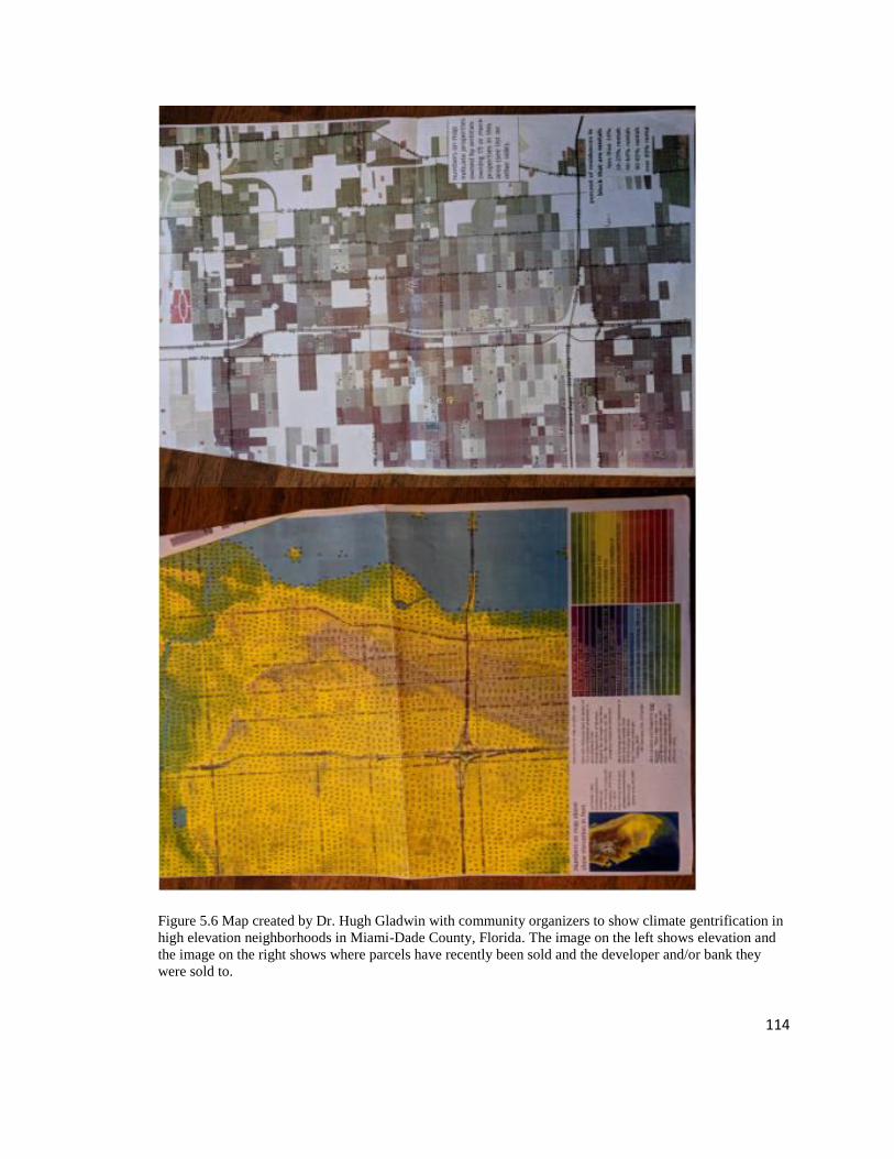
114
Figure 5.6 Map created by Dr. Hugh Gladwin with community organizers to show climate gentrification in
high elevation neighborhoods in Miami-Dade County, Florida. The image on the left shows elevation and
the image on the right shows where parcels have recently been sold and the developer and/or bank they
were sold to.

115
In addition to minimizing knowledge from socio-economically marginalized
communities, risk knowledge that runs counter to an economically viable future, or that
points to issues and concerns about the way in which risks are being measured and
addressed were marginalized and often ignored in the planning process. For example,
many community and environmental organizations discussed the political inertia towards
addressing sea level rise with the nuclear power plant owned by Florida Power and Light.
As one interviewee suggested,
The Florida Power and Light [are] persisting in the myth that their power
plant won't be affected by sea level rise, and that they've got a plan to deal
with two feet of sea level rise and it's what they're counting on.
This private sector sea level rise knowledge avoidance persisted in attitudes towards the
development community and real estate community. Policies and regulations often fail to
integrate sea level rise and thus shape the conversation away from regional economies.
For example, when discussing the challenge of getting realtors on board with
understanding and sharing sea level rise risks, one interviewee shared,
And then, in real estate… regard to flooding has a don't ask, don't tell
policy, so their standard of conduct for the realtors is don't ask, don't tell.
So, if the realtor did not see the flooding, they have no obligation
themselves to tell a buyer about tidal flooding. All they have to do is say,
“Here's the FEMA flood map. Find your home. Figure out where you are.
Have a nice life. Buy it, don't buy it, whatever.” But, they have no
obligation because the sea level rise flooding is not covered by FEMA
maps, and I'll admit, the realtors know about it because they're not stupid.
And they drive their cars through seawater, and they're going like, “I never
saw that property flood. Never.” Of course, they didn't go there in
September, October, November when it was flooding.
And while private sector avoiding the issue of risk due to financial strain is not
entirely surprising, in some cases, environmental and community organizations challenge
the way that risks are understood and addressed in infrastructure adaptation planning.

116
Several environmental organizations express concerns over the county’s proposed
adaptation to use inland injection sites that send treated wastewater to an area below the
Floridian aquifer in the boulder zone, including uncertainty from taking water out of the
water cycle and the impacts the treated wastewater will have on the aquifer. As one
informant expressed their concerns,
It's taking hundreds of billions of gallons of water out of the water cycle
and putting it into a hole, which I think is not sustainable. It's also a
somewhat untested technology. What's going to happen to that water down
there? Is it just going to stay down there forever? Is it going to migrate, is
it going to contaminate the aquifer, is it going to create a methane bubble
and become anoxic? It's becoming more and more clear that, particularly
in Miami, where we have porous limestone, things are not very well
contained underground… There are fissures even into the boulders now
that we don't even know about.
Additionally, some interviewees expressed uncertainty around stormwater pumps
installed in the City of Miami Beach, and that they create more concentrated pollution
into the waterway. As expressed by one individual:
Well, it has been effective in short term lowering of the water in the
streets. The downside of it is that the stuff is pumped into the bay without
any real treatment. They might strain out a few chunks or something like
that, but it's… So, North Biscayne Bay sea grasses are dying off, and it
probably relates to turbidity in the bay, and it started to happen about the
same time that the pumps were turned on. That's not proof that that's the
case but… It's an observation, and one of the obvious candidates. Florida
International University did measurements of the nutrient loading in the
plumes of stuff going into the bay, and the mayor of Miami Beach,
Levine, was outraged because they were finding there were some
problems with the amount of nutrients, and so, instead of working with
them, basically a politician often attacks the messenger.9
9 In response to this testing and community pushback, the City of Miami Beach is now testing different
methods to treat stormwater at these pump sites.

117
And community organizations question whether the focus on infrastructure is ignoring
the people that rely on that infrastructure and call for other adaptation approaches to
support low-income and historically marginalized communities. Knowledge that
addresses several ecological and social components of sea level rise risks remains as
negative knowledge, and “undone science” while knowledge about sea level rise impacts
transportation, wastewater, water treatment, and stormwater take priority.
5.5 Prioritization and the Creation of Vulnerability and Adaptive Capacity
The way that risk knowledge is constructed is connected to adaptation project
selection and prioritization. In Miami-Dade County the production of knowledge about
biophysical hazards shaped by economic and political values leads to a path dependency
around knowledge and decision-making and creates a system in which some communities
gain more attention and adaptation solutions, over others. During interviews, planners
focused on two types of decisions related to vulnerability (primarily of infrastructure) that
they make and how they use sea level rise risk knowledge to make those decisions which
reinforce this finding. The first type of decision is where to invest in adaptations, and the
second type of decision is how to integrate sea level rise projections into the
infrastructure adaptation designs.
Currently, planners within Miami-Dade County and city governments are working
towards developing different criteria for determining where to invest. Several managers
reported how difficult adaptation decisions are to make. One stormwater manager
commented,
There are some difficult decisions to make in that, [we] had this vision of
like are there neighborhoods that we leave as is and we let them flood. Are
there neighborhoods we protect? Well if you make a decision like that,

118
how do you do that? How do you make a decision that this neighborhood
is going to get protected, this one is not? Kind of developing that criteria
like well is it about severity of that risk or potential vulnerability.
Much of this is already established in policies around flooding and stormwater
management. For example, the South Florida Water Management District holds the most
authority over flood control and water infrastructure management in the region. In
analyzing the risk associated with sea level rise they apply formulas for storage capacity
based on level of service which inherently prioritizes dense urban areas over rural regions
in the southern portion of the county. Similarly, though the NFIP does not consider future
sea level rise conditions in modeling, it determines a lot of how the region understands
and addresses current risks and is connected to prioritization. Stormwater management
and prioritizing projects is based on a combination of modeling components (NOAA
Historical High Tide Data, the groundwater table, existing land use, elevation data, and
different flood event data), FEMA insurance claims, and complaints. The county, for
example, prioritizes drainage capital improvement projects in areas with most repetitive
losses, flood complaints, and low-lying areas, with flood protection levels of service
(integrating sea level rise projections) below the threshold identified in the
Comprehensive Development Master Plan. Because many shared that insurance rates are
a major concern for homeowners, the focus of mitigating risk is related to projects that
can reduce insurance costs for homeowners. Much of this takes place using flood risk
management activities that are included in FEMA’s Community Benefits Rating System.
In this way, FEMA flood insurance and local government actions that address those risks
are building people into more risk. At the same time, the local governments have no real
information around how flood insurance rates or not having flood insurance impacts low

119
income and historically marginalized communities—who tend to live in older houses that
may not require insurance. Despite these challenges around insurance, it still drives a lot
of the focus and attention for how sea level rise adaptation planning is taking shape. As
one interviewee shared,
Well, it's all about insurance at the end of the day. There's two main users,
insurance and then the local flood plan administrators are the guys who are
really using it to then mitigate disasters and risks. But the insurance drives
a lot of the conversation with the homeowners. Homeowners aren’t
concerned with mitigating risk, they're concerned with, what am I paying.
Just bottom line. And so the insurance drives a large part of that.
And while several planners discuss the need to create objective approaches to
avoid favoring some regions over others, several of these same planners shared how the
outcomes of these efforts favor those who have flood insurance—which are primarily in
low-lying coastal areas that also represent more affluent parts of the county. Nearly all
informants expressed that areas like Miami Beach and other affluent communities will
have the most resources available for adaptation and protecting infrastructure. Beach re-
nourishment, for example, is funded in part by the USACE, the State of Florida, and local
municipalities and several people expressed that Miami Beach receives the most funding
for this, as expressed by one planner:
They [Miami Beach] get lots of funding for beach re-nourishment projects
which are helpful to sea level rise. But in some of those areas like Miami
River and some of those back areas, they're not going to get any funding to
do anything on theirs. So they're just going to be more susceptible to the
sea level rise… Anywhere that doesn't have a beach and tourist dollars, is
probably in trouble.
From the USACE’s perspective, the purpose of beach re-nourishment is to protect
building structures and prioritizing funding is based on exposure and cost benefit analysis

120
of property values and number of human lives, again favoring low-elevation, densely
crowded and high-property value regions.
In addition to differences in external funding sources and prioritization, there are
also differences in internal funding and tax base to support adaptations. Floodplain
administrators for small and under-resourced cities and municipalities may lack the
ability to influence planning decisions, shaping how risks are distributed across the
landscape. As one planner shared,
Most [Floodplain administrators] have a very challenging job. Because
[Miami-Dade County] obviously has a lot of resources and we go down to
many of these other communities they have one person and they're also
doing whatever. Ten other jobs, and so it's a very small piece of their job.
So imagine if you had something like this [flood map] and you wanted the
community to be more resilient in the coastal areas, so you said hey to
your board of commissioners, hey we really need to change our code to
enforce this. And she's a little nobody down in the middle of some
organization. The board is going to be listening to all their developer
friends and anybody else that wants to develop in those areas and doesn't
want those stricter regulations and so they're going to fight it. She has an
uphill battle to even convince her board of county commissioners that this
is a good thing.
Both current and future loss of property values becomes one of the key ways risk
is understood and in adaptation planning. When discussing wastewater treatment and
hooking septic systems up to the sewer system as a sea level rise adaptation, one
interviewee shared that it is a difficult decision because some of the areas on septic
systems are low elevation areas that may not be ideal for development because of sea
level rise impacts. So, the question is whether or not it makes sense to invest in those
areas that may be abandoned in the future. In this way, infrastructure vulnerability gets
caught up in debates and decisions regarding the economic and social values across the
region, in determining what is and what is not worth investing. As one insurance industry

121
expert shared, “The way we fund government is part of what’s driving how our
organizations see risk. Because for local governments, their property value is what they
need to operate.” Informant interviews corroborated this with their emphasis on needing
to protect the economic core to fund future adaptation efforts. As one interviewee shared,
Well, the city and the area around Little River and Shorecrest, they were
talking about basically allowing the areas that are low to flood and become
more marsh like, and, just accept the water coming on to the land. Well,
my own personal feeling is that the water front areas are the high value
areas and they are the economic drivers that would finance the changes
that we need to make, so we need to… For example, if you go to Fort
Lauderdale and you drive around, you'll notice that there are a lot of big
yachts and so forth that are up there next to very opulent water front
homes that are on top of fill pads, and basically if you made the North Bay
more accessible to upscale yachts, then it would be possible to raise the
money to elevate the bridges, to do the… Whatever is necessary.
Another reason people suggested prioritizing areas that are high property value is that
wealthier people can afford adaptation strategies on their property. While at the same
time, others expressed the challenge with aiding lower-income communities with
addressing the risk of sea level rise. This is wrapped up in who’s responsible for adapting
private property, as one respondent shared,
So that's one of the big challenges, is that… rightfully so, people say we
should focus on the most vulnerable areas, and we should focus on the
most socially vulnerable areas, these, sort of, economically vulnerable
areas, which makes sense. But then, again, when you get into those
communities, what is the solution? The solution, in Florida, is that you
have to elevate your homes, and you have to elevate the roadways, and
you need to connect the septic systems to sewer, and those are
expensive… So then, if you take no action, you get into a blighted
condition, or exacerbating the housing disparity.
In line with what this individual shared, several other interviewees recognize that socio-
economic conditions can shape peoples’ experience of climate risks. At the same time,
many interviewees across sectors expressed concern that these communities will be
122
ignored in the planning process. As one person shared regarding how adaptation planning
will take place within low-income communities,
They are not even gonna talk to those people. They're gonna ignore them,
and the developers are gonna develop. That's how it works… it's gonna be
business as usual. It's [sea level rise] playing a… It's a big forcing
function, and so it's stimulating people to move, and so the relocation,
there are plans for big buildings in the Overtown area. Maybe they haven't
been put out in public yet, but I'm sure… I've been in some of the climate
marches, and those people are marching. They're literally beating the drum
about this… I haven't talked to the development side about it, it's mostly
either outside of town money. Miami is a speculator's paradise, always has
been.
And part of this is linked to the way in which vulnerability is understood, when
discussing one key vulnerability assessment being created for county planning an
interviewee shared, “Purely economic.” Planning documents use inundation maps of sea
level rise combined with property value and demonstrate the estimated costs of sea level
rise to these assets. This takes place in diverse ways including, beach re-nourishment
programs focused on protecting coastal properties, the attention to building codes and
developing differently.
Yeah, they [different committees] seem to be sort of fixated on building
code changes, and asking for money to get surveys, or risk assessments, or
experts, or things like that. That has been slow in coming.
However, this same individual elaborated on the challenge of focusing on building codes
and other economic priorities in that it can shift attention away from things that the
region could be doing now, for example, fixing sewer overflow and investing in green
infrastructure.
It's very slow and difficult to get changes to the building code. It takes
years. The City of Miami just did this Miami 21… new building codes.
They don't cover resiliency but they're more modern than they were
before. And then Miami is a very developer driven town economically,

123
and so adding additional burdens onto developers for doing things with
sea level rise in mind is slow going. Because it's going to cost them more
money to build their buildings differently, or elevate them, or so on and so
forth. Because right now most of the costs are pushing on people who are
buying apartments and things like that, because developers sort of engage
for three to five years, and then they sell them.
[Things we could be doing instead of focusing on building codes and
infrastructure] Holding up the dune infrastructure, restoring mangrove
habitat. New infrastructure needs to be built with sea level rise in mind.
Stormwater master plans. Making sure that there are storm water master
plans, that the water can percolate, that there are enough impervious
surfaces around that we have areas that can flood. That the sewage
infrastructure is well maintained so that it doesn't flood when it rains.
Other interviewees expressed their frustration with calls to spend $100,000 for high
resolution studies to create a fine detail elevation map of downtown Miami. While
proponents argue that this will help the city better understand where to invest in
stormwater management and change building codes, several respondents expressed that
those funds could instead be used to support socio-economically vulnerable communities
to prepare for hurricanes.
In addition to decisions around where to adapt there, planners shared approaches
for how to integrate sea level rise projections into adaptation strategies. The concept of
“design life” has been used and integrated into water and sewer infrastructure planning
and discussed widely among different institutions governing infrastructure. When
designing infrastructure projects, the projection used is based on the length of the useful
life of infrastructure and the cost of that infrastructure upgrade. The risk that is embedded
in talking about “design-life” are the risks of the physical impacts from sea level rise, the
risk of the infrastructure failing and causing harm to property values and human life, as
well as the risk of the investment of the infrastructure falling short of meeting its goal.

124
For example, wastewater treatment infrastructure that both costs a lot and has a long
useful life would adopt the sea level rise curve showing a higher rate of projection for the
year that the infrastructure would be expected to be used for. This is compared to
infrastructure that may only have a useful life of 20-30 years and not cost as much, which
would be designed for one of the more conservative projections at 20-30 years in the
future. Many of the reports on infrastructure suggest or explicitly recommend a cost
benefit analysis or optimization for prioritizing and designing projects.
Ultimately, the way local governments portray information around sea level rise
risks shows us how they are choosing to “get ahead” of the issue and construct risk in the
planning process. Despite individual efforts among some planners, community
organizers, and scientists to address socio-economic and broader ecological risks around
how sea level rise will be experienced, these areas of vulnerability have been somewhat
ignored to different degrees. On the one hand, issues such as socio-economic
vulnerabilities are brought up during design charrettes, while on the other hand, they are
left out of local government information surrounding impacts from sea level rise (see
Figure 5.6).

125
Figure 5.7 Image of sea level rise impacts from Miami-Dade County’s website: Represents how most
municipal governments frame the issue of sea level rise risks and adaptation strategies. While some
planners shared the need to integrate socio-economic vulnerabilities into planning, representations of the
risk fall short of integrating those considerations. Here we see the emphasis is on flooding, erosion, storm
sure, saltwater intrusion, infrastructure and economic impacts. Economic impacts emphasis property loss,
insurance costs, and business interruption, not vulnerability from socio-economic marginalization.
126
5.6 Discussion
Sea level rise adaptation planning in Miami-Dade County is predicated in
identifying objective facts and hazards about sea level rise rates and projections as well as
knowledge about the hydrogeology of where water will flow, and how this will interact
with the built environment. Bocking (2004) argues that regions focus on physical aspects
and scientific assessments of risks and hazards in order to wrap decisions in the authority
of science and avoid choices that would be deemed arbitrary and capricious. While
identifying sea level rise risks, including anticipated projections and measurements is
fundamental to planning, Carlo Jaeger et al. (2001, p. 24) summarize a common view of
measuring risk, “Approaches for objectively quantifying risk, actuarial analysis,
probabilistic risk assessment, and epidemiology/toxicology all assume that risks can be
assigned a value of harmfulness independent of the social, economic, political, or cultural
context.” Bocking (2004) elaborates on this drawing out common assumptions of risk in
environmental planning. First, that risks are an objective property of the physical world
and therefore freely amenable to measurement. Second, that people everywhere perceive
hazards the same way, and third, that this can be revealed by science which override
historical and cultural differences (Bocking 2004). Like the work of Bocking (2004), and
other scholars who challenge these assumptions (e.g. Perrow 1984; Liftin 1994; Jasanoff
and Long Martello 2004), the process of determining sea level rise hazards in Miami-
Dade County is shaped by political, social, and economic contexts. While actors within
Miami-Dade County are driven towards identifying a sea level rise projection that
represents “objective truth,” given uncertainties around climate change and sea level rise
projections these same actors recognize the complexity and challenges of identifying
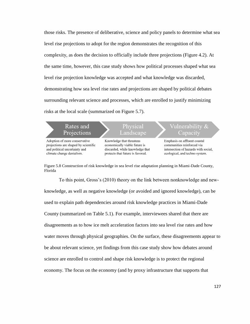
127
those risks. The presence of deliberative, science and policy panels to determine what sea
level rise projections to adopt for the region demonstrates the recognition of this
complexity, as does the decision to officially include three projections (Figure 4.2). At
the same time, however, this case study shows how political processes shaped what sea
level rise projection knowledge was accepted and what knowledge was discarded,
demonstrating how sea level rise rates and projections are shaped by political debates
surrounding relevant science and processes, which are enrolled to justify minimizing
risks at the local scale (summarized on Figure 5.7).
Figure 5.8 Construction of risk knowledge in sea level rise adaptation planning in Miami-Dade County,
Florida
To this point, Gross’s (2010) theory on the link between nonknowledge and new-
knowledge, as well as negative knowledge (or avoided and ignored knowledge), can be
used to explain path dependencies around risk knowledge practices in Miami-Dade
County (summarized on Table 5.1). For example, interviewees shared that there are
disagreements as to how ice melt acceleration factors into sea level rise rates and how
water moves through physical geographies. On the surface, these disagreements appear to
be about relevant science, yet findings from this case study show how debates around
science are enrolled to control and shape risk knowledge is to protect the regional
economy. The focus on the economy (and by proxy infrastructure that supports that

128
economy), continues to put pressure on identifying additional and more detailed risk
measurements. For example, the emphasis placed on high-resolution elevation and
LiDAR data to understand where risks will be at a finer resolution. Within each of the
type of risk knowledge there is a cadre of actors and institutional structures that prioritize
some risk knowledge over others. While this process is expected, it also leaves out other
potential risks (expressed as negative risk knowledge), and instead can build a path
dependency around nonknowledge, new knowledge, and feeding back into new
ignorance. Many scholars discuss the importance of paying attention to the agglomeration
of uncertainties when climate models are compiled. Those uncertainties are often only
expressed in scientific terms of findings and associated uncertainties and without
consideration of how the process of framing those uncertainties can exclude some risks
from the planning process. But we also need to pay attention to the way in which those
uncertainties are socially determined.

129
Table 5.1 Risk construction summary table. The findings examine what knowledge uncertainties are
prioritized for further exploration and what knowledge uncertainties are ignored. Dimension of
Risk
Construction
Description Explored Knowledge
Uncertainties and New
Knowledge
Ignored Knowledge
Uncertainties
Rates &
Projections
Regional SLR models incorporate
downscaled global climate data
with regional and localized
processes affecting sea-level, as
well as regional and local data
points. Agreement for which
projections to use came out of
collaborative effort with external
Federal precedence. Adoption of
more conservative projections are
shaped by scientific and political
uncertainty and climate change
denialism.
Impacts of global
processes (e.g. ice melt
acceleration);
measuring errors and
uncertainty
Technological
advancements for
measurements
Rates that
incorporate ice melt
acceleration and
higher emissions
scenarios
Physical
Landscape
Bathtub models assume uniform
landscape and static
environmental processes.
Government institutions address
uncertainties via data gathering
and modeling around
groundwater-surface water
interactions. Yet this knowledge
is restricted in use, as is other
knowledge regarding the physical
landscape that impacts how SLR
will affect the region.
Limitations of bathtub
approach (i.e.
groundwater surface
water interactions;
changes to
precipitation)
Additional monitoring
instruments for
hydrologic shifts in
aquifer, groundwater
and surface water
interaction
Water flow for canal
drainage; stormwater
management;
wastewater and water
supply; storm surge;
low-elevation coastal
neighborhoods
Enviro impacts from
sewer overflow and
deep well injection;
health impacts of
stormwater;
community
baselines of
acceptability;
salinization on
agriculture lands;
impacts to areas
outside of low-
elevation areas
Vulnerability &
Capacity
While understandings of the
physical landscape reinforce the
focus of risks along coastal
affluent parts of the county, the
economic focus to protect tax-
base and insurance costs also
emerge out of how vulnerability
and adaptive capacity is
understood. Other concerns
around how SLR will affect
communities, including
displacement and extreme events,
exist on the planning periphery.
Incomplete knowledge
of the hazards, potential
for infrastructure
failures
Parcel level information
for elevation
assessments
Impacts to insurance
and populated coastal
regions
How people interact
with infrastructure
in their daily life,
infrastructure needs
in less populated
regions

130
The self-fulfilling process of scientific inquiry to identify and address risks
shaped through a system that prioritizes economic, technological, and political factors,
itself prevents adaptation planners from addressing social inequities and risks that could
be addressed. This echoes Gross’s (2010) argument that the lack of acknowledgement
and addressing the different forms of ignorance in knowledge practices, creates a system
where knowledge production favors narrowly defined uncertainties while either
intentionally or unintentionally ignoring areas that some groups shared need further
exploration. Such knowledge practices are reinforced by institutional positionality
(Douglas and Wildavsky 1983), how organizations identify and measure risks (Haas
1992), and the emphasis on preparing for the future rather than dealing with things now
(Barnett 2001). In sea level rise adaptation planning in Miami-Dade County, the way that
risks are understood, broken down into their most basic components, is connected to
prioritizations and adaptation planning outcomes.
Within climate adaptation planning in Miami, there is a push to capture more
information at hyper-localized scales to better map climate risks. Being hyper-focused on
addressing nonknowledge creates knowledge practices that address scientific
uncertainties around rates, projections, and biophysical components the planning process.
At the same time, this emphasis within Miami can serve to limit the integration of diverse
risk constructions that exist on the periphery as negative knowledge around risk (Barnett
and Cambell 2010). While hazards identified are often considered neutral and apolitical,
they form the basis for how risks are determined on the landscape and can affect planning
dynamics and processes (Wisner et al. 2014). This can create what Hajer (1995) calls
“problem closure,” in which solutions are born out of well-developed but often

131
unquestioned problem framings (Hajer 1995). Within Miami-Dade County, problem
closure around sea level rise risks being focused on where water goes and how it
intersects with infrastructure and property values and ignores other ways in which sea
level rise can impact the broader landscape and community functioning that it supports.
In Miami-Dade County, the way in which risks are constructed support sea level rise
problem framing as a technical issue in which more information about these physical and
economic systems are needed to make technical engineered solutions. These problem
closures are related to Stirling’s notion of technological commitments, in which the way
the problem is appraised can “close down” the range of different technologies and
approaches to solving the problem (Stirling 2009).
The process of constructing risks and prioritizing certain risk knowledge in the
planning arena, can limit policy options and the space for democratic debate over
adaptation strategies, or opening-up ignorance to include more unrecognized risk
knowledge and more integrative risk knowledge prioritized in the planning arena (Hajer
1995). Within Miami, climate risks that exist outside of the dominant way in which the
problem is framed are left on the margins, rather than integrated into assessments,
projections, and adaptation strategies themselves. Barnett and Cambell (2010) extend this
idea to scientific models of climate change which they argue are mechanisms of
“problem closure” and one approach to a “well-defined problem” that, “Have the effect
of rendering climate change as an environmental fact against which actors can do little
but suffer. They deny the agency of people at risk: to define the problem in their own
terms; to apply their own systems of knowledge; to implement the solutions that are
appropriate to their needs and values and which accommodate uncertainty; and to make

132
knowledge claims of equal value to those of science.” (2010, p. 2) Through this idea of
problem closure, based on the way in which hazards and risks are understood, some
communities have more attention and access to adaptation planning decisions than others
(Barnett and Cambell 2010).
While incorporating multiple knowledge frames into integrated risk assessments
can be beneficial (Warren et al. 1995; MA 2003; Pahl-Wostl 2003), these efforts remain
limited by risk constructions that favor biophysical and economic dimensions. As in other
cases, this case study in Miami-Dade County demonstrates that knowledge around sea
level rise adaptation risks favor credentialed experts that use formal scientific procedures
(Brugnch and Ingram 2012) and the subsequent technical solution—like many climate
adaptation strategies—are often unproblematized and considered objective, rational,
scientific, and engineered solutions (Winner 1989; Jasanoff 2006). In Miami-Dade
County, technical rationality—or the idea that risk decisions are made based on empirical
evidence, gathered and evaluated by experts and expressed in universal, quantitative
terms (Bocking 2004)—is favored over other forms of rationality, including
communicative or cultural rationality. Communicative and cultural forms of rationality
suggests that people do not calculate risks the way experts do, that is, by evaluating the
expected consequences of a course of action and by multiplying them by the probability
of their occurrence. Instead, they proceed more intuitively by recognizing patterns,
classifying alternatives in terms of clusters of values, applying rules of thumb (Fischer
2000). In doing so, they take a broader view of environmental hazards, a view that
encompasses aspects of the hazards themselves and how they are encountered (Fischer
2000).

133
Conflicts are common outcomes when governments or companies apply a narrow
technical perspective to risks, ignoring broader concerns, including awareness that this
perspective itself incorporates tacit political and moral assumptions (Bocking 2004).
Within Miami-Dade County, there are both conflicts that happen during public meetings,
and conflicts that were discussed during interviews. Rational and technical approaches to
constructing knowledge around risk differ from other knowledge constructions. For
example, when determining climate change projections at the global scale, the process
can be highly contentious and shaped by competing economic and political discourses
(Hulme 2009). Adopting rates and projections at the local level is also politicized as local
governments may be unwilling to recognize sea level rise as a problem because they
would have to act or are concerned about devaluing property (Hulme 2009). While
scientists may determine risks with quantified data and models, community activists may
use knowledge of place-based experiences, linking outcomes from previous climatic
events within their communities to a changing climate as well as social, economic and
political histories (Fischer 2000). As such, people may think of risk from climate change
in terms of impacts and changes to their daily lives and worry about housing, future
employment, health, and asserting their rights (Fischer 2000; Jasanoff and Long Martello
2004). These different forms of rationality rooted in discourse are further explored in
Chapter 6 where I focus more explicitly on sea level rise adaptation governance and
emerging discourse storylines among different institutions coming together to address the
risk of sea level rise.
134
5.7 Conclusion
In this chapter I articulate the social process of how risks are selected for attention
in sea level rise adaptation planning in Miami-Dade County, Florida. Using Gross’s
(2010) notion of ignorance, I examine how some risk knowledge is included in the
planning process while other knowledge is either ignored or deemed unimportant. This
risk construction process is underscored by the political process of identifying sea level
rise rates and projections; the favoring of risk knowledge that supports an economically
viable future; and the path dependency of how these risks constructions can become
embedded in adaptation strategies themselves.
135
Chapter 6: Pathway for Change or Business as Usual? Discourses in Sea Level Rise
Adaptation Governance in Miami-Dade County, Florida
6.1 Introduction
Managing sea level rise adaptations is inherently contentious. Regions must make
decisions around whether to limit or regulate development in low-lying areas, how to
prepare socio-economically vulnerable communities, how to change design or building
standards and transform infrastructure, among other choices and tradeoffs of how to
address risks from climate change (Adger et al. 2005; Taylor et al. 2012). Planning
activities like these take place in multiple arenas with diverse approaches and ideas of
how to prepare and prioritize actions, bringing diverse interests together on the topic of
adaptation (Adger et al. 2009; van den Hoek et al. 2014). This is in part due to the
multiple ways that risks are experienced and understood (Dewulf et al., 2005; Brugnach
et al., 2008; Renn et al., 2011) and different priorities and politics embedded in urban
environments, policies, and institutions governing adaptation planning (Hilgartner 1992;
Hommels 2005; Heynen et al. 2006; van den Hoek 2012). This decentralized planning
arena mirrors theory on environmental governance, which suggest that decisions
surrounding the urban environment take place through systems of shared authority and
decision-making power among multiple organizations with different mandates and
agendas (Jasanoff and Long Martello 2004; Leach et al. 2007). Climate adaptation
governance is defined as the system of institutions, including laws, norms, policies,
organizations, and regulations involved in decisions surrounding how to understand and
respond to challenges posed by climate change (Lemos and Agrawal 2006; Leach et al.
2007; Chaffin et al. 2014). In both intentional and unintentional ways, governance

136
determines how scientific and technological processes are directed; how environmental
issues are defined and addressed; and how consequences of these decisions become
distributed (Leach et al. 2007). Each of these processes shape the future trajectory of
social, ecological, and technological systems (Leach et al. 2007). Marking a departure
away from considering governance as being directed solely by government and top-down
mandates, decentralized approaches recognize a networked understanding of all the
institutions—both formal and informal—involved in making decisions for the urban
environment (Schmitter 2001; Lejano et al. 2013).
Many scholars view this form of governance as being nimble and more responsive
to local context with multiple organizations integrated across different scales (Healey
1997; Sabatier et al. 2005). Relationships among the different organizations are viewed
as offering institutional flexibility necessary to achieve principles of adaptive
management and planning under uncertain conditions (Elzen et al. 2005; Smith et al.
2005). In many ways, cities have embraced this form of planning within climate change
adaptation because of these benefits and engage in partnerships and promote strategies
that connect and collaborate across formally bureaucratic siloed departments, between
public and private sectors, and across various levels of governance to promote resilience
strategies (Leach et al. 2007). Divergent perspectives and approaches to address impacts
from climate change come together in a unique way where diverse interests converge
around the topic of sea level rise to address a variety of issues in the urban landscape.
This shift mimics calls for holistic planning approaches that emphasize planning for
cross-sector resilience and point to problems with narrowly defined approaches (Leach et
al. 2007; Adger et al. 2009; Taylor et al. 2012).

137
While decentralized governance arrangements may connect groups across scales
to decision-making, there is no guarantee that they will offer democratic, participatory, or
collaborative approaches (Cooke and Kothari 2001). With aspects of unequal power and
authority in the planning process, decentralized governance arrangements can create
dynamics where rights, responsibilities, and who bears the benefits and burdens are
controlled by those with the most influence over decision-making, acting within the
system (Cooke and Kothari 2001; Jasanoff and Long Martello 2004; Agrawal 2005).
Although conflicts within network governance are expected, they can result in power
struggles that further separate and entrench ideals (Fischer 2000; Bäckstrand and
Lövbrand, 2006). One reason for these challenges is because institutions have different
levels and types of power, authority, and rationalities (Rydin 2003; Bäckstrand and
Lövbrand, 2006; Dryzek 2013). Some groups are more connected and have more power
and authority over decision-making than other groups (Rydin 2003; Bäckstrand and
Lövbrand, 2006). At the same time, other groups may justify their decisions with
economic rationalities which often carry more weight within decision-making contexts
than other forms of rationality (Healey 1997; Fischer 2000; Bäckstrand and Lövbrand
2006). Along these lines, several scholars have pointed out that the rationale and practice
of urban planning and policy within diffuse governance arrangements have been
dominated by concerns of economic efficiency, deregulation, and privatization (Thorns
2002; Low 2008; Gleeson 2010; Taylor et al. 2014).
In response to these challenges, a growing body of scholarship now exists around
discourses, or shared meanings, among actors and institutions governing urban planning
and climate change policy (Rydin 1998 and 2005; Hastings 1999; Bulkeley 2000; Lees

138
2004; Lindseth 2005; Jacobs 2006; Bäckstrand and Lövbrand 2006; Lovell et al. 2009;
Taylor et al. 2014). Most of these studies examine how global discourses around climate
change interfere with local narratives, power, and knowledge (Hulme 2009). Few studies
have examined discourses surrounding sea level rise adaptation planning, especially
within the United States. This chapter addresses this gap and uses institutional discourse
analysis to better understand how institutions—both formal and informal—shape
decision-making around sea level rise adaptation planning in Miami-Dade County. This
chapter focuses on examining the process by which diverse risk knowledge are integrated
into adaptation planning. I use discourse storylines (Hajer 1995) and rationality claims
(Rydin 2003; Taylor et al. 2014) around key institutions involved in sea level rise
adaptation planning in Miami-Dade County, Florida to shed light on knowledge
integration practices. As new institutional arrangements emerge to plan for risks posed by
sea level rise, this chapter asks, what are the different storylines and forms of reasoning
around sea level rise and how are those connected to different adaptation pathways and
planning processes. This chapter considers the basis of rationality within adaptation
planning, the role this plays in legitimizing strategies, and the interplay of discourses
promoted by governing institutions. The analysis seeks to identify the storylines
alongside the interplay of interests and to explore the role that these discourses fulfill.
This chapter contributes to planning theory around how institutions frame the problem
and solutions with sea level rise adaptation, and how those problem framings are
connected to institutional structures, power and authority within the system.

139
6.2 Institutional Discourse Analysis to Unpack Sea Level Rise Risk, Problem
Framings, and Solutions
An institutional discourse approach can be applied to sea level rise adaptation
governance to identify areas of divergence and convergence surrounding ways that
different groups understand the problem in relation to different systems, power, and
authority that exist in a particular place (Rydin 2003). This approach suggests that
“discourses are the product of institutional practices and individual activities that reflect
types of knowledge claims—different accounts of what is true and what counts as a
representation of reality” (Taylor et al. 2014, p. 6). In this way, a discourse can be
understood as a grouping of ideas, concepts, and categorizations that are produced in a set
of practices, and which meaning is given to social reality (Hajer 1995).
One approach that has been widely used is to understand discourses through
storylines of shared terms and concepts (Hajer 1995; Lejano et al. 2013). Narrative
storylines do the task of creating shared meaning; actors that subscribe to a particular
storyline and place themselves into the network of a particular discourse (Lejano et al.
2013). Through storylines, meaning given to physical and social processes around how
the problem is framed (Hajer 1995; Lejano et al. 2013). While competing storylines may
highlight possible challenges and disagreements, they can also offer opportunities for
policy change by uniting actors across domains and with different values into “discourse
coalitions” through their adherence to shared terms and concepts (Hajer 1995; Mander
2007; Lovell et al. 2009).
Storylines align actors by which they ascribe credibility to the claims of certain
groups (Taylor et al. 2014). One approach to doing this is by paying attention to the way

140
in which storylines are rationalized (Rydin 2003; Taylor et al. 2014). Claims to various
forms of rationality embody assumptions about appropriate courses of action and are
central to legitimizing planning policy and practice (Rydin 2003; Taylor et al. 2014).
There are five rationality claims that are important to climate adaptation governance and
these can be used to examine storylines (Healey 1997; Fischer 2000; Rydin 2003):
procedural, scientific, economic, cultural, and communicative rationalities. Each of these
can be used to legitimate policy decisions (Healey 1997; Fischer 2000; Rydin 2003).
(1) Procedural rationality is based on the idea that there is advantage from ‘‘categorizing,
listing and breaking up the policy process into steps and stages’’ (Rydin, 2003, p. 78–79),
and that this process legitimizes the activities and centralization of public sector planning
activities which strive to optimize for the public interest.
(2) Scientific rationality stresses the scientific knowledge and processes related to the
problem, focuses on reducing uncertainty, and the translation of scientific knowledge into
the policy process.
(3) Economic rationality considers concerns about the environment and urban
sustainability from the perspective of economic decision-making, determining which
policy choices have the greatest economic impacts, and/or results for the cost. This
rationality views the environment as something that can be commodified and promotes
the use of market-based solutions to resolve problems associated with externalities and
other policy issues.
(4) Cultural rationality sees environmental problems as hyper localized and related to
peoples’ quality of life and daily lived experiences (Fischer 2000). This form prioritizes

141
personal and familiar experiences as a basis for knowledge, over detached and calculated
forms of knowledge.
(5) Communicative rationality recognizes the potential for groups with diverging interests
to come together and co-construct knowledge and meaning relevant for decision-making
(Healey 1997). This form views participation and inclusion in the policy process as the
key to the informed acceptance of environmental risks.
Framing institutional discourse analysis from a rationality perspective allows us to
examine what forms of discourses may be aligned with rationality claims, highlighting
points of tension and areas for opportunity (Rydin 2003; Taylor et al. 2014). Discourses
can be connected to an institutional analysis around how institutions act within a system,
in relation to their political power and authority (Ostrom 1990; Rydin 2003). It enables us
to look across the system of institutions governing various aspects of sea level rise
adaptation problem framings and solutions and identify places where coalitions may form
between actors or conflicts may remain entrenched (Sabatier and Jenkins-Smith 1993;
Taylor et al. 2014). Using Rydin’s rationality approach, we can identify how actors frame
and reason their arguments within planning and policy debates around sea level rise
(Rydin 2003; Taylor et al. 2014) and connect this to their political position and type of
authority within the governance arena (Ostrom 1990; Rydin 2003) (summarized on Table
6.1). This can also allow us to look at how those meanings connect and possibly
influence the political and material outcomes of the planning process (Taylor et al. 2014).
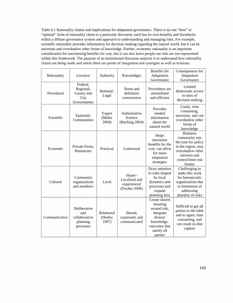
142
Table 6.1 Rationality claims and implications for adaptation governance. There is no one “best” or
“optimal” form of rationality claim to a particular discourse, each has its own benefits and drawbacks
within a diffuse governance system and approach to understanding and managing risks. For example,
scientific rationality provides information for decision-making regarding the natural world, but it can be
uncertain and overshadow other forms of knowledge. Further, economic rationality is an important
consideration for maximizing benefits for cost, but it can also leave people out who are not represented
within this framework. The purpose of an institutional discourse analysis is to understand how rationality
claims are being made and where there are points of integration and synergies as well as tensions.
Rationality Location Authority Knowledges
Benefits for
Adaptation
Governance
Consequences for
Adaptation
Governance
Procedural
Federal,
Regional,
County and
City
Governments
Rational-
Legal
Norm and
definition
construction
Procedures are
streamlined
and efficient
Limited
democratic access
to sites of
decision-making
Scientific Epistemic
Communities
Expert
(Miller
2004)
Authoritative
Science
(Bocking 2004)
Provides
needed
information
about the
natural world
Costly, time
consuming,
uncertain, and can
overshadow other
forms of
knowledge
Economic Private Firms,
Businesses Practical Contextual
Helps
maximize
benefits for the
cost, can allow
for more
adaptation
strategies
Business
community sets
the tone for policy
in the region, may
overshadow other
interests and
control/limit risk
frames
Cultural
Community
organizations
and members
Local
Hyper-
Localized and
experienced
(Fischer 2000)
Draw attention
to risks shaped
by local
dynamics and
processes and
expand
planning lens
Challenging to
make this work
for bureaucratic
organizations due
to limitations of
addressing
plurality of risks
Communicative
Deliberative
and
collaborative
planning
processes
Relational
(Healey
1997)
Shared,
expressed, and
communicated
Create shared
meaning
around risk,
integrate
diverse
knowledge,
outcomes that
satisfy all
parties
Difficult to get all
parties to the table
and to agree, time
consuming, and
can result in elite
capture

143
In this chapter, I provide the interpretive governance context for emerging
discourses among institutions involved in sea level rise adaptation planning in Miami-
Dade County (Lee 2004). This includes an overview of roles and responsibilities of
institutions involved or affected by sea level rise adaptation planning and the associated
adaptation pathways, or proposed strategies to adapt to sea level rise. I then use storylines
to examine the emerging discourses that surround how the problem of sea level rise is
framed, how it is understood, and proposed solutions (Tonkiss 1998; Rydin 2003; Lee
2004). The institutional framework coupled with storylines around problem and solution
framing are used to capture the dynamic processes by which risks are broadly interpreted
in the planning process. How different groups understand risk is ultimately connected to
their priorities on the landscape and how they rationalize problem and solution framing.
6.3 Institutions and Sea level Rise Adaptation in Miami-Dade County, Florida
Local Governments
Local governments are central to decision-making around land use planning,
zoning, stormwater management, and other infrastructure. Because of their position in
overseeing municipal infrastructure, they are key decision-makers with adapting to sea
level rise and hold formal authority over infrastructure design. Design codes around
infrastructure and the built environment are embedded within municipal codes and
regulations. These codes are set through comprehensive planning and other mechanisms,
then adopted into plans by elected officials. In Miami-Dade County, the three largest
local governments involved in sea level rise adaptation planning are Miami-Dade County,
the City of Miami, and the City of Miami Beach.

144
• Miami-Dade County has a mayor form of government with an elected county
mayor serving as the chief executive and the county commission serving as the
legislative body. The county has 34 independent municipalities and oversees a
population of over 1 million people in unincorporated Miami-Dade County.
• The City of Miami is the county’s largest municipality and has an executive
mayor who appoints a city manager to serve as the chief administrative officer
while the City Commission is the legislative body.
• Because of its role in tourism, the City of Miami Beach has a significant amount
of regional influence and is viewed both nationally and regionally as a leader in
adapting to sea level rise. The City of Miami Beach has a council-manager
system, with the mayor and six commissioners setting city policy and the city
manager serving as the chief executive.
Property taxes serve as a large source of revenue for Miami-Dade County and city
governments, and a recent report produced by local governments for the Rockefeller
Foundation’s 100 Resilient Cities Initiative claimed that the greater Miami region is
strong financially (Resilient Cities Assessment 2017). Each of the three jurisdictions uses
comprehensive planning which includes short and long term economic, social, physical,
environmental and fiscal goals, with resilience being integrated into their next
comprehensive plan updates (Resilient Cities Assessment 2017). Each of these
municipalities either currently have or have had different sea level rise, resiliency, and
climate change advisory committees to advise on policies and prioritizing work to
varying degrees. These panels have comprised of business interests, environmental

145
interests, scientists, and government employees, with community-based organizations
mostly absent from the process, though this has recently shifted in the City of Miami.
Three cities within Miami-Dade County, Coral Gables, South Miami, Key Biscayne, and
Pine Crest, have also been actively involved in sea level rise adaptation planning with
their respective Mayors leading many of the efforts. Financial, scientific, and other
resource limitations are a challenge for many of the municipalities, especially smaller
and/or resource poor governments that do not have significant tax revenue from tourist
dollars and property taxes. Maintaining and providing infrastructure and accessing
resources needed to plan for sea level rise (financial and technical) are highly uneven
across jurisdictions.
Regional, State, and Federal Oversight
Regional, state, and federal agencies and authorities have regulatory oversight
over water quality, floodplain management, regional water management, the Everglades
conveyance and restoration, and other areas. Each of these organizations has roles and
responsibilities related to sea level rise adaptation planning. Sometimes these
organizations work together and sometimes they have distinct agendas.
• The South Florida Water Management District (SFWMD) and the USACE are
key water governing entities in Southeast Florida, responsible for overseeing
Everglades restoration, in partnership with the National Park Service and other
organizations, and the primary canal infrastructure that carries water from the
Everglades out to Biscayne Bay and other regions across South Florida. Their
water management strategies play a significant role in water supply, water quality,
146
and flood control in the region, and consequently shape Miami-Dade County’s
and other municipalities water management strategies. These agencies collaborate
closely with Miami-Dade County on issues of water management and supply, as
well as Everglades restoration.
• FEMA oversees the NFIP and has recently been updating the flood insurance
maps and storm surge modeling for Miami-Dade and surrounding counties. In
addition, local governments incorporate the Community Benefits Rating System,
a component of the NFIP, into stormwater management planning to lower flood
insurance rates for residents. The NFIP program operates locally through
floodplain administrators that sit at each municipal government.
• NOAA oversees much of the tide gage data on sea level rise trends, provides data
on hurricanes, and offers planning support to local governments. Both NOAA and
the USACE have regional sea level rise projections used by local governments in
Miami-Dade County.
• USGS primarily serves in a supporting role to local governments offering
research services on the hydrology, hydrogeomorphology, and other aspects of the
region’s geology.
• The EPA and the Florida Department of Environmental Protection agencies are
responsible for oversite of the Clean Water Act, including stormwater permitting,
which has some overlap with sea level rise adaptation planning, particularly
around wastewater treatment facilities.
Non-Governmental Entities

147
There are numerous non-governmental institutions involved or affected by sea
level rise adaptation planning. These include community-based organizations,
foundations, environmental NGOs, academic institutions, private consulting firms, and
various business interests. Diverse institutions operate at different scales, with differing
levels of coordination, and on both distinct and overlapping adaptation strategies. In
general, locally based community organizations are funded by two primary foundations,
The Kresge Foundation and The Miami Foundation, along with donor and grant support.
Individuals from environmental organizations, academic institutions, private firms and
business interests are connected to the formal planning process through advisory roles,
partnerships and contracts with departments in both city and county government. Some
community organizations are connected to the Rockefeller Foundation’s 100 Resilient
Cities planning and with the City of Miami on the Miami Forever Bond’s by serving on
community advisory panels. There is also one community representative on the City of
Miami’s Sea Level Rise Committee, with the city yielding to political pressure to include
community representation. Private firms comprised both of business that work in the
environmental and adaptation fields and of businesses working in development,
insurance, tourism, and other industries with different priorities and interests in
adaptation. In general, the development and insurance community has been closely
connected to sea level rise adaptation planning by serving on advisory roles to local
government. Environmental and engineering firms have also been closely involved by
conducting contractual work for local governments. Environmental organizations have a
long history working in the region, primarily on issues related to the Everglades and

148
Biscayne Bay. They participate on several advisory committees and collaborative efforts
related to sea level rise adaptation planning.
Adaptation Pathways
Within Miami-Dade County, there are several adaptation pathways, or strategies
for preparing the region for the impacts of sea level rise (summarized on Table 6.2).
Changes to urban infrastructure is the primary focus of adaptation efforts followed by
updates to building and landscape design, collaborative efforts, and emergency
preparations. Beach re-nourishment, which is the replacement of sand along the
shoreline, and Everglades and Biscayne National Park restoration activities are two
dominant ecological strategies, while the focus on social capacity remains fairly limited
in terms of resources and efforts. A recent report from the 100 Resilient Cities effort
summarized the key actions that Miami-Dade County, the City of Miami, and the City of
Miami Beach has taken towards addressing sea level rise (summarized in Chapter 4 on
Table 4.2). The projects these governing bodies are undertaking reiterate the focus on
infrastructure, design, and the environment. The City of Miami Beach includes their
recent outreach activities which are project specific to road and stormwater drainage
upgrades.
There are two primary collaborative efforts in the region related to sea level rise
adaptation planning: the Southeast Florida Regional Climate Change Compact (Compact)
and the Rockefeller 100 Resilient Cities initiative. The Compact is led by county
governments and involves a diverse set of partners including, environmental
organizations, city governments, the SFWMD, and recently has expanded to include
some community organizations from Miami-Dade County. This organization operates as
149
a support role for local governments and to create a unified voice for the region to lobby
for funding and climate adaptation support. The Compact hosts an annual meeting that
brings together scientists, planners, private firms, NGOs, and others to share the state of
knowledge around climate change in the region. In 2017 they published their second
report, Regional Climate Action Plan 2.0 with strategies suggested to guide regional
planning and individual municipal planning efforts. Since the first iteration published in
2012, the new Regional Climate Action Plan has expanded to include public health,
public outreach and engagement, and social equity. The Rockefeller 100 Resilient Cities
effort is led through a partnership between Miami-Dade County, the City of Miami, and
the City of Miami Beach, with the City of Miami expected to follow the prescriptive
approach given that their Chief Resilience Officer is funded through a grant from the
Rockefeller Foundation, where as the Chief Resilience Officers from the county and
Miami Beach are funded through their respective governments budgeting.

150
Table 6.2 Adaptation Pathways in Miami-Dade County, Florida. The responsibility of formalized processes
around sea level rise adaptation planning has largely been that of local government, especially Miami-Dade
County, the City of Miami, and the City of Miami Beach. Formalized roles and responsibilities are not the
only source of power over the sea level rise adaptation process, as private firms, community organizations,
and environmental groups are also involved in adaptation planning efforts.
Pathway Activities Description Institutions Involved
Infrastructure Stormwater and Canal
System; Drinking
Water and Wastewater
Treatment; Critical
Infrastructure Planning
System adaptations include
increasing capacity,
installing new and/or more
pumps, moving electrical
equipment out of flood area,
identifying “critical
pumping stations”
SFWMD, City and County
Governments, USGS,
FEMA, Firms
Design Comprehensive
Planning; Sustainability
Planning; Design
Charrettes; Adaptation
Action Areas
Both for new developments
and retrofitting existing
communities. Includes ideas
for localized retreat and re-
development
City and County
Governments, Firms,
Business Interests,
Academic, Institutes,
Compact, SFWMD, Env.
Orgs
Emergency
Preparations
Transportation routes;
Local Mitigation
Strategy (LMS);
Building Codes
LMS in response to
Hurricane Andrew and
FEMA insurance policy.
Also, projects for
transportation facilities and
critical infrastructure for
emergency response
FEMA, emergency
services, transportation,
County and City
Government, Business
Interests, Firms
Social
Capacity
Education and
Engagement;
Grassroots Organizing
and Community
Development, Public
Health
Preformed primarily
through non-profit
community organizations,
individual community
leaders, public meetings
Community-based
organizations,
Foundations, 100 Resilient
Cities, County and City
Government
Collaborative
Efforts
Southeast Florida
Regional Climate
Change Compact, 100
Resilient Cities
Rockefeller Foundation
Primarily focused on
government, regional
collaborations among
different municipalities to
coordinate efforts and use a
unified sea level rise
projection
County and City
Governments, Federal
Agencies, Firms,
Foundations, Env. Orgs,
Business interests,
Community Based Orgs
(more recently)
Ecological
Restoration,
Protection, &
Adaptation
Beach Re-nourishment,
Mangroves, Everglades
and Biscayne NP
Restoration
Emphasis is on ecological
community in part because
the regional economy is so
dependent on a functioning
ecosystem
USACE, SFWMD, County
and City Government, Env.
Orgs, Firms, USGS,
NOAA
6.4 Sea Level Rise Adaptation Storylines Discourses
Case study findings point to four discourses around risk of sea level rise used in
the planning process and shaping adaptation priorities in Miami-Dade County. The first is

151
a focus on the economic core of development and tourism. This discourse arises out of an
economic rationality for basing adaptation planning decisions in support of protecting the
dominant economic drivers in the region. The emphasis is on “A city of the future” and
what some call, “the future Miami.” The second discourse emphasizes infrastructure and
is closely aligned with local governments and the desire to sustain a regional tax base to
fund adaptation actions. This discourse is closely aligned with procedural rationality and
is based in local governments efforts to understand and address sea level rise impacts
through infrastructure. The economic and infrastructure discourses are reinforced by risk
assessments and reports emphasizing and framing economic and infrastructure risks, that
emerged in Chapter 5. Thirdly, a discourse around ecological impacts from sea level rise
emerged among environmental non-governmental organizations, some government
employees, and private interest groups, primarily underpinned by scientific rationality.
Finally, considerations for the people using infrastructure and that people also matter
emerged out of cultural rationality with community organizations and others purporting
initiatives that recognize distributive justice and the unevenness of socio-economic
vulnerabilities. In addition to the four discourses, there are examples of both individuals
and organizations seeking to span boundaries and build connections across these
storylines. Both from governmental and non-governmental entities, these individuals and
actions of institutions represent opportunities for building and expanding collaborative
approaches, based on claims for communicative rationality. For each discourse, I provide
a thematic description of the problem framing, the actors involved, and the proposed
adaptation approaches being discussed or implemented. I also include points of
152
contention and points of shared meanings, as they emerge within and among the different
risk discourses.
Economic Discourse: The Business of Sea Level Rise and the Future Miami
Under the “Business of sea level rise and the future Miami” discourse, people
representing private business interests, politicians, and others emphasize the economic
risks sea level rise poses to development and tourism, the two largest economies in the
county. The risk of sea level rise is framed in an economic context and financial risks are
prioritized through planning and vulnerability assessments that focus on the monetary
assets at risk of inundation and coastal beach erosion. Such a focus is reinforced formally
in the planning process through different task forces and advisory panels largely
comprised of people from building, real estate, insurance, and banking industries. A large
reason behind the economic framing is it reflects the priorities of those involved. It is also
used to motivate political action and will to adapt. This is in part due to the notion among
several people that economic considerations are the primary roadblock to adaptation. As
one elected official shared when discussing the political sentiment around sea level rise
risks and adaptation, “Elected officials aren't discussing. They aren't. It's all about our
economic engine, which is development. That's why they're not talking about it.” And as
a business leader in the region shared,
Well, the big concern in the Business Community, mainly, is creating
panic where it lowers property values. Starts lowering property values to
such a degree that it creates this whole disaster… Yeah, disaster.
People within this discourse framed the problem around how impacts from sea level rise
on property values are inevitable, and that the loss of property value is the largest risk to
the region. As this business leader expressed with the example of the housing market,

153
But it’s inevitable. It’s going to happen. People are going to start saying,
“Does this house flood?” If I’m a buyer in Miami Beach, that’s what I
would ask… There's other people that say, “Well, insurance will happen
first and that will destroy the market.” Regardless, water will destroy the
market.
The notion that sea level rise will destroy the market was shared by some government
employees and elected officials. Many of the government officials expressed that market
failures would occur via anticipated impacts of sea level rise through the insurance
industry. As one county employee expressed,
I think we generally expect that, at least I do, that insurance will be a
major driver… What starts to happen with property values will end up
providing some influence. If there's a major storm and people are
impacted, that's going to have an influence on whether people decide to
stay or not.
The fear for many within this storyline is that insurance companies will either stop
insuring people or costs will be so high that they will result in local economic disasters,
and that an ultimate risk would be having to retreat. An elected official elaborated on this
point and discussed it in the context of someone bringing up the idea of planned retreat.
What we all understand is the reinsurance industries, the Swiss Re and
other reinsurers are warning us and have been warning us for the last
couple years that we need to mitigate against the damage that's going to
come from all this flooding. Yeah, to limit and reduce known hazards and
known losses. It's billions in known losses. Nobody is doing anything
about it. They're just raising the dollar value of known losses by allowing
more and more. One of the scariest comments I heard about two or three,
maybe three years ago… there was a gentleman from Army Corps of
Engineers doing a presentation… He said, “At some point soon, you'll
have to develop an exit plan.”
Another part of the problem framing in this discourse is that the drive for short-term
gains in the development industry is creating problems for adapting to sea level rise. As
one elected official shared,

154
… here we are, just looking the other way and letting them keep building
these multi-million, billion-dollar…” Developments are reliant on our
foreign money still coming in, developers making a buck, a lot of
construction going on, so helps the economy, and it's all short-term gain.
Narratives around economic risks are structured around the loss of the economic
core and the loss of the tax base needed to finance adaptation measures going forward. In
addition, risks are viewed as the possibility that there will not be a federal or state bailout
for these market driven failures.
Both current and future loss of property values becomes one of the key ways the
problem is framed under this storyline. The focus placed on the economic core manifests
in the way risks are understood and measured. For example, with the Compact, risk maps
are presented in terms of inundation levels and property values, embedding assumptions
about risk as being the places where the greatest property loss occurs (Vulnerability
Assessment 2012). Informant interviews corroborated this with their emphasis on
needing to protect the economic core to fund future adaptation efforts. In this way,
maintaining property value, protecting the economic core, and planning for a future
economy in the region become the focus of adaptation efforts in the region. This takes
place in diverse ways including, beach re-nourishment programs focused on protecting
coastal properties and the attention to building codes and urban design.
Linked to the problem framing around economic risks, is the emphasis on
economic gains and emerging economies around adaptation actions. Business
opportunities were expressed in-terms of both consulting firms that can take advantage of
the emerging adaptation industry, but also in-terms of the need for ongoing development
that will secure investments in the region. This second point was expressed in terms of

155
the risk of not building and how sea level rise will create slums in existing low-elevation
areas. Development is viewed as a necessary adaptation solution for raising base floor
elevations and protecting economic investments. As one private sector individual
described the relationship between developers and adaptation planning,
When Barret Houseman and Napoleon III tore out Paris, they said they
were doing it to stop the possibility of more revolution and violence. This
was breeding ground for rebellion and revolt. They tore down Paris, and
they built a new Paris, but that new Paris made a lot of developers really,
really wealthy. It's the same thing. It also made Paris a city of the middle
class, whereas the city was a city of poor before they started their work.
Similarly, North Beach is an area of poverty. There's always been a reason
to tear down places the poor live, whether it's put in highway or a
stoplight, or to stop concentrations of poverty, or whatever. The newest
reason is sea level rise and climate change. Just like those other reasons,
there's a validity to it. You're talking about a Barrier Island in Florida.
Several interviewees that represent this view shared that there are no physical limits to
adaptation, that the limits to adaptation are economic limits, that the land must be worth
enough and the concern is if the region waits too long to adapt, the land will no longer be
worth enough to save. This sentiment is commensurate with problem framings and
solutions that are engineered and adapt the physical landscape to allow for growth in the
era of sea level rise. One government employee shared that sea level rise risks will not
limit future growth, it will just change the way the region grows,
We are not thinking about abandoning any areas at all. We already live on
reclaimed land so we will keep reclaiming. It doesn't really matter. It's all
reclaimed land anyways so it's not an issue. So then, you have to abandon
this area and say ‘Why? China can make an island in the middle of the
ocean, we can build some more.’ So the thing is that abandonment is
going be more related to areas that are already difficult to live, because
they're too low so they need to be redeveloped. And [those areas are]
going to be redeveloped with more focus on how we're going dispose of
the water because it's going to be harder for us to drain… So there are

156
some areas that are going to look very different to what they look now.
That doesn't mean that there are not going to be houses there.
Another government employee shared this sentiment and discussed a link between the
economic framing of sea level rise adaptation with an engineered perspective. In this
way, economic framings are matched with ideas for re-grading the city to solve the
problem of sea level rise. As this individual shared,
One thing that I suggested is you can fix everything with enough money.
But the land needs to be worth the money… you know there's a cost
benefit analysis to that… if you ask me what's the best thing that could
happen from the engineering standpoint to get rid of the problem not
necessarily about the individual people who are living there but from… If
some developer will buy everything out fill it two and a half feet and
rebuild it. You know, and that would make the problem literally go away.
Many in this discourse echo this individual and bound the problem of sea level
rise by the financial constraints to solve the problem. In this risk discourse around the
economic core, risks are expressed via a monetary lens. As one city employee shared
when discussing future growth and development in the region,
It's all land value. It's not really the buildings and that's what we talk
about. Saving the building. I said the buildings are worth very little, it's
where they sit is what the value is.
The risk of sea level rise is bound by the ability of the region to be economically
prosperous as to be able to afford the adaptations needed to support cities in Miami-Dade
County. Several interviewees used economic reasoning to discuss prioritization for
adaptation strategies, as one elected official shared,
There's economic activity to happen and there's places where they need to
be reinforcing, elevating structures and land to keep that happening.
There's an area, very high economic activity in the Jackson Hospital area,
along the Miami river. That area is a big job engine and the area is pretty
low. They need to be paying attention there.
157
With the problem framed around developers serving as a major roadblock to
adaptation planning, the logic follows that this stakeholder group needs to be included in
planning activities. Several people from the development community have been involved
in sea level rise adaptation planning via participating on committees and proving input in
assessments. Because of the presence of the business community on these committees
and their involvement, the conversations that take place in those arenas often surround
the need to update codes, building materials, and emerging business opportunities around
adaptation planning. Several interviewees from outside this discourse commented on the
focus on building codes and new growth for sea level rise adaptation and resiliency
strategies. These outsiders expressed that these building code changes can be slow
because of political challenges and detract from activities that could take place in the
nearer term. As one individual from an environmental organization shared when
discussing private sector organizations involved in adaptation planning efforts,
Yeah, they seem to be sort of fixated on building code changes, and asking
for money to get surveys, or risk assessments, or experts, or things like
that. That has been slow in coming… Economic impact studies, like GIS
surveys… Financial, and elevation perspective, and flood maps… And
building code changes… It's very slow and difficult to get changes to the
building code. It takes years… And then Miami is a very developer driven
town economically, and so adding additional burdens onto developers for
doing things with sea level rise in mind is slow going. Because it's going
to cost them more money to build their buildings differently, or elevate
them, or so on and so forth. Because right now most of the costs are
pushing on people who are buying apartments and things like that, because
developers sort of engage for three to five years, and then they sell them.
While those within the economic discourse emphasize the need to focus on building
design and code challenges, this individual from outside the economic discourse
discussed an alternative framing. Understanding how slow moving changes to building

158
codes can be, this individual shared that there are alternative solutions that could be done
in the nearer term, including green infrastructure and emissions reduction.
Within the economic discourse, several people representing private sector
interests discussed the new economy emerging out of building adaptation strategies. This
new emerging economy is part of how those within this discourse frame adaptation
solutions and focus on infrastructure investments. For example, one private sector
individual discussed recent changes to Miami-Dade County’s sewer treatment in terms of
a positive economic driver,
They were slapped with a consent order, and so now they were forced to
basically upgrade their infrastructure to accommodate for the growth, and
also to protect sewage issues into our ecosystem. Therefore, that’s been
good for business… The economy is the environment, and the
environment is the economy in South Florida… $20 billion dollars over…
well, over 20 years, so you do the math. There’s a lot of contracts out on
the street already, and big global firms are down here hiring small firms.
My firm benefits from that as well, because they hire me to help them.
This notion of emerging economies out of the need to engineer and transform the built
environment was discussed among several others. In relation to the business community
an elected official discussed how some in the business community discuss the need to
focus on the new economies around adaptation to sea level rise. This individual shared,
[The business community] talks about new economies that we should be
focusing on. One is the ability to bring in engineers and state-of-the-art to
help with planning, and to help with infrastructure. There is an economy
waiting to do that. Renewable energy, solar, all of those things. There is a
new green economy, but we aren't involved in it as a county, at the
chamber… or any of those levels. We are solely invested in tourism
development. These developers come in, and they're building in the most
vulnerable coastal areas, which is still the most valuable property, because
they know they'll be able to take the money and run within the next five-
year spread.

159
Economic benefits are also discussed in terms of longer-term improvements to the region.
As some business and homeowners in Miami-Beach have expressed frustration with
infrastructure projects at public meetings, one adaptation proponent from the business
sector reframes this issue in the context of economic gains.
Guess what? We’re going to bust up your street… But it’s all for the
greater good, and you’re going to have better services, and we're
improving the system. There are temporary impacts to greater benefits,
and it’s also helpful for the economy. The [business community] comes in
and understands that and wants to build… that conversation.
Economic Discourse Summary: The link between the economic framing of the problem
with the economic opportunities surrounding new growth and an adaptation economy are
produced out of and reinforced by an economic rationality. Miami as a development
driven town with political leaders and officials closely connected to developers lends
more political weight towards this discourse. The long-term involvement of the
development and business community participating on sea level rise and climate change
committees for the different municipalities lends the business community some level of
administrative authority, shaping the development of plans and assessments. Further,
insurance programs, flood protection, and beach nourishment activities create a direct
pathway for economic considerations to have formal positions within the planning arena.
This storyline is used by local politicians and the business community to reframe the
problem of economic barriers to sea level rise adaptation as an economic opportunity.
Infrastructure Discourse: Risks are Technological and can be Managed with
Infrastructure
Regional, county, and city planners and managers primarily frame the problem of
sea level rise around the physical impacts to infrastructure that result from inundation and

160
associated physical changes to the landscape. Part of this is understood in relation to
protecting the regional economy and tax base, overlapping with the economic framing of
risk. This framing is rationalized through procedural rationality, where those within this
group justify action and problem framing in the context of what they perceive as logical
and apolitical assessments and prioritizations. A large emphasis around the framing of the
problem of sea level rise is around the roles and responsibilities of local government, and
the need to address their own issues and risks before asking others to do the same. This
places some focus around roles and responsibilities of local governments and not wanting
to infringe on property rights. As one federal employee suggests,
I think that local governments in general they are trying to work on things
they can do… You know the things that involve public infrastructure are
going to be more feasible to start working on than anything that impacts
private property… That is something that you see a lot of the emphasis is
on public infrastructure.
In addition, government employees shared the desire to get their own assets prepared for
sea level rise before asking the public to do theirs. The question of public and private
responsibility is brought up in the context of when landowners should adapt and whether
to wait for the government to adapt the infrastructure first. As one scientist and county
resident explained this question of public and private action,
If they're gonna charge me tax on my parcel of land with my house on it, I
should have access to my parcel of land. That's my feeling… I mean, I can
afford to elevate my house, and do those things. I mean it'd be kind of fun,
but, before I make the investment, I want to be sure that I can get to my
house.
And while the procedural logic around adapting infrastructure is wrapped up in
roles and responsibilities of local governments, there are several outspoken critics of this
discourse. Critics from the environmental discourse shared that ongoing infrastructure

161
investments in low-elevation areas encourages additional growth in vulnerable regions.
As one scientist shared,
And so what we're doing is we're putting all our money into this basket of
infrastructure protection, and it's going to keep driving our property values
down and keep more social inequity, higher cost, poor quality of life, and
then finally, we're going to start get hit with serial Katrina and Sandy style
events because it won't take that big a storm at some point where when
that system finally gets swamped, it's going to be bad… We're going to
build ourselves into a disaster. That's my fear… And once it gets to that
point, I think what we're going to end up with is… this kind of…
apocalyptic shoreline where you're going to have abandoned infrastructure
and cities, squatters living in places that don't have any sewer or water,
maybe they have hi-jacked electricity or something.
Logic around adapting infrastructure is to approach it from an incremental
perspective. In Miami Beach, for example, the city has been installing stormwater
pumps and raising roads based on a 30-year planning horizon. Several people
shared that this is in part because raising roads higher than that would kill the
local economy. While the logic behind planning this way is based on procedural
and economic elements, there were several outspoken critics that expressed this
planning was too short-term and parochial. For example, as an environmentalist
and critic shared about infrastructure adaptation in Miami Beach,
I kept saying, “Good guys, but what happens when you've raised the
streets 3 feet and you put the pumps in and you're pumping the water out
24 hours a day pumping it out? You put sea walls all around Miami Beach
and the rest of Miami-Dade County looks like that?” There is no causeway
to drive across because it's under water. Great, and good, you have built a
1 mile wide, 7-mile-long island, with a wall around it. You can't call it
Miami Beach anymore because there is no beach here. What quality of life
is that? Is that where you want to live? Are we slowing down and
building? Hell no. We're building billions and billions of dollars’ worth of
stuff all along this. Something's wrong with people.

162
This individual as well as other critics favor planned retreat as a strategy for adaptation
planning. Interviewees representing the infrastructure arena discuss encounters with
outspoken critics of adaptation who favor planned retreat. In these scenarios, those that
subscribe to the infrastructure storyline—especially those working in local government—
argue that planned retreat is not an option. This is in part because people want to continue
living in the region and it’s the local governments role to provide infrastructure. As one
government employee shared,
A planned retreat, which, you know, is a totally valid argument when you
look at the whole scale of the problem. But then their individual plans for
their own family are not in accordance with that. And you think, “Okay, I
understand why, because you like where you live.” And that is also true of
your neighbors, so it's not really possible to assume that these other people
should pack up and leave, while you maintain your particular home and
community. So people, not everywhere, but a lot of people wanna
maintain their community, and they wanna maintain their house… which
is what we're, as a government, you know, what the community wants is
what we're trying to provide.
Local government employees do discuss some hyper-localized retreat in the general sense
when speaking on panels but have yet to formally address this issue in policies, plans,
and official public forum. They emphasize small scale retreat within low-lying parts of
neighborhoods, not mass planned retreat. Beyond the moral argument around the purpose
of local governments to provide a certain quality of life and maintain communities, the
emphasis on hard infrastructure projects is embedded in policies and mandates.
Emergency management and FEMA become one lens for how the region views
infrastructure risks from sea level rise. Often, these policies direct investment towards
what was referred to as “hard” infrastructure projects, meaning infrastructure projects that
are built to withstand disturbance. As one government employee shared,

163
One of the other collateral things I was involved in was called “Local
Mitigation Strategy.” Which was part of the emergency management
office. FEMA is really the driving force on that. The county was very
aggressive, probably one of the leading counties in the country, on
developing this Local Mitigation Strategy on how to harden vulnerable
facilities. They have taken advantage of a lot of grant money through
FEMA. A lot of programs that they have to help communities, both
municipal government and county agencies. A lot of other entities get
funding to protect, harden their resource. Whether it is hurricane impact
windows, doors, or generators. Raise a facility or build a new facility.
Kind of drainage, pumping facilities to pump water.
Some government employees discussed wanting to explore more flexible infrastructure
projects, for example green infrastructure, which are designed to take on some of the
impact of disturbance and dissipate that across a larger system for impact. This notion of
infrastructure flexibility was contested among different people within this discourse,
particularly in discussions about green infrastructure. Many proponents of more flexible
infrastructure did not see it as a replacement for hard infrastructure, but to augment and
alleviate disturbances to hard infrastructure.
With local governments, the emphasis of the risk is framed around public
infrastructure and the solutions are centered around developing a detailed understanding
of risks and engineering solutions to those physical risks. This is supported with logical,
decision-making and represents a procedural rationality, backed up by scientific
assessments and economic rationalities around costs and benefits specific to
infrastructure design and investments. The work of developing criteria and prioritization
for projects is most often done by consulting firms and government employees and
mandated by different state and federal policies. As one planner shared,
The first task that we gave them [the consultant] under that contract was to
assess climate impacts. They did extensive evaluations. They did storm
surge modeling. We did rainfall projections. Because part of that program

164
is also to calculate what our future flows will be. If a rainfall is going to be
more intensive, we may have higher peak flows in the future. They did
that assessment. We look at wind also. Based on all that, we came up with
a criteria.
Prioritizations and solutions become embedded in the infrastructure themselves.
Several people within this discourse discussed the role of the useful life of infrastructure
in determining what science to apply, what the costs and benefits are, and how to
prioritize different strategies. In some cases, people described this process as being
represented as a formula around weighting different decisions. As one planner shared,
Basically, we have this formula for allocating those stormwater
utility dollars to improve flooding. So objectively, this basin was
the most flood prone area that we had, so it's pretty standard.
Even though the system is currently set up to strive for procedural
approaches to decision-making and prioritization, some within this discourse
challenged the efficacy of standardized approaches to prioritize adaptation
actions. For example, some government planners within this arena shared the
challenge in coming up with standards for determining “Adaptation Action
Areas.” “Adaptation Action Areas,” are supported by State land use policies as an
official designation (Section 163.3177(6)(g)(10), Florida Statutes), which can be
used to as a land use zone to support adaptation actions. There are different
approaches to designating Adaptation Action Areas and some planners question
the ability to come up with calculations to identify these priority areas. For
example, one individual shared that they used a standard calculation used for
allocating stormwater utility dollars to determine a pilot area for an Adaptation
Action Area. This planner describes the tension between an official systematic

165
process for designating Adaptation Action Areas using a standard stormwater
calculation verses a more flexible approach,
…when we selected the area… obviously we didn't know that much about
the area when we chose it… the most flood prone area was just off the
map, it was this mobile home facility, basically. It's just a little bit off the
map. It's literally across the street. Anyway, it's just off the map, and it's
like, as soon as you start to speak to people, and you go up there, and you
learn more about the area, and you're mapping it et cetera, you're like “Oh
man, this is just outside the boundary.” Which isn't a problem for us in this
particular sense, cause we just say “Okay, this is part of it.” Yeah, it's just
a part of it. It's not a big deal. But if it's officially designated, I don't
know… It wouldn't be in there. So I don't know. I guess some of the
benefits of being designated is that you might be able to direct funding
towards those places.
This view of systems being too complex to have strict criteria for prioritizing and
determining adaptation actions was linked with people who shared the need to work on
hyper-focused projects that explore the complexities and nuance of place. Such a concept
is emerging in some areas around pilot projects sponsored by different foundations, and
design charrettes have been performed in this way. However, currently this approach and
the logic behind this approach exists more on the periphery of this discourse. Most that
subscribe to the infrastructure discourse emphasize the need to have prescribed
assessments and approaches to determine prioritization and adaptation solutions.
Part of the concern around having standardized approaches to prioritize adaptation
planning based on physical risks of sea level rise surrounds how to address complex
issues experienced by low-income communities. The response to the concerns of low-
income communities within this discourse is varied. Some planners shared that while
there are vulnerabilities unique to these communities, the bigger picture of the risks from
sea level rise do not make those vulnerabilities worse than vulnerabilities to more affluent

166
communities. “Risks do not discriminate between rich and poor” was a common
argument made to rationalize the inclusion of low-income communities in the
conversation. As one planner shared,
Well, I think the big takeaway is the same as it is in lots of other
communities, I mean, like, this is an existential threat to Miami, and
people are informed about the severity of the threat, and that, basically,
regardless of emissions, the amount of sea level rise the community will
encounter is probably more than the community can absorb. We're not
talking about inches, we're taking about feet. And such a huge percentage
of the community is below six feet. So, I think the challenge is that, you
know, the concerns that you hear in Liberty City and the concerns that you
hear from big developers, affluent developers… Key Biscayne, an affluent
community… they're the same. People are like, “This is a serious problem.
What you said, it sounds very serious, I haven't heard you say what we can
do about it.” And like, “What are we gonna do about it and why isn't it
already happening?”
And really I think that they're the same… you know, the content is
different, like, in Key Biscayne residents brought up that… one woman
asked this room full of people, like “Who knows Donald Trump?
Someone pick up the phone.” Obviously, in Liberty City, those kinds of
comments don't come up. People are talking about New Orleans a lot
more, and they're talking about storms, and savings getting wiped out, so
the impacts are the same, but I would say that the tenor, and the real
fundamental concern, is pretty similar. You know, it's like “What you've
just told me is that this sounds really serious and irreversible. Like, what
are we gonna do about it? And why haven't you, like, come up with a
plan?
When discussing solutions, some planners shared that infrastructure adaptations will
benefit rich and poor alike, that there is no distinction. In this way, the focus on the
elevation and infrastructure is used as a tool to depoliticize the planning process. Some
interviewees shared that they view infrastructure adaptations as an apolitical,
technological solution that provides equal opportunity and benefits to those within the
167
regions the infrastructure serves. When discussing equity issues with climate change, one
city employee suggested that,
Every neighborhood will have different [socio-economic] levels like we
mentioned. North Beach is kind of a lower income but at the same time
some other neighborhoods are mixed. Any project that is developed will
end up benefiting them, any level of society because they're a part of those
neighborhoods… but basically when it comes to lower income population
they'll also benefit… We have homeless all the way to billionaires as you
heard. As in any city, is it always challenging to provide and tailor things
to everybody… It was like I mentioned, [the city] really does a lot of
communication to the public, a lot of outreach and education on the things
that are being done. Those meetings are public, and anybody can attend
and learn more.
At the same time, some planners were more vocal about the different challenges among
different communities. These planners expressed that possibility of sea level rise
adaptation planning addressing a plurality of issues related to low-income communities.
As one planner shared,
… sea level rise planning really if it's done well… there's a real
opportunity to address many other stresses and potential shocks hitting our
community so I think that holistic resilience one is really, it bodes well
particularly given socio-economic vulnerability so much of our… city.
70% of the city's population is struggling to make ends meet.
While views like this may offer the seeds for innovation around integrating social
considerations outside of economic and biophysical drivers into infrastructure planning
decisions, current planning remains focused on physical hazards for prioritization. There
are different framings around how to support low-income communities with adapting to
sea level rise. In considering sea level rise as a physical problem with high cost solutions,
some interviewees within this infrastructure discourse were highly vocal about the
challenges of supporting low-income communities. As one government representative

168
shared when discussing why conversations around adaptation do not focus on how to
support low-income communities,
We’re not discussing how to support them, because there is no supporting
them. It's people mostly just waving their arms up and down saying, “Hey
this is going to be unfair.” That's are things are, things are unfair. Right
now, ironically the rich people are in the way of the problems, but rich
people can relocate themselves to their Swiss chalet or whatever…
Two meters by the end of the century…The slope is like that, so now it
doesn't stop at two meters. Two meters, okay I got to figure out what to do
with two meters… It's accelerating. You can't catch up with it. You never
catch up with it and finally it overtakes you. You're out of money and
you're out of rock. The sea level isn't quitting. It's still cranking up on
you… Then what? You're going to worry about gentrification and Liberty
City at that point? I don't think so… Yeah, by the time the water finally
gets up to… Makes Liberty City's property valuable… This is going to be
a very different place.
Infrastructure Discourse Summary: Within the infrastructure storyline, sea level rise
poses risks to infrastructure. The emphasis is on local governments to address those
issues. Local governments primarily rely on procedural rationalities and also use
economic and scientific rationalities to bolster procedural elements in relation to
infrastructure costs, design and prioritization. The emphasis is on considering threats
from sea level rise as being physical and economic, and solutions are framed in a similar
context. Counter arguments around the need to consider retreat are ignored by this
planning arena, primarily because of the moral and legal obligations local governments
must maintain communities. At the same time, considerations for how to integrate
challenges experienced by low-income communities remain mixed with some expressing
visions for integration and others focused on the challenges and impossibility of
integrating them into planning due to the perceived prohibitive costs of adaptations on
private land.

169
Ecological Discourse: Ecological Complexity and Longer-term Processes and Impacts
The third discourse storyline that emerged surrounds ecological complexity and
longer-range impacts from climate change. This discourse is primarily supported by
environmental organizations and scientists with some government employees who work
in environmental focused programs. In this discourse, risks to sea level rise are
understood in relation to the environment and the solutions consider the role of the
environment in adaptation. This arena is primarily based on scientific rationality.
Individuals from environmental organizations discussed their close relationships with
scientists from local and regional universities, and often talked about the biophysical
impacts from sea level rise in longer-term with higher projections and more severe
impacts than other groups.
Environmental sea level rise impacts are often discussed in the context of broader
climate change impacts to the environment and emphasize inundation of the Everglades,
salinity issues within Biscayne Bay, coastal erosion and warming impacts on the living
shoreline (including mangroves, eel grass, and coral bleaching), and water quality
challenges that are worsened by sea level rise. For example, as one an individual from an
environmental organization shared,
All the mangroves will be gone, all the grasslands will be gone. Flats are
going to die. All the grass flats, all the mangroves are going to die. They
can't take sea level rise more than nine inches a century. They cannot
migrate quick enough.
Several people linked regional vulnerability to the overall health of the ecosystem.
Many focus on the Everglades, in part because of the longstanding environmental focus

170
on connecting regional systems with Everglades restoration. As one individual from an
NGO shared,
I think people are seeing that our vulnerability to a great degree is affected
by the health of our natural systems. I think that one thing we could do a
better job of is conveying to people that we have been regulating this
system, this aquatic system in our backyard going back to the late 1940s
and providing flood control in a system that receives a lot of water. If we
can manage this Everglades ecosystem, and also restore it, put more water
out there and still keep our developed areas relatively dry in what is
otherwise a flat, low lying landscape, then we might have the capacity to
do really what people think is the impossible.
Many that subscribed to this discourse talked about the multiple threats to the
environment and often discussed these threats in the context of broader climate change
risks to the ecosystem. Sea surface temperature and ocean acidification were frequently
added into interviews in the context of risk from sea level rise. One government
employee focused on ecological protection shared,
… there's going to be significant impacts to the natural resources. I don't
think that our resources will maintain the same homeostasis that they
historically had with potentially accelerated sea level rise. Impacts
potential to benthic resources, corals which we're seeing right now. Sea
surface temperature, ocean acidification, coral disease. The coral reefs off
Miami-Dade County are not in great shape. Also, we are seeing a large-
scale sea grass die-off in certain parts of Biscayne Bay which may be
attributed to land-based sources of pollution.
In terms of impacts, baselines and reference points often follow an ecological time scale.
Several people within this arena focus on whether the ecological systems can keep up
with the impacts from sea level rise. For example, several shared that one key uncertainty
is how the mangrove system will be able to keep up via soil accretion rates.
In addition to these direct impacts, this discourse discusses indirect water quality
impacts from failed infrastructure surrounding sewerage system and stormwater

171
infrastructure failures. Several interviewees and documents also discuss ecological risks
from adaptation strategies themselves, including from sea-walls, well drilling, and
stormwater pumps. One informant shared, “They'll [individual homeowners] start
hardening yep, along the coastal areas. The problem then is, is you lose your inner tidal
zone. There is no inner tidal zone, it's just two lines on a wall.” Another environmentalist
expressed, “You lose your inner tidal and you lose your inner tidal life. It's a temporary
fix. Also of course when the water tops your sea wall then you're in big trouble. It gives
you a false sense of security.”
Many within this discourse framed part of the problem around ecological risks
being rooted in decisions that support economic benefits to the region. Many were
outspoken critics of short-term economic gains at the expense of the environment and
considerations for the impacts of sea level rise. As one interviewee from an
environmental organization shared,
We have the port dredging to bring in mega cruises. You're damaging
coral reef and marine life. It's like, “We need coral reefs. You're killing
them. What are you doing?” It's brutal. Money is… It's a monster.
In addition to framing the risks and the problem around climate change and sea
level rise to ecological systems, many discussed that risks (both to the environment and
to the economy) can be addressed using ecological systems. Most within this arena link
the economy to the environment and identify synergies between the environment and sea
level rise adaptation solutions. These include: living shorelines restoration, sand dune
restoration, stormwater treatment, green infrastructure, Everglades and Biscayne Bay
restoration, sending water south to prevent saltwater intrusion, and green space. As such,
environmental protections and funding are often driven by the need to protect the

172
environment for the economy. This is linked to the connection between the environment
and the economy, expressed by one individual, “It's like the quality of our water. The
availability of our water. The health of the ecosystem, which is at the center of our
economy.” Groups use this framing to make a case for restoration and the role of the
environment in adapting to sea level rise. As one individual from an environmental
organization shared,
I think one of the most compelling things that we can do, and we're
working toward that, is making a strong economic case for Everglades
restoration. That includes understanding the economic impacts of the
existing system, and being able to project what restoration will do, not
only in terms of avoiding those impacts, but also improving the system on
some trajectory back to what it may have been. We've done economic
studies. We know that people pay a lot of money to fish, people pay a lot
of money to bird watch.
The importance around protecting the environment because it’s tied to the economy was
shared by some local government officials. As one municipal employee shared,
… we have a lot of money and political backing for the environment and
an understanding of how important it is because it’s tied to our economy.
The same way and that’s why people move here and that what funds all
our programs. In the end if we don’t have a pleasant environment to enjoy
and live in, we and all these other items don’t really matter because
nobody is going to want to live here. Everybody is going to be like oh you
know this area is doomed okay we might as well just leave because it’s not
even worth living. We don’t ever want to get to that point.
In extending the role of the environment for protecting the economy, the
environment also gets brought into discussion around protecting the region from impacts
of sea level rise. The environment is enrolled in conversations about solutions for
adapting to sea level rise, solving some of the proximal impacts of sea level rise. For
example, one individual from an environmental organization shared,

173
Yeah, living shoreline is not going to solve sea level rise. That’s more
about sort of proximal effects, like flooding and erosion. Sea level rise
exacerbates those things… It takes not so much mangroves to really stop a
lot of waves… So that protects from erosion and flooding… And provide
all kinds of other benefits; habitat for fish that people love to catch, and
water filtration, wildlife habitat, a million other things.
At the same time, some within this discourse express a strong scientific argument
around climate change impacts being insurmountable and call for discussions of planned
retreat and political movements towards greenhouse gas reductions. The challenge of
addressing these longer-term impacts is the lack of political motivation around emissions
reduction. As one individual from an environmental organization shared when discussing
the risk Miami Beach took in discussing and addressing sea level rise,
… you potentially put your region in the cross hairs for bad press with this
issue that you don't have a solution to. It's a really expensive, intractable
problem. I don't think people want to talk about it without knowing what
to do about it. The sort of logical end to these conversations is sort of
reducing emissions, and I don't think people want to talk about what that
means. There's political and economic pressure to not talk about those
things… It's insanely expensive to do adaptation and it's insanely
expensive to… or is going to shift our economic structure to do the
mitigation. Neither thing is particularly palatable.
Like both the economic and infrastructure storylines around the problem framing,
people within the ecological discourse discussed barriers to implement adaptation
strategies posed by private landowners. This was discussed in the context of trying to get
private landowners onboard with some of the ecological adaptation strategies, for
example, sand dune restoration. As one person from an environmental organization
shared,
Most of the governments want dunes… It’s really private homeowners,
and the government can’t put a dune in front of a home until they sign
paperwork, so sometimes they build a big project and they have to put
gaps in the dune, because there are certain homeowners that don’t want a

174
dune on their property… There’s nothing bad about a dune. They’re
protective, they’re a good wildlife habitat… From like an, other than not
being able to see over it, there’s nothing bad about a dune.
Several among this group suggested that the adaptation strategies themselves will
have environmental impacts that are not being considered. For example, one individual
from an environmental discussed environmental concern for drilling into the aquifer to
treat wastewater as part of a sea level rise adaptation strategy. They shared,
I know they're doing this deep well injection process now that makes me
quite nervous… Yeah, so they're just sticking all the dirty water down a
hole basically… It's taking hundreds of billions of gallons of water out of
the water cycle and putting it into a hole, which I think is not sustainable.
It's also a somewhat untested technology. What's going to happen to that
water down there? Is it just going to stay down there forever? Is it going to
migrate, is it going to contaminate the aquifer, is it going to create a
methane bubble and become anoxic? It's becoming more and more clear
that, particularly in Miami, where we have porous limestone, things are
not very well contained underground, and… there are fissures even into
the boulders now that we don't even know about.
People within the environmental discourse differed in their opinion of how impactful the
high profile stormwater pumps and elevated streets in Miami Beach are to the
environment. Some expressed concern that the pumps concentrate stormwater pollution
and create more problems in Biscayne Bay that existed prior to the pumping. For
example one scientist shared,
Well, it has been effective in short term lowering of the water in the
streets. The downside of it is that the stuff is pumped into the bay without
any real treatment. They might strain out a few chunks or something like
that, but it's… So, North Biscayne Bay sea grasses are dying off, and it
probably relates to turbidity in the bay, and it started to happen about the
same time that the pumps were turned on. That's not proof that that's the
case but… It's an observation, and one of the obvious candidates. FIU
[Florida International University] did measurements of the nutrient
loading in the plumes of stuff going into the bay, and the mayor of Miami
Beach, [Mayor] Levine, was outraged because they were finding there

175
were some problems with the amount of nutrients, and so, instead of
working with them, basically a politician often attacks the messenger.
At the same time, some people from this discourse, including from environmental
organizations, feel that the pumping is no worse than what’s been going on in the past
and that the real concern is a lack of stormwater infrastructure in general. As one
individual shared,
On the scale of massive pollution issues I'm much more worried about the
sewage infrastructure getting overwhelmed and getting millions or billions
of gallons of sewage… Yeah, the bigger problem is we don't have good
stormwater management, we have a shallow water table, we have too
much water. Every time it rains we end up with infiltration in the sewage
infrastructure. There's lots of storm water pollution, we don't have enough
green spaces to let it percolate. I think that problem is only getting worse
with sea level rise and salt water intrusion issues. It's like the pumps are
very visible, and sort of high profile, so people are sort of fixated on them,
but it's a much bigger problem than just for the Miami Beach where they
have pumps.
While people working within local governments also share ecological goals, the pressure
from those that are more central to the ecological discourse is pushing local governments
towards those considerations. For example, within Miami Beach, government and non-
government employees discussed how the pressure from scientists sampling water quality
has resulted in additional sampling programs and efforts to design stormwater
infrastructure to address bacteria and contamination at the water pump stations. Some
interviewees shared that many of the activities proposed by the environmental
community are long-standing issues. One consultant expressed,
The environmentalists in this county were the first adopters of the sea
level rise and climate change. Environmental goals that were being
pursued anyway are being strengthened. Restoration of habitat… of the
Everglades protection. Things that were happening anyway.

176
Most of what was already “happening anyway” center around Everglades restoration
efforts aligned with sea level rise risks and adaptation. Restoring the natural flow of the
Everglades and maintaining the brackish characteristic needed to sustain ecological
processes in Biscayne Bay have long been ecological goals among environmental
organizations and local and federal governments in the region. Among those within the
environmental discourse, this goal of sending water south and “growing the bubble” is
seen as preventing salinization of the Biscayne aquifer, an important water supply. The
risk of salinization comes both from not enough aquifer recharge and from saltwater
intrusion from sea level rise. This argument is also linked to other ecosystem needs for
the Everglades and Biscayne Bay. As one individual shared,
But anyway, that natural flow that goes through the Everglades, that
reestablishes freshwater flow there to the extent that it then continues into
Florida Bay. The fresh water is important to Florida Bay because without
it, the bay dies. It's that brackish water, the fresh water that collides with
salt water, that creates these amazing estuaries for fish and natural life. But
these other fish, it ends up being part of this whole fishing economy, that
you hear about in the Florida Keys. That hydration needs to then continue
to Biscayne Bay because there's evidence that the bay might be dying off
in certain areas. Sea grasses are not there like they used to be. You don't
want the bottom of the bay to be muddy. You want it to be filled with sea
grass.
This issue framing around sea level rise and the Everglades restoration has historical
context which impact modern conflicts and present challenges for restoration. In Palm
Beach County, for example, the sugar industry has long been considered by
environmental organizations as a big polluter and political power against sending the
water south, which is viewed as necessary for Everglades restoration, and now for sea
level rise adaptation.

177
Ecological Discourse Summary: Within the ecological discourse, the problem is
framed in relation to direct and indirect impacts of climate change and sea level
rise on the environment. These include how inundation rates affect different
species, ecological impacts of adaptation strategies, and the broader human
impacts on the environment which places sea level rise among multiple threats.
The role of private property rights and developers are also framed as part of the
problem, with ongoing development in the region both producing ecological
harms and long-term challenges for sea level rise adaptation. The environment is
linked to the economy in that it supports tourism, quality of life, and the reason
people are drawn to live in the area. Within this problem framing, there are
different problem solutions that emerge, many focusing on the role of the
environment in protecting infrastructure. Risks from climate change are
considered much longer-term and more severe and calls for mitigation and
planned retreat emerge from this framing.
Community Discourse: People also Matter, and Risks are Not the Same
The fourth discourse storyline emerged out of cultural rationality and emphasizes
the need to consider the people who use infrastructure and the importance of including
the public in adaptation planning. The emphasis is on low-income and historically
marginalized communities which have a history of being left out of planning decisions in
the city. As one community organizer expressed, “If you don’t have a seat at the table
you’re on the menu.” In addition to urban community organizations, people from South
Miami-Dade County and the agricultural community expressed similar sentiments around
being left out of planning efforts and had less awareness of sea level rise impacts to their

178
region. The problem of sea level rise risks is framed both in terms of impacts to day to
day life, the situatedness of historical and contemporary socio-economic factors,
exclusion from the planning process, displacement from adaptation practices, and health
and economic risks to the community from flooding and other impacts of sea level rise.
Emergency preparedness for hurricanes and flooding events is another major concern for
this group. Heat and other climate stressors factored into the risk understandings, as did
other social and economic stressors, as interviewees articulated that they cannot be
separated.
While some in this arena discussed flooding impacts and potential inundation
from sea level rise in low-income communities, most focused on how sea level rise and
climate change present a complex problem that extends beyond physical inundation.
Within this context, the problem is framed not only around the impacts but also the
inability of some communities to be able to bounce back. One community organizer
shared,
As you know… low income communities, when you're having
conversations about any kind of stress, like sea level rise or gentrification,
the issue is not how they'll be affected, but the fact that they can't bounce
back. They don't have the same ability to adapt to changes or stresses.
Several interviewees discussed this issue of not being able to bounce back in the context
of public health challenges that will emerge from sea level rise and climate change.
During interviews, several people within this group used Zika as an example and the role
that the disease played in impacting low-income verses affluent communities. As one
interviewee shared when discussing the variegated effects of Zika:
Sea level rise will present a whole new generation of public health threats,
and when you don't have the money to adapt to those threats, you're

179
uniquely affected. Zika is a great example because, when Zika came to
Miami, many of the affluent or even just middle-class women that I knew
that were pregnant. Yes. They were like, “Oh, I'll be in Canada. You have
a blessed life. I'm going to have my babies Zika-free, wait until this all
dies down, and then come back.” Obviously, that's a privilege that a lot of
women did not have. Especially, when Zika moved to Miami Beach,
which is a very high affluent community compared to this area and to
Little Haiti… So, Zika was just a prime example. But there's going to be
other threats, and Zika's not completely eradicated yet. Let's not forget,
mosquito season died down, but it's coming back…
Evoking the 2016 Zika crisis in relation to impacts from sea level rise and climate
change is indicative of considerations for public health, socio-economic
disparities creating different risk exposure, and different abilities to bounce back
from risks. Similar logic was used to contextualize the issue of urban flooding
from sea level rise, which is understood in a largely economic context among
local governments. However, under the community storyline public health and
different challenges in the community are emphasized. As one community
organizer from this group shared,
We can talk about other public health threats, such as flood water
exposure. You saw some of the pictures of the flooding during the tidal
events in Shorecrest. They're just now trying to get shuttles that will
transport residents down these roads. But if you lived there before, and
there's articles that show, residents in knee, waist high water having to
wade through… Now, there was a study done showing that, in the pumps
that funnel the water into Biscayne Bay, there was traces of human fecal
waste. Those studies haven't been replicated with the actual water that
people are exposed to, but can you imagine wading through water that is
clearly contaminated? There are probably floating animals and all kinds of
things in there. There is the issue of trash and trash then being released
into this water, that's moving and carrying things with it, so that's an issue.
Among those in this group, it was widely expressed that the local governments and
planning arenas are not discussing public health issues and the concerns of low-income
communities. People shared that because these issues only affect some people, and those

180
people tend to have minimal political power and access to decision-makers, these issues
are ignored. In discussing why no one is talking about public health issues including heat
and increased frequency of diseases such as Zika, one person shared that,
Nobody talks about it… Because it's not affecting everybody. People
think, well, we have A/C [air conditioning] units. People in low-income
communities don't always have A/C units. The fact that we lack vegetation
in most of our low-income communities. It's really, really hot… And I'm
almost sure Liberty City and Little Havana are [hot]. I know down in
Coral Gables and different places, they have these huge canopy trees.
Several shared how the dominant planning circles call Miami Beach and other low-laying
coastal communities as “frontline” communities and related this terminology to the
communities they are a part of and represent.
Yeah. So, why we call it frontlines is because, you know, they call it
frontline communities that would be affected by climate… So, Miami
Beach is definitely a frontline community, right? You can't deny that. But
a place like Little Haiti, where they don't have money to pay a light bill.
They don't have money to evacuate. They don't have money to buy
hurricane supplies. So, that puts us in a more vulnerable situation than
other communities.
One of the major concerns from institutions primarily focused around this
discourse, is that people in the communities they represent and work with are very
uninformed about sea level rise and the impacts that are coming. When a foundation
became involved in sea level rise and resiliency planning they worked with local
community organizations to understand the perspectives from the communities those
organizations work with. People involved in that organizing shared that those community
members were largely unaware of sea level rise being an issue. As one individual shared,
I mean, their concerns were that they had no idea. A lot of these people
that came, this was new information. They had heard of climate change,
but they didn't know that sea level rise was as big of a threat. They didn't

181
know that climate change was a threat multiplier. With sea level rise it's
heat, it's vector-borne diseases. It's food and water vulnerability.
People in this discourse also shared their concern for representational justice and having
their voices heard. In different efforts by community organizations and foundations to
gather and share information, several expressed the view that community members
wanted more information and more contact with government representatives. Some
people also talked about the challenge of bridging these connections because of distrust
on part of the community for local government and non-government organizations from
past injustices. For example, one person shared,
The African American community is not necessarily on good terms with
the Red Cross, with government, because they feel that they are slighted,
in obvious ways. So, I wouldn't say it's the best relationship, but I feel like
creating these platforms is the first and best step to, I guess, like placating
that kind of tension, I would say. I would say it's a little tense. They don't
hate each other… but it's not the best.
Equity issues were viewed as not being included in conversations about sea level rise
risks and adaptation strategies. When discussing what’s not included in formal planning
efforts one community organizer responded, “Equity. That’s it, in a nutshell… we’ve
seen the results of cities who don't plan for everybody. You have people sleeping on the
highway for a week, waiting for assistance. Or living in a stadium.” While those in this
discourse shared that this is changing slowly and pointed to the Rockefeller Foundation
100 Resilient Cities initiative, they also shared that progress is slow. Many shared they
have not seen changes in policies or the way decisions are made based on their
participation.
Within this discourse, risks are understood to differentially affect low-income
communities because they will not have the means to adapt, pay for damages to their

182
homes, and fight displacement from climate gentrification. In addition, development and
the focus on the economy are also part of the problem framing around risk. However, the
difference in this framing is that developers are viewed as a threat to their communities
from gentrification. In the context of development, one individual shared,
Miami has a development problem that we don't know how to balance. We
don't know, really, how to redevelop for a community. We redevelop for a
new community instead of redeveloping with a community. That's why I
mentioned the hyper-gentrification. It's not regular gentrification where
there's a few apartment buildings, some people come in, and then it's like
mixed income. No. It's like, “All of ya'll have to go… It's like, “Here's the
new crowd in this neighborhood” …
Many people frame the challenge of gentrification as an economic problem with
the city prioritizing economic interests over community interests. As one person
shared,
Well, it's economics because we want to bring more money into the city.
So these developers come with these mega projects, and we're like, “Yes!”
What we don't think about is the fact that, as soon as that development is
even approved, the property values in that neighborhood skyrocket.
Another part of the problem framing is that existing adaptation planning efforts
focus on the economy, development, and things that both displace people and fail
to address needs of low-income communities. For example, one individual
discussed how conversations focusing on development ignore low income
communities:
Planning and zoning is… I mean, they're a huge department. They cover a
lot. One conversation, for the greater part of three hours, revolved around
changes that can be applied to new developments. Now, there are not a
whole lot of people in Miami that can afford the new developments that
are being built, but you know who definitely can't afford them? People
under a certain income. So, to me, it was another example of them
addressing something that's not very important [to low income
communities].

183
While this individual and many within this arena recognize the point of exploring
building codes and economic components to address sea level rise, they argue that the
policy and planning work around sea level rise cannot be purely economic. As one person
elaborated on this:
A lot of the ways that you spur an argument, or you start the conversation
and inspire action, is economic. You're going, “Look, you're going to lose
your city, so whether or not you agree with me, this threat is coming. Do
you want to be ready for it or not?” That doesn't mean that the
conversation should stay economic though… Once you've started the
conversation, and you've gotten the resources, then there's your
opportunity to redirect it back too… Infrastructure matters. People also
matter. We can have these conversations concurrently.
The economic context reads like three risks: a risk of communities being ignored, not
having the resources to bounce back, and the risk of displacement from climate
gentrification. Several situate this high elevation development pressure in a historic
context. As one community organizer shared,
We had to have special passes to get over the causeway to go to the beach
during segregation… So, when we had the conversation, all of those
things came up. It was just so crazy how they pushed us to this one area
because they didn't want us by the beach. And now the beach is flooding.
Now they want to push us out and they want to come to the center of the
city.
Community organizers share that people are experiencing climate gentrification as
developers are buying land in low-income high elevation neighborhoods such as Liberty
City and Little Haiti. This framing is based on personal experience. While referring to the
woman who coined the term “climate gentrification,” one community organizer shared,
And she coined the term and every resident when you first hear the term.
You're like, that's exactly what I've been hearing. Like, immediately you
put two and two together. She didn't have any science behind it. But she
just knew that we're starting to see this trend of developers from the beach
coming into Liberty City. Buying up property. Buying up lots.

184
In addition to personal observation within their communities, several organizers also
referenced how they see newspapers quoting developers about this issue. In this way, the
problem framing of risks from sea level rise includes private greed. One community
organizer shared,
When you have certain developers. Peter Erlich, who was quoted saying
that he's buying up Little Haiti because it's gonna be beach-front property.
That furthers the evidence for us, right. And this guy despises Haitians.
Real racist man. I don't like him at all.
Several outside this arena, while pointing to issues of gentrification experienced in these
communities argue that it’s not possible to prove that it is due to sea level rise. People
within this group respond to such criticisms with examples of things they have heard
developers say and that whether or not it can be “proved” is irrelevant because they see it
happening. As one community organizer shared,
Well people will say we can't prove that's why they're doing it because
they never said that's why they're doing it. They actually might not—it
might not be a factor, or it could be… because they're very short-term
thinkers, developers. Because they get a short-term buyout. So they could
just be gentrifying it. But it doesn't matter to me because it's happening, so
it doesn't matter what their intention is.
In response, community organizations point to the work of a geographer at Florida
International University who has mapped out elevations and recent purchases by land
developers across gentrifying communities (discussed in chapter 5, see Figure 5.5). When
discussing this map and critics of the climate gentrification argument, one person shared,
This map here. Everybody shuts up now, because we have proof to show
that it's trending. Maybe it's not happening as fast or as in-depth as we
think it is. But it's happening. Right? It's real.
For solutions and sea level rise adaptations, those within this discourse focused on
the need for hyper-localized approaches, efforts for distributional justice, and community
185
organizing and education. This is like some of the views shared within the infrastructure
discourse who shared the need to conduct localized planning to address social issues not
captured by large-scale planning. To overcome issues of climate gentrification, for
example, community organizing and education around issues of displacement are being
used. People are also drawing attention to these community issues to get government
spending on adaptation to support these communities. Many community organizers are
focused on distributional justice and making sure communities get what they need in
terms of adaptation to sea level rise and climate change. This was often independent of
references to infrastructure investments and prioritizations. As one individual from a
community organization shared,
And I don't know all the science and everything, but I'm more than sure,
like, if you don't get rid of the water first, the water's not going to go
anywhere. So, throughout all of that, I just really focused on making sure
low-income communities get what they need.
During interviews about sea level rise, the problem was often discussed in relation
to other climate stressors, for example heat waves. The problem around heat is partially
framed in terms of distributional differences and inequities. This was discussed in
relation to spending on sand dune restoration, resilience development, and infrastructure
adaptations. As one community organizer shared when discussing how some of the
resources could be redirected,
You should be pouring those millions of dollars into these houses so that
these kids are not passing out from heat exhaustion in their own house.
Instead, you're building a multimillion dollar skyscraper when there's ten
other ones around you. So it's frustrating. It's very, very frustrating.
Surrounding community development and education, much of the focus is on preparing
for storms and extreme events. As one person from a community organization shared,

186
My work usually focuses on educating low-income communities and
preparing us for storms and things like that… Hurricane preparedness and
any other things I do there. Because the way things are going, we gotta
expect more than just a hurricane, if we're not careful… also, I'm going to
try to do a big push on heat.
While much of the storyline around people center around urban areas, there are
similar storylines emerging in the southern, more rural part of the county. The agriculture
community and community leaders in South Miami-Dade County expressed concern with
being left out of planning conversations about many issues, including climate change and
sea level rise. Though the agriculture community in South Miami-Dade County is new to
this topic and currently lacks a cohesive problem framing around the issue, several from
South Miami-Dade County shared that they do not have information on the impacts of
sea level rise to their communities. These interviewees focused on how their unique
experiences and needs are regularly ignored from planning processes. For example,
several people shared that formalized climate change planning ignores issues relevant to
the agriculture community. Some from the agricultural community took this further and
shared that policies fail to support and at times cause greater challenges to agriculture
communities. For example, land use policies that allow for development on agriculture
land are resulting in increased development pressure and further loss of agriculture land.
At the same time, several managers and government employees expressed that there is
little that can be done to address sea level rise issues in the agriculture community
because of inundation and salt water intrusion. While there are differences around
storylines and problem framings between urban communities and agricultural
communities, the general cultural rationality claims underscore both. Both express unique

187
social challenges surrounding the way risks are experienced and being left out of
planning processes.
Community discourse summary: Community based organizations and foundations within
the community discourse frame risks of sea level rise around impacts to daily life,
including housing affordability, health concerns, transportation, and more. Risks framed
under the community discourse emphasize the social risks in how low-income and
historically marginalized communities are uniquely at risk because they do not have the
ability to bounce back. The storyline is based on cultural rationality claims as much of the
reasoning behind it comes from peoples’ daily lived experiences. The problem is also
framed around issues of justice and being left out of decision-making related to climate
change planning. Individuals within this discourse expressed their concern that many
people from low-income and historically marginalized communities are unaware of sea
level rise. Efforts to address these risks take place through building social capacity. This
includes education and community organizing efforts.
Seeds for a Communicative Approach
The four discourse storylines offer an assessment of the primary modes by which
institutions and individuals acting within those institutions frame the problem of sea level
rise and adaptation planning. At the same time, however, institutions are not static and
some individuals acting within the system do work towards integrating some of these
disparate and at times opposing views. During the interviews, some individuals discussed
different integrative approaches and expressed frustration with the challenge of trying to
span certain discourse boundaries. Though not well enough established to be its own
discourse, these boundary spanning activities offer places where there may be a more

188
communicative turn in adaptation governance. This has occurred primarily through
resiliency planning, community organizing and education, and efforts of the Compact.
Rockefeller’s 100 Resilient Cities initiative has brought groups together who had
previously been left out of climate change and created an official platform for the City of
Miami, Miami-Dade County, and the City of Miami Beach to work together on resilience
issues. While issues of equity had previously been ignored, the 100 Resilient Cities
advisory committee was required include community organizations representing those
issues. The 100 Resilient Cities framework also requires that local governments work to
understand issues pertaining to the community to determine what planning assessments
and efforts are needed. Most of the public participation was done via public polling and
committee discussions. While these mechanisms have limitations in integrating the public
into decision-making, nonetheless the 100 Resilient Cities initiative represents a
government supported, broad public engagement effort around issues of resilience,
including sea level rise. Some planners within local government as well as community
organizers expressed that they are hopeful about the outcomes of this planning being able
to integrate more perspectives into issues of climate change and sea level rise. At the
same time, however, some were skeptical and shared that resilience planning is too broad
and would distract the region from needed sea level rise adaptation planning. Several
skeptics shared their frustration with local governments now claiming that everything
they do is resilient planning, often referencing the Mayor of Miami-Dade County who
made such proclamations.
Some environmental and community organizations work with regional
universities and scientists to engage stakeholders, including the public, in discussions
189
about climate change. For example, the CLEO Institute, a Miami based nonprofit
organization dedicated to climate change education, engagement and advocacy, was
discussed by people across all four discourses. Several interviewees shared that the
“listening sessions” hosted by the CLEO Institute bring people with diverse interests into
the same space. These listening sessions take place at the neighborhood scale and invite
members from the community to share their concerns and experiences with climate
change. Local government staff, primarily from resilience offices, attend these as do
scientists and other stakeholders. People who may have otherwise not become involved
in climate change and sea level rise learn about the issues and share their experiences in
these listening sessions. Some of those individuals have become community organizers
and participate on panels and committees. For example, based on their participation at
listening sessions and other educational activities, several community organizations
successfully made a case for having someone on the City’s Sea Level Rise Committee
representing their interests. Many interviewees noted that the presence of someone
representing socio-economically marginalized communities on the City of Miami’s Sea
Level Rise Committee has broadened the dialogue towards more issues.
The Compact has been the longest collaborative effort in the region but has
primarily focused on collaboration among local governments and to some extent
environmental organizations. The Compact supports design charrettes which take place at
very local scales. These charrettes may serve to model some of the hyper-local scale
planning approaches that a few people from the infrastructure, community, and
ecological discourses suggested are needed. Many interviewees from institutions that
exist primarily outside this effort shared that the Compact is primarily for local
190
government. However, recently this organization has been broadening its scope, in
response to some of these criticisms and the acknowledgement of including more
stakeholders. In the updated Regional Climate Action Plan 2.0 they added issues of
public health, public outreach and engagement, and social equity, which many pointed to
as a reflection of the change in who is involved. However, some still expressed their
frustration with the Compact for being disconnected to issues that matter to different
stakeholders. Several people from the agriculture community shared that the Compact
emphasizes things (such as urban agriculture) that have little to do with the issues facing
the agriculture industry.
While these efforts offer opportunities for boundary spanning, those individuals
working in these efforts also express frustration with the current governance system
limiting knowledge integration. For example, some within the environmental community
vocalized that they would like to see local governments more actively pursuing green
infrastructure for stormwater, integrating both ecological and infrastructure goals. Several
also expressed frustrations that they do not have access to how local governments,
including Miami-Dade County and the City of Miami, conduct their stormwater
management planning. Those wishing to be able to comment or contribute different
approaches and ideas to managing stormwater—primarily from the environmental
discourse—expressed their frustration with not having access to this information or being
able to provide input. At the same time, however, some from the community discourse
shared that they think the experts should make decisions around how to design
stormwater systems, and that it may not be appropriate for the community to provide
input on engineering decisions.

191
6.5 Discussion
Efforts to plan, design, and implement radical changes to the urban form—such as
sea level rise adaptations—are often confronted by obdurate social, economic, and
political systems embedded in physical structures (Hommels 2005). To overcome
obduracy in the city, institutions make knowledge claims in support of new infrastructure
and connect with other groups to garner political backing (Hommels 2005). Cities are
contested spaces with different economic, social, and political interests vying for space
and resources (Heynen et al. 2006). While urban transformations require an efficacious
political process to take hold, the way these planning efforts are carried out— and the
knowledge that goes into making these decisions— shapes social, political, economic,
and biophysical aspects of the city and the overall outcomes of adaptation efforts. Within
urban transformations, such as adapting to sea level rise, the process by which dominant
ideas take hold is ‘‘practically accomplished and politically constructed… inherently, if
not exclusively’’ by discursive means (McGuirk, 2012, p. 260). Discourse storylines
about risk are not only used in the political planning process promoting climate
adaptation, but become embedded in physical designs, plans, implementation efforts,
strategies, and technologies (Hilgartner 1992). The discourse storylines that emerge in sea
level rise adaptation planning in Miami-Dade County characterize the current governance
system around this issue (summarized on Table 6.3). Once integrated into new
technologies they transform those institutions and groups encountering the new proposed
and implemented solution (Hilgartner 1992).
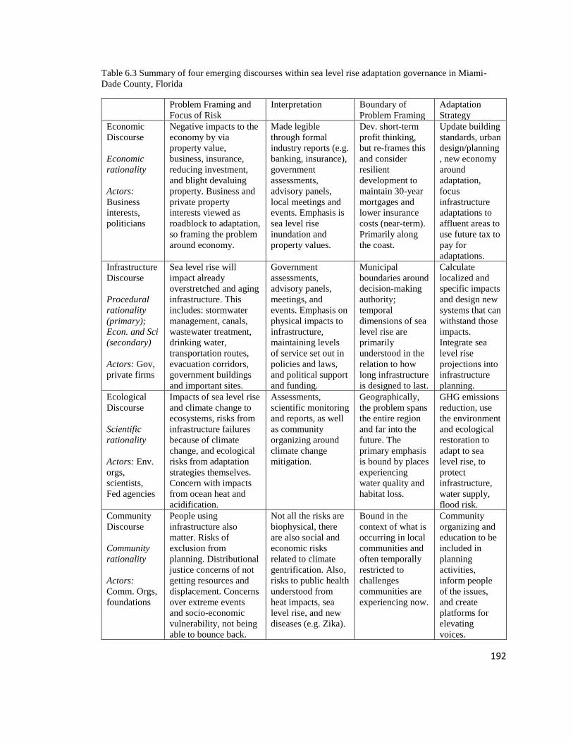
192
Table 6.3 Summary of four emerging discourses within sea level rise adaptation governance in Miami-
Dade County, Florida
Problem Framing and
Focus of Risk
Interpretation Boundary of
Problem Framing
Adaptation
Strategy
Economic
Discourse
Economic
rationality
Actors:
Business
interests,
politicians
Negative impacts to the
economy by via
property value,
business, insurance,
reducing investment,
and blight devaluing
property. Business and
private property
interests viewed as
roadblock to adaptation,
so framing the problem
around economy.
Made legible
through formal
industry reports (e.g.
banking, insurance),
government
assessments,
advisory panels,
local meetings and
events. Emphasis is
sea level rise
inundation and
property values.
Dev. short-term
profit thinking,
but re-frames this
and consider
resilient
development to
maintain 30-year
mortgages and
lower insurance
costs (near-term).
Primarily along
the coast.
Update building
standards, urban
design/planning
, new economy
around
adaptation,
focus
infrastructure
adaptations to
affluent areas to
use future tax to
pay for
adaptations.
Infrastructure
Discourse
Procedural
rationality
(primary);
Econ. and Sci
(secondary)
Actors: Gov,
private firms
Sea level rise will
impact already
overstretched and aging
infrastructure. This
includes: stormwater
management, canals,
wastewater treatment,
drinking water,
transportation routes,
evacuation corridors,
government buildings
and important sites.
Government
assessments,
advisory panels,
meetings, and
events. Emphasis on
physical impacts to
infrastructure,
maintaining levels
of service set out in
policies and laws,
and political support
and funding.
Municipal
boundaries around
decision-making
authority;
temporal
dimensions of sea
level rise are
primarily
understood in the
relation to how
long infrastructure
is designed to last.
Calculate
localized and
specific impacts
and design new
systems that can
withstand those
impacts.
Integrate sea
level rise
projections into
infrastructure
planning.
Ecological
Discourse
Scientific
rationality
Actors: Env.
orgs,
scientists,
Fed agencies
Impacts of sea level rise
and climate change to
ecosystems, risks from
infrastructure failures
because of climate
change, and ecological
risks from adaptation
strategies themselves.
Concern with impacts
from ocean heat and
acidification.
Assessments,
scientific monitoring
and reports, as well
as community
organizing around
climate change
mitigation.
Geographically,
the problem spans
the entire region
and far into the
future. The
primary emphasis
is bound by places
experiencing
water quality and
habitat loss.
GHG emissions
reduction, use
the environment
and ecological
restoration to
adapt to sea
level rise, to
protect
infrastructure,
water supply,
flood risk.
Community
Discourse
Community
rationality
Actors:
Comm. Orgs,
foundations
People using
infrastructure also
matter. Risks of
exclusion from
planning. Distributional
justice concerns of not
getting resources and
displacement. Concerns
over extreme events
and socio-economic
vulnerability, not being
able to bounce back.
Not all the risks are
biophysical, there
are also social and
economic risks
related to climate
gentrification. Also,
risks to public health
understood from
heat impacts, sea
level rise, and new
diseases (e.g. Zika).
Bound in the
context of what is
occurring in local
communities and
often temporally
restricted to
challenges
communities are
experiencing now.
Community
organizing and
education to be
included in
planning
activities,
inform people
of the issues,
and create
platforms for
elevating
voices.

193
By examining discourse storylines, it is possible to identify places where groups
are in alignment and where tensions may emerge in a diffuse governance arena. Across
all discourses, problem framing is tightly linked to proposed solutions. For example,
ecological problem framings are linked with the use of ecosystem processes to mitigate
impacts from sea level rise. Likewise, impacts to the community are matched with the
need to educate people and create opportunities to integrate diverse voices into adaptation
decisions. Similar patterns follow the economic and infrastructure framings. Further, the
role of private property is brought up in all four discourses though intersects with
problem framings and storylines in different ways. For each, private property is seen as
an impediment to adaptation solutions and/or as a source of risk. In the ecological
discourse, for example, private property is viewed as a barrier to implementing ecological
adaptations such as sand dunes and mangroves. Those in the community discourse view
the focus on risks to private property as something that excludes their interests from the
planning process. For the economic discourse, private property is used to frame the
problem of sea level rise, with risk shaped by property values and threats to private
property. This has similarities with the infrastructure discourse which complicates the
issue of private property surrounding service delivery.
The two most closely aligned discourses are the economic and the infrastructure
discourses. Within the economic discourse, part of the problem is framed around existing
and ongoing high-value development within low-lying areas that are viewed as being
vulnerable to sea level rise. Because local governments (the primary group involved in
the Infrastructure Investments discourse), are concerned with maintaining their tax base,

194
this gives individuals within the economic discourse practical authority in the governance
arena. There is evidence for this in that several members from the business community
are represented on sea level rise and climate change task forces and advising groups. Of
course, not all interests are aligned and those within the infrastructure discourse are
responsible for addressing non-economic factors to maintain quality of life, ecological
processes, and other goals. At the same time, people from the business community and
others shared how businesses push back against local governments for regulations that
create barriers to economic growth. From the infrastructure discourse, the emphasis on
risks to infrastructure and the link between infrastructure and tax-dollars creates a further
justification to engage with the business community. In addition, both the business and
the infrastructure groups view risks from sea level rise from a highly biophysical and
engineered perspective, framed in the context of risks to property value and insurance
rates. This framing places the focus of sea level rise solutions on engineered, technical
solutions while avoiding challenges around land use and social and environmental
impacts from those solutions—including new, resilient urban development. Local
governments primarily emphasize infrastructure to stabilize the risks of sea level rise and
ensure ongoing investments and insurance stabilization in the region. This emphasis
placed on infrastructure creates a knowledge arena that favors engineered, technical
knowledge and solutions and serves as a barrier to other interests, primarily ecological
and community based.
Within the ecological discourse, there is some alignment with the economic and
infrastructure discourses in that many evoke the role of the environment in protecting the
economy and built environment. Some ecologically based activities, for example beach

195
re-nourishment, demonstrate this link. While beach re-nourishment comes out of
infrastructure protection, many from the ecological discourse pointed to it as a “win-win”
solution, that it is good for the environment, infrastructure, and economy. At the same
time, economic and infrastructure impacts to the environment are viewed in tension.
Longer term and more complex impacts of climate change and sea level rise are
connected to calls for retreat and greenhouse gas emissions reduction.
There is also some overlap between the ecological discourse and the community
discourse. Both discourses frame part of the problem around the emphasis placed on
economic growth in the region at the expense of their interests. There has been some
alignment around calls for greenhouse gas emissions reduction and community
organizing around improvements to the local environment. At the same time, these
discourses are largely distinct with the environmental discourse focused primarily on
“traditional” ecological concerns such as Everglades and Biscayne Bay restoration
activities and the community discourse emphasizing hyper local and contextual
experiences.
The four discourse storylines around sea level rise adaptation governance that
emerged out of Miami-Dade County, Florida share commonality with other studies and
work on discourses around the environment. In terms of the tensions among the different
groups, this case study demonstrates how those are linked to different forms of rationality
and power dynamics (Hajer 1995; Fischer 2000; Bäckstrand and Lövbrand 2006; Dryzek
2013; Taylor et al. 2014). Although conflicts between competing discourses will
happen—different sides of a conflict interpret the issues at hand in different ways and the
way an issue is dealt with depends partly on the balance of competing discourses (Dryzek

196
2013). Within Miami-Dade County, the economic and infrastructure discourses are
primarily aligned with the most decision-making authority and power around adaptation
strategies. The infrastructure and economic discourses embody power which can advance
economic and growth interests while suppressing others (Foucault 1980). This is not
surprising given the privileged position of business in city planning because of tax
revenue (Lindblom 1978) and urban growth machine politics (Logan and Molotch 1976).
In considering the economic discourse, problem framings are born out of the
inevitability of financial impacts and the political inertia created by the business
community. This problem framing shapes much of the emphasis around planning
activities that support economic growth, reframing the issue around creating economic
opportunity. While climate adaptation studies have pointed to the way in which risks
from climate change are often understood in economic terms (Adger et al. 2005), it is
more complex than that. In Miami-Dade County, these risks to the economic core relate
to a view that they are also an opportunity to reshape the economy around an adaptation
and resilient development economy. Echoing calls for ecological modernization, in which
the economy is reshaped to support the environment (Bäckstrand and Lövbrand 2006),
business leaders and politicians that evoke the economic discourse storyline in Miami-
Dade County emphasize opportunity in the context of economic risks. Like critics of
ecological modernization theories, critics of this framing in Miami-Dade County point
out the contradiction: that the same economic rationality used to justify adaptation
planning is also creating the economic problem (Dryzek 2013). Critics of this logic point
to the ways in which ongoing development in the region—no matter if striving for
resilience from sea level rise—will continue to grow economic risks.
197
Local governments that primarily emphasize the infrastructure discourse latch
onto the economic framing to overcome political inertia and advance future growth in the
region. Within both discourses, large-scale retreat is not considered a viable option, and
local governments emphasize infrastructure to adapt the physical landscape to protect and
encourage economic investment. The combination of the emphasis on infrastructure and
the economy offers problem and solution framing to support ongoing growth in the
region. While this tactic is focused on maintaining community function in the region, the
primary underlying objective seems to be either in protecting assets from physical
impacts or from changes and risks of the insurance industry. The emphasis on having
formal assessments to base planning choices on are situated in procedural, economic and
certain scientific rationalities, leaving out and conflicting with community-based
interests. At the same time, the science used for infrastructure decisions often ignores
ecological science and debates in longer-term and more climate change complex impacts
on the environment. The divergence of these discourses is not perhaps surprising. In other
regions, pro-growth discourses have been shown to run in opposition of adaptation
planning and greenhouse gas emissions reduction. For example, Taylor et al. (2014)
examine the tensions between urban growth and climate adaptation discourses in
Queensland, Australia with pro-growth largely in conflict with GHG emissions reduction
and adaptation. The shift away from greenhouse gas emissions reduction and towards the
economy around adaptation is connecting what may otherwise be divergent discourses in
Miami-Dade County. However, the emerging discourses around the economy and
infrastructure shut out some discussions of retreat and greenhouse gas emissions—and
science used to inform those arguments—in favor of a pro-growth future.

198
The tendency for economic and procedural rationalities to be tied to formal and
contextual forms of power and authority within institutional arrangements governing the
urban environment is being re-produced in the context of sea level rise adaptation
planning. While such linkages have a long history in planning theory and practice, the
threat of sea level rise is primarily viewed as a highly expensive and engineering
challenge, places more emphasis on those rationalities. What this case study suggests, is
that although there are calls for integrative approaches that consider social and ecological
risk factors within the governance arena, these occur on the margins. Community groups
expressed feelings of being left out of planning processes and not having their interests
represented or discussed. Part of this is because of the view that sea level rise threats are
largely economic and physical, it seems to those that subscribe to these dominant
discourses believe that there is little need for attention to other interests. Interests within
the ecological and people-centric discourses are often infringed upon and go
unconsidered by the dominant narratives around problem and solution framing.
While the divergent storylines and interests create numerous planning challenges,
this case study also points to actors and activities that strive for more integration. These
places of integration represent seeds for where more communicative rationality efforts
can start to lead the way and help address many of the challenges discussed above. A
collaborative process can be communicatively rational “To the extent that all the affected
interests jointly engage in face-to-face dialogue, bringing their various perspectives to the
table to deliberate on the problems they face together… all participants must also be fully
informed and able to express their views and be listened to, whether they are powerful or
not. Techniques must be used to mutually assure the legitimacy, comprehensibility,

199
sincerity, and accuracy of what they say. Nothing can be left off the table. They have to
seek consensus.” (Innes and Booher 2010, p. 6). Based on ideas from Habermas (1984)
and Dewey (1927) and brought into the planning field by Healey (1997) and Forester
(1999), collaborative processes designed to generate collaborative rationality can produce
effective options for how actors can move forward together, and allow for collective
learning that will help make communities more adaptive and resilient (Innes and Booher
2010). In the Miami-Dade County case study, the 100 Resilient Cities initiative,
community outreach and involvement practices by local organizations, and the Compact
have certain elements that offer possible direction for collaborative planning. For
example, each of these initiatives is bringing diverse interests and people into the
planning process and opening the conversation around sea level rise to other perspectives
and problem framings. While some of the divergent interests have yet to be formally
addressed in planning processes, the connections being made are bringing stakeholders
that had been left out of sea level rise into the planning process.
Design charrettes and activities looking at neighborhood scale have begun to
build these connections. The Compact has played a large role in supporting these efforts
which bring together universities, governments, scientists, and stakeholders for short,
design charrettes to look at a small area. This type of work could be expanded and
formalized by local governments. Broader public engagement efforts are needed around
resilient community design activities. Because existing efforts have tended to be on
shorter planning timelines, they have been limited in public engagement.
Within Miami-Dade County, building off the existing collaborative approaches
could move the region into a more communicative approach. One mechanism would be

200
to adjust the role of the Resiliency Officers, supporting the 100 Resilient Cities Planning
Effort, from one that is primarily internally focused as cross bureau relationship
managers to a position that incorporates communicative planning. Resilience Officers
could work integrate communicative planning process into all dimensions of
infrastructure and planning choices by creating education and outreach materials,
establishing community advisory committees, and creating an equity and justice division
to provide oversight. There is currently a lack of community dialogue being integrated
into infrastructure adaptation planning decisions. Establishing the role of Resilience
Officers as one that expands public engagement around cross-bureau planning activities
could help address this issue.
These cross-sector efforts show early signs of groups working together to find
more holistic and joint problem framings around the risks of sea level rise. Another
potential mechanism to integrate a more communicative approach could be to use joint
fact finding to frame the problem of sea level rise (Susskind et al 1999; Innes and Booher
2010). The approach connects diverse stakeholders to the process of identifying risks and
creating and using different forms of knowledge to frame problems and solutions (Innes
and Booher 2010). In Miami, this could occur with community derived baselines of
acceptable risks that currently exist outside of mainstream activities and instead be
integrated into existing assessment processes. This practice can be a powerful tool where
even if the outcome was not what the group predicted, they may still be happy with the
decision that was made. For example, Inness and Booher (2010) point to a case in which
stakeholders brought together by the CALFED Bay-Delta Program agreed to close off
one channel to allow more flow into the delta in fear of drought conditions. All the

201
participants agreed, including the Los Angeles Metropolitan Water District, which was
significantly harmed by the decision. These participants testified that though the result
was unsatisfactory, and there was a mistake in judgement (the drought did not occur) that
the decision was right. Collaborative approaches can help uncover issues of dubious
findings, opens-up assumptions, identifies biases, and dismisses unsupported claims and
ultimately, the “truth” is whatever the group agrees upon (Innes and Booher 2010). More
participatory activities around different infrastructure projects could produce similar
results in Miami. This would require a restructuring of the way infrastructure is assessed
and planned for from one that is predominately expert driven towards a process that is
more open and engaged with the broader community. Efforts by the City of Miami Beach
to provide public information surrounding adaptation planning are a good start, but more
mechanisms for public engagement and integrating diverse perspectives would help the
city and the region overcome some of the current conflicts and challenges.
6.6 Conclusion
This chapter used an institutional discourse approach to examine sea level rise
adaptation governance in Miami-Dade County. Within Miami-Dade County, there are
several governmental and non-governmental institutions involved with sea level rise
adaptation planning, and these activities take place across a variety of adaptation
strategies. The four emerging discourses—around the economy, infrastructure,
environment, and community—mirror other findings around discourses related to
environmental changes and risks. The economic and infrastructure discourses are at the
core of adaptation governance while discourses around the environment and communities
exist on the periphery. Though the case study shows that the region has yet to achieve
202
integrative approaches across divergent discourses, these institutions and the governance
arrangements are not static. The case study also demonstrates that some activities and
individuals are actively working to address these issues. It is in those activities where
communicative approaches may expand and integrate broader aspects of the system.

203
Chapter 7 Miami-Dade Case Study Conclusions, Theoretical and Planning
Contributions, and Recommendations
Some people are very gloom and doom, but that's also sort of by necessity,
because we don't really know what to do about it. There isn't one easy
silver bullet that's going to fix it like, “If we just paid for this thing it
would fix everything.” The geology here is very difficult, we have so
much infrastructure along the water, and we have a state that won't talk
about climate change. We have cities and counties that are relatively
recently talking about this as an issue, and we don't have great plans.
-Environmental Organizer in Miami-Dade County, Fl
7.1 Summary of Findings from Miami-Dade County, Florida
In Miami-Dade County risk construction around sea level rise generally follows a
hazards assessment approach. Local governments, scientists, and other institutions
seeking knowledge about the risks from sea level rise emphasize reducing uncertainty
around rates and projections and how that will interact with the local landscape and
hydrogeologic conditions. The process of determining what risks to select is a negotiated
and contested political process underscored by climate change denialism, scientific
reticence around ice melt acceleration, and political uncertainty as to how people would
react to higher projections. The need for a narrow range of sea level rise projections
comes from local governments requiring specific numbers to design and implement
adaptation planning activities. Part of the desire for local governments to strategically
identify solutions is in response to the scientific uncertainties and tendency of some
people to be very “doom and gloom” as described in the quote from an environmental
organizer at the beginning of this chapter. Local governments strive to create hope and
present a future for people in Miami. To do so, they promote risk knowledge that can
allow them to present a secure future for people in the region. At the same time,

204
knowledge suppression practices may also present minimized risks to the landscape to
continue allowing economic growth in the region.
Considering sea level rise adaptation governance, there are several governmental
and non-governmental institutions involved with sea level rise adaptation planning, and
these activities take place across a variety of adaptation strategies. These diverse groups
frame the risks of sea level rise around four emerging discourses—focused on the
economy, infrastructure, environment, and community. Economic and infrastructure
discourses are at the core of adaptation governance while discourses around the
environment and community exist on the periphery. This privileged framing connects
with risk construction and knowledge practices around risk.
In linking the findings from Chapters 5 and 6, narrative discourse storylines that
frame risks from sea level rise in the context of the current and future economy and
infrastructure closes-down knowledge production practices and serves to limit diverse
knowledge integration around risks. The self-fulfilling process that frames risks from sea
level rise as a threat to the future of Miami’s economy places much of the emphasis on
knowledge practices and identifying solutions to minimize risks to the economy. While
the case study shows that the region has yet to achieve integrative approaches across
divergent discourses, it also demonstrates some activities that are currently trying to
address the lack of integration. It is in those activities where communicative approaches
may expand and integrate broader aspects of the system.
7.2 Situating Case Study Findings in Risk and Planning Theory and Practice
Within environmental planning, theorists examine the way in which institutions
understand risk and how diverse understandings can lead to conflicts, barriers to

205
implementation, and uneven benefits and harms (Beck 1992; Fischer 2000; Bocking
2004). This work has been applied in several different planning contexts. When applied
to environmental toxicants, for example, local communities, environmental organizations,
and other affected parties are often less willing to accept government and industry
standards for “safe” levels of exposure, advocating instead for stricter regulations and
“cleaner” environments (Fischer 2000). Standards around allowable levels of
contaminants in the environment that favor economic interests over community interests
can result in community pushback in the form of protests and lawsuits at best, and public
health crises at worst. Risk literature on hazards shows how risks are disproportionately
distributed across the landscape, often with low-income and historically marginalized
communities exposed to more hazards (Wisner et al. 2014). What these and other studies
point to is that although there are multiple ways to understand and come to “know” risks,
the planning arena often prioritizes risks that are understood through a top-down
government driven process that favors some knowledge over other knowledge. Part of
this is based on the role of uncertainty, and the drive for governments to present certainty
and confidence in their ability to manage risks (Innes and Booher 2010). The desire to
represent risks as measured and manageable is wrapped up in the need to establish trust
and confidence among the public (Beck 1992). At the same time, however, such top top-
down knowledge practices are often disconnected with other ways of understanding risk,
and the desire for certainty in a complex and uncertain world can backfire. This can occur
through community pushback, distrust, and with the reproduction of social inequities
through risk management. Because of these challenges, risk theorists regularly call for

206
integrative approaches to incorporate social and cultural components into the production
of risk knowledge, prioritization, and planning (Wisner et al. 2014).
From knowledge systems literature, we know that either intentionally or
unintentionally ignoring different forms of knowledge—especially around risks—can
result in barriers to risk knowledge integration and disproportionate planning outcomes
that favor some communities over others (Miller and Muñoz-Erickson 2018). The Miami-
Dade County case study on sea level rise adaptation planning points to similar processes
around risk. At the same time, however, institutions governing risk are not static and even
if limited, risk knowledge is leaning towards more integration going forward.
Applying risk construction and knowledge integration to the context of climate
change adaptation planning expands theories and practice around risk in key ways. While
the risk literature often focuses on a hyper local scale, risks from climate change are
understood at a global scale and are dependent on models compiled from local scale data
sets (Edwards 2001). There is also a temporal mismatch on how risks from climate
change are understood, in that risks that are understood as possibly occurring in the future
are measured, prioritized and planned for now. These future risks also shape present day
discourses around how the problem is framed, understood, and different solutions for
addressing those risks. Projecting climate into the future and at global scales has several
uncertainties that are debated, politicized, and lead to additional scientific research to
reduce those uncertainties (Edwards 2001).
Although the global and temporal distinctions surrounding climate change risks
create new risk construction challenges, there are several components of climate change
adaptation planning that are like other risk construction and planning contexts. Primarily,

207
global and temporal constructions of climate risks are interpreted and adopted at regional
and local scales (Adger et al. 2005). Such localized processes mirror other risk practices
in which global, scientific knowledge (i.e. around contaminants, technologies, hazards)
are debated and brought to bear in local settings. Like these other risks, knowledge about
the biophysical hazards of sea level rise are constructed and then converted into risks by
governments and non-governmental institutions in the way that those hazards are
understood to intersect with social, ecological, and technological systems (Adger et al.
2005). The centrality of both decision-making authority and knowledge production
practices around risks echo Muñoz-Erickson’s (2014) findings on knowledge practices
around land use in San Juan Puerto Rico. Like Muñoz-Erickson’s (2014) findings, in
Miami-Dade County, institutions that dominate knowledge about risks from sea level rise
also make most of the decisions. This suggests that a lot of what we know about risks
from sea level rise are filtered by values of actors controlling adaptation resources
(Muñoz -Erickson 2014). At the same time, from the experience of Miami-Dade County
identifying, prioritizing, and planning for risks from sea level rise, we see that risk
knowledge is also contested. It is through the different contestations that we see how
future and current uncertainties around sea level rise risks create a planning arena in
which risks are open to social construction (Beck 1992). The local governments’
perception for a need to identify tangible risks and to mitigate these risks creates problem
closure around risk construction rooted in biophysical and economic framings (Hajer
1995). The question then becomes how to situate these findings in the context of risk and
planning theory and practice, how this links back to the problem of planning for sea level
rise adaptation, and what actions can be taken to address these issues.

208
The case study on knowledge practices and sea level rise adaptation governance
in Miami-Dade County contributes to the theoretical and planning literature around risk
knowledge production and governance in three important ways: 1) Risk knowledge about
sea level rise is constructed and prioritized in a primarily top-down approach; 2) This
construction of knowledge for action is created in political, social, and economic contexts
and shaped by the idea of taking action and what is possible to manage; and 3) The way
in which risk knowledge is constructed, favoring certain political and economic values
over other values on the landscape, creates a planning arena in which the “facts” are
already stacked against groups representing other interests.
First, risk knowledge constructed and prioritized in a primarily top-down
approach produces knowledge that is situated in plans connected to drive action. Risk is a
concept that is fundamentally connected to uncertainty. If societies knew the exact
outcomes of a situation or decision, there would be no risk because they would have
perfect information of how to act to mitigate that risk. Climate change risks are
understood in different ways and shaped by different knowledge practices and epistemic
choices that can drastically change their significance, level of uncertainty, and magnitude
of the outcome. While the exact rates and impacts of sea level rise can never be known,
institutions create knowledge around what they think those impacts might be, and this
knowledge is shaped by institutional positionality as well as interactions with outside
pressure and knowledge acting on those institutions. This process in Miami-Dade County
continues to unfold as a system of complex relationships and forms of knowledge and is
bound by codified institutional arrangements and power structures.

209
Risk knowledge that falls outside of what can systematically be planned for is
ignored in dominant problem framings, planning documents, and formal public forum. In
the early 2000s, knowledge of impacts from climate change began to reach the
mainstream media and concerns over sea level rise placed Florida—a very low-lying
state—at the center of these narratives. Former Vice President Al Gore and others were
discussing the vulnerability of South Florida and cities within Miami-Dade County early
in this process. Locally, geologists, other scientists, and environmental groups mobilized
around climate change and sea level rise impacts. At the same time, king tides, rain
events, and the threat of storm surges put pressure on local governments to address
flooding issues. Local governments in Miami-Dade County began to pay attention to
issues of sea level rise and wanted to “get ahead of the issue” to change the global
narrative of doom and gloom. In the mid and late aughts, local governments began
assembling committees, task forces, and adopting ordinances for how to understand and
address these issues. This organization was partially in response to the global narratives
of the insurmountable risks that cities within Miami-Dade County would suffer including
destruction and economic loss if they took no action to adapt.
Based on this risk of economic loss via changes to the insurance and reinsurance
industries, flooding, and loss of investments, local governments have been the primary
focus for actions deemed necessary to change the global narrative around destruction,
towards a narrative of continued growth. To do so, knowledge about risks were shaped in
a way commensurate with the ability to act and systematically identify risks and plan to
mitigate those risks. To control the narrative around action, risk knowledge about sea
level rise has been and continues to be constructed and prioritized in a primarily top-

210
down, technocratic approach. This produces knowledge that is situated in plans
connected to drive action. Because much of the knowledge about sea level rise risks
comes from technocratic planning activities by local governments, that knowledge is
primarily constructed in relation to priorities and actions of local government. The
emphasis on infrastructure, building codes, and insurance are rooted in a system that
prioritizes the primary roles and responsibilities of local government.
By understanding risks via what institutions governing risk care about, we also
see that the risk knowledge is shaped by the constraints around what can be done to
mitigate those risks. Within Miami-Dade County, we see this in that most of planning
activities that are designed for no more than 30 years—or 2 feet of sea level rise—into
the future. The idea that planning for any more than that would “kill the economy,” as
several planners shared. Knowledge suppression practices around the hydrogeologic
connections between groundwater, surface water, and broader impacts from climate
change take place to minimize risks on the landscape. This is in part because
acknowledging these impacts would render future land use planning as currently
envisioned impossible, since more of the region would be deemed undevelopable. Risk
knowledge that falls outside of what can systematically be planned for is also ignored in
dominant problem framings, planning documents, and formal public forum.
While this case study also points to places of intervention, where individuals
acting within the system are seeking more integrative approaches, the present trajectory
around knowledge production practices around risk suggest that these attempts will
continue to fall short. This is because most of these strategies to integrate diverse
perspectives take place following the knowledge production process, and this risk

211
knowledge already embeds values that may not align and may run counter to other
interests on the landscape. The way in which risk knowledge is constructed, favoring
certain political and economic values over other values on the landscape, creates a
planning arena in which the “facts” are already stacked against groups representing other
interests. Drawing on recent knowledge systems work by Miller and Muñoz-Erickson
(2018), collaborative planning work of Innes and Booher (2010), and others, for regions
to integrate diverse constructions of risk, they must pay attention to the design of their
knowledge system and integrate more stakeholders into the planning process.
7.3 Strategies to Address Risk Ambiguity Challenges in Climate Change Adaptation
Planning
While it is often thought that planning is about linking knowledge and action
(Friedmann 1987; Innes and Booher 2010), we now extend this to question the nature of
that knowledge and its purpose for action (Miller and Muñoz-Erickson 2018). The quality
of knowledge reflects the process of how knowledge was made (Miller and Muñoz-
Erickson 2018) and who participated in the production of that knowledge (Innes and
Booher 2010). Unfortunately, institutions often lack a clear understanding of how their
knowledge is constructed and based on the organization’s own values, routines,
assumptions and other factors which can be both explicit and hidden (Miller and Muñoz-
Erickson 2018). The different ways in which institutions construct risk knowledge can
create ambiguity emerging out of different problem framings and ways to understand the
problem. Overall, reflexivity, or self-confrontation and self-reflection, provides an
opportunity to change this practice. The call for reflexivity in the biophysical and social

212
sciences urges scientists to examine how the knowledge they produce, and the methods
used to produce it, are influenced by political, historical, cultural and social processes
(Harding 1987; Boström et al. 2017). Interest in reflexivity emerged from concern about
how “truth claims” serve particular political and private interests. More recently, scholars
have extended the call for reflexivity to environmental governance (Dryzek and Pickering
2017), to examine the politics of knowledge, public discourse, and institutions to improve
policy outcomes. Others have begun to develop models for institutionalized reflexivity
where environmental institutions develop mechanisms for examining their own political
commitments, constraints and assumptions, opening these issues to public debate
(Boström et al. 2017).
I echo the call for reflexivity to the practice of identifying and planning for risks
from impacts and climate change. While some of the knowledge practices within Miami-
Dade County point to the overshadowing of diverse representations of risk in framing the
problem and identifying solutions, there are also actors working towards knowledge
integration. In this vein, I use the findings from Miami-Dade County—both the
challenges and the opportunities—to offer recommendations to create more integrated
ways for regions to assess and manage risks from climate change, overcoming challenges
related to risk ambiguity.
Train experts in areas outside of their disciplinary boundaries
Part of the challenge around risk knowledge integration in Miami-Dade County
are the epistemological conditions surrounding expertise. Within sea level rise adaptation
planning, it is often engineering expertise that is relied upon for decision-making. This
expert knowledge has epistemic rules that influence the construction of risk knowledge.

213
In Miami-Dade County, for example, engineers and experts producing most of the
knowledge about risks are not necessarily trained to account for social and ecological
system components. Several shared that the risks are primarily physical and saw
engineering analysis and solutions as being equal across socio-economic conditions. This
problem is not unique to sea level rise risks, but other work points to epistemic challenges
around how risks are measured, and experts having certain rules of their field (Miller and
Muñoz-Erickson 2018). Because this problem is ubiquitous across different types of
risks, scholars have begun to identify ways to shift the epistemic rules guiding expert
disciplines. For example, Jack Ahern (2011) presents an argument to change engineers
thinking from “fail safe” to “safe to fail” to incorporate ecological processes and dynamic
natures into engineered systems. Engineers often place the emphasis on over designing
systems so that they will not fail, similar to the findings in Chapter 6 around policies that
emphasize “hard” infrastructure. While fail safe designs are important in many contexts,
natural systems are dynamic and impacts from climate change introduce additional
uncertainty into the system. In response, the call to transition thinking to “safe to fail”
introduces more flexibility into engineering epistemic views (Ahern 2011), similar to the
calls for flexible infrastructure in Chapter 6. This is only one example, experts that
represent the dominant knowledge framings around risk can be trained outside of their
disciplinary boundaries to reframe the epistemic conditions which guide those knowledge
practices. This can occur with climate scientists working with philosophers, engineers
intersecting with social scientists, and other forms of disciplinary integration.
Create multi-faceted risk assessments

214
Most of the formal risk assessments used in Miami-Dade County emphasize
economic and infrastructure risks, including property value, stormwater infrastructure,
and transportation infrastructure. There is a critical need to expand this to integrate social
and ecological risks into core municipal government planning assessments. A goal for
regions undergoing adaptations to climate change should be to create multi-faceted risk
assessments. While these currently exist on the fringe in Miami-Dade County, local
governments have most of the decision-making authority over how to prioritize actions
and they rely on risk assessments that ignore social and ecological components. Recent
advances in hazards literature incorporates social dimensions of hazards (e.g. Solecki et
a. 2011; Wisener et al. 2014), which can include different socio-economic characteristics
such as income level, number of minorities, different health indicators, and other
characteristics that relate to social vulnerability (Solecki et al. 2011; Wisener et al. 2014).
Integrate an equity lens into planning
Local governments could conduct assessments that relate to those who are the
most socio-economically vulnerable and address some of the concerns and questions
raised by community organizations. For example, rather than only examining the impacts
on changes to the insurance industry, local governments could conduct assessments of
how those who do not carry flood insurance will be affected. Another concern that could
be assessed includes climate displacement due to inhospitable living conditions and
adaptation policies. In addition to conducting a formal assessment of this issue, local
government could track where people are being displaced to and the risks that surround
their new location. Researchers are integrating these kinds of approaches, called co-
production of science and actionable science (Vogel et al. 2016; Kjellström et al. 2016;

215
Beier et al. 2017). While this has largely focused on better establishing relationships
between scientists and managers, this field is expanding to incorporate broader
stakeholders in the production of science that can be directly used in decision-making
(Innes and Booher 2010; Miller and Muñoz-Erickson 2018). There are many ways local
government could use these approaches to create integrated risk assessments or
assessments for interests currently on the fringe. For example, during the CLEO
Institute’s listening sessions, communities highlight issues of pressing concern. Local
governments and researchers could build assessments framed by these concerns, putting
resources to answering and solving problems that matter to the community. The climate
gentrification map that came out of a Florida International University professor attending
a listening session is a good example of knowledge co-production. Local governments
better connected to decision-making and resources could work with the existing
community organizing efforts and relationships to allocate funding for assessments that
seek to understand risk from diverse perspectives, including assessments framed by the
community. This can also be paired with more participation in risk evaluation and setting
baselines for management.
Broaden adaptation measures with plausible scenarios approach and incremental
planning
Risk theorists argue for increased participation in decision-making that surround
knowledge production and governance of risk (Beck 1992; Fischer 2000), applied to
climate change adaptation planning this means broader participation in risk evaluation
and setting baselines. Within Miami-Dade County, most of the decisions surrounding
how to measure, assess, and prioritize risks take place in a closed off arena of experts and

216
decision makers. This process has served to limit broad representation and integration of
risks. In addition to ecological and social risks existing largely on the periphery, planned
retreat is primarily ignored. This is in part due to current accepted baselines and risk
framings demonstrating the possibility of continued growth. However, many scientists
and even some planners argue that these baselines are a minimum and that actual sea
level rise rates and impacts will be far greater.
Incorporating broader participation into decisions surrounding baselines and risk
evaluation would enable civic dialogue and engagement around risk (Beck 1992; Fischer
2000). There is very little information regarding public perspective on rates of sea level
rise, because the regionally adopted government projections are assumed to be the “real”
rates from which peoples’ perspectives are measured against. These “real” rates could
either be wrong, or as many scientists suggest in the case study, should be taken as a
minimum. This suggests that broader adaptation measures should be taken to capture
more plausible futures, or futures that wider stakeholder groups view as plausible,
including the upper boundaries of the risk.
Presenting upper boundaries of the risk for planning can have its own challenges
because addressing large scale change is difficult in any planning context. One approach
to include the upper boundary of the risks would be through looking at incremental
changes overtime using plausible scenarios that look at several planning horizons.
Broader participation in decisions surrounding what different incremental planning
horizons to include along with the upper boundaries of the risk would help the region
identify incremental planning solutions to address issues at different stages. A plausible
futures scenarios approach with different temporal increments of potential change can

217
engage communities to consider ways to address the issue of uncertainty around different
climate futures at different planning horizons (both short term and long term) in the
future. This would entail planners to open-up the climate projections they have currently
selected when they engage with diverse stakeholders. Rather than assume the regionally
adopted sea level rise projections, stakeholders could engage in planning activities to
examine impacts from a range of possible climate scenarios to determine different
adaptation responses.
Identify visions for post environmental disaster
Current knowledge practices that close off debates around baselines and
projections allow local governments to present a vision for the future of Miami that
allows continued resilience, growth and prosperity. While not mal intended, this framing
potentially minimizes the current risks and given more knowledge on the topic and more
ability to influence decisions, civic epistemologies may or may not change this
perception (Miller 2008). The intentions of local governments to present an optimistic
future are important, but optimism and retreat do not run counter to each other as local
governments project. Though decisions about community and individual retreat are
highly political and deeply personal, there are examples of voluntary retreat programs
following Hurricane Sandy in New York and New Jersey. In Miami-Dade County,
discussions of retreat are shut out of local government, though interviewees from federal
government agencies brought up the need for the region to begin this conversation. There
are multiple ways to look at retreat. Retreat can symbolize the death of community or the
death of place or, it can allow for risk avoidance (financial, personal, and human life).
This is an area where post disaster recovery planning can be beneficial (Berke and

218
Campanella 2006). Public engagement practices that address community values, politics,
and what visions people have for their communities post environmental disaster offer a
way to build conversation around regional goals for a longer-term vision of the
community (Berke and Campanella 2006). Within Miami-Dade County, this could allow
for opening-up the conversation around planned retreat rather than economic disaster
forcing retreat.
Reframing the issue to broaden scope and create more public involvement
In Miami-Dade County, current modes of public involvement in adaptation
planning center on climate change and sea level rise focused advisory panels, which the
City of Miami Beach and the City of Miami both currently have, and Miami-Dade
County had in the past. Within this planning context, the focus is primarily on sea level
rise, with less engagement in broader climate change issues including heat waves,
changes to hurricane patterns, other climate stressors, and mitigation. Several individuals
from the ecological and community discourses expressed these limitations and shared
that they want to see the planning issues broaden to include more aspects of climate
change. This would expand the planning conversation around different risks—not just sea
level rise risks—and also to different solutions, including more mitigation and solutions
that address these additional risks. Mitigation was framed by many in the environmental
discourse as a necessary part of adaptation to slow-down and limit the problem of sea
level rise.
In addition, a re-framing around resilience currently underway via the 100
Resilient Cities initiative is one approach to broadening the scope to create a more
inclusive dialogue. The planning efforts that are framed as sea level rise adaptation

219
planning are primarily expert driven and limit public involvement. Perhaps a re-framing
of sea level rise adaptation planning to the context of reducing harm to communities
could help broaden scope (e.g. to include crime, safety, hurricanes, heat, etc.) and
increase participation. Additionally, while the Southeast Florida Regional Climate
Change Compact (Compact) provides easy online access to planning assessments and
documents, several planning activities remain out of public view. For example, while the
county provides access to generalized risk assessments, publicly accessible information
around stormwater infrastructure and decisions regarding how stormwater projects are
prioritized is lacking. Interviewees from outside of government expressed frustration with
not having information regarding stormwater planning in Miami-Dade County. Similar
frustration occurred among City of Miami Beach residents as adaptation projects were
implemented. When newly installed stormwater pumps failed and flooded a local
business, residents and business owners began to demand more transparency around
planning. This resulted in the City of Miami Beach hosting open houses about project
development. This activity helps address issues of transparency but at the same time is
primarily a one-way flow of information. Reframing these infrastructure adaptation
planning activities around reducing harm to communities could open up this planning
process from expert-driven towards broader inclusion.
Increase transparency and actively solicit input from groups
Other approaches to increase transparency and public involvement would be to
require community engagement strategies be developed for each plan, have community
advisory panels for different infrastructure planning divisions, and have an environmental
justice and service equity division. The Seattle Public Utilities in Seattle, Washington, for

220
example, uses these tools to both create more transparency in their infrastructure planning
activities and increase public involvement in decision-making. Within Miami-Dade
County, local governments could provide information that emphasizes how infrastructure
and flood management decisions are assessed and create direct pathways for
involvement. The budgetary oversight committee being established for the Miami
Forever Bond is a good place to start. It is also possible to imagine a service equity
oversight committee reviewing codes for project selection criteria and propose criteria
around environmental justice and equity. Within Miami-Dade County, the Resilience
Officers primarily focus on building connections across sectors of government to work
towards creative resiliency planning. Their role could be expanded to also promote
transparency and public engagement in all infrastructure planning decisions. In this way,
they could help serve as a boundary organization or integrate existing boundary
organizations between infrastructure, environmental and social justice communities. They
could be engaged in organizing and institutionalizing oversight committees across
multiple layers of municipal planning and representing multiple interests. A formalized
climate justice committee could review planning related to climate change adaptation,
including changes to zoning that may lead to displacement. This would move position of
the planner from internally facing to outward facing and a turn towards a more
communicative approach to resilience planning.
Reflexivity in climate adaptation planning
While much of the risk knowledge and governance practices come out of an
expert and decision-maker space focused on infrastructure and the economy, there are
elements of the current planning process that bend towards more integration. This is

221
evident in the Resilient Cities initiative, activities of the Compact, and community
organizations seeking to incorporate broader groups through education and organizing.
Expanding these communicative processes to more aspects of sea level rise adaptation
planning can serve as a point of reflection for planners embedded in the process. For
example, a communicative process around stormwater adaptation planning could expand
knowledge practices from just favoring scientific-technical knowledge, to one that
recognizes multiple types of knowledge and the values embedded within them. Climate
adaptation planners can build more reflexivity in the planning process by examining
knowledge biases in current decision-making frameworks, identifying how diverse public
views are integrated into planning decisions, and assessing modes of participation and
ensuring that everyone has a seat at the table for all adaptation planning activities. These
reflexive practices must extend beyond the communicative approaches and towards
activities governing decisions around infrastructure, a predominantly expert and decision-
maker space. Opening-up these predominantly technocratic planning spaces towards a
reflexive and communicative approach can foster trust and create shared meaning and
problem framing around risks from sea level rise.
7.4 Conclusion
On October 22, 2018, WLRN Public Radio and Television in Miami hosted a sea
level rise adaptation expert panel to share their perspectives and where they view the
region headed. The four panel members each represented the following categories,
closely aligned with the discourses identified in this dissertation: an environmentalist, a
community activist, a local developer, and a government planner. As if it were
choreographed, each spoke of the problem in relation to what they prioritize and value on

222
the landscape. The environmentalist emphasized the need for carbon reduction and
possible planned retreat, while the community organizer discussed the impacts to low-
income communities and the responsibility of others to support those who cannot afford
to adapt. The developer discussed innovative building solutions and the need to secure
investments in economic hot spots and high tax base areas. Finally, the planner
recognized the importance of all these issues but emphasized adapting infrastructure to
secure investment. This was explained as a necessary first step to stabilize the situation
and attract external investments to be able to afford the necessary adaptations that would
be needed. While this planner kept coming back to acknowledging the variety of ways
people are impacted, this planner is also confronted by the risk of major physical impacts
on municipal infrastructure, and the obligation to provide services to citizens. Such short-
term planning, addressing the immediate needs for infrastructure and investment, cannot
preclude the region from finding more integrated solutions. Although the current
planning trajectory around risk appears to leave people out, the region can build off the
existing communicative strategies to create a more integrated planning future for the
region.
While this chapter offers a conclusion and recommendations for the Miami-Dade
County case study, the following Chapter 8 offers an integrated approach to how this
might be applied to sea level rise knowledge practices from global to local scales. More
work on knowledge and governance practices around climate change adaptation planning
is needed to understand how those practices help or hinder diverse knowledge
integration.
223
Chapter 8: Re-Scaling the Black Box of Decision-making: Global to Local
Knowledge Practices of Sea level Rise Risk in Coastal Adaptation Planning
Mary Ann Rozancea*, Ashlie Dentona, Zbigniew Grabowskib, Marissa Matslerb, and
Wendy Mayhughc
a College of Urban and Public Affairs, Portland State University, Portland, United
States;
b Cary Institute of Ecosystem Studies;
C Department of Geography, Portland State University
8.1 Introduction
Over the past century, changes in mean sea level and increased tidal fluctuations
have been recorded around the world and modeled projections show the potential for sea
level rise to significantly impact cities’ social, ecological, and technological systems
(IPCC 2012) here termed SETs (Grabowski et al. 2017). In two particularly vulnerable
regions—the South Pacific and South Florida USA—sea level rise is expected to be
around 80 inches by 2100 (Compact 2015; Sweet et al. 2017); this rise is expected to
contribute significantly to extreme weather-related risks (IPCC 2012). In response,
coastal governments work to manage threats posed to urban life (e.g. raising roads and
expanding stormwater drainage in Florida and discussing plans for retreat and relocation
in Kiribati). These sea level rise adaptation strategies vary in their underlying value
systems, spatial scales, and forms of institutional collaboration. While part of a seemingly
innocuous technical planning processes, sea level rise transitions are inherently political
in their processes, indicators, and outcomes, often reinforcing long-standing unequal
development and power relations (Kaika 2017), because the types of knowledge and

224
expertise used in decision-making inherently ignore some risks and favor others (Gross
2010).
Scholarship on community and urban resilience continues to rapidly evolve,
encompassing prescriptive and descriptive analyses (e.g. Cutter et al. 2008), as well as
process-based approaches that frame resilience as an emergent property of risk-
negotiating social, environmental, and infrastructural systems (Adger et al. 2005). Here
we expand this work by asking how different socio-political arenas describe and frame
the risks of sea level rise at different temporal, spatial, and administrative scales. We use
knowledge systems analysis to expose linkages between global and local knowledges and
transformations of irreducibly complex social, ecological, and technical systems (SETs)
of the city (McPhearson et al. 2016) and beyond. Drawing upon field work with urban
and regional managers and engaged communities, we propose the concept of ‘scalar
politics of risk,’ i.e. the ways in which scales explicitly frame and channel interactions
between knowledge systems that define and manage risks. Here we provide a theoretical
grounding for this approach, explicate five distinct arenas of ‘scalar politics,’ and
illustrate the utility of this conceptual framework (Figure 1) by examining results from
interviews with practitioners and communities engaged in sea level rise adaptation in
Miami, USA and the Pacific Islands. By exploring the scalar politics of risk, we present a
framework for exploring sea level rise (and other) governance that can make more
explicit the knowledge systems and politics at play within multi-scalar governing bodies.
Theoretical Grounding of the Scalar Politics of Risk
The notion that systemic forms of knowledge are developed and often
problematically deployed by governments and municipalities to manage territories,
225
populations, economic activities, and infrastructures have long been studied by scholars
of science and technology studies (Scott 1998; Graham and Marvin 2001, Pritchard
2011), including those explicitly examining city level adaptations to climate change
(Miller 2004; Muñoz-Erickson 2014). We draw on these works, as well as fundamental
concepts of coproduction of knowledge and social order (Foucault 1980; Jasanoff 2004),
knowledge systems analysis (Miller and Muñoz-Erickson 2018), and the social and
scientific production of risk (Beck 1992) to examine sea level rise.
First, of particular importance to understanding sea level rise adaptation is the
literature examining the totalizing potential of seemingly apolitical scientific knowledge
production (Porter 1996), which can erase the social and political contingencies of its
production, or the ‘power knowledge relationship’ (Foucault 1980). Powerful actors often
frame specific knowledges as inherently apolitical, obscuring the actual political and
subjective elements of knowledge creation (Hajer 1995; Jasanoff 2004; Agrawal 2005).
Jasanoff (2004) describes this power/knowledge relationship as coproduction. She
explains, “Scientific knowledge, in particular, is not a transcendent mirror of society. It
both embeds and is embedded in social practices, identities, norms, conventions,
discourses, instruments, and institutions” (Jasanoff 2004, p. 3). Thus, looking through a
coproductive lens clarifies the ways in which particular understandings of the world are
privileged in questions of what is being studied, why it is being studied, and how it is
being studied (Porter 1996; Scott 1998; Jasanoff 2004). These considerations are not only
theoretical, but also inherently practical as local climate adaptations form the basis of the
urban experience of sea level rise, and misalignment between framings at different levels

226
of decision-making about adaptation can lead to less equitable and less effective
outcomes.
Second, to help expose the underlying coproduction of sea level rise adaptation,
we utilize knowledge systems analysis. Organizations often focus on examining policy
outcomes rather than the values, assumptions, and routines that go into their policy
decision-making processes in the first place. Knowledge systems analysis, instead,
examines how knowledge is conceived and constructed for decision-making, rejecting the
concept of the “logic of discovery” that assumes knowledge is found, pre-formed and
ready for use (Miller and Muñoz-Erickson 2018). Knowledge systems analysis builds on
the concept that different disciplinary practices designate rules, standards, and norms for
producing legitimate and useful knowledge (Foucault 1980; Gieryn 1999; Wynne 2003),
as well as defining what constitutes the ‘public’ for whom such knowledge is relevant
(Rogers and Hall 2003; Rancière 2015). This is key to holistically understanding sea level
rise adaptation and its consequences.
Lastly, we specifically seek to examine how risks are conceived and constructed
by different knowledge systems, both shaping and being shaped by the social and
material world (Jasanoff and Wynne 1998; Miller and Edwards 2001; Jasanoff 2004). In
following this coproduction of risk, we examine the processes by which dominant
discourses, expertise, and institutions render risk calculable and knowable. And while
risks are most often understood from a material point of view (i.e. risk is the probability
of a consequence), a constructivist point of view unpacks this process and asks: whose
experience counts, who bears the consequences, and who determines the probabilities
(Beck 1992; Lupton 1999), making institutional structure the ultimate cause of risk

227
perception (Rayner 1992). These theoretical foundations—power/knowledge, knowledge
systems analysis, and risk construction—ground our work in multi-scalar sea level rise.
8.2 Scalar politics of risk in sea level rise adaptation planning
While humans have certainly dealt with rapid climate change throughout their
evolutionary history (Calvin 2002), anthropogenic climate change presents two novel
considerations. First, human decisions surrounding SETs and resource consumption has
directly produced climate change and its corollary, rapid sea level rise, both of which are
clearly visible in the geologic record (Zalasiewicz et al. 2017). Secondly, and more
importantly for our purposes here, climate change has for the first time in the human
story been understood as a truly global phenomenon rather than a local or regional event,
as well as a phenomenon requiring coordinated global responses (Edwards 2001;
Demeritt 2001; Miller 2004). However, insufficient attention has been paid to the various
intermediate scales between the construction of global knowledge systems and local
experiences of climate change. To fill this gap, we argue for understanding feedbacks
between five scalar arenas within which knowledge is co-produced and turned into
actions (Muñoz Erickson 2014). Between each arena—which correspond to distinct
spatial and temporal scales (Figure 8.1)—knowledge must be translated (Latour 2012)
into forms relevant for decision-making within each political arena. Below, we define the
scope of each arena (summarized in Table 8.1), briefly describe existing work that has
uncovered each arena, and identify key tensions within each.

228
Figure 8.1: Distribution of the five scalar arenas across spatial, biophysical, and administrative time.
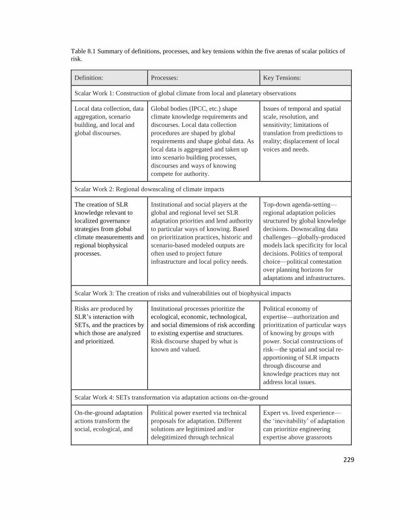
229
Table 8.1 Summary of definitions, processes, and key tensions within the five arenas of scalar politics of
risk.
Definition: Processes: Key Tensions:
Scalar Work 1: Construction of global climate from local and planetary observations
Local data collection, data
aggregation, scenario
building, and local and
global discourses.
Global bodies (IPCC, etc.) shape
climate knowledge requirements and
discourses. Local data collection
procedures are shaped by global
requirements and shape global data. As
local data is aggregated and taken up
into scenario building processes,
discourses and ways of knowing
compete for authority.
Issues of temporal and spatial
scale, resolution, and
sensitivity; limitations of
translation from predictions to
reality; displacement of local
voices and needs.
Scalar Work 2: Regional downscaling of climate impacts
The creation of SLR
knowledge relevant to
localized governance
strategies from global
climate measurements and
regional biophysical
processes.
Institutional and social players at the
global and regional level set SLR
adaptation priorities and lend authority
to particular ways of knowing. Based
on prioritization practices, historic and
scenario-based modeled outputs are
often used to project future
infrastructure and local policy needs.
Top-down agenda-setting—
regional adaptation policies
structured by global knowledge
decisions. Downscaling data
challenges—globally-produced
models lack specificity for local
decisions. Politics of temporal
choice—political contestation
over planning horizons for
adaptations and infrastructures.
Scalar Work 3: The creation of risks and vulnerabilities out of biophysical impacts
Risks are produced by
SLR’s interaction with
SETs, and the practices by
which those are analyzed
and prioritized.
Institutional processes prioritize the
ecological, economic, technological,
and social dimensions of risk according
to existing expertise and structures.
Risk discourse shaped by what is
known and valued.
Political economy of
expertise—authorization and
prioritization of particular ways
of knowing by groups with
power. Social constructions of
risk—the spatial and social re-
apportioning of SLR impacts
through discourse and
knowledge practices may not
address local issues.
Scalar Work 4: SETs transformation via adaptation actions on-the-ground
On-the-ground adaptation
actions transform the
social, ecological, and
Political power exerted via technical
proposals for adaptation. Different
solutions are legitimized and/or
delegitimized through technical
Expert vs. lived experience—
the ‘inevitability’ of adaptation
can prioritize engineering
expertise above grassroots

230
technological systems
(SETs) of a local place.
decision-making procedures around
infrastructure. Local prioritization,
authorization, and enactment of
adaptations transform material reality
on the ground, leaving legacy impacts.
input. Adaptation vs. legacy—
climate changes demand shifts
in SETs and financial systems,
yet legacy impacts can be
resistant to change.
Scalar Work 5: Evaluation and certification of best practices for addressing risks
Ways in which local
initiatives to manage risk
are monitored, as well as
how they interact with
local-global strategies for
managing risk.
Evaluation procedures may or may not
exist, based on the institutional value
placed on assessment. Institutions that
do put evaluation procedures in place
set up procedures to determine the local
effectiveness of interventions based on
constructions of risk and prioritization
of expertise. Infrastructures are then
evaluated for how they fit with global
certification procedures as strategies for
effectively managing risk.
Legitimization of risk
management—expertise
embedded in existing
institutional practices is
prioritized in determining
which risks to evaluate and
what knowledge to use to
evaluate them. Temporal issues:
outputs/outcomes of one-off or
pilot projects deemed
acceptable, while long-term
impacts are not assessed. Scalar
challenges: global and local
constructions of risk may be
considered separately, if at all.

231
Scalar Work 1: Construction of global climate from local and planetary observations
Global sea level rise projections rely on complex coupled social, technological
and environmental models to project climate and oceanographic conditions in the near
and distant future. These modelled projections rely on ongoing practices of local (e.g.
tidal gauges, buoys), remote (e.g. satellite measurements of mean sea level), and
historical (e.g. stratigraphic records) data (Miller 2004). Practices of aggregating different
forms of data (e.g. biophysical and socio-economic) are then used to construct possible
future scenarios (Edwards 2001) and local and global discourses interdependent with
these modelling processes are deployed (Jasanoff and Long-Martello 2004). Global
projections are thus extremely sensitive to both scientific uncertainties (Hansen 2007)
and the socio-economic and technological scenarios guiding emissions projections. They
are also of limited relevance for local decision makers due to a mismatch in scales of data
aggregation and analysis; this contributes to distrust against scientific, political, and
humanitarian actors when models fail to match local experiences (Mahony 2014), or take
into account uneven vulnerabilities (Nicholls and Mimura 1998) and longer standing
practices of community resilience (Spencer et al. 2016), resulting in further victimization
of local people rather than empowerment (Miller 2004; McNamara and Gibson 2009). In
this arena, global institutions such as the IPCC represent a unified body of knowledge
(Hulme 2013) yet rely on inherently contentious processes of legitimizing and
constructing knowledge which can often mask the conditional elements of projections of
future conditions (Hulme 2010). In response, a large body of work has sought to ‘down-
scale’ global climate projections to more relevant regional scales however, down-scaled

232
results still contain the inherent uncertainties of global projections processes outlined
above.
Scalar Work 2: Regional downscaling of climate impacts
Regional downscaling includes the creation of localized sea level rise rates and
projections from global projections (e.g. mean sea level rise, tidal variance, extreme
weather patterns) and regional biophysical processes (e.g. tectonic uplift, sediment
accretion, tidal geometries). These biophysical processes are assessed using similar data
collection and aggregation protocols, yet come with their own sets of assumptions,
uncertainties, and social decisions about what constitutes the region (Fawn 2009) and
what processes are considered relevant by different social actors involved in their
creation. Adjudication of knowledge relevance cannot be separated from the constellation
of social and political actors involved, all of whom have their own demands for regional
sea level rise projections, while also being constrained by gatekeeping organizations
(Lejano et al. 2013). The selection of metrics and scales (time, space, and administrative)
to address sea level rise knowledge and governance, especially as regional downscaling is
often performed by global actors (Miller 2004), produce tension between global
institutions and the needs of regional decision makers. Additionally, such decisions can
be shaped by political and financial pressures, rather than by best available science
(Edwards et al. 2007). These dynamics can both disrupt or solidify institutional
arrangements by identifying which problems are likely to emerge and implementing
presumably—though not guaranteed—effective responses (Wildavsky 1988; Barnett

233
2001), which ultimately depend on the ability to make regional impacts legible as matters
of social concern or risk.
Scalar Work 3: The creation of risks and vulnerabilities out of biophysical impacts
Risks are produced by translating impacts into operational and functional damage
to regional and local SETs (Adger et al. 2009), such as damages to the built environment,
as well as potential loss of life. Risks are what make impacts meaningful for decision
makers who possess their own institutional priorities and knowledge systems (Short and
Clark 1992; Wisner et al. 2014) and are subject to the influence of powerful interests
(Kelman 2014; McCubbin et al. 2015;). Risk translation as a scientific practice relies on
higher precision models of localized impacts of anticipated events, yet in order to be
robust, requires recognizing diverse risk and vulnerability knowledge for adequate
system characterization (Dovers et al. 1996; Barnett 2001). Given that risks are both
regional (e.g. regional infrastructure failure), and local (e.g. a neighborhood being
washed away), we must avoid unproblematically valorizing the ‘local trap’ (Jasanoff and
Long-Martello 2004), which equates locality with spatial smallness, social homogeneity,
and norm similarity (Agrawal and Gibson 1999). By focusing on weaknesses and
shortcomings, risk production can produce a loss of confidence in decision-making
(Campbell 1997), as well as bounding the effectiveness of different management and
adaptation strategies (McCubbin et al. 2015).

234
Scalar Work 4: SETs transformation via adaptation actions on-the-ground
On-the-ground adaptation actions require specific transformations of given SETs.
In this arena, scalar politics move from socio-political processes of planning and into the
seemingly apolitical technical practices of engineering and design. However, this process
is indeed political as proposed and enacted material actions on the ground distribute risks,
benefits, and costs differentially through the “hidden” work of project finance and design
(Heynen et al. 2006), along with the internalization of assumptions from the previous 3
scalar arenas. sea level rise and climate change make SETs transformation inevitable; the
key question then becomes how the lived experience of these transformations, including
grassroots and unstructured responses, relate to formal processes of planning and
designing adaptation measures, including adjudicating between competing technical
proposals. Additionally, the path dependency of existing infrastructures and knowledge
systems impede SETs transformations through pre-existing practices of prioritizing
capital distribution and material inertia on the ground (Palm 2006). Flows of capital
embedded in infrastructure systems shape local spaces, with the sunk costs of previous
infrastructure choices impacting any future adaptation proposals (Palm 2006). Taken
together, these considerations highlight both the complexity of translating risks into
material adaptation proposals, making the evaluation of their effectiveness a key
consideration for their contextual desirability, as well as global generalizability.

235
Scalar Work 5: Evaluation and certification of best practices for addressing risks
Evaluation and certification of best practices for addressing risks involves the
ways in which SETs transformations managing risk are monitored and evaluated, as well
as how they scale up to act as best practices and generalizable strategies within the other
four scalar arenas. As rapid sea level rise becomes a driving concern of regional and city
level adaptation programs, there is a need to construct robust monitoring and evaluation
programs that are shaped by contextual process and distributional concerns to assess the
effectiveness of interventions and compare to global municipal peers (Holling and Meffe
1996). To do so, the original contexts of risk constructions and competing knowledge
claims (e.g. marginalization of local voices, creation of pathological path dependencies)
must not be ignored as institutions seek to attain measurable outcomes. Temporal and
spatial challenges to representative assessment can impact the ability of locals to
adequately assess their own interventions, not least because of global social and
environmental concerns that make sea level rise rates uncertain. Mechanisms of
evaluation encounter limited control comparisons for one-off or local projects, procedural
justice assessments (e.g. how equitable is the process), as well as risk shifting (e.g. sea
walls transferring risk to adjacent communities). At the same time, larger scale impacts
are often ignored (e.g. the impacts of large scale construction projects on rates of climate
change).

236
8.3 Applying Scalar Politics of Risk
We apply the scalar work framework to case studies of sea level rise adaptation
planning in the Pacific Islands (Table 8.2) and Miami-Dade County, Florida USA (Table
8.3), two regions that are undergoing adaptation planning and implementation. Case
studies were developed based on empirical work done by two of the authors of this paper.
Each case used interviews, document analysis, and literature reviews to examine
conceptions of sea level rise risk. In each case, we identify key dynamics affecting the
circulation of knowledge in framing vulnerabilities and solutions to climate change in
each identified arena. The different scales that each case study represents allows us to
explore how vulnerability is framed and by whom, to make explicit the scalar elements of
risk construction and governance, and to understand how different communities are
perceiving risk across scales. This illuminates the ways in which risk construction in
urban environments is produced by, and productive of, global trends in climate change
governance.
Pacific Island Nations
PI- Scalar Work 1
The Pacific Islands are often the focus of literature surrounding regions hit by sea
level rise, and frequently portrayed as victims (Denton 2017). Lower levels of scientific
and technical capacity require many Pacific Island countries to rely on IPCC projections
of sea level rise--staffed by predominantly Northern, white, male scientists (Barnett and
Campbell 2010) who value scientific expertise--or use global data collection networks’
requirements as guiding forces. With the stringent requirements made by global data
gathering networks, this means that PIs are mostly limited to gathering the data that is

237
required globally without paying attention to local needs and conditions. As these
capacity challenges play out in global discourses, there is rarely inclusion of beliefs or
practices promoted by locals to combat these issues (Barnett and Campbell 2010). The
Pacific Islands are the most commonly discussed and analyzed region within global
climate change, which can be damaging when the same group of people are consistently
framed as victims or as a vulnerable population. This focus on the Pacific Islands key-
holes its people in the position of victims in the global sea level rise narrative, while other
groups who are also facing very real dangers in terms of sea level rise are ignored.
PI- Scalar Work 2
As data is downscaled, the global framing of the Pacific Islands as victims creates
politics over knowledge and expertise. For instance, in a recent study of Tuvalu’s
landmass, researchers found that, as adaptive ecosystems, the islands of Tuvalu had
actually grown over the last four decades (Kench et al. 2018). These findings produced a
wide range of reactions among recipients: hope among islanders, vindication among
climate deniers, or anger and frustration among Pacific Island climate negotiators,
depending on the recipient’s position (Friedman 2018). Additionally, in 2016 the
Guardian released a story entitled, “Five Pacific islands lost to rising seas as climate
change hits” (Anon. 2016). Immediately after, the publication released a correction
requested by the study’s authors, “Headlines 'exaggerated' climate link to sinking of
Pacific Islands” (Mathiesen 2016). Debates like this one are rarely simple, power and
authority produced by and productive of climate change knowledge means that
contestation is at the heart of the decision-making.

238
Such contestation can put additional pressure on already constrained scientific and
technical capacity of PIs. For instance, large-scale funders are prioritizing even more
rigorous data collection processes to address these measurement issues rather than
investing more heavily into adaptation strategies. This can be seen in recent efforts to use
LiDAR to measure the landmass of islands in addition to the simple sea level rise buoy
measurement used up to this point (UNCC 2018). The new procedures require costly
technology and training to use properly, even as adaptation measures become more
informed.
PI- Scalar Work 3
Risks are continuously shifting due to the adaptive nature of the islands,
ecologically but also socially, and politically. Traditional ways of knowing trend toward
an adaptive knowledge of nature that puts power to overcome climate risks in the hands
of capable, adaptive communities (Denton 2018). Alternatively, global strategies tend to
view nature as an object in need of control, therefore requiring scientific and technical
capacity to overcome challenges. In response to the global strategies view of risk, one-off
pilot projects are used to mitigate for rapid shifting social, ecological, and political
changes. These strategies come about due to the global discourses of urgency and
inevitability of biophysical climate risks that delegitimize alternative approaches. As
Barnett and Campbell argue, “These regular statements have the effect of rendering
climate change as an environmental fact against which actors can do little but suffer.
They deny the agency of people at risk: to define the problem in their own terms; to apply
their own systems of knowledge; to implement the solutions that are appropriate to their

239
needs and values and which accommodate uncertainty; and to make knowledge claims of
equal value to those of science” (2010, p. 2).
PI- Scalar Work 4
The construction of Pacific Islanders as victims in need of scientific and technical
capacity to overcome climate challenges and control an unwieldy nature has fostered
inconsistent and, at times, counterproductive infrastructure interventions. International
investments in infrastructure in the region require extensive pre-grant assessments that
can be prohibitively costly in terms of time and resources (Denton 2018). This fosters the
emphasis on one-off and pilot projects that can have counterproductive outcomes. For
example, seawalls are regularly used in the Pacific as a tangible adaptation to sea level
rise that also appeals to global desires to control nature. Imbedded in these choices is also
a colonial history and international aid that shapes the flows of finance in the region
(Atteridge and Canales 2017). While alternative approaches like mangroves are used as
well, considerations of beach development, the visibility of an intervention and the ability
to “fly the flag” of the donating country, etc. are considered in determining this choice. In
fact, local communities many times choose this option due to lower upkeep and the
perceived lack of alternatives.
PI- Scalar Work 5
Although the region emphasizes scientific and technical capacity, it may seem
ironic that evaluation and certification play such small roles in climate governance. The
use of one-off and pilot projects means that projects can only be evaluated for achieving
outputs or adhering to processes, but not for other desired impacts including alleviating
risks and vulnerabilities. Projects that do run long-term have resource constraints that can

240
make it challenging to evaluate broader impacts. Additionally, global constructions of
risk can be privileged over local-level evaluation, hiding the nuances of attitudes between
islands. One example of this is in the differing ways in which ‘climate refugee’ status is
considered. Some countries such as Kiribati have purchased land on Fiji for climate-
based migration, others like the Marshall Islands denounce migration seeing it as giving-
up on making polluters pay.

241
Table 8.2: Pacific Island case study scalar work processes and key tensions.
Pacific Islands
SLR presents a pervasive risk to islands everywhere. In the Pacific Islands, detangling the specific risks
presented by SLR from development pressure, ocean acidification, & climatic changes resulting in
extreme weather events can be challenging. This leads to multiple contestations over authoritative
knowledge, power in decision-making, & risk constructions, which move between & across scales.
Processes: Key Tensions:
Scalar Work 1:
Construction of
global climate
from local &
planetary
observations
Lower levels of scientific & technical
capacity create reliance on IPCC SLR
projects. Efforts within the PIs are
mostly limited to gathering the data that
is required globally without paying
attention to local needs & conditions.
Global victimization of the region.
Contestation between local & global
data/adaptation needs.
Scalar Work 2:
Regional
downscaling of
climate impacts
Reliance on international community
pits scientific assessments against local
experiences of SLR resulting in debates
over knowledge within climate change
diplomacy & governance.
Regional contestation over
measurements. Scientific/technical
capacity constraints exacerbated by
global requirements. Adaptive capacity
possibilities & realities largely ignored.
Scalar Work 3:
The creation of
risks &
vulnerabilities
out of
biophysical
impacts
The construction of risks is
commensurate with different views of
nature. Pacific Islanders often view
nature as an adaptive ecosystem which
puts power to overcome climate risks in
the hands of capable, adaptive
communities, while understanding
nature as an object in need of control
creates other problems & solutions.
Risks constructed without consideration
of multiple types of capacity or ways of
knowing. Views of nature delimit the
nature of risk & opportunities for
addressing vulnerabilities.
Scalar Work 4:
SETs
transformation as
adaptation
International investments in
infrastructure in the region require
extensive pre-grant assessments that can
be prohibitively costly in terms of time
& resources. This fosters the emphasis
on one-off & pilot projects that can have
counterproductive outcomes.
Outside funding requires extensive up-
front investment in status evaluation,
limiting access to quality projects. Pilot
projects produce inconsistent &, at
times, counterproductive infrastructure
interventions. Colonial flows of finance
can shift decision-making, leaving
long-term legacy impacts.
Scalar Work 5:
Evaluation &
certification of
best practices for
addressing risks
The use of one-off & pilot projects
means that projects can only be
evaluated for achieving outputs or
adhering to processes, but not for if the
measures had the desired impacts--
alleviating risks & vulnerabilities
One-off & pilot projects are limited to
process evaluation instead of impact
evaluation, leaving little opportunity for
improvement. Evaluation of risk
abatement can be out of touch with
local valuations & constructions of risk.

242
Miami-Dade County, Florida, USA
MDC- Scalar Work 1
Low-lying coastal regions of the United States such as South Florida are
portrayed as ground zero for sea level rise by the media, scientists, and environmental
activists. In the global narrative, sea level rise impacts in Miami-Dade County are
primarily focused on tourism and affluent residents, which can overshadow discussions
of vulnerable and marginalized communities within the region. The region has high-
levels of technical and scientific capacity, with support from federal agencies to gather
and integrate localized datasets into global sea level rise models.
MDC- Scalar Work 2
Southeast Florida Regional Climate Change Compact (Compact) formed in 2009
as a four-county partnership between Miami-Dade, Broward, Monroe, Palm Beach
Counties, and cities align regional sea level rise projections and lobby for funding.
Beginning in the mid-2000s, disagreements amongst scientists and policymakers centered
around which sea level rise models and rates to adopt (e.g. IPCC, NOAA, and USACE),
with some scientists arguing that because some sea level rise projections fail to account
for ice melt acceleration and localized processes they underestimate sea level rise. While
some local governments were reluctant to adopt sea level rise projections, external forces
with locally relevant projections (including NOAA and the USACE), as well as the
collaborative Compact effort, helped to drive the adoption of higher projections that
extend further into the future. The Compact adopted projections from NOAA, the
USACE, and the IPCC, which are now the primary projections referenced in Miami-Dade
County.

243
MDC- Scalar Work 3
Miami-Dade County development is supported by systems of canals and other
stormwater infrastructure. Upon initial settlement, large-scale infrastructure projects were
built to drain portions of the Everglades and allow for development. As such, risks from
sea level rise are primarily understood in terms of physical, economic, and infrastructure
domains. For example, a process called “bathtub modeling” is used to superimpose where
water will rise with sea level rise stemming from the coast, adding water levels to high-
tides and using elevation gradients to determine what areas will be inundated. This form
of modeling has several limitations as it assumes that land geomorphology, tidal surface
variability and other conditions remain constant (e.g. groundwater surface water
interactions), and it does not consider additional hydrodynamic effects during storm
surges (SFRCCC 2012). Because of these limitations, the use of bathtub modeling
emphasizes risks to coastal regions and de-emphasizes inland risks. And while the
primary focus for assessments is on infrastructure, vulnerability assessments often
highlight property values. Several interviewees shared that this is in part to get attention
and garner action for adaptation strategies. At the same time, however, the emphasis
placed on economic risks may lead to the ongoing focus of adaptation strategies that
support the economy over others. Currently, it appears that sea level rise risk knowledge
that supports an economically viable future is favored over knowledge that may threaten
that future. For example, calls for fine resolution LiDAR to better understand elevation
gradients support engineered solutions and building at higher elevations, and support
dominant narratives that the region will not stop growing, that growth will happen in a
different way. While community organizations emphasize concerns over high-elevation

244
climate gentrification, emergency preparedness, displacement, insurance, and health
impacts, few government assessments covering these issues have been completed, though
recent planning efforts may begin to address these issues.
MDC- Scalar Work 4
Engineered solutions dominate SETs transformation and, as technical design
tasks, are being viewed as an apolitical decision points with limited to no interaction with
people prior to decisions around where to adapt and how to adapt have been made.
Planning decisions around infrastructure are made in an expert space and rooted in a path
dependency around existing infrastructure. Infrastructure decisions around stormwater
management, wastewater treatment, and water provision surround cost benefit analysis
and risk management decision-making practices that focus on level of service and shaped
by policies including the NFIP and Clean Water Act stormwater permitting. Issues of
public versus private investments and responsibilities are emerging. In the City of Miami
Beach, for example, roads are being raised with new stormwater drainage and landowners
are expected to tie their driveways into the new system. Longer-term, people have begun
to speculate and question whether it would be up to individual landowners to raise their
homes, and historic designations and zoning disagreements have been emerging around
the drive for new development and ground raising over older buildings that are
susceptible to flooding. Planners also express concern over how to plan for lower income
communities where the adaptation costs for private property may be prohibitively
expensive. While additional efforts are taking place including community organizing
efforts via education and organizing to access decision-making arenas; environmental
organizations designing and implementing green infrastructure and living shoreline

245
projects; and informal discussions of localized and regional planned retreat, these are
primarily on the planning periphery.
MDC- Scalar Work 5
Several projects and programs have built in monitoring and evaluation. For
example, the Compact, which develops regional goals and planning practices, holds an
annual meeting with policy-makers, managers, scientists, and other practitioners to share
information. In addition, the Compact has a process for reviewing sea level rise
projections as new models and information are available. The recent Regional Climate
Action Plan published by the Compact reflects broader inclusion than the first plan,
expanding to groups and topics including social equity. And while at the regional level
the tendency has moved towards evaluation and broader inclusion, individual projects
have had varying levels of evaluation. Several projects initiated by the Compact and
different foundations are evaluated as case studies communicated to cities around the
world. The City of Miami Beach recently received high praise from an independent panel
of experts brought in to evaluate their sea level rise adaptation strategies. Projects within
the region have been used as case studies, design charrettes, and project feasibility
assessments and this knowledge has circulated the region primarily via the Compact. This
knowledge often focuses on the technocratic aspects and infrastructure designs and less
about the process and public/community involvement.

246
Table 8.3: Miami-Dade County, Florida case study scalar work processes and key tensions.
Miami-Dade County, Florida, USA
Climate projections suggest that Miami-Dade County will experience increased flooding from SLR,
higher severity of extreme weather events. Municipalities have undertaken activities to mitigate
anticipated impacts from SLR. The City of Miami Beach, for example, is implementing an aggressive
& expensive plan to combat SLR by moving water off city streets & away from businesses & houses.
Processes: Key Tensions:
Scalar Work 1:
Construction of
global climate
from local &
planetary
observations
High technical & scientific capacity &
support from federal agencies allows for
local datasets & technologies to be
integrated into SLR models.
Ground zero for SLR but portrayed as
affluent & able to handle the adaptation
challenges. The focus on economic &
infrastructure risks overshadows
marginalized communities within the
city & surrounding areas.
Scalar Work 2:
Regional
downscaling of
climate impacts
The Southeast Florida Regional Climate
Change Compact (Compact) (a 4-county
& multi-city partnership) was formed in
2009 to adopt a unified regional SLR
projection, lobby for funding, &
coordinate planning activities.
Process contested & shaped by
reticence around ice melt, climate
change denialism, & political
uncertainty. Pattern of gov. wanting to
adopt smaller projections, but support
for larger projections came from local
downscaling of models via NOAA,
USACE, and collaborative efforts.
Scalar Work 3:
The creation of
risks &
vulnerabilities
out of
biophysical
impacts
Development is supported by systems of
canals & other stormwater infrastructure.
Upon initial settlement, large-scale
infrastructure projects were built to drain
portions of the Everglades & allow for
development. As such, risks from SLR
are understood in terms of physical,
economic, & infrastructure domains.
Knowledge systems that support the
dominant political economy, linking
power with knowledge, is more
prevalent & sometimes runs counter to
knowledge that addresses social risks.
Scalar Work 4:
SETs
transformation
via adaptation
actions on-the-
ground
Planning decisions around infrastructure
are made in an expert space & rooted in
a path dependency around existing
infrastructure, cost benefit analysis, &
risk management decision-making.
Public private tensions around
responsibility for funding adaptation.
Path dependency around engineered
solutions. Engineered solutions are
expensive & may be unattainable for
many individuals & communities.
Scalar Work 5:
Evaluation &
certification of
best practices for
addressing risks
Evaluation & certification of best
practices occurs primarily via the
Compact & foundations funding design
charrettes. Evaluation of stormwater
projects in Miami-Beach has recently
taken place with panel of experts.
Knowledge gathered to evaluate
focuses on the technocratic aspects &
infrastructure designs & less about the
process & public/community
involvement.

247
8.4 Discussion
As Foucault argues, “Power never ceases in its interrogation, its inquisition, its
registration of truth; it institutionalizes, professionalizes, and rewards its pursuit” (1980,
p. 93). In both PIs and Miami, technical and scientific approaches are largely privileged
over local constructions of risk, as technological solutions are presented by global actors
as working across scales without having to address many, if not all, cross-scale socio-
political tensions. While PIs are largely making decisions in transnational space about sea
level rise knowledge and adaptation, Miami’s work at the urban scale mirrors many of
the politics at play. Global constructions of a vulnerable and victimized Pacific Islands
have prioritized scientific and technical approaches to risk abatement, while largely
ignoring the knowledges, discourses, and capacities used by the Islanders, themselves.
Alternatively, perceptions of affluence surrounding residents of the Miami area has left
vulnerable and marginalized communities within the region largely ignored, instead
measurable elevation and property value considerations are emphasized. The globalized,
objective approaches to sea level rise in these areas obscure rights and knowledges from
non-expert and local communities in attempts to scale up knowledges, practices, and
discourses in sea level rise adaptation. As local populations are written off as victims in a
global, technical space, they are left out of the sea level rise projections and models.
It is in these spaces that scalar politics of risk play out as knowledge systems
interact and compete across scales, from global to local and back again. These tensions
are cascading—global constructions of the climate victimize both Pacific Islanders and
Miami-Dade County residents (Scalar Work 1), which then causes regional approaches to
emphasize scientific measurement over local understanding (Scalar Work 2), which then
248
constructs risks as technical concerns (Scalar Work 3) that transform SETs and leave
legacy infrastructures (Scalar Work 4), which then pose challenges for quality evaluation
(Scalar Work 5). These things also work in reverse, however, as legacy infrastructures
(Scalar Work 4) impact global sea level rise measurements (Scalar Work 1) and
opportunities for policy change (Scalar Work 2). Additionally, regional policy changes
(Scalar Work 2) can transform the processes by which data is collected for global models
(Scalar Work 1) and what risk abatements are evaluated (Scalar Work 5). Without
addressing each scale within the system, hidden struggles over knowledge, discourses,
and practices can remain just that—hidden.
8.5 Conclusion
We have used knowledge systems analysis to question the construction of science,
and the framing of science as apolitical and objective, specifically in respect to multi-
scalar understandings of the risk of sea level rise. We look at five primary arenas in
which a scalar politics of risk emerge: 1) the construction of the global climate; 2) the
regional downscaling of climate impacts; 3) the local definition of risks; 4) the
transformation of on-the-ground social-ecological-technical systems and infrastructures;
and, 5) the evaluation of intervention efficacy.
The processes by which power flows through these knowledge systems can leave
local populations, saddled with victim discourses, with little recourse. Adaptive
capacities, non-expert/non-scientific knowledge systems, and everyday practices can be
hidden by ‘objective’ investigations in to sea level rise. A thorough investigation of scalar
politics thus works to take apart the “regimes of truth” that conceal the histories of how
those ways of knowing came to be (Foucault, 1980). These principles and practices do

249
not only apply to Miami and Pacific Islands but can work across knowledge systems at
all scales. We encourage future work to continue to investigate these scalar politics of
risk in this and other arenas.

250
References
Adger, N., N. Arnell, and E. Tompkins. 2005. Successful adaptation to climate change
across scales. Global Environmental Change, 15: 77-86.
Adger, N. and A. Jordan. 2009. Governing sustainability. Cambridge: Cambridge
University Press.
Adger, W., S. Dessai, M. Goulden, M. Hulme, I. Lorenzoni, D. Nelson, L. Naessm J.
Wolf, and A. Wreford. 2009. Are there social limits to adaptation to climate
change? Climatic Change, 93(3-4): 335-354.
Agrawal, A. 1995. Dismantling the divide between indigenous and scientific knowledge.
Development and Change, 26: 413-439.
Agrawal, A. 1999. On power and indigenous knowledge. In Cultural and spiritual values
of biodiversity, ed. And comp. D. Posey. London: United Nations Environment
Programme/Intermediate Technology Publications.
Agrawal, A. 2005. Environmentality: technologies of government and political subjects.
Duke University Press.
Agrawal, A. and C. Gibson. 1999. Enchantment and disenchantment: The role of
community in natural resource conservation. World Development, 27(4): 629–
649.
Ahern, J. 2011. From fail-safe to safe-to-fail: Sustainability and resilience in the new
urban world. Landscape and urban Planning, 100(4): 341-343.
Alder, C. and G. Hirsch Hadorn. 2014. The IPCC and treatment of uncertainties: topics
and sources of dissensus WIREs Clim Change 2014. Doi: 10.1002/wcc.297.
Anon. Five Pacific islands lost to rising seas as climate change hits. (2016, May 10). The
Guardian. https://www.theguardian.com/environment/2016/may/10/five-pacific-
islands-lost-rising-seas-climate-change
Arnstein, S. 1969. A ladder of citizen participation. Journal of American Institute of
Planners, 35(4): 216-224.
Atteridge, A. and N. Canales. 2017. Climate finance in the Pacific: An overview of flows
to the region’s Small Island Developing States. Stockholm Environment Institute.
Bäckstrand, K., and E. Lövbrand. 2006. Planting trees to mitigate climate change:
Contested discourses of ecological modernization, green governmentality and
civic environmentalism. Global Environmental Politics, 6(1): 50-75.

251
Bakker, K. 2010. The limits of “neoliberal natures”: Debating green neoliberalism.
Progress in Human Geography, 34(6): 715–735.
Barnett, J. 2001. Adapting to climate change in Pacific Island countries: the problem of
uncertainty. World Development, 29(6): 977-993.
Barnett, J. 2003. Redesigning cities: Principles, practice, and implementation. Chicago:
American Planning Association.
Barnett, J. and J. Campbell. 2010. Climate change and small island states: Power,
knowledge, and the South Pacific. Earthscan.
Beck, U. 1992. Risk society: Towards a new modernity. Sage.
Beier, P., L. Hansen, L. Helbrecht, and D. Behar. 2017. A how‐to guide for coproduction
of actionable science. Conservation Letters, 10(3): 288-296.
Berke, P. and E. Kaiser. 2006. Urban land use planning. University of Illinois Press.
Berke, P. and T. Campanella. 2006. Planning for postdisaster resiliency. The Annals of
the American Academy of Political and Social Science, 604(1): 192-207.
Berkes, F. 2007. Community-based conservation in a globalized world. Proceedings of
the National Academy of Sciences, 104(39): 15188-15193.
Bernard, S. “Gentrification and Climate Change are Totally Related, Says Report.”
Seattle Weekly [Seattle] March 15, 2016.
Bocking, S. 2004. Nature’s experts: Science, politics, and the environment. New
Brunswick, NJ: Rutgers University Press.
Bogason, P. and J. Musso. 2006. The democratic prospects of network governance.
American Review of Public Administration, 36(1): 3–18.
Borzel, T. 1998. Organizing Babylon—on the different conceptions of policy networks.
Public Administration, 76: 233–273.
Boström, M., R. Lidskog, and Y. Uggla. 2017. A reflexive look at reflexivity in
environmental sociology. Environmental Sociology, 3(1): 6–16.
Braun, V. and V. Clarke. 2006. Using thematic analysis in psychology. Qualitative
Research in Psychology, 3(2): 77-101.
Brenner, N. 2001. The limits to scale? Methodological reflections on scalar structuration.
Progress in Human Geography, 25: 591-614.
Brosius, J. 2006. What counts as local knowledge in global environmental assessments
and conventions? In Reid, W., F. Berkes, T. Wilbanks, D. Capistrano, Eds.
Bridging Scales and Knowledge Systems: Concepts and Applications in

252
Ecosystem Assessment. Island Press.
Brugnach, M., A. Dewulf, C. Pahl-Wostl, and T. Taillieu. 2008. Toward a relational
concept of uncertainty: about knowing too little, knowing too differently, and
accepting not to know. Ecology and Society, 13(2): 30.
Brugnach, M. and H. Ingram. 2012. Ambiguity: the challenge of knowing and deciding
together. Environmental Science and Policy, 15(1): 60–71.
Bulkeley, H. 2000. Discourse coalitions and the Australian climate change policy
network. Environment and Planning C, 18: 727–748.
Bush, G. W. 2016. White Sand Black Beach: Civil Rights, Public Space, and Miami's
Virginia Key. University Press of Florida.
Calvin, W. 2002. A brain for all seasons: Human evolution and abrupt climate change.
University of Chicago Press.
Campbell, J. 1997. ‘Examining Pacific Island Vulnerability to Natural Hazards’, in
Planitz, A. and Chung, J. (eds.), Proceedings of the VIII Pacific Science Inter-
Congress, United Nations Department for Humanitarian Affairs, Suva, 53–62.
Chaffin, B. 2014. A decade of adaptive governance scholarship: synthesis and future
directions. Ecology and Society, 19(3): 56.
Chasan, J. “Green group turns attention to affordable housing.” Crosscut May 23, 2016.
Choo, C. W. 2007. The Knowing Organization: How Organizations Use Information to
Construct Meaning, Create Knowledge, and Make Decisions. New York: Oxford
University Press, Inc.
Church, J. and N. White. 2011. Sea level rise from the late 19th to the early 21st century.
Surveys in Geophysics, 32(4-5): 585-602.
Church, J., P. Clark, A. Cazenave, J. Gregory, S. Jevrejeva, A. Levermann, M.
Merrifield, G. Milne, R. Nerem, P. Nunn, A. Payne, W. Pfeffer, D. Stammer and
A. Unnikrishnan, 2013: Sea Level Change. In: Climate Change 2013: The
Physical Science Basis. Contribution of Working Group I to the Fifth Assessment
Report of the Intergovernmental Panel on Climate Change [Stocker, T., D. Qin,
G. Plattner, M. Tignor, S. Allen, J. Boschung, A. Nauels, Y. Xia, V. Bex and P.
Midgley (eds.)]. Cambridge University Press, Cambridge, United Kingdom and
New York, NY, USA.
(Compact) Southeast Florida Regional Climate Change Compact. 2012. A region
responds to a changing climate: Regional Climate Action Plan.

253
(Compact) Southeast Florida Regional Climate Change Compact Sea Level Rise Work
Group. October 2015. Unified Sea Level Rise Projection for Southeast Florida. A
document prepared for the Southeast Florida Regional Climate Change Compact.
Clayton, S. 2003. Identity and the natural environment: The psychological significance of
nature. Mit Press.
Collins, H. 1974. ‘The TEA Set: Tacit Knowledge and Scientific Networks.’ Science
Studies, 4: 165–85.
Cornell, S., F. Berkhout, W. Tuinstra, J. Tàbara, J. Jäger, I. Chabay, and I. Otto. 2013.
Opening up knowledge systems for better responses to global environmental
change. Environmental Science and Policy, 28: 60-70.
Cornish, A. “Scorching Phoenix plans for an even hotter future.” National Public Radio,
August 12, 2012.
Cox, K. 1998. Spaces of dependence, spaces of engagement and the politics of scale, or:
looking for local politics. Political Geography, 17: 1-23.
Crona, B. and O. Bodin. 2010. Power asymmetries in small-scale fisheries: a barrier to
governance transformability? Ecology and Society, 15(4).
Cutter, S., L. Barnes, M. Berry, C. Burton, E. Evans, E. Tate, and J. Webb. 2008. A
place-based model for understanding community resilience to natural disasters.
Global Environmental Change, 18(4): 598-606.
DeConto, R. and D. Pollard. 2016. Contribution of Antarctica to past and future sea level
rise. Nature, 531(7596): 591-597.
Demeritt, D. 2001. The construction of global warming and the politics of science.
Annals of the Association of American Geographers, 91(2): 307-337.
Denton, A. 2017. Voices for environmental action? Analyzing narrative in environmental
governance networks in the Pacific Islands. Global Environmental Change, 43:
62-71.
Denton, A. 2018. Building Climate Empire: Power, Authority, and Knowledge Within
Pacific Islands Climate Change Diplomacy and Governance Networks.
Dissertations and Theses. Paper 4401.
https://pdxscholar.library.pdx.edu/open_access_etds/4401
Dewey, J. 1927. The public and its problems. New York.
Dewulf, A., M. Craps, R. Bouwen, T. Taillieu, and P. Pahl-Wostl. 2005. Integrated
management of natural resources: dealing with ambiguous issues, multiple actors
and diverging frames. Water Science and Technology, 52: 115–124.

254
Dillman, D., J. Smyth, and L. Melani. 2011. Internet, mail, and mixed-mode surveys: the
tailored design method. Toronto: Wiley & Sons.
Donahue, J. 2002. Market-based governance and the architecture of accountability. In
Market-Based Governance, ed. J. Donahue and J. Nye. Brookings Institution.
Douglas, M. and A, Wildavsky. 1983. Risk and Culture: An essay on the selection of
technological and environmental dangers. University of California Press:
Berkeley, California.
Dovers, S., T. Norton, and J. Handmer. 1996. Uncertainty, ecology, sustainability and
policy. Biodiversity and Conservation, 5(10): 1143-1167.
Dryzek, J. 2013. The Politics of the Earth: Environmental Discourses. Oxford University
Press.
Dryzek, J. and J. Pickering. 2017. Deliberation as a catalyst for reflexive environmental
governance. Ecological Economics, 131: 353-360.
Dunn, M. 1997. Black Miami in the twentieth century. University Press of Florida.
Edwards, P. 2001. Representing the global atmosphere: computer models, data, and
knowledge about climate change. In Changing the atmosphere: Expert
Knowledge and Environmental Governance. MIT Press.
Edwards, P., S. Jackson, G. Bowker, and C. Knobel. 2007. Understanding infrastructure:
Dynamics, tensions, and design. Report of a Workshop on “History and Theory of
Infrastructure: Lessons for New Scientific Cyberinfrastructures.”
Elzen, B., F. Geels, and K. Green. (eds). 2005. System Innovation and the Transition to
Sustainability: Theory, Evidence and Policy, Camberley: Edward Elgar.
Ernstson, H., S. Sörlin, and T. Elmqvist. 2008. Social movements and ecosystem
services–the role of social network structure in protecting and managing urban
green areas in Stockholm. Ecology and Society, 13(2): 39.
Fabricus, C., R. Scholes, and G. Cundill. 2006. Mobilizing knowledge for integrated
ecosystem assessments. In Reid, W., F. Berkes, T. Wilbanks, D. Capistrano, Eds.
Bridging Scales and Knowledge Systems: Concepts and Applications in
Ecosystem Assessment. Island Press.
Fawn, R. 2009. ‘Regions’ and their study: where from, what for and where to? Review of
International Studies, 35(S1), 5-34.
Feagin, J., A. Orum, and G. Sjoberg. 1991. A case for the case study. UNC Press Books.

255
Feldman, D. and H. Ingram. 2009. Climate forecast, water management, and knowledge
networks: making science useful to decision makers. Water, Climate and Society,
1: 19-21.
Fincher, R., and K. Iveson. 2008. Planning and Diversity in the City: Redistribution,
Recognition and Encounter. Macmillan International Higher Education.
Fischer, F. 2000. Citizens, Experts and the Environment: The Politics of Local
Knowledge. Duke University Press.
Fisher, R. and W. Ury. 1981. Getting to Yes. Simon & Schuster Sound Ideas.
Flechas, J. “Miami Beach skips public bids to move fast on sea rise projects.” Miami
Herald [Miami] October, 23, 2015.
Flechas, J. and J. Staletovich. “Miami Beach’s battle to stem rising tides.” Miami Herald
[Miami] October, 23, 2015.
Forester, J. 1999. The Deliberative Practitioner: Encouraging Participative Planning
Processes. Cambridge, MA: MIT Press.
Foucault, M. 1980. Power/knowledge: Selected interviews and other writings, 1972-
1977. Pantheon.
Foucault, M., G. Burchell, C. Gordon, and P. Miller, P. 1991. The Foucault effect:
Studies in governmentality. University of Chicago Press.
Fox, N. 1999. Postmodern reflections on ‘risk’, ‘hazards’ and life choices. In Lupton, D.
(ed.) Risk and sociocultural theory: New directions and perspectives, 12-33.
Cambridge University Press, Cambridge.
Frickel, S. 2008. On missing New Orleans: Lost knowledge and knowledge gaps in an
urban hazardscape. Environmental History, 13(4): 643-650.
Friedmann, J. 1987. Planning in the public domain: From knowledge to action. Princeton
University Press.
Friedman, L. 2018. Tuvalu is growing (for now). New York Times.
Giddens, A. 2009. The politics of climate change. Polity Press.
Gieryn, T. 1999. Cultural Boundaries of Science: Credibility on the Line. Chicago:
University of Chicago Press.
Gieryn, T. 2006. City as truth-spot: laboratory and field sites in urban studies. Social
Studies of Science, 36(1): 5-38.
Gleeson, B. 2010. Lifeboat Cities. Sydney: University of New South Wales Press.

256
Golledge, N., D. Kowalewski, T. Naish, R. Levy, C. Fogwill, and E. Gasson. 2015. The
multi-millennial Antarctic commitment to future sea level rise. Nature,
526(7573): 421-425.
Google (n.d.). [Miami-Dade County, Florida]. Retrieved November 11, 2018 from
https://www.google.com/maps/place/Miami-Dade+County,+FL/@25.8062051,-
87.0256184,6z/data=!4m5!3m4!1s0x88d98b054de91839:0x49691e748195638b!8
m2!3d25.5516034!4d-80.6326916
Gottlieb, R. 2005. Forcing the spring: The transformation of the American environmental
movement. Island Press.
Grabowski, Z., A. Matsler, C. Thiel, L. McPhillips, R. Hum, A. Bradshaw, T. Miller, and
C. Redman. 2017. Infrastructures as Socio-Eco-Technical Systems: Five
Considerations for Interdisciplinary Dialogue. Journal of Infrastructure Systems,
23(4): 02517002.
Graham, S. and S. Marvin. 2001. Splintering Urbanism: Networked Infrastructures,
Technological Mobilities and the Urban Condition. London: Routledge.
Gross, M. 2010. Ignorance and surprise: Science, society, and ecological design. MIT
Press.
Grunwald, M. 2006. The swamp: the Everglades, Florida, and the politics of paradise.
Simon and Schuster.
Gupta, A. 2004. When is global local: Negotiating safe use of biotechnology. In Earthly
politics: local and global in environmental governance, Eds. S. Jasanoff and M.
Long Martello. Cambridge: MIT Press.
Haas, P. 1992. “Epistemic Communities and International Policy Coordination.”
International Organization, 46(1): 1–35.
Habermas, J. 1984. “The Theory of Communicative Action: Reason and the
Rationalization of Society (T. McCarthy, Trans. Vol. 1).” Boston: Beacon.
Hacking, I. 2002. Chapter 6, ‘Making Up People.’ Historical Ontology. Cambridge, MA:
Harvard University Press.
Hajer, M. 1995. The politics of environmental discourse: Ecological modernization and
the policy process. Oxford: Clarendon Press.
Hajer, M. and W. Versteeg. 2005. A decade of discourse analysis of environmental
politics: achievements, challenges, perspectives. Journal of environmental policy
and planning, 7(3): 175-184.

257
Hansen, J. 2007. Scientific reticence and sea level rise. Environmental research letters,
2(2): 024002.
Harding, S. 1987. Feminism and methodology: Social science issues. Indiana University
Press.
Harlem, Peter, “Sea Level Rise Map Projections” (2008). Sea Level Rise Collection. 2.
https://digitalcommons.fiu.edu/sea_level_rise/2
Harris, A. Should Miami’s sea level rise committee address climate change too? Miami
Herald
[https://www.miamiherald.com/news/local/environment/article208034699.html]
April 5, 2018.
Hastings, A. 1999. Discourse and urban change: introduction to the special issue. Urban
Studies, 36: 7–12.
Hay, C., E. Morrow, R. Kopp, and J. Mitrovica. 2015. Probabilistic reanalysis of
twentieth century sea level rise. Nature, 517(7535): 481-484.
Healey, P. 1997. Collaborative Planning: Shaping Places in Fragmented Societies. UBC
Press.
Hess, D. 2007. Alternative pathways in science and industry. MIT Press.
Heynen, N., H. Perkins, and P. Roy. 2006. “The Political Ecology of Uneven Urban
Green Space: The Impact of Political Economy on Race and Ethnicity in
Producing Environmental Inequality in Milwaukee.” Urban Affairs Review, 42(1):
3–25.
Hilgartner, S. 1992. “The Social Construction of Risk Objects: Or, How to Pry Open
Networks of Risk,” in Organizations, Uncertainties, and Risk, ed. James F. Short
and Lee Clark (Boulder: Westview Press, 1992).
Hine, A., Chambers, D., Clayton, T., Hafen, M., and Mitchum, G. 2016. Sea Level Rise in
Florida: Science, Impacts, and Options. University Press of Florida.
Hodson, M. and S. Marvin. 2010 World Cities and Climate Change. New York: Open
University Press.
Holling, C. (Editor). 1978. Adaptive environmental assessment and management.
London: John Wiley & Sons.
Holling, C. and G. Meffe. 1996. Command and control and the pathology of natural
resource management. Conservation Biology, 10(2): 328-337.

258
Hommels, A. 2005. Unbuilding cities. Obduracy in urban sociotechnical change. MIT
Press: Cambridge, Mass.
Howarth, D. 2000. Discourse. Open University Press: Buckingham.
Hughes, J. and J. White. 2016. Hydrologic conditions in urban Miami-Dade County,
Florida, and the effect of groundwater pumpage and increased sea level on canal
leakage and regional groundwater flow (ver. 1.2, July 2016): U.S. Geological
Survey Scientific Investigations Report 2014–5162.
Hulme, M. 2009. Why we disagree about climate change: Understanding controversy,
inaction and opportunity. Cambridge University Press.
Hulme, M. 2010. Problems with making and governing global kinds of knowledge.
Global Environmental Change, 20(4): 558-564.
Hulme, M. 2013. Lessons from the IPCC: Do scientific assessments need to be
consensual to be authoritative. Future directions for scientific advice in Whitehall,
142-147.
Florida Institute for Health Innovation. 2016. Health and sea level rise: Impacts on South
Florida.
Innes, J. and D. Booher. 2004. Reframing Public Participation: Strategies for the 21st
Century. Planning Theory and Practice 5: 419-436.
Innes, J. and D. Booher. 2010. Planning with Complexity: An Introduction to Collaborative
Rationality for Public Policy. Routledge.
IPCC. Field, C. 2012. Managing the risks of extreme events and disasters to advance
climate change adaptation: special report of the intergovernmental panel on
climate change. Cambridge University Press.
(IPCC) Pachauri, R., M. Allen, V. Barros, J. Broome, W. Cramer, R. Christ, J. Church, L.
Clarke, Q. Dahe, P. Dasgupta, and N. Dubash. 2014. Climate Change 2014:
Synthesis Report. Contribution of Working Groups I, II and III to the Fifth
Assessment Report of the Intergovernmental Panel on Climate Change / R.
Pachauri and L. Meyer (editors), Geneva, Switzerland, IPCC, 151 p., ISBN: 978-
92-9169-143-2
Irwin, A. 1995. Citizen Science: A Study of People, Expertise, and Sustainable
Development. Routledge, New York.
Irwin, A. and B. Wynne. 1996. Misunderstanding Science? The Public Reconstruction of
Science and Technology. Cambridge University Press, Cambridge.

259
Jacobs, K. 2006. Discourse analysis and its utility for urban policy research, Urban Policy
and Research, 24, pp. 39–52.
Jaeger, C., O. Renn, E. Rosa, and T. Weber. 2001. Risk, uncertainty, and rational action.
London: Earthscan.
Jarrett, B., A. Hine, R. Halley, D. Naar, S. Locker, A. Neumann, D. Twichell, C. Hu, B.
Donahue, W. Jaap, and D. Palandro. 2005. Strange bedfellows—a deep-water
hermatypic coral reef superimposed on a drowned barrier island; southern Pulley
Ridge, SW Florida platform margin. Marine Geology, 214(4): 295-307.
Jasanoff, S. 1987. Contested boundaries in policy-relevant science. Social Studies of
Science, 17: 195-230.
Jasanoff, S. 1998. Contingent knowledge: Implications for implementation and
compliance. In Engaging Countries, ed. E. Weiss and H. Jacobson. MIT Press.
Jasanoff, S. and B. Wynne. 1998. Science and decisionmaking. In Human choice and
climate change: The societal framework, ed. S. Rayner and E. Malone. Columbus,
OH: Batelle Press.
Jasanoff, S. 2004. Science and Citizenship: a new synergy. Science and public policy,
31(2): 90-94.
Jasanoff, S. 2004. States of knowledge: The co-production of science and the social
order. New Brunswick, NJ: Routledge.
Jasanoff, S. 2006. Technology as site and object of politics. Oxford Handbook of
Contextual Political Analysis, R. Goodin and C. Tilly, eds. Oxford University
Press: Oxford, UK.
Jasanoff, S. and M. Long-Martello. 2004. Earthly politics: local and global in
environmental governance. Cambridge: MIT Press.
Johnson, R. and A. Onwuegbuzie. 2004. Mixed methods research: A research paradigm
whose time has come. Educational Researcher, 33(7): 14-26.
Johnson, R., A. Onwuegbuzie, and L. Turner. 2007. Toward a definition of mixed
methods research. Journal of Mixed methods Research, 1(2): 112-133.
Juhola, S. and L. Westerhoff. 2011. Challenges of adaptation to climate change across
multiple scales: a case study of network governance in two European countries.
Environmental Science and Policy, 14(3): 239-247.
Kaika, M. 2017. ‘Don’t call me resilient again!’: the New Urban Agenda as
immunology… or… what happens when communities refuse to be vaccinated
with ‘smart cities’ and indicators. Environment and Urbanization, 29(1): 89-102.

260
Kelman, I. 2014. No change from climate change: vulnerability and small island
developing states. The Geographical Journal, 180(2): 120-129.
Kench, P., M. Ford, and S. Owen. 2018. Patterns of island change and persistence offer
alternate adaptation pathways for atoll nations. Nature communications, 9(1): 605.
King, J. “Rising Reality.” San Francisco Chronicle [San Francisco] May 2016.
Kjellström, E., L. Bärring, G. Nikulin, C. Nilsson, G. Persson, and G. Strandberg. 2016.
Production and use of regional climate model projections–A Swedish perspective
on building climate services. Climate Services, 2: 15-29.
Kleinberg, E. 2003. Black cloud: The great Florida hurricane of 1928. Basic Books.
Knox, C. 2013. Distorted communication in the Florida Everglades: A critical theory
analysis of ‘Everglades Restoration.’ Journal of Environmental Policy and
Planning, 15(2): 269-284.
Kopp, R., A. Kemp, K. Bittermann, B. Horton, J. Donnelly, W. Gehrels, and S.
Rahmstorf. 2016. Temperature-driven global sea level variability in the Common
Era. Proceedings of the National Academy of Sciences: 201517056.
Krimsky, S. and D. Golding (Eds.). 1992. Social Theories of Risk. Praeger Publishers,
Westport, CT.
Kuhn, T. 1970. The structure of scientific revolutions. Chicago: Univ. of Chicago Pr.
Kunreuther, H., G. Heal, M. Allen, O. Edenhofer, C. Field, and G. Yohe. 2013. Risk
management and climate change. Nature Climate Change, 3(5): 447-450.
Latour, B. 2004. “Why Has Critique Run out of Steam? From Matters of Fact to Matters
of Concern.” Critical Inquiry, 30: 225.
Latour, B. 2012. We have never been modern. Harvard university press.
Latour, B. and S. Woolgar. 1986. Laboratory Life: The Construction of Scientific Facts.
Princeton University Press.
Leach, M., I. Scoones, B. Wynne. (Eds.). 2005. Science and Citizens: Globalization and
the Challenge of Engagement. Zed Books, London.
Leach, M., G. Bloom, A. Ely, P. Nightingale, I. Scoones, E. Shah, and A. Smith. 2007.
Understanding Governance: pathways to sustainability. Paper 2, Brighton:
STEPS.
Lebel, L. 2006. The politics of scale in environmental assessments. In Reid, W., F.
Berkes, T. Wilbanks, D. Capistrano, Eds. Bridging Scales and Knowledge
Systems: Concepts and Applications in Ecosystem Assessment. Island Press.

261
Lee, K. 1999. Appraising adaptive management. Conservation Ecology, 3(2): 3.
Lees, L. 2004. Urban geography: discourse analysis and urban research. Progress in
human geography, 28(1): 101-107.
Lejano, R., M. Ingram, and H. Ingram. 2013. The power of narrative in environmental
networks. MIT Press.
Lemos, M. and A. Agrawal. 2006. Environmental governance. Annual Review of
Environmental Resources, 31: 297-325
Lengwiler, M. 2008. Participatory approaches in science and technology: historical
origins and current practices in critical perspective. Science, Technology, and
Human Values, 33(2): 186-200.
Lichtenberg, J. and D. MacLean. 1991. The role of the media in risk communication. In
Communicating risks to the public (pp. 157-173). Springer Netherlands.
Lindblom, C. 1978. Why government must cater to business. Business and Society
Review, 27: 5-6.
Lindseth, G. 2005. Local level adaptation to climate change: discursive strategies in the
Norwegian context. Journal of Environmental Policy and Planning, 7(1): 61–84.
Litfin, K. 1994. Ozone discourses: Science and politics in global environmental
cooperation. New York: Columbia University Press.
Lovell, H., H. Bukeley, and S. Owens. 2009. Converging agendas? Energy and climate
change policies in the UK. Environment and Planning C, 27: 90-109.
Low, N. and B. Gleeson. 2001. Ecosocialisation or countermodernisation? Reviewing the
shifting ‘storylines’ of transport planning. International Journal of Urban and
Regional Research, 25(4): 784–803.
Lupton, D. (ed.) 1999. Risk and sociocultural theory: new directions and perspectives.
Cambridge University Press, Cambridge.
Mahony, M. 2014. The predictive state: science, territory and the future of the Indian
climate. Social Studies of Science, 44(1):109-133.
Mander, S. 2007. Regional renewable energy policy: a process of coalition building.,
Global Environmental Politics, 7: 45–63.
Mathiesen, K. (2016, May 10) Headlines 'exaggerated' climate link to sinking of Pacific
islands. The Guardian.
https://www.theguardian.com/environment/2016/may/10/headlines-exaggerated-
climate-link-to-sinking-of-pacific-islands

262
McCarthy J., O. Canziani, N. Leary, D. Dokken, K. White (eds). 2001. Climate change
2001: impacts, adaptation and vulnerability. IPCC working group II. Cambridge
University Press, Cambridge.
McCubbin, S., B. Smit, T. and Pearce. 2015. Where does climate fit? Vulnerability to
climate change in the context of multiple stressors in Funafuti, Tuvalu. Global
Environmental Change, 30: 43-55.
McGuirk, P. 2012. Geographies of urban politics: pathways, intersections, interventions,
Geographical Research, 50(3): 256–266.
McNamara, K. and C. Gibson. 2009. We do not want to leave our land’: Pacific
ambassadors at the United Nations resist the category of ‘climate refugees.
Geoforum, 40(3): 475-483.
McPhearson, T., T. Steward, A. Pickett, N. Grimm, J. Niemelä, M. Alberti, T. Elmqvist,
C. Weber, D. Haase, J. Breuste, and S. Qureshi. 2016. Advancing Urban Ecology
toward a Science of Cities. BioScience, 66(3): 198–212.
Meadows, D. 1999. Leverage points: Places to intervene in a system (pp. 1-19). Hartland,
VT: Sustainability Institute.
Meadowcroft, J. 2002. Politics and Scale: Some implications for environmental
governance. Landscape and Urban Planning, 61: 169-179.
Medema, W., B. McIntosh, and P. Jeffrey. 2008. From premise to practice: a critical
assessment of integrated water resources management and adaptive management
approaches in the water sector. Ecology and Society, 13(2): 29.
Molotch, H. 1976. The city as a growth machine: Toward a political economy of place.
American journal of sociology, 82(2): 309-332.
(Recommendations). Miami-Dade County Climate Change Advisory Task Force. (2008).
Second Report and Initial Recommendations Presented to The Miami-Dade Board
of County Commissioners in April 2008.
(MA) Millennium Ecosystem Assessment. 2003. Ecosystems and human well-being: A
framework for assessment. Washington D.C.: Island Press.
Miller, C. 2000. ‘The Dynamics of Framing Environmental Values and Policy: Four
Models of Societal Processes.’ Environmental Values, 9: 211–30.
Miller, C. 2004. Climate science and the making of a global political order. States of
knowledge: The coproduction of science and social order, 46-66.
Miller, C. 2008. Civic Epistemologies: Constituting Knowledge and Order in Political
Communities. Sociology Compass, 2(6): 1896-1919.

263
Miller, C. and P. Edwards. 2001. Changing the Atmosphere: Expert Knowledge and
Environmental Governance. MIT Press.
Miller, C., T. Muñoz-Erickson, and C. Monfreda. 2010. Knowledge systems analysis. A
report for the Advancing Conservation in a Social Context Project.
Miller, C. and T. Muñoz-Erickson. 2018. Designing Knowledge. Vol. 11. The Rightful
Place of Science. Tempe, AZ: Consortium for Science, Policy and Outcomes.
Morgan, D. 1998. Practical Strategies for Combining Qualitative and Quantitative
Methods: Applications to Health Research. Qualitative Health Research, 8(3):
362–76.
Morgan, D. 2014. Integrating Qualitative and Quantitative Methods: A Pragmatic
Approach. Thousand Oaks, California: SAGE Publications, Inc.
Muñoz-Erickson, T., B. Cutts, L. Larson, K. Darby, M. Neff, A. Wutich, and B. Bolin.
2010. Spanning boundaries in an Arizona watershed partnership: information
networks as tools for entrenchment or ties for cooperation? Ecology and Society,
15(3).
Muñoz-Erickson, T. 2014. Co-production of knowledge–action systems in urban
sustainable governance: the KASA approach. Environmental Science and Policy
37, 182-191.
Nerem, R., D. Chambers, C. Choe, and G. Mitchum. 2010. Estimating Mean Sea Level
Change from the TOPEX and Jason Altimeter Missions. Marine Geodesy, 33(S1):
435–446.
Nicholls, R. and N. Mimura. 1998. Regional issues raised by sea level rise and their
policy implications. Climate Research, 11(1): 5-18.
NOAA Coastal Services Center. (2010b, August). Mapping Inundation Uncertainty.
http://www.csc.noaa.gov/sea level
rise/viewer/assets/pdfs/Elevation_Mapping_Confidence_Methods.pdf
NOAA NOS. (2010, September). Technical Considerations for Use of Geospatial Data
in Sea Level Change Mapping and Assessment (NOAA Technical Report NOS
2010-01).
http://www.csc.noaa.gov/digitalcoast/inundation/_pdf/SLC_Technical_Considerat
ions_Document.pdf
O'Brien, K. and R. Leichenko. 2000. Double exposure: assessing the impacts of climate
change within the context of economic globalization. Global environmental
change, 10(3): 221-232.
Ostrom, E. 1990. Governing the commons: The evolution of institutions for collective
action. Cambridge University Press: Cambridge.

264
Ozawa, C. 1996. Science in environmental conflicts. Sociological Perspectives, 39(2):
219-230.
Pahl-Wostl, C. 2003. Polycentric integrated assessment. In Scaling issues in integrated
assessment, ed. J. Rotmans and D. Rothman, 237-261. Lisse, The Netherlands:
Swets and Zeitlinger.
Palm, J. 2006. Development of Sustainable Energy Systems in Swedish Municipalities: A
Matter of Path Dependency and Power Relations. Local Environment, 11(4): 445–
457.
Perrow, C. 1984. Normal Accidents: Living with High Risk Technologies. New York:
Basic Books.
Pietri, D., T. Stevenson, and P. Christie. 2015. The Coral Triangle Initiative and regional
exchanges: Strengthening capacity through a regional learning network. Global
Environmental Change, 33: 165-176.
Pilkey, O., L. Pilkey-Jarvis, and K. Pilkey. 2016. Retreat from a rising sea: Hard choices
in an age of climate change. Columbia University Press.
Porter, T. 1996. Trust in Numbers: The Pursuit of Objectivity in Science and Public Life.
Princeton, N.J.: Princeton University Press.
Pritchard, S. 2011. Confluence: The Nature of Technology and the Remaking of the
Rhône. Harvard University Press.
Ragin, C. 1992. Introduction: Cases of “What is a case?”. What is a case, 1-17.
Rancière, J. 2015. Dissensus: On politics and aesthetics. Bloomsbury Publishing.
Rayner, S. 1992. “Cultural theory and risk analysis.” In, S. Krimsky and D. Golding
(eds.) Social Theories of Risk. Praeger Publishers, Westport, CT.
Reed, M., A. Graves, N. Dandy, H. Posthumus, K. Hubacek, J. Morris, C. Prell, C.
Quinn, and L. Stringer. 2009. Who’s in and why? A typology of stakeholder
analysis methods for natural resource management. Journal of Environmental
Management, 90: 1933-1949.
Reid, W., F. Berkes, T. Wilbanks, and D. Capistrano. 2006. Bridging Scales and
Knowledge Systems: Concepts and Applications in Ecosystem Assessment. Island
Press.
Renn, O., A. Klinke, and M. Van Asselt. 2011. Coping with complexity, uncertainty and
ambiguity in risk governance: a synthesis. AMBIO, 40(2): 231–246.
Resilient Cities Assessment. 2017. Resilient Greater Miami and the Beaches. Website
Retrieval resilient305.com/resources/#tab2
265
Rogers, P. and A. Hall. 2003. Effective water governance. Global water partnership.
Rosener, J. 1981. User-oriented evaluation: A new way to view citizen participation.
Journal of Applied Behavioral Science, 17(4): 583-96.
Rowe, G., and L. Frewer. 2000. Public participation methods: A framework for
evaluation. Science, Technology, and Human Values, 25(1): 3-29.
Rowe, G., and L. Frewer. 2004. Evaluating public participation exercises: A research
agenda. Science, Technology, and Human Values, 29(4): 512-557.
Rydin, Y. 1998. The enabling local state and urban development: resources, rhetoric and
planning in East London. Urban Studies, 35(2): 175–191.
Rydin, Y. 2005. Geographical knowledge and policy: the positive contribution of
discourse studies. Area, 37(1): 73–78.
Sabatier, P. and H. Jenkins-Smith. 1993. The advocacy coalition framework: Assessment,
revisions, and implications for scholars and practitioners. Policy change and
learning: An advocacy coalition approach, 211-236.
Sarawitz, D., R. Pielke, and R. Byerly (eds.). 2000. Prediction: Science, Decision
Making, and the Future of Nature. Island Press.
Sarewitz, D. 2004. How Science Makes Environmental Controversies Worse.
Environmental Science and Policy, 7: 385-403.
Schmitter, P. 2001. What is there to legitimize in the European Union… and how might
this be accomplished? No. 75, Political Science Series, Institute for Advanced
Studies, Vienna.
Schwing, R. and W. Albers. 2013. Societal risk assessment: How safe is safe enough?.
Springer.
Scott, J. 1998. Seeing like a state: How certain schemes to improve the human condition
have failed. Yale University Press.
Shapin, S. and S. Schaffer 1985. Leviathan and the Air Pump: Hobbes, Boyle, and the
Experimental Life. Princeton University Press.
Shi, L., E. Chu, I. Anguelovski, A. Aylett, J. Debats, K. Goh, T. Schenk, K. Seto, D.
Dodman, D. Roberts, T. Roberts, and S. VanDeveer. 2016. Roadmap towards
justice in urban climate adaptation research. Nature Climate Change, 6: 131-137.
Short, J. and L. Clarke, Eds. 1992. Organizations, Uncertainties, and Risk. Boulder:
Westview Press.
Simons, H. 2009. Case study research in practice. London: SAGE.

266
Singleton, R. and B. Straights. 2010. Approaches to Social Research. Oxford University
Press: Oxford.
Smith, A., A. Stirling, and F. Berkhout. 2005. The Governance of Sustainable Socio-
technical Transitions. Research Policy, 34: 1491-1510.
Solecki, W., R. Leichenko, and K. O’Brien. 2011. Climate change adaptation strategies
and disaster risk reduction in cities: connections, contentions, and synergies.
Current Opinion in Environmental Sustainability, 3(3): 135-141.
Sommer, L. “Proposed Property Tax to Fight Climate Change Criticized as Unfair.”
National Public Radio May 11, 2016.
(Regional Projection /SFRCCC) Southeast Florida Regional Climate Change Compact
Sea Level Rise Work Group. October 2015. Unified Sea Level Rise Projection for
Southeast Florida. A document prepared for the Southeast Florida Regional
Climate Change Compact.
(Vulnerability Assessment) Southeast Florida Regional Climate Change Compact
Inundation Mapping and Vulnerability Assessment Work Group. August 2012.
Analysis of the Vulnerability of Southeast Florida to Sea Level Rise. p. 103.
Spencer, T., M. Schuerch, R. Nicholls, J. Hinkel, D. Lincke, A. Vafeidis, R. Reef, L.
McFadden, and S. Brown. 2016. Global coastal wetland change under sea level
rise and related stresses: The DIVA Wetland Change Model. Global and
Planetary Change, 139: 15-30.
Stake, R. 2005. Qualitative case studies. In N. K. Denzin and Y. S. Lincoln (Eds.), The
SAGE handbook of qualitative research (3rd ed.) (pp. 443–466). Thousand Oaks,
CA: SAGE.
Stirling, A. 2009. Participation, precaution, and reflexive governance for sustainable
development in Governing Sustainability. Cambridge University Press.
Stowe, C. “Got Green, Puget Sound Sage Climate Change Report puts focus on South
Seattle Community.” International Examiner April 27, 2016.
Strauss, A. and J. Corbin. 1990. Basics of qualitative research: Grounded theory
procedures and techniques. Sage: Newbury Park, CA.
Susskind, L. and J. Cruikshank. 1987. Breaking the Impasse. Basic Books.
Sweet, W., J. Park, J. Marra, C. Zervas, and Stephen Gill. 2014. Sea level rise and
nuisance flood frequency changes across the United States. NOAA Technical
Report NOS CO-OPS 073.

267
Sweet, W., R. Kopp, C. Weaver, J. Obeysekera, R. Horton, R. Thieler, and C. Zervas.
2017. Global and regional sea level rise scenarios for the United States. NOAA
Technical Report NOS CO-OPS 083.
Swyngedouw, E. 2000. Authoritarian governance, power and the politics of rescaling.
Environment and Planning D: Society and Space, 18: 63-76.
Takacs, D. 1996. Ideas of Biodiversity: Philosophies of Paradise. Baltimore, MD: Johns
Hopkins University Press.
Tanner, T., T. Mitchell, E. Polack, and B. Guenther. 2009. Urban governance for
adaptation: assessing climate change resilience in ten Asian cities. IDS Working
Papers, 2009(315): 01-47.
Tannert, C., H. Elvers, H., and B. Jandrig. 2007. The ethics of uncertainty: In the light of
possible dangers, research becomes a moral duty. EMBO reports, 8(10): 892-896.
Taylor, B., T. Wallington, S. Heyenga, and B. Harman. 2014. Urban growth and climate
adaptation in Australia: Divergent discourses and implications for policy-making.
Urban Studies, 51(1): 3-21.
Tenenbaum, E. and A. Wildavsky. 1984. Why policies control data and data cannot
determine policies. Scandinavian Journal of Management Studies, 1(2): 83-100.
Theuerkauf, E., A. Rodriguez, S. Fegley, and R. Luettich Jr. 2014. Sea level anomalies
exacerbate beach erosion. Geophysical Research Letters, 41(14): 5139–5147.
Thomas, G. 2011. A typology for the case study in social science following a review of
definition, discourse, and structure. Qualitative inquiry, 17(6): 511-521.
Thorns, D. 2002. The Transformation of Cities: Urban Theory and Urban Life. New
York: Palgrave Macmillan Press.
Tompkins, E. and W. Adger. 2004. Does adaptive management of natural resources
enhance resilience to climate change? Ecology and Society, 9(2): 10.
Tonkiss, F. 1998: Analysing discourse. In Seale, C., editor, Researching society and
culture, London: Sage, 245–60.
Tuana, N. 2013. Embedding ethics in the practices of science: Bringing humanities to the
sciences. Synthese: An International Journal for Epistemology, Methodology and
Philosophy of Science, 190(11): 1955-1973.
Tuana, N. 2015. The essential role of coupled ethical-epistemic analyses.
Communications of the Association for Computing Machinery, 58(12).
(UNCC) United Nations Climate Change. Mapping Exposure to Sea Level Rise.
https://unfccc.int/climate-action/momentum-for-change/ict-solutions/mapping-
exposure-to-sea level-rise. Accessed on 7/16/2018.

268
U.S. Census Bureau; American Community Survey, 2015,
http://www.census.gov/quickfacts/table/PST045215/12086,06081; (14 October
2016).
van Asselt, M. and O. Renn. 2011. Risk governance. Journal of Risk Research, 14(4):
431-449.
van den Hoek, R., M. Brugnach, J. Mulder, and A. Hoekstra. 2014. Analysing the
cascades of uncertainty in flood defense projects: How “not knowing enough” is
related to “knowing differently.” Global Environmental Change, 24: 373-388.
Vogel, J., E. McNie, and D. Behar. 2016. Co-producing actionable science for water
utilities. Climate Services, 2: 30-40.
Wanless, H. Statement on Sea Level in the Coming Century. Presentation given April 22,
2008 to the Board of County Commissioners. Slides retrieved from
https://www.miamidade.gov/environment/library/brochures/08-04-22-statement-
on-sea level.pdf on 7/18/2018
Warren, D, L. Slikkerveer, and D. Brokensha, eds. 1995. The cultural dimension of
development: Indigenous knowledge systems. London: intermediate Technology
Publications.
Wasserman, S. and F. Faust. 1994. Social Network Analysis: Methods and Applications.
Cambridge University Press.
Weick, K., 1995. Sensemaking in Organizations. Sage Publications, Thousand Oaks, CA,
USA.
Weiss, J. “Miami’s Low-Income Communities Might Finally Get a Voice in Sea level
Rise Planning. Miami New Times May 20, 2016.
Wilbanks, T. 2006. How scale matters: Some concepts and findings. In Reid, W., F.
Berkes, T. Wilbanks, D. Capistrano, Eds. Bridging Scales and Knowledge
Systems: Concepts and Applications in Ecosystem Assessment. Island Press.
Wildavsky, A. 1988. Searching for safety (Vol. 10). Transaction publishers.
Winner, L. 1989. Do artifacts have politics? In The Whale and the Reactor: A Search for
Limits in an Age of High Technology, pp. 19-39.
Wisner, B., P. Blaikie, T. Cannon, and I. Davis. 2014. At risk: natural hazards, people's
vulnerability and disasters. Routledge.
Wynne, B. 1992. Uncertainty and environmental learning: reconceiving science and
policy in the preventive paradigm. Global environmental change, 2(2): 111-127.
Wynne, B. 1996. A reflexive view of the expert-lay knowledge divide. Risk, environment
and modernity: Towards a new ecology, 40: 44.

269
Wynne, B. 2003. Misunderstood Misunderstandings: social identities and the public
uptake of science, Chapter I in Irwin, A., and Wynne, B. 2003. Misunderstanding
science: the public reconstruction of science and technology. Cambridge
University Press.
Yin, R. 2014. Case study research: Design and methods. Sage publications.
Zalasiewicz, J., W. Steffen, R. Leinfelder, M. Williams, and C. Waters. 2017. Petrifying
earth process: The stratigraphic imprint of key earth system parameters in the
Anthropocene. Theory, Culture and Society, 34(2-3): 83-104.

270
Appendix A: Timeline of events related to sea level rise adaptation planning in
Miami-Dade County
1992 Hurricane Andrew, Category 5.
1992 Responding to Andrew, Miami-Dade County improved stormwater management
program.
1995 Florida updated building codes, primarily for wind.
1998 Miami-Dade County created first FEMA Local Mitigation Strategy.
2006: Miami-Dade County Water Conservation Program Established.
2006 The Board of County Commissioners established the Miami-Dade County Climate
Change Advisory Task Force, through the adoption of Ordinance 06-113.
2007: The South Florida Water Management District passed a regulation that put a cap in
the Biscayne Aquifer (Miami-Dade County’s main source of drinking water). Led the
county to implement aggressive water conservation program and plans to drill into the
Floridan aquifer (which is deeper and less susceptible to saltwater intrusion).
2008 February: Miami-Dade County entered into Joint Funding Agreement
08E0FL20817 with the USGS to develop an integrated surface/groundwater numerical
flow model, with one of the objectives of the project being to evaluate if sea level rise
will cause salt water intrusion into coastal wellfields
2008 April: Miami-Dade County Climate Change Advisory Task Force delivered Second
Report and Initial Recommendations to county commissioners.
2008: State Law governing water treatment outflows (forces Miami-Dade County to
upgrade systems at cost of $3.3 billion).
2009 Southeast Florida Regional Climate Change Compact formalized.
2009: The South Florida Water Management District’s Interdepartmental Climate
Change Group published a report entitled, “Climate Change and Water Management in
South Florida.” This report provides an overview of the impacts of sea level rise,
temperature, evapotranspiration, rainfall, floods, drought, tropical storms, and hurricanes
to South Florida. This report states that flood protection in Southeast Florida may be
impacted by sea level rise. The report identifies several existing South Florida Water
Management District coastal structures in Miami-Dade County that could be potentially
impacted. The South Florida Water Management District initiates a new pilot project to
determine the current level of flood protection in the C-4 basin, to consider future
changes that may impact flood protection, and to develop adaptation strategies to address
such impacts with funding from the Federal Emergency Management Agency.

271
2010: Miami-Dade County Climate Change Advisory Task Force delivered
Recommendations to county commissioners.
2010: Miami-Dade County GreenPrint Published, includes some of the recommendations
from the Miami-Dade County Climate Change Advisory Task Force, but not the
projections from the Science and Technology Committee.
2012: Miami-Dade County started negotiating second consent decree with EPA because
of needed updates to water treatment facilities to come into compliance with regulations.
2012: City of Miami Beach approved stormwater master plan, the plan discussed sea
level rise but no actions to address it.
2012 October: Southeast Florida Regional Climate Change Compact Publishes first set of
projections.
2012: Southeast Florida Regional Climate Change Compact publishes first Southeast
Florida Regional Climate Action Plan.
2013 July: Miami-Dade County Sea Level Rise Task Force Created through Miami-Dade
County Resolution R-599-13, adopted on July 2, 2013. It was amended to add a seventh
member through Resolution R-744-13, adopted on Sept. 17, 2013.
2013: Miami-Dade County and EPA finalized water treatment consent decree, total cost
of prescribed projects/upgrades $1.6 billion.
2013: Mayor Philip Levine elected to City of Miami Beach on a campaign to drain the
streets.
2013 October: Board of County Commissioners approved amendments in Miami-Dade
County’s Comprehensive Development Master Plan to incorporate language addressing
climate change and sea level rise in over thirty objectives and policies of the plan.
2014 April: Formal partnership between the South Florida Water Management District
and the Ministry of Ministry of Infrastructure and the Environment of the Netherlands
established.
2014 September: USGS integrated surface/groundwater numerical flow model published.
This enhanced modelling is considered by scientists and planners to be extremely
important to planning because of its improvement to “bathtub” sea level rise inundation
maps.
2014: The streets in Miami Beach were dry during the King Tides. The city had plugged
holes in the pipes and put in critical pumps during Mayor Levine’s first year in office.
2014 January: City of Miami Beach Mayor’s Blue-Ribbon Panel on Flood Mitigation
meets for first time.
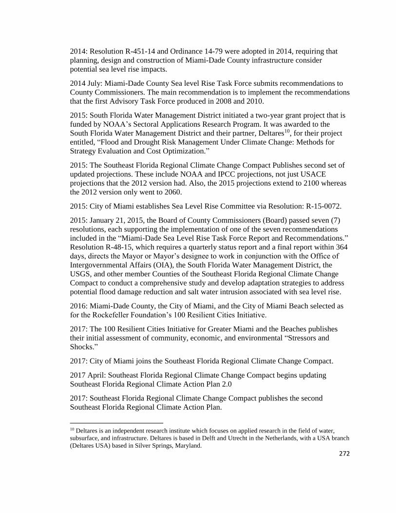
272
2014: Resolution R-451-14 and Ordinance 14-79 were adopted in 2014, requiring that
planning, design and construction of Miami-Dade County infrastructure consider
potential sea level rise impacts.
2014 July: Miami-Dade County Sea level Rise Task Force submits recommendations to
County Commissioners. The main recommendation is to implement the recommendations
that the first Advisory Task Force produced in 2008 and 2010.
2015: South Florida Water Management District initiated a two-year grant project that is
funded by NOAA’s Sectoral Applications Research Program. It was awarded to the
South Florida Water Management District and their partner, Deltares10, for their project
entitled, “Flood and Drought Risk Management Under Climate Change: Methods for
Strategy Evaluation and Cost Optimization.”
2015: The Southeast Florida Regional Climate Change Compact Publishes second set of
updated projections. These include NOAA and IPCC projections, not just USACE
projections that the 2012 version had. Also, the 2015 projections extend to 2100 whereas
the 2012 version only went to 2060.
2015: City of Miami establishes Sea Level Rise Committee via Resolution: R-15-0072.
2015: January 21, 2015, the Board of County Commissioners (Board) passed seven (7)
resolutions, each supporting the implementation of one of the seven recommendations
included in the “Miami-Dade Sea Level Rise Task Force Report and Recommendations.”
Resolution R-48-15, which requires a quarterly status report and a final report within 364
days, directs the Mayor or Mayor’s designee to work in conjunction with the Office of
Intergovernmental Affairs (OIA), the South Florida Water Management District, the
USGS, and other member Counties of the Southeast Florida Regional Climate Change
Compact to conduct a comprehensive study and develop adaptation strategies to address
potential flood damage reduction and salt water intrusion associated with sea level rise.
2016: Miami-Dade County, the City of Miami, and the City of Miami Beach selected as
for the Rockefeller Foundation’s 100 Resilient Cities Initiative.
2017: The 100 Resilient Cities Initiative for Greater Miami and the Beaches publishes
their initial assessment of community, economic, and environmental “Stressors and
Shocks.”
2017: City of Miami joins the Southeast Florida Regional Climate Change Compact.
2017 April: Southeast Florida Regional Climate Change Compact begins updating
Southeast Florida Regional Climate Action Plan 2.0
2017: Southeast Florida Regional Climate Change Compact publishes the second
Southeast Florida Regional Climate Action Plan.
10 Deltares is an independent research institute which focuses on applied research in the field of water,
subsurface, and infrastructure. Deltares is based in Delft and Utrecht in the Netherlands, with a USA branch
(Deltares USA) based in Silver Springs, Maryland.

273
Appendix B: Key Documents
Document Name Year Author
MD County Stormwater Master
Plan C-7 Basin Phase II Executive
Summary and Final Report
2006 Miami-Dade County
Miami-Dade Climate Change
Advisory Task Force Second
Report and Initial
Recommendation
2008 Miami-Dade County
Presentation on SLR to first
climate change committee
2008 Dr. Hal Wanless, University of Miami
Planning for Hazards and Climate
Change Impacts: One County's
Approach
2009 NOAA
An Update on USACE Sea Level
Change Guidance and Preliminary
Applications for Everglades
Restoration Projects
2010 US Army Corps of Engineers
Miami-Dade County GreenPrint
Our Design for a Sustainable
Future
2010 Miami-Dade County
Climate Change Advisory Task
Force Status of Recommendations
2010 Miami-Dade County
Analysis of the Vulnerability of
Southeast Florida to Sea Level
Rise
2012 Southeast Florida Regional Climate
Change Compact
A Region Responds to a Changing
Climate: Southeast Florida
Regional Climate Change
Compact Counties: Regional
Climate Action Plan
2012 Southeast Florida Regional Climate
Change Compact
Implementation Guide: Southeast
Florida Regional Climate Action
Plan
2012 Southeast Florida Regional Climate
Change Compact
Regional Impacts of Climate
Change and Issues for Stormwater
Management
2012 Southeast Florida Regional Climate
Change Compact; South Florida Water
Management District
US EPA Region 4 Adaptation
Implementation Plan
2013 Environmental Protection Agency
Nature Conservancy Coastal
Resilience Visualization Tool
2013 The Nature Conservancy
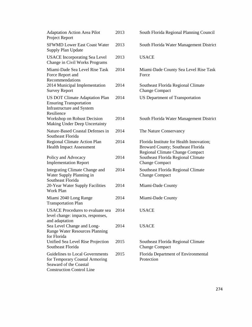
274
Adaptation Action Area Pilot
Project Report
2013 South Florida Regional Planning Council
SFWMD Lower East Coast Water
Supply Plan Update
2013 South Florida Water Management District
USACE Incorporating Sea Level
Change in Civil Works Programs
2013 USACE
Miami-Dade Sea Level Rise Task
Force Report and
Recommendations
2014 Miami-Dade County Sea Level Rise Task
Force
2014 Municipal Implementation
Survey Report
2014 Southeast Florida Regional Climate
Change Compact
US DOT Climate Adaptation Plan
Ensuring Transportation
Infrastructure and System
Resilience
2014 US Department of Transportation
Workshop on Robust Decision
Making Under Deep Uncertainty
2014 South Florida Water Management District
Nature-Based Coastal Defenses in
Southeast Florida
2014 The Nature Conservancy
Regional Climate Action Plan
Health Impact Assessment
2014 Florida Institute for Health Innovation;
Broward County; Southeast Florida
Regional Climate Change Compact
Policy and Advocacy
Implementation Report
2014 Southeast Florida Regional Climate
Change Compact
Integrating Climate Change and
Water Supply Planning in
Southeast Florida
2014 Southeast Florida Regional Climate
Change Compact
20-Year Water Supply Facilities
Work Plan
2014 Miami-Dade County
Miami 2040 Long Range
Transportation Plan
2014 Miami-Dade County
USACE Procedures to evaluate sea
level change: impacts, responses,
and adaptation
2014 USACE
Sea Level Change and Long-
Range Water Resources Planning
for Florida
2014 USACE
Unified Sea Level Rise Projection
Southeast Florida
2015 Southeast Florida Regional Climate
Change Compact
Guidelines to Local Governments
for Temporary Coastal Armoring
Seaward of the Coastal
Construction Control Line
2015 Florida Department of Environmental
Protection

275
Miami-Dade County
Comprehensive Development
Master Plan
2015 Miami-Dade County
Village of Pine Crest
Comprehensive Development
Master Plan
2015 Village of Pinecrest
Miami Comprehensive
Neighborhood Plan
2015 City of Miami
Miami Beach Stormwater
Management Master Plan
2015 City of Miami Beach
Village of Pine Crest Stormwater
Master Plan Report
2015 Village of Pinecrest
Pinecrest Survey for Landowners
about Flooding
2015 City of Pinecrest
Pinecrest Stormwater Plan 2015 City of Pinecrest
Effective Sea Level Rise
Communication Strategies for
Local Governments
2016 Southeast Florida Regional Climate
Change Compact and The Miami
Foundation
Integrating the Unified Sea Level
Rise Projection into Local Plans
2016 Institute for Sustainable Communities
Local Mitigation Strategy Miami-
Dade County Whole Community
Hazard Mitigation
2016 Miami-Dade County
Memorandum Miami Dade
County: Final Status reports in
response to multiple resolutions
pertaining to recommendations by
the sea level task force
2016 Miami-Dade County
Assessment of Available Tools to
Create a More Resilient
Transportation System
2016 Miami-Dade County
Climate Adaptation: The State of
Practice in U.S. Communities
2016 The Kresge Foundation
Report on Flooding and Salt water
intrusion
2016 Miami-Dade County
Mobilizing Miami for Sea Level
Rise
2016 The Miami Foundation and the Knight
Foundation, written by firm, Sightful
Sea Level Rise and U.S. Coasts:
Science and Policy Considerations
(by Congressional Research
Service)
2016 Congressional Research Service
Reducing Climate Risk and
Creating Economic Opportunity
(Regional Climate Action Plan
Implementation Support Guidance
Series)
2016 Southeast Florida Regional Climate
Change Compact

276
Southeast Florida Climate
Indicators
2016 Southeast Florida Regional Climate
Change Compact
Integrating the Southeast Sea
Level Rise Projections into
Community Planning
2016 Southeast Florida Regional Climate
Change Compact
South Florida Climate Change
Vulnerability and Adaptation
Assessment Pilot Project
2016 U.S. Department of Transportation
Adaptation Action Areas:
Feasibility Assessment
2016 Miami-Dade County
Miami Frontlines Coalition Letter 2016 Community organizations and leaders
FreddieMac Life's a Beach:
Economic and Housing Insight
2016 FreddieMac
Health and Sea Level Rise:
Impacts on South Florida
2016 Florida Institute for Health Innovation
Climate Change Advisory Task
Force
2016 Miami-Dade County
Strategic Implementation of the
Environmentally Endangered
Lands Program
2016 Miami-Dade County
Hydrologic Conditions in Urban
Miami-Dade County, Florida, and
the Effect of Groundwater
Pumpage and Increased Sea Level
on Canal Leakage and Regional
Groundwater Flow
2016 USGS
FEMA Letter to Mayor Cindy
Lerner about CRS rating in Village
of Pinecrest
2016 FEMA
USACE Guidance for
incorporating climate change
impacts to inland hydrology in
civil works studies, designs, and
projects
2016 USACE
Arch Creek Briefing Book 2016 Miami-Dade County
Arch Creek Final Report 2016 Urban Land Institute
Pinecrest Climate Action Plan 2016 City of Pinecrest
What Climate Change Means for
Florida
2016 Environmental Protection Agency
Climate Change Leadership
Training
2017 Catalyst Miami
Rising to the Challenge, Together:
A review and critical assessment
of the state of the US climate
adaptation field
2017 The Kresge Foundation
Miami-Dade County: selected
policies and legislation related to
sea level rise and climate change
2017 Miami-Dade County

277
100 Resilient Cities Preliminary
Assessment
2017 Miami-Dade County, City of Miami, City
of Miami Beach
Miami-Dade Comprehensive
Planning Survey
2017 Miami-Dade County
Compact survey for feedback on
the Regional Climate Action Plan
2.0
2017 Southeast Florida Regional Climate
Change Compact
USACE Guidance for detection of
nonstationarities in annual
maximum discharges
2017 USACE
Joint Statement on Collaboration
for Regional Economic Resilience
in Southeast Florida
2017 Southeast Florida Regional Climate
Change Compact
Regional Climate Action Plan 2.0 2018 Southeast Florida Regional Climate
Change Compact

278
Appendix C: Interview Guide
Interview guide for planning professional, manager, and government employees
Tell me a bit about your background and how you got to your current position.
When did you first get involved in sea level rise planning?
[Alternatively: Can you tell me about your current role in sea level rise adaptation
planning?]
What are some of the projects and policies you are aware of going on in the county?
What are your thoughts on how the region is doing regarding sea level rise adaptation
planning?
[Alternatively: What are the biggest issues regarding sea level rise adaptation planning?]
What parts of the county do you see getting investment and resources for sea level rise
adaptation?
Are there areas getting more resources and investments towards adaptation planning than
other areas?
Follow-up questions:
• What is it about these areas that you think makes them receive more resources and
investments?
• What do you see as driving adaptation planning?
• Where is the funding coming from?
What types of strategies do you see getting the most investment and resources for sea
level rise adaptation?
Follow-up questions:
• What is it about these strategies that you think makes them receive more
resources and investments?

279
Can you tell me about some of the policy changes that have taken place since sea level
rise adaptation planning became a priority for the region?
What was your main objective with [name of document/effort/adaptation/etc]
What do you think are the most important things that can be done to prepare the region
for sea level rise?
Follow-up questions:
• What is it about these strategies that make them so important?
• How is the region addressing these strategies?
• What do you think it will take to implement these strategies?
• How would you prioritize these strategies?
Where in the county is most vulnerable to sea level rise?
Follow-up question:
• What about these places makes you think they are vulnerable?
Can you tell me about your relationship with other organizations in the area who are also
working on sea level rise adaptation planning?
Follow-up questions:
• Who do you see are most involved in adaptation planning efforts?
• Who do you work with?
• How do you work with them?
• Who are your most vocal opponents/Critics?
What, in your opinion, would be a successful sea level rise adaptation project?
[Alternatively: How do you measure project success?]
What lessons have you learned from this process that you could share with other areas?
What is your hope for this region in 50 years from now?

280
Interview guide for community, environmental, or other organization
Tell me a bit about your background and how you got to your current position.
What are your interests in sea level rise planning?
What are your thoughts on how the region is doing regarding sea level rise adaptation
planning?
[Alternatively: What are the biggest issues regarding sea level rise adaptation planning?]
What are the biggest issues regarding some of the proposed adaptation strategies or
policies affecting your organization?
What was your main objective with [name of document/effort/adaptation/etc]
What parts of the county do you see getting the most attention for sea level rise
adaptation?
Follow-up questions:
• What is it about these areas that you think give them the most attention?
• What do you see as driving adaptation planning?
What parts of the county do you see getting the least attention for sea level rise
adaptation?
Follow-up questions:
• What is it about these areas that you think give them the least attention?
What types of strategies do you see getting the most attention for sea level rise
adaptation?
Follow-up questions:
• What is it about these strategies that you think give them the most attention?
What was your main objective with [name of document/effort/adaptation/etc]
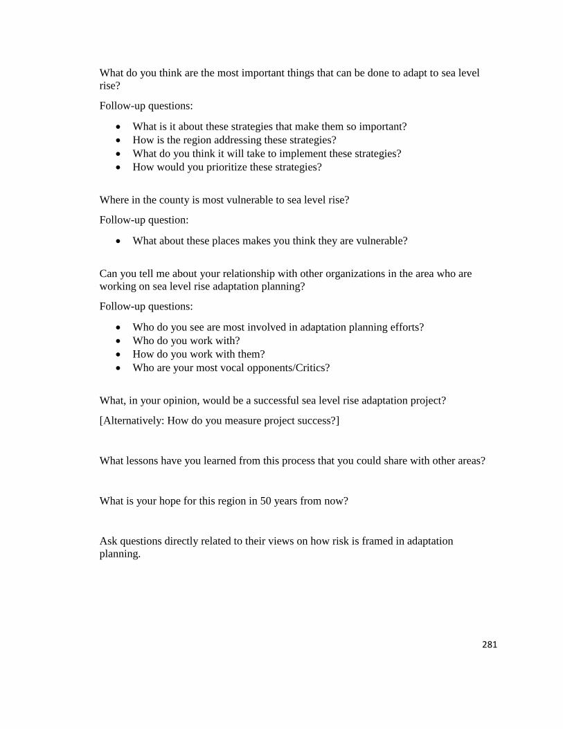
281
What do you think are the most important things that can be done to adapt to sea level
rise?
Follow-up questions:
• What is it about these strategies that make them so important?
• How is the region addressing these strategies?
• What do you think it will take to implement these strategies?
• How would you prioritize these strategies?
Where in the county is most vulnerable to sea level rise?
Follow-up question:
• What about these places makes you think they are vulnerable?
Can you tell me about your relationship with other organizations in the area who are
working on sea level rise adaptation planning?
Follow-up questions:
• Who do you see are most involved in adaptation planning efforts?
• Who do you work with?
• How do you work with them?
• Who are your most vocal opponents/Critics?
What, in your opinion, would be a successful sea level rise adaptation project?
[Alternatively: How do you measure project success?]
What lessons have you learned from this process that you could share with other areas?
What is your hope for this region in 50 years from now?
Ask questions directly related to their views on how risk is framed in adaptation
planning.

282
Appendix D: Codebook used in Atlas.ti
100 Focus of Risk
101 Economic/Tourism
102 Ecological
103 Infrastructure/Canals/Buildings
104 Wellness and health
105 Political
106 Identity, sense of place
107 Historical
108 Hazard
109 Water supply
110 Agriculture
111 Communities of Special Concern
112 Private Property
113 Affordable Housing
114 Future Generations
115 Legal/Liability
200 Interpret Information About Risk (Risk Measurement)
201 Models
202 Assessments/plans
203 Personal Experience
204 Historical Information
205 Community input
206 Cost benefit analysis/Valuation
207 Prioritize Projects
208 Best Available Science
209 Vulnerable Places in the County
210 Media
211 Maps
212 Materiality/Understanding of Physical Property of risk
213 Harmonization
214 Scientific Study
215 Scenarios
300 Risk Boundary
301 Baseline
302 Projection Range (temporal)
303 Uncertainty
304 Boundary (geographical)

283
305 Constraints/Limitations
306 Monitoring/evaluation
400 Planning Process
401 Comprehensive Land Use Planning
402 Stormwater Planning
403 Water and Sewer Planning
404 Vulnerability Assessment
405 Adaptation Action Area
406 Hazard Mitigation Planning
407 Post Disaster Recovery
408 Adaptive Management/Planning
409 Sustainability/Resiliency Planning
410 Task Force/Committee
411 Adaptation Planning
412 Incremental Planning
413 Proactive
414 Reactive
415 Economic development
416 Regional Plan
417 Holistic
500 Governance
501 Laws/Policies/Regulations
502 Funding
503 Transparency
504 Accountability
505 Inclusiveness
506 Fairness
507 Collaboration/Integration
508 Capability
509 Adaptability
510 Legitimacy/Authority
600 Knowledge Networks
601 Partnerships
602 Trust
603 Miami-Dade County
604 City
605 Southeast Florida Regional Climate Compact
606 SFWMD
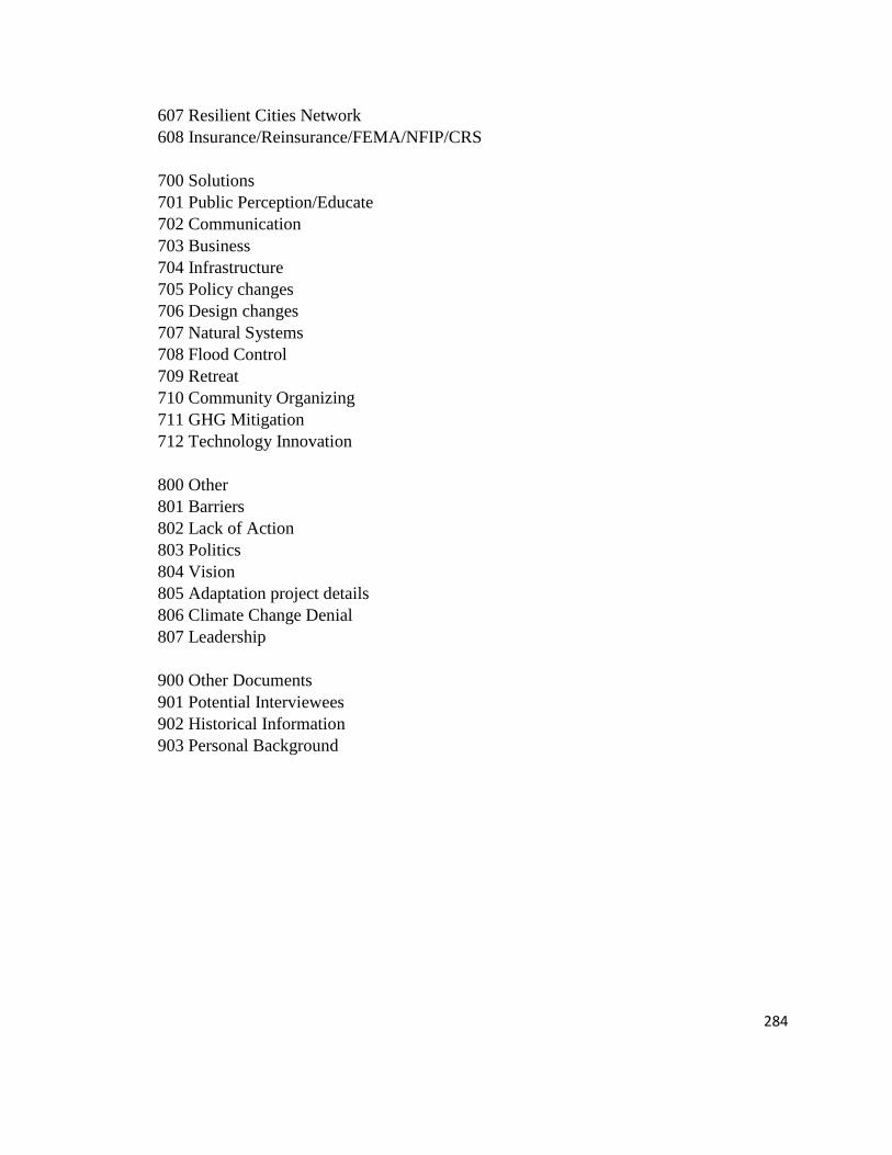
284
607 Resilient Cities Network
608 Insurance/Reinsurance/FEMA/NFIP/CRS
700 Solutions
701 Public Perception/Educate
702 Communication
703 Business
704 Infrastructure
705 Policy changes
706 Design changes
707 Natural Systems
708 Flood Control
709 Retreat
710 Community Organizing
711 GHG Mitigation
712 Technology Innovation
800 Other
801 Barriers
802 Lack of Action
803 Politics
804 Vision
805 Adaptation project details
806 Climate Change Denial
807 Leadership
900 Other Documents
901 Potential Interviewees
902 Historical Information
903 Personal Background

285
Appendix E: Events Attended During Field Research
Name of Event
Date
Attended Brief Description
Stand Up Rise Up Film
Screening of Revolution 3/22/2017
Event put together by CLEO and other
environmental organizations to show film
about degraded coral reef habitat in South
Florida. Panel following screen filming
had several stakeholders involved in sea
level rise adaptation planning.
City of Miami Sea Level
Rise Committee Meeting 3/27/2017
Monthly committee meeting at City Hall
for sea level rise Committee.
Miami-Dade County FEMA
Risk MAP Technical
Update Meeting #2 3/28/2017
Meeting hosted by Taylor Engineering, no
FEMA Staff present. A technical meeting
to go over FEMA Risk Mapping updates.
Several county and city employees
(including floodplain administrators)
present for updates.
North Beach Neighborhood
Association Meeting 4/3/2017
Meeting about proposed zoning changes
to North Beach neighborhood in the City
of Miami Beach. Focus was on comparing
proposed changes with the recently
developed North Beach Plan. Sea level
rise was key component, up-zoning
discussion based on need for resilient
buildings, counter to community goals of
historic and maintaining quality of life.
City of Miami Beach
Project Open House 4/4/2017
Organized by City of Miami Beach to
share information with residents that will
be affected by stormwater upgrades
(including road raising)
Salon Juste 4/5/2017
Climate justice panel organized by
community activists and lawyers.
CLEO Institute Climate 101 5/4/2017 Introductory training on climate change.
City of Miami General
Obligations Bond Public
Comment: City Hall 5/8/2017
Information meeting about proposed
General Obligation Bond which featured
stormwater management and sea level rise
adaptation planning.

286
City of Miami General
Obligations Bond Public
Comment: Hadley Park 5/15/2017
Information meeting about proposed
General Obligation Bond which featured
stormwater management and sea level rise
adaptation planning.
City of Miami General
Obligations Bond Public
Comment: Little Havana 5/16/2017
Information meeting about proposed
General Obligation Bond which featured
stormwater management and sea level rise
adaptation planning.
City of Miami General
Obligations Bond Public
Comment: Juan Pablo
Duarte 5/17/2017
Information meeting about proposed
General Obligation Bond which featured
stormwater management and sea level rise
adaptation planning.
New Florida Majority
Presentation by Chris
Gongoria and Film
Screening from Dwight
Bullard: The Birth of a
Nation 5/18/2017
Community event organized by New
Florida Majority, an organization involved
in resiliency and community organizing
around climate justice and hurricane
preparation/response
City of Miami Sea Level
Rise Committee Meeting 5/22/2017
Monthly committee meeting at City Hall
for sea level rise Committee.
Gen CLEO Meetup 5/23/2017
Event designed for youth engagement in
climate change work in Miami.