recent glacier advances at glaciar exploradores, hielo ... · recent glacier advances at glaciar...
TRANSCRIPT
Recent glacier advances at Glaciar Exploradores, Hielo Patagónico Norte, Chile
Masamu ANIYA+, Gonzalo BARCAZA, and Shogo IWASAKI-
+ Graduate School of Life and Environmental Sciences, University of Tsukuba, Tsukuba, Ibaraki -*/�2/1,, Japan
, Graduate Student, Graduate School of Life and Environmental Sciences, University of Tsukuba, Tsukuba, Ibaraki -*/�2/1,,
Japan
- National Institute of Polar Research, Itabashi, Tokyo +1-�2/+/, Japan
(Received September ,3, ,**0; Revised manuscript accepted November ,,, ,**0)
Abstract
With the purpose of establishing the recent glacial chronology of the HPN, moraines at Glaciar
Exploradores were identified and investigated, thereby collecting samples for +.C dating. In total,
three moraine systems were recognized, the Invernada moraine (TM+), main moraine (TM,) and the
modern (secondary) moraines (TM-). TM- was further subdivided into TM-�+ and TM-�, based on
vegetation cover, size, morphology, degree of rock weathering, and development of mosses on rocks.
Two samples from TM+, six samples from TM, and seven samples from TM- were dated. Also the
number of tree rings was counted at TM, and TM-. Based on these data, four possible scenarios were
postulated and examined. The tentative conclusion is that there were two recent glacial advances at
Glaciar Exploradores, one sometime between the +,th and +1th century (forming main moraine, TM,)
and the other around the early to mid-+3th century (TM-�+) and after ca. +3.. (TM-�,). We could not
obtain a date that would indicate the age of the Invernada moraine (TM+): however, from the age of
TM,, it was speculated that it could be of the Neoglaciation III (+0**�+-** BP).
+. Introduction
The Patagonia Icefield is very important to under-
stand the global pattern of the environmental changes,
because of its nature (temperate glacier), size and loca-
tion. In order to elucidate the global pattern of Holo-
cene glaciations, Neoglacial advances of Patagonian
glaciers have been studied mostly at the HPS (Hielo
Patagónico Sur; southern Patagonia Icefield), first by
Mercer (+30., +302, +31*, +310, +32,) and later by Aniya
(+33/, +330). Mercer identified three Neoglaciations
around .1**�.,** BP, ,1**�,*** BP, and the Little Ice
Age (LIA), whereas Aniya proposed four glaciations
around -0** BP, ,-** BP, +0**�+.** BP, and the LIA.
Glasser et al. (,**.) called this as Mercer type and
Aniya type chronology.
On the other hand, at the HPN (Hielo Patagónico
Norte; northern Patagonia Icefield) studies on recent
glacial chronology are scarce and the glacial chronol-
ogy of the HPN has not well established yet. The
first such study was carried out by Aniya and Naruse
(+333) who identified two glacial advances at Glaciar
Soler, +-** BP and the LIA during the +2th century.
Later Glasser et al. (,**,) suggested another advance
between AD +,**�+-/*. Harrison and Winchester
(,***), at Glaciares Colonia and Arco, suggested the
LIA advance during the +2�+3th century from the
dendrochronology. Recently, Glasser et al. (,**/), us-
ing ASTER and other satellite images, manually inter-
preted terminal moraines of the HPN outlet glaciers
and identified three advances including the LIA, with-
out assigning ages to the other two earlier advances.
Because of the satellite resolution (ASTER, +/ m; Lan-
dsat, -* m), identification of terminal moraines was
naturally limited. In their paper, they list the big
moraine of Glaciar Exploradores as of the LIA, with-
out giving any concrete evidence or argument. It
was probably simply judged so because it is located
immediately front of the present glacier snout.
Including Glaciar Exploradores, there is a big ter-
minal moraine in front of the present snout at many
outlet glaciers, and some of them have formed a pro-
glacial lake such as Glaciares León, Fiero, Nef and
Ste#en, to name but a few. Determining the age of
this big moraine is an important key for establishing
the recent glacial chronology of the HPN. Aniya first
thought it is probably of the age around +0**�+-** BP,
from the study at Glaciar Soler (Aniya and Naruse,
+333), whereas British groups (i. e., Harrison and Win-
chester, ,***; Glasser et al., ,**/) think it is of the LIA.
With this background, we carried out landform inves-
Bulletin of Glaciological Research ,. (,**1) .3�/1
�Japanese Society of Snow and Ice
49
tigation in December ,**-, December ,**. and August
,**/, thereby collecting many samples for +.C dating.
Based upon the moraine distribution and the ages
of +.C data, we present our interpretation of the recent
glacier advances at Glaciar Exploradores.
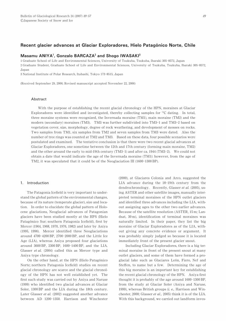
,. Study area
Glaciar Exploradores is located at .0�-*�S and
1-�+*�W, on the north side of Monte San Valentin, the
highest mountain in Patagonia (-3+* m) and is fed
principally with snow accumulating on the mountain
slope and snow/ice avalanches (Fig. +). It is not di-
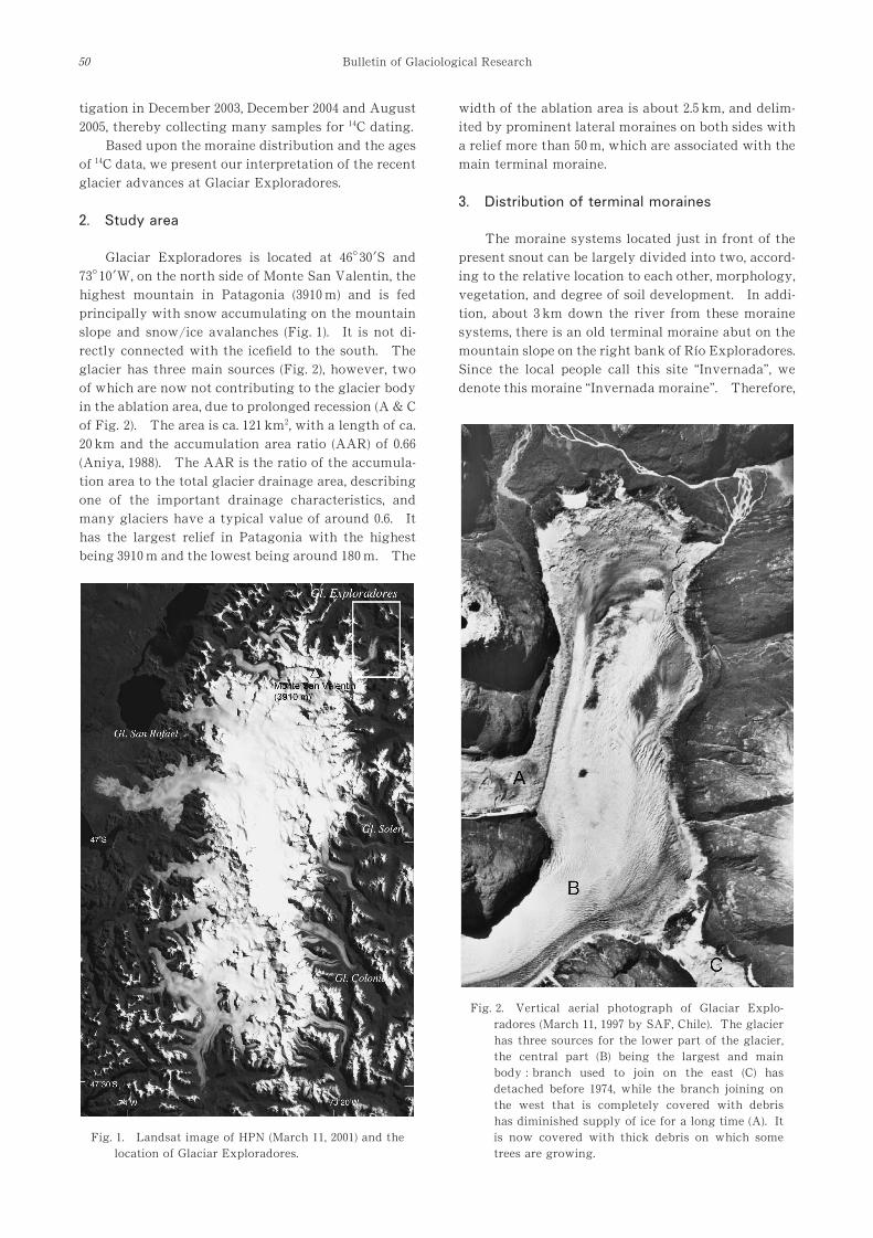
rectly connected with the icefield to the south. The
glacier has three main sources (Fig. ,), however, two
of which are now not contributing to the glacier body
in the ablation area, due to prolonged recession (A & C
of Fig. ,). The area is ca. +,+ km,, with a length of ca.
,* km and the accumulation area ratio (AAR) of *.00
(Aniya, +322). The AAR is the ratio of the accumula-
tion area to the total glacier drainage area, describing
one of the important drainage characteristics, and
many glaciers have a typical value of around *.0. It
has the largest relief in Patagonia with the highest
being -3+* m and the lowest being around +2* m. The
width of the ablation area is about ,./ km, and delim-
ited by prominent lateral moraines on both sides with
a relief more than /* m, which are associated with the
main terminal moraine.
-. Distribution of terminal moraines
The moraine systems located just in front of the
present snout can be largely divided into two, accord-
ing to the relative location to each other, morphology,
vegetation, and degree of soil development. In addi-
tion, about - km down the river from these moraine
systems, there is an old terminal moraine abut on the
mountain slope on the right bank of Río Exploradores.
Since the local people call this site “Invernada”, we
denote this moraine “Invernada moraine”. Therefore,
Fig. +. Landsat image of HPN (March ++, ,**+) and the
location of Glaciar Exploradores.
Fig. ,. Vertical aerial photograph of Glaciar Explo-
radores (March ++, +331 by SAF, Chile). The glacier
has three sources for the lower part of the glacier,
the central part (B) being the largest and main
body : branch used to join on the east (C) has
detached before +31., while the branch joining on
the west that is completely covered with debris
has diminished supply of ice for a long time (A). It
is now covered with thick debris on which some
trees are growing.
Bulletin of Glaciological Research50

in total, there are three main terminal moraine sys-
tems in the area down the snout (Fig. -).
-.+ Invernada moraine (TM+)This moraine was first spotted from the road in
December ,**., when we tried to walk to the neighbor
glacier Grosse, and subsequently checked on the +331
vertical aerial photographs. In August ,**/, we vis-
ited this site and confirmed indeed as a terminal mo-
raine (Fig. .). This is a huge moraine consisting of a
single ridge, with a relief from the valley floor exceed-
ing ,/* m, length more than +*** m, and the width at
the base about 3** m. The whole hill is covered with
dense, large vegetation. There is a gently inclined
terrace to the northwest of this moraine, which was
formed by huge landslide deposits. Since the ridge of
the moraine is separated from the mountain slope, this
cannot be a depositional landform produced by huge
landslide. Actually, the formation and existence of
this moraine seems to owe this terrace, which may
have blocked the glacier snout. We call the glacier
advance that formed this moraine “Invernada Ad-
vance”.
The moraine consists of huge blocks of granites,
particularly near the top. Here boulders of more
than / m long are piled up, and without soil develop-
ment and dense vegetation cover, it would have been
impossible to walk about. From depressions near the
top, we collected two samples of organic matters for+.C dating.
Although the moraine is located by the mountain
slope, we have judged this moraine a terminal one,
from its position on the valley floor and the direction
of the main ridge (though not completely transverse
to the valley direction). To our enigma, however, we
could not recognize any corresponding lateral mo-
raines on either side of the valley, from the field
observation of hill slope topography and/or vegeta-
tion change on slope, or even from stereoscopic inter-
pretation of the +331 aerial photographs at about
+: 1****. At present with so much debris supply, the
development of lateral moraines is very good. There-
fore, it seems di$cult to think that lateral moraines
were not formed when the Invernada Moraine was
deposited. If formed, what would have completely
destroyed the lateral moraines of the Invernada ad-
vance. One possibility is a glacial lake outburst flood
(GLOF). If a GLOF of such magnitude had occurred,
the Invernada Moraine should have been a#ected;
however, due to dense vegetation cover such evidence
could not possibly be recognized.
-., Main terminal moraine (TM,)Because this terminal moraine system is most
prominent and important in this area and therefore is
a subject of age estimation of this project, we call it
“main moraine” (Fig. /). This moraine encircles the
present snout almost completely with one active out-
let stream on the eastern edge and three old, dried-out
outlets that break the continuation of the moraine
ridge. There are distinctive lateral moraines on ei-
ther side of the glacier, which are associated with the
main moraine. On the +3.. Trimetrogon aerial pho-
tograph, at least three active outlets were recognized
(Fig. 0). Since then, the central ones were dried out,
and on the +31. aerial photographs two active outlet
Fig. -. Terminal moraines and sampling sites for
dating materials at Glaciar Exploradores �aerial
photo by SAF, Chile, March ++, +331).
Fig. .. Ground photograph of Invernada moraine
(August -, ,**/, by Aniya), looked from the south
on the road under construction along Río Explo-
radores. Note: although it was the middle of win-
ter, the snow cover on the mountain slope was
very limited, indicating moderate climate around
here even in winter.
Aniya et al. 51

streams are recognized at the western and eastern
edges, while on the +331 aerial photographs the west-
ern outlet stream was dried out due to surface lower-
ing. When we visited the wind gap at the western
edge in December ,**., the lake level on the glacier
side was about ,* m lower than the wind gap.
A relief of the moraine on the proximal side is up
to 2* m, while on the distal side it is +.*�,** m from
Río Exploradores. The moraine is extensively cov-
ered with trees, particularly on the distal side due to
mild climate with abundant rain; however, it is still
ice-cored at many sites. The evidence for ice-cores
includes: (+) seepage of water from the proximal base
of the moraine (even in winter); (,) exposure of ice-
core at the base due to erosion; and (-) bulging of the
proximal slope, flowage of surficial rubbles and tilting
of trees on them due to core-ice melting. For this
reason, much of the proximal side is devoid of vegeta-
tion or with fallen trees of +*�+/ cm thick, while the
distal side is covered with thick soils and dense trees
(many conifers) with the diameter at breast height
(DBH) of /*�0* cm.
The proximal slope of the eastern part of the
moraine ridge is totally devoid of vegetation, on
which rock fall is very active, particularly when it is
raining. Abundant water seepage from the base of
this part, including winter time, indicates that a large
core-ice still exists inside this part. The nature of
sediments is totally di#erent between the upper and
the lower part. The upper part consists of fine mate-
rial that has slightly indurated with weak stratifica-
tion, inclining toward the distal side, and the proxi-
mal slope is more than /*�, while the lower part con-
sists mainly of gravel of loose materials resting at the
Fig. /. The main terminal moraine of Glaciar Exploradores (July ,0, ,**., by Aniya), looked from the northeast, with
perfect reflection in Lago Bayo. The mirror-like lake surface indicates that there was absolutely no wind, which was
not unusual during winter. The peak at the top left is Monte San Valentin (-3+* m), the highest mountain in
Patagonia. Since the elevation of Lago Bayo is about +2* m, the relief in this photograph is more than -1** m.
Fig. 0. Trimetrogon aerial photograph of Glaciar Exploradores, taken in +3... A is a branch joining on the west, which
was completely covered with debris. B is the main body.
Bulletin of Glaciological Research52

angle of repose, some of which are subrounded or
subangular indicating the influence of running water.
Many fallen rocks originate from the lower slope. A
lot of wood pieces are seen embedded here on both the
upper and lower parts.
-.- Modern terminal moraines (TM-)These moraines are located between the main
moraine (TM,) and the present snout. At places,
there are proglacial lakes between TM- and the snout.
From the fieldwork and the aerial photographic inter-
pretation, this moraine system can be further divided
into two types (see Fig. - inset), according to vegeta-
tion cover, size, morphology, degree of rock weather-
ing, and development of mosses on rocks.
-.-.+ TM-�+This moraine system is located near the eastern
edge, in front of a water pool for the outlet stream.
This system comprises several small moraine ridges
transverse to the glacier flow direction and two kettle
ponds developed here. Nothofagus found on this mo-
raine system are large, with the DBH ranging up to .*
�/* cm near the water pool. The present snout abuts
on this system, with striking contrast in appearance.
The area (rocks) without vegetation is covered with
extensive mosses. Boulders include many lime-
stones, which cannot be found elsewhere on the mo-
raine.
-.-., TM-�,This system is located on the proximal side of the
Main moraine (TM,). In many places, active progla-
cial lakes are located between this system and the
present snout. In contrast to TM-�+, the topography
of this moraine system is generally flat, with some
hummocky areas. Invasion of vegetation is fairly
well, and at places Nothofagus trees with the DBH of
+/�,* cm are found. There exist extensive ice cores
beneath the soil of about -* cm thick. Recent melting
of core ice is very striking, with trees falling, ponds
enlarging, and steps on the surface formed due to
di#erential melting (Aniya et al., ,**/).
.. +.C Samples and dating results
Sampling sites are shown in Figure -, and the
following dates were obtained for each moraine sys-
tem.
+) Invernada Moraine: two organic samples were col-
lected from two depressions near the top, which
yielded the following ages.
+A, ca. +*0 BP: +B, ca. +** BP.
,) Main Moraine: six wood samples were collected
from this moraine, with the following ages.
,A, 3,/*�/* BP; ,B, +3**�/* BP; ,C, +.**�.* BP; ,D,
+*/*�/. BP; ,E, 21*�/* BP, and ,F, 2,*�0* BP.
-) Modern Moraines: seven samples were dated.
-A, ca. +*2 BP (plant); -B, ca. +*3 BP (organic matter); -
C, ca. ++/ BP (wood); -D, ca. +,+ BP (wood); -E, +,- BP
(organic matter); -F, ca. +-. BP (plant); -G, ca. +.1 BP
(organic matter).
..+ Interpretation of +.C dataA sample for +.C data is normally a piece of wood
that was embedded in a moraine or destroyed by a
glacier advance, or organic matters/plant remains
found in a depression that was supposedly formed by
a glacier advance. Interpretation of these data is to-
tally di#erent though. In case of a piece of wood, the
age of a sample indicates that the glacial advance was
later than that age (maximum possible age). On the
other hand, the age of organic matter or plant remains
found in a depression indicates that the glacier ad-
vance was well before the age of such samples (mini-
mum possible age). As for a wood sample, we nor-
mally do not know its origin and transportation pro-
cesses until its deposition. As for the organic mat-
ters, we are usually not sure how long it took for the
organic matter to be formed in a depression that was
formed by a glacier advance. It is not di$cult to
suppose that this decomposition/sedimentation pro-
cess is very di#erent under di#erent climate condi-
tions and nature of sediments (gravelly or clayey/
silty), and in Patagonia it is inferred to range from +**
to more than ,*** years (Mercer, +310). Therefore,
interpretation of the +.C age must be carefully done,
considering the nature and the environment of sam-
ples.
..+.+ Samples from Invernada moraineSamples +A and +B both yielded a modern age of
ca. +** BP. Although these samples were collected
from a layer just above the gravel in depressions near
the top of the moraine, this cannot be indicative of the
age of the moraine formation, judged from the circum-
stance and the environment of the moraine.
..+., Samples from the main moraineAges of these samples are wide spread, ranging
from 3,/* BP to 2,* BP. Of these samples, ,A (3,/*�/* BP), ,B (+3**�/* BP), ,C (+.**�.* BP), ,D (+*/*�/.
BP) were collected from the proximal slope of the
moraine. The age of sample ,A is very di#erent and
from the general circumstance of the icefield it is very
likely that it was reworked many times before being
embedded in the moraine. Therefore, we can safely
exclude this sample from our subsequent discussion.
The age of +3** BP of sample ,B was obtained
with a piece of wood that was embedded in the proxi-
mal slope by a proglacial lake near the western edge
of the main moraine. The piece of wood was chipped
from a tree trunk of about -* cm thick, which was one
of the piled-up tree trunks. From the size of tree
Aniya et al. 53

trunks and the way they are clustered, it is unlikely
that these were subglacially transported and subse-
quently brought up onto the surface by thrusting. It
seems rather that these tree trunks were mostly trans-
ported supraglacially. Around this sampling site,
which is about +* m above the present proglacial lake
level, there is a weak-bedding structure on the slope,
indicating a higher level of the old proglacial lake.
From these circumstances, we interpret that the for-
mation of the main moraine was after this date, +3**
BP.
One of the distinctive characteristics of the main
moraine is that the ridge near the eastern edge has a
bedding structure, although weak, that inclines to-
ward the distal side. Samples ,C (+.**�.* BP) and
,D (+*/*�/. BP) were collected from the proximal side
of this bedded part. Because the age of samples be-
comes progressively older from the top (Fig. 1), it is
possible to interpret that the formation of this mo-
raine started around +.** BP and culminated around
+*/* BP. This interpretation is close to the Aniya and
Naruse’s (+333).
It is di$cult, however, to suppose that such struc-
ture was formed in random deposits of supraglacial
debris, because the bedding structure is normally
found in sediments that were deposited in water. It
is therefore natural to suppose that either these are
subglacial sediments by subglacial streams that were
brought up by thrust, or sediments in a proglacial
lake. These strata contain a lot of subround or sub-
angular gravel, indicating strong e#ect of running
water. Because the thickness of these strata is more
than ,* m, it seems unlikely that this was brought up
by thrust and we interpret that this strata was sedi-
ments in a proglacial lake. Varved clay layers that
are normally recognized in sediments in still-standing
water cannot be found in this sediment though. The
reason may be that at Glaciar Exploradores, there is
no strong contrast in melting between summer and
winter, and the volume of the outlet stream does not
fluctuate much without lake freezing. From this in-
terpretation of the nature of this layer, it is probable
that wood pieces originated somewhere upstream
where Nothfagus are abundant. Fallen trees were
probably subglacially transported and near the snout
were brought up onto the surface by thrust and then
deposited in a proglacial lake. From these data, the
moraine formation was probably later than +*/* BP.
Samples ,E (21*�/* BP) and ,F (2,*�0* BP) were
collected at the same site on the distal side of the
moraine (Fig. 2). There are horizontal strata here in
which tree remains with -*�.* cm thick were embed-
ded. Since the tree remains were laid down, its origin
cannot be ascertained; if they were washed into a lake
after being killed somewhere else, or if they were
killed and buried in situ by impounding water due to
moraine formation or glacial advance. According to
their origin, the interpretation would be totally oppo-
site. If the interpretation is the former, the glacial
advance took later than 2,* BC, or if the latter, the
Fig. 1. Sampling sites on the eastern part of the main moraine (TM,) and their
dates. Compare with Figure - for the location.
Bulletin of Glaciological Research54

glacial advance occurred before 2,* BC. Here, consid-
ering the result of the tree ring analysis in the follow-
ing section, it is interpreted that the glacial advance
or moraine formation took later that 2,* BP.
/. Tree ring analysis
/.+ TM,
The number of tree rings was roughly counted on
a tree section that was cut and left by the road for the
road construction. We counted roughly ,** rings on
the section with a diameter of about .* cm. The larg-
est tree in this area is about /*�0* cm at DBH and if we
simply extrapolate the growth rate (/ years/cm), we
obtain a maximum age of about ,/*�-** years. The
development of vegetation and soil is very well in this
area, because of mild, temperate climate; however, in
comparison to those at the Invernada Moraine, they
look much younger.
/., TM-
By a proglacial lake behind TM-�,, we found
several fallen trees due to the recent melting of the
core ice, and cut one of them for tree ring count.
About -* cm above the root, ,* rings were counted at
the section with a diameter of +/ cm. This area was
debris-covered glacier in +3.. (see Fig. 0). So trees
started growing ,*�-* years later and in about ,*
years it grew to a height of around / m. Such rapid
invasion of trees and subsequent rapid growth are
probably due to thick debris, mild climate and abun-
dant precipitation.
0. Postulation of moraine formation ages and
recent glacier advances
0.+ Main moraine (TM,)From the preceding discussion of interpretation
of +.C data, indicating the maximum age of ca. 2,* BP,
and the tree ring count (,�-** years) and the time
elapsed before plant invasion (not known for sure, but
probably less than /* years from TM-�,), it appears
best to suppose that the moraine was formed some-
time between the +,�+1th century, that is, the Medie-
val warm period to the LIA.
0., Modern moraines (TM-)Ages obtained from organic matters and plant
remains range from ca. +/* BP to +** BP. Wood sam-
ples -D and -G were collected from sediments on top
of the ice-cored moraines, which were probably bro-
ught up by thrust. This area was still debris-covered
part of the glacier in +3... Considering the time re-
quired for algae and plants to grow in a pond on the
ice-cored moraine, it seems reasonable to suppose that
the formation of TM-�+ was sometime between the
mid- and the late+3th century. Glacial advance at
this time was recognized at Glaciar Colonia of the
HPN (Harrison and Winchester, ,***). The manual
interpretation of the Trimetrogon aerial photograph
indicates that TM-�, was formed after +3...
TM- moraines were divided into two types, TM-�+ and TM-�,. Then we can postulate several scenar-
ios for glacial advance and retreat that produced TM
-�+ and TM-�,, because the sources of glacier bodies
that produced these moraines are likely di#erent.
Some of them are as follows.
(+) After forming the main moraine sometime be-
tween the +,th and +1th century, the glacier retreated.
Then the glacier bodies that formed both TM-�+ and
Fig. 2. Sites of samples ,E and ,F on the distal side of
the main moraine (TM,), showing the bedding
structure (about , m thick), near the bottom of
which samples were located. Before ca. AD ++**,
it was warm enough to support a forest of large
trees here.
Aniya et al. 55

TM-�, advanced at the same time around the early +3
th century. The glacier body that formed TM-�+started retreating earlier than the other part, and
during the slow retreat the glacier formed a series of
recessional moraines (mid- to late +3th century).
Meanwhile, the large part of the glacier that subse-
quently formed TM-�, had been stationary for a long
time, being blocked by the large main moraine. It
was only ca. +3.*s when that part started receding
after a prolonged period of surface lowering. Be-
cause of long stagnation (about +** years?), a mantle
of thick debris has been developed, which facilitated
easy plant invasion along with the mild climate.
(,) After forming the main moraine, the glacier be-
came stagnant for a while. Because of diminished
accumulation, the glacier surface gradually lowered,
thereby accumulating thick debris cover and eventu-
ally started receding. In this process, the eastern part
(TM-�+) started receding earlier than the western part
(TM-�,), forming a series of recessional moraine ridges.
(-) After forming TM,, the glacier receded. Then
the glacier advanced at the whole front in the early to
mid-+3th century, and the glacier receded at the whole
front, thereby forming a series of recessional mo-
raines. The TM-�, part advanced again, destroying
the recessional moraine, and remained abutting on the
TM, until around the +3.*s before starting recession
again.
(.) Only the TM-�+ part advanced during the early
to mid-+3th century, and receded by the late +3th
century, thereby leaving recessional moraines. The
TM-�, part advanced independently around the be-
ginning of the ,*th century and started losing mass of
ice from the mid-,*th century.
Of these four scenarios, either (+) or (,) seems most
plausible for the following reason. The proximal side
of TM-�+ is a water pool for the only outlet stream at
present, and the recession of ice on this part is con-
spicuous, compared with the other parts of the front.
This is because the glacier body (branch) that used to
join the main body and come down to this part no
longer joins the main body since the +3.*s (see C in
Fig. ,). Therefore, after the +3th century advance,
the glacier part that was fed with this branch could
have started earlier retreat than the TM-�, part. Al-
though the appearance and characteristics of TM-�+and TM-�, are quite di#erent, these are basically the
products of the same glacier advance, and the di#er-
ence in stagnation period and the nature of debris
materials have caused such apparent di#erence.
If we take the scenario (+), Glaciar Exploradores
made two LIA advances. In case of the scenario (,),
there was only one LIA advance. We do not have
decisive data yet. However, in Patagonia, at Glaciar
Ameghino of the HPS two LIA advances are recog-
nized at +0�+1th century and the late +3th century
(Aniya, +330), and at a moraine-dammed lake near
Glaciar Soler of HPN, two LIA dates were obtained for
the double moraine ridges (Aniya and Shibata, ,**+).
Therefore, it appears that the scenario (+) is most
plausible.
As the tentative conclusion for the recent glacier
advance, we propose that Glaciar Exploradores ad-
vanced sometime between the +,th and+1th centuries,
thereby forming the main, big moraine. In addition
the glacier made another advance around the begin-
ning of the +3th century, thereby producing the secon-
dary moraines. We have no data to infer the glacier
advance that produced the Invernada moraine; how-
ever, from the studies at Glaciar Soler (Aniya and
Naruse, +333; Aniya and Shibata, ,**+), and the ap-
pearance of the moraine, it could be of the Neoglacia-
tion III (Aniya, +33/), that is, sometime between +0**�+-** BP, from the date of the main moraine.
Acknowdgments
This study was supported by a grant-in-aid for Sci-
entific Research of Japan Society for Promotion of
Research (No.+/,/-**+, Principal investigator, M.
Aniya). Field support by Mr. Orland Soto on Río
Exploradores during August ,**/ is much appreci-
ated. Without his guide and help, we could not have
visited the Invernada moraine and taken samples.
References
Aniya, M. (+322): Glacier inventory for the Northern Patago-
nia Icefield, Chile, and variations +3.././ to +32//20.
Arct. Alpine Res., ,*, +13�+21.
Aniya, M. (+33/): Holocene glacial chronology in Patagonia:
Tyndall and Upsala Glaciers. Arct. Alpine Res., ,1, -++�-,,.
Aniya, M. (+330): Holocene variations of Ameghino Glacier,
Southern Patagonia. The Holocene, 0, ,.1�,/,.
Aniya, M. and Naruse, R. (+333): Late-Holocene glacial ad-
vances at Glaciar Soler, Hielo Patagonico Norte, South
America: Trans. Japanese Geomorph. Union, ,*, 03�2-.
Aniya, M. and Shibata, Y. (,**+): The Holocene glacial chro-
nology of Rio Soler valley, Hielo Patagónico Norte, Chile.
In Aniya, M. and Naruse, R. (ed.) Glaciological and Geo-
morphological Studies in Patagonia, +332 and +333.
Rapid Printing Center, Sapporo, 01�2-.
Aniya, M., Satow, K., Skvarca, P., Anma, R., Aoki, T., Sawagaki,
T., Tanikawa, T., Naruse, R., Glasser, N. and Harrison,
S. (,**/): Overview of Glaciological Research Project in
Patagonia ,**-. Bull. Glaciol. Res., ,,: +*3�++3.
Harrison, S. and Winchester, V. (,***): Nineteenth- and twen-
tieth-century glacier fluctuation and climatic implica-
tions in the Arco and Colonia Valleys, Hielo Patagonico
Norte, Chile. Arct. Antar. Alpine Res., -,, //�0-.
Glasser, N., Hambrey, M. J. and Aniya, M. (,**,): An advance
of Soler Glacier, North Patagonian Icefield, at c. ad +,,,�+-.,. The Holocene, +, (+), ++-�+,*.
Glasser, N. F., Harrison, S., Winchester, V. and Aniya, M.
(,**.): Late Pleistocene and Holocene palaeoclimate and
glacier fluctuations in Patagonia. Global and PlanetaryChange .-: 13�+*+.
Glasser, N., Jansson, K. N., Harrison, S. and Rivera, A. (,**/):
Geomorphological evidence for variations of the North
Patagonian Icefield during the Holocene. Geomorph., 1+,
Bulletin of Glaciological Research56

,0-�,11.
Mercer, J. H. (+30.): Advance of a Patagonian glacier. Jour.
Glaciol., / (-2), ,01�,02.
Mercer, J. H. (+302): Variations of some Patagonian glaciers
since the Late-Glacial. Am. Jour. Sci., ,00, 3+�+*3.
Mercer, J. H. (+31*): Variations of some Patagonian glaciers
since the Late-Glacial: II. Am. Jour. Sci., ,03, +�,/.
Mercer, J. H. (+310): Glacial history of southernmost South
America. Quarter. Res., 0, +,/�+00.
Mercer, J. H. (+32,): Holocene glacier variations in Southern
South America. Striae, +2, -/�.*.
Aniya et al. 57