rebuilding the north carolina coast after hurricane fran ... · rebuilding the north carolina coast...
TRANSCRIPT

Coastal Mal/agemenl, 30:249-269,2002Copyright © 2002 Taylor & Francis0892-0753,m $12.00 + .00001: 10.1080,\)8920750290042192
Rebuilding the North Carolina Coast afterHurricane Fran: Did Public Regulations Matter?
RUTHERFORD H. PLATT
DepUitment of GeosciencesUniversity of MassachusettsAmherst, Massachusetts, USA
DAVID SALVESEN
DepUitment of City and Regional PlanningUniversity of North CarolinaChapel Hill, North Carolina, USA
GEORGE H. BALDWIN, II
The Haltford Financial Services Group, Inc.Hartford, Connecticut, USA
The 320-mi/e oceanfrom slwrelilJe of North Carolina, one of the nation's premiervacatioll destinations, is frequently struck by landfalling hurricanes and extratropical wimer storms. III 1996, Hurricane Fran, two months after Hurricane Bertha,inflicted an estimated $7 billion ill public and private damage, ineluding 40,000homes destr~yed, 115,000 bui/dings damaged, and 25 lives lost. Post-storm rebuilding of the North Carolina coastal zone is governed by a complex array of federal,state, and local laws, of which the keyslone is the state Coastal Area ManagementAct (CAMA). This act, as augmenled by the National Flood Insurance Program andthe federal Coastal Barrier Resources Act, seeks to reduce vulnerability to futurecoastal hazards Ihrough postdisastel'adjustments in the horizontal and vertical placememof struclllres, among other measures, This article reviews experience in rebuildingthe North Carolina oceanfront afler the 1996 hurricanes to dh;cem the influence, ifallY, of these laws. The research is based on review of postdisaster assessments,interviews with key personnel, news media reports, and direct observation. We fOl/l1dwidespread compliance wilh vertical elevation and bui/ding codes but rather unevenapplication of minimlll/1 setbacks Wider CAMA, especially where vegetation was renlOl'ed. Oceanfrollt structures are being built more strongly to resist wave (lnd windforces but (Ire vulncrable to ongoing erosion, resultillg in beach alld dune scour,and possible slranding of structures below the mean high waler fif/e. Experiencewith temporary replacement of dUlles and the shore road at North Topsail Beach
Received 15 Febmary 200 I; accepted 8 Febmary 2002.Adapted from an unpublished report prepared by Platt for The H. John Heinz III Center for
Science, Economics, and the Environment. TIle authors thank for their assistance: Todd Miller,N.C. Coastal Federation; David R. Godschalk, University of North Carolina at Chapel Hill; OrrinH. Pilkcy, Jr. and Tracy Rice, Duke University; and Janet Russell, Charles Jones, and AlisonDavis, all with the North Carolina Division of Coastal Management.
Address correspondence to Rutherford H. Platt, Ecological Cities Project, Department ofGeosciences, University of Massachusetts, Amherst, MA 01003, USA. E-mail: [email protected],edu
249

250 R. H. Platt e/ al.
indicates that political pressure may overwhelm the intcnt of Congress to limit repetitive loss costs for ifljrastrucllIre, especially ill areas designated /lnder the CoastalBarrier Resources Act.
Keywords coast, hazard, hurricane, law
"Do yOll realize the risk that people take every day when they illl'eS! ill fhe stockmarket? People every day take much morc risk Ihall buying properly Oil a beautifulbeach. "
-John Starling, real estate developerNorth Topsail Beach, NCl1lC News and Observer (Raleigh, NC)December 2\, 1989
"Tlte thing tltat bothers me the most is the way we've lost the beach. It's right up tothose cottages,"
-Governor James B. Hunt, Jr.The News and Observer (Raleigh, NC)September 7, 1996
Introduction
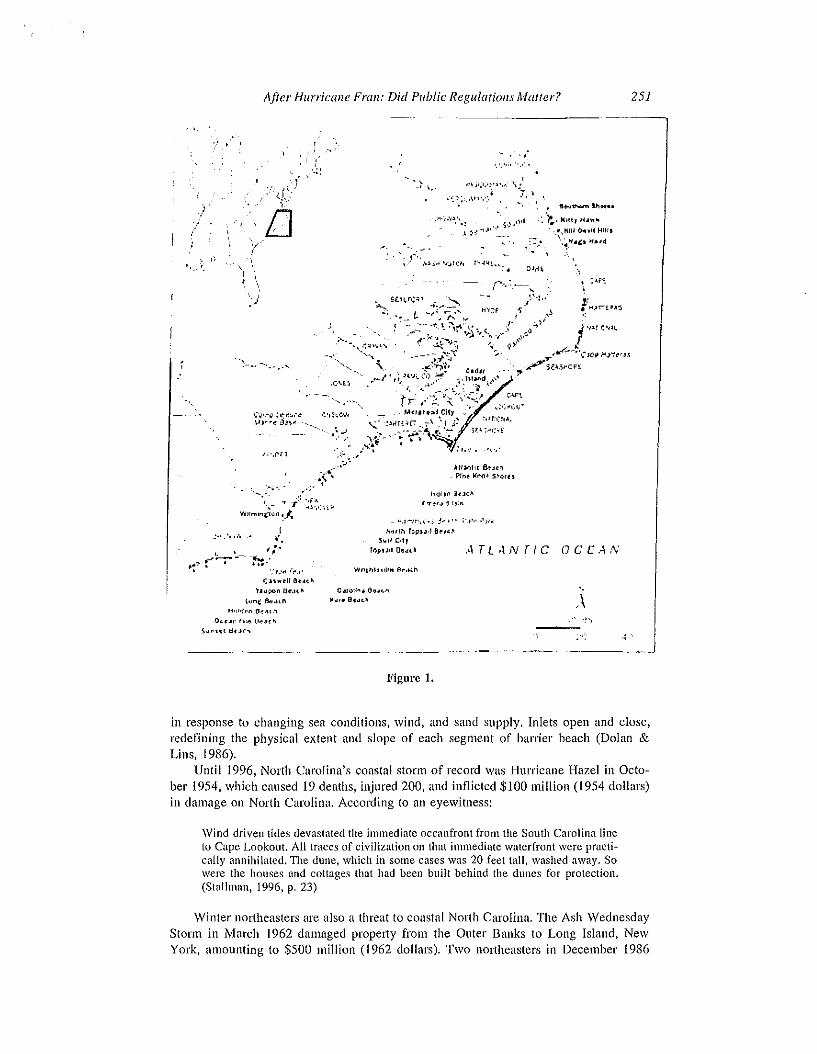
A dramatic 320-mile chain of coastal barriers lines the coast of North Carolina fromCurrituck Banks near the Virginia line to Sunset Beach at the South Carolina border(pilkey et aI., 1980) (Figure I). The Quter Banks-the northerly half of this chainforms a narrow arc of beaches and maritime forest sheltering CUlTituck, Albemarle, andPamlico Sounds and the mainland from the Atlantic Ocean. Cape Hatteras and CapeLookout are the seaward extremities of the Banks, each the focal point of a nationalseashore. Offshore of the Outer Banks lies Diamond Shoals, the "Graveyard of the Atlantic," where hundreds of shipwrecks lie just beneath the waves. Southwesterly of theBanks, the lower North Carolina coast is lined with additional bmTiers and mainlandbeaches, each of storied history and distinctive landform: Bogue Banks, Topsail Island,Figure Eight Island, Wrightsville, Carolina, Kure, Holden, and Sunset Beaches. The barrier shoreline is shaped and pierced by inlets, some ephemeral and others al1it1ciallystabilized, including: Oregon, Hatteras, Ocracoke, Drum, Beaufort, Bogue, New River,Masonboro, Carolina Beach, and the mouth of the Cape Fear River (Dolan & Lins,1986).
About one-third of the NOlth Carolina oceanfront is in public ownership. The othertwo-thirds in private ownership has experienced widespread residential and commercialdevelopment over the past three decades wherever road access is available. Behind thecoastal balTiers, North Carolina's sounds are lined by some 4,400 miles of shoreline,much of it also in the process of development. The fishing camps and barren beaches ofthe 1930s gave way to summer cottages and small motels in the 1950s and 1960s,which in turn have yielded to pseudo-urban clusters of subdivisions, malls, and condos.Even in areas earlier avoided as too hazardous, such as North Topsail Island and ShellIsland (\Vrightsville Beach), high-lise structures have mushroomed along the oceanfront.
Coastal Hazards
Developed or not, the lowHlying barrier beaches of North Carolina continually shift inresponse to wind, tide, storms, sea level, and human interventions. Remaining dunetlelds are subject to overwash during storms, and beaches oscillate in width and slope
After Hurricane Fran: Did Public Regulations Matter?
"
251
. ,-' \.'
'.'.";' ',,',
• ~ u,.......
'. '~. Kltt} ~ ..
',',KIII o...1l Hila
:':,'. \~_~.C:t Ifud
,I<,
"'j
",
t,·..,....~ ~\~r.~.-~
V)",''' j)J~~ -'"
..... "'~'- . ,:';-\_ "--i' ~~~",..;;.
Wllml~~\lfl ~.~ . -
•("-.:
j ·I..rc·,~~
:T'~~:-~'~~Jl.'li'.....}~cr,J_~:,.,rio!4,"ii'CFl
,\U.vlli-[ &4('_ PI,,~ 1C1'(l.1 :;,'Qf~ t
lo<Jll~ :1,.10:/\
£..'T't,., ~ 1,:"
- ",1'-""".;< 1. ,"
r'r.-.- ---~:' ..
.'!Mlh fopu.) 8~,~"
$1111 C'lyrOpt~,1 O~,j(~ ATL4NTIC OCCA,V
r;n.,..,lJ OUt"tJIl...,,,IJt'.n/\ C.loH 6\1...."
I.m!: ""..(II I(v,. 8.~ .
J)L~"" I.;~ tt.....c"s,,~ut B,.)("'I
Figure 1.
"
.\
in response to changing sea conditions, wind, and sand supply. Inlets open and close,redefining the physical extent and slope of each segment of barrier beach (Dolan &Lins, 1986),
Until 1996, North Carolina's coastal storm of record Was Hurricane Hazel in October 1954, which caused 19 deaths, injured 200, and inflicted $100 million (1954 dollars)in damage on North Carolina. According to an eyewitness:
Wind-driven tides devastated the immediate oceanfront from the South Carolina lineto Cape Lookout. All traces of civilization on that inunediute waterfront were practically annihilated. The dune, which in some cases was 20 feet tall, washed away. Sowere the houses and cottages that had been built behind the dunes for protection.(Stallman, 1996, p, 23)
\Vinter northeasters are also a threat to coastal North Carolina. The Ash \VednesdayStorm in March 1962 damaged property from the Outer Banks to Long Island, NewYork, amounting to $500 million (1962 dollars). Two northeasters in December 1986
252 R. H. Plait et al.
damaged over 100 homes at Topsail Island, N0l1h Carolina,washed out the shore roadand sewer line, and removed viltually all dunes and beach there (Stallman, 1996, p. 23).
Most of the North Carolina coast is subject to long- and shOit-term erosion. TheCape Hatteras Lighthouse, the world-renowned symbol of coastal N0l1h Carolina, wasbuilt 1,500 feet from the water in 1870, but by the 1990s was at the water's edge. In1999, the 208-foot tower and associated buildings were physically moved about 2,000feet landward to save them from the encroaching sea, as a National Research Council(1988) rcport had recommended a decade earlier. Rapidly shifting inlets also reflcct thedynamism of the ban-ier shore. New Topsail Inlet just north of Wilmington decreased inwidth from 2,500 feet to roughly 1,200 feet between the 1920s and 1970s while shiftingsouthward about a half-mile (Stallman, 1996, pp. 9-10).
Studies of coastal shoreline change indicate that over a 50-year period, more thanhalf of North Carolina's oceanfront exhibited average annual erosion rates of two feet ormore (National Research Council, 1990, p. 104). A 1988 state study estimated that ofthe 237 miles of ocean shoreline surveyed, approximately 70% was eroding, of whichabout 30 miles appeared to be receding at rates exceeding six feet per year (McCullough,1988). North Carolina has received more direct hun"icane strikes than any other Atlanticcoast state except Florida (Godschalk, Brower, & Beatley, 1989). As of the late 1980s,nearly 5,000 buildings were within the estimated reach of erosion over the next 60years, with about 770 of those threatened within the next 10 years (Association of StateFloodplain Managers, 1988).
The North Carolina Coastal Area Management Act
In 1974, North Carolina adopted its Coastal Area Management Act (CAMA)' to reducestorm and erosion damage and to protect the biotic and recreational amenities of itscoastal areas. The act involved two major approaches to reducing coastal hazards: (l)state designation and regulation of Areas of Environmental Concern (AECs) and (2)mandatory local planning in North Carolina's 20 coastal counties. CAMA established aIS-member Coastal Resources Commission (CRC) with the authority to formulate andoversee the regulation of coastal policy.2 The Division of Coastal Management (DCM)administers the act and provides staff for the CRC.
AECs
The CRC designates Areas of Environmental Concern (AECs) of four basic types: (I)estuaries; (2) ocean hazard areas; (3) public water supplies; and (4) natural and culturalresource areas.) A state CAMA permit is required for "major developments within AECs,namely those which (1) require approval from the state or federal government, (2) involve drilling, (3) occupy more than 20 acres of land or water, or (4) involve a structurewith a ground area of more than 60,000 square feet. Other projects ("minor development") require a local permit issued in conformity with CAMA standards. Both typesof permit decisions may be appealed to the CRC. \Vithin ocean hazard areas, newconstmction and improvements that increase a structure's value by 50% or more ('Isub~
stantial improvements") must satisfy wind resistance, elevation, and pile requirementsbased on FEMA standards and the state building code (Owens, 1984).
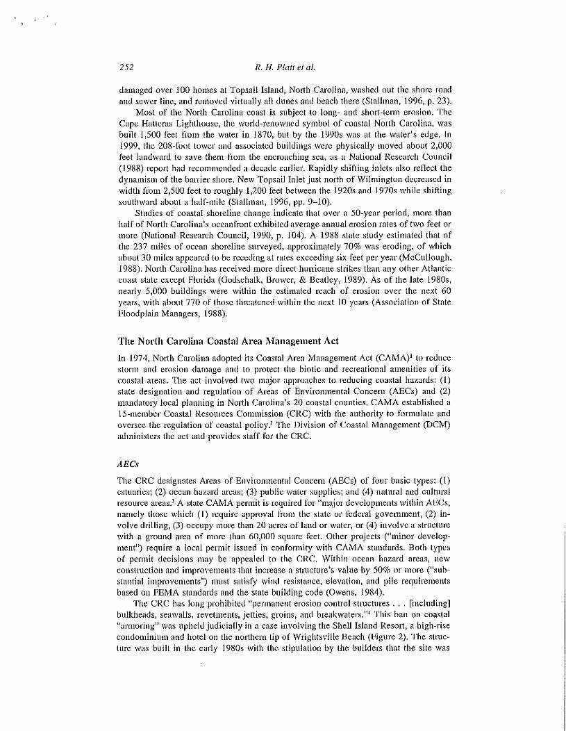
The CRC has long prohibited Ilpermanent erosion control structures ... [including]bulkheads, seawalls, revetments, jetties, groins, and breakwaters.".f This ban on coastal"annoring" was upheld judicially in a case involving the Shell Island Resort, a high-risecondominium and hotel on the northern tip of \Vrightsville Beach (Figure 2). The structure was bnilt in the early 19808 with the stipulation by the buildel~ that the site was

After Hurricane Fran: Did Public Regulations A1alter?
•
-0
J
•
Figure 2.
253
known to be hazardous and no sea walls would be permitted. Subsequently, the inletseparating Wtightsville Beach from Figure Eight Island has shifted southward, threatening to undermine the entire complex. The CRC initially opposed a variance to the state'sno-annoring policy, but after the inlet moved closer to the building during HunicaneFran, the commission reversed itself and approved the construction by the resort of a"temporary" revetment of two-ton sand bags (Richissin, 1996). (The resort also receivedan SBA disaster loan of $1.5 million to repair damage caused by Fran.) After the CRC

254 R. H. Plaff e/ 01.
rejected Shell Island's request to build a permanent sea wall, the homeowners association sued the state in 1998, claiming that the denial amounted to a taking of their property without compensation in violation of the 5th Amendment to the U.S. Constitution,sIn July 1999, the North Carolina Court of Appeals unanimously upheld the state bau onseawalls.6
Oceallji'ollt Setbacks
Under CAMA, the eRe sets minimum setbacks for new development within ocean hazard areas based on average annual erosion rates, natural site features, and the nature ofthe proposed development. Setbacks are measured landward from the first line of stablenatural vegetation or, in its absence, an approximation thereof based on aerial photographs or ground surveys.1 Preexisting lots that arc not deep enough to meet the erosionsetback requirements may be developed subject to constmction standards, the 60~foot
minimum setback requirement, and dune setback provisions.Oceanfront setbacks are based on both long-tenn shoreline fluctuations and dra
matic, short-term coastal changes. Long-term erosion rates were estimated from aerialphotography taken between 1937 and 1986. Fluctnations for the entire North Carolinashoreline have now been mapped at 50-meter transect intervals. The state strives toupdate these data every five years.
COUllty (Iud L(lcal Coastal Pious
CAMA required North Carolina's 20 coastal counties to prepare land use plans underthe guidance of the state Coastal Resource Commission and encouraged municipalgovemments to do so as well.8 Such plans must address population and land use trends,resource protection, resource production and management, economic and communitydevelopment, public pUl1icipation, and storm hazard planning. Concerning the latter,plans should include: (1) hazard maps and narrative descriptions of hazardous areas;(2) an inventory and analysis of existing structures and land uses in hazard areas;(3) descriptions of the risks and severity of damage and an estimate of monetmy lossesthat might be sustained in hazard areas; and (4) hazard mitigation policies for public andprivate facilities in all hazard areas.
By 1989, all of the connties and 90 municipalities had adopted local plans (Godschalk,Brower, & Beatley, 1989). However, according to the NOlih Carolina Coastal Federation(Nliller, 1998), "more of these plans are paper exercises that mean nothing to localgovernments." On September 25, 1998, the state CRe for the first time rejected a localplan for not following CRC's land use guidelines. A study of ban'ier island communitycompliance with storm mitigation policies in land use plans found that 1110st local governments do not meet the guidelines required by the North Carolina Administrative Code(Baldwin, 2000). The study also found that the DCM and the CRC, with responsibilityfor plan development oversight and plan approval, respectively, placed no emphasis onmitigation in the local plans, in spite of the communities' rapid development and theirvulnerability to coastal storms.
Federal Programs Affecting Coastal Development in North Carolina
The National Flood Insurance Program
All communities on North Carolina ban'ier islands pmiicipate in the National FloodInsurance Program (NFIP) (Federal Emergency Management Agency, 1997). As estab-

After Hurricane Fran: Did Public Regulations Maller? 255
lished by Congress in 1968, the NFIP involves three major interrelated activities, namelyto: (l) map inland and coastal flood hazard areas throughout the nation; (2) establishminimum land use and building standards to guide community regulation of development and redevelopment in such areas; and (3) offer affordable flood insurance to property owners within communities that adopt and enforce such standards (Platt et al., 1992,pp. 26-27). Land use management in floodplains was intended to be a central focns ofthe NFIP, along with actuarial insurance rates for new construction, as stated by GeorgeBernstein, the first Flood Insurance Administrator, in Congressional testimony in 1973:
It is the combination of effective land use controls and full actuarial based rates fornew construction that makes the national flood insurance program an insurance program rather than a reckless and unjustifiable giveaway program that could impose anenormous burden on the vast majority of taxpayers without giving them anything inreturn, (U,S, Congress 1973)
The 1973 Flood Disaster Act9 added "flood-related" coastal erosion as an insurablehazard nnder the NFIP, "(c) The term 'flood' shall also include the collapse or subsidence of land along the shore of a lake or other body of water as a result of erosionor undermining caused by waves or currents of water exceeding anticipated cyclicallevels, , , ,"10 The act also reaftlrmed that land use planning would be prerequisite tofederal flood insurance and disaster assistance:
The purpose of this act, . , is to: (3) require states or local communities, as a condition of future federal financial assistance to participate in the flood insurance programand to adopt adequate flood plain ordinances with effective enforcement provisionsconsistellt with federal standards to reduce or avoid future tlood losses, , , ,II
Special limits on development are required within "coastal high hazard zones"(V-zones) as mapped by FEMA along open ocean coasts and some bay and Great Lakesshorelines. A coastal high hazard is defined as "an area of special flood hazard extending from offshore to the inland limit of a primary frontal dune along an open coast andany other area subject to high velocity wave action from storms or seismic sources,"12They are based on a computer simulation of the reach of a three~foot breaking wavedOling a IDO-year flood, Despite the imposing term "coastal high hazard area," FEMAallows new construction in V-zones as far seaward as Hthe reach of mean high tide/' aslong as the structure is elevated and does not encroach on dunes or mangrove swampsY
But oddly, erosion hazard areas are omitted from NFIP maps even when such datahave been published by states like North Carolina. Erosion is not reflected in NFIP landuse standards or in rating of flood insurance premiums.14 The NFIP has nudged recentshoreline development upward but not landward. Stmctures built or substantially improved in communities where the NFIP is in effect must be elevated to 01' above thespecified 1DO-year flood elevation (plus wave heights) or else insurance premiums willbe prohibitive and a building permit may be denied by the local govemment. Elevation,however, does nothing to retard erosion: retreating shorelines will simply continue tomove toward and beneath the elevated structure until collapse eventually occurs. Ofcourse, once utilities, septic fields, and safe access and egress are disl11pted, a structurebecomes legally uninhabitable, If not demolished or moved, it may persist as a derelicthulk towering over the surf zone, obstructing public use of the beach, A recent studyconducted pursuant to the Flood Insurance RefOlrn Act of 1994 (Sec. 577) reported thatover the next 60 years, erosion may claim one out of four houses within 500 feet of theU.S. shoreliue (H. John Heinz III Center, 2000). The report urged FEMA to reflecterosion hazards in NFIP maps and insurance rates.

256
Coastal Banier Resources Act
R. H. Plait et al.
After a spate of hurricanes in the late 19705, Congress was persuaded that flood insurance and other federal benefits actually encourage development on coastal bmTiers. TheCoastal Barrier Resources Act of 1982 (CBRA)15 prohibited new flood insurance coverage, shoreline and access projects, and other federal development incentives within aseries of undeveloped, unprotected barriers designated as the Coastal Barrier ResourceSystem (CBRS). The system initially inclnded nearly 200 segments of coastal barriersidentified by the U.S. Depmlment of the Interior. The system was enlarged in 1990 toinclude 560 units involving 1.3 million acres and 1,200 shoreline miles (Bentley, Brower,& Schwab, 1994, p. 90). CBRA units may still be developed privately without federalbenefits. In other coastal at~as not covered by the CBRA, federal flood insurance nndother benefits remain in effect.
Federal Disaster Assistance
Under a long succession of disaster relief acts dating back to 1950, the nation has committed tens of billions of dollars to relief and recovery from natural disasters. The StanardDisaster Relief and Emergency Assistance Act ("Stafford Act")" and its predecessorsprovided that federal disaster assistance is: (1) limited as to the scope of federal assistance to be supplied; (2) contingent upon a presidential disaster declaration; and (3)limited as to amounts of federal funding to be allocated to disaster relief (Platt, 1999).But these limitations have been eased over time as declarations have become more plentiful and generous. During the I990s, FEMA spent more than $25.4 billion on declareddisasters and emergencies compared with $3.9 billion during the 1980s.17 The 1999 hurricane season produced 17 disaster declarations, surpassing a record set in 1985. Hurricane Floyd that year alone spawned 13 presidential declarations for states extendingfrom Florida to Maine (Maiolo et aI., 2001).
The Stafford Act (Sec. 409) requires that states or local governments receiving disaster assistance: "shall agree that the natural hazards in the areas in which the proceedsof the grants or loans are to be used shall be evaluated and appropriate action shall betaken to mitigate such hazards, including safe land-use and construction practices...."18
However, researchers at the University of North Carolina have found that this provisionis a dead letter in terms of eliciting significant mitigation actions and that "Section 409reports" are routinely prepared solely to qualify for (more) federal assistance (Kaiser &Goebel, 1999; Godschalk et aI., 1999).
The foregoing has summarized state and federal provisions that affect rebuildingafter a coastal disaster in North Carolina. The remainder of this article explores thequestion as to whether these elaborate state and federal rules have made any differencein North Carolina's recovery from Hurricane Fran.
Hurricane Fran and the North Carolina Coast
From 1996 to 1999, six hurricanes struck North Carolina (Bellha, Fran, Bonnie, Dennis,Floyd, and Irene). Since a previous cluster in 1954-1955, only one damaging hurricanehad hit the state (Donna in 1960). During the relatively calm period of 1955-1996, abuilding boom occurred along the coast, setting the stage for the onslaught of the late1990s.
Hurricane Bertha stmck North Carolina near ·Wilmington on July 12, 1996, withsustained winds over 105 miles per hour (mph) and drenching rains. Bertha batteredbuildings, downed trees, eroded beaches, toppled mobile homes, damaged fishing piers,

, '
After Hurricane Frail: Did Public Regulations Matter? 257
and left about 160,000 homes and businesses without power. Two people died, at least127 homes were destroyed. and over 650 structures suffered major damage. Accordingto an account in The New York Times:
Pounding surf gouged through high dunes protecting the beaches leaving many homesteetering closer to the water's edge and in a few cases, toppling houses into thesea. On Topsail Island ... the authorities estimated that 40 houses were severelydamaged.... In some places, the surf had eaten away up to 50 feet of beach.(lanorsky, 1996)
This was the state of the North Carolina coast when Fran arrived two months lateron September 5 as a low CategolY 3 hurricane. Maximum sustained winds were approximately 115 mph with a minimum central pressure of 954 millibars. Fnm generatedstorm surges of up to 12 feet along the southern banier islands of North Carolina extending from Cape Fear near \Vilmington to Bogue Banks. The storm moved inland atabout 10 mph, delivering up to 12 inches of rain in some areas and with gale forcewinds measuring up to 69 mph at the Raleigh-Durham Ailp0l1. Coastal and inland flooding,wind damage, and falling trees ravaged eastem North Carolina except for the OuterBanks, which escaped serious harm.
Hurricane Fran was estimated to be a $7 billion disaster, including governmental,insured, and uninsured losses..........-one of the costliest hun'icanes in U.S. history.19 The indirect costs upon social communities, businesses, and the environment would drive thattotal even higher. In North Carolina, the following were estimated levels of damage orlosses due to Fran20:
25 lives lost,• over 40,000 homes destroyed at a total cost of $2.24 billion,• over 115,000 stnlctures damaged in five coastal counties,
891 businesses damaged at a total cost of $50 million,8+ million cubic yards of debris removed at a cost of $200 million,$2 billion in crop and timber losses,J50 miles of coast damaged,$1+ billion in damages to public facilities,power outages affecting 1.8 million people,six ocean piers destroyed,
• 4,000-5,000 recreational and thhing boats destroyed or damaged.
\Vith the shore already weakened by Bertha, Hurricane Fran caused more propertydamage in North Carolina than any other hurricane prior to Floyd in 1999. Coastaldamage affected close to 90% of oceanfront homes along the 100-mile stretch of bmTierislands from the Cape Fear River to Bogue Banks,21 The worst coastal damage wnsexperienced at Topsail Island, a 26-mile heavily developed barrier (discussed below).Erosion under oceanfront houses there averaged 4-6 feet of vel1ical loss of sand (Federal Emergency Management Agency, 1997).
On the day that Fran struck, North Carolina Governor James B. Hunt Jf. requested apresidential major disaster declaration for the state (see quotation at beginning of thisal1icle). The declaration was granted the following day by President Clinton, authorizing100% federal funding for the first 72 hours and a 75% federal shnre thereafter. In December, the federal share was increased to 90% upon petition from the state claimingthat total disaster-relnted expenses from Fran exceeded $64 per capita." A total of 58counties in central and coastal North Carolina were included in the declaration and wereeligible for federal disaster benefits. Federal costs within the state relating to Fran eventually nmounted to nearly $850 million (Tnble I).
258 R. H. Pia II el al.
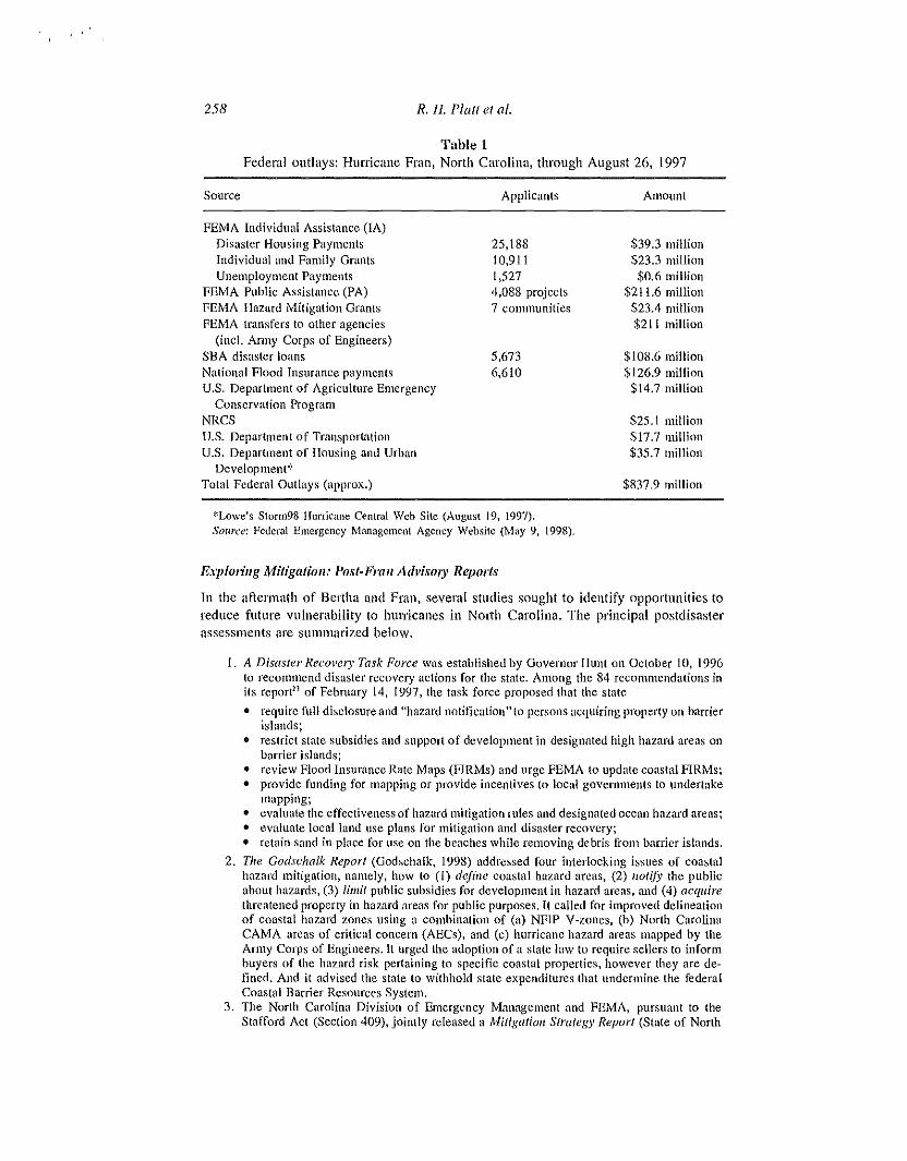
Table 1Federal outlays: Hunicane Fran, North Carolina, through August 26, 1997
Source
FEMA Individual Assistance (IA)Disaster Housing PaymentsIndividual and Family GrantsUnemployment Payments
FEMA Public Assistance (PA)FEMA Hazard Mitigation GruntsFEMA transfers to other agencies
(incI. Army Corps of Engineers)SBA disaster loansNational Flood Insurance paymentsU.S. Department of Agriculture Emergency
Conservation ProgramNRCSU.S. Department of Tran~poftation
U.S. Department of Housing and UrbanDevelopmcnt*
Total Federal Outlays (approx.)
Applicants
25,18810,9111,5274,088 projects7 communities
5,6736,610
Amount
$39.3 million$23.3 million$0.6 million
$211.6 million$23.4 million$211 million
$108.6 million$126.9 million$14.7 million
$25.1 million$17.7 million$35.7 million
$837,9 million
*Lowe's Storm98 Hurricane Central Web Site (August 19, 1997).SOl/rce: Federal Emergency r...fanagcment Agency Website (May 9, 1998).
E.,plo';lIg Mitigatioll: Post·Frail fldvisory Reports
In the aftermath of Bertha and Fran, several studies sought to identify opportunities toreduce future vulnerability to htHTicanes in NOlth Carolina. The principal postdisasterassessments are summarized below.
1. A Disaster Recave1)' Task Force was established by Governor Hunt on October to, 1996to recommend disaster recovery actions for the state. Among the 84 recommendations inits repoceJ of February 14, 1997, the task force proposed that the state
• require full disclosure and "hazard notitication" to persons acquiring property on barrierislands;
• restrict state subsidies and support of development in designated high hazard areas onbarrier islands;
• review Flood Insurance Rate Maps (FIRMs) and urge FEMA to update coastal FIRMs;• provide funding for mapping or provide incentives to local governments to undertake
mapping;• evaluate the effectiveness of hazard mitigation rules and designated ocean hazard areas;• evaluate local land use plans for mitigation and disaster recovery;• retain sand in place for use on the beaches while removing debris from barrier islands.
2. The Coc/schalk Report (Godschalk, 1998) addressed four interlocking issues of coastalhazard mitigation, namely, how to (1) define coastal hazard arcas, (2) llotify the pUblicabout hazards, (3) limit public subsidies for development in hazard areas, and (4) acquirethreatened property in hazard meas for public purposes. It called for improved delineationof coastal hazard zones using a combination of (a) NFIP V-zones, (b) North CarolinaCAMA areas of critical concern (AECs), and (c) hurricane hazard areas mapped by theArmy Corps of Engineers. It urged the adoption of a state law to require sellers to informbuyers of the hazard risk pertaining to specific coastal properties, however they are defined. And it advised the state to withhold state expenditures that undermine the federalCoastal Barrier Resources System.
3. The North Carolina Division of Emergency Management and FEMA, pursuant to theStafford Act (Section 409), jointly released a Mitigatioll Strategy Report (State of North
After Hurricane Fran: Did Public Regulatiolls Maller? 259
Carolina, 1997) five months after the disaster. The report was intended to serve as ablueprint for hazard mitigation projects to be cost-shared by PEMA and the state at aratio of 75/25 with potential joint funding totaling $100 million. Its four primary concerns were:
• principal dwellings: acquisition, relocation, demolition, or elevation of chronically floodedproperties;
• critical public facilities: relocation, retrofitting, or floodproofing of water and otherpublic facilities;
• business recovery: tloodproofing, windproofing, and relocation; and• storm water drainage improvcmcnts.
In addition to statewide recommendations, the Mitigation Strategy Report called for coastalstorm surge modeling studies as a basis for a revision of FEMA's flood hazard maps to"encourage more stringent building codes, subdivision ordinances, and improved land usepractices." The report also urged that the state require the implementation of local plansas well as consistency between those plans and local zoning and subdivision regulations.It also urged that beller public information be provided by the state and realtors concerning limitations on federal flood insurance within Coastal Barrier Resources Act units.
4. FEMA deployed a Building Performance Assessment Team (BPAT) to coastal North Carolina to assess damage to structures caused by Fran, In the worst affected areas, its reportdocumented a loss of sand under structures of 4-7 feet due to erosion and scour (FEMA,1997). Over 100 structures were found to have collapsed due to inadequate depth of pilings,particularly those built before state embedment depths were increased in 1986. Also severalhundred decks and porches were found to have collapsed as a result of insufficient foundation and piling support, In general, it found that structures inland from the oceanfront whichwere built to NFl? and state specifications survived relatively intact.
Each of the four reports summarized above appeared several months after Hurricane Fran. Their potential usefulness as guides to public policy revisions was thereforediminished; Le., the "window of opportunity" for the adoption of new legislation hadpassed. The FIRMs for affected coastal areas were revised by FEMA based on post-Franground and aerial measurements. However, the state has not acted on recommendationsconcerning mandatOly disclosure of hazards to buyers or elimination of state subsidieswithin CBRA units.
The FEMA BPAT report suggested ways to strengthen structures to withstand hurricanes, but the unstated implicit message is that those inland from the oceanfront faredmuch better. In general, improvement of building durability on a disappearing beachfrontlllay be compared with redesigning the Titanic's deck chairs to float.
Rebuilding on the North Carolina Barriers
Three days after Fran, the Wilminglon MOl'lling SIal' (1996) reported that "Fran destroyed an estimated 90% of the structures [at North Topsail Beach)" and the Governorwas weighing a ban on rebuilding there. This ban was not implemented, but residentswere prohibited from returning to their propeliies for a month. Rebuilding was fueled bya massive infusion of federal assistance (excluding flood insurance) amounting to nearly$115 million for the three coastal counties hit most directly by Fran: Pender, Onslow,and New Hanover (Table 2). One year after Fran, federal disbursements to three batTierislands, Topsail, Wrightsville Beach, and Pleasure Island (including Carolina and KureBeaches), were estimated at $10,500 per year-round resident (Whitlock, 1997).
The Road al North Topsail Beach
Between 1982 and 1989, 12 oceanfront condominium, hotel, and townhouse projectsinvolving over 1ADO units were approved by Onslow County for the hazardous northernend of Topsail Island (Olson & Vance, 1989). In 1990, the area incorporated as the

260 R. H. Platl ef al.
Tuble 2Federal disaster assistance allocated to three North Carolina coastal counties
after hurricanes Bertha and Fran (excluding flood insurance payments)
Housing grants SBA disaster loans Public assistance
No. Amt, No. Amt. No. Amt. Total*
Pender Co. 1,616 $2.8 III 429 $7.2 III 10 $4,6 III $16,5 III
Onslow Co. 2,034 $3.3 III 473 $13,0 III 9 $16.2 III $34.7 III
New Hanover Co. 3,006 $4.1 III 1,015 $31.0 III 9 $23.7 III $63.0 III
Three counties 6,656 $10.2 III 1,917 $51.2 III 28 $44.5 III $114,2 III
*Includes Individual and Family Grants (IFGs) not shown in table.SOl/ree: Federal data reprinted in Godschalk (1998, App. 3H).
town of N0l1h Topsail Beach to limit further high~rise development and improve localservices. Proposals for further growth appeared, however, drawing a warning from DukeUniversity coastal geologist Orrin H. Pilkey in a letter to the state governor: "It is OUf
opinion that the physical danger to inhabitants on North Topsail Island has reached an \\unconscionable level. This may be America's most dangerous barrier island develop-ment ill terms of human hazards. It also ranks very high in its potential for propertydamage."24
The shore road (S.R, 1568) serving North Topsail Beach was overwashed and damaged by bOlh Bel1ha and Fran. The road had long been contentious and vulnerable, Inthe 1980s, Ihe state and private developers had relocated the road slightly landward tofacilitate construction of high-rise development along the oceanfront. In 199 C the statewithdrew the road from the federal highway system in order to avoid the need forfederal permits. In 1993, the stale asked the Federal Highway Authority to take it backso thai it would be eligible for federal repair funds in the event of flll1her damage, Atleast half the length of the road within Norlh Topsail Beach lies within a CBRA uuitdesignated by Congress in 1982 where no new federal expenditures or new financialassistance is allowable. HOWeVel\ the CBRA exempts from this ban "repairs" of roadsthat are Uessentiallinks in a larger network or system." Under this exception, S.R. 1568was repaired at a cost of $200,000 after Bel1ha and another $376,000 after Fran, a lotalof $576,000, of which the federal share amounted 10 between 75% aud 90%. By contrast, the tOlal cosl of road repairs for the other two-thirds of Topsail Island was $458,000(Godschalk, 1998, pp, 62-{i3),
Tile Emergel/cy DIII/e
Another infrastructure issue concerned the reconstl1lction of dunes along Topsail Islandwhich were substantially overwashed by Beltha and Fran. Whereas dune damage atWrightsville Beach and Carolina Beach was eligible for restoration by the Army Corpsof Engineers under their ongoing projects at those sites, Topsail Island does not have anapproved Corps nourishment project. Its dunes have long fluctuated in height and widthaccording to storm activity, sand supply, and local beach scraping with bulldozers.
The presidential disaster declarations for Bertha and Fran extended the benefits ofthe Stafford Act to the three Topsail Island communities, FEMA is authorized to provide assistance for restoration of beaches and dunes in selected locations after declaredcoastal disasters. Beach nourishment is authorized under two authorities: (1) "Emer-

After Hurricaue Fran: Did Public Regulations Matter? 261
gency Facilities" (limited to a five-year level of protectionr5 and (2) "Permanent publicworks-parks. recreational, and other" (limited to "engineered beaches" built to Corpsof Engineers specifications),26 Beach nourishment also may potentially be eligible forFEMA hazard mitigation grants (HMGs) if estimated to be cost-effective."
FEMA beach restoration activities have been modest in number and cost so far, butpolitical pressure can be expected to grow as beaches continue to erode and structuresarc endangered. FEMA can act much faster than the Anny Corps of Engineers, whichrequires a specific congressional authorization and extended period for design and enviHroumental impact assessment. FEMA reimburses for 75% of project costs (90% for Fran)versus 65% or less under Corps programs. Also, FEMA is a less visible political targetfor opponents of beach nourishment since these efforts are included in the overall process of disaster recovety, which is politically popular in the affected area.
FEMA paid $4.6 million in Public Assistance (PA) funds to restore a "five-year berm"along IS miles of Topsail Island in the communities of Snrf City and Topsail Beach.Much of the sand for this purpose was pumped into the beach by the Corps of Engineersusing material dredged out of the Intracoastal Waterway and the New River Inlet. (Although the Corps had no authorized project to renourish Topsail Island, it provideddredge spoil pursuant to an opinion of its legal department.j8 Other sand was trucked backto the beach from overwash areas on the island. Still more was scraped up from the beachface by bulldozers. The result was a low (4-5 foot) sand ridge of various grain size andcolor along the landward edge of tbe beach just in front of the building line (Figure 3).
FE:rvrJ\, however, drew the line at funding beach nourishment within the CBRAp011ion of North Topsail Beach, where the most severe damage had occurred on TopsailIsland. A low berm was temporarily established there through state, local, and privatebeach scraping.
The "five-year berm" provided little or no protection: most homes were elevatedwell above the five-year storm elevation. A Fish and Wildlife biologist described theproject as "a useless, feel-good project" (Whitlock, 1997). A representative of the Corps
Figure 3.
)

262 R. H. Platt et al.
of Engineers in Wilmington declared: "From an engineering perspective, [the emergencydunes] have VClY little protective value. The experience I have with them is that theygenerally don't last, even with grass on them" (Whitlock, 1997). These assessmentsproved accurate: at least half of the postHFran emergency dune was washed away byHurricane Bonnie in 1998 (Figure 4).29
Rebllildlllg Residelllial Properly
The state Disaster RecovcIY Task Force estimated that 115,000 structures were damagedor destroyed in the five North Carolina coastal counties struck by Bertha and Fran. Dueto the enormity of the damage, precise structure-by-stmcture data on rebuilding practices arc unavailable. There is no reliable community or state database that encompasses:the rebuilding of coastal areas in North Carolina.30 In general, the rebuilding processwm; haphazard and subject to differing definitions and objectives of local, state, andfederal authOlities.
The state Coastal Area Management Act delegates many key actions to local andcounty governments. The rebuilding or repair of a damaged structure requires a CAMA"minor permitll which "shall be obtained from the appropriate city or county,"·H A fur~
ther local determination that is critical to the rebuilding process is whether a structure is"snostantially damaged." This concept is fnndamental tn both the state CAMA and thefederal NFIP. Structures so declared may only be rebuilt in compliance with all CllITentfederal, state, and local regulations pertaining to siting and construction. Thus a Hsub~
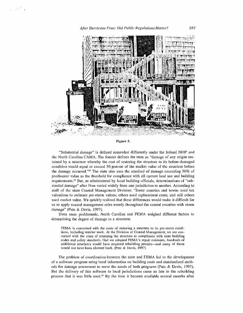
stantially damaged" structure must conform to current minimum elevation and setbackregulations in effect at the time of rebuilding (even if adopted after the disaster event).However, a structure not found to be substantially damaged is "grandfathered" and maybe rebuilt with the predisaster elevation, position, and footprint (nuless the lot itself hasbeen washed away) (Figure 5).
-- -_ ',a...:
--"
~\\\IIII\1111l11111l1II'\III 1111 " I" I,........ , r
I .. 1'1 /..
!I I;
-- .-Figure 4.
After Hurricane Fran: Did Public Regulations Malter? 263
Figure 5.
"Substantial damage" is defined somewhat differently uuder the federal NFIP andthe North Carolina CAMA. The former defines the term as "damage of any origin sustailled by a structure whereby the cost of restoring the structure to its before-damagedcondition would equal or exceed 50 percent of the market value of the structure beforethe damage occun'ed. "32 The state also uses the standard of damage exceeding 50% ofpredisaster value as the threshold for compliance with all CUlTent land use and buildingrequirements.33 But, as administered by local building officials, detenninations of "substantial damage" after Fran varied widely from one jurisdiction to another. According tostaff of the state Coastal Management Division: "Some counties and towns used taxvaluations to estimate pre-storm values; others used replacement costs; and still othersused market value. We quickly realized that these differences would make it difficult forus to apply coastal management mles evenly throughout the coastal counties with stormdamage" (Pate & Davis, 1997).
Even more problematic, NOllh Carolina and FEMA weighed different factors indetermining the degree of damage to a structure:
FEMA is concemed with the costs of restoring a structure to its pre-storm conditions, including interior work. At the Division of Coastal Management, we are concerned with the costs of returning the structure to compliance with state buildingcodes and safety standards. Had we adopted FEMA's repair estimates, hundreds ofadditional stmctures would have required rebuilding permits-and many of thosewould not have been allowed back. (Pate & Davis, 1997)
The problem of coordination between the state and FEMA led to the developmentof a software program using local infonuation on building costs and standardized methods for damage assessment to serve the needs of both programs (Pate & Davis, 1997).But the delivery of this software to local jurisdictions came so late in the rebuildingprocess that it was little used.34 By the time it became available several months after

264 R. H. Plait et al.
Fran, local building inspectors had made hundreds of judgments regarding whether individual structures were "substantially damaged." While there is no precise accounting asto how many buildings were so designated, coastal engineer Spencer Rogers estimatedthe total at abollt 200 structures.35
\Vhere substantial damage was found, rebuilding required compliance with federalelevation and V-zone regulations under the National Flood Insurance Program (whetheror not a structure actually was covered by flood insurance), as well as with state erosionsetbacks under CAMA. A coastal disaster like Fran often renders obsolete the zoneboundades and elevations designated in predisaster FIRMs. In part, this is because FIRMsdo not reflect the effects of short- and long-term erosion. Indeed, many coastal FIRMsare chronically inaccurate due to the continuous process of shoreline change. Fran devastated the dune line of Topsail Island and nearby coastal areas. It also scoured severalfeet of sand from beaches, of which part was deposited landward of the beach throughthe process of wave overwash and putt was drawn seaward and along the shore.
As part of its new emphasis on hazard mitigation, FEMA undertook to remap coastalareas affected by Hurricane Fran. \Vithin a few days after the storm, a team of coastalengineers from Dewbeny and Davis, Inc" under contract with FEMA developed a newset of shoreline positions and elevations using satellite-based GPS and GIS technology.Based on this new data, a new set of coastal FIRMs was developed that raised minimumbase flood elevations (EFEs) and expanded the landward extent of the V-zone on Topsail Island, in some cases all the way to the landward side of the island.
The technical ability to update FIRMs, however, had leaped ahead of the legalprocess for map revisions. Under a procedure established in the 1970s, FEMA regulations prescribe a lengthy period of comment, publication, and revision of local ordinances, altogether lasting as long as a full year.J6 Clearly, this would have been tooprotracted to influence the rebuilding process after Fran. However, mitigation staff fromFEMA's Region IV office in Atlanta presented the maps to the coastal communities toenlist their voluntary compliance with them, pending formal adoption. Despite somerancorous meetings, several coastal communities agreed to use the new elevations andV-zones in issuing permits for rebuilding substantially damaged structures. The exactnumber of buildings rebuilt under the new maps is unknown.
Substantially damaged stmctures were also subject to state erosion setbacks underCAMA. Once again, the enforcement of state rules was a local function, with technicalassistance provided by the state. A major problem was that the baseline from whichsetbacks were measured was the first line of stable, natural vegetation, and Fran haderased all vegetation from many areas of the shoreline. Working with local govel1lments, the state devised a method to estimate where the vegetation line would be expected to reappear. Under a temporalY rule of the state Coastal COlllmission, the Division of Coastal Management measured the extent of recession in the vegetation line,where still visible, due to Fran with respect to where it stood in a set of aerial photographs taken just after Bertha. By subtracting the distance the line receded from itspre-Fran location (ranging from 5 to 70 feet), the state established lines from whichto measure setbacks in areas where no vegetation remained (Pate & Davis, 1997, p.125).
Field measurement of the setback from the reference line (either actual vegetationor the state's estimated line) is largely a local determination, as with the other elementsof the rebuilding process discussed above. Also, there is evidently some uncertaintyabout exactly what comprises the seaward edge of a structure. Decks, pools, and otherappurtenant features are observed to encroach into the setback area in celtain cases. Butconversely, some lots have been declared unbuildable for failure to contain enough spacelandward of the CAMA setback.

A/Ie/' Hurricalle Frail: Did Public Regu!atiolls Maller?
Conclusion: Did Public Regulations Matter?
265
The results of the post-Fran rebuilding process in North Carolina are mixed, a productof conflicting public policy signals. The shoreline at Topsail Island, in pm1icular, is amosaic of public and private decisions, some clearly denying the existence of continuedhUlTicane hazards, and others leaning in the direction of reduced vulnerability. This wasin fact a reflection of inconsistency among federal and state policies affecting the coast,some of which encourage development while others attempt to promote hazard mitigation. While this study could not conduct a house-by-house survey of the rebuildingprocess, some broad conclusions are possible.
First, the Coastal Banier Resources Act (CBRA) designation of pmt of NOlth TopsailIsland failed to deter intense development there. While the act prohibits federal floodinsurance and other federal inducements to growth on designated coastal batTiers, it doesnot prohibit private constmction in such areas. In this case, a de facto alliance between thestate, Onslow County, and the private developers led to the relocation of the shore road(S. R. 1568) and the construction of several high-rise stmctures between the new road andthe ocean. In so doing, the warnings of coastal geologist Orrin Pilkey and the NorthCarolina Coastal Federation were brushed aside. There were also charges that realtyagencies failed to warn condominium buyers of the coastal hazard and the nonavail~
ability of federal flood insurance, and that insurance agents improperly sold some NFIPpolicies to cover units within the CBRA area, (These policies, however, were not honoredby the Federal Insurance Administration after the 1996 hunicanes.) The rebuilding of theshore road after both Bertha and Fran was funded in patt by the federal government undera loophole in the CBRA for repairs to roads that are Hessentiallinks in a larger networkor system." FEMA, however, declined to fund the construction of an emergency dunewithin the CBRA unit. The Godschalk Repolt urged North Carolina to enact legislation toprohibit state subsidies for constl1lction within CBRA units and to require disclosure ofcoastal hazards. Neither of these proposals have been acted upon to date.
Second, FEMA's elevation requirements were apparently enforced by state and lo~
cal authorities for new or substantially damaged structures. Oceanfront structures onTopsail Island are, by and large, elevated on heavy pilings, with the space below thefirst floor evidently limited to parking, access, and storage in accordance with NFIPregulations. FEMA was able to persuade some coastal communities to adopt new post~
Fran elevations voluntarily. The FEMA Building Performance Assessment Team dis~
closed numerous technical problems with embedment depth, cross-bracing, and concreteslabs, some of which dated back to a change in state regulations in 1986. On the whole,post-I986 buildings performed quite well, except on the oceanfront where many wereundermined by erosion and scour amounting to 5-7 feet in vertical depth. It wouldappear that the marginal cost of complying with elevation and building code require~
ments has been capitalized into the private value of stmctures that run to several hundred thousand dollars apiece on the oceanfront, with commensurately high rental values.The BPAT report, however, did not address the wisdom of rebuilding, no matter howdurably, on land that is vanishing into the ocean. FEMA's V~zone regulations do notinvolve any setback along emding shorelines. Despite repetitive claims, federal floodinsurance remains available to substantially damaged structures at the water's edge(other than in a CBRA nnit).
Third, setbacks for new and substantially damaged structures in North Carolina aregovemed by the state Coastal Area Management Act (CAMA). There are an unknownbut significant number of lots that cannot be rebuilt due to both CAMA setbacks andother requirements such as septic regulations and street setbacks. However, the statesought to avoid banning any rebuilding where Fran had removed all vegetation (the

266 R. H. Plait el al.
reference featnre for setbacks prescribed by CAMA). The state approved an emergencyprocedure to extrapolate the "vegetation line" to cover such denuded areas. Some wouldargue that this procedure circumvented the intent of CAMA: If there is no vegetationremaining, there should be no rebuilding. But the state decided to depart from a literalreading of CAMA in the interest of allowing as many structures to be rebuilt as possible, while giving lip service to the setback requirement. One may assume that vegetation will revive naturally or through human intervention, provided the dune-beach system remains stable for long enough to allow that to happen. That, however, is a questionable assumption at Topsail Island, where much of the post-Fran emergency dunewas washed away by HUlTicane Bonnie in August 1998.
Fourth, the CAMA prohibition against arllloring the shore has been notahly effective (and has heen upheld judicially in the Shell Islnnd decision). By and large, NorthCarolina has avoided the trap of building seawalls, groins, revetments, and other structures that hinder public use of beaches and often exacerbate erosion losses. However,the 30- and GO-year setbacks, which have been intended to forestall the need for armoring,may have been based on erosion rates that are too low. According to the North CarolinaCoastal Federation, "30-year setbacks have been more like 15-20 year grace periods.The day of reckoning is now here, and the continued existence of the ban on annoringis by no means certain."J7
Although North Carolina has one of the leading state coastal management programsin the countly, many key decisions affecting the rebuilding of the state's oceanfront aremade locally. The zoning of North Topsail by Onslow County for high-rise developmentin 1979 facilitated the building boom there in the 1980s despite the well-documentedhazards affecting the site. After Bertha and Fran, local authorities were responsible formany critical determinations governing the rebuilding process. These included: (1) designation of substantially damaged structures; (2) issuance of "minor pennits" under CAMA;(3) enforcement of CAMA minimum setbacks; (4) enforcement of minimum elevation andbuilding code requirements; and (5) issuance of building pennits under local land use plansand zoning laws. These functions were conducted under extreme pressure of time, mediaattention, and public sympathy for owners of damaged structures. Also, local actions weretaken in the midst of other damage assessments by federal and state authorities andinsurance adjusters with resulting confusion of findings and cross-purposes.
Paradoxically, the abundance of federal assistance, including grants, flood insurance, and disaster loans, has been blamed for undercutting the effort of the state, as wellas FEMA's own mitigation staff, to promote hazard mitigation. As noted above, federalassistance to the principal barrier islands affected by Bertha and Fran was estimated at$10,500 per full-time resident of those islands (Whitlock. 1997). Local coastal communities were spared difficult choices by having at least 90% of their public costs assumed by FEMA. Owners of oceanfront property were similarly encouraged to rebuildby the availability of low-interest SBA disaster loans and continuing eligibility for affordable flood insurance. A year after Fran, the Raleigh News & Dbsell'er (Nov. 11,1997) editorialized:
In the Wake of Hurricane Fran, North Carolina's coastal communities and residentsmined taxpayer accounts to rebuild in fragile areas. Such generosity encourages overdevelopment, at great expense.... The allocation of hundreds of millions in taxpayer dollars has led the federal government to undermine what state officials havebeen trying to do for decades-----discourage development in coastal areas that arevulnerable not just to hurricanes but to heavy storms of any kind.
Ten months later, after the nearHmiss by Hurricane Bonnie, the same newspaperpuhlished the following reprise:

After Hurricalle Frail: Did Public Regulatialls Matter?
When a natural disaster strikes, government does, indeed, have a reasonable respon~
sibility to help people rebuild their homes, their businesses, and their lives.... Butthose are not open-ended obligations. Extending insurance in the face of irresponsible placement of property, building infrastructure that storms arc bound to washaway. and encouraging any policy that continues a cycle of predictable damage andguaranteed repair-----{\I1 thai sounds like the recipe for chronic disaster. (News &- Db·ser!'er, Sept. 3, 1998)
Notes
267
L North Carolina General Statute 113A-IOO et seq. The early development of the NorthCarolina Coastal Program was discussed in Owens (1985) and National Research Council (1990).
2. NC Laws, Ch. 113A, Sec. 104.3. NC Rules Tl5A, Subchapter 7H.4. Ibid.5. Todd Miller, Execlltive Director, NC Coastal Federation, personal communication, Sept.
28, 1998.6. Raleigh News and ObSell'er, "Court rules against resort on sea walls," July 19, 1999.
See: Shell/stand Homeowners Assn. v. Tomlinson 517 S.E.2d 40 I and 517 S.E.2d 406 (NC App.1999).
7. Alison Davis, NC Division of Coastal Management, personal communication, June 15,1998. New structures smaller than 5,000 square feet and containing fewer than five residentialunits must be constructed the farthest landward of (1) a distance equal to 30 times the long-termannual erosion rate, (2) the crest of the primary dune (the first dune with an elevation equal to theIOO-year storm level plus six [ceO, (3) the landward toe of the frontal dune (the first dune withsubstantial protective value), or (4) 60 feet landward of the vegetation line. Structures larger than5,000 square feet in total noor area or containing five or more residential units must be set backto the farthest of the following four distances: (1) 60 times the average annual erosion rate; (2)the crest of the primary dunes; (3) the landward toe of the frontal dune; or (4) 120 feet landwardof the permanent vegetation line.
8. NC Laws, Ch.II3, Sec. 106.9. P.L. 93-234.
10. 42 USCA, Sec. 4121.II. 42 USCA, Sec. 4002(b)(3).12. 44 CFR Sec. 59.1. "Primary frontal dunes" are defined as "a continuous or nearly
continuous mound of ridge of sand with relatively steep seaward and landward slopes immediately landward and adjacent to the beach and subject to erosion and overtopping from high tidesand waves during major coastal storms." Moreover, dunes are designated as landward limits of Vzones only where the dune cross-section above the 100 year stillwater elevation and seaward ofthe dune crest excccds 540 square feet. V-zones have long been delineated on flood insurancerate maps (FIRMs) based on computer simulation of the reach of a three-foot breaking waveduring a IOO-year storm event.
13. 44 CFR Sec. 60.3(e). Additional provisions for V-zones prohibit "manmade alterationof sand dunes ... which would increase potential flood damage" and the enclosure of spacebelow elevated structures with non-breakaway walls or for purposes other than parking, access,or storage. Mapped V-zones typically are fairly narrow and are bordered on the landward side byA zones with lower elevations and less restriction of solid wall enclosure of space below baseflood elevation,
14. The 1994 National Flood Insurance Reform Act (PL 103-325, Sec. 577) directed theFederal Emergency Management Agency (FEMA) to study the impacts of coastal erosion. Theact, however, failed to impose any limits on flood insurance in areas of critical erosion hazards asrecommended by the National Research Council (1990) and adopted by the House of Representatives in 1991 (HR 1246). See: PiaU, 1999. Ch. 6.
15. P.L. 97-348; 16 USCA 3501-10.16. P.L. 100-707; 42 USCA Sees. 5121 et seq.17. FEMA website: www.fcma,govllibrary, Nov. 2, 2000.

268 R. H. Platt e/ a/.
18. P.L. 100-707, Sec. 409.19, Lowe's Stonn98 Hurricane Central Web Site (August 17, 1997).20. North Carolina Disaster Recovery Task Force. Draft Goals alld Action Team Reports,
November 1996. Raleigh, NC: Office of the Lieutenant Governor (mimeo); "Recommendationsfor Action" (Feb. 14, 1597) Raleigh, NC: Otlice of the Lieutenant Governor (mimeo).
21. NC Disaster Recovery Task Force, Coastal Action Team Report, November 26, 1996,22. NC Disaster Recovery Task Force. "Recommendations for Action" (Feb. 14, 1997).
The source of the $64 per capita standard is unknown.23. North Carolina Disaster Recovery Task Force, Draft Goals and Action Team Reports,
November 1996. Raleigh, NC: Office of the Lieutenant Governor (mimeo).24. Letter from O. H. Pilkey, Jr. to North Carolina Governor James Martin dated June 27,
1990 (emphasis added). Pilkey reaffirmed this opinion after Hurricane Bonnie grazed TopsailIsland in 1998 (The New York Times, August 31,1998, p. 8).
25. 44 CPR 206.225.26. 44 CPR 206.226.27. 44 CPR 206.434.28. Testimony of Martin Lancaster, Assistant Secretary of the Army for Civil Works, to
Subcommittee on Clear Air, Wetlands, Private Property, and Nuclear Safety of the U.S. SenateCommittee on Environment and Public Works (104th Cong., 2nd Sess.), October 2, 1996. \Vash~ington, DC, U.S. Government Printing Office, p 11.
29. Todd Miller, NC Coastal Federation, personal communication, September 28, 1998.30. Alison Davis, NC Division of Coastal Management, personal communication, June 15,
1998.31. NC CAMA, Sec. 113A-118(b).32. 44 CFR Sec. 59.2. "Substantial damage" is included in "substantial improvement" which
is subject to applicable elevation and other building regulations under 44 CFR Sec. 60,3.33. NC CAMA Regs., Subch. 7J.34, Janet Russell, NC Division of Coastal Management, personal communication, June 17,
1998.35, Spencer Rogers, NC Sea Grant Program, personal communication, January 15,1997.36. 44 CPR ParI 67.37, Todd Miller. NC Coastal Federation, personal communication, September 28, 1998.
References
Association of State Floodplain Manngers. 1988. Rcsp01l.5es to the ASFPM Coas/a! Commillee ShorclilleErosion Setback Qucs/ioll/wire (mimeD), Madison, Wr.
B.1Idwin, George H., II, 2000. Lalld Use planning for coastal storm mitigation on Nor/II Carolina's barrierislands: Compliance or complacency? Unpublished M.S. thesis in Geography, Dcpartment of Geosciences, University of 1\'lassachusctts, Amherst.
Beatley, T" D. J. Brower, and A. K. Schwab. 1994. All illtroduc/ioll to coastal zone mallagemen/. Washing~
ton, DC: Island PressDolan, R" and H. Lins. 1986, The Outer Banks of North Carolina. U,S. Geological Survey Professional
Paper lIn-B. Washington, DC: U.S. Government Printing Office.Federal Emergency Management Agency. 1997. Hurriawc Frail in Nor/II Carolina: Obsen'a/iolls, recom
mendations, and tec/micul gflidance. Washington, DC: FEMA.Federal Emergency 1\,(nnagel11cnt Agency. 1997, Hurricane Frail ill Nor/h Carolinl/: Building performance
assessment. Washington, DC: FEMA.Godschalk, D. R., D. J. Brower, and T. Beatley. 1989, Catastrophic coastal storms: Hazard mitigation alld
dCl'elopmeJl/. Durham, NC: Duke University Prcss.Godschnlk, D. R. 1998. COl/s/al!lOzonls mitigation: Plll1lic notification, e.\pel/(litllre limitations and hazard
areas acquisition. Chapel Hill: University of North Carolina Center for Urban and Regional Studies.Godschalk, D. R., T. Beatley, P. Berke, D. J. Brower, and E. J. Kaiser. 1999, Natum! lIazard mi/igatioll:
Recasting disas/er policy alld planning, Washington, DC: Island Press.H. John Heinz III Center for Science. Economics, and the Environment. 2000. EI'alau/ioll of erosion haz
ards. Wa~hington, DC: The Heinz Center.Kaiser, E. J., and R. M, Goebel. 1999. Slate hazard mitigation 409 plans: Falling short of their potential. In

After Hurricalle Fran: Did Public Regulations Matter? 269
D. R. Godschalk et aI., Natural hazard mitigalion: Recasting Ila/llral hazards plal/nillg (lild illlplemelltatioll, Washington, DC: Island Press.
Janofsky, M. 1996. Losing power, storm still pummels East Coast. The Nell' York Tillles, July 14, 1.Maiolo, J. et al. 2001. Facillg 01/1' ff/tures Hurricane Floyd and l'ecol'ery III the coaslalplaill. Greenville,
NC: Coa~tal Carolina Press.McCullough, M. 1988. AI'erage af/Ilual long-Ierm erosioll rate updale, methods report. Raleigh: North
Carolina Department of Natural Resource ,Uld Community Development, Division of Coastal Management.
National Research Council. 1988. Sa\'illg Cape Hatteras Lighthollse from the Sea: Options alld policyimplications. Wa~hington, DC: Nutional Academy Press.
National Research Council. 1990. Ml/Ilagillg coastal erosion. Washington, DC: National Academy Press.NeIl'S & O!Jsenw. 1997. Editorial: Awash in tax dollars (Nov. II), p. 16.News & Observer. 1998. Editorial: Money washed away (Sept. 3), p, 16.NeIl'S & Observer, 1999. Court rules against resort on sea walls (July 19), p. I.Olson J., and M. Vance. 1989. North Topsail island: Resort at risk" (First of Five Part Series), Wilmillgton
Star-News (Dec. 17), pp. lA, 8A.Owens, D. W, 1984. Erosion rates and hazard mapping in coastal resource management. In J. Monday and
D. L. Butler, eds" Proceedillgs, Eigh/h Allllual Conference of the Associatioll of Slale FloodplaillMallagers (Portland, Maine). Boulder: University of Colorado Institute of Behavioral Sciences, pp.137-148.
Owens, D. W. 1985, Coastal management in North Carolina. Joumal of the Americall Planllillg Association51(3):322-329.
Pate, P., and A. D<lvis. 1997. The Hurricane Fran coastal zone management experience: Regulatory andredevelopment issues on North Carolina barrier islands. In Floodplaill managemellt ill a multi-facetedworld. Proceedings of the 21st Annual Meeting of the Association of Stale Floodplain Managers.Little Rock, AK (April 28-1'1ay 2, 1996). Boulder: University of Colorado Institute of BehavioralScience, pp. 123-128.
Pilkey, O. H. Jr., W. J. Neal, O. H. Pilkey, Sr., and S. R. Riggs. 1980. From Curritllck to Calabasll: Livillgwith North Carolilla's barrier islallds. Durham, NC: Duke University Press.
Platt, R. H. et al. 1992. Coaslal erosioll: Has retreat soullded? Monograph No, 53. Boulder: University ofColorado Institute of Behavioral Science, pp. 26-27.
Platt, R. H. 1999. Disasters and democracy: The politics of exlreme natllral evellt.~. Washington, DC:Island Press.
Richissin, T. 1996. Coastal panel reverses policy, backs wall for Shell Island. News & Observer (Sept. 21).Stallman, D. 1996. Echoes of Topsail: Stories of Ihe islalid's pasl. Bethel, CT: Routledge Books.State of North Carolina. 1997. Mitiga/ion strategy reporl: Hurricalle Frail (FEMA-1134-DR-NC), February
I, 1997. Raleigh: Division of Emergency lv[anagement and FEto,'[A Region IV (mimeo).U,S. Congress. 1973. Flood Illsurallce and Disaster Assisla//ce. Hearings before the Senate Subcommittee
on Housing and Urban Affairs, 93rd Cong., lsi Sess. Washington, DC: U,S. Government PrintingOffice, p. 28.
Whitlock, C. 1997. Flooded with generosity. Neil'S alld Obsen'eI' (Nov, 17), p. 16.Wilmington Mot//illg Star. 1996. Rebuilding may not be allowed at N. Tops<lil (Sept. II), p. 1.