real%&me(archiving(of(( spontaneous(events((...
TRANSCRIPT

Real-‐&me Archiving of Spontaneous Events
(Use-‐Case : Hurricane Sandy)
Kiran ChiBuri, Digital Library Research Laboratory,
Virginia Tech.
Archive-‐it Partner Mee&ng, Annapolis, Maryland December 3, 2012

Background
• Crisis, Tragedy and Recovery Network (CTRnet) [1] – Dr. Edward A. Fox (Principal Inves&gator) – 3+ year project started in August 2009 with grant from NSF – Researching the problems of integra&ng content, community, and services related to crises, tragedies, and recovery (CTR)
– Building a domain specific distributed digital library, integra&ng informa&on from many sources, with ontology support
• Partnership with Internet Archive for archiving data

Background
• Data collected using Archive-‐it – 8.8 TB + ( 43 archive collec&ons)
• Collec&ons – School Shoo&ngs – Earthquakes – Hurricanes – Floods – Plane Crashes

Hurricane Sandy [2] • Devasta&ng tropical cyclone
§ Formed -‐ October 22, 2012 § Dissipated -‐ October 31, 2012 § Damage -‐ At least $65.6 billion § Fatali&es -‐ 253 total § Spanning Seven Countries

Archiving Hurricane Sandy -‐ Tweet Collec&on
• Tweet collec&on based on hash tags and keywords – Example: #HurricaneSandy, #Sandy, Sandy prepare, Sandy Help, Sandy Shelter, Hurricane Sandy …
• Our Sample – Collec&ng tweets since October 25, 2012 – 8 million tweets
• Seed Extrac&on through tweets

Archiving Hurricane Sandy -‐ Seeds from Tweets
• Seeds – tweets sta&s&cs (Oct.25 – Nov.11) – 338,505 dis&nct seeds from 49,083 domains
– Some top domains and seeds
Domain Unique Seeds
Instagram.com 43098
TwiBer.com 40863 (pictures )
Facebook.com 26176
youtube.com 12596
huffintonpost.com 4519
ny&mes.com 3305

Archiving Hurricane Sandy -‐ Seed Collec&on and Crawling
• Collec&ng seeds from public – Crawl type based on user choice
• Seeds extracted from tweets – Crawl type : single page
• Google news real-‐&me coverage – Crawl type : News/RSS – Crawl Frequency : daily twice
• Popular news, business and weather portals – Crawl type : News/RSS – Crawl Frequency : daily once

Archiving Hurricane Sandy -‐ Seed Collec&on and Crawling (con&nued) • Government, Emergency Organiza&ons
– Crawl type : whole website – Crawl Frequency : twice daily
• Facebook, twiBer pages of local governments, and non-‐profit organiza&ons – Crawl type : News/RSS – Crawl Frequency : daily once
• 83 Facebook pages about recovery of local communi&es (prepared by Steven Clil [3]) – Crawl type : News/RSS – Crawl Frequency : weekly once

Archiving Hurricane Sandy – Weather maps from Wayback machine
10/27/2012 – 12.05 UTC 10/27/2012 – 19.43 UTC 10/28/2012 – 19.41 UTC
10/29/2012 – 07.42 UTC 10/29/2012 – 23.46 UTC 10/30/2012 – 12.45 UTC
10/30/2012 – 23.23 UTC 10/31/2012 – 11.22 UTC
Tropical Storm Warning Hurricane Warning Storm Warning Red Flag Warning Winter Storm Warning
Lakeshore Flood Advisory
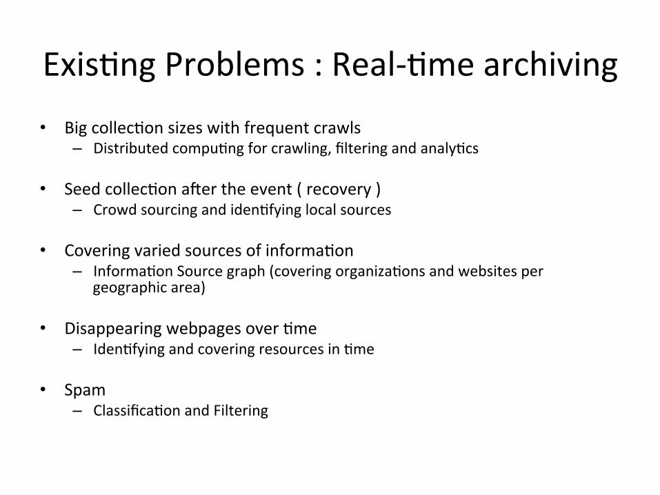
Exis&ng Problems : Real-‐&me archiving • Big collec&on sizes with frequent crawls
– Distributed compu&ng for crawling, filtering and analy&cs
• Seed collec&on aler the event ( recovery ) – Crowd sourcing and iden&fying local sources
• Covering varied sources of informa&on – Informa&on Source graph (covering organiza&ons and websites per
geographic area)
• Disappearing webpages over &me – Iden&fying and covering resources in &me
• Spam – Classifica&on and Filtering

Future Goals • Use Lucid Works Big Data Solware with the archive data
– Integrated planorm for solving informa&on access problems with the tools for Search, Discovery, and Analysis of massive content sets
• Digital Library to provide access to the data
– Features • Faceted Search • Image and Video extrac&on • Filtered, relevant documents per collec&on

Summary • Real-‐&me Archiving
– Seed Collec&on – Big Data – Access
• Collabora&on
– Spoong Events – Access to data and solware – IDEAL proposal

References and Resources
1. www.ctrnet.net 2. www.en.wikipedia.org/wiki/Hurricane_Sandy 3. hBp://bitly.com/sandygroups 4. hBp://archive-‐it.org/collec&ons/3358 5. hBp://archive-‐it.org/organiza&ons/156

Analyzing and Visualizing (Tweet) Archives
Presenter: Seungwon Yang 12/3/2012
Internet Archive Partners Mee&ng

Overview
• Descrip&on – Four Phase Model of Emergency Management
• Data Flow Diagram – Selec&on/cleaning à classifica&on à visualiza&on
• PhaseVis Components – What, When, Where, and Who
• A Sample Use Case
15

Tweet Analysis & Visualiza&on Study
• Title: PhaseVis: What, When, Where, and Who in Visualizing the Four Phases of Emergency Management Through the Lens of Social Media • Conference SubmiBed: The 10th Interna&onal ISCRAM Conference’13 (Informa&on Systems for Crisis Response and Managment)
• Prototype Link: • hBp://spare05.dlib.vt.edu/~ctrvis/phasevis/
16

Four Phases of Emergency Management
Phases Descrip&on Mi&ga&on Ac&vi&es providing a cri&cal founda&on in the effort to
reduce or eliminate the risks to persons or property, and to lessen or avoid the impact of a disaster
Preparedness Range of deliberate, cri&cal tasks and ac&vi&es necessary to build, sustain, and improve the opera&onal capability to prevent, protect against, respond to, and recover from emergency and disasters.
Response Immediate and ongoing ac&ons following an emergency or disaster, which are designed to provide emergency assistance for casual&es such as search/rescue, emergency shelter, medical care, mass feeding.
Recovery The development, coordina&on, and execu&on of service and site restora&on plans. The reconstruc&on of government opera&ons and services.
17

Four Phases of Emergency Management -‐ Tweet Examples -‐
First author’s last name (use et al. if more than one author) Visualizing the Four Phases of Emergency Management
Proceedings of the 10th International ISCRAM Conference – Baden-Baden, Germany, May 2013 T. Comes, F. Fiedrich, S. Fortier, J. Geldermann and L. Yang, eds.
5
Org. Names FEMA Red Cross Salvation Army Total*
Num. Tweets 2,058 (388) 3,670 (1,052) 76 (52) 5,675 (1,457)
Table 4. Number of tweets with disaster organization names, both in the target set and in our training set (within parentheses).
* Note: some tweets contain more than a single organization name; therefore, the sum of the numbers in column 2, 3, and 4 is greater than the total (column 5:tweets that have at least one organization name).
!"#$#%&'()*&&%#(*"%+(&,&'-&./0(
1'-#2($-&./0(.$,&#(
3"#4$5"6$71.(8(
9.%&'$/71.(
:$.4$5(;$<&5".-(
)'$".".-(!$%$(
)'$".&=(/5$##">/$71.(
,1=&5(
?5&$.&=()*&&%#(
@'"-".$5()*&&%#(
@'"-".$5(8(A&%*&&%#(
?5$##">&=()*&&%#(
#&5&/71.B/5&$.".-(/5$##">/$71.(C"#4$5"6$71.(
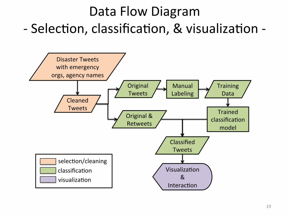
Figure 1. A data flow diagram: selection, classification, and visualization.
Figure 1 shows an overview of the procedures for the selection of relevant tweets, classification using a training set, and visualization of classified tweets. Details are described in the following sections.
Since tweets often embed shortened links to webpages, those webpages might provide essential information required to understand the tweets themselves. Thus, we followed the first embedded link (if it exists) and extracted the title of the webpage. Then we concatenate the resource title with the tweet to form a richer tweet text with the intent of strengthening the distinguishability of the classifier. As a pre-processing step, we removed non-informative English stopwords, special characters, and URLs from tweets, and applied the Porter stemmer provided in the WEKA toolkit4.
3.2. Classification
Each tweet in our training set was manually categorized as one of ‘1:Response’, ‘2:Recovery’, ‘3:Mitigation’, ‘4:Preparedness’, and ‘5:Other’ based on the activities described in the content. Selected labeled training examples are presented in Table 5. We excluded 331 tweets categorized as ‘5:Other’. In total, 1,121 tweets were used as our training set.
Phase (Category) Example Tweet
1: Response Red Cross provided 20,000+ overnight shelter stays and served 400,000+ meals/snacks to help those impacted by #Hurricane #Isaac. THANK YOU!!
2: Recovery Hurricane #Isaac relief efforts in the Gulf continue. Pls help! Txt REDCROSS to 90999, to give $10.
3: Mitigation FEMA mitigation to offer rebuilding tips in St. John Parish at Home Depot in LaPlace, La. http://t.co/8UFJFEz5 #Isaac
4: Preparedness RT @jeffiel: Seriously, everybody should have this #RedCross app on their phone. What to do in #emergencies http://t.co/MtrQcOo1 #isaac
Table 5. Selected example tweets in each of four phase categories.
Using our training set, we trained three classification algorithms -- multi-class SVM, multinomial Naïve Bayes,
4 http://www.cs.waikato.ac.nz/ml/weka 18
First author’s last name (use et al. if more than one author) Visualizing the Four Phases of Emergency Management
Proceedings of the 10th International ISCRAM Conference – Baden-Baden, Germany, May 2013 T. Comes, F. Fiedrich, S. Fortier, J. Geldermann and L. Yang, eds.
5
Org. Names FEMA Red Cross Salvation Army Total*
Num. Tweets 2,058 (388) 3,670 (1,052) 76 (52) 5,675 (1,457)
Table 4. Number of tweets with disaster organization names, both in the target set and in our training set (within parentheses).
* Note: some tweets contain more than a single organization name; therefore, the sum of the numbers in column 2, 3, and 4 is greater than the total (column 5:tweets that have at least one organization name).
!"#$#%&'()*&&%#(*"%+(&,&'-&./0(
1'-#2($-&./0(.$,&#(
3"#4$5"6$71.(8(
9.%&'$/71.(
:$.4$5(;$<&5".-(
)'$".".-(!$%$(
)'$".&=(/5$##">/$71.(
,1=&5(
?5&$.&=()*&&%#(
@'"-".$5()*&&%#(
@'"-".$5(8(A&%*&&%#(
?5$##">&=()*&&%#(
#&5&/71.B/5&$.".-(/5$##">/$71.(C"#4$5"6$71.(
Figure 1. A data flow diagram: selection, classification, and visualization.
Figure 1 shows an overview of the procedures for the selection of relevant tweets, classification using a training set, and visualization of classified tweets. Details are described in the following sections.
Since tweets often embed shortened links to webpages, those webpages might provide essential information required to understand the tweets themselves. Thus, we followed the first embedded link (if it exists) and extracted the title of the webpage. Then we concatenate the resource title with the tweet to form a richer tweet text with the intent of strengthening the distinguishability of the classifier. As a pre-processing step, we removed non-informative English stopwords, special characters, and URLs from tweets, and applied the Porter stemmer provided in the WEKA toolkit4.
3.2. Classification
Each tweet in our training set was manually categorized as one of ‘1:Response’, ‘2:Recovery’, ‘3:Mitigation’, ‘4:Preparedness’, and ‘5:Other’ based on the activities described in the content. Selected labeled training examples are presented in Table 5. We excluded 331 tweets categorized as ‘5:Other’. In total, 1,121 tweets were used as our training set.
Phase (Category) Example Tweet
1: Response Red Cross provided 20,000+ overnight shelter stays and served 400,000+ meals/snacks to help those impacted by #Hurricane #Isaac. THANK YOU!!
2: Recovery Hurricane #Isaac relief efforts in the Gulf continue. Pls help! Txt REDCROSS to 90999, to give $10.
3: Mitigation FEMA mitigation to offer rebuilding tips in St. John Parish at Home Depot in LaPlace, La. http://t.co/8UFJFEz5 #Isaac
4: Preparedness RT @jeffiel: Seriously, everybody should have this #RedCross app on their phone. What to do in #emergencies http://t.co/MtrQcOo1 #isaac
Table 5. Selected example tweets in each of four phase categories.
Using our training set, we trained three classification algorithms -- multi-class SVM, multinomial Naïve Bayes,
4 http://www.cs.waikato.ac.nz/ml/weka
Data Flow Diagram -‐ Selec&on, classifica&on, & visualiza&on -‐
19

First author’s last name (use et al. if more than one author) Visualizing the Four Phases of Emergency Management
Proceedings of the 10th International ISCRAM Conference – Baden-Baden, Germany, May 2013 T. Comes, F. Fiedrich, S. Fortier, J. Geldermann and L. Yang, eds.
7
a summary box (i.e., the dark gray box next to a selection bar) as a quick summary. Selected tweets are listed in Tweet View (b), where they can be sorted by clicking the column heading. In this way, users can sort tweets in a certain phase.
When
The date and time information from tweets is extracted and forms the date axis. A detail date and time interval is shown inside the summary box. For example, “02:45 09/07–07:08 09/10” represents the start and end point of the selection bar.
Where
User IDs from the selected tweets are identified, and locations are extracted from their publicly available Twitter profile page in advance. Then, we applied geocoding using the Google Geocoding API6 on the locations to find the latitude and longitude data. Out of 7,616 users, we were able to extract only 4,573 (60%) with latitude and longitude information. Problems might have been caused by: (1) the user did not add any location information in his/her profile; or (2) the entered location information could not be processed due to uninterpretable content (e.g., “Sumwhere in the universe”, “R.D”, “InMySkin” “http://maps.BlackBerry.com?lat”).
Who
By identifying the users and @mentions in tweets, we constructed a Social Network View as shown in (c). We found that the performance of a force-directed graph quickly degraded when the number of nodes (i.e., user IDs) increased.
!"#$%&"'($)*(+$
!,#$-+((.$)*(+$ !/#$0"1$)*(+$
!2#$342*"5$6(.+478$)*(+$
9:;-$
9:;-$ 9:<=<$
9:>$
9:<6$
Figure 2. The PhaseVis user interface integrating the What, When, Where, and Who aspects of a disaster tweet data
in four views: (a) Phase View, (b) Tweet View, (c) Social Network View, and (d) Map View.
3.3.3. Component Details of PhaseVis
As briefly mentioned in Section 3.3.2, PhaseVis consists of four distinct views: the Phase View (a), Tweet View (b), Social Network View (c), and Map View (d).
6 https://developers.google.com/maps/documentation/geocoding/
What, When, Where, and Who in PhaseVis
20
First author’s last name (use et al. if more than one author) Visualizing the Four Phases of Emergency Management
Proceedings of the 10th International ISCRAM Conference – Baden-Baden, Germany, May 2013 T. Comes, F. Fiedrich, S. Fortier, J. Geldermann and L. Yang, eds.
9
SVM
Naïve Bayes Multinomial 0.79 0.779 0.782 77.88% tf, normalization, stemming
Random Forest 0.762 0.763 0.754 76.27% tf, normalization, stemming
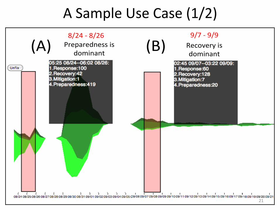
4.2. A Sample Use Case
A researcher in the Disaster Informatics field wants to know what was happening during certain time periods of Hurricane Isaac from the associated tweet data collection. So, she first selects a time interval (A) shown in
Figure 3 by clicking, dragging, and releasing the mouse button to fix the interval. The interval covers two days from Aug. 24 to 26, which is a beginning part of the hurricane. A gray box immediately displays details of date and time range in textual format as “05:25 08/24—06:02 08:26.” The box also shows that Preparedness was the dominant phase (419 tweets) followed by Response (100 tweets) and Recovery (42 tweets).
!"#$ !%#$&'()*'(+,(--$.-$+/0.,*,1$
2(3/4('5$.-$+/0.,*,1$
6789$:$678;$ <7=$:$<7<$
Figure 3. Selected time intervals showing two summaries superimposed on a single ThemeRiver™ for simplicity of
presentation. (A) the beginning part of the hurricane; (B) one week after the hurricane dissipates in Sep. 1st.
!"#$%&'()*&+,-
.&/01(22-
3456-
768- 798-
7:8-7;8-
7;8-7<8-
.&/01(22-
3456-.&/01(22'4=6-
Figure 4. Who and Where aspects of time intervals (A) (8/24-8/26) and (B) (9/7-9/9), visualized with a user mention graph and a user location map respectively.
A Sample Use Case (1/2)
21

First author’s last name (use et al. if more than one author) Visualizing the Four Phases of Emergency Management
Proceedings of the 10th International ISCRAM Conference – Baden-Baden, Germany, May 2013 T. Comes, F. Fiedrich, S. Fortier, J. Geldermann and L. Yang, eds.
9
SVM
Naïve Bayes Multinomial 0.79 0.779 0.782 77.88% tf, normalization, stemming
Random Forest 0.762 0.763 0.754 76.27% tf, normalization, stemming
4.2. A Sample Use Case
A researcher in the Disaster Informatics field wants to know what was happening during certain time periods of Hurricane Isaac from the associated tweet data collection. So, she first selects a time interval (A) shown in
Figure 3 by clicking, dragging, and releasing the mouse button to fix the interval. The interval covers two days from Aug. 24 to 26, which is a beginning part of the hurricane. A gray box immediately displays details of date and time range in textual format as “05:25 08/24—06:02 08:26.” The box also shows that Preparedness was the dominant phase (419 tweets) followed by Response (100 tweets) and Recovery (42 tweets).
!"#$ !%#$&'()*'(+,(--$.-$+/0.,*,1$
2(3/4('5$.-$+/0.,*,1$
6789$:$678;$ <7=$:$<7<$
Figure 3. Selected time intervals showing two summaries superimposed on a single ThemeRiver™ for simplicity of
presentation. (A) the beginning part of the hurricane; (B) one week after the hurricane dissipates in Sep. 1st.
!"#$%&'()*&+,-
.&/01(22-
3456-
768- 798-
7:8-7;8-
7;8-7<8-
.&/01(22-
3456-.&/01(22'4=6-
Figure 4. Who and Where aspects of time intervals (A) (8/24-8/26) and (B) (9/7-9/9), visualized with a user mention graph and a user location map respectively.
A Sample Use Case (2/2)
22

Acknowledgments
• Members of the Digital Library Research Laboratory, Virginia Tech
• We thank NSF for suppor&ng the CTRnet project (IIS-‐0916733), of which this work is part. Any opinions, findings, and conclusions or recommenda&ons expressed in this material are those of the authors and do not necessarily reflect the views of the Na&onal Science Founda&on.
23

Thank you! Ques&ons?
24