realignment of south fields reach 2 environmental assessment
TRANSCRIPT

November 2019
Realignment of South Fields Reach 2
Environmental Assessment
PREPARED BY:
U.S. Department of the Interior Central Utah Project Completion Act Office
Central Utah Water Conservancy District
Utah Reclamation Mitigation and Conservation Commission


Realignment of South Fields Reach 2
Environmental Assessment
November 2019

Joint Lead Agencies U.S. Department of the Interior, Central Utah Project Completion Act Office Central Utah Water Conservancy District Utah Reclamation Mitigation and Conservation Commission
Cooperating Agencies U.S. Bureau of Reclamation
Responsible Officials Reed R. Murray U.S. Department of the Interior, CUPCA Office 302 East 1860 South Provo, Utah 84606-7317 Sarah Sutherland Central Utah Water Conservancy District 1426 East 750 North Suite 400 Orem, Utah 84097-5474
Mark Holden Utah Reclamation Mitigation and Conservation Commission 230 South 500 East, Suite 230
Salt Lake City, Utah 84102-2045
For information, contact: Chris Elison Central Utah Water Conservancy District 1426 East 750 North Suite 400 Orem, Utah 84097-5474 (801) 226-7166 [email protected]

Page i Realignment of South Fields Reach 2 Environmental Assessment Table of Contents and List of Figures and Tables November 2019
TABLE OF CONTENTS Table of Contents ................................................................................................................................. i List of Figures and Tables ................................................................................................................... iv Abbreviations and Acronyms .............................................................................................................. v Chapter 1: Purpose and Need ............................................................................................................. 1
1.1 Introduction ............................................................................................................................ 1 National Environmental Policy Act ........................................................................................................... 1 Cooperating Agencies ............................................................................................................................... 1 Utah Lake Drainage Basin Water Delivery System Environmental Impact Statement ............................. 1 Project Study Area .................................................................................................................................... 1
1.2 Project Information and Background ..................................................................................... 3 Central Utah Project ................................................................................................................................. 3
1.3 Proposed Action ...................................................................................................................... 6
1.4 Purpose and Need ................................................................................................................... 6
1.5 Permits, Contracts, and Authorizations .................................................................................. 7
1.6 Related Projects and Documents ........................................................................................... 7 Chapter 2: Alternatives ....................................................................................................................... 8
2.1 Introduction ............................................................................................................................ 8
2.2 Development of South Fields Reach 2 Alternatives ............................................................... 8 NEPA Scoping ............................................................................................................................................ 8 Value Engineering Analysis ..................................................................................................................... 10 Future Development Plans and Coordination with Landowners ............................................................ 10
2.3 Alternatives ........................................................................................................................... 11 Common Features of the Alternatives .................................................................................................... 11 No-Action Alternative ............................................................................................................................. 11 Alternative B – Woodland Hills Drive ...................................................................................................... 13 Alternative C – Salem Canal (Preferred Alternative) .............................................................................. 13 Selection of the Preferred Alternative .................................................................................................... 16
Chapter 3: Affected Environment and Environmental Consequences ............................................. 17
3.1 Introduction .......................................................................................................................... 17 Affected Environment ............................................................................................................................. 17 Environmental Consequences ................................................................................................................ 17 Resources Considered but Dismissed from Further Analysis ................................................................. 17 Resources Evaluated Further .................................................................................................................. 17

Page ii Realignment of South Fields Reach 2 Environmental Assessment Table of Contents and List of Figures and Tables November 2019
3.2 Air Quality .............................................................................................................................. 18 Affected Environment ............................................................................................................................. 18 Environmental Consequences ................................................................................................................ 18 Mitigation ................................................................................................................................................ 19
3.3 Noise ...................................................................................................................................... 19 Affected Environment ............................................................................................................................. 19 Environmental Consequences ................................................................................................................ 20 Mitigation ................................................................................................................................................ 21
3.4 Transportation ...................................................................................................................... 21 Affected Environment ............................................................................................................................. 21 Environmental Consequences ................................................................................................................ 21 Mitigation ................................................................................................................................................ 22
3.5 Water Resources ................................................................................................................... 22 Affected Environment ............................................................................................................................. 22 Environmental Consequences ................................................................................................................ 24 Mitigation ................................................................................................................................................ 25
3.6 Wildlife .................................................................................................................................. 25 Affected Environment ............................................................................................................................. 25 Environmental Consequences ................................................................................................................ 26 Mitigation ................................................................................................................................................ 26
3.7 Endangered Species Act and State Listed Sensitive Species ................................................ 26 Affected Environment ............................................................................................................................. 27 Environmental Consequences ................................................................................................................ 28 Mitigation ................................................................................................................................................ 28
3.8 Cultural Resources ................................................................................................................ 28 Affected Environment ............................................................................................................................. 29 Environmental Consequences ................................................................................................................ 29 Mitigation ................................................................................................................................................ 33
3.9 Prime, Unique, and Statewide Important Farmland ............................................................ 33 Affected Environment ............................................................................................................................. 33 Environmental Consequences ................................................................................................................ 34 Mitigation ................................................................................................................................................ 37
3.10 Land Use Plans and Policies .................................................................................................. 37 Utah County Zone Designation ............................................................................................................... 37 Future Plans ............................................................................................................................................ 38 Environmental Consequences ................................................................................................................ 38 Mitigation ................................................................................................................................................ 38

Page iii Realignment of South Fields Reach 2 Environmental Assessment Table of Contents and List of Figures and Tables November 2019
3.11 Environmental Justice ........................................................................................................... 39 Affected Environment ............................................................................................................................. 39 Environmental Consequences ................................................................................................................ 39 Mitigation ................................................................................................................................................ 39
3.12 Indian Trust Assets ................................................................................................................ 39 Affected Environment ............................................................................................................................. 40 Environmental Consequences ................................................................................................................ 40 Mitigation ................................................................................................................................................ 40
3.13 Climate Change ..................................................................................................................... 40 Affected Environment ............................................................................................................................. 40 Environmental Consequences ................................................................................................................ 40 Mitigation ................................................................................................................................................ 41
3.14 Indirect Impacts .................................................................................................................... 41
3.15 Cumulative Impacts .............................................................................................................. 41 Past, Present, and Reasonably Foreseeable Future Actions ................................................................... 42 Cumulative Impacts ................................................................................................................................ 42
3.16 Construction Impacts ............................................................................................................ 43 Air Quality ............................................................................................................................................... 43 Noise and Vibration ................................................................................................................................ 44 Transportation ........................................................................................................................................ 44 Water Resources ..................................................................................................................................... 45 Wildlife .................................................................................................................................................... 45 Cultural Resources .................................................................................................................................. 46 Agricultural .............................................................................................................................................. 46 Soils ......................................................................................................................................................... 46 Vegetation and Invasive Species ............................................................................................................. 46 Public Health and Safety ......................................................................................................................... 47
Chapter 4: Project Coordination ....................................................................................................... 48
4.1 Cooperating Agencies ........................................................................................................... 48
4.2 Public and Agency Scoping Process ...................................................................................... 48 Fall 2017 Scoping Process ....................................................................................................................... 48 Spring 2019 Scoping Process ................................................................................................................... 49
Chapter 5: List of Preparers .............................................................................................................. 57
Page iv Realignment of South Fields Reach 2 Environmental Assessment Table of Contents and List of Figures and Tables November 2019
LIST OF FIGURES AND TABLES Figure 1-1: Project Study Area .......................................................................................................... 2
Figure 1-2: Bonneville Unit of the CUP ............................................................................................. 4
Figure 1-3: Reaches and Alignment for the Spanish Fork – Santaquin Pipeline ................................. 5
Figure 2-1: South Fields Reach 2 Alternatives ................................................................................... 9
Figure 2-2: Salem City Annexation Plan .......................................................................................... 10
Figure 2-3: No-Action Alternative ................................................................................................... 12
Figure 2-4: Alternative B – Woodland Hills Drive ............................................................................ 14
Figure 2-5: Alternative C – Salem Canal .......................................................................................... 15
Figure 2-6: Proposed Future Roadway Typical Section ................................................................... 13
Figure 2-7: Alternatives Evaluated in the EA .................................................................................. 16
Figure 3-1: Underdrain System and Beer Creek Drainage Ditch ...................................................... 23
Figure 3-2: Eligible Historic Resources and Potential Impacts to the Salem Canal .......................... 31
Figure 3-3: Prime, Unique, and Statewide Important Farmland ...................................................... 35
Figure 3-4: Agricultural Protection Areas ....................................................................................... 36
Table 3-1: Noise Levels along Proposed Future Roadway ............................................................... 21
Table 3-2: Endangered Species List in Project Study Area .............................................................. 27
Table 3-3: State Sensitive and Conservation Agreement Species In Project Area ........................... 27
Table 3-4: NRHP Criteria ................................................................................................................. 29
Table 3-5: Historic Resources within the Project Area of Potential Effects ..................................... 30
Table 3-6: Summary of Impacts by Alternative to the Eligible Historic Resources .......................... 32

Page v Realignment of South Fields Reach 2 Environmental Assessment Abbreviations and Acronyms November 2019
ABBREVIATIONS AND ACRONYMS ACHP Advisory Council on Historic Preservation af acre-feet APA agricultural protection areas APE Area of Potential Effects BMP Best Management Practice CAAA Clean Air Act Amendments CERCLA Comprehensive Environmental Response, Compensation, and Liability Act CEQ Council on Environmental Quality CFR Code of Federal Regulations CFS cubic feet per second CO carbon monoxide CO2 carbon dioxide CS species with conservation agreement CUP Central Utah Project CUPCA Central Utah Project Completion Act CUPCA Office Central Utah Project Completion Act Office CUWCD Central Utah Water Conservancy District CWA Clean Water Act dB decibel dB(A) A-Weighted decibel DERR Utah Division of Environmental Response and Remediation DEQ Utah Division of Water Quality District Central Utah Water Conservancy District DWR Utah Division of Wildlife Resources EA Environmental Assessment EIS Environmental Impact Statement EPA U.S. Environmental Protection Agency EPCRA Emergency Planning and Community Right-to-Know Act ESA Endangered Species Act FEMA Federal Emergency Management Agency FHWA Federal Highway Administration FONSI Finding of No Significant Impact FPPA Farmland Protection Policy Act IPaC Information for Planning and Consultation Interior U.S. Department of the Interior, Central Utah Project Completion Act Office ITAs Indian Trust Assets JLAs Joint Lead Agencies JSRIP June Sucker Recovery Implementation Program LEQ equivalent continuous sound level LUST leaking underground storage tank MAG Mountainland Association of Governments M&I Municipal and Industrial MBTA Migratory Bird Treaty Act MG million gallon

Page vi Realignment of South Fields Reach 2 Environmental Assessment Abbreviations and Acronyms November 2019
Mitigation Commission Utah Reclamation Mitigation and Conservation Commission MOA Memorandum of Agreement MOU Memorandum of Understanding N20 nitrous oxide NAAQS National Ambient Air Quality Standards NEPA National Environmental Policy Act NFIP National Flood Insurance Program NHPA National Historic Preservation Act NO2 nitrogen dioxide NOX oxides of nitrogen NRCS Natural Resource Conservation Service NRHP National Register of Historic Places O3 ozone Pb lead PL Public Law PM particulate matter PM2.5 particulate matter 2.5 micrometers PM10 particulate matter 10 micrometers POAQC Projects of Air Quality Concern RCRA Resource Conservation and Recovery Act RDCC Resource Development Coordination Committee Reclamation U.S. Bureau of Reclamation SFHA Special Flood Hazard Area SFSP Spanish Fork – Santaquin Pipeline SHPO State Historic Preservation Office SO2 sulfur dioxide SPC species of concern SR state road SWPPP Storm Water Pollution Prevention Plan TMDL Total Maximum Daily Load UAC Utah Administrative Code UDAQ Utah Division of Air Quality UDCC Utah Data Conservation Center UDEQ Utah Department of Environmental Quality UDOT Utah Department of Transportation UDWR Utah Division of Wildlife Resources UNHP Utah Natural Heritage Program ULS Utah Lake Drainage Basin Water Delivery System UPDES Utah Pollutant Discharge Elimination System USACE U.S. Army Corps of Engineers USC United States Code USFWS U.S. Fish and Wildlife Service UST underground storage tank VE value engineering VOC volatile organic compounds

Page 1 Realignment of South Fields Reach 2 Environmental Assessment Chapter 1: Purpose and Need November 2019
CHAPTER 1: PURPOSE AND NEED
1.1 Introduction The Central Utah Water Conservancy District (CUWCD), the United States Department of the Interior – Central Utah Project Completion Act Office (CUPCA Office), and the Utah Reclamation Mitigation and Conservation Commission (Mitigation Commission), as Joint Lead Agencies (JLAs), are proposing to realign a segment of the Spanish Fork – Santaquin Pipeline (SFSP) known as South Fields Reach 2. In addition, the JLAs are proposing to keep the SFSP at a consistent 60-inch diameter for its entire length.
National Environmental Policy Act The JLAs are preparing this Environmental Assessment (EA) for the proposed project. The EA presents and evaluates the potential effects of the Proposed Action in order to determine whether it would cause significant impacts to the human or natural environment as defined by the National Environmental Policy Act of 1969 (NEPA, Public Law [PL] 91-190 and 42 USC 4321-4347), the Council on Environmental Quality (CEQ, 40 Code of Federal Regulations [CFR] Parts 1500-1508), and U.S. Department of the Interior Regulations Implementing NEPA (43 CFR Part 46). The JLAs will use the EA process to satisfy disclosure requirements and as a means for public participation mandated by NEPA and the Central Utah Project Completion Act (CUPCA, PL 102-575). The requirements under Section 106 of the National Historic Preservation Act of 1966 (NHPA), Section 7 of the Endangered Species Act of 1973 (ESA), and other state and local regulatory obligations have also been satisfied. If the NEPA process, as document in the EA, shows no significant impacts associated with implementation of the Proposed Action, then a Findings of No Significant Impact (FONSI) will be issued by the JLAs. During the NEPA process, if it is determined that there may be significant impacts, the JLAs would initiate the preparation of an Environmental Impact Statement (EIS) prior to implementing the Proposed Action.
Cooperating Agencies As defined in 40 CFR 1501.6, a Cooperating Agency actively participates in the NEPA process, provides information for preparing environmental analyses for which the Cooperating Agency has jurisdiction by law or special expertise, and is part of the proposed project’s interdisciplinary team. The JLAs invited the U.S. Bureau of Reclamation (Reclamation) to participate in the preparation and review of this NEPA process as a Cooperating Agency. Reclamation accepted the invitation and has assisted in the preparation of this EA.
Utah Lake Drainage Basin Water Delivery System Environmental Impact Statement Pursuant to 40 CFR 1502.20 and 1508.28, this EA tiers to and updates a portion of the Utah Lake Drainage Basin Water Delivery System (ULS) Environmental Impact Statement (EIS) published in 2004. Records of Decisions authorizing the construction of the ULS were signed by the CUPCA Office and Mitigation Commission in 2004 and 2005, respectively.
Project Study Area The proposed project is located within unincorporated Utah County south of Spanish Fork City and east of Salem City. The main roadways within the project study area are 8800 South, 400 East, Woodland Hills Drive, 9800 South, and 9650/9600 South; 800 East is mainly used for private farm access. There are two large canals in the study area: South Field Canal and Salem Canal. The land uses are mainly agricultural with some homes along the main roadways. The project study area is shown in Figure 1-1.

Page 2 Realignment of South Fields Reach 2 Environmental Assessment Chapter 1: Purpose and Need November 2019
FIGURE 1-1: PROJECT STUDY AREA

Page 3 Realignment of South Fields Reach 2 Environmental Assessment Chapter 1: Purpose and Need November 2019
1.2 Project Information and Background
Central Utah Project The Central Utah Project (CUP) is a federal water project and a participating project under the Colorado River Storage Project Act of April 11, 1956 (PL 84-485, 70 Stat. 105). Constructed by Reclamation and CUWCD, it is the largest water resources development project in the state. The CUP makes use of a portion of Utah’s share of the Colorado River yield as set forth in the Colorado River Compact of 1922. Water developed by the CUP is used for municipal, industrial, and agricultural supplies; hydroelectric power; fish and wildlife; and recreation. The CUP also improves flood-control capability and helps control water quality. The CUP was originally divided into six units to facilitate planning and construction: Vernal, Bonneville, Jensen, Upalco (deauthorized), Uinta (deauthorized), and Ute Indian (deauthorized). The Bonneville Unit is currently under construction while Vernal and Jensen units are completed.
Bonneville Unit The Bonneville Unit collects and diverts water from the Uinta Basin which is part of the Colorado River Basin to the Bonneville Basin (see Figure 1-2). It is located in central and northeastern Utah and provides water for Salt Lake, Utah, Wasatch, Duchesne counties, and a portion of Summit County. The Bonneville Unit is comprised of seven systems: the Starvation Collection System, Strawberry Aqueduct & Collection System, Municipal and Industrial System, Diamond Fork System, Utah Lake Drainage Basin Water Delivery System (ULS), Wasatch County Water Efficiency/Daniel Replacement Project, and Uintah Basin Replacement Project. These systems contain a network of reservoirs, aqueducts, tunnels, canals, pipelines, pumping plants and other conveyance facilities that develop water for irrigation, municipal, and industrial uses, instream flows, hydropower production, and recreation. Much of the Bonneville Unit is completed and the remaining features, mainly the ULS, are currently under construction.
Spanish Fork – Santaquin Pipeline The Spanish Fork – Santaquin Pipeline is a feature of the ULS which is part of the Bonneville Unit. Water delivered through the SFSP originates from Strawberry Reservoir and is conveyed through the Diamond Fork System, into the Spanish Fork Canyon Pipeline, and into the SFSP.1 The ULS EIS evaluated the SFSP for diameters ranging from 60 to 36-inches. The pipe diameter would become smaller as the SFSP headed west from the mouth of Spanish Fork Canyon to Santaquin. However, the Proposed Action includes a single, 60-inch diameter for the entire SFSP. Construction of the first two segments, Spanish Fork Reach and the South Fields Reach 1, have been completed. They were constructed of welded steel, mortar-lined and coated and are both 60-inch diameter pipelines; the SFSP alignment is shown in Figure 1-3.2 The South Fields Reach 2 project would be constructed of the same materials as the Spanish Fork Reach and the South Fields Reach 1 pipelines.
1 Project water may be also delivered to the Spanish Fork – Provo Reservoir Canal Pipeline and/or to the Mapleton-Springville Pipeline (see Figure 1-2). 2 Reaches: Spanish Fork, South Fields 1, South Fields 2 (Proposed Project), Salem 1, Salem 2 (under construction), Payson, Spring Lake, and Santaquin.

Page 4 Realignment of South Fields Reach 2 Environmental Assessment Chapter 1: Purpose and Need November 2019
FIGURE 1-2: BONNEVILLE UNIT OF THE CUP

Page 5 Realignment of South Fields Reach 2 Environmental Assessment Chapter 1: Purpose and Need November 2019
FIGURE 1-3: REACHES AND ALIGNMENT FOR THE SPANISH FORK – SANTAQUIN PIPELINE

Page 6 Realignment of South Fields Reach 2 Environmental Assessment Chapter 1: Purpose and Need November 2019
1.3 Proposed Action The Proposed Action for the South Fields Reach 2 project involves the following:
• Evaluation of three alternatives,3 No-Action and two realignment alternatives, for the construction of a 60-inch diameter pipeline. The South Fields Reach 2 pipeline would connect with the South Fields Reach 1 and the future Salem Reach 1 pipelines; and
• Designing and constructing the SFSP with up to a 60-inch diameter pipe for approximately 17.5 miles. Tables 1-9 and 1-10 in the ULS EIS (see pages 1-38 and 1-49 in the ULS EIS) show the SFSP diameter ranging from 60 to 36-inches.4 By having one consistent pipe diameter, the SFSP would be able to be cleaned with a foam swab known as a pipeline ‘PIG’. Raw water pipelines may need to be periodically cleaned, depending on the quality of water, to remove dirt, sludge, and other buildup on the interior of the pipe wall. Buildup of sludge and other material decreases the flows rates through a pipeline. The volume of water conveyed in the SFSP would remain the same as described in the ULS EIS.5
1.4 Purpose and Need The purposes and needs for the Realignment of the South Fields Reach 2 project are the same as documented in the ULS EIS. The ULS EIS purpose and need was developed in part through a public involvement process, which states:
“The Joint-Lead Agencies finalized a purpose and need statement to guide them through the planning process and development of this NEPA document. The statement defines the underlying needs to which the selected plan and any alternatives must respond, and the attendant purposes of the ULS. Needs: • To complete the Bonneville Unit by delivering 101,900 acre-feet on an average
annual basis from Strawberry Reservoir to the Wasatch Front Area and project water from other sources to meet some of the municipal and industrial (M&I) demand in the Wasatch Front Area.
• To implement water conservation measures. • To address all remaining environmental commitments associated with the
Bonneville Unit. • To maximize current and future M&I water supplies associated with the Bonneville
Unit.
Purposes: 1 To protect water quality of surface and underground water resources that may
be affected by Bonneville Unit completion 2 To provide creative methods, facilities and incentives to implement water
conservation measures, reuse and conjunctive use of water resources 3 To participate in the implementation of the June Sucker Recovery
3 Four alternatives were presented as part of the scoping process in May of 2019 as shown in Figure 2-1. One alternative has since been dismissed. 4 The SFSP would reduce in size from east to west as the water it carries is delivered to the agencies along its alignment (e.g. Spanish Fork City, Salem City, Elk Ridge City). 5 30,000 acre-feet for south Utah County agencies and up to 10,200 AF of Strawberry Valley Project water shares, on a space available basis (see page 1-37 in the ULS EIS).

Page 7 Realignment of South Fields Reach 2 Environmental Assessment Chapter 1: Purpose and Need November 2019
Implementation Program 4 To provide previously committed in-stream flows within the Bonneville Unit
area and statutorily mandated in-stream flows, and assist in improving fish, wildlife and related recreational resources
5 To provide for the United States to acquire adequate District water rights in Utah Lake to implement the ULS and other water rights as authorized by CUPCA
6 To continue to provide Bonneville Unit water in accordance with existing contracts.
7 To develop project power”
1.5 Permits, Contracts, and Authorizations The Proposed Action for the Realignment of the South Fields Reach 2 project will comply with all federal, state, and local regulations. The contractor will be required to obtain a Utah Pollution Discharge Elimination System permit and follow a Storm Water Pollution Prevention Plan.
1.6 Related Projects and Documents The Proposed Action has been developed with consideration given to the related planning and environmental documents listed below:
• Bonneville Unit Definite Plan Report (1964); • Final Environmental Statement, Bonneville Unit of the CUP (1972); • Supplement to the Bonneville Unit Definite Plan Report (1988); • Supplement to the Bonneville Unit Definite Plan Report (2004); and • Final Environmental Impact Statement and Records of Decisions, Utah Lake Drainage
Basin Water Delivery System (2004 and 2005).


Page 8 Realignment of South Fields Reach 2 Environmental Assessment Chapter 2: Alternatives November 2019
CHAPTER 2: ALTERNATIVES
2.1 Introduction This chapter describes the alternatives considered for the Realignment of the South Fields Reach 2 project: No-Action Alternative and three realignment alternatives as shown in Figure 2-1. This chapter also discusses how the alternatives were developed, the alternatives considered but dismissed, and the alternatives evaluated further in this EA per 40 CFR 1502.14.
2.2 Development of South Fields Reach 2 Alternatives The No-Action Alternative is the Preferred Alternative from the ULS EIS. Since the approval of the ULS EIS, additional studies, investigations, and public and agency coordination have occurred and assisted with the development of realignment alternatives for the South Fields Reach 2 project. The considerations that assisted the JLAs development of the alternatives for evaluation are described in this section. They are:
• NEPA Scoping; • Value Engineering Analysis; and • Future Development Plans and Coordination with Landowners.
NEPA Scoping The JLAs conducted scoping6 as part of NEPA for the Realignment of South Fields Reach7 project in the fall of 2017 –see Chapter 4 for more discussion. Scoping was used to present potential realignment alternatives that had been developed by the JLAs for the South Fields Reach 2 project and to solicit public and agency input on any potential impacts and issues. The No-Action Alternative, Alternative A – 400 East, and Alternative B – Woodland Hills Drive were presented as alternatives for the proposed project in the fall 2017 scoping process. Through the 2017 scoping process, an alignment that roughly followed the Salem Canal diagonally through the farmlands was suggested by Brigham Young University on property they own. As a result, Alternative C – Salem Canal was developed. The JLAs conducted a subsequent scoping process in the spring 2019. The three previous alternatives8 that were shown in the fall of 2017 and Alternative C – Salem Canal which had been developed since were presented. The alternatives presented during May 2019 scoping process are shown in Figure 2-1. Multiple comments were received during both scoping processes from adjacent property owners concerned about short-term construction effects to their property as a result of the Proposed Action. Concerns were identified by adjacent property owners along 9600/9650 South and 8800 South; these are documented in Table 4-1 in Chapter 4 along with a response to each comment. Comments were also received that recommended the JLAs consider Alternative C – Salem Canal which could share the same corridor as a proposed future road – grade and alignment that may be constructed as part of Alternative C – and conform with future development plans in the area. This alternative could provide a joint-use corridor for a proposed future roadway and the South Fields Reach 2 pipeline, as well as a corridor for a pipe for the Salem Canal water.
6 Scoping is a process where project proponents solicit comments from the public and resource agencies concerning their Proposed Action. Comments received are then addressed and used to assist in the NEPA process. 7 In the late fall of 2017, South Fields Reach was separated into two construction projects: South Fields Reach 1 (construction completed) and South Fields Reach 2. These are shown in Figure 1-3. 8 No-Action Alternative, Alternative A, and Alternative B.

Page 9 Realignment of South Fields Reach 2 Environmental Assessment Chapter 2: Alternatives November 2019
FIGURE 2-1: SOUTH FIELDS REACH 2 ALTERNATIVES

Page 10 Realignment of South Fields Reach 2 Environmental Assessment Chapter 2: Alternatives November 2019
Value Engineering Analysis A value engineering analysis (VE) is a systematic and multi-step process used by the JLAs to help identify key issues and construction constraints for their projects. Another purpose of a VE study is to develop alternative concepts that assist with addressing the identified issues and to reduce project costs where feasible. In spring of 2018, a VE analysis was conducted for the South Fields Reach 2 project, as well as several other reaches of the SFSP. An interdisciplinary VE team was assembled consisting of professionals in environmental resources, engineering (e.g. geotechnical, pipeline, roadway), and construction. One of the concepts identified in the VE analysis was to consider the shortest route for the South Fields Reach 2 project. The shortest and most direct route would run diagonally through farmlands between 8800 South9 and Woodland Hills Drive. An alignment that was more direct would not impact as many residents and reduce traffic impacts along 8800 South, 9600 South, 9650 South, and 9800 South.
Future Development Plans and Coordination with Landowners The District and CUPCA Office have coordinated with Salem City, Utah County, and private landowners in the area regarding the proposed Realignment of South Fields Reach 2 project in regard with future and planned development and infrastructure needs in the area. In the fall of 2017, Brigham Young University suggested that an alternative alignment running diagonally through their property be evaluated which is Alternative C – Salem Canal. Brigham Young University has preliminary plans to develop the area, currently being used for agricultural purposes, which includes a future potential road extending between 8800 South to 400 East. As a result of this coordination and to better meet future development plans of the area, the JLAs developed Alternative C to follow the alignment of this future potential roadway. 9 Powerhouse Road changes to 8800 South.
FIGURE 2-2: SALEM CITY ANNEXATION PLAN

Page 11 Realignment of South Fields Reach 2 Environmental Assessment Chapter 2: Alternatives November 2019
Salem City has an annexation plan to assist them with future development potential for their city as shown in Figure 2-2. Annexation is the process for bringing land in unincorporated areas into city limits. One purpose of an annexation plan is to identify areas adjacent to a city boundary where the city can expand and grow. Future plans and infrastructure needs within a city’s annexation plan boundary can be better planned knowing that someday the area would be within city limits. Salem City has identified areas of unincorporated Utah County to be annexed within their city boundaries at some point in the future. The project study area is completely within the city’s annexation plan as shown in Figure 2-2. Its anticipated that the areas identified, including the project study area, will be annexed into Salem City. Brigham Young University has applied to have its land within the project study area annexed from unincorporated Utah County into incorporated Salem City.
2.3 Alternatives The Realignment of South Fields Reach 2 project involved the development of four alternatives: No-Action, Alternative A – 400 East, Alternative B – Woodland Hills Drive, and Alternative C – Salem Canal. The JLAs have dismissed Alternative A – 400 East from consideration because of an existing underdrain system which helps lower the groundwater in the area (see section 3.5 – Water Resources and Figure 3-1). The underdrain system most likely would be impacted during construction of Alternative A. Also, Alternative A would use existing roadways, some of which are narrow and contain utilities. Residents along these existing roadways have expressed concern regarding short-term impacts to their property during construction. The alternatives evaluated further in this EA are:
• No-Action • Alternative B – Woodland Hills Drive • Alternative C – Salem Canal (Preferred Alternative)
Common Features of the Alternatives The alternatives evaluated all begin at the same location on 8800 South with a connection to the recently constructed South Fields Reach 1 pipeline and end at Woodland Hills Drive/Salem Canal Road intersection with a connection to Salem Reach 1 which will be constructed in the future. In the ULS EIS, the SFSP was evaluated as ranging from a 60 to 36-inch diameter10 pipe and would be constructed in industry standard pipe sizes by reach as document in (see tables 1-9 and 1-10 in the ULS EIS). The JLAs have determined that SFSP should be a consistent 60-inch diameter throughout the entire approximately 17.5 miles including the South Fields Reach 2 pipeline as discussed in section 1.3 in Chapter 1.
No-Action Alternative The No-Action Alternative is the ULS EIS Preferred Alternative as shown on maps 1-3 on page 1-35 and A-1 of Appendix A in the ULS EIS and is approximately 3.0 miles in length. The environmental effects of this alternative were evaluated in the ULS EIS as documented in section 1.4.2.4 of the ULS EIS. It would be constructed within the following roadways: 8800 South, 800 East, which is mainly a private farm road, 9600/9650 South, 400 East, and 9800 South. The No-Action Alternative is currently the approved alignment for construction of the South Fields Reach 2 pipeline. The No-Action Alternative is shown in Figure 2-3.
10 The SFSP pipe diameter would decrease as it gets closer to Santaquin.

Page 12 Realignment of South Fields Reach 2 Environmental Assessment Chapter 2: Alternatives November 2019
FIGURE 2-3: NO-ACTION ALTERNATIVE

Page 13 Realignment of South Fields Reach 2 Environmental Assessment Chapter 2: Alternatives November 2019
Alternative B – Woodland Hills Drive Alternative B would begin at 8800 South with a connection to South Fields Reach 1 pipeline. It would continue for approximately 1.8 miles westward on 8800 South to Woodland Hills Drive, turn south on Woodland Hills Drive for approximately 1.2 miles to the Woodland Hills Drive/Salem Canal Road intersection. This alternative is approximately 3.0 miles in length and would be constructed within or adjacent to existing roadways. Alternative B is shown in Figure 2-4.
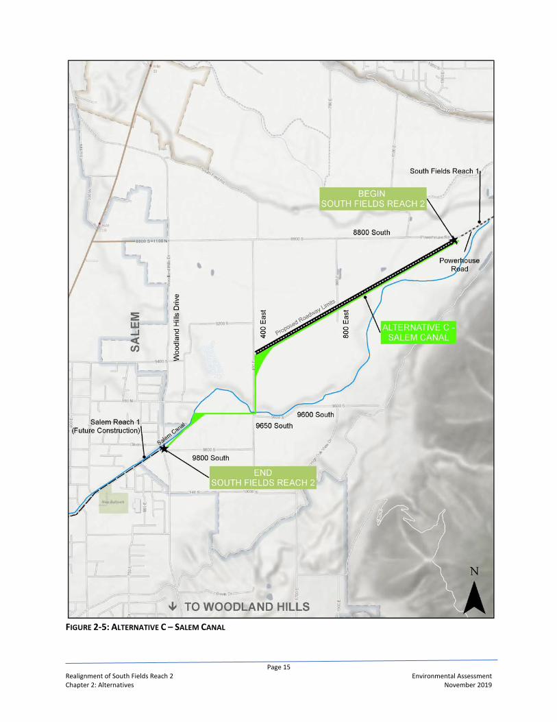
Alternative C – Salem Canal (Preferred Alternative) Alternative C – Salem Canal has been selected as the Preferred Alternative by the JLAs. This alternative would head southwest across the agricultural fields for approximately 1.4 miles to 400 East where it would turn south for approximately 0.4 miles. From there, Alternative C (Preferred Alternative) would turn west and southwest, follow along the Salem Canal and property lines for approximately 0.7 miles to the Woodland Hills/Salem Canal Road intersection. Alternative C – Salem Canal (Preferred Alternative) would be approximately 2.5 miles in length. Figure 2-5 shows the alignment for Alternative C – Salem Canal (Preferred Alternative). Alternative C (Preferred Alternative) may include the construction of the grade and alignment for a proposed future roadway and a pipe to carry the Salem Canal water.
Proposed Future Roadway Alternative C – Salem Canal (Preferred Alternative) may include the construction of the grade and alignment for a proposed future roadway; the asphalt would be placed by others. Figure 2-5 shows the alignment for the proposed future roadway which would extend between 8800 South and 400 East. The grade and alignment of the proposed future roadway is only included as part of Alternative C and would extend through the agricultural property owned by Brigham Young University. If constructed as shown, the proposed future roadway grade and alignment would be approximately 1.4 miles in length and include two 12-foot travel lanes with 5-foot shoulders. The proposed future roadway typical section is shown in Figure 2-6.
Pipe for Salem Canal Water Alternative C may include the construction of a 48 to 54-inch pipe to carry Salem Canal water. The new Salem Canal pipe, if constructed, could parallel the proposed South Fields Reach 2 pipeline through the project study area, a distance of about 2.5 miles. If the new Salem Canal pipe is constructed and used, the existing Salem Canal alignment would then be abandoned. Existing water deliveries points made from the Salem Canal within the project study area could be moved to the proposed Salem Canal pipe.
FIGURE 2-6: PROPOSED FUTURE ROADWAY TYPICAL SECTION

Page 14 Realignment of South Fields Reach 2 Environmental Assessment Chapter 2: Alternatives November 2019
FIGURE 2-4: ALTERNATIVE B – WOODLAND HILLS DRIVE
Page 15 Realignment of South Fields Reach 2 Environmental Assessment Chapter 2: Alternatives November 2019
FIGURE 2-5: ALTERNATIVE C – SALEM CANAL

Page 16 Realignment of South Fields Reach 2 Environmental Assessment Chapter 2: Alternatives November 2019
Selection of the Preferred Alternative The JLAs selected Alternative C – Salem Canal as the Preferred Alternative. Alternative C would be the most direct alternative and would be the shortest to construct. During construction, Alternative C would be the least disruptive to area residents since the majority of its construction would occur within agricultural fields. Alternative C was identified by Brigham Young University, owners of 709 acres of agricultural property in the area, as the alternative that met their future needs. Approximately 1.4 miles of this alternative is located on property owned by Brigham Young University.
Figure 2-7 shows the three alternatives evaluated in the EA.
FIGURE 2-7: ALTERNATIVES EVALUATED IN THE EA


Page 17 Realignment of South Fields Reach 2 Environmental Assessment Chapter 3: Affected Environmental and Environmental Consequences November 2019
CHAPTER 3: AFFECTED ENVIRONMENT AND ENVIRONMENTAL CONSEQUENCES
3.1 Introduction In accordance with the NEPA regulations codified in 40 CFR §1502.14, this chapter discusses the existing environmental conditions that may be impacted by the alternatives to be evaluated further as described in Chapter 2 and the environmental consequences of these alternatives. The alternatives carried forward in the EA include the No-Action, Alternative B – Woodland Hills Drive, and Alternative C – Salem Canal (Preferred Alternative).
Affected Environment The affected environment or the existing conditions were identified based on prior experience and knowledge of surrounding area along with coordination with federal, state, and local agencies. In addition, information was used from the ULS EIS to help define and outline the affected environment within the project study area.
Environmental Consequences NEPA requires consideration of direct, indirect, and cumulative impacts, plus identification of measures to avoid, minimize, and mitigate impacts, if any. The description of these impacts are:
• Direct impacts are those caused by the action and occur at the same time and place (40 CFR §1508.8). Those resources with the potential to be impacted are discussed in this chapter.
• Indirect impacts are those caused by the action and occur later in time or are farther removed in distance, but are still reasonably foreseeable (40 CFR §1508.8). Indirect impacts are discussed in section 3.14.
• Cumulative impacts are those impacts to the environment which result from the incremental impact of the action when added to other past, present, and reasonably foreseeable future actions (40 CFR §1508.7). Cumulative impacts are discussed in section 3.15 in this chapter.
Resources Considered but Dismissed from Further Analysis Resources considered but dismissed from analysis are those that may not be present within or near the project study area and/or would not be impacted by the No-Action, Alternative B, or Alternative C (Preferred Alternative). The resources considered for inclusion but dismissed are:
• Recreation; • Wild and Scenic Rivers; • Floodplains; • Wilderness; • Energy; • Socioeconomics; • Visual resources; and • Hazardous Waste.
Resources Evaluated Further The following resources have been analyzed further and addressed in more detail in this chapter:

Page 18 Realignment of South Fields Reach 2 Environmental Assessment Chapter 3: Affected Environmental and Environmental Consequences November 2019
• Air Quality; • Noise; • Transportation; • Water Resources; • Wildlife; • Endangered Species Act and State Listed Sensitive Species; • Cultural Resources; • Prime, Unique, and Statewide Important Farmland; • Land Use Plans and Policies; • Environmental Justice; • Indian Trust Assets; and • Climate Change.
3.2 Air Quality The Clean Air Act Amendments (CAAA) of 1990 established the National Ambient Air Quality Standards (NAAQS) for airborne pollutants. The six criteria pollutants addressed in the NAAQS are carbon monoxide (CO), particulate matter (PM), ozone (O3), nitrogen dioxide (NO2), lead (Pb), and sulfur dioxide (SO2). Particulate matter is broken into two categories: particulate matter with a diameter of 10 micrometers or less (PM10) and particulate matter with a diameter of 2.5 micrometers or less (PM2.5). Ground level or "bad" ozone is not emitted directly into the air but is created by chemical reactions between oxides of nitrogen (NOX) and volatile organic compounds (VOC) in the presence of sunlight. Emissions from industrial facilities and electric utilities, motor vehicle exhaust, gasoline vapors, and chemical solvents are some of the major sources of NOX and VOC. The CAAA requires that air quality conditions within all areas of a state be designated with respect to the NAAQS as attainment, maintenance, nonattainment, or unclassifiable. Areas that do not exceed the NAAQS are designated as attainment, while areas that exceed the standards are designated as nonattainment. A maintenance area is an area previously designated as a nonattainment area where a state or local government has developed a plan to reduce the criteria pollutant concentrations to levels below NAAQS standards.
Affected Environment The project study area is located in Utah County, Utah, which is within the Utah County PM10 Nonattainment Area, the Provo Utah PM2.5 Nonattainment Area, and Southern Wasatch Front Ozone Nonattainment Area. But, it is outside of the Provo Carbon Monoxide Maintenance Area. The project study area is in compliance for all other NAAQS pollutants. Projects of Air Quality Concern (POAQC) are certain highway and transit projects that involve a significant level of diesel vehicle traffic or any other project that is identified in the PM2.5 or PM10 State Implementation Plan as a localized air quality concern. If the project qualifies as a POAQC, it requires a hot spot analysis, which must be based on both i) quantitative analysis methods in accordance with 40 CFR 93.116(a) and ii) the consultation requirements of 40 CFR 93.105(c)(1)(i). If the project does not qualify as a POAQC, it must be qualitatively shown that it would not contribute to any new localized violations, increase the frequency or severity of any existing violations, or delay the timely attainment of the NAAQS or any required emission reductions or milestones in any nonattainment or maintenance area.
Environmental Consequences For construction related impacts to air quality, see section 3.16.

Page 19 Realignment of South Fields Reach 2 Environmental Assessment Chapter 3: Affected Environmental and Environmental Consequences November 2019
No-Action Alternative The No-Action Alternative would involve the construction of the proposed pipeline along the alignment previously approved in the ULS EIS and Records of Decisions. For the operation of the pipeline, the No-Action Alternative would have no long-term adverse impacts on air quality. There would be no air quality emissions from operation of the South Fields Reach 2 pipeline for particulate matter (PM2.5 and PM10), carbon monoxide, and ozone.
Alternative B –Woodland Hills Drive Alternative B would involve the construction of the proposed pipeline along 8800 South and Woodland Hills Drive. For the operation of the pipeline, this alternative would have no long-term adverse impacts on air quality. There would be no air quality emissions from operation of the South Fields Reach 2 pipeline for particulate matter (PM10 and PM2.5), carbon monoxide, and ozone.
Alternative C – Salem Canal (Preferred Alternative) Alternative C (Preferred Alternative) would involve the construction of the proposed pipeline. It also may provide the grade and alignment for a proposed future roadway between 8800 South and 400 East. Therefore, the JLAs conducted an analysis of whether this alternative would qualify as a POAQC and whether a quantitative hot spot analysis would be required. The analysis determined that Alternative C (Preferred Alternative), specifically the proposed future roadway if constructed, would not be a POAQC and thereby would not require a PM2.5 or PM10 hot spot analysis. The proposed future roadway grade and alignment, that may be constructed as part of this alternative, would not be expected to influence the vehicle mix in the area near the project nor attract a large number of new diesel vehicles to the area.
Mitigation No mitigation required for air quality.
3.3 Noise The Federal Noise Control Act of 1972 (PL 92-574) requires that all federal agencies manage their programs within their control in a manner that promotes an environment free from noises that could jeopardize public health or welfare. Studies have shown that some of the most prevalent sources of noise in our environment are those associated with roads and transportation and traffic noise tends to be the most predominant noise source in rural and urban areas.11
Affected Environment For purposes of the Realignment of the South Fields Reach 2 project, the JLAs are following the Utah Department of Transportation (UDOT) Noise Abatement Policy dated June 15, 2017. Only Alternative C – Salem Canal (Preferred Alternative) could include the construction of the grade and alignment of a proposed future roadway between 8800 South and 400 East. Therefore, there are no noise impacts, other than during construction which is discussed in section 3.16, from the No-Action and Alternative B alternatives. The level of noise, defined as unwanted sound, near roads depends on six factors:
• Presence of noise sensitive receivers12; • Traffic volumes; • Percentage of trucks; • Speed of the traffic;
11 Federal Highway Administration [FHWA], Highway Traffic Noise: Analysis and Abatement Guidance, 2011. 12 The most common noise sensitive receivers include residential dwellings, churches, schools, parks, cemeteries.

Page 20 Realignment of South Fields Reach 2 Environmental Assessment Chapter 3: Affected Environmental and Environmental Consequences November 2019
• Topography; and • Atmospheric conditions.
Presence of Noise Sensitive Receivers UDOT defines a sensitive noise receptor as “Any property where frequent exterior human use occurs and where a lowered noise level would be of benefit.” The land uses, adjacent and near the proposed future roadway as part of Alternative C – Salem Canal (Preferred Alternative), are currently in agricultural production. There are no noise sensitive receivers within or near the proposed future roadway.
Traffic Volume Traffic volumes are based on the Mountainland Association of Governments (MAG) 2050 Travel Demand Model. The traffic model indicates that a proposed future roadway connecting 8800 South to Woodland Hills Drive13 would carry volumes between 3,700 and 6,400 vehicles on an average weekday. A volume of 6,400 vehicles per day as the worst-case scenario for 2050 was used in the Low Volume Road Noise Calculation Tool.
Percentage of Trucks The percentage of traffic composed of medium and heavy trucks is unknown for the study area as counts have not been completed. A percentage of 2% trucks (1% medium and 1 % heavy) was used based the expertise and experience of the traffic engineer who conducted the traffic modeling.
Speed of Traffic At this time, the design speed of the proposed future roadway has not been established.
Topography The topography of the area between 8800 South and 400 East, area of the proposed future roadway, gently slopes to the northwest. Topography in this area would have little to no effect on traffic noise levels.
Atmospheric Conditions The atmospheric conditions in this area would have little to no effect on traffic noise levels.
Environmental Consequences For noise construction related impacts, see section 3.16.
No-Action Alternative The No-Action Alternative does not propose the construction of the grade and alignment for a road. Therefore, there would be no noise impacts for this alternative.
Alternative B – Woodland Hills Drive Alternative B – Woodland Hills Drive does not propose the construction of the grade and alignment for a road. Therefore, there would be no noise impacts for this alternative.
13 The proposed future roadway as part of Alternative C (Preferred Alternative) would only extend between 8800 South and 400 East and would only include the grade and alignment; asphalt would be placed by others.

Page 21 Realignment of South Fields Reach 2 Environmental Assessment Chapter 3: Affected Environmental and Environmental Consequences November 2019
Alternative C – Salem Canal (Preferred Alternative) Alternative C (Preferred Alternative) may include the construction of the grade and alignment for a proposed future roadway between 8800 South and 400 East; asphalt would be placed by others. The JLAs conducted a traffic noise analysis even though there are no existing noise sensitive receivers near the proposed future roadway. The results are found in the Table 3-1. The analysis was completed using FHWA’s Low Volume Road Noise Calculation Tool. The results were compared to FHWA noise level guidance found in 23 CFR 772, which indicates that a noise impact occurs on noise sensitive receivers when the Leq (equivalent continuous sound level) equals or exceeds 67 dB(A).14 TABLE 3-1: NOISE LEVELS ALONG PROPOSED FUTURE ROADWAY
Distance from Proposed Future Roadway (feet)
Leq Result (dB(A))
Federal Standard (dB(A))
25 61.8 67 50 58.8 67
100 55.9 67 For every distance, the modeled noise level is below the federal standard for impacted receptors; there are no noise sensitive receptors near the proposed future roadway. Therefore, the proposed future roadway would not have a noise impact on existing or future residential or commercial development. The existing land uses between 8800 South and 400 East are mainly in agricultural production and are not sensitive for noise. Therefore, there would be no noise impacts resulting from Alternative C (Preferred Alternative).
Mitigation No mitigation required for noise.
3.4 Transportation This section discusses the existing and planned roadways within the project study area.
Affected Environment Paved roads in the project study area include the east-west 8800 South, 9600 South, 9650 South, and 9800 South and the north-south Woodland Hills Drive, 400 East, and 800 East which is mainly a private farm access road. There are paved and unpaved roads that provide access to residential and agricultural properties. There are also private, unpaved farm and property accesses that are not open for public use.
Environmental Consequences For transportation related impacts during construction, see section 3.16.
No-Action Alternative The No-Action Alternative would have no long-term impacts to existing or planned transportation corridors within the project study area.
14 Decibels weighted to reflect the way the human ear hears sound.

Page 22 Realignment of South Fields Reach 2 Environmental Assessment Chapter 3: Affected Environmental and Environmental Consequences November 2019
Alternative B – Woodland Hills Drive Alternative B would have no long-term impacts to existing or planned transportation corridors within the project study area.
Alternative C – Salem Canal (Preferred Alternative) Alternative C (Preferred Alternative) would route the proposed pipeline diagonally northeast to southwest from 8800 South to 400 East. This alternative may include the construction of the grade and alignment for a proposed future roadway between 8800 South to 400 East. Further, future long-range plans for MAG include the proposed future roadway with a slightly different alignment in this area. According to the 2050 MAG Regional Transportation Plan, there would be no more than 5,000 Average Weekday Daily Traffic on the proposed future roadway. Changes in travel patterns in this area of Utah County resulting from the proposed future roadway would be negligible.
Mitigation No mitigation required for transportation.
3.5 Water Resources The Federal Water Pollution Control Act (33 USC §1251-1376), as amended by the Clean Water Act (CWA) of 1977 and 1987, acts as the primary regulation for water quality. Water quality, including wetlands, are regulated by the U.S. Environmental Protection Agency (EPA) through the CWA. In Utah, water quality standards are regulated by the Utah Division of Water Quality (DWQ) and groundwater is regulated by the State Engineer through the Utah Division of Water Rights. The CWA also controls the discharge of dredged or fill materials into “Waters of the United States”, including wetlands, which is administred by the U.S. Army Corps of Engineers (USACE). Executive Order 11990 (May 24, 1977) requires federal agencies to not undertake or provide assistance to activities that impact wetlands.
Affected Environment There are no surface waters within the project study area.
Groundwater Generally, the groundwater system in southern Utah Valley is in unconsolidated basin-filled deposits which consist of interbedded deposits of gravel, sand, silt, and clay.15 In southern Utah Valley, groundwater generally moves from the mountain range, south and east of the project study area, to Utah Lake located to the north and west. Maps 3-5 and 3-6 on pages 3-83 and 3-84 in the ULS EIS show the historical and the modeled groundwater levels, respectively, in southern Utah Valley. To more accurately determine groundwater levels, the District drilled 25 groundwater monitoring wells within or near the project study area and has been monitoring groundwater levels since the summer of 2017. The monitoring wells are one-inch PVC slotted pipe that were drilled to a maximum depth of 30 feet. Based on observation of these wells, the depth to groundwater varies within the project study area. The shallowest groundwater levels were found along 400 East which was measured approximately four to six feet from the surface. To help manage and lower the groundwater, underground drain systems have been installed in the areas as shown in Figure 3-1. These underdrains lower and maintain the water table from near the ground surface to approximately four to six feet in depth so that the fields can be used for agricultural purposes. The underdrains are mainly located within the agricultural fields between 800 East and 400 East and drain to Beer Creek Drainage Ditch which flows into the Spanish Fork River.
15 United States Geological Survey, Ground-Water Flow in Southern Utah and Goshen Valleys, Utah, 1995.

Page 23 Realignment of South Fields Reach 2 Environmental Assessment Chapter 3: Affected Environmental and Environmental Consequences November 2019
FIGURE 3-1: UNDERDRAIN SYSTEM AND BEER CREEK DRAINAGE DITCH

Page 24 Realignment of South Fields Reach 2 Environmental Assessment Chapter 3: Affected Environmental and Environmental Consequences November 2019
Beer Creek Drainage Ditch Beer Creek Drainage Ditch was constructed to help lower the high groundwater. It flows a relatively small amount of water year-round and it originates near the Salem Canal as shown in Figure 3-1. Besides groundwater, its other water sources are irrigation return flows and stormwater runoff. Beer Creek Drainage Ditch generally flows northwest and is approximately ten feet wide.
Wetlands The JLAs contracted with Reclamation to conduct a wetland delineation within the project study area to determine the extent of wetlands. Existing data sources were used to predict the potential occurrence of jurisdictional wetlands, as defined by the CWA and the USACE’s Wetland Delineation Manual (1987). Existing databases used include the U.S. Fish and Wildlife Service’s (USFWS) National Wetland Inventory online mapping database (NWI mapper) and the U.S. Department of Agriculture, Natural Resources Conservation Service’s Web Soil Survey. Both data sets were added to recent color satellite imagery using a geographic information system application to spatially identify potential wetland areas. Once potential jurisdictional wetland areas were identified, a field survey was conducted, focusing on those areas to confirm if any qualify as jurisdictional. From this survey a wetland area map was developed and quantified.
The wetland delineation identified only one wetland area near the project study area. It is located just east of Woodland Hills Drive immediately north of the 9550 South intersection. Following the USFWS’s Classification of Wetlands and Deepwater Habitat of the United States (1979), this wetland area is a palustrine emergent marsh, persistent. The estimated wetland area extent is less than 0.10 acres.
Environmental Consequences For water resources related impacts during construction, see section 3.16.
No-Action Alternative Groundwater The No-Action Alternative may affect how groundwater flows within the project study area. The South Fields Reach 2 pipeline would be a 60-inch welded steel pipe that would be embedded with low-strength concrete typically up to one foot above the top of the pipe. The 60-inch welded steel pipe, along with the low-strength concrete, can act like a groundwater drainage barrier and impede groundwater flow. Wetlands The No-Action Alternative would have no impacts to wetlands.
Alternative B – Woodland Hills Drive Groundwater Alternative B may affect how groundwater flows within the project study area. The South Fields Reach 2 pipeline would be a 60-inch welded steel pipe that would be embedded with low-strength concrete typically up to one foot above the top of the pipe. The 60-inch welded steel pipe, along with the low-strength concrete, can act like a groundwater drainage barrier and impede groundwater flow. Wetlands Alternative B would have no impacts to wetlands.

Page 25 Realignment of South Fields Reach 2 Environmental Assessment Chapter 3: Affected Environmental and Environmental Consequences November 2019
Alternative C – Salem Canal (Preferred Alternative) Groundwater Alternative C – Salem Canal (Preferred Alternative) may affect how groundwater flows within the project study area. This alternative would extend through approximately ½ mile reach where groundwater is approximately four to six feet below the surface. The South Fields Reach 2 pipeline would be a 60-inch welded steel pipe that would be embedded with low-strength concrete typically up to one foot above the top of the pipe. The 60-inch welded steel pipe, along with the low-strength concrete, can act like a groundwater drainage barrier and impede groundwater flow. There is a network of existing groundwater drains in the project study area whose operation and function would not be adversely impacted by Alternative C (Preferred Alternative). Wetlands Alternative C (Preferred Alternative) would have no impacts to wetlands.
Mitigation
Groundwater To mitigate the potential impediment of groundwater flow, buried gravel drainage paths would be evaluated for use during the design phase and may be constructed below and above the South Fields Reach 2 pipeline to provide for the continual flow of groundwater. Additionally, all existing underdrains crossing the South Fields Reach 2 pipeline corridor that may be impacted would be replaced with new pipe and course drain material. During design, the underdrain design could result in larger cross drainpipes or additional locations for cross drains to allow groundwater to move from one side of the South Fields Reach 2 pipeline to the other. If groundwater levels are shown to be measurably higher on the upstream side of the South Fields Reach 2 pipeline compared to the downstream side post construction, adjustments to the buried gravel drainages or some other mitigation may be necessary to allow free movement of the groundwater.
Wetlands No mitigation required.
3.6 Wildlife This section describes the wildlife habitats and species that may exist within the project study area. Federal and state regulations protecting wildlife include the Endangered Species Act (ESA), see section 3.7, the Bald and Golden Eagle Protection Act (16 USC 136 668a-d), and the Migratory Bird Treaty Act (16 USC 703-712). State regulations include, the Utah Sensitive Species List, see section 3.7, which identifies those species considered a wildlife species of concern to preclude the future need to list them under the ESA.
Affected Environment Based on the general habitat requirements for wildlife species common to Utah County and site visits, existing conditions of the project study area provide marginal to poor quality habitat for most wildlife species. The area is dominated by agricultural use, city streets, and suburban development. Limited marginal riparian habitat may be associated with the Salem Canal, but any riparian habitat occurring in the project study area consists mostly of a narrow, tall overstory and a weedy, non-wetland understory. Irrigated agricultural fields combined with suburban development results in fragmented habitat types with limited wildlife value.

Page 26 Realignment of South Fields Reach 2 Environmental Assessment Chapter 3: Affected Environmental and Environmental Consequences November 2019
The agricultural fields and limited riparian areas provide some habitat for small mammals and a few bird species. Species such as raccoon (Procyon lotor), striped skunk (Mephitis mephitis), and numerous other small mammals have been observed in limited numbers within the project study area. Waterfowl, some shorebirds, passerines, and upland game birds may use the limited riparian areas and adjacent irrigated fields. However, the limited area supports only small populations of these species. Given historic agricultural and urban uses, habitat structure has been altered severely enough to impact the abundance and diversity of wildlife species within the project study area. Such changes alter wildlife species composition and utilization of these areas.
Environmental Consequences For wildlife related impacts during construction, see section 3.16.
No-Action Alternative The No-Action Alternative would have no impact on wildlife in the project study area. The limited, marginal habitat currently available within the project area would remain unchanged.
Alternative B – Woodland Hills Drive Alternative B would have no impact on wildlife in the project study area. The limited, marginal habitat currently available within the project area would remain unchanged.
Alternative C – Salem Canal (Preferred Alternative) Alternative C (Preferred Alternative) may include the construction of the grade and alignment of a proposed future roadway between 8800 South and 400 East in an existing agricultural field; the asphalt would be placed by others. Approximately 6.7 acres of this agricultural field would be removed from agricultural production and potential wildlife habitat. However, this habitat is considered low-value for wildlife due to it currently being used for agricultural production. Therefore, Alternative C (Preferred Alternative) would have no impact on wildlife. The limited, marginal habitat currently available within the area would remain unchanged.
Mitigation No mitigation is required.
3.7 Endangered Species Act and State Listed Sensitive Species Section 7 of the ESA of 1973 (16 U.S.C. §1531 et seq.), as amended, requires federal agencies to consult with the USFWS if listed species or designated critical habitat may be affected by a Proposed Action. If adverse impacts would occur as a result of a Proposed Action, the ESA requires federal agencies to evaluate the likely effects of the Proposed Action, and minimize the possibility that it neither jeopardizes the continued existence of federally-listed ESA species, nor results in the destruction or adverse modification of designated Critical Habitat. Pursuant to Utah Division of Wildlife Resources (UDWR) Administrative Rule R657-48, species and candidate species, which are listed under the ESA, as amended, or for which a conservation agreement is in place, automatically qualify for the Utah Sensitive Species List. The additional species on the Utah Sensitive Species List are those species for which there is credible scientific evidence to substantiate a threat to continued population viability.

Page 27 Realignment of South Fields Reach 2 Environmental Assessment Chapter 3: Affected Environmental and Environmental Consequences November 2019
Affected Environment
Endangered Species Act The Information for Planning and Consultation (IPaC) is a database managed by the USFWS. The IPaC provides the listed endangered and threatened species that are known to occur within or near the project study area. These are shown in Table 3-2. TABLE 3-2: ENDANGERED SPECIES LIST IN PROJECT STUDY AREA
Species Status Occurrence in the Study Area
Canada Lynx (Lynx canadensis) Threatened None Yellow-billed Cuckoo (Coccyzus americanus) Threatened None June sucker (Chasmistes liorus) Endangered None Jones Cyladenia (Cycladenia humlis var. jonesii) Threatened None Ute Ladies-tresses (Spiranthes diluvialis) Threatened None Source: https://ecos.fws.gov/ipac/
According to IPaC, there are no critical habitats within the project study area for the species listed.
State Listed Sensitive Species The Utah Sensitive Species List identifies several conservation agreement or sensitive species in addition to federally listed threatened and endangered species in Table 3-2. There are a total of 34 Utah Sensitive Species listed in Utah County according to the Utah Conservation Data Center website. Of those, only five have been documented to occur within the project study area as shown in Table 3-3. TABLE 3-3: STATE SENSITIVE AND CONSERVATION AGREEMENT SPECIES IN PROJECT AREA
Species Status Critical Habitat
Bobolink (Dolichonyx oryzivorus) SPC
Within the state of Utah, Bobolinks occur mainly in the north. They winter mainly in South America. Bobolinks nest and forage in wet meadow, grasses and sedges, wet grassland, and irrigated agricultural areas. These habitats, particularly wet meadows, tend to be associated with riparian or wetland areas. There is limited to no suitable habitat for the Bobolink within the project study area.
Columbia Spotted Frog (Rana luteiventris) CS
Suitable habitat consists of perennial seeps, springs, and sloughs with herbaceous wetland vegetation. There is limited to no suitable habitat for the Columbia Spotted Frog within the project study area.
Greater sage-grouse (Centrocercus urophasianus)
CS These species are obligate residents of the sagebrush ecosystem. There is limited to no suitable habitat for the Greater sage-grouse within the project study area.
Short-eared Owl (Asio flammeus) SPC
This owl is usually found in grasslands, shrublands, and other open habitats. It is nomadic, often choosing a new breeding site each year, depending on local rodent densities. There is limited to no suitable habitat for the Short-eared Owl within the project study area.
Smooth Greensnake (Opheodrys vernalis) SPC
The smooth greensnake prefers moist areas, especially moist grassy areas and meadows where the snake is camouflaged due to its solid green dorsal coloration. There is limited to no suitable habitat for the Smooth Greensnake within the project study area.
SPC – Species of Concern CS – Species with Conservation Agreement Source: Utah Conservation Data Center and UNHP Data

Page 28 Realignment of South Fields Reach 2 Environmental Assessment Chapter 3: Affected Environmental and Environmental Consequences November 2019
Environmental Consequences
No-Action Alternative Endangered Species Act The No-Action Alternative would have a no effect on endangered or threatened species. According to IPaC, there are no critical habitats within the project study area for those species listed in Table 3-2. State Listed Sensitive Species The No-Action Alternative would have a no effect on state listed sensitive species. There is limited to no habitat within the project study area as discussed in Table 3-3.
Alternative B – Woodland Hills Drive Endangered Species Act Alternative B would have a no effect on endangered or threatened species. According to IPaC, there are no critical habitats within the project study area for those species listed in Table 3-2. State Listed Sensitive Species Alternative B would have a no effect on state listed sensitive species. There is limited to no habitat within the project study area as discussed in Table 3-3.
Alternative C – Salem Canal (Preferred Alternative) Endangered Species Act Alternative C (Preferred Alternative) would have a no effect on endangered or threatened species. According to IPaC, there are no critical habitats within the project study area for those species listed in Table 3-2. State Listed Sensitive Species Alternative C (Preferred Alternative) would have a no effect on state listed sensitive species. There is limited to no habitat within the project study area as discussed in Table 3-3.
Mitigation No mitigation is required.
3.8 Cultural Resources Historic properties can include archaeological resources, both prehistoric and historic, architectural resources, buildings and structures, and traditional cultural properties. The Advisory Council on Historic Preservation (ACHP) defines a historic property as “any prehistoric or historic district, site, building, structure, or object included in, or eligible for inclusion in, the NRHP (National Register of Historic Places).” The National Historic Preservation Act (NHPA) of 1966, as amended, and its implementing regulations (36 CFR §800) establish the national policy and procedures regarding historic properties. Section 106 of the NHPA requires consideration of the effects of federal projects and policies on historic properties. Utah Annotated Code (UAC) §9-8-401 et seq. was passed to provide protection of “all antiquities, historic and prehistoric ruins, and historic sites, buildings, and objects which, when neglected, desecrated, destroyed or diminished in aesthetic value, result in an irreplaceable loss to the people of this state.” The Section 106 review process requires historic properties to be evaluated for eligibility and listing on the NRHP, based upon whether “the quality of significance in American history, architecture,

Page 29 Realignment of South Fields Reach 2 Environmental Assessment Chapter 3: Affected Environmental and Environmental Consequences November 2019
archeology, engineering, and culture is present in districts, sites, buildings, structures, and objects that possess integrity of location, design, setting, materials, workmanship, feeling, and association,” and meet one or more of the criteria listed in Table 3-4. TABLE 3-4: NRHP CRITERIA
NRHP Criteria Characteristics
A Associated with events that have made a significant contribution to the broad patterns of our history.
B Associated with the lives of persons significant in our past.
C Embody distinctive characteristics of a type, period, or method of construction, or that represent the work of a master, or that possess high artistic value, or that represent a significant and distinguishable entity whose components may lack individual distinction.
D Yielded, or may likely yield, information important in prehistory or history.
Affected Environment A survey of historic resources within the Area of Potential Effects (APE), or project study area, was completed for the Realignment of South Fields Reach 2 project. The APE is approximately 302 acres in size. This survey identified historic resources and determined whether each resource qualified for eligibility for the NRHP. Also, a historic resources inventory was conducted as part of the ULS EIS. The historic resources located within the APE along with their eligibility to the NRHP are listed in Table 3-5 and are shown in Figure 3-2.
Environmental Consequences For discovery of cultural resources during construction, see section 3.16. Impacts or effects to cultural resources are defined as “alteration[s] to the characteristics of a historic property qualifying it for inclusion in or eligibility for the National Register” (36 CFR §800.16(i)). These impacts are categorized as No Historic Properties Affected, No Adverse Effect, and Adverse Effect.
A finding of No Historic Properties Affected is made when “[e]ither there are no historic properties present or there are historic properties present but the undertaking will have no effect upon them as defined in §800.16(i)” (36 CFR §800.1(d)(1)). A finding of No Adverse Effect is made “[w]hen the undertaking’s effects do not meet the criteria of [adverse effect] or the undertaking is modified or conditions are imposed... to ensure consistency with the Secretary’s standards for the treatment of historic properties (36 CFR §68) to avoid adverse effects” (36 CFR §800.5(b)). In other words, a finding of “no adverse effect” is used when an undertaking affects a property that is eligible for or listed on the NRHP but does not impair the integrity of the property. A finding of Adverse Effect is made “[w]hen an undertaking may alter, directly or indirectly, any of the characteristics of a historic property that qualify the property for inclusion in the National Register in a manner that would diminish the integrity of the property’s location, design, setting, materials, workmanship, feeling, and association” (36 CFR §800.5(a)(1)).

Page 30 Realignment of South Fields Reach 2 Environmental Assessment Chapter 3: Affected Environmental and Environmental Consequences November 2019
TABLE 3-5: HISTORIC RESOURCES WITHIN THE PROJECT AREA OF POTENTIAL EFFECTS Historic
Resource/Structure NRHP
Eligibility Description and NRHP Criteria
South Field Canal (42UT935) Eligible
Historic canal eligible under criterion A of the NRHP. The South Field Canal construction began in 1855 and was one of the earliest canals in Utah Valley. Through the project study area, the canal is earth-lined and approximately 15-25 feet wide. It runs along the northern edge of 8800 South.
Salem Canal (42UT936) Eligible
Historic canal eligible under criterion A of the NRHP. This canal was recorded as part of the ULS EIS. The Salem Canal diverts from South Field Canal and conveys Spanish Fork River water. Construction on the canal was completed in 1869 and it was one of the earliest, large canals in Utah Valley. Through the project study area, the Salem Canal is concrete lined, v-shaped, about 10-15 feet wide at the top, and 4-6 feet wide at the bottom.
East 9800 S road (42UT2141) Not Eligible Two-lane paved road that is regularly maintained.
East 9600/9650 S road (42UT2142) Not Eligible Two-lane paved road that is regularly maintained.
South 400 E road (42UT2143) Not Eligible Two-lane paved road that is regularly maintained.
Powerhouse Road (42UT2144) Not Eligible Two-lane paved road that is regularly maintained.
8800 S road (42UT2145) Not Eligible Two-lane paved road that is regularly maintained.
814 E 8800 S Eligible
Minimal traditional/WW II Era house built in 1940 eligible under criterion A of the NRHP. Recorded as part of the ULS EIS (see ULS Cultural Resources Technical Report, September 2004, Table 3-9 on page 52. The report can be view at www.cupcao.org).
1028 E 8800 S Not Eligible House recorded for the ULS EIS but has been removed by others. 1012 E 8800 S Not Eligible House recorded for the ULS EIS but has been removed by others.
998 E 8800 S Not Eligible House recorded for the ULS EIS but has been removed by others.
8845 S 800 E Not Eligible House recorded for the ULS EIS but has been removed by others.
9021 S 800 E Not Eligible House recorded for the ULS EIS but has been removed by others.
9009 S 800 E Not Eligible House recorded for the ULS EIS but has been removed by others.
9658 S 400 E Not Eligible Minimal traditional/WW II Era house built in 1945. The structure lacks architectural integrity and is not considered eligible for the NRHP.
9697 S 400 E Eligible Bungalow foursquare residence built in 1910 eligible under criterion A of the NRHP. Recorded as part of the ULS EIS.

Page 31 Realignment of South Fields Reach 2 Environmental Assessment Chapter 3: Affected Environmental and Environmental Consequences November 2019
FIGURE 3-2: ELIGIBLE HISTORIC RESOURCES AND POTENTIAL IMPACTS TO THE SALEM CANAL

Page 32 Realignment of South Fields Reach 2 Environmental Assessment Chapter 3: Affected Environmental and Environmental Consequences November 2019
Finding of Effect Project effects have been coordinated the Realignment of South Fields Reach 2 with the Utah State Historic Preservation Office (SHPO). An NRHP eligibility determination and finding of effect letter along with the cultural resources survey was sent to SHPO. SHPO has agreed with the NRHP determinations and the findings of effect; these are summarized by alternative below.
No-Action Alternative The No-Action Alternative would not impact the South Field Canal, or the historic buildings located at 814 E 8800 S and 9697 S 400 E.16 It would have minor impacts to the Salem Canal by crossing under it on 800 East. Therefore, the JLAs have determined that the No-Action Alternative would have a No Adverse Effect on the Salem Canal and the SHPO has concurred with this determination. Alternative B – Woodland Hills Drive Alternative B would not impact the South Field Canal (42UT935), or the historic buildings located at 814 E 8800 S and 9697 S 400 E. It would have minor impacts to the Salem Canal by crossing it near Woodland Hills Drive/Salem Canal Road intersection. The JLAs have determined that Alternative B would have a No Adverse Effect on the Salem Canal (42UT936) and SHPO has concurred with this determination. Alternative C – Salem Canal (Preferred Alternative) Alternative C (Preferred Alternative) would not impact the South Field Canal (42UT935), or the historic buildings located at 814 E 8800 S and 9697 S 400 E. Impacts to the Salem Canal - Alternative C (Preferred Alternative) would have an Adverse Effect to the Salem Canal (42UT936). Between 400 East and the Woodland Hills Drive/Salem Canal Road intersection, approximately 3,600 feet of the Salem Canal alignment would be removed as part of the Realignment of South Fields Reach 2 project. Therefore, the JLAs have determined that Alternative C (Preferred Alternative) would have an Adverse Effect to the Salem Canal (42UT936). SHPO has concurred with this determination. Summary of Impacts to Eligible Historic Resources by Alternative Table 3-6 provides a summary of impacts to eligible historic resources within the project APE.
TABLE 3-6: SUMMARY OF IMPACTS BY ALTERNATIVE TO THE ELIGIBLE HISTORIC RESOURCES
Historic Resource No-Action Alternative
Alternative B – Woodland Hills Dr.
Alternative C – Salem Canal
(Preferred Alternative) South Field Canal (42UT935) No Effect No Effect No Effect
Salem Canal (42UT936) No Adverse Effect No Adverse Effect Adverse Effect
814 E 8800 S No Effect No Effect No Effect 9697 S 400 E No Effect No Effect No Effect
16 The ULS EIS stated that the No-Action Alternative (preferred alternative in the ULS EIS) would have an Adverse Effect upon the historic buildings located at 9658 S 400 E and 9697 S 400 E and a No Adverse Effect on the Salem Canal. However, 9658 S 400 E is no longer eligible for the NRHP. The JLAs have also determined that the No-Action Alternative would result in a No Historic Properties Affected for the historic building at 9697 S 400 E and a No Adverse Effect to the Salem Canal. SHPO has concurred with this finding.

Page 33 Realignment of South Fields Reach 2 Environmental Assessment Chapter 3: Affected Environmental and Environmental Consequences November 2019
Mitigation
No-Action Alternative The No-Action Alternative would not require mitigation for cultural resources.
Alternative B - Woodland Hills Drive Alternative B would not require mitigation for cultural resources.
Alternative C – Salem Canal (Preferred Alternative) Alternative C (Preferred Alternative) would require the development of the Memorandum of Agreement for mitigation because of the Adverse Effect to the Salem Canal (42UT936). If Alternative C (Preferred Alternative) was chosen for construction as shown, the JLAs would continue to coordinate with SHPO and ACHP as required by Section 106 of the NHPA.
3.9 Prime, Unique, and Statewide Important Farmland The Farmland Protection and Policy Act (FPPA) defines prime farmland as farmland that has the best combination of physical and chemical characteristics for producing food, feed, forage, fiber, and oilseed crops, and is also available for other uses. A unique farmland is land other than prime farmland that is used for production of specific high-value food and fiber crops; it has the special combination of soil quality, location, growing season, and moisture supply needed to economically produce sustained high quality or high yields of specific crops. Farmland does not include land already in or committed to urban development as identified on the U.S. Census Bureau “urbanized area” maps. Farmland committed to urban development or water storage includes all such land that receives a combined score of 160 points or less from the Natural Resources Conservation Service’s (NRCS) Farmland Conversion Impact Rating (using the Farmland Conversion Impact Rating for Corridor Type Projects Form NRCS-CPA-106). A portion of this form is completed by the federal agency involved in the potential farmland conversion, and the remainder is completed by the NRCS. The form considers information such as the average farm size in the area, major crops, the amount of farmland to be converted, and the distance to urban areas. The State of Utah allows for the formation of Agricultural Protection Areas (APAs) which are areas protected for the production of crops, livestock, and livestock products (Utah Administrative Code Title 17, Chapter 41 - Agriculture Protection Areas). Each county in Utah is required to create an Agriculture Protection Area Advisory Board to evaluate each APA proposal. Landowners in agricultural production can petition their local municipality for an APA designation which protects them from state and local laws that would restrict farm practices. The county in which the APA is located may not change the zoning designation of the land within the APA unless the landowners give written approval for the change. APA status is typically maintained even after the property is developed and is no longer in agricultural use, unless the property owner files a petition to remove the land from the APA. When this occurs, the rest of the APA maintains its status, and the boundaries of the APA are redefined. APAs are reviewed every 20 years to determine if they should be maintained, modified, or terminated.
Affected Environment
Prime, Unique, and Statewide Important Farmland A review of the NRCS web soil survey revealed the presence of soils indicative of prime, unique, and state important farmland in the project study area. Figure 3-3 shows the Prime, Unique, and Statewide Important Farmland within the project study area. The most prominent soil type relating to prime and

Page 34 Realignment of South Fields Reach 2 Environmental Assessment Chapter 3: Affected Environmental and Environmental Consequences November 2019
unique farmland is Bingham gravelly loam with a 1 to 3 percent slope. The only soil type for statewide important farmland within the project study area is Bramwell silt clay loam with a 0 to 2 percent slope. Most of the area shown as prime, unique, and statewide important farmland is owned by Brigham Young University and is used for agricultural purposes; other farmlands are owned by private individuals. Most crops grown within this area are alfalfa and corn. Irrigation water is provided by the Salem Canal and smaller irrigation network of ditches that are supplied water from this canal.
Agricultural Protection Areas Utah County was contacted regarding APAs within the Project Study Area. Figure 3-4 shows the majority of the agricultural area owned by Brigham Young University is in an APA.
Environmental Consequences For agricultural related impacts during construction, see section 3.16. The JLAs have coordinated with the NRCS regarding the potential to convert prime, unique, and statewide important farmland to a non-agricultural use. NRCS form CPA-106 was completed and sent it to the NRCS to complete their portion. The NRCS responded that they attempted to rate the agricultural productivity of the area based on the Crop Productivity Index, the Iowa Corn Sustainability, the Minnesota Crop Productivity Index, and other data. However, there is no information from these agricultural productivity indices available that is comparable for this area of Utah County. Therefore, the NRCS stated that there are no issues or concerns with the permanent conversion of prime, unique, or statewide important farmland resulting from the Realignment of the South Fields Reach 2 project.
No-Action Alternative Prime, Unique, and Statewide Important Farmland The No-Action Alternative would construct the proposed South Fields Reach 2 pipeline along the alignment previously approved in the ULS EIS and Records of Decisions. Construction of project features would not result in irreversible conversion of prime, unique, and statewide important farmland to other uses because these areas would be restored to their original condition. Temporary impacts would occur on these farmlands, but these areas would be replanted or otherwise restored after construction (see section 3.16 – Construction Impacts). Agricultural Protection Areas The No-Action Alternative would require coordination with Brigham Young University.
Alternative B - Woodland Hills Drive Prime, Unique, and Statewide Important Farmland Alternative B would construct the proposed pipeline west along 8800 South to Woodland Hills Drive, then south to the Woodland Hills Drive/Salem Canal Road intersection. Construction of project features would not result in irreversible conversion of prime farmland since the pipeline would be constructed within or along existing roadways. Temporary impacts would occur on these farmlands, but these areas would be restored after construction. Agricultural Protection Areas There would be no impact to the existing APAs for this alternative.

Page 35 Realignment of South Fields Reach 2 Environmental Assessment Chapter 3: Affected Environmental and Environmental Consequences November 2019
FIGURE 3-3: PRIME, UNIQUE, AND STATEWIDE IMPORTANT FARMLAND

Page 36 Realignment of South Fields Reach 2 Environmental Assessment Chapter 3: Affected Environmental and Environmental Consequences November 2019
FIGURE 3-4: AGRICULTURAL PROTECTION AREAS

Page 37 Realignment of South Fields Reach 2 Environmental Assessment Chapter 3: Affected Environmental and Environmental Consequences November 2019
Alternative C – Salem Canal (Preferred Alternative) Prime, Unique, and Statewide Important Farmland Alternative C (Preferred Alternative) would involve the construction of the proposed 60-inch welded steel pipe diagonally from 8800 South to 400 East and then south to 9800 South. This alternative may include the construction of the grade and alignment for a proposed future roadway through what is currently active farmland classified as either prime or statewide important farmland. The proposed future roadway would only extend between 8800 South and 400 East. Due to the inclusion of the proposed future roadway grade and alignment, if constructed as part of this alternative, the impact to farmland would be permanent by converting farmland to transportation uses. Approximately, 6.7 acres of prime and statewide important farmland would be converted from agricultural production to the proposed future roadway grade and alignment which aassumes a 40-foot width for the proposed future roadway. Agricultural Protection Areas Alternative C (Preferred Alternative) would require the coordination with Brigham Young University. Acquisition of permanent easement for proposed pipeline right-of-way would not affect the status of the APA.
Mitigation The JLAs would continue to coordinate property issues with property owners that would be affected by the Realignment of the South Fields Reach 2 project.
3.10 Land Use Plans and Policies Generally, the existing land use within the Realignment of South Fields Reach 2 project study area is agricultural and farmland uses. The project study area is located in unincorporated Utah County; a small triangular shaped piece of Salem City extends into the project study area near Woodland Hills Drive. The nearest incorporated cities are Salem, which is west of the project study area, and Spanish Fork to the north.
Utah County Zone Designation The Utah County zone is “Residential Agricultural 5 (RA-5)”. From the Utah County Land Use Ordinance:
“The RA-5 Residential Agricultural Zone covers that portion of Utah County which historically has been irrigated land and utilized for the growing of crops and the raising of livestock. It includes that area of the county where the combination of soil quality, size of land parcel, availability and supply of water, and other natural and man-caused factors make the land most appropriately suited for agricultural use. Although the main thrust of the RA-5 zone is to protect the farming industry, certain non-farm uses and residences on lots large enough to preclude conflict with the surrounding farms are allowed in the zone.”
The permitted uses within RA-5 are centered around agricultural production. Each family dwelling unit must be on a lot of at least five acres in size.

Page 38 Realignment of South Fields Reach 2 Environmental Assessment Chapter 3: Affected Environmental and Environmental Consequences November 2019
Future Plans
Salem City Annexation Plans Salem City has an annexation plan to assist them with future development potential for their city. Annexation is the process for bringing land in unincorporated areas into city limits. One purpose of an annexation plan is to identify areas adjacent to a city boundary where the city can expand and grow. Future plans and infrastructure needs within a city’s annexation plan boundary can be better planned knowing that someday the area would be within city limits. Salem City has identified areas of unincorporated Utah County to be annexed into their city boundaries at some point in the future. The project study area is completely within the city’s annexation plan (see Figure 2-2 in Chapter 2). Brigham Young University has applied to have its land within the project study area annexed from unincorporated Utah County into incorporated Salem City.
Future Development The District and CUPCA Office have coordinated with private landowners within the project study area regarding the proposed Realignment of South Fields Reach 2 project in regard to future and planned development and infrastructure needs. In the fall of 2017, Brigham Young University suggested that an alternative alignment running diagonally through their property be evaluated and considered. They own 709 acres of agricultural property within or near the project study area and are developing a masterplan for the anticipated development of their property. The masterplan includes preliminary alignments and locations for future potential roadways and other utilities. As a result of this coordination, the JLAs developed Alternative C – Salem Canal (Preferred Alternative) including the proposed future roadway grade and alignment between 8800 South to 400 East.
Environmental Consequences
No-Action Alternative The No-Action Alternative would have no effect on existing or future land uses within the project study area.
Alternative B - Woodland Hills Drive Alternative B would have no effect on existing or future land uses within the project study area.
Alternative C – Salem Canal (Preferred Alternative) Alternative C (Preferred Alternative) may include the construction of the grade and alignment of a proposed future roadway between 8800 South and 400 East through the property owned by Brigham Young University. The grade and alignment of the proposed future roadway would be consistent with future land use plans for this area as discussed in Chapter 2. Therefore, Alternative C (Preferred Alternative) would have no effect on future land uses within the project study area.
Mitigation Coordination with property owners, Utah County, and Salem City would continue regarding the Realignment of the South Fields Reach 2 project.

Page 39 Realignment of South Fields Reach 2 Environmental Assessment Chapter 3: Affected Environmental and Environmental Consequences November 2019
3.11 Environmental Justice Executive Order 12898, Federal Actions to Address Environmental Justice in Minority Populations and Low-Income Populations, signed by the President on February 11, 1994, directs federal agencies to take appropriate and necessary steps to identify and address disproportionately high and adverse effects of federal projects on the health or environment of minority and low-income populations to the greatest extent possible and permitted by law. Executive Order 12898 established Environmental Justice as a federal agency priority to ensure that minority and low-income groups are not disproportionately affected by federal actions.
Affected Environment The existing land uses within the project study area is mainly agricultural. Some residential areas exist generally adjacent to existing roadways. The project study area is within Utah County and the nearest cities are Salem City to the west and Spanish Fork City to the north.
Environmental Consequences Implementation of the any of the Realignment of the South Fields Reach 2 project would not disproportionately or unequally affect any low-income or minority communities or populations. Impacts and benefits from of the Realignment of the South Fields Reach 2 project would be comparable for all residents that may be affected. The Proposed Action would not involve any population relocation, health hazards, hazardous waste, or substantial economic impacts. The Proposed Action would therefore have no adverse human health or environmental effects on minority and low-income populations.
No-Action Alternative The No-Action Alternative would have no effect to Environmental Justice communities or populations.
Alternative B – Woodland Hills Drive Alternative B would have no effect to Environmental Justice communities or populations.
Alternative C – Salem Canal (Preferred Alternative) Alternative C (Preferred Alternative) would have no effect to Environmental Justice communities or populations.
Mitigation No mitigation is required for environmental justice communities or populations.
3.12 Indian Trust Assets Indian Trust Assets (ITAs) are legal interests in property held in trust by the United States for federally recognized Indian tribes or individuals. Assets can be real property, physical assets, or intangible property rights, such as lands, minerals, hunting and fishing rights, and water rights. The U.S. Department of the Interior’s policy is to recognize and fulfill its legal obligations to identify, protect and conserve the trust resources of federally recognized Indian tribes and tribal members, and to consult with the tribes on a government-to-government basis whenever plans or actions affect tribal trust resources, trust assets, or tribal safety. Under this policy, the federal government is committed to carrying out its activities in a manner that avoids adverse impacts to ITAs when possible, and to mitigate or compensate for such impacts when it cannot. All impacts to ITAs, even those considered insignificant, must be discussed in the trust analyses in NEPA compliance documents and appropriate compensation

Page 40 Realignment of South Fields Reach 2 Environmental Assessment Chapter 3: Affected Environmental and Environmental Consequences November 2019
or mitigation must be implemented. The implementation any of the project alignment alternatives would have no foreseeable negative impacts on Indian Trust Assets.
Affected Environment The CUPCA Office sent letters to all Indian Tribes that may have had an interest in the Realignment of the South Fields Reach 2 project requesting information regarding ITAs within the project study area. No response was received.
Environmental Consequences There are no known ITAs in the project study area
No-Action Alternative The No-Action Alternative would have no effect on ITAs.
Alternative B – Woodland Hills Drive The Alternative B would have no effect on ITAs.
Alternative C – Salem Canal (Preferred Alternative) The Alternative C would have no effect on ITAs.
Mitigation No mitigation is required for ITAs.
3.13 Climate Change Executive Order 13514, Federal Leadership in Environmental, Energy, and Economic Performance (as amended by Executive Order 13693, Planning for Federal Sustainability in the Next Decade) established an integrated strategy towards sustainability in the Federal Government and made the reduction of greenhouse gas emissions a priority for federal agencies. Greenhouse gas emissions caused by human activities represent the largest driver of climate change and are chemical compounds found in the earth’s atmosphere that absorb and trap infrared radiation or heat in the lower part of the atmosphere. Carbon dioxide (CO2) makes up the largest component of greenhouse gas emissions.
Affected Environment The EPA defines climate change as any substantial change in measures of climate lasting for an extended period of time. The principle greenhouse gases emitted into the atmosphere through human activities are CO2, methane (CH4), nitrous oxide (N2O), and fluorinated gases. Of these four gases, CO2 is the major greenhouse gas emitted.
Environmental Consequences As discussed in sections 3.2 – Air Quality and 3.4 - Transportation above, the Realignment of South Fields Reach 2 project would not cause an increase in CO2 or other greenhouse gas emissions during operation and only a temporary increase during construction. Implementation of the Proposed Action would be consistent with Executive Order 13514, Federal Leadership in Environmental, Energy, and Economic Performance.
No-Action Alternative The No-Action Alternative would have no effect on climate change nor would it create vulnerability to climate change impacts.

Page 41 Realignment of South Fields Reach 2 Environmental Assessment Chapter 3: Affected Environmental and Environmental Consequences November 2019
Alternative B – Woodland Hills Drive Alternative B would have no effect on climate change nor would it create vulnerability to climate change impacts.
Alternative C – Salem Canal (Preferred Alternative) Alternative C (Preferred Alternative) would have no effect on climate change nor would it create vulnerability to climate change impacts. This alternative could provide the grade and alignment for a proposed future roadway between 8800 South and 400 East. However, as discussed in section 3.4 – Transportation, there would be negligible increase to the number of vehicles using surface roads within the project study area.
Mitigation No mitigation required for climate change.
3.14 Indirect Impacts Indirect impacts are those impacts caused by the Proposed Action and are later in time or removed in distance but are still reasonably foreseeable (40 CFR 1508.8). Indirect impacts may include those induced by population growth, growth rates and/or changes in the pattern of land use, water, and other natural systems.
No-Action Alternative The No-Action Alternative would not have any indirect impacts.
Alternative B – Woodland Hills Drive Alternative B would not have any indirect impacts.
Alternative C – Salem Canal (Preferred Alternative) Alternative C (Preferred Alternative) may include the construction of the grade and alignment of a proposed future roadway between 8800 South and 400 East. This proposed future roadway, once completed and used, could lead to growth inducing changes within and near the project study area. Induced growth effects are changes in the location, magnitude, or pace of future development that result from changes in accessibility caused by the Proposed Action. The existing land use where the grade and alignment of the proposed future roadway may be constructed is primarily in agricultural production. Brigham Young University owns approximately 709 acres in this area and leases it to a private entity. The main crops produced are alfalfa and corn. Brigham Young University is developing a masterplan for property they own in the area and at some point in the future, plan to convert their property from agricultural uses to residential and commercial uses. Brigham Young University has applied to have its land within the project study area annexed from unincorporated Utah County into incorporated Salem City.
3.15 Cumulative Impacts In addition to project-specific impacts, cumulative impacts were analyzed for the potential for adverse effects to resources affected by the Proposed Action and by other past, present, and reasonably foreseeable activities. According to the CEQ's regulations for implementing NEPA (40 CFR §1508.7), a “cumulative impact” is an effect on the environment which results from the incremental impact of the action when added to other past, present, and reasonably foreseeable future actions, regardless of what agency or person undertakes such other actions. Cumulative impacts can result from individually minor

Page 42 Realignment of South Fields Reach 2 Environmental Assessment Chapter 3: Affected Environmental and Environmental Consequences November 2019
but collectively larger actions taking place over a period of time. It focuses on whether the Proposed Action, considered together with any known or reasonably foreseeable actions by the JLAs or other federal or state agencies, or some other entity combined to cause an effect.
Past, Present, and Reasonably Foreseeable Future Actions The cumulative impact analysis considered the following past, present, and reasonably foreseeable actions:
Past Actions Land Development – Land development and settlement of the area occurred between 1850-1852. Southern Utah Valley was settled by pioneers that had reached the Salt Lake Valley in the summer of 1847. They began to clear the land for farming and ranching purposes. With the land use changes at this time, construction of large canals began. Specifically, construction began on the South Field Canal and the Salem Canal in 1855 and 1865 respectively which divert Spanish Fork River water for agricultural uses. Strawberry Valley Project – The Strawberry Valley Project comprises about 45,000 acres of irrigable land in southern Utah Valley. Construction on the project began in 1906 and was completed in 1912. The project provided the first large-scale transbasin diversion from the Colorado River basin to the Bonneville Basin. The Strawberry Valley Project major features include Strawberry Dam, replaced by the Soldier Creek Dam as part of the enlargement of Strawberry Reservoir in 1983, Strawberry Reservoir, diversions, three powerplants, and a canal system including the High Line Canal located just south of the project study area. Transportation – The area has seen improvements in the roadway network since the pioneers first settled south Utah Valley. Woodland Hills, located south and west of the project study area, became a city in 2000 and has increased in population as a bedroom community for Utah Valley. Also, the population of Salem City has required improvements to the roadway/transportation system in the area. The major roadways in the project study area are the north-south Woodland Hills Drive, east-west 8800 South, and the north-south 400 East. There are other smaller connector roads such as 9800 South and 9650/9600 South that provide access to adjacent landowners.
Present Actions Land Development – The conversion of agricultural land to residential and commercial development is ongoing within southern Utah Valley. Brigham Young University has applied to have its land within the project study area annexed from unincorporated Utah County into incorporated Salem City.
Reasonably Foreseeable Future Actions Land Development – Urban development in southern Utah Valley and within the project study area is expected to continue. The JLAs have been coordinating with Brigham Young University regarding the Proposed Action and their 709 acres of agricultural lands located between 8800 South and 400 East. Brigham Young University is currently developing a masterplan for this area. In the future, Brigham Young University plans to convert their agricultural property to residential and commercial uses. Brigham Young University has applied for annexation into Salem City limits.
Cumulative Impacts The cumulative impact analysis focuses on environmental resources that would have a direct or indirect impact resulting from the Proposed Action. Most resources do not have a direct impact, or they are not

Page 43 Realignment of South Fields Reach 2 Environmental Assessment Chapter 3: Affected Environmental and Environmental Consequences November 2019
of a nature to result in a cumulative impact. The Proposed Action would have no effect on many environmental resources within the project study area. The incremental impacts resulting from the Proposed Action, taken into consideration with the past, present, and reasonably foreseeable future actions, are discussed by each resource that would have a direct or indirect impact.
Resources Groundwater – The Proposed Action may affect the movement of groundwater through the project study area. The Proposed Action includes the construction of a 60-inch welded steel pipe that would be embedded with low-strength concrete typically up to one foot above the top of the pipe. The 60-inch welded steel pipe along with the low-strength concrete, can act like a groundwater drainage barrier and may impede groundwater flow. The JLAs are committed to providing mitigation that would allow for the passage of groundwater from one side to the other of the South Fields Reach 2 pipeline with minimal difference in groundwater level from one side of the pipeline to the other. Anticipated future growth and development may also impede the flow of groundwater. Present and future landowners would be responsible to maintain the existing drain system outside the South Fields Reach 2 pipeline right-of-way to maintain the existing artificial lowered groundwater table. Cultural Resources – Only Alternative C would have an Adverse Effect to the historic Salem Canal (42UT936). There are three other historic resources within the project study area – South Field Canal (42UT935) and historic buildings at 814 E 8800 S and 9697 S 400 E. Future development may adversely affect these other historic resources as the area develops and becomes more populated. If Alternative C is constructed, the JLAs will mitigate for the Adverse Effect to the Salem Canal as discussed in section 3.8 Cultural Resources.
3.16 Construction Impacts
Air Quality Construction of the Realignment of South Fields Reach 2 project would have temporary impacts on air quality related to emissions from the use of construction equipment and fugitive dust. Temporary and localized impacts to air quality as a result of fugitive dust emissions could occur during construction. Some dust would be released and become airborne during the construction; implementation of Best Management Practices (BMPs), including periodic watering of borrow and spoil material, and access roads, would prevent large amounts of dust from being emitted. PM2.5 and PM10 emissions from construction activities are usually local and short-term and last only for the duration of the construction period which may last up to two years. BMPs would be employed during construction to mitigate for temporary impacts on air quality due to construction related activities. The BMPs would include:
• Applying dust suppressants and watering to control fugitive dust • Minimizing the extent of disturbed surfaces • Restricting earthwork activities during times of abnormal high wind • Limiting the use of and speeds on unimproved road surfaces
Additionally, the contractor would be required adhere to the following standards and specifications:
• Abatement of Air Pollution: The contractor would utilize reasonable methods and devices to prevent, control, and otherwise minimize atmospheric emissions or discharges of air contaminants. Equipment and vehicles that show excessive emissions

Page 44 Realignment of South Fields Reach 2 Environmental Assessment Chapter 3: Affected Environmental and Environmental Consequences November 2019
of exhaust gases would not be allowed to operate until corrective repairs or adjustments are made to reduce emissions to acceptable levels.
• Dust Control: The contractor would comply with all applicable federal, state, and local
laws and regulations, regarding the prevention, control, and abatement of dust pollution. The methods of mixing, handling, and storing cement and concrete aggregate would include means of eliminating atmospheric discharges of dust.
Emissions of CO would be generated from construction equipment and vehicle exhaust during construction activities, which would result in temporary impacts to air quality limited to the construction period. Ground level or "bad" ozone is not emitted directly into the air but is created by chemical reactions between NOX and volatile organic compounds (VOC) in the presence of sunlight. Emissions from industrial facilities and electric utilities, motor vehicle exhaust, gasoline vapors, and chemical solvents are some of the major sources of NOX and VOC. Construction would include the use of mechanized construction equipment and vehicles, which would result in a temporary increase in motor vehicle exhaust emissions in the project study area. Such impact would be temporary and would not have a long-lasting impact on air quality in the area.
Noise and Vibration Residents and businesses near the construction of the Realignment of South Fields Canal Reach 2 project may experience temporary inconvenience due to construction related noise and vibration. Extended disruption of normal activities is not anticipated, since no single area would be exposed to construction noise of long duration. Temporary construction noise would be minimized through adherence to standard specifications for noise levels in the construction area:
• Noise Levels in the construction area: the contractor will comply with applicable federal, state, and local laws, orders, and regulations concerning the prevention, control, and abatement of excessive noise. The contractor will monitor construction noise levels within the construction area. Mufflers on construction equipment shall be checked regularly to minimize noise.
Vibration may be generated during construction of the South Fields Reach 2 project and could be an inconvenience to nearby residents and businesses. However, the impacts would be temporary and only occur during the construction phase of this project. The majority of construction vibration is a result of heavy equipment use. The contractor would be required to adhere to standard specifications for compliance with laws and regulations.
Transportation There would be temporary travel delays, temporary changes in roadway alignments, and road closures along certain roadways during construction due to the movement of heavy machinery and other equipment and supplies. Travel in the area to and from private property or for other public purposes would be maintained throughout construction. Prior to construction, a Traffic Control Plan would be developed to address traffic concerns and approved.

Page 45 Realignment of South Fields Reach 2 Environmental Assessment Chapter 3: Affected Environmental and Environmental Consequences November 2019
Water Resources Construction activities in the project study area would disturb the soils and increase the potential for temporary soil erosion and sedimentation/siltation impacts. In order to prevent construction impacts, the contractor would be required to comply with all federal and state laws and regulations regarding control and abatement of water pollution. All waste materials and sewage from construction activities or project-constructed features would be disposed of as specified by federal and state health and pollution control regulations. The Contractor would be required to monitor water quality of discharges and receiving water, both background and below discharges, during any construction activities that could impact water quality. Construction specifications would require construction activities to be performed using methods that would prevent entrance or accidental spillage of solid matter, contaminants, debris, and other objectionable pollutants and wastes into flowing or dry watercourses and underground water sources. Potential pollutants and wastes include refuse, garbage, cement, concrete, sewage effluent, industrial waste, oil, and other petroleum products, aggregate processing tailings, mineral salts, and thermal pollution. Excavated materials would not be stockpiled or deposited near or on surface waters or other watercourse perimeters where they could be washed away by storm runoff or encroach upon the sensitive area. Construction activities that disturb more than one acre require the development of a Storm Water Pollution Prevention Plan (SWPPP) to comply with the Utah Pollutant Discharge Elimination System permit (UPDES). The SWPPP may include such measures as using silt fences, fiber mesh rolls, check-dams, or other techniques to minimize impacts to the surrounding receiving waters. The contractor will be required to adhere to standard specifications for drainage and sediment control. The construction of the Realignment of South Fields Reach 2 project may encounter groundwater within the project study area. The construction may require dewatering of the pipeline trench. A dewatering plan would be developed during the design phase of this project.
Wildlife Tree removal would be performed outside of the nesting season to avoid the potential for impacts to migratory bird nests or fledglings. If it is necessary to remove vegetation during the migratory bird nesting season, which generally runs January 1 through August 31, a qualified biologist would conduct nesting surveys, prior to construction activities, to verify that no migratory birds are nesting in the vegetation to be removed. These pre-construction nesting bird surveys would be conducted for the construction footprint and 100 feet on either side of the footprint and would not occur more than seven days prior to vegetation alteration or surface disturbance. The survey area for active bird nests would include areas where vegetation removal and disturbance would be necessary. These surveys would be conducted in consultation with the appropriate agency(ies). If occupied nests are located, construction activities would not occur within the species-specific spatial and seasonal buffer zones as outlined in the Utah Field Office Guidelines for Raptor Protection from Human and Land Use Disturbances. Coordination with USFWS and UDWR would also be reinitiated to discuss monitoring and reporting.

Page 46 Realignment of South Fields Reach 2 Environmental Assessment Chapter 3: Affected Environmental and Environmental Consequences November 2019
All records of observation of any state sensitive or federally protected species would be reported to UDWR and the USFWS.
Cultural Resources During construction there is the potential to discover previous, unknown, cultural resources and Native American artifacts. In the event of cultural resources or Native American artifacts being discovered during construction, all work would cease until a qualified archaeologist was able to evaluate the site, document cultural resources, and coordinate with SHPO. The contractor would be required to be trained on the procedures and protocol for discovery of cultural resources during construction prior to ground-disturbing activities.
Agricultural The Realignment of South Fields Reach 2 project may temporarily impact agricultural operations within the project study area. These impacts may include disruption of irrigation services, traffic and access disruptions and detours, dust, and loss of agricultural production. The contractor would be required to coordinate with affected property owners to maintain irrigation deliveries, if impacted during construction, provide access to their properties, and to minimize dust.
Soils Several procedures would be used as necessary to prevent and minimize erosion and siltation during construction and during the period needed to reestablish permanent vegetative cover on disturbed sites. These include the use of a native and approved seed mix on disturbed areas. Clearing schedules would be arranged to minimize the practical exposure of soils. Final erosion control and site restoration measures would be initiated as soon as an area is no longer needed for construction, stockpiling, or access. Upon project completion, all yards, offices, and construction buildings, including concrete footings and slabs, and all construction materials and debris would be removed from the site. Construction roads, if needed, would be restored to the original contour. Erosion control measures would be initiated as soon as an area is no longer needed for construction, stockpiling, or access. Upon completion of construction, any land disturbed, but not permanently occupied by new facilities would be graded to provide proper drainage and blend with the natural contours of the land and restored to its pre-construction condition. Where such lands were vegetated, they would be covered with topsoil stripped from construction areas, and revegetated, as appropriate, with plants native to the area and beneficial to wildlife.
Vegetation and Invasive Species The Realignment of South Fields Reach 2 project would include construction activities that would disturb the ground surface and result in the removal of established vegetation. This disturbance could allow for the establishment or spread of invasive species and noxious weeds. Construction specifications would require the contractor to preserve the natural landscape and prevent any unnecessary destruction, scarring, or defacing of the natural surroundings in the work vicinity. All trees, native shrubbery, and other vegetation would be preserved and protected from construction operations and equipment except where clearing operations are required for permanent structures, approved construction roads, or excavation operations. All maintenance yards, field offices, and staging areas would be arranged to preserve trees and vegetation to the maximum practicable extent. Clearing operations would be limited

Page 47 Realignment of South Fields Reach 2 Environmental Assessment Chapter 3: Affected Environmental and Environmental Consequences November 2019
to those needed for construction. Areas around structures would be backfilled and compacted, and all disturbed areas reclaimed to the native vegetation type. Disturbed areas, other than the grade and alignment for the proposed future roadway, if constructed, would be seeded with native grasses and erosion control measures would be put in place to prevent the incursion of invasive weed species while still complying with Reclamation and District standards regarding allowable vegetation. To prevent the spreading of invasive species, the contractor would be required to adhere to the following guidelines as outlined in the specifications:
• Identify invasive and noxious weeds within the areas planned for earthwork operations; • Treat areas identified as having invasive and noxious weeds with an approved herbicide
within 10 days before starting earthwork operations; and • Clean all earth-moving before entering the project site.
Public Health and Safety The Realignment of South Fields Reach 2 project would increase construction traffic during construction to, from, and within the project study area. However, a Traffic Control Plan would be developed to address traffic concerns and minimize the hazards associated with construction traffic. Further, construction barriers and fencing would be used to clearly demarcate construction zones and prevent access to all but construction personnel.


Page 48 Realignment of South Fields Reach 2 Environmental Assessment Chapter 3: Affected Environmental and Environmental Consequences November 2019
CHAPTER 4: PROJECT COORDINATION Chapter 4 describes the project coordination and public involvement activities for the Proposed Project.
4.1 Cooperating Agencies U.S. Bureau of Reclamation (Reclamation) accepted the JLAs invitation to be a cooperating Agency, as defined in the CEQ 40 CFR 1501.06, to participate in the preparation and review of the NEPA process for the Proposed Project (see section 1.1 for more information).
4.2 Public and Agency Scoping Process As part of the NEPA process, the JLAs conducted two separate public scoping processes – one in the fall of 2017 and the other in the spring of 2019. Scoping is a process where project proponents present the Proposed Action, outline and define alternatives, provide contact information, and solicit comments from the public and resource and regulatory agencies. The scoping process occurs during the initial phase of NEPA and comments received are then addressed and used to assist in the preparation of NEPA documents.
Fall 2017 Scoping Process The fall 2017 scoping period extended from September 1 through October 6, 2017 in which the public and agencies were invited to review project information and to submit comments. Information disseminated through scoping consisted of:
• Listing the JLAs as the project proponents and Reclamation as a cooperating agency; • Project background; • Stating that the NEPA process had been initiated; • Describing the Proposed Action and the alternatives to be evaluated (at that time the
alternatives being evaluated were the No-Action, Alternative A – 400 East and Alternative B – Woodland Hills Drive);
• Changes to the Proposed Action since completion of the ULS EIS; • Maps showing the Spanish Fork – Santaquin Pipeline (SFSP) by reach; • Environmental resources to be studied as part of NEPA; • Soliciting comments and concerns and how to submit them; and • Providing contact information including telephone numbers, email, and web site address.
The JLAs used the following to notify the public and agencies about the Proposed Project and to solicit comments:
• Mailed an interested parties letter with an attached scoping newsletter to all property owners within the project study area and to local, state, and federal agencies;
• Development of a project webpage with the scoping newsletter, project contact information, and a means to provide comments on the proposed project;
• Newspaper ad with project information; • Native American Consultation Letters with an attached scoping newsletter (sent by the CUPCA
Office); and • Public Information Meeting.

Page 49 Realignment of South Fields Reach 2 Environmental Assessment Chapter 3: Affected Environmental and Environmental Consequences November 2019
Public Information Meeting The JLAs also held a public information meeting on Wednesday, September 20, 2017 at Foothills Elementary School located in Salem City located southwest of the project study area. At this meeting, presentation boards with project specific information that explained the proposed project, alignment alternatives, and other pertinent project information were set up for attendees to review. Project representatives were in attendance and assisted with answering questions about the proposed project. Approximately 25 people attended the public information meeting.
Comments Received During the Fall 2017 Scoping Period A total of four comments were received from the public during the 2017 scoping period. The comments and JLA responses to each are shown in Table 4-1.
Spring 2019 Scoping Process The JLAs conducted another scoping process because an alignment alternative (Alternative C – Salem Canal [Preferred Alternative]17) was identified during the fall 2017 scoping process (see response to comment #3 in Table 4-1). The spring 2019 scoping period extended from May 1 through June 7, 2019. Information disseminated through the spring 2019 scoping process was the same as the fall 2017 scoping process but Alternative C – Salem Canal was added as an alternative. Activities used during scoping to notify the public and agencies about the Proposed Action and to solicit comments consisted of the same measures as the fall 2017 scoping process.
Public Information Meeting The JLAs also held another public information meeting on May 16, 2019 at Foothills Elementary School which was the same location as previous meeting. At this meeting, boards with information explaining the Proposed Action were set up including the alignment alternatives to be evaluated. Project representatives from the JLAs were in attendance and assisted with answering questions. Approximately 10 people attended the public information meeting.
Comments Received During the Spring 2019 Scoping Period A total of five comments were received from the public during the scoping period. The comments and responses to each are shown in Table 4-1.
17 Alternative C – Salem Canal was not identified as the Preferred Alternative at this scoping meeting.

TABLE 4-1: COMMENTS AND REPONSES
Page 50 Realignment of South Fields Reach 2 Environmental Assessment Chapter 4: Project Coordination November 2019
Comments Received Joint Lead Agencies Response
Fall 2017 Scoping Comments and Responses
Comment #1 (Jim & Marie Anderson) We would like to go on public record that we are opposed to the Spanish Fork to Santaquin Pipeline going down 9650 South. We are against a high pressure line going right in front of our home. We are concerned about a breach caused by the earthquake fault the(sic) is right next to our home. We are also concerned about the traffic problems that the construction of a pipeline will cause.
Since this comment was received in the fall of 2017, the JLAs have been coordinating with landowners in the project study area and a new realignment alternative has been developed (Alternative C – Salem Canal [Preferred Alternative]). The No-Action Alternative that would be constructed within 9650 South was evaluated as part of the ULS EIS. Construction related issues would be temporary. The JLAs are committed to coordinating with property owners impacted by the construction of the Realignment of South Fields Reach 2 pipeline (see response to Comment #4 below).
Comment #2 (Chris Nelson) We are opposed to any pipe line any way near our house. (house is located on 9600 South)
Thank you for your comment. See response to Comment #1.
Comment #3 (Craig Weidmer – Representing BYU) BYU has various concerns with the 400 E and 800 E alignments. BYU is open for discussion regarding an alternative route along the MAG future road alignment that maybe mutually beneficial to CUWCD, the City of Salem, and BYU.
The JLAs have been coordinating with Brigham Young University, landowner that submitted this comment, since this comment has was received in the fall of 2017. As a result of this coordination, the JLAs have developed Alternative C – Salem Canal (Preferred Alternative) and are evaluating it as part of the NEPA process.

TABLE 4-1: COMMENTS AND REPONSES
Page 51 Realignment of South Fields Reach 2 Environmental Assessment Chapter 4: Project Coordination November 2019
Kenneth Seng through David D. Jeffs Comment #4 1. I have reviewed the various roads through which the Southfields Reach would be constructed under the proposed ULS EIS alignment and alternatives A and B and also regarding another alternate that may be through property of the LDS Church. Many of the roads are very narrow roads. Many of the roads are so narrow that the construction will not be able to accommodate traffic alongside or past the construction. As such those roads will be closed to all traffic including those seeking to get to their residences and farm properties in the area. Based on my review of the properties and roads and my experience with the construction process, the impact on the access to the adjoining properties is likely to be very significant and it is likely that some of those adjoining properties may have no actual or effective access to their properties for significant periods of time. Even though there are engineering proposals which are intended to reduce the impact on the adjoining property owners, my experience is that the construction process, even with a contractor that is making all efforts to provide access to and reduce the impact on the adjoining property owners, will have more adverse impact on and for longer periods of time on the access by the adjoining property owners to their properties than is identified by the engineers and their report and information. If the contractor is not making all the efforts possible, but runs the construction consistent with normal construction methods and procedures, then the potential adverse impact on the adjoining property owners’ access will be significantly greater than the engineering reports indicate.
The JLAs will coordinate with adjacent landowners through the design and construction phases of the Proposed Action. Advanced notice will be given to affected property owners prior to impacts or disruptions. The District standard specifications for impacts to business, landowners, and access to properties state: Specification 02010 section 1.09 LAND OWNER AND BUSINESS ACCESS A. Provide access for the Owner and local land owners using existing access
roads to access their lands in all areas of the construction site. 1. Business Access, Driveway and Private Road Closures:
a. Maintain satisfactory means of entry and exit for persons residing or having occasion to transact business along the route of the Work.
b. Do not block access to private driveways for a period exceeding 24 hours unless Contractor notifies Owner and Utah County, arranges with property owners blocked, and pays for alternative lodgings and related services at no cost to affected property owners.
c. When private driveway access must be denied due to construction, notify each land owner (and relevant responsible resident) of such closure not less than 5 working days before closure. Notify each resident in writing of estimated closure time and location of Contractor provided temporary parking within 500 feet of the closed driveway.
d. Provide access for local land owners who must access their lands or homes.
2. Provide temporary parking for up to three vehicles for each private driveway closed during the closure period.
The selected contractor will be required to adhere to this specification. Therefore, the impacts to adjacent property owners would be minimal and temporary during construction. Also, see response to Comment #3.

TABLE 4-1: COMMENTS AND REPONSES
Page 52 Realignment of South Fields Reach 2 Environmental Assessment Chapter 4: Project Coordination November 2019
Comment #5 2. It appears that the construction will be wide enough that it will necessitate condemning portions of those adjoining properties, both temporarily for purposes of construction as well as permanently for the easement for the pipeline. Even though the pipeline is to be located in existing roads, many of those roads are not dedicated roads. As such the adjoining property owners actually own the fee ownership in the road. Any condemnation would have to acquire the fee ownership in the road as well as condemning for any expansion or widening of the road. The costs of such condemnations will be a cost to the project. Condemnation proceedings can have additional significant impacts on the adjoining property owners in that they may be required to engage legal counsel, appraisers or others to assist in determining the costs and impacts on their properties and their property values. If instead of using either the ULS EIS alignment or alternative A or B, but instead if the Southfields Reach pipeline were moved to the same right of way as the Strawberry Highline canal, it would not be necessary to condemn as much property for the Southfields Reach since it would sit largely within the existing Strawberry Highline Canal right of way. It is true that it might be preferable to straighten parts of the Strawberry Highline Canal right of way which may also necessitate some condemnation of properties for the straightening. However, the properties along the ULS EIS alignment and the alternatives, are lower, flatter, and more readily farmed increasing their values. Additionally the properties in the proposed alignments are closer to the existing developments and therefore more readily developable and on a shorter timetable again increasing their values. As such the cost for condemnation of the properties along the ULS EIS alignment and the alternatives would likely be significantly more costly, both on a per acre basis as well as the numbers of condemned properties, and would have significantly more impact on the properties affected and their owners than the fewer properties that would likely need to be condemned in order to straighten the Strawberry Highline canal.
JLAs will coordinate with all affected property owners during the final design phase of the Proposed Action. At this time, the JLAs do not anticipate condemnation to any property. The JLAs evaluated an alignment alternative along the Strawberry Highline Canal access road which runs parallel to the canal. However, the JLAs are no longer considering an alternative alignment along the Strawberry Highline Canal right-of-way for the following reasons:
• existing cross drainage concerns; • existing geotechnical/geological issues and concerns (i.e. landslides,
slope stabilization concerns, and seismic faults); • constructability constraints within a narrow right-of-way corridor
(maintenance access road along the canal); and • increased design and construction costs due to longer distance for the
SFSP pipeline.

TABLE 4-1: COMMENTS AND REPONSES
Page 53 Realignment of South Fields Reach 2 Environmental Assessment Chapter 4: Project Coordination November 2019
Comment #6 3. The proposed Southfield Reach was anticipated to be 54” but consideration is to increase it to 60”. But the pipeline is only being placed 4 feet underground just below the water, gas and power lines. However, there will still be a significant impact on any sewer lines for the adjoining and adjacent properties as they are developed. Obviously, the other utility lines are pressurized. But sewer lines are dependent upon gravity flow. Due to the proposed location of the Southfields Reach, as any properties which are up gradient from the Southfields Reach line are developed, they will have to deal with the location and depth of the Southfields Reach pipeline in developing and constructing any necessary sewer lines. More directly, the sewer laterals of any properties in the vicinity of the Southfields Reach line will have to address and work around the location and depth of the Southfields Reach pipeline as they make arrangements for and connections to their respective sewer laterals. This impact would not exist if the Southfields Reach were installed in the same right of way as the Strawberry Highline canal because any sewer or other utilities have already had to deal with and are already impacted by the existing Strawberry Highline canal and its right of way.
The depth of the South Fields Reach 2 pipeline varies. Currently, the project study area is within unincorporated Utah County where there are no existing sewer lines; individual septic systems are generally used in this area for each property owner. Future sewer lines could be designed and constructed with the knowledge of where the South Fields Reach 2 pipeline is located. The project study area is within the annexation plan for Salem City as shown in Figure 2-2 and the JLAs are coordinating with the city regarding the proposed project. The Proposed Action would be designed and constructed to minimize impacts on future development plans. In addition, high groundwater in the project study area may prohibit the use of deeper sewer lines. See response to Comment #5 regarding the use of Strawberry Highline Canal right-of-way.
Comment #7 4. I have not been able to run a full analysis of the construction costs associated with the ULS EIS alignment and alternatives A and B as compared to the construction costs associated with an alignment in the Strawberry Highline Canal right of way. However, even if after taking into account the costs and impacts described above, it were greater than the construction costs of the other proposed alignments, there are other reasons for utilizing the existing Strawberry Highline Canal right of way. It is anticipated that the construction of the Southfields Reach pipeline is to be about $100 million. It is also estimated that the piping of the Strawberry Highline Canal would be about $100 million. However, if the Southfields Reach pipeline and the Strawberry Highline canal piping were done at the same time, I estimate that it would save between $30 million and $50 million over the construction cost of doing them separately. In addition, the impact on the adjoining properties would occur only once as opposed to the potential for impact from two separate construction projects on the various property owners. Although the two projects may technically be separate funding sources or programs, both are nonetheless federal projects that are being paid from funds of the federal government. Saving $30-50 million is a significant enough savings that it should be explored before a final decision is made on the alignment of the Southfields Reach.
See response to Comment #5.

TABLE 4-1: COMMENTS AND REPONSES
Page 54 Realignment of South Fields Reach 2 Environmental Assessment Chapter 4: Project Coordination November 2019
Comment #8 5. An additional benefit of completing the combined construction of the Southfields Reach and the Strawberry Highline Canal is that in piping the canal, it removes existing safety hazards. As development continues to approach and adjoin the Strawberry Highline canal, the public safety concern associated with an open canal will only grow and become more of a public problem and concern. Additionally, the Strawberry Highline canal is already very old and there have recently been issues with the integrity of it and other canals in the area. Any breaches of the Strawberry Highline canal can have significant adverse effects on the property owners below the canal. The combined construction provides an opportunity to sooner remove both of these safety concerns of the Strawberry Highline canal. For all of the foregoing reasons, I strenuously urge consideration or reconsideration of an alignment of the Southfields Reach through the right of way of the Strawberry Highline canal. Inasmuch as there would apparently need to be an amendment to the ULS EIS to accommodate the alternatives (which are apparently favored by most parties) anyway, consideration should be given to an amendment to permit an alternative alignment in the Strawberry Highline canal right of way.
Any improvements to the Strawberry Highline Canal to safety or hazards due to age is outside the scope of the Proposed Action. See response to Comment #5.
Spring 2019 Scoping Comments and Responses
Comment #10 (Don Williams) Why not take the least expensive route and not tear up the streets? Or power lines? The JLAs have coordinated with Salem City and the property owners for the Proposed
Action. A new alignment, as shown in this comment (green line directly south of Alternative C – Salem Canal), would not meet the future development plans within the project study area. It would also leave smaller parcels to the south that would be less valuable to the property owner(s) for future development.

TABLE 4-1: COMMENTS AND REPONSES
Page 55 Realignment of South Fields Reach 2 Environmental Assessment Chapter 4: Project Coordination November 2019
Comment #11 (Shane Hill – Representing Utah Division of Wildlife Resources) All of the proposed alternatives have similar impacts when it comes to wildlife habitat and so these comments apply to all of the proposed actions. There are known occurrences of state sensitive and threatened species associated with riparian zones within the immediate vicinity of this project. These species include: Western Yellow-billed Cuckoo (Federally listed as "Threatened") and Lewis's Woodpecker (State species of greatest conservation need list, "Vulnerable") We recommend the following actions be taken to avoid and minimize impacts to wildlife. 1. Avoid any vegetation alteration or surface disturbance during the migratory bird nesting season (January 1 - August 31). 2. If vegetation alteration or surface disturbance is to occur during the migratory bird nesting season, an avian biologist should be hired to conduct pre-disturbance nest surveys. These surveys should not occur more than 7 days prior to vegetation alteration or surface disturbance. 3. If occupied nests are detected, vegetation alteration or surface disturbance will not occur within an appropriate spatial buffer until birds have fledged and are no longer dependent on the nest site. 4. Records of observation of any state sensitive or federally protected species should be reported back to UDWR and US Fish and Wildlife Service. Thank you for the opportunity to comment of this project.
The following commitments are included in section 3.16 – Construction Impacts which address this comment.
“Tree removal would be performed outside of the nesting season to avoid the potential for impacts to migratory bird nests or fledglings. If it is necessary to remove vegetation during the migratory bird nesting season, which generally runs January 1 through August 31, a qualified biologist would conduct nesting surveys, prior to construction activities, to verify that no migratory birds are nesting in the vegetation to be removed. These pre-construction nesting bird surveys would be conducted for the construction footprint and 100 feet on either side of the footprint and would not occur more than seven days prior to vegetation alteration or surface disturbance. The survey area for active bird nests would include areas where vegetation removal and disturbance would be necessary. These surveys would be conducted in consultation with the appropriate agency(ies). If occupied nests are located, construction activities would not occur within the species-specific spatial and seasonal buffer zones as outlined in the Utah Field Office Guidelines for Raptor Protection from Human and Land Use Disturbances. Coordination with USFWS and UDWR would also be reinitiated to discuss monitoring and reporting.”
Comment #12 Val Cope My wife is the trustee on the Pulley Property. We would prefer to see the canal & pipeline go through BYU. We appreciate you willingness to work with us.
The JLAs are evaluating an alignment within the property owned by Brigham Young University (Alternative C – Salem Canal [Preferred Alternative).
Comment #13 (Jim & Marie Anderson) We are very concerned about the No Action Alternative in that it would in all probability interfear(sic) with our greenbelt status. We also have mature fruit trees that would be affected & would probably have to be torn out. A 66’ road would bring the road almost to our front doorstep. All of our neighbors would also have the same issue. We are in favor of taking the pipe through BYU.
The JLAs are evaluating a full range of alternatives. See response to Comment #4.

TABLE 4-1: COMMENTS AND REPONSES
Page 56 Realignment of South Fields Reach 2 Environmental Assessment Chapter 4: Project Coordination November 2019
Comment #13
The JLAs appreciate the comments received from the Utah Department of Environmental Quality. The JLAs response to each UDEQ comment is provided below:
• There are no 303(d) listed waterbodies within the Project Study Area. • There are no streams or lakes within the project study area therefore,
there are no impacts to any waters below the ordinary highwater mark. • The JLAs are committed to managing stormwater runoff. Best
Management Practices would be implemented to manage and treat stormwater runoff (see section 3.16 – Construction Impacts).
• As discussed in the second bullet, there are no waters of the United States that fall under the Clean Water Act or purview of the U.S. Army Corps of Engineers. The Proposed Action does not require the discharge into an impaired water or require a Clean Water Act or a section 404(b)(1) permit. A SWPPP would be prepared in accordance with the UPDES requirements of the General Permit for Storm Water Discharge from Construction Activities (UTGRH00000) prior to ground disturbance.


Page 57 Realignment of South Fields Reach 2 Environmental Assessment Chapter 5: List of Prepares November 2019
CHAPTER 5: LIST OF PREPARERS
Name Title Agency
W. Russ Findlay CUPCA Program Coordinator CUPCA Office
Maureen Wilson Project Coordinator Mitigation Commission
Sarah Sutherland Environmental Programs Manager District
Rich Tullis Assistant General Manager District
Chris Hansen CUPCA Program/Construction Manager District
Mark Breitenbach ULS Project Manager District
Bart Leeflang CUPCA Program Support Manager District
Chris Elison Engineering Manager I District
Lindsy Bentley Senior GIS Analyst District
Judy Imlay Environmental Specialist Horrocks Engineers
Nicole Tolley Environmental Specialist Horrocks Engineers
Adam Murdock Vice President, Buildings and Infrastructure Jacobs