read the complete report on east romsey town cement works
TRANSCRIPT

MILL ROAD HISTORY PROJECT
BUILDING REPORT
East Romsey Town Cement Works Pre-industrial (1800–1900)
Cement Production (1900s–1980s)
Post-industrial (1980s–c.2000)
The Search for New uUses (c.2000–present)
John McGill

MILL ROAD HISTORY PROJECT BUILDING REPORT East Romsey Cement Works
2
The Mill Road History Project was officially launched in 2013 under the umbrella of Mill Road Bridges1 to study the heritage of Mill Road, Cambridge, its buildings (residential, commercial and industrial), institutions and community. It was supported by a two-year grant from the Heritage Lottery Fund.
First Edition ‒ June 2015 Second Edition ‒ September 2015
Author: John McGill
Cover picture: The Norman Works, aerial photograph, 1946: http://www.cementkilns.co.uk/cement_kiln_norman.html
1 'Mill Road Bridges seeks to grow and maintain the community spirit, heritage and rich cultural diversity of the Mill Road area by
improving the flow of information between and about individuals, businesses, voluntary organisations and local stakeholders.'
MILL ROAD HISTORY PROJECT BUILDING REPORT East Romsey Cement Works
3
TABLE OF CONTENTS
INTRODUCTION 6
1800s to 1900s: Lime and coprolite mining 7
The Brookfields Area prior to the 1900s 8
1900 to 1950: The Advent and Stabilisation of the Cement Industry 9
The Development of Portland Cement 10
Cement works in the Cambridgeshire region 10
Brief Description of the Cement Manufacturing Process 11
Quarrying 11
Local Cement Production Companies 13
The Romsey Town Cement and Lime Company 13 The Saxon Portland Cement Company 13 The Atlas Artificial Stone Company 15 The Norman Portland Cement Company 17 National Cement Companies – BPCM, ACPM, Blue Circle and Lafarge 19
The Brookfields Area in 1902/1906 19
The Brookfields Area in 1925/1927 21
Local Employment in the Cement Industry 24
The Brookfields Area in 1938 27
The Brookfields Area in 1950 29
Reconstruction of the Norman Works 30
Development of the Ring Road, and Closure of Cement Works 32
Land Use Planning Issues 32
Cambridge Planning Proposals (1950) 32 County Development Plan, Pt I (1952) 33 A Guide to the Cambridge Plan (1956) 33 Report on the First Review of the Town Map for Cambridge (1961) 33
The Brookfields Area in 1967 34
The Brookfields Area in 1973 36
Local Objections over Air and Noise Pollution 38
The Brookfields Area in 1984 39
The Draft Romsey Plan (1983) 40
The Romsey Local Plan (July 1986) 43
The End of Operations at the Norman Works 45
MILL ROAD HISTORY PROJECT BUILDING REPORT East Romsey Cement Works
4
Post-1980s. Re-Development and/or Conservation 47
The Brookfields Area in 1991 and 2002 47
Local Government 48
Re-Development of the Cement Works Area 48
Pit and Refuse Disposal 48 Re-development of the Area – proposed and/or completed 51
2005 Cambridge Wildlife Sites Register 53
2006 Cambridge Local Plan 54
Nature Conservation Strategy, 2006 56
Draft Open Space and Recreation Strategy, 2011 57
Review of Likely Development Options 58
Local Relief and Drainage 59
Summary of Local Topography 59 Drainage 60
Local NGO Interests 61
Land Ownership 61
2013 Cambridge Local Plan ‒ Issues and Options Report 62
2014 Cambridge Local Plan 62
The Anderson Master Plan (2015) 65
APPENDIX A 67
Article from The Engineer, 20 March 1908: ‛Inland Portland Cement Works’
APPENDIX B 74
Article from the Greater London Industrial Archaeology Society, August, 1980: ‛Norman Cement Works’
BIBLIOGRAPHY 76
__________________

MILL ROAD HISTORY PROJECT BUILDING REPORT East Romsey Cement Works
5
Abbreviations APCM Association of Portland Cement Manufacturers BPCM British Portland Cement Manufacturers CA Cambridgeshire Archives, currently in Shire Hall CC Cambridgeshire Collection in Cambridge Central Library CHADAC Cherry Hinton and District Angling Club CIP Cambridge Independent Press CEN Cambridge Evening News TA Territorial Army / Army Reserve
__________________
NOTE This report was produced by John McGill and edited by Sue Wells, both residents of Romsey Town, Cambridge and volunteers for the Project. The focus of the report is the area (approximately 155 acres) lying east of Brookfields/Brooks Road, south of Coldham’s Lane, west of Cherry Hinton, and north of Cherry Hinton Brook/Snakey Path. Previously used for quarrying and cement production, the area is bisected by the Cambridge to Newmarket railway line, and is now characterised by open lakes south of the railway, and some commercial and recreational uses, and undeveloped open space north of the line. The area is currently classified as an Area of Major Change by the local planning authority (Cambridge City Council, 2014). National Grid reference (centroid) TL 548108 257422 X: 546555 Y:257684 Latitude: 52.197914, Longitude: 0.14291009
__________________

MILL ROAD HISTORY PROJECT BUILDING REPORT East Romsey Cement Works
6
INTRODUCTION A visit to the Brookfields area of Cambridge, lying at the far eastern end of Mill Road and beyond the Ring Road, can give the impression of entering an out-of-the-way leafy neighbourhood: sweeping willows fringe the gently flowing Cherry Hinton Brook; birdlife splashes about; wooded lakes glint through the trees. Yet up until the 1980s this was a centre of manufacturing in Cambridge. Two large cement works and an artificial stone works dominated the area, with five enormous quarry pits, that, while creating some employment, regularly blighted the surrounding streets with dust and noise. Expanding on the local coprolite and lime excavation industry which had pitted the nearby fields since at least the 1850s, the growing late 19th-century market for lime-based products – essentially cement – prompted entrepreneurs to exploit the local rich lime/clay seams by establishing lime and cement processing works of increasing sophistication: first the Romsey Town Lime and Cement Works on Mill Road / Brookfields; then the Saxon Portland Cement Works on the site of the present day Territorial Army base; then the Atlas Artificial Stone Works where Sainsbury’s supermarket now stands; and lastly the Norman Portland Cement Works on land lying between the Newmarket rail line and the Tins footpath, where the Travel Lodge and the David Lloyd gym are found. Though the Saxon Works and, more particularly, the Norman Works were written up at the time as being notably innovative in the industry, modernization and rationalisation eventually led to the closure of the former in the 1920s and the latter in the 1980s. The Brookfields area, essentially the eastern part of Romsey Town, is a model of a landscape in transition: from rural, to industrial to post-industrial. Prior to the late 19th century, the area was predominantly countryside – the land divided into fields crossed only by Cherry Hinton Brook, agricultural drains, the Cherry Hinton footpath, Coldham’s Lane and the Newmarket railway line. By the late 20th century the area was a thoroughly built-up part of Cambridge City, intersected by numerous roads, and under an active flight-path from Cambridge Airport. Now in the early 21st century, there are initiatives to turn the legacy of the intervening industrial period – the three large lakes – into conservation and recreational assets for the city. For the sake of convenience, the recent history of the area can be described as having several phases:
1800s to 1900 – generally rural, with lime digging and burning (which most likely pre-dated the 1800s), and later coprolite mining; the former not greatly widespread, though the latter was quite intensive;
1900 to 1950 – with the dominance of large lime /clay based manufacturing plants and the completion of the ‘Victorian / Edwardian’ urban layout in East Romsey Town;
1950 to 1980s – the development of the Ring Road system and the new residential areas around it, and the closing-down of the heavy manufacturing plants;
Post 1980s – the post-industrial landscape, with new service-orientated land uses and the consolidation of the area as an urban part of Cambridge.
As may be expected, there are gaps in the information – most particularly the records of the manufacturing works – yet these might come to light in time. The latter years (1980s to 2014), however, are well documented, especially as concerns the options for the re-development and/or conservation of the ex-industrial area, filled-in pits, and the lakes.

MILL ROAD HISTORY PROJECT BUILDING REPORT East Romsey Cement Works
7
1800s to 1900s: Lime and Coprolite Mining Cambridge, not widely thought of as an industrial city, has a history of mining, quarrying and processing. The usefulness of lime as a fertilizer and as a counter to high soil acidity, has been known for centuries, and exploitation of local chalk seams, to be burned and crushed to produce lime, is recorded in The Economic History of Cherry Hinton as taking place in the first years of the 19th century, with small-scale digging and burning in the Limekiln Road area, though the practice may well predate that. Netherhall Farm (Wort’s Causeway / Queen Edith’s Way area) is mentioned in particular. The work was more artisanal than industrial, and offered little or no full-time employment. Kilns were generally individually owned and locally operated, being erected around manually dug pits. The burnt lime was then sold on either by the individual kiln operators or by dealers. Hard blocks, or stones, of clay known as ‘clunch’ were also mined, mainly for use in construction, and the local clay seams were also exploited for brick-making – again mostly on an artisanal basis. Large scale commercial brick making in the region was generally centered on the Oxford Clay formation running from Bedfordshire to Peterborough, a little north of Cambridge.
Figure 1 ‒ Local Geology. Reading from the northwest to the southeast – light green = sands
& gravel; dark blue = gault clay; dark green = chalk marl; grey = grey chalk; light blue =
middle chalk; very light blue = upper chalk; cream = quaternary clays. Locations of cement
works are shown in black; towns & villages in red (Dylan Moore)
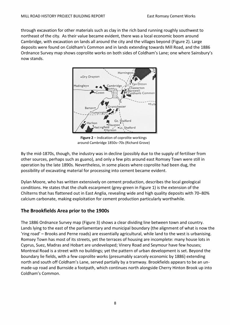
However, the main focus for mining in the area became coprolites, defined as ‛phosphatic nodules’ or phosphate-rich fossilized faeces, which were ground and used as an excellent fertiliser. Coprolite mining was first recorded in the early 1850s, before which they had only been found by accident, often
MILL ROAD HISTORY PROJECT BUILDING REPORT East Romsey Cement Works
8
through excavation for other materials such as clay in the rich band running roughly southwest to northeast of the city. As their value became evident, there was a local economic boom around Cambridge, with excavation on lands all around the city and the villages beyond (Figure 2). Large deposits were found on Coldham’s Common and in lands extending towards Mill Road, and the 1886 Ordnance Survey map shows coprolite works on both sides of Coldham’s Lane; one where Sainsbury’s now stands.
Figure 2 ‒ Indication of coprolite workings
around Cambridge 1850s–70s (Richard Grove)
By the mid-1870s, though, the industry was in decline (possibly due to the supply of fertiliser from other sources, perhaps such as guano), and only a few pits around east Romsey Town were still in operation by the late 1890s. Nevertheless, in some places where coprolite had been dug, the possibility of excavating material for processing into cement became evident. Dylan Moore, who has written extensively on cement production, describes the local geological conditions. He states that the chalk escarpment (grey-green in Figure 1) is the extension of the Chilterns that has flattened out in East Anglia, revealing wide and high quality deposits with 70‒80% calcium carbonate, making exploitation for cement production particularly worthwhile.
The Brookfields Area prior to the 1900s The 1886 Ordnance Survey map (Figure 3) shows a clear dividing line between town and country. Lands lying to the east of the parliamentary and municipal boundary (the alignment of what is now the ‛ring road’ – Brooks and Perne roads) are essentially agricultural, while land to the west is urbanising. Romsey Town has most of its streets, yet the terraces of housing are incomplete: many house lots in Cyprus, Suez, Madras and Hobart are undeveloped; Vinery Road and Seymour have few houses; Montreal Road is a street with no buildings; yet the pattern of urban development is set. Beyond the boundary lie fields, with a few coprolite works (presumably scarcely economic by 1886) extending north and south off Coldham’s Lane, served partially by a tramway. Brookfields appears to be an un-made-up road and Burnside a footpath, which continues north alongside Cherry Hinton Brook up into Coldham’s Common.

MILL ROAD HISTORY PROJECT BUILDING REPORT East Romsey Cement Works
9
Figure 3 ‒ 1886 Ordnance Survey map of the east the Brookfields area (Ordnance
Survey / AGB Environmental Ltd)
The Tins footpath is also there, leading off from a foot bridge. The other main feature is the railway which used to connect the Newmarket and Bury line straight to Cambridge station. It ran from the current line alignment where the Travel Lodge now is, along what is now Budleigh Close, alongside Marmora Road to the north of what is now Greville Road, and across Charles Street into the station yards; Argyle Street is curved to accommodate the line. Approval for realignment through Coldham’s Common, to allow better access to Cambridge station, was obtained in 1895, and the old alignment closed in the mid-1900s.
1900 to 1950: The Advent and Stabilisation of the Cement Industry By 1910 the situation had changed. The cement industry had been established, with the Romsey Town Cement and Lime Works on Brookfields (just west of what is now the Brookfields Hospital), the Saxon Cement Works just east of Cherry Hinton Brook (where the Army Reserve now is, see footnote below), and the Atlas Artificial Stone Works just west of the brook (where Sainsbury’s now is). The larger Norman Cement Works was further east, between the railway and Coldham’s Lane. Excavation of the clay pits had commenced. Moreover, the area had become built-up and houses now extended all the way to Burnside.
MILL ROAD HISTORY PROJECT BUILDING REPORT East Romsey Cement Works
10
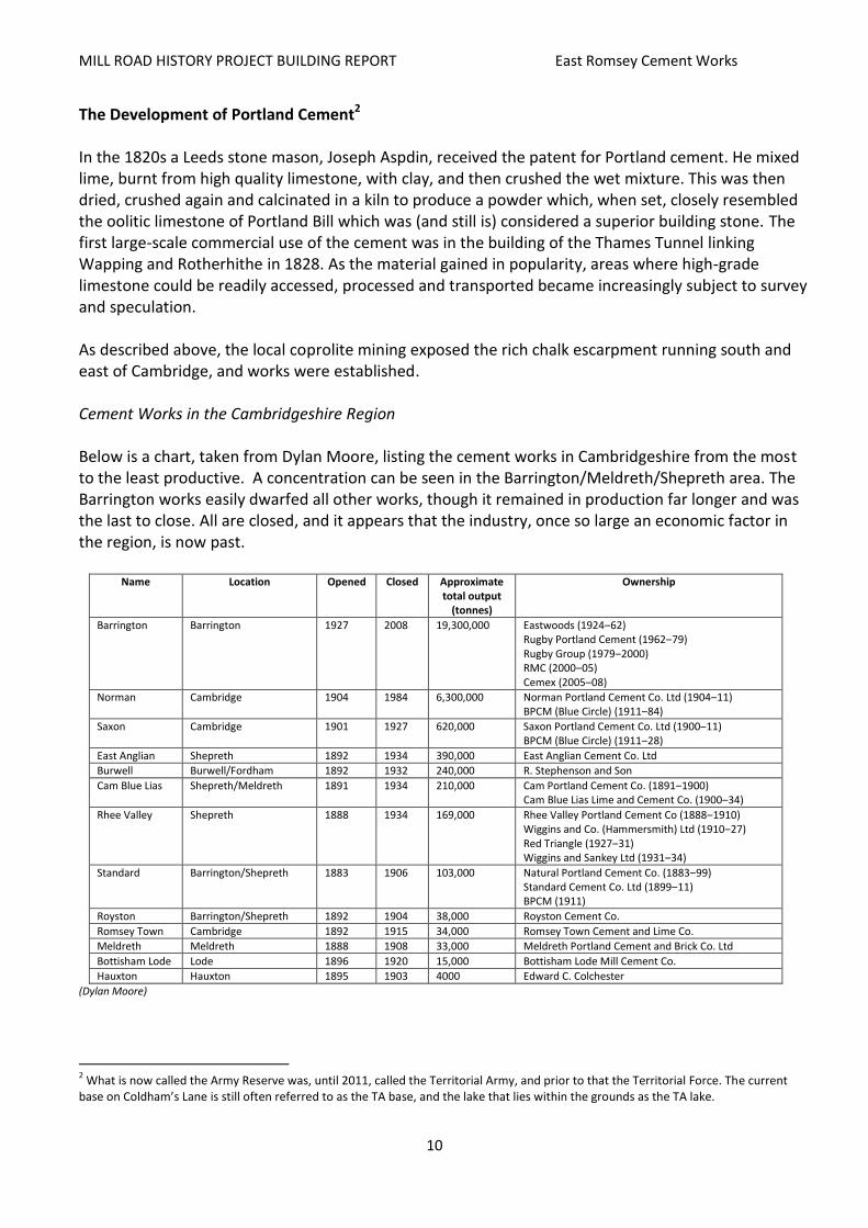
The Development of Portland Cement2 In the 1820s a Leeds stone mason, Joseph Aspdin, received the patent for Portland cement. He mixed lime, burnt from high quality limestone, with clay, and then crushed the wet mixture. This was then dried, crushed again and calcinated in a kiln to produce a powder which, when set, closely resembled the oolitic limestone of Portland Bill which was (and still is) considered a superior building stone. The first large-scale commercial use of the cement was in the building of the Thames Tunnel linking Wapping and Rotherhithe in 1828. As the material gained in popularity, areas where high-grade limestone could be readily accessed, processed and transported became increasingly subject to survey and speculation. As described above, the local coprolite mining exposed the rich chalk escarpment running south and east of Cambridge, and works were established. Cement Works in the Cambridgeshire Region Below is a chart, taken from Dylan Moore, listing the cement works in Cambridgeshire from the most to the least productive. A concentration can be seen in the Barrington/Meldreth/Shepreth area. The Barrington works easily dwarfed all other works, though it remained in production far longer and was the last to close. All are closed, and it appears that the industry, once so large an economic factor in the region, is now past.
Name Location Opened Closed Approximate total output
(tonnes)
Ownership
Barrington Barrington 1927 2008 19,300,000 Eastwoods (1924‒62) Rugby Portland Cement (1962‒79) Rugby Group (1979‒2000) RMC (2000‒05) Cemex (2005‒08)
Norman Cambridge 1904 1984 6,300,000 Norman Portland Cement Co. Ltd (1904‒11) BPCM (Blue Circle) (1911‒84)
Saxon Cambridge 1901 1927 620,000 Saxon Portland Cement Co. Ltd (1900‒11) BPCM (Blue Circle) (1911‒28)
East Anglian Shepreth 1892 1934 390,000 East Anglian Cement Co. Ltd
Burwell Burwell/Fordham 1892 1932 240,000 R. Stephenson and Son
Cam Blue Lias Shepreth/Meldreth 1891 1934 210,000 Cam Portland Cement Co. (1891‒1900) Cam Blue Lias Lime and Cement Co. (1900‒34)
Rhee Valley Shepreth 1888 1934 169,000 Rhee Valley Portland Cement Co (1888‒1910) Wiggins and Co. (Hammersmith) Ltd (1910‒27) Red Triangle (1927‒31) Wiggins and Sankey Ltd (1931‒34)
Standard Barrington/Shepreth 1883 1906 103,000 Natural Portland Cement Co. (1883‒99) Standard Cement Co. Ltd (1899‒11) BPCM (1911)
Royston Barrington/Shepreth 1892 1904 38,000 Royston Cement Co.
Romsey Town Cambridge 1892 1915 34,000 Romsey Town Cement and Lime Co.
Meldreth Meldreth 1888 1908 33,000 Meldreth Portland Cement and Brick Co. Ltd
Bottisham Lode Lode 1896 1920 15,000 Bottisham Lode Mill Cement Co.
Hauxton Hauxton 1895 1903 4000 Edward C. Colchester
(Dylan Moore)
2 What is now called the Army Reserve was, until 2011, called the Territorial Army, and prior to that the Territorial Force. The current
base on Coldham’s Lane is still often referred to as the TA base, and the lake that lies within the grounds as the TA lake.

MILL ROAD HISTORY PROJECT BUILDING REPORT East Romsey Cement Works
11
In many cases the sites of the disused works have returned to agriculture, with their marl pits now small lakes. Some, however, have been developed – the Meldreth site is now the Eternit Marley works (see below), the Romsey site on Mill Road has had a history of re-development, and the Saxon works is now a Territorial Army base. Being the largest, the re-development of the Norman and Barrington sites is still (2015) under discussion – the former is addressed below, and the latter is currently subject to proposals, contested by the village council, that include a mix of housing and recreation. The vast quarry at Barrington, which, being excavated into the side of a hill, is only slightly flooded, is in the process of being rehabilitated, though the cliffs on the west, north and east sides may well remain. It is noteworthy that, as Moore states, British Portland Cement Manufacturers (BPCM – see ‛National Cement Companies – BPCM, ACPM, Blue Circle and Lafarge’ below) acquired the Burwell and the Royston/Standard works in their latter years to create a marl reserve for the Norman works, though it was never exploited.
Brief Description of the Cement Manufacturing Process
Cement is formed by burning ‛rawmix’ (marl) in a kiln to produce clinker, a calcium based material, which is then ground. The rawmix consists of a mixture of materials that react together to form calcium silicates which make clinker a very strong material, described by Dylan Moore as ‛man-made igneous rock’. High-quality clinker, such as that produced at the Norman Works, requires little addition of other minerals and was manufactured from the high-grade marl excavated from the surrounding marl pits. The catalytic agent is water, which sets off a chemical process resulting in applied cement which is strong, consistent and durable; the finer the clinker is ground, the quicker the effect of hydration.
The Saxon and Norman works used the rotary kiln process which produced clinker in the form of small, generally uniform lumps. Rotary kilns were used in two ways: either to grind raw materials with the addition of water, which formed a slurry, after which the water was burned off (the ‛wet’ process); or to grind them dry, to form a powder (the ‛dry’ process). Initially the ‛dry’ rotary system was used but with the development of a longer kiln in the early 1900s, the ‛wet’ system gained popularity with manufacturers, although this requires more fuel. Moore states that the average size of a rotary kiln in 1900 was approximately 60 feet, but by 1901 one Thomas Edison was proposing a 150 feet long kiln, which was far more economic, and allowed effective ‛wet’ processing.
Moore suggests that, in the early decades of the 1900s, the ready availability of coal in Britain meant that British manufacturers used the ‛wet’ processing method. However, in Germany and Japan, both countries with a pioneering industry but less ready access to natural resources, the more fuel-efficient ‛dry’ process was used. Moore makes the interesting point that use of the ‛wet’ process meant that cement-making plants in Britain were restricted to the locations where ‛good chalk’ could be found, with ‛dry’ plants not being so tied to the source of their basic material. Thus, a degree of un-competitiveness entered the British industry from which it was difficult to emerge. The Saxon and Norman Works may have been subject to this trend.
Quarrying
Methods of excavating the marl needed for the milling process evolved over the period during which the Saxon and Norman works were in operation. In the late 19th century the work was primarily

MILL ROAD HISTORY PROJECT BUILDING REPORT East Romsey Cement Works
12
manual, as can be seen in Figure 4 (which, though not being of the Cambridge works, indicates contemporary practice). The seam was uncovered, trenches dug into its side, the marl then loosened and shot down into a waiting trolley to be wheeled off to the works. The work was slow, labour-intensive, and, as can be seen in the photograph, lamps allowed excavation to be continued into the evening. While employment was relatively high, the extent of excavation was necessarily limited.
By the early 1900s mechanisation was increasingly employed. Figure 5 (again, not Cambridge) shows a mechanised digger working away at a chalk face, dumping the marl straight into a waiting series of wagons attached to a locomotive. The process is far more expeditious, though still requiring several workers. Figure 6 shows a highly-mechanised process that has not been recorded as used at Cambridge, though it does indicate how excavation was, in places, becoming far more intensive.
Figure 7, dating from the late 1960s to the late 1970s, shows a Ruston dragline at work – a single-person-operated digger depositing material into a waiting line of rail-based wagons. This is the type of process by which the latter Norman Works excavated the two large pits running between the Tins footpath/Railway and Cherry Hinton Brook. The system is simple, and requires minimal employment. This picture does not represent the practices used in contemporary quarries, which are seemingly completely vehicle-based operations, the laying of rails being considered inflexible and too costly.
Figure 4 ‒ manual quarrying, probably late-19th centuryy (http://www.cementkilns.co.uk/millsetc.html)
Figure 5 ‒ early mechanised quarrying, straight onto rail transport (http://www.cementkilns.co.uk/millsetc.html)
Figure 6 ‒ intensified mechanical drag quarrying, probably 1930s
(http://www.cementkilns.co.uk/millsetc.html)
Figure 7 ‒ 1970s quarrying, a Ruston dragline like those used at the Norman Works, operated largely by one
person (http://www.flickr.com)

MILL ROAD HISTORY PROJECT BUILDING REPORT East Romsey Cement Works
13
Figure 27 (an aerial view of the Norman Works together with its northern marl pits) shows a digger, similar to that in Figure 5, at work. Local Cement Production Companies In the period 1900–85 there were four cement and/or cement-related companies in the east Romsey Town area: the Romsey Town Cement and Lime Company (on Mill Road, where the new mosque is scheduled for development); the Saxon Portland Cement Company (Coldham’s Lane, where the Army Reserve centre now is); the Atlas Artificial Stone Company (Coldham’s Lane, on the site of present-day Sainsbury’s); and the Norman Portland Cement Company (Coldham’s Lane, on the site now occupied by Travel Lodge/David Lloyd Gym). The Romsey Town Cement and Lime Company The Romsey Town Cement and Lime Company, founded in 1892, was the first cement works in, or directly abutting, Cambridge, and it had its works where Mill Road meets Brookfields. Dylan Moore implies that the site may have started as a coprolite mine, but it eventually developed eleven kilns, with production being distributed by road, as it had no rail or tram connection. The works was not a great economic success, and it closed in 1915, after which the site came to be used as The Cam Foundry and Iron Works and as a sawmill until sometime in the mid- to late 1950s or early 1960s. In 1965 the Magnet bowling alley was built on the land, which was later converted to a warehouse for the Robert Sayle department store.3 The Saxon Portland Cement Company The Saxon company was founded in 1900 and started production in 1901 on land east of Cherry Hinton Brook and south of Coldham’s Lane, land which, according to Ordnance Survey maps, had not itself been mined for coprolites although there were mines to the north and west. It was a different kind of affair to the Romsey Town Works, with greater investment and far advanced technology. Financing was provided by the Keeble brothers of Royston, who had interests in other cement works such as Barrington. The ‛brains of the enterprise’, as Dylan Moore describes it, was a Mr A C Davis. A C Davis, trained as a chemist, has been described as a pioneer on the national scale in the development of cement technology, introducing greater chemical and engineering rigour into the industry, and he wrote on the subject (Portland Cement and A Hundred Years of Portland Cement). In his earlier years as an independent producer he was considered a maverick, disparaging of the dominant interests in the business. In time, however, he became a pillar of the system, becoming managing director of the Association of Portland Cement Manufacturers (APCM) through which most of the smaller UK independent producers were amalgamated, and resident of Barrington Hall. Sir Charles Davis (by then not using the Arthur) was appointed Lord Mayor of the City of London in 1945.
3 See L M Sieveking, J Gooch and O Daly, A History of Robert Sayle (Cambridge: John Lewis Cambridge, 2004; rev. 2008; rev. 2013),
pp. 159‒65.

MILL ROAD HISTORY PROJECT BUILDING REPORT East Romsey Cement Works
14
Figure 8 ‒ a curious photo of A C (Sir Charles) Davis when
Lord Mayor of London (http://www.chessgraphics.net/rr.htm)
The works had eight Schneider kilns and, according to Dylan Moore, it ‛represented the best dry process technology of the time’. Moore continues:
Crushed marl was fed to a Smidth dryer, then ground with successive edge-runners and Griffin mills…. After blending and correcting, the raw meal was damped and pressed into bricks of house-brick dimensions. The kilns, with one 45 m stack for each set of four, were operated on natural draught. The output was as indicated by Davis much later: initial output (from eight kilns) on natural draught was 560 t/week, and the introduction of forced draught in 1904-1906 raised this to 1200 t/week.
Moore describes a Griffin mill, introduced in the 1880s, as one of the first to be made of steel, as opposed to previously used stone, giving it a far longer life.
Figure 9 ‒ The Saxon Works, probably in the late 1910s, and
probably photographed from Coldham’s Lane. (Dylan Moore).
Production had its difficulties and in 1907 the Cambridge Evening News recorded an alarming explosion at Portland Saxon Cement Co.’s works. An explosion in the boiler room ‛hurled masses of iron and brickwork at least 50 yards’. Fortunately, there were no fatalities.
The company was stated as exhibiting ‛mosaic cement of excellent appearance’ and sections of reinforced cement at the Japan‒Britain Exhibition of 1910. However, productivity actually decreased in the years 1907, 1913 and 1924 to 1,000 tons per week, indicating production difficulties. With the establishment of the newer, more advanced and cheaper to operate Norman

MILL ROAD HISTORY PROJECT BUILDING REPORT East Romsey Cement Works
15
Works, the Saxon Works was put to secondary use to make up the overall (Saxon and Norman) tonnage allowed in the operating license. The works was formally closed in 1928, and in its final years it operated at less than 40% capacity. Nonetheless, it can be seen from Figure 9 above that the Saxon Works was a substantial construction with a particularly impressive kiln stack.
The works had a reliable rail connection, which fed off the new Cambridge to Newmarket‒Bury St Edmunds line which passed north through Coldham’s Common and replaced the original Budleigh Close/Marmora/Greville Road alignment. (A full copy of a contemporary description of the Saxon Works from The Engineer is included as Annexe One.)
Figure 10 ‒ The Saxon Works (adapted from Dylan Moore)
The Atlas Artificial Stone Company The Atlas Works was another of A C Davis’s enterprises. Two versions of its establishment have been found: one, that the successful opening of the Meldreth branch of the Atlas Works, on the site of the Meldreth Lime and Cement Works, led to the opening of the Saxon Works and the Cambridge Atlas Works, and later the Norman Works; second, that the Cambridge branch was founded in 1902, though the actual date of the start of production is unsure; the works do not feature on the 1903 map. The company was founded with A C Davis’s brother, F W Davis, with a focus on the development of new uses for cement; The Engineer article states that the works produced material from by-products from the cement produced at the Saxon and Norman:

MILL ROAD HISTORY PROJECT BUILDING REPORT East Romsey Cement Works
16
a great variety of artificial stonework is manufactured by treating a mixture of granite chips and
cement by means of hydraulic pressure. The chief articles … were paving blocks and staircases, but …
a good many other things were made, and that the output from these works was regular and
considerable. (The Engineer, 20 March 20 1908). In 1928 the company concentrated operations in Meldreth. By 1929 the Meldreth Works was producing asbestos, and in the 1940s it went on to produce asbestos for air-raid shelters and repair of war damage. The company was eventually sold to Eternit, a Belgian company, which continued production. In 2005 Eternit merged with Marley.
Figure 11 ‒ Atlas at the
Meldreth Works (Local
History of Meldreth)
Figure 12 ‒ The site of the bridge from the Saxon to
the Atlas works, Cherry Hinton Brook at Sainsbury's
car park. Note brick mountings (author).
As an indication of the often convoluted nature of industrial development in the region, the Meldreth Portland Cement and Brick Company was acquired by the Meldreth Cement and Coprolite Syndicate in 1892, which then came to be operated by the British Saxon Cement Company in 1913, the Davis connection assumedly still being strong. The Cherry Hinton Brook works seemingly continued more as a depot than a works. Meldreth History has the story of one of several ‛Puffing Billies’, in this case a 0-4-0 Simplex shunter. It was built in Bedford in 1920 for BPCM (see below) and, though expensive to operate, was sold to the Atlas Works in 1928 and used at Meldreth to transport goods from the station to the works. Around 1929 it was sold back to BPCM and used at the Saxon Works, and later at the Norman Works where it shunted coal wagons. Concerning the site in Romsey, an auction notice published by Bidwell & Sons in 1968 states that Atlas, with a view to ‛consolidate their various local activities on an extensive site at Meldreth which the firm already operates’ is putting the four-acre site put up for auction. Its zoned land use is stated as ‛industrial’, and its rateable value as £1,700 pa. The auction notice contains an aerial photograph of the site which shows it as only half used – the southern part is overgrown (Figure 21 below shows the site as fully used in 1928). There was a collection of one-storey sheds (office block, drying shed, press house, etc), and a two-house terrace fronting Coldham’s Lane was not included in the sale. The photograph also shows the Army Reserve centre (on the site of the old Saxon works) as it then was – a series of one-storey huts, with a range of what may have been quite pleasant semi-detached houses lying alongside the brook (the 1967 map in Figure 34 below clearly shows the range).

MILL ROAD HISTORY PROJECT BUILDING REPORT East Romsey Cement Works
17
The site is now occupied by Sainsbury’s supermarket. How Sainsbury’s managed to have the zoning of the site changed from ‛industrial’ to ‛commercial’ would be an interesting story, though planning policy in the late 1960s/early 1970s was moving away from industrial development in such a residential area. Evidence of the old rail link to the Saxon Works on the east side of Cherry Hinton Brook is still discernable. The Norman Portland Cement Company The Norman Works, established by A.C. Davis and the Keeble brothers under the Norman Portland Cement Co., was registered in 1903, cost £69,000 to construct, and commenced production in 1904. Although described as a subsidiary of the Saxon Works, it was far superior in innovation technology and capacity. As Dylan Moore describes it:
it represented an aggressive move in the industry, setting up a rotary plant large by the standards of the
day, from scratch. It was among the first British plants to be built exclusively with rotary kilns…. It was
certainly the first British rotary plant designed specifically to use the Dry Process – a further confident
gamble. The forty or so rotary kilns installed prior to these were all wet process, although in the USA (the)
dry process was at the time prevalent. It commenced with five dry process rotary kilns. Marl was crushed
by roll-crusher, then dried by a pair of rotary driers heated by kiln exhaust gases. The dried marl was
ground by seven Griffin mills, then blended in an elaborate elevator-fed re-circulating mixer before
storage in a silo of 700 ton capacity. (http://www.cementkilns.co.uk/cement_kiln_norman.html)
Figure 13 ‒ A 1946 aerial photo of the Norman Works, taken from the west. Although several
decades after its opening, much of the building must be as it was in 1904. Note the marl pit on the left (towards Coldham's Lane) and the hay ricks on the land beyond the railway - which
was later to be excavated. (http://www.cementkilns.co.uk/cement_kiln_norman.html)
The Norman Works evidently represented a great enthusiasm in development in the cement production industry. Demand was expanding, particularly for high-grade and quickly-produced cement, and the Saxon Works, only three years old, was not meeting this demand. The significance of this must be the boom in construction – in industrial, commercial, residential and in corporation/ institutional/community-based uses throughout the UK, and the Norman Works was both a reflection and a response to this. The local newspaper, presumably the Cambridge Daily News, stated that the

MILL ROAD HISTORY PROJECT BUILDING REPORT East Romsey Cement Works
18
Norman Works was ‛one of the largest and most modern cement works in England’ under construction in the UK. Krupp (of Essen, Germany) supplied most of the machinery. In 1903 The Engineer stated that the company had placed an order with the Bradley Pulveriser Co. of London for 19 Griffin mills, to be installed at the works (Engineer, 15/5/1903).
Figure 14 ‒ Sketch of the layout of the Norman Works (with west to the left),
taken from The Engineer, March 1908
Figure 15 ‒ Norman Works in the 1900s, seen from
the south across the railway (CC)
Figure 16 ‒ Norman Works. Coal feeds and
clinker coolers (The Engineer)
A local reflection of the confidence that the opening of the works engendered may be seen in the naming of Norman Terrace, situated at the meeting of Mill Road and Brookfields, though it should be noted that the chairman of the company was part of a local building firm. The building of the terrace of thirty houses was finalised in 1904, and is of a high standard – most probably representing the new building standards required by law, and requiring quality cement. Dylan Moore states that the Norman Works, first using five rotary kilns, was innovative in developing the use of the ‛dry process’ which had earlier been introduced at the Saxon Works. At that time the ‛dry process’ was more popular in the USA – most UK works preferring the ‛wet process’.
Marl was crushed by roll-crusher, then dried by a pair of rotary driers heated by kiln exhaust gases. The dried marl was ground by seven Griffin mills, then blended in an elaborate elevator-fed re-circulating mixer before storage in a silo of 700 t capacity. It soon became clear that the registered output of 1200 t/week could be obtained with only three kilns, and (two of the first kilns) were shut down after the BPCM takeover. (http://www.cementkilns.co.uk/cement_kiln_norman.html)
These re-opened briefly in 1919. Moore continues: ‛the plant was then rebuilt as wet process. The wet
MILL ROAD HISTORY PROJECT BUILDING REPORT East Romsey Cement Works
19
kiln … was subsequently replaced in 1949’.
Average cement production at the Works at height of production, assumedly the late 1970s, is said to have been 2,000 tonnes per week, or just over 100,000 tonnes per annum. National Cement Companies – BPCM, ACPM, Blue Circle and Lafarge As Moore states above, the Norman and Saxon companies were taken over by BPCM, which acquired the works in 1911/12. BPCM was itself a subsidiary of APCM. ACPM was founded in 1900 through the merger of the major British cement producers with the difficult intention of bringing all Portland cement producers together into one commercial entity. Initially holding about 60% of national manufacturing capacity, this holding decreased to around 35% by 1910, after the closure of those plants that were considered inefficient. It seems that the Saxon, and particularly the Norman, works were not then considered inefficient. ACPM/BPCM merged at the end of the First World War, becoming just APCM. The 1920s slump affected production, yet the industry recovered and APCM’s management structure, with A C Davis as director of all works, was modernised. Demand for cement in the Second World War, particularly for coastal defences and air raid shelters, considerably increased production and, with the post-war Labour government, there were proposals for nationalisation. This was avoided by APCM, and post-war reconstruction and 1950s public sector schemes led to a boom in the industry. Through the 1960s APCM expanded, buying up related businesses such as sand and gravel extraction, and in 1978 it became Blue Circle Industries. It was also in this period that the company commenced construction of the giant Northfleet Works on the Thames in Kent, which facilitated the closure of less economic works. After problems with fuel supply (oil and coal) in the 1970s, which led to some closures, the 1980s saw the company expand, with an emphasis on diversification into overseas markets, particularly in the USA. In the UK economic plants were modernised, and those not so economic were closed. It can be taken that the Norman Works fitted into this latter category, closing in 1984. The boom-and-bust nature of the construction industry led to record profits in the late 1980s and a sharp decline in the early 1990s. Out of the twenty works Blue Circle operated in the early 1970s, only eleven remained by the mid-1990s. Blue Circle continued to expand internationally, but in 2000 the French company Lafarge launched a hostile take-over bid which, though initially resisted, led in 2001 to Blue Circle becoming part of Lafarge, reportedly the largest cement producer in the world.
The Brookfields Area in 1902/1906
The 1903 Ordnance Survey map (Figure 17 below) shows the new Saxon Works in the northeast corner. The result of coprolite diggings (pits) can be seen running along the west side of Cherry Hinton Brook, though no actual workings are indicated. The earlier tramway running south to Brookfields/ Mill Road has been dismantled and there is now only a path. The Romsey Town Lime and Cement

MILL ROAD HISTORY PROJECT BUILDING REPORT East Romsey Cement Works
20
Works, by now about 10 years old, is shown, next to the Hospital (infectious diseases) which had been labelled a sanatorium in the 1886 map. The map shows a thorough mix of uses: industry, allotments, agriculture, the hospital, and a range of housing types from suburban villas to in-fill terraced housing. Natal Road has been laid out, and Burnside has become a street with several houses. There are, though, still many undeveloped gaps in the all the streets. Apart from the brook running south to north, there is also a large ditch or drain. The old Budleigh Close/Marmora/Greville Road rail alignment appears to be still in operation.
A description of the area by Eglantyne Jebb was published in 1906 and vividly evokes the local atmosphere:
The cement works of the Atlas and Saxon companies at Romsey Town employ about 220 men and boys; with the other firms probably about 250 to 300 hands are engaged in this branch of trade, which for the most part is regular, not seasonal, and consists of unskilled labour ……. of brickmakers there must be also a large number, brick works of six firms being established in the neighbourhood of Newmarket Road and Coldham Lane. ….. As you pass along the street (taken to be Mill Road) the shops become fewer and smaller, and down the slope you come into a region of quite a different character: a greyish region where a whizzing sound disturbs the heavy atmosphere. There are great lime and cement works on your left, and where the houses end abruptly at the foot of the hill you look across a bare field to an irregular stack of buildings piled high with tall chimneys – more cement works. The whole place seems enmeshed in railway lines, and the puffing of trains and screaming of engines break in upon the vibrating hum of the works. The brook is still there; a rather dirty ditch with tins and fragments of pottery amongst its weeds, and with a large notice on its bank prohibiting rubbish from being thrown in. The houses near it are of course called Brook Terrace and Brookfield Cottages; the houses along its edge Brookside, the post office, Brookfields, and one of the inns Brookfield House. And beyond the ditch the footpath still leads up the hill, but it is confined now between two high black palisades. (Cambridge: A Social Study (1906))
Figure 17 ‒ 1903 Ordnance Survey map of the Brookfields
area (Ordnance Survey / AGB Environmental Ltd)

MILL ROAD HISTORY PROJECT BUILDING REPORT East Romsey Cement Works
21
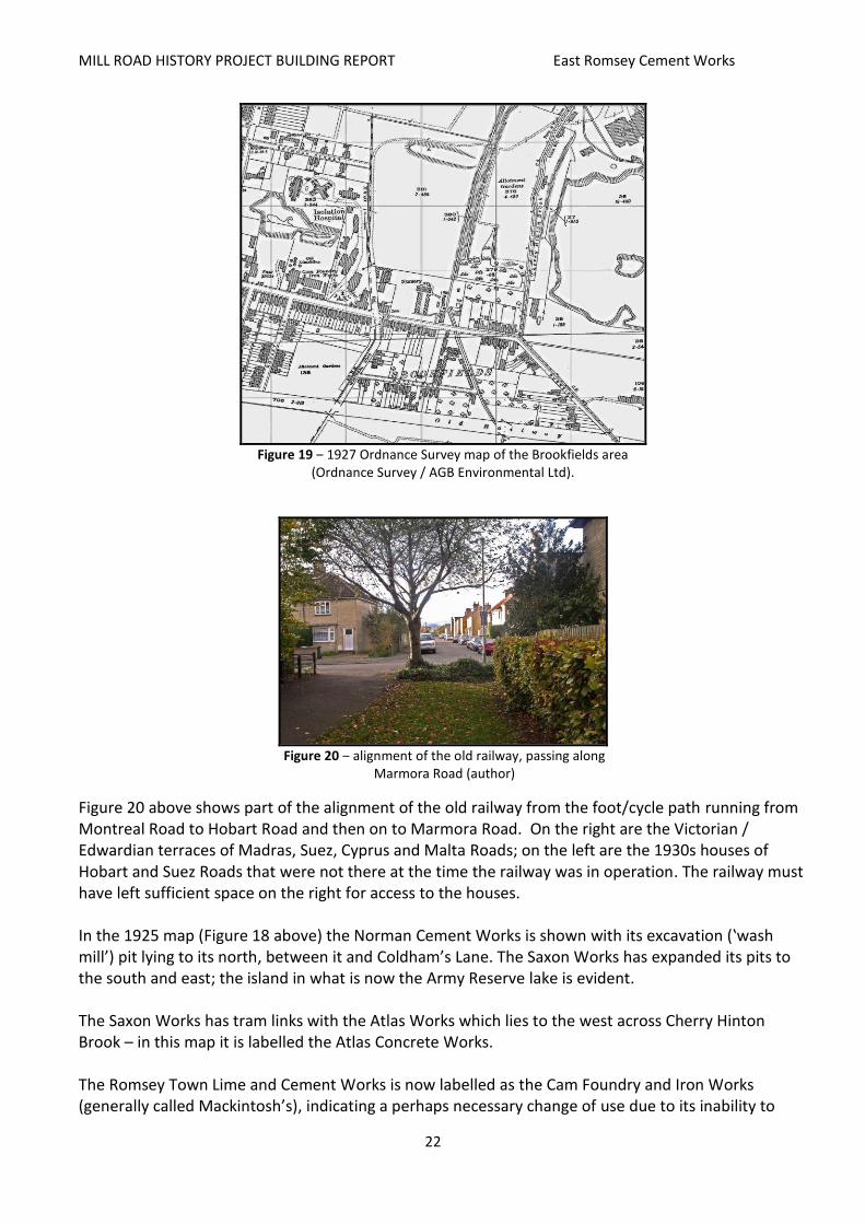
The Brookfields Area in 1925/1927
Looking at the 1925 (Figure 18) and 1927 (Figure 19) maps below, it can be seen that there has been considerable development since the 1903 map (Figure 17 above). The old Marmora Road/Greville Road/Charles Street railway has been closed down and dismantled, and the new railway to the north has been build, passing through Coldham’s Common. It has connections to both the Saxon and Norman works. Whether the realignment was encouraged by the Saxon/Davis interests to give improved rail access to that works is possible though improbable, especially considering its declining output in relation to the Norman Works.
Figure 18 ‒ 1925 Ordnance Survey map of the Brookfields area (Ordnance
Survey / AGB Environmental Ltd).
MILL ROAD HISTORY PROJECT BUILDING REPORT East Romsey Cement Works
22
Figure 19 ‒ 1927 Ordnance Survey map of the Brookfields area
(Ordnance Survey / AGB Environmental Ltd).
Figure 20 ‒ alignment of the old railway, passing along
Marmora Road (author)
Figure 20 above shows part of the alignment of the old railway from the foot/cycle path running from Montreal Road to Hobart Road and then on to Marmora Road. On the right are the Victorian / Edwardian terraces of Madras, Suez, Cyprus and Malta Roads; on the left are the 1930s houses of Hobart and Suez Roads that were not there at the time the railway was in operation. The railway must have left sufficient space on the right for access to the houses. In the 1925 map (Figure 18 above) the Norman Cement Works is shown with its excavation (‛wash mill’) pit lying to its north, between it and Coldham’s Lane. The Saxon Works has expanded its pits to the south and east; the island in what is now the Army Reserve lake is evident. The Saxon Works has tram links with the Atlas Works which lies to the west across Cherry Hinton Brook – in this map it is labelled the Atlas Concrete Works. The Romsey Town Lime and Cement Works is now labelled as the Cam Foundry and Iron Works (generally called Mackintosh’s), indicating a perhaps necessary change of use due to its inability to

MILL ROAD HISTORY PROJECT BUILDING REPORT East Romsey Cement Works
23
compete with the two new works. The streets have become more built-up; Norman Terrace mentioned above has been built facing the hospital, and some of the housing along the nascent Coleridge Road is there, east of what will later become Greville Road. Other features of interest on the 1925 map are the ‛allotment gardens’ lying beside Cherry Hinton Brook south of the Atlas Works, with a swampy area at its south. These have since been built upon, with the exception of the small park/playground, and Brooks Road now passes along their west side. The depression left by the coprolite works shown on the 1886 map remains, lying in open ground to the northeast of the Isolation Hospital. Also, some buildings are shown on the farm land across the brook from Burnside accessed by a bridge. Keith Lagdon, long-time resident of Brookfields, states that this was a small agricultural holding with poultry and the land was later excavated for the Norman Works. The aerial photograph of the area in 1928, taken looking east (Figure 21), is revealing.
Figure 21 ‒ Aerial photo of the area, 1928 (CUCAP, Dept of Geography,
University of Cambridge (http://www.britainfromabove.org.uk/image/epw025477)
In the immediate foreground is the Atlas Works, surrounded on the south and west by allotments. The use of the works as a depot can be seen by its numerous outbuildings and by the lack of chimneys; the works opens onto Coldham’s Lane which runs east towards Cherry Hinton. Beyond Atlas lies the alignment of Cherry Hinton Brook (running south to north) and beyond that is the Saxon Works, with a small plume of smoke rising from its northernmost chimney. Its inundated excavation pit lies to its south, with the island clearly visible. A further un-inundated pit lies beyond the railway. Then there is an open field, and past that is the Norman Works, with long plumes emanating from at least two of its chimneys across its quarried pit which extends north to Coldham’s Lane. To the south lie open fields, with the alignment of the disused railway cutting across east to west. There is no evidence of any airport expansion south to Coldham’s Lane, as this was not built until the late 1930s.

MILL ROAD HISTORY PROJECT BUILDING REPORT East Romsey Cement Works
24
Figure 22 ‒ the Saxon Works in 1928
(http://www.britainfromabove.org.uk/image/epw025457)
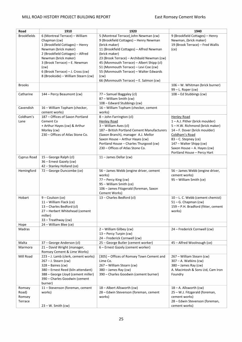
Figure 22 above was taken from the southeast on the same flight as Figure 21, in 1928. The Saxon Works can be seen occupying a triangle between the inundated pit, the railway and Cherry Hinton Brook. Beyond the brook lies the Atlas Works, packed tight with buildings and sheds around the central pool that can be seen in the 1925 map (Figure 18). The railway slices across from southeast to northwest, crossing Coldham’s Lane. A line of wagons can be seen on the sidings. Around both works lie allotments and open fields, with Coldham’s Common beyond. There is a small wood lying between the railway and the road where there are now (2015) allotments. The smallpox/ isolation hospital can be seen in the middle distance on a minor road that leads off from Coldham’s Lane. Local Employment in the Cement Industry As the works operated mainly in the early 20th century, and considering both transport and accommodation costs, it is likely that the great majority of the workforce for the cement and artificial stone works lived locally. Research into the housing of the workforce was undertaken at the Archives in Shire Hall and focussed on the Spalding’s directories which list addresses and occupations street by street from the late 19th century to the 1970s. A selection from the years 1910, 1920 and 1940 is shown in the table below. Throughout the period of the works’ operation, the streets of Romsey Town were largely occupied by people employed in manual work. Most of the references in Spalding’s directories refer to people working in a variety of trades, with a seeming majority working on the railways. However, it is tricky to clearly identify those who worked for the Norman and Saxon works and the Atlas Artificial Stone works. While Spalding’s has direct references to people working in the ‛cement’ industry, many of the workers may be listed more generically as ‛labourers’. Similarly, the frequent references to ‛stonemasons’ may describe those working at Atlas or those working as masons in the building trade (cw = cement worker; cl = cement labourer; ce = cement employee).4
4 W P Spalding, Cambridge Street and General Directory (1910, 1919/20, 1939/40), available in CA and CC.
MILL ROAD HISTORY PROJECT BUILDING REPORT East Romsey Cement Works
25
Road 1910 1920 1940
Brookfields 6 (Montreal Terrace) – William Chapman (cw) 1 (Brookfield Cottages) – Henry Newman (brick maker) 2 (Brookfield Cottages) – Alfred Newman (brick maker) 3 (Brook Terrace) – E. Newman (cw) 6 (Brook Terrace) – J. Cross (cw) 8 (Brookside) – William Stearn (cw)
5 (Montreal Terrace) John Newman (cw) 9 (Brookfield Cottages) – Henry Newman (brick maker) 11 (Brookfield Cottages) – Alfred Newman (brick maker) 23 (Brook Terrace) – Archibald Newman (cw) 45 (Monmouth Terrace) – Albert Shipp (cl) 51 (Monmouth Terrace) – Levi Coe (cw) 55 (Monmouth Terrace) – Walter Edwards (cw) 66 (Monmouth Terrace) – E. Salmon (cw)
9 (Brookfield Cottages) – Henry Newman, (brick maker) 19 (Brook Terrace) – Fred Wallis (ce)
Brooks 106 – W. Whitman (brick burner) 99 – L. Roper (cw)
Catharine 144 – Percy Beaumont (cw) 77 – Samuel Baggaley (cl) 87 – William Smith (cw) 108 – Edward Stubbings (cw)
108 – Ed Stubbings (cw)
Cavendish 16 – William Topham (checker, cement works)
16 – William Topham (checker, cement works)
Coldham’s Lane
187 – Offices of Saxon Portland Cement Co + Arthur Hayes (cw) & Arthur Morley (cw) 230 – Offices of Atlas Stone Co.
8 – John Farrington (cl) Henley Road 3 – William Aves (cl) 187 – British Portland Cement Manufacturers (Saxon Branch), manager A.J. Mellor Saxon House – Arthur Hayes (cw) Portland House – Charles Thurgood (cw) 230 – Offices of Atlas Stone Co.
Henley Road 1 – A.J. Pither (brick moulder) 5 – H.W. Richmond (brick maker) 14 – F. Dover (brick moulder) Coldham’s Road 83 – C. Stepney (ce) 147 – Walter Shipp (cw) Saxon House – A. Hayes (cw) Portland House – Percy Hart
Cyprus Road 15 – George Ralph (cl) 36 – Ernest Gazely (cw) 42 – Stanley Holland (ce)
11 – James Dellar (cw)
Hemingford 72 – George Duncombe (ce)
56 – James Webb (engine driver, cement works) 77 – Percy King (cw) 95 – William Smith (ce) 106 – James Fitzgerald (foreman, Saxon Cement Works)
56 – James Webb (engine driver, cement works) 95 – William Smith (ce)
Hobart 9 – Coulson (ce) 11 – William Flack (ce) 13 – Charles Bedford (cl) 27 – Herbert Whitehead (cement miller) 33 – Treathway (cw)
13 – Charles Bedford (cl) 10 – L. C. Webb (cement chemist) 51 – G. Chapman (cw) 159 – P.H. Bradford (fitter, cement works)
Hope 24 – William Blee (ce)
Madras 2 – William Gilbey (cw) 13 – Percy Turpin (cw) 24 – Frederick Cornwell (cw)
24 – Frederick Cornwell (cw)
Malta 37 – George Anderson (cl) 25 – George Butler (cement worker) 45 – Alfred Woolnough (ce)
Marmora 21 – David Wright (manager, Romsey Cement & Lime Works)
6 – Ernest Gazely (cement worker)
Mill Road 223 – J. Lamb (clerk, cement works) 267 – J. Stearn (cw) 328 – Baines (cw) 380 – Ernest Reed (kiln attendant) 388 – George Lloyd (cement miller) 390 – Charles Goodwin (cement burner)
[305] – Offices of Romsey Town Cement and Lime Co. 267 – William Stearn (cw) 380 – James Ray (cw) 390 – Charles Goodwin (cement burner)
267 – William Stearn (cw) 307 – A. Watkins (cw) 380 – James Ray (cw) A. Macintosh & Sons Ltd, Cam Iron Foundry
Romsey Road) Romsey Terrace
11 – Stevenson (foreman, cement works) 23 – W. Smith (cw)
18 – Albert Allsworth (cw) 28 – Edwin Stevenson (foreman, cement works)
18 – A. Allsworth (cw) 25 – W.J. Fitzgerald (foreman, cement works) 28 – Edwin Stevenson (foreman, cement works)

MILL ROAD HISTORY PROJECT BUILDING REPORT East Romsey Cement Works
26
Road 1910 1920 1940
Ross 199 – Albert Shipp (cw)
St Philip’s 71 – Harry Marchant (ce) 76 – John Williams (kiln attendant)
71 – Harry Marchant (ce)
Sedgewick 114 – Albert Brown (cw)
Seymour 10 – L.C. Pettit (cw) 22 – William Day (engine driver, Atlas Works) 25 – John Ruffells (cw) 35 – William Peck (cw)
25 – John Ruffells (cw) 35 – Harry Peck (cw)
Stockwell 34 – W. Kitchener (foreman cement works)
Suez 2 – Fred Groom (cement tester) 4 – Richardson (cl) 6 – James Secker (cl) 33 – Bertram Morell (ce) ? – Palmer (ce)
10 – S. Brown (cl) 21 – Job Bendall (cw) 41 – William Gladwell (cw) 43 – Winthrop Bendall (cw)
59 – Albert Prime (ce) 108 – H.W. Loates (cw) 112 – Claude Kinsey (cw 123 – Leonard Woods (stoker, cement works)
Thoday 115 – A. Clarke (cw) 118 – William Allpress (cw)
Vinery 33 – Charles Pragnell (ce) 25 – William Minns (cw) 53 – William Bell (cw) 97 – William Wisbey (cw)
25 – William Minns (cw) 97 – William Wisbey (cw) 140 – Herbert Covill (cw)
There are human interest stories here, such as that of Edwin Stevenson, foreman, who was in No. 11 Romsey Road in 1910, then moved to No. 28 for 1920 and 1940. A better or bigger house? And the case of the Stearns, with J Stearn living at No. 267 Mill Road, replaced by William Stearn by 1920 and 1940. Was William the son of J, or was he the same William Stearn who lived at No. 8 Brookside in 1910, making him possibly a brother? What can readily be seen, however, is the evident lack of a clear promotional path in the cement industry. Mr. Stevenson remained a foreman for thirty years, as did William Stearn as a cement worker and Henry Newman (Brookfield Cottages) as a brick maker. William Wisbey (Vinery Road) carried on as a cement worker for twenty years or more, as did James Ray (Mill Road), and there are many more examples. Purkiss dissertation focused on social conditions in Romsey Town in the inter-war period:5
The cement workers were at the far end of Mill Road on the chalky fen edge in the area called Brookfields, near the Bury to Newmarket railway line, a district with a certain degree of exclusivity… Cement workers were unskilled and un-unionised, like D_ B_’s father.
He was only a little man and he used to have to get in the truck with all the slack coal and push the slack into the hold that would feed the kilns to make the cement. He used to go home absolutely black. Then you used to have to stand him in his little old kitchen with a funny old brown sink. Mother used to have the copper on day in, day out and he used to stand and be washed down on top. When he was taken into the kitchen, everybody had to get out of the way
The standard of living of the family was well below that of the skilled workers. His wife was a frequent customer of the pawnbrokers, took an empty can down to the College kitchens for free soup and accepted police boots for the children to wear. She supplemented the family income by fruit picking in the summer and constantly scrimped and 'made do' to keep them above the poverty line. Several other women in the row of cottages did undergraduates' washing. Working and living conditions were made worse by the white dust that blew everywhere. There was nowhere for men to protect their cans of tea and sandwiches, so the children had to take these to their fathers before they went to school. Despite the links between the cement works and the building trade, builders as directors, no attempts were made to unionise the workers.
5 Purkis (1982), pp. 18‒19.
MILL ROAD HISTORY PROJECT BUILDING REPORT East Romsey Cement Works
27
He never talked about a union. Maybe there was one, but he never mentioned it.
Yet as a man who had been a Wesleyan Sunday School teacher, who voted Labour as far back as his daughter could remember, there appears to have been no ideological barrier that would have prevented him joining if he had been approached. Wages were poor and seem to have fluctuated with the prevailing market conditions. The family
knew what poverty was when the depression came but for a conscientious worker there was job security, and he worked there for forty eight years until retirement long after the family had grown up and set up homes of their own.
While it is probable that the great majority of the manual workers at the works lived in the East Romsey Town area, information on the 1911 census transcribed by the Trumpington Local History Group is revealing. 1911 was shortly after the works had been established, and the data indicates that those in more managerial roles lived in more affluent areas.6
Address Name Occupation Origin
Trinity House, Hills Road
Henry Campion Apthorpe Director Limited Company, Norman Cement Company Cambridge
Perlethorpe, Hills Road
Henry Turvey Director Sales Manager & Secretary of Portland Cement Company
Ordsall, Notts
Southacre, Latham Road Frederick Henry Hatch Consulting Mining Engineer London
Apart from the more expensive address, the origin of Messrs Hatch and Turvey indicates a wide scope of recruitment. This may, of course, also have been true for those living in East Romsey. It is quite likely that the founding of the works attracted a workforce from far beyond Cambridge. Mr Hatch has been included as there can have been little other demand for a consulting mining engineer than for marl quarrying – whether in East Romsey or at some other site.
The Brookfields Area in 1938 The 1938 map below shows some significant developments on what was present in the early to mid-1920s. It can be suggested that, building on the social reforms of the Edwardian period, and possibly reflecting the ‛homes for heroes’ mood following the First World War, Cambridge had begun to embark upon an expansion which went beyond the bounds of the Victorian and Edwardian period. This saw new housing development all around the city, particularly in the south and east, undertaken by a mix of the public and private sectors, and underpinning this were the first attempts at streamlining the increasing amount of road traffic.
6 http://www.trumpingtonlocalhistorygroup.org/resources_census1911.html: File reference:
Trumpington_CensusTranscript_1911.pdf
MILL ROAD HISTORY PROJECT BUILDING REPORT East Romsey Cement Works
28
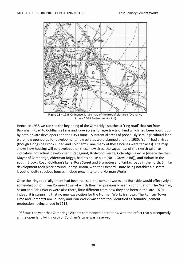
Figure 23 ‒ 1938 Ordnance Survey map of the Brookfields area (Ordnance
Survey / AGB Environmental Ltd)
Hence, in 1938 we can see the beginning of the Cambridge southeast ‛ring road’ that ran from Babraham Road to Coldham’s Lane and gave access to large tracts of land which had been bought up by both private developers and the City Council. Substantial areas of previously semi-agricultural land were now opened up for development, new estates were planned and the 1930s ‛semi’ had arrived (though alongside Brooks Road and Coldham’s Lane many of these houses were terraces). The map shows how housing will be developed on these new sites, the vagueness of the sketch taken as indicative, not actual, development: Radegund, Birdwood, Perne, Coleridge, Greville (where the then Mayor of Cambridge, Alderman Briggs, had his house built (No 1, Greville Rd)), and Hobart in the south; Brooks Road, Coldham’s Lane, Ross Street and Brampton and Fairfax roads in the north. Similar development took place around Cherry Hinton, with the Orchard Estate being notable: a discrete layout of quite spacious houses in close proximity to the Norman Works. Once the ‛ring road’ alignment had been realised, the cement works and Burnside would effectively be somewhat cut off from Romsey Town of which they had previously been a continuation. The Norman, Saxon and Atlas Works were also there, little different from how they had been in the late 1920s – indeed, it is surprising that no new excavation for the Norman Works is shown. The Romsey Town Lime and Cement/Cam Foundry and Iron Works was there too, identified as ‛foundry’, cement production having ended in 1915. 1938 was the year that Cambridge Airport commenced operations, with the effect that subsequently all the open land lying north of Coldham’s Lane was ‛reserved’.
MILL ROAD HISTORY PROJECT BUILDING REPORT East Romsey Cement Works
29
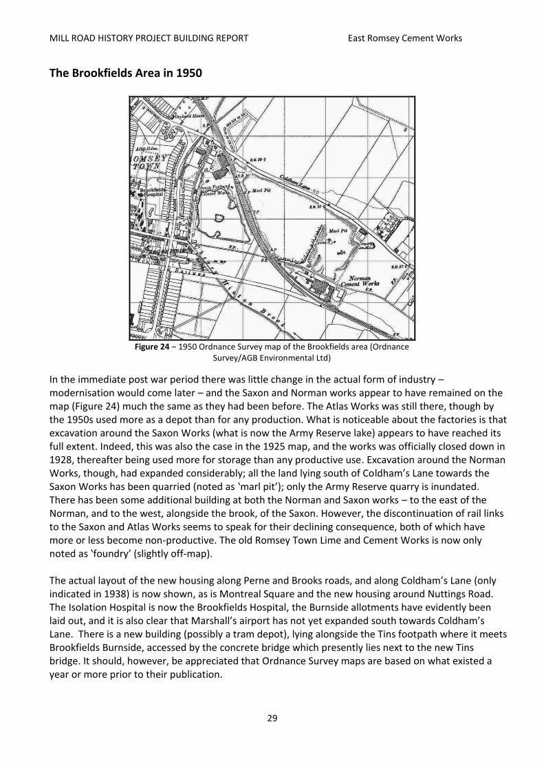
The Brookfields Area in 1950
Figure 24 ‒ 1950 Ordnance Survey map of the Brookfields area (Ordnance
Survey/AGB Environmental Ltd)
In the immediate post war period there was little change in the actual form of industry – modernisation would come later – and the Saxon and Norman works appear to have remained on the map (Figure 24) much the same as they had been before. The Atlas Works was still there, though by the 1950s used more as a depot than for any production. What is noticeable about the factories is that excavation around the Saxon Works (what is now the Army Reserve lake) appears to have reached its full extent. Indeed, this was also the case in the 1925 map, and the works was officially closed down in 1928, thereafter being used more for storage than any productive use. Excavation around the Norman Works, though, had expanded considerably; all the land lying south of Coldham’s Lane towards the Saxon Works has been quarried (noted as ‛marl pit’); only the Army Reserve quarry is inundated. There has been some additional building at both the Norman and Saxon works – to the east of the Norman, and to the west, alongside the brook, of the Saxon. However, the discontinuation of rail links to the Saxon and Atlas Works seems to speak for their declining consequence, both of which have more or less become non-productive. The old Romsey Town Lime and Cement Works is now only noted as ‛foundry’ (slightly off-map). The actual layout of the new housing along Perne and Brooks roads, and along Coldham’s Lane (only indicated in 1938) is now shown, as is Montreal Square and the new housing around Nuttings Road. The Isolation Hospital is now the Brookfields Hospital, the Burnside allotments have evidently been laid out, and it is also clear that Marshall’s airport has not yet expanded south towards Coldham’s Lane. There is a new building (possibly a tram depot), lying alongside the Tins footpath where it meets Brookfields Burnside, accessed by the concrete bridge which presently lies next to the new Tins bridge. It should, however, be appreciated that Ordnance Survey maps are based on what existed a year or more prior to their publication.

MILL ROAD HISTORY PROJECT BUILDING REPORT East Romsey Cement Works
30
Reconstruction of the Norman Works In 1949 the Norman Works was comprehensively rebuilt – the old 1900 buildings being replaced by what basically was a very large shed, to take new machinery. The ‘wet’ kiln, which superseded the earlier ‘dry’ kiln after the BPCM takeover, was replaced. As Dylan Moore states, ‛this was a scaled-down version of the Shoreham kilns (then considered as state-of-the-art by owners Blue Circle), and was the first in Britain to be fitted from the start with a Fuller grate cooler, supplied under license by Vickers Armstrong’.
Figure 25 ‒ Sketch of the old Norman Works
layout 1900s (Dylan Moore)
Figure 26 ‒ Sketch of the new Norman Works
layout 1949 (Dylan Moore)
Figure 27 ‒ Aerial photo of the new Norman Works,
undated though probably late 1950s (CUCAP, Dept of Geography, University of Cambridge)
Figure 28 ‒ 1948 view over Cambridge with the Norman
Works in the middle distance (http://www.britainfromabove.org.uk/image/eaw014113)
The aerial photograph in Figure 27, taken from the east looking towards Romsey Town, shows clearly the reconstructed Norman Works. Gone is the complex of Edwardian buildings, replaced by the new long shed, the single new chimney at the west end, and the large silos at the east end. The new building was not what could be considered an architectural improvement. The original excavation pit to the works’ immediate north appears to be disused as it has become overgrown, however the far

MILL ROAD HISTORY PROJECT BUILDING REPORT East Romsey Cement Works
31
pit, running alongside the railway towards the Saxon Works (which is out of the picture), is evident, as is the newer pit in the immediate foreground in which a digger can be seen at work. This pit is not shown on the 1950 O/S map. The road access to the works is shown running east of the site and bending north to Coldham’s Lane. The alignment of the disused railway is clear, running to the south of Burnside and across Perne Road and Coleridge Road. The 1930s housing (Radegund, Birdwood, Perne, Coleridge, Greville, Hobart, etc.) is evident, and the land between the new railway and Cherry Hinton Brook, which would later be excavated, is still fields. Figure 28 is a photograph taken in 1948, looking east over the city. Parker’s Piece can be seen in the near right foreground, with the line of Mill Road extending east. The railway can be seen as a black line crossing from south to north. Beyond the mass of housing an open white-ish area can be seen amongst the fields, with a smoking chimney. This is the Norman Works and its pits. The line of the old railway is still discernible to the right (south) of the works. To the left (north) is the openness of Coldham’s Common, with an area of unidentified clearance on the extreme left. Below are three photographs illustrating the appearance of the works around this time. Figure 32 shows the newly installed kiln C1, which was the major kiln in the works, built by Vickers Armstrong and operating from 1949 to 1984.
Figure 29 ‒ The new Norman Works seen from
Coldham’s Lane (across the marl pit lying between it and the Saxon Works) (CC)
Figure 30 ‒ The new Norman Works seen in the
distance from the as yet unfinished Barnwell Road, taken as being in the early 1960s
7
Figure 31 ‒ View of the wash mill (a mechanism to wash marl prior to processing it) area and the
new Norman Works (CC)
Figure 32 ‒ Kiln C1 (see Figure 25 above) after installation in 1949 (Norman Collection / Dylan
Moore)
7 Mike Petty, ‛Memory Lane Cambridge’, Cambridge News, 2002.

MILL ROAD HISTORY PROJECT BUILDING REPORT East Romsey Cement Works
32
While the new Norman Works was, as Dylan Moore states, ‛now (a) relatively small plant … buoyed up by low maintenance costs on its simple process’, production increased right up to the point of its closure, as can be seen in Figure 33 below.
Figure 33 ‒ Norman Works production, approximate tonnes
per year (Dylan Moore)
A description of the operation of the reconstructed Norman Works is given in Appendix B – an account by one Pam Carr of an outing by the Greater London Industrial Archaeology Society to the Works in August 1980, when it was owned and operated by Blue Circle.
Development of the Ring Road, New Residential Areas, and the Closing-down of the Cement Works Land Use Planning Issues Research undertaken in the Cambridge City Council Planning Department cast a light upon the history of the area from a planning perspective. Cambridge Planning Proposals (1950)8 The Town and Country Planning Act of 1947 required all local authorities, in this case Cambridge County Council (the borough in those days not having responsibility for town planning), to prepare comprehensive development plans for the area under their jurisdiction …‛indicating the manner in which a local planning authority proposes that land in their area should be used’. The procedure first required analysis of the existing conditions before any forecasts and proposals could be made concerning future development. The County Council commissioned Sir William Holford with Henry Myles Wright to draft a county development plan. The focus of Holford’s work was on movement of traffic around the city, and there was little attention to the cement works area:
larger factories are to be encouraged to develop around Barnwell (off Cromwell Road), as ‛smoke and fumes can blow clear of the town’;
concerning the chalk pits area, its future use was zoned for ‛War Department’ (assumedly referring to what is now the Army Reserve centre), with the rest being ‛undetermined’.
8 W Holford and H Myles Wright, Cambridge Planning Proposals (Cambridge: Cambridge University Press, 1950).

MILL ROAD HISTORY PROJECT BUILDING REPORT East Romsey Cement Works
33
The final Development Plan was submitted to government in 1952. County Development Plan, Report & Written Analysis. Part I (1952) This Report and Analysis by the county Planning Department acts partially as the ‛written’ section of the Development Plan: explaining, justifying and elaborating on the plan as shown on a map. Relevant to the cement works is:
As concerns commercial minerals, the area around Brookfields has resources which are of a very good quality and are a very important economic asset;
The British Portland Cement site at Cherry Hinton (Norman Works) has recently been rebuilt, demonstrating confidence in future production;
If demand increases ‛further areas may be required’ for quarrying, but no land is allocated in the plan as current reserves are deemed sufficient.
(Mineral Planning Permission was granted in 1951 (CB. 50.226), after a public enquiry. The quarries were classified as dormant by 1998.) A Guide to the Cambridge Plan (1956) By the mid-1950s, in conformity with the Town and Country Planning Act, the changing social, economic and physical conditions necessitated a review of the development plan leading, in effect, to a second generation. With each iteration, the plans became wider in scope and the evident need to better engage the public in the process was acknowledged. A digestible summary of the 1956 Plan was written by Derek Senior of the County Planning Department. Though the planning department had prepared several land-use plans for parts of the borough in the 1920s and 30s, the 1956 Plan appears to be the first one to refer specifically to the land affected by the cement works. Essentially, the land was divided into two zones: the north – from Coldham’s Lane to the railway ‒, and the south – from the railway to Cherry Hinton Brook. The former was zoned for continued ‛mineral workings and industry’, and the latter for ‛proposed … mineral workings and industry’, acknowledged as probably not taking place until the 1970s. The implication is that the Norman Works was considered as having a viable future, and could provide valued employment, should it be able to expand its quarrying activities. Quarry expansion points to an issue that was bound to arise as more housing was developed in the area: conflicting land uses. When the Saxon and Norman works were established in the 1900s there were few residential uses in direct proximity. However, this changed throughout the early part of the 20th century as Romsey Town expanded east, Cherry Hinton expanded west, and the lands lying north of Cherry Hinton Road were filled in. Complaints from neighbouring residential areas about dust and noise pollution from the Norman Works were to mount particularly in the second half of the century. Report on the First Review of the Town Map for Cambridge (1961) Prepared by the County Planning Department, this planning review contains the ‛Written Statement’, which acts as a policy, that the Council will only approve proposals for new industrial development
MILL ROAD HISTORY PROJECT BUILDING REPORT East Romsey Cement Works
34
within the city that would employ five or less personnel. Existing industries would be permitted only moderate expansion. The implication is that the Council was seeking to promote more small-scale ‛workshop’-type industry that would supposedly be less polluting. It could be assumed that this would encourage larger industries to locate outside of the city boundary. The review contains some interesting statistics under ‛Estimates of Insured Employees’: Employed in quarrying & mineral products:
1951 1957 1959
377 417 369
These figures essentially describe the workforce employed in the Norman, Saxon and Atlas works, the latter two being used as depots and for storage and distribution. The figures might also include Cherry Hinton Pit, which was worked until the 1980s, and the quarry that is now Milton Country Park. The review also gives an indication of the extent of mineral workings: Mineral workings: area in acres:
1949 1959 1971
101 107 an extra 69
The extra 69 acres estimated for 1971 probably refers to quarrying expansion on the land between the railway and Cherry Hinton Brook. The Land Use Analysis part of the 1961 review focused particularly on the appraisal of land use issues. It noted/confirmed that:
the land north and south of the railway alignment is zoned as ‛mineral/chalk’;
in 1949 the Norman Works required 61.6 acres, in 1952 it required 74.1 and in 1959 66.7 acres;
quarried land south of the railway in 1949 consisted of 0 acres, and in 1952 and 1959 of 63 acres;
the Limekiln Road (Cherry Hinton) East quarry consisted in 1949, 1952 and 1959 of 20.9 acres;
the Limekiln Road (Cherry Hinton) West quarry in 1949 consisted of 10.9 acres, then in 1952 of 19.9 acres, then in 1959 of a reduced 14.4 acres.
An implication of this may be that an end to marl extraction, and cement production, was being recognised as probably coming to an end. However, provisions would be needed to ensure its short, and maybe medium, term production was ensured.
The Brookfields Area in 1967 By the time the map in Figure 34 (below) was produced, the pattern of contemporary urban development in east Romsey Town had been well established. The ring road is integral to the fabric of the area, the 1930s housing has become central to the urban pattern, and the only area yet to be developed was the Tiverton Way estate behind the 1930s housing along Perne Road (where it effectively halved the Burnside allotments), and the block of flats next to the Atlas site.

MILL ROAD HISTORY PROJECT BUILDING REPORT East Romsey Cement Works
35
The Romsey Town Lime and Cement Works/foundry has gone, replaced by the Magnet bowling alley and the Priory Motors garage. Seymour Street is in place, and there has been housing in-fill on the site of the old coprolite pit east of the Brookfields Hospital. The disused railway alignment is being in-filled, by such as the Scout centre on Perne Road and the Girl Guides hut. There is an ‛island’ at the junction of Brookfields and the ring road. The Saxon Works has disappeared, replaced by the Territorial & Auxiliary Volunteer Reserve Centre, with some associated housing. However, as can be seen from Figure 35 below (1973), the Atlas site has not yet been cleared.
Figure 34 ‒ 1967 Ordnance Survey map of the Brookfields
area (Ordnance Survey / AGB Environmental Ltd)
Excavation for the Norman Works has expanded onto the land south of the railway, and what had previously been farm land across the brook from Burnside (farmed, according to Keith Lagdon, by Bob Dellar, who raised pigs, and poultry and grew sugar beet) is now being quarried – resulting in the disappearance of the series of buildings that had been there, though the footbridge remains. Marl from this quarry was transported over the Tins and the railway to the Works by a conveyor just east of the footbridge over the railway (see Figure 35 below).

MILL ROAD HISTORY PROJECT BUILDING REPORT East Romsey Cement Works
36
Figure 35 ‒ Aerial view of the Atlas Works and the early layout of the Army Reserve
centre (taken from Bidwell’s notice of auction of the Atlas site, 1968, supplied by Alan Brigham)
Figure 35 above shows the Atlas Works ready for auction by Bidwell & Sons in 1968. By this time the buildings of the works were considerably reduced from their earlier state, and almost half the land (the southern part) appears to be unused and overgrown. Most of the land is now (2015) occupied by Sainsbury’s supermarket, with a block of ‛affordable housing’ on the overgrown land. One or two houses fronting on to Coldham’s Lane (presumably originally associated with the Works) are exempt from the auction, and stand where the present supermarket fuel station is situated. Across Cherry Hinton Brook lies the Army Reserve centre on the site of the Saxon Works. This was the earlier, low-rise, form of the base. It was rebuilt, without the row of houses alongside the brook, in the late 1980s. At this time, 1968, there was no Barnwell Road connection to the Newmarket Road.
The Brookfields Area in 1973
Figure 36 ‒ 1973 Ordnance Survey map of the Brookfields area
(Ordnance Survey/AGB Environmental Ltd).

MILL ROAD HISTORY PROJECT BUILDING REPORT East Romsey Cement Works
37
By 1973 the extent of the continued quarrying can be seen. The ‛middle’ pit (labelled ‛chalk pit’) has grown to take up about half of its eventual size. The pit is in operation, so it is not inundated, and the conveyor to the Norman Works can be clearly seen. All four pits lying to the north of the railway are shown to be disused and filled-in – the disposal of general waste in the abandoned pits being sanctioned by the authorities, which has consequently led to the site’s being defined as contaminated land. Only the original Norman pit, which lay between the Works and Coldham’s Lane (and has been known as the ‛wash mill’ site, see Figure 31), was not used for dumping and never became contaminated. The only actual lake is what is now known as the Army Reserve lake, originally being quarried for the Saxon Works. It reached its full extent prior to the 1925 Ordnance Survey map, shortly before the Works went out of production. Other changes since 1967 are: Marshall’s has by now extended it runway to Coldham’s Lane; the Atlas site is still undeveloped (in fact it is labelled ‛works’); the continuation of the ‛ring road’ under the railway to Barnwell Road has not yet been commenced, though it can be seen that the alignment land has been reserved; and a small ‘works’ has been established on land to the immediate southeast of the Coldham’s Lane railway bridge. This works was eventually to become the ‛Hanson’ site, the only ‛industrial’ use remaining in the area after the closure of the Norman Works in 1984. The three photographs below (Figures 37, 38 and 39) give an indication of what the area around Cherry Hinton Brook/Snakey Path looked like in the 1960s. In the rather grainy Figure 37, the landscape is quite bare, and the brook looks more like a drain than a stream. An adult and a child can be seen walking along Snakey Path with the bulk of the Norman Works in front of them. The land on the north side of the brook (on the right) is yet to be excavated. Figure 38 shows the meeting of Snakey Path and Burnside. Again, there are far fewer trees than in 2014 – the willows in particular are absent. The car is parked on the alignment of the old railway – the bridge that currently gives access to the lakes. Figure 39 gives an impression of how the works dominated all or most views in the area.
Figure 37 ‒ Norman Works viewed from
Cherry Hinton Brook (CC)
Figure 38 ‒ Snakey Path and Burnside in the
1960s (CC)

MILL ROAD HISTORY PROJECT BUILDING REPORT East Romsey Cement Works
38
Figure 39 ‒ View of the Norman Works from the then newly built St Bede’s school (Grant Lewison/Cambridge New
Architecture)
Local Objections over Air and Noise Pollution Marl quarrying and cement production are manifestly bad neighbours in any residential areas. Not only are the processes intrinsically noisy and dusty, but often adaptions to the manufacturing process to mitigate pollution can come to be streamlined in order to secure profitability rather than local environmental conditions. A series of complaints from local residents over noise, dust and smells from the Norman Works arose, and were recorded by the Cambridge News/Evening News. The publicity given to these complaints necessarily stimulated the Works to improve its anti-pollution measures. Some of the reports are summarised chronologically below:
9 March 1964: the Works closes down due to a breakdown in the filter system. A petition had been signed by locals a few years earlier (over dust pollution);
8 October 1965; many complaints over dust are recorded. The Norman Works is labelled by Councillor R May (Romsey) as ‛public nuisance No. 1’;
12 December 1972: a glass fibre cone (locally known as the ‛bikini’) is placed on top of the 150ft chimney to improve smoke dispersal. There are also ‛general improvement works’ to reduce dust collection and smells;
4 July 1973: approximately thirty residents of Burnside sign a petition and threaten to withhold their council rates until something is done about noise from the site, which they state is ‛unbearable’. The residents include: Keith Lagdon (58 Brookfields), Sidney Challis (91 Burnside), Sidney Westwood (93), Philip Suckling (97), Kathleen Green (99), Sidney Cornish (Mr & Mrs) (109), and Ethel Ward (?) (see Figure 40 below). Westwood says that effluent is going into the brook and killing the fish. Challis states ‛years ago this was a kids’ paradise. Now the brook stinks’. While Ian McLeod, the Works’ manager denied effluent was flowing into the brook, that it was only general run-off, Lagdon (who still resides in Brookfields) states that the flow of the brook often used to be milky-white.

MILL ROAD HISTORY PROJECT BUILDING REPORT East Romsey Cement Works
39
Figure 40 ‒ Burnside residents gathered in front of the
Works to state their complaints (Cambridge News)
16 March 1976: the Works receives a ‛Good Safety Record’. Employment is recorded as 110. The question arises over why such complaints were not recorded earlier. The Works had been in operation since 1904 and must have been noisy and dirty over the 60 years prior to the first complaint being noted in the press. Perhaps the Works had been intensifying its production in its last years, and Dylan Moore’s chart of production (Figure 33 above) does indicate a steady increase. Equally, perhaps people’s expectation of a cleaner environment had risen, and tolerance of a dirty one lowered. Noteworthy is the fact that in the 1970s, many of the citizens in the western part of the city, and particularly students and staff at the University, were completely unaware of this industrial part of the city and the problems the local residents faced – an illustration of the ‛town and gown’ factor.
The Brookfields Area in 1984 The 1984 map (Figure 41) clearly shows the final scope of the Norman Works’ quarrying on land south of the railway. It is taken that deep excavation is shown on the land opposite Burnside, while preliminary excavation is indicated by the dashed lines around the ‛middle’ and the ‛east’ pits. There is, however, an incongruity here. As the works closed down in 1984, how could the ‛middle’ and ‛east’ pits be quarried to the depth they currently have, especially the ‛middle’ pit which is estimated as being almost ten meters deep? The only explanation must be that the map is based on outdated information, and that there must have been an acceleration in quarrying in the Works’ last few years.

MILL ROAD HISTORY PROJECT BUILDING REPORT East Romsey Cement Works
40
Figure 41 ‒ 1984 Ordnance Survey map of the Brookfields area
(Ordnance Survey / AGB Environmental Ltd)
The older pits that lay between Coldham’s Lane and the railway have been filled, mostly with waste material, though the ‛wash mill’ pit, immediately north of the Works, has not. It may be supposed that Blue Circle (Norman Works) commenced this new quarrying, which was to take in a large tract of land in close proximity to areas of expanding urban use, in the presumption that the resulting pits would be filled-in, rehabilitated and used for residential or commercial uses: there was little or no intention of creating lakes. Housing in the area has expanded. Two new estates have been built, one to the east of St Bede’s School, and the other taking up the western section of the Burnside allotments. The Atlas site has been redeveloped for Sainsbury’s supermarket and car park, which opened in 1974. The Draft Romsey Local Plan (1983) The City Council Planning Department undertook the preparation of the 1983 Draft Romsey Local Plan, reflecting the then popularity of localised, community-based planning. This draft was intended to inform and feed into the subsequent official Romsey Local Plan of 1986. It differs from the final 1986 plan in some respects. Focusing on ‛The Chalk Pits Complex’ (section 12) the document sees the area as ripe for major change, citing the development of the Sainsbury’s supermarket, the winding-down of Blue Circle’s operations, and proposed (or planned) re-development of the Blacklands allotments for housing. Consequently, recognising the area’s potential contribution to local, open space and recreation, and its physical assets (the then two lakes), the main thrust was to limit development of the ‛southern and western part’ (south of the railway) to ‛open space uses’, and to conserve its wildlife character. Policies and statements: On the Army Reserve centre:

MILL ROAD HISTORY PROJECT BUILDING REPORT East Romsey Cement Works
41
allow the then desired expansion of the new Sainsbury’s supermarket across the Cherry Hinton Brook onto the Army Reserve land – the purpose is not spelled out, though it may have been for parking or storage.
The Blue Circle Industries (BCI) site:
the western pits along Coldham’s Lane are zoned as an active ‛domestic refuse tip’;
the ‛wash mill’ site and two pits further east (towards Cherry Hinton) are defined as ‛filled’ domestic refuse tips;
south of railway are the ‛marl reserves’ – the Burnside lake is flooded, and used as a water resource for the Works, while the eastern ‛marl quarry’ pit is not flooded, and land further east is in ‛arable’ use (the eastern pit has not yet been fully excavated);
BCI ‛are likely to continue manufacturing cement on site for several years and possibly over the whole plan period’, yet it has outline plans for modernisation, and for when the plant ultimately closes;
methane recovery will be permitted on all refuse-filled pits to power the Works, though any excess will be used elsewhere;
should there be no methane extraction, the ‛filled’ pits could be used for commercial development, though a possible playground is identified south of Wolsey Way;
the western active tip (on Coldham’s Lane) may well be filled by 1987/88, and it should then be used for methane extraction or, if not, for ‛agricultural or recreational uses’;
the actual Norman Works site is zoned for light industrial or warehousing use;
the ‛wash mill’ site – BCI expressed its intention to use it as a refuse tip, though the Council states its desire to try to secure a temporary use as ‛unique informal recreation area of wildlife interest’;
the marl reserves (south of the railway): The unquarried land is owned by a ‛private trust’, and BCI cannot state whether the reserves will be needed. If the land is not quarried, the ‛private trust’ wants the northern part (by the railway) to be developed for housing, to be accessed via Chelwood Road, and the southern part to be used for recreation, connected to the Spinney. Part of the ‛marl reserve’ land owned by Peterhouse may probably not be quarried as underground services would be difficult to re-route;
the Burnside pit and the ‛marl pit’ (the un-flooded and not-yet-fully quarried eastern pit) should not be used for refuse disposal as it is surrounded by housing and St Bede’s. However, by ‛combining’ the two pits there might be the potential for water-based recreation and ‛non-motorised boating, diving and & fishing’. ‛The city council will seek to explore this potential with BCI & Peterhouse to decide the long term future of these sites’;
generally, a ‛policy of sensitive management could conserve and enhance the wildlife’ of the area south of the railway. Concerning worries about access and traffic, vehicle access should be via the current BCI access on to Coldham’s Lane;
the Blacklands allotments – though Peterhouse would prefer the land to be developed for housing, the Council will not permit it, as a valuable amenity;
Cherry Hinton Brook is recognised for its value as an ‛attractive natural feature’, and measures should be undertaken to enhance its environment along its whole course with improvements, including a footpath along its northern side, and seating;
There should be tree planting throughout to enhance the appearance of the area.
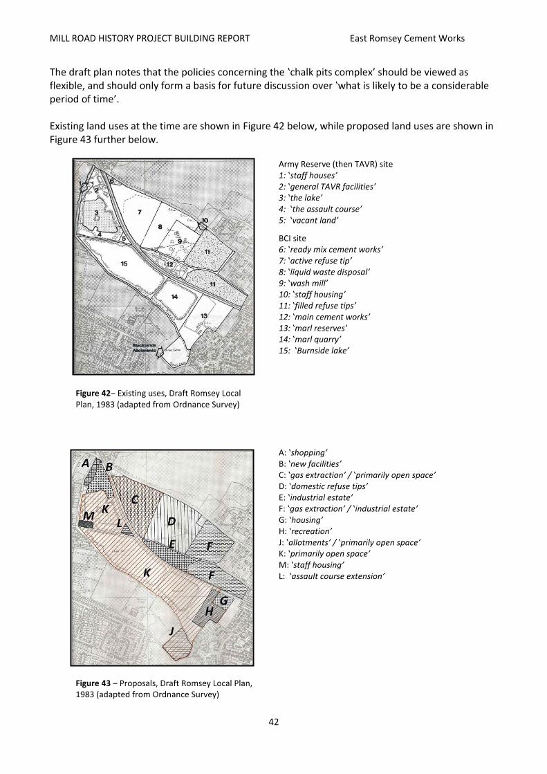
MILL ROAD HISTORY PROJECT BUILDING REPORT East Romsey Cement Works
42
The draft plan notes that the policies concerning the ‛chalk pits complex’ should be viewed as flexible, and should only form a basis for future discussion over ‛what is likely to be a considerable period of time’. Existing land uses at the time are shown in Figure 42 below, while proposed land uses are shown in Figure 43 further below.
Figure 42‒ Existing uses, Draft Romsey Local Plan, 1983 (adapted from Ordnance Survey)
Army Reserve (then TAVR) site 1: ‛staff houses’ 2: ‛general TAVR facilities’ 3: ‛the lake’ 4: ‛the assault course’ 5: ‛vacant land’
BCI site 6: ‛ready mix cement works’ 7: ‛active refuse tip’ 8: ‛liquid waste disposal’ 9: ‛wash mill’ 10: ‛staff housing’ 11: ‛filled refuse tips’ 12: ‛main cement works’ 13: ‛marl reserves’ 14: ‛marl quarry’ 15: ‛Burnside lake’
Figure 43 ‒ Proposals, Draft Romsey Local Plan, 1983 (adapted from Ordnance Survey)
A: ‛shopping’ B: ‛new facilities’ C: ‛gas extraction’ / ‛primarily open space’ D: ‛domestic refuse tips’ E: ‛industrial estate’ F: ‛gas extraction’ / ‛industrial estate’ G: ‛housing’ H: ‛recreation’ J: ‛allotments’ / ‛primarily open space’ K: ‛primarily open space’ M: ‛staff housing’ L: ‛assault course extension’

MILL ROAD HISTORY PROJECT BUILDING REPORT East Romsey Cement Works
43
From the text of the draft plan the impression can be gained that Blue Circle essentially wished to be left alone to wind down its business according to its own schedule. It is likely that by 1983 the decreasing profitability and feasibility of the Norman Works was generally acknowledged: there was little marl left to quarry south of the railway; transporting marl from elsewhere would be costly; the plant was becoming increasingly outdated; housing development was hemming it in; public and political opinion was becoming more critical of its impact on the neighbourhood; the number of employed was decreasing. Nonetheless, it seems that re-development of the area was not a priority, and considerable leeway was given to options for Blue Circle’s maximised use of the area until it was finally wound down. Other points of particular interest are:
Peterhouse’s plans for its land which comprised part of the un-quarried marl reserve. In Figure 43 above, ‛G’ indicates the area Peterhouse was proposing for housing, to be accessed, presumably, via Chelwood Road. This development has subsequently taken place, to form the Haystor Drive/Harcombe Road residential area. However, the area identified as ‛H’ was proposed for recreation. This is now where the Spinney School is located, along with some recreation land. The wooded area – later to become the ‛Spinney/Hayster Protected Open Space’ in the 2006 Local Plan – was left un-zoned.
The newly-built Sainsbury’s supermarket (on the old Atlas site) was expected to need land for expansion, and the only land available was on part of the Army Reserve centre (the old Saxon site) across Cherry Hinton Brook. The assumption is that the need was for extra parking space, which was subsequently developed, leaving the brook and the footpath somewhat beleaguered.
The Army Reserve, or TAVR as it was called in the draft plan, wanted to re-develop its base. The mainly one-storey sheds were to be replaced by more substantial buildings, and the small row of semi-detached houses lying alongside the brook were to go. The training assault course, largely on the south side of the Army Reserve lake, was to expand into the triangle-shaped piece of land between the Tins and the railway. This also never occurred, and the land is currently a litter-strewn thicket.
The ‛Staff housing’ identified at ‛M’ on the map above must reflect land use which is evident on O/S maps from 1950 to, at the latest, 1991, where a block, presumably of housing, is shown. It is probable that this was housing associated with the Army Reserve centre, though this has not been confirmed. Currently, the site is occupied by an Army Reserve shed.
Peterhouse, the current or former owners of the Blacklands allotments, wished to re-develop the whole site for housing. The City Council recognised the high demand for allotments and threw cold water on the proposal.
The actual site of the Norman Works is zoned for light industrial or warehousing use. The site, nonetheless, was developed for the Holiday Inn hotel and the David Lloyd gym. How this change of use was negotiated is not known.
The Romsey Local Plan (July 1986) By the time the 1986 Plan was officially approved, the Norman Works had finally closed down, in 1984, and consequently parts of the Plan address the future of the site and the pits (filled-in, inundated or otherwise) which were now available for re-development. Concerning the ‛chalk pits’ in particular: ‛the

MILL ROAD HISTORY PROJECT BUILDING REPORT East Romsey Cement Works
44
changes which will occur in this area will be controlled so as to achieve the maximum benefit, especially in the field of recreation’. The Plan goes on to identify important factors of the pits area:
the area is a ‛vital part of the open space setting of east Cambridge’;
there is a ‛variety of physical features which provide important visual contrasts and natural habitats’;
Cherry Hinton Brook and most of the rest of the area are sites of Natural History Interest. The Plan also stated that, concerning the area earlier covered by the Norman Works and its pits, that the most important area lies south of the railway (probably a reflection of the use of the northern pits for waste disposal). Policies included in the Plan that directly concerned the old works site and the pits are summarised as follows:
Policy 60: the open space setting will be retained by restricting future development;
Policy 77: current environmental qualities are to be retained, where possible, by (a) restricting development and (b) conserving wildlife interest;
Policy 85: the use of the disused pits for waste disposal will not normally be permitted;
Policy 87: through-routes for pedestrians and cyclists is to be encouraged. It is acknowledged that Snakey Path is too narrow to effectively accommodate both pedestrians and cyclists. The long-term objective is to have a second walkway along the north side of the brook;
Policy 88: tree planting and landscape improvement will be undertaken in conjunction with land owners;
Also, some housing is proposed on the small piece of land where the Tins meets Brookfields. Also stated was that if the pits south of the railway are left unfilled they should be used for ‛quiet boating, diving, fishing, conservation’ and wildlife enhancement. It appears that it was the Council’s policy of now discouraging waste disposal that led to the pits south of the railway becoming lakes. Concerning vehicle access to the development and conservation sites, the Council should enter into negotiations with Blue Circle and Peterhouse College (being the main landowners). Concerning other areas in the vicinity:
Policy 78: development by Sainsbury's on the TAVR (Army Reserve) side of Cherry Hinton Brook is supported in principle (referring to the extended car park);
Policy 79: development of the TAVR site for housing, general facilities and an assault course will be permitted;
Policy 80: the recovery of methane gas from the active refuse pits will be permitted, though if there is no such recovery development for industry will be encouraged;
Policy 81: this is similar to Policy 80, though here stating that if there is no recovery of methane the pits should be used for open space or agriculture;
Policy 82: redevelopment of the ‛main works site’ should be for industrial uses;
Policy 83: ‛the use of liquid waste and wash mill sites for refuse tipping will normally be permitted’.

MILL ROAD HISTORY PROJECT BUILDING REPORT East Romsey Cement Works
45
Figure 44 ‒ Location of the policies outlined above (author)
A generalised interpretation of the 1986 Local Plan is that the area impacted by the Norman Works is to be divided – the land and pits south of the railway will be earmarked for recreation and conservation, while that to the north of the railway is earmarked mainly for a mix of industry, housing (Army Reserve site), waste disposal and the recovery of methane gas – originally intended to diversify (and cheapen) fuel consumption for the Norman Works. This 1986 plan mirrors the 1984 draft in most aspects – the main difference being the absence of housing on the Blacklands allotments proposed by Peterhouse, which the draft was minded to refuse. The End of Operations at the Norman Works As described in BPCM, ACPM, Blue Circle and Lafarge above, APCM’s profits were low in the mid-1970s. However, by the 1980s profits were back up again, and the company, by 1978 called Blue Circle, embarked upon a programme of modernising its works. It has not been determined whether the Norman Works was part of this programme, yet it can be supposed that by that time the works had been earmarked for closure. In the meantime, however, operating costs would have to be kept to the minimum. In 1981 the Cambridge Evening News (CEN) reported that the Works was exploring the possibility of using methane gas, obtained from the waste-filled pits, to part-fuel its kiln (this possibility was reflected in the 1986 Romsey Local Plan), and indeed, by 1983 10% of kiln C1’s fuel was landfill gas. In August 1983 the CEN reported a resurgence in complaints from local residents over dust, yet the public health inspector stated that it was within the permitted limits. It can, nonetheless, be assumed that, based on the history of local concern over dust and noise pollution, a good deal of local political opposition to the Works had built up. This, taken with the Work’s relatively low economic viability, may have only encouraged Blue Circle to cease operations. The CEN reported in June 1984 that Blue Circle was engaged in a programme to find alternative jobs for those probably to be made unemployed. It was stated that there was a staff of 91:- 57 process workers, 10 drivers, and 24 administrative personnel. Marshall's made a commitment to offer employment to a fifth of these. Though manufacturing at the Works ceased in 1984, resulting in 91 redundancies, the site was still used for grinding, storage and distribution, employing 22. There was some opposition to closure, though negotiation was fruitless and on 24 January 1987, the CEN stated that there was official Notice of Closure, as part of the general Blue Circle modernisation programme. As Richard Attwood, manager

MILL ROAD HISTORY PROJECT BUILDING REPORT East Romsey Cement Works
46
of the site at the time stated, ‛there is a typical East Anglian reaction here. They seem to have resigned themselves to it’. In January 1988 CEN reported that the City Council Planning Department (the City Council having taken on responsibility for planning) had commenced assessment of potential new uses for the area: a mix of education, water sports and camping. In February 1988 CEN described the demolition of the 150ft chimney, which had been part of the 1948 modernisation. ‛One of area's best known landmarks’, CEN stated, and there were crowds of people to witness the event, causing some local traffic chaos. Proximity to the airport was one of the stated reasons for demolition. The two photographs below show the Works as it was in 1987. Figure 45 shows it from Burnside across the ‘middle’ lake. Note the chalk ‘escarpments’ at the side of the lake, which have by 2014 become far more overgrown. Figure 46 shows what must have been an everyday sight to travellers along the Tins –approaching from the east these silos would have risen up somewhat like the towers of a medieval castle. Further below are two photographs of the demolition of the 150ft chimney in 1988. The presence of a policeman on then Tins indicates the need to control interested onlookers.
Figure 45 ‒ A 1987 view of the disused Norman Works
from Burnside (CC)
Figure 46 ‒ The Norman Works silos seen from
the Tins footpath in 1987 (CC)
Figure 47 ‒ The Norman
Works’ 150ft chimney (CC)
Figure 48 ‒ View from the Tins of the demolition of the chimney. About to
go. (CC)
Figure 49 ‒ Demolition of the chimney.
Gone. (CC)

MILL ROAD HISTORY PROJECT BUILDING REPORT East Romsey Cement Works
47
Post-1980s. Re-Development and/or Conservation
The Brookfields Area in 1991 and 2002
Figure 50 ‒ 1991 Ordnance Survey map of the Brookfields
area (Ordnance Survey / AGB Environmental Ltd).
Figure 51 ‒ 2002 Ordnance Survey map of the Brookfields
area (Ordnance Survey / AGB Environmental Ltd).
By 1991 (Figure 50) the Brookfields area was much as it had been in 1984. However, now the Norman Works had been demolished and the site cleared. No re-development has yet taken place. Excavation for marl had continued through the 1970s, and probably the early 1980s, on the land lying between Cherry Hinton Brook and the railway, as had been sanctioned in the 1956 Cambridge Plan and subsequent local development plans. The southeastern-most pit (directly north of St Bede’s Crescent) had been excavated, being the last pit the Works quarried. Both of the pits south of the railway have become flooded to form, along with the inundated old Saxon Works pit (now the Army Reserve lake), the three Brookfields lakes. Of the pits lying between the railway and Coldham’s Lane, the one lying directly north of the Tins footbridge over the railway appears to be still receiving waste material, while the old ‛wash mill’ pit has been cleared of its tanks and conveyor equipment. The Norman Works has completely gone, with only the access road remaining. The small terrace of two houses fronting onto Coldham’s Lane by the ‛wash mill’ area is still in place. The Army Reserve site has been re-developed, and the row of houses lining the brook that were assumedly part of the Army Reserve complex has now been demolished for the expansion of Sainsbury’s car park. The Tiverton Way estate has been expanded with the Budleigh Close housing, and the Doggett Road area of Cherry Hinton has expanded west towards the ‛east’ lake, along with the Spinney Primary School. By 2002 (Figure 51) the picture remained much the same. The remaining smaller building near the ‛wash mill’ has gone, as has the small terrace on Coldham’s Lane (possibly Saxon House and Portland House, where cement workers Arthur Hayes and Charles Thurgood lived in 1920). The alignment of the Tins footpath appears to be a bit vague in 2002. St Bede’s has expanded.
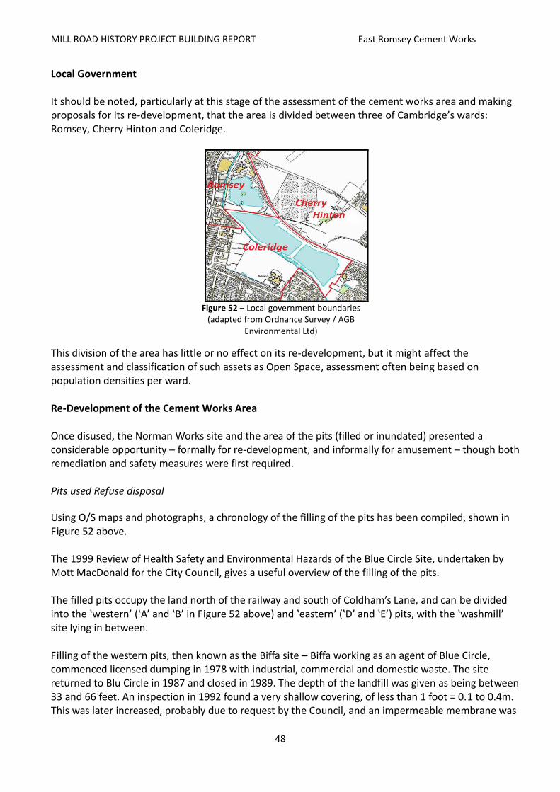
MILL ROAD HISTORY PROJECT BUILDING REPORT East Romsey Cement Works
48
Local Government It should be noted, particularly at this stage of the assessment of the cement works area and making proposals for its re-development, that the area is divided between three of Cambridge’s wards: Romsey, Cherry Hinton and Coleridge.
Figure 52 ‒ Local government boundaries
(adapted from Ordnance Survey / AGB Environmental Ltd)
This division of the area has little or no effect on its re-development, but it might affect the assessment and classification of such assets as Open Space, assessment often being based on population densities per ward. Re-Development of the Cement Works Area Once disused, the Norman Works site and the area of the pits (filled or inundated) presented a considerable opportunity – formally for re-development, and informally for amusement – though both remediation and safety measures were first required. Pits used Refuse disposal
Using O/S maps and photographs, a chronology of the filling of the pits has been compiled, shown in Figure 52 above. The 1999 Review of Health Safety and Environmental Hazards of the Blue Circle Site, undertaken by Mott MacDonald for the City Council, gives a useful overview of the filling of the pits. The filled pits occupy the land north of the railway and south of Coldham’s Lane, and can be divided into the ‛western’ (‛A’ and ‛B’ in Figure 52 above) and ‛eastern’ (‛D’ and ‛E’) pits, with the ‛washmill’ site lying in between. Filling of the western pits, then known as the Biffa site – Biffa working as an agent of Blue Circle, commenced licensed dumping in 1978 with industrial, commercial and domestic waste. The site returned to Blu Circle in 1987 and closed in 1989. The depth of the landfill was given as being between 33 and 66 feet. An inspection in 1992 found a very shallow covering, of less than 1 foot = 0.1 to 0.4m. This was later increased, probably due to request by the Council, and an impermeable membrane was
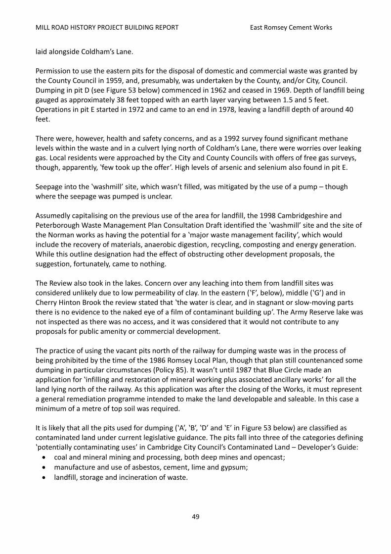
MILL ROAD HISTORY PROJECT BUILDING REPORT East Romsey Cement Works
49
laid alongside Coldham’s Lane. Permission to use the eastern pits for the disposal of domestic and commercial waste was granted by the County Council in 1959, and, presumably, was undertaken by the County, and/or City, Council. Dumping in pit D (see Figure 53 below) commenced in 1962 and ceased in 1969. Depth of landfill being gauged as approximately 38 feet topped with an earth layer varying between 1.5 and 5 feet. Operations in pit E started in 1972 and came to an end in 1978, leaving a landfill depth of around 40 feet. There were, however, health and safety concerns, and as a 1992 survey found significant methane levels within the waste and in a culvert lying north of Coldham’s Lane, there were worries over leaking gas. Local residents were approached by the City and County Councils with offers of free gas surveys, though, apparently, ‛few took up the offer’. High levels of arsenic and selenium also found in pit E. Seepage into the ‛washmill’ site, which wasn’t filled, was mitigated by the use of a pump – though where the seepage was pumped is unclear. Assumedly capitalising on the previous use of the area for landfill, the 1998 Cambridgeshire and Peterborough Waste Management Plan Consultation Draft identified the ‛washmill’ site and the site of the Norman works as having the potential for a ‛major waste management facility’, which would include the recovery of materials, anaerobic digestion, recycling, composting and energy generation. While this outline designation had the effect of obstructing other development proposals, the suggestion, fortunately, came to nothing. The Review also took in the lakes. Concern over any leaching into them from landfill sites was considered unlikely due to low permeability of clay. In the eastern (‛F’, below), middle (‛G’) and in Cherry Hinton Brook the review stated that ‛the water is clear, and in stagnant or slow-moving parts there is no evidence to the naked eye of a film of contaminant building up’. The Army Reserve lake was not inspected as there was no access, and it was considered that it would not contribute to any proposals for public amenity or commercial development. The practice of using the vacant pits north of the railway for dumping waste was in the process of being prohibited by the time of the 1986 Romsey Local Plan, though that plan still countenanced some dumping in particular circumstances (Policy 85). It wasn’t until 1987 that Blue Circle made an application for ‛infilling and restoration of mineral working plus associated ancillary works’ for all the land lying north of the railway. As this application was after the closing of the Works, it must represent a general remediation programme intended to make the land developable and saleable. In this case a minimum of a metre of top soil was required. It is likely that all the pits used for dumping (‛A’, ‛B’, ‛D’ and ‛E’ in Figure 53 below) are classified as contaminated land under current legislative guidance. The pits fall into three of the categories defining ‛potentially contaminating uses’ in Cambridge City Council’s Contaminated Land – Developer’s Guide:
coal and mineral mining and processing, both deep mines and opencast;
manufacture and use of asbestos, cement, lime and gypsum;
landfill, storage and incineration of waste.
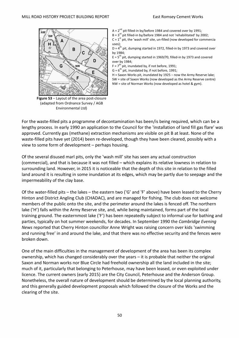
MILL ROAD HISTORY PROJECT BUILDING REPORT East Romsey Cement Works
50
Figure 53 ‒ Layout of the area post-closure
(adapted from Ordnance Survey / AGB Environmental Ltd)
A = 2nd
pit filled-in by/before 1984 and covered over by 1991; B = 3
rd pit filled-in by/before 1984 and not ‛rehabilitated’ by 2002;
C = 1st
pit, the ‛wash mill’ site, un-filled (now developed for commercial uses); D = 4
th pit, dumping started in 1972, filled-in by 1973 and covered over
by 1984; E = 5
th pit, dumping started in 1969/70, filled-in by 1973 and covered
over by 1984; F = 7
th pit, inundated by, if not before, 1991;
G = 6th
pit, inundated by, if not before, 1991; H = Saxon Works pit, inundated by 1925 – now the Army Reserve lake; SW = site of Saxon Works (now developed as the Army Reserve centre); NW = site of Norman Works (now developed as hotel & gym).
For the waste-filled pits a programme of decontamination has been/is being required, which can be a lengthy process. In early 1990 an application to the Council for the ‛installation of land fill gas flare’ was approved. Currently gas (methane) extraction mechanisms are visible on pit B at least. None of the waste-filled pits have yet (2014) been re-developed, though they have been cleared, possibly with a view to some form of development – perhaps housing. Of the several disused marl pits, only the ‛wash mill’ site has seen any actual construction (commercial), and that is because it was not filled – which explains its relative lowness in relation to surrounding land. However, in 2015 it is noticeable that the depth of this site in relation to the filled land around it is resulting in some inundation at its edges, which may be partly due to seepage and the impermeability of the clay base. Of the water-filled pits – the lakes – the eastern two (‛G’ and ‛F’ above) have been leased to the Cherry Hinton and District Angling Club (CHADAC), and are managed for fishing. The club does not welcome members of the public onto the site, and the perimeter around the lakes is fenced off. The northern lake (‛H’) falls within the Army Reserve site, and, while being maintained, forms part of the local training ground. The easternmost lake (‛F’) has been repeatedly subject to informal use for bathing and parties, typically on hot summer weekends, for decades. In September 1990 the Cambridge Evening News reported that Cherry Hinton councillor Anne Wright was raising concern over kids ‛swimming and running free’ in and around the lake, and that there was no effective security and the fences were broken down. One of the main difficulties in the management of development of the area has been its complex ownership, which has changed considerably over the years – it is probable that neither the original Saxon and Norman works nor Blue Circle had freehold ownership all the land included in the site; much of it, particularly that belonging to Peterhouse, may have been leased, or even exploited under licence. The current owners (early 2015) are the City Council, Peterhouse and the Anderson Group. Nonetheless, the overall nature of development should be determined by the local planning authority, and this generally guided development proposals which followed the closure of the Works and the clearing of the site.
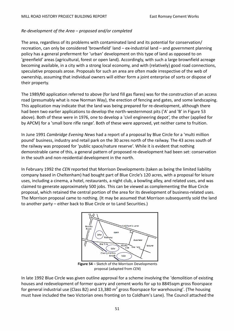
MILL ROAD HISTORY PROJECT BUILDING REPORT East Romsey Cement Works
51
Re-development of the Area – proposed and/or completed
The area, regardless of its problems with contaminated land and its potential for conservation/ recreation, can only be considered ‛brownfield’ land – ex-industrial land – and government planning policy has a general preferment for ‛urban’ development on this type of land as opposed to on ‛greenfield’ areas (agricultural, forest or open land). Accordingly, with such a large brownfield acreage becoming available, in a city with a strong local economy, and with (relatively) good road connections, speculative proposals arose. Proposals for such an area are often made irrespective of the web of ownership, assuming that individual owners will either form a joint enterprise of sorts or dispose of their property. The 1989/90 application referred to above (for land fill gas flares) was for the construction of an access road (presumably what is now Norman Way), the erection of fencing and gates, and some landscaping. This application may indicate that the land was being prepared for re-development, although there had been two earlier applications to develop the north-westernmost pits (‛A’ and ‛B’ in Figure 53 above). Both of these were in 1976, one to develop a ‛civil engineering depot’, the other (applied for by APCM) for a ‛small bore rifle range’. Both of these were approved, yet neither came to fruition. In June 1991 Cambridge Evening News had a report of a proposal by Blue Circle for a ‛multi million pound’ business, industry and retail park on the 30 acres north of the railway. The 43 acres south of the railway was proposed for ‛public space/nature reserve’. While it is evident that nothing demonstrable came of this, a general pattern of proposed re-development had been set: conservation in the south and non-residential development in the north. In February 1992 the CEN reported that Morrison Developments (taken as being the limited liability company based in Cheltenham) had bought part of Blue Circle’s 120 acres, with a proposal for leisure uses, including a cinema, a hotel, restaurants, a night club, a bowling alley, and related uses, and was claimed to generate approximately 500 jobs. This can be viewed as complementing the Blue Circle proposal, which retained the central portion of the area for its development of business-related uses. The Morrison proposal came to nothing. (It may be assumed that Morrison subsequently sold the land to another party – either back to Blue Circle or to Land Securities.)
Figure 54 ‒ Sketch of the Morrison Developments
proposal (adapted from CEN)
In late 1992 Blue Circle was given outline approval for a scheme involving the ‛demolition of existing houses and redevelopment of former quarry and cement works for up to 8845sqm gross floorspace for general industrial use (Class B2) and 13,380 m2 gross floorspace for warehousing’. (The housing must have included the two Victorian ones fronting on to Coldham’s Lane). The Council attached the

MILL ROAD HISTORY PROJECT BUILDING REPORT East Romsey Cement Works
52
condition that all construction must maintain a low height, reflecting the airport’s flight path, and to include ‛appropriate nature conservation measures’ such as a 20-metre-wide ‛green corridor’ along its southern edge. However, by September 1993 the CEN reported that Blue Circle’s scheme had changed and that its plans for the area now focused on leisure (bowling alley, cinema, restaurant, shops), a proposal similar to Morrison’s. These new proposals led to a local public meeting being convened at which great concern was expressed over the volume of traffic it would produce (two-lane Coldham’s Lane being the only access). Whether or not related to these concerns, plans were subsequently scaled down in January, and then completely changed again, to light industrial use. It appears evident that little or no progress was achieved with these plans between 1993 and 1997, as in March that year the CEN reported that Blue Circle had lodged an appeal against the County Council’s decision to deem development proposals for the former Works’ site as ‛dormant’ (the County Council having responsibility for establishing the strategic planning parameters for the whole county which should be mirrored by the City Council’s plans). The rationale behind the appeal was to give Blue Circle flexibility: having the site acknowledged as ‛live’ meant that development proposals could still be generated and altered. However, after the clearing of the Norman Works site, or possibly before, it is reasonable to assume that Blue Circle entered into negotiations with development companies over the disposal of the land. Cambridge News reported that Land Securities purchased the area in April 2002, presumably from Blue Circle, and later submitted an application to the Council in 2003 for the ‛construction of a footpath and cycleway’ at Norman Way – seemingly an up-grading of the Tins. It may be that Land Securities had sub-divided the area for different developers, such as the Coldham’s Lane Business Park on the ‛wash mill’ site, and on the actual factory site: David Lloyd Leisure (at that time Next Generation) with eight indoor tennis courts and four outdoor courts, three squash courts and four badminton courts, an indoor swimming pool, gym and aerobic and yoga studios (the Next Generation chain was created by former British tennis player David Lloyd); and the 100-room Holiday Inn Express on the actual factory site, developed by BDL Hotels in 2003 and opened in 2004, with, as Cambridge News reported it, a ‛wildlife zone’ surrounding it. The Coldham’s Lane Business Park, occupying the ‛wash mill’ area and accessed by the new Norman Way, was developed at much the same time, and a number of businesses were established: Mitchell & Butler’s Retail (pub and restaurant management); Sweatshop (sports equipment); Millennium Investments (wholesale food); Booker (wholesale food); Pulsar Light (illumination); Bike Sense (motorcycles); Creative Education Corporation (primary education, now out of business); Windhorse Trading (ethical gifts). Inspection in early 2015 shows that there appears to have been some change over the last few years, with only Booker, Pulsar and Windhorse occupying the site (Windhorse closed for business in mid 2015). Lexus and Toyota have showrooms on Coldham’s Lane at the top of Norman Way (more or less on the site of the cottages possibly occupied by ‛cement workers’ Arthur Hayes and Arthur Morley), and there is now also a servicing workshop for cars and commercial vehicles. At some point, probably in the late 2000s or early 2010s, Land Securities either sold or entered into a partnership over the remainder of the area – essentially the contaminated and less-developable filled-
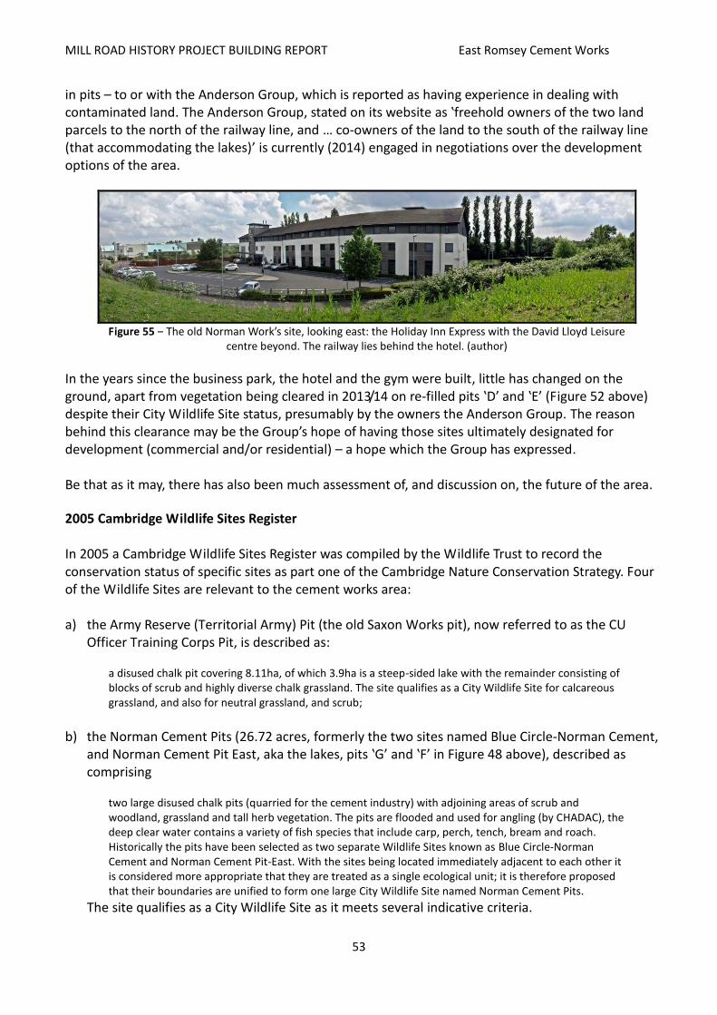
MILL ROAD HISTORY PROJECT BUILDING REPORT East Romsey Cement Works
53
in pits – to or with the Anderson Group, which is reported as having experience in dealing with contaminated land. The Anderson Group, stated on its website as ‛freehold owners of the two land parcels to the north of the railway line, and … co-owners of the land to the south of the railway line (that accommodating the lakes)’ is currently (2014) engaged in negotiations over the development options of the area.
Figure 55 ‒ The old Norman Work’s site, looking east: the Holiday Inn Express with the David Lloyd Leisure
centre beyond. The railway lies behind the hotel. (author)
In the years since the business park, the hotel and the gym were built, little has changed on the ground, apart from vegetation being cleared in 2013/14 on re-filled pits ‛D’ and ‛E’ (Figure 52 above) despite their City Wildlife Site status, presumably by the owners the Anderson Group. The reason behind this clearance may be the Group’s hope of having those sites ultimately designated for development (commercial and/or residential) – a hope which the Group has expressed. Be that as it may, there has also been much assessment of, and discussion on, the future of the area.
2005 Cambridge Wildlife Sites Register In 2005 a Cambridge Wildlife Sites Register was compiled by the Wildlife Trust to record the conservation status of specific sites as part one of the Cambridge Nature Conservation Strategy. Four of the Wildlife Sites are relevant to the cement works area: a) the Army Reserve (Territorial Army) Pit (the old Saxon Works pit), now referred to as the CU
Officer Training Corps Pit, is described as: a disused chalk pit covering 8.11ha, of which 3.9ha is a steep-sided lake with the remainder consisting of blocks of scrub and highly diverse chalk grassland. The site qualifies as a City Wildlife Site for calcareous grassland, and also for neutral grassland, and scrub;
b) the Norman Cement Pits (26.72 acres, formerly the two sites named Blue Circle-Norman Cement,
and Norman Cement Pit East, aka the lakes, pits ‛G’ and ‛F’ in Figure 48 above), described as comprising
two large disused chalk pits (quarried for the cement industry) with adjoining areas of scrub and woodland, grassland and tall herb vegetation. The pits are flooded and used for angling (by CHADAC), the deep clear water contains a variety of fish species that include carp, perch, tench, bream and roach. Historically the pits have been selected as two separate Wildlife Sites known as Blue Circle-Norman Cement and Norman Cement Pit-East. With the sites being located immediately adjacent to each other it is considered more appropriate that they are treated as a single ecological unit; it is therefore proposed that their boundaries are unified to form one large City Wildlife Site named Norman Cement Pits.
The site qualifies as a City Wildlife Site as it meets several indicative criteria.
MILL ROAD HISTORY PROJECT BUILDING REPORT East Romsey Cement Works
54
c) the Coldham’s Lane Old Landfill Sites (formerly known as three sites – Blue Circle Old Landfill
(11.59 acres), Blue Circle Oldest Landfill (8.86 acres), and Coldham’s Lane Hedgerow). The 8.91-hectare City Wildlife Site is described as:
two old landfill sites that now form a green space comprising largely scrub, poor semi-improved grassland together with tall ruderal vegetation. With the sites being located immediately adjacent to each other it is considered more appropriate that they are treated as a single ecological unit; it is therefore proposed that their boundaries are unified to form one large City Wildlife Site named Coldham’s Lane Old Landfill Sites. A third site, formerly known as Coldham’s Lane Hedgerow, which adjoins the northern perimeter of Blue Circle Old Landfill, has also been incorporated into the new site boundary. This site qualifies as a City Wildlife Site for scrub with a strong diversity of woody scrub indicator species present in significant numbers. It qualifies … for hedgerows. It further qualifies … as a habitat mosaic; a site over 1ha in size with a mix of scrub, semi-improved grassland and ruderal communities and which by virtue of its ‛position in an ecological unit’, ‛human value’ in the form of use for recreation by children and dog walkers, and ‛potential value’, is judged to score highly against the supplementary criteria.
d) the Spinney and Hayster Open Space. This land, lying at the southeast corner of the ‛lakes’ area and next to the Spinney School, was never excavated and therefore is not exactly part of the cement pits system, but it is directly adjacent to the lakes and is included in proposals for the area. The Spinney was formerly eligible as a County Wildlife Site as it had a high index of ecological continuity. However, due to changes in the index of ecological continuity it no longer qualified. Nonetheless, having at least four mature pollard trees, the site does qualify as a City Wildlife Site.
While the grasslands are not of City Wildlife Site status in their own right, they form important supplementary habitat to the Spinney…. It is therefore proposed that a new City Wildlife Site be created to include the Spinney and associated semi-natural grasslands, tall herb vegetation and scrub. This larger site qualifies under the Habitat Mosaic criteria, as a site over one hectare in extent with two or more of the appropriate habitats (woodland, scrub, mature trees, semi-improved grassland and tall ruderal communities) and which is judged to score highly against the supplementary criteria.
The Register deleted two sites in the cement works area that had previously been identified as having nature conservation importance – the Railway reserve running between the pits, and the ‛Blue Circle Chalk Pit’ – the ‛wash mill’ site, subsequently zoned as a ‛protected industrial site’. 2006 Cambridge Local Plan The 2006 Cambridge Local Plan, addressing development in the east of the city, introduced an ‛area of major change’ for the Cambridge Airport land. At that time, and indeed from at least 2000 and up until around 2008, there was a strong assumption that Marshall (the airport owner) was considering a relocation to a more favourable and less hemmed-in site. This would release a large swathe of land directly adjacent to the city available for development – potentially 4,660 dwellings. Yet, this ‛area of major change’ did not extend south to include the vacant land lying between Coldham’s Lane and the railway – filled-in pits ‛A’, ‛B’ and ‛D’ in Figure 48 above – the more complex ownership and land contamination may have made it less able to be integrated. In the Local Plan much of the old Norman and Saxon works site was zoned as City Wildlife Sites – a classification that does not have statutory authority, meaning that it can be invalidated or altered as

MILL ROAD HISTORY PROJECT BUILDING REPORT East Romsey Cement Works
55
may be later considered necessary. Cambridgeshire County Council (which designated ‛County Wildlife Sites’, defines the sites as
areas of local importance for nature conservation that complement nationally and internationally designated geological and wildlife sites. Designating these areas as Local Sites raises awareness of their nature conservation importance to owners, planners and conservation bodies, to help preserve them for future generations to enjoy.
The sites’ eligibility for designation was based on their meeting several flora and fauna criteria, which, through revision, can vary over time. Concerning the zoning: A) the three lakes were obviously included in this classification, yet so were the two ‛old landfill sites’
(A3) which had been filled, assumedly rendering them contaminated; and it may have been this consideration that, negatively, made them un-developable, and, positively, left them open to natural regeneration;
B) ‛protected industrial site’ on the old ‛wash mill’ site. It has subsequently not been developed for industrial use but for wholesale and warehousing uses;
C) the preferred use of this land was not identified, leaving it open to question, though the passing of the ‛public safety zone’ (intended to control the development in the airport’s landing approach/taking off path) through the western part may have inhibited its potential;
D) the outline proposals for the Cambridge Airport ‛area of major change’, which included generous provision of open space, seemingly impacted ideas for uses south of Coldham’s Lane – such as the city wildlife sites;
E) the Spinney/Hayster area, surrounding the school, effectively became buffer zone to the more protected Lakes.
As regards general policy (3/9), the plan recognises that, among other watercourses and water bodies: the water-filled pits south of Coldham's Lane … are important to the character and form of the City. They are rich in wildlife and offer important opportunities for leisure and recreation as well as providing a drainage function. It is important that any development proposed alongside these watercourses or that use the watercourses protects and, where possible, enhances this vital resource. [As such,] development will be permitted if it is demonstrated that it would: a. complement and enhance the waterside setting; b. maintain or improve public access to and along the waterside; c. maintain and enhance the biodiversity of the watercourses and other bodies of water and their margins; and d. in the case of recreational development, there is sufficient capacity to accommodate additional usage of the waterway arising from the development.

MILL ROAD HISTORY PROJECT BUILDING REPORT East Romsey Cement Works
56
Figure 56 ‒ The 2009 iteration of the 2006 Local
Plan (adapted from Ordnance Survey / AGB Environmental Ltd )
A1: the Territorial Army (Army Reserve) pit City Wildlife Site. A2: the ‛Norman Cement’ City Wildlife Site.
A3: the ‛Coldham’s Lane Old Landfill Sites’ City Wildlife Site.
B: Protected Industrial Site.
C: not zoned. D: Cambridge Airport ‛Area of Major Change’
E: the Spinney / Hayster Protected Open Space.
___: Public Safety Zone
In 2009 the Secretary of State for Communities and Local Government deleted several policies from the 2006 Local Plan, referred to as ‛saved’ policies coming from previous local plans, which were deemed as not reflecting current government policy. The result was that there was a 2009 iteration of the Local Plan that differed in several ways to the 2006 version, and this had some effect on the cement pits site as can be seen in ‛Nature Conservation Strategy, 2006’ below. Nature Conservation Strategy, 2006 Building on the 2005 Register, the 2006 Nature Conservation Strategy was prepared by the Wildlife Trusts for the City Council as a Supplementary Planning Document to the 2006 Local Plan. In its Summary of Existing Resource the strategy noted that
brownfield sites, though rarely undeveloped for long in Cambridge, can develop into valuable wildlife habitats. The Coldham’s Lane Old Landfill sites and the former Norman Cement Works site are examples of brownfield sites that have developed considerable wildlife interest.
It is noticeable that in the 2009 iteration of the Local Plan (Figure 51 above) the Spinney/Hayster Open Space is labelled as ‛Protected Open Space’ whereas in the Nature Conservation Strategy it is recorded as a City Wildlife Site. Its current (2015) status is uncertain. The Norman Cement Pits (the Lakes) along with the Spinney and Hayster Open Space were also identified as ‛potential new nature reserves’ possibly being declared so after 2011 – changing their status from ‛local’ to statutory. Furthermore, the Norman Cement Pits, the CU Officer Training Corps Pit, the Spinney/Hayster land and the Coldham’s Lane Old Landfill Sites were classified as ‛designated nature conservation sites’. The filled-in pits (‛A’ and ‛B’ in Figure 52 above) were defined as ‛natural grassland with trees and shrubs’, and therefore having the potential for conservation or perhaps open space. The area was also perceived as being a component of the indicative green corridor (from Teversham to Coldham’s Common) that was a central part of the Airport ‛Area of Major Change’.
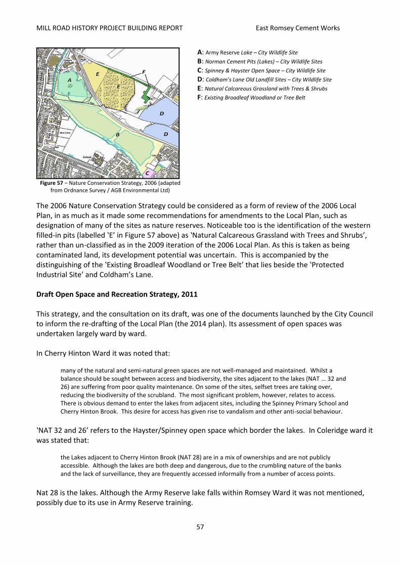
MILL ROAD HISTORY PROJECT BUILDING REPORT East Romsey Cement Works
57
Figure 57 ‒ Nature Conservation Strategy, 2006 (adapted
from Ordnance Survey / AGB Environmental Ltd)
A: Army Reserve Lake – City Wildlife Site
B: Norman Cement Pits (Lakes) – City Wildlife Sites C: Spinney & Hayster Open Space – City Wildlife Site
D: Coldham’s Lane Old Landfill Sites – City Wildlife Site E: Natural Calcareous Grassland with Trees & Shrubs
F: Existing Broadleaf Woodland or Tree Belt
The 2006 Nature Conservation Strategy could be considered as a form of review of the 2006 Local Plan, in as much as it made some recommendations for amendments to the Local Plan, such as designation of many of the sites as nature reserves. Noticeable too is the identification of the western filled-in pits (labelled ‛E’ in Figure 57 above) as ‛Natural Calcareous Grassland with Trees and Shrubs’, rather than un-classified as in the 2009 iteration of the 2006 Local Plan. As this is taken as being contaminated land, its development potential was uncertain. This is accompanied by the distinguishing of the ‛Existing Broadleaf Woodland or Tree Belt’ that lies beside the ‛Protected Industrial Site’ and Coldham’s Lane. Draft Open Space and Recreation Strategy, 2011 This strategy, and the consultation on its draft, was one of the documents launched by the City Council to inform the re-drafting of the Local Plan (the 2014 plan). Its assessment of open spaces was undertaken largely ward by ward. In Cherry Hinton Ward it was noted that:
many of the natural and semi-natural green spaces are not well-managed and maintained. Whilst a balance should be sought between access and biodiversity, the sites adjacent to the lakes (NAT … 32 and 26) are suffering from poor quality maintenance. On some of the sites, selfset trees are taking over, reducing the biodiversity of the scrubland. The most significant problem, however, relates to access. There is obvious demand to enter the lakes from adjacent sites, including the Spinney Primary School and Cherry Hinton Brook. This desire for access has given rise to vandalism and other anti-social behaviour.
‛NAT 32 and 26’ refers to the Hayster/Spinney open space which border the lakes. In Coleridge ward it was stated that:
the Lakes adjacent to Cherry Hinton Brook (NAT 28) are in a mix of ownerships and are not publicly accessible. Although the lakes are both deep and dangerous, due to the crumbling nature of the banks and the lack of surveillance, they are frequently accessed informally from a number of access points.
Nat 28 is the lakes. Although the Army Reserve lake falls within Romsey Ward it was not mentioned, possibly due to its use in Army Reserve training.

MILL ROAD HISTORY PROJECT BUILDING REPORT East Romsey Cement Works
58
Name Acreage Qualification on
environment grounds
Qualification on recreation
grounds
Overall quality
Spinney County Primary School 0.87 Yes Yes 88.00%
Former Landfill Site West of Norman Way
11.59 Yes No 35.00%
Former Landfill Site East of Norman Way 8.86 Yes No 35.71%
Lakes Adjacent to Cherry Hinton Brook 26.72 Yes Yes 44.62%
Meadow & Small Wood (Peterhouse College) - South of Hayster Drive
0.95 Yes Yes 34.00%
(Cambridge City Council: Draft Open Space and Recreation Strategy, 2011)
The strategy also identified the ‛former landfill site west of Norman Way’ (‛A’ and ‛B’ in Figure 52 above) as private and possibly being a ‛private protected open space’, and the ‛Land East of Norman Way Business Park’ (‛D’) as ‛likely to be only suitable for commercial uses’. Review of Likely Development Options It appears from all the previous studies, plans and proposals that the whole of the area of the disused cement works and its pits can be roughly divided into four parts, each seemingly with different development or conservation options.
the Coldham’s Lane Business Park along with the Holiday Inn Express and David Lloyd Leisure: The business park, hotel and gym are all commercial uses developed on uncontaminated land – there is scope for further development, though it would only be in-filling. Occupants and buildings may change, though the general use will most probably remain as it is.
the Army Reserve base (‛H’ in Figure 58 below): The same as the above is probable in this case, though a question hangs over the designation of the Army Reserve lake and its surroundings. At present the lake forms part of the general training area, and though it has been mooted for more formal conservation status, it appears that the Army Reserve wishes to keep its options open and prefers to remain detached from discussions over the rest of the area.
the lakes (‛G’ and ‛F’): The lakes, leased and maintained by CHADAC for fishing, are closed to the public. However, it can be assumed that there is little likelihood of them being drained, filled or cleared. At present (early 2015) there are proposals by local NGOs to have access to the lakes opened to the public for recreation and/or conservation.
the refuse-filled pits (‛A’, ‛B’, ‛D’ and ‛E’): A major question hangs over the future of these sites. Sites D and E are identified as ‛city wildlife sites’ in the 2006 City Plan, though this has not prevented site E from being cleared of vegetation within the last year (2014).
The lasting designation of these sites, however, has been, and is (early 2015), subject to some variation with propositions that either the northwestern (‛A’ and ‛B’) or the northeastern (‛D’, and possibly ‛E’) are opened up for development. Currently classified as contaminated land, their potential development is limited to commercial and/or industrial use, or recreation/conservation. Land remediation is both costly and time-consuming. ‛A’ and ‛B’ in particular are also affected by the airport ‘public safety zone’ restricting new building and its height. Constrained road access also limits their potential, especially site E.

MILL ROAD HISTORY PROJECT BUILDING REPORT East Romsey Cement Works
59
In March 2005 the Cambridge News reported that what was called the Blue Circle Site was not to be considered for housing by the Council’s planning committee due to ‛health concerns’.
Figure 58 ‒ Division of the area into
potential development/conservation sites (adapted from Ordnance Survey /
AGB Environmental Ltd)
Figure 59 ‒ Filled-in pit B, showing de-contamination equipment.
Coldham’s Lane runs along the right, on the other side of the hedge. The Hanson site in the distance (author)
Local Relief and Drainage Of the three lakes, the Army Reserve lake was the first to be inundated – it is shown as a lake in the 1925 Ordnance Survey Map (Figure 18 above). The other lakes, alongside Burnside and Snakey Path, became inundated in the mid- to late 1980s – the western-most lake stated as being the first, was said to act as a reservoir for the Norman Works, though why it would need a reservoir is unclear. It appears that all three pits have become inundated through natural drainage and rainfall – no regularly flowing water course leads to any of them. Summary of Local Topography The lay of the land, and thereby the drainage, in and around east Romsey Town can be difficult to discern; slopes are, at most, slight. However, there are accounts, such as that by Eglantyne Jebb in 1906 (p. 20 above), which refer to a descent from upper Mill Road to lower Mill Road, and Brookfields. Figure 53 below indicates overall topography based on Ordnance Survey contours (which can be generalised). A narrow neck of land ten metres or less below mean sea level is shown as extending approximately from the point where Mill Road becomes Brookfields to a point along the Tins – the Mill Road descent is noticeable, the Tins ascent not quite so. However, it can be seen that Cherry Hinton Brook, on its way to the Cam, passes north through this neck after rising at Giant’s Grave, a spring which lies more or less at the base of the elevation of 15 metres which represents the beginning of the Gog Magog hills. Although there are several accounts of subterranean water courses in the area, it seems probable that Giant’s Grave gathers its waters from the higher lands to the south. Cherry Hinton Brook, however, has little or no impact on the lakes – the inundated marl extraction pits which generally lie in higher ground – it runs alongside them, to their south and their west, and receives their waters when they are flooded.
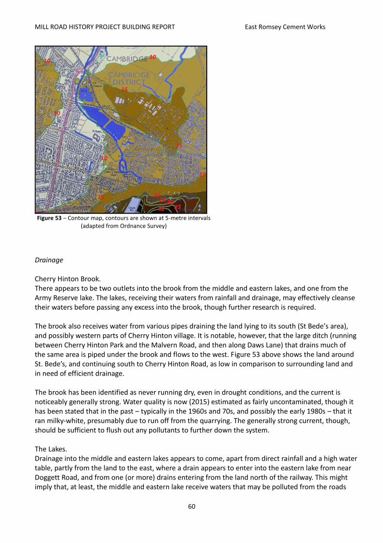
MILL ROAD HISTORY PROJECT BUILDING REPORT East Romsey Cement Works
60
Figure 53 ‒ Contour map, contours are shown at 5-metre intervals
(adapted from Ordnance Survey)
Drainage Cherry Hinton Brook. There appears to be two outlets into the brook from the middle and eastern lakes, and one from the Army Reserve lake. The lakes, receiving their waters from rainfall and drainage, may effectively cleanse their waters before passing any excess into the brook, though further research is required. The brook also receives water from various pipes draining the land lying to its south (St Bede’s area), and possibly western parts of Cherry Hinton village. It is notable, however, that the large ditch (running between Cherry Hinton Park and the Malvern Road, and then along Daws Lane) that drains much of the same area is piped under the brook and flows to the west. Figure 53 above shows the land around St. Bede’s, and continuing south to Cherry Hinton Road, as low in comparison to surrounding land and in need of efficient drainage. The brook has been identified as never running dry, even in drought conditions, and the current is noticeably generally strong. Water quality is now (2015) estimated as fairly uncontaminated, though it has been stated that in the past – typically in the 1960s and 70s, and possibly the early 1980s – that it ran milky-white, presumably due to run off from the quarrying. The generally strong current, though, should be sufficient to flush out any pollutants to further down the system. The Lakes. Drainage into the middle and eastern lakes appears to come, apart from direct rainfall and a high water table, partly from the land to the east, where a drain appears to enter into the eastern lake from near Doggett Road, and from one (or more) drains entering from the land north of the railway. This might imply that, at least, the middle and eastern lake receive waters that may be polluted from the roads

MILL ROAD HISTORY PROJECT BUILDING REPORT East Romsey Cement Works
61
and parking areas in the Norman Way Business Park. While drainage into the Army Reserve lake is unknown, the 1999 Review of Health Safety and Environmental Hazards of the Blue Circle Site (see above), in reviewing the local hydrogeology and lakes, assumed they are in ‛hydraulic continuity’ with the local aquifer, rising and falling accordingly. Local NGO Interests Three community groups with an interest in the use and development of the old cement works and pits have established themselves in recent years. In 2009 the Friends of Cherry Hinton Hall was formed, though with a remit focused more on Cherry Hinton Park and the hall rather than the brownfield lands both north and south of the railway. Also in 2009, the Friends of Cherry Hinton Brook was formed. This group commenced with a specific focus on the well-being of the brook and its immediate surroundings. However, as the brook forms the southern and western boundary of the old cement pits, and the integrity of its environmental setting is contingent on what lies, literally, on the other side of the fence, the group’s concern has expanded to take in the general development options of the lakes in particular. Thirdly, in 2011 the Cam Lakes Project was founded with the aim of having the lakes (G & F – the area lying between the railway and Cherry Hinton Brook – likely not including the Army Reserve lake) opened up as a general public recreational amenity for ‛picnicking, swimming, fishing, scuba diving, dog walking, and birdwatching’. These groups take an active interest in the planning of the old cement works and pits, though from occasionally differing standpoints. Land Ownership A major issue determining the re-development of the area has been land ownership. Judging from the pattern of current (2015) land ownership (see Figure 60 below) it may be taken that the successive owners of the Norman Works (Norman Portland Cement, BPCM, Blue Circle) owned the actual site of the works and the land north of the railway. After the closing of the works the land appears to have been subdivided, with parts being sold to other interests – Land Securities has been mentioned, though the physical, and temporal, extent of its ownership has not been determined. The land now occupied by the Army Reserve was owned by Saxon Portland Cement, then passed to BPCM. Its disposal to the Army Reserve (parent being, presumably, the Ministry of Defence) occurred sometime in the 1950s or early 1960s. While the Norman Works originally exploited its marl reserves north of the railway, it must have become apparent that further reserves would be needed, and the quality of the marl to the south must have proved suitable – to the north lay the unavailable Marshall’s land. This was possibly in the late 1950s, as O/S maps show that quarrying south of the railway had commenced by the mid-1960s. However, as can be seen in Figure 60, the pattern of land ownership is more complex. It is probable that much of the land was leased from original owners, exploited, and then returned. Quite possibly the original owners also accrued some income from royalties. This might explain the Peterhouse land; the City Council may have come to own some land through matters such as land swaps or possession through non-payment of tax, its ownership around the Spinney School must have come from

MILL ROAD HISTORY PROJECT BUILDING REPORT East Romsey Cement Works
62
Peterhouse, as the 1983 draft Romsey Plan states that that college wanted to develop that land. Some boundaries appear to be determined by the original fields, though it is the alignment of the old railway (which went along what is now Budleigh Close) that slices across.
Figure 60 ‒ Land Ownership (Anderson Group)
Orange: Army Reserve (Ministry of Defence) Blue: The Anderson Group Green: Peterhouse Pink: Cambridge City Council Yellow: alienated (various other owners) Red: other (Hanson site)
2013 Cambridge Local Plan – Issues and Options The Issues and Options Report identified and consulted on matters that the City Council should include in the drafting of the 2014 Local Plan. Of particular bearing was the ‛opportunity area’ recognised in Option 40, concerning ‛Land South of Coldham’s Lane’, where the potential for a ‛“green and blue corridor” that runs from Coldham’s Common through the two closed landfill sites and the lakes into Cherry Hinton Hall and out through the Spinney Nature Reserve’ was identified. Being labelled an ‛opportunity area’ implied that the Council was willing to open discussion on the area’s development, and responses were submitted which broadly supported the ‛green and blue corridor’ concept, though with some divergence on the uses that such a corridor should accommodate. 2014 Cambridge Local Plan Having scoped out initial ideas of what the emerging 2014 Local Plan should contain, the City Council prepared a Proposed Submission of the plan (essentially a ‛first draft’). Concerning the Chalk Pits Complex, the July 2013 Proposed Submission, building on Option 40 of the Issues and Options consultation, included the following notable variation from the 2006 Local Plan – designating all the land impacted by the old cement works as the ‛South of Coldham’s Lane Area of Major Change’. As stated on the Council’s Planning Department consultation web-site:
The Council is seeking the wider regeneration of this area with appropriate redevelopment and the creation of an urban country park to serve the east of the city…. A masterplan for the area will be developed and this will set out the principal uses, quantum of development and extent of developable land, approach to the built form, circulation and movement, public access and landscape improvements, and future management and funding arrangements for the urban country park. The masterplan and associated transport assessment will need to be developed and adopted before any planning application is submitted. There are two main parts to this area:
a. the area immediately south of Coldham’s Lane (lying north of the railway line), which will allow for appropriate commercial uses on closed landfill sites and some outdoor recreational uses; and
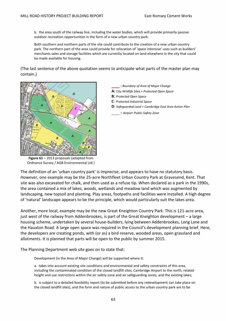
MILL ROAD HISTORY PROJECT BUILDING REPORT East Romsey Cement Works
63
b. the area south of the railway line, including the water bodies, which will provide primarily passive outdoor recreation opportunities in the form of a new urban country park.
Both southern and northern parts of the site could contribute to the creation of a new urban country park. The northern part of the area could provide for relocation of ‛space intensive’ uses such as builders’ merchants sales and storage facilities which are currently located on land elsewhere in the city that could be made available for housing.
(The last sentence of the above quotation seems to anticipate what parts of the master plan may contain.)
Figure 61 ‒ 2013 proposals (adapted from
Ordnance Survey / AGB Environmental Ltd )
___ : Boundary of Area of Major Change A: City Wildlife Sites + Protected Open Space
B: Protected Open Space
C: Protected Industrial Space
D: Safeguarded Land + Cambridge East Area Action Plan
___ : Airport Public Safety Zone
The definition of an ‛urban country park’ is imprecise, and appears to have no statutory basis. However, one example may be the 25-acre Northfleet Urban Country Park at Gravesend, Kent. That site was also excavated for chalk, and then used as a refuse tip. When declared as a park in the 1990s, the area contained a mix of lakes, woods, wetlands and meadow land which was augmented by landscaping, new topsoil and planting. Play areas, footpaths and facilities were installed. A high degree of ‛natural’ landscape appears to be the principle, which would particularly suit the lakes area. Another, more local, example may be the new Great Kneighton Country Park. This is 121-acre area, just west of the railway from Addenbrookes, is part of the Great Kneighton development – a large housing scheme, undertaken by several house-builders, lying between Addenbrookes, Long Lane and the Hauxton Road. A large open space was required in the Council’s development planning brief. Here, the developers are creating ponds, with (or as) a bird reserve, wooded areas, open grassland and allotments. It is planned that parts will be open to the public by summer 2015.
The Planning Department web site goes on to state that:
Development (in the Area of Major Change) will be supported where it:
a. takes into account existing site conditions and environmental and safety constraints of this area, including the contaminated condition of the closed landfill sites, Cambridge Airport to the north, related height and use restrictions within the air safety zone and air safeguarding zones, and the existing lakes;
b. is subject to a detailed feasibility report (to be submitted before any redevelopment can take place on the closed landfill sites), and the form and nature of public access to the urban country park are to be

MILL ROAD HISTORY PROJECT BUILDING REPORT East Romsey Cement Works
64
established;
c. includes the upgrading of existing public routes to support increased pedestrian and cycle access from the wider area;
d. is part of a masterplan for the entire area, which will provide the mechanism to deliver the required vision; and
e. recognises existing sites of local nature conservation importance within and surrounding the site, and where development is proposed, provides for appropriate ecological mitigation measures.
As can be seen, there is an emphasis on the drafting of a master plan for the area, and through subsequent meetings with the City Council it has become evident that the Anderson Group is being commissioned to draft the plan. Questions remain, however, over the scope of the master plan:
Will it focus on selected areas, such as the land lying between the railway and Coldham’s Lane, or will it incorporate the whole of the proposed Area of Major Change, which includes Sainsbury’s supermarket but excludes the Spinney City Wildlife Site and the Army Reserve centre (though not the centre’s lake)?
What is the master plan approval process – will the draft plan be subject to comprehensive consultation and will there be adequate means to ensure any comment and/or objection is properly addressed?
Studies, such as on local ecological values, will be required to inform the master planning process – Will these studies be made available for comment prior to their integration into the draft plan?
Some comments on the drafting of the Local Plan (the Issues and Options Report and the Proposed Submission) are ‛ ’of the divergent views and concerns of some of the interested parties:
Sainsbury’s stated that it supported the concept of the Area of Major Change, particularly were a new site for the supermarket to be found – leading to the question of where that new, and probably larger, site might be;
The Anderson Group, represented by Iceni Projects Ltd., responding to the Council’s proposal that ‛Land East of Norman Way’ (‛D’ in Figure 58 above) could cease to be a City Wildlife Site and be developed for commercial uses, would seek to develop that site for housing;
CHADAC for a number of reasons did not support opening up the lakes to the public;
The Universities Superannuation Scheme Ltd, likely representing University interests in the land (Peterhouse in particular), supported expanded commercial/industrial uses around Coldham’s Lane Business Park;
The Cambridge Lakes Project proposed the establishment of ‛a non-profit Camlakes Trust to promote recreation, education, conservation, and safety at the proposed urban park’;
The Friends of Cherry Hinton Hall, among other things, argued that residential use would not be appropriate anywhere in the area;
The Friends of Cherry Hinton Brook stated ‛the lakes, with their surrounding area and the open spaces that are linked with them, be maintained as a green and blue nature corridor, enhanced with open access to the lakes and those landfill sites that are currently undeveloped, for appropriate leisure activities’.

MILL ROAD HISTORY PROJECT BUILDING REPORT East Romsey Cement Works
65
The Anderson Master Plan, 2015 Following on from the Council’s Planning Department proposal, stated in the emerging 2014 Local Plan, to have a master plan drawn up for the area, the Anderson Group, being the major landowner, and the champion for re-development, was given the responsibility for its drafting. Inherent in the drafting of the master plan was the condition that the whole area should be addressed as two parts: the area north of the railway and south of Coldham’s Lane, being appropriate for commercial uses on the ‛closed’ landfill sites, together with some outdoor recreational uses; and the area south of the railway line, including the lakes, to provide recreation opportunities ‛in the form of a new urban country park’. The Anderson Group started its consultation process in late February 2015, with exhibitions at the David Lloyd Gym and the Queen Emma Primary School, Gunhild Way. Although it may be expected that, in this initial stage, the consultation would be a scoping process, it also put forward some specific potential suggestions, and stated it was using a survey undertaken by the Cam Lakes Project as a ‛starting point’. A summary of the February 2015 proposals, framed as questions, labelled The Lakes at Cherry Hinton, are: South of the railway:
works on the Tins footpath / cycleway, to include two entrances to the lakes, one ‒ an ‛art gateway feature’ – to access the lakes located at the junction of Brookfields/Burnside and the Tins, the other near the Tins bridge over the railway;
‛recreational routes’ around the lakes, whether such routes should access both lakes, and what uses (cycling/picnicking etc) should be permitted;
retention of existing fishing uses;
clearance of vegetation along Snakey Path to afford views into the lakes;
maintaining a balance between conservation and recreation.
North of the railway:
‛opportunity area(s) for commercial use’ on the two filled-in pit sites east of Norman Way (‛D’ and ‛E’ in Figure 58 above);
access to these sites via a new road opening onto Coldham’s Lane east of Norman Way;
‛opportunity area for formal leisure use’ on the filled-in pit site (‛A’ and ‛B’ in Figure 58 above) between the Coldham’s Lane Business Park and the Hanson depot.
There was also mention of a ‛management plan [that] will be produced for the lakes, which will set out how the local landscape and ecological features will be maintained to ensure a balance between the recreational uses and the nature conservation aims’. It may be indicative of the changing perspective of the Council Planning Department that the ‛opportunity’ areas for commercial and formal leisure on the filled-in pits north of the railway were designated as ‛protected open space/city wildlife sites’ in the 2013 version of the emerging 2014 Local Plan. The clearing of the vegetation on these sites by Anderson prior to their being formally declared may have facilitated their altered designation. Nonetheless, Anderson appears to have dropped its preferment for housing development mentioned in its comments on the Local Plan (the Issues and Options Report and the Proposed Submission).

MILL ROAD HISTORY PROJECT BUILDING REPORT East Romsey Cement Works
66
It may be notable that the area covered by the Anderson masterplan does not wholly correspond to the Area of Major Change in the emerging 2014 Local Plan. The Army Reserve area, with its lake, is not included, and nor is Sainsbury’s supermarket (though why that was included in the Area of Major Change is unclear). It is understood that the Army Reserve is not particularly interested in any direct participation in plans for change. Consultation on the Anderson masterplan is anticipated to continue into 2015.
MILL ROAD HISTORY PROJECT BUILDING REPORT East Romsey Cement Works
67
APPENDIX A
From The Engineer, 20 March 20 1908
INLAND PORTLAND CEMENT WORKS It is an unusual thing to find Portland cement works having at their command a naturally-formed chalk marl which in everything save its “strength” – if we may be permitted to use such an expression – is exactly what is required to produce first class cement. By the term “strength” we mean the relative proportions of chalky and clayey matter possessed by the marl. The Saxon Portland Cement Company, of Cambridge, with its sister works, the “Saxon” and the “Norman,” has this somewhat distinctive advantage. The site which it owns is underlaid with a vast deposit of marl in which the relative proportion of chalky to clayey matter varies from about 83 per cent. of the former and 17 per cent. of the latter to about 65 per cent. and 33 per cent. respectively. In all other respects the chalk marl, which has only a top soil of about 1ft. or 18in. In thickness, fulfils the requirements of first-class cement manufacture, and there is little, if any, flint present. There is no doubt that such a deposit is of very great value indeed, but the natural substance, if used exactly in the state in which it is found, would produce very inferior cement. The proportions of chalk to clay which are necessary to produce good cement vary within very narrow limits. A divergence of 1 per cent. on one side or the other of a fixed line may – and in fact does ‒ make all the difference between success and failure. This fact is very fully realised by the Saxon Portland Cement Company, and consequently, we find its processes governed and directed with the greatest scientific care. By the courtesy of Mr A C Davis, Assoc Inst. C.E., the managing director of the company, we recently had an opportunity of inspecting both the “Saxon” and the “Norman” works, and are enabled to lay the following description of them before our readers. In the case of both works we had the advantage of being shown over by Mr. C. F. Cooper, the chief engineer of the company. We had, therefore, every facility for obtaining accurate information regarding the different processes by which the cement is produced, for there is a considerable difference between the methods employed at the two works. It will be convenient if, in the first place, we describe the first works to be started the “Saxon.” These works were commenced in 1898, and got to work in 1901. They are situated some two miles north-east of Cambridge Station, and on the side of the main line from Cambridge to Newmarket, a siding from which is led on to the site. The marl is obtained from a quarry some 40ft. deep by means of a light runaway and a steel rope manipulated by a steam winch. A single line only is employed, but there is a crossing place half way up the incline from the bottom of the quarry, where the full truck ascending can pass the empty truck which is descending. The various “strengths” of chalk marl occur in more or less well-defined strata. These are being continually analysed, and, by the direction of a chemist, who is always on the spot, so much is taken from such and such a spot and so much from another, so as to make up each truck load. As each load gets to the surface a representative sample is taken from it, and this is analysed and a record kept of the results obtained. In this manner it is found that there is no difficulty whatever in keeping the proportions of the whole mass of material exactly to the ratios required. Moreover, testing is continually carried on throughout the various processes until the final cement is produced, for in this manner alone can uniform results be obtained.

MILL ROAD HISTORY PROJECT BUILDING REPORT East Romsey Cement Works
68
As it comes from the quarry the marl is in a more or less wet condition, this depending to a large extent on the state of the weather. In any case it has to be dried, and in the present instance this is done in a circular brick tower which, to some extent, resembles a hop kiln in outward appearance. We believe that this is the only example of a drying tower of this kind in this country. To the upper part of this tower the loaded trucks are lifted in an elevator after being carefully weighed. The drying tower has in it two furnaces, which are constructed much in the same manner as is a coke oven, and they are fired with coal under forced draught. The heated gases pass up a brick cone in the centre of the tower, and impinge on the marl as it gradually descends. When it reaches the bottom it is in big lumps and is perfectly dry. It comes out from a number of drawing eyes placed round the bottom of the tower; and it is then taken by a light railway to a perforated pan provided with edge runners. The bottom of this pan is perforated so that nothing having a greater diameter than 3/4in. can leave it. What does come through is elevated and then allowed to descend to three tiger mills. From these mills the ground raw material passes through three separators, the discharge from which passes to a Griffin mill. When it leaves the latter it is in a very fine state of sub-division, so fine that no residue is left on a sieve having 5800 meshes per square inch, and it is called ‛raw meal’. It is not, however, in a condition to be burnt, for it is quite possible for it still to be in a somewhat unmixed condition. Portions of it may be very much weaker in chalk, and parts very much stronger than is actually required, and hence to make assurance doubly sure there arises the necessity for intimate mixing. For this purpose three large wooden bins have been provided, and into each of these in turn the raw meal is delivered. Inside the bins are special stirring appliances, and arrangements are made so that samples can be taken and analyses made by the chemists. Alterations can then be ordered should they be required. The usual practice is to have one mixer tilling, one mixing, and one emptying at the same time. The actual mixing of the meal is brought about in the following manner:- The raw meal is delivered by a screw conveyor into one of the mixers, and as it falls into the hopper is caught by a series of rolls, which again empties into a conveyor at the bottom of the silo. From this conveyor an elevator lifts the material which has passed through the mixer, and delivers it to the feeding conveyor. The whole contents of one mixer is thus continually in circulation, and while this process is being carried on samples are continually taken for analysis by the chemist, who does not allow the raw meal to pass to the further stages of manufacture until the entire contents of the mixer are of the necessary composition to make a thoroughly good cement. When adequately mixed and passed by the chemist as correct, the meal is in a condition to be burnt. As, however, Schneider kilns, which we will describe a little later on, are used at these works, it is necessary beforehand to mould the meal into bricks. To do this the meal has first of all to be damped, and this is brought about in a horizontal trough in which revolves a worm conveyor. As the meal is taken along this trough by the action of the worm, the requisite quantity of water is added to bring the resulting paste to the necessary consistency. The mass then descends to either one of four Whittaker repress type brick presses, where it is formed into bricks 10in. long by 4in. wide by 3½in. thick, these bricks having their four comers slightly rounded. In this condition they are taken up to the charging floors of the Schneider kilns, which are in a building adjoining the crushing and mixture house.

MILL ROAD HISTORY PROJECT BUILDING REPORT East Romsey Cement Works
69
The Schneider kilns are in construction not unlike blast furnaces, but natural draught instead of blast is employed. They are circular in form, are made of brickwork lined with firebrick, and are open at the bottom save for two upwardly sloping grates. When operations are commenced a substantial fire is laid on the grates, and above this are stacked alternate layers of coke and meal bricks. As the burning proceeds, alternate layers of coke and bricks are fed in from the top as shown in the illustration, there being a considerable art in charging these two materials correctly into the kiln. The actual charging takes place through openings at the top of the kiln, which openings are closed when the kiln is at work, and its top opening being connected to a chimney, there is sufficient draught properly to consume the coke and burn the bricks. When in full operation the fire zone is rather above the middle of the kiln, the lower portion being termed the cooling zone. The cooling is brought about, of course, by reason of the large volume of air which is drawn by the draught up through the burnt clinker to provide for the combustion of the coke. Incidentally, this air is naturally heated and thus aids the process of combustion. The process of burning is continuous, the clinker being removed from the bottom as it falls from the grates, and new bricks of meal being led in at the top at intervals. The quantity of fuel used in the bottom layers is greater than in those at the top, and as the loading of a kiln proceeds, the layers of raw material and fuel are also slightly reduced in thickness towards the top. By this means the desired heat is obtained more regularly over the kiln when it is fired. As it comes from the kiln the clinker presents a regular appearance. In the lower layers there may sometimes be a few bits which are not thoroughly burnt, but these are not many, and are easily separated from the rest. It may be said that the time which elapses between the charging of a brick into the top or the kiln, and the time when it is withdrawn as clinker from the bottom is from three to four days. At the Saxon Works there are eight kilns arranged in two rows of four kilns. Four of these are connected into one chimney and four into another, these chimneys being 150ft. high. The clinker on being removed from the base of the kilns is taken to a Krupp crusher, where the big lumps are broken up into pieces about 2in. in diameter. In this condition it is raised in an elevator, and first passes through two ball mills, and from them to two tube mills, where the crushing and grinding to the requisite fineness is carried out. The ball mill, as most of our readers are aware, consists of a large drum or cylindrical chamber revolving on a central steel shaft and partially filled with hard steel balls of varying sizes As the drum revolves these balls roll around inside it and crush the clinker by their action of falling one upon another. In the ball mills the size of the particles of clinker is reduced to from less than an inch in diameter downwards. The tube mills into which the discharge from the ball mills is passed are horizontal steel cylinders 15ft long and 4ft in diameter. They are lined with a specially hard material, and are about half filled with flints of various sizes. They rotate at about thirty revolutions per minute. The clinker grit is fed in at one end, and the attritive force of the flints falling upon one another as the cylinder revolves is so great that practically any degree of fineness can be obtained. The average fineness worked is, so we are informed, such that there is a residue of about 0.5 per cent. on a sieve having 5800 holes per square inch, and 15 per cent. on a 180 by 180 sieve, though by reducing the quantity passing through the mills this fineness may be still further reduced. As it leaves the grinding mills the finished cement is lifted in an elevator and delivered into a spiral conveyor which carries it to the cement storehouse which adjoins the grinding house. Numerous outlets are provided in the conveyor so that the cement may be delivered into any desired bin. The stores at the Saxon Works are capable of holding some 7000 tons of cement. The weekly output from these works is, we understand, well over 800 tons a week, which means that each kiln produces over

MILL ROAD HISTORY PROJECT BUILDING REPORT East Romsey Cement Works
70
100 tonnes in this time. The power is derived from two Lancashire boilers fitted with Bennis automatic stokers. There is a Pollit and Wigzell’s horizontal compound tandem jet condenser engine of 470 indicated horse power. The condensing is cooled in two ponds. The water supply for the works is obtained from a deep well, from which the water is raised by a direct-acting pump, of which the steam cylinder is fixed vertically at ground level. The works are lighted throughout by electric light, the current for which is obtained from a compound wound dynamo working at 230 volts and driven by a vertical Davey-Paxman engine. Another dynamo is driven off the main shafting, this being used to supply to the works of a subsidiary company, of which Mr Davis is also the managing director. In this works, which are known as the Atlas Artificial Stone Works, and which are situated on land adjoining the Saxon works, a great variety of artificial stonework is manufactured by treating a mixture of granite chips and cement by means of hydraulic pressure. The chief articles we saw in course of manufacture were paving blocks and staircases, but we gathered that a good many other things were made, and that the output from these works was regular and considerable. It became evident very shortly after the Saxon works had been started, that there was a call for more cement than they could supply. Accordingly, it was determined to erect the ‛Norman’ works, which are about half a mile away and situated upon a deposit exactly similar to that on which the first-named works stand. The science of cement-making had, however, advanced considerably in the intervening time, and the use of rotary kilns become much more general. It is not surprising, therefore, to find the Schneider kiln passed over for the newer form. The rotary kiln consumes rather more fuel than does the Schneider – at least, that is the experience at the Norman and Saxon works – but the cement produced by the former is of an exceedingly well-burnt and regular character, and, moreover, less floor space is required for a given output, and there is not so much labour required. There are other points of difference between the two works, as will be seen from the following description. The marl is taken from a quarry which is some distance from that which feeds the Saxon works. It is, however, dealt with in a precisely similar manner, the excavators working at different faces so as to produce the regulation mixture of ingredients. At the top of the incline leading from the quarry, up from which the trolley tubs are drawn by wire rope, there is an analysing workshop. As each tub comes up, samples are taken and at once analysed. If the proportions are not correct, then alterations are ordered, but as far as our observations went, the navvies had so accurately followed the direction of the chemist as to what quantities to take from various parts of the faces of the quarry that the proportions of the raw material were made very nearly correct from the outset. This, however, did not cause any relaxation of inspection. Analysis and tests are being continuously carried out, and there are three separate laboratories throughout the works, which are under the charge of the chief chemist, Mr. R Kirkland. The drying tower mentioned as being used at the Saxon works is not repeated in the newer establishment. In its place are two cylindrical drying drums, which are heated by the gases in the flues leading from the rotary kilns. The trucks of marl are first of all taken by either of two lifts to the top of a tower. Here the marl is passed through two crushers which break up the lumps and produce pieces some 2in. or so in diameter. In this form the marl descends by gravity to the two rotary drying drums. These, in form, are very similar to rotary kilns, only they are smaller. They are, however, carried on roller bearings, and are rotated in exactly the same way. The heat to which the marl is subjected in these drums is very high, and the consequence is that every particle of moisture is removed, and the

MILL ROAD HISTORY PROJECT BUILDING REPORT East Romsey Cement Works
71
bits of marl become quite hard and friable. In this condition they are taken by an elevator to the raw mea1 mills, which are of the Griffin type. There are seven of these arranged in a line, and fed from an overhead hopper into which the dried marl is delivered. All the seven machines are mounted on a solid block of concrete, and the vibration is but slight. The discharge from these is elevated to the top of a mixer, in which a very intimate mixture of the whole mass is brought about in the following manner:-The finely-ground raw meal is delivered by a screw conveyor and drops on to a series or shelves, forming different sections of the mixer silo. From these shelves a butterfly feed drops a certain quantity of the raw meal from each shelf into the centre portion of the mixer, there it is caught by a screw conveyor and elevator, and emptied into the conveyor feeding the mixer. When the mixing is complete the meal has arrived at the bottom of the mixer, and we should state that during the whole process analyses are going on, and when of a correct composition it is elevated to a storage silo from which the rotary kilns are fed. There are in all five rotary kilns. These are 60ft. long and 7ft. 6in. in diameter. They are fired with powdered coal, which is driven into them by air blast derived from fans. The coal is, of course, well dried before being ground. When arriving on the sidings, the trucks of coal are emptied into an elevator feeding a coal silo of some 500 tons capacity. From there the coal is fed into a rotary drying drum, which is heated by the waste gases from the kilns. It is then taken to crushers which deliver into Griffin mills, of which there are three. The powdered coal as it comes from these is so fine that there is only 1 per cent. residue on a sieve with 100 by 100 meshes per square inch. In this condition it is taken by an elevator to a worm conveyor running over a series of five hoppers, one being arranged for each kiln over the firing platform. There is one blast fan to each kiln. Each one draws its supply of air through the clinker cooler corresponding to the kiln which it controls. These coolers are cylindrical in form, and are made of steel, being some 30ft. long and 4ft. in diameter. They are arranged slightly on the incline. The glowing clinker, as it is discharged from the ends of the kilns, falls by gravity into the higher end of the coolers and, as the latter gradually revolve, it is taken slowly down towards the discharging ends. Meanwhile it has become considerably cooled - so much so that the smaller pieces may be picked up with the fingers. Naturally, therefore, the air which has been drawn over it is correspondingly heated, and in this condition it is delivered into the kiln, taking the coal along with it. The amounts of coal and air can be regulated at will, there being a variable worm feed for the former. The clinker produced is some of the best burnt we have ever seen, and is wonderfully regular. It has a noticeably dark colour; in fact, it may be said that the cement produced at both the Norman and the Saxon works are a bit darker in colour than other kind of cement, and that that coming from the former is slightly the darker of the two. As it comes from the coolers, the clinker is caught on a travelling tray conveyor and is deposited into a hopper at the far end or the building, from which it is lifted by an elevator and delivered into the hopper or the clinker crusher, where it is broken up into fairly small pieces. It is then again elevated to the hoppers above the clinker grinders. These are also of the Griffin type, and there are nine of them. Practically any degree of fineness can be obtained in these mills, but unless it is otherwise specified the British Standard Specification is worked to. The finished cement is again elevated and delivered into a conveyor which takes it to the stores, where it in turn delivers it into another conveyor running the whole length of the building. These stores form quite a feature of the works. They are constructed to hold up to 15,000 tons of cement. The upper side walls are formed of a series of semi-circular brickwork, and the shape of the bottom – which is made of concrete – is that of an inverted cone with a triangular division piece

MILL ROAD HISTORY PROJECT BUILDING REPORT East Romsey Cement Works
72
running the full length of the store in the centre at the bottom. This division piece supports a series of joists which carry the roof, and is constructed over a culvert or passage way which runs underneath the whole of the store. A number of gratings may be observed on either side of the division piece. These lead to shoots connecting with feeding devices in the culvert, along the whole length of which runs a worm conveyor. Cement can therefore be drawn from a number of different parts in the stores, all the feeding devices being provided with shutting-off valves. As the cement descends to this conveyor it is taken along to the end of the building, where it is delivered into a hopper, from which it is lifted by an elevator into hoppers over Savory automatic weighing machines, which weigh out and deliver automatically into sacks the required amount of cement, which is hence not touched by hand from the very commencement after it leaves the quarry right up to the time of delivery, and then only it is the sack which contains it and not the cement itself which is handled. As each sack leaves the works a small sample of it is taken for testing purposes. The sacks are filled in a room the floor of which is at the same level as a platform of a railway siding, and the sacks, as soon as the weighed quantity of cement falls into them, are at once wheeled on hand trucks into a covered railway wagon. The machinery in the cement packing, weighing, and shipping stores is driven by an electric motor. As was to be expected, the power required at these works is considerably in excess of that necessary at the Saxon works. There are, to begin with, three Babcock and Wilcox boilers working at a pressure of 140 lb. per square inch, the steam being superheated 100 deg. Fah. The boilers are fitted with chain grate stokers, and have sufficient capacity to supply steam to the three engines, to which we shall shortly refer; steam pumps, jets, &c., in various parts of the works amounting in all to some 1000 indicated horse-power. There is also a Green’s economiser with 160 tubes, and the feed water is supplied at 180 deg. Fah. The largest engine supplied by these boilers indicates some 750 horse-power. It is or Pollit and Wigzell’s horizontal compound tandem condensing design, the condenser being of the jet type. The next largest engine indicates 200 horse-power, is of the same type, and is fitted with Corliss valve gear. Like the first engine, it has a jet condenser. The fly-wheel of the large engine revolves parallel to the wall between these two houses, and drives both ways into the rope races shown, thus commanding the raw meal drying shop, the raw meal grinding shop, the kilns and coolers, and the clinker grinding shop. The 200 horse-power engine drives the rotary kilns and coolers on Sundays. The third engine is a smaller horizontal engine indicating 70 horse-power. It drives a dynamo for the lighting of the works and quarry. The former are served by 400 30 candle-power incandescent lamps, and the latter by flame arc lamps. The condensing water is cooled in a tower, and the water supply is obtained from a deep well, as at the Saxon works. There is a small engineers’ shop for repairs, and the machine tools in this consisting of lathes, drilling, punching, and sheering machines in this, as well as a smith’s fan, are also driven by an electric motor driving on to a line shafting. The coal is lifted direct from rail-way trucks on the siding into a large circular hopper, capable of holding 500 tons. From this it can be drawn on as required. The output of the Norman works of the Saxon Portland Cement Company is over 1200 tons a week, making a total output of over 2000 tons a week for the both works. Before leaving this interesting subject, we may perhaps say a few words about the characteristics of the cement produced. The following comparison between the requirements of the British standard specification and what it is guaranteed to do is instructive:-
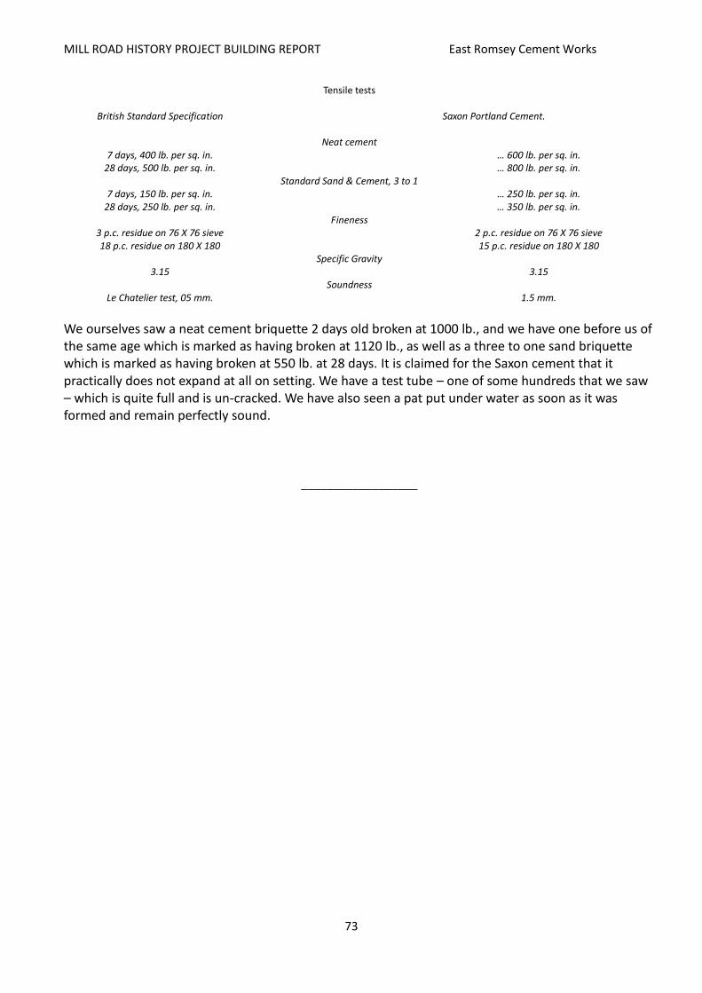
MILL ROAD HISTORY PROJECT BUILDING REPORT East Romsey Cement Works
73
Tensile tests
British Standard Specification Saxon Portland Cement.
Neat cement 7 days, 400 lb. per sq. in. … 600 lb. per sq. in.
28 days, 500 lb. per sq. in. … 800 lb. per sq. in. Standard Sand & Cement, 3 to 1
7 days, 150 lb. per sq. in. … 250 lb. per sq. in. 28 days, 250 lb. per sq. in. … 350 lb. per sq. in.
Fineness 3 p.c. residue on 76 X 76 sieve 2 p.c. residue on 76 X 76 sieve 18 p.c. residue on 180 X 180 15 p.c. residue on 180 X 180
Specific Gravity 3.15 3.15
Soundness Le Chatelier test, 05 mm. 1.5 mm.
We ourselves saw a neat cement briquette 2 days old broken at 1000 lb., and we have one before us of the same age which is marked as having broken at 1120 lb., as well as a three to one sand briquette which is marked as having broken at 550 lb. at 28 days. It is claimed for the Saxon cement that it practically does not expand at all on setting. We have a test tube – one of some hundreds that we saw – which is quite full and is un-cracked. We have also seen a pat put under water as soon as it was formed and remain perfectly sound.
__________________

MILL ROAD HISTORY PROJECT BUILDING REPORT East Romsey Cement Works
74
APPENDIX B
From The Greater London Industrial Archaeology Society, August 1980 (http://www.glias.org.uk/news/069news.html)
Norman Cement Works
The GLIAS visit to Norman Cement Works, Cherry Hinton, Cambridge, commenced at 10.00 hrs. as planned on Saturday March 22nd this year in very fine weather. The works were started in 1904 by the Norman Portland Cement Company and (?) after various amalgamations are now part of Blue Circle Industries. Norman Works is the smallest in the group. The wet process of cement manufacture has been operated here since after World War One.
To start we visited the marl quarry to the south of the works. Marl, clay with a high chalk content, is extracted by a Ruston dragline. After roughly two feet of topsoil are removed the marl extends down about 40 feet, below which is greensand. Some 3,000 tons per week are excavated and transported to the washmills by conveyor. Additionally about 1,000 tons of chalk per week are brought in by road from a quarry a few miles away.
At the washmill the marl is weighed automatically. A hooter signals to the driver of the dragline to deposit loads of chalk as required while a hopper dispenses the correct amount of sodium silicate and soda ash. The latter are added to reduce the amount of water in the slurry while maintaining fluidity. The slurry has a water content of 30-34 per cent, without additives it would be 42 per cent. The first washmill has two chain-hung harrows. Here chalk, marl and water are mixed to a slurry. The fines pass through screens around the circumference. The mix then passes through a second mill, the screening mill, containing swisher blades and screens. The electric motor powering the mills is connected by rope drive. From here the slurry passes to two mixer-Storage tanks. We noted in the next pumphouse a three-throw positive displacement pump by Ernest Newell, about 60 years old. Dimensions are 8 inches diameter by 16 inches stroke.
Slurry is transferred next to another mixer/storage tank just to the north of the main buildings which house the rotary kiln. The tank is of 52 feet diameter with sun and planet motion paddles. Close by, another pumphouse contained two more positive displacement pumps. The slurry is pumped to the rear of the rotary kiln which is 300 feet long and has internal diameters of 71 9 ½ and 9 ½". This kiln was installed in 1949 when major reconstruction at Norman Works took place. It was built by Vickers and transported to Cherry Hinton in sections by rail. The building which encloses the entire kiln plant was erected at the same time, together with the present chimney.
The slurry is fed into the upper end of the kiln which is inclined downwards. At the other end a coal dust/hot air mixture is blown in and ignited with the flame blowing up the kiln. The coal is pulverised in an Alfred Herbert mill. At the lower end the temperature is at about 1,500°C falling to around 230°C at the top. Slurry passes down the kiln and the water it contains evaporates. Chains inside the kiln help to transfer heat to the slurry. At the bottom white hot clinker falls into a Fuller Grate Cooler — the first in this country to be used by Blue Circle. The Fuller Cooler employs a cold air blast and plates and is not rotary. The clinker now goes to a storage bunker. About 6 per cent of Gypsum is added to prevent the finished cement from setting too quickly and the mixture is ground in a tube ball mill. The first chamber of the mill has 3" diameter balls, the second has graded balls

MILL ROAD HISTORY PROJECT BUILDING REPORT East Romsey Cement Works
75
2½" to ½" in diameter. The cement powder, as it is now, is blown into a storage silo. Low pressure air can be introduced at the bottom of the silo which aerates the cement powder so that it flows like water. As required cement powder is either loaded into bulk road vehicles or bagged for distribution. At Norman Works 70 per cent is distributed in bulk.
Coal for firing the kiln is brought by rail from Bolsover Colliery, Derbyshire. The 16 ton mineral wagons are shunted by the works own Planet diesel locomotive. It is still economic to operate this small plant at Cherry Hinton for local distribution. The nearest other plant in East Anglia is at Ipswich. Cement from Norman Works was used in building the last two sections of the M11.
We would like to express our thanks to our guide Mr. Don Evans for the trouble he took to show us everything. GLIAS is also grateful to Mr. B.D. Crane, the Works General Manager, for allowing the visit. Pam Carr
__________________
MILL ROAD HISTORY PROJECT BUILDING REPORT East Romsey Cement Works
76
BIBLIOGRAPHY
Anderson Group, The Lakes at Cherry Hinton, consultation document, February 2015
Bidwells, Notice of auction of 4 acres of industrial land, 1967
Cambridge City Council, Cambridge Local Plan, July 2006
Cambridge City Council, Contaminated Land in Cambridge, Developers Guide, 2009
Cambridge City Council, Draft Open Space and Recreation Strategy, October 2011
Cambridge City Council, Draft Romsey Local Plan, May 1983
Cambridge City Council, 2013 Local Plan review: Issues and Options consultation, 2013
Cohen, Ruth & Cook, P. Lesley, The Effects of Mergers (London: Routledge, 1958)
Cooper, Anthony J., Planners and Preservationists. The Cambridge Preservation Society and the
City’s Green Belt 1928-1985 (Cambridge Preservation Society, 2000)
Grove, Richard, The Cambridge Coprolite Mining Rush (Oleander Press, 1976) Jebb, Eglantyne, Cambridge: A Social Study (Cambridge: Macmillan & Bowes, 1906)
Mott MacDonald, Blue Circle Site, Coldham’s Lane, Review of Health Safety and Environmental
Hazards, Cambridge City Council Planning Dept, 15 March 1999
Mutsu, Hirokichi, ed., The British Press and the Japan-British Exhibition of 1910 (London: Routledge,
2001)
Purkis, Sallie, ‛Over the Bridge: Another Cambridge between Two Wars: Communal Responses to
Political, Economic and Social Changes, 1919‒1938’ (MA thesis in Social History, Department
of Sociology, University of Essex, 1982)
Taylor, Nicholas & Booth, Philip, Cambridge New Architecture (London: Leonard Hill, 1970)
Websites
Lafarge Cement UK History: http://www.fundinguniverse.com/company-histories/lafarge-cement-uk-history/
Cement Plants and Kilns of Britain and Ireland, Dylan Moore: http://www.cementkilns.co.uk/index.html
Cambridgeshire County Council: Nature conservation sites: http://www.cambridgeshire.gov.uk/info/20012/arts_green_spaces_and_activities/88/nature_conservation_sites
Northfleet Urban Country Park: http://en.wikipedia.org/wiki/Northfleet_Urban_Country_Park

MILL ROAD HISTORY PROJECT BUILDING REPORT East Romsey Cement Works
77
Representation by Iceni Projects on the draft 2014 Local Plan, Cambridge City Council: http://cambridge.jdi-consult.net/localplan/viewrepfull.php?repid=27881
Cam Lakes Project: http://www.camlakes.co.uk/home/who-we-are/
Friends of Cherry Hinton Brook: http://www.friendsofcherryhintonbrook.org.uk/
Friends of Cherry Hinton Hall: http://www.cherryhintonhall.com/
Archived planning applications: http://cambridge.jdi-consult.net/expsys/address_search.php
Cambridge News archives: http://www.cambridge-news.co.uk/search/search.html?searchType=&searchPhrase
The Local History of Meldreth: http://www.meldrethhistory.org.uk/index.aspx
Cherry Hinton Village Web-site: https://sites.google.com/site/cherryhintonvillage/home/history-of-cherry-hinton
Cherry Hinton: Economic History, British History Online: http://www.british-history.ac.uk/vch/cambs/vol10/pp109-113
Britain From Above: http://www.britainfromabove.org.uk/
Grace’s Guide: The Engineer, December 1908: http://www.gracesguide.co.uk/The_Engineer_1908/12/25
Greater London Industrial Archaeological Society: Norman Cement Works 1080: http://www.glias.org.uk/news/069news.html#M
Trumpington Local History Group: http://www.trumpingtonlocalhistorygroup.org/resources_census1911.html
Personal Communications from:
Keith Lagdon, resident, Brookfields Andy Kurdynowskii, resident, Romsey