ras pre geography of rajasthan - s
TRANSCRIPT

Contact: 7737313911
Geography of Rajasthan
RAS Pre Syllabus as per RPSC, Ajmer1. Major physiographic regions and their characteristics2. Climatic characteristics3. Major Rivers & Lakes4. Natural Vegetation & Soil5. Major Crops- Wheat, Maize, Barley, Cotton, Sugarcane & Bajra6. Major Industries.7. Major Irrigation Projects & Water Conservation Techniques8. Population-Growth, Density, Literacy, Sex-ratio & Major Tribes9. Minerals- Metallic & Non-Metallic10.Power Resources- Conventional & Non-Conventional11. Biodiversity & its Conservation12.Tourist Centres & Circuits
www.AswaTHinstitue.com 7737313911 CEO: Rajpurohit Anil
Contact: 7737313911
RAS Pre Syllabus as per RPSC, Ajmer 1
Major physiographic regions and their characteristics 10
Introduction 10
Physiography of Rajasthan 16Western Sandy Plain/Desert Plain 18
1. Sandy Arid Plain 20Sandy Arid Plain subdivided into two parts 212. Semi-Arid Plain or Rajasthan Bangar 23Semi-Arid Plain/Rajasthan Bangar subdivided into: 23
Aravalli regions 24Aravalli hills divided into: 25Southern Aravalli Area(from Abu to Ajmer) 25Central Aravalli area (from Ajmer to Jaipur) 26Northern Aravalli area (from Jaipur to Khetri) 26
Eastern Plain 27Eastern plain subdivided into 27Chambal Basin 27Banas-Banganga Basin 27Middle Mahi-Chhappan Basin 28
South-East Rajasthan Plateau 28Vindhyan Scrap 29Deccan Lava Plateau 29
Climatic Characteristics 29Climate 29Seasons of Rajasthan 31Climatic Region 35
Koppen Classification 38Agro-Climatic Zone(Rajasthan) 39
Major Rivers & Lakes 40River/Drainage System 40Rivers Draining into Bay of Bengal 42River Draining into the Arabian Sea 46River of Inland Drainage 49
Lakes 50Saline water lake 50
www.AswaTHinstitue.com 7737313911 CEO: Rajpurohit Anil

Contact: 7737313911Sambhar lake 51Pachpadra lake 51Lunkaransar lake 52Didwana lake 52
Fresh water lake 53Jaisamand lake(Dhebar Lake) 53Pichhola lake 54Fateh Sagar lake 54Udai Sagar 54Rajsamand lake 54Bal Samanad 55Kolayat Lake 55Anasagar lake 55Fai Sagar lake 55Pushkar lake 55Nakki Lake 56Siliserh lake 56Note: 56
Natural Vegetation and Soil 56Natural Vegetation 56
Distribution of Forests 57Types of Forest 57
Tropical Thorny Forests 57Tropical Dry Deciduous Forests 59Sub-Tropical Mountain/evergreen Forest 61Importance of Forests for Rajasthan 62There are direct and indirect advantages of forests. 62Note: 63Recent Scheme of Forest Department 63Scheme (Centre) 63Additional Information (Rajasthan) 63Note: 64
Soil 64Types of Soil 66
Desert Soil/sandy 66Red-Yellow Soil 66Laterite Soil 67Mixed Red and Black Soil 67Black Soil 67
www.AswaTHinstitue.com 7737313911 CEO: Rajpurohit Anil

Contact: 7737313911Alluvial Soil 68
Soil Problem 68Soil Erosion 68The problem of Soil Fertility Loss 69
Major Crops- Wheat, Maize, Barley, Cotton, Sugarcane & Bajra 70Major Agriculture Crops: 70
Wheat 70Maize/Macca 71Barley( जौ ) 71Cotton 71Sugarcane 72Bajra ( Pearl Millet - Pennisetum typhoides) 72Some Other Crops(Not in Syllabus): 73Jowar 73Gram 73Guar 73Rice 73Mustard 74Ground Nut 74
Major Industries 75Cotton Textile Industry 75
Rajasthan State Handloom Development Corporation(RHDC) 75Wool Clothes Industry 76
Central Wool Development Board(Ministry of Textile, India) 76Sugar Industry 77Cement Industry 77Glass Industry 78Paper Industry 78Silk textile Industry 79Salt Industry 79
Sambhar Salts Limited (SSL) 80Chemical Industry 80Engineering Industry 80Industrial Overview 81
Index of Industrial Production(IIP) 81Micro, Small and Medium Enterprises(MSME) 82
In the state, various policies measures to promote and support MSMEenterprises are implemented are: 82
Exports 82
www.AswaTHinstitue.com 7737313911 CEO: Rajpurohit Anil

Contact: 7737313911For the development of exports, the state introducing various exportpromotion initiatives such as: 83
Department responsible for the Industrial development of Rajasthan 83Department of Industries 83Programmes/Schemes of Industrial Development 84Bureau of Investment Promotion(BIP) 85Rajasthan State Industrial Development and Investment CorporationLimited(RIICO)-1969(Re-established 1980) 85The Key progress made by RIICO 85Innovative Schemes/Initiatives taken up by the Corporation. 86Rajasthan Small Industries Corporation Limited(RAJSICO)-1961 87Rajasthan Financial Corporation(RFC)-1955 87Delhi-Mumbai Industrial Corridor(DMIC) 89Khadi and Village Industries (KVI) 90Mining Sector 91Rajasthan State Mines and Minerals Limited(RSMML) 91Oil and Natural Gas 91Labour 92Employment Department 93Rajasthan Skill and Livelihoods Development Corporation(RSLDC) 93Mukhya Mantri Yuva Kaushal Yojana(MMYKY) 93Rural Non Farm Development Agency(RUDA)-1995 94
Industrial Development (Economic Survey: 2020-2021) 94Some Important Facts: 94
Major Irrigation Project and Water Conservation Techniques 95Indira Gandhi Canal Project(Rajasthan Canal) 95Bhankhra-Nangal Project 97Beas Project 98Chambal Project 100Mahi Bajaj Project 101Narmada Canal 101Gang Canal 102Rajiv Gandhi Sidhmukh Nohar Project 103Bisalpur Project 103Jhakam Project 104Sidhmukh Project 104Parwan Dam Project 104Dholpur Lift Irrigation Project 105Rajasthan Water Sector Restructuring Project for Desert Area(RWSRPD)105
www.AswaTHinstitue.com 7737313911 CEO: Rajpurohit Anil

Contact: 7737313911Jaipur Zone 105Kota Zone 106Udaipur Zone 106Jodhpur Zone 106
Medium Irrigation Project district wise 107Jhalawar 107Kota 107Pali 107Pratapgarh 108Tonk 108Chittorgarh 109Rajsamand 109Jalore 110Jaipur 110Sawai Madhopur 110Dausa 111Alwar 111Bundi 111Udaipur 111Baran 112Ajmer 112Bhilwara 113Karauli 113Sirohi 113Sikar 114Jodhpur 114Dungarpur 114Dholpur 114Bharatpur 114
Population: Growth, Density, Distribution, Sex-Ratio, Literacy & Major Tribes115
Population(Rajasthan) 115Density 116Sex-ratio 117Literacy 118
Male Literacy 119Female Literacy 120
Rajasthan: Rural and Urban Population(2011) 121Rural 121Urban 121
www.AswaTHinstitue.com 7737313911 CEO: Rajpurohit Anil

Contact: 7737313911Schedule Caste Population 122Schedule Tribe Population 123
Tribe Population 123
Mines and Minerals 123Minerals 124
Copper 124Gold 125Iron-Ore 126Lead, Zinc and Silver 127Tungsten 128Manganese 128Limestone 129Beryllium 129Mica 130Bismuth 130Wollastonite 131Tin 131Vermiculite 131Silica Sand 132Steatite 132Asbestos 133Baryte 133Bauxite 134China Clay 134Dolomite 135Feldspar 135Fluorite 136Gypsum 136Graphite(Black Lead) 137Fuller’s Earth(Multani Mitti) 137Kyanite 137Magnesite 138Nickel 138Rock Phosphate(Phosphorite) 138Pyrite 139Marble 139Granite 140Uranium 142
Energy Minerals 142
www.AswaTHinstitue.com 7737313911 CEO: Rajpurohit Anil

Contact: 7737313911Coal 142Petroleum 142Natural Gas 143Mining Department 143
Power Resources: Conventional & Non-Conventional 143Power Generation: 143
Installed Capacity: 143Non-Renewable Source 144
Coal 144Types of Coal: 144Thermal Energy 146Nuclear/Atomic Power/Energy resources: 147
Rajasthan Atomic Power Project (RAPP) 148Banswara Thermal Power Station: 148
Natural Gas: 149Renewable Source 149
SOLAR 150Solar Power Generation 150Development of Solar Parts and Mega Solar Power projects 150The major field of solar energy development is: 151Biomass Energy 152Wind Power 152
Biodiversity & its Conservation 153National Park, Wildlife Sanctuary and Conservation Reserve 153National Park 153
National Park(Rajasthan = 3) 154Ranthambore National Park, Sawai Madhopur 154Keoladeo Ghana National Park, Bharatpur 154Mukundara National Park, Kota 155
Wildlife Sanctuary 156Wildlife Sanctuary(Rajasthan) 156
Mount Abu WS 156Desert National Park 157Kumbhalgarh WS 157Sariska Wildlife Sanctuary, Alwar 158Tal Chhapar WS 159National Chambal WS, Sawai Madhopur 159Sita Mata WS 160Phulwari Ki Nal WS, Udaipur 160
www.AswaTHinstitue.com 7737313911 CEO: Rajpurohit Anil

Contact: 7737313911Todgarh-Raoli WS 161Sajjangarh WS 161Bassi WS 162Bandh Bharatha WS 162Bhainsrorgarh WS 162Jaisamand WS 162Jamwa Ramgarh WS 163Kailadevi WS 164Nahargarh WS 164Ramsagar WS 164Kaisarbagh WS 165Ramgarh Vishdhari WS 165Sawai Madhopur WS 165Sawai Man Singh WS 165Shergarh WS 165Van Vihar WS 165
Conservation Reserve 165Zoo in Rajasthan 167Deer Park 167
Tourist Centres & Circuits 168Tourism Sector 168
The Rajasthan Government took the step for the development of the tourismsector: 168International Tourist day 169
Schemes of Rajasthan Government for the development of tourist sector: 169Tourist Places in Rajasthan 169
Additional Information: 171Livestock 171
Animal Breeding and Research Centre(Rajasthan) 171Camel 172
Breeds of Camels 172Cow 172
Breeds of Cow(https://gopalan.rajasthan.gov.in/cow-breeds.htm) 172Buffalo 175
Breeds of Buffalo 175Goat 175
Breeds of Goat 176Sheep 176
Breeds of Sheep 176
www.AswaTHinstitue.com 7737313911 CEO: Rajpurohit Anil

Contact: 7737313911Horse 177
Breed of Horse 177Donkey 177Hens 177Mule 178Pig 178
Animal Fairs 178Economic Survey 2020-21 178
Livestock Census-2019 178Major initiatives taken by Animal Husbandry Department during the year2019-20: 179
Gopalan Department 18020th Livestock Census-2019 180
Great Boundary Fault 183
Major physiographic regions and theircharacteristics
Introduction1. Rajasthan lies in the north-western part of India and the north-eastern part of
the world.
www.AswaTHinstitue.com 7737313911 CEO: Rajpurohit Anil

Contact: 7737313911
a.
www.AswaTHinstitue.com 7737313911 CEO: Rajpurohit Anil
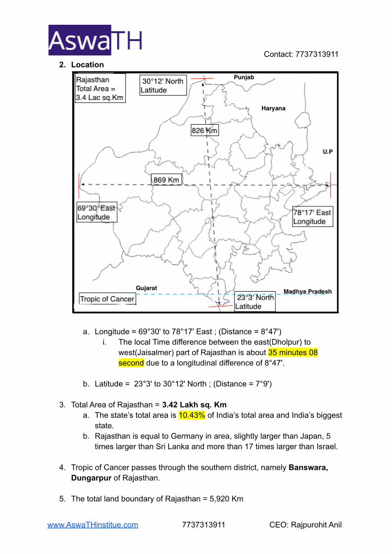
Contact: 77373139112. Location
a. Longitude = 69°30' to 78°17' East ; (Distance = 8°47')i. The local Time difference between the east(Dholpur) to
west(Jaisalmer) part of Rajasthan is about 35 minutes 08second due to a longitudinal difference of 8°47'.
b. Latitude = 23°3' to 30°12' North ; (Distance = 7°9')
3. Total Area of Rajasthan = 3.42 Lakh sq. Kma. The state’s total area is 10.43% of India’s total area and India’s biggest
state.b. Rajasthan is equal to Germany in area, slightly larger than Japan, 5
times larger than Sri Lanka and more than 17 times larger than Israel.
4. Tropic of Cancer passes through the southern district, namely Banswara,Dungarpur of Rajasthan.
5. The total land boundary of Rajasthan = 5,920 Km
www.AswaTHinstitue.com 7737313911 CEO: Rajpurohit Anil

Contact: 77373139116. Rajasthan boundary with other states and Country
a. North direction: Punjabb. North-east direction: Haryana and Uttar Pradeshc. East and South-east direction: Madhya Pradeshd. South and South-west direction: Gujarat
e. West direction: Pakistani. The international boundary lies between Rajasthan and Pakistan
is a length of 1070 Km, known as the Redcliffe line.1. 1070 Km = Hindumalkot(Ganganagar) to
Shahgarh(Barmer)
ii.iii. Jaisalmer(464 Km) > Barmer(228 Km) > Ganganagar(210 Km) >
Bikaner(168 Km) are the border districts.
7. Extensiona. East to West(Length) = 869 Km
i. East: Village - Jagmohan ka pura, Silavat( Tehsil - Rajakhera,Dholpur)
ii. West: Village - Kharanta(Tehsil - Jaisalmer, Jaisalmer)
www.AswaTHinstitue.com 7737313911 CEO: Rajpurohit Anil

Contact: 7737313911
b.
c. North to South(Broad) = 826 Kmi. North: Village - Konna(Tehsil - Ganganagar, Ganganagar)ii. South: Village - Borkund chota(Tehsil - KhushalGarh,
Banaswara)d. Long - Broad = 869 - 826 Km = 43Km(Difference)
8. Districts of Rajasthan, the border with other states area.
Districts(Rajasthan) States
Barmer, Jalore, Sirohi, Udaipur,Dungarpur, Banswara
Gujarat
Banswara, Pratapgarh,Chittorgarh, Bhilwara, Kota,Jhalawar, Baran, SawaiMadhopur, Karauli, Dholpur
Madhya Pradesh
Dholpur, Bharatpur Uttar Pradesh
Bharatpur, Alwar, Jaipur, Sikar,Jhunjhunu, Churu, Hanumangarh
Haryana
HanumangarhGanganagar
Punjab
9. Physical Features
www.AswaTHinstitue.com 7737313911 CEO: Rajpurohit Anil

Contact: 7737313911a. Tethys sea:
i. Most of the western and north-western part of Rajasthan is theResidue of Tethys sea.
ii. Over time, parts of Rajasthan got filled with alluvium deposits bythe rivers descending from the Himalayas.
iii. Salt lakes of the state like Sambhar, Deendwana, Pachpadra,Lunkaransar etc., are the remains of the Tethys sea.
b. Gondwanalandi. Aravallis and the Deccan plateau are part of Gondwanaland.
1. Aravallis are one of the oldest mountains in the world.2. Aravallis acts as the major water-divide, making two
divisions of the state.
c. The state’s physical features represent the cumulative effect ofendogenic movements, geological structure, denudation, and drainagepattern.
d. The state’s relief comprises mountains, plains, plateaus and deserts inwhich materials are ranging from the oldest rocks to newer alluvium.
www.AswaTHinstitue.com 7737313911 CEO: Rajpurohit Anil

Contact: 7737313911
Physiography of Rajasthan
1. Aravalli Rangea. The range runs across the state from the Southwest peak of Guru
Shikhar (Mount Abu), which is 1,722 m in height, to Khetri(Jhunjhunu)in the Northeast.
b. The range divides the state into two parts, 60% in the northwest and40% in the southeast.
2. Northwest tracta. The tract is sandy and unproductive with little water present in the soil.b. Still, it improves gradually from desert land in the far west and
northwest to comparatively fertile and habitable land towards the east.The area includes the Thar Desert.
3. South-eastern areaa. Higher in elevation and more productive has a much-diversified
topography.4. South
a. The hilly tract of Mewar
5. Southeast
www.AswaTHinstitue.com 7737313911 CEO: Rajpurohit Anil

Contact: 7737313911a. A large area within the districts of Kota and Bundi forms a tableland.
i. To the northeast of these districts is a rugged region (badlands)following the Chambal River line.
6. Northeasterna. Bharatpur district's flat plains are part of an alluvial basin.
7. Merta City lies in the geographical centre of Rajasthan.
www.AswaTHinstitue.com 7737313911 CEO: Rajpurohit Anil

Contact: 7737313911
Western Sandy Plain/Desert Plain
1.2. This region covers 61.11% area and 39% of the Rajasthan population,
including Bikaner, Barmer, Churu, Jodhpur, Jaisalmer, Nagaur, Hanumangarh,Sriganganagar, Pali, Sirohi, Sikar and Jhunjhunu districts.
3. The annual rainfall is 20 - 50cm, which was very low as compared to otherregions.
www.AswaTHinstitue.com 7737313911 CEO: Rajpurohit Anil

Contact: 77373139114. The Dry and Semi-Arid type of climatic condition occurs in this region.5. Before the Indra Gandhi canal, Gang canal, Jawai canal and Narmada canal,
this region was not suitable for living conditions.6. The west part of the sandy plain is known as the Thar Desert, perfectly dry
and desolate with thin patches of prickly grass and other desert plants.7. The Aravalli’s western submontane zone marks the eastern boundary of the
region up to the Udaipur district’s northern point. Beyond which the border ischaracterised by a 50cm rainfall line and Great Indian Watershed.
a.8. The region slopes, generally, from east to west and north to south.
a. The north-eastern part of the region has a general elevation of about300meters.
b. Towards the south, the height is about 150 meters, excepting theJalore-Siwana upland, which lies above 300 metres.
9. The main river in this region is Luni which rises in the Aravalli, south-west ofAjmer and flows towards the south-west.
www.AswaTHinstitue.com 7737313911 CEO: Rajpurohit Anil

Contact: 77373139111. Sandy Arid Plain
1.2. Sandy Arid plain situated to the west of the 25 cm isohyet line is a desert
plain.3. It encompasses Jaisalmer, Barmer, Bikaner and Jodhpur, and the western
parts of Nagaur and Churu.4. In some parts of Jaisalmer, Barmer and Bikaner, rocky projection intercepts
with the dunes. This rocky projection consists of granite, limestone andsandstone.
5. This region also consists of shallow depressions of brackish water known asRann.
www.AswaTHinstitue.com 7737313911 CEO: Rajpurohit Anil

Contact: 7737313911Sandy Arid Plain subdivided into two parts
1. Marusthalia. This covers Bikaner, Jaisalmer, Churu, some western Nagaur
and western two-thirds of Barmer and Jodhpur district.b. The shifting sand, locally termed as "Dharians'' are present in
the west, near Shagarh village, where they extend many Kmand continuously change their surface.The types of dunes present in this region are:
i. Longitudinal dunes: These dunes formed parallel to theprevailing winds.
1.ii. Barchans: These are the crescent-shaped dunes.
www.AswaTHinstitue.com 7737313911 CEO: Rajpurohit Anil

Contact: 7737313911
1.iii. Transverse Dunes: These dunes formed at a right angle
to the prevailing winds.
1.
2. Dune Free Tracta. The rocky, dune free tract of Jaisalmer-Barmer-Bikaner covers
nearly 65sq. Km around the Jaisalmer town, half of Pokhrantehsil, western and southern parts of Phalodi tehsil of Jodhpurdistrict.
b. The limestone and sandstone rocks exposed here belong toJurassic and Eocene formation.
www.AswaTHinstitue.com 7737313911 CEO: Rajpurohit Anil

Contact: 77373139112. Semi-Arid Plain or Rajasthan Bangar
Semi-Arid Plain/Rajasthan Bangar subdivided into:1. Luni Basin
a. The basin lies to the southwest of Aravallis between 25 to 50centimetres isohyet lines.
b. The Luni basin covers Jodhpur, Pali, Jalore and the western partof the Sirohi districts.
c. The drainage area of the river Luni covers alluvial plains. Theimportant tributaries of the river Luni are, Lilri, Sukari Jawai,Jojari and Bandi. These rivers are seasonal.
d. Pachpadra a brackish saltwater lake present in Luni Basin.
2. Shekhawati region(Plain of Inland river)a. The Shekhawati covers Jhunjhunu, Sikar, Churu and the
northern Nagaur district.b. This region has sand-dunes of medium and low height.c. There are many small rivers and nallas which disappear after
flowing a short distance in the region.d. The main rivers of the regions are Mendha and Kantli.e. There are several saltwater lakes and Ranns in this area.
i. Sambhar, Deedwana, Kuchaman, Sujangarh,Tal-Chhapar and Parihara (Churu) are the leadingsaltwater lakes.
3. Nagauri Uplanda. The Nagauri Upland covers the area of Didwana, Nagaur and
Jayal.
www.AswaTHinstitue.com 7737313911 CEO: Rajpurohit Anil

Contact: 7737313911b. There are no hills in this region except tehsil Parbatsar where
the mountain ranges on the southern side are the off-shoots ofAravalli hills.
4. Ghaggar Plaina. It is the northern part of the desert which extends in districts of
Ganganagar and Hanumangarh.b. Ghaggar river is part of the inland drainage system of this area.c. The dry bed of the streams of Ghaggar considered being part of
the Saraswati river originating from the Himalayas as describedin the Puranas.
d. Intensive agriculture is practised in this area due to the irrigationfacility’s availability through Indira Gandhi Canal and GangCanal.
Aravalli regions
1.2. Aravalli range is the main and the oldest mountain in Rajasthan.3. This range covers about 9.3% of the state.4. The range extends 550 kilometres from Khed Brahma (Gujarat border)
to Khetri in Rajasthan.a. It extends in a continuous chain from Sirohi to Khetri, but it
develops in the form of small hills up to Delhi.
www.AswaTHinstitue.com 7737313911 CEO: Rajpurohit Anil

Contact: 77373139115. It mainly extends in nine districts Sirohi, Udaipur, Rajsamand, Ajmer,
Jaipur, Dausa, Alwar, Sikar and Jhunjhunu.6. The average height of this hilly region is 930 metres.
Aravalli hills divided into:
1. Southern Aravalli Area(from Abu to Ajmer)a. It includes Sirohi, Udaipur and Rajsamand. Here the Aravallis
are very complex and high.
b. Bhorat plateau is situated between Kumbhalgarh and Gogundato the north of Udaipur.
i. East-flowing rivers originate from the plateau.
c. Mewar Rocky region and Bhorat Plateau:i. The Mewar hills cover the Udaipur district's whole except
these eastern tehsils(Maoli, Rajsamand andVallabhnagar), the south-eastern margin of pali districtand parts of Gujarat state situated between Banks Plainand Abu block.
ii. The westernmost ridge in east Sirohi, which has no greatheight, is steep and rugged, locally known as Bhakar.
iii. Some of the hill spurs girdle the saucer-shaped inUdaipur basin, locally known as Girwa(girdle of hills).
d. Hill rangesi. Mewar hills & Bhorat Plateauii. Girwa Hillsiii. Merwara Hillsiv. Abu block & Oria plateau
e. Peaksi. Guru Shikhar(Sirohi): 1722 mii. Ser (Sirohi): 1597 miii. Dilwara (Sirohi): 1442 miv. Jarga (Udaipur): 1431 mv. Achalgarh (Sirohi): 1380 m
vi. Kumbhalgarh (Rajsamand): 1224 mvii. Dhoniya(Sirohi): 1183 mviii. Hrishikesh(Sirohi): 1017 mix. Kamalnath (Udaipur): 1001 mx. Sajjangarh (Udaipur): 938 mxi. Lilagarh: 874 m
xii. Roja Bhakar(Jalore): 730 mxiii. Jharola(Jalore)
www.AswaTHinstitue.com 7737313911 CEO: Rajpurohit Anil

Contact: 7737313911
2. Central Aravalli area (from Ajmer to Jaipur)a. It extends between Ajmer and Jaipur.b. There is an alternate arrangement of ranges, narrow valleys and
plains in this section.c. Luni, the main river of western Rajasthan, originates from Nag
Pahar lying in this section.d. Hill ranges:
i. Shekhawati lower hillsii. Marwar Hills
e. Peaks(Ajmer)i. Goramji: 934 mii. Taragarh: 870 miii. Nag Pahar: 795 miv. Tatgarh
3. Northern Aravalli area (from Jaipur to Khetri)a. Northern Aravallis extends in the districts of Jaipur, Dausa,
Alwar, Sikar and Jhunjhunu.b. Aravallis spread in the form of scattered and isolated hills,
instead of a continuous chain.c. It includes the hills of Shekhawati, Torawati, Jaipur and Alwar.
i. These hills have an elevation ranging between 450 to 700metres.
d. Hill Rangesi. Malkhet & Khetri Group of hillsii. Torawati Hills
e. Peaksi. Raghunathgarh (Sikar): 1055 mii. Kho (Jaipur): 920 miii. Bhairach (Alwar): 792 miv. Barwara (Jaipur): 786 mv. Babai (Jhunjhunu):780 m
vi. Bilali (Alwar): 775 mvii. Manoharpura (Jaipur): 747 mviii. Bairath (Jaipur): 704 mix. Sariska (Alwar): 677 mx. Siravas: 651 mxi. Jaigarh(Jaipur)xii. Bhangarh(Alwar)
www.AswaTHinstitue.com 7737313911 CEO: Rajpurohit Anil

Contact: 7737313911
Eastern Plain
1.2. The region covers 23.9% area of Rajasthan.3. It is a river basin area.4. It extends over the plains of Bharatpur, Alwar, Sawai Madhopur, Karauli,
Jaipur, Tonk and Bhilwara in its northern section and over the plains of fifty-sixvillages of Dungarpur, Banswara and Chittorgarh districts in its southern area.
5. The plain is made up of fertile alluvial soil and irrigated by several rivers.Situated between Aravallis and Hadauti plateau.
Eastern plain subdivided into
1. Chambal Basina. The Chambal basin’s plain presents a homogeneous
topography instead for hundreds of years characterised by floodplains, river bluffs, and ravines best developed in the region.
2. Banas-Banganga Basina. The plain of Banas and its tributaries is known as the ‘Plain of
Mewar’ in the south and the ‘Plain of Malpura Karauli’ in thenorth.
b. This plain averages height between 280 to 500 metres.c. Berach, Khasi, Mansi, Morel and Banganga etc. are the main
tributaries of Banas river.
www.AswaTHinstitue.com 7737313911 CEO: Rajpurohit Anil

Contact: 7737313911d. The Eastern bare slopes east and north-eastwards.e. There are flat-topped isolated hills in the region.
3. Middle Mahi-Chhappan Basina. It covers the southeastern part of Udaipur, Dungarpur, Banswara
and Chittorgarh.b. It averages in height from 200 to 400 metres.c. Salumbar-Sarada area is locally known as Chhappan and
Dungarpur-Banswara area as Vagad.d. Banswara is also known as the Area of Hundred Islands due to
the presence of several rivers.e. The principal tributaries of the Mahi river are Som, Jakham,
Kagdar, Jhamri etc.f. Bhils and Garasiyas are the local tribes who practice shifting
cultivation, locally known as Walra.
South-East Rajasthan Plateau
1.2. The south-eastern plateau of Rajasthan is popularly known as Hadauti.3. It covers 7% area and 10% of the population of the state.4. It spreads over Kota, Bundi, Baran, Jhalawar and the eastern part of
Chittorgarh.5. It is composed of lava mixed rocks and Vindhyan rocks.
www.AswaTHinstitue.com 7737313911 CEO: Rajpurohit Anil

Contact: 77373139116. The average height of the plateau is 500 metres above mean sea level.7. Black and red soils found in this area.8. Major rivers of this area are Chambal, Parvati and Kali Sindh.9. The physiography unit of south-east Rajasthan is also known as
Uparmal(high or stony Plateau).
The plateau is divided into two sub-physiographic regions.
1. Vindhyan Scrapa. The scarp mainly consists of sandstone and limestone.b. It rises to an elevation ranging between 350 to 550 metres
above MSL(mean sea level).c. The scarp faces south-east and eastwards continuously
between Banas and Chambal rivers.d. The scarp extends northwards in Sawai Madhopur, Karauli and
Dholpur along the Chambal river.
2. Deccan Lava Plateaua. It is a wider and raised rocky feature of south-eastern
Rajasthan.b. It is composed of sandstone and limestone rocks.c. It’s eastern and southern parts are covered with lava.d. Fertile black soil found here.e. Chambal and its tributaries Kali Sindh and Parvati rivers have
formed a triangular alluvial plain in Kota.
www.AswaTHinstitue.com 7737313911 CEO: Rajpurohit Anil