rapid watershed assessment pintada arroyo watershed
TRANSCRIPT

Pintada Arroyo Watershed (HUC8 13060002)
1
Rapid Watershed Assessment Pintada Arroyo Watershed

Pintada Arroyo Watershed (HUC8 13060002)
2
The U.S. Department of Agriculture (USDA) prohibits discrimination in all its programs and activities on the basis of race, color, national origin, age, disability, and where applicable, sex, marital status, familial status, parental status, religion, sexual orientation, genetic information, political beliefs, reprisal, or because all or a part of an individual's income is derived from any public assistance program. (Not all prohibited bases apply to all programs.) Persons with disabilities who require alternative means for communication of program information (Braille, large print, audiotape, etc.) should contact USDA's TARGET Center at (202) 720-2600 (voice and TDD). To file a complaint of discrimination write to USDA, Director, Office of Civil Rights, 1400 Independence Avenue, S.W., Washington, D.C. 20250-9410 or call (800) 795-3272 (voice) or (202) 720-6382 (TDD). USDA is an equal opportunity provider and employer.

Pintada Arroyo Watershed (HUC8 13060002)
3
Table of Contents Overview ......................................................................................................................................... 4 Physical Setting ............................................................................................................................... 6 Precipitation .................................................................................................................................. 10 Land Ownership ............................................................................................................................ 11 Land Use / Land Cover ................................................................................................................. 13 Hydrology ..................................................................................................................................... 17 Threatened and Endangered Species ............................................................................................ 20 Invasive Species ............................................................................................................................ 20 Common Resource Areas ............................................................................................................. 21 Conservation ................................................................................................................................. 23 Soil Resource Inventory ................................................................................................................ 24 Socioeconomic Data ..................................................................................................................... 28 References ..................................................................................................................................... 29 List of Tables Table 1. Pintada Arroyo watershed acreage distribution. ............................................................... 5 Table 2. Land ownership in the Pintada Arroyo watershed. ......................................................... 12 Table 3. Extent of NLCD classes in the Pintada Arroyo watershed. ............................................ 14 Table 4. SW Region Gap analysis ecosystem acreages. ............................................................... 16 Table 5. NHD Water Course Type and Extents ........................................................................... 17 Table 6. Threatened and Endangered Plant and Animal Species ................................................ 20 Table 7. Invasive Species Recognized by the SWEMP ............................................................... 20 Table 8. 5 year Trends in Applied Conservation Practices. Reported in Acres. ......................... 23 Table 9. 5 year Trends in Location Specific Applied Conservation Practices. Reported in Feet if linear (i.e. fence) ........................................................................................................................... 23 Table 10. Criteria Used for Soil Erosion Susceptibility Model ................................................... 25 Table 11. Soil Erosion Potential Model Results. ....................................................................... 27 Table 12. Socioeconomic Data of Counties in the Watershed (2000). ........................................ 28 List of Figures Figure 1. Pintada Arroyo watershed overview. ............................................................................. 4 Figure 2. Hydrologic Soil Group ................................................................................................... 8 Figure 3. Pintada Arroyo watershed shaded relief. ........................................................................ 9 Figure 4. Pintada Arroyo watershed annual precipitation. .......................................................... 10 Figure 5. Pintada Arroyo watershed land ownership. .................................................................. 11 Figure 6. Subset of the National Land Cover Dataset. ................................................................ 13 Figure 7. Subset of the SWREGAP over the Pintada Arroyo watershed. ................................... 15 Figure 8. National Hydrologic Dataset of the Pintada Arroyo. ................................................... 18 Figure 9. Declared Groundwater Basins of the Pintada Arroyo. ................................................. 19 Figure 10. Common Resource Areas of the Pintada Arroyo. ...................................................... 21 Figure 11. National Cooperative Soil Survey coverage of the Pintada Arroyo Watershed. ........ 24 Figure 12. Pintada Arroyo Watershed Erosion Potential ............................................................. 26
Pintada Arroyo Watershed (HUC8 13060002)
4
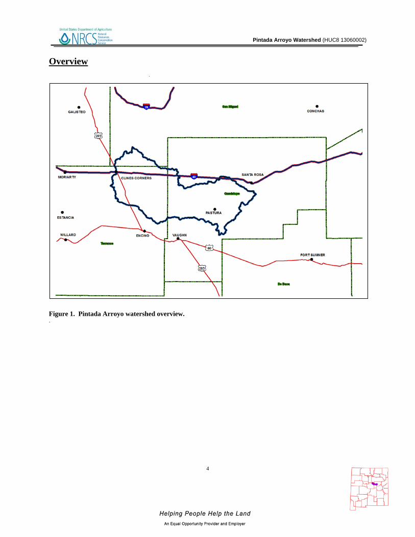
Overview Figure 1. Pintada Arroyo watershed overview. .

Pintada Arroyo Watershed (HUC8 13060002)
5
Overview The Pintada Arroyo Watershed is located in east central New Mexico and covers 658,727 acres (2,666 sq. km). Portions of the Pintada Arroyo watershed extend into Guadalupe, San Miguel, and Torrance counties. Table 1 summarizes the distribution of the Pintada Arroyo watershed.
Table 1. Pintada Arroyo watershed acreage distribution.
COUNTY Co. Acres Total
Acres in HUC
% of HUC in Co.
% of Co. in HUC
Guadalupe 1,938,741 342,966 52 18
San Miguel 3,028,614 50,297 8 2
Torrance 2,139,981 265,464 40 12
Sum (∑) -- 658,727 100 --
Pintada Arroyo Watershed (HUC8 13060002)
Physical Setting
Geology: The Pintada Arroyo watershed lies in the Pecos River Section of the Great Plains Province. Geologically, the bedrock consists of Permian and Triassic aged sedimentary rocks. The upper portion of the watershed contains Triassic sedimentary rocks which have not been individually classified due to their non-distinct nature. These rocks consist of sandstone, siltstone, and mudstone. Also found in this area are Permian aged rocks including the San Andres Limestone, the Glorieta Sandstone, and shales and sandstones of the Yeso Formation. The middle and lower portions of the watershed have exposures of Triassic aged formations consisting of the Santa Rosa Sandstone and the Chinle Shale. Permian aged rocks include the sedimentary rocks of the Artesia Group. These Permian aged rocks consist of shales, limestones and sandstones, but have not been divided into distinct formations. The watershed is formed from sedimentary rocks including sandstone, limestone, siltstone, mudstone and shale. The softer materials will weather at a more rapid rate than those formed from the limestone and sandstone. Erosion of these rocks can occur with water and wind. Salts will be present in all of these materials which may have an adverse effect on the water quality. The arroyo is generally dry during most times of the year, and acts as a drainageway during significant precipitation events. The arroyo eventually joins with the Pecos River. Resource concerns are high sediment erosion. In addition the lowering of valleys by river incision is a continuing process. Rivers respond by aggrading during climates that promote large sediment yield and large, stable discharges; and incise during climates that produce flashy flows and reduce the sediment supply. Groundwater quality and quantity is a concern. Depth to groundwater is a concern if the shallow unconfined aquifer does not produce enough water for the resource or increased population demands are ‘mining’ the water. Groundwater in the limestone is usually along fracture zones which are hard to intercept with water wells. Groundwater quality ranges from good to fair for livestock or crops.
Pintada Arroyo Watershed (HUC8 13060002)
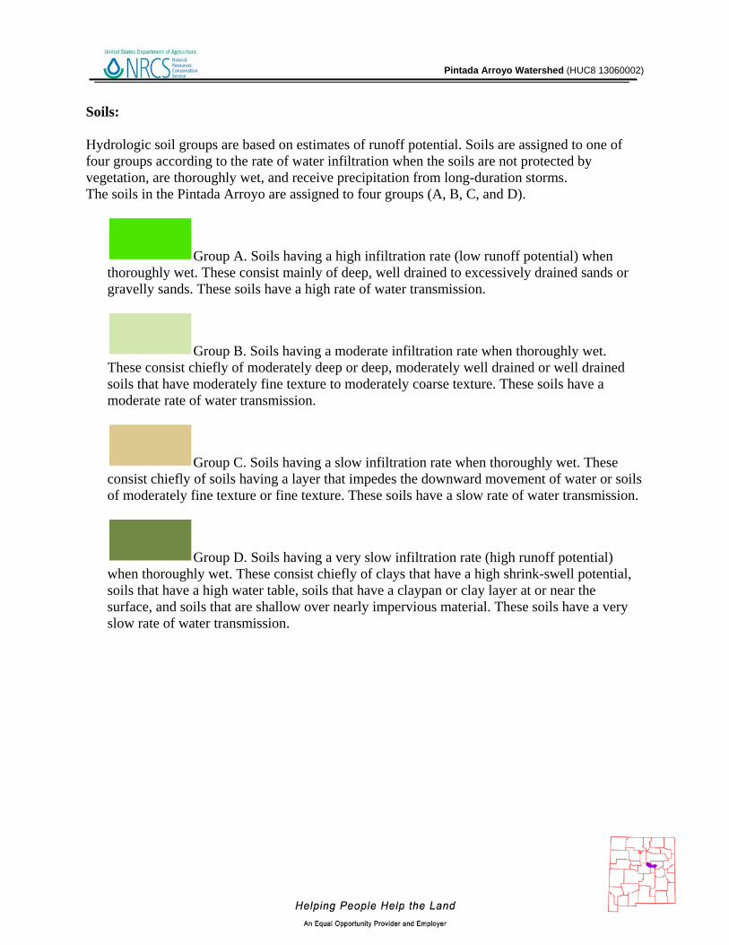
Soils: Hydrologic soil groups are based on estimates of runoff potential. Soils are assigned to one of four groups according to the rate of water infiltration when the soils are not protected by vegetation, are thoroughly wet, and receive precipitation from long-duration storms. The soils in the Pintada Arroyo are assigned to four groups (A, B, C, and D).
Group A. Soils having a high infiltration rate (low runoff potential) when thoroughly wet. These consist mainly of deep, well drained to excessively drained sands or gravelly sands. These soils have a high rate of water transmission.
Group B. Soils having a moderate infiltration rate when thoroughly wet. These consist chiefly of moderately deep or deep, moderately well drained or well drained soils that have moderately fine texture to moderately coarse texture. These soils have a moderate rate of water transmission.
Group C. Soils having a slow infiltration rate when thoroughly wet. These consist chiefly of soils having a layer that impedes the downward movement of water or soils of moderately fine texture or fine texture. These soils have a slow rate of water transmission.
Group D. Soils having a very slow infiltration rate (high runoff potential) when thoroughly wet. These consist chiefly of clays that have a high shrink-swell potential, soils that have a high water table, soils that have a claypan or clay layer at or near the surface, and soils that are shallow over nearly impervious material. These soils have a very slow rate of water transmission.

Pintada Arroyo Watershed (HUC8 13060002)
Figure 2. Hydrologic Soil Group
Pintada Arroyo Watershed (HUC8 13060002)
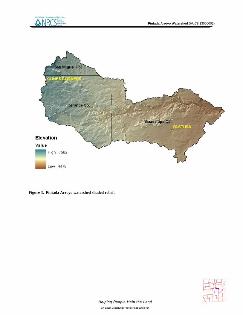
Figure 3. Pintada Arroyo watershed shaded relief.
Pintada Arroyo Watershed (HUC8 13060002)
10
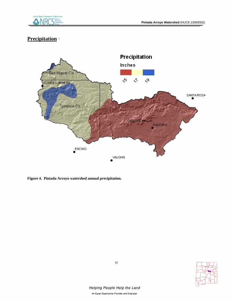
Precipitation 1
Figure 4. Pintada Arroyo watershed annual precipitation.
Pintada Arroyo Watershed (HUC8 13060002)
11
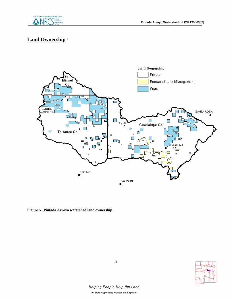
Land Ownership 2
Figure 5. Pintada Arroyo watershed land ownership.
Pintada Arroyo Watershed (HUC8 13060002)
12
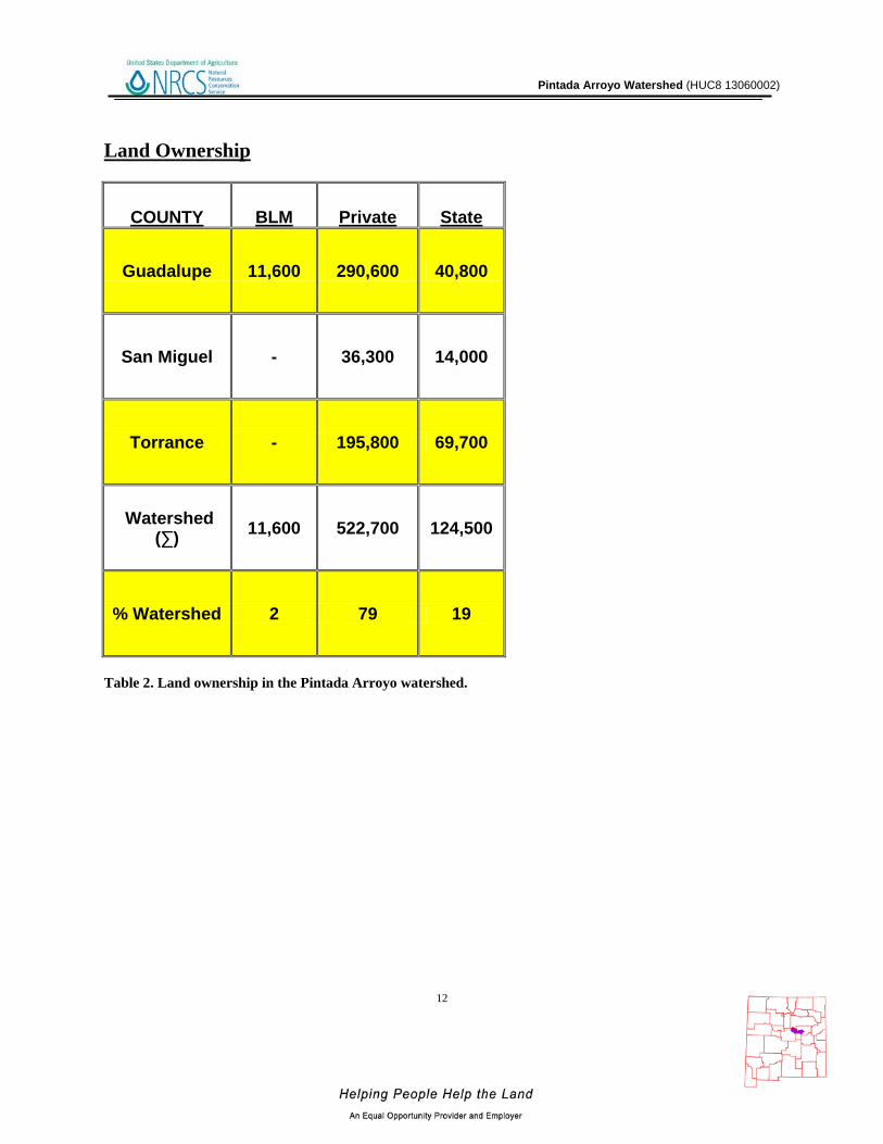
Land Ownership
COUNTY BLM Private State
Guadalupe 11,600 290,600 40,800
San Miguel - 36,300 14,000
Torrance - 195,800 69,700
Watershed (∑) 11,600 522,700 124,500
% Watershed 2 79 19
Table 2. Land ownership in the Pintada Arroyo watershed.

Pintada Arroyo Watershed (HUC8 13060002)
13
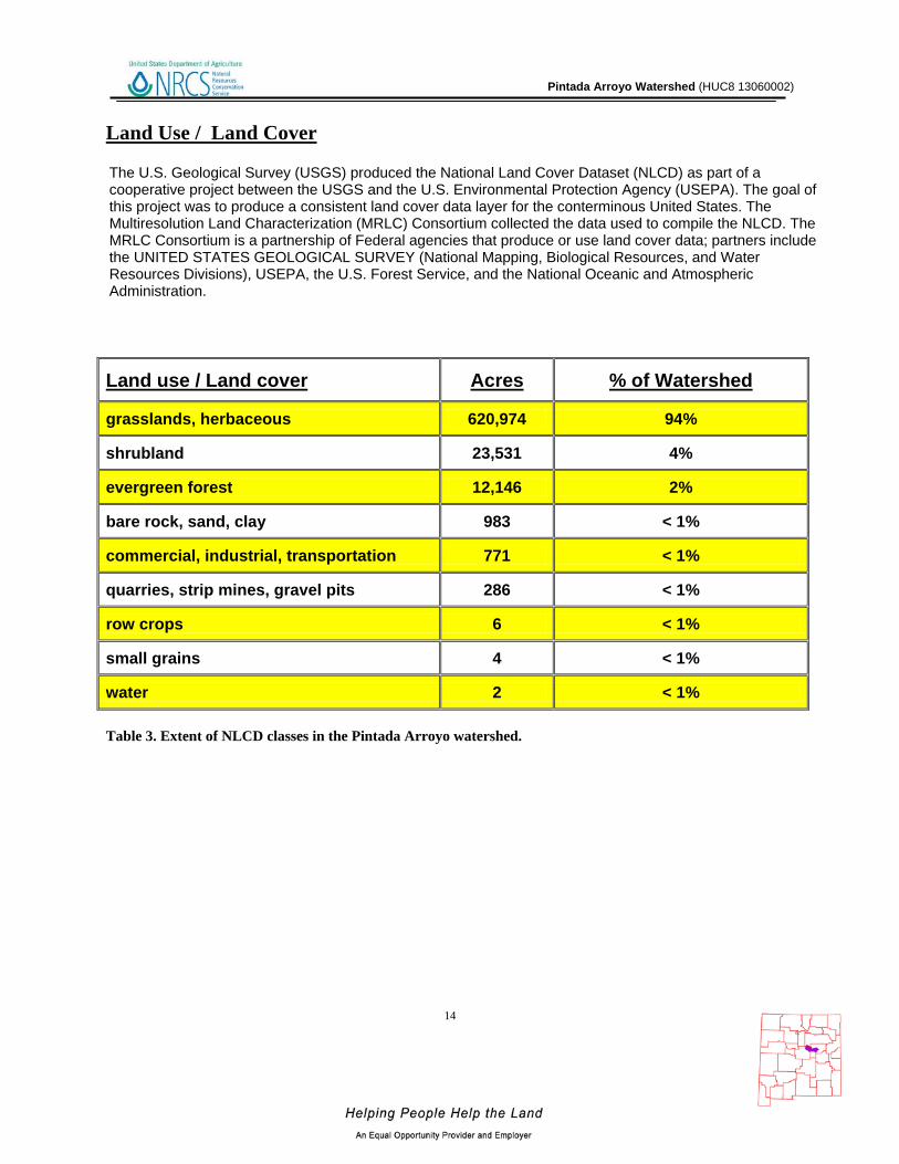
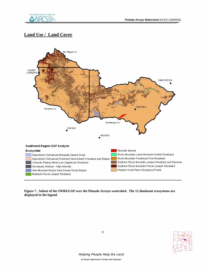
Land Use / Land Cover 3, 4
Figure 6. Subset of the National Land Cover Dataset.
Pintada Arroyo Watershed (HUC8 13060002)
14
Land Use / Land Cover
Table 3. Extent of NLCD classes in the Pintada Arroyo watershed.
Land use / Land cover Acres % of Watershed
grasslands, herbaceous 620,974 94%
shrubland 23,531 4%
evergreen forest 12,146 2%
bare rock, sand, clay 983 < 1%
commercial, industrial, transportation 771 < 1%
quarries, strip mines, gravel pits 286 < 1%
row crops 6 < 1%
small grains 4 < 1%
water 2 < 1%
The U.S. Geological Survey (USGS) produced the National Land Cover Dataset (NLCD) as part of a cooperative project between the USGS and the U.S. Environmental Protection Agency (USEPA). The goal of this project was to produce a consistent land cover data layer for the conterminous United States. The Multiresolution Land Characterization (MRLC) Consortium collected the data used to compile the NLCD. The MRLC Consortium is a partnership of Federal agencies that produce or use land cover data; partners include the UNITED STATES GEOLOGICAL SURVEY (National Mapping, Biological Resources, and Water Resources Divisions), USEPA, the U.S. Forest Service, and the National Oceanic and Atmospheric Administration.
Pintada Arroyo Watershed (HUC8 13060002)
15
Land Use / Land Cover
Figure 7. Subset of the SWREGAP over the Pintada Arroyo watershed. The 12 dominant ecosystems are displayed in the legend.

Pintada Arroyo Watershed (HUC8 13060002)
16
Land Use / Land Cover
Ecosystem Acres % of Watershed
Western Great Plains Shortgrass Prairie 466,800 71 Southern Rocky Mountain Juniper Woodland and Savanna 135,700 21 Southern Rocky Mountain Pinyon-Juniper Woodland 33,100 5 Inter-Mountain Basins Semi-Desert Shrub Steppe 9,300 1 Recently Burned 2,000 < 1 Colorado Plateau Mixed Low Sagebrush Shrubland 1,800 < 1 Apacherian-Chihuahuan Mesquite Upland Scrub 1,600 < 1 Madrean Pinyon-Juniper Woodland 1,400 < 1 Apacherian-Chihuahuan Piedmont Semi-Desert Grassland and Steppe 1,300 < 1 Developed, Medium - High Intensity 1,100 < 1 Rocky Mountain Ponderosa Pine Woodland 800 < 1 Rocky Mountain Lower Montane-Foothill Shrubland 800 < 1 Western Great Plains Riparian Woodland and Shrubland 700 < 1 Western Great Plains Foothill and Piedmont Grassland 700 < 1 Inter-Mountain Basins Mixed Salt Desert Scrub 600 < 1 Rocky Mountain Gambel Oak-Mixed Montane Shrubland 500 < 1 Chihuahuan Creosotebush, Mixed Desert and Thorn Scrub 500 < 1 Western Great Plains Cliff and Outcrop 300 < 1 North American Warm Desert Active and Stabilized Dune 200 < 1 Chihuahuan Gypsophilous Grassland and Steppe 200 < 1 Chihuahuan Sandy Plains Semi-Desert Grassland 100 < 1 Madrean Juniper Savanna 100 < 1 North American Warm Desert Wash 100 < 1 Open Water 100 < 1
Table 4. SW Region Gap analysis ecosystem acreages.
The landcover mapping effort for the Southwest Region Gap Analysis Project was a coordinated multi-institution endeavor. This dataset was created for regional terrestrial biodiversity assessment. Additional objectives were to establish a coordinated mapping approach to create detailed, seamless maps of land cover, all native terrestrial vertebrate species, land stewardship, and management status, and to analyze this information to identify those biotic elements that are underrepresented on lands managed for their long term conservation.
Pintada Arroyo Watershed (HUC8 13060002)
17
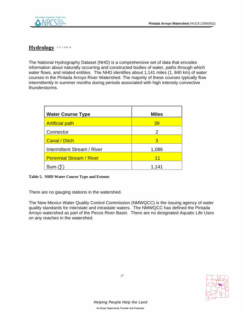
Hydrology 5, 6. 7. 8, 9, 10
The National Hydrography Dataset (NHD) is a comprehensive set of data that encodes information about naturally occurring and constructed bodies of water, paths through which water flows, and related entities. The NHD identifies about 1,141 miles (1, 840 km) of water courses in the Pintada Arroyo River Watershed. The majority of these courses typically flow intermittently in summer months during periods associated with high intensity convective thunderstorms.
Water Course Type Miles
Artificial path 39
Connector 2
Canal / Ditch 3
Intermittent Stream / River 1,086
Perennial Stream / River 11
Sum (∑) 1,141
Table 5. NHD Water Course Type and Extents
There are no gauging stations in the watershed.
The New Mexico Water Quality Control Commission (NMWQCC) is the issuing agency of water quality standards for interstate and intrastate waters. The NMWQCC has defined the Pintada Arroyo watershed as part of the Pecos River Basin. There are no designated Aquatic Life Uses on any reaches in the watershed.

Pintada Arroyo Watershed (HUC8 13060002)
18
Hydrology Under section 303(d) of the Clean Water Act, states, territories, and authorized tribes, are required to develop lists of impaired waters. These are waters for which technology-based regulations and other required controls are not stringent enough to meet the water quality standards set by states. The law requires that states establish priority rankings for waters on the lists and develop Total Maximum Daily Loads (TMDLs), for these waters. A TMDL is a calculation of the maximum amount of a pollutant a water body can receive and still safely meet water quality standards. Within the Pintada Arroyo Watershed, there are no bodies of water that are listed as impaired as of the 2008-10 listing cycle.
Figure 8. National Hydrologic Dataset of the Pintada Arroyo.
Pintada Arroyo Watershed (HUC8 13060002)
19
Hydrology
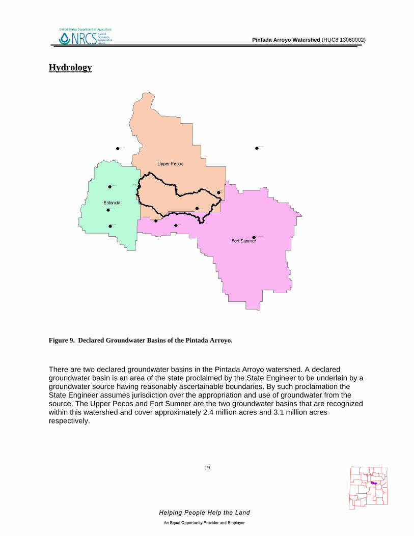
Figure 9. Declared Groundwater Basins of the Pintada Arroyo. There are two declared groundwater basins in the Pintada Arroyo watershed. A declared groundwater basin is an area of the state proclaimed by the State Engineer to be underlain by a groundwater source having reasonably ascertainable boundaries. By such proclamation the State Engineer assumes jurisdiction over the appropriation and use of groundwater from the source. The Upper Pecos and Fort Sumner are the two groundwater basins that are recognized within this watershed and cover approximately 2.4 million acres and 3.1 million acres respectively.
Pintada Arroyo Watershed (HUC8 13060002)
20
Threatened and Endangered Species 11 Endangered species are those that are at risk of extinction throughout all or a significant portion of its native range. A threatened species is one that is likely to become endangered in the foreseeable future. The New Mexico Natural Heritage program tracks the status of threatened and endangered species which are listed on both federal and state lists. Table 7 lists those species which are currently listed and tracked in the Pintada Arroyo River Watershed.
Table 6. Threatened and Endangered Plant and Animal Species Invasive Species 12
Invasive species are those which have been introduced into a region or ecosystem and have the ability to out-compete native species for resources (i.e. water, nutrients, sunlight, etc.) The Southwest Exotic Plant Mapping Program (SWEMP) is a collaborative effort between the United States Geological Survey and federal, tribal, state, county and non-government organization partners in the southwest which maintains ongoing efforts to compile and distribute regional data on the occurrence of non-native invasive plants in the southwestern United States. Within the Pintada Arroyo watershed, the SWEMP has identified 7 species of invasive plants. Each of these species is defined as non-native by the USDA PLANTS database.
Scientific Name Common Name
Fabaceae (Pea Family) camelthorn Scrophylariaceae (Figwort Family) Dalmatian Toadflax
Brassicaceae (Mustard Family) Hoary Cress (Whitetop) Asteraceae (Sunflower Family) Musk Thistle Brassicaceae (Mustard Family) Perennial Pepperweed (Tall Whitetop) Asteraceae (Sunflower Family) Russian Knapweed Asteraceae (Sunflower Family) Spotted Knapweed
Table 7. Invasive Species Recognized by the SWEMP
Common Name Scientific Name Tax.Class Family Fed Status
State Status
Bigscale Logperch Percina macrolepida Actinopterygii Percidae T
Pintada Arroyo Watershed (HUC8 13060002)
21
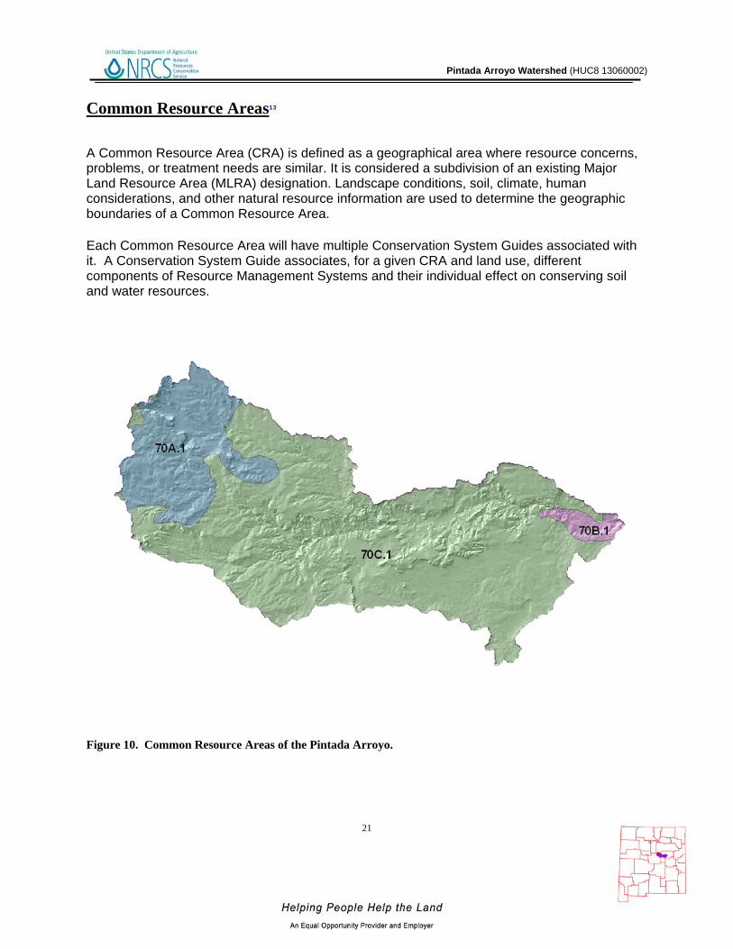
Common Resource Areas13
A Common Resource Area (CRA) is defined as a geographical area where resource concerns, problems, or treatment needs are similar. It is considered a subdivision of an existing Major Land Resource Area (MLRA) designation. Landscape conditions, soil, climate, human considerations, and other natural resource information are used to determine the geographic boundaries of a Common Resource Area.
Each Common Resource Area will have multiple Conservation System Guides associated with it. A Conservation System Guide associates, for a given CRA and land use, different components of Resource Management Systems and their individual effect on conserving soil and water resources.
Figure 10. Common Resource Areas of the Pintada Arroyo.
Pintada Arroyo Watershed (HUC8 13060002)
Common Resource Areas
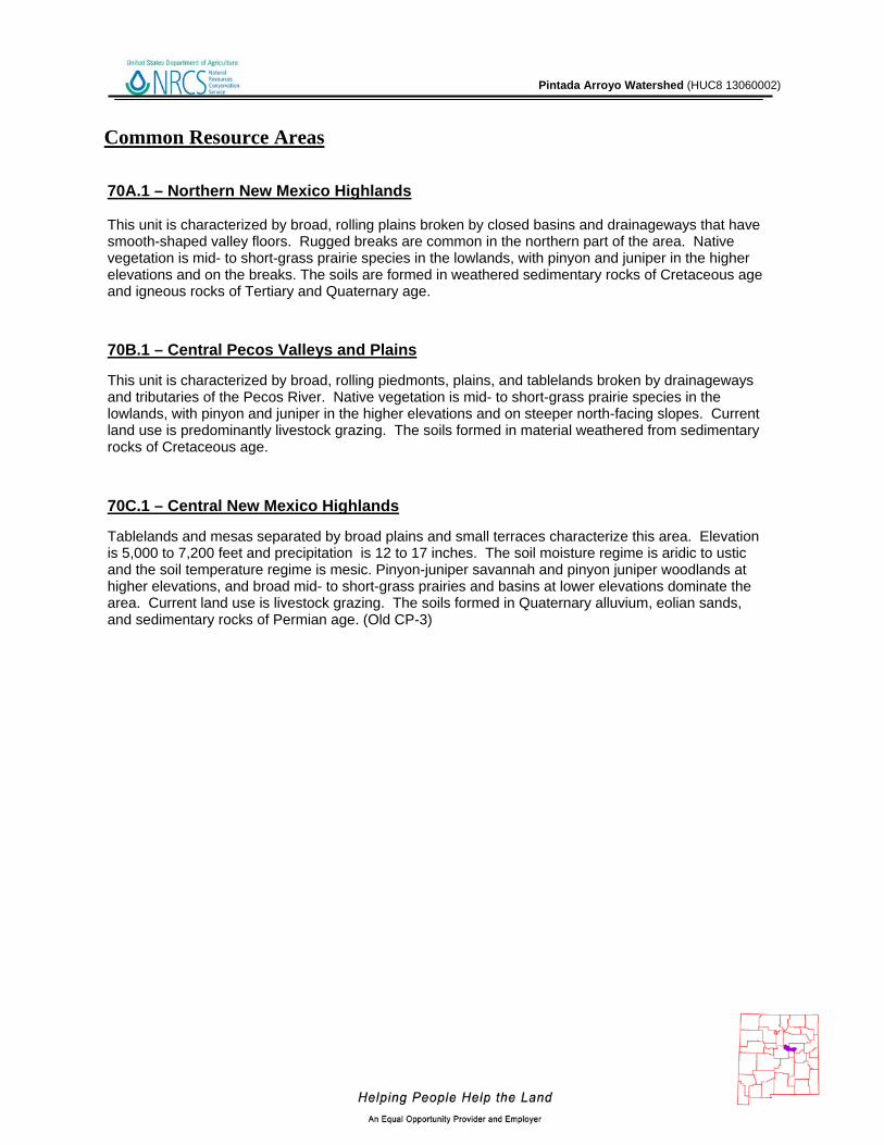
70B.1 – Central Pecos Valleys and Plains This unit is characterized by broad, rolling piedmonts, plains, and tablelands broken by drainageways and tributaries of the Pecos River. Native vegetation is mid- to short-grass prairie species in the lowlands, with pinyon and juniper in the higher elevations and on steeper north-facing slopes. Current land use is predominantly livestock grazing. The soils formed in material weathered from sedimentary rocks of Cretaceous age.
70C.1 – Central New Mexico Highlands Tablelands and mesas separated by broad plains and small terraces characterize this area. Elevation is 5,000 to 7,200 feet and precipitation is 12 to 17 inches. The soil moisture regime is aridic to ustic and the soil temperature regime is mesic. Pinyon-juniper savannah and pinyon juniper woodlands at higher elevations, and broad mid- to short-grass prairies and basins at lower elevations dominate the area. Current land use is livestock grazing. The soils formed in Quaternary alluvium, eolian sands, and sedimentary rocks of Permian age. (Old CP-3)
70A.1 – Northern New Mexico Highlands This unit is characterized by broad, rolling plains broken by closed basins and drainageways that have smooth-shaped valley floors. Rugged breaks are common in the northern part of the area. Native vegetation is mid- to short-grass prairie species in the lowlands, with pinyon and juniper in the higher elevations and on the breaks. The soils are formed in weathered sedimentary rocks of Cretaceous age and igneous rocks of Tertiary and Quaternary age.

Pintada Arroyo Watershed (HUC8 13060002)
23
Conservation 14
The USDA-Natural Resources Conservation Service (NRCS) focuses on the development and delivery of high quality products and services that enable people to be good stewards of our Nation’s soil, water, and related natural related resources on non-Federal lands. The Natural Resources Conservation Service’s conservation programs aid agricultural producers in their efforts to reduce soil erosion, enhance water supplies, improve water quality, increase wildlife habitat, and reduce damages caused by floods and other natural disasters. Public benefits include enhanced natural resources that help sustain agricultural productivity and environmental quality while supporting continued economic development, recreation, and scenic beauty.
2006 2007 2008 2009 2010 Total
Conservation Practice # Acres # Acres # Acres # Acres # Acres # Acres
Brush Management 6 1,127 13 1,434 6 1,106 16 1,683 8 1,400 49 6,750 Integrated Pest Management 3 397 3 397
Prescribed Grazing 2 5,070 4 639 14 25,387 1 329 21 31,425 Upland Wildlife Habitat Management 2 5,070 5 3,652 10 21,410 1 329 18 30,461
SUM (∑) 10 11,267 17 2,073 14 5,155 40 48,480 10 2,058 91 69,033 Table 8. 5 year Trends in Applied Conservation Practices. Reported in Acres.
2006 2007 2008 2009 2010 Total Conservation Practice # Feet # Feet # Feet # Feet # Feet # Feet Diversion 1 10 1 10
Fence 1 3,370 4 17,215 5 30,054 1 4,095 11 54,734
Pipeline 3 18,147 5 23,979 5 9,050 2 3,640 15 54,816
Pond 2 1 3 NA
Pumping Plant 1 1 1 3 NA
Water Well 1 1 1 3 NA
Watering Facility 1 3 20 4 1 29 NA
SUM (∑) 2 NA 33 NA 11 NA NA 5 NA 65 NA Table 9. 5 year Trends in Location Specific Applied Conservation Practices. Reported in Feet if linear (i.e. fence)

Pintada Arroyo Watershed (HUC8 13060002)
24
Soil Resource Inventory 15
Figure 11. National Cooperative Soil Survey coverage of the Pintada Arroyo Watershed.
The entire Pintada Arroyo Watershed has a certified National Cooperative Soil Survey (NCSS) inventory.
National Cooperative Soil Survey

Pintada Arroyo Watershed (HUC8 13060002)
25
Soil Resource Inventory
In order to evaluate the susceptibility of erosion within the Pintada Arroyo watershed, a model was developed using Soil Survey Geographic Database (SSURGO) information. The soil properties saturated hydraulic conductivity, soil loss tolerance, and wind erodibility group were used in conjunction with slope to assess soil mapunit potential for erosion. Saturated hydraulic conductivity and slope are reported in SSURGO databases as interval/ratio data whereas wind erodibility and soil loss tolerance are ordinal data. Data transformations for the model are listed -
Table 10. Criteria Used for Soil Erosion Susceptibility Model
SSURGO Value Nominal Description Model Rank
Saturated Hydraulic Conductivity
µm / s 705.0 - 100.0 Very High 0 100.0 - 10.0 High 1
10.0 - 1.0 Moderately High 2 1.0 - 0.1 Moderately Low 3 0.1 - 0.01 Low 4 Slope %
0 - 5 0 5 - 10 1
10 - 15 2 15 - 25 3
> 25 4 Soil Loss Tolerance
5 High Tolerance For loss 0 4 ↓ 1 3 ↓ 2 2 ↓ 3 1 Low Tolerance For Loss 4
Wind Erodibility Group 1 Very High 4 2 Very High 4 3 High 3 4 High 3 4L High 3 5 Moderate 2 6 Moderate 2 7 Moderate 1 8 Slight 0

Pintada Arroyo Watershed (HUC8 13060002)
26
Soil Resource Inventory
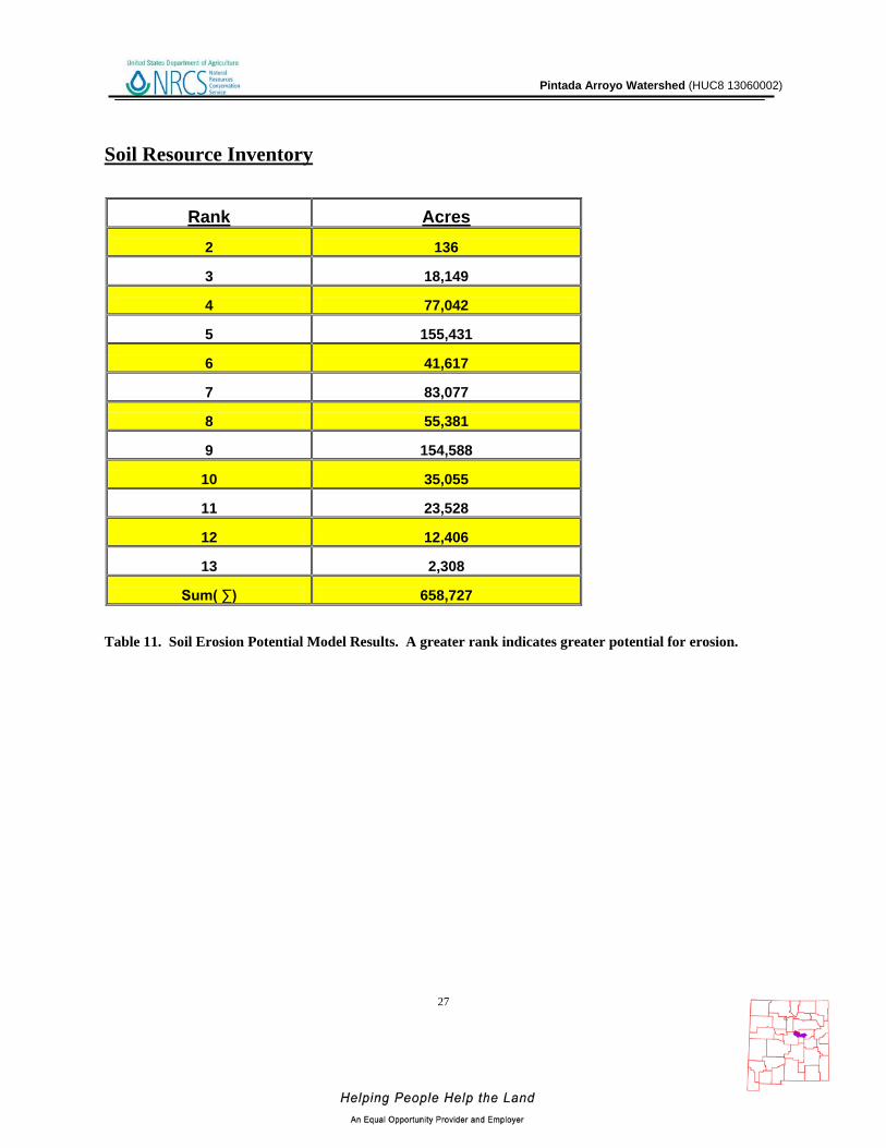
For each soil map unit (discrete delineation), the soil properties (named above) of the dominant soil type was used as the condition to be evaluated in the susceptibility to erosion model. Miscellaneous areas such as gravel pits, water, riverwash, etc. were excluded from evaluation. Possible range of values for each map unit are 0 – 16. Increasing values represent a higher susceptibility to soil erosion.
Figure 12. Pintada Arroyo Watershed Erosion Potential
Soil Erosion Susceptibility
Pintada Arroyo Watershed (HUC8 13060002)
27
Soil Resource Inventory
Table 11. Soil Erosion Potential Model Results. A greater rank indicates greater potential for erosion.
Rank Acres 2 136
3 18,149
4 77,042
5 155,431
6 41,617
7 83,077
8 55,381
9 154,588
10 35,055
11 23,528
12 12,406
13 2,308
Sum( ∑) 658,727

Pintada Arroyo Watershed (HUC8 13060002)
28
Socioeconomic Data 16
COUNTY
Total population:
Total
Total population:
Urban
Total population:
Rural
Total Pop,: Rural Farm
Total Pop.: Rural
Nonfarm
Total population: Hispanic or Latino
Total population:
White alone
Total population:
Black or African
American alone
Total population: American Indian and
Alaska Native alone
Total population:
Asian alone
Total population:
Native Hawaiian and Other
Pacific Islander
alone
Total population:
Some other race
alone
Total population:
Two or more races
Families: Median family
income in 1999
Guadalupe 4,680 2,530 2,150
269
1,881 3,801 2,530 62 53 25 2 1,828 180 $28,279 San Miguel 30,126 18,000 12,126
290
11,836 23,487 16,938 236 549 163 25 10,910 1,305 $31,250
Torrance 16,911 819 16,092
829
15,263 6,283 12,495 280 354 54 22 3,035 671 $34,461 Table 12. Socioeconomic Data of Counties in the Watershed (2000).

Pintada Arroyo Watershed (HUC8 13060002)
29
References 1. Parameter-elevation Regressions on Independent Slopes Model (PRISM).PRISM is a unique knowledge-based system that uses point measurements of precipitation, temperature, and other climatic factors to produce continuous, digital grid estimates of monthly, yearly, and event-based climatic parameters. http://www.prism.oregonstate.edu/ 2. Bureau of Land Management – New Mexico State Office. - http://www.blm.gov/nm/st/en/prog/more/geographic_sciences/spatial_data_metadata.html 3. UNITED STATES GEOLOGICAL SURVEY - National Land Cover Dataset. http://landcover.United States Geological Survey.gov/ 4. Southwest Regional Gap Analysis Project (SWReGAP). http://earth.gis.usu.edu/swgap/ 5. UNITED STATES GEOLOGICAL SURVEY – National Hydrography Dataset. http://nhd.United States Geological Survey.gov/ 6. State of New Mexico Clean Water Act 303(d)/305(b) Integrated Report ftp://ftp.nmenv.state.nm.us/www/swqb/303d-305b/2010/USEPA-Approved303dList.pdf 7. United States Environmental Protection Agency - http://cfpub.epa.gov/surf/huc.cfm?huc_code=13060002 8. New Mexico - Office of the State Engineer- http://www.ose.state.nm.us/water_info_data.html 9. UNITED STATES GEOLOGICAL SURVEY - http://waterdata.usgs.gov/nwis/rt 10. New Mexico - Office of the State Engineer- http://www.ose.state.nm.us/water_info_awrm.html 11. New Mexico Natural Heritage Program - http://nhnm.unm.edu/ 12. Southwest Exotic Plant Mapping Program - http://www.invasiveweeds.com/mapping/welcome.html 13. Natural Resources Conservation Service – Common Resource Area (CRA) Geographic Database http://soils.usda.gov/survey/geography/cra.html 14. Natural Resources Conservation Service – Performance Results System http://ias.sc.egov.usda.gov/PRSHOME/ 15. Natural Resources Conservation Service – Soil Data Mart http://soildatamart.nrcs.usda.gov/ 16. United States Census Bureau - http://factfinder2.census.gov/faces/nav/jsf/pages/index.xhtml