rapid shelter assessment (remote and rural...
TRANSCRIPT

CARE International Indonesia
Rapid Shelter assessment
(Remote and Rural areas) West Sumatra Earthquake of 30 Sept 2009
Prepared by
Adjie Fachrurrazi Emergency Response Coordinator
+62 (0)8121076782
Seki Hirano Shelter Advisor
DRAFT Zero 15th Oct 2009
Page 1 of 1

Contents
1. Back ground 2. Rapid field assessment methodology 3. Data analysis 4. Rural specificity 5. Human settlement 6. Shelter visual assessments 7. Construction techniques 8. Water and sanitation 9. Schools 10. Hospitals/ Health centres 11. Religious buildings 12. Self – made emergency shelter solutions 13. Self recovery 14. Strong Community structures 15. Collective centres 16. Barracks 17. Landslides 18. Further assessments 19. Conclusion
This qualitative assessment (technical in nature) has been created to share CARE International Indonesia’s
observations within the first week post‐earthquake. It has been created for the aim of sharing information
within CARE organisations, cluster members and the wider humanitarian community as a sample of one of the
most affected areas.
Executive summary
CARE’s emergency response team has observed some of the devastating effects of the West
Sumatra earthquake of 30th Sept 2009. 135,333 houses have been rendered un-inhabitable. Much of
the structural failure has been due to the magnitude of the 7.6 earth quake combined with unsafe
construction practices. Observations within the first week post disaster reports impressive local culture
to self-help, and put together makeshift shelters from salvaged material. However the fact remains
that affected populations have lost their homes, water and sanitation facilities, assets and in some
cases their livelihoods (land, shops etc). A portion of the affected have been seen living in collective
centres and some in government IDP camps.
The rapid assessment has found that the affected population needs of shelter from the elements and
support to clear dangerous structures. Also to reduce the risk of water born diseases and maintain
health essential household items and hygiene material will contribute to the relief.
The damage experienced is over-whelming it must be highlighted that efforts to aid building back
safer must be the highest priority to limit the impact of any future disasters.
Page 2 of 2

01 Back ground;
Wednesday 30th September 2009 at
17:16 hrs an earthquake Richter scale
7.6, struck West Sumatra, Indonesia.
The epicenter 57 km southwest of the
district of Pariaman was followed by an
aftershock 22 minutes later, with an
epicenter located 22km southeast of
Pariaman.
Affected populations have reported that
there were lateral thrusts followed by a
strong vertical movement which maybe
the reason for the large scale of
destruction. In the mountainous areas of
Pariaman landslides were experienced
and in one sub-district of Sungai
Geringging within the district of Padang
Pariaman, a landslide claimed three
villages and its inhabitants.
A sample of affected communities was
visited within days of the earthquake.
The visits saw the strength of the
affected to make make-shift shelters. As of 12th October, Large numbers of affected people continue
to sleep outside due to the worries of another earthquake collapsing the damaged house. The
majority of water and electricity systems have been destroyed. Initial CARE field assessments have
reported an increase of diarrhea in 4 villages post-earthquake.
02 Rapid field assessment methodology
This technical assessment is to compliment other ongoing assessments such as the ECB and DaLa.
This assessment presents a sample of affected rural districts of Pandang Pariaman where the
damage has been severe, official District level data indicates that an 95% of the houses are severely
or moderately damaged rendering the house unsafe to occupy. This assessment is reliant upon first
hand observations and interviews with the affected households, combined with data and information
available at cluster, district and village level.
Page 3 of 3

03 Data analysis
Government figures estimate a total of 135,3331 houses were severely damaged and 62,882
houses moderately damaged. This is a total of 198,215 houses made un-inhabitable and potentially
requiring emergency relief items. This earthquake has left all buildings in the region more vulnerable
to future natural disasters than before.
This assessment concentrates on the most affected Padang Pariaman district as indicated on the
map above. The district of Padang Pariaman has approx 400,000 inhabitants and has 18 sub-
districts. Estimated damage in the district of Padang Pariaman according to local government
indicates 87,682 houses were (11th October 2009);
1 Indonesian government figures dated 11-Oct-2009
Page 4 of 4

According to statistics gathered by the field team, numbers of effected household appear to be higher
than of the reported figures (as above) it is envisaged that the numbers will keep fluctuating until
government inspections and verifications are complete.
Government statistics (11th October 2009) for earthquake damage in Padan Pariaman district. House Schools Level of damage Severely Moderate Slightly Severely Moderate Slightly No. 70,608 12,631 4,443 257 87 31 Total damaged 8,3239 houses
Un-inhabitable 87,682 houses damaged
344 schools unsafe to occupy
375 schools damaged
04 Rural specificity
This assessment concentrates on the remote rural areas. The conditions in rural areas are different to
those in urban areas for the following key reasons:
- Limited transport access
- Predominantly agricultural based livelihoods
- Predominantly single storey buildings
- Most villages without piped water
- Most villages located in mountainous land
- Some areas affected by landslides
These differences should affect response strategies and the implementation of support programmes.
05 Human settlement
Un-inhabitable houses are currently estimated at 198,215 houses. The majority of affected
populations tend remain on or near their plot of land. Sleeping under makeshift shelters made with
salvaged material. Initial observations have seen some living, or just sleep in collective centres such
as mosques. Other visits have seen affected populations in government IDP camps, figure yet to be
confirmed by IOM or ECB assessment. A villager told that they might take a host family option soon,
however as in that village 95% of houses were damaged it may be a challenge.
Page 5 of 5
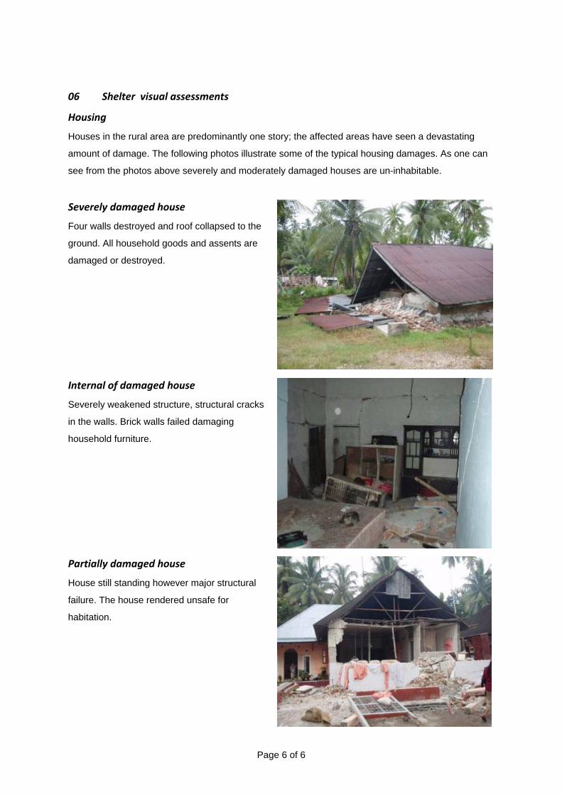
06 Shelter visual assessments
Housing
Houses in the rural area are predominantly one story; the affected areas have seen a devastating
amount of damage. The following photos illustrate some of the typical housing damages. As one can
see from the photos above severely and moderately damaged houses are un-inhabitable.
Severely damaged house
Four walls destroyed and roof collapsed to the
ground. All household goods and assents are
damaged or destroyed.
Internal of damaged house
Severely weakened structure, structural cracks
in the walls. Brick walls failed damaging
household furniture.
Partially damaged house
House still standing however major structural
failure. The house rendered unsafe for
habitation.
Page 6 of 6

07 Construction techniques
There are four common types of building techniques in the affected rural areas; Structural Brick walls,
Concrete column with brick in fill, Stone with clay and lime mortar and Timber frame, all of which has
been damaged to different degrees.
Brick walls
Brick wall construction is common in the
region, however without reinforcement brick
walls just crumbled and peeled away. This is
a very hazardous construction technique as
the wall collapse and roof cave in or the wall
falls in on top of the people inside.
Concrete column with brick infill
Slender concrete columns failed. Brick infill
walls peeled off the columns as there were no
ties between column and wall.
Page 7 of 7

Stone with clay and lime mortar
In some areas the use of local stone with clay
and lime mortar have been seen, however
much of them have been damaged.
Timber frame
Timber frame houses are present in the area
although brick building are more common as
it is seen as “permanent”. In the same village
timber frame houses generally have seen less
damage. This photo shows a undamaged
timber house and next to this house a totally
destroyed brick house.
,
Lack of reinforcement connecting the column to
the foundations.
No ring beam (sloth)
Traditional Padang roof structures are heavy
and in this instance structural columns failed.
Page 8 of 8

Land movement, causing sedimentation to
the foundations, relocation and tenure
issues may become important.
Lack of lateral bracing, dangerous structure.
Size of structural columns too small and low
quality of re‐enforcement bars.
Dangerous structures left and owners put
supports to avoid collapse.
Page 9 of 9

Entire ground floor collapsed.
Weakness in corners without structural
columns
Page 10 of 10
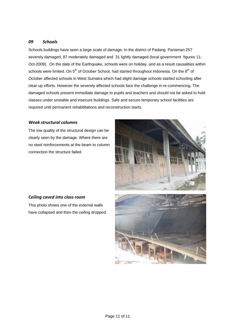
09 Schools
Schools buildings have seen a large scale of damage; In the district of Padang Pariaman 257
severely damaged, 87 moderately damaged and 31 lightly damaged (local government figures 11-
Oct-2009). On the date of the Earthquake, schools were on holiday, and as a result causalities within
schools were limited. On 5th of October School, had started throughout Indonesia. On the 8th of
October affected schools in West Sumatra which had slight damage schools started schooling after
clear-up efforts. However the severely affected schools face the challenge in re-commencing. The
damaged schools present immediate damage to pupils and teachers and should not be asked to hold
classes under unstable and insecure buildings. Safe and secure temporary school facilities are
required until permanent rehabilitations and reconstruction starts.
Weak structural columns
The low quality of the structural design can be
clearly seen by the damage. Where there are
no steel reinforcements at the beam to column
connection the structure failed.
Ceiling caved into class room
This photo shows one of the external walls
have collapsed and then the ceiling dropped.
Page 11 of 11

No connection from the Ring beam to
the foundations
This detail shows the ring beam was not
anchored to the foundations. Thus the building
collapsed.
10 Hospitals/ Health centres
Central hospital in the sub-district have been
heavily damaged and hospitals operate under
tents.
11 Religious buildings
Some Religious buildings have collapsed also,
destroying community space.
Page 12 of 12
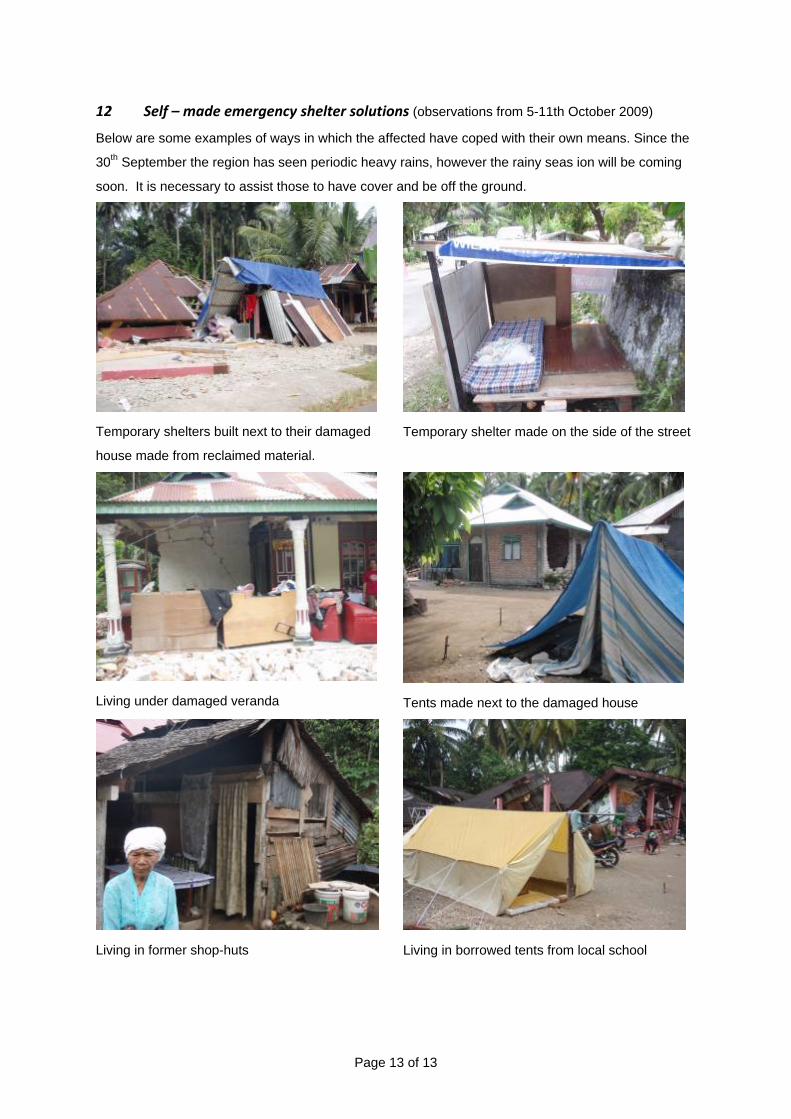
12 Self – made emergency shelter solutions (observations from 5-11th October 2009)
Below are some examples of ways in which the affected have coped with their own means. Since the
30th September the region has seen periodic heavy rains, however the rainy seas ion will be coming
soon. It is necessary to assist those to have cover and be off the ground.
Temporary shelters built next to their damaged
house made from reclaimed material.
Temporary shelter made on the side of the street
Living under damaged veranda
Tents made next to the damaged house
Living in former shop-huts
Living in borrowed tents from local school
Page 13 of 13

13 Self recovery
Visits to the sites 3-7 days post-earthquake has seen the determination of the affected community to
piece together their lives. Many of the households have started clearing the rubble, sorting materials;
the conditions are not like tsunami cyclones or flooding building destroyed, but materials salvageable.
Households clearing up rubble
Households salvaging re-useable material Community start constructing
Page 14 of 14

14 Strong Community structures
Goto Ryongu translated “team work” is a form of community work. According to the villagers prior to
the Earthquake and still now there is a strong community tie within Padang Pariaman. In the Korong
(village) of Sungai Rantai within the Sungai Geringging sub-district there is a community structure
called “Julo Julo” This is a grouping of approximate 30 people who support any of the other members
who need to build or repair a house. The support would be either finance or labour and skills.
15 Collective centres
The photo shows an example of a collective
centre; a mosque is used as an earthquake
centre. In this place 120 people sleep at night.
Local groups support this facility and they make
food together from donations.
16 Barracks
11th October we have observed a national NGO
starting to construct a barrack. This complex will
house one household in a 2.5mx 4m space and
will have 100 units within a former football pitch.
Latrines and a temporary school had been
planned.
Page 15 of 15

17 Landslides
The area of Pariaman have experienced
many landslides. This photo is from a village
in Patamuar where three complete villages
(300 households) were claimed by the
landslide, only 4 survived.
Specific concerns for the survivors and
neighbouring communities are;
- Weakened soil, higher risk of further landslides
- Risk of mud slides in heavy rain
- Loss of agricultural land
- Potential re-location and related tenure issues
Further assessments
A further in-depth needs and vulnerability assessment will be required this should target the following
groups:
- Landslide affected
- Newly handicapped
- Single parent households
- Renters and non-landowners
- The poor
- Minority groups
19 Conclusion
Long term need to cultivate safer building practice and associated Disaster Risk Reduction
in the multiple hazard environment.
Emergency Shelter needs;
Need cover from rain and sun especially as the rainy session is approaching.
Need basic non food items such as blankets cloth cooking equipment as most household assets have
been lost under the rubble.
Need tool kits, in order to clear the dangerous structures and to salvage materials before they are
spoilt.
Emergency WASH needs;
Basic hygiene item are needed as the affected population have limited means to purchase materials.
Emergency sanitation relief is required in areas which as increased rate of water-borne diseases.
Page 16 of 16