rap and lrp for rumsl’s 1500 mw solar park project and...
TRANSCRIPT

The business of sustainability
RAP and LRP for RUMSL’s 1500 MW Solar Park Project and associated infrastructure across Neemuch, Agar and Shajapur
Final Report-Volume II A Neemuch Solar Park (Units 1, 2 & 3)
03 May 2021
Project No.: 0528741
www.erm.com

www.erm.com Version: 2.1 Project No.: 0528741 Client: Rewa Ultra Mega Solar Limited (RUMSL) 03 May 2021
RAP AND LRP FOR RUMSL’S 1500 MW SOLAR PARK PROJECT AND ASSOCIATED INFRASTRUCTURE ACROSS NEEMUCH, AGAR AND SHAJAPUR Final Report-Volume II A Neemuch Solar Park (Units 1, 2 & 3)
CONTENTS
Document details The details entered below are automatically shown on the cover and the main page footer.
PLEASE NOTE: This table must NOT be removed from this document.
Document title RAP and LRP for RUMSL’s 1500 MW Solar Park Project and associated infrastructure
across Neemuch, Agar and Shajapur
Document subtitle Final Report-Volume II A Neemuch Solar Park (Units 1, 2 & 3)
Project No. 0528741
Date 03 May 2021
Version 2.1
Author ERM India Private Limited
Client Name Rewa Ultra Mega Solar Limited (RUMSL)
Document history
ERM approval to issue
Version Revision Author Reviewed by Name Date Comments
Draft 1.0 Aritra
Chakrabarty;
Shruti Srikanth
Sumati Bhatia
Rutuja
Tendolkar
Akshita Misra
Neena Singh 30 January
2021
Draft for Client
Draft Final 2.0 Aritra
Chakrabarty;
Shruti Srikanth
Akshita Misra
Sumati Bhatia
Rutuja
Tendolkar
Ajay Pillai 22 April
2021
Draft final for
disclosure
Final 2.1 AAkshita Misra Sumati Bhatia
Rutuja
Tendolkar
Ajay Pillai 03 May 2021 Final RAP

www.erm.com Version: 2.1 Project No.: 0528741 Client: Rewa Ultra Mega Solar Limited (RUMSL) 03 May 2021
RAP AND LRP FOR RUMSL’S 1500 MW SOLAR PARK PROJECT AND ASSOCIATED INFRASTRUCTURE ACROSS NEEMUCH, AGAR AND SHAJAPUR Final Report-Volume II A Neemuch Solar Park (Units 1, 2 & 3)
CONTENTS
Signature Page
03 May 2021
RAP and LRP for RUMSL’s 1500 MW Solar Park Project and associated infrastructure across Neemuch, Agar and Shajapur
Final Report-Volume II A Neemuch Solar Park (Units 1, 2 & 3)
Name Ajay Pillai
Job title Partner In Charge
Name Rutuja Tendolkar
Job title Principal Consultant
ERM India Private Limited
3rd Floor, Building 10 B
DLF Cyber city,
Gurgaon - 122 002
Tel:-0124-4170300
© Copyright 2021 by ERM Worldwide Group Ltd and/or its affiliates (“ERM”).
All rights reserved. No part of this work may be reproduced or transmitted in any form,
or by any means, without the prior written permission of ERM.

www.erm.com Version: 2.1 Project No.: 0528741 Client: Rewa Ultra Mega Solar Limited (RUMSL) 03 May 2021
RAP AND LRP FOR RUMSL’S 1500 MW SOLAR PARK PROJECT AND ASSOCIATED INFRASTRUCTURE ACROSS NEEMUCH, AGAR AND SHAJAPUR Final Report-Volume II A Neemuch Solar Park (Units 1, 2 & 3)
CONTENTS
CONTENTS
EXECUTIVE SUMMARY: NEEMUCH SOLAR PARK ............................................................................ I
Preamble ...................................................................................................................................................... I Project Overview ........................................................................................................................................... I
Key Project Development Timelines ............................................................................................. III Land Footprint for Neemuch Solar Park........................................................................................ III Avoidance and Impact Minimization ............................................................................................. IV
Overview of Project Affected Households .................................................................................................. VII
Project Affected Villages .............................................................................................................. VII Project Affected Khasras ............................................................................................................. VII Titleholders and Non-titleholders ................................................................................................ VIII Key Survey Milestones ................................................................................................................. IX
Profile of Project Affected Communities ....................................................................................................... X
Profile of Villages in the Project Footprint ...................................................................................... X Profile of Project Affected Households .......................................................................................... X
Profile of Key Stakeholder Groups and Feedback ..................................................................................... XII
Stakeholder Identification and Analysis ....................................................................................... XII
Involuntary Resettlement Impacts ............................................................................................................ XIV
Overview of Project-Affected Land and Assets .......................................................................... XIV Immovable Structures ................................................................................................................. XV Common Property Resources .................................................................................................... XVI Intensity of Involuntary Resettlement Impacts .......................................................................... XVII Physical Displacement .............................................................................................................. XVII Economic Displacement ........................................................................................................... XVII Community based livelihood impacts ....................................................................................... XVIII Gendered livelihood impacts .................................................................................................... XVIII Impact on Vulnerable groups ................................................................................................... XVIII
Project-specific Strategies for Implementation ......................................................................................... XIX Grievance Management ........................................................................................................................... XIX
1. INTRODUCTION TO VOLUME II A ............................................................................................. 1
1.1 Brief Project Description for Neemuch Solar Park ......................................................................... 2 1.2 Project Development Timelines ..................................................................................................... 5 1.3 Approach, Methodology and Survey Coverage ............................................................................. 6
1.3.1 Resettlement Scoping ................................................................................................... 6 1.3.2 Optimization .................................................................................................................. 6 1.3.3 RAP Survey Coverage .................................................................................................. 7 1.3.4 Specific Limitations applicable to the RAP surveys, for Unit 1, 2 and 3 ........................ 8
1.4 Layout of the Volume II A ............................................................................................................... 9
2. PROJECT FOOTPRINT AND LAND PROCUREMENT STATUS ............................................ 10
Project Footprint .......................................................................................................................... 10
Government Land Allotment ....................................................................................... 10 Use of Government Land ............................................................................................ 11 Private and Patta Land ............................................................................................... 14
Impact Avoidance and Project Boundary Optimization ................................................................ 14
Comparison of Project Land Requirements ................................................................ 14 Optimization carried out and suggested ...................................................................... 14
3. SUMMARY OF PROJECT AFFECTED ENTITIES .................................................................... 19
Land Use and other Sensitivities ................................................................................................. 19 Project Affected Villages .............................................................................................................. 21 Affected Khasras ......................................................................................................................... 21

www.erm.com Version: 2.1 Project No.: 0528741 Client: Rewa Ultra Mega Solar Limited (RUMSL) 03 May 2021
RAP AND LRP FOR RUMSL’S 1500 MW SOLAR PARK PROJECT AND ASSOCIATED INFRASTRUCTURE ACROSS NEEMUCH, AGAR AND SHAJAPUR Final Report-Volume II A Neemuch Solar Park (Units 1, 2 & 3)
CONTENTS
Project affected area and survey coverage .................................................................................. 22
Assets affected ........................................................................................................... 22
Project Affected Households (PAHs) ........................................................................................... 23
4. SOCIO-ECONOMIC BASELINE PROFILE OF AFFECTED COMMUNITIES OF NEEMUCH
SOLAR PARK ............................................................................................................................ 25
Profile of Villages in the Project Footprint .................................................................................... 25
Profile of Villages in Unit 1, 2 and 3 ............................................................................ 25 Cultural Resources ..................................................................................................... 31
Socioeconomic profile of the households surveyed in the Project Footprint ................................ 32
Social Group Dynamics .............................................................................................. 35 Education .................................................................................................................... 38 Land and Asset Ownership ......................................................................................... 40 Livelihood Profile ......................................................................................................... 45 Agricultural Activities ................................................................................................... 48 Livestock Rearing ....................................................................................................... 53 Income and Expenditure ............................................................................................. 55 Community Dependence on Natural Resources ......................................................... 57 Physical and Social Infrastructure ............................................................................... 59 Gender Profile ............................................................................................................. 65 Vulnerability ................................................................................................................ 68
5. STAKEHOLDER ENGAGEMENT AND CONSULTATION ....................................................... 71
Stakeholder Identification and Analysis ....................................................................................... 71 Overview of the Engagement Process as Part of Resettlement Planning ................................... 82
Government Land Allotment ....................................................................................... 82 ESIA ............................................................................................................................ 82 Private and Patta Land Procurement .......................................................................... 82 Resettlement Surveys ................................................................................................. 83
Incorporation of Stakeholder Feedback into Project Decision Making ......................................... 83
6. INVOLUNTARY RESETTLEMENT IMPACTS .......................................................................... 85
Summary of Key Impacts ............................................................................................................. 85 Project-Affected Land and Assets ................................................................................................ 87
GrazierGrazier ............................................................................................................ 89 Grazier ........................................................................................................................ 89
Project-Affected Residential Structures ...................................................................... 89 Affected immovable assets ......................................................................................... 89 Private/Patta agricultural khasras ............................................................................... 92 Extent of Government Land under informal use.......................................................... 93 Clearing of Standing crops .......................................................................................... 94 Change of land use on government land used for grazing .......................................... 94 Clearing of privately owned fruit and timber trees ....................................................... 95 Affected Collective Assets .......................................................................................... 95
Involuntary Resettlement Impacts ................................................................................................ 95
6.3.1 Physical displacement ................................................................................................ 96 Economic displacement .............................................................................................. 96 Community based livelihood impacts .......................................................................... 98 Gendered livelihood impacts ....................................................................................... 99 Impact on Vulnerable groups .................................................................................... 100
7. IMPLEMENTATION STRATEGIES FOR NEEMUCH SOLAR PARK .................................... 102
Completion of pending activities prior to Implementation ........................................................... 102 Stakeholder Engagement and Grievance Management ............................................................ 103 RAP Implementation schedule for Neemuch Solar Park ........................................................... 103

www.erm.com Version: 2.1 Project No.: 0528741 Client: Rewa Ultra Mega Solar Limited (RUMSL) 03 May 2021
RAP AND LRP FOR RUMSL’S 1500 MW SOLAR PARK PROJECT AND ASSOCIATED INFRASTRUCTURE ACROSS NEEMUCH, AGAR AND SHAJAPUR Final Report-Volume II A Neemuch Solar Park (Units 1, 2 & 3)
CONTENTS
APPENDIX A PHOTO DOCUMENTATION
APPENDIX B SUMMARY OF CONSULTATIONS
APPENDIX C PROFILE OF INFORMAL USERS IN NEEMUCH SOLAR PARK
APPENDIX D PROFILE OF RESIDENTIAL STRUCTURES WITHIN NEEMUCH SOLAR PARK
APPENDIX E HOUSEHOLD LEVEL ENTITLEMENTS
List of Tables
Table 0.1 Salient Features: Neemuch Solar Park: 500 MW ............................................................. I
Table 0.2 Village Wise Land Requirement for the Project (ha) ....................................................... III
Table 0.3 Impact avoidance undertaken by village ......................................................................... IV
Table 0.4 Land Footprint by Ownership, in Project Villages ..........................................................VII
Table 0.5 Land required for Solar Park ..........................................................................................VII
Table 0.6: Status of Household Survey Coverage .........................................................................VIII
Table 0.7 Profile of Households Surveyed ....................................................................................... X
Table 0.8: Stakeholder Group Categorization .................................................................................XII
Table 0.9 Feedback Received for Incorporation into Resettlement ............................................. XIV
Table 0.10 Land Area under Informal land Use .............................................................................. XV
Table 0.11 Count of Immovable and Fixed Assets ......................................................................... XV
Table 0.12 Dependence of households on grazing land ............................................................... XVI
Table 0.13 Economic and Physical displacement of PAHs .......................................................... XVII
Table 0.14 Park Specific Implementation Insights ......................................................................... XIX
Table 1.1 Neemuch Solar Park Project Summary ........................................................................... 2
Table 1.2 Field Survey Activities: Neemuch Solar Park .................................................................. 7
Table 1.3 PAH Not Surveyed ........................................................................................................... 8
Table 2.1 Village Wise Land Requirement for the Project (ha) ...................................................... 10
Table 2.2 Dates of Government Land Allotment for Neemuch Solar Park .................................... 11
Table 2.3 Designated government grazing land ............................................................................ 13
Table 2.4 Impact avoidance undertaken by village ........................................................................ 15
Table 3.1 Land Requirement by Ownership, in Project Villages .................................................... 21
Table 3.2 Land required for Solar Park .......................................................................................... 21
Table 3.3 Survey coverage ............................................................................................................ 22
Table 3.4 Status of Household Survey Coverage .......................................................................... 23
Table 4.1 Population Profile of Villages ......................................................................................... 25
Table 4.2 Proportion (%) of village population Livelihood Source ................................................. 28
Table 4.3 Cultural resources in the Solar Park .............................................................................. 31
Table 4.4 Demographic Profile of surveyed households ............................................................... 32
Table 4.5 Age Structure of the population ..................................................................................... 33
Table 4.6 Summary of Qualitative Observation on Social Groups ................................................ 36
Table 4.7 Literacy amongst surveyed population .......................................................................... 38
Table 4.8 Age wise literacy levels among surveyed Population .................................................... 39
Table 4.9 Size of land holdings ...................................................................................................... 41
Table 4.10 Land holding of the PAHs by Village ............................................................................. 41
Table 4.11 Movable Assets amongst surveyed households by village ........................................... 44
Table 4.12 Count of PAHs by Cropping Pattern .............................................................................. 49
Table 4.13 Month wise dependence on Grazing land and Fodder .................................................. 55
Table 4.14 Average Annual Expenditure by Income Group (INR) ................................................... 56
Table 4.15 Types of Tree plantations .............................................................................................. 58
Table 4.16 Tree species by use ....................................................................................................... 59
Table 4.17 Fruit species by productivity ........................................................................................... 59

www.erm.com Version: 2.1 Project No.: 0528741 Client: Rewa Ultra Mega Solar Limited (RUMSL) 03 May 2021
RAP AND LRP FOR RUMSL’S 1500 MW SOLAR PARK PROJECT AND ASSOCIATED INFRASTRUCTURE ACROSS NEEMUCH, AGAR AND SHAJAPUR Final Report-Volume II A Neemuch Solar Park (Units 1, 2 & 3)
CONTENTS
Table 4.18 Sources of Electricity ..................................................................................................... 60
Table 4.19 Demography of women led households among surveyed PAH .................................... 65
Table 4.20 Qualitative Observations on Female headed and Male headed households ................ 67
Table 4.21 Types of Vulnerability among PAHs .............................................................................. 70
Table 5.1 Stakeholder Group Categorization ................................................................................. 71
Table 5.2 Assessment parameters and characteristics ................................................................. 72
Table 5.3 Characterization and Assessment of Stakeholders Significance .................................. 73
Table 5.4 Stakeholder Positioning ................................................................................................. 81
Table 5.5 Feedback Received for Incorporation into Resettlement ............................................... 83
Table 6.1 Summary of Impacts for the TL RoW ............................................................................. 86
Table 6.2 Count of Immovable and Fixed Assets .......................................................................... 91
Table 6.3 Land Area under Informal land Use ............................................................................... 93
Table 6.4 Economic and Physical displacement of PAHs ............................................................. 96
Table 6.5 Impact on households Surveyed owning private/patta land .......................................... 96
Table 6.6 Informal Occupiers/Users (encroachment/squatting) .................................................... 97
Table 6.7 PAH impacted by loss of timber trees ............................................................................ 98
Table 6.8 Dependence of households on grazing land ................................................................. 99
Table 6.9 Women headed households among PAH ...................................................................... 99
List of Figures
Figure 0-1 Overview of Neemuch Solar Park Layout ........................................................................ II
Figure 0.2 Habitat Clusters in the Solar Park avoided & suggested ................................................ VI
Figure 0-3 Overview of Key Village-level Attributes .......................................................................... X
Figure 0-4 Prioritisation of Stakeholders ........................................................................................XIII
Figure 1.1 Structure of the RAP and LRP Deliverables for 1500 MW .............................................. 1
Figure 1.2 Project Location Map ....................................................................................................... 3
Figure 1.3 Neemuch Solar Park Footprint Map (Unit 1-3) ................................................................ 4
Figure 2.1 Photographs of residential clusters in Unit 3: Badi ........................................................ 16
Figure 2.2 Photographs of religious structures in Unit 3: Badi ........................................................ 17
Figure 2.3 Habitat Clusters in the Solar Park avoided & suggested ............................................... 18
Figure 3.1 Sensitivity map of Unit 1, 2 & 3 ...................................................................................... 20
Figure 4.1 Proportion of Social Group Households ........................................................................ 26
Figure 4.2 Average Land Holding ................................................................................................... 27
Figure 4.3 Preference for R&R Support .......................................................................................... 30
Figure 4.4 Age Sex Pyramid ........................................................................................................... 33
Figure 4.5 Social groups by Village ................................................................................................. 34
Figure 4.6 Residential Structures within the village ........................................................................ 35
Figure 4.7 Level of Education among surveyed population ........................................................... 39
Figure 4.8 Housing: Types of Construction ..................................................................................... 42
Figure 4.9 Type of Livestock holdings ............................................................................................. 42
Figure 4.10 Primary Livelihoods across Age grops........................................................................... 45
Figure 4.11 Primary Occupation Profile by village ............................................................................ 46
Figure 4.12 Primary Occupation Profile by Gender .......................................................................... 46
Figure 4.13 Primary occupation by Social Group............................................................................. 47
Figure 4.14 Households engaged in Agriculture by Village .............................................................. 49
Figure 4.15 Seasonal calendar for major crops of surveyed households ......................................... 50
Figure 4.16 Crop Productivity per hectare (in Quintal) ...................................................................... 51
Figure 4.17 Cropping pattern amongst PAH by types of Farmer ...................................................... 52
Figure 4.18 Food Security amongst PAH by Types of Farmers ....................................................... 53
Figure 4.19 Uses of Livestock ........................................................................................................... 54
Figure 4.20 Annual Income of the Surveyed Households (INR) ....................................................... 55
Figure 4.21 Annual Income of surveyed households by social group (INR) ..................................... 56

www.erm.com Version: 2.1 Project No.: 0528741 Client: Rewa Ultra Mega Solar Limited (RUMSL) 03 May 2021
RAP AND LRP FOR RUMSL’S 1500 MW SOLAR PARK PROJECT AND ASSOCIATED INFRASTRUCTURE ACROSS NEEMUCH, AGAR AND SHAJAPUR Final Report-Volume II A Neemuch Solar Park (Units 1, 2 & 3)
CONTENTS
Figure 4.22 Income-Expenditure Comparison ................................................................................. 57
Figure 4.23 Dependence of surveyed households on Natural Resources ....................................... 57
Figure 4.24 Collection of Natural resources for Household Consumption ........................................ 58
Figure 4.25 Preference of Health care facility ................................................................................... 59
Figure 4.26 Source of Drinking Water ............................................................................................... 61
Figure 4.27 Source of Water for household use .............................................................................. 61
Figure 4.28 Sanitation Facilities in Households ................................................................................ 62
Figure 4.29 Cooking Fuel Usage across Social Groups ................................................................... 63
Figure 4.30 Sources of Credit ........................................................................................................... 64
Figure 4.31 Primary Employment among Women ............................................................................ 67
Figure 5.1 Position of Stakeholders as per stakeholder assessment ............................................. 81
Figure 6.1 Overview of impacted assets surveyed in Unit 1, 2 and 3 ............................................. 88
Figure 6.2 Cattle shed structure on agricultural parcels ................................................................. 90
Figure 6.3 Dug Well on agricultural parcels .................................................................................... 92
Acronyms and Abbreviations
Name Description
AGOL ArcGIS Online
DC District Collector
DEM Draft Entitlement Matrix
DRO District Revenue Officer
EMC External Monitoring Consultant
ESF Environmental and Social Framework, 2018 (of the World Bank)
ESIA Environmental and Social Impact Assessment
ERM ERM India Private Limited
ESMPF Environmental and Social Management Policy Framework
GoMP Government of Madhya Pradesh
Ha Hectares
HoH Head of Household
IFC International Finance Corporation
L&A Land and Asset
LRP Livelihood Restoration Plan
MPLRC Madhya Pradesh Land Revenue Code
MPNRED Madhya Pradesh New and Renewable Energy Department
MW Mega Watt
NSP Neemuch Solar Park
PAE Project Affected Entity
PAH Project Affected Household
PAP Project Affected Persons
PGCIL Power Grid Corporation of India Limited
PMC Project Management Contract
PRC Principal Revenue Commissioner
'PS Performance Standards, 2012 (of the IFC)

www.erm.com Version: 2.1 Project No.: 0528741 Client: Rewa Ultra Mega Solar Limited (RUMSL) 03 May 2021
RAP AND LRP FOR RUMSL’S 1500 MW SOLAR PARK PROJECT AND ASSOCIATED INFRASTRUCTURE ACROSS NEEMUCH, AGAR AND SHAJAPUR Final Report-Volume II A Neemuch Solar Park (Units 1, 2 & 3)
CONTENTS
Name Description
PWD Public Works Department
RAP Resettlement Action Plan
RFCTLARR Right to Fair Compensation and Transparency in Land Acquisition, Resettlement and Rehabilitation
RUMSL Rewa Ultra Mega Solar Limited
SDO Sub Divisional Officer
SGURR SgurrEnergy India
SLR Superintendent of Land Records
SPD Solar Project Developers
WB World Bank

www.erm.com Version: 2.1 Project No.: 0528741 Client: Rewa Ultra Mega Solar Limited (RUMSL) 03 May 2021 Page I
RAP AND LRP FOR RUMSL’S 1500 MW SOLAR PARK PROJECT AND ASSOCIATED INFRASTRUCTURE ACROSS NEEMUCH, AGAR AND SHAJAPUR Final Report-Volume II A Neemuch Solar Park (Units 1, 2 & 3)
EXECUTIVE SUMMARY: NEEMUCH SOLAR PARK
EXECUTIVE SUMMARY: NEEMUCH SOLAR PARK
Preamble
Rewa Ultra Mega Solar Limited (RUMSL) has been authorized by the Ministry of New and Renewable
Energy Development (MNRED) to develop three solar parks (including internal power evacuation
infrastructure and associated transmission lines) with an aggregate capacity of 1500 MW (hereafter
referred to as the Project or the 1500 MW Project). This includes the 500 MW Neemuch Solar Park in
Singoli Tehsil, Neemuch District of Madhya Pradesh (the Project).
The World Bank (WB) intends to finance the Project and/or its associated facilities whereas the
International Finance Corporation (IFC) is providing transaction advisory to RUMSL to implement a
competitive bidding and tender process to support the development of the Project.
In order to align the Project to the requirements of the WB and IFC; RUMSL appointed ERM India
Private Limited (ERM) to undertake an Environmental and Social Impact Assessment (ESIA) of
Neemuch Solar Park and its associated facilities. The scope of the ESIA includes two technical
studies, i.e. the Resettlement Action Plan and Livelihood Restoration Plan (RAP&LRP) and the
Development of the approach and strategy to undertake Free, Prior and Informed Consent (FPIC),
which includes an Indigenous Peoples Development Plan (IPDP).
Volume I is the overarching RAP & LRP for the 1500 MW Project and its power evacuation
infrastructure. This document (Volume II A) is a companion document to Volume I which summarises
the consolidated outcome of the resettlement surveys undertaken for Neemuch Solar Park in order to
provide an overview of the profile of affected communities and describe involuntary resettlement
impacts. The transmission line for Neemuch Solar Park is covered as part of Volume II-D.
Project Overview
The following table summarises salient features of the Neemuch Solar Park. This is followed by an
overview of the project layout, key project development timelines as of March 2021, the land footprint,
and specific impact avoidance and mitigation that was undertaken to optimize the layout.
Table 0.1 Salient Features: Neemuch Solar Park: 500 MW
S.
No.
Particulars Description
Unit 1 (160 MW) Unit 2 (170 MW) Unit 3 (170 MW)
1. Project Village Location Bardawada and Kawai Kawai and Badi Badi
2. Capacity 160 MW 170 MW 170 MW
3. Pooling State and Power
Evacuation
Three Pooling substations of 33/220 kV (PSS), one in each Unit;
Power evacuation through proposed 220/400 kV ISTS substation of
PGCIL at Badi village located north of Project site
4. Site Conditions Flat land with minimal vegetation cover, rocky surface and light soil
condition. There is agricultural activity in private/patta khasras and the
government khasras that have been under informal use through
encroachment/squatting.
5. Land Area Required and
(Allotted) for Solar Park
351.50 ha (357.918 ha) 347.08 ha (362 ha) 367.07 ha (372.78
ha)

www.erm.com Version: 2.1 Project No.: 0528741 Client: Rewa Ultra Mega Solar Limited (RUMSL) 03 May 2021 Page II
RAP AND LRP FOR RUMSL’S 1500 MW SOLAR PARK PROJECT AND ASSOCIATED INFRASTRUCTURE ACROSS NEEMUCH, AGAR AND SHAJAPUR Final Report-Volume II A Neemuch Solar Park (Units 1, 2 & 3)
EXECUTIVE SUMMARY: NEEMUCH SOLAR PARK
Figure 0-1 Overview of Neemuch Solar Park Layout

www.erm.com Version: 2.1 Project No.: 0528741 Client: Rewa Ultra Mega Solar Limited (RUMSL) 03 May 2021 Page III
RAP AND LRP FOR RUMSL’S 1500 MW SOLAR PARK PROJECT AND ASSOCIATED INFRASTRUCTURE ACROSS NEEMUCH, AGAR AND SHAJAPUR Final Report-Volume II A Neemuch Solar Park (Units 1, 2 & 3)
EXECUTIVE SUMMARY: NEEMUCH SOLAR PARK
Key Project Development Timelines
As of March 2021, the following activities have been undertaken for the planning and development of
Neemuch Solar Park:
Site Selection: The Project location was selected within Singoli tehsil by RUMSL during 2016-
2017. These potential project areas were thereafter discussed and finalised through workshops
between RUMSL, potential lenders and third party consultants (engaged to undertake a
preliminary environmental and social baseline of identified land areas); further to which the
process of formal land allotment was initiated based on the MP Solar Policy, 2012 and MP Land
Revenue Code, 1959 from March 2017;
Environmental and Social Baseline and Scoping: An E&S baseline review was undertaken in
May-June 2019 which was prepared in August 2017 followed by a scoping visit in September
2018 to assess environmental and social sensitivities;
DPR and Project Layout Finalisation: RUMSL engaged third party consultants to finalise the
project layout as well as the detailed project report (DPR) with the technical details concurrently
with the initial activities associated with a parallel Environmental and Social Impact Assessment
(ESIA) process. The Final Project Layout was finalised in June 2020 and the associated DPR
was finalised in September 2020;
Environmental and Social Impact Assessment (ESIA) and Resettlement Scoping: ERM
undertook site visits from 19 to 22 November, 30 Nov-3 December (Resettlement Scoping) and
19 to 25 December 2019 to undertake the ESIA study. Iterative activities during the ESIA
development and resettlement scoping phase also helped to suggest avoidance and impact
minimization measures;
Boundary Demarcation Process: The boundary demarcation exercise was initiated by the
revenue department in August-September 2020;
Resettlement Surveys: The RAP and LRP related site visit was undertaken from 30th November
up to 10th December 2020, based on which this report has been prepared
Land Procurement and Land Access: Further to the land allotment process, RUMSL will initiate
land procurement and land access in accordance to the Madhya Pradesh Mutual Consent-based
Land Purchase Policy (2014). As of March 2021, preparatory activities associated with land
procurement are understood to have commenced through the Singoli Tehsil authorities;
Bid Process for the Neemuch Solar Park: To be completed;
Construction work: Timeline to be determined basis the completion of the bid process; and
Indicated Commercial Operations Date (CoD): To be Decided.
Land Footprint for Neemuch Solar Park
The following table summarises the total land footprint for Neemuch Solar Park across the three (3)
affected villages as well as by type of land ownership:
Table 0.2 Village Wise Land Requirement for the Project (ha)
Unit Village
Government land (NRED Allotted and Newly Identified) - Ha
Private Land (Ha)
Patta Land (Ha) Total Land (Ha)
Unit 1 Bardawada 201.83 5.1 50.7 257.63
Kawai 89.62 4.25 0 93.87
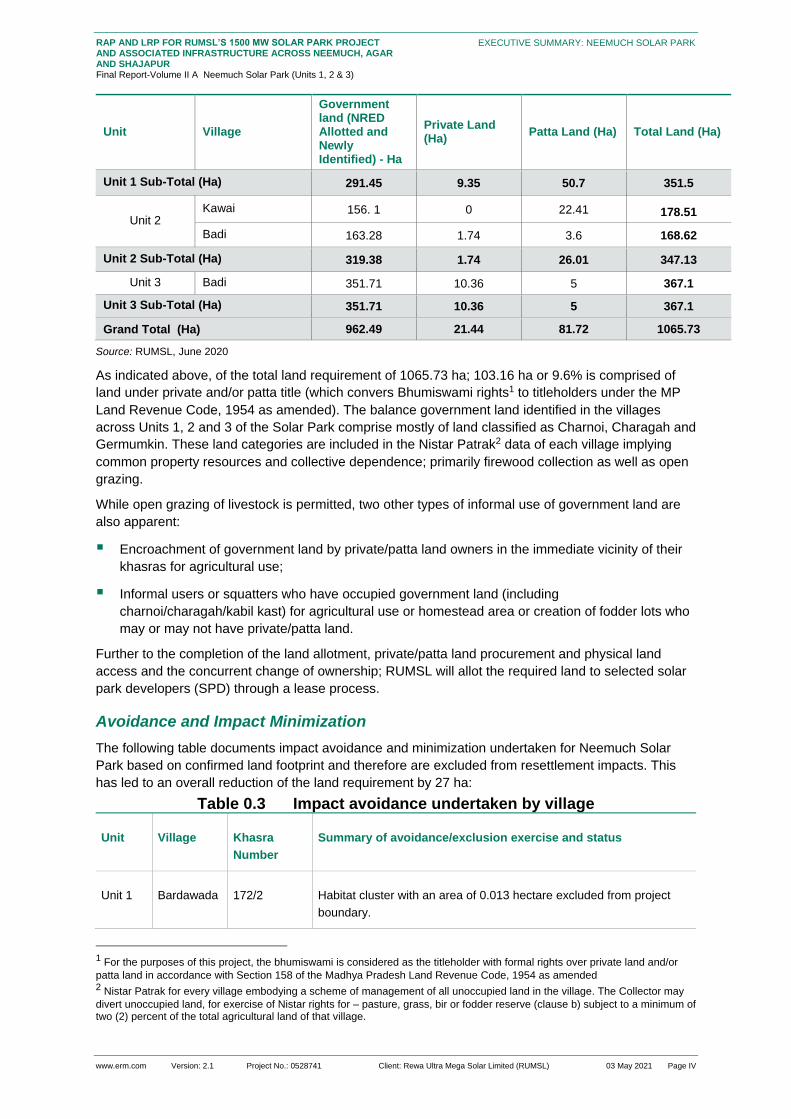
www.erm.com Version: 2.1 Project No.: 0528741 Client: Rewa Ultra Mega Solar Limited (RUMSL) 03 May 2021 Page IV
RAP AND LRP FOR RUMSL’S 1500 MW SOLAR PARK PROJECT AND ASSOCIATED INFRASTRUCTURE ACROSS NEEMUCH, AGAR AND SHAJAPUR Final Report-Volume II A Neemuch Solar Park (Units 1, 2 & 3)
EXECUTIVE SUMMARY: NEEMUCH SOLAR PARK
Unit Village
Government land (NRED Allotted and Newly Identified) - Ha
Private Land (Ha)
Patta Land (Ha) Total Land (Ha)
Unit 1 Sub-Total (Ha) 291.45 9.35 50.7 351.5
Unit 2 Kawai 156. 1 0 22.41 178.51
Badi 163.28 1.74 3.6 168.62
Unit 2 Sub-Total (Ha) 319.38 1.74 26.01 347.13
Unit 3 Badi 351.71 10.36 5 367.1
Unit 3 Sub-Total (Ha) 351.71 10.36 5 367.1
Grand Total (Ha) 962.49 21.44 81.72 1065.73
Source: RUMSL, June 2020
As indicated above, of the total land requirement of 1065.73 ha; 103.16 ha or 9.6% is comprised of
land under private and/or patta title (which convers Bhumiswami rights1 to titleholders under the MP
Land Revenue Code, 1954 as amended). The balance government land identified in the villages
across Units 1, 2 and 3 of the Solar Park comprise mostly of land classified as Charnoi, Charagah and
Germumkin. These land categories are included in the Nistar Patrak2 data of each village implying
common property resources and collective dependence; primarily firewood collection as well as open
grazing.
While open grazing of livestock is permitted, two other types of informal use of government land are
also apparent:
Encroachment of government land by private/patta land owners in the immediate vicinity of their
khasras for agricultural use;
Informal users or squatters who have occupied government land (including
charnoi/charagah/kabil kast) for agricultural use or homestead area or creation of fodder lots who
may or may not have private/patta land.
Further to the completion of the land allotment, private/patta land procurement and physical land
access and the concurrent change of ownership; RUMSL will allot the required land to selected solar
park developers (SPD) through a lease process.
Avoidance and Impact Minimization
The following table documents impact avoidance and minimization undertaken for Neemuch Solar
Park based on confirmed land footprint and therefore are excluded from resettlement impacts. This
has led to an overall reduction of the land requirement by 27 ha:
Table 0.3 Impact avoidance undertaken by village
Unit Village Khasra
Number
Summary of avoidance/exclusion exercise and status
Unit 1 Bardawada 172/2 Habitat cluster with an area of 0.013 hectare excluded from project
boundary.
1 For the purposes of this project, the bhumiswami is considered as the titleholder with formal rights over private land and/or
patta land in accordance with Section 158 of the Madhya Pradesh Land Revenue Code, 1954 as amended 2 Nistar Patrak for every village embodying a scheme of management of all unoccupied land in the village. The Collector may
divert unoccupied land, for exercise of Nistar rights for – pasture, grass, bir or fodder reserve (clause b) subject to a minimum of two (2) percent of the total agricultural land of that village.

www.erm.com Version: 2.1 Project No.: 0528741 Client: Rewa Ultra Mega Solar Limited (RUMSL) 03 May 2021 Page V
RAP AND LRP FOR RUMSL’S 1500 MW SOLAR PARK PROJECT AND ASSOCIATED INFRASTRUCTURE ACROSS NEEMUCH, AGAR AND SHAJAPUR Final Report-Volume II A Neemuch Solar Park (Units 1, 2 & 3)
EXECUTIVE SUMMARY: NEEMUCH SOLAR PARK
Unit Village Khasra
Number
Summary of avoidance/exclusion exercise and status
Unit 1 Bardawada 42/1 , 42/1/2
and 42/3
Habitat cluster with an area of 0.061 hectares has been excluded from
Project boundary including area for access road of 0.040 hectare.
Unit 2 Kawai 523/3 Structures including temple and community hall with an area of 0.020
hectare has been excluded from Project boundary.
Unit 2 Badi 478 (2,3) Habitat cluster with an area of 0.091 hectares has been excluded from
Project boundary including area for access road of 0.038 hectare.
Unit 3 Badi 430 and
448/2
Habitat cluster with an area of 1.560 hectare excluded from project
boundary.
Unit 3 Badi 449/2 Cremation ground for dead livestock animals with an area of less than
One hectare.
Unit 3 Badi 327/1/1 Habitat cluster with an area of 0.415 hectares has been excluded from
Project boundary including area for access road of 0.161 hectare.
Unit 3 Badi 790/1 Habitat cluster with an area of 1.747 hectares has been excluded from
Project boundary including area for access road of 0.434 hectare.
Unit 3 Badi 790/1 Cremation land with an area 0.377 hectares has been excluded from
Project boundary including area for access road of 0.092 hectare.
Source: Based on site visits undertaken, review of drone imagery of land use, and land allotment details provided by RUMSL.
In addition to the above impact avoidance; two specific khasras were recommended for exclusion
further to the completion of the resettlement surveys in December 2020. These exclusions are yet to
be formally approved/confirmed and are therefore included in the assessment of resettlement impacts
as part of this RAP and LRP:
Unit 3 - Khasra 430 of Badi Village: There are 20 isolated residential structures (Gujjar settlement)
currently part of the Project Footprint in Badi;
Unit 3 – Khasra 790/3 of Badi Village: The Bhil settlement on this Khasra comprises 25
households. Although their physical displacement (main settlement area on 790/3) has been
avoided, their physical displacement may be induced as the rest of the khasra (which is under
informal use for agriculture and grazing) is allocated to the project. In view of loss of access to this
land (economic displacement); they may also need to physically relocate to another area.

www.erm.com Version: 2.1 Project No.: 0528741 Client: Rewa Ultra Mega Solar Limited (RUMSL) 03 May 2021 Page VI
RAP AND LRP FOR RUMSL’S 1500 MW SOLAR PARK PROJECT AND ASSOCIATED INFRASTRUCTURE ACROSS NEEMUCH, AGAR AND SHAJAPUR Final Report-Volume II A Neemuch Solar Park (Units 1, 2 & 3)
EXECUTIVE SUMMARY: NEEMUCH SOLAR PARK
Figure 0.2 Habitat Clusters in the Solar Park avoided & suggested
Source: Land Use sensitivity mapping by ERM

www.erm.com Version: 2.1 Project No.: 0528741 Client: Rewa Ultra Mega Solar Limited (RUMSL) 03 May 2021 Page VII
RAP AND LRP FOR RUMSL’S 1500 MW SOLAR PARK PROJECT AND ASSOCIATED INFRASTRUCTURE ACROSS NEEMUCH, AGAR AND SHAJAPUR Final Report-Volume II A Neemuch Solar Park (Units 1, 2 & 3)
EXECUTIVE SUMMARY: NEEMUCH SOLAR PARK
Overview of Project Affected Households
Project Affected Villages
The following table provides an overview of the three (3) project affected villages and the balance
land that is available post government land allotment and private/patta land procurement:
Table 0.4 Land Footprint by Ownership, in Project Villages
Village Name Geographical
Area of
Village (ha)
Land required for the Neemuch solar park
(ha)
Land
remainin
g (ha)
Proportio
n of Land
Remainin
g (%) Government
land
Private
land
Patta
land
Total
Bardawada 565.09
201.83 5.1 50.7 257.6
3
307.46 54.4
Kawai 826.46
245.7 4.25 22.41 272.3
8
554.08 67.04
Badi 1300.43
514.99 12.1 8.6 535.7
2
764.71 58.8
Total 2691.98 962.52 35.5 87.72 1065.
73
1626.25 60.4
Source: Land data provided by RUMSL as on November 2020
As part of the resettlement surveys, ERM surveyed all of these three (3) villages through a Village
Questionnaire as well as select qualitative discussions and focus group discussions in order to
identify livelihood impacts, collective dependence concerns, general stakeholder insights and profiling
vulnerable social groups (gender, economic vulnerabilities, caste groups etc.).
Project Affected Khasras
The following table provides an overview of the government and private/patta khasras which are
affected across the villages as well as those that were surveyed:
Table 0.5 Land required for Solar Park
Unit Type Number of Khasras Land Area (ha)
Unit 1 Government 15 291.45
Private 10 9.35
Patta 43 50.71
Sub - total 78 351.50
Unit 2 Government 9 319.38
Private 1 1.74
Patta 22 26.01
Sub - total 32 347.13
Unit 3 Government 25 351.71
Private 20 10.36
Patta 3 5.0

www.erm.com Version: 2.1 Project No.: 0528741 Client: Rewa Ultra Mega Solar Limited (RUMSL) 03 May 2021 Page VIII
RAP AND LRP FOR RUMSL’S 1500 MW SOLAR PARK PROJECT AND ASSOCIATED INFRASTRUCTURE ACROSS NEEMUCH, AGAR AND SHAJAPUR Final Report-Volume II A Neemuch Solar Park (Units 1, 2 & 3)
EXECUTIVE SUMMARY: NEEMUCH SOLAR PARK
Unit Type Number of Khasras Land Area (ha)
Sub - total 48 367.1
Grand Total 158 1065.73
Source: Land data provided by RUMSL as on June 2020 (Figures in brackets indicates parcels either entirely or partially that
were surveyed during the Land and Asset inventory)
(Figures in brackets indicates coverage)
As part of the resettlement surveys, ERM undertook a Land and Asset Inventory of 58.2 hectares of
private and patta khasras as well as 144.37 hectares of government khasras in order to identify
assets, impacts on titleholders and any non-titleholders as well as their intensity. For the remaining
parcels that could not be surveyed, ERM undertook a spatial analysis of the khasras as well as their
land use in order to ascertain involuntary resettlement impacts.
Titleholders and Non-titleholders
The following table provides an overview of the titleholders and non-titleholders for Neemuch Solar
Park, including the ones that could be identified and therefore including in either the land and asset
inventory and/or household survey (see 0.3.4):
Unit Village Title Holders (coverage) Non-Title Holders (coverage)
Private Patta Encroachers Informal users
I Bardawada 06 (06) 57 (34) 06 (06) 23 (23)
II Kawai 35 (07) 39 (17) 06 (06) 07 (07)
III Badi 58 (28) 09 (07) 10 (10) 30 (09)
Total 99 (41) 105 (58) 22 (22) 60 (39)
(Figures in brackets indicates coverage)
Project Affected Households
Based on the above, Neemuch Solar Park will lead to involuntary resettlement of 225 Project Affected
Households as summarised in the subsequent table:
Table 0.6: Status of Household Survey Coverage
Survey Coverage by category Household Count (in numbers) Proportion (%)
Total PAH 225 100
Physically and Economically Displaced PAHs 23 10.6
Only Economically Displaced PAHs 202 89.4
Impacted Categories Surveyed
Households Surveyed 127 56.4
PAH Households surveyed 126 56
Physically Displaced PAHs surveyed 4 16.67
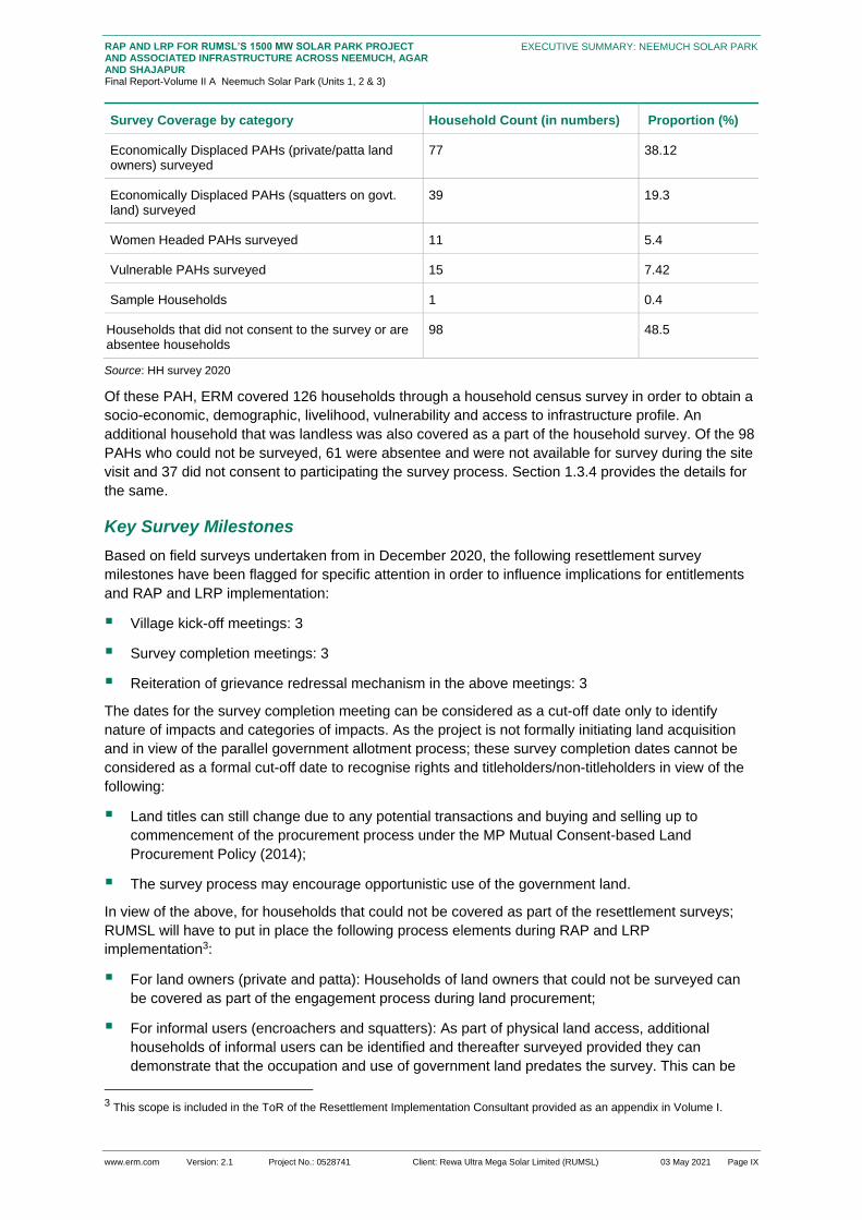
www.erm.com Version: 2.1 Project No.: 0528741 Client: Rewa Ultra Mega Solar Limited (RUMSL) 03 May 2021 Page IX
RAP AND LRP FOR RUMSL’S 1500 MW SOLAR PARK PROJECT AND ASSOCIATED INFRASTRUCTURE ACROSS NEEMUCH, AGAR AND SHAJAPUR Final Report-Volume II A Neemuch Solar Park (Units 1, 2 & 3)
EXECUTIVE SUMMARY: NEEMUCH SOLAR PARK
Survey Coverage by category Household Count (in numbers) Proportion (%)
Economically Displaced PAHs (private/patta land owners) surveyed
77 38.12
Economically Displaced PAHs (squatters on govt. land) surveyed
39 19.3
Women Headed PAHs surveyed 11 5.4
Vulnerable PAHs surveyed 15 7.42
Sample Households 1 0.4
Households that did not consent to the survey or are absentee households
98 48.5
Source: HH survey 2020
Of these PAH, ERM covered 126 households through a household census survey in order to obtain a
socio-economic, demographic, livelihood, vulnerability and access to infrastructure profile. An
additional household that was landless was also covered as a part of the household survey. Of the 98
PAHs who could not be surveyed, 61 were absentee and were not available for survey during the site
visit and 37 did not consent to participating the survey process. Section 1.3.4 provides the details for
the same.
Key Survey Milestones
Based on field surveys undertaken from in December 2020, the following resettlement survey
milestones have been flagged for specific attention in order to influence implications for entitlements
and RAP and LRP implementation:
Village kick-off meetings: 3
Survey completion meetings: 3
Reiteration of grievance redressal mechanism in the above meetings: 3
The dates for the survey completion meeting can be considered as a cut-off date only to identify
nature of impacts and categories of impacts. As the project is not formally initiating land acquisition
and in view of the parallel government allotment process; these survey completion dates cannot be
considered as a formal cut-off date to recognise rights and titleholders/non-titleholders in view of the
following:
Land titles can still change due to any potential transactions and buying and selling up to
commencement of the procurement process under the MP Mutual Consent-based Land
Procurement Policy (2014);
The survey process may encourage opportunistic use of the government land.
In view of the above, for households that could not be covered as part of the resettlement surveys;
RUMSL will have to put in place the following process elements during RAP and LRP
implementation3:
For land owners (private and patta): Households of land owners that could not be surveyed can
be covered as part of the engagement process during land procurement;
For informal users (encroachers and squatters): As part of physical land access, additional
households of informal users can be identified and thereafter surveyed provided they can
demonstrate that the occupation and use of government land predates the survey. This can be
3 This scope is included in the ToR of the Resettlement Implementation Consultant provided as an appendix in Volume I.

www.erm.com Version: 2.1 Project No.: 0528741 Client: Rewa Ultra Mega Solar Limited (RUMSL) 03 May 2021 Page X
RAP AND LRP FOR RUMSL’S 1500 MW SOLAR PARK PROJECT AND ASSOCIATED INFRASTRUCTURE ACROSS NEEMUCH, AGAR AND SHAJAPUR Final Report-Volume II A Neemuch Solar Park (Units 1, 2 & 3)
EXECUTIVE SUMMARY: NEEMUCH SOLAR PARK
confirmed through drone imagery of December 2019-January 2020 available with RUMSL, and
records of the local Patwaris linked to any fines or notices that may have been issued as well as
through village leaders).
Profile of Project Affected Communities
Profile of Villages in the Project Footprint
Figure 0-3 Overview of Key Village-level Attributes
Source: Village Survey Tool
Profile of Project Affected Households
Based on the survey of 126 Project Affected Households (coverage of 56.4% of total PAH) as well as
some sample households; the following table provides a qualitative overview of their socio-economic
and livelihood profile:
Table 0.7 Profile of Households Surveyed
Parameter Key Observations/ Findings –Neemuch Solar Park
Household Level
Demographics
There are 225 households to be impacted by the project of which 126 impacted households were
surveyed.
Most of the community (more than 97%) is Hindu. 3% of the PAHs are reported as Muslims.
The sex ratio within this population is 844 to 1000 males

www.erm.com Version: 2.1 Project No.: 0528741 Client: Rewa Ultra Mega Solar Limited (RUMSL) 03 May 2021 Page XI
RAP AND LRP FOR RUMSL’S 1500 MW SOLAR PARK PROJECT AND ASSOCIATED INFRASTRUCTURE ACROSS NEEMUCH, AGAR AND SHAJAPUR Final Report-Volume II A Neemuch Solar Park (Units 1, 2 & 3)
EXECUTIVE SUMMARY: NEEMUCH SOLAR PARK
Parameter Key Observations/ Findings –Neemuch Solar Park
The average family size of the surveyed households is reported to be 5.8
The average literacy rate in Unit 4 is 58.1%.
Land Ownership
and Use
Average land holding size is 2ha under predominantly agricultural use
Most of the agricultural land is under a multi-cropping system, with the key crops being Soyabean,
Mustard, Groundnut, Maize and Dal
Livelihood Farm-based activities are the main earning source of the families. Agriculture, followed by livestock
and labour are the main economic activities. Non-farm based livelihood are limited to daily wage
labour, construction work, petty businesses, etc.
Key gender
disaggregated
data points
There are 11 women headed households that were surveyed. They have reported a marginally
smaller family size as compared to male headed households.
Women in women-led households reported an average annual income of INR 250,750
approximately as compared to women in male- led households who report an annual average
income of INR 204,790 approximately.
The most common livelihood reported by women was agriculture and agricultural labours
Income and
Expenditure
The major source of income for the households are agriculture, livestock, wages and businesses.
The avg. annual income levels is 2,35,220 INR per year and the avg annual expenditure is
reported to be 3,186,05 INR per year. The reasons for higher expenses compared to income
earning was due to higher expenditure on debt (repayment/new loan), which is a recurring liability
for the households.
Standard of Living House structure:
1) 40.1 percent of the housing is of kutcha type
2) 27.5 percent of the surveyed households have a pucca housing structure
Asset ownership:
3) Majority of the surveyed households reported owning land between 1-2ha.
4) Cows were reported to be the common livestock among all PAHs.
5) In terms of household appliances, the highest proportion of assets is of ceiling fans, mobile
phones, television sets and cable connections.
6) In terms of vehicles, most of the PAHs reported ownership of two wheelers including bicycles
and motor cycles.
7) Amongst the agricultural implements, PAHs reported ownership mostly of implements such as
tractors and water pump sets.
Participation in collectives:
8) Women SHGs are the most popular SHGs in the surveyed villages, even though they are
mostly inactive
9) The Van Samiti in Badi and Kawai has been active since the past 12-15 years.
Dependence on
Natural
Resources
Community dependence on natural resources is mainly for grazing and fodder, water for livestock
and firewood and dung collection

www.erm.com Version: 2.1 Project No.: 0528741 Client: Rewa Ultra Mega Solar Limited (RUMSL) 03 May 2021 Page XII
RAP AND LRP FOR RUMSL’S 1500 MW SOLAR PARK PROJECT AND ASSOCIATED INFRASTRUCTURE ACROSS NEEMUCH, AGAR AND SHAJAPUR Final Report-Volume II A Neemuch Solar Park (Units 1, 2 & 3)
EXECUTIVE SUMMARY: NEEMUCH SOLAR PARK
Parameter Key Observations/ Findings –Neemuch Solar Park
Access to
Physical and
Social
Infrastructure
The access to primary healthcare is limited within the project footprint, and resident typically have
to travel 5-10 km for a hospital. There are no doctors or clinics within the villages. The average
distance for schools is 4 km. on an average, 41.7% of the households have a functional toilet at
and 94.4% of households are connected to the government grid supply for electricity
Source: RAP & LRP surveys 2020
Profile of Key Stakeholder Groups and Feedback
Stakeholder Identification and Analysis
Table 0.8: Stakeholder Group Categorization
Stakeholder
Groups
Primary Stakeholders Secondary Stakeholders
Individual and
Community
Private land owners and Patta land owners
from the Project Area villages
Informal land users (encroachers/squatters
to be impacted)
Agricultural labourers
ST households
Women groups
Vulnerable groups (Below Poverty Line
households, women headed households)
Owners of land required for temporary
occupation or use during construction
phase
■ Fence line community
Government
Bodies and
Institutional
Stakeholders
District administration of Neemuch
Gram panchayat of impacted villages
Tehsildar of Singoli and Patwaris
EPC Contractor
RUMSL
Civil society/Local Non-
governmental organizations (NGOs)
Local media
Local political groups
10) Forest Department, Singoli
Agriculture and Livestock
Department at Neemuch
11) Industrial Training Institute (ITI),
Neemuch
Department of Animal Husbandry,
Dairy Development, Neemuch

www.erm.com Version: 2.1 Project No.: 0528741 Client: Rewa Ultra Mega Solar Limited (RUMSL) 03 May 2021 Page XIII
RAP AND LRP FOR RUMSL’S 1500 MW SOLAR PARK PROJECT AND ASSOCIATED INFRASTRUCTURE ACROSS NEEMUCH, AGAR AND SHAJAPUR Final Report-Volume II A Neemuch Solar Park (Units 1, 2 & 3)
EXECUTIVE SUMMARY: NEEMUCH SOLAR PARK
Figure 0-4 Prioritisation of Stakeholders
As a part of the resettlement planning, engagement was undertaken at various stages with the
stakeholders. RUMSL was responsible for overall coordination across various stakeholders including
the district administration, and the administration at the tehsil level
12) A District Renewable Energy Officer (DREO) has been appointed by RUMSL to undertake the
initial meetings with the Tehsil office, and guide the land allotment process. The land allotment
process was initiated in 2017 for the government khasras.
13) For Neemuch Solar Park, government land allotment process was undertaken in 2 phases over
2017 and 2018. As a part of the land procurement process of private and patta land RUMSL
through the Patwari and Tehsil department is understood to be reaching out to the concerned
land owners for the purpose of land purchase. 70 percent of the land allotment was completed at
the time of RAP survey and the remaining is still under process.
14) As a part of the resettlement surveys undertaken for the solar park in December 2020, an
engagement process was set up at the start and end of surveys in each village. The kick-off
meetings were used to understand the existing level of information about the project available
with the community and incorporate any feedback received from the community on the concerns
regarding involuntary impacts, and feedback for project planning. The close-out meeting was
carried out at the end of the survey process to summarise key outcomes, relay the significance of
survey completion dates to identify categories and types of impacts and to reiterate the
mechanism to register any grievances from the community to the DREO.
15) The survey team faced a level of reluctance from the residents of Bardawada village in
undertaking RAP study in their village. The community stated that there was no engagement
process undertaken regarding information disclosure on the project, the land demarcation process
was undertaken without providing them any scope for engagement and suggestions on the land

www.erm.com Version: 2.1 Project No.: 0528741 Client: Rewa Ultra Mega Solar Limited (RUMSL) 03 May 2021 Page XIV
RAP AND LRP FOR RUMSL’S 1500 MW SOLAR PARK PROJECT AND ASSOCIATED INFRASTRUCTURE ACROSS NEEMUCH, AGAR AND SHAJAPUR Final Report-Volume II A Neemuch Solar Park (Units 1, 2 & 3)
EXECUTIVE SUMMARY: NEEMUCH SOLAR PARK
take, and moreover, there has been a lack of transparency regarding the land purchase and
guidance on the valuation of land. However, the residents of the Bardawada village eventually
agreed to participate in the survey process, upon being explained the purpose of the survey and
its use
16) Similar resistance was faced from the gurjar settlement of Badi village were particularly non-
cooperative to participate in the survey. Their grievance was regarding the lack of any
engagement process undertaken regarding information disclosure on the project, the land
demarcation process was undertaken without providing them any scope for engagement and
suggestions on the land take, and moreover, there has been a lack of transparency regarding the
land purchase and guidance on the valuation of land. The residents had submitted a written letter
to the Tehsil office regarding their grievance on the extent of land being utilized for the project
three years ago. However, there was no action or course of redressal undertaken thereafter.
Table 0.9 Feedback Received for Incorporation into Resettlement
Planning
Feedback Received Incorporation into Resettlement Planning
Lack of information disclosure and
absence of engagement process
as part of land procurement
Requirement is to identify personnel from the Tehsil administration
(preferably the Patwari) and ensure all information is shared through the
Patwari with the village community in the form of group discussions.
Provision of water supply
infrastructure
It is suggested that the Project take into consideration providing water
supply infrastructure for agriculture, as part of community level
resettlement program.
Increase in distance to access
grazing land
The specific mitigation measures have been included in the Grazing
Management Plan.
Concerns of loss of informal land
use of government land
Villagers across the three villages of the Solar Park are well aware of the
extent of encroached/squatted area, and duration of such use.
Involuntary Resettlement Impacts
Overview of Project-Affected Land and Assets
Khasras
An overview of the project affected land and assets highlight that approximately 103.16 hectares of
private and patta agricultural khasras will be impacted due to project activities. Out of this, 66 percent
is patta land, and the remaining is private land (Table 0.4). Out of the total private land,34 percent of
this private the land is in Badi village (Unit 2 & 3).
Similarly, 151.51 hectares of government land used informally for agriculture and fodder cultivation
was assessed through the land and asset inventory survey. Of the total area under informal use, 77.8
percent is under squatting for agriculture. The Table 0.10 below provides details on the extent of
informal use of government land.
The highest impact of permanent land loss is observed in Bardawada village (Unit 1). The village
accounts for more than 49 percent of impacted private and patta land.

www.erm.com Version: 2.1 Project No.: 0528741 Client: Rewa Ultra Mega Solar Limited (RUMSL) 03 May 2021 Page XV
RAP AND LRP FOR RUMSL’S 1500 MW SOLAR PARK PROJECT AND ASSOCIATED INFRASTRUCTURE ACROSS NEEMUCH, AGAR AND SHAJAPUR Final Report-Volume II A Neemuch Solar Park (Units 1, 2 & 3)
EXECUTIVE SUMMARY: NEEMUCH SOLAR PARK
Table 0.10 Land Area under Informal land Use
Unit Encroachment for agriculture (ha)
Squatter for agriculture (ha)
Encroachment for Fodder lot (ha)
Squatter for fodder lot (ha)
Grand Total
Unit 1
16.7 44.4 3.4 5 69.5
Unit 2
3.8 30 3.3 0 37.1
Unit 3
5.26 22.5 9.95 7.2 44.91
25.76 92.1 16.65 12.2 151.51
Source: LA survey 2020
Crops
A total of 254.67 ha of land is under agricultural use (private/patta and government, including non-surveyed private land under farming). Cultivators of this agricultural land would be impacted by loss of standing crop at the time of land clearing, depending on the season. The khasras under multi-cropping would be more likely to be impacted by loss of standing crops. The loss to farmers, from clearing standing crops will depend on when the possession of the land required for the project will be taken by the Solar Park Developer (SPD). The more favourable option would be to allow standing crops to be harvested before taking possession and thus not needing to clear standing crops. This will reduce the extent of economic displacement (economic loss of produce).
Immovable Structures
There are 22 residential structures located in Badi in addition to two (2) residential structures in Badi
and 2 in Bardawada that would be affected by land procurement for the project. The LA survey was
undertaken for 2 structures in Badi village and 2 structures in Bardawada village.
Similarly, the project will result in impact on 64 fixed and salvageable assets on khasra surveyed,
which includes wire fencing, hand pumps, shed and water tank. The highest impact, however, is seen
on the loss of dug (open) wells. There are 50 open wells, of which 60 percent have been assessed on
private/patta khasras. The counts of all such immovable and fixed assets are as given below:
Table 0.11 Count of Immovable and Fixed Assets
nit Number of PAHs
Op
en
Wle
ll
Catt
le
sh
ed
Bo
re w
ell
Han
d
pu
mp
Wate
r
sta
ll
Wate
r
tan
k
Wir
e
fen
cin
g
wit
h
wo
od
en
po
le
Unit 1 16 10 6 12 6 NA 1 NA
Unit 2 22 19 3 8 1 1 NA 1
Unit 3 21 21 3 19 3 NA NA NA
Grand Total
59 50 12 39 10 1 1 1
Source: LA survey 2020
NA: Not Applicable

www.erm.com Version: 2.1 Project No.: 0528741 Client: Rewa Ultra Mega Solar Limited (RUMSL) 03 May 2021 Page XVI
RAP AND LRP FOR RUMSL’S 1500 MW SOLAR PARK PROJECT AND ASSOCIATED INFRASTRUCTURE ACROSS NEEMUCH, AGAR AND SHAJAPUR Final Report-Volume II A Neemuch Solar Park (Units 1, 2 & 3)
EXECUTIVE SUMMARY: NEEMUCH SOLAR PARK
Trees
264 trees (timber and fruit) have been identified spread across 42 khasras which are to be impacted.
Out of these, 237 trees are of timber use. On an average, there are 5 - 10 trees on a single private
khasra. Similarly, 27 fruit trees were assessed on 13 khasras with an average of two (2) fruit trees on
one khasra. It has been found that 62 percent of the fruit trees are in the young productive (fruit
bearing) years. Majority of the fruit trees are mango (77 percent).
Common Property Resources
Government land is used for open grazing of livestock (grazing on shrubs, grasses that grow in the
open) and there are designated land areas (Charnoi, Charagarh) which are meant to be used for
grazing by the village community. However, there are no physical identifiers for such khasras, and
typically, grazing is undertaken on any open government khasra.
Table 0.12 Designated government grazing land
Unit Village
Charnoi & Kadim available after Project allotment (ha )
Total Government land left after Project allotment (ha )
Total Agricullture land (Net Sown) in the Village as per Census 2011 data (in Hectare)
Share of Charnoi & Kadim to government land in the village after Project allotment (%)
Share of Charnoi & Kadim to agricultural land in the village after Project allotment (%)
Unit 1
Bardawada 0 137.31 181.06 0 0
Kawai NA 89.62
145.89
NA
2.72 Unit 2
Kawai 3.97 379.96 1.04
Badi NA 163.28
294.59
NA
0 Unit 3
Badi 0 449.6 0
Grand Total 3.97 966.87 0.41
Source: Nistar Patrak data of each village, and land allotment letters
NA: Not Applicable
The major impact at the community level in terms of loss of CPR is linked to loss of open grazing land
due to land use change. There will be loss of livelihood and sustenance linked to use of government
land for open grazing of livestock. According to government records, 105.6 hectares is designated as
grazing land. Another loss linked to loss of open land in general, and restricted access to government
land is collection of firewood for cooking and grass (for livestock feed).
Table 0.13 Dependence of households on grazing land
Village No.of HHs using government
land for grazing
% of total HHs in the village
Bardawada ~300-320 90

www.erm.com Version: 2.1 Project No.: 0528741 Client: Rewa Ultra Mega Solar Limited (RUMSL) 03 May 2021 Page XVII
RAP AND LRP FOR RUMSL’S 1500 MW SOLAR PARK PROJECT AND ASSOCIATED INFRASTRUCTURE ACROSS NEEMUCH, AGAR AND SHAJAPUR Final Report-Volume II A Neemuch Solar Park (Units 1, 2 & 3)
EXECUTIVE SUMMARY: NEEMUCH SOLAR PARK
Village No.of HHs using government
land for grazing
% of total HHs in the village
Kawai ~65-70 50
Badi ~250 77
Grand Total ~615-640 ~77.8
Source: Village Profiling 2020
The overall magnitude of the impact is assessed as medium for most of the villages in the project
footprint. This is in keeping with the understanding that while alternative grazing land will be available
within the village after Project related land procurement, the location in terms of distance from
settlement and suitability of the land for fodder or grazing is presently unknown. The loss of grazing
land may thus result in an increased travel time for grazing purposes as well as increased pressure on
the remaining grazing land in the village.
Intensity of Involuntary Resettlement Impacts
Table 0.14 Economic and Physical displacement of PAHs
Unit Total PAHs Economically displaced PAHs
Physically and Economically displaced PAHs
Unit 1
78 76 2
Unit 2
57 57 0
Unit 3
90 68 21
Grand Total 225 202 23
Source: HH survey 2020
Physical Displacement
The 24 residential structures correspond to impact on 23 PAHs. These 23 households will be
impacted by loss of physical structure in addition to loss of land for agricultural use. The structures
which are within the project footprint and are at a risk of physical displacement are observed to be of
seasonal use, constructed with very low costs, since these are mainly made of wooden walls with
thatched roof. As reported during consultations with the households, no investments have been
undertaken on such type of structures in the past two (2) years. The structures that will be impacted
are isolated structures, away from the main village settlement and have seasonal use. The loss of
such physical assets is concurrent with the loss of livelihood due to economic displacement.
Economic Displacement
a total of 204 households are to be impacted by the loss of private/patta land. Based on the survey
analysis, 58 percent of the PAHs are patta land owners (131 PAHs), while the remaining 94 are
private land owning PAHs. There are 82 PAHs who will be impacted by loss of livelihood arising from
informal use of government land for agriculture and fodder cultivation for private consumption, due to
project land allotment. Of these 82 PAHs. Among the surveyed PAHs, 39 (47 percent) of the PAHs

www.erm.com Version: 2.1 Project No.: 0528741 Client: Rewa Ultra Mega Solar Limited (RUMSL) 03 May 2021 Page XVIII
RAP AND LRP FOR RUMSL’S 1500 MW SOLAR PARK PROJECT AND ASSOCIATED INFRASTRUCTURE ACROSS NEEMUCH, AGAR AND SHAJAPUR Final Report-Volume II A Neemuch Solar Park (Units 1, 2 & 3)
EXECUTIVE SUMMARY: NEEMUCH SOLAR PARK
are squatters, and the remaining are private land owners who have encroached upon adjacent
government land for agriculture.
Each of these PAH have an average area of two (2) hectares under agricultural use. Among the
surveyed PAHs, 59 households will be impacted by loss of immovable structures. Out of these PAHs,
22 households have constructed these structures on their private land holdings, and 21 PAHs have
utilized their patta land for building such structures.
Land procurement for the project is reported to impact land holdings, this includes loss of private and
patta land due to the land procurement for the project and the overall reduction in land holding
amongst the PAHs. As mentioned above, the surveyed villages have reported that their primary
source of livelihood is agriculture and this loss of land will result in a permanent loss of agriculture and
livelihood. Moreover, loss of government land, is another concern for the households who have
reported encroachment of informal use of government land for agricultural use or fodder cultivation. A
reduction in overall land under agriculture per household will also impact the food security of the
household, thereby increasing the dependence on the Government PDS schemes or increasing the
expenditure on food grains.
Community based livelihood impacts
The primary impact at the community level arises due to reduction in available land for open grazing,
due to land allotment, i.e. loss of livelihood and sustenance linked to use of government land for open
grazing of livestock. The reduction in common land for grazing will also lead to reduction in count of
livestock head by households, due to reduction in land available per unit of livestock, especially for
those in economically weaker groups, as input costs will increase (creation of stall-shed, feeding stalls
etc.) which may trigger livestock being sold and/or abandoned.
The secondary impact linked to loss of open grazing is reduced/loss of access to collection of
firewood. Out of the surveyed PAHs, 43 percent depend on common land for collection of firewood for
cooking and grass (for livestock feed). Dependence on government forest land was reported by 22
percent of the PAHs for collection of grass. There are three cultural structures, in Badi village (Unit 3)
which are likely to be displaced by the land procurement. The structures belong to the Gujjar
settlement and have been in use for more than 50 years.
Gendered livelihood impacts
It is estimated that there are 20 women headed households who are vulnerable due to their
dependence on farm produce from their own khasras. Out of these, 11 women headed households
were identified and surveyed. These households have reported to primarily depend on income from
farm produce on their own khasras, supplemented by agricultural labour work. The average land
holding size of the private and patta land holders is 1- 2 hectares, with the highest land holding
reported to be of 3 hectares.
Impacts on women headed household, specifically, is expected to be higher as they are considered a
vulnerable group. The women-led households would not only be economically displaced due to the
project, they would also lose their supplementary income from agricultural labour due to loss of land.
These women-led households would be impacted more severely than the other affected households
as they are a vulnerable group and have no other source of income. Their socio-economic
backwardness is discussed in the baseline section of the report. Moreover, the loss of land would lead
to women travelling greater distances from the village settlements to collect natural resources such as
firewood, water etc.
Impact on Vulnerable groups
The vulnerability profiling (Section 4.2.12) of impacted households shows that there are 16 vulnerable
households, extrapolated to 29 PAHs in total. Of the surveyed PAHs 11 of which are women headed,

www.erm.com Version: 2.1 Project No.: 0528741 Client: Rewa Ultra Mega Solar Limited (RUMSL) 03 May 2021 Page XIX
RAP AND LRP FOR RUMSL’S 1500 MW SOLAR PARK PROJECT AND ASSOCIATED INFRASTRUCTURE ACROSS NEEMUCH, AGAR AND SHAJAPUR Final Report-Volume II A Neemuch Solar Park (Units 1, 2 & 3)
EXECUTIVE SUMMARY: NEEMUCH SOLAR PARK
one household resided by only elderly members, four households dependent on artisan income. The
impacts on these households are similar to the impacts discussed for the rest of PAHs, and uniform.
The Bhil settlement in Badi village will be economically displaced due to land procurement. The size
of land holding is an average of 2-3 hectares, with majority of the Bhil households being patta holders
Majority of the Bhils are patta land-holders (55 percent of the PAHs) and undertake single-cropping
on their khasras, in comparison to other land owners who typically undertake at least double cropping.
Project-specific Strategies for Implementation
Volume I of the RAP and LRP provides the overarching entitlement matrix, market valuation
framework, livelihood restoration, approach to resettlement housing and the overarching
implementation arrangements, roles and responsibilities as well as schedule. The following table
summarises key aspects that need to be considered by RUMSL while implementing the RAP and LRP
for Neemuch Solar Park:
Table 0.15 Park Specific Implementation Insights
Aspect Description/Remarks
Pre-implementation
Actions
Undertake the resettlement surveys with the households who could not be
covered as part of the RAP and LRP
The project should undertake focused consultations with the impacted land
owners in the context of the project impacts, and resettlement and planned
livelihood restoration measures.
The Project shall undertake focused and dedicated engagement activities with
the local community and affected households prior to the initiation of land
purchase and RAP&LRP implementation in keeping with the SEP and GRM
developed for the project.
Expectations on Land
Rates
Anything from numbers that consented and also generic expectations
Grievance Management
Given the associated large scale grievances reported during the resettlement surveys undertaken in
November and December 2020, it is suggested that regular engagement should be undertaken with
all the villages in the project footprint, with specific focus on the villages who have refused to
resettlement surveys. These range from Consultations with the Gram Panchayat to provide update on
the land procurement process of private land in the villages to conducting workshops with specific
stakeholder groups identified during the resettlement surveys to incorporate feedback and
suggestions on resettlement planning.
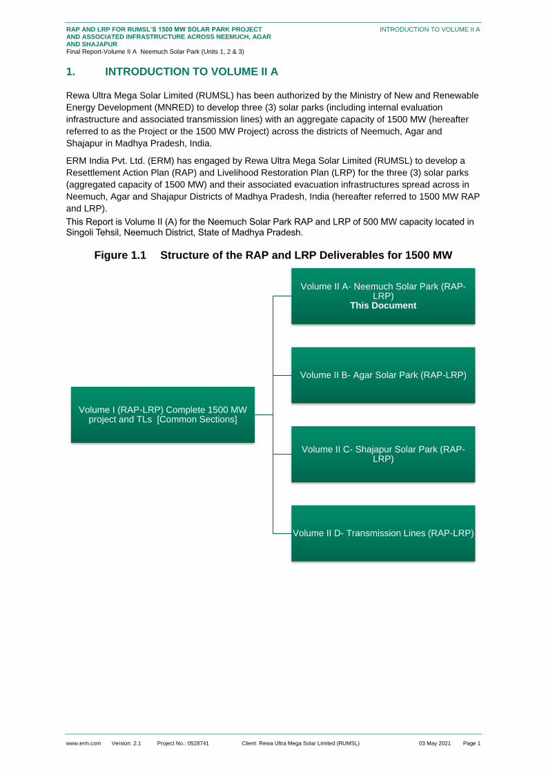
www.erm.com Version: 2.1 Project No.: 0528741 Client: Rewa Ultra Mega Solar Limited (RUMSL) 03 May 2021 Page 1
RAP AND LRP FOR RUMSL’S 1500 MW SOLAR PARK PROJECT AND ASSOCIATED INFRASTRUCTURE ACROSS NEEMUCH, AGAR AND SHAJAPUR Final Report-Volume II A Neemuch Solar Park (Units 1, 2 & 3)
INTRODUCTION TO VOLUME II A
1. INTRODUCTION TO VOLUME II A
Rewa Ultra Mega Solar Limited (RUMSL) has been authorized by the Ministry of New and Renewable
Energy Development (MNRED) to develop three (3) solar parks (including internal evaluation
infrastructure and associated transmission lines) with an aggregate capacity of 1500 MW (hereafter
referred to as the Project or the 1500 MW Project) across the districts of Neemuch, Agar and
Shajapur in Madhya Pradesh, India.
ERM India Pvt. Ltd. (ERM) has engaged by Rewa Ultra Mega Solar Limited (RUMSL) to develop a
Resettlement Action Plan (RAP) and Livelihood Restoration Plan (LRP) for the three (3) solar parks
(aggregated capacity of 1500 MW) and their associated evacuation infrastructures spread across in
Neemuch, Agar and Shajapur Districts of Madhya Pradesh, India (hereafter referred to 1500 MW RAP
and LRP).
This Report is Volume II (A) for the Neemuch Solar Park RAP and LRP of 500 MW capacity located in Singoli Tehsil, Neemuch District, State of Madhya Pradesh.
Figure 1.1 Structure of the RAP and LRP Deliverables for 1500 MW
Volume I (RAP-LRP) Complete 1500 MW project and TLs [Common Sections]
Volume II A- Neemuch Solar Park (RAP-LRP)
This Document
Volume II B- Agar Solar Park (RAP-LRP)
Volume II C- Shajapur Solar Park (RAP-LRP)
Volume II D- Transmission Lines (RAP-LRP)

www.erm.com Version: 2.1 Project No.: 0528741 Client: Rewa Ultra Mega Solar Limited (RUMSL) 03 May 2021 Page 2
RAP AND LRP FOR RUMSL’S 1500 MW SOLAR PARK PROJECT AND ASSOCIATED INFRASTRUCTURE ACROSS NEEMUCH, AGAR AND SHAJAPUR Final Report-Volume II A Neemuch Solar Park (Units 1, 2 & 3)
INTRODUCTION TO VOLUME II A
1.1 Brief Project Description for Neemuch Solar Park
The proposed 500 MW Neemuch Solar Park will be developed as three (3) units. Unit 1 of capacity
160 MW, Unit 2 of capacity 170 MW and Unit 3 of capacity 170 MW.
Table 1.1 Neemuch Solar Park Project Summary
S. No. Particulars Description for
Unit 1
Description for
Unit 2
Description for
Unit 3
1. Project Village Location Bardawada and
Kawai
Kawai and Badi Badi
2. Tehsil Singoli tehsil
3. District Name/State Neemuch, Madhya Pradesh
4. Location Coordinates 24°59'39.78"N and
75°13'26.82"E
24099’84.07’’ N and
75°21'39.89"E
25001’06.67’’ N and
75°24'44.83"E
5. Capacity 160 MW 170 MW 170 MW
6. Pooling State and Power
Evacuation
Three Pooling substations of 33/220 kV (PSS), one in each Unit;
Power evacuation through proposed 220/400 kV ISTS substation
of PGCIL at Badi village located north of Project site in between
Units 2 and 3.
7. Site Conditions Flat land with minimal vegetation cover, rocky surface and light
soil condition. There is agricultural activity in private/patta khasras
and the government khasras that have been under informal use
through encroachment/squatting
8. Land Area allotted for Solar
Park
357.918 ha. 362 ha. 372.78 ha.
9. Land Area required for Solar
Park
351.50 ha 347.08 ha 367.07 ha
The resettlement and livelihood impacts linked to land requirement for the power evacuation (tower
base and easement) across transmission lines between the three units and thereafter up to the
PGCIL substation at Badi Village is covered in Volume II D (RAP and LRP of Transmission Lines
across 1500 MW).
A more detailed description is included in the ESIA document for the Neemuch Solar Park. An
overview of the Project location is provided in the subsequent figures.

www.erm.com Version: 2.1 Project No.: 0528741 Client: Rewa Ultra Mega Solar Limited (RUMSL) 03 May 2021 Page 3
RAP AND LRP FOR RUMSL’S 1500 MW SOLAR PARK PROJECT AND ASSOCIATED INFRASTRUCTURE ACROSS NEEMUCH, AGAR AND SHAJAPUR Final Report-Volume II A Neemuch Solar Park (Units 1, 2 & 3)
INTRODUCTION TO VOLUME II A
Figure 1.2 Project Location Map
Source: http://www.surveyofindia.gov.in/files/Political%20Map%20of%20India.jpg
https://www.mapsofindia.com/maps/madhyapradesh/districts/neemach.htm

www.erm.com Version: 2.1 Project No.: 0528741 Client: Rewa Ultra Mega Solar Limited (RUMSL) 03 May 2021 Page 4
RAP AND LRP FOR RUMSL’S 1500 MW SOLAR PARK PROJECT AND ASSOCIATED INFRASTRUCTURE ACROSS NEEMUCH, AGAR AND SHAJAPUR Final Report-Volume II A Neemuch Solar Park (Units 1, 2 & 3)
INTRODUCTION TO VOLUME II A
Figure 1.3 Neemuch Solar Park Footprint Map (Unit 1-3)
Source: Project boundary data provided by RUMSL, June 2020

www.erm.com Version: 2.1 Project No.: 0528741 Client: Rewa Ultra Mega Solar Limited (RUMSL) 03 May 2021 Page 5
RAP AND LRP FOR RUMSL’S 1500 MW SOLAR PARK PROJECT AND ASSOCIATED INFRASTRUCTURE ACROSS NEEMUCH, AGAR AND SHAJAPUR Final Report-Volume II A Neemuch Solar Park (Units 1, 2 & 3)
INTRODUCTION TO VOLUME II AINTRODUCTION TO VOLUME II A
1.2 Project Development Timelines
The overall Project overview and Project progress timeline has been described in Section 2 of
Volume I the RAP-LRP. The details provided here pertain to specific activities undertaken for
Neemuch Solar Park, starting from site selection up to resettlement surveys
Past activities that have led up to the current project profile and land footprint:
Site Selection: Neemuch district was carved out of erstwhile Mandsaur district in 1998. Singoli
tehsil was created as a new sub-district, along with Jeeran. The Project was selected in Singoli
tehsil of Neeumch District by RUMSL during 2016-2017. These potential project areas were
thereafter discussed and finalised through workshops between RUMSL, potential lenders and
third party consultants; further to which the process of formal land allotment was initiated based
on the MP Solar Policy, 2012 and taking into account the relevant procedural provisions of the
MP Land Revenue Code, 1959.
Baseline at Project Footprint Identification stage: A review was undertaken in May-June 2019
of the baseline report which was prepared in August 2017;
Land allotment: the land allotment for Neemuch site started in May 2017;
Scoping: E&S Scoping visit for Neemuch Solar Park was undertaken in September 2018 to
understand the site selection, environmental and social sensitivities and identify relevant
stakeholders. As part of this site visit, consultations were undertaken in – Bardawada, Kawai and
Badi villages. Based on the scoping visit, an E&S scoping visit report was submitted which had
identified the environmental and social sensitivities around the Project site for incorporation into
the DPR;
DPR: the Draft Detailed Project Report was submitted in October 2019, as part of the
implementation schedule. The DPR provided technical information of the Solar Park, the review
of which was undertake by ERM to undertake the ESIA study. The Final DPR was provided to
ERM in September 2020;
Environmental and Social Impact Assessment (ESIA): ERM undertook site visits from 19 to
22 November and 19 to 25 December 2019 to understand the site setting, review the E&S
sensitivities identified during the scoping stage and to identify the relevant local stakeholders.
The activities undertaken included –
Identification of key social risks/receptors in the study area;
Understanding of prevailing community engagement processes;
Understanding aspects of community health and safety, if any, linked to the proposed
Project;
Understanding land-based impacts, livelihood impacts, issues of vulnerable groups, cultural
heritage issues;
Understanding significance of impacts on biodiversity and natural resource management; and
Consultations with the local communities and focused group discussions in the vicinity to
understand their views and concerns of the Project
Based on the ESIA study, the impacts identified during scoping stage were updated, stakeholders
were identified and mitigation measures with relevance to displacement and resettlement were
incorporated into RAP planning;
Resettlement Planning: the information collected from the ESIA study was used to undertake
the planning of the resettlement activities based on identified land based impacts leading to
potential economic and physical displacement of the stakeholders. The RAP related site visit was
undertaken from 30th November – 10th December 2020, based on which a Resettlement Action
www.erm.com Version: 2.1 Project No.: 0528741 Client: Rewa Ultra Mega Solar Limited (RUMSL) 03 May 2021 Page 6
RAP AND LRP FOR RUMSL’S 1500 MW SOLAR PARK PROJECT AND ASSOCIATED INFRASTRUCTURE ACROSS NEEMUCH, AGAR AND SHAJAPUR Final Report-Volume II A Neemuch Solar Park (Units 1, 2 & 3)
INTRODUCTION TO VOLUME II AINTRODUCTION TO VOLUME II A
Plan (RAP) and Livelihood Restoration Plan (LRP) has been developed. The details of the same
have been provided in this document;
Boundary Demarcation Process: the boundary demarcation exercise was initiated by the
revenue department in August-September 2020.
Bid Process for the Neemuch Solar Park: To be completed;
Land Procurement and Land Access: The land allotment process of government for Neemuch
Solar Park started in May 2017. The planning for the procurement of private land had begun in
March 2020 and was resumed in September 2020 once the Covid-19 imposed lockdown was
lifted;
Construction work: Timeline to be determined basis the completion of the bid process;; and
Indicated Commencement of Operation Date (CoD): To be Decided.
1.3 Approach, Methodology and Survey Coverage
The overarching approach and methodology undertaken for resettlement planning has been
discussed in Section 1 of the Volume I of the RAP-LRP. The following section summarises the
specific methodology for the Neemuch Solar Park.
1.3.1 Resettlement Scoping
The ESIA visit undertaken between November and December 2019 includes a scoping of potential
involuntary resettlement impacts in order to propose an entitlement matrix as well as the approach for
the resettlement surveys.
An impact assessment of potential impacts on the various environmental, ecological and social
elements was identified during the ESIA study. The activities undertaken during the ESIA study
included:
Identification of key social risks/receptors in the study area;
Understanding of prevailing community engagement processes;
Understanding aspects of community health and safety, if any, linked to the proposed Project;
Understanding land-based impacts, livelihood impacts, issues of vulnerability among individuals
and communities, vulnerable groups, issues relating to Scheduled Tribes , and cultural heritage
issues;
Understanding the significance of impacts on biodiversity and natural resource management on
local communities; and
Consultations with the local communities and focus group discussions (FGDs) in the vicinity to
understand their views and concerns of the Project.
The consultation undertaken in the Project footprint villages during this stage informed the scope of
the RAP and provided an estimate of the extent of impacts. The detailed impact assessment field
work was undertaken from 30th November – 10th December 2020 to assess the extent of land–based
impacts, loss of livelihoods and conduct specific consultations with the impacted stakeholder group as
identified and updated from the ESIA study. Data for the RAP study was collected through two (2)
field tools – Household Survey (socioeconomic baseline) and Land and Asset Survey covering
Project-affected assets.
1.3.2 Optimization
Prior to undertaking the RAP based field study of the Solar Park, an optimisation exercise of the
Project land footprint was undertaken based on E&S sensitivities identified during the ESIA study, as
well as geospatial assessment of the area. The exercise involved exclusion of khasras with presence

www.erm.com Version: 2.1 Project No.: 0528741 Client: Rewa Ultra Mega Solar Limited (RUMSL) 03 May 2021 Page 7
RAP AND LRP FOR RUMSL’S 1500 MW SOLAR PARK PROJECT AND ASSOCIATED INFRASTRUCTURE ACROSS NEEMUCH, AGAR AND SHAJAPUR Final Report-Volume II A Neemuch Solar Park (Units 1, 2 & 3)
INTRODUCTION TO VOLUME II AINTRODUCTION TO VOLUME II A
of physical structures, water bodies, dense vegetation and/or sites of cultural significance. This helped
in reducing the extent and scale of adverse and irreversible impacts. The details of the optimisation
process are provided in Section 2.2.
1.3.3 RAP Survey Coverage
RAP surveys were undertaken for the Neemuch site between 30th November – 10th December 2020
based on the activities discussed in Volume I Section 1.4. Overall, the survey coverage is outlined
below:
All three (3) Project affected villages were profiled using Village Profiling Tool covering Project
affected villages for the Neemuch Solar Park;
150 land and asset surveys using the Land and Asset Tool were conducted based on physical
assessment of the impacted khasras;
126 household-level socio-economic surveys were undertaken with Project Affected Households
PAHs) comprising of private and patta land owners, informal land users. Of these 99 PAHs are to
be impacted by land take for the solar park boundary, while 28 are to be impacted by both the
Solar Park boundary and the TL RoW; and
Six (6) qualitative discussions.
The household socio-economic survey and the Land & Asset survey was initiated from Kawai village
in Neemuch of Unit 1 & 2 of the Solar Park. Of the 225 households assessed as project affected, 126
households (i.e. 56%) could be surveyed. In addition to this, one survey was completed in Badi village
for a landless household. The list of surveys and consultations held across the village in Unit 1, Unit 2
and Unit 3 are presented in the table below:
Table 1.2 Field Survey Activities: Neemuch Solar Park
Unit Village Kick-off
Meeting
Land and
Asset
Survey
Dates
Household
Survey
Dates
Survey
Completion
Meeting
Total PAH
number
Total PAHs
Surveyed
1 & 2 Kawai 1/12/2020 1/12/2020
–
3/12/2020
1/12/2020 -
3/12/2020
3/12/2020 57 35
2 & 3 Badi 3/12/2020 3/12/2020
–
5/12/2020
3/12/2020 –
5/12/2020
7/12/2020 –
8/12/2020
8/12/2020 90 40
1 Bardawada 5/12/2020 5/12/2020
–
7/12/2020
5/12/2020 –
7/12/2020
7/12/2020 78 52
Total 225 127
Source: Resettlement surveys, August 2020
Note: The discrepancy in the Total PAH number and Total PAH surveyed has been explained in Section 1.3.4.

www.erm.com Version: 2.1 Project No.: 0528741 Client: Rewa Ultra Mega Solar Limited (RUMSL) 03 May 2021 Page 8
RAP AND LRP FOR RUMSL’S 1500 MW SOLAR PARK PROJECT AND ASSOCIATED INFRASTRUCTURE ACROSS NEEMUCH, AGAR AND SHAJAPUR Final Report-Volume II A Neemuch Solar Park (Units 1, 2 & 3)
INTRODUCTION TO VOLUME II AINTRODUCTION TO VOLUME II A
1.3.4 Specific Limitations applicable to the RAP surveys, for Unit 1, 2 and 3
The following sections discuss key limitations due to which 99 households (of the 225 PAHs) could
not be surveyed:
Of the 99 households, 20 households (also assessed to be physically displaced in spite of
boundary optimization, it is assumed that one household occupies one structure) were residents
of the Gujjar settlement in Badi village (Unit 3). These structures are scattered and separete from
the main Gujjar settlement (which has been avoided through boundary optimization). These
households did not consent to participate in the household and LA survey as they are opposed to
the project. It is understood that this Gujjar settlement in Badi village dates back to approximately
100 years and they have always occupied the government land which has been allotted to the
project.
Sixty-one (61) households were assessed to be absent as they were owners but not residents in the
Project affected villages. It was reported that these absentee owners have not resided in the project
area for over 20 years.
Table 1.3 PAH Not Surveyed
Unit Village No. of Absentee PAHs No. of PAHs who did not consent to the RAP
survey
Unit 1 Bardawada 24 2
Unit 2 Kawai 19 4
Unit 3 Badi 18 31
17 households did not consent to be included in the household survey, which is why the potential
impacts on these PAHs have been estimated based on the overall trends. However, of these 17
households; 4 households participated in the land and asset survey. These 4 households agreed
to participate in the LA survey with the understanding that the same would result in a payment of
compensation, albeit they were not willing to participate in the HH survey;
In addition to project affected households, the HH surveys also attempted to collect socio-
economic information of other households with a dependence on community resources which
may be impacted by the project footprint. However, such households could not be identified as all
households (other than the absentee households) reported some form of dependence on either
private/patta land or informal use of government land;
The 99 Project affected households that were not surveyed for the reasons above, will need to be
covered before the implementation phase, to include their data on affected land and assets, and
their household socioeconomic baseline.
Villages that were common across the Solar Park footprint and were part of the Transmission
Line (TL) Right of Way (RoW) (7.45 km in length) have been surveyed only once. There are 28
households (7 PAHs in Unit 1, 18 PAHs in Unit2, and 12 PAHs in Unit 3) that are expected to be
impacted by the solar park project footprint as well as TL ROW, based on the land records
available. The data for these households has been presented in this volume for the RAP.
However, the survey conducted did not account for any incremental impacts on the land users
due to combined impacts from the solar park and transmission line. The same is discussed in
Volume II D: TL RAP
While undertaking an analysis of the satellite imagery provided by MAP IT and land record data
made available by RUMSL, a discrepancy has been observed between the two, in terms of the
project boundary and the khasras within the same. This is understood to be an issue with the

www.erm.com Version: 2.1 Project No.: 0528741 Client: Rewa Ultra Mega Solar Limited (RUMSL) 03 May 2021 Page 9
RAP AND LRP FOR RUMSL’S 1500 MW SOLAR PARK PROJECT AND ASSOCIATED INFRASTRUCTURE ACROSS NEEMUCH, AGAR AND SHAJAPUR Final Report-Volume II A Neemuch Solar Park (Units 1, 2 & 3)
INTRODUCTION TO VOLUME II AINTRODUCTION TO VOLUME II A
geo-referencing of the digitized maps of the villages. For the purpose of the RAP, the data from
the land records as provided by RUMSL is considered accurate. The maps with khasra
boundaries have been used for the sole purpose of providing a visual reference to the project
boundary and may not represent the actual project footprint (due to distortion issues). It is
understood that these issues with distortion will be addressed after ground survey, at the time of
boundary finalization and demarcation in coordination with the Patwari and Tehsil office, for the
village.
Disclaimer: This report has been finalized on the basis of discussions with RUMSL and feedback
from World Bank and the IFC. A recommended strategy for community-level disclosure of the
RAP and LRP has been suggested to RUMSL and is being currently deliberated. In view of the
COVID-19 pandemic related health and safety concerns and travel restrictions (as of 30 April
2021), this report has been finalised based on the understanding that RUMSL and the
Resettlement Implementation Consultant will undertake the recommended disclosure. A Hindi
translation of the Volume 1 Executive Summary will be provided to the local community. Any
relevant feedback from the local community can be incorporated by the RIC as a part of RAP and
LRP implementation
1.4 Layout of the Volume II A
Section 1 (this section) Introduction
Section 2 Project Footprint and Land Procurement Status
Section 3 Summary of Project Affected Entities
Section 4 Socio-Economic Baseline Profile of Affected Communities
Section 5 Stakeholder Engagement and Consultation
Section 6 Involuntary Resettlement Impacts
Section 7 Implementation Strategies for Neemuch Solar Park
Appendix A Photo Documentation
Appendix B Summary of Consultation
Appendix C Summary Profile of Informal Users in Neemuch Solar Park
Appendix D Profile of Residential Structures within Neemuch Solar Park
Appendix E Household Level Entitlements (to be developed once an agreement on Entitlement and Valuation is achieved)

www.erm.com Version: 2.1 Project No.: 0528741 Client: Rewa Ultra Mega Solar Limited (RUMSL) 03 May 2021 Page 10
RAP AND LRP FOR RUMSL’S 1500 MW SOLAR PARK PROJECT AND ASSOCIATED INFRASTRUCTURE ACROSS NEEMUCH, AGAR AND SHAJAPUR Final Report-Volume II A Neemuch Solar Park (Units 1, 2 & 3)
PROJECT FOOTPRINT AND LAND PROCUREMENT STATUS
2. PROJECT FOOTPRINT AND LAND PROCUREMENT STATUS
Project Footprint
The Solar Park is spread across three (3) villages in Singoli Tehsil, Neemuch District. The land
required for 500 MW Solar Park including solar fields 1065.7 hectares. The following table provides a
summary of the land requirement by village and land ownership type:
Table 2.1 Village Wise Land Requirement for the Project (ha)
Unit Village
Government land (NRED Allotted and Newly Identified)
Private Land Patta Land Total Land
Unit 1 Bardawada 201.83 5.1 50.7 257.63
Kawai 89.62 4.25 0 93.87
Unit 1 Sub-Total 291.45 9.35 50.7 351.5
Unit 2 Kawai 156. 1 0 22.41 178.51
Badi 163.28 1.74 3.6 168.62
Unit 2 Sub-Total 319.38 1.74 26.01 347.13
Unit 3 Badi 351.71 10.36 5 367.1
Unit 3 Sub-Total 351.71 10.36 5 367.1
Grand Total 962.49 21.44 81.72 1065.73
Source: RUMSL, June 2020
The plant area for all the three (3) units are in three (3) continuous villages, which has been based on
avoidance criteria applied in the land selection and optimization process (refer to Section 2.2). The
understanding of the land requirement in comparison to total land available per village is provided in
Section 3..
Review of the Project boundary maps provided by RUMSL, after the land optimisation exercise,
confirms that priority has been given to allotment of government land (~ 90.3 per cent of Solar Park
land), in order to minimise impacts associated with procurement of private and patta land.
Specific avoidance included:
Land used for habitation and access to habitation has been avoided, though a few residential
structures are within the project footprint (24 residential structures);
Exclusion of forest land;
Avoidance of land within major natural drainage or surface water body;
Land for religious structures or cremation has been deducted from the initially identified khasras,
though a few such structures/areas remain within the project footprint; and
Land for access to isolated structures has been avoided to the extent feasible.
Government Land Allotment
At the time of the RAP survey, 70.4% of the government land required had been allotted for the
project. The remaining government land allotment is under process.
The allotment details are provided in the table below:

www.erm.com Version: 2.1 Project No.: 0528741 Client: Rewa Ultra Mega Solar Limited (RUMSL) 03 May 2021 Page 11
RAP AND LRP FOR RUMSL’S 1500 MW SOLAR PARK PROJECT AND ASSOCIATED INFRASTRUCTURE ACROSS NEEMUCH, AGAR AND SHAJAPUR Final Report-Volume II A Neemuch Solar Park (Units 1, 2 & 3)
PROJECT FOOTPRINT AND LAND PROCUREMENT STATUS
Table 2.2 Dates of Government Land Allotment for Neemuch Solar Park
Allotment Date Allotment Letter
Number
Area Allotted (ha) Villages
30.05.2017 26/A-20(3)/2016-2017 439.52 Badi and Kawai
17.01.2018 7/A-20(3)/2017-2018 238.68 Bardawada, Kawai and Badi
Total 678.19
Source: RUMSL
Note: The land allotment records are available till 2018. Data for the latest and revised allotment based on land requirement
after exclusion and addition of new parcels was not available at the time of writing the report.
The government land identified in the villages across Units 1, 2 and 3 of the Solar Park comprises
mostly of land classified as Charnoi, Charagah, Germumkin. These land categories are included in
the Nistar Patrak4 data of each village implying common property resources and collective
dependence.
As part of the allotment exercise, RUMSL has indicated that 2% of the total agricultural land available
in the village remains available for grazing of cattle as stipulated in the MP Land Revenue Code
(1959, as amended).
Use of Government Land
The current community use of government land is characterized by open grazing, encroachment and
informal use of government land by squatters for agriculture and fodder lots. While open grazing of
livestock is permitted, the two types of informal use of government land are not, as noted below:
Land owner encroachment on government land: A private land owner who has occupied part
of Government Land, adjoining their private/patta lands for cultivation, or other use. These
encroachers have no legal claim over the occupied government land; and
Squatter on government land: Squatters are informal users, who have occupied government
land (including charnoi/charagah/kabil kast) for agricultural use or creation of fodder lots, while
their private/patta land is at a different location in the village. Squatting may also be undertaken
by landless households for agriculture and/or residence.
Encroachment
Encroachment of government land adjoining existing private/patta land to cultivate larger parcels has
been noted in all three villages: Bardawada, Kawai and Badi of Neemuch Solar Park.
Unit 1
In Neemuch, private land owners (in most cases those who own more than 2 hectares of land) have
used encroachment as a practice to increase the area available for cultivation. Some have also
occupied land for grazing their own livestock, and prohibited use by the other residents of village by
making a fence around the occupied land. This practise has been in existence for more than twenty
years, on an average, and in some cases, for more than forty (40) years due to which the more
4 Nistar Patrak for every village embodying a scheme of management of all unoccupied land in the village. The Collector may
divert unoccupied land, for exercise of Nistar rights for – pasture, grass, bir or fodder reserve (clause b) subject to a minimum of two (2) percent of the total agricultural land of that village.

www.erm.com Version: 2.1 Project No.: 0528741 Client: Rewa Ultra Mega Solar Limited (RUMSL) 03 May 2021 Page 12
RAP AND LRP FOR RUMSL’S 1500 MW SOLAR PARK PROJECT AND ASSOCIATED INFRASTRUCTURE ACROSS NEEMUCH, AGAR AND SHAJAPUR Final Report-Volume II A Neemuch Solar Park (Units 1, 2 & 3)
PROJECT FOOTPRINT AND LAND PROCUREMENT STATUS
powerful land owners have occupied large parcels for agriculture and their own pastoral activities. As
a result, the available government land for grazing, for the wider community, has reduced.
Marginal and small farmers (less than 2 ha) have relied on agricultural labour work on the khasras of
such medium and semi-medium land owners. Encroachment has also been influenced by the size of
the household in the manner that the head of the household has had encroached on government land
in the past which has then been distributed among the sons of the households, and as of today, the
encroachment has increased over the years due to segmentation of land holding among smaller
household units. The availability of flat land has led to uninterrupted encroachment for all the land
owning households.
The LA survey covered 20.1 hectares of government land under encroachment in Unit 1 which
accounts for 2.1 percent of the allotted government land for the Solar Park. This corresponded to 6
PAHs in the baseline survey who reported encroachment on government land for agriculture and
private fodder lots.
The encroachment areas are demarcated with stone boundaries rising up to 4 – 5 ft. in height, to
differentiate land being used by individual land owner. Consultations with the land owners, and the
village community shows that they have complete information on the extent of encroachment of all the
land owning households in the village, and fines are paid out to the Patwari for the extent of
encroached area. However, the regularity of the fine collection is not ensured, and sometimes the
fines are paid for a period of 3 – 4 years taken together. 5
Unit 2
The extent of encroachment observed during the RAP study was the lowest in Unit 2 among the three
units. This is due to two factors – the small size of Kawai village (105 households), and presence of
private/patta land holding among 65 percent of the population of the village. The village is spread
across both Unit 1 and Unit 2. Within the project footprint, only 24 percent of the Project Affected
Households (PAHs) from Kawai village had any informal use of government land. The encroached
khasras, as observed during the RAP study, were mostly barren and/or used for single cropping cycle.
The LA survey assessed 7.1 hectares of government land under encroachment in Unit 2 which
accounts for 0.7 percent of the allotted government land for the Solar Park. This corresponded to 6
PAHs in the baseline surveys who reported encroachment.
Unit 3
The nature of encroachment in this Unit has similar characteristics in terms of socio-economic
dynamics and land use, as observed in Unit 1 and Unit 2. The land footprint for Unit 3 has same
nature of land use of encroached khasras and have been a phenomenon which has been in existence
since the past 20 – 30 years on an average. Within the project footprint, 34 percent of the PAPs from
Badi village had informal use of government land. Except for one Brahmin household, all the
encroached khasras were withheld with households from the OBC community who are original
inhabitants of the village.
In Unit 3, the LA survey could assess 15.21 hectares of government land under encroachment,
accounting for 1.6 percent of the allotted government land for the Solar Park. This corresponded to 10
PAHs in the baseline survey who reported encroachment.
1.4.1.2 Informal Use of Government Land by Squatters
Informal use of government land by squatters (i.e. entities without formal claims or titles on the land or
any adjoining khasra) has been in practice by the OBC, SC and ST households across the three
5 Copies of such fines (receipts of payments) by the encroachers, could not be reviewed as the same were not shared by the
households or Patwaris.

www.erm.com Version: 2.1 Project No.: 0528741 Client: Rewa Ultra Mega Solar Limited (RUMSL) 03 May 2021 Page 13
RAP AND LRP FOR RUMSL’S 1500 MW SOLAR PARK PROJECT AND ASSOCIATED INFRASTRUCTURE ACROSS NEEMUCH, AGAR AND SHAJAPUR Final Report-Volume II A Neemuch Solar Park (Units 1, 2 & 3)
PROJECT FOOTPRINT AND LAND PROCUREMENT STATUS
villages and is relatively lesser in terms of scale as compared to encroachment around or adjacent to
their private/patta khasras.
Informal use of government land supplements income from agriculture on land owned and located
elsewhere.
The LA survey covered 104.3 hectares of government land (Section 1.1.1) under informal use across
the Solar Park. This accounts for 10.8 percent of the allotted government land of which the major
proportion (61.9 percent or 49 hectares) of squatted land use has been observed in Bardawada
village (Unit 1). There are 39 PAHs who reported squatting on government land out of which 58
percent (23 PAHs) are in Unit 1.
Grazing
Government land is used for open grazing of livestock (grazing on shrubs, grasses that grow in the
open) and there are designated land areas (Charnoi, Charagarh) which are meant to be used for
grazing by the village community. However, there are no physical identifiers for such khasras, and
typically, grazing is undertaken on any open government khasra. The total designated grazing land
available in the Project affected villages, and as a proportion of total government land in the village is
as given below:
Table 2.3 Designated government grazing land
Unit Village
Charnoi & Kadim available after Project allotment (ha )
Total Government land left after Project allotment (ha )
Total Agricullture land (Net Sown) in the Village as per Census 2011 data (in Hectare)
Share of Charnoi & Kadim to government land in the village after Project allotment (%)
Share of Charnoi & Kadim to agricultural land in the village after Project allotment (%)
Unit 1
Bardawada 0 137.31 181.06 0 0
Kawai NA 89.62
145.89
NA
2.72 Unit 2
Kawai 3.97 379.96 1.04
Badi NA 163.28
294.59
NA
0 Unit 3
Badi 0 449.6 0
Grand Total 3.97 966.87 0.41
Source: Nistar Patrak data of each village, and land allotment letters
NA: Not Applicable
The above table shows the availability of designated grazing land, after the allotment of government
land for the Project. While in keeping with the Land Revenue Code, a minimum of 2 percent of total
agricultural land in a village needs to allocated as grazing land, the reduction in available grazing
land is highest in Bardawada and Badi, where no designated grazing land will remain in the village.
The available Charnoi land in Bardawada village was 8.7 hectares while the government land
allotment specifies 20.8 hectares of Charnoi land allotted from this village to the Project. Similarly, the
available Charnoi land in Badi village was 6.45 hectares while the allotted land from this village
included 6.84 hectares of Charnoi land. This discrepancy is resultant from the allotted area stating the
presence of a larger grazing land area than what is provided in the Nistar Patrak. This may be due to

www.erm.com Version: 2.1 Project No.: 0528741 Client: Rewa Ultra Mega Solar Limited (RUMSL) 03 May 2021 Page 14
RAP AND LRP FOR RUMSL’S 1500 MW SOLAR PARK PROJECT AND ASSOCIATED INFRASTRUCTURE ACROSS NEEMUCH, AGAR AND SHAJAPUR Final Report-Volume II A Neemuch Solar Park (Units 1, 2 & 3)
PROJECT FOOTPRINT AND LAND PROCUREMENT STATUS
the Nistar Patrak not being updated with latest data. Hence the above analysis shows there will be no
designated Charnoi land (used for open grazing left) in Bardawada and Badi village.
Consultations undertaken with the community also confirmed the findings from the above data – the
available open grazing land (i.e the government land) is limited, and currently, the village residents
have ease of access to the same. The solar plant will lead to decrease in the availability of open
grazing land and will increase the travel time (to the other land for grazing that may be allotted at a
distance).. This is because, the villages are surrounded by the adjoining hill range in the North (forest
land) and road in the south, thus, alternative grazing lands will be limited in these directions.
According to the discussion with the locals, these hill ranges are scarcely used (if at all) due to the
distance from the villages and the present availability of open government land surrounding the
settlement. Also since these hill ranges are part of the designated forest area, the extraction of natural
resources is restricted.
Private and Patta Land
The private land identified for the Solar Park is 123.2 hectares, all under agriculture/horticulture,
and/or fodder crop or private fodder lots. The land use of private land has remained the same, with
the intensity of agriculture increasing over the years, with multiple cropping round the year becoming
a prevalent practice. With improved and reliable electricity becoming available, installation and use of
irrigation systems by private land owners has led to improved productivity and cropping intensity.
Initial activities/consultations associated with the Private land procurement as per the provisions of the
MP Consent-based Land Purchase Policy (2014) was initiated by the District administration, upon
request by RUMSL in 2020. Due to Covid-19 imposed lockdown and restrictions on activities, the
mutual consent process was put on hold and is presently in initial stages.
Impact Avoidance and Project Boundary Optimization
Comparison of Project Land Requirements
The initial land requirement for the Neemuch Solar Park was 1092.707 hectares. The current land
requirement has been reduced to 1065.7 ha. The distribution of this current land requirement is
provided in Table 2.1. The reduction is the result of the land area optimization exercise undertaken, to
reduce the E&S risks, while maintaining techno-economic viability.
The exclusion of khasras was undertaken based on a review of aerial imagery, site observations by
ERM, and an avoidance exercise undertaken by RUMSL’s consultants, based on the land allotment
details provided by RUMSL. The considerations included details of the khasras, status of land
ownership and land use as per government records, the total area of each khasra and the area
allotted to the Project. In addition to this RUMSL made available the village wise khasra maps through
MAP IT6 for the purpose of analysis. In parallel, the land allotment details were ground truthed to an
extent by the district revenue administration to identify the correct ownership status on ground as well
update of land records.
Exclusion as part of the E&S studies includes: 6.4142 hectares in Unit 1; 14.276 hectares in Unit 2;
and 5.7135 hectares in Unit 3.
The details of the optimization suggested and completed are provided in Table 2.4 below.
Optimization carried out and suggested
The detailed impact avoidance and boundary optimization exercise undertaken for each of the Units
has been described below. This exercise was undertaken based on site visits undertaken and GIS
imagery analysis of land cover, review of existing land use, and presence of residential structures.
6 Madhya Pradesh Agency for Promotion of Information Technology (Department of Science and Technology, GoMP)

www.erm.com Version: 2.1 Project No.: 0528741 Client: Rewa Ultra Mega Solar Limited (RUMSL) 03 May 2021 Page 15
RAP AND LRP FOR RUMSL’S 1500 MW SOLAR PARK PROJECT AND ASSOCIATED INFRASTRUCTURE ACROSS NEEMUCH, AGAR AND SHAJAPUR Final Report-Volume II A Neemuch Solar Park (Units 1, 2 & 3)
PROJECT FOOTPRINT AND LAND PROCUREMENT STATUS
The table also contains a summary of the optimisation that were accepted and those that are
recommended but have not be undertaken due to technical feasibility constraints.
Table 2.4 Impact avoidance undertaken by village
Unit Village Khasra
Number
Summary of avoidance/exclusion exercise and status
Khasras for which exclusion/avoidance completed or mitigation measures agreed- therefore excluded
from resettlement impacts in the RAP
Unit 1 Bardawada 172/2 Habitat cluster with an area of 0.013 hectare excluded from project
boundary.
Unit 1 Bardawada 42/1 , 42/1/2
and 42/3
Habitat cluster with an area of 0.061 hectares has been excluded from
Project boundary including area for access road of 0.040 hectare.
Unit 2 Kawai 523/3 Structures including temple and community hall with an area of 0.020
hectare has been excluded from Project boundary.
Unit 2 Badi 478 (2,3) Habitat cluster with an area of 0.091 hectares has been excluded from
Project boundary including area for access road of 0.038 hectare.
Unit 3 Badi 430 and
448/2
Habitat cluster with an area of 1.560 hectare excluded from project
boundary.
Unit 3 Badi 449/2 Cremation ground for dead livestock animals with an area of less than
One hectare.
Unit 3 Badi 327/1/1 Habitat cluster with an area of 0.415 hectares has been excluded from
Project boundary including area for access road of 0.161 hectare.
Unit 3 Badi 790/1 Habitat cluster with an area of 1.747 hectares has been excluded from
Project boundary including area for access road of 0.434 hectare.
Unit 3 Badi 790/1 Cremation land with an area 0.377 hectares has been excluded from
Project boundary including area for access road of 0.092 hectare.
Khasras recommended for exclusion but not yet approved. These have been included in the
assessment of resettlement impacts and are in RAP- subject to final confirmation of the boundary
Unit 3 Badi 430 There are 20 isolated residential structures (Gujjar settlement) a
currently part of the Project Footprint in Badi spread over an area of
5.8 hectares.
Discussions with the Patwari of Badi Panchayat revealed that a report
was submitted to RUMSL recommending the avoidance of this entire
Khasra along with Khasra 448/2 and 449 which is used by the habitat

www.erm.com Version: 2.1 Project No.: 0528741 Client: Rewa Ultra Mega Solar Limited (RUMSL) 03 May 2021 Page 16
RAP AND LRP FOR RUMSL’S 1500 MW SOLAR PARK PROJECT AND ASSOCIATED INFRASTRUCTURE ACROSS NEEMUCH, AGAR AND SHAJAPUR Final Report-Volume II A Neemuch Solar Park (Units 1, 2 & 3)
PROJECT FOOTPRINT AND LAND PROCUREMENT STATUS
Unit Village Khasra
Number
Summary of avoidance/exclusion exercise and status
cluster (Gujjar settlement) on 430 for farming, and grazing. The total
area (residence plus agriculture) is estimated at 9 hectares.
Unit 3 Badi 790/3 The Bhil settlement on this Khasra comprises 25 households.
Although their physical displacement has been avoided, their physical
displacement may be induced as their livelihood is land-based
(dependent on the informal use of government land and private/patta
land within the Khasra that is currently within the project boundary).
With the loss of that land, in addition to economic displacement, they
may also need to physically relocate to another area, thus also
experiencing induced physical displacement.
Source: Based on site visits undertaken, review of drone imagery of land use, and land allotment details provided by RUMSL.
Figure 2.1 Photographs of residential clusters in Unit 3: Badi

www.erm.com Version: 2.1 Project No.: 0528741 Client: Rewa Ultra Mega Solar Limited (RUMSL) 03 May 2021 Page 17
RAP AND LRP FOR RUMSL’S 1500 MW SOLAR PARK PROJECT AND ASSOCIATED INFRASTRUCTURE ACROSS NEEMUCH, AGAR AND SHAJAPUR Final Report-Volume II A Neemuch Solar Park (Units 1, 2 & 3)
PROJECT FOOTPRINT AND LAND PROCUREMENT STATUS
Figure 2.2 Photographs of religious structures in Unit 3: Badi

www.erm.com Version: 2.1 Project No.: 0528741 Client: Rewa Ultra Mega Solar Limited (RUMSL) 03 May 2021 Page 18
RAP AND LRP FOR RUMSL’S 1500 MW SOLAR PARK PROJECT AND ASSOCIATED INFRASTRUCTURE ACROSS NEEMUCH, AGAR AND SHAJAPUR Final Report-Volume II A Neemuch Solar Park (Units 1, 2 & 3)
PROJECT FOOTPRINT AND LAND PROCUREMENT STATUS
Figure 2.3 Habitat Clusters in the Solar Park avoided & suggested
Source: Land Use sensitivity mapping by ERM

www.erm.com Version: 2.1 Project No.: 0528741 Client: Rewa Ultra Mega Solar Limited (RUMSL) 03 May 2021 Page 19
RAP AND LRP FOR RUMSL’S 1500 MW SOLAR PARK PROJECT AND ASSOCIATED INFRASTRUCTURE ACROSS NEEMUCH, AGAR AND SHAJAPUR Final Report-Volume II A Neemuch Solar Park (Units 1, 2 & 3)
SUMMARY OF PROJECT AFFECTED ENTITIES
3. SUMMARY OF PROJECT AFFECTED ENTITIES
Land Use and other Sensitivities
This section provides an enumeration of the project affected entities. Project affected land use
categories along with a tabular summary of project-affected entities based on different types of
dependence, as identified through the RAP study have been included. The graphical representation
below provides a snapshot of the land use within the project boundary identified. On the basis of the
land use categories identified and the dependence reported, the RAP study presents an assessment
of impacts and the PAHs.
The map below shows that current land use by the community for agricultural (green colour) and
residential purposes (dark yellow colour), within the Solar Park footprint. The proposed TL routes
have been described in blue, originating from the three Pooling Sub-Stations (PSS) represented by a
yellow outline. Of the total land area under cultivation within the Solar Park footprint, 103.16 (9.6 %)
hectares is private/patta land, and 151.51 (14.2 percent) hectares is informal use of government land
for agriculture and/or fodder cultivation. The agreed/proposed exclusions to mitigate/minimize
economic and physical displacement has been provided in Table 2.4.

www.erm.com Version: 2.1 Project No.: 0528741 Client: Rewa Ultra Mega Solar Limited (RUMSL) 03 May 2021 Page 20
RAP AND LRP FOR RUMSL’S 1500 MW SOLAR PARK PROJECT AND ASSOCIATED INFRASTRUCTURE ACROSS NEEMUCH, AGAR AND SHAJAPUR Final Report-Volume II A Neemuch Solar Park (Units 1, 2 & 3)
SUMMARY OF PROJECT AFFECTED ENTITIES
Figure 3.1 Sensitivity map of Unit 1, 2 & 3
Source: Land Use sensitivity mapping based on information provided by RUMSL

www.erm.com Version: 2.1 Project No.: 0528741 Client: Rewa Ultra Mega Solar Limited (RUMSL) 03 May 2021 Page 21
RAP AND LRP FOR RUMSL’S 1500 MW SOLAR PARK PROJECT AND ASSOCIATED INFRASTRUCTURE ACROSS NEEMUCH, AGAR AND SHAJAPUR Final Report-Volume II A Neemuch Solar Park (Units 1, 2 & 3)
SUMMARY OF PROJECT AFFECTED ENTITIES
Project Affected Villages
Based on the final project footprint, the following villages have been identified as impacted along with
the area affected in each village. Of all the impacted villages, Bardawada has the highest impact with
54 percent of the total village land being procured for the project. By comparison, the lowest share of
land take is in Badi, where the village is losing 42 percent of the land to the project. In total, the Solar
Park is affecting 40 percent of the total land area across the three villages.
Table 3.1 Land Requirement by Ownership, in Project Villages
Village Name Geographical
Area of
Village (ha)
Land required for the Neemuch solar park
(ha)
Land
remainin
g (ha)
Proportio
n of Land
Remainin
g (%) Governmen
t land
Private
land
Patta
land
Total
Bardawada 565.09 201.83 5.1 50.7 257.63 307.46 54.4
Kawai 826.46 245.7 4.25 22.41 272.38 554.08 67.04
Badi 1300.43 514.99 12.1 8.6 535.72 764.71 58.8
Neemuch Solar
Park
2691.98 962.52 35.5 87.72 1065.73 1626.25 60.4
Source: Land data provided by RUMSL as on November 2020
The impact on private land holding however is relatively the highest in Badi (55 percent) among the
three villages, while Bardawada has the highest proportion (62 percent) of the patta land within the
project footprint.
Affected Khasras
The total number of khasras affected by the land procurement for the three Units is given below. The
spatial representation of these parcels and their ownership is provided in Figure 3.1.
Table 3.2 Land required for Solar Park
Unit Type Number of Khasras Land Area (ha)
Unit 1 Government 15 291.45
Private 10 9.35
Patta 43 50.71
Sub - total 78 351.50
Unit 2 Government 9 319.38
Private 1 1.74
Patta 22 26.01
Sub - total 32 347.13
Unit 3 Government 25 351.71
Private 20 10.36
Patta 3 5.0
Sub - total 48 367.1
Grand Total 158 1065.73

www.erm.com Version: 2.1 Project No.: 0528741 Client: Rewa Ultra Mega Solar Limited (RUMSL) 03 May 2021 Page 22
RAP AND LRP FOR RUMSL’S 1500 MW SOLAR PARK PROJECT AND ASSOCIATED INFRASTRUCTURE ACROSS NEEMUCH, AGAR AND SHAJAPUR Final Report-Volume II A Neemuch Solar Park (Units 1, 2 & 3)
SUMMARY OF PROJECT AFFECTED ENTITIES
Source: Land data provided by RUMSL as on June 2020
Project affected area and survey coverage
Land for the Project comprises of 1065.7. hectares of which government land identified for the project
from the three project villages’ amounts to 962.52 hectares, which forms 90.3 percent of the total land
required. About 103.16 hectares of private and patta land together has been considered for purchase,
which forms 9.7 percent of the total area identified for the project.
The LA surveys were undertaken for the private/patta khasras as well as those government khasras
on which agriculture through informal use was being undertaken. The LA surveys covered about 57
percent of private land and 15 percent of government land required by the project. The specific
limitations have been explained in Section 1.3.4.
For the Neemuch Solar Park, L&A surveys were undertaken for private and patta land holders. The
LA survey for private khasras was undertaken with the private khasra owners on recall basis i.e based
on the reporting ability of the of the respondent, while the LA survey for patta khasras was undertaken
based on physical measurements of the parcel. The proportion of survey coverage for private and
patta land owners was the highest in Badi village, while the extent of LA survey undertaken for
informal use of government land was the highest in Barawada village.
Table 3.3 Survey coverage
Village
Required
Governme
nt Land
(ha)
Government
Land under
informal use,
surveyed
(ha)
% surveyed
of required
govt. land
under
informal use
Required
Private &
Patta Land
(ha)
Private
and Patta
land
covered in
the survey
(ha)
% surveyed
of required
private/patta
land
Bardawada 201.83 86.3 42.3 55.8 28.83 51.66
Kawai 245.72 18.1 6.5 26.66 17.84 43.9
Badi 514.99 47.11 76.4 20.7 23.6 86.5
Grand Total 962.494 151.51 14.6 103.16 70.27 57.0
Source: Land data provided by RUMSL and ERM’s L&A survey 2020
Note: The difference in the survey coverage and private/patta land area is due to the absenteeism of khasra owners and/or not
consenting to participate in the survey process
Assets affected
The assets affected due to the land procurement pertain to loss of land and access to land. The
extent of these impacts on the fixed assets are further described in Section 6.1. This section provides
the summary of such assets, including their counts and spread across the villages
Residential structures: Twenty-four residential structures are to be impacted due to the land
procurement process either directly as they were isolated structures or indirectly due to induced
displacement:
- Out of these, four (4) residential structures have been surveyed. These structures were on or
associated with the agricultural khasras and were used for dwelling purposes for more than
six months in a given year.
- Apart from the surveyed residential structures impacted, 20 structures in the Gujjar
settlement, spread over two clusters in Badi village are likely to be physically displaced. The
total area of the habitat cluster (including homestead area of cattle shed, community
religious structures, fodder lots, etc.) is approximately ~6 hectares. Each homestead unit

www.erm.com Version: 2.1 Project No.: 0528741 Client: Rewa Ultra Mega Solar Limited (RUMSL) 03 May 2021 Page 23
RAP AND LRP FOR RUMSL’S 1500 MW SOLAR PARK PROJECT AND ASSOCIATED INFRASTRUCTURE ACROSS NEEMUCH, AGAR AND SHAJAPUR Final Report-Volume II A Neemuch Solar Park (Units 1, 2 & 3)
SUMMARY OF PROJECT AFFECTED ENTITIES
within this cluster is estimated to be spread over an average area of 0.3 ha, based on the
analysis of the satellite imagery. The residential area associated with each homestead is
estimated to be approximately 0.05 ha. This settlement could not be surveyed due to the
community not providing consent for the survey, as described in Section 1.3.4.
Other immovable structures: Sixty- eight (68) structures which include storage shed, cattle shed,
bore well, hand pump, open wells have been covered as part of the affected entities surveyed.
Out of these, 54 are fixed assets that are salvageable which includes irrigation systems like water
tank, hand pump and bore well, and wire fencing with wooden poles. The data does not include
information regarding the land area not surveyed during the LA survey.
Standing crop: There are 141 private/patta khasras (these khasras correspond to 94 Khasras
wherein each Khasra has one or more than one identified land user for agriculture)with farming
activity and spread over an area of 103.16 hectares that are likely to be affected by the project
land requirement, though the standing crop will need to be determined at the time the land
procurement is planned. In addition, there are 47 government khasras with agricultural activity
(informal use in the form of encroachment/squatting) spread over 151.51 ha. If land is procured
after all standing crops have been harvested, this category will not apply.
Timber and Fruit trees: 211 timber trees and 39 fruit trees, none of which were part of a planted
orchard.
Project Affected Households (PAHs)
As part of RAP survey, household –level socioeconomic surveys were carried out for those who are to
be directly impacted by the land procurement (private land owners and informal users of government
land) for the proposed project.
The baseline (Section 4.2) has been developed, based on the responses received on the completed
HH surveys undertaken for Neemuch Solar Park. The following table provides a summary PAH and
coverage of the survey.
Similarly, 150 LA surveys were undertaken which covered 126 PAHs (out of 127 PAHs), all of which
are to be economically displaced (except four households) by the project. This excludes the
potentially physically displaced Gujjar households in Badi village who could not be surveyed.
Table 3.4 Status of Household Survey Coverage
Survey Coverage by category Household Count (in numbers) Proportion (%)
Total PAH 225 100
Physically and Economically Displaced PAHs 23 10.6
Only Economically Displaced PAHs 202 89.4
Impacted Categories Surveyed
Households Surveyed 127 56.4
PAH Households surveyed 126 56
Physically Displaced PAHs surveyed 4 16.67
Economically Displaced PAHs (private/patta land owners) surveyed
77 38.12
Economically Displaced PAHs (squatters on govt. land) surveyed
39 19.3
Women Headed PAHs surveyed 11 5.4

www.erm.com Version: 2.1 Project No.: 0528741 Client: Rewa Ultra Mega Solar Limited (RUMSL) 03 May 2021 Page 24
RAP AND LRP FOR RUMSL’S 1500 MW SOLAR PARK PROJECT AND ASSOCIATED INFRASTRUCTURE ACROSS NEEMUCH, AGAR AND SHAJAPUR Final Report-Volume II A Neemuch Solar Park (Units 1, 2 & 3)
SUMMARY OF PROJECT AFFECTED ENTITIES
Survey Coverage by category Household Count (in numbers) Proportion (%)
Vulnerable PAHs surveyed 15 7.42
Sample Households 1 0.4
Households that did not consent to the survey or are absentee households
98 48.5
Source: HH survey 2020

www.erm.com Version: 2.1 Project No.: 0528741 Client: Rewa Ultra Mega Solar Limited (RUMSL) 03 May 2021 Page 25
RAP AND LRP FOR RUMSL’S 1500 MW SOLAR PARK PROJECT AND ASSOCIATED INFRASTRUCTURE ACROSS NEEMUCH, AGAR AND SHAJAPUR Final Report-Volume II A Neemuch Solar Park (Units 1, 2 & 3)
SOCIO-ECONOMIC BASELINE PROFILE OF AFFECTED COMMUNITIES OF NEEMUCH SOLAR PARK
4. SOCIO-ECONOMIC BASELINE PROFILE OF AFFECTED COMMUNITIES OF NEEMUCH SOLAR PARK
A socioeconomic baseline for the project area was included in the ESIA document based on primary
consultations and secondary data.
This section profiles the socio-economic baseline, covering livelihood, gender disaggregated
assessment and vulnerability profile across affected communities based on information collected
through the HH surveys and community consultations undertaken in December 2020.
The baseline has been presented at village level for all the three Units. The Unit boundaries include
land from Kawai village in Unit 1 (100. 167 ha.) and Unit 2 (185.69 ha.); from Badi village in Unit 2
(181.16 ha.) and Unit 3 (356.72 ha) Unit
The RAP survey included:
Coverage of three villages using a village profile checklist;
Of a total of 225 PAHs, 126 HHs in the socioeconomic HH surveys along with 1 sample survey;
and
Six (6) discussions with key stakeholders and/or focus groups including women, youth, farmers,
graziers7.
The information provided in Section 4.1 is based on the village profiling exercise and consultations
conducted with Gram Panchayat while the household level information in Section 4.2 is based on the
primary household survey data.
Profile of Villages in the Project Footprint
The project footprint in the Neemuch District is comprised of three units, Unit 1, Unit 2 and Unit 3. The
villages in Unit 1 and Unit 2 are overlapping. Unit 1 consists of 2 villages; Bardawada and Kawai, Unit
2 consists of 2 villages, as well; Kawai and Badi. Unit 3 consists of Badi village only. The detailed
profile of the three units is given in the following sections.
Profile of Villages in Unit 1, 2 and 38
Village Population
Villages in Units 1, 2 and 3 reported a total population of 5,750 persons comprising of 555 HHs,
during consultations. Out of these villages, Badi has the highest population, with a relatively large
average family size. It should be noted that data reported during village profiling for Badi village takes
into account information on households across the different hamlets (there are four separate
hamlets), while the baseline study considered two settlements/hamlets. Review of secondary data
(Census of India 2011) shows that the average family size was in the range of 4.0 – 5.0 for the three
village with 5.2 being the highest in Bardawada, and 4.3 for Badi. The data reported from the baseline
study (Section 0) is similar in trend with the Census numbers, with the former being on the higher
side (given that there has been in increase in number of households since the last Census).
Table 4.1 Population Profile of Villages
Villages Total HHs Total Population
Bardawada 105 350
7 Those who tend to cattle for a cluster of houses for rental fee 8 The profiling of the villages across the three Units has been analysed together due to the overlap in the land footprint, to
present comparative analysis of the three villages, and thorough representation of the RAP data

www.erm.com Version: 2.1 Project No.: 0528741 Client: Rewa Ultra Mega Solar Limited (RUMSL) 03 May 2021 Page 26
RAP AND LRP FOR RUMSL’S 1500 MW SOLAR PARK PROJECT AND ASSOCIATED INFRASTRUCTURE ACROSS NEEMUCH, AGAR AND SHAJAPUR Final Report-Volume II A Neemuch Solar Park (Units 1, 2 & 3)
SOCIO-ECONOMIC BASELINE PROFILE OF AFFECTED COMMUNITIES OF NEEMUCH SOLAR PARK
Villages Total HHs Total Population
Kawai 125 400
Badi 325 2000
Total 555 2,750
Source: Village profiling 2020
Social Stratification
While a mixed population characterises the total population in the villages in terms of religion and
caste, the dominant religion is reported to be Hinduism, with 91 per cent of the population being
Hindus (according to the village profile, filled in consultation with community representatives in each
village).
A majority of the population in the villages belonged to the Other Backward Classes (OBC) category.
The most prominent social group among the OBCs are Gujjars (56 percent of total OBC households),
followed by Dhakad community (41 percent of total OBC households). The lowest proportion of
households belong to Scheduled Caste (SC) which includes Balai, Chamar, Kumhar, Barait, Nai, and
Dholki social groups. The number of Bhil and Bhilala households (the only Scheduled Tribes
category) is the highest in Badi village which has two such ST settlements, as reported during village
profiling. Among these two settlements, one settlement of 30 Bhil families had migrated from Ratlam
district 20 years ago and have settled in Badi village since then. Rajput and Brahmin are the main
groups in the General category. Their proportion in total households is similar across all the three
villages, at about 17-18 percent.
Figure 4.1 Proportion of Social Group Households
Source: Village profiling 2020
Land Ownership, Occupation, and Use
According to the consultations, the land use across the villages is characterized predominantly by
agriculture () and fodder lots. Villagers have also reported informal occupation/use of government
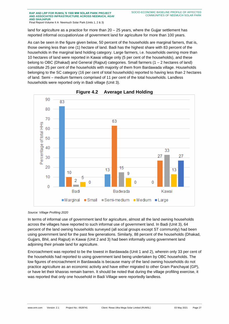
www.erm.com Version: 2.1 Project No.: 0528741 Client: Rewa Ultra Mega Solar Limited (RUMSL) 03 May 2021 Page 27
RAP AND LRP FOR RUMSL’S 1500 MW SOLAR PARK PROJECT AND ASSOCIATED INFRASTRUCTURE ACROSS NEEMUCH, AGAR AND SHAJAPUR Final Report-Volume II A Neemuch Solar Park (Units 1, 2 & 3)
SOCIO-ECONOMIC BASELINE PROFILE OF AFFECTED COMMUNITIES OF NEEMUCH SOLAR PARK
land for agriculture as a practice for more than 20 – 25 years, where the Gujjar settlement has
reported informal occupation/use of government land for agriculture for more than 100 years.
As can be seen in the figure given below, 50 percent of the households are marginal famers, that is,
those owning less than one (1) hectare of land. Badi has the highest share with 83 percent of the
households in the marginal land holding category. Large farmers, i.e. households owning more than
10 hectares of land were reported in Kawai village only (5 per cent of the households), and these
belong to OBC (Dhakad) and General (Rajput) categories. Small farmers (1 – 2 hectares of land)
constitute 25 per cent of the households with majority of them from Bardawada village. Households
belonging to the SC category (16 per cent of total households) reported to having less than 2 hectares
of land. Semi – medium farmers comprised of 11 per cent of the total households. Landless
households were reported only in Badi village (Unit 3).
Figure 4.2 Average Land Holding
Source: Village Profiling 2020
In terms of informal use of government land for agriculture, almost all the land owning households
across the villages have reported to such informal use of government land. In Badi (Unit 3), 64
percent of the land owning households surveyed (all social groups except ST community) had been
using government land for the past few generations. Similarly, 88 percent of the households (Dhakad,
Gujjars, Bhil, and Rajput) in Kawai (Unit 2 and 3) had been informally using government land
adjoining their private land for agriculture.
Encroachment was reported to be the lowest in Bardawada (Unit 1 and 2), wherein only 33 per cent of
the households had reported to using government land being undertaken by OBC households. The
low figures of encroachment in Bardawada is because many of the land owning households do not
practice agriculture as an economic activity and have either migrated to other Gram Panchayat (GP),
or have let their khasras remain barren. It should be noted that during the village profiling exercise, it
was reported that only one household in Badi Village were reportedly landless.

www.erm.com Version: 2.1 Project No.: 0528741 Client: Rewa Ultra Mega Solar Limited (RUMSL) 03 May 2021 Page 28
RAP AND LRP FOR RUMSL’S 1500 MW SOLAR PARK PROJECT AND ASSOCIATED INFRASTRUCTURE ACROSS NEEMUCH, AGAR AND SHAJAPUR Final Report-Volume II A Neemuch Solar Park (Units 1, 2 & 3)
SOCIO-ECONOMIC BASELINE PROFILE OF AFFECTED COMMUNITIES OF NEEMUCH SOLAR PARK
These encroachments or squatters are reported to be at least one generation9 old. It has been
reported that the local community deposits fines for encroachment/squatting and cultivation on
Government lands; however, the fines are paid only for a smaller fraction of the actual encroachment.
The payment of fines for a fraction of encroached land helps the households get their names in the
Government records while avoiding the payment of actual sum of fines, which is much higher in most
cases. People see benefit in remaining on this list (of squatters/encroachers), even if they have to pay
a fine, as they think that this makes them eligible for future ‘patta’ allotments or regularisation of their
claims on government land. This understanding was not confirmed by relevant government officials.
However, this seems to act as an extra-legal, proxy, claims establishment system, where families and
generations continue to cultivate, year after year. The khasras encroached upon are characterised by
higher productivity (triple cropping and more) and access to irrigation facilities. The khasras under
informal use by squatters are characterised by primarily single or double crop, with a few reporting
triple cropping and mostly no irrigation facilities. The PAHs surveyed also reported to not undertaking
significant investments in improving the productivity of khasras under informal use by squatting, in
comparison to encroached khasras.
Livelihoods
The affected communities across the project affected villages are dependent upon agriculture in the
form of either farming on their private khasras or engaged in agricultural labour work. Most of the
cultivators are also engaged as agricultural labourers. The dependence on non-farm-based livelihood
is 1.3 per cent of the total population with the highest proportion of persons engaged in such
occupations reported in Bardawada village. As understood from consultations, non-farm occupations
are limited, and the population in the youth age group (15 – 35 years) would want to engage in
contractual employments within their tehsil (Sub-division of District). The higher proportion of non-
farm occupation among the three villages is explained by the fact that certain household members in
the village have gone into non-farm occupations for livelihood such as civil construction work,
machine work, etc, as compared to the other two villages where the population continues to be
dependent on traditional livelihoods.
Livestock holding has been reported by all the surveyed PAHs (Section 4.2.4.2). Less than one
percent (0.6 per cent of the population) are engaged in grazing of livestock for income as graziers,
and is primarily undertaken by members of the Bhil community (17 persons) in terms of livestock
holdings. According to the discussions with the local community, the members of the Bhil community
undertake jobs as graziers due to lack of other opportunities, smaller land holdings and weaker
economic standing, in comparison to non-ST households. In terms of difference in livestock holding
across social groups, the ST population of Bhils/Bhilalas have more goats in comparison to
cows/buffaloes. This trend is reversed in the non-ST households in the villages.
Table 4.2 Proportion (%) of village population Livelihood Source
Village
Agriculture
Cultivators
Livestock (Graziers)
Machinery/ Factory Workers
Agricultural
Labourers
Transport Workers
Construction
Workers
Government/ Private
Services
Bardawada 88.2 2 0 88.2 0 4.3 1.47
Kawai 62.5 2.5 0 62.5 0 2.5 1.25
Badi 80 0 0.4 80 0 0 0.12
Source: Village Profiling 2020
Out migration for work is limited and is of seasonal in nature across the three villages. Since majority
of the population is engaged in farm based activities, migration is undertaken during the lean period of
March – June when agricultural activity is low (in between Kharif and Rabi season). Badi has the
9 A generation is defined as spanning over 25 years, as defined in Forest Rights Act (FRA) 2006

www.erm.com Version: 2.1 Project No.: 0528741 Client: Rewa Ultra Mega Solar Limited (RUMSL) 03 May 2021 Page 29
RAP AND LRP FOR RUMSL’S 1500 MW SOLAR PARK PROJECT AND ASSOCIATED INFRASTRUCTURE ACROSS NEEMUCH, AGAR AND SHAJAPUR Final Report-Volume II A Neemuch Solar Park (Units 1, 2 & 3)
SOCIO-ECONOMIC BASELINE PROFILE OF AFFECTED COMMUNITIES OF NEEMUCH SOLAR PARK
highest share of households (50 per cent of total households) from whom male members out –
migrate for work in construction sector. The two other villages had 9 per cent (Bardawada), and 20
per cent (Kawai) of households reporting out – migration.
Community Development
All households in the villages have access to water for drinking, and domestic use. All households
also have electricity. For education facilities, almost all the Project affected villages have school till
primary level (5th standard). For higher studies, children from the villages have to travel to Singoli
town, approximately 20 km away from the villages. Further, there are no medical facilities in any of the
villages. The nearest medical facility is in Singoli or Tharod. Market facilities to buy and sell
agricultural produce (on MSP and through bids) and for purchase of household consumables is
available at Singoli, which has a dedicated farmers’ market.
As part of the village profiling exercise, the villagers were asked to rank the kind of community support
as High, Medium, and Low from the provided options. Based on the information collected on
requirement of community development support, the highest demand across the villages is for
financial literacy and investment training, and fodder and feed management for livestock (2 out of the
3 villages gave a medium rank). Education and health related support programs such as scholarship
schemes, mobile health facility, and veterinary support for livestock are of low importance as the
current infrastructure and services available are assessed as sufficient by the community.

www.erm.com Version: 2.1 Project No.: 0528741 Client: Rewa Ultra Mega Solar Limited (RUMSL) 03 May 2021 Page 30
RAP AND LRP FOR RUMSL’S 1500 MW SOLAR PARK PROJECT AND ASSOCIATED INFRASTRUCTURE ACROSS NEEMUCH, AGAR AND SHAJAPUR Final Report-Volume II A Neemuch Solar Park (Units 1, 2 & 3)
SOCIO-ECONOMIC BASELINE PROFILE OF AFFECTED COMMUNITIES OF NEEMUCH SOLAR PARK
Figure 4.3 Preference for R&R Support
Source: Village Profiling 2020

www.erm.com Version: 2.1 Project No.: 0528741 Client: Rewa Ultra Mega Solar Limited (RUMSL) 03 May 2021 Page 31
RAP AND LRP FOR RUMSL’S 1500 MW SOLAR PARK PROJECT AND ASSOCIATED INFRASTRUCTURE ACROSS NEEMUCH, AGAR AND SHAJAPUR Final Report-Volume II A Neemuch Solar Park (Units 1, 2 & 3)
SOCIO-ECONOMIC BASELINE PROFILE OF AFFECTED COMMUNITIES OF NEEMUCH SOLAR PARK
Cultural Resources
There are no listed cultural resources that are protected by national or state departments that are
affected by the Project. However, there are certain religious structures that have been identified to be
potentially affected in Badi village due to land procurement. There are three religious structures in the
Gujjar settlement in Badi village which have been in existence over 40 – 50 years, and are of local
cultural significance. These include a temple in the courtyard of the settlement, and a mazaar, as
observed during the RAP surveys. . Apart from these structures, the villages have reported to
worshipping, sacred trees and small shrines. All the social groups use these cultural sites with equal
access. The details of cultural resources affected by the project are given below in table below.
Table 4.3 Cultural resources in the Solar Park
Unit Village Cultural
Resource
Status of cultural
resource on inside
or outside the
project boundary
Remarks Categorization
of the
Resources as
per IFC PS 8
Suggestion for
RUMSL
1 Badi Two
religious
structure,
and one
sacred
stone
As per the current
land footprint of the
Solar Park, these
are within the
project boundary
These
structures are
part of the
settlement and
located in the
central
courtyard of the
settlement
Tangible form of
cultural heritage
Exclude the entire
Khasra where the
Gujjar settlement
is residing to avoid
economic and
physical
displacement
impacts, and
cultural impacts.
Presently, the
settlement has
been included in
the RAP/LRP. In
case it is in the
project boundary
cannot be
revised and the
impact cannot be
avoided,
alternative
access needs to
be provided or
the heritage site
to be relocated in
consultation with
the local
community
Source: Village Profiling 2020

www.erm.com Version: 2.1 Project No.: 0528741 Client: Rewa Ultra Mega Solar Limited (RUMSL) 03 May 2021 Page 32
RAP AND LRP FOR RUMSL’S 1500 MW SOLAR PARK PROJECT AND ASSOCIATED INFRASTRUCTURE ACROSS NEEMUCH, AGAR AND SHAJAPUR Final Report-Volume II A Neemuch Solar Park (Units 1, 2 & 3)
SOCIO-ECONOMIC BASELINE PROFILE OF AFFECTED COMMUNITIES OF NEEMUCH SOLAR PARK
Socioeconomic profile of the households surveyed in the Project Footprint
This section provides an overview of the socio-economic baseline of the project affected households
(PAH) and sample households. The socio-economic profile is based on the primary survey and
consultations conducted in the three villages in three units of Neemuch Solar Park. This section
presents the socioeconomic baseline analysis by village, and covers key aspects such as education,
livelihood, land and asset ownership, income and expenditure patterns, physical and social
infrastructure, relevant to the PAHs. It also highlights different vulnerabilities among the population
and their dependency on resources to understand the significance of involuntary resettlement
impacts. Demographics
The table below provides the demographic characteristics of the 127 surveyed households (including
one sample household) in the three villages.
Table 4.4 Demographic Profile of surveyed households
Village Number of Households
Total Population
Sex Ratio10
Average Family Size
Dependency Ratio11
Bardawada 52 292 802 5.6 37.7
Kawai 35 216 895 6.1 48.9
Badi 40 228 853 5.7 60.5
Total 127 736 844 5.8 47.4
Source: HH survey 2020
The overall sex ratio among PAHs is lower than the sex ratio of the district (954) and country’s sex
ratio of 940 females per thousand males. The sex ratio across in Bardawada is the lowest among all
three villages.
Badi Village has the lowest dependency ratio as compared to Kawai and Bardawada. The potential
reason for low dependency can be a high proportion of people engaging in income generating
activities. The dependency can only be lowered if there are better educational, vocational and
employment opportunities for vulnerable groups in the society.
As shown in Table 4.4 the average family size is 5.8. Among the surveyed households, 42.6 percent
have up to five (5) members in their family while, 57.4 percent have 5 to 10 family members. The
households reporting more than 5 members primarily comprised of joint families, with two or more
brothers residing together in the same household along with their families, parents, unmarried siblings
and other dependents. The surveyed households reported a preference of large joint families, with
sons residing with their other siblings’ families and their parents after marriage. The trend of nuclear
families was rare but common in Bardawada, where sons reside separately from their parents in
another village, after marriage. The trend of nuclear families was reported to be higher amongst the
OBC families. The lowest family size was reported was of 5.6 in Bardawada.
In terms of age wise population distribution, Figure 4.4 shows that the majority of the population in
the district is in the age group of 15-35, i.e. the youth population. The sex ratio among different age
groups is detailed in Table 4.5. The population in the age group of below 6 years shows the lowest
sex ratio among all age groups. Despite of several policies and schemes to promote gender
10 Sex ratio refers to the ratio of females to 1000 males among the PAH. 11 Dependency ratio refers to the proportion of dependents with respect to the working population among the PAH. The formula
used to calculate this ratio is PAPs below 15 years of age + PAPs above 60 years of age divided by the PAPs between 15-60 years of age.

www.erm.com Version: 2.1 Project No.: 0528741 Client: Rewa Ultra Mega Solar Limited (RUMSL) 03 May 2021 Page 33
RAP AND LRP FOR RUMSL’S 1500 MW SOLAR PARK PROJECT AND ASSOCIATED INFRASTRUCTURE ACROSS NEEMUCH, AGAR AND SHAJAPUR Final Report-Volume II A Neemuch Solar Park (Units 1, 2 & 3)
SOCIO-ECONOMIC BASELINE PROFILE OF AFFECTED COMMUNITIES OF NEEMUCH SOLAR PARK
development, these figures raise serious concerns towards gender equality among children in the
area.
Table 4.5 Age Structure of the population
Age group Males % Females % Total % Sex Ratio
Below 6 51 12.7 39 11.1 90 12.2 765
6-15 years 44 11.02 42 12.4 86 11.6 954
15-35 years 167 41.8 144 42.7 311 42.2 862
35-60 years 105 26.3 83 24.6 188 25.5 790
Above 60+ 32 8.02 29 8.6 61 8.2 906
Total 399 100 337 100 736 100 887
Source: HH survey 2020
Figure 4.4 Age Sex Pyramid
Source: HH survey 2020
Religion, Caste and Ethnicity
More than 97 percent of the PAHs are Hindu while, the remaining 3 percent are Muslim households.
The Hindu households have a higher sex ratio (889), as compared to the households in the Muslim
category (666). The surveyed villages reported practice monogamy and the preferred norms of
kinship are endogamous.
Social group profiling of the PAHs shows that 55.5 percent of them belong to OBC category
households, and 17.4 percent belong to SC category households (out of 127 impacted households).
There are no caste based differences observed in occupation/livelihood, however, landlessness has
been observed only among ST category (0.7 percent of the households) across the PAPs.
The division of social groups by village is detailed in Figure 4.5.
60.00 40.00 20.00 0.00 20.00 40.00 60.00 80.00
Above 60+
35-60 years
15-35 years
6-15 years
Below 6
Male Female

www.erm.com Version: 2.1 Project No.: 0528741 Client: Rewa Ultra Mega Solar Limited (RUMSL) 03 May 2021 Page 34
RAP AND LRP FOR RUMSL’S 1500 MW SOLAR PARK PROJECT AND ASSOCIATED INFRASTRUCTURE ACROSS NEEMUCH, AGAR AND SHAJAPUR Final Report-Volume II A Neemuch Solar Park (Units 1, 2 & 3)
SOCIO-ECONOMIC BASELINE PROFILE OF AFFECTED COMMUNITIES OF NEEMUCH SOLAR PARK
Figure 4.5 Social groups by Village
Source: HH survey 2020
The main caste groups amongst the surveyed households comprise of the Rajputs and Brahmins in
General category, Gujjars, Dhakkads and Silavats in the OBC category, Ragers and Balais in the SC
category and Bhils in the ST category. Pinjaras are the dominant castes among Muslims. Among the
OBC’s nearly 35 percent Banjaras, followed by the Dhakkads.
Settlement Pattern
The settlement pattern in the villages have undergone a significant change over the years. The main
village has grown in size and extended to a larger area. There is typically one main settlement in the
village, followed by scattered multiple hamlets around the main settlement in the radius of 500 mtrs –
1 km radius. The main village is understood to be up to 300-500 years old while the emergence of
these extended hamlets is a comparatively recent phenomenon (60-80 years). Caste hierarchy has
spatially segregated the hamlets from the main settlement wherein the main settlement has a mixed
social fabric with the dominant higher caste groups while the hamlets are resided by households from
SC and ST communities. Within the main village, though there is a cohabitation of various social
groups, people of the same social group reside in specific areas of the village. For example, the
Gujjars in Badi, live in a street at the end of the village and the Brahmins of the village live near the
access road. These extended hamlets are either called a baldi or a colony. This settlement pattern is
predominant in Badi.
The overall relationship of people in the village and these extended hamlets are cordial, and there is
no demarcation of areas about common natural resources, particularly surface water bodies, and
grazing land.
There is however a stark difference when it comes to accessing these hamlets as compared to the
villages. The access roads to all three villages is through a semi-pucca road, but accessing the
extended hamlets is more challenging because of absence of roads. It takes about 20-30 mins by foot
to reach the hamlets from the main village. Those living in the villages have a travelling distance of
within 3 kms (less than 30 mins) to access their agricultural lands. The only exception is Bardawada,
where households have to travel for about 5 kms (45 - 50 mins) to access their khasras, with some
households even depending on two-wheeler transport to access their agricultural fields. In terms of
accessing land for open grazing of livestock, it was understood during consultation that the residents
let the livestock out for grazing for a distance of up to 1 – 3 kms from the village to access the
designated grazing land or private khasras to graze.
Badi Barawada Kawai
General 6 8
OBC 21 27 22
SC 6 14 2
ST 7 3 11
0
5
10
15
20
25
30

www.erm.com Version: 2.1 Project No.: 0528741 Client: Rewa Ultra Mega Solar Limited (RUMSL) 03 May 2021 Page 35
RAP AND LRP FOR RUMSL’S 1500 MW SOLAR PARK PROJECT AND ASSOCIATED INFRASTRUCTURE ACROSS NEEMUCH, AGAR AND SHAJAPUR Final Report-Volume II A Neemuch Solar Park (Units 1, 2 & 3)
SOCIO-ECONOMIC BASELINE PROFILE OF AFFECTED COMMUNITIES OF NEEMUCH SOLAR PARK
Within these extended hamlets reside the minority population of the district such as Bhils, Suttars,
Gujjars etc. Though the surveyed villages have a small proportion of these minority castes living
within the main village as well, the majority of the people reside in the designated extended hamlets.
Box 4.1: Changing settlement patterns
Badi village, is reportedly a 600 year old village. The village elders are understood to be the third and
fourth generation within this village. There are nearly 300 households currently within the main village.
In the last 70-80 years, there are 4 small hamlets which have emerged around the main village of
Badi; baithron ki basti, sutaaron ki basti, bhil basti and mama bhil basti. Baithron ki basti, situated at
north-east of the main settlement of Badi is a predominantly Gujjar settlement while Sutaaron ki basti,
at north-west of Badi is a predominantly Suttar settlement. Both these settlements, 2-3kms from the
main village, are reportedly nearly 80-90 years old but their access is still through a kutcha road. The
residents in the Suttar settlement reportedly were engaged in agriculture, agricultural labour and
labour work.
Bhil basti, south-west of Badi, is residence to the Bhil community of Badi. Bhils are the ST community
of the region who are mainly engaged in agriculture and agricultural labour. They have settled in the
area more than 100 years ago but the hamlet is a more recent emergence Mama basti which is a
farther down to the bhil basti, is a more recent establishment (50 years), as understood during
consultations. Nearly 4-5 kms south-west, from the main village, the hamlet is understood to be
inhabited by Bhils who have migrated from Ratlam district.
Source: consultations with the local community during RAP study
Most of the residential areas, were kutcha and semi- pucca. Bardawada and Badi were observed to
have 1-2 market areas within their boundaries, catering to the daily needs but the people preferred to
go to the nearby district headquarters to buy their supplies and monthly purchases.
The surveyed households also reported having temporary structures on their agricultural khasras.
These structures acted as temporary residences for the families of the land owners during farming
season or as a shelter during bad weather.
Figure 4.6 Residential Structures within the village
Source: RAP study, 2020
Social Group Dynamics
The district is characterised by a mixed population in terms of religion and social/caste groups; Hindus
are the predominant religion-category, OBCs are the predominant caste group.
The marriages within these villages are mostly endogamous and the social set up is patriarchal. As
highlighted in Section 4.2.1.2, in most villages, the different social categories reside in different
clusters and hamlets within the village. However, the people reported having a cordial and co-
dependent relationship across communities. Cultural activities are celebrated, across communities,
and with participation by various groups.

www.erm.com Version: 2.1 Project No.: 0528741 Client: Rewa Ultra Mega Solar Limited (RUMSL) 03 May 2021 Page 36
RAP AND LRP FOR RUMSL’S 1500 MW SOLAR PARK PROJECT AND ASSOCIATED INFRASTRUCTURE ACROSS NEEMUCH, AGAR AND SHAJAPUR Final Report-Volume II A Neemuch Solar Park (Units 1, 2 & 3)
SOCIO-ECONOMIC BASELINE PROFILE OF AFFECTED COMMUNITIES OF NEEMUCH SOLAR PARK
In terms of decision making at the village level, there are instances where people from SC and OBC
groups are the elected representatives of the village as per the 73rd amendment12. However, the
traditionally dominant caste group members of the panchayat hold the decision making power in the
villages. For example, in Badi and Kawai the Sarpanch from the Bhalai group in the SC category.
However, the decision making authority in both villages continues to be with the village elders
belonging to the general category who act as advisors or are informal ‘committee members’ and
sometimes formal elected panchayat members as well.
Box 4.2: Spatial segregation by Caste Groups
Source: Consultations with the local community during RAP study
The following table provides a summary of the qualitative assessment of social group dynamics which
are further elaborated with data in relevant sections:
Table 4.6 Summary of Qualitative Observation on Social Groups
Aspect General OBC SC ST
Settlement Pattern
Live in the main settlement. A small proportion live in the main settlement in a particular cluster.
Also, reside in separate extended hamlets.
A small proportion live in the main settlement in a particular cluster.
Also, reside in separate extended hamlets.
Very small proportion reside in the main village
Mainly reside in a separate extended hamlet.
Land Ownership
Mostly marginal and small holdings.
Mostly small and semi-medium size land holdings.
Mostly small and semi-medium holdings.
Mostly small and semi-medium holdings.
Literacy Levels
Nearly 75 percent of the population is literate with education up to secondary
Nearly 63 percent of the population is literate and are
Nearly 54 percent is educated till primary and
Nearly 38 percent of the population is educated till
12 Accordingly, it is proposed to add a new Part relating to Panchayats in the Constitution to provide for among other things,
Gram Sabha in a village or group of villages; constitution of Panchayats at village and other level or levels; direct elections to all seats in Panchayats at the village and intermediate level, if any, and to the offices of Chairpersons of Panchayats at such levels; reservation of seats for the Scheduled Castes and Scheduled Tribes in proportion to their population for membership of Panchayats and office of Chairpersons in Panchayats at each level. (http://legislative.gov.in/constitution-seventy-third-amendment-act-1992)
In Badi village, the Muslims families of the village; Pinjaras, reside on a street next to the Gujjars
Moholla. The Brahmins live in a cluster at the heart of the village, next to the village temple. The
communal relationship within these villages among all social groups is cordial and co-dependent.
Bardawada, a well-developed village which has multi storeyed houses also displayed a spatial caste
segregation. The Ragers and Bairagis of the SC community live in a cluster which is distant from the
Rajputs, Dhakkads and Gurjjars. All the communities, spatially spread out in their respective
settlement, have freedom of access to the main temple in the main cluster (except for the Muslims,
who have their dargah situated at the entrance road to Badi village). The Gujjars offer worship at the
main temple, as well as the Ragers visit the main temple during religious/cultural festivals. Apart from
the main temple, each settlement have created their own structures of worship.

www.erm.com Version: 2.1 Project No.: 0528741 Client: Rewa Ultra Mega Solar Limited (RUMSL) 03 May 2021 Page 37
RAP AND LRP FOR RUMSL’S 1500 MW SOLAR PARK PROJECT AND ASSOCIATED INFRASTRUCTURE ACROSS NEEMUCH, AGAR AND SHAJAPUR Final Report-Volume II A Neemuch Solar Park (Units 1, 2 & 3)
SOCIO-ECONOMIC BASELINE PROFILE OF AFFECTED COMMUNITIES OF NEEMUCH SOLAR PARK
Aspect General OBC SC ST
and higher secondary and in some cases, graduation.
The main reason for discontinuation of education is for work and marriage.
educated till primary and secondary levels, few instances of education beyond higher secondary.
The main reason for discontinuation of education is an absence of economic resources and for work.
secondary levels. Few instances of education till higher secondary.
The main reason for discontinuation of education is for marriage and lack of familial support.
primary and secondary levels. Very few instances of higher secondary and graduate training.
The main reason for discontinuation of education is absence of economic resources and marriage and work.
Other Skills There is one driver and one tailor in Badi village and a couple who reported traditional skills in Bardawada.
There is one electrician and one driver in Kawai and 4 drivers and one tailor in Bardawada (2 from the same family). 3 people reported to be practicing traditional arts in Kawai.
There is one mason and one driver in Bardawada. One man reported that he practices traditional arts in Bardawada.
There is one mason in Badi and a driver is Bardawada.
Participation in the Work Force
People in the working age (15-60) mainly engage in agriculture and agriculture labour. Very few of them have a business or shop or work at a private job.
People in the working age (15-60) participate mostly in agriculture, agricultural labour and construction work. Few of them have a business or shop and only nearly 5% of this population has a government or teaching job or are engaged in livestock livelihoods.
People in the working age (15-60) participate mostly in agriculture, agriculture labour and construction work.
Very few are engaged in non-farm based activities like working in a stone crusher and livestock based livelihoods.
People in the working age (15-60) participate only in agriculture and agriculture labor and only one person reported to be engaged in livestock livelihoods.
Poverty Levels
None None None None
Gender Roles (Section 4.2.11)
Decision making authority in the household is traditionally with the male head of the family.
Women are responsible for domestic work such as cooking, cleaning, taking care of the children and the elderly, washing and feeding the livestock etc. Women are responsible for fetching water from within the village for the household and are in this role from a very young age.
Decision making authority in the household is traditionally with the male head of the family, despite women being the head of household in some cases.
Women are responsible for domestic chores and in very few instances are allowed to do household chores and
Decision making authority in the household is traditionally with the male head of the family, despite women being the head of household in some cases.
Women are responsible for domestic chores and household work. They are responsible for
Decision making authority in the household is traditionally with the male head of the family
Women are responsible for domestic chores and household work. Young girls in most cases made to quit school post primary school for

www.erm.com Version: 2.1 Project No.: 0528741 Client: Rewa Ultra Mega Solar Limited (RUMSL) 03 May 2021 Page 38
RAP AND LRP FOR RUMSL’S 1500 MW SOLAR PARK PROJECT AND ASSOCIATED INFRASTRUCTURE ACROSS NEEMUCH, AGAR AND SHAJAPUR Final Report-Volume II A Neemuch Solar Park (Units 1, 2 & 3)
SOCIO-ECONOMIC BASELINE PROFILE OF AFFECTED COMMUNITIES OF NEEMUCH SOLAR PARK
Aspect General OBC SC ST
Young girls in most cases do not continue with education after primary school for several reasons.
Men are responsible for activities outside the house, selling of market produce, going to the markets etc. Women’s role pertains to household activities and supporting male members in agricultural work on the fields, as reported from consultations.
activities outside the domestic space. They are responsible for fetching water, firewood and fodder from the forest of grasslands near the village. Young girls in most cases do not continue with education after primary school for several reasons.
Men are responsible for activities outside the house, going to the markets, livestock grazing etc.
fetching water, firewood and fodder from the forest of grasslands near the village. Young girls in most cases do not continue with education after primary school for several reasons.
Men are responsible for activities outside the house, going to the markets, livestock grazing etc.
household chores. Very few instances of women taking livestock for grazing in the grazing lands.
Men are responsible for activities outside the house, fetching firewood, going to the markets, livestock grazing etc.
Education
Education and Literacy
The literacy rate in the Solar Park is highlighted in Table 4.7 . The overall literacy rate of the surveyed
population is nearly 58.1 percent. The village with the highest illiteracy rate is Bardawada (68.8
percent) while Badi has 48.2 percent of literate population.
Table 4.7 Literacy amongst surveyed population
Categories Illiterate Literate
Village Male Male % Female Female %
Male Male % Female Female %
Bardawada 28 9.5 63 21.5 134 45.7 67 22.8
Kawai 42 19.4 57 26.3 72 33.3 45 20.8
Badi 55 24.1 63 27.6 68 29.8 42 18.4
Total Average
125 17 183 24.8 274 37.2 154 20.7
Source: HH survey 2020
It is reported that 42.2 percent of the surveyed population have completed primary education and
nearly 34.1 percent have never attended formal schooling. About 50.7 percent of the literate surveyed
population have studied till secondary or higher secondary but only about 7 percent have pursued
graduate or post graduate courses.

www.erm.com Version: 2.1 Project No.: 0528741 Client: Rewa Ultra Mega Solar Limited (RUMSL) 03 May 2021 Page 39
RAP AND LRP FOR RUMSL’S 1500 MW SOLAR PARK PROJECT AND ASSOCIATED INFRASTRUCTURE ACROSS NEEMUCH, AGAR AND SHAJAPUR Final Report-Volume II A Neemuch Solar Park (Units 1, 2 & 3)
SOCIO-ECONOMIC BASELINE PROFILE OF AFFECTED COMMUNITIES OF NEEMUCH SOLAR PARK
Figure 4.7 Level of Education among surveyed population
Source: HH survey 2020
Looking at the educational infrastructure within and around the surveyed villages, most children
attend the government schools in or near their villages. While Primary schools are reported to be
relatively closer to the villages, in Tharod village, most children in these villages who are in secondary
or higher secondary classes attend schools which are 10-12 kms away in Singoli, which is the nearest
town. A proportion of children cover this distance by public transport or are taken by their parents.
This is a contributing factor to high drop outs post primary schools in the villages. It is understood that
families are not comfortable letting their children, specifically girls, travel such a distance to attend
school and opt to discontinue their education after primary school.
Those studying in graduate and post-graduate degree courses, and vocational training either travel to
Singoli or Chittorgarh, and in some cases, undertake residential facilities for courses in Indore, Bhopal
or Rajasthan.
Table 4.8 Age wise literacy levels among surveyed Population
Age group Literate Illiterate
Male Female Male Female
6-15 years 38 39 6 3
15-35 years 146 90 21 54
35-60 years 60 16 45 67
Above 60+ 14 1 18 28
Total 258 146 90 152
Source: HH survey 2020
Table 4.8 indicates the learning gap between males and females in the Project footprint villages.
Overall, 35.9 percent of the women are literate. Of those who are illiterate, nearly 20 percent did not
get the opportunity to attend any formal educational institution due to traditional family rules and
0%
10%
20%
30%
40%
50%
60%
70%
80%
90%
100%
Badi Barawada Kawai
Primary Secondary level Higher Secondary level
Graduate Post Graduate Not school going age
Never attended formal education Vocational Training

www.erm.com Version: 2.1 Project No.: 0528741 Client: Rewa Ultra Mega Solar Limited (RUMSL) 03 May 2021 Page 40
RAP AND LRP FOR RUMSL’S 1500 MW SOLAR PARK PROJECT AND ASSOCIATED INFRASTRUCTURE ACROSS NEEMUCH, AGAR AND SHAJAPUR Final Report-Volume II A Neemuch Solar Park (Units 1, 2 & 3)
SOCIO-ECONOMIC BASELINE PROFILE OF AFFECTED COMMUNITIES OF NEEMUCH SOLAR PARK
marriage at an early age, as understood during consultation. Young girls drop out after completing
primary level of learning, due to societal norms, and physical distance of higher education institutions
from the village areas.
The male members of the family are encouraged to study beyond primary school but nearly 21.7
percent gave up studies due to a death in the family or an illness or disability, while 20 percent of the
males left studies because of lack of interest. Around 24.7 percent of the male drop-outs are engaged
in agriculture and labour work. There are a few households in Badi where children below the age of
10 who were going to school but also helping out in the fields as the family relocates to temporary
sheds on their fields where all the members of the family help during agricultural seasons.
Even though, the above table shows the difference between male and female literacy levels, there
also is a growing trend in the willingness to educate girls to higher education, and provide support to
undertake higher education courses.
Other Skills (non-farm based)
Several skills have been reported across all three villages especially in Bardawada and Badi. Of those
who reported skills (2.5 percent) about 31.6 percent of the surveyed households reported practicing
traditional artisanal skills, mainly general and OBC category. These households reported practicing
traditional arts and crafts such as basket weaving and the Bhils practice their traditional art of wall
painting (although the custom has declined over generations). Apart from these traditional crafts,
there are households who reported skills pertaining to driving, rajmistris (masonry), tailoring. These
individuals reported practicing their craft as means of livelihood but have not obtained any formal
certification for the same except for those who are drivers by profession. These individuals reported to
have obtained a driving license.
Knowledge and skills on farm-based activities (agriculture and livestock rearing), are ubiquitous
across the project affected households
Land and Asset Ownership13
Over the years, there has been negligible to no recorded change in the extent and intensity of land
used for agriculture among the villages. Majority of the households undertake double cropping during
a calendar year. The private/patta khasras of each household have an established boundary in the
form of stone walls (stones piled over one another), wire fences and stone slabs, providing clear
demarcations of land ownership as separate for each household. The use of government land
informally by the households (either as encroachment by private/patta land holders, or through
squatting) has been in practice for an average of 25 years. Encroachment in Badi village has been in
existence for more than 35 years.
Due to fragmentation of large families into smaller household units, the second generation of sons of
the household have their separate dwelling structures. The source of livelihood, however, is
dependent on the khasra owned by the male patriarch of the family. This has led to informal division
of large landholdings wherein the sons have divided the land holding (each parcel having separate
land-based investments undertaken by each son). However, there has been no formal division of the
land holding in terms of either transfer of ownership to the second generation as per official land
records.
The land identified for the purpose of the project is comprised of primarily government land (90.3
percent), with a small section of private land. Approximately 9.6 percent of land is private which also
includes patta land (7.6 percent is patta land). All the private land owners are residents of Singoli
Tehsil. The land identified includes both, agricultural land and barren land without any farming activity
13 This section takes into consideration the PAH with land holding only, Sample households are not considered as they are
landless. .

www.erm.com Version: 2.1 Project No.: 0528741 Client: Rewa Ultra Mega Solar Limited (RUMSL) 03 May 2021 Page 41
RAP AND LRP FOR RUMSL’S 1500 MW SOLAR PARK PROJECT AND ASSOCIATED INFRASTRUCTURE ACROSS NEEMUCH, AGAR AND SHAJAPUR Final Report-Volume II A Neemuch Solar Park (Units 1, 2 & 3)
SOCIO-ECONOMIC BASELINE PROFILE OF AFFECTED COMMUNITIES OF NEEMUCH SOLAR PARK
being undertaken (land owned by absentee owners). Table 4.9 details the proportion of PAHs across
land holdings and Table 4.10 details the same by village.
Table 4.9 Size of land holdings
Land Holding Size PAH PAHs (%)
Marginal Farmer (<1 ha) 11 8.7
Small Farmer (1-2 ha) 55 44.4
Semi-medium Farmer (2-4 ha) 37 29.3
Medium Farmer (4-10 ha) 22 17.4
Large Farmer (>10 ha) 0 0
Source: HH survey 2020
Table 4.10 Land holding of the PAHs by Village
Village Marginal Farmer (<1 ha) Marginal
Farmer (<1 ha) %
Small Farmer (1-2 ha
Small Farmer (1-2 ha) %
Semi-medium Farmer (2-4 ha)
Semi-medium Farmer (2-4 ha) %
Medium Farmer (2-4 ha) Medium Farmer
(4-10 ha) %
Bardawada 2 3.8 32 63.4 11 21.1 4 7.6
Kawai 3 8.5 6 17.1 16 45.7 10 28.5
Badi 6 15 15 37.5 10 25 8 17.5
Source: HH survey 2020
Majority of the PAHs (44 percent approx.) are categorized as small farmers, owning 1-2 hectare of
land, while there are no PAHs with large land holdings (more than 10 hectares). The highest
proportion of small farmers are in Bardawada. The potential impacts from the land procurement for
the project in terms of change in land holdings and loss of livelihoods is discussed in the section on
impacts.
A look at land holding by caste group shows that 50 percent of the small farmers and nearly 70
percent of the semi-medium farmers belong to OBC category. The Dhakad community are known to
be skilled agriculturalists and belong to the OBC community. This may be a key reason for the land
holding pattern reported. Analysis of land holding by gender shows that 58.3 percent of women-
headed households have small land holdings and 27.2 percent of them have semi-medium land
holdings.
Construction material used
Except for two (2) residential structures, all residences are owned by the surveyed households who
also use it as permanent dwelling structure. About 40.1 percent of the housing is of kutcha type, and
27.5 percent of the surveyed households have a pucca housing structure.

www.erm.com Version: 2.1 Project No.: 0528741 Client: Rewa Ultra Mega Solar Limited (RUMSL) 03 May 2021 Page 42
RAP AND LRP FOR RUMSL’S 1500 MW SOLAR PARK PROJECT AND ASSOCIATED INFRASTRUCTURE ACROSS NEEMUCH, AGAR AND SHAJAPUR Final Report-Volume II A Neemuch Solar Park (Units 1, 2 & 3)
SOCIO-ECONOMIC BASELINE PROFILE OF AFFECTED COMMUNITIES OF NEEMUCH SOLAR PARK
Figure 4.8 Housing: Types of Construction
Source: HH survey 2020
Livestock Ownership
The PAHs are characterised by livestock holdings of cows, buffaloes, goats and sheep with most of
the households having at least cows and goats. The dependence on livestock is mostly for household
consumption along with the sale of dairy products, especially milk, being secondary in nature. Figure
4.9 shows the number of PAH which have different varieties of livestock in the district. Cows are the
most commonly owned livestock. Each household has at least one - two heads of livestock. The
social group bifurcation of ownership shows no apparent difference in ownership across caste groups.
The difference arise in cases of buffalo ownership, which is higher in General, and OBC social group
in comparison to the SC and ST social group. The reason behind the low ownership of buffalo
between the two social groups stems from their financial status. The other reasons for significantly
low ownership of buffaloes are high costs of purchasing buffaloes, maintenance costs of veterinary
support and fodder that makes it difficult for low-income households to purchase and maintain
buffaloes.
Figure 4.9 Type of Livestock holdings
Source: HH survey 2020
0.00%
2.00%
4.00%
6.00%
8.00%
10.00%
12.00%
14.00%
16.00%
18.00%
Badi Barawada Kawai
Kutcha Pucca Semi Pucca
86
4 5
31
4 110
0 00
18
35
53
70
88
105
1-5. 5-10. more than 10
Cow Buffalo Goat

www.erm.com Version: 2.1 Project No.: 0528741 Client: Rewa Ultra Mega Solar Limited (RUMSL) 03 May 2021 Page 43
RAP AND LRP FOR RUMSL’S 1500 MW SOLAR PARK PROJECT AND ASSOCIATED INFRASTRUCTURE ACROSS NEEMUCH, AGAR AND SHAJAPUR Final Report-Volume II A Neemuch Solar Park (Units 1, 2 & 3)
SOCIO-ECONOMIC BASELINE PROFILE OF AFFECTED COMMUNITIES OF NEEMUCH SOLAR PARK
Other Assets
In terms of household appliances, the highest proportion of assets is of ceiling fans, mobile phones,
television sets and cable connections. In terms of vehicles, most of the PAHs reported ownership of
two wheelers including bicycles and motor cycles. Amongst the agricultural implements, PAHs
reported ownership mostly of implements such as tractors and water pump sets.

www.erm.com Version: 2.1 Project No.: 0528741 Client: Rewa Ultra Mega Solar Limited (RUMSL) 03 May 2021 Page 44
RAP AND LRP FOR RUMSL’S 1500 MW SOLAR PARK PROJECT AND ASSOCIATED INFRASTRUCTURE ACROSS NEEMUCH, AGAR AND SHAJAPUR Final Report-Volume II A Neemuch Solar Park (Units 1, 2 & 3)
SOCIO-ECONOMIC BASELINE PROFILE OF AFFECTED COMMUNITIES OF NEEMUCH SOLAR PARK
Table 4.11 Movable Assets amongst surveyed households by village
Village Kitchen Appliance
Kitchen Appliance %
Household Appliance
Household Appliance%
Agricultural appliance
Agricultural appliance %
Means of Transport
Means of Transport %
Communication devices
Communication devices %
Bardawada 10 19.2 24 46.1 7 11.5 43 84.6 50 96.1
Kawai 0 0 11 31.4 1 2.8 24 71.4 24 71.4
Badi 5 12.5 12 30 5 12.5 26 65 37 92.5
Grand Total 15 10.5 47 35.8 13 9 93 73.6 111 85.7
Source: HH survey 2020

www.erm.com Version: 2.1 Project No.: 0528741 Client: Rewa Ultra Mega Solar Limited (RUMSL) 03 May 2021 Page 45
RAP AND LRP FOR RUMSL’S 1500 MW SOLAR PARK PROJECT AND ASSOCIATED INFRASTRUCTURE ACROSS NEEMUCH, AGAR AND SHAJAPUR Final Report-Volume II A Neemuch Solar Park (Units 1, 2 & 3)
SOCIO-ECONOMIC BASELINE PROFILE OF AFFECTED COMMUNITIES OF NEEMUCH SOLAR PARK
Livelihood Profile
Within the working age group (people who are 15-60 years of age) nearly 10.02 percent of the
individuals have no current occupation. Of those who are employed in farm or non-farm based
occupations in the working population, 37.07 percent of them are women. Housewives are not
considered as a part of the income earning population even though they constitute nearly 25 percent
of the surveyed population. The reason for the same is detailed in the below sections.
Primary Occupation
The type of primary occupations across age groups is given in Figure 4.10. It can be seen that
among the working population (15-60 years of age) the dominant primary occupation reported is farm-
based activities (35-50 years). Even though there is a mixed dependence upon farm based and non-
farm based activities across age groups, it was reported that there is a greater dependence on
agriculture for sustenance as compared to non-farm based activities.
Figure 4.10 Primary Livelihoods across Age grops
Source: HH survey 2020
Figure 4.11 highlights the distribution of primary occupation within the surveyed villages. It can be
understood that the most common primary occupation among villages is agriculture (48.2 percent).
Agricultural labour is reported as the most common secondary occupation with nearly 30 percent of
the PAPs engaged in the same. Nearly one (1) percent of the surveyed households also reported
working as artisans along with agricultural labour as their secondary activity. These households are
residents of Badi.
15-35 years 35-60 years 60+ years
No Occupation 13.5 4.2 31.1
Non Farm Based 19.2 17.5 14.75
Farm based 67.2 78.1 54.09
67.278.1
54.09
19.2
17.5
14.75
13.54.2
31.1
0%
10%
20%
30%
40%
50%
60%
70%
80%
90%
100%
Farm based Non Farm Based No Occupation

www.erm.com Version: 2.1 Project No.: 0528741 Client: Rewa Ultra Mega Solar Limited (RUMSL) 03 May 2021 Page 46
RAP AND LRP FOR RUMSL’S 1500 MW SOLAR PARK PROJECT AND ASSOCIATED INFRASTRUCTURE ACROSS NEEMUCH, AGAR AND SHAJAPUR Final Report-Volume II A Neemuch Solar Park (Units 1, 2 & 3)
SOCIO-ECONOMIC BASELINE PROFILE OF AFFECTED COMMUNITIES OF NEEMUCH SOLAR PARK
Figure 4.11 Primary Occupation Profile by village
Source: HH survey 2020
Looking at the gendered distribution of occupation among villages, there is a domination of men in
almost all types of remunerative occupations. Women are most commonly engaged in unpaid
domestic work, and to a smaller extent, farm based activities. The discussion of primary occupation
among women is detailed in Section 4.2.11.
Figure 4.12 Primary Occupation Profile by Gender
Source: HH survey 2020
0%
10%
20%
30%
40%
50%
60%
70%
80%
90%
100%
Badi Barawada Kawai
Chart Title
Agriculture Agricultural Labour Construction worker
Business/shop Government job Private job
Livestock Housewife Mechanic
Teacher Working in stone crushers
0%
10%
20%
30%
40%
50%
60%
70%
80%
90%
100%
Female Male

www.erm.com Version: 2.1 Project No.: 0528741 Client: Rewa Ultra Mega Solar Limited (RUMSL) 03 May 2021 Page 47
RAP AND LRP FOR RUMSL’S 1500 MW SOLAR PARK PROJECT AND ASSOCIATED INFRASTRUCTURE ACROSS NEEMUCH, AGAR AND SHAJAPUR Final Report-Volume II A Neemuch Solar Park (Units 1, 2 & 3)
SOCIO-ECONOMIC BASELINE PROFILE OF AFFECTED COMMUNITIES OF NEEMUCH SOLAR PARK
Lastly, the caste wise distribution of occupation in Figure 4.13 a similar trend of preference of
agriculture across different castes.
Figure 4.13 Primary occupation by Social Group
Source: HH survey 2020
Farm Based Livelihoods
As can be seen in Section 4.2.5.1 farm based livelihoods, including agriculture and agricultural
labour, is the most common livelihood among most surveyed households. The potential reason
behind this choice of livelihood is the traditional familial responsibilities among the households and
providing financial support. As can be seen in Figure 4.10 a large proportion of people engaged in
agriculture are between the ages of 35-60. A slightly lesser number of surveyed population between
the ages of 15-35 are engaged in farm based activities. These individuals are studying and engaged
in agriculture and agricultural labour to support their families, financially. During consultation it was
understood that most people prefer to continue with their familial occupation of agriculture rather than
venturing out to other sectors because lack of opportunities in and around the village. Another reason
for this is the absence of vocational training centres, graduate and post-graduate colleges in the
vicinity.
As mentioned before the engagement in farm based activities of surveyed population between the
ages of 35-60 is significantly higher. As can be seen in the above tables, the potential reason for the
same is the familial responsibility of providing financial support. It was understood during
consultations that people in this age group were forced to quit their education to support to their family
occupation. The average gross income from agriculture and horticulture reported by the PAH was
approximately INR 1, 60,00014 annually and approximately INR 30, 000 annually from agricultural
labour.
Non-Farm Based Livelihoods
Non-farm based livelihoods are also reported among 15-35 year olds (Figure 4.10). Nearly 5.8
percent of the surveyed households work in non-farm based occupations as their primary source of
income, of which 62.08 percent are between the ages of 15-35. The most common non-farm based
14 The reported income based on multi cropping system in the area
0%
10%
20%
30%
40%
50%
60%
70%
80%
90%
100%
General OBC SC ST
Farm based Non Farm Based No Occupation

www.erm.com Version: 2.1 Project No.: 0528741 Client: Rewa Ultra Mega Solar Limited (RUMSL) 03 May 2021 Page 48
RAP AND LRP FOR RUMSL’S 1500 MW SOLAR PARK PROJECT AND ASSOCIATED INFRASTRUCTURE ACROSS NEEMUCH, AGAR AND SHAJAPUR Final Report-Volume II A Neemuch Solar Park (Units 1, 2 & 3)
SOCIO-ECONOMIC BASELINE PROFILE OF AFFECTED COMMUNITIES OF NEEMUCH SOLAR PARK
occupation reported is ownership of small business or shop or working as a wage laborer. 57.1
percent of the business or shop owners are in the age group of 15-35 years. The average annual
income from a small business or a shop is around INR 13,000.
Gender- disaggregation of non-farm occupation shows that non-farm based occupations are also
male dominated. The potential reason for the lack of women participation in non-farm based activities
might be the absence of opportunities. The few number of active SHGs in the region to support
livelihood and skill building programs also is a compounding factor. Women in the area are generally
discouraged to engage in work outside the house. It was understood that women mostly engage in
farm-based activities and that too only if a male member of the family is engaged in the same with
them. When it comes to non-farm based activities, women are mainly employed as casual wage
workers or in (very cases) government jobs in the area; 11 percent of wage workers are female and 6
percent of the surveyed female PAPs, held government jobs, mainly between the ages of 15-40. The
average annual household income from wage work is approximately INR 23,861, annually and from
government job is approximately INR 43,457 annually.
The literacy levels among the non-farm occupation related workers is high. Nearly 90 percent of those
engaged in non-farm based activities are literate up to secondary and higher secondary levels.
Migration
Over the years, the dependence on non-farm based activities has increased. Nearly 7 percent of the
surveyed households have family members that migrate from their village to work in another district
or, state. These individuals travel to nearby districts or in some cases, they even travel to another
state to work for 7-8 months of the year. Of the total, 25 percent are women-migrants. 62.5 percent of
the migrants were in another state (mostly Rajasthan, Gujarat). The most common occupation for
which they migrate is labour work. Only 37.8 percent of the people who migrated, secured a private
job. The migrant workers send an average of INR 33, 500 annually, as remittances to their families in
the village. Of the people who migrated, 37.5 percent of the workers had returned during the
COVID19 imposed nationwide lockdown. While in their village, 45.5 percent of the people were
unemployed. It was reported that all the migrant workers, returned to their district of migration once
the lockdown was lifted.
Agricultural Activities
Nearly 71.7 percent of the total surveyed population between 15-60 years of age are engaged in farm
based activities. Of those engaged in agriculture, 34.6 percent are female and the remaining are
male. The female contribute equally to the activity but are not considered the earning member of the
family. The reason for the same is discussed in Section 4.2.11.
It was understood during consultations that the most commonly grown crops in these villages are
Soyabean, Mustard, Groundnut, Maize and Dal. The cropping pattern varies from village to village
depending on the type of soil and the availability of land in the area. Most surveyed households
reported that they cultivate 2-3 crops in a year while some households who have more than 1.25 – 1.3
hectares of land have a variety of crops up to 8 growing in one season.
Figure 4.14 shows the proportion of surveyed households engaged in agriculture. Bardawada has the
highest proportion of households who are engaged in agriculture. In Kawai, the surveyed households
reported non-farm work as their source of income.

www.erm.com Version: 2.1 Project No.: 0528741 Client: Rewa Ultra Mega Solar Limited (RUMSL) 03 May 2021 Page 49
RAP AND LRP FOR RUMSL’S 1500 MW SOLAR PARK PROJECT AND ASSOCIATED INFRASTRUCTURE ACROSS NEEMUCH, AGAR AND SHAJAPUR Final Report-Volume II A Neemuch Solar Park (Units 1, 2 & 3)
SOCIO-ECONOMIC BASELINE PROFILE OF AFFECTED COMMUNITIES OF NEEMUCH SOLAR PARK
Figure 4.14 Households engaged in Agriculture by Village
Source: HH survey 2020
Table 4.12 Count of PAHs by Cropping Pattern
Unit Single Cropping Double cropping Triple cropping Four and more than four crops
Unit 1
20 11 11 16
Unit 2
9 5 11 10
Unit 3
4 8 10 6
Grand total 33 24 33 32
% of total PAHs 25.9 18.9 25.9 25.2
Source: LA survey 2020
Out of the 122 PAHs who undertake farming, 26 percent (31 PAHs) undertake single cropping in one
agricultural cycle. Triple crop cycle or more is undertaken by 53 percent (63 PAHs) of the households.
As specified above, among the PAHs undertaking farming, about 50 percent (61 PAHs) are informal
land (encroachers and squatters) using households. Among these, 32 percent are those who have
squatted on government land for agriculture. There is a difference in the land use between
households encroaching and squatting for agriculture – as compared to encroaching households,
squatting households cultivate one - two crops in a year.
Land Utilisation
As mentioned in Section 4.2.4, 90 percent of land in the solar park is government land and 10
percent is private/ patta land. It should be noted that the surveyed PAHs owned private/patta land as
well as reported to informal use of government land (through encroachment). Considering the nature
of dependence and use of land among the surveyed PAHs, about 48 percent of the impacted
households are informal users of government land of which 17 percent are private land owners
32.11%
41.97%
25.92%
0.00%
5.00%
10.00%
15.00%
20.00%
25.00%
30.00%
35.00%
40.00%
45.00%
Badi Barawada Kawai

www.erm.com Version: 2.1 Project No.: 0528741 Client: Rewa Ultra Mega Solar Limited (RUMSL) 03 May 2021 Page 50
RAP AND LRP FOR RUMSL’S 1500 MW SOLAR PARK PROJECT AND ASSOCIATED INFRASTRUCTURE ACROSS NEEMUCH, AGAR AND SHAJAPUR Final Report-Volume II A Neemuch Solar Park (Units 1, 2 & 3)
SOCIO-ECONOMIC BASELINE PROFILE OF AFFECTED COMMUNITIES OF NEEMUCH SOLAR PARK
encroached upon government land, and 31 percent are households that have squatted on
government land for farming. The remaining 52 percent are private/patta land owners.
Among the households who are using government land informally, 91.3 percent undertake agricultural
and horticulture activities, while 16.3 percent utilize such khasras as fodder lots along with agriculture.
Of the 80.1 percent of the private and patta land owning households, 78.9 percent of them utilize their
lands for agriculture and horticulture activities. The land use has been described in Section 3.1.
Irrigation Sources
The most common sources of irrigation (other than rain), are open wells, tube wells/bore wells. 24
percent of the surveyed households reported that their land was rain-fed, of which 38 percent are
informal users of government land. Consultations with private/patta land owners during LA survey
showed that there are notable investments undertaken in constructing irrigation systems such as dug
wells and bore wells. More than 50 percent of the farming households have open wells, tube wells as
their source of irrigation. Over the years there have been erratic rains in the area which has led to a
change in the cropping patters. As noted in the sections below, the two major crop cycles in the area
are Kharif and Rabi. During the time of the RAP study, major Rabi crops: Mustard, Chana, and
Wheat, were being cultivated. Soyabean and Maize are the main Kharif crops. It has been reported
that there has been persistent water shortage in the area. There exists a potential for more crops if
sources of irrigation are present throughout the year.
Major crops and their productivity
Amongst the surveyed households undertaking cultivation, it was understood that almost none of
these households undertake single crop cultivation. Almost all houses undertake double or triple
cropping patterns. Nearly 26 percent of the PAH reported harvesting more than three (3) crops on
their khasras in the last year. A similar proportion of PAHs undertake only single cropping in a
calendar year. Furthermore, according to the information made available during the survey, and visual
assessments it was understood that that, the number of crops grown in a year does not appear to be
directly co-related to the economic position of the surveyed households. This is so because
households with varying income ranges may opt for single and double crops. Earlier the major crops
cultivated were channa and maize. Over time, soyabean has become more popular among farmers.
This was reported to be because of the hardiness of the crop for heavy rains and dry spells. Apart
from soyabean the other commonly grown crops in the district are mustard, wheat, maize and dal, of
which soyabean and maize are Kharif crops and wheat, dal and channa are Rabi crops.
Approximately 77.7 percent of the PAH grow soyabean and nearly 61.9 percent grow mustard. Apart
from the popular crops, many households also reportedly grow vegetables; onion, potato, ladyfinger,
green chillies and coriander, as intermittent crops between the major farming seasons. The seasonal
calendar is given below:
Figure 4.15 Seasonal calendar for major crops of surveyed households
Jan
uary
Feb
ruary
Marc
h
Ap
ril
May
Ju
ne
Ju
ly
Au
gu
st
Sep
tem
ber
Octo
ber
No
vem
be
r
Dec
em
ber
Soyabean
Wheat
Maize
Mustard

www.erm.com Version: 2.1 Project No.: 0528741 Client: Rewa Ultra Mega Solar Limited (RUMSL) 03 May 2021 Page 51
RAP AND LRP FOR RUMSL’S 1500 MW SOLAR PARK PROJECT AND ASSOCIATED INFRASTRUCTURE ACROSS NEEMUCH, AGAR AND SHAJAPUR Final Report-Volume II A Neemuch Solar Park (Units 1, 2 & 3)
SOCIO-ECONOMIC BASELINE PROFILE OF AFFECTED COMMUNITIES OF NEEMUCH SOLAR PARK
Dal
Lady finger
Green chillies
Potato
Garlic
Onion
Coriander
Source: HH survey 2020
Apart from the major cash crops listed above, the other crops grown include onion, garlic and channa
(in decreasing order of number of households reporting to cultivating these crops). Soyabean and
mustard are the major cash crop for the region. Wheat is primarily grown for sustenance and is used
(about 50 percent of output) for self-consumption. Apart from wheat, urad dal and til seeds are grown
as intermediate crops between the two crop cycles. The Minimum Support Price (MSP) that the
farmers received for soyabean in the previous year was INR 3710 per quintal and INR 1925 per
quintal for wheat.
Figure 4.16 Crop Productivity per hectare (in Quintal)
Source: HH survey 2020
Looking at the crop production with respect to land holding size, Figure 4.17 highlights the popularity
of soyabean across all types of farmers. The potential reason for the same is the security that
soyabean as a cash crop and the ease of sale in the market. Though groundnut is not popular among
medium and semi-medium farmers, it is reportedly most popular among marginal farmers. Nearly 7-
10 percent of them sell these crop rather than consuming them. The potential reason behind this
higher income potential. They prefer to procure grains and vegetables from the market or through
government assistance rather than lose out on their income. Nearly 35 percent of the major crops
mentioned above are utilized for self-consumption and the rest are sold for income. In case of
soyabean and mustard, 20-30 percent of the output is kept for self-consumption, while 50 percent of
wheat is used by households for consumption. The discussion on subsistence is covered in Section
4.2.6.4.
40 41
36
40
45
0
50
Soyabean Mustard Groundnut Wheat Maize

www.erm.com Version: 2.1 Project No.: 0528741 Client: Rewa Ultra Mega Solar Limited (RUMSL) 03 May 2021 Page 52
RAP AND LRP FOR RUMSL’S 1500 MW SOLAR PARK PROJECT AND ASSOCIATED INFRASTRUCTURE ACROSS NEEMUCH, AGAR AND SHAJAPUR Final Report-Volume II A Neemuch Solar Park (Units 1, 2 & 3)
SOCIO-ECONOMIC BASELINE PROFILE OF AFFECTED COMMUNITIES OF NEEMUCH SOLAR PARK
Figure 4.17 Cropping pattern amongst PAH by types of Farmer
Source: HH survey 2020
Food Security
With regards to food security, the information was collected on sufficiency of production of grains,
pulses, and vegetables. Across all three categories, the insufficiency reported is highest for vegetable
production – 92.1 percent of the surveyed households have a shortfall in production. This is followed
by pulses – 63.7 percent of the surveyed households report that the pulses they cultivate are also
insufficient, and nearly 41 percent of the surveyed households report that the grains that they cultivate
in their fields are insufficient. The potential reasons for insufficiency is growth of cash crops in majority
of land holdings. Government assistance in the form of distribution of food ration through Public
Distribution System (PDS) shops is available primarily for grains (81.8 percent) and pulses (64.5
percent) while only 6.2 percent of the surveyed households report that they receive government
assistance in terms of purchase of vegetables from government run mandis. The shortfall in
production is met through open market purchase, at a quarterly frequency, and sometimes, for every
month in a given year.
Looking at food sufficiency with respect to land holding sizes (Figure 4.17), it can be seen that
despite land holding size, there is limited sufficiency of vegetables and the procurement is mainly
through purchase or via government assistance. Small, semi-medium and medium are most secure in
terms of sustenance of grains, pulses and vegetables as compared to marginal farmers.
0%
10%
20%
30%
40%
50%
60%
70%
80%
90%
100%
Soyabean Mustard Groundnut Wheat Maize Channa
Marginal Farmer Small Farmer Semi Medium Famer Medium Farmer

www.erm.com Version: 2.1 Project No.: 0528741 Client: Rewa Ultra Mega Solar Limited (RUMSL) 03 May 2021 Page 53
RAP AND LRP FOR RUMSL’S 1500 MW SOLAR PARK PROJECT AND ASSOCIATED INFRASTRUCTURE ACROSS NEEMUCH, AGAR AND SHAJAPUR Final Report-Volume II A Neemuch Solar Park (Units 1, 2 & 3)
SOCIO-ECONOMIC BASELINE PROFILE OF AFFECTED COMMUNITIES OF NEEMUCH SOLAR PARK
Figure 4.18 Food Security amongst PAH by Types of Farmers
Source: HH survey 2020
Livestock Rearing
All the surveyed PAHs reported to owning at least one head of livestock. Most households own cows.
The breed of cows in the villages are Malvi15 , an indigenous breed of cow, local to Madhya Pradesh.
They are a breed of the Zeebu cattle from the Malwa region of Madhya Pradesh. The potential reason
behind the high number of cow in the region are:
They are traditionally owned by household in the area.
The other reason is for draught- the cow here basically being the mother of bullocks that helped
farmers to plough the field, and pull their cart.
Figure 4.19 show the use of livestock for self-consumption and for income across the PAHs. The
PAH that use livestock for self also use this livestock as income sources. The most common uses of
livestock are for milk production. The men of the household are responsible for selling the produce
and for decisions regarding purchase and sale of livestock. Majority of the cows graze on private
lands, and/or available grazing land without any direct supervision.
15 http://afs.okstate.edu/breeds/cattle/malvi/index.html/
0%
10%
20%
30%
40%
50%
60%
70%
80%
90%
100%
Marginal Farmers Small Farmers Semi-medium Farmers Medium Farmers
Grains Pulses Vegetables

www.erm.com Version: 2.1 Project No.: 0528741 Client: Rewa Ultra Mega Solar Limited (RUMSL) 03 May 2021 Page 54
RAP AND LRP FOR RUMSL’S 1500 MW SOLAR PARK PROJECT AND ASSOCIATED INFRASTRUCTURE ACROSS NEEMUCH, AGAR AND SHAJAPUR Final Report-Volume II A Neemuch Solar Park (Units 1, 2 & 3)
SOCIO-ECONOMIC BASELINE PROFILE OF AFFECTED COMMUNITIES OF NEEMUCH SOLAR PARK
Figure 4.19 Uses of Livestock
Source: HH survey 2020
Observations and information reported from the surveyed PAHs show that grazing is undertaken on
Charnoi land, as well as any available free land (either government or private) in the region. Villagers
reported that grazing does not require supervision for the livestock. The grazing paths have been
established and have been unchanged over the past 30 – 40 years. Fodder for livestock is thus
available from open government land and private fodder lots (which are demarcated with boundary
walls). The extent of dependence on government land has been described in Section 1.1.1.
Discussions undertaken as part of the RAP study with PAHs, and information collected on source of
open grazing from LA surveys shows that all the three villages have had a history of open grazing
dating back to more than a 100 years
There is abundant availability of such land, and the households have a nominal dependence on
purchased fodder from the market. The use of private/patta land as fodder lot is used in the manner
such that the natural grass growth on the khasras during non-agricultural period of the year is used for
fodder. Typically, the households undertake two cropping cycles in a year, and for the remaining
months (4 - 5 months) leave the khasras unutilised for natural grass growth that is then cut as a
fodder grass source.
The most common practice for feeding is open grazing with a combination of either crop residue or
market purchased fodder. Of the households that have livestock, 25.2 percent purchase fodder from
markets to feed their animals, specifically for cows and buffaloes. 95.1 percent practice grazing on
open government lands and 30.01 percent allow their livestock to graze on private parcels. Though
the common grazing practices are in open grazing lands, the surveyed households reported that this
is possible only for a few months of the year (monsoon season) for cows and buffaloes. The reason
behind this was reported to be the poor quality of grass and the low availability of grass in in the dry
seasons. Another reason was reported to be the shrinking in area of available grazing lands due to
encroachment or squatting. The surveyed households reported that they now prefer to purchase
fodder from markets and charging a fee for better quality grazing areas and availability of fodder.
Details the on dependence on different sources of grazing for livestock throughout a typical year is
given in table below.
Cow Buffalo Goat
Self Consumption 94 45 10
Income Source 11 15 9
0
18
35
53
70
88
105

www.erm.com Version: 2.1 Project No.: 0528741 Client: Rewa Ultra Mega Solar Limited (RUMSL) 03 May 2021 Page 55
RAP AND LRP FOR RUMSL’S 1500 MW SOLAR PARK PROJECT AND ASSOCIATED INFRASTRUCTURE ACROSS NEEMUCH, AGAR AND SHAJAPUR Final Report-Volume II A Neemuch Solar Park (Units 1, 2 & 3)
SOCIO-ECONOMIC BASELINE PROFILE OF AFFECTED COMMUNITIES OF NEEMUCH SOLAR PARK
Table 4.13 Month wise dependence on Grazing land and Fodder
Livestock Dependence on Grazing land and Fodders
Charnoi/Chargah Agricultural parcels used as fodder Parcels
Cow January to December June - October
Buffalo January to December June - October
Goats/Sheep January to December June - October
Source: Village Profiling and FGDs with Graziers
It was reported that the livestock did not need to be taken for grazing and they travel to and from
grazing parcels, independently. Women were mostly reported to be responsible for the care of
livestock within the household which includes feeding cleaning the stalls, washing the animals and
mixing/cooking their feed (silage). Information collected from village level consultations (village
profiling exercise) reported that there are no government dairy cooperatives operating at the Tehsil
level. The households, who have surplus milk after household consumption, sell the milk at Singholi to
private milk storage units. There is no cooperative functioning at the village level.
Income and Expenditure
An analysis of household income, expenditure and the overall trends are covered in this section. The
Village wise distribution of gross income is given in the figure below. It must be noted that the income
is assumed to be gross annual income.
Figure 4.20 Annual Income of the Surveyed Households (INR)
Source: HH survey 2020
The income across different social categories among surveyed households are detailed in Figure
4.21.
0
10
20
30
40
50
60
Badi Barawada Kawai
0-100,000 100,000-300,000 300,000-600,000 600,000-1,000,000 More than 1,000,000

www.erm.com Version: 2.1 Project No.: 0528741 Client: Rewa Ultra Mega Solar Limited (RUMSL) 03 May 2021 Page 56
RAP AND LRP FOR RUMSL’S 1500 MW SOLAR PARK PROJECT AND ASSOCIATED INFRASTRUCTURE ACROSS NEEMUCH, AGAR AND SHAJAPUR Final Report-Volume II A Neemuch Solar Park (Units 1, 2 & 3)
SOCIO-ECONOMIC BASELINE PROFILE OF AFFECTED COMMUNITIES OF NEEMUCH SOLAR PARK
Figure 4.21 Annual Income of surveyed households by social group (INR)
Source: HH survey 2020
The average annual gross income reported from agriculture is INR 1,58,617, while that from the
government or private job was reported to be INR 44,000 and INR 23,832 from wage labour. The
average income from livestock activities was reported as INR 17,986. Another source of income for
the PAHs is business activities, with an average annual income of INR 14,790. Apart from these, the
other sources of income reported by the surveyed households include old age pension and
assistance received from government.
In terms of expenditure, the major heads were reported to be for the basic household provisions
(ration), education, cultural expenses, agricultural inputs and health care. The households reported
maximum expenditure on loan repayment (INR 83, 966).
Table 4.14 shows the correlation between income and expenditure among the households. The table
and figure highlight that the surveyed households report higher expense as compared to income. one
potential cause of this trend is the respondent’s estimates based on recall, where there is likely to be
a tendency to over- estimate the expenses incurred in comparison to the income.
Table 4.14 Average Annual Expenditure by Income Group (INR)
Income Range Average Annual Household
Expenditure (INR)
Lowest Annual Household
Expenditure (INR)
Median Annual Household
Expenditure (INR)
Highest Annual Household
Expenditure (INR)
Below 100,000 218,981 53,464 1,39,278 181,376
100,000-300,000 425,468 228,313 400,288 806,021
300,000-600,000 661,611 614,301 716,668 1,055,180
600,000-1,000,000 1,415,975 1,294,516 1,544,511 1,630,228
More than 1,000,000 2,380,446 2,051,902 2,525,586 2,563,851
Source: HH survey 2020
General OBC SC ST
More than 1,000,000 1 2
600,000-1,000,000 6
300,000-600,000 2 15 2 1
100,000-300,000 5 37 13 12
0-100,000 6 10 7 8
0
10
20
30
40
50
60
70
80

www.erm.com Version: 2.1 Project No.: 0528741 Client: Rewa Ultra Mega Solar Limited (RUMSL) 03 May 2021 Page 57
RAP AND LRP FOR RUMSL’S 1500 MW SOLAR PARK PROJECT AND ASSOCIATED INFRASTRUCTURE ACROSS NEEMUCH, AGAR AND SHAJAPUR Final Report-Volume II A Neemuch Solar Park (Units 1, 2 & 3)
SOCIO-ECONOMIC BASELINE PROFILE OF AFFECTED COMMUNITIES OF NEEMUCH SOLAR PARK
Figure 4.22 Income-Expenditure Comparison
Source: HH survey 2020
Community Dependence on Natural Resources
One of the main forms of dependence on natural resources is the community’s dependence on
firewood as a cooking fuel. The primary reason for this dependence was reported to be the costs of
refilling LPG. The other household natural resource dependents are given in Figure 4.23.
Figure 4.23 Dependence of surveyed households on Natural Resources
Source: HH survey 2020
Among the surveyed households, firewood is the most commonly gathered natural resource. The
most preferred areas from where these resources are collected are the common land (73.2 percent)
and the nearby forest (45.4). The small percentage of households that collect leaf are ST households
who use dried leaf as fuel in the kitchen, as reported during consultation. The average amount of
firewood collected is 170 kgs/month. The firewood is collected from the fodder lots, as well as
Reserve forests in the proximate vicinity (within 5 kms) from the project area. The villagers can collect
dry firewood around the year on head load basis. The access to the Reserve forest is utilized by
residents of Badi village who also have a Van Samiti, which looks after forestry management. The
Van Samiti is also active in Chaksodijhar, and Kheda Moka ka Dhol.
115
41
3
28 25
81
26
0
23
45
68
90
113
135
Firewood Fodder/Grass Leaf Fruit Soil / Stone Water Other

www.erm.com Version: 2.1 Project No.: 0528741 Client: Rewa Ultra Mega Solar Limited (RUMSL) 03 May 2021 Page 58
RAP AND LRP FOR RUMSL’S 1500 MW SOLAR PARK PROJECT AND ASSOCIATED INFRASTRUCTURE ACROSS NEEMUCH, AGAR AND SHAJAPUR Final Report-Volume II A Neemuch Solar Park (Units 1, 2 & 3)
SOCIO-ECONOMIC BASELINE PROFILE OF AFFECTED COMMUNITIES OF NEEMUCH SOLAR PARK
The gender dynamics play a key role in collection of natural resource products (firewood, fodder etc.).
The responsibility of the women of the household to fetch water, especially the young women of the
house, the responsibility of collecting firewood is with both men and women. They travel up to one (1)
km to collect water and up to two (2) kms for firewood.
Figure 4.24 Collection of Natural resources for Household Consumption
Source: RAP study, 2020
4.2.9.1 Trees within Project Footprint
The table below gives the details of trees identified within the project footprint through the LA survey.
Table 4.15 Types of Tree plantations
Unit Type of tree Count
Unit 1 Fruit tree saplings 4
Fruit Tree Young Productive 0
Fruit Tree Mature 0
Timber Tree Above 45 Cm DBH 77
Unit 2 Fruit Tree Saplings
Fruit Tree Young Productive 7
Fruit Tree Mature 0
Timber Tree Above 45 Cm DBH 71
Unit 3 Fruit Tree Saplings 6
Fruit Tree Young Productive 10
Fruit Tree Mature 0
Timber Tree Above 45 Cm DBH 89
Grand total 264
Source: LA survey 2020

www.erm.com Version: 2.1 Project No.: 0528741 Client: Rewa Ultra Mega Solar Limited (RUMSL) 03 May 2021 Page 59
RAP AND LRP FOR RUMSL’S 1500 MW SOLAR PARK PROJECT AND ASSOCIATED INFRASTRUCTURE ACROSS NEEMUCH, AGAR AND SHAJAPUR Final Report-Volume II A Neemuch Solar Park (Units 1, 2 & 3)
SOCIO-ECONOMIC BASELINE PROFILE OF AFFECTED COMMUNITIES OF NEEMUCH SOLAR PARK
The tables below describe the type of tree species surveyed on the private khasras.
Table 4.16 Tree species by use16
Tree Type Fodder Fuelwood NTFP Other Timber Grand Total
Khejdi NA 46 NA NA 34 80
Palash NA 45 NA NA 45
Babul 2 44 NA NA 10 56
Neem NA NA NA NA 40 40
Peepal NA NA NA NA 16 16
Grand Total 2 135 NA NA 100 237
Source: LA survey 2020
Table 4.17 Fruit species by productivity
Fruit Type Sapling Young Non Productive Young Productive
Tamarind NA NA 1
Jujube NA NA 5
Mango 10 NA 11
Grand Total 10 NA 17
Source: LA survey 2020
Physical and Social Infrastructure
This section provides an understanding of the surveyed households’ access to basic social and
physical infrastructure including access to water for drinking and household purposes, sanitation
facilities, electricity, health facilities and credit and market facilities.
Healthcare and Health Infrastructure
Figure 4.25 Preference of Health care facility
Source: HH survey 2020
16 The tree count by species includes 17 trees with DBH below 45 cms
8.6022.80
96.0691.40
77.20
3.901.0
0%
25%
50%
75%
100%
Common Illness Major illness Institutionalized Delivery
Government Private

www.erm.com Version: 2.1 Project No.: 0528741 Client: Rewa Ultra Mega Solar Limited (RUMSL) 03 May 2021 Page 60
RAP AND LRP FOR RUMSL’S 1500 MW SOLAR PARK PROJECT AND ASSOCIATED INFRASTRUCTURE ACROSS NEEMUCH, AGAR AND SHAJAPUR Final Report-Volume II A Neemuch Solar Park (Units 1, 2 & 3)
SOCIO-ECONOMIC BASELINE PROFILE OF AFFECTED COMMUNITIES OF NEEMUCH SOLAR PARK
Amongst the surveyed households, more than 80 percent reported a preference for private facilities
for medical treatment, in both common complaints and complex cases. This trend is because of the
distance of private facilities to the village and the availability of better treatment at a lower cost. This
dependence upon private facilities is also facilitated by the availability of these facilities in close
proximity to the area of residence of the households.
Among the social groups, 71.4 percent of OBC and nearly 60 percent of ST prefer to go to a private
hospital for treatment of small illnesses. Government hospitals are the choice of institution in cases of
childbirth across the solar park. They prefer to travel to a government hospital even if there is
considerable distance from their village. Only 12.05 percent of OBC prefer to go to a private institution
among those who go to a private facility for child birth.
The most common chronic health condition reported by the surveyed population in the last year
include common asthma, blood pressure, diabetes and stomach and intestine related problems.
Common disabilities which many reported were related to eye sight and physical disability.
Access to Electricity
94.4 percent of the surveyed households reported that they have access to electricity. The table
below highlights the sources of electricity.
Table 4.18 Sources of Electricity
Type of access PAHs Proportion (%)
Government supply 120 94.4
Solar Panel 1 0.07
None 7 5.5
Total 127 100
Source: HH survey 2020
There was one household that use solar panels for their electricity in Kawai. Those who reported
having no electricity were residents of the Bhil Basti in Badi and Kawai Village. The reasons for lack of
complete access to all the households is understood to be from the absence of metering connection
installation across all the households.

www.erm.com Version: 2.1 Project No.: 0528741 Client: Rewa Ultra Mega Solar Limited (RUMSL) 03 May 2021 Page 61
RAP AND LRP FOR RUMSL’S 1500 MW SOLAR PARK PROJECT AND ASSOCIATED INFRASTRUCTURE ACROSS NEEMUCH, AGAR AND SHAJAPUR Final Report-Volume II A Neemuch Solar Park (Units 1, 2 & 3)
SOCIO-ECONOMIC BASELINE PROFILE OF AFFECTED COMMUNITIES OF NEEMUCH SOLAR PARK
Drinking water and Water for household consumption
Figure 4.26 Source of Drinking Water
Source: HH survey 2020
Figure 4.27 Source of Water for household use
Source: HH survey 2020
As seen in the graphs above, the source for both drinking water and water for daily use varied in
summer and other seasons. Overall, approximately 96.06 percent of the households experienced
good water while 3.9 percent complained of water being of poor quality.
3.94%
36.22%
9.45%
0.79%
45.67%
3.94%
Deep tube well
Hand pump
Open well
Other
Piped water supply (individual taps at every household)
Shallow Tube well
Deep Tubewell
Hand pumpPiped water
supplyRiver
ShallowTube well
Open Well
Summer Season 3.93 28.3 44.8 1.5 3.9 18.1
Other Season 2.3 11.8 41.7 2.3 2.3 39.3
0
5
10
15
20
25
30
35
40
45
50

www.erm.com Version: 2.1 Project No.: 0528741 Client: Rewa Ultra Mega Solar Limited (RUMSL) 03 May 2021 Page 62
RAP AND LRP FOR RUMSL’S 1500 MW SOLAR PARK PROJECT AND ASSOCIATED INFRASTRUCTURE ACROSS NEEMUCH, AGAR AND SHAJAPUR Final Report-Volume II A Neemuch Solar Park (Units 1, 2 & 3)
SOCIO-ECONOMIC BASELINE PROFILE OF AFFECTED COMMUNITIES OF NEEMUCH SOLAR PARK
Of the total households surveyed, 60 percent reported having access to drinking water purposes and
25 percent reported to have access to water for household purposes at a distance of more than 100
metres. These comprise of those households dependent upon tube wells and hand pumps.
When it comes to scarcity of water, 68.5 percent of the households reported that they do not face any
severe scarcity of drinking water for household. The remaining proportion of surveyed households
reported that they face shortage of water for a period of 3-4 months during the summer season.
Sanitation and Wastewater Disposal
In terms of access to sanitation facilities, 41.7 percent of the surveyed households reported access to
private toilets. Among these the details about the type of facility is given in the graph below.
Figure 4.28 Sanitation Facilities in Households
Source: HH survey 2020
Of those who have latrine with septic tanks, 22.7 percent are in the general category and 81.8 percent
are in the OBC category. Nearly 51.1 percent of those who practice open defecation are OBC.
The practice of open defecation has reduced over the years but the fall in numbers has been minimal,
The government’s scheme of Swach Bharat Abhiyan, which led to the initiative of creating latrines in
all houses, was implemented in the Project villages in all three villages. . During consultation it was
understood that though almost every house has a toilet, most people prefer to practice open
defecation. . 20 percent of those who have a toilet facility within their house practice open defecation.
The women of the households were the most ardent practitioners of this practice. The potential
reasons for this practice were the taboo of the toilets being unhygienic and smelly and the lack of
water in the facility. The absence of a septic tank under dry latrines made it difficult to clean, as
understood during consultation.
The loss of land around their village has created a threat in the loss of land for open defecation round
these project affected villages and was communicated during consultations specifically in Kawai and
Badi.
15.75%
16.54%
66.93%
0.79%
Dry Latrine Latrine with Septic Tank Open Defecation Pit Latrine

www.erm.com Version: 2.1 Project No.: 0528741 Client: Rewa Ultra Mega Solar Limited (RUMSL) 03 May 2021 Page 63
RAP AND LRP FOR RUMSL’S 1500 MW SOLAR PARK PROJECT AND ASSOCIATED INFRASTRUCTURE ACROSS NEEMUCH, AGAR AND SHAJAPUR Final Report-Volume II A Neemuch Solar Park (Units 1, 2 & 3)
SOCIO-ECONOMIC BASELINE PROFILE OF AFFECTED COMMUNITIES OF NEEMUCH SOLAR PARK
Box 4.6: Swachch Bharat Abhiyan in Neemuch
Source: consultations with the local community during RAP study
Energy
Figure 4.29 Cooking Fuel Usage across Social Groups
Source: HH survey 2020
The graph shows the fuel requirement across surveyed households. It must be noted that 20.6
percent of the households use two sources of fuel and less than 1 percent of the households use
three sources of fuel. These households use a combination of LPG, firewood and cow dung. While
LPG gas remains an unviable option, due to the high cost, for a substantial proportion of the surveyed
households, there are growing concerns associated with the dependence upon firewood as a cooking
fuel. These concerns are due to the decreasing availability of agricultural and forest land and
increasing market rates for firewood. This can be seen in the fact that more than 30 percent of the
surveyed households reported having to traverse a distance of more than 3 km for the procurement of
fire wood. It is important to note that the land allotted for the Project would involve reduction in
agricultural land that also provides fodder and dry firewood for cooking fuel (from trees on it). There is
thus likely to be a negative impact on supply of firewood as it would lead to further reduction in
available agricultural land, and higher dependence on other government land, surrounding forest land
and/or market purchase.
Markets and Market Linkage
Among the surveyed households, nearly 38.5 percent of the households have taken a loan in the past
year. Among these households there are some who took loan from multiple credit sources. The most
1410
3
1618
5
19
13
5
5457
19
0
18
35
53
70
Firewood LPG Cow Dung
General SC ST OBC
As a part of the swach bharat mission, mass construction of toilets were undertaken for each
household (who did not have a toilet within the household premises). However, people do not prefer
to use the toilets, primarily, because the toilets constructed are single pit latrines. This pit overflows
fast and requires manual or machine excavation. Another reason that toilet usage has not gained
the expected momentum in these villages is the absence of piped water facility for these toilets. The
toilets are now defunct, and damaged without maintenance. The sanitation system of these toilets
have made them unusable in most houses, which has led to the continued practice of open
defecation.

www.erm.com Version: 2.1 Project No.: 0528741 Client: Rewa Ultra Mega Solar Limited (RUMSL) 03 May 2021 Page 64
RAP AND LRP FOR RUMSL’S 1500 MW SOLAR PARK PROJECT AND ASSOCIATED INFRASTRUCTURE ACROSS NEEMUCH, AGAR AND SHAJAPUR Final Report-Volume II A Neemuch Solar Park (Units 1, 2 & 3)
SOCIO-ECONOMIC BASELINE PROFILE OF AFFECTED COMMUNITIES OF NEEMUCH SOLAR PARK
common reason for taking a loan was for investment in agriculture (46.9 percent). Those who took
loan for home construction (5.2 percent) also took loans for household needs and 20 percent of those
who took loans for medical treatment also took loans for household needs and to pay off another loan.
The most common sources of loan are from banks (40.8 percent). The other common source of loans
is cooperative groups, with nearly 34.6 percent of the surveyed households sourced loans from a
cooperative group. Those who took a bank loan also had additional loans sourced from cooperatives,
informal money lenders and micro-credit and savings groups too. The potential reason which came up
during consultations for having multiple sources of loans is the interest rate, collateral in some cases
and the process of taking a bank loan. Women headed households prefer taking loans from
cooperatives, informal money lender or family and friends.
Figure 4.30 Sources of Credit
Source: HH survey 2020
In terms of access to market facilities, nearly 40 percent of the surveyed households reported that
they have a village level market facility within 500m for their daily needs. 23.9 percent of those PAH
who do not have a market within their village or a market which is more than 500ms, travel 10-20km
for their daily needs. These households are mainly in Bardawada. When it comes to the market for
buying and selling agricultural products, the population within the surveyed household have to travel a
minimum of 5kms. 30.6 percent of those who require to buy or sell agricultural products have to travel
10-20kms for the same. The PAH who need to buy and sell livestock and livestock products have the
markets within 500m. The preferred market in the district is in Singoli or Tharod.
Memberships of Groups
Among the villages in the solar park, there are a few self- help groups (SHG). The most common of
them are the women SHGs that are present in all villages. The women SHGs were primarily for
provision of monetary support for women who need loans for household needs. However most of these
SHGs are non-functional or have diminishing participating members. The potential reason for the non-
functionality of these female led SHGs is the lack of coordination and support for management.
The Van Samiti is another committee in Badi and Kawai. It has been active for the past 12-15 years
approximately. The awareness about this samitii is low in the village. On consultation with the head of
the samiti in Badi village it was understood that the samiti is only responsible for regulation of the
Bank Cooperative Micro-credit and savings group
Informal money lender Friends and Family

www.erm.com Version: 2.1 Project No.: 0528741 Client: Rewa Ultra Mega Solar Limited (RUMSL) 03 May 2021 Page 65
RAP AND LRP FOR RUMSL’S 1500 MW SOLAR PARK PROJECT AND ASSOCIATED INFRASTRUCTURE ACROSS NEEMUCH, AGAR AND SHAJAPUR Final Report-Volume II A Neemuch Solar Park (Units 1, 2 & 3)
SOCIO-ECONOMIC BASELINE PROFILE OF AFFECTED COMMUNITIES OF NEEMUCH SOLAR PARK
collection of dry firewood from the forest by the villagers. Apart from this, it was understood that the
samiti does not engage in any other activities and has not engaged in the past as well. However the
samiti does not conduct any community engagement programs for forestry management or non-timber
forest products in the forest. The management of the committee is under the forest department,
primarily the forest guard of the area. On consultation with the forest guard, it was understood that the
committee allows the collection of firewood throughout the year on a ‘head-load’ basis and not via any
transportation or trolleys. This firewood collection is generally undertaken by the women in the village.
Box 4.5: Jai Mahalaxmi: SHG
The Jai Mahalaxmi SHG was started in 2002 and is headed by an elderly woman, who has been the
head since the committee’s inception. This group of women used to meet every month and donate a
small amount that was saved in a bank account, which they had set up in Tharod. This saved up
money was used for providing need-based assistance loan to the women of the SHG. The women in
the committee also cooked mid-day meals for primary school near the village and were responsible
for cooking the offerings during festival in the temple. The group also discussed ways to motivate girl
child education in the village. The SHG, however has become non-functional over the years. There is
scant savings in the bank and the participant numbers have reduced. The reasons is unclear from the
consultation. However, there is still small group of women that meet every quarter or bi-annually and
discuss how they can participate in helping women who need money.
Source: Consultations with the local community during RAP study
Gender Profile
. This section presents the gender profile for the PAHs based on the gender disaggregated responses
received and qualitative information made available during the FGDs. From the discussions it is
understood that the decision making authority is with the men of the household. The men are
considered to be the main earning member of the family even though the women contribute but
usually undertaking unpaid work. Only 9.4 percent of households are headed by women. These
households have the eldest women as the head of household (mostly widows). Within these
households as well, the eldest son, is reported to be the economic and subsequently social power
holder in the family.
Consultations with women groups revealed that girl children do not study beyond middle school (till 8th
standard), and are engaged in household chores after dropping out of formal education.. The women
headed households, too do not encourage females to study beyond middle school. The illiteracy rate
among the project affected people is 41.8 percent and women constitute 87.9 percent of this
proportion. The low literacy rate among women is due to a number of reasons; 25.8 percent dropped
out to help out in household chores followed by 16.3 percent of the women reported dropping out of
formal education due to marriage at an early age and traditional family norms of not permitting women
to study.
As mentioned earlier, Bardawada and Kawai have higher proportion of women headed households.
These households have marginally smaller family sizes (5.5) as compared to male headed
households. While the head of the household and the decision making authority is held by the eldest
male members, the women are the decision makers when the male head is away. The demographic
characteristics of the women headed households are provided in the table below.
Table 4.19 Demography of women led households among surveyed PAH
Village/town Number Sex Ratio Average family size
Women HoH Male HoH Women HoH Male HoH Women HoH Male HoH
Bardwada 5 47 1200 800 5.2 5.6

www.erm.com Version: 2.1 Project No.: 0528741 Client: Rewa Ultra Mega Solar Limited (RUMSL) 03 May 2021 Page 66
RAP AND LRP FOR RUMSL’S 1500 MW SOLAR PARK PROJECT AND ASSOCIATED INFRASTRUCTURE ACROSS NEEMUCH, AGAR AND SHAJAPUR Final Report-Volume II A Neemuch Solar Park (Units 1, 2 & 3)
SOCIO-ECONOMIC BASELINE PROFILE OF AFFECTED COMMUNITIES OF NEEMUCH SOLAR PARK
Village/town Number Sex Ratio Average family size
Kawai 5 29 1105 880 6.3 6
Badi 1 39 500 860 3 5.5
Grand Total 11 115 935 847 5.5 5.7
Source: HH survey 2020
Nearly 44.7 percent of the women reported that their primary occupation as farm based activities and
30.4 percent of them reported being housewives as their secondary occupation (Section 4.1.1.4).
These women are either employed on their own fields or as labour on other fields. In the former
scenario, women contribute equally to the household income as compared to the male members and
in the latter scenario, they are paid a lower daily wage as compared to their male counter parts
working along with them. In both cases, working women do not consider themselves to be the earning
members of their household. This is because women engaged in agriculture do not perceive this to be
an economic activity even though they contribute to the household income or receive wage.
Discussions with women members of the household during survey shows that they consider the men
of the household as the sole earning member, even though they make almost equal monetary
contributions to the household. Even through there were women who were engaged in farm-based
occupations, they reported their primary occupation as housewives during surveys (31.48 percent).
Those who have reported an income earning activity, had an average annual income of INR 204,790
approximately. This is lower than the average annual income of women in the women-led households
where it was reported to be INR 250,750 approximately.
With regards to land ownership, daughters are legally registered as co-land owners but do not have
any decision making authority on access to and control of the sale of land, or say in any land
sale/purchase related activity. However, functionally, all decisions are made by the male members of
the household. In some cases the land is also registered in the name of under aged (below 18 years)
girls as the head of the family divides the land among all their children. In these cases, though the
women remain the legal owners, the users of the land are the male members of the family. Even if the
women get married and move to another village, district or city, the users of the land remain the same
and there is no specific sharing of proceeds from any crops cultivated and/or income generated with
these co-owners.
Figure 4.31 details the primary occupation among men and women. As reported the predominant
occupations reported by women were home maker and agricultural activities.

www.erm.com Version: 2.1 Project No.: 0528741 Client: Rewa Ultra Mega Solar Limited (RUMSL) 03 May 2021 Page 67
RAP AND LRP FOR RUMSL’S 1500 MW SOLAR PARK PROJECT AND ASSOCIATED INFRASTRUCTURE ACROSS NEEMUCH, AGAR AND SHAJAPUR Final Report-Volume II A Neemuch Solar Park (Units 1, 2 & 3)
SOCIO-ECONOMIC BASELINE PROFILE OF AFFECTED COMMUNITIES OF NEEMUCH SOLAR PARK
Figure 4.31 Primary Employment among Women
Source: HH Survey 2020
Discussions with women stakeholders revealed that the living conditions and the economic
environment at the village level has marginally improved over the last decades, owing to
advancements in provision of social infrastructure and increased mobility for women to access other
villages, nearby markets and freedom to work. Girl children are tasked with fetching water, and
collecting firewood from as far as one (1) km away and also undertake a share in responsibility of
almost all household chores from a young age. The average age of marriage has slowly but gradually
risen but is still low as compared to the legal marriage age in India (18 years).
The following table provides a qualitative assessment between male and female headed households
which are further elaborated with data in relevant sections:
Table 4.20 Qualitative Observations on Female headed and Male headed households
Aspect Male Headed Households Women Headed Household
Land
Ownership
Dominantly male owners of land and main
decision makers for land related information.
Females who own land or are co-owners have
limited say in decisions related to land. A
significant proportion of male headed households
are engaged in agricultural activities through
private and patta land primarily.
Women legally own and co-own land and
responsible for decisions relating to land
too. Family members of women headed
households are engaged in agricultural
activities through informal use of
government land primarily
Literacy
Levels
Majority of members of male headed households
are literate and educated till higher secondary
level. There are also significant instances of
Majority of members of a female headed
household are literate and are educated till
primary and secondary level. Drop outs are
Agriculture
Agricultural
Labour
Governmentjob
Privatejob
Business/sho
p
Constructionworker
Housewife
Livestock
Mechanic
Teacher
Working in
stonecrushe
rs
NoOccupation
Female 16.71% 3.80% 0.14% 0.00% 0.27% 0.00% 9.24% 0.27% 0.00% 0.00% 0.00% 15.35%
Male 31.52% 2.58% 0.27% 0.41% 1.36% 0.27% 0.00% 0.54% 0.14% 0.14% 0.14% 15.76%
0.00%
5.00%
10.00%
15.00%
20.00%
25.00%
30.00%
35.00%

www.erm.com Version: 2.1 Project No.: 0528741 Client: Rewa Ultra Mega Solar Limited (RUMSL) 03 May 2021 Page 68
RAP AND LRP FOR RUMSL’S 1500 MW SOLAR PARK PROJECT AND ASSOCIATED INFRASTRUCTURE ACROSS NEEMUCH, AGAR AND SHAJAPUR Final Report-Volume II A Neemuch Solar Park (Units 1, 2 & 3)
SOCIO-ECONOMIC BASELINE PROFILE OF AFFECTED COMMUNITIES OF NEEMUCH SOLAR PARK
Aspect Male Headed Households Women Headed Household
gradates and post graduates in these households.
Drop outs are due to work and marriage.
due to death in the family, marriage and
household chores
Skill Levels Limited to negligible
There is one driver and one tailor in Badi village
and a couple who reported traditional skills in
Bardawada. There is one electrician and one
driver in Kawai and 4 drivers and one tailor in
Bardawada (2 from the same family). 3 people
reported to be practicing traditional arts in Kawai.
There is one mason and one driver in Bardawada.
One man reported that he practices traditional
skills in Bardawada. There is one mason in Badi
and a driver is Bardawada.
Limited to negligible
One family in Kawai practices traditional
skills
Participation
in the Work
Force
Working age people (15-60) are mostly engaged
in farm based livelihoods and as construction
workers. Relatively larger number engaged in
business or shop ownership as compared to
women headed households.
Working age people (15-60) are mainly
engaged in farm based livelihoods.
Infrastructure
access
Mostly Semi-pucca and pucca houses. Majority of
the households have a dry pit latrine, with high
proportion of houses practicing open defecation. A
combination of firewood and LPG is used as
source of cooking.
Mostly kutcha and semi-pucca housing.
Majority of these households practice open
defecation. All women headed households
use a combination of firewood and cow
dung as their source of cooking.
Source: HH Survey 2020 and consultation with women groups
Vulnerability
This section discusses the socio-economic vulnerabilities amongst the project affected households.
Considering the socio-economic context of the region, five main vulnerabilities have been identified
amongst the project affected households. These are below poverty line, female headed households,
households with only elderly persons, landless households and village artisans. This identification of
vulnerable groups has been guided by the Environmental and Social Management framework (ESMF)
for solar parks by World Bank. The vulnerabilities amongst the PAH has been discussed below:
Below poverty line households: It is noted that more than half of the population reported
having a Below Poverty Card. The purpose of having of having a BPL may or may not be related
to financial stability since the BPLs are commonly used for public distribution system. In Madhya
Pradesh, 83 % of rural households and overall, 80% of the households own ration card while only
1.3 percent of ration card holders owns an Antodaya card which is for the poorest of the poor17.
17 State Planning Commission. (2016). Report on socio-economic Disparities in Madhya Pradesh (Working Paper I). http://mpplanningcommission.gov.in/international-aided-projects/pmpsu/Report%20on%20Socio-Econonic%20Disparities%20in%20Madhya%20Pradesh.pdf

www.erm.com Version: 2.1 Project No.: 0528741 Client: Rewa Ultra Mega Solar Limited (RUMSL) 03 May 2021 Page 69
RAP AND LRP FOR RUMSL’S 1500 MW SOLAR PARK PROJECT AND ASSOCIATED INFRASTRUCTURE ACROSS NEEMUCH, AGAR AND SHAJAPUR Final Report-Volume II A Neemuch Solar Park (Units 1, 2 & 3)
SOCIO-ECONOMIC BASELINE PROFILE OF AFFECTED COMMUNITIES OF NEEMUCH SOLAR PARK
The report utilizes the Niti Ayog method18 of determination of poverty levels, which is based on
per capita expenditure, as calculated from information reported in the HH survey. This method
determines the poverty levels on actual spending, as compared to using a blanket approach of
identifying BPL cardholder households. According to the Niti Ayog method, none of the project
affected households qualify as being below the poverty line.
Female headed households: Gender related norms and related constraints on women are very
apparent in the villages putting a female household into the category of vulnerability. Cultural
norms do not allow women sitting on charpaayi (wooden-jute bed) next to male member of house
and are required to cover their faces in the presence of men and not talk to people outside the
house..
Households with only elderly persons: An elderly person living alone or only with spouse are
vulnerable to social, financial and physical security. Furthermore, it is also noted that households
with only elderly have multiple vulnerabilities. Being poor in old age and without the support of
other family member put such households in a severe vulnerable position. They also lack social
and financial assistance from the state. Firstly, not all elderly are beneficiaries of social security
schemes and secondly even if they receive a pension or any assistance, the amount of pension
is meagre and not sufficient for self-sustenance.
Village artisans: This vulnerable group has been identified in keeping with the ESMF applicable
for the project. In regards to artisans identified, based on the information, these primarily include
the Bhil artisans in the local community. These aritsans are understood to be dependent upon
agricultural labour and artisanal crafts for their livelihoods. Furthermore, lack on data on artisan
have hampered the required assistance or security from the state.
Uneducated youth without skills. The total number of individuals in this category are 75, of which
30 (40 percent) belong to the OBC category, whereas 3 are in the general category, 10 are SC
and 32 are ST. This trend in terms of social groups is in keeping with the overall trend of social
group composition in the villages, with OBC and ST groups being the dominant category. This is
thus reflective of the overall low levels of literacy in the PAHs and the status of educational
infrastructure in the villages. The vulnerability for this group stems from the trend of the youth
population moving towards non-farm based livelihoods, in comparison to illiterate population
without skills in other age categories. This shift is primarily due to the reducing size of land
holdings; due to growing families; higher risk in agriculture etc. however, while overall the youth is
moving towards non-farm based livelihoods, the lack of literacy and skills restricts the
opportunities available for such individuals in terms of livelihood opportunities. the lack of literacy
and appropriate skills is also likely to restrict the ability of these individuals to partake in the
employment opportunities created by the project
18 As per the Planning commission method, the poverty line is determined by the ability of individual to
spend INR 32 per day per person for rural areas. The poverty level was calculated based on total
annual per capita expenditure. The values has been adjusted against inflation rate in 2020.
https://www.prsindia.org/theprsblog/poverty-estimation-india

www.erm.com Version: 2.1 Project No.: 0528741 Client: Rewa Ultra Mega Solar Limited (RUMSL) 03 May 2021 Page 70
RAP AND LRP FOR RUMSL’S 1500 MW SOLAR PARK PROJECT AND ASSOCIATED INFRASTRUCTURE ACROSS NEEMUCH, AGAR AND SHAJAPUR Final Report-Volume II A Neemuch Solar Park (Units 1, 2 & 3)
SOCIO-ECONOMIC BASELINE PROFILE OF AFFECTED COMMUNITIES OF NEEMUCH SOLAR PARK
Box 4.3: Unemployment in Kawai
Source: Consultations with the local community during RAP study
Women headed households constitute 9.4 percent of the PAH and there are 1.5 percent artisans and
0.7 elderly households each.
Table 4.21 Types of Vulnerability among PAHs
Village BPL Women HoH Artisan Elderly Households
Uneducated youth without skills
Bardawada - 5 1 1 17
Kawai - 5 1 34
Badi - 1 2 26
Grand Total - 11 2 1 75
Source: HH survey 2020
50 percent of the women headed households are OBC and 33.3 percent are in the SC category, while
only 8.3 percent are in the ST category.
Nearly 70 percent of the youth in Kawai is mainly engaged in the traditional agricultural activities.
Apart from a small proportion of those engaged in non-farm activities, the remaining are unemployed.
Consultations with this group indicated low literacy and skill levels as well as lack of any employment
opportunities in the wider region. It was understood that livelihood opportunities in the village are very
limited and traditionally land-based. Though boys are encouraged to study beyond primary school,
their livelihood opportunities are limited to agriculture or traditional familial occupations. It was
reported that there is very limited scope to venture out to any non-farm occupations because of
absence of opportunities in and around the district. The people in the village need to migrate to
another state or district in search of private or government job or even to set up a business. The
school dropout rate in the village is also high because of lack of interest or avenues of work. Youth
tend to leave schooling and associate with existing livelihood profile of the household, rather than
continuing higher education without any job prospects.

www.erm.com Version: 2.1 Project No.: 0528741 Client: Rewa Ultra Mega Solar Limited (RUMSL) 03 May 2021 Page 71
RAP AND LRP FOR RUMSL’S 1500 MW SOLAR PARK PROJECT AND ASSOCIATED INFRASTRUCTURE ACROSS NEEMUCH, AGAR AND SHAJAPUR Final Report-Volume II A Neemuch Solar Park (Units 1, 2 & 3)
STAKEHOLDER ENGAGEMENT AND CONSULTATION
5. STAKEHOLDER ENGAGEMENT AND CONSULTATION
This section provides the stakeholder identification and mapping for the project based on the
understanding developed during RAP study. The broader stakeholder mapping was undertaken in the
ESIA stage. In the current stage of the project, the profiling has been developed for the stakeholders
linked to RAP study, and subsequently their engagement has been mapped. The impact/influence of
each stakeholder is dynamic throughout the project lifecycle, and hence the Stakeholder Engagement
Plan (SEP) is a live document and will be updated from time to time, so as to make it comprehensive
for any given period of time.
Stakeholder Identification and Analysis
The table below presents the key stakeholders identified at the RAP stage of the Project, and have
been categorized as primary and secondary stakeholders.
Table 5.1 Stakeholder Group Categorization
Stakeholder
Groups
Primary Stakeholders Secondary Stakeholders
Individual and
Community
Private land owners and Patta land owners
from the Project Area villages
Informal land users (encroachers/squatters
to be impacted)
Agricultural labourers
ST households
Women groups
Vulnerable groups (Below Poverty Line
households, women headed households)
Owners of land required for temporary
occupation or use during construction
phase
■ Fence line community
Government
Bodies and
Institutional
Stakeholders
District administration of Neemuch
Gram panchayat of impacted villages
Tehsildar of Singoli and Patwaris
EPC Contractor
RUMSL
Civil society/Local Non-
governmental organizations (NGOs)
Local media
Local political groups
Forest Department, Singoli
Agriculture and Livestock
Department at Neemuch
Industrial Training Institute (ITI),
Neemuch
Department of Animal Husbandry,
Dairy Development, Neemuch
The subsequent analysis has mapped the significance of the identified stakeholders based on specific
parameters and their characteristics. The significance of each stakeholder has been assessed
considering four parameters:
Impact on the project/ power to Influence the project;
www.erm.com Version: 2.1 Project No.: 0528741 Client: Rewa Ultra Mega Solar Limited (RUMSL) 03 May 2021 Page 72
RAP AND LRP FOR RUMSL’S 1500 MW SOLAR PARK PROJECT AND ASSOCIATED INFRASTRUCTURE ACROSS NEEMUCH, AGAR AND SHAJAPUR Final Report-Volume II A Neemuch Solar Park (Units 1, 2 & 3)
STAKEHOLDER ENGAGEMENT AND CONSULTATION
Dependence on the project, and
Perception/ Expectation level
Table 5.2 Assessment parameters and characteristics
Parameters Characteristics
Influence/Power to Impact
■ Affecting the reputation of the project
■ Ability to cause delay in project activities
■ As pool of available labour for the project, can impact construction activities
■ Source of early warning signals for emerging concerns
Impacted by the Project
■ Direct Impact – Land intake
■ Indirect Impact – Impact on livelihoods
■ Vulnerability criteria*
Perception/ Expectation Level
■ Awareness amongst a few but no real concern
■ Broader awareness, but little concern
■ Considerable concern influencing a few
■ Considerable concern influencing many

www.erm.com Version: 2.1 Project No.: 0528741 Client: Rewa Ultra Mega Solar Limited (RUMSL) 03 May 2021 Page 73
RAP AND LRP FOR RUMSL’S 1500 MW SOLAR PARK PROJECT AND ASSOCIATED INFRASTRUCTURE ACROSS NEEMUCH, AGAR AND SHAJAPUR Final Report-Volume II A Neemuch Solar Park (Units 1, 2 & 3)
STAKEHOLDER ENGAGEMENT AND CONSULTATION
Table 5.3 Characterization and Assessment of Stakeholders Significance
Sr. no
Stakeholder Profile Power to Impact Impacted by the Project Perception/
Expectation
Primary Stakeholders
1 Private and Patta land owners
Private Land Owners comprise of those households, whose khasras are falling within land footprint of the Solar Park.
Patta holders comprises of households that were assigned land (Patta), because of their landlessness (or other vulnerabilities), in 1950s- 60s to 80s, under various schemes.
The criteria and terms for allotting Patta land were different as this was done at different times, for different purposes. The Tehsil office reported that these documents were lost over time and are not available;
This group is dependent on their khasras for their livelihood needs;
Among the communities in the villages of PFA, majority of the land holding is with the Gujjars, Dhakad, Balai, Rajput, Bhil, Rajputs. The average land holding size is 1.5 – 2 ha. The highest land holding has been reported with the Rajputs in the
The stakeholder consent to sell land can impact the project development
Their support is key for the smooth functioning of the project related activities in the area, even after land purchase, in the operations phase
The dependence on land for agriculture in the area is high, as understood through household survey,
The purchase of land for the project development activities will affect the livelihood of this stakeholder group due to reduction/loss in land holdings;
Additionally, if this stakeholder group is provided with alternate khasra, the quality of alternate khasras and the effort and investment required to make it fit for cultivation, is also of key concern, as these holdings have been in use for around 20 years, and investments have been undertaken on boundary wall, irrigation systems, and soil fertility.
As reported during the household survey, the land owners also work as agricultural labourers, particularly owners with marginal land holding (less than 1 ha.).The impact on livelihood will be therefore two-fold – loss of income from reduced land holding of self,
The major concern of the landowners from the project is to get adequate payment as per the MP Mutual Consent Policy, (twice the market rate established by the collector office) and get timely payment of the amount;
Concerns regarding land being
procured by the Project,
because there has been
significant cost and effort
expended in the preparation of
the land for making it
cultivable;
Potential employment opportunities that the project will generate

www.erm.com Version: 2.1 Project No.: 0528741 Client: Rewa Ultra Mega Solar Limited (RUMSL) 03 May 2021 Page 74
RAP AND LRP FOR RUMSL’S 1500 MW SOLAR PARK PROJECT AND ASSOCIATED INFRASTRUCTURE ACROSS NEEMUCH, AGAR AND SHAJAPUR Final Report-Volume II A Neemuch Solar Park (Units 1, 2 & 3)
STAKEHOLDER ENGAGEMENT AND CONSULTATION
Sr. no
Stakeholder Profile Power to Impact Impacted by the Project Perception/
Expectation
General category and some Gujjars (OBC).
and loss of income from agricultural labour
2 Informal Land Users
(encroachers/squatters (for
agriculture)
This stakeholder group comprises of households that have encroached/ informally occupied Government Land, which was lying unused, in the project area and around
Encroachment in Neemuch project area pertains to private land owners informally farming on government khasras for an average of more than a few generations
It has been reported that the practice of encroachment is usually undertaken by the relatively well-off households, that already own land;
The encroached khasras are used for farming throughout the year.
The land owners are well aware of the encroached portion and have reported to using the encroached parcel across generations.
When the encroachment related practices are identified by the Government officials, this group is willing to pay fines against the use of Government land; however, in such scenario, the Encroachers do not disclose the exact encroachment and only declare a fraction of the
The power of this stakeholder group to impact is moderate, considering they do not have legal rights on the land. However they have influence in the village by virtue of their economic power (they are all land owners and employers of agricultural labour). They have previously held agitations and protests as they do not want to part with their encroached khasras, given that they have made several improvements to it and made this land productive.
The squatting households have limited power to influence the perception of the larger community as the decision making power in the impacted villages is reserved with the private land owning households.
The project would lead to disruption of economic activities and incomes of these households. The significance of economic displacement of this group is medium considering the extent of the occupied land that is affected (42.41 ha which is equivalent to ~40% of the private/patta land to be impacted
The project would be set up on the encroached land and would lead to disruption of economic activities and incomes to these households, and those employed by them on these lands (usually seasonally).
Awareness among the few but also an acknowledgement of the status. Their preference would be for the project to not come but they expect to be compensated for their inputs in the land to make it cultivable. Some expectation of employment.

www.erm.com Version: 2.1 Project No.: 0528741 Client: Rewa Ultra Mega Solar Limited (RUMSL) 03 May 2021 Page 75
RAP AND LRP FOR RUMSL’S 1500 MW SOLAR PARK PROJECT AND ASSOCIATED INFRASTRUCTURE ACROSS NEEMUCH, AGAR AND SHAJAPUR Final Report-Volume II A Neemuch Solar Park (Units 1, 2 & 3)
STAKEHOLDER ENGAGEMENT AND CONSULTATION
Sr. no
Stakeholder Profile Power to Impact Impacted by the Project Perception/
Expectation
actual encroached land to, in tier understanding, get some sort of sanction to continue to informally occupy and use the land.
This practice helps them to make official records of their dependence on the land, simultaneously saving the fines for the actually encroached land, which would be significantly higher.
To make it productive, most occupiers have made improvements to the land, including installing bore wells and improving the soli quality through use of manure and repeated cultivation and tilling.
Squatting for agriculture has a similar trend . The type of land used for squatting is similar w.r.t soil condition and fertility.
3 Agricultural labourers As reported during consultations, agricultural work is undertaken by all of the land owning and informal land using household. There is high dependence on farm labour work as non-farm labour work opportunities are limited and provide less income earning potential compared to farm work.
The influence of this group on the project is minimal, considering they are a subset of the private land owning group.
Both men and women derive income from agricultural labour;
The project would lead loss of income for this stakeholder group, and also force them to shift to non-farm labour which is sparsely available in the villages and would require short – term (seasonal)
Awareness amongst a few but no real concern
Concerns over lack of other employment opportunities due loss of land access;
Provision of skill training by the project for non-farm livelihoods

www.erm.com Version: 2.1 Project No.: 0528741 Client: Rewa Ultra Mega Solar Limited (RUMSL) 03 May 2021 Page 76
RAP AND LRP FOR RUMSL’S 1500 MW SOLAR PARK PROJECT AND ASSOCIATED INFRASTRUCTURE ACROSS NEEMUCH, AGAR AND SHAJAPUR Final Report-Volume II A Neemuch Solar Park (Units 1, 2 & 3)
STAKEHOLDER ENGAGEMENT AND CONSULTATION
Sr. no
Stakeholder Profile Power to Impact Impacted by the Project Perception/
Expectation
Almost all private land owners work as farm and non-farm labourers. This labour work is undertaken by all land owning households, regardless of the size of land holding. However, the share of farm labourers among marginal and small land owning households is high. The prevalence has also been reported to be higher among the patta land holders who reportedly cannot utilize the patta lands for farming due to poor soil condition and lack of irrigation systems.
migration to neighbouring towns/cities.
4 Indigenous People (Bhil and Bhilala community)
While the project area does not fall under Schedule V area; however, the ST community of Bhils and Bhilalas were identified in Badi village as being potentially adversely impacted by the project.
The Bhil community (46 individuals) are patta land owners as well as informal users within the park footprint. Based on their socio-economic profile and characteristics, this community has been assessed to trigger FPIC in accordance to IFC PS 7 due to the impacts on their traditional livelihoods
The overall impact on Bhil households is anticipated to be of similar in nature with the overall project impacted households. However, since majority of the households are patta land owners and/or informal users of government land, the impact of economic displacement are to be treated separately. Their power to impact the project is limited but crucial as according to the requirements of IFC PS 7, prior informed consent from the IP households is required to be undertaken by the project.
The dependence on the project is the potential loss of agricultural land, and loss of access to government notified grazing land.
Priority in economic benefits and development opportunities created by the project
Minimal disturbance to their current dependence on current grazing management and access to forest land for firewood
As per the FPIC Approach Note, it is recommended that a ST committee be formed with representation from the habitation which includes a youth, women and a traditional leader from the community. The committee will help in capacity building and provide recommendations on the IPP.

www.erm.com Version: 2.1 Project No.: 0528741 Client: Rewa Ultra Mega Solar Limited (RUMSL) 03 May 2021 Page 77
RAP AND LRP FOR RUMSL’S 1500 MW SOLAR PARK PROJECT AND ASSOCIATED INFRASTRUCTURE ACROSS NEEMUCH, AGAR AND SHAJAPUR Final Report-Volume II A Neemuch Solar Park (Units 1, 2 & 3)
STAKEHOLDER ENGAGEMENT AND CONSULTATION
Sr. no
Stakeholder Profile Power to Impact Impacted by the Project Perception/
Expectation
associated with livestock rearing and grazing.
The Bhils are part of the main community and are original residents of the PF villages. They have similar farm based occupation and customs as with other communities in the village.
5 Vulnerable households with marginal land holding, BPL households, Women headed households
This stakeholder group is comprised of /households that are vulnerable due to their social, or economic status in the villages
This stakeholder group should be provided with adequate provisions in the RAP and LRP for the differential impacts expected on this group, as part of the larger community. The vulnerable group has limited ability to impact the project activities, due to their marginalization in the village community, and unequal access to natural resources
The influence of project on this group is similar in nature as the entire project affected villages, as it is a subset of the same however, the impact is higher in magnitude owing their nature of vulnerability
Awareness amongst a few but no real concern
Local community engaged in stone crushing
6 Gram Panchayats This stakeholder group is comprised of Sarpanch, ward members of Panchayats of Badi (includes Kawai village), and Dhardi village (which includes Bardawada) in Singhoi Teshil.
This group has the ability to influence the perception of the community in regards to the Project and its activities
The impact of project on this stakeholder group is minimal due to limited control that the project can exert on the functioning of this group.
Awareness amongst a few but no real concern
7 Revenue Administration of Singoli Tehsil of Kawai and Badi, and Bardawada
This group is comprised of the regulatory authorities at the tehsil level that are
The Tehsildars are responsible for executing the land demarcation exercise, and the
The impact of the project is limited on this stakeholder
Broader awareness, responsible for implementing the Land

www.erm.com Version: 2.1 Project No.: 0528741 Client: Rewa Ultra Mega Solar Limited (RUMSL) 03 May 2021 Page 78
RAP AND LRP FOR RUMSL’S 1500 MW SOLAR PARK PROJECT AND ASSOCIATED INFRASTRUCTURE ACROSS NEEMUCH, AGAR AND SHAJAPUR Final Report-Volume II A Neemuch Solar Park (Units 1, 2 & 3)
STAKEHOLDER ENGAGEMENT AND CONSULTATION
Sr. no
Stakeholder Profile Power to Impact Impacted by the Project Perception/
Expectation
responsible for land demarcation for the project, assessment of extent of encroachment and squatting on government land and providing information on exclusion of khasras and/or inclusion of alternative parcels depending on current land use.
The tehsil administration is also important as the residents submit their grievances and concerns at the tehsil office. The residents of Bardawada village have previously voiced their protest and dissent to the land demarcation and allotment in the form of written complaint at the Tehsil office
extent of encroachment on government land within the project boundary.
Allotment of khasras based on their current use, and ownership.
Noncompliance to conditions laid down in permits issued by this group stakeholders group can result in penalties and fines being levied on the Project.
group, and is limited to permitting requirements.
procurement through the Mutual consent policy
8 Patwaris This stakeholder group is critical because the physical verification of the allotted khasras, verification of encroachment area, extent of squatting on the allotted government khasras is carried out by this stakeholder group
This group has critical role in impacting the project because of their role determining the khasras, and also guiding village opinion on the project activities and the land take process
No impact Broader awareness
9 District Administration The DC is important as all land-related issues, in terms of their regulatory role in approval of land allotment, and deciding on the compensation valuation for private land owners.
The District Administration is a high influence stakeholder due to their pivotal role in land allotment approval, oversight on private land purchase, and acting as the decision making authority on award of
No impact Broader awareness,

www.erm.com Version: 2.1 Project No.: 0528741 Client: Rewa Ultra Mega Solar Limited (RUMSL) 03 May 2021 Page 79
RAP AND LRP FOR RUMSL’S 1500 MW SOLAR PARK PROJECT AND ASSOCIATED INFRASTRUCTURE ACROSS NEEMUCH, AGAR AND SHAJAPUR Final Report-Volume II A Neemuch Solar Park (Units 1, 2 & 3)
STAKEHOLDER ENGAGEMENT AND CONSULTATION
Sr. no
Stakeholder Profile Power to Impact Impacted by the Project Perception/
Expectation
compensation, price for private land purchase, and for other land based impacts, as decided by the project
Secondary Stakeholders
10 Fence Line Community This stakeholder group is comprised of the local population in the three villages, coming under the project boundaries, and have been using the land identified by the Project for grazing, accessing the agricultural land, etc.
This stakeholder group shall play a critical role in the smooth functioning of the Project
The project will use land which is currently being used by this stakeholder group in accessing their farms, ponds and other common areas, grazing their cattle, etc. there is also the potential impact on agricultural use of land in the immediate project vicinity.
These activities will be disrupted after the project related activities commence on the identified land
Awareness amongst a few but no real concern
11 Local Political Groups This stakeholder group is comprised of the political parties and local politicians active in the region;
This group might be active in the area and may play an important role in the polarisation of public opinion towards the Project
This group can influence the project life cycle by polarising public opinion of the local communities (within impacted villages and Fenceline community);
The political groups can capitalize on the existing adverse sentiments regarding the project site/construction activities and make it a tool of propaganda against the project
No impact Awareness amongst a few but no real concern
12 Civil Society/Local NGOs NGOs and Civil Society Organizations at local level who may be active in the area. Most of the NGOs and
The influence of this stakeholder group is potentially limited as currently, there are no active NGOs working in this region
No impact NA

www.erm.com Version: 2.1 Project No.: 0528741 Client: Rewa Ultra Mega Solar Limited (RUMSL) 03 May 2021 Page 80
RAP AND LRP FOR RUMSL’S 1500 MW SOLAR PARK PROJECT AND ASSOCIATED INFRASTRUCTURE ACROSS NEEMUCH, AGAR AND SHAJAPUR Final Report-Volume II A Neemuch Solar Park (Units 1, 2 & 3)
STAKEHOLDER ENGAGEMENT AND CONSULTATION
Sr. no
Stakeholder Profile Power to Impact Impacted by the Project Perception/
Expectation
CSOs working in the region are district level NGOs.
However, currently there are no active NGOs working in the region in the project affected villages, and hence no consultation could be undertaken
13 Agriculture and Livestock Department; Dairy Development Board
To increase agricultural production in the district
To increase livestock and increase milk production in the district. Promote small/marginal and landless farmers to undertake animal husbandry
The stakeholder group can provide assistance to the project and help the project in implementing the Grazing Management Plan (GMP), developed as part of the mitigation measures for the villagers in the affected areas;
They can influence the impact mitigation measures to be adopted by the Project during the construction and operation stage
No impact Awareness amongst a few but no real concern
14 Industrial Training Institute (ITI)
To provide training in industrial trades to men and women and develop the capacity for securing employment in industrial establishments
The stakeholder group can provide assistance to the project and help the project in creating a goodwill among by providing skill training specific to the project requirements.
They can influence the impact mitigation measures to be adopted by the Project during the construction and operation stage
No impact Awareness amongst a few but no real concern

www.erm.com Version: 2.1 Project No.: 0528741 Client: Rewa Ultra Mega Solar Limited (RUMSL) 03 May 2021 Page 81
STAKEHOLDER ENGAGEMENT AND CONSULTATION RAP AND LRP FOR RUMSL’S 1500 MW SOLAR PARK PROJECT AND ASSOCIATED INFRASTRUCTURE ACROSS NEEMUCH, AGAR AND SHAJAPUR Final Report-Volume II A Neemuch Solar Park (Units 1, 2 & 3)
Based on impact influence analysis framework of above, the stakeholders have been ranked on
impact-influence matrix, as shown in the figure below.
Figure 5.1 Position of Stakeholders as per stakeholder assessment
The Table 5.4 provides the ranking of all the stakeholders, relevant to Neemuch Solar Park, based on
their power to impact the project, and influence of the project.
Table 5.4 Stakeholder Positioning
S. No Stakeholder S. No Stakeholder
1 Private and Patta land owners 7 Gram Panchayat
2 Informal land users 8 Tehsil administration
3 Agricultural labourers 9 District administration
4 Bhil households 10 Fenceline community
5 Vulnerable households 11 Local Political Groups
6 Owners of land required during
construction phase
12 Civil Society/NGOs
13 Industrial Training Institute (ITI)
14 Agricultural and Dairy Development Board

www.erm.com Version: 2.1 Project No.: 0528741 Client: Rewa Ultra Mega Solar Limited (RUMSL) 03 May 2021 Page 82
RAP AND LRP FOR RUMSL’S 1500 MW SOLAR PARK PROJECT AND ASSOCIATED INFRASTRUCTURE ACROSS NEEMUCH, AGAR AND SHAJAPUR Final Report-Volume II A Neemuch Solar Park (Units 1, 2 & 3)
STAKEHOLDER ENGAGEMENT AND CONSULTATION
Overview of the Engagement Process as Part of Resettlement Planning
Government Land Allotment
The land allotment process was initiated in 2017 for the government khasras. For Neemuch Solar
Park, government land allotment process was undertaken in a span of two years (2017 – 2018).
As part of the land allotment process, consultations were undertaken by the following agencies with
the land owners in particular.
RUMSL is responsible for overall coordination across various stakeholders including the district
administration, and the administration at the tehsil level. A District Renewable Energy Officer
(DREO) has been appointed by RUMSL to undertake the initial meetings with the Tehsil office,
and guide the land allotment process.
District Collector is the key officer contacted by RUMSL for any land related matters. The DC is
the authority for final communication on the decisions made on the land. He has the authority to
approve or reject allotment requests for any khasras required for development projects. The DC
also holds consultations with the individual land owners regarding the land procurement of private
land, and the benefits/impact from project activities on the private khasra owners.
Tehsil Administration was responsible for executing the tarmeem process (revision of land
records based on updated land use, land occupancy, and involves revision of land maps for
subdivisions in khasras. As part of the tarmeem process, the patwaris held consultations with the
Gram Panchayat on encroachment and squatting in the impacted villages in the Solar Park, and
with individual land owners who have been using government khasras informally on the duration
of encroachment, and use of such encroached parcels.
it should be noted that despite the fact that the government land required is already allotted to the
project, a continuous process of optimization is being undertaken considering the environmental
and social sensitivities identified.
ESIA
The ERM team undertook the ESIA study related site visits during November and December 2019 to
develop the socio-economic baseline of the villages in the project footprint, and held consultations
across all the three villages in the Solar Park. These consultations were focused on understanding the
key social and environmental risks in the Solar Park, understand the existing community engagement
process prevailing at the Gram Panchayat level, caste wise land holding pattern, presence of
vulnerable groups and their specific issues relating to access to resources and livelihood sources, and
gender differences in division of labour, livelihood profile, etc. This understanding was used to
develop the stakeholder profile and potential primary and secondary impacts, which has been
updated based on the RAP study.
Private and Patta Land Procurement
As understood from consultations with the Sarpanch of Badi (which includes Kawai), Patwari of Badi
and Kawai, the procurement of private and patta land (on the basis of the Land Procurement Process
through Mutual Consent Policy, 2014) was at an initial stage of commencement at the time of the
resettlement surveys. As part of this process, RUMSL through the Patwari and Tehsil department is
understood to be reaching out to the concerned land owners for the purpose of land purchase. As part
of this engagement an understanding is being provided of the proposed project and potential impact
on the land owners. However, no documentation of such consultations is reportedly being maintained.

www.erm.com Version: 2.1 Project No.: 0528741 Client: Rewa Ultra Mega Solar Limited (RUMSL) 03 May 2021 Page 83
RAP AND LRP FOR RUMSL’S 1500 MW SOLAR PARK PROJECT AND ASSOCIATED INFRASTRUCTURE ACROSS NEEMUCH, AGAR AND SHAJAPUR Final Report-Volume II A Neemuch Solar Park (Units 1, 2 & 3)
STAKEHOLDER ENGAGEMENT AND CONSULTATION
Resettlement Surveys
The resettlement surveys were undertaken in December 2020, and as part of this exercise
consultations were undertaken through household surveys, Land and Asset surveys and focus group
discussions with potentially impacted stakeholder categories as listed in Table 5.1. Through these
consultations, information was collected on the nature of land use of private land and patta land, the
extent of informal use of government land, livelihood profile, caste differences in land use,
dependence on farm and non-farm economic activities, and gender role in land based livelihood. The
information collected was utilized to update the impact significance of each stakeholder group.
An important part of the resettlement surveys was the approach followed towards each village
community for undertaking HH and LA surveys. Kick-off meetings were scheduled for each of the
project footprint villages, in which the project was explained and the purpose of the resettlement
surveys was described. The kick-off meetings were used to understand the existing level of
information about the project available with the community and incorporate any feedback received
from the community on the concerns regarding involuntary impacts, and feedback for project
planning.
Across the three villages, there was some resistance to participate in the survey from the residents of
Bardawada and Badi village.
ERM team faced a level of reluctance from the residents of Bardawada village in undertaking RAP
study in their village. They showed initial reluctance to participate in resettlement surveys stating that
their previous experience with the tehsil level administration regarding the land demarcation process.
The community stated that there was no engagement process undertaken regarding information
disclosure on the project, the land demarcation process was undertaken without providing them any
scope for engagement and suggestions on the land take, and moreover, there has been a lack of
transparency regarding the land purchase and guidance on the valuation of land. The residents had
submitted a written letter to the Tehsil office regarding their grievance on the extent of land being
utilized for the project three years ago. However, there was no action or course of redressal
undertaken thereafter. However, the residents of the Bardawada village eventually agreed to
participate in the survey process, upon being explained the purpose of the survey and its use.
Discussion with the Tehsildar of Singoli revealed that such issues and grievances of the villagers are
few and not formally raised. Since the project has proceeded in terms of land procurement, and
purchase of private land across the villages was underway, such issues would be addressed in the
course of land procurement. They did not acknowledge the receipt of any formal complaint from the
community.
Incorporation of Stakeholder Feedback into Project Decision Making
Through the consultations and information collection undertaken from the resettlement surveys, the
following key feedback relevant to the resettlement planning was received for Neemuch Solar Park.
Table 5.5 Feedback Received for Incorporation into Resettlement Planning
Feedback
Received
Incorporation into Resettlement Planning
Lack of
information
disclosure and
absence of
As understood from the consultations undertaken with the general community across the
three villages, there has been a lack of engagement by the Project with the potentially
impacted households, and the village community.

www.erm.com Version: 2.1 Project No.: 0528741 Client: Rewa Ultra Mega Solar Limited (RUMSL) 03 May 2021 Page 84
RAP AND LRP FOR RUMSL’S 1500 MW SOLAR PARK PROJECT AND ASSOCIATED INFRASTRUCTURE ACROSS NEEMUCH, AGAR AND SHAJAPUR Final Report-Volume II A Neemuch Solar Park (Units 1, 2 & 3)
STAKEHOLDER ENGAGEMENT AND CONSULTATION
Feedback
Received
Incorporation into Resettlement Planning
engagement
process as part of
land procurement
Information currently available is based on incomplete disclosure by the Patwari and the
Project proponents during the land demarcation stage and initial stages of land
procurement process. The requirement is to identify personnel from the Tehsil
administration (preferably the Patwari) and ensure all information is shared through the
Patwari with the village community in the form of group discussions.
The SEP for the project and the implementation plan for the RAP incorporates specific
requirements for engagement with the concerned stakeholder groups
Provision of water
supply
infrastructure
Currently, the major source of irrigation is ground water, sourced through dug wells, or
bore wells. All the villages have raised their concern on the absence of surface water
supply infrastructure, in the form of canals. Lack of canal system has led to high
dependence on ground water that has witnessed depletion in the last ten years. The
ground water table has further depleted, leading to additional boring/digging in recent
years to pump water.
It is suggested that the Project take into consideration providing water supply
infrastructure for agriculture, as part of community level resettlement program.
Increase in
distance to
access grazing
land
The cattle ownership in the Project villages is higher amongst Gujjar community (Cows
and Buffaloes), while the Bhil households rely on goats and sheep for consumption of
livestock products. All the communities rely on the traditional practice of leaving cattle to
graze during the day at designated fodder lots (private or open designated fodder lots)
while sheep and goats are fed with fodder within the households premises.
The villagers have raised concerns that the Solar Park will disrupt the traditional land
routes used by cattle for grazing, as well as increase the travel time for the animals. The
project development will alter the current practice of grazing – Graziers/herders will be
required to tend to cattle to guide them on new paths for grazing.
As part of Resettlement Planning, the disruption in current mode of accessing grazing
land and loss of private fodder lots has been assessed. The specific mitigation measures
have been included in the Grazing Management Plan.
Concerns of loss
of informal land
use of
government land
Villagers across the three villages of the Solar Park are well aware of the extent of
encroached/squatted area, and duration of such use. The villagers were cognizant of
their respective informally used khasras, and expressed concerns of the loss of such
khasras in terms of whether there will be any compensatory measures for such land loss,
apart from the price to be paid for private khasras.

www.erm.com Version: 2.1 Project No.: 0528741 Client: Rewa Ultra Mega Solar Limited (RUMSL) 03 May 2021 Page 85
RAP AND LRP FOR RUMSL’S 1500 MW SOLAR PARK PROJECT AND ASSOCIATED INFRASTRUCTURE ACROSS NEEMUCH, AGAR AND SHAJAPUR Final Report-Volume II A Neemuch Solar Park (Units 1, 2 & 3)
INVOLUNTARY RESETTLEMENT IMPACTS
6. INVOLUNTARY RESETTLEMENT IMPACTS
This section presents the involuntary resettlement impacts linked to land procurement (for the project
boundaries of Unit 1,2 and 3) associated with the Neemuch Solar Park. The impacts have been
identified and categorised based on the analysis of the information collected from the following
sources:
Project Information as described in Section 2.1
Project affected entities as described in Section 3
Socio-economic baseline of the Project Affected Households as described in Section 4.2
Spatial assessment of all (100 percent) khasras within the solar park area, using aerial imagery
data and khasra related information from the official land records.
This section is in two parts, the first describes the affected assets (immovable and movable) in
Section 6.2 . and covers the extent and scale of loss of land and change in land use, loss of assets on
all such khasras that are falling within the project footprint.
The second part, Section 6.3 provides an assessment of project-affected households, under each
impact category, based on their dependence on the project affected land and assets.
This section provides an analysis of the magnitude of such impacts due to land loss of the PAHs,
particularly loss of land – based livelihood, and potential landlessness.
Summary of Key Impacts
The analysis of the magnitude of such impacts due to land procurement for the solar park is
summarized below and detailed in the following section. These losses/impacts have been categorized
into the physical and economic displacement impact-types noted below:
Removal of residential structures which are located within the project footprint area
Removal of other immovable assets on the private/patta khasras within the project footprint area
Removal of other immovable assets constructed on government land which is
encroached/squatted upon
Loss of agricultural land leading to loss of livelihood that was dependent on private and patta
agricultural land within the project footprint and government land that is used ((occupied-
encroached/squatted upon) for agriculture;
Economic losses to cultivators from the clearing of standing crops on private, patta or occupied
land;
Economic loss to owners/users from the clearing of trees (fruit or timber) on private and patta
land or occupied land
Loss of access to grazing land due to use restrictions within the project boundary
The table below summarises the aggregate numbers of project affected households, assessed across
the project footprint.

www.erm.com Version: 2.1 Project No.: 0528741 Client: Rewa Ultra Mega Solar Limited (RUMSL) 03 May 2021 Page 86
RAP AND LRP FOR RUMSL’S 1500 MW SOLAR PARK PROJECT AND ASSOCIATED INFRASTRUCTURE ACROSS NEEMUCH, AGAR AND SHAJAPUR Final Report-Volume II A Neemuch Solar Park (Units 1, 2 & 3)
INVOLUNTARY RESETTLEMENT IMPACTS
Table 6.1 Summary of Impacts for the TL RoW
Category of Impact Summary of Impact
Impact on Residential
Structures leading to
physical displacement
■ The present project footprint will affect 24 residential structures in the 3 units.
These structures are associated with 23 PAHs. The total homestead area to be
impacted is 6.03 ha.
■ These impacts are likely to have an overall medium magnitude due to the number of structures to be impacted. However, if the 2 clusters with 20 structures in Badi are excluded in keeping with the Patwari recommendation, this magnitude is may be reduced to low.
Impact on Immovable
Assets ■ The project will result in an impact on 52 immovable structures such as cattle
shed, water stall and other agricultural structures
■ The project will also result in an impact on 62 fixed and salvageable assets including wire fencing with wooden poles and open well
■ Based on the data available, 105 PAHs are expected to be impacted by the loss of immovable structures
■ The impact on other salvageable assets and structures are spread across the 3 units. The magnitude of this impact however is likely to be low, as the material from the structures can be salvaged and moved to an alternate khasra.
Impact on Private and
Patta Agricultural
Khasras with Project
Footprint
■ As part of the project footprint optimization, an attempt was made to reduce the number of private khasras for the reduction of E&S risks. However, due to restrictions on land availability and technical constraints, the present project footprint will affect 68 patta khasras (khasras) and 31 private khasras (khasras). These parcels have a cumulative area of 103.16 ha (9.67 percent of the total land requirement);
■ These khasras are associated with 204 PAHs across the 3 Units
■ All these khasras will be affected by a permanent change in land use and ownership (farm based to non-farm based) and loss of standing crop during the land clearing phase. The impact of land use and ownership change will be permanent, while the loss of standing crop will be a one-time impact, on those khasras which are under cultivation at the time of land clearing;
■ These impacts are likely to have a high magnitude due to the permanent nature of impact, high dependence of the local community on agriculture as a source of livelihood.
Impact on Government
Land Used/occupied for
Agriculture
(squatters/encroachers)
■ Of the total 962.49 ha of government land, 151.51 (15.7 percent) is occupied (encroached/ squatted) for agriculture or fodder cultivation (for private consumption). Of the total area under informal use, 77.8 percent is under squatting for agriculture.
■ There are 82 PAHs who will be impacted by loss of livelihood arising from informal use of government land for agriculture and fodder cultivation for private consumption, due to project land allotment.
■ The loss of this land under informal use is likely to overall have a low magnitude of impact, due to the small proportion of total required government land being under cultivation (by squatters and encroachers).
Impact due to Clearing
of Crops ■ A total of 254.67 ha of land is under agricultural use (private/patta and
government, including non-surveyed private land under farming).
■ Cultivators of this agricultural land would be impacted by loss of standing crop at the time of land clearing, depending on the season.
■ The khasras under multi-cropping would be more likely to be impacted by loss of standing crops. Thus, a reduction in overall land under agriculture per household may, in some cases also impact the food security of the household, thereby increasing the expenditure on food grains.
■ The loss to farmers, from clearing standing crops will depend on when the possession of the land required for the project will be taken by the Solar Park Developer (SPD). The more favourable option would be to allow standing crops to be harvested before taking possession and thus not needing to clear standing crops. This will reduce the extent of economic displacement (economic loss of produce).

www.erm.com Version: 2.1 Project No.: 0528741 Client: Rewa Ultra Mega Solar Limited (RUMSL) 03 May 2021 Page 87
RAP AND LRP FOR RUMSL’S 1500 MW SOLAR PARK PROJECT AND ASSOCIATED INFRASTRUCTURE ACROSS NEEMUCH, AGAR AND SHAJAPUR Final Report-Volume II A Neemuch Solar Park (Units 1, 2 & 3)
INVOLUNTARY RESETTLEMENT IMPACTS
Category of Impact Summary of Impact
■ The magnitude of impact is assessed as high, due to the importance of agricultural activities in the household income as well as food security for the household
Change of land use on
government land used
for grazing
■ Of the total government land identified for the project footprint, 105.6 ha is designated as grazing land (Charnoi) land in government records.
■ Open grazing is the preferred form of livestock feeding in most villages. This is supplemented by fodder from private and/or patta khasras- fodder crops and crop residue.
■ 97 PAHs are assessed to be dependent upon common land for collection of firewood for cooking and grass (for livestock feed),
■ While livestock holdings are not the primary source of income for the household, it does form an important sustenance source. As understood from the Household surveys, major dependence on livestock is for self-consumption of products (88 percent of milk production of cows is for household consumption).
■ The overall magnitude of the impact is assessed as medium for most of the villages in the project footprint. This is in keeping with the understanding that while alternative grazing land will be available within the village after Project related land procurement, the location in terms of distance from settlement and suitability of the land for fodder or grazing is presently unknown. The loss of grazing land or common land may thus result in an increased travel time for grazing purposes or collection of natural resources as well as increased pressure on the remaining government land in the village.
Impact on Timber
and/or Fruit Trees ■ A total of 264 trees (timber and fruit) have been identified across 42 khasras in
the project footprint.
■ A total of 237 timber trees have been identified in the project footprint. These trees are primarily used for fuelwood (50.18 percent) followed closely by timber/construction related use (49 percent). On an average, there are 5 - 10 trees on a single private khasra.
■ Similarly, 27 fruit trees were assessed on 13 khasras with an average of two (2) fruit trees on one khasra.
■ Fifty two (52) PAHs are assessed to be impacted by the loss of timber trees and thirteen (13) PAHs have reported and have been assessed for fruit trees
■ The project land take will require the felling/clearing of these trees as part of the land clearing process. This will result in a significant economic impact or loss of assets for the owners.
Gendered Livelihood
Impact ■ Based on the information available, 20 female headed households are
expected to be impacted by the project
■ The women headed households identified through the households survey will be economically displaced by the project and will be also be impacted due to lack of any other source of earning to supplement agricultural income.
■ Apart from these impacts, women as a group are also likely to be impacted by increased responsibilities for livestock rearing due to potential shift towards stall feeding and lack of lack of access to the economic opportunities/ livelihood restoration programs by the project, due to lower literacy levels and socio-cultural norms and restrictions on women engaging in income generating activities.
Impact on Vulnerable
Group ■ 29 households are likely to fall in the vulnerable group category due to baseline
conditions
■ The impacts of these households are similar in nature to the involuntary economic displacement related impacts, discussed earlier.
Project-Affected Land and Assets
The overview of the impacted land within the project footprint and assets impacted and is shown on a
map in the following figures. The figures depict the distribution of assets impacted (crops, structures),
for the surveyed khasras. The following subsections provide an understanding of the assets that are
likely to be impacted by the project

www.erm.com Version: 2.1 Project No.: 0528741 Client: Rewa Ultra Mega Solar Limited (RUMSL) 03 May 2021 Page 88
RAP AND LRP FOR RUMSL’S 1500 MW SOLAR PARK PROJECT AND ASSOCIATED INFRASTRUCTURE ACROSS NEEMUCH, AGAR AND SHAJAPUR Final Report-Volume II A Neemuch Solar Park (Units 1, 2 & 3)
INVOLUNTARY RESETTLEMENT IMPACTS
Figure 6.1 Overview of impacted assets surveyed in Unit 1, 2 and 3

www.erm.com Version: 2.1 Project No.: 0528741 Client: Rewa Ultra Mega Solar Limited (RUMSL) 03 May 2021 Page 89
RAP AND LRP FOR RUMSL’S 1500 MW SOLAR PARK PROJECT AND ASSOCIATED INFRASTRUCTURE ACROSS NEEMUCH, AGAR AND SHAJAPUR Final Report-Volume II A Neemuch Solar Park (Units 1, 2 & 3)
INVOLUNTARY RESETTLEMENT IMPACTS
GrazierGrazier
Grazier
Project-Affected Residential Structures
While the aim has been to minimize impacting residential structures, due to restrictions on land
availability and technical constraints, the present project footprint will affect twenty four (24) residential
structures. Of these, 22 structures are located in Badi village (Unit 2 and 3) while 2 structures are
located in Bardawada village (Unit 1). The 22 structures in Badi village are spread across 2 clusters.
While the LA survey for 20 structures in Badi village could not be undertaken, the analysis of
satellite imagery and visual observations indicates that the structures are all RBC in construction,
spread over a typical area of 0.05 ha, the overall homestead area is spread over 6 ha. In an
attempt to avoid impacting these structures, the Patwari has recommended carving out the entire
khasra number (Khasra 430) from the project footprint area. However, the decision regarding the
same is pending with the Tehsildaar and RUMSL.
The LA survey was undertaken for 2 residential structures in Badi village. These structures had a
land area of 120 and 9 m2 respectively. These structures are built on private land, approx. 10
years ago. These two structures were kutcha structures, with mud walls and tin roof.
Lastly, two structures were identified in Bardawada village. Based on the LA survey, these
structures had a land area of 80 and 52 m2 respectively. These two structures are RCC with tin
roof and were constructed 30 years ago. However, these are understood to be temporary
residences during the farming season.
The impact from the land procurement for the project on these structures will be permanent as
these structures will be removed during the land clearing activities
These impacts are likely to have an overall medium magnitude due to the number of structures to
be impacted. However, if the 2 clusters with 20 structures in Badi are excluded in keeping with the
Patwari recommendation, this magnitude is may be reduced to low. The magnitude of impact will
be lower in Bardawada as the structures are used as temporary residences and the primary
residential structures for these households are not being impacted by the project
Affected immovable assets
Immovable assets include bore well, cattle shed, water stall and any other agricultural structures,
The project will result in an impact on fifty two (52) such structures across the three units. The
estimated total area of all these structures taken together is 0.02.
Cattle shed: Sheds as observed during the LA survey are temporary structures with plastic/thatch
roof, and wooden structure with mud flooring. These are used as temporary resting and crop
residue storage structure during farming.

www.erm.com Version: 2.1 Project No.: 0528741 Client: Rewa Ultra Mega Solar Limited (RUMSL) 03 May 2021 Page 90
RAP AND LRP FOR RUMSL’S 1500 MW SOLAR PARK PROJECT AND ASSOCIATED INFRASTRUCTURE ACROSS NEEMUCH, AGAR AND SHAJAPUR Final Report-Volume II A Neemuch Solar Park (Units 1, 2 & 3)
INVOLUNTARY RESETTLEMENT IMPACTS
Figure 6.2 Cattle shed structure on agricultural parcels

www.erm.com Version: 2.1 Project No.: 0528741 Client: Rewa Ultra Mega Solar Limited (RUMSL) 03 May 2021 Page 91
RAP AND LRP FOR RUMSL’S 1500 MW SOLAR PARK PROJECT AND ASSOCIATED INFRASTRUCTURE ACROSS NEEMUCH, AGAR AND SHAJAPUR Final Report-Volume II A Neemuch Solar Park (Units 1, 2 & 3)
INVOLUNTARY RESETTLEMENT IMPACTS
Visual observations of these structure during the LA survey showed that these structures are
currently in use during the Rabi cropping season and also have yearlong use during Kharif
season.
Other fixed (and salvageable) assets surveyed across the khasras included wire fencing with wooden
poles, water tanks and hand pumps. There are 62 such assets.
Dug wells: Majority of the khasras surveyed (private and/or patta) had dug wells that were
constructed more than 20 years ago, and have been renovated in successive years. These wells
are more than 40 – 50 ft in depth and are used as source of water for irrigation, drawing water
from shallow aquifers. The wells are lined with cement from the outside with brick structure from
the inside. There are 50 open wells, of which 60 percent is on private/patta khasras.
Wire fencing (with wooden poles): The boundary walls constituted of wire fencing, held together
by wooden pillars (it is easier to replace, and incurs less cost compared to cement pillars).
The counts of all such immovable and fixed assets are as given below:
Table 6.2 Count of Immovable and Fixed Assets
nit Number of PAHs
Op
en
Wle
ll
Catt
le
sh
ed
Bo
re w
ell
Han
d
pu
mp
Wate
r
sta
ll
Wate
r
tan
k
Wir
e
fen
cin
g
wit
h
wo
od
en
po
le
Unit 1 16 10 6 12 6 NA 1 NA
Unit 2 22 19 3 8 1 1 NA 1
Unit 3 21 21 3 19 3 NA NA NA
Grand Total
59 50 12 39 10 1 1 1

www.erm.com Version: 2.1 Project No.: 0528741 Client: Rewa Ultra Mega Solar Limited (RUMSL) 03 May 2021 Page 92
RAP AND LRP FOR RUMSL’S 1500 MW SOLAR PARK PROJECT AND ASSOCIATED INFRASTRUCTURE ACROSS NEEMUCH, AGAR AND SHAJAPUR Final Report-Volume II A Neemuch Solar Park (Units 1, 2 & 3)
INVOLUNTARY RESETTLEMENT IMPACTS
Source: LA survey 2020
NA: Not Applicable
Figure 6.3 Dug Well on agricultural parcels
The impact on other salvageable assets and structures are spread across the 3 units. The
magnitude of this impact however is likely to be low, as the material from the structures can be
salvaged and moved to an alternate khasra.
Private/Patta agricultural khasras
The selection of private parcels has been undertaken following avoidance criteria (Section 2.2)
wherein, the private and patta khasras within the final project boundary were selected after the
government land allotment, by taking into consideration optimization exercise for reduction of E&S
risks.
As part of the project footprint optimization, an attempt was made to reduce the number of private
and patta khasras, for reduction of E&S risks. Post the optimization exercise, the project will
result in an impact on 68 patta khasras (khasras) and 31 private khasras (khasras). These
parcels have a cumulative area of 103.16 ha (9.67 percent of the total land requirement);
Of these 99 khasras, 53 (53.53 percent) are located in Unit 1, while the remaining are equally
divided in Unit 2 & 3. Within this, the lowest impact on Patta land is in Unit 3, with only 3 khasras

www.erm.com Version: 2.1 Project No.: 0528741 Client: Rewa Ultra Mega Solar Limited (RUMSL) 03 May 2021 Page 93
RAP AND LRP FOR RUMSL’S 1500 MW SOLAR PARK PROJECT AND ASSOCIATED INFRASTRUCTURE ACROSS NEEMUCH, AGAR AND SHAJAPUR Final Report-Volume II A Neemuch Solar Park (Units 1, 2 & 3)
INVOLUNTARY RESETTLEMENT IMPACTS
being impacted. Similarly the lowest impact on private land is in Unit 2, with only 1 khasra being
impacted. In terms of villages, 49 percent of the private/patta land requirement is being procured
from Bardawada village in Unit 1. The average area under holding per household is 0.5 – 1 ha.
All these khasras will be affected by a permanent change in land use and ownership (farm based
to non-farm based) and loss of standing crop during the land clearing phase. The impact of land
use and ownership change will be permanent, while the loss of standing crop will be a one-time
impact, on those khasras which are under cultivation at the time of land clearing.
These impacts are likely to have a high magnitude due to the permanent nature of impact and
high dependence of the local community on agriculture as a source of livelihood. Within the
project footprint, the village Bardawada is likely to be most impacted, as the highest proportion of
private and patta land (area and number of parcels) is from this village, comprising of 58 percent
of the total private/patta land requirement for the solar park.
Extent of Government Land under informal use
Of the total 962.49 ha of government land, 151.51 (15.7 percent) is occupied (encroached/
squatted) for agriculture or fodder cultivation (for private consumption). Of the total area under
informal use, 77.8 percent is under squatting for agriculture. The table below provides details on
the extent of informal use of government land.
Table 6.3 Land Area under Informal land Use
Unit Village Encroachment for agriculture (ha)
Squatter for agriculture (ha)
Encroachment for Fodder lot (ha)
Squatter for fodder lot (ha)
Grand Total
Unit 1 Bardawada 16.7 44.4 3.4 5 69.5
Unit 2 Badi and Kawai 3.8 30 3.3 0 37.1
Unit 3 Badi 5.26 22.5 9.95 7.2 44.91
Grand total 25.76 92.1 16.65 12.2 151.51
Source: LA survey 2020
The informal use (squatting/encroachment) of government land for agriculture has the following patterns
in Unit 4 and Unit 5:
The general trend has been towards squatting of barren land. Squatting has been in practice for
more than a few generations while encroachment is relatively more dated phenomenon.
Encroachment of government land adjacent to existing owned land to cultivate larger parcels or
plots in villages across the 3 units. Land owners of large khasras who are relatively economically
well-off in the village, have used encroachment as a practice to increase the area under private
control, and used for agricultural, livestock practices. Majority of land ownership is vested among
the Rajputs (General) and Dhakad (OBC) community, while, Gujjars (OBC) and Bhils (ST) has
relatively less land holding. . This practice has been in existence for a few generations due to
which the land owning class has amassed large parcels for farm-related use.
Squatting was relatively a later practice, compared to encroachment, but has exceeded
encroachment in the extent of area under squatting. This is a result of availability of flat terrain
without encumbrance, and non-availability of private/patta land in the village (patta land allocation
had ceased to exist after 2003). While there has been increase in the population of the village,
there had no simultaneous allocation of new patta khasras for the new households. Squatting is
the highest in Bardawada, where households of the SC community have relied on this practice,
for sustaining farm-based livelihood.
The general trend among encroachers/squatters, is to utilize government notified kabil kast land
(land suitable for farming) for agriculture.

www.erm.com Version: 2.1 Project No.: 0528741 Client: Rewa Ultra Mega Solar Limited (RUMSL) 03 May 2021 Page 94
RAP AND LRP FOR RUMSL’S 1500 MW SOLAR PARK PROJECT AND ASSOCIATED INFRASTRUCTURE ACROSS NEEMUCH, AGAR AND SHAJAPUR Final Report-Volume II A Neemuch Solar Park (Units 1, 2 & 3)
INVOLUNTARY RESETTLEMENT IMPACTS
Across the Units, Unit 1 (Bardawada and Kawai) has the highest area under informal use (69.5
hectares)
When compared with private/patta khasras in terms of crop being cultivated, it is understood that
the government land under agriculture is primarily used for cultivation during the Kharif season,
when the rainfall is abundant. Although Rabi crops are also grown, the area under productivity is
low, as reported by the farmers.
The major difference between land under informal use for agriculture through squatting and
encroached land is in the presence of irrigation systems and investments undertaken to improve
soil fertility for the encroached khasras. The private khasras are replenished with top soil
periodically (almost every two years) to improve fertility for each crop cycle. On an average, INR
21,000 is invested annually to improve top soil. In comparison, the squatted khasras do not
receive similar investment for improving their soil fertility in terms of adding top soil, and the
investments are undertaken primarily for land clearing and removal stones. The squatted parcels
are used for one – two crops in a year, and has relatively lower grade of top soil than private
khasras.
The loss of this land under informal use is likely to overall have a low magnitude of impact, due to
the small proportion of total required government land being under cultivation (by squatters and
encroachers).
Clearing of Standing crops
A total of 254.67 ha of land is under agricultural use (private/patta and government, including non-
surveyed private land under farming). Cultivators of this agricultural land would be impacted by loss of
standing crop at the time of land clearing, depending on the season. Within this agricultural land,
there is not a significant difference between private/patta land and government khasras in terms of
number of crops in a given year, as both reported 2-3 crops, despite the investments made on private
khasras for productivity improvement. However, households who have more than 1.25 – 1.3 ha of
land reported up to 8 crops growing in one year. Thus, given the trend to multi crop in the area, the
likelihood of impacts to standing crops increases. The khasras under multi-cropping would be more
likely to be impacted by loss of standing crops. The loss to farmers, from clearing standing crops will
depend on when the possession of the land required for the project will be taken by the Solar Park
Developer (SPD). The more favourable option would be to allow standing crops to be harvested
before taking possession and thus not needing to clear standing crops. This will reduce the extent of
economic displacement (economic loss of produce).
Change of land use on government land used for grazing
Of the total government land identified for the project footprint, 105.6 ha is designated as grazing land
(Charnoi) land in government records. As discussed in Section 4.2.7, open grazing is the preferred
form of livestock feeding in most villages. This is supplemented by the fodder lots on private and/or
patta khasras. The dependence on government land for grazing has been assessed through village
profiling and consultations
Table 6.7 Population dependent on grazing for livelihood
Village No. of persons % of total population
Bardawada 7 2.05
Badi NA NA
Kawai 10 2.5
Source: Village Profiling 2020
As reported in Section 4.2.7, grazing is undertaken by the livestock animals on their own, without any
dedicated Grazier associated to tend to cattle, with only 17 out of 126 households (13.49
percent)_surveyed reported to be engaged as Graziers as a supplementary source of income, which
www.erm.com Version: 2.1 Project No.: 0528741 Client: Rewa Ultra Mega Solar Limited (RUMSL) 03 May 2021 Page 95
RAP AND LRP FOR RUMSL’S 1500 MW SOLAR PARK PROJECT AND ASSOCIATED INFRASTRUCTURE ACROSS NEEMUCH, AGAR AND SHAJAPUR Final Report-Volume II A Neemuch Solar Park (Units 1, 2 & 3)
INVOLUNTARY RESETTLEMENT IMPACTS
may be extrapolated to 30 PAHs in total. The village Kawai has the highest dependence on grazing
as a source of livelihood. 35 surveyed PAHs across the Units reported an income from livestock
products as compared to all PAHs reporting household consumption, indicating that most of the
surveyed PAHs use livestock products for household consumption.
The overall magnitude of the impact is assessed as medium for most of the villages in the project
footprint. This is in keeping with the understanding that while alternative grazing land will be available
within the village after Project related land procurement, the location in terms of distance from
settlement and suitability of the land for fodder or grazing is presently unknown. The loss of grazing
land may thus result in an increased travel time for grazing purposes as well as increased pressure on
the remaining grazing land in the village. The impact will be highest in Bardawada and Badi as
presently no grazing land will remain after project land take, unless additional land is identified as
designated grazing land.
Clearing of privately owned fruit and timber trees
A total of 264 trees (timber and fruit) have been identified across 42 khasras in the project
footprint.
A total of 237 timber trees have been identified in the project footprint. These trees are primarily
used for fuelwood (50.18 percent) followed closely by timber/construction related use (49
percent). On an average, there are 5 - 10 trees on a single private khasra.
Among the timber trees assessed, 83 percent of them have an average diameter of more than 45
cms at breast height.
Similarly, 27 fruit trees were assessed on 13 khasras with an average of two (2) fruit trees on one
khasra. It has been found that 62 percent of the fruit trees are in the young productive (fruit
bearing) years. Majority of the fruit trees are mango (77 percent). It should be noted that there
were no dedicated mango orchards observed during the LA survey.
The project land take will require the felling/clearing of these trees as part of the land clearing
process. This will result in a significant economic impact or loss of assets for the owners.
In terms of magnitude, the impact is likely to be most significant in Unit 3, specially Badi village
with 40 percent of the trees impacted being located in Unit 3.
Affected Collective Assets
There are three cultural structures, in Badi village (Unit 3) which are likely to be displaced by the land
procurement. The structures belong to the Gujjar settlement (described in Section 4.1.2) and have
been in use since the time of existence of the settlement, approximately more than 50 years. The
magnitude of this impact will be low if this khasra is avoided as discussed in Section 6.1.1.
Involuntary Resettlement Impacts
This section discusses the effect of the impact on land and assets on the PAHs. The impacts due to
the Project can be categorized as impacts on livelihood (economic displacement) and/or impacts on
structures for residential uses (physical displacement). These involuntary impacts will lead to
economic and/or physical displacement of 225 PAHs, of which 126 PAHs (55 percent) were covered
through the HH survey.
There are approximately 23 households who will be displaced due to loss of physical structure (24
structures), and hence are likely to physically displaced over and above their economic displacement
due to loss of land to the Project.

www.erm.com Version: 2.1 Project No.: 0528741 Client: Rewa Ultra Mega Solar Limited (RUMSL) 03 May 2021 Page 96
RAP AND LRP FOR RUMSL’S 1500 MW SOLAR PARK PROJECT AND ASSOCIATED INFRASTRUCTURE ACROSS NEEMUCH, AGAR AND SHAJAPUR Final Report-Volume II A Neemuch Solar Park (Units 1, 2 & 3)
INVOLUNTARY RESETTLEMENT IMPACTS
Table 6.4 Economic and Physical displacement of PAHs
Unit Total PAHs Only Economically displaced PAHs
Physically and Economically displaced PAHs
Unit 1 78 76 2
Unit 2 57 57 0
Unit 3 90 68 21
Grand Total 225 202 23
Source: HH survey 2020
6.3.1 Physical displacement
A key impact due to the land procurement for the project is the loss of residential structures located
within the project footprint. 23 PAHs will be impacted by the loss of residential structures across Unit 1
and 3. No physical displacement has been identified for Unit 2.
Of the 24 total structures, 22 structures are on government land, belonging to 21 households and 2
structures are on private land belonging to 2 households. While the 2 households in Bardawada will
be impacted by loss of temporary residential structure, the 21 households in Badi will be impacted by
loss of permanent residential structure.
Thus the magnitude of impact will be higher for the households in Badi village. Furthermore, the loss
of such physical assets is concurrent with the loss of livelihood due to economic displacement, and
hence the impacts are to be considered in totality for such PAHs.
Economic displacement
Households impacted due to loss of private and patta land
A key impact is the loss of private and patta land due to the land procurement for the project and the
overall reduction in land holding amongst the PAHs. As can be seen from the table below, a total of
204 households are to be impacted by the loss of private/patta land. Based on the survey analysis, 58
percent of the PAHs are patta land owners (131 PAHs), while the remaining 94 are private land
owning PAHs.
Table 6.5 Impact on households Surveyed owning private/patta land
Unit Private land owning PAHs
Patta land owning PAHs
Total PAPs Potential landless PAHs
Unit 1 6 57 353 11
Unit 2 35 39 396 1
Unit 3 58 9 380 9
Grand Total 99 105 1129 21
Source LA survey and: HH survey 2020
These 204 PAHs will be impacted by a permanent loss of asset and livelihoods, in terms of
agricultural livelihoods. Amongst these PAHs, the impact magnitude is likely to be high, whereas it is
assessed to be most severe for the 21 households (16.6 percent, extrapolated to 38 PAHs in total)
who would become landless due to the project land take. The highest number of impacted PAHs is
reported in Badi (Unit 3) in terms of both highest number of PAHs. There are 81 PAHs who will be
impacted by loss of private/patta land in Badi village. Badi (unit 3) also has the highest proportion of
PAHs (45 percent of total private/patta owning PAH in the village) who would become landless due to
the project.

www.erm.com Version: 2.1 Project No.: 0528741 Client: Rewa Ultra Mega Solar Limited (RUMSL) 03 May 2021 Page 97
RAP AND LRP FOR RUMSL’S 1500 MW SOLAR PARK PROJECT AND ASSOCIATED INFRASTRUCTURE ACROSS NEEMUCH, AGAR AND SHAJAPUR Final Report-Volume II A Neemuch Solar Park (Units 1, 2 & 3)
INVOLUNTARY RESETTLEMENT IMPACTS
Households impacted due to change of land use of government land
There are 82 PAHs who will be impacted by loss of livelihood arising from informal use of government
land for agriculture and fodder cultivation for private consumption, due to project land allotment. Each
of these PAH have an average area of two (2) hectares under agricultural use. Of these 82 PAHs.
Among the surveyed PAHs, 39 (47 percent) of the PAHs are squatters, and the remaining are private
land owners who have encroached upon adjacent government land for agriculture. Of the 61 PAHs
surveyed, 14 PAHs reported to informal use of occupied government land for fodder crop cultivation.
Table 6.6 Informal Occupiers/Users (encroachment/squatting)
Unit Squatting households Encroacher households Total
Unit 1 23 6 29
Unit 2 7 6 13
Unit 3 30 10 40
Grand Total 60 22 82
Source: HH survey 2020
Across the three Units, Bardawada (Unit 1) has the highest area under informal use (86 ha) with 29
PAHs. Five (5) of these households also reported owning private agricultural land (outside the project
footprint) apart from the land under informal use. The magnitude of impact on these informal users will
be high due to a loss of livelihood associated with the land allotment and change in land use.
Amongst the PAHs, the impact on squatters (apart from the 5 households mentioned above) is likely
to be more severe as they are either landless or own land that is less productive in comparison; as in
the case of patta owners;
Households impacted due to loss of other structures
Among the surveyed PAHs, 59 PAHs (extrapolated to 105 PAHs) will be impacted by loss of
immovable structures. Out of these PAHs, 22 households have constructed these structures on their
private land holdings, and 21 PAHs have utilized their patta land for building such structures. One
private land owning household has utilized the encroached parcel for construction of the cattle shed,
apart from having another cattle shed on private agricultural khasras. Sixteen households are using
their squatted khasras for the immovable structure, along with agricultural land use. While the overall
impact magnitude is low, the highest impact is likely to result from loss of access to open wells which
are used for irrigation of land outside the project footprint. In such cases, the project should consider
allowing continued access to such wells by other households during project construction and
operation.
Households impacted due to loss of income from agricultural activities
As discussed in Section 1.1.1 and Section 4.2, the primary occupation amongst the PAHs is farm
based activities (~78 percent across the age group 35-60 years) and a total of 151.51 ha of
government land, and 103.16 hectares of private land in the solar park is under agricultural use
presently. On an average, ~3 percent of the PAHs in the 3 Units also engage in agricultural labour
work. On an average, agricultural income comprises 67 percent of the total household income
The project land take will result in an impact on the agricultural income for the PAHs in terms of
loss of standing crop at the time of land clearing as well as opportunity cost of the cultivation that
would have been undertaken on the khasra in the next season. This is assuming that the PAHs
will likely take one more agricultural season to procure replacement land and make it productive,
or participate in the Livelihood Restoration opportunities made available by the project.
Agricultural activities also contribute towards the food security of the household. Thus, a reduction
in overall land under agriculture per household may, in some cases also impact the food security
of the household, thereby increasing the dependence on the Government PDS schemes or
increasing the expenditure on food grains. This is likely to be significant for households left with

www.erm.com Version: 2.1 Project No.: 0528741 Client: Rewa Ultra Mega Solar Limited (RUMSL) 03 May 2021 Page 98
RAP AND LRP FOR RUMSL’S 1500 MW SOLAR PARK PROJECT AND ASSOCIATED INFRASTRUCTURE ACROSS NEEMUCH, AGAR AND SHAJAPUR Final Report-Volume II A Neemuch Solar Park (Units 1, 2 & 3)
INVOLUNTARY RESETTLEMENT IMPACTS
sub-optimal land after the land procurement; whose land holdings get reduced significantly or
patta land owners who had encroached on government land due to low productivity of allotted
land);
The magnitude of impact is assessed as high, due to the importance of agricultural activities in
the household income as well as food security for the household
Households impacted due to loss of timber and fruit trees
Fifty two (52) PAHs are assessed to be impacted by the loss of timber trees. Of these, 21 PAHs
are private khasra holders, 19 PAHs are patta land holders, and the rest are households
informally using government land for tree plantations.
Thirteen (13) PAHs have reported and have been assessed for fruit trees on the land under
agricultural use. All of these PAHs are private/patta land-holders with land for agricultural use.
Table 6.7 PAH impacted by loss of timber trees
Village PAH Count of Trees
Village PAH
Khe
jdi
Pala
sh
Bab
ul
Baka
in
Neem
Kha
jur
Kum
tha
Pee
pa
l
Oth
ers
(Ma
hu
a,
Gu
lar)
Bardawada 20 70 35 9 1 15 NA 4 NA 2
Kawai 12 NA 15 47 NA 5 3 NA NA 1
Badi 20 14 25 5 NA 42 NA NA 3 NA
Grand total 52 84 75 61 1 62 3 4 3 3
Source: LA survey 2020
Of the total timber trees reported, 20 percent (59 out of 296 trees) have been grown cultivated on
government khasras being informally used for agriculture. All the households (12 PAHs) who
have planted trees on government khasra use it on an ongoing basis for fodder, or twigs for use
as fuelwood or for construction of temporary sheds.
According to the discussion with the encroachers/squatters these trees have been grown by the
individuals for their personal use, and are differentiated from the naturally growing trees on
government land;
On an average a typical households has about 5 timber trees on the khasra under agricultural
use, being used as timber. The difference among private land owners and those who are
cultivating government land informally is in the type of trees grown. The private and patta land
holders grow Neem, Babul and Palash as the major timber trees, while informal land users
depend on Kheji, Babul and Neem to meet firewood and timber requirements. Palash and Babul
trees which have a higher price in the market (420/cubic meter) as compared neem (14/cubic
meter) as reported by the khasra owners and informal land users during consultations.
The impact from the loss of these trees would be medium, due to the impact on overall asset
holding as well as livelihoods of these households. The highest impact will be in the Badi Village
(Unit 2 and 3)
Community based livelihood impacts
The primary impact at the community level arises due to reduction in available land for open grazing,
due to land use change, i.e. loss of livelihood and sustenance linked to use of government land for
open grazing of livestock. Open grazing of livestock reduces the input costs linked to grazing which
otherwise would be market purchased fodder, and/or paying for stall feeding, which would increase

www.erm.com Version: 2.1 Project No.: 0528741 Client: Rewa Ultra Mega Solar Limited (RUMSL) 03 May 2021 Page 99
RAP AND LRP FOR RUMSL’S 1500 MW SOLAR PARK PROJECT AND ASSOCIATED INFRASTRUCTURE ACROSS NEEMUCH, AGAR AND SHAJAPUR Final Report-Volume II A Neemuch Solar Park (Units 1, 2 & 3)
INVOLUNTARY RESETTLEMENT IMPACTS
the input costs of livestock management. Based on the data collected from the Household Survey, it
is understood that out of the surveyed PAHs, 43 percent (55 PAHs out of 126 surveyed) depend on
common land for collection of firewood for cooking and grass (for livestock feed), this may be
extrapolated to 97 PAHs in total. Dependence on government forest land was reported by 22 percent
(23 PAHs) for collection of grass, extrapolated to 50 PAHs in total.
Table 6.8 Dependence of households on grazing land
Village No.of HHs using government
land for grazing
% of total HHs in the village
Bardawada ~300-320 90
Kawai ~65-70 50
Badi ~250 77
Grand Total ~615-640 ~77.8
Source: Village Profiling 2020
Open grazing of livestock is the most preferred option, as against stall feeding, reported during
consultations with livestock grazing households.
While livestock holdings do not comprise of a significant source of income for the household, it
does comprise of an important sustenance source. As understood from the Household surveys,
major use of livestock is for self-consumption (88 percent of milk production of cows is for
household consumption).
Livestock is a crucial source of livelihood for the marginal and small farmers, especially those
households engaged as graziers-– who tend to cattle for a cluster of houses for a fee.
Due to loss of access to grazing lands, these households may have to rely on market purchase
for fodder which would increase input costs, and affect the income of the graziers.
Secondly, the reduction in such common land for grazing could also lead to reduction in count of
livestock held by these households, as input costs increase (creation of stall-shed, feeding stalls,
etc.). Thus, the total income earning capacity for the household from livestock may reduce.
In keeping with this, the impact magnitude is assessed as high, especially for Bardawada, as it
has reported the highest proportion of population dependent upon government land for grazing
Gendered livelihood impacts
The Section 4.2.12 assesses the Female headed households as a vulnerable group. based on the
information available, eleven (11) such households have been identified, based on the extrapolated
data for the entire PAH, there are estimated to be 20 female headed households. These households
have reported to primarily depend on income from farm produce on their own khasras, supplemented
by agricultural labour work.
Out of these eleven PAHs, only one is private land owner, while nine are patta land owners. Three
PAHs are to be impacted for their squatting on government khasras, of which two PAHs are also to be
impacted for their loss of patta land to the project. The average land holding size of the private and
patta land holders is 1- 2 hectares (small land holders), with the highest land holding reported to be of
3 hectares. The average annual income of the these Women PAHs is observed at around INR
1,85,000 with 80 percent of the household income derived from agriculture.
Table 6.9 Women headed households among PAH
Village No.of Women HoH Women PAP
Bardawada 5 12

www.erm.com Version: 2.1 Project No.: 0528741 Client: Rewa Ultra Mega Solar Limited (RUMSL) 03 May 2021 Page 100
RAP AND LRP FOR RUMSL’S 1500 MW SOLAR PARK PROJECT AND ASSOCIATED INFRASTRUCTURE ACROSS NEEMUCH, AGAR AND SHAJAPUR Final Report-Volume II A Neemuch Solar Park (Units 1, 2 & 3)
INVOLUNTARY RESETTLEMENT IMPACTS
Village No.of Women HoH Women PAP
Kawai 5 13
Badi 1 1
Grand Total 11 26
Source: HH survey 2020
The women headed households identified through the households survey are likely to be
economically displaced by the project and did not report any other source of income other than their
agricultural income as part of the household survey. Thus the magnitude of impact from loss of
agricultural income and loss of land may be more severe for women headed households.
Another impact on female headed households will be the Impact due to loss of access to government
grazing land and land used for firewood collection that were located near their village, and are now
included in the project boundary. This is based on the understanding that the grazing/firewood
collection activities by women were primarily undertaken close to the village settlement, with men
taking livestock to grazing land that was located further away. Due to the project impact on the
grazing areas close to the settlement, grazing and firewood collection areas may be available at
further distances, the alternative is to access the parcels which are at greater distance and will thus
have higher time cost implications. This in turn may have an opportunity cost of time lost that was
earlier used for other agricultural labour work activities.
Apart from the impacts on female headed households, there are also likely to be certain impacts
which differentially impact women in the project affected population. Most of the women land owners
are joint owners. If not managed well, there is a risk of women in joint land ownerships not getting
their fair share, or access to their share of the compensation amount. This may be further
compounded by the lack of access to the economic opportunities/ livelihood restoration programs by
the project, due to lower literacy levels and socio-cultural norms and restrictions on women engaging
in income generating activities.
Furthermore, reduction in available government land for open grazing is likely to lead to a shift
towards stall feeding in the short term. In the current practice of livestock management, the
responsibilities are shared equally by men and women, with women undertaking feeding of the
animals in stalls, cleaning, washing, mulching, while men undertake grazing, and help in collection of
fodder. The shift towards stall feeding could increase the work load and responsibilities of women of
the households without any remuneration attached for the same. Men on the other hand, may have
lesser work share as they were responsible for open grazing livestock and to a lesser degree, in stall-
feeding activities.
Impact on Vulnerable groups
The vulnerability profiling (Section 4.2.12) of impacted households shows that there are 16
vulnerable households, extrapolated to 29 PAHs in total. Of the surveyed PAHs 11 of which are
women headed, one household resided by only elderly members, four households dependent on
artisan income. The impacts on these households are uniform in nature to the involuntary economic
displacement related impacts, discussed earlier \
In addition to the vulnerable PAHs identified based on the HH survey, the Bhil settlement in Badi
village will be physically and economically displaced due to land procurement.
Majority of the Bhils are patta land-holders (55 percent of the PAHs) and undertake single-
cropping on their khasras, in comparison to other land owners who typically undertake at least
double cropping.
All the Bhil households undertake agricultural labour work (average annual income of INR 17,200
from labour work) to supplement farm income.

www.erm.com Version: 2.1 Project No.: 0528741 Client: Rewa Ultra Mega Solar Limited (RUMSL) 03 May 2021 Page 101
RAP AND LRP FOR RUMSL’S 1500 MW SOLAR PARK PROJECT AND ASSOCIATED INFRASTRUCTURE ACROSS NEEMUCH, AGAR AND SHAJAPUR Final Report-Volume II A Neemuch Solar Park (Units 1, 2 & 3)
INVOLUNTARY RESETTLEMENT IMPACTS
Livestock management is the most important economic activity for most of the Bhil families.
Village commons, or the common grazing areas on government land are the source of fodder for
these families. 60 percent of these PAHs own livestock (cows, and goats only) primarily to meet
household consumption.
The land procurement will lead to economic displacement due to loss of agricultural land as well
as grazing land
As explained in FPIC approach process, a ST committee will be formed which will disclose the
mitigation measures as part of the Indigenous Peoples Plan (IPP) to the community. A workshop
will be organized to explain the range and extent of impacts, particular to the community, and
incorporate their suggestions into resettlement planning. The extent of impacts on the community
will be further identified through the consultations between the committee, and RUMSL. These
inputs will be incorporated into the IPP as well as in the Restoration Planning.

www.erm.com Version: 2.1 Project No.: 0528741 Client: Rewa Ultra Mega Solar Limited (RUMSL) 03 May 2021 Page 102
RAP AND LRP FOR RUMSL’S 1500 MW SOLAR PARK PROJECT AND ASSOCIATED INFRASTRUCTURE ACROSS NEEMUCH, AGAR AND SHAJAPUR Final Report-Volume II A Neemuch Solar Park (Units 1, 2 & 3)
IMPLEMENTATION STRATEGIES FOR NEEMUCH SOLAR PARK
7. IMPLEMENTATION STRATEGIES FOR NEEMUCH SOLAR PARK
This section discusses the Solar Park specific implementation strategies that have been identified
based on the resettlement surveys undertaken, as distinct from the overall implementation plan
presented in Volume I of the RAP-LRP. This section provides the implementation strategies, the
necessary stakeholder engagement activities, and the RAP budget for Neemuch Solar Park.
Completion of pending activities prior to Implementation
Based on the entitlement matrix and measures of compensation, rehabilitation and livelihood
restoration, the following table summarizes specific mechanisms that will need to be incorporated as
part of the RAP and LRP implementation, prior to the implementation of RAP-LRP:
Table 7.1 Pre-implementation actions
Aspects Description
Completion of RAP & LRP surveys Undertake the resettlement surveys with the households who could not be
covered as part of the RAP and LRP surveys in order to complete the
understanding of the socio-economic profile and its impacts.
Information disclosure with the
impacted community
As understood from discussions with the potentially impacted land owners
across the villages as part of the RAP surveys, they have incomplete
information regarding the project. The project should undertake focused
consultations with the impacted land owners in the context of the project
impacts, and resettlement and planned livelihood restoration measures.
The Project shall undertake focused and dedicated engagement activities
with the local community and affected households prior to the initiation of
land purchase and RAP&LRP implementation in keeping with the SEP
and GRM developed for the project. This shall be focused on providing the
local community an understanding of the Project context and the potential
impacts from the same, with a focus on the measures taken for avoidance
of impacts, land procurement process and provisions for protection of
Nistar rights.
These engagement activities shall specifically be focused on the Badi
village where there is high proportionate of Schedule Tribe (Bhil)
community. This will be covered as key actions under the FPIC process
which include disclosure of the Decision Making Framework (DMF),
followed by formation of a committee from the impacted group. The
process also stipulates workshops to disclose the impacts and thereafter
to incorporate their suggestions in the Final IPP.
Consultations with the land owners
to be impacted by the procurement
process

www.erm.com Version: 2.1 Project No.: 0528741 Client: Rewa Ultra Mega Solar Limited (RUMSL) 03 May 2021 Page 103
RAP AND LRP FOR RUMSL’S 1500 MW SOLAR PARK PROJECT AND ASSOCIATED INFRASTRUCTURE ACROSS NEEMUCH, AGAR AND SHAJAPUR Final Report-Volume II A Neemuch Solar Park (Units 1, 2 & 3)
IMPLEMENTATION STRATEGIES FOR NEEMUCH SOLAR PARK
Stakeholder Engagement and Grievance Management
Given the gap in the stakeholder engagement and grievance redressal management, it is suggested
that regular engagement should be undertaken with all the villages in the Project footprint, with
specific focus on Badi village, where the ST population is higher and a specific focus on those who
refused surveys.
As understood from consultation with Patwaris, and government officials at the Tehsil level, there is a
need to implement a process of grievance management and consultation activities for the villages.
These includes:
Consultations with the Gram Panchayat to provide update on the land procurement process of
private land in the villages including the steps undertaken thus far and the next steps going
forward;
Sharing of timeline of Project activities with the Tehsil office and sensitisation on the same with
the Tehsildar;
Regular meetings with the private and patta land holders to be impacted by land take should be
held by the DREA, in association with the Tehsildar, and Patwari to make them aware of the
potential land based impacts as well as share information on the livelihood restoration measures;
Conduct workshops with specific stakeholder groups identified during the resettlement surveys to
incorporate feedback and suggestions on resettlement planning such that the specific needs of
vulnerable groups are included in the implementation plan.
The current state of stakeholder engagement requires improvement in terms of record keeping of
grievances, identifying community representatives to ensure sustained engagement, and
involvement of local government authorities’ record keeping and resolution platform.
RAP Implementation schedule for Neemuch Solar Park
The overall implementation schedule in Volume I of the RAP-LRP contains the key Project timelines,
including the disclosure of RAP and LRP as well as regular engagement activities. Neemuch Solar
Park level implementation schedule will be prepared in keeping with the Volume I schedule.

www.erm.com Version: 2.1 Project No.: 0528741 Client: Rewa Ultra Mega Solar Limited (RUMSL) 03 May 2021
APPENDIX A PHOTO DOCUMENTATION

www.erm.com Version: 2.1 Project No.: 0528741 Client: Rewa Ultra Mega Solar Limited (RUMSL) 03 May 2021
Photo 1: Boundary walls in Project Footprint Kawai
Village Photo 2: Boundary Walls in Kawai Village
Photo 3: Residential structure in Kawai Village Photo 4: Village Consultations in Kawai Village
Photo 5: Residential structure and cattle area with
residence in Kawai Village Photo 6: Outdoor primary school in Kawai Village

www.erm.com Version: 2.1 Project No.: 0528741 Client: Rewa Ultra Mega Solar Limited (RUMSL) 03 May 2021
Photo 7: Mazar in the outskirts of Badi Village Photo 8: Temple in the outskirts of Badi Village
Photo 9: Area within Project Boundary in Badi Village Photo 10: Area within Project Boundary in Badi
Village

www.erm.com Version: 2.1 Project No.: 0528741 Client: Rewa Ultra Mega Solar Limited (RUMSL) 03 May 2021
Photo 11: Women in hamlets of Badi Village Photo 12: Suttaron ki Basti in Badi Village
Photo 13: Ration Centre in Badi Village Photo 14: Livestock in Badi Village
Phot 15: Cattle returning from grazing in Badi Village Photo 16: Area within Project Footprint in Badi Village
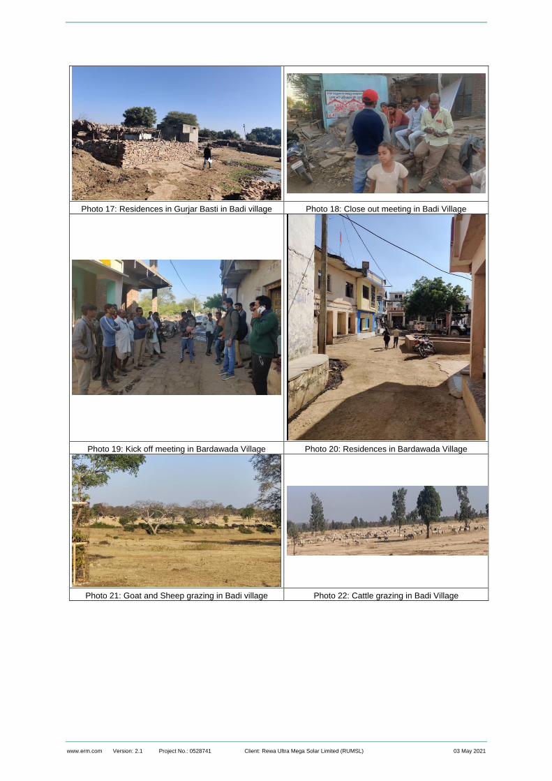
www.erm.com Version: 2.1 Project No.: 0528741 Client: Rewa Ultra Mega Solar Limited (RUMSL) 03 May 2021
Photo 17: Residences in Gurjar Basti in Badi village Photo 18: Close out meeting in Badi Village
Photo 19: Kick off meeting in Bardawada Village Photo 20: Residences in Bardawada Village
Photo 21: Goat and Sheep grazing in Badi village Photo 22: Cattle grazing in Badi Village

www.erm.com Version: 2.1 Project No.: 0528741 Client: Rewa Ultra Mega Solar Limited (RUMSL) 03 May 2021
Photo 23: Women in Badi village carrying fodder. Photo 24: Local deity temple within Project Footprint
in Badi Village
Photo 25: Well structure and fodder lot structure in Badi
Village

www.erm.com Version: 2.1 Project No.: 0528741 Client: Rewa Ultra Mega Solar Limited (RUMSL) 03 May 2021
APPENDIX B SUMMARY OF CONSULTATIONS

www.erm.com Version: 2.1 Project No.: 0528741 Client: Rewa Ultra Mega Solar Limited (RUMSL) 03 May 2021
Village Date Type of Consultations
Brief about discussions
Kawai 1.12.2020 Village Profiling General discussion with the elders of the village to understand the presence of different caste groups and their livelihood and land holding profile of the village. The consultations were used as guidance to inform the villagers about the resettlement surveys, their scope and objective.
1.12.2020 Consultations with Graziers
Based on the understanding developed through village profiling on livestock holding and grazing pattern, consultations were held with members of the village who undertake grazing activity to understand the grazing area, routes and times of grazing, and overall livestock management.
1.12.2020 Consultation with women’s groups
Based on the identification of Self-Help-Groups (SHGs) through village profiling exercise, consultations were undertaken with SHG members to understand the concerns, issues from a gender lens. The discussion was also used to understand the current state of functioning of SHGs in the village.
2.12.2020 Consultation with youth group
Consultation with youth group was undertaken to discuss specific issues on livelihood opportunities, current dependence on land – based livelihood of the youth, and availability of skill-based training infrastructure in the Tehsil.
Badi 3.12.2020 Village Profiling General discussion with the elders of the village to understand the presence of different caste groups and their livelihood and land holding profile of the village. The consultations were used as guidance to inform the villagers about the resettlement surveys, their scope and objective.
3.12.2020 Consultations with Graziers
Based on the understanding developed through village profiling on livestock holding and grazing pattern, consultations were held with members of the village who undertake grazing activity to understand the grazing area, routes and times of grazing, and overall livestock management.
5.12.2020 Consultation with women’s groups
Based on the identification of Self-Help-Groups (SHGs) through village profiling exercise, consultations were undertaken with SHG members to understand the concerns, issues from a gender lens. The discussion was also used to understand the current state of functioning of SHGs in the village.
Bardawada 6.12.2020 Village Profiling General discussion with the elders of the village to understand the presence of different caste groups and their livelihood and land holding profile of the village. The consultations were used as guidance to inform the villagers about the resettlement surveys, their scope and objective.
7.12.2020 Consultation with women’s groups
Based on the identification of Self-Help-Groups (SHGs) through village profiling exercise, consultations were undertaken with SHG members to understand the concerns, issues from a gender lens. The discussion was also used to understand the current state of functioning of SHGs in the village.

www.erm.com Version: 2.1 Project No.: 0528741 Client: Rewa Ultra Mega Solar Limited (RUMSL) 03 May 2021
APPENDIX C PROFILE OF INFORMAL USERS IN NEEMUCH SOLAR PARK

www.erm.com Version: 2.1 Project No.: 0528741 Client: Rewa Ultra Mega Solar Limited (RUMSL) 03 May 2021
The tables below provides the details on PAE and PAH wise informal users of government land who will be economically displaced due to the land procurement for the project footprint, or can be potentially displaced based on the field assessments undertaken as part of the resettlement surveys.
Village Khasra Number
PAE Number
PAH Number Caste Encroacher/ Squatter
Area Encroached/ Squatted (ha.)
Nature of Dependence (Agriculture/ Grazing/firewood etc.)
Dependence on land for primary livelihood (Yes/No)
Years of Land Use
Any other Land Available
Assessment of Vulnerability* (NA denotes not applicable)
Badi 479/1/Min-2 and 479/min3
352035 30315267006 OBC Encroacher 1.7 Agriculture No 40 Yes NA
Badi 479/1/Min-3 and
479/min3
352036 30315267007 OBC Encroacher 2.1 Agriculture No 40 Yes NA
Badi 479/1/Min-5 and
479/1
352034 30315267005 OBC Encroacher 1 Agriculture No 40 Yes NA
Badi 790/1/Min-9 and
790/1/min8
352015 Refused HH survey
OBC Encroacher 5 Agriculture No 18 Yes NA
Badi 790/1/Min-9 and
790/1/min8
352016 Refused HH
survey
OBC Encroacher 0.2 Agriculture No 20 Yes NA
Badi 790/1/Min-9 and
790/1/min8
352017 Refused HH
survey
OBC Encroacher 2 Agriculture No 20 Yes NA
Badi
790/1/min8
352049 Refused HH
survey
OBC Squatter 2 Agriculture No 20 No NA
Badi 478/Min-1 and
268
352010 30315265010 OBC Encroacher 2 Agriculture No 45 Yes NA
Badi 478/Min-1 and
268
352009 30315265009 OBC Encroacher 1 Grazing No 10 Yes NA
Badi 478/Min-1 and
268
352008 30315265011 OBC Encroacher 2 Agriculture No 10 Yes NA

www.erm.com Version: 2.1 Project No.: 0528741 Client: Rewa Ultra Mega Solar Limited (RUMSL) 03 May 2021
Village Khasra Number
PAE Number
PAH Number Caste Encroacher/ Squatter
Area Encroached/ Squatted (ha.)
Nature of Dependence (Agriculture/ Grazing/firewood etc.)
Dependence on land for primary livelihood (Yes/No)
Years of Land Use
Any other Land Available
Assessment of Vulnerability* (NA denotes not applicable)
Badi 478/Min-1 and
268
352023 30315265008 OBC Encroacher 1 Grazing No 4 Yes NA
Badi
790/1/min8
352018 Refused HH
survey
ST Squatter 1.5 Agriculture Yes 40 No NA
Badi
790/1/min8
352019 Refused HH
survey
ST Squatter 2 Grazing Yes 20 No NA
Badi
790/1/min8
352020 Refused HH
survey
ST Squatter 1 Agriculture Yes 50 No NA
Badi 790/1/min8 Absentee OBC Squatter 2.4 Agriculture Yes 20 No NA
Badi 379/1 Deceased OBC Squatter 3.2 Agriculture Yes 50 No NA
Badi 790/6/Min-1 and
790/1/min8
Absentee General Encroacher 2 Agriculture No 50 Yes NA
Badi 790/6/Min-2 and
790/1/min8
Deceased General Encroacher 3.8 Agriculture No 12 Yes NA
Badi 921/3 and 921/5
and 805/1/min1
352048 30315276090 OBC Encroacher 13.5 Agriculture No 45 Yes NA
Badi 1007/1/Min-2
and
1007/1/min1
352030 Absentee OBC Encroacher 7.4 Agriculture No 35 Yes NA
Badi 1007/1/Min-2
and
1007/1/min1
352031 Absentee OBC Encroacher 6.1 Agriculture No 45 Yes NA

www.erm.com Version: 2.1 Project No.: 0528741 Client: Rewa Ultra Mega Solar Limited (RUMSL) 03 May 2021
Village Khasra Number
PAE Number
PAH Number Caste Encroacher/ Squatter
Area Encroached/ Squatted (ha.)
Nature of Dependence (Agriculture/ Grazing/firewood etc.)
Dependence on land for primary livelihood (Yes/No)
Years of Land Use
Any other Land Available
Assessment of Vulnerability* (NA denotes not applicable)
Badi 1007/1/Min-2
and
1007/1/min1
352032 Absentee OBC Encroacher 3.1 Agriculture No 15 Yes NA
Badi
1007/1/min1
352029 Refused HH
survey
SC Squatter 13.5 Agriculture Yes 15 No NA
Badi
268
352024 Refused HH
survey
SC Squatter 2.4 Agriculture Yes 15 No NA
Badi
268
352025 Refused HH
survey
SC Squatter 2.4 Agriculture Yes 50 No NA
Badi
268
352026 Refused HH
survey
SC Squatter 1 Agriculture Yes 50 No NA
Badi
268
352027 Refused HH
survey
SC Squatter 0.7 Agriculture Yes 60 No NA
Badi
268
352028 Refused HH
survey
SC Squatter 1.4 Agriculture Yes 12 No NA
Badi 805/1/min1 352046 30315267017 SC Squatter 1.5 Agriculture Yes 12 No NA
Badi
805/1/min1
352063 30315267018 SC Squatter 2.9 Agriculture Yes 65 No NA
Badi 805/1/min1 352045 Not available OBC Squatter 2.5 Grazing Yes 30 No NA
Badi
479/min/3
352037 Refused HH
survey
SC Squatter 4.1 Grazing Yes 16 No NA
Badi 479/min/3 352038 30315265040 SC Squatter 3.2 Agriculture Yes 50 No NA
Badi
479/min/3
352039 Refused HH
survey
SC Squatter 0.6
Agriculture 50 NA
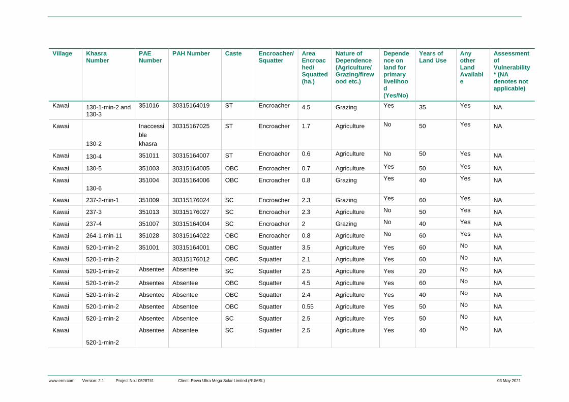
www.erm.com Version: 2.1 Project No.: 0528741 Client: Rewa Ultra Mega Solar Limited (RUMSL) 03 May 2021
Village Khasra Number
PAE Number
PAH Number Caste Encroacher/ Squatter
Area Encroached/ Squatted (ha.)
Nature of Dependence (Agriculture/ Grazing/firewood etc.)
Dependence on land for primary livelihood (Yes/No)
Years of Land Use
Any other Land Available
Assessment of Vulnerability* (NA denotes not applicable)
Kawai 130-1-min-2 and 130-3
351016 30315164019 ST Encroacher 4.5
Grazing Yes 35 Yes NA
Kawai
130-2
Inaccessi
ble
khasra
30315167025 ST Encroacher 1.7
Agriculture
No 50
Yes NA
Kawai 130-4 351011 30315164007 ST Encroacher 0.6 Agriculture No 50 Yes NA
Kawai 130-5 351003 30315164005 OBC Encroacher 0.7 Agriculture Yes 50 Yes NA
Kawai
130-6
351004 30315164006 OBC Encroacher 0.8 Grazing Yes 40 Yes NA
Kawai 237-2-min-1 351009 30315176024 SC Encroacher 2.3 Grazing Yes 60 Yes NA
Kawai 237-3 351013 30315176027 SC Encroacher 2.3 Agriculture No 50 Yes NA
Kawai 237-4 351007 30315164004 SC Encroacher 2 Grazing No 40 Yes NA
Kawai 264-1-min-11 351028 30315164022 OBC Encroacher 0.8 Agriculture No 60 Yes NA
Kawai 520-1-min-2 351001 30315164001 OBC Squatter 3.5 Agriculture Yes 60 No NA
Kawai 520-1-min-2 30315176012 OBC Squatter 2.1 Agriculture Yes 60 No NA
Kawai 520-1-min-2 Absentee Absentee SC Squatter 2.5 Agriculture Yes 20 No NA
Kawai 520-1-min-2 Absentee Absentee OBC Squatter 4.5 Agriculture Yes 60 No NA
Kawai 520-1-min-2 Absentee Absentee OBC Squatter 2.4 Agriculture Yes 40 No NA
Kawai 520-1-min-2 Absentee Absentee OBC Squatter 0.55 Agriculture Yes 50 No NA
Kawai 520-1-min-2 Absentee Absentee SC Squatter 2.5 Agriculture Yes 50 No NA
Kawai
520-1-min-2
Absentee Absentee SC Squatter 2.5 Agriculture Yes 40 No NA

www.erm.com Version: 2.1 Project No.: 0528741 Client: Rewa Ultra Mega Solar Limited (RUMSL) 03 May 2021
Village Khasra Number
PAE Number
PAH Number Caste Encroacher/ Squatter
Area Encroached/ Squatted (ha.)
Nature of Dependence (Agriculture/ Grazing/firewood etc.)
Dependence on land for primary livelihood (Yes/No)
Years of Land Use
Any other Land Available
Assessment of Vulnerability* (NA denotes not applicable)
Kawai 520-1-min-2 Absentee Absentee OBC Squatter 0.7 Agriculture Yes 40 No NA
Kawai 520-1-min-2 Absentee Absentee SC Squatter 3.8 Agriculture Yes 26 No NA
Kawai 130-1-min-1 351020 30315164020 OBC Squatter 0.36 Grazing Yes 26 No NA
Kawai 130-1-min-1 351021 30315164021 OBC Squatter 1 Grazing Yes 28 No NA
Kawai
130-1-min-1
351022 30315164008 OBC Squatter 7.2
Agriculture Yes 32 No NA
Kawai
130-1-min-1
Deceased
OBC Squatter 1.7
Grazing Yes 60 No NA
Kawai 237/1 351031 30315176028 OBC Squatter 2.1 Agriculture Yes 30 No NA
Kawai 237/1 351032 Absentee OBC Squatter 1 Agriculture Yes 30 No NA
Kawai 237-3 351032 30315167030 SC Squatter 5 Agriculture Yes 50 No NA
Kawai 237-3 351033 30315167032 SC Squatter 0.2 Grazing Yes 40 No Women HoH
Kawai 479/1/Min-2 and 479/min3
352035 30315267006 OBC Encroacher 2 Grazing No 40 Yes NA
Kawai 479/1/Min-3 and
479/min3
352036 30315267007 OBC Encroacher 2
Agriculture No 50 Yes NA
Kawai 479/1/Min-5 and
479/1
352034 30315267005 OBC Encroacher 2
Agriculture No 60 Yes NA
Kawai 790/1/Min-9 and
790/1/min8
352015 Refused HH OBC Encroacher 1
Agriculture No 60 Yes NA
Kawai 790/1/Min-9 and
790/1/min8
352016 Refused HH OBC Encroacher 2 Agriculture No 60 Yes NA

www.erm.com Version: 2.1 Project No.: 0528741 Client: Rewa Ultra Mega Solar Limited (RUMSL) 03 May 2021
Village Khasra Number
PAE Number
PAH Number Caste Encroacher/ Squatter
Area Encroached/ Squatted (ha.)
Nature of Dependence (Agriculture/ Grazing/firewood etc.)
Dependence on land for primary livelihood (Yes/No)
Years of Land Use
Any other Land Available
Assessment of Vulnerability* (NA denotes not applicable)
Kawai 790/1/Min-9 and
790/1/min8
352017 Refused HH OBC Encroacher 1
Agriculture No 70 Yes NA
Kawai 790/1/min8 352049 Refused HH OBC Squatter 1.5 Agriculture 80 No NA
Kawai 478/Min-1 and
268
352010 30315265010 OBC Encroacher 2 Agriculture No 60 Yes NA
Kawai 478/Min-1 and
268
352009 30315265009 OBC Encroacher 1
Agriculture No 60 Yes NA
Kawai 478/Min-1 and
268
352008 30315265011 OBC Encroacher 2.4 Agriculture No 60 Yes NA
Kawai 478/Min-1 and
268
352023 30315265008 OBC Encroacher 3.2 Grazing No 15 Yes NA
Kawai 790/1/min8 352018 Refused HH ST Squatter 2 Agriculture Yes 60 No NA
Kawai 790/1/min8 352019 Refused HH ST Squatter 3.8
Agriculture Yes 60 No NA
Kawai 790/1/min8 352020 Refused HH ST Squatter 13.5
Grazing Yes 60 No NA
Kawai 790/1/min8 Absentee OBC Squatter 7.4 Agriculture Yes 60 No NA
Kawai 379/1 Deceased OBC Squatter 6.1 Agriculture Yes 28 No NA
Kawai 790/6/Min-1 and
790/1/min8
Absentee General Encroacher 3.1 Agriculture Yes 25 Yes NA
Kawai 790/6/Min-2 and
790/1/min8
Deceased General Encroacher 13.5 Grazing No 35 Yes NA

www.erm.com Version: 2.1 Project No.: 0528741 Client: Rewa Ultra Mega Solar Limited (RUMSL) 03 May 2021
Village Khasra Number
PAE Number
PAH Number Caste Encroacher/ Squatter
Area Encroached/ Squatted (ha.)
Nature of Dependence (Agriculture/ Grazing/firewood etc.)
Dependence on land for primary livelihood (Yes/No)
Years of Land Use
Any other Land Available
Assessment of Vulnerability* (NA denotes not applicable)
Kawai 921/3 and 921/5
and 805/1/min1
352048 30315276090 OBC Encroacher 2.4
Grazing No 30 Yes NA
Kawai 1007/1/Min-2
and
1007/1/min1
352030 Not available OBC Encroacher 2.4
Grazing No 30 Yes NA
Kawai 1007/1/Min-2
and
1007/1/min1
352031 Absentee OBC Encroacher 1
Grazing No 30 Yes NA
Kawai 1007/1/Min-2
and
1007/1/min1
352032 Absentee OBC Encroacher 0.7
Grazing No 30 Yes NA
Kawai 1007/1/min1 352029 Absentee SC Squatter 1.4
Grazing Yes 30 No NA
Kawai 268 352024 Refused HH SC Squatter 1.5 Agriculture Yes 70 No NA
Kawai 268 352025 Refused HH SC Squatter 2.9 Agriculture Yes 50 No NA
Kawai 268 352026 Refused HH SC Squatter 2.5 Agriculture Yes 60 No NA
Kawai 268 352027 Refused HH SC Squatter 4.1 Grazing Yes 60 No NA
Kawai 268 352028 Refused HH SC Squatter 3.2 Agriculture Yes 40 No NA
Kawai 805/1/min1 352046 30315267017 SC Squatter 0.6 Agriculture Yes 40 No NA
Kawai 805/1/min1 352063 30315267018 SC Squatter 4.5 Agriculture Yes 40 No NA
Kawai 805/1/min1 352045 Not available OBC Squatter 1.7 Agriculture Yes 18 No NA

www.erm.com Version: 2.1 Project No.: 0528741 Client: Rewa Ultra Mega Solar Limited (RUMSL) 03 May 2021
Village Khasra Number
PAE Number
PAH Number Caste Encroacher/ Squatter
Area Encroached/ Squatted (ha.)
Nature of Dependence (Agriculture/ Grazing/firewood etc.)
Dependence on land for primary livelihood (Yes/No)
Years of Land Use
Any other Land Available
Assessment of Vulnerability* (NA denotes not applicable)
Kawai 479/min/3 352037 Refused HH SC Squatter 0.6 Agriculture Yes 20 No NA
Kawai 479/min/3 352038 30315265040 SC Squatter 0.7 Agriculture Yes 20 No NA
Kawai 479/min/3 352039 Refused HH SC Squatter 0.8 Agriculture Yes 20 No NA
Kawai 479/1/Min-2 and 479/min3
352035 30315267006 OBC Encroacher 2.3 Agriculture No 45 Yes NA

www.erm.com Version: 2.1 Project No.: 0528741 Client: Rewa Ultra Mega Solar Limited (RUMSL) 03 May 2021
APPENDIX D PROFILE OF RESIDENTIAL STRUCTURES WITHIN NEEMUCH SOLAR PARK

ww.erm.com Version: 2.1 Project No.: 0528741 Client: Rewa Ultra Mega Solar Limited (RUMSL) 03 May 2021
The table below provides the details on PAE wise use of the residential structures that will be directly impacted due to the land procurement for the project
footprint, or can be potentially displaced (induced due to proximity to the project boundary) based on the field assessments undertaken as part of the
resettlement surveys.
S.
No
Unit Village Khasra
No.
Direct/
Induced
Displacement
Ownership
Status of
Land
PAH ID PAE ID Area of
Structure
(sq.m)
Description
of Structure
Status of Use (temporary/
permanent)
Vulnerability
Status of
PAH
Approx
Value of
Structure
1 Unit 1 Barawada 35/2/1 Direct Squatter on
government
land
30315364012 352049 80 Constructed
in 1990; RBC
structure with
RCC roofing
(RBC)
Permanent None 3,86,000
2 Unit 1 Barawada 35/2/1 Direct Squatter on
government
land
30315364015 353056 52.5 Constructed
in 2017; RBC
structure on
cemented
flooring and
RCC roofing
(RBC)
Permanent None 2,36,250
3 Unit 3 Badi 493/2 Direct Private
Land
Owner
30315264012 352060 120 Constructed
in 2010;
Mud
structure with
CGI sheet
roofing
(Kutcha)
Permanent None 18,00,000

ww.erm.com Version: 2.1 Project No.: 0528741 Client: Rewa Ultra Mega Solar Limited (RUMSL) 03 May 2021
S.
No
Unit Village Khasra
No.
Direct/
Induced
Displacement
Ownership
Status of
Land
PAH ID PAE ID Area of
Structure
(sq.m)
Description
of Structure
Status of Use (temporary/
permanent)
Vulnerability
Status of
PAH
Approx
Value of
Structure
4 Unit 3 Badi 430 Direct Squatter on
government
land for
residence
and
agriculture
Refused LA
and HH
survey
NA 20 structures
admeasuring
~400 sq. m
RBC
structure
Permanent Not Available

ww.erm.com Version: 2.1 Project No.: 0528741 Client: Rewa Ultra Mega Solar Limited (RUMSL) 03 May 2021
APPENDIX E HOUSEHOLD LEVEL ENTITLEMENTS

The business of sustainability
ERM has over 160 offices across the following
countries and territories worldwide
Argentina
Australia
Belgium
Brazil
Canada
Chile
China
Colombia
France
Germany
Ghana
Guyana
Hong Kong
India
Indonesia
Ireland
Italy
Japan
Kazakhstan
Kenya
Malaysia
Mexico
Mozambique
Myanmar
The Netherlands
New Zealand
Norway
Panama
Peru
Poland
Portugal
Puerto Rico
Romania
Russia
Senegal
Singapore
South Africa
South Korea
Spain
Sweden
Switzerland
Taiwan
Tanzania
Thailand
UAE
UK
US
Vietnam
ERM India Private Limited
3rd Floor, Building 10 B
DLF Cyber city,
Gurgaon - 122 002
Tel:-0124-4170300
www.erm.com