ranganadi hydro electric project and the dikrong...
TRANSCRIPT
�
61��
���
CHAPTER – III
RANGANADI HYDRO ELECTRIC PROJECT AND
THE DIKRONG VALLEY
Hydroelectric projects have been symbols of modern state’s economic
progress. They are guarantees to people of an assured supply of
power and water besides controlling devastating floods. The budget
allocations till the sixth five year plan reveal that 15206 crores have
been utilized for large irrigation projects and hydroelectric schemes
constitute 15 percent of the national expenditure74
. For the project
building purposes, lands could be forcibly cleared of population in the
larger interest of the nation. Rehabilitation and resettlement of people
affected by projects were not the primary task or concern. Much has
been written, discussed and criticized over the years about dam
building and its failures, unfulfilled promises of relief and
compensation and the role of state. However, if we are to judge the
impacts of projects we will have to be provided with comprehensive
data of the social and environmental impacts of the projects which is,
in most cases, not done in India.75
Broadly speaking, we can gauge
the impacts from the manner in which dams have been functioning
during and after construction. Part of dam building requires creating
reservoirs, submerging lands, displacing people, altering and
�������������������������������������������������������������74
Enakshi Ganguly Thukral ed. Big Dams, Displaced People: Rivers of Sorrow,
Rivers of Change.(Sage: New Delhi) 75
Shekhar Singh and Pranab Banerji Large Dams in India; Environmental,
Social and Economic Impacts. Indian Institute of Public Administration, New
Delhi
�
62��
���
diverting the flow of the rivers, diverting the waters through canals
and tunnels, redistribute water to agricultural fields etc.76
In this
chapter we will try to identify the environmental and social impacts
of the Ranganadi hydro electric project (RHEP henceforth) on the
Dikrong valley. We will proceed by looking into the impacts, which
were anticipated and taken into consideration while assessing the
feasibility of the project. Every project goes through a project
assessment to assess the viability, cost benefit calculations, and the
overall feasibility of the project. We will try to find out which of the
impacts were anticipated and which all were not and link the effects
with the corrective measures taken on the part of the project
sponsoring agencies and the state.
As part of the fieldwork, the researcher collects primary data from the
field. Informations have been gathered mainly through schedules
administered among 22 villages from the Dikrong valley. In addition
to that, the researcher collects statistics of damage assessment due to
flood and erosion for two separate periods. These periods are divided
as pre- Ranganadi Hydel Power Project from 1991-2001 and post-
Ranganadi Hydel Power Project from 2002-2010. The researcher’s
effort to gather relevant information and statistics from the
respondents has been presented in tabular form- Table No-I and
Table No II . The table represents the collected data about the
affected families, population, loss of land in hectares and loss of
property dwelling and houses.
�������������������������������������������������������������76
Ibid.

�
63��
���
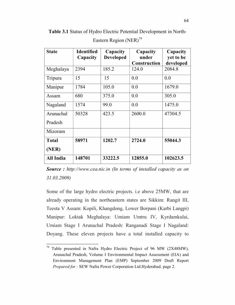
Hydro Electric Potential of North East India
The entire region of Northeast India consists of the eight states of
Assam, Arunachal Pradesh, Manipur, Meghalaya, Mizoram,
Nagaland, Tripura and Sikkim. This region has been identified as the
future Powerhouse of India. The total hydro electric potential of the
region has been estimated at 58,971 MW, of which only a small
portion of about 2.04% is said to be harnessed so far77
. According to
the Central Electricity Authority data 200178
, the total hydropower
potential of the Northeast is 63, 257 MW1. This amounts to 43% of
the total assessed hydropower potential of the country. The state wise
estimation of hydroelectric potential are Assam: 680 MW, Arunachal
Pradesh: 50,328 MW, Manipur: 1784 MW, Meghalaya: 2394 MW,
Mizoram: 2196 MW, Nagaland: 1574 MW, Sikkim: 4286 MW,
Tripura: 15 MW. Table 1 shows the hydro power potential of
northeast and the extent to which it has been utilized.
�������������������������������������������������������������77
Nafra Hydro Electric Project of 96 MW (2X48MW), Arunachal Pradesh,
Volume I Environmental Impact Assessment (EIA) and Environment
Management Plan (EMP)
September 2009 Draft Report Prepared for : SEW Nafra Power Corporation
Ltd. Hyderabad 78
Central Electricity Authority data from report of Inter-Ministerial Group on
NE Hydro, February 2010. Slight variation with CEA 2001 data.
�
64��
���
Table 3.1 Status of Hydro Electric Potential Development in North-
Eastern Region (NER)79
State Identified
Capacity
Capacity
Developed
Capacity
under
Construction
Capacity
yet to be
developed
Meghalaya 2394 185.2 124.0 2084.8
Tripura 15 15 0.0 0.0
Manipur 1784 105.0 0.0 1679.0
Assam 680 375.0 0.0 305.0
Nagaland 1574 99.0 0.0 1475.0
Arunachal
Pradesh
50328 423.5 2600.0 47304.5
Mizoram
Total
(NER)
58971 1202.7 2724.0 55044.3
All India 148701 33222.5 12855.0 102623.5
Source : http://www.cea.nic.in (In terms of installed capacity as on
31.03.2009)
Some of the large hydro electric projects. i.e above 25MW, that are
already operating in the northeastern states are Sikkim: Rangit III,
Teesta V Assam: Kopili, Khangdong, Lower Borpani (Karbi Langpi)
Manipur: Loktak Meghalaya: Umiam Umtru IV, Kyrdamkulai,
Umiam Stage I Arunachal Pradesh: Ranganadi Stage I Nagaland:
Doyang. These eleven projects have a total installed capacity to
�������������������������������������������������������������79
Table presented in Nafra Hydro Electric Project of 96 MW (2X48MW),
Arunachal Pradesh, Volume I Environmental Impact Assessment (EIA) and
Environment Management Plan (EMP) September 2009 Draft Report
Prepared for : SEW Nafra Power Corporation Ltd.Hyderabad. page 2.
�
65��
���
produce 1686MW of electricity80
. Among the projects that are under
construction include the ten projects with total capacity of 4891MW.
These are Sikkim: Chujachen, Teesta III, Teesta VI, Rangit IV,
Jorethang Loop Arunachal Pradesh: Kameng, Lower Subansiri, Pare
Meghalaya: Myndtu, New Umtru81
.
Of all the Northeastern states, Arunachal Pradesh has been identified
as the biggest hydropower player in region and therefore it has been
allotted 132 hydropower projects with total installed capacity of 40,
140.5 MW. By 2010 October ,the State government has already
allotted private and public sector players to undertake the
implementation of the Project. According to available data, among
the projects were 92 large hydropower projects (above 25 MW) and
38 above 100 MW. 50 projects were granted Scoping or pre-
construction environmental clearances from the Ministry of
Environment on October 2010. By the end of 2010, a total of 7 hydro
electric projects in Arunachal Pradesh were granted final
environmental clearances by the ministry82
.
It is important to note that the ‘biggest hydropower player’ of the
northeastern region is located in an extra ordinarily difficult
geological set-up. The entire Himalayan mountain system bends
acutely around a mountain knot83
. The movement of these knots are
manifested in earthquakes that rock the land and the rivers
�������������������������������������������������������������80
Cited in Vagholikar, N. and Das, P.J., 2010. Damming Northeast India.
Kalpavriksh, Aaranyak and Action Aid India. Pune/Guwahati/ New Delhi81
Ibid. 82
Ibid. 83
K.S. Valdiya A Geodynamic Perspective of Arunachal Pradesh and its
Bearing on Environmental Security and Developmental Planning, excerpts
from his keynote address at a workshop in Dec 1999 organised by the
Arunachal Unit of G.B. Pant Institute of Himalayan Environment and
Development.
�
66��
���
devastatingly. “The high seismicity of the area is attributed to the
northeastward –moving Indian landmass which pushes and presses
the Himalayas. Since India continues to move at the rate of 54-62mm
per year, the Himalayan ranges are bound to experience the force of
squeezing against the Asian continent. Consequently, the land of
Assam is siding northward under the Arunachal Himalaya and
eastward beneath Indo-Myanmarese ranges. Therefore, very severe
deformation and attendant rupturing of the crust or faulting and land
displacement is taking place in the geological province of Arunachal
Pradesh.”84
. Given such fragility of the region, it is to be noted that
the environmental clearances were issued to project authorities to
proceed with hydroelectric project building in the region. In a region
which is prone to earthquake, dam building may induce further
seismic disturbances. It has been observed that huge mass of water
behind a dam may induce seismic activities in the neighbourhood
area. Seismologist and geologist have confirmed that dam building in
seismic belt is particularly dangerous. In case of a dam burst followed
by earthquake of severe intensity has the potential to bring in
irreversible damage and disaster85
. It has been well proved through
scientific investigation that northeast in general and Arunachal
Pradesh in particular is located in the seismic belt of the earth.86
�������������������������������������������������������������84
Ibid. 85
B.D. Dhawan “Mounting Antagonism Towards Big Dams” in B.D Dhawan
(ed) (1990)
Big Dams: Claims and Counter Claims, Commonwealth Publishers: New
Delhi86
According to Independent People’s Tribunal on Dams in Arunachal Pradesh
Interim Report February 3, 2008, Arunachal Pradesh falls in Seismic Zone-5
which meant that the dams were likely to be subjected to earthquakes of high
intensity. This has immense implications for the safety of the populations in
the neighbouring and downstream areas. In particular, the fear of the colossal
�
67��
���
Taking the ecological vulnerability into account, the environmental
clearances for hydropower projects in the area only points to the
strong nexus between the project builders and the environment
assessment consultancies. In fact, in an interview with Ashish Kothari
who served on the Ministry of Environment and Forest’s Expert
committee for river valley projects in 1994-1995, it was revealed that
“90% of the dams that have commenced construction between 1978
and 1995 had not complied with the environmental conditions!
Hundreds of crores of rupees were being spent on projects that are, by
the law of the land illegal! Equally shocking was the fact that the
MoEF had not stopped a single one of the projects, or penalized any
official concerned.”87
In order to tap hydropower from the rivers
flowing from the Himalayas, the northeastern region of India was
identified as the “future power house of India.”88
The Central
Electricity Authority (CEA) in its Preliminary Ranking Study of the
nationwide potential of hydroelectric schemes identified the
Brahmaputra river system with the highest potential to generate
���������������������������������������������������������������������������������������������������������������������������������������������������������������������loss of life and property and the destruction that would cost, in case of a dam
break haunts the people. 87
Excerpts from the interview of Ashish Kothari founder member of
Kalpavriksh, “We Should have Gone to Court” published in Ecologist Asia
Vol.11 No.1, January-march 2003. p.38
88 Darlong V.T.1998.Environmental Impact Assessment in Northeast India: A
Case Study of River Valley Projects, Perspectives For Palnning and
Development in Northeast India, G.B Pant Institute of Himalayan
Environment and Development, Himavikas Ocassional Publication,
Sundariyal. R.C. Shnkar Uma Upreti T.C (eds) No.11(1998)
�
68��
���
electricity89
. However, “in view of the inadequate knowledge base,
lack of systemic data over an adequate time span and across diverse
terrains and considering the intense dynamism and immense scale of
geophysical processes of the Himalayas raises more questions than
can be possibly answered.”90
It is also important to take note of the
supra state character and nature of functioning of the public sector
undertaking that implement the project. In case of Arunachal Pradesh,
the following observation of NEEPCO shows how project
implementing authorities violate basic criteria of environment impact
assessment.
The NEEPCO was recently forced by the people to order a survey of
the 110 MW Dikrong HEP in Arunachal Pradesh. The first ‘public
hearing’ on Pare (Dikrong) HEP was held on March 5, 05. The EIA
report of Dikrong HEP and its executive summary was not available
in local language by NEEPCO till the day of public hearing. Now the
public hearing would be held later. It was decided that a committee
�������������������������������������������������������������89
The central electricity authority (CEA) has identified 162 sites, spread across
16 states of India, for hydroelectric projects with an aggregate installed
capacity of 50,560 MW. According to preliminary feasibility reports prepared
till July 5, 2004, 154 of the 162 sites have a potential to generate 47,190 MW
of electricity. The CEA has offered the sites to central public sector units for
preparation of detailed feasibility reports. The preliminary reports revealed
that of the 16 states, 42 projects in Arunachal Pradesh have a combined
capacity of 21,660 MW. Of the 162 sites identified by CEA all over India, the
largest capacity of 4,000 MW is proposed at Etalin in Arunachal Pradesh with
16 units of 250 MW each. The second largest project will also be located in
Arunachal Pradesh at Demwe(Dibang multipurpose hydro project) with a
capacity to generate 3,000 MW of electricity- cited in Independent People’s
Tribunal on Dams in Arunachal Pradesh Interim Report February 3, 2008, 90
Dulal C. Goswami and Partha J. Das,” The Brahmaputra River, India”,
Ecologist Asia Vol.11 No.1, January-march 2003.p.13
�
69��
���
would be formed to create awareness about the project. The role of
Arunachal Pradesh PCB came in for severe criticism. Most of the
people were ignorant about the very nature and purpose of an EIA
and what a public Hearing is all about? The Composition of the Panel
members was not in compliance with the EIA notification, 1994.
Arunachal Citizen’s Right interjected and requested the Chairman of
the Panel to ensure that the panel members maintain their neutrality.
Rather than each panel members instead of noting down the issues,
were allotted time to speak about the Dikrong HEP. The House
finally came to know about their rights and the actual nature of a PH
on EIA as submitted by NEEPCO before the PCB. As a result, the
Chairman, Public Hearing Committee gave time to few legislatures,
Panchayat leaders, Gaon Buras and Public. Finally, the panel
members unanimously ended the PH with the decision that an
Awareness Committee on EIA shall be constituted to educate the
people about the project and the Public Hearing shall be held within
two months. Many people complained that even the 29 families likely
to be affected by the project were unaware of the EIA. The NEEPCO
tried to wash its hands off the responsibility of rehabilitation.
It has been observed by scholars that “the absence of post-
construction reviews severely hamper assessments of multi-purpose
river valley projects' (MRVPs) actual performance vis-a-vis its
claims. Long-term effects like ecological disequilibrium remain
unaccounted for due to an absence of comprehensive pre-project
environmental impact assessment.”91
In the work on the analyses of
�������������������������������������������������������������91
Rohan D'Souza, Pranab Mukhopadhyay, Ashish Kothari “Re-Evaluating
Multi-Purpose River Valley Projects: A Case Study of Hirakud, Ukai and
IGNP”, Economic and Political Weekly, Vol. 33, No. 6 (Feb. 7-13, 1998),
pp. 297-302.p 297
�
70��
���
three projects, namely, Hirakud, Ukai and Indira Gandhi Nahar
Project (IGNP), it was clearly demonstrated that “there was the
glaring and complete dichotomy between pre-construction projections
and post-construction realities. Water-logging, salinity, sedimentation
and health hazards have a high possibility of occurrence. Even flood
control, irrigation and power generation are not effective as
envisaged. These experiences, the article argues, need to be studied
in-depth and made to constitute an important part of future planning
for MRVPs.”92
Patrick Mc Cully says that the long term effects of
dams are “huge and largely irreversible”93
which may be manifested
after hundreds of years of construction of dams. Listing specially the
impacts on rivers and its associated aquatic species, he mentions that
human intervention in the natural flow of the rivers tend to “fragment
the riverine ecosystem, isolating population of species living up and
downstream of the dam and cutting off migrations and other species
movements.”94
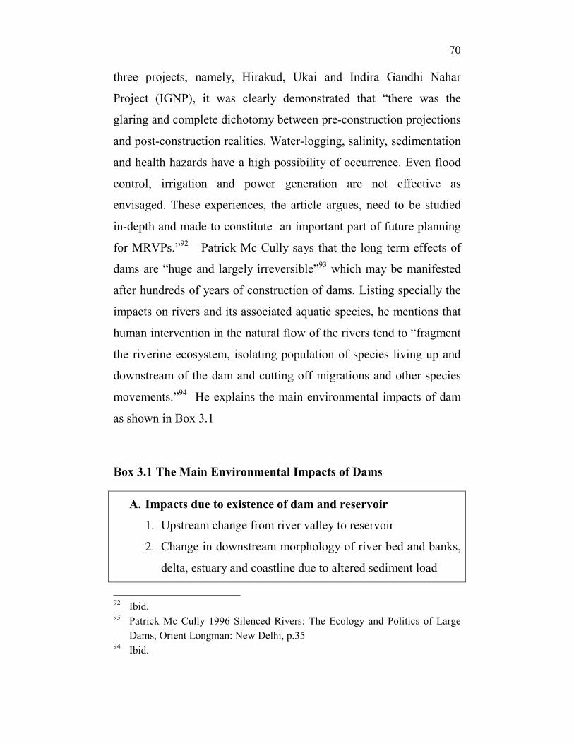
He explains the main environmental impacts of dam
as shown in Box 3.1
Box 3.1 The Main Environmental Impacts of Dams
A. Impacts due to existence of dam and reservoir
1. Upstream change from river valley to reservoir
2. Change in downstream morphology of river bed and banks,
delta, estuary and coastline due to altered sediment load
�������������������������������������������������������������92
Ibid. 93
Patrick Mc Cully 1996 Silenced Rivers: The Ecology and Politics of Large
Dams, Orient Longman: New Delhi, p.35 94
Ibid.
�
71��
���
3. Change in downstream water quality: temperature,
nutrients, turbidity, dissolved gases, heavy metals and
minerals
4. Reduction of biodiversity due to blocking of the movement
of organisms and because change 1.2 and 3above
Superimposed upon the above impacts may be:
B. Impacts due to Pattern of Dam Operation
1. Change in downstream Hydrology: (a) change in total
flows; (b) change in seasonal timing of flows; (c) change in
extreme high and low flows
2. Changes in downstream morphology caused by altered flow
pattern
3. Change in downstream water quality caused by altered flow
pattern
4. Reduction in riverine/ floodplain habitat diversity,
especially because of elimination of floods.
Source: Patrick Mc Cully 1996 Silenced Rivers: The Ecology and
Politics of Large Dams. P.34
The River Ranganadi
Let us begin by understanding briefly the river Ranganadi. The
Ranganadi river is one of the major tributary of river Brahmaputra
and lies in the northeastern part of Assam. It originates at an elevation
of 3,440.00m near the border of Lower Subansiri and East Kameng
districts. The total 2941 sq km catchment area of the Ranganadi river
is divided between Arunachal Pradesh and Assam of which 700 sq
km lies in the Lakhimpur district of Assam and the remaining 2241 sq
�
72��
���
km lies in Arunachal Pradesh. This river is important for our study
because of the Hydel power project that is built over the Ranganadi
river which envisaged inter basin transfer of water from Ranganadi
river to Dikrong river. In order to find out the impact of this power
project on the river Dikrong and its valley we have to look into the
issues, prospects, and problems of the Ranganadi hydel power
project.
The Ranganadi Hydro Electric Project (RHEP)
The Ranganadi Hydro Electric Project (RHEP) is a run-off-river
scheme with a Full Reservoir Level (FRL) of EL 567.00m. This
project was part of the North Eastern Council (NEC) scheme and was
under implementation by the North Eastern Electric Power
Corporation (NEEPCO. At stage 1 of the scheme, the 405 MW (68m
high dam) of the RHEP was commissioned in 2002 henceforth) in
Lower Subansiri district. The NEEPCO mentions that the design of
the project is such that it will store water to its full capacity in
reservoir. i.e. up-to the level of 567.00m. Hence, if flooding occurs
and water rises beyond this capacity, the reservoir will not be able to
retain it. The reservoir pondage being small and fully utilized for
water storage and having no extra capacity to retain water, the
reservoir was bound to overflow. Technically speaking, the working
of the project mentions that for the generation of hydropower from
the Project, a maximum of 160 cumecs of water from the reservoir
will be utilized for operating the 3 units at full load, which will be
finally diverted to the Dikrong river from the power house at Hoz95
through a tailrace channel. The excess water which the reservoir
�������������������������������������������������������������95
HOZ is a place 40’5 kms U/S of Bridge over Dikrong on NH-52 at Harmutty
and 58’5kms U/S of Sissapathar Bridge
�
73��
���
cannot hold beyond 567.00m (FRL) was to be released to the
downstream of Ranganadi river over the diversion dam at Yazali96
through spillway gates in a controlled manner.
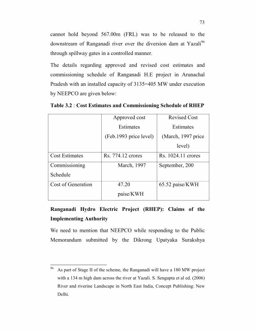
The details regarding approved and revised cost estimates and
commissioning schedule of Ranganadi H.E project in Arunachal
Pradesh with an installed capacity of 3135=405 MW under execution
by NEEPCO are given below:
Table 3.2 : Cost Estimates and Commissioning Schedule of RHEP
Approved cost
Estimates
(Feb.1993 price level)
Revised Cost
Estimates
(March, 1997 price
level)
Cost Estimates Rs. 774.12 crores Rs. 1024.11 crores
Commissioning
Schedule
March, 1997 September, 200
Cost of Generation 47.20
paise/KWH
65.52 paise/KWH
Ranganadi Hydro Electric Project (RHEP): Claims of the
Implementing Authority
We need to mention that NEEPCO while responding to the Public
Memorandum submitted by the Dikrong Upatyaka Surakshya
�������������������������������������������������������������96
As part of Stage II of the scheme, the Ranganadi will have a 180 MW project
with a 134 m high dam across the river at Yazali. S. Sengupta et al ed. (2006)
River and riverine Landscape in North East India, Concept Publishing: New
Delhi.
�
74��
���
Samiti97
in the year 2008 claimed that it had discussed a set of
concerns with the Ministry of Welfare for Plains Tribes and
Backward classes, the Government of Assam, Flood Control
Department of Assam, Irrigation Department of Assam, Power
Department of Assam prior to the implementation of the RHEP. The
chronology of the meetings and discussions were provided year wise
starting from 1988 onwards where it claimed to have received and
responded to queries of Assam Flood control department on the
implementation of RHEP and additional discharge of 160 cumec of
water from RHEP to Dikrong river. According to the letter of
NEEPCO, all the concerned departments of Assam and the Minister
of Welfare of Plain tribes and Backward classes have convened joint
meetings to assess the impact that would be caused by the diversion
of water from RHEP to Dikrong river and the measures that will be
required to compensate the negative impacts98
. The following were
the impact assessments and the plan of actions of the concerned
departments and NEEPCO99
.
1) NEEPCO was to spend an amount of Rs.835.85 lakhs for
raising and strengthening of embankment of Dikrong both bank
embankments including anti-erosion works in different reach as
required by the Chief engineer, Flood control Deptt. Govt of
Assam.
�������������������������������������������������������������97
Letter of the North Eastern Electric Power Corporation LTD( A Govt. of
India Enterprise) No: NEEPCO/PER/2/C-10093 dated 1st of August 2008 to
Golak Hazarika, The President, Dikrong Uptakya Surakshya Samiti,
Bihpuria, Dist Lakhimpur-784161 Assam
98 Ibid.
99 Ibid.
�
75��
���
2) It was stated that a survey carried out by NEEPCO and Flood
Department of Assam in Bihpuria, laluk, Narayanpur,
Nowboicha revealed that there was already a problem of
overtopping of embankment due to floods even prior to the
implementation of the RHEP.
Existing flood control measures were inadequate to control
normal flood waters of the Dikrong river.
3) The NEEPCO prepared a report according to which it agreed
to spend 88.61 lakhs for protection works of raising and
strengthening of the existing embankment system.
4) The Central Water Power Research Station (CWPRS), Pune
was assigned the work of examining the actual flood impact as
per prevailing conditions and due to additional 160 cumec of
water from RHEP. NEEPCO entrusted this work to CWPRS,
Pune which was supposed to carry a mathematical model study
of the Dikrong river basin downstream of Hoz power house
upto the confluence of Dikrong and Ranganadi river.
5) The CWPRS submitted the impact assessment report with the
findings that due to additional discharge of 160 cumec in
monsoon months, the water level in different stretches of the
course of the river Dikrong in Assam portion from Banderdewa
to Sissapathar would raise from 7cm to 12cm.
6) The CWPRS report also mentioned that since the flood
discharge of Dikrong river would be 20 to 30 times of the
discharge of the Ranganadi Power House, the impact of the
additional water would be negligible.
7) The CWPRS report brushed aside any fears that were related to
the release of the additional water from RHEP. It concluded
�
76��
���
that based on “outcomes of the studies undertaken by CWPRS,
Pune, the fears expressed are not real.”
The minister of power while answering questions regarding the outlay
of Ranganadi Hydel Project in Arunachal Pradesh asserted the
following – “The Ranganadi Hydel Power Project in its report had
mentioned it clearly that an inter basin water transfer would take
place from river Ranganadi to river Dikrong. This transfer was
required because of the discharge of 160 cumecs of tail race water
from the power house when operated at full capacity. The Central
Water and Power Research Station, Pune at the instance of NEEPCO
had revealed that rise in water level will be between 7-12 cm when
power house operates at full capacity. The effect of the rise of water
will be very marginal in comparison to the observed peak flood of
2500 cumecs of the river Dikrong. The incremental discharge of 160
cumecs is therefore not likely to cause any damage in the lower reach
of Dikrong river and will not pose any danger to the population in the
area .The North Eastern Electric Power Corporation has carried out a
joint survey with Flood Control Department and Irrigation
Department of Government of Assam to access the flood control
protection work of Dikrong river from the down stream of
Banderdewa bridge to the confluence of river Dikrong and Subansiri.
Based on the actual survey, the flood protection work as existing
without transfer of 160 cumecs of water from Ranganadi basin to
Dikrong basin is not sufficient to retain the observed 2500 cumecs
discharge of Dikrong river during the peak flood season. NEEPCO
has since conveyed to Government of Assam that any protection
measures, if required due to additional discharge of 160 cumecs of
water from the power house will be fully funded by them against the
�
77��
���
project cost.” On queries related to environmental clearances the
minister replied – “The environmental and forest clearances were
accorded to the project by the Ministry of Environment and Forests.
No Memorandum of Understanding (MOU) was signed by the
NEEPCO with Government of Assam. All the states in the North
Eastern region including Government of Assam will be allocated
power from the project in accordance with approved sharing formula
applicable to central Hydel Power Stations. Besides, Assam is
benefitted in terms of improvement of Pochumara-Kimin road
upgraded to the level of National Highway including construction of
bridges at the project cost. There was no financial liability on Assam
for the construction of the Project.”
Appeal and Agitation: State and People’s Initiative
Keeping in view the existing flood problem of the river Dikrong, a
number of memorandums have been submitted even prior to
commissioning of the RHEP to consider the ecological vulnerability
of the Dikrong valley. The feasibility of hydro electric project in a
ecologically fragile valley was countered both by the people and the
state government of Assam.The then Chief Minister of Assam, Shri
Hiteshwar Saikia in his letter to the Prime minister of India in the
year 1993100
brought to notice the falsity of the claims of the
NEEPCO of having consulted the State Government of Assam prior
to the execution of the RHEP and the additional discharge of water.
In fact, the Chief Minister wrote that it was only after an enquiry that
the State Government of Assam could know from the chief engineer
�������������������������������������������������������������100
Chief Minister of Assam Hiteshwar Saikia letter to Prime Minister of India.
No. D.O.NO. CRD. 2/93/23 dated April 28th
1993
�
78��
���
(C) P &D NEEPCO that 160 cumec of water from RHEP will be
discharged into the Dikrong river. The letter also mentioned the
attitude of NEEPCO in ensuring the safety of the bridges over the
river and surrounding valley which was limited to the
recommendations made on the basis of the mathematical model study
done by CWPRS, Pune. Moreover, NEEPCO committed itself to take
responsibility of any negative impacts of RHEP which was subject to
the report of CWPRS. Besides, the letter also clearly pointed out the
adverse effects of the additional water on flood situation of the
Dikrong valley. It was pointed out that the Dikrong river was flood
prone and an additional discharge of water would aggravate the
existing flood situation of the Dikrong valley. The inundation that
will occur with the extra force of water would bring in a major
setback to agriculture and overall economy of the state. Two bridges
were mentioned in the letter to be in extremely vulnerable position.
The Chief Minister expressed concern as he wrote that the stability of
the bridges over river dikrong on NH-52 at Harmutty and another
Bridge on the state P.W.D at Sissapathar were threatened given the
existing vulnerable position of the Dikrong river. Is interesting and
important to note that the letter explicitly points out that any decision
related to addition or alteration on structures on a national highway
and on bridges on it comes under the authority of the ministry of
surface transport. It seems NEEPCO bypassed the concerned ministry
while taking decisions regarding bridges on the national highway.
In another letter by a former education minister of Assam, Shri
Premadhar Bora in the year 1994101
to the then Prime Minister Late
�������������������������������������������������������������101
Letter from Shri Premadhar Bora, Former Education Minister, Assam. Dated
21st Jan 1994
�
79��
���
Narsimha Rao, brought to notice that the RHEP was responsible for
creating problems for the populations of the district of Lakhimpur by
discharging water from Ranganadi river through canal to Dikrong
river. The additional waters from Ranganadi, has aggravated the
existing flood problem in Dikrong. This diversion of the waters was
bound to affect the Ranganadi river too as it would decrease the
inflow of water in the river during the dry season. The minister
mentioned that around 5 lakh people inhabiting both the river basin
i.e Dikrong river basin and Ranganadi river basin will be affected by
the diversion of water in Dikrong and resultant decrease of water in
Ranganadi. As far as the Dikrong valley is concerned, it mentioned,
the diversion effect would additionally burden the already flood
affected Dikrong with waters coming from the Ranganadi. As a
result, the extra water from Ranganadi would increase the flood level
of Dikrong and would inundate Dikrong valley from Harmutty to
Badati which are situated in the Lakhimpur district of Assam. The
affect on Ranganadi would be that it would turn dry during dry season
due to reduction of flow in the river. A dry river was sure to affect
agriculture, pisiculture, vegetation, veterinary, problems of drinking
water, sericulture, ecology, navigation etc. He even mentioned that
the Chief minister of Assam in his letter to the Prime minister102
has
stated that “The NEEPCO prior to the execution of the project have
not consulted the state Government about additional discharge to the
Dikrong river”103
…….moreover…….the letter also added that it was
specifically mentioned that the chief minister made it clear that “ The
�������������������������������������������������������������102
Chief Minister of Assam Hiteshwar Saikia letter to Prime Minister of India.
No. D.O.NO. CRD. 2/93/23 dated April 28th
1993. 103
Ibid.
�
80��
���
State Government is not in a position to allow discharging water of
Ranganadi to Dikrong on the above circumstances”104
Highlighting the adverse effects of the diversion of water from the
RHEP, the Engineer of the Public Works Department, North
Lakhimpur, requested the Government of Assam, to take up the
matter to the appropriate authority and NEEPCO of considering the
possibility “to divert the ranganadi’s discharge from the outflow
tunnel back to the same river by digging out canals in suitable
directions.”105
The people living in the lower reaches of the Dikrong sub basin were
especially alert to the flood damages of the river Dikrong. They have
been constantly struggling to bring to the notice of the state agencies
the plight of the flood affected people living in the Dikrong valley in
Assam. Some leaders of the Lakhimpur district towns have submitted
memoranda to the State and Central Government urging them to take
note of the flood conditions of the Dikrong river and its impact on the
people and the valley. In its submissions, these memoranda and
appeals spelt out the nature of damages caused by the floods, erosion
and breaching of embankments. In one memorandum submitted to the
leader of Central team, Government of India for assessing flood affect
in Assam, the people of Bihpuria town mentioned in detail the
damages caused by flood on 25th
may 1998. Embankments were
breached at Pakadal, the PWD road at jamuguri was breached on June
due to erosion and flood disrupting road communication besides
�������������������������������������������������������������104
Ibid. 105
Letter to the Chief Engineer PWD (Roads) Assam, Chandmari, Guwahati by
B.P. Hazarika, Superintending Engineer, PWD, North Lakhimpur Road
Circle dated 7.10.92
�
81��
���
affecting the whole of surrounding areas such as jamuguri, Dahgaria,
Khakanaguri, Kenduguri, Hamara Kachikata, Maricha Pathar- 1&2,
Bagicha gaon, japjup-1&2, Baraikhana and Kholaguri. The paddy
fields and dwelling houses were ravaged. In the same week, on the
12th of june 1998, the entire Bihpuria town was submerged under
flood waters breaching town protection embankments at Bihpuria
revenue circle office and the town protection embankment at ward no
1 and 3. The Maricha Pathar tribal village was also submerged
resulting in loss of lives and property. This flood also breached the
Bihpuria-North Lakhimpur old North Trunk Road. This affected
transport and communication even to the nearest headquarter for a
long time. A bamboo footbridge continued to serve as the link
between the densely populated town to the district headquarter at
North Lakhimpur. The loss were estimated at around 30 crore rupees.
In their memorandum the people of Bihpuria town demanded that a
permanent and strong embankment to protect the people living from
Badati to Bihpuria. They clearly mentioned that the existing pattern
of embankment building was faulty and that they needed a strong
embankment to prevent flood havoc. Most importantly they pointed
that due to tectonic forces, after the great earthquake of 1950, the
river bed of the river Dikrong has been raised. Due to the raised river
bed, the carrying capacity of the river had decreased. Hence, the river
was not capable of holding its own water which resulted in
overflowing and flooding. In such a situation, the proposal of
NEEPCO to discharge additional water from RHEP was unscientific
and dangerous.
Contrary to the recommendations of the reports of the CWPRS, Pune,
and the claims of NEEPCO, the people of the Dikrong Sub basin
�
82��
���
were convinced that the RHEP and the discharge of the tail water had
aggravated the flood situation of the Dikrong river. Flash floods
became a major concern. On many occasions there were clear
indications that flash floods were caused by the opening of gates by
the NEEPCO to release the excess water of the RHEP, which it often
did without any warning. On one such occasion on July 16, 2007,
flash floods inundated 83 villages in Lakhimpur district of Assam.
The Assam's Minister for Flood Control Bharat Narah accused
NEEPCO of opening the dam gates and causing floods. The
corporation, as usual refused the allegations and instead attributed
floods to a cloudburst106
.On another occasion, following the release of
excess water from the Ranganadi dam in April 2008 and the heavy
rains and devastating floods in the subsequent months, a report
published in the month of august in the same year in the local
newspaper summarized the impacts of the RHEP on the lower reach
of the Dikrong valley and on the people therein. The report read as
presented in Box 3.2 –
Box 3.2
Correspondent NORTH LAKHIMPUR, Aug 6,2008
The flood situation in Lakhimpur district took a serious turn on
Friday with the Dikrong and other rivers submerging a large area and
disrupting communication and transport links. The worst-hit areas in
the district are under the Nowboicha and Bihpuria revenue circles.
Incessant rains since the two days caused a spate in the Ranganadi,
Singara, Bokanadi and Pabha, inundating new areas in Nowboicha
revenue circle and forcing villagers to take shelter on embankments.
�������������������������������������������������������������106
Independent People’s Tribunal on Dams in Arunachal Pradesh Interim Report
February 3, 2008
�
83��
���
The overflowing waters of the Singra and Bokanadi rivers flooded 60
villages including No. 2 Borsola, Paandhowa, Mohghuli, Garchiga,
Singra, Gossaneebari, Chelengeejaan, Gelahati, Rowdung, Borpothar,
Ahomoni, Pokoniya, Salmora, Kawoibhuruka, Duwarahgaon, Gesek,
Balijaan, No.2 Sonapur, Ranabari, Habirdoloni, Bokanadi, Bishnupur,
Boloma, Haripur, Kutukai, Katahlpukhuri, No.1 and No.2 Deejoo
Pathar, No.1 and No.2 Paanchnoi, etc., submerging hundreds of
hectares of cropland. The floodwaters of Singara entered through the
breached portion of its embankment at No. 1 Borsola, overflowing the
Dolahat-Mohghuli PWD Road at No.2 Borsola. About 200 families
of BMP Gaon Panchayaat have been taking shelter on the
embankment of the Singra river and at No. 1 East Borsola LP School
and No. 2 East Borsola LP School. The floodwaters have also
destroyed hundreds of fisheries in that GP area. The floodwaters of
these rivers have also breached the PWD roads connecting NH-52
with Faringajaan-Dolahat, Pahumora-Pokoniya PWD Road and many
more, leaving the villagers stranded in different places due to
disruption of road transport.
The alleged release of additional waters of the Ranganadi hydro-
electric power plant at Yazali, Arunachal Pradesh by the NEEPCO
into the Dikrong river flooded many areas under Bihpuria revenue
circle. That release of water without any prior information caused the
Dikrong river to swell, sweeping away a portion of the Laluk-
Bihpuria connecting PWD road near Bihpuria town and snapping
road transport between these two important places of Lakhimpur
district for several hours. However, the breached portion of the road
was repaired and traffic movement was restored in the evening.
Dikrong also flooded many areas in Teteliguri, Dongeebeel and
Bodoti. The floodwaters of Pichala river inundated several villages
under the Deori Autonomous Council in Narayanpur. Twenty villages
under Narayanpur revenue circle were affected in yesterday’s flood.
�
84��
���
In North Lakhimpur town, several low-lying areas are still reeling
under waterlogging. The areas near the Judicial Court under Ward
No. 6, the localities behind Lakhimpur Commerce College and many
areas under Ward No. 14 are still under water and the outbreak of
water-borne diseases is feared107
.
In a Public memorandum submitted to NEEPCO108
in the year 2008,
the Dikrong Upatyaka Surakshya Samiti of Bihpuria town demanded
compensation for damages caused by the flood due to excess water in
Dikrong. It further urged NEEPCO to protect life and property of the
people of Dikrong Valley of Assam from the downstream effects of
RHEP109
. However, NEEPCO responded in a five-page letter to the
Samiti the manner in which the RHEP was proposed and carried out.
With facts and figures NEEPCO denied to have added to the flood
problems of the Dikrong valley, mentioning repeatedly that the
ecological conditions of the valley were fragile even prior to the
implementation of the RHEP and that the project in no way
aggravated the situation in any significant way. It particularly
mentioned that – “On 13.6.2008 and 14.6.2008 due to torrential
rainfall in the adjacent areas there was huge inflow (428 cumec at
2.45 am on 14.6.2008 which increases to approximately 2120 cumec
at 5.10 am of the same day) to the Ranganadi reservoir. The excess
water was spilled through the spill gates of the diversion dam to the
downstream in a controlled manner. During this period the generating
units were operating at full load of 405 MW utilizing 160 cumec of
�������������������������������������������������������������107
The Assam Tribune Correspondent NORTH LAKHIMPUR, Aug 6,2008 108
Public Memorandum Submitted to NEEPCO by , Dikrong Uptakya Surakshya
Samiti, Bihpuria, Memo No. NEEPCO/2/08 dated 15-07-2008 109
Ibid.
�
85��
���
water, which was finally discharged to Dikrong river. The tail water
discharge of 160 cumec is very insignificant in comparison to the
observed peak flood discharge of Dikrong river, which is about 2300
cumec at Yayee and about 3500 cumec at Sissapathar Observed in
1974) and such additional impact on this account is negligible and
cannot be the cause of loss of lives and devastations.”
In fact, it was year back in July 2006, when the NEEPCO abdicated
all its responsibility in a notice to the villages which said "... during
monsoon ... the gates of the Ranganadi Diversion Dam may require
opening from time to time .... All concerned authorities, village
headmen are therefore requested to bring the same to the notice of all
villagers ... downstream of the dam to refrain from going to the river
and ... also restrict pet animals from moving around the
river/reservoir during the monsoon period. The corporation will not
take any responsibility for any loss of life of human, pet animals etc.
(ibid)" Thus, in clear words it expressed its callousness and refusal to
assume any kind of responsibility or accountability of the situation.
However, public protests and agitation made it mandatory for project
authorities to assess the downstream affects of dam building. Another
daily recorded the following compulsory assessment of downstream
impacts –
Box 3.3
Mega dams in Northeast: Downstream impact study made
mandatory Spl. Correspondent NEW DELHI, Nov 25
Faced with protests in Assam against big dam projects in upper
reaches in neighbouring Arunachal Pradesh, the Ministry of Power
�
86��
���
has commissioned a number of study projects, while Ministry of
Environment and Forest has made assessment of downstream impacts
mandatory.
The Centre has received representations from organizations and
Government of Assam protesting construction of big dams for power
generation and related impact of hydel power development in
downstream areas in the State, admitted Union Minister of State for
Power Bharatsinh Solanki in reply to a Rajya Sabha question by
Biren Baishya.
To ally the apprehensions of the people over the downstream impact
in Assam of upstream projects, National Hydro Power Corporation
(NHPC) and NEEPCO have commissioned studies to assess the
downstream impact due to Subansiri Lower Hydroelectric Project,
Ranganadi Stage – I and Pare Hydroelectric Projects.
Further, the Ministry of Environment and Forest while approving the
Terms of Reference (ToR) for construction of big dams, includes the
assessment of downstream impacts in the ToR for preparation of
Environment Impact Assessment Report, said Solanki.
On studies commissioned by NHPC, a Central government
undertaking, the Minister said the Power Company has awarded a
comprehensive downstream impact study to Gauhati University last
May. The study is being undertaken by the University in association
with Dibrugarh University and Indian Institute of Technology (IIT)
Guwahati.
NEEPCO, on the other hand, has also entrusted IIT Guwahati for a
Detailed Hydrological Study of the Dikrong-Panyor River Basin and
its impact in the downstream, which will cover the hydro-
�
87��
���
meteorological study of the River Basin and its impact on the flood
scenario at the downstream Ranganadi hydel Project and ongoing
Pare Project with and without dam.
Moreover to forewarn the people in the downstream areas in case of
approaching floods in the future, NEEPCO has entrusted the task of
developing a model for flood forecasting in the downstream of the
commissioned Ranganadi hydroelectric project (Stage – I) and
ongoing Pare Project, to North Eastern Space Applications Centre
(NESAC), Umiam Meghalaya.
In April 2008 release of excess dam water by NEEPCO and heavy
rains in neighbouring Arunachal Pradesh caused flash floods in
Lakhimpur district claiming 21 lives.110
As far as people protest are concerned, a major grassroots social and
political movement against the mega dams in the past few years has
been witnessed by the the region (particularly in downstream Assam).
The Krishak Mukti Sangram Samiti (KMSS) took the lead and
submitted a memorandum signed by 1,12,000 signatories to the
Indian Prime Minister seeking his urgent intervention and action on
dam issue. Among its demands, the KMSS listed the following as the
urgent concerns of the people and the samiti. These are –
1. A complete moratorium on all clearances (including pre-
construction clearances) by the MoEF to large dams/hydropower
projects in Northeast India.
2. Immediate withdrawal of clearances granted to the 2000 MW
Lower Subansiri project, 1750 MW Demwe Lower and 1500 MW �������������������������������������������������������������110
Mega dams in Northeast: Downstream impact study made mandatory Spl
Correspondent NEW DELHI, Nov 25
�
88��
���
Tipaimukh which were granted environmental clearance without
downstream impact assessment and public consent.
3. Commission of a special study group consisting of Independent
Reviewers (including scientists, people’s representative) to study
the environmental and social impact of all the existing dams in
Assam.
4. A complete review of pre-construction clearances granted to
projects in the region.
5. Future steps on hydropower projects and dams to be taken only
after full, prior and informed consent of the people of the
Brahmaputra & Barak river basins.
6. The Brahmaputra River and its tributaries to be protected as a
cultural and ecological endowment of the people of the region and
the country as a whole. Development plans will need to respect
the environmental and cultural sensitivity of the region.111
Damages Prior to the Ranganadi Project
During our fieldwork, we have noticed that a large number of people
were victims of flood and erosion. Flood and erosion was major threat
to the people living in and around the Dikrong Valley. Even prior to
the construction of the Ranganadi hydel power projects, the valley
had witnessed a series of activities that compromised its ecological
functioning. Felling of trees, denuding mountains, digging of hilly
area and extraction of gravels, stones, rocks and sands from river
catchments area were done much before the construction of
Ranganadi project. However, the flood and erosion affected areas
�������������������������������������������������������������111
Press Release Krishak Mukti Sangram Samiti, Assam 23rd November 2010,
New Delhi
�
89��
���
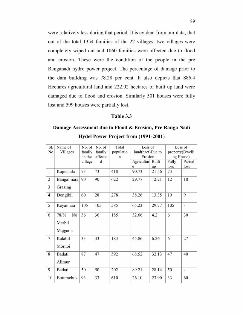
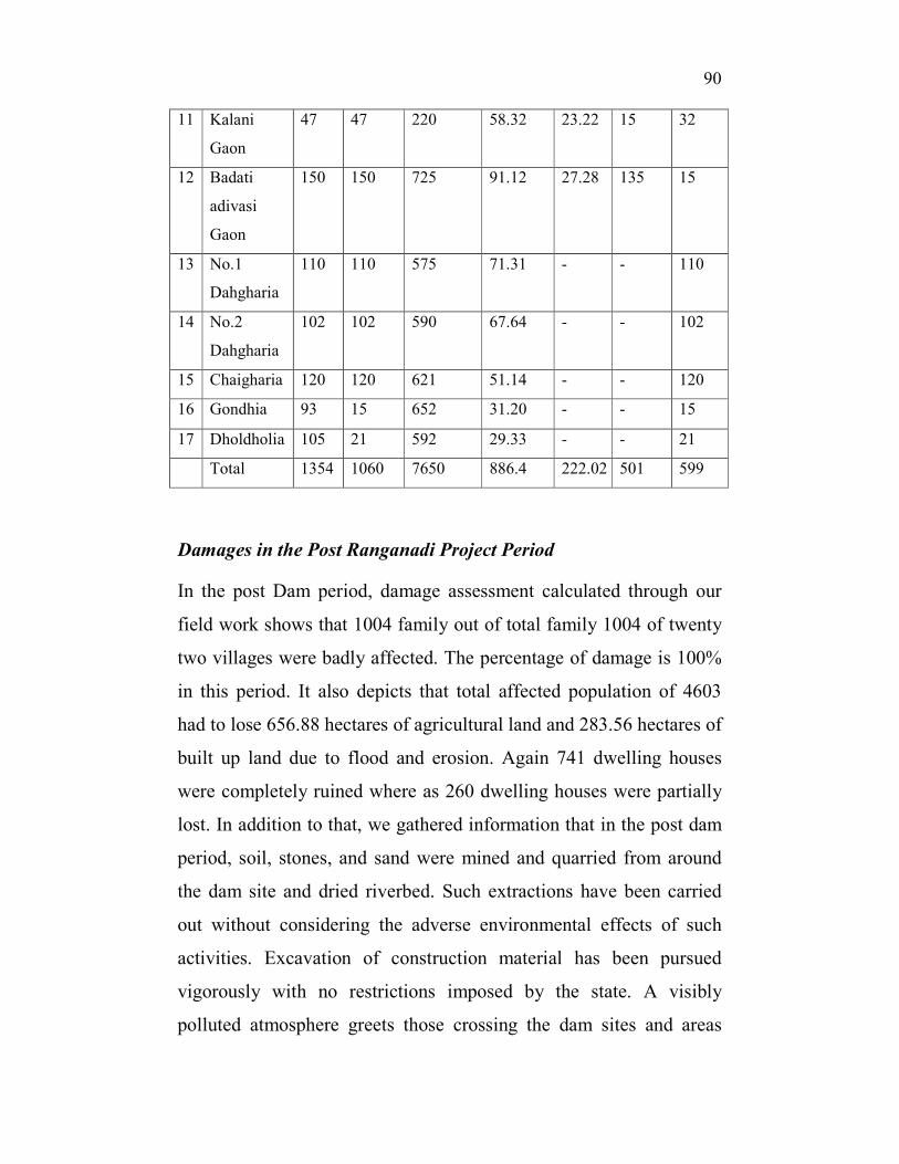
were relatively less during that period. It is evident from our data, that
out of the total 1354 families of the 22 villages, two villages were
completely wiped out and 1060 families were affected due to flood
and erosion. These were the condition of the people in the pre
Ranganadi hydro power project. The percentage of damage prior to
the dam building was 78.28 per cent. It also depicts that 886.4
Hectares agricultural land and 222.02 hectares of built up land were
damaged due to flood and erosion. Similarly 501 houses were fully
lost and 599 houses were partially lost.
Table 3.3
Damage Assessment due to Flood & Erosion, Pre Ranga Nadi
Hydel Power Project from (1991-2001)
Sl.
No
.
Name of
Villages
No. of
family
in the village
No. of
family
affected
Total
populatio
n
Loss of
land(hact)Due to
Erosion
Loss of
property(Dwelli
ng House)
Agricultur
e
Built
up
Fully
loss
Partial
loss
1 Kapichala 73 73 418 90.73 21.56 73 -
2
3
Bangalmara
Grazing
90 90 622 29.77 12.21 12 18
4 Dongibil 60 28 278 38.26 13.35 19 9
5 Keyamara 105 105 585 65.23 29.77 105 -
6 78/81 No
Merbil
Majgaon
36 36 185 32.66 4.2 6 30
7 Kalabil
Mornoi
33 33 183 45.86 6.26 6 27
8 Badati
Alimur
87 47 592 68.52 32.13 47 40
9 Badati 50 50 202 89.21 28.14 50 -
10 Botumchuk 93 33 610 26.10 23.90 33 60
�
90��
���
11 Kalani
Gaon
47 47 220 58.32 23.22 15 32
12 Badati
adivasi
Gaon
150 150 725 91.12 27.28 135 15
13 No.1
Dahgharia
110 110 575 71.31 - - 110
14 No.2
Dahgharia
102 102 590 67.64 - - 102
15 Chaigharia 120 120 621 51.14 - - 120
16 Gondhia 93 15 652 31.20 - - 15
17 Dholdholia 105 21 592 29.33 - - 21
Total 1354 1060 7650 886.4 222.02 501 599
Damages in the Post Ranganadi Project Period
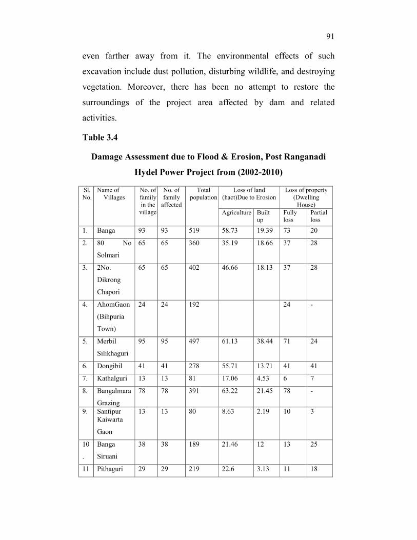
In the post Dam period, damage assessment calculated through our
field work shows that 1004 family out of total family 1004 of twenty
two villages were badly affected. The percentage of damage is 100%
in this period. It also depicts that total affected population of 4603
had to lose 656.88 hectares of agricultural land and 283.56 hectares of
built up land due to flood and erosion. Again 741 dwelling houses
were completely ruined where as 260 dwelling houses were partially
lost. In addition to that, we gathered information that in the post dam
period, soil, stones, and sand were mined and quarried from around
the dam site and dried riverbed. Such extractions have been carried
out without considering the adverse environmental effects of such
activities. Excavation of construction material has been pursued
vigorously with no restrictions imposed by the state. A visibly
polluted atmosphere greets those crossing the dam sites and areas
�
91��
���
even farther away from it. The environmental effects of such
excavation include dust pollution, disturbing wildlife, and destroying
vegetation. Moreover, there has been no attempt to restore the
surroundings of the project area affected by dam and related
activities.
Table 3.4
Damage Assessment due to Flood & Erosion, Post Ranganadi
Hydel Power Project from (2002-2010)
Sl.
No.
Name of
Villages
No. of
family
in the
village
No. of
family
affected
Total
population
Loss of land
(hact)Due to Erosion
Loss of property
(Dwelling
House)
Agriculture Built
up
Fully
loss
Partial
loss
1. Banga 93 93 519 58.73 19.39 73 20
2. 80 No
Solmari
65 65 360 35.19 18.66 37 28
3. 2No.
Dikrong
Chapori
65 65 402 46.66 18.13 37 28
4. AhomGaon
(Bihpuria
Town)
24 24 192 24 -
5. Merbil
Silikhaguri
95 95 497 61.13 38.44 71 24
6. Dongibil 41 41 278 55.71 13.71 41 41
7. Kathalguri 13 13 81 17.06 4.53 6 7
8. Bangalmara
Grazing
78 78 391 63.22 21.45 78 -
9. Santipur
Kaiwarta
Gaon
13 13 80 8.63 2.19 10 3
10
.
Banga
Siruani
38 38 189 21.46 12 13 25
11 Pithaguri 29 29 219 22.6 3.13 11 18
�
92��
���
.
12
.
Badati Miri
Gaon
185 185 132.55 68.45 185 -
13
.
Badatia-
limur
40 40 209 52.11 25.13 40 -
14
.
Botumchuk 60 60 273 21.77 18.23 60 -
15
.
Lega
Chung
110 110 590 29.21 20.12 35 75
16
.
Badalpara 30 30 172 30.85 19.32 30 -
17
.
Kathiabari 25 25 151 24.62 17.32 25 -
18
.
Banikanta
Para
28 28 163 27.46 19.14 28 -
19
.
Rakhal Para 120 120 711 92.33 68.21 120 -
Total 1004 1004 4603 656.88 283.56 741 269
The above table shows the number of families in a village and total
number of population affected due to flood and erosion. It also
documents the loss of land and loss of dwelling places in the post
Ranganadi project period. While it is important to take note of the
quantum of land and families affected, it is significant to understand
what this loss implies in practical terms. Loss of land as we have
already stated implies as series of loss in terms of livelihood, shelter,
health, property and most importantly one’s claim as a citizen. The
effect of flood and erosion has its own class and gender dimension.
Environmental degradation have disproportionate effect on the rich
and the poor. The poor bear the brunt of any kind of environmental
disruption, as they are the ones greatly dependant on communal
resources. The gender dimension of the problem stems from the fact
�
93��
���
that in poor households, women and children engage in much of the
food gathering activities for example collecting fuels, fetching water
from rivers and wells etc. When the environment that provides the
fuel and fodder of poor household is disturbed, it is the women and
children who suffer in the process. They come to be burdened with
the responsibility of finding newer ecological places from where to
collect food, water and fuel. Because women and children have
marginal positions in the labour market their source of alternative
livelihood id also constricted. They are forced to live within their
traditional settings and make optimum use of the environment in
which they live. Hence, when the environment degrades in the form
of land loss and erosion it is the women and children who suffer the
most. The effect of environmental degradation takes a toll on the
health of women and children. Agarwal has shown that women and
children are more prone to water borne diseases and river pollution
due to use of fertilizers and pesticides.112
It is also important to take
note of the social support systems that are affected as result of
displacement due to environmental reasons. A number of scholars
writing on the consequences of environmental degradation have
highlighted changed circumstances in the post displacement period.
Displacement has painfully eroded the social support networks of
communities especially of women. Women are closely woven into
their communities where they depend on the members of their
communities. Their dependence range from activities that include
daily simple exchanges to crucial borrowings and lending at the
�������������������������������������������������������������112
Bina Agarwal, “The Gender and Environmental Debate: Lessons from India” ,
in Mahesh Rangarajan (ed) 2007 Environmental Issues in India: A Reader
(Pearson: New Delhi)

�
94��
���
times of urgent need. On scholar has put these simple and complex
dependencies in the following words- “Social relationship with kin,
and with villagers outside the kin network, provide economic and
social support that is important to all rural households but especially
to poor households and to the women. This includes reciprocal
labour-sharing arrangements during peak agricultural season; loans
taken in cash or kind during severe crises such as droughts; and the
borrowings of small amounts foodstuffs, fuel, fodder, and so on, even
in normal times. Women typically depend a great deal on such
informal support networks, which they also help to build through
daily social interactions, marriage alliances that they are frequently
instrumental in arranging, and complex gift exchanges”113
.
�������������������������������������������������������������113
Ibid. pg.341