raft basic assessment report - cullinan conservancy x15 & 16... · 881 old farm road old farm...
TRANSCRIPT

Director – P De Lange BL (UP) Pr LArch SAFax: +27 86 588 4242 Mobile: +27 82 571 5396 Email: [email protected]
881 Old Farm Road Old Farm Office Park Building D Ground Floor Faerie Glen X8 PretoriaP.O. Box 177 Woodlands 0072
ENVIRONMENTAL IMPACT ASSESSMENT PROCESS
APPLICATION FOR ENVIRONMENTAL AUTHORISATION FOR THE PROPOSED TOWNSHIPS: 1) PIENAARSPOORTEXTENSION 15 SITUATED ON PORTIONS 28, 29, 36 AND 39 OF THE FARM DONKERHOEK NO 365-JR; AND 2)PIENAARSPOORT EXTENSION 16 SITUATED ON PORTIONS 33 AND 34 OF THE FARM PIENAARSPOORT NO 339-JRWITHIN THE CITY OF TSHWANE METROPOLITAN MUNICIPALITY
GAUTENG DEPARTMENT OF AGRICULTURE AND RURAL DEVELOPMENT (GDARD)
Prepared on behalf of:
HUPP Properties (RF) Pty LtdP.O. Box 73909Lynnwood RidgePretoria0040
Phone : (012) 940 4424Cell : (076) 796 2995Fax : (087) 809 5521E-mail : [email protected]
For review and approval by:
GAUTENG DEPARTMENT OF AGRICULTURE AND RURAL DEVELOPMENT11 Diagonal StreetDiamond BuildingNewtownJohannesburg2000
Tel: (011) 240 2500Fax: (011) 240 2700
OCTOBER 2016
A Report Compiled by:
DELRON CONSULTING (Pty) LtdP.O. Box 177Woodlands0072
Tel: 082 5715396Fax: 086 588 4242
DRAFT BASIC ASSESSMENT REPORT

Page i
Date October 2016
Document Title
DRAFT BASIC ASSESSMENT REPORT: Application for Environmental Authorisationfor The Proposed Townships: 1) Pienaarspoort Extension 15 Situated On Portions 28,29, 36 and 39 of The Farm Donkerhoek No 365-JR; and 2) Pienaarspoort Extension 16Situated On Portions 33 And 34 of The Farm Pienaarspoort No 339-JR within the Cityof Tshwane Metropolitan Municipality
Proponent / Applicant HUPP PROPERTIES (RF) Pty Ltd
P.O. Box 73909Lynnwood Ridge
Pretoria0040
Phone: (012) 940 4424Cell: (076) 796 2995Fax: (087) 809 5521
E-mail: [email protected]
The Competent Authority Gauteng Department of Agriculture andRural Development
11 Diagonal StreetDiamond Building
NewtownJohannesburg
2000
Tel: (011) 240 2500Fax: (011) 240 2700
Authority Reference Number
Environmental AssessmentPractitioner
Delron Consulting (Pty) Ltd881 Old Farm RoadOld Farm Office ParkBuilding D, Ground FloorFaerie Glen X8Pretoria
P.O. Box 177, Woodlands, 0072Tel: 082 571 5396
Fax: 086 588 4242E-mail: [email protected]
Revision Number: #1
Prepared / Checked by: C Mahlangu, P De Lange
Approved: Mr. P De Lange (BL (UP) Pr LArch SA)
Signature:
COPYRIGHT IS VESTED IN DELRON CONSULTING CC IN TERMS OF THE COPYRIGHT ACT (ACT 98 OF 1978) AND NO USE OR REPRODUCTIONOR DUPLICATION THEREOF MAY OCCUR WITHOUT THE WRITTEN CONSENT OF THE AUTHOR

Page ii
APPLICATION FOR ENVIRONMENTAL AUTHORISATION FOR THE PROPOSED TOWNSHIPS: 1) PIENAARSPOORTEXTENSION 15 SITUATED ON PORTIONS 28, 29, 36 AND 39 OF THE FARM DONKERHOEK NO 365-JR; AND 2)PIENAARSPOORT EXTENSION 16 SITUATED ON PORTIONS 33 AND 34 OF THE FARM PIENAARSPOORT NO 339-JRWITHIN THE CITY OF TSHWANE METROPOLITAN MUNICIPALITY
BASIC ASSESSMENT REPORT
TABLE OF CONTENTS
SECTION A: ACTIVITY INFORMATION ................................................................................................................ 11. PROPOSAL OR DEVELOPMENT DESCRIPTION ........................................................................................................... 1
2. APPLICABLE LEGISLATION, POLICIES AND/OR GUIDELINES .................................................................................. 11
3. ALTERNATIVES .............................................................................................................................................................. 14
4. PHYSICAL SIZE OF THE ACTIVITY ............................................................................................................................... 18
5. SITE ACCESS ................................................................................................................................................................. 18
6. LAYOUT OR ROUTE PLAN ............................................................................................................................................ 20
7. SITE PHOTOGRAPHS .................................................................................................................................................... 21
8. FACILITY ILLUSTRATION .............................................................................................................................................. 21
SECTION B: DESCRIPTION OF RECEIVING ENVIRONMENT .......................................................................... 221. PROPERTY DESCRIPTION............................................................................................................................................ 22
2. ACTIVITY POSITION....................................................................................................................................................... 23
3. GRADIENT OF THE SITE ............................................................................................................................................... 23
4. LOCATION IN LANDSCAPE ........................................................................................................................................... 23
5. GROUNDWATER, SOIL AND GEOLOGICAL STABILITY OF THE SITE....................................................................... 24
6. AGRICULTURE ............................................................................................................................................................... 25
7. GROUNDCOVER ............................................................................................................................................................ 25
8. LAND USE CHARACTER OF SURROUNDING AREA................................................................................................... 33
9. SOCIO-ECONOMIC CONTEXT ...................................................................................................................................... 34
10. CULTURAL/HISTORICAL FEATURES ......................................................................................................................... 36
SECTION C: PUBLIC PARTICIPATION (SECTION 41) ...................................................................................... 381. LOCAL AUTHORITY PARTICIPATION ........................................................................................................................... 38
2. CONSULTATION WITH OTHER STAKEHOLDERS ....................................................................................................... 39
3. GENERAL PUBLIC PARTICIPATION REQUIREMENTS ............................................................................................... 40
4. APPENDICES FOR PUBLIC PARTICIPATION............................................................................................................... 41
SECTION D: RESOURCE USE AND PROCESS DETAILS................................................................................. 421. WASTE, EFFLUENT & EMISSION MANAGEMENT ....................................................................................................... 42
2. WATER USE.................................................................................................................................................................... 45
3. POWER SUPPLY ............................................................................................................................................................ 45
4. ENERGY EFFICIENCY ................................................................................................................................................... 45

Page iii
SECTION E: IMPACT ASSESSMENT.................................................................................................................. 471. ISSUES RAISED BY INTERESTED & AFFECTED PARTIES ........................................................................................ 47
2. IMPACTS THAT MAY RESULT FROM THE CONSTRUCTION & OPERATIONAL PHASE.......................................... 49
3. IMPACTS THAT MAY RESULT FROM THE DECOMMISSIONING & CLOSURE PHASE ............................................ 68
4. CUMULATIVE IMPACTS................................................................................................................................................. 70
5. ENVIRONMENTAL IMPACT STATEMENT..................................................................................................................... 70
6. IMPACT SUMMARY OF THE PROPOSAL OR PREFERRED ALTERNATIVE .............................................................. 72
7. SPATIAL DEVELOPMENT TOOLS................................................................................................................................. 74
8. RECOMMENDATION OF THE PRACTITIONER ............................................................................................................ 75
9. THE NEEDS AND DESIRABILITY OF THE PROPOSED DEVELOPMENT................................................................... 76
10. THE PERIOD FOR WHICH THE ENVIRONMENTAL AUTHORISATION IS REQUIRED ............................................ 77
11. ENVIRONMENTAL MANAGEMENT PROGRAMME (EMPR)....................................................................................... 77
SECTION F: APPENDIXES .................................................................................................................................. 78
LIST OF APPENDIXES
A LOCALITY MAP
B SITE PHOTOGRAPHS
C LAYOUT PLAN
D FACILITY ILLUSTRATION
E PUBLIC PARTICIPATION
E.1 PROOF OF SITE NOTICE
E.2 WRITTEN NOTICES ISSUED
E.3 PROOF OF NEWSPAPER ADVERTISEMENTS
E.4 COMMUNICATIONS TO AND FROM I&APS
E.5 MINUTES OF ANY PUBLIC AND/OR STAKEHOLDER MEETINGS
E.6 COMMENTS AND RESPONSES REPORT
E.7 COMMENTS FROM I&APS ON BASIC ASSESSMENT (BA) REPORT
E.8 COMMENTS FROM I&APS ON AMENDMENTS TO THE BA REPORT
E.9 COPY OF THE REGISTER OF I&APS
E.10 LIST OF STATE DEPARTMENTS
F WATER USE LICENSE(S) AUTHORISATION, SAHRA INFORMATION, SERVICE LETTERS FROMMUNICIPALITIES, WATER SUPPLY INFORMATION
G SPECIALIST REPORTS
H EMPR
I OTHER INFORMATION

Page iv
Basic Assessment Report in terms of the National Environmental Management Act,1998 (Act No. 107 of 1998), as amended, and the Environmental Impact AssessmentRegulations, 2014 (Version 1)
Kindly note that:
1. This Basic Assessment Report is the standard report required by GDARD in terms of the EIA Regulations, 2014.
2. This application form is current as of 8 December 2014. It is the responsibility of the EAP to ascertain whether subsequentversions of the form have been published or produced by the competent authority.
3. A draft Basic Assessment Report must be submitted, for purposes of comments within a period of thirty (30) days,to all State Departments administering a law relating to a matter likely to be affected by the activity to be undertaken.
4. A draft Basic Assessment Report (1 hard copy and two CD’s) must be submitted, for purposes of comments withina period of thirty (30) days, to a Competent Authority empowered in terms of the National EnvironmentalManagement Act, 1998 (Act No. 107 of 1998), as amended to consider and decide on the application.
5. Five (5) copies (3 hard copies and 2 CDs-PDF) of the final report and attachments must be handed in at offices of the relevantcompetent authority, as detailed below.
6. The report must be typed within the spaces provided in the form. The size of the spaces provided is not necessarily indicativeof the amount of information to be provided. The report is in the form of a table that can extend itself as each space is filledwith typing.
7. Selected boxes must be indicated by a cross and, when the form is completed electronically, must also be highlighted.
8. An incomplete report may lead to an application for environmental authorisation being refused.
9. Any report that does not contain a titled and dated full colour large scale layout plan of the proposed activitiesincluding a coherent legend, overlain with the sensitivities found on site may lead to an application forenvironmental authorisation being refused.
10. The use of “not applicable” in the report must be done with circumspection because if it is used in respect of materialinformation that is required by the competent authority for assessing the application, it may result in the application forenvironmental authorisation being refused.
11. No faxed or e-mailed reports will be accepted. Only hand delivered or posted applications will be accepted.
12. Unless protected by law, and clearly indicated as such, all information filled in on this application will become publicinformation on receipt by the competent authority. The applicant/EAP must provide any interested and affected party withthe information contained in this application on request, during any stage of the application process.
13. Although pre-application meeting with the Competent Authority is optional, applicants are advised to have these meetingsprior to submission of application to seek guidance from the Competent Authority.
DEPARTMENTAL DETAILS
Gauteng Department of Agriculture and Rural DevelopmentAttention: Administrative Unit of the of the Environmental Affairs BranchP.O. Box 8769Johannesburg2000
Administrative Unit of the of the Environmental Affairs BranchGround floor Diamond Building11 Diagonal Street, Johannesburg
Administrative Unit telephone number: (011) 240 3377 Department central telephone number: (011) 240 2500

Page v
If this BAR has not been submitted within 90 days of receipt of the application by the competent authority and permission wasnot requested to submit within 140 days, please indicate the reasons for not submitting within time frame.
Not Applicable
Is a closure plan applicable for this application and has it been included in this report?
if not, state reasons for not including the closure plan.Not Applicable
Has a draft report for this application been submitted to a competent authority and all State Departmentsadministering a law relating to a matter likely to be affected as a result of this activity?
Is a list of the State Departments referred to above attached to this report including their full contact details and contactperson?
Refer to Appendix E.10
If no, state reasons for not attaching the list.Not Applicable
Have State Departments including the competent authority commented?
If no, why?
This application is the first Draft Basic Assessment Report submitted.
(For official use only)
NEAS Reference Number:
File Reference Number:
Application Number:
Date Received:
No
Yes
Yes
No
Page 1
SECTION A: ACTIVITY INFORMATION1. PROPOSAL OR DEVELOPMENT DESCRIPTION
1.1 Project Title (must be the same name as per application form):
Application for Environmental Authorisation for The Proposed Townships: 1) Pienaarspoort Extension 15 Situated OnPortions 28, 29, 36 and 39 of The Farm Donkerhoek No 365-JR; and 2) Pienaarspoort Extension 16 Situated On Portions33 And 34 of The Farm Pienaarspoort No 339-JR within the City of Tshwane Metropolitan Municipality
1.2 Development Description
HUPP Properties (RF) Pty Ltd proposes the development of 2 mixed-use townships, namely:
1) Pienaarspoort Extension 15 situated on Portions 28, 29, 36 and 39 of The Farm Donkerhoek No 365-JR; and2) Pienaarspoort Extension 16 situated on Portions 33 and 34 of The Farm Pienaarspoort No 339-JR.
The combined size of the subject properties is altogether 133, 9185 hectares.
The proposed development is located to the north of the R104 Bronkhorstspruit/Pretoria Road, and to the southeast of thetownship of Mamelodi in Ward 100 of the City of Tshwane Metropolitan Municipality. The site is bounded by a gravel roadknown as Road D771 to the west. A section of the proposed development site will be bisected by the K54 road that hasalready been approved by GDARD. The site of the proposed development is currently being used for agricultural purposes,specifically for the purpose of a pig farm, with related infrastructure. The surrounding area is characterized mainly byinformal settlements, agricultural and rural residential land uses.
The site includes a wetland environment, classified as an unchanneled valley bottom wetland and man-made depressions(dams) with riparian woodland. A specialist investigation confirmed that the wetlands at the proposed development site arein a Class E “Seriously Modified” condition, mainly as a result of alien invasive species, sedimentation and road crossings.These wetlands are not ecologically important and sensitive at any scale. The biodiversity of these wetlands is ubiquitousand not sensitive to flow and habitat modifications.
1. Development Proposal
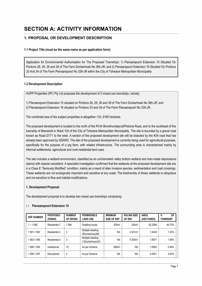
The development proposal is to develop two mixed use townships comprising:
1.1 Pienaarspoort Extension 15
ERF NUMBER PROPOSEDZONING
NUMBEROF ERVEN
PERMISSIBLELAND USE
MINIMUMSIZE OF ERF
RULING SIZEOF ERF
AREA(HECTARES)
% OFTOWNSHIP
1 – 1 580 Residential 1 1 580 Dwelling house 300m2 330m2 52.2398 44.73%
1 581-1 582 Residential 3 2 Multiple dwelling(80units/ha)±268 NA 4 621m2 1.4428 1.23%
1 583-1 585 Residential 4 3 Multiple dwelling(120units/ha)±433 NA 5 504m2 1.9577 1.68%
1 586-1 595 Institutional 10 As per Scheme 866m2 NA 1.0953 0.94%
1 596-1 597 Educational 2 As per Scheme NA NA 5.4051 4.63%

Page 2
1 598 Business 1 1 As per Scheme NA NA 6.9003 5.91%
1 599 Amusement 1 As per Scheme NA NA 0.5272 0.45%
1 600 – 1 613 Public openSpace 14 As per Scheme NA NA 10.0172 8.58%
Streets andRoads NA Streets and Roads NA NA 37.2027 31.85%
TOTAL NA 116.7881 100%
Total Number of Erven 1 613
Total Length of Streets ±16.8 km
1.2 Pienaarspoort Extension 16
ERFNUMBER
PROPOSEDZONING
NUMBEROF ERVEN
PERMISSIBLELAND USE
MINIMUMSIZE OF ERF
RULINGSIZE OF ERF
AREA(HECTARES)
% OFTOWNSHIP
1 – 187 Residential 1 187 Dwelling house 300m2 330m2 6.4901 37.9%
188 – 196 Business 1 7 As per Scheme NA NA 3.5351 20.6%
197 “Special”” 1 As per Scheme NA NA 0.6849 4.0%
198 - 199 Public openSpace 3 As per Scheme NA NA 1.9880 11.6%
Streets andRoads NA Streets and
Roads NA NA 4.4323 25.9%
TOTAL NA 198 17.1304 100%
Total Number of Erven 199
Total Length of Streets ±1.35 km
2. Associated Infrastructure
Project engineers have developed the following engineering services proposals:
2.1 Water
Existing Bulk Services
An existing 315-355mm Ø municipal water pipeline is located adjacent and on the northern side of Road R104 west of theproposed development which has a direct connection to the existing Rand Water H26 Pipeline. The connection point is atapproximately the following co-ordinates 25°44'34.75"S and 28°22'59.50"E.
The existing municipal water pipeline terminates at co-ordinates 25°45'44.49"S and 28°25'7.79"E approximately 2km to thewest of the proposed development.
Proposed Bulk Services
The project engineers have assessed the status of bulk engineering services in proximity of the subject properties and haveconfirmed that upgrades and new bulk services infrastructure will have to be developed, in order to ensure satisfactoryservices provision to the proposed township. Refer to Appendix I for details.

Page 3
Estimated Water Demand
The estimated water demand for the proposed development is 3 587,31 Kl/d.
2.2 Sewer
Bulk Service
There is no existing municipal sewage reticulation in the immediate vicinity of the proposed development.
Proposed Bulk Services
The following infrastructure upgrades are proposed. The proposed development is located within the BaviaanspoortDrainage area. Due to the rural location of the proposed development although within the urban edge, no existinginfrastructure is available. The nearest infrastructure available to which the proposed development could connect to issituated directly north of the proposed development within Mamelodi approximately 5972m away.
An engineering investigation indicated that an outfall sewer will have to be constructed parallel to and alternating on thewestern and eastern side of the proposed K54 Route from the proposed development up to the nearest connection point inMamelodi. The outfall sewer will be approximately 5972m long varying in sizes from 250mm up to 525mm Ø. The proposeddevelopment’s internal network will connect to the outfall sewer proposed above.
Refer to Appendix I for details.
Estimated Sewerage Flow
The estimated sewerage flow for the proposed development is 2385,75 Kl/d.
2.3 Roads
Access to the Development
Access to the proposed development will be directly from Road D771 on the western boundary of the proposeddevelopment. The future K54 Route runs through the proposed development. Access from this road will be provided fromthe northern boundary of the subject property. The accesses and internal roads will be designed and constructed accordingto the Standards and Specifications of City of Tshwane.
2.4 Solid Waste Disposal
Volume of Solid Waste
The estimated volume of waste to be generation on a weekly basis is 978, 09 m³/week. The solid waste will be transportedto the solid waste disposal site of the City of Tshwane by the City of Tshwane or by a private contractor appointed by them.
2.5 Electrical Engineering Services
The proposed development will be supplied from the City of Tshwane (CoT) power supply network. The external networkdesign will adhere to CoT’s standards and requirements. The internal network will be taken over by the CoT. Other standardsto which the electrical design will adhere include the relevant SABS safety and equipment standards, as well as the NRS048 Quality of Supply Standard.

Page 4
2.6 Storm Water Management
2.6.1 Catchment Areas
2.6.1.1 Existing Catchment
The catchment area of the proposed development consists of several high points to the east, directing storm water throughthe center of the catchment area towards a low point on the south-western catchment boundary. The existing catchmentarea can be defined as the pre-development run-off catchment, i.e., no-development taken place yet and the Road K54 notconstructed yet.
The total catchment area of the proposed development upstream of the lowest point that could affect the proposeddevelopment is approximately 2.847km2 and forms part of the Quaternary Drainage Region A23A as indicated by theDepartment of Water and Sanitation (OWS).
One watercourse, a tributary of the Edendale Spruit, running from south to north was identified. The tributary is an intermittedflowing watercourse which can at best be described as a highly modified wetland.
Three catchment areas were identified to determine the impact of the tributary on each portion of the proposedDevelopment. The catchment areas consist mostly of agricultural holdings including small industrial uses. The undevelopedareas consist mostly of undisturbed natural bush and grass lands type veldt.
The catchment slopes vary typically from 1% to 30%.
2.6.1.2 Catchment After Construction of Road K54 and the Development of the Proposed Townships
The construction of Road K54 and the development of the proposed development will divert and formalise the storm waterrun-off from the entire catchment area.
The construction of Road K54 will result in the alteration and diversion of the tributary and ultimately deplete the existingroute of the drainage line should no storm water infrastructure be implemented.
The initial proposal by Gauteng Department of Roads and Transport was to drain the catchment areas east of Road K54through several small culverts as indicated on Gauteng Department of Roads and Transport Drawing No. PRS 90/144/5Bp.
This proposal will however not be considered due to the effect of tail water on the proposed development to the east ofRoad K54. The post-development catchment was divided into different catchments areas that will ultimately drain towardsthe proposed storm water infrastructure to the north of the Proposed Development.
The area west of Road K54 will be drained through formalized storm water infrastructure up to a point where it will bedischarged into a formalized channel west of Road K54.
2.6.2 Proposed Storm Water Infrastructure
2.6.2.1 Storm Water Systems
As mentioned above CoT has no formal storm water master plan available for the area and this report, should it be approved,will be incorporated as part of the storm water master plan for the area. The proposal to formalise the existing tributary bycreating inter alia an artificial wetland were discussed in a meeting held with DWS where they supported the concept. The

Page 5
storm water system proposed should not include concrete lined channels but rather vegetation lined channels with lowvelocities with the focus placed on environmental friendly designs.
The minor internal storm water system for the Proposed Development will be designed for a 1:5 year flood return periodand major systems for the 1:20 year flood return period. A run-off coefficient of 80% (C= 0.8) will not be exceeded for theProposed Development.
The storm water outlet structures will cater for energy breakers at the outlets to minimize the possibility of erosion at thepoint of discharge. Silt traps will also be incorporated with outlet structure designs.
DWS also indicated that bio-detention dams will have to be incorporated to prevent high velocity discharge direct into theproposed artificial wetland area. With rainfall intensities increasing over the last decade and more occurrences of floodingit was decided to include the bio-detention dams which will also act as storm water attenuation dams.
Open Storm Water Channels and Bio-Detention Dams
The design and placement of the proposed bio-detention dams were done to maximize the capacity and drainage potentialfrom surrounding areas. The full capacity of the bio-detention dams will be 39,308m3, 34,676m3, 17,891m3 and 3,660m3respectively and will attenuate the post development 1:100 year floods. The outflow structures will be designed toaccommodate the post development 1:20 year floods.
Channel 1 will be constructed adjacent and parallel to the south-western boundary of the Proposed Development and willdischarge into Bio-Detention Dam 2. Channel 1 will accommodate the discharge volume from Bio-Detention Dam 1 as wellas the 1:100-year run-off from catchment areas 9 and 10.
Channel 2 will be constructed adjacent and parallel to the east of Road K54 route and will discharge into Bio-Detention Dam2. Channel 2 will be able to accommodate the 1:100-year run-off from catchment areas 11 and 12.
Channel 3, 4 and 5 will be constructed adjacent and parallel to the west of Road K54. The construction of this channel willbe the formalisation of the existing tributary of the Edendale Spruit. Bio-Detention Dams 2, 3 and 4 will discharge directlyinto the proposed channel.
Channel 4 will be able to accommodate the post development 1:100-year flood for catchment area 18 and Channel 5onwards the post development 1:100-year flood for Catchment Area 25.
The proposed channel on the western side of the K54 will be positioned within a 50m buffer zone.
Refer to Appendix I: Storm Water Management Report for the Formalisation of the Tributary of the Edendale Spruit(Route K54), September 2016.
3. EXISTING PIG FARM DECOMMISSIONING
The applicant has utilised the properties for purposes of pig farming for a number of years, but has decided to relocate thefarming operation to some of his other farms. The applicant currently operates two distinct units called Ilmadia and NewFarm. Ilmadia facilitates 1,100 sows with weaning accommodation. New Farm has 750 sows with weaning accommodation(the weaned pigs are moved to specialist grower units in the greater Bronkhorstspruit area). A small feed mill where rawmaterials (primarily soy meal and maize) are milled and mixed into rations for the pigs is also operating on the farm.
The aim of decommissioning would be to prepare the land for township establishment. During decommissioning of the pigfarm all components, structures and infrastructure will have to be demolished, disassembled, removed and re-used and/or

Page 6
recycled as far as possible. Depending on the best available option at the time, any above ground structures will bedemolished unless an alternative use is found for them.
General solid waste that is expected to be generated during decommission and construction includes:
General waste (e.g. paper, plastic, glass); Building rubble (e.g. bricks, concrete); Scrap metal; Pig manure; and Effluent (liquid waste) in the dedicated slurry dams. After approximately 12 months the liquid waste solidifies into a
solid waste.
3.1 Proposed Handling and Disposal of Solid Waste
Recyclable waste shall be collected by a recognised recycling service provider for appropriate recycling purposes. Scrapmetal will be sold to scrap yards. Scrap metals, steel, and glass will be collected in separate waste skips and each containerintended for identified recyclable waste will be clearly marked, i.e. scrap metals.
All non-recycled general waste will be removed by a registered waste contractor and taken to a licensed general wastelandfill site. According to South African Waste Information Centre (SAWIC), the closest registered General Waste landfillsite is Hatherley Landfill Site.
The solidified liquid waste and the pig manure will be sold to a local compost manufacturer.
Solid waste, generated from demolition and/or construction and land clearing (e.g. vegetation debris, sand, gravel, rocks,bricks, concrete and spoil material) will be used for filling, rehabilitation and storm water protection features where required.Other litter and waste (including packaging, plastics, off-cuts, paper, material containers etc) generated during thedecommissioning phase will be removed from the site.
Waste manifests will be kept on record to prove legal disposal.
A hazardous waste, if any, will be collected by a registered hazardous waste contractor and taken to a licensed hazardouswaste disposal site.
4. LISTED & SPECIFIED ACTIVITIES TRIGGERED & BEING APPLIED FOR
The NEMA EIA Regulations, 2014 GN R.983, 984, and 985 listed activities associated with the projects are indicated in theTable below.
Table: NEMA EIA Regulations, 2014-Listed Activities to be Authorised for the Proposed Projects.
GovernmentNotice
No. Activity Activity Description
GN. No. R 9834 Dec 2014List Notice 1
9 The development of infrastructure exceeding 1000 metres inlength for the bulk transportation of water or storm water –(i) with an internal diameter of 0,36 metres or more; or(ii) with a peak throughput of 120 litres per second or more;
excluding where-
From the City of Tshwane’sRegion 6 SDF Plan it wouldappear as if the subjectproperties are located withinthe Urban Edge.

Page 7
(a) such infrastructure is for bulk transportation of water orstorm water or storm water drainage inside a road reserve; or(b) such development will occur within an urban area.
This listed activity thus doesnot require environmentalauthorisation.
GN. No. R 9834 Dec 2014List Notice 1
10 The development and related operation of infrastructureexceeding 1000 metres in length for the bulk transportation ofsewage, effluent, process water, waste water, return water,industrial discharge or slimes –(i) with an internal diameter of 0,36 metres or more; or(ii) with a peak throughput of 120 litres per second or more;
excluding where-(a) such infrastructure is for bulk transportation of sewage,effluent, process water, waste water, return water, industrialdischarge or slimes inside a road reserve; or(b) such development will occur within an urban area.
From the City of Tshwane’sRegion 6 SDF Plan it wouldappear as if the subjectproperties are located withinthe Urban Edge.
This listed activity thus doesnot require environmentalauthorisation.
GN. No. R 9834 Dec 2014List Notice 1
12 The development of-(i) canals exceeding 100 square metres in size;(ii) channels exceeding 100 square metres in size;(iii) bridges exceeding 100 square metres in size;(iv) dams, where the dam, including infrastructure and
water surface area, exceeds 100 square metres in size;(v) weirs, where the weir, including infrastructure and water
surface area, exceeds 100 square metres in size;(vi) bulk storm water outlet structures exceeding 100 square
metres in size;(vii) marinas exceeding 100 square metres in size;(viii) jetties exceeding 100 square metres in size;(ix) slipways exceeding 100 square metres in size;(x) buildings exceeding 100 square metres in size;(xi) boardwalks exceeding 100 square metres in size; or(xii) infrastructure or structures with a physical footprint of
100 square metres or more;
where such development occurs-(a) within a watercourse;(b) in front of a development setback; or(c) if no development setback exists, within 32 metres of awatercourse, measured from the edge of a watercourse.
Excluding –
(aa) the development of infrastructure or structures withinexisting ports or harbours that will not increase thedevelopment footprint of the port or harbour;(bb) where such development activities are related to thedevelopment of a port or harbour, in which case activity 26 inListing Notice 2 of 2014 applies;(cc) activities listed in activity 14 in Listing Notice 2 of 2014 oractivity 14 in Listing Notice 3 of 2014, in which case thatactivity applies;
From the City of Tshwane’sRegion 6 SDF Plan it wouldappear as if the subjectproperties are located withinthe Urban Edge.
This listed activity thus doesnot require environmentalauthorisation.

Page 8
(dd) where such development occurs within an urban area; or(ee) where such development occurs within existing roads orroad reserves.
GN. No. R 9834 Dec 2014List Notice 1
19 The infilling or depositing of any material of more than 5 cubicmetres into, or the dredging, excavation, removal or movingof soil, sand, shells, shell grit, pebbles or rock of more than 5cubic metres from –
(i) a watercourse;(ii) the seashore; or(iii) the littoral active zone, an estuary or a distance of 100
metres inland of the high-water mark of the sea or anestuary, whichever distance is the greater -
But excluding where such infilling, depositing , dredging,excavation, removal or moving -a) will occur behind a development setback;b) is for maintenance purposes undertaken in accordance
with a maintenance management plan; orc) falls within the ambit of activity 21 in this Notice, in which
case that activity applies.
Associated infrastructure(roads, bridges, waterprovision pipelines,stormwater pipes and outlets,open water channels, bio-retention dams, erosionprotection measures etc.) forthe proposed developmentmay be located within awatercourse and it may berequired to excavate and/ormove soil.
GN. No. R 9834 Dec 2014List Notice 1
24 The development of -(i) a road for which an environmental authorisation was
obtained for the route determination in terms of activity5 in Government Notice 387 of 2006 or activity 18 inGovernment Notice 545 of 2010; or
(ii) a road with a reserve wider than 13,5 meters, or whereno reserve exists where the road is wider than 8 metres;
but excluding -
(a) roads which are identified and included in activity 27 inListing Notice 2 of 2014; or(b) roads where the entire road falls within an urban area.
From the City of Tshwane’sRegion 6 SDF Plan it wouldappear as if the subjectproperties are located withinthe Urban Edge.
This listed activity thus doesnot require environmentalauthorisation.
GN. No. R 9834 Dec 2014List Notice 1
27 The clearance of an area of 1 hectares or more, but less than20 hectares of indigenous vegetation, except where suchclearance of indigenous vegetation is required for-
i) The undertaking of a linear activity; orii) Maintenance purposes undertaken in accordance with a
maintenance management plan.
The proposed developmentand associated infrastructurewill require clearance ofvegetation where suchvegetation cover constitutesindigenous vegetation.
The biodiversity specialistassessment has confirmedthrough the site visit that thecombined vegetationclearance for the proposeddevelopment will be more than1ha but less than 20ha.
GN. No. R 9834 Dec 2014
28 Residential, mixed, retail, commercial, industrial orinstitutional developments where such land was used for
The development will occur onagricultural land bigger than 5

Page 9
List Notice 1 agriculture or afforestation on or after 01 April 1998 andwhere such development:
i) will occur inside an urban area, where the total land tobe developed is bigger than 5 hectares; or
ii) will occur outside an urban area, where the total land tobe developed is bigger than 1 hectare;
excluding where such land has already been developed forresidential, mixed, retail, commercial, industrial or institutionalpurposes.
ha which are located inside anurban area.
GN. No. R 9834 Dec 2014List Notice 1
31 The decommissioning of existing facilities, structures orinfrastructure for -(i) any development and related operation activity or
activities listed in this Notice, Listing Notice 2 of 2014 orListing Notice 3 of 2014;
(ii) any expansion and related operation activity or activitieslisted in this Notice, Listing Notice 2 of 2014 or ListingNotice 3 of 2014;
(iii) any development and related operation activity oractivities and expansion and related operation activityor activities listed in this Notice, Listing Notice 2 of 2014or Listing Notice 3 of 2014;
(iv) any phased activity or activities for development andrelated operation activity or expansion or relatedoperation activities listed in this Notice or Listing Notice3 of 2014; or
(v) any activity regardless the time the activity wascommenced with, where such activity:(a) is similarly listed to an activity in (i), (ii), (iii), or(iv) above; and(b) is still in operation or development is still inprogress;
excluding where-
(aa) activity 22 of this notice applies; or(bb) the decommissioning is covered by part 8 of the NationalEnvironmental Management: Waste Act, 2008 (Act No. 59 of2008) in which case the National EnvironmentalManagement: Waste Act, 2008 applies.
Existing Pig FarmDecommissioningThe applicant currentlyoperates two distinct unitscalled Ilmadia and New Farm.Ilmadia facilitates 1,100 sowswith weaning accommodation.New Farm has 750 sows withweaning accommodation (theweaned pigs are moved tospecialist grower units in thegreater Bronkhorstspruitarea). A small feed mill whereraw materials (primarily soymeal and maize) are milledand mixed into rations for thepigs is also operating on thefarm.
The aim of decommissioningwould be to prepare the landfor township establishment.
GN. No. R 9854 Dec 2014List Notice 3
4 The development of a road wider than 4 metres with a reserveless than 13,5 metres.
(c) In Gauteng:
iv. Sites identified as Critical Biodiversity Areas (CBAs) andEcological Support Areas (ESAs) in the GautengConservation Plan or in bioregional plans;
Parts of Portions 28, 29 and 39of The Farm Donkerhoek No365-JR; and Portion 34 of TheFarm Pienaarspoort No 339-JR are located within anEcological Support Area(ESA) in terms of C-Plan

Page 10
GN. No. R 9854 Dec 2014List Notice 3
14 The development of-(i) canals exceeding 10 square metres in size ;(ii) channels exceeding 10 square metres in size;(iii) bridges exceeding 10 square metres in size;(iv) dams, where the dam, including infrastructure and
water surface area exceeds 10 square metres in size;(v) weirs, where the weir, including infrastructure and water
surface area exceeds 10 square metres in size;(vi) bulk storm water outlet structures exceeding 10 square
metres in size;(vii) marinas exceeding 10 square metres in size;(viii) jetties exceeding 10 square metres in size;(ix) slipways exceeding 10 square metres in size;(x) buildings exceeding 10 square metres in size;(xi) boardwalks exceeding 10 square metres in size; or(xii) infrastructure or structures with a physical footprint of 10
square metres or more;
where such development occurs –
(a) within a watercourse;(b) in front of a development setback; or(c) if no development setback has been adopted, within 32metres of a watercourse, measured from the edge of awatercourse;
excluding the development of infrastructure or structureswithin existing ports or harbours that will not increase thedevelopment footprint of the port or harbour.
(b) In Gauteng:iv. Sites identified as Critical Biodiversity Areas (CBAs) andEcological Support Areas (ESAs) in the GautengConservation Plan or in bioregional plans; -
Parts of Portions 28, 29 and 39of The Farm Donkerhoek No365-JR; and Portion 34 of TheFarm Pienaarspoort No 339-JR are located within anEcological Support Area(ESA) in terms of C-Plan
Select the appropriate box
The application is for anupgrade of an existingdevelopment
n/a The application is for a newdevelopment X Other, specify n/a
Does the activity also require any authorisation other than NEMA EIA authorisation?
YES NO X
If yes, describe the legislation and the Competent Authority administering such legislation
National Water Act (Act No 36 of 1998)

Page 11
A Water Use License (Ref: 01/A23A/CI/4300) was issued to the Gauteng Department of Roads and Transport for the K54Road between the K22 and K69 as well as the Section of Road 2561 from the K54 to Tsamaya Road in Mamelodi.
The licence authorizes Gauteng Department of Roads and Transport for the construction of K54 Road between the K22(Old Bronkorspruit Road) and K69 (Hans Strijdom) as well as a section of Road 2561 from K54 to Tsamaya Road inMamelodi East.
The road construction is divided into three (3) crossings. Crossing one (1) and two (2) include Construction of road crossingwith associated culverts through a wetlands and crossing three (3) include the entire road crossing within 500m a wetland.
The proposed activity will take place within the jurisdiction of City of Tshwane Metropolitan Municipality and it is locatedwithin the A23A quaternary catchment in the Limpopo Water Management Area at geographical point starting at S 25° 44'0.4" & E 28° 25’ 30.4" and ending at S 25° 44' 18.4" & E 28° 25' 24.3".
The water uses authorized are: Section 21(c) of the Act: Impeding or diverting the flow of water in a watercourse; and Section 21(i) of the Act: Altering the bed, banks, course or characteristic of a watercourse.
According to the Water Use License, the proposed K54 road will impede/divert/alter the flow and characteristics of thewatercourse through which it will be constructed.
The WULA requires an offset on the wetland that will be affected by the K54 road construction. The footprint of the roadthrough the wetland is 62 500m² or 6.2 ha and thus must be rehabilitated as per the offset required by DWS.
The conditions of the WUL are integrated into the proposed Pienaarspoort Extension 15 and Pienaarspoort Extension 16townships’ storm water management system. The proposed residential development to be known as PienaarspoortExtension 15 and 16 situated on Portions 28, 29, 36 and 39 of the farm Donkerhoek no 365-JR and portions 33, and 34 ofPienaarspoort 339-JR, will provide approx. 8,9 ha of open space as part of the wetland offset strategy.
Refer to Appendix F: Water Use License (Ref: 01/A23A/CI/4300)
If yes, have you applied for the authorisation(s)? YES X NO
If yes, have you received approval(s)? (attach in appropriate appendix) YES X NO
2. APPLICABLE LEGISLATION, POLICIES AND/OR GUIDELINES
List all legislation, policies and/or guidelines of any sphere of government that are applicable to the application as contemplatedin the EIA regulations:
Title of legislation, policy or guideline: Administering authority: Promulgation Date:
Constitution of the Republic of South Africa (Act No 108 of1990)
Government of SouthAfrica 18 December 1996
National Environmental Management Act, 1998 (Act No. 107 of1998 as amended).
Department ofEnvironmental Affairs(DEA) and Gauteng
27 November 1998

Page 12
Title of legislation, policy or guideline: Administering authority: Promulgation Date:Department of Agricultureand Rural Development(GDARD)
Regulations GN. R. 982, 983, 984 and 985 promulgated underChapter 5 of the National Environmental Management Act(NEMA, Act 107 of 1998) in Government Gazette 38282 on 4December 2014.
Listed activities:
1. GN R 983: Listing Notice 1: Activity 192. GN R 983: Listing Notice 1: Activity 273. GN R 983: Listing Notice 1: Activity 284. GN R 983: Listing Notice 1: Activity 31
5. GN R 985: Listing Notice 3: Activity 4 (c)(iv)6. GN R 985: Listing Notice 3: Activity 14 (i) (ii) (iv) (vi) (xi)
(xii) (a) (c) (b) (iv)
Gauteng Department ofAgriculture and RuralDevelopment (GDARD)
4 December 2014
National Water Act (Act No 36 of 1998) Department of WaterAffairs (DWA) 26 August 1998
National Heritage Resources Act No 25 of 1999 (Act No 25 of1999 as amended)
South African HeritageResources Agency(SAHRA)
28 April 1999
Description of compliance with the relevant legislation, policy or guidelines:
Legislation, policy of guideline Description of compliance
Constitution of the Republic of South Africa (Act No 108 of1990)
Obligation to ensure that the proposed developmentwill not result in pollution and ecological degradation;and
Obligation to ensure that the proposed development isecologically sustainable, while demonstratingeconomic and social development.
The proposed project can be considered as a sustainabledevelopment that will prevent pollution and ecologicaldegradation whilst promoting justifiable economic and socialdevelopment.
National Environmental Management Act, 1998 (Act No.107 of 1998 as amended).
The 2014 EIA Regulations, were published on 4 December2014 in terms of the NEMA and came into effect on 8December 2014.
In terms of these EIA Regulations, the following listedactivities within Government Notice R. 983 and R 985 aretriggered by the proposed development, thereby requiringenvironmental authorisation from the GDARD.
1) GN R 983: Listing Notice 1: Activity 192) GN R 983: Listing Notice 1: Activity 27

Page 13
Legislation, policy of guideline Description of compliance3) GN R 983: Listing Notice 1: Activity 284) GN R 983: Listing Notice 1: Activity 31
5) GN R 985: Listing Notice 3: Activity 4 (c)(iv)6) GN R 985: Listing Notice 3: Activity 14 (i) (ii) (iv) (vi)
(xi) (xii) (a) (c) (b) (iv)
Government Notice R. 983, R. 984 and R. 985, listsconstruction, transformation, extraction, exploration andexpansion of facilities or activities that require environmentalauthorisation prior to commencement of construction. Adistinction is made between Listing Notices 1 and 3activities, which require a Basic Assessment, and ListingNotice 2 activities, which require a full EIA (Scoping followedby Impact Assessment).
A Basic Assessment is generally intended for smaller scaleactivities, or activities whose impacts are well understoodand can be easily managed. A Full EIA is required for ListingNotice 2 activities which are activities that due to their natureand/or extent are likely to have significant impacts thatcannot be easily predicted. Listing 2 activities are thereforehigher risk activities that potentially cause higher levels ofpollution, waste and environmental degradation.
The proposed project requires a basic assessment in termsof R. 982.
National Water Act (Act No 36 of 1998)
A Water Use License (Ref: 01/A23A/CI/4300) was issued tothe Gauteng Department of Roads and Transport for theK54 Road between the K22 and K69 as well as the Sectionof Road 2561 from the K54 to Tsamaya Road in Mamelodi.
The water uses authorised are:
1) The impeding or diverting of flow in a water course –Section 21 c; and
2) Altering of bed, banks or characteristics of awatercourse – Section 21 i.
The conditions of the WUL are integrated into the proposedPienaarspoort Extension 15 and Pienaarspoort Extension16 townships’ storm water management system.
National Heritage Resources Act No 25 of 1999 (Act No 25of 1999 as amended)
A permit may be required should identify cultural/heritagesites on site be required to be disturbed or destroyed as aresult of the proposed development.
A HIA has been undertaken as part of the Basic AssessmentProcess to identify potential heritage sites.

Page 14
Legislation, policy of guideline Description of compliancei. Companion Guideline on the Environmental Impact
Assessment Regulations, 2010ii. Environmental Management Framework Guidelines, 10
October 2012iii. Public Participation Guideline, 10 October, 10 October
2012iv. Fee Regulations Guidance Document, April 2014v. Guideline on need and desirability in terms of the
Environmental Impact Assessment Regulations, 2010vi. EIA Listed Activities and Timelines (January 2015)vii. Section 24G and Similar Listings (January 2015)
Guidelines have informed this Application for EnvironmentalAuthorisation procedures and project / BAR.
3. ALTERNATIVES
Describe the proposal and alternatives that are considered in this application. Alternatives should include a consideration of allpossible means by which the purpose and need of the proposed activity could be accomplished. The determination of whetherthe site or activity (including different processes etc.) or both is appropriate needs to be informed by the specific circumstancesof the activity and its environment.
The no-go option must in all cases be included in the assessment phase as the baseline against which the impacts of the otheralternatives are assessed. Do not include the no go option into the alternative table below.
Note: After receipt of this report the competent authority may also request the applicant to assess additional alternatives thatcould possibly accomplish the purpose and need of the proposed activity if it is clear that realistic alternatives have not beenconsidered to a reasonable extent.
Please describe the process followed to reach (decide on) the list of alternatives below
The concept of Integrated Environmental Management suggests that an Environmental Impact Assessment process, todetermine the possible impact of the proposed activity, should incorporate the consideration of feasible alternatives. Areasonable number of possible proposals or alternatives, to achieve the same objective should be assessed. Theidentification, description, evaluation and comparison of alternatives are important for ensuring a sound environmentalimpact assessment process.
Alternatives should be considered as a norm within the Environmental Process. These should include, if applicable:
Site alternatives; Design or layout alternatives; Activity alternatives; Technology alternatives; and The No-Action alternative (No-Go).
For any alternative to be considered feasible, the alternative must meet the need and purposes of the development proposalwithout presenting significantly high associated impacts. Alternatives are typically distinguished into discrete or incrementalalternatives. Discrete alternatives are overall development options, which are typically identified during the pre-feasibility,feasibility and / or Basic Assessment process. Incremental alternatives typically identified arise during the BasicAssessment process and are usually suggested as a means of addressing / mitigating identified impacts (e.g.: wastemanagement, noise reduction measure, contamination management, etc.) These alternatives are closely linked to the

Page 15
identification of mitigation measures and therefore are not specifically identified as distinct alternatives. The types ofalternatives considered for this project are presented below.
Provide a description of the alternatives considered
No. Alternative Type Description
1 SITE / LOCATIONALTERNATIVES
Site alternatives for the proposed development, which constitutes a mix use residentialdevelopment, include the following:
i) Inner-city locationAn inner-city location would be environmentally and socially feasible, howevereconomically unviable, provided that the same area extent of land be found availablefor development as inner-city resources are very scarce.
ii) Suburban locationNot socially, environmentally or economically feasible due to the following: Not situated adjacent to primary movement corridors; Not accessible to a range of socio-economic population groups; Isolated nature of development and therefore not inclusive; Contrasting densities and heights with regard to the mixed-use nodal development,
and Availability of land at an affordable cost minimal.
iii) Urban edge / rural locationAlthough land is available in this location at a lower economic cost, this location issocially and environmentally less feasible due to the following: Lack of proximity to social amenities, services and infrastructure; Locating a nodal development far from other urban facilities; Loss of land that is environmentally / ecologically valuable; and Creation of urban sprawl.
iv) Infill development location (preferred)This is the most preferred location type due to the balance achievable between social,environmental and economic requirements: The development proposal is consistent with the development guidelines of the
RSDF of Region 6. Situated within the urban realm adjacent to existing and proposed urban
infrastructure, service and amenities; Socially inclusive due to its location to numerous communities and along public
transport routes.
The study area is surrounded by existing and future land-uses that are in line with theproposed land-use. Development trends indicate that there is a definite need for thedevelopment of residential housing opportunities in the area, as informal settlementshave already established adjacent to the subject properties.
2 LAYOUTALTERNATIVES
Before commencing with layout design various technical and specialist investigationswere conducted to determine the feasibility of the proposed project. The proposeddesign is based on various team meetings and workshops in order to plan the most

Page 16
No. Alternative Type Descriptionefficient and feasible option. Several meetings were held discussing the most feasibleoptions with regards to environmental constraints, bulk services, topography, stormwater as well as other constraints. This approach to a large-scale development will resultin a well-planned area with sufficient services provision.
Various layout alternatives were presented to the environmental assessmentpractitioners. However, the changes in these layout alternatives presented are notconsidered to be so significant as to require an individual assessment of each layout ofthe proposed development. The proposed layout has been formulated taking thefollowing into account:
The future K54 Route; Proximity to the environmental sensitive areas (dams, water courses and
associated flood lines, wetlands and associated buffer); Alignment with transformed areas of the site; Locality of areas not suitable for development identified in geotechnical and
biodiversity investigations; The existing and future road network; and Stormwater management requirements.
However, the changes in design and layout alternatives are not considered to be sosignificant as to require an individual assessment of each alternative.
3STORM WATERDESIGNALTERNATIVES
Alternative 1: Lined storm water channel positioned parallel and on thewestern side of the proposed K54.
Alternative 1 proposes that storm water from the proposed development will be drainedtowards an existing tributary of the Edendale Spruit running through the proposeddevelopment from the south west to the north west. With the construction of theproposed K54 the existing tributary will be mostly formalised. It is proposed that thetributary be formalised to operate as a major system. A lined channel positioned paralleland on the western side of the proposed K54 could be implemented.
This channel will be sized to accommodate the 1:100 year flood return period and alsoact as a future conveyance channel for all the proposed townships in the direct vicinityof the tributary up to Mamelodi.
Alternative 2 (preferred): Artificial Wetlands, Open Storm Water Channelsand Bio-Retention Dams
Alternative 2 proposes to formalise the existing tributary by creating inter alia artificialwetlands, open storm water channels and bio-retention dams. The storm water systemproposed will not include concrete lined channels but rather vegetation lined channelswith low velocities with the focus placed on environmental friendly designs.
The minor internal storm water system for the proposed development will be designedfor a 1:5 year flood return period and major systems for the 1:20 year flood return period.A run-off coefficient of 80% (C= 0.8) will not be exceeded for the proposed development.

Page 17
No. Alternative Type DescriptionThe storm water outlet structures will cater for energy breakers at the outlets to minimizethe possibility of erosion at the point of discharge. Silt traps will also be incorporatedwith outlet structure designs.
DWS also indicated that bio-detention dams will have to be incorporated to prevent highvelocity discharge direct into the proposed artificial wetland area. With rainfall intensitiesincreasing over the last decade and more occurrences of flooding it was decided toinclude the bio-detention dams which will also act as storm water attenuation dams.
Open Storm Water Channels and Bio-Detention Dams
The design and placement of the proposed bio-detention dams were done to maximizethe capacity and drainage potential from surrounding areas. The full capacity of the bio-detention dams will be 39, 308m³, 34, 676m³, 17, 891m³ and 3, 660m³ respectively andwill attenuate the post development 1:100 year floods. The outflow structures will bedesigned to accommodate the post development 1:20 year floods.
Channel 1 will be constructed adjacent and parallel to the south-western boundary ofthe proposed development and will discharge into Bio-Detention Dam 2. Channel 1 willaccommodate the discharge volume from Bio-Detention Dam 1 as well as the 1:100year run-off from catchment areas 9 and 10.
Channel 2 will be constructed adjacent and parallel to the east of Road K54 route andwill discharge into Bio-Detention Dam 2. Channel 2 will be able to accommodate the1:100 year run-off from catchment areas 11 and 12.
Channel 3, 4 and 5 will be constructed adjacent and parallel to the west of Road K54.The construction of this channel will be the formalisation of the existing tributary of theEdendale Spruit. Bio-Detention Dams 2, 3 and 4 will discharge directly into the proposedchannel.
Channel 4 will be able to accommodate the post development 1:100 year flood forcatchment area 18 and Channel 5 onwards the post development 1:100 year flood forCatchment Area 25.
4 TECHNOLOGYALTERNATIVES
Technology alternatives have not been considered at this stage. Consideration of suchalternatives can only reasonably considered at the detailed design stage, at which timeconsideration will be given to, but will not necessarily be limited to, the following aspects:materials, energy efficiency, rain water harvesting, stormwater management etc.
In the event that no alternative(s) has/have been provided, a motivation must be included in the table below.
Not Applicable

Page 18
4. PHYSICAL SIZE OF THE ACTIVITY
Indicate the total physical size (footprint) of the proposal as well as alternatives. Footprints are to include all new infrastructure(roads, services etc), impermeable surfaces and landscaped areas:
Size of the activity:
Proposed activity (Total environmental (landscaping, parking, etc.)and the building footprint)
Pienaarspoort x15 = 116,7881 HaPienaarspoort x16 = 17,1304 Ha
Total = 133,9185 Ha
Alternatives:
Alternative 1 (if any)Pienaarspoort x15 = 116,7881 Ha
Pienaarspoort x16 = 17,1304 HaTotal = 133,9185 Ha
Alternative 2 (if any) n/a
Ha / m2
or, for linear activities:Length of the activity:
Proposed activity n/a
Alternatives:
Alternative 1 (if any) n/a
Alternative 2 (if any) n/a
m/km
Indicate the size of the site(s) or servitudes (within which the above footprints will occur):Size of the site/servitude:
Proposed activityPienaarspoort x15 = 116,7881 Ha
Pienaarspoort x16 = 17,1304 HaTotal = 133,9185 Ha
Alternatives:
Alternative 1 (if any)Pienaarspoort x15 = 116,7881 Ha
Pienaarspoort x16 = 17,1304 HaTotal = 133,9185 Ha
Alternative 2 (if any) n/a
Ha/m2
5. SITE ACCESS
Proposal
Does ready access to the site exist, or is access directly from an existing road? YES X NO
If NO, what is the distance over which a new access road will be built n/a

Page 19
Describe the type of access road planned:
A Traffic Impact Study was undertaken by EDS Engineering Design Services (Pty) Ltd. The complete report may be foundin Appendix I. According to the TIS access to the subject property will be obtained from 2 access points, namely:
Primary Access Point 1: This is the K54 / Class 3 Road Intersection planned to serve both portions of the township (tothe east and west of the K54). The intersection will be controlled by traffic signal. This primary access point will providedirect access points (off K54) to the site, located on the northern boundary of the site and those located to the west ofthe western portion of the township layout.
Primary Access Point 2: This is the D771 / Access Road Intersection planned to serve the eastern portion of thetownship. The intersection will be priority controlled, in a form of a 2-way stop (also known as side stop), whereby theD771 Road will be the main road whilst the access road will be the side road or minor road. In the longer term, anetwork of local roads will traverse and serve this development and areas to the north and south. Therefore, in thelonger term a more permeable road network will further enhance traffic flows and access.
Include the position of the access road on the site plan (if the access road is to traverse a sensitive feature the impact thereofmust be included in the assessment).
Alternative 1
Does ready access to the site exist, or is access directly from an existing road? YES X NO
If NO, what is the distance over which a new access road will be built n/a
Describe the type of access road planned:
As per Project Proposal above.Include the position of the access road on the site plan. (if the access road is to traverse a sensitive feature the impactthereof must be included in the assessment).
Alternative 2Does ready access to the site exist, or is access directly from an existing road? n/a n/a
If NO, what is the distance over which a new access road will be built n/a
Describe the type of access road planned:
n/aInclude the position of the access road on the site plan. (if the access road is to traverse a sensitive feature the impactthereof must be included in the assessment).
PLEASE NOTE: Points 6 to 8 of Section A must be duplicated where relevant for alternatives
(only complete when applicable)
Section A 6-8 has been duplicated 0 Number of times

Page 20
6. LAYOUT OR ROUTE PLAN
Refer to Appendix C
A detailed site or route (for linear activities) plan(s) must be prepared for each alternative site or alternative activity. It must beattached to this document. The site or route plans must indicate the following:
the layout plan is printed in colour and is overlaid with a sensitivity map (if applicable); layout plan is of acceptable paper size and scale, e.g.
o A4 size for activities with development footprint of 10sqm to 5 hectares;o A3 size for activities with development footprint of ˃ 5 hectares to 20 hectares;o A2 size for activities with development footprint of ˃20 hectares to 50 hectares);o A1 size for activities with development footprint of ˃50 hectares);
The following should serve as a guide for scale issues on the layout plan:o A0 = 1: 500o A1 = 1: 1000o A2 = 1: 2000o A3 = 1: 4000o A4 = 1: 8000 (±10 000)
shapefiles of the activity must be included in the electronic submission on the CD’s; the property boundaries and Surveyor General numbers of all the properties within 50m of the site; the exact position of each element of the activity as well as any other structures on the site; the position of services, including electricity supply cables (indicate above or underground), water supply pipelines,
boreholes, sewage pipelines, septic tanks, storm water infrastructure; servitudes indicating the purpose of the servitude; sensitive environmental elements on and within 100m of the site or sites (including the relevant buffers as prescribed by
the competent authority) including (but not limited thereto):
o Rivers and wetlands;o the 1:100 and 1:50 year flood line;o ridges;o cultural and historical features;o areas with indigenous vegetation (even if it is degraded or infested with alien species);
Where a watercourse is located on the site at least one cross section of the water course must be included (to allow theposition of the relevant buffer from the bank to be clearly indicated).
FOR LOCALITY MAP (NOTE THIS IS ALSO INCLUDED IN THE APPLICATION FORM REQUIREMENTS)
the scale of locality map must be at least 1:50 000. For linear activities of more than 25 kilometres, a smaller scale e.g.1:250 000 can be used. The scale must be indicated on the map;
the locality map and all other maps must be in colour; locality map must show property boundaries and numbers within 100m of the site, and for poultry and/or piggery, locality
map must show properties within 500m and prevailing or predominant wind direction; for gentle slopes the 1m contour intervals must be indicated on the map and whenever the slope of the site exceeds 1:10,
the 500mm contours must be indicated on the map;
Page 21
areas with indigenous vegetation (even if it is degraded or infested with alien species); locality map must show exact position of development site or sites; locality map showing and identifying (if possible) public and access roads; and the current land use as well as the land use zoning of each of the properties adjoining the site or sites.
7. SITE PHOTOGRAPHS
Refer to Appendix B
Colour photographs from the center of the site must be taken in at least the eight major compass directions with a descriptionof each photograph. Photographs must be attached under the appropriate Appendix. It should be supplemented with additionalphotographs of relevant features on the site, where applicable.
8. FACILITY ILLUSTRATION
Facility illustrations not applicable - Refer to Appendix C for Proposed Site Development Plan
A detailed illustration of the activity must be provided at a scale of 1:200 for activities that include structures. The illustrationsmust be to scale and must represent a realistic image of the planned activity. The illustration must give a representative viewof the activity to be attached in the appropriate Appendix.
Page 22
SECTION B: DESCRIPTION OF RECEIVING ENVIRONMENT
Note: Complete Section B for the proposal and alternative(s) (if necessary)
Instructions for completion of Section B for linear activities1) For linear activities (pipelines etc) it may be necessary to complete Section B for each section of the site that has a
significantly different environment.2) Indicate on a plan(s) the different environments identified3) Complete Section B for each of the above areas identified4) Attach to this form in a chronological order5) Each copy of Section B must clearly indicate the corresponding sections of the route at the top of the next page.
Instructions for completion of Section B for location/route alternatives1) For each location/route alternative identified the entire Section B needs to be completed2) Each alterative location/route needs to be clearly indicated at the top of the next page3) Attach the above documents in a chronological order
(completeonly when
appropriate)
Instructions for completion of Section B when both location/route alternatives and linear activities are applicable forthe application
Section B is to be completed and attachments order in the following way All significantly different environments identified for Alternative 1 is to be completed and attached in a chronological
order; then All significantly different environments identified for Alternative 2 is to be completed and attached chronological order, etc.
Section B - Section of Route n/a (complete only when appropriate for above)
Section B – Location/route Alternative No. n/a (complete only when appropriate for above)
1. PROPERTY DESCRIPTION
Property Description:(Including Physical Address andFarm name, portion etc.)
1) Pienaarspoort Extension 15 situated on Portions 28, 29, 36 and 39 of The FarmDonkerhoek No 365-JR; and
2) Pienaarspoort Extension 16 situated on Portions 33 and 34 of The Farm PienaarspoortNo 339-JR.
The subject properties are located to the north east of the intersection of the N4 NationalFreeway and the Boschkop Road (R964). The properties are situated on the east side of thegravel road which connects the old Bronkhorstspruit Road (R104) and Mamelodi.
Section B has been duplicated for sections of the route n/a times
Section B has been duplicated for location/route alternatives n/a times

Page 23
2. ACTIVITY POSITION
Indicate the position of the activity using the latitude and longitude of the centre point of the site for each alternative site. Theco-ordinates should be in decimal degrees. The degrees should have at least six decimals to ensure adequate accuracy. Theprojection that must be used in all cases is the WGS84 spheroid in a national or local projection.
Alternative: Latitude (S): Longitude (E):
1. Project Proposal 25°45'34.94"S 28°26'30.31"E
2. Alternative 1 As above As above
In the case of linear activities:Alternative: Latitude (S): Longitude (E):
Starting point of the activity n/a n/a
Middle point of the activity n/a n/a
End point of the activity n/a n/a
For route alternatives that are longer than 500m, please provide co-ordinates taken every 250 meters along the route andattached in the appropriate Appendix
Addendum of route alternatives attached n/a
The 21 digit Surveyor General code of each cadastral land parcel
Portion 28 T 0 J R 0 0 0 0 0 0 0 0 0 3 6 5 0 0 0 2 8
Portion 29 T 0 J R 0 0 0 0 0 0 0 0 0 3 6 5 0 0 0 2 9
Portion 36 T 0 J R 0 0 0 0 0 0 0 0 0 3 6 5 0 0 0 3 6
Portion 39 T 0 J R 0 0 0 0 0 0 0 0 0 3 6 5 0 0 0 3 9
Portion 33 T 0 J R 0 0 0 0 0 0 0 0 0 3 3 9 0 0 0 3 3
Portion 34 T 0 J R 0 0 0 0 0 0 0 0 0 3 3 9 0 0 0 3 4
3. GRADIENT OF THE SITE
Indicate the general gradient of the site.
Flat 1:50 – 1:20 X 1:20 – 1:15 1:15 – 1:10 1:10 – 1:7,5 1:7,5 – 1:5 Steeper than 1:5
4. LOCATION IN LANDSCAPE
Indicate the landform(s) that best describes the site.

Page 24
Ridgeline PlateauSide slope of
hill/ridge Valley Plain X Undulating plain/lowhills River front
5. GROUNDWATER, SOIL AND GEOLOGICAL STABILITY OF THE SITE
a) Is the site located on any of the following?
Shallow water table (less than 1.5m deep) YES NO XDolomite, sinkhole or doline areas YES NO XSeasonally wet soils (often close to water bodies) YES X NO
Unstable rocky slopes or steep slopes with loose soil YES NO XDispersive soils (soils that dissolve in water) YES NO XSoils with high clay content (clay fraction more than 40%) YES NO XAny other unstable soil or geological feature YES NO XAn area sensitive to erosion YES NO X
(Information in respect of the above will often be available at the planning sections of local authorities. Where it exists, the1:50 000 scale Regional Geotechnical Maps prepared by Geological Survey may also be used).
b) are any caves located on the site(s) YES NO X
If yes to above provide location details in terms of latitude and longitude and indicate location on site or route map(s)Latitude (S): Longitude (E):
n/a n/a
c) are any caves located within a 300m radius of the site(s) YES NO X
If yes to above provide location details in terms of latitude and longitude and indicate location on site or route map(s)Latitude (S): Longitude (E):
n/a n/a
d) are any sinkholes located within a 300m radius of the site(s) YES NO X
If yes to above provide location details in terms of latitude and longitude and indicate location on site or route map(s)Latitude (S): Longitude (E):
n/a n/a
If any of the answers to the above are “YES” or “unsure”, specialist input may be requested by the Department

Page 25
6. AGRICULTURE
Does the site have high potential agriculture as contemplated in the Gauteng AgriculturalPotential Atlas (GAPA 4)? YES NO X
Please note: The Department may request specialist input/studies in respect of the above.
7. GROUNDCOVER
To be noted that the location of all identified rare or endangered species or other elements should be accurately indicated onthe site plan(s).
Indicate the types of groundcover present on the site and include the estimated percentage found on site.
Natural veld - goodcondition
% =
Natural veld withscattered aliens
% = 10
Natural veld withheavy alieninfestation
% = 15
Veld dominated byalien species
% = 5
Landscaped(vegetation)
% =
Sport field% =
Old Cultivated land% = 55
Paved surface(hard landscaping)
% =
Building or otherstructure X
% = 15
Bare soil% =
Please note: The Department may request specialist input/studies depending on the nature of the groundcover and potentialimpact(s) of the proposed activity/ies.
Specialist Study - Exigo Sustainability was appointed to conduct a Biodiversity Impact Assessment on the subject property.The conclusion is presented here, and the complete report may be found in Appendix G.
“The proposed development of the Pienaarspoort Extension 15 and 16 townships was found to be largely on degradedvegetation units, with potential impacts in isolated areas on riparian woodland, wetlands and woodland. The importance ofrehabilitation and implementation of mitigation processes to prevent negative impacts on the environment during and afterthe construction phase should be considered a high priority.
Provided that the recommendations and mitigation measures provided in this report are adhered to the planned residentialproject can be supported.”
Are there any rare or endangered flora or fauna species (including red list species)present on the site
YES NO X
If YES, specify and explain:
Not Applicable
Are there any rare or endangered flora or fauna species (including red list species) presentwithin a 200m (if within urban area as defined in the Regulations) or within 600m (if outsidethe urban area as defined in the Regulations) radius of the site.
YES NO X
If YES, specify and explain:
Not Applicable

Page 26
Are there any special or sensitive habitats or other natural features present on the site? YES X NO
If YES, specify and explain:
Specialist Study - Exigo Sustainability was appointed to conduct a Wetland and Riparian Delineation and FunctionalityAssessment on the subject property. A summary is presented here, and the complete report may be found in Appendix G.
Two wetland types were identified on site namely:
Unchannelled valley bottom wetland; Artificial depressions (dams)
The proposed development site is located inside the urban edge as stipulated in the Regional Spatial DevelopmentFramework (2012) for Region 6. A band of 30 meters was delineated around the periphery of the natural wetland zone asa buffer zone according to guidelines stipulated by GDARD (2014). A buffer zone is a collar of land that filters out edgeeffects, including the effects of invasive plant and animal species, physical damage and soil compaction caused throughtrampling and harvesting, abiotic habitat alterations and pollution. Strict mitigation should be applied in this area.
Riparian zone identification was done according to the aerial photograph and a field survey where the topography of thelandscape and vegetation were used to delineate the edge of the riparian zone. These riparian zones are located insidethe urban edge as stipulated in the Regional Spatial Development Framework (2012) for Region 6. A band of 32 meterswas delineated around the periphery of the riparian zones as a buffer zone.
Although the buffer zone is indicated in Figure 1 it is a guideline to indicate areas where no development should be allowedto ensure the integrity of the wetlands are kept intact. However, considering that the K54 route has already been approvedby authorities inside a section of the wetland, the integrity of the wetland will be compromised by the road development.The buffer will therefore have no practical implementation or function and subsequently the aim should be for the proposedresidential development in combination with the K54 road designs to provide an alternative stormwater design that wouldprevent flooding of neighbouring areas.
A new floodline determination and wetland management and rehabilitation strategy should aim at providing environmentaloptimisation to stormwater designs. The development of stormwater canals adjacent to the K54 road is considered anoption as indicated in Figure 2, especially considering the PES and EIS determined in Section 6 of this report.

Page 27
Figure 1. Wetland / riparian map for the proposed development with buffer zones as recommended by GDARD regulations (2014)
Figure 2. Recommended management of the wetland area taking its PES, EIS and the proposed layout plan of the authorised K54 Roadand proposed township development.

Page 28
WETLAND / RIPARIAN CLASSIFICATION
Unchannelled valley bottom wetland
The area directly west of the primary old cultivated fields represents an unchannelled valley-bottom wetland (Photograph1). Large areas of the wetland are also impacted by cultivation and overlaying of compost. A furrow was also constructedin the wetland to drain water into a dam (Photograph 2). This has caused the soils to become highly humic with a mixedsoil profile. Combined with the vertic soils of the area, delineation of the wetland was difficult. Wetness indicators werelimited in the soils due to a combination of possible agricultural draining of the wetland areas as well as the humic conditions.The system is impounded through the excavation into the wetland (Galago Environmental, 2014).
An unchannelled valley-bottom wetland is a mostly flat valley-bottom wetland area without a major channel running throughit, characterised by an absence of distinct channel banks and the prevalence of diffuse flows, even during and after highrainfall events. Water inputs are typically from an upstream channel, as the flow becomes dispersed, and from adjacentslopes (if present) or groundwater.
Water generally moves through the wetland in the form of diffuse surface flow and/or interflow (with some temporarycontainment of water in depressional areas), but the outflow can be in the form of diffuse or concentrated surface flow.Infiltration and evaporation from unchannelled valley-bottom wetlands can be significant, particularly if there are a numberof small depressions within the wetland area. Horizontal, unidirectional diffuse surface-flow tends to dominate in terms ofthe hydrodynamics.
In terms of plant species composition the wetland represents moist grassland dominated by grasses such as Setariasphacelata, Sorghum bicolor and Sporobolus africanus, although sedges also occur in the HGM.Unfortunately, the valley bottom wetland provides a distribution route for weeds and invading trees. Many of the usualweeds were recorded together with Eucalyptus camaldulensis (Red river gum), Xanthium strumarium (Large cocklebur)Datura stramonium and Flaveria bidentis. Weeds and invaders should be removed, as well as destruction of such plants ina safe place and manner.
As a result of the furrow inside the valley bottom, alluvial soils formed causing the development of riparian along the edgesof the furrow. Riparian Habitat are described by the National Water Act (1998) Section 1.1 (xxi) as follows: "Riparian habitat''includes the physical structure and associated vegetation of the areas associated with a watercourse (in this case thefurrow) which are commonly characterised by alluvial soils, and which are inundated or flooded to an extent and with afrequency sufficient to support vegetation of species with a composition and physical structure distinct from those ofadjacent land areas”.
The riparian zones can mostly be described as dense, medium tall riparian woodland on alluvial soils (Photograph 3). Theriparian woodland is dominated by species such as Acacia karroo, Searsia pyroides and various alien invasive speciessuch as Melia azedarach.

Page 29
Photograph 1. Unchannelled valley bottom wetland in the western section of the project area
Photograph 2. Furrow inside the valley bottom wetland
Photograph 3. Riparian woodland that formed along the edge of the furrow on alluvial soils

Page 30
Man-made depressions (dams)The man-made dams in the valley bottom wetland (Photograph 4) as well as the sludge dams (Photograph 5) used for thepiggery represent depressions, even though these drainage features are now considered as artificial wetlands.
A depression is classified as a landform with closed elevation contours that increases in depth from the perimeter to acentral area of greatest depth, and within which water typically accumulates. Dominant water sources are precipitation,ground water discharge, interflow and (diffuse or concentrated) overland flow. For ‘depressions with channelled inflow’,concentrated overland flow is typically a major source of water for the wetland, whereas this is not the case for ‘depressionswithout channelled inflow’. Dominant hydrodynamics are (primarily seasonal) vertical fluctuations. Depressions may be flat-bottomed (in which case they are often referred to as ‘pans’) or round-bottomed (in which case they are often referred toas ‘basins’), and may have any combination of inlets and outlets or lack them completely.
The two types of depressions that occur in the project area are characterised by the way water exits the systems. Waterexits by means of evaporation and infiltration for endorheic depressions (sludge dams); and as concentrated surface flowin channels for exorheic depressions (dams in wetland area), although the primary means of water still exits as evaporation.The vegetation associated with depressions is mostly sedges and bulrushes depending on the depth of the water and thesubstrate. Species such as Persicaria serullata, Typha capensis, Schoenoplectus corymbosus, Ludwigia stolonifer andPhragmites australis mostly grow along the shallow edges of dams in the project area on a muddy substrate.
Photograph 4. Edge of dam inside the unchannelled valley bottom wetland
Photograph 5. Sludge dams that forms part of the piggery
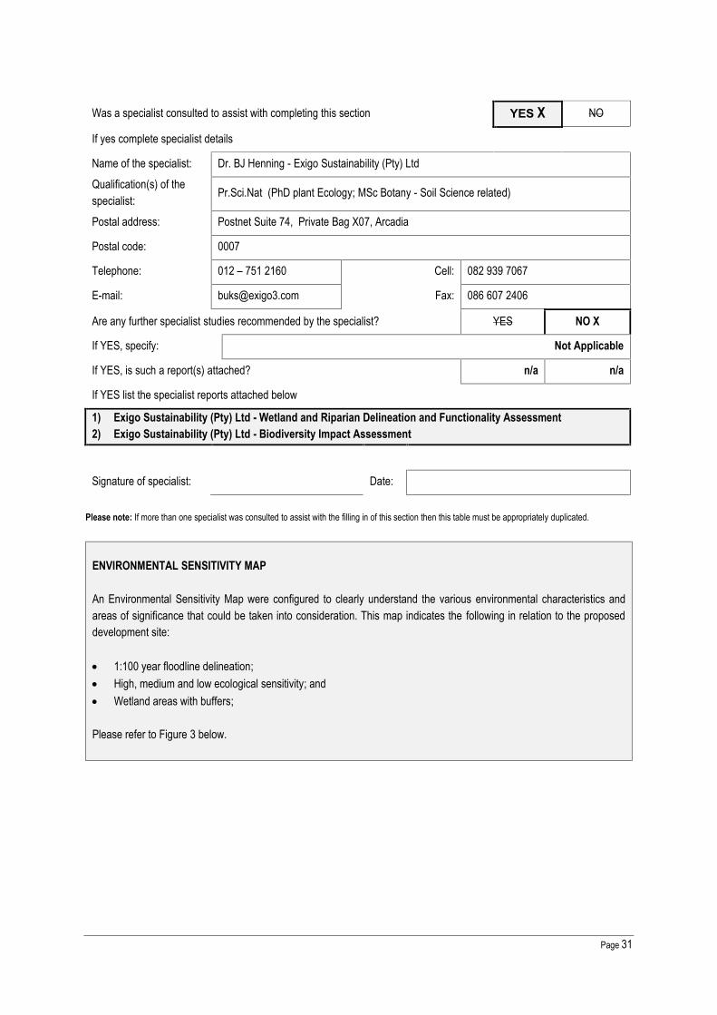
Page 31
Was a specialist consulted to assist with completing this section YES X NO
If yes complete specialist details
Name of the specialist: Dr. BJ Henning - Exigo Sustainability (Pty) LtdQualification(s) of thespecialist: Pr.Sci.Nat (PhD plant Ecology; MSc Botany - Soil Science related)
Postal address: Postnet Suite 74, Private Bag X07, Arcadia
Postal code: 0007
Telephone: 012 – 751 2160 Cell: 082 939 7067
E-mail: [email protected] Fax: 086 607 2406
Are any further specialist studies recommended by the specialist? YES NO X
If YES, specify: Not Applicable
If YES, is such a report(s) attached? n/a n/a
If YES list the specialist reports attached below
1) Exigo Sustainability (Pty) Ltd - Wetland and Riparian Delineation and Functionality Assessment2) Exigo Sustainability (Pty) Ltd - Biodiversity Impact Assessment
Signature of specialist: Date:
Please note: If more than one specialist was consulted to assist with the filling in of this section then this table must be appropriately duplicated.
ENVIRONMENTAL SENSITIVITY MAP
An Environmental Sensitivity Map were configured to clearly understand the various environmental characteristics andareas of significance that could be taken into consideration. This map indicates the following in relation to the proposeddevelopment site:
1:100 year floodline delineation; High, medium and low ecological sensitivity; and Wetland areas with buffers;
Please refer to Figure 3 below.

Page 32
Figure 3: Environmental Sensitivity Map

Page 33
8. LAND USE CHARACTER OF SURROUNDING AREA
Using the associated number of the relevant current land use or prominent feature from the table below, fill in the position ofthese land-uses in the vacant blocks below which represent a 500m radius around the site.
1. Vacant land 2. River, stream,wetland
3. Natureconservation area 4. Public open space 5. Koppie or ridge
6. Dam or reservoir 7. Agriculture8. Low density
residential9. Medium to highdensity residential
10. Informalresidential
11. Old age home 12. Retail 13. Offices 14. Commercial &warehousing
15. Light industrial
16. Heavy industrialAN 17. Hospitality facility 18. Church 19. Educationfacilities 20. Sport facilities
21. Golf course/polofields 22. AirportN
23. Train station orshunting yardN 24. Railway lineN 25. Major road (4
lanes or more)N
26. Sewagetreatment plantA
27. Landfill or wastetreatment siteA 28. Historical building 29. Graveyard 30. Archeological site
31. Open cast mine 32. Undergroundmine
33.Spoil heap orslimes damA 34. Small Holdings
Other land uses (describe): 35. Eskom Substation
Note: More than one (1) Land-use may be indicated in a block
Please note: The Department may request specialist input/studies depending on the nature of the land use character of the area and potential impact(s) ofthe proposed activity/ies. Specialist reports that look at health & air quality and noise impacts may be required for any feature above and in particular thosefeatures marked with an “A“ and with an “N” respectively.
Have specialist reports been attached YES NO XIf yes indicate the type of reports below
n/a
NORTH
WEST
10 10 10 10 5
EAST
34 34 10 34 5
10 10 5 5
34 34/1 34 34 5
34/1 34/1 34 34 34
SOUTH
NOTE: Each block represents an area of 250m X 250m, if your proposed development is larger than this pleaseuse the appropriate number and orientation of hashed blocks
= Site

Page 34
9. SOCIO-ECONOMIC CONTEXT
Describe the existing social and economic characteristics of the area and the community condition as baseline information toassess the potential social, economic and community impacts.
REGIONAL INFORMATION
LOCALITYRegion 6 is bordered by the Magaliesberg Mountain range to the north and the N1 freeway to the west and EkhuruleniLocal Municipality to the South. The Region includes large parts of the former Kungwini and Nokeng Tae Tsamane regions.
The N4 freeway which links the City of Tshwane with Mpumalanga Province and runs east-west through the region. The N1 freeway which runs on the western side of the region and links the City of Tshwane with the Limpopo Province
in the north and Johannesburg, Bloemfontein and Cape Town towards the south The R21 freeway along the western boundary of the region which links the City with the Ekurhuleni Municipality and
the OR Tambo International Airport.The region clearly enjoys a high level of accessibility.
AREAThe region is 885 km² in extend.
Region 6M² km² ha Wards885,239,940 885 88524 24
Demographic
Region 6 had a population of about 605554 people according to the 2011 Census.
POPULATIONHigh Medium Low Total
152289 141418 292743 605 554
In terms of income groups 48 % can be regarded as within the Low income group (monthly household income of less thanR 2000.00 a month).
Region 6 has an unemployment figure of about 20.5 % which is below the national average of 25%
REGIONAL CHARACTERISTICS
The main characteristics of Region 6 are discussed below:
The south-eastern section of this region has the highest income per capita and could be considered the fuel injectionof the city.
However, there is also a huge concentration of people in the north east quadrant, representing low and no- incomegroups.
It is the region with the greatest development pressure. Decentralised nodes accommodate a wide range of urban facilities. The region is popular in terms of retail as well as office functions as many of the higher category retail and office
functions of the City have relocated to this region over the past few years. Further to this is also the second mostimportant industrialised area in Tshwane situated in Silverton/ Silvertondale/ Waltloo/ Bellevue- area.
Suburban areas are mostly low density in nature and the region accommodates a number of Golf and Life StyleEstates such as Woodhill, The Hills and Silver lakes. However, there is also a high density area to the north of the

Page 35
region with large areas planned for RDP type development and informal settlements invaded the land beforeconstruction of services took place.
The east-west transportation linkages between nodes are saturated during peak hours. The historical radial linkages to the CBD are prominent. There is a high dependency on private motor vehicles, from the southern section of the region, placing an impossible
demand on the road infrastructure. Further to this is a high rail related dependency of the north eastern quadrant tothe City Centre. No south connection is possible.
There are also an unusually high dependency on bus travel through the area from the far outlying rural areas e.g.Moutse and Moloto.
The Bronberg and the Magaliesberg Mountain range is a major environmental feature running east to west in thenorthern part of the region. It provides limited thoroughfare, with only two major crossing points.
The Moreleta Spruit and its tributaries cover virtually the entire area to the south of the Bronberg, contributing to thewell-defined regional open space system of the southern part of the region.
Further to the south of the region is the Rietvlei Dam and Nature reserve which is one of the larger open space assetsof the City.
The region contains a number of strategic land uses including the CSIR, South African National Intelligence Serviceand the Menlyn Park Retail Node which has a metropolitan function in terms of facilities.
The Hatherley landfill site has a metropolitan function in terms of its Strategic nature and size. No other sites areknown for future development in the Metro as yet.
The region contains three large private hospitals as well as the Pretoria East Cemetery Almost all the developable land within the southern section of the Region has been developed and the uncontrolled
development in the old Kungwini area places a burden on the existing saturated road infrastructure The north-eastern section of the region accommodates mostly low-income communities and industrial land uses. The middle and south-western section of the region accommodates medium to high-income areas with large
institutional uses. The northern section of the region includes a number of strategically located undeveloped areas in terms of
accessibility and infrastructure which offer significant development potential.
STRUCTURING ELEMENTS
The main structuring elements of the region include: The N1 and N4 Freeways facilitating north-south and east-west regional linkages with the rest of the country. The secondary (mobility) roads including Lynnwood Road, Atterbury Road, Garsfontein Road, radiating from the CBD
through the region and Solomon Mahlangu Drive (Hans Strydom) linking the three roads with the N1 in the south andN4 in the north.
The Bronberg Mountain limits road linkage with the northern section of the region to only two major crossing points. The Moreleta Spruit and its tributaries covering the entire area forming an interlinked regional open space network. The Rietvlei Nature Area limiting southward expansion of the region. The Urban Edge roughly following the municipal boundaries and currently under pressure due to limited expansion
possibilities. The low density rural residential estate – Mooikloof – limits expansion in a south-eastern direction. The Menlyn retail node and Silverton/Waltloo Industrial node within the region plays a further important structuring
role in terms of economic development and regional accessibility. Pretoria Road and Stormvoël/Tsamaya Roads are parallel to the N4. Large industrial and vacant land parcels divide the mainly low-income in the north east and the higher income areas
to the south. A railway line runs east-west through the region with industrial and residential uses following this line, and a north-
south line linking with the huge freight facility near Babsfontein to the south east of the region. The Magaliesberg forms the northern boundary of the region and limits access to the areas north of the mountain.

Page 36
Micheal Brink (Nico Smith)/Stormvoël/Tsamaya Roads provides east-west linkage between the north eastern part ofthe region and the CBD.
Linkage between the north-eastern part of the metro and the CBD is very poor and obstructed by the mountain range.
10. CULTURAL/HISTORICAL FEATURES
Please be advised that if section 38 of the National Heritage Resources Act 25 of 1999 is applicable to your proposal oralternatives, then you are requested to furnish this Department with written comment from the South African Heritage ResourceAgency (SAHRA) – Attach comment in appropriate annexure
38. (1) Subject to the provisions of subsections (7), (8) and (9), any person who intends to undertake a development categorisedas-(a) the construction of a road, wall, powerline, pipeline, canal or other similar form of linear development or barrier exceeding
300m in length;(b) the construction of a bridge or similar structure exceeding 50m in length;(c) any development or other activity which will change the character of a site-
(i) exceeding 5 000 m2 in extent; or(ii) involving three or more existing erven or subdivisions thereof; or(iii) involving three or more erven or divisions thereof which have been consolidated within the past five years; or(iv) the costs of which will exceed a sum set in terms of regulations by SAHRA or a provincial heritage resources
authority;(d) the re-zoning of a site exceeding 10 000 m2 in extent; or(e) any other category of development provided for in regulations by SAHRA or a provincial heritage resources authority, must
at the very earliest stages of initiating such a development, notify the responsible heritage resources authority and furnishit with details regarding the location, nature and extent of the proposed development.
Are there any signs of culturally (aesthetic, social, spiritual, environmental) or historically significantelements, as defined in section 2 of the National Heritage Resources Act, 1999, (Act No. 25 of 1999),including archaeological or palaeontological sites, on or close (within 20m) to the site?
YES NO X
If YES, explain:
n/a
If uncertain, the Department may request that specialist input be provided to establish whether there is such a feature(s)present on or close to the site.
Briefly explain the findings of the specialist if one was already appointed:
Exigo Sustainability was appointed to conduct an Archaeological Impact Assessment (AIA). The AIA was conducted subjectto requirements as set out by the National Environmental Management Act (Act 107 of 1998), the National HeritageResources Act (NHRA - Act 25 of 1999). The report includes background information on the area’s archaeology, itsrepresentation in southern Africa, and the history of the larger area under investigation, survey methodology and results aswell as heritage legislation and conservation policies. A copy of the report will be supplied to the provincial heritage agencyand recommendations contained in this document will be reviewed.
A summary is presented here, and the complete report may be found in Appendix G.

Page 37
A number of recent period ruined multi-room buildings and foundation structures in the study area (Site EXIGO-PH-RP01, Site EXIGO-PH-RP02, Site EXIGO-PH-RP03, Site EXIGO-PH-RP04, Site EXIGO-PH-RP05, Site EXIGO-PH-RP06, Site EXIGO-PH-RP07) are of low significance due to their poor preservation and also a recent temporal context.However, it is recommended that the sites and any activities in its surrounds be monitored in order to avoid thedestruction of previously undetected heritage remains.
An old petrol pump in the study area (Site EXIGO-PH-FT01) is of low significance and no further action is required interms of mitigation.
The ruined remains of a probable Historical Period farmstead on the farm Donkerhoek (EXIGO-PH-HP02) is of lowsignificance due to the site’s poor preservation and the general loss of context. It is recommended that the sites andany activities in its surrounds be monitored in order to avoid the destruction of previously undetected heritage remains.
A small, fairly well preserved one-room rectangular house of possible historical value on the farm Donkerhoek (EXIGO-PH-HP01) is of medium significance as the structure might inform on architectural, settlement and social developmentsat Donkerhoek. It is primarily recommended that the site be avoided and that a 50m conservation buffer around thestructure be implemented. Should the site be impacted on by development it should be adequately documented(mapped, described and contextualised by means of a desktop study) and the necessary destruction permits shouldbe obtained from the relevant Heritage Resources Authorities.
Will any building or structure older than 60 years be affected in any way? YES X NO
Is it necessary to apply for a permit in terms of the National Heritage Resources Act,1999 (Act 25 of 1999)? YES X NO
If yes, please attached the comments from SAHRA in the appropriate Appendix

Page 38
SECTION C: PUBLIC PARTICIPATION (SECTION 41)
Note: The Environmental Assessment Practitioner must conduct public participation process in accordance with therequirement of the EIA Regulations, 2014.
1. LOCAL AUTHORITY PARTICIPATION
Local authorities are key interested and affected parties in each application and no decision on any application will be madebefore the relevant local authority is provided with the opportunity to give input. The planning and the environmental sectionsof the local authority must be informed of the application at least thirty (30) calendar days before the submission of theapplication to the competent authority.
Was the draft report submitted to the local authority for comment? YES X NO
If yes, has any comments been received from the local authority? YES X NO
If “YES”, briefly describe the comment below (also attach any correspondence to and from the local authority to thisapplication):City of Tshwane Municipality: Environmental Management Services Department: Mr. T MphephuReceived:14 March 2016Recommendationsa) The Gauteng Provincial Environmental Management Frame (GPEMF) November 2014 provide the following
conditions which are applicable in Zone 1: Urban development zone: Development in this area must be sustainable in respect to the capacity of the environment and specifically the
hydrological system to absorb additional sewage and storm water loads as a result of increased densities; Existing open spaces and urban parks should be retained as open space to cater for the open space needs the of
foreseen increased densities; and Storm water drainage must be in accordance with the Water Research Commission Report, 2012 and the South
African Guidelines for Sustainable Drainage Systems.The conditions mentioned above must be adhered to, as per the requirements of the GPEMF.b) All the recommendations and mitigation measures in the report and specialist studies in the attached appendix must
be adhered to and implemented as part of the design, planning and construction phase of the development.c) The area within the class 2 ridge line should not be development; such area should be designated as open space
and shown as such in the layout plan to be attached to the final basic assessment report.d) The Stormwater Management Plan attached within the draft Basic Assessment Report (BAR) should meet the
requirements of the City of Tshwane Roads and Storm Water Division. Comments on the attached StormwaterManagement Plan from the City’s Roads and Storm Water Division are as follows:
The proposed layout plans for Pienaarspoort Extension 15 & 16 are not acceptable. The existing 1:50 year floodplain of the Pienaarspoort Spruit (Tributary of the Edendale Spruit) as well as the associated wetlands with the bufferzones must be accommodated in the layout plan of the township;
The proposed channelization of the Pienaarspoort Spruit (Tributary of the Edendale Spruit) is not acceptable; Contours must be clearly shown on the proposed layout plans, All areas with seasonal shallow ground water, perched ground water and surface seepage must be clearly be
indicated on the proposed layout plan and zoned open space;

Page 39
The proposed layout Plans for Pienaarspoort Extension15 & 16 as well as the “Stormwater Management Report forthe Formalization of the Tributary of the Edendale Spruit” prepared by Civilconsult Consulting Engineers, must beamended to reflect the above.
e) Confirmation of service capacity (water, electricity, stormwater and sewer) from the relevant service providers mustbe included within the final Basic Assessment Report. Should no capacity exist for any of these services, analternative should be discussed within the Report.
f) It is the reasonability of the applicant to comply with the Water Use legislation and apply for water-use licences andauthorisation from Department of Water and Sanitation (DWS) according to the National Water Act where necessarywith respect to any activities occurring within the wetland, riparian and river boundaries. Comments from DWSshould be obtained and attached in the Final Basic Assessment Report.
g) Any form of waste material and rubble generated during the construction must be disposed of at a facility registeredin terms of section 20(b) of the National Environmental Management: Waste Act, 2008 (Act N.59 of 2008), if itcannot be responsibly re-used or recycled on site or offsite. No waste material of any kind may be bruised or burnt.
h) A complete waste handling and separation procedure for the decommissioning phase compiled and include withinthe final Basic Assessment Report. The procedure should indicate the handling, storing and disposal of any wastein the area.
i) The Geotechnical Investigation and Traffic Impact Study Report should be included within the final BasicAssessment report for the perusal.
j) According to City of Tshwane Green Building By-laws (July 2013), the proposed development should adhere to thefollowing green building guidelines and be included in the final BA Report:
Provide a site plan that indicates the external hard surface areas, including roofs. Annotate this plan to indicate thattype of surface, the absorptance value.
Provide a table of internal spaces that indicates the number of light fittings and respective power ratings. Provide a table that contains all external light fitting and type of controls. A renewable energy generation report that indicates the building’s predicted renewable energy generation in
kWh/annum, the building’s total predicted annual energy consumption sourced from renewable sources. Provide a table that indicates all the flush toilets in the building. This should include the manufacturer and product
type, the flush volumes and the respective numbers. Provide a table that indicates all hand wash basin taps in the building. This should include the manufacturer and
product, the flow rate and the respective numbers. Provide a plan drawing that indicates hot water pipe runs from the generating devices to the consumption point(s). Provide a plan drawing that indicates the rainwater harvesting tank and the linked water consumption areas. An on-site storm water retention report that indicates the predicted on-site storm water retention performance of the
project should be provided. This should show that at least 80% of run-off volume is retained on-site.
If “NO” briefly explain why no comments have been received or why the report was not submitted if that is the case.
Not Applicable
2. CONSULTATION WITH OTHER STAKEHOLDERS
Any stakeholder that has a direct interest in the activity, site or property, such as servitude holders and service providers,should be informed of the application at least thirty (30) calendar days before the submission of the application and beprovided with the opportunity to comment.
Has any comment been received from stakeholders? YES X NO

Page 40
If “YES”, briefly describe the feedback below (also attach copies of any correspondence to and from the stakeholders tothis application):
Department of Water and Sanitation: Llmpopo-NW CMA: Acting Chief Executive Officer: Mr. AD MaumelaReceived: 31 March 2016 - The Department of Water and Sanitation has evaluated the document and would like thefollowing issues to be addressed in terms of the National Water Act, 1988 (Act 36 of 1998).1. Page 26 & 46 of the report indicate that the proposed townships are within 500m from boundary of a wetland, pleasenote that these trigger Section 21 (c) and (i) wateruse of National Water Act, 1998 (Act NO.36 of 1998) which requireauthorisation by the Department.2. Page 02 & 03 of the report indicate that the proposed townships will receive sanitation and water services from City ofTshwane Metropolitan Municipality, an agreement between the municipality and the applicant must be submitted to thisDepartment for record purposes. Sanitation facilities should be provided for employees during construction, preferablychemical toilets and the contents should be disposed to an authorised sewage work facility.3. All waste materials (including non-biodegradable and biodegradable) generated during the activity should be disposedof at a permitted landfill site and an agreement between the municipality and the contractor must be submitted to thisoffice regarding the disposal of such waste material.4. Any oil spillages, diesel or any other hazardous substance should be treated and disposed of at a permittedhazardous landfill site and the Department must be notified within 24 hours.5. No construction or development should take place within the scale of 1:100 year flood line and or riparian area withoutan authorisation from this Department.6. Please note that this office will inspect this project at any time to ensure compliance.
7. Storm Water Management plans must be submitted to City of Tshwane Metropolitan Municipality for approval.
8. No activity should proceed prior to the necessary authorisation.
Petro Lemmer - Plot 44 PienaarspoortThe fauna study must include a bullfrog study as the giant bullfrog Pyxicephalus adspersus occurs in the entire area.They breed in the shallow water in the wetland and manmade dams and are seen annualy throughout the study area.Their presence in the area can be confirmed by all the residents of Pienaarspoort and Donkerhoek, even against theslope of the Magaliesberg east of the study area. To ignore their occurrence is a serious omission. Mitigating measuresshould be included.
If “NO” briefly explain why no comments have been received
Not Applicable
3. GENERAL PUBLIC PARTICIPATION REQUIREMENTS
The Environmental Assessment Practitioner must ensure that the public participation process is adequate and must determinewhether a public meeting or any other additional measure is appropriate or not based on the particular nature of each case.Special attention should be given to the involvement of local community structures such as Ward Committees and ratepayersassociations. Please note that public concerns that emerge at a later stage that should have been addressed may cause thecompetent authority to withdraw any authorisation it may have issued if it becomes apparent that the public participationprocess was flawed.
The EAP must record all comments and respond to each comment of the public / interested and affected party before theapplication report is submitted. The comments and responses must be captured in a Comments and Responses Report asprescribed in the regulations and be attached to this application.

Page 41
4. APPENDICES FOR PUBLIC PARTICIPATION
All public participation information is to be attached in the appropriate Appendix. The information in this Appendix is to beordered as detailed below:
Appendix E provides details of the public consultation process to date.
Appendix E.1 PROOF OF SITE NOTICE
Appendix E.2 WRITTEN NOTICES ISSUED
Appendix E.3 PROOF OF NEWSPAPER ADVERTISEMENTS
Appendix E.4 COMMUNICATIONS TO AND FROM I&APS
Appendix E.5 MINUTES OF ANY PUBLIC AND/OR STAKEHOLDER MEETINGS
Appendix E.6 COMMENTS AND RESPONSES REPORT
Appendix E.7 COMMENTS FROM I&APS ON BASIC ASSESSMENT (BA) REPORT
Appendix E.8 COMMENTS FROM I&APS ON AMENDMENTS TO THE BA REPORT
Appendix E.9 COPY OF THE REGISTER OF I&APS
Appendix E.10 LIST OF STATE DEPARTMENTS

Page 42
SECTION D: RESOURCE USE AND PROCESS DETAILSNote: Section D is to be completed for the proposal and alternative(s) (if necessary)
Instructions for completion of Section D for alternatives1) For each alternative under investigation, where such alternatives will have different resource and process details (e.g.
technology alternative), the entire Section D needs to be completed.2) Each alterative needs to be clearly indicated in the box below.3) Attach the above documents in a chronological order.
(complete only when appropriate)
Section D Alternative No. 0 (complete only when appropriate forabove)
1. WASTE, EFFLUENT & EMISSION MANAGEMENT
Solid Waste Management
Will the activity produce solid construction waste during the construction/initiation phase? YES X NO
If yes, what estimated quantity will be produced per month? Unknown at this stage
How will the construction solid waste be disposed of (describe)?
The aim of decommissioning would be to prepare the land for township establishment. During decommissioning of thepig farm all components, structures and infrastructure will have to be demolished, disassembled, removed and re-usedand/or recycled as far as possible. Depending on the best available option at the time, any above ground structures willbe demolished unless an alternative use is found for them.
General solid waste that is expected to be generated during decommission and construction includes:
General waste (e.g. paper, plastic, glass); Building rubble (e.g. bricks, concrete); Scrap metal; Pig manure; and Effluent (liquid waste) in the dedicated slurry dams. After approximately 12 months the liquid waste solidifies into a
solid waste.
Proposed Handling and Disposal of Solid Waste
i) Recyclable waste shall be collected by a recognised recycling service provider for appropriate recycling purposes.Scrap metal will be sold to scrap yards. Scrap metals, steel, and glass will be collected in separate waste skips andeach container intended for identified recyclable waste will be clearly marked, i.e. scrap metals.
ii) All non-recycled general waste will be removed by a registered waste contractor and taken to a licensed generalwaste landfill site. According to South African Waste Information Centre (SAWIC), the closest registered GeneralWaste landfill site is Hatherley Landfill Site.
Section D has been duplicated for alternatives 0 times

Page 43
iii) The solidified liquid waste and the pig manure will be sold to a local compost manufacturer.
iv) Solid waste, generated from demolition and/or construction and land clearing (e.g. vegetation debris, sand, gravel,rocks, bricks, concrete and spoil material) will be used for filling, rehabilitation and storm water protection featureswhere required. Other litter and waste (including packaging, plastics, off-cuts, paper, material containers etc)generated during the decommissioning and construction phases will be removed from the site.
v) Waste manifests will be kept on record to prove legal disposal.
vi) A hazardous waste, if any, will be collected by a registered hazardous waste contractor and taken to a licensedhazardous waste disposal site.
Where will the construction solid waste be disposed of (describe)?
All non-recycled general waste will be removed by a registered waste Contractor and taken to the licensed HatherleyLandfill Site.
Will the activity produce solid waste during its operational phase? YES X NO
If yes, what estimated quantity will be produced per month? 978, 09 m³/week approx. 3900m³/ month
How will the solid waste be disposed of (describe)?
The City of Tshwane Metropolitan Municipality will collect, transport and dispose waste materials. The CTMM willprovide containers / black refuse bins for general waste and will be lifted once a week. In terms of the Health Act, dailyrefuse removal is compulsory for each business that generates food residue. A compaction vehicle or a rear-end loaderwill collect and dispose of at Hatherley licensed landfill site.
Has the municipality or relevant service provider confirmed that sufficient air spaceexists for treating/disposing of the solid waste to be generated by this activity? YES X NO
Where will the solid waste be disposed if it does not feed into a municipal waste stream (describe)?
Waste will feed into the City of Tshwane Metropolitan Municipality’s waste stream.
Note: If the solid waste (construction or operational phases) will not be disposed of in a registered landfill site or be takenup in a municipal waste stream, the applicant should consult with the competent authority to determine whether it isnecessary to change to an application for scoping and EIA.
Can any part of the solid waste be classified as hazardous in terms of the relevantlegislation?
YES NO X
If yes, inform the competent authority and request a change to an application for scoping and EIA.
Is the activity that is being applied for a solid waste handling or treatment facility? YES NO XIf yes, the applicant should consult with the competent authority to determine whether it is necessary to change to anapplication for scoping and EIA.
Describe the measures, if any, that will be taken to ensure the optimal reuse or recycling of materials:

Page 44
Businesses and the community will be encouraged to separate waste into glass, tins, paper, hard plastics, organicand general waste. This will be stored in appropriate containers and collected by a contractor on a regular basis,with recyclable waste taken to the nearest appropriate facility, and non-recyclable waste to the municipal landfill site.
Liquid Effluent (other than domestic sewage)Will the activity produce effluent, other than normal sewage, that will be disposed of in amunicipal sewage system?
YES NO X
If yes, what estimated quantity will be produced per month? n/aIf yes, has the municipality confirmed that sufficient capacity exist for treating / disposing ofthe liquid effluent to be generated by this activity(ies)?
n/a n/a
Will the activity produce any effluent that will be treated and/or disposed of on site? Yes NO XIf yes, what estimated quantity will be produced per month? n/a
If yes describe the nature of the effluent and how it will be disposed.Not Applicable
Note that if effluent is to be treated or disposed on site the applicant should consult with the competent authority todetermine whether it is necessary to change to an application for scoping and EIA
Will the activity produce effluent that will be treated and/or disposed of at another facility? YES NO XIf yes, provide the particulars of the facility:Facility name: n/aContact person: n/aPostal address: n/aPostal code: n/aTelephone: n/a Cell: n/aE-mail: n/a Fax: n/a
Describe the measures that will be taken to ensure the optimal reuse or recycling of waste water, if any:
No waste water will be produced for this proposed activity.
Liquid Effluent (Domestic Sewage)Will the activity produce domestic effluent that will be disposed of in a municipalsewage system? YES X NO
If yes, what estimated quantity will be produced per month? Approx. 2385,75 Kl/d orApprox. 71 572,5 Kl/month
If yes, has the municipality confirmed that sufficient capacity exist for treating /disposing of the domestic effluent to be generated by this activity(ies)? YES X NO
Will the activity produce any effluent that will be treated and/or disposed of on site? YES NO XIf yes describe how it will be treated and disposed off.
n/a
Emissions into the AtmosphereWill the activity release emissions into the atmosphere? YES NO XIf yes, is it controlled by any legislation of any sphere of government? n/a n/a

Page 45
If yes, the applicant should consult with the competent authority to determine whether it isnecessary to change to an application for scoping and EIA.If no, describe the emissions in terms of type and concentration:Not Applicable
2. WATER USE
Indicate the source(s) of water that will be used for the activity
Municipal X Directly fromwater board groundwater
river, stream,dam or lake other
the activity willnot use water
If water is to be extracted from groundwater, river, stream, dam, lake or any other natural feature, please indicatethe volume that will be extracted per month: n/a
If Yes, please attach proof of assurance of water supply, e.g. yield of borehole, in the appropriate AppendixDoes the activity require a water use permit from the Department of Water Affairs? YES NO XIf yes, list the permits required
n/a
If yes, have you applied for the water use permit(s)? n/a n/a
If yes, have you received approval(s)? (attached in appropriate appendix) n/a n/a
3. POWER SUPPLY
Please indicate the source of power supply eg. Municipality / Eskom / Renewable energy sourceThe proposed development will be supplied from the City of Tshwane (CoT) power supply network. The externalnetwork design will adhere to CoT’s standards and requirements. The internal network will be taken over by theCoT.
If power supply is not available, where will power be sourced from?Not Applicable
4. ENERGY EFFICIENCY
Describe the design measures, if any, that have been taken to ensure that the activity is energy efficient:The following energy savings methods shall be investigated for possible implementation for theproposed development: Use of energy efficient lighting, Use of day light wherever possible in lieu of artificial lighting, Use of renewable solar powered lighting for external lighting, Switching off of all electrical appliances at night and times not in use, Use of high-efficient HVAC systems, Possibility of co-generation in co-operation with the supply authority, Use of solar water heating, Setting thermostats of water heaters at the most efficient level, Insulation of hot water pipes and hot water storage tanks, Use of low-flow shower heads,
Page 46
Use of high-efficient electric motors, Use of variable speed drives on electric motors, Use of appropriate conductor size to reduce distribution losses, Use of control methods to reduce maximum demand and exploit off peak electricity tariffs, Insulation of windows, wills, ceilings and roofs.
Describe how alternative energy sources have been taken into account or been built into the design of the activity,if any:Not Applicable

Page 47
SECTION E: IMPACT ASSESSMENTThe assessment of impacts must adhere to the minimum requirements in the EIA Regulations, 2014, and should takeapplicable official guidelines into account. The issues raised by interested and affected parties should also be addressed inthe assessment of impacts as well as the impacts of not implementing the activity (Section 24(4)(b)(i).
1. ISSUES RAISED BY INTERESTED & AFFECTED PARTIES
Summarise the issues raised by interested and affected parties.City of Tshwane Municipality: Environmental Management Services Department The area within the class 2 ridge line should not be development; such area should be designated as open space and
shown as such in the layout plan to be attached to the final basic assessment report. The Stormwater Management Plan attached within the draft Basic Assessment Report (BAR) should meet the
requirements of the City of Tshwane Roads and Storm Water Division. The proposed layout Plans for PienaarspoortExtension15 & 16 as well as the “Stormwater Management Report for the Formalisation of the Tributary of the EdendaleSpruit” prepared by Civilconsult Consulting Engineers, must be amended.
It is the reasonability of the applicant to comply with the Water Use legislation and apply for water-use licences andauthorisation from Department of Water and Sanitation (DWS) according to the National Water Act where necessary withrespect to any activities occurring within the wetland, riparian and river boundaries. Comments from DWS should beobtained and attached in the Final Basic Assessment Report.
Department of Water and Sanitation: Llmpopo-NW CMA The report indicate that the proposed townships are within 500m from boundary of a wetland, please note that these trigger
Section 21 (c) and (i) wateruse of National Water Act, 1998 (Act NO.36 of 1998) which require authorisation by theDepartment.
All waste materials (including non-biodegradable and biodegradable) generated during the activity should be disposed ofat a permitted landfill site and an agreement between the municipality and the contractor must be submitted to this officeregarding the disposal of such waste material.
No construction or development should take place within the 1:100 year flood line and or riparian area without anauthorisation from this Department.
Storm Water Management plans must be submitted to City of Tshwane Metropolitan Municipality for approval.
Petro Lemmer - Plot 44 Pienaarspoort1) The fauna study must include a bullfrog study as the giant bullfrog Pyxicephalus adspersus occurs in the entire area. They
breed in the shallow water in the wetland and manmade dams and are seen annualy throughout the study area. Theirpresence in the area can be confirmed by all the residents of Pienaarspoort and Donkerhoek, even against the slope ofthe Magaliesberg east of the study area. To ignore their occurrence is a serious omission. Mitigating measures should beincluded.
Summary of response from the practitioner to the issues raised by the interested and affected parties (including the manner inwhich the public comments are incorporated or why they were not included)(A full response must be provided in the Comments and Response Report that must be attached to this report):
City of Tshwane Municipality: EnvironmentalManagement Services Department1) The area within the class 2 ridge line should not be
development; such area should be designated as openspace and shown as such in the layout plan to beattached to the final basic assessment report.
1) No development is proposed within the Class 2 ridge line.
2) An amended Stormwater Management Plan is attachedas Appendix I: Storm Water Management Report for theFormalisation of the Tributary of the Edendale Spruit(Route K54), September 2016. During a meeting on 19September 2016 with CoTMM is was confirmed that Mr.

Page 48
2) The Stormwater Management Plan attached within thedraft Basic Assessment Report (BAR) should meet therequirements of the City of Tshwane Roads and StormWater Division. The proposed layout Plans forPienaarspoort Extension15 & 16 as well as the“Stormwater Management Report for the Formalisation ofthe Tributary of the Edendale Spruit” prepared byCivilconsult Consulting Engineers, must be amended.
3) It is the reasonability of the applicant to comply with theWater Use legislation and apply for water-use licencesand authorisation from Department of Water andSanitation (DWS) according to the National Water Actwhere necessary with respect to any activities occurringwithin the wetland, riparian and river boundaries.Comments from DWS should be obtained and attachedin the Final Basic Assessment Report.
Department of Water and Sanitation: Llmpopo-NW CMA4) The report indicate that the proposed townships are
within 500m from boundary of a wetland, please note thatthese trigger Section 21 (c) and (i) wateruse of NationalWater Act, 1998 (Act NO.36 of 1998) which requireauthorisation by the Department.
5) All waste materials (including non-biodegradable andbiodegradable) generated during the activity should bedisposed of at a permitted landfill site and an agreementbetween the municipality and the contractor must besubmitted to this office regarding the disposal of suchwaste material.
6) No construction or development should take place withinthe 1:100 year flood line and or riparian area without anauthorisation from this Department.
7) Storm Water Management plans must be submitted toCity of Tshwane Metropolitan Municipality for approval.
Petro Lemmer - Plot 44 Pienaarspoort8) The fauna study must include a bullfrog study as the giant
bullfrog Pyxicephalus adspersus occurs in the entirearea. They breed in the shallow water in the wetland andmanmade dams and are seen annualy throughout thestudy area. Their presence in the area can be confirmedby all the residents of Pienaarspoort and Donkerhoek,even against the slope of the Magaliesberg east of thestudy area. To ignore their occurrence is a seriousomission. Mitigating measures should be included.
Gawie Jansen van Vuuren (Chief Engineer: IntegratedStormwater Planning) approved the amendedStormwater Management Plan.
3) A Water Use License (Ref: 01/A23A/CI/4300) was issuedto the Gauteng Department of Roads and Transport forthe K54 Road between the K22 and K69 as well as theSection of Road 2561 from the K54 to Tsamaya Road inMamelodi. The water uses authorised are: 1) Theimpeding or diverting of flow in a water course – Section21 c; and 2) Altering of bed, banks or characteristics of awatercourse – Section 21 i. The conditions of the WULare integrated into the proposed Pienaarspoort Extension15 and Pienaarspoort Extension 16 townships’ stormwater management system. Refer to Appendix F: WaterUse License (Ref: 01/A23A/CI/4300).
4) As per point 3 above.
5) All general waste will be removed by a registered wastecontractor and taken to a licensed general waste landfillsite. According to South African Waste InformationCentre (SAWIC), the closest registered General Wastelandfill site is Hatherley Landfill Site.
6) See point 4 above.
7) Noted. A Stormwater Management Plan has beensubmitted to the City of Tshwane Roads and StormwaterDivision for approval.
8) Dr. Buks Henning Ph.D Plant Ecology, MSc SoilScience, Pr. Sci.Nat 400149/07: Ecological & SoilScience Specialist The valley bottom wetland in the project area has
been modified to a large extent when compost wasdumped in this area many years ago which largelychanged the soil conditions. This area is notconsidered optimal bullfrog habitat and no bullfrogswas observed during the surveys. The habitat hasbeen severely modified through canalisation andalien species invasion and wood harvesting from thenearby informal settlements adjacent to Mamelodi.Locals also harvest the bullfrogs where they stilloccur and as a result most of the bullfrogs in theareas adjacent to Mamelodi townships havedisappeared;
The pig farm sludge dams do not present habitat forbullfrogs considering the dams to be very deepalong its edges creating very little suitable and

Page 49
shallow bullfrog habitat, while the water quality in thesludge dams is aso considered inadequate tosupport populations and breeding of bullfrogs;
It is acknowledged that bullfrogs might occur in thelarger area, although the degradation of habitat tothe north of the N4 makes the probability of findingany bullfrogs here much lower, compared to themore natural areas to the south of the N4.
2. IMPACTS THAT MAY RESULT FROM THE CONSTRUCTION & OPERATIONAL PHASE
Briefly describe the methodology utilised in the rating of significance of impacts.
2.1 METHODS USED TO IDENTIFY POTENTIAL IMPACTS
A combination of the following methods was used to identify impacts during the Basic Assessment:
2.1.1 Technical and Specialist Study Findings
The following shows a list of the potential impacts according to technical or specialist studies:
Table: Possible Impacts According To Technical and Specialist Studies
SPECIALIST STUDY IMPACT IDENTIFICATIONFlora The area in which the proposed site is situated can be classified as Marikana Thornveld, situated
in the Grassland Biome. The study area is characterised by two major landscapes namely slightlyundulating to flat plains; and low-lying bottomlands (riparian woodland associated with drainagechannels and wetlands). Vegetation units were identified during the ecological surveys accordingto plant species composition, previous land-use, soil types and topography. The state of thevegetation of the proposed development site varies from slightly degraded (riparian woodland,woodland areas) to completely modified (degraded grassland / gardens). Most of the study areais vacant land at present, with some of the farm portions used for pig farming. Most of the landwas previously used for crop cultivation.
A Valley-Bottom (VB) wetland has been identified on the site. The impacts associated with thesite are reflected in the results of the PES assessment which indicates that the wetlands at theproposed development site are in a ‘Seriously Modified’ condition. The wetlands and riparianzones have been modified through alien invasive species, sedimentation and road crossings. Thecanalisation, previous agricultural activities, impoundments and alien species invasion plays amajor part in the LOW EIS of the unchannelled valley bottom wetlands.
The habitats have been severely degraded and fragmented. The close proximity to the informalsettlements and townships have further caused reduction in habitat as a result of wood harvesting,alien species invasion and poaching.
No red listed species were found.
Potential impacts identified are:
Direct habitat destruction;

Page 50
SPECIALIST STUDY IMPACT IDENTIFICATION Habitat fragmentation; Increased soil erosion and sedimentation; Soil and water pollution; Habitat degradation due to dust; Spread and establishment of alien invasive species; Negative effect of human activities; and Road mortality.
Fauna No RDL faunal species were observed during the field survey of the proposed development area.It was found that the proposed development will not result in the loss of ecologically sensitive andimportant habitat units, ecosystem function, loss of faunal habitat nor the loss or displacement ofthreatened or protected fauna, avifauna, reptiles or amphibians.
Wetland & RiparianDelineation Report
In determining the integrity of the wetland the condition of the site and the indirect and directdisturbances is taken into account. Dumping, roads, overgrazing, alien invasive vegetationspecies, etc. was taken into account in determining the Present Ecological Status and EcologicalImportance & Sensitivity of these wetland units (Table below). The valley bottom wetland anddams inside this wetland type was assessed as one unit.
Present Ecological State (PES) and Ecological Importance & Sensitivity (EIS) of the wetlands andriparian zones of the proposed development site:
Wetland / Water course PES EISUnchannelled VB wetland, riparian zone &
dams inside wetlandClass E: Seriously Modified Low
Evidence was observed on site of transformation of the floristic characteristics of the valley bottomwetlands. Impacting activities which have altered the expected floristic composition includecanalisation, alien infestation, impoundments (dams), agricultural activities (ploughing insidewetlands) and road crossings. All of the above impacts have resulted in the current condition ofthe wetlands on site departing significantly from the reference or un-impacted condition of thewetland.
The impacts associated with the site is reflected in the results of the PES assessment whichindicates that the ‘Unchannelled Valley bottom Wetland is in a ‘Seriously Modified’ condition dueto the factors noted above.
The Ecological Importance and Sensitivity of this HGM unit on site are considered to be Low dueto the stands of alien invasive species, sedimentation, previous ploughing inside the wetlands andcanal that modified the area. These wetlands are not ecologically important and sensitive at anyscale. The biodiversity of these Wetlands is ubiquitous and not sensitive to flow and habitatmodifications. They play an insignificant role in moderating the quantity and quality of water thatfeeds the larger rivers of the area. The changes in the state of the wetland were also previouslyaddressed by Galago Environmental (2014) for the wetland delineation study for the proposedK54 road. From these aerial images it can be concluded that that the land uses of the site hasmoved from large agriculture to more intensive small holding agriculture. Large areas of whatseems to be an unchannelled valley bottom wetland system has been transformed and convertedto agriculture. Extensive areas of the study site, and adjacent properties have also been minedfor sand, impacting the wetland systems (Galago Environmental, 2014).

Page 51
SPECIALIST STUDY IMPACT IDENTIFICATIONImpacts relating to the proposed development on the wetlands are as follows:
Direct wetland destruction; Soil erosion and sedimentation; Water pollution from spillages; Spread and establishment of alien invasive species in wetlands.
Considering that the wetland is classified as Class E (Seriously Modified) and that large sectionof the wetland will be destroyed during the K54 road construction, the focus of mitigation shouldrather be on implementing a stormwater canal system adjacent to the K54 road. The applicationof buffers will therefore have no practical implementation or function. This will ensure the aquaticintegrity of the northern section of the wetland (also degraded) is kept intact.
Geotechnical Geology - This site is not underlain by dolomitic bedrock and a stability investigation is thereforenot required.
Slope Stability and Erosion - The slope gradients on site are mainly shallow and therefore nonatural slope instabilities are expected.
Groundwater - Groundwater seepage was not noted in any of the excavated trial pits.
Drainage - The general site conditions are such that groundwater will percolate down slopetowards the west or percolate downwards towards the regional groundwater table. Local runoffdirection may vary due to the presence of smaller drainages and infiltration may be increased dueto the roads and houses present on site. Sections of the site which are located on the highestelevated ground, will encourage most of the precipitation to runoff or seep away as shallowinterflow and emerge as seep water within the floodplain.
Surface drainage is largely controlled by the road orientation and some evidence of erosion in thethick colluvial soils in the eastern portion of the site in roads parallel to the slope, indicate erodibleconditions of the surficial soils.
The mottled appearance and occasional presence of ferruginised residual soils in some of thewestern profiles are also evidence of seasonal saturated soil profile conditions.
Excavation Classification with Respect to Services - Based on the excavation conditions inthe trial pits and open excavations no serious excavation difficulties are expected, although theremay be some localised areas where shallow stiff residual material occurs. Refusal of the TLBoccurred in several test pits within the residual soils.
AgriculturalPotential
According to the Gauteng Agricultural Potential Atlas (GAPA Version 3), the proposeddevelopment site is not situated within a region delineated as an Agricultural Hub.
Cultural Heritage Sensitive heritage resources occur inside areas proposed for the Pienaarspoort Extension 15 &16 Township Establishment development and the mitigation and management of some of theseresources are required for the duration of the development. In the opinion of the author of thisArchaeological Impact Assessment Report, the proposed Pienaarspoort Extension 15 & 16Township Establishment Project on the Farms Pienaarspoort 365JR and Donkerhoek 339JR mayproceed from a culture resources management perspective, provided that mitigation measures,endorsed by the relevant Heritage Resources authority, are implemented where applicable, andprovided that no subsurface heritage remains are encountered during construction.

Page 52
SPECIALIST STUDY IMPACT IDENTIFICATIONDestruction of Heritage Structures or Features in the Project Area - A small, fairly wellpreserved one-room rectangular house of possible historical value on the farm Donkerhoek(EXIGO-PH-HP01) is of medium significance as the structure might inform on architectural,settlement and social developments at Donkerhoek. It is primarily recommended that the site beavoided and that a 50m conservation buffer around the structure be implemented. Should the sitebe impacted on by development it should be adequately documented (mapped, described andcontextualised by means of a desktop study) and the necessary destruction permits should beobtained from the relevant Heritage Resources Authorities.
Traffic Impact Conclusions: The proposed development is expected to generate 2683 and 1698 peak hour vehicular trips
during the respective morning and afternoon peak hours. The expected traffic impact of the K54 has been accounted for in this study. The existing
traffic patterns in the area will be automatically redistributed as a result of the new K54 link. The minor intersections upgrades would be required to cater for the expected development
traffic impact. D771 Road is currently in a very poor condition. The proposed township is being directly affected by the K54 Route alignment. There is currently public transport service available in the vicinity of the proposed township. There are existing and proposed public transport lay-bys in the area to serve the township. Section of the K54 between the R104 Road and the northern boundary of the site will operate
at congested levels of service during the critical AM peak periods if comprises one traffic laneper direction.
It is recommended that:
A section of D771 Road fronting the township be upgraded to a surfaced road to sufficientlyserve the proposed township and funds be offset against the bulk engineering servicescontribution.
Section of the K54 between the R104 Road and the northern boundary of the site beconstructed as a 4-lane road in order to cater for the expected total future traffic demandduring the peak periods.
A dedicated public transport terminus be provided on-site to serve the proposed shoppingcentre (Business 1).
The proposed township be approved by roads authorities from traffic and transportationengineering perspectives.
StormwaterManagement
A Water Use License (Ref: 01/A23A/CI/4300) was issued to the Gauteng Department of Roadsand Transport for the K54 Road between the K22 and K69 as well as the Section of Road 2561from the K54 to Tsamaya Road in Mamelodi.
The licence authorizes Gauteng Department of Roads and Transport for the construction of K54Road between the K22 (Old Bronkorspruit Road) and K69 (Hans Strijdom) as well as a section ofRoad 2561 from K54 to Tsamaya Road in Mamelodi East.
The road construction is divided into three (3) crossings. Crossing one (1) and two (2) includeConstruction of road crossing with associated culverts through a wetlands and crossing three (3)include the entire road crossing within 500m a wetland.

Page 53
SPECIALIST STUDY IMPACT IDENTIFICATIONThe proposed activity will take place within the jurisdiction of City of Tshwane MetropolitanMunicipality and it is located within the A23A quaternary catchment in the Limpopo WaterManagement Area at geographical point starting at S 25° 44' 0.4" & E 28° 25’ 30.4" and endingat S 25° 44' 18.4" & E 28° 25' 24.3".
The water uses authorized are: Section 21(c) of the Act: Impeding or diverting the flow of water in a watercourse; and Section 21(i) of the Act: Altering the bed, banks, course or characteristic of a watercourse.
According to the Water Use License, the proposed K54 road will impede/divert/alter the flow andcharacteristics of the watercourse through which it will be constructed.
The WULA requires an offset on the wetland that will be affected by the K54 road construction.The footprint of the road through the wetland is 62 500m² or 6.2 ha and thus must be rehabilitatedas per the offset required by DWS.
The conditions of the WUL are integrated into the proposed Pienaarspoort Extension 15 andPienaarspoort Extension 16 townships’ storm water management system. The proposedresidential development to be known as Pienaarspoort Extension 15 and 16 situated on Portions28, 29, 36 and 39 of the farm Donkerhoek no 365-JR and portions 33, and 34 of Pienaarspoort339-JR, will provide approx. 8,9 ha of open space as part of the wetland offset strategy.
Refer to Appendix I: Storm Water Management Report for the Formalisation of the Tributaryof the Edendale Spruit (Route K54), September 2016 and Appendix F: Water Use License(Ref: 01/A23A/CI/4300)
Services Provision Bulk services are not currently available, certain bulk services infrastructure and extensions willhave to be conducted by the developer, in order to ensure satisfactory services provision to theproposed township. Communication with the applicable municipal departments will be maintainedto ensure adequate supply plans without hindering the supply to the surrounding areas.
2.1.2 Site Inspection
The EAP and specialists conduct several site visits and identified potential sensitive environments. These areas are then red-flagged to be investigated further and excluded from development if necessary.
2.1.3 Technical / Desktop Studies
Technical and specialist reports such as the geotechnical and agricultural assessments are used to identify those areas andaspects that may be impacted on, but that will not be identified through the other specialists’ studies.
2.1.4 Public Participation
Conducting public participation produces an issues list. Such a list needs to be screened for relevant impacts which then needto be addressed by specialist studies or identified for further investigation.
2.1.5 GDARD Policies, Review / Terms of Reference
GDARD C-Plan 3 as well as the policies provides the red flags that must be investigated by the specialists. Furthermore, theGDARD officials and the different sub-directorates within the department review the application and give comments to the
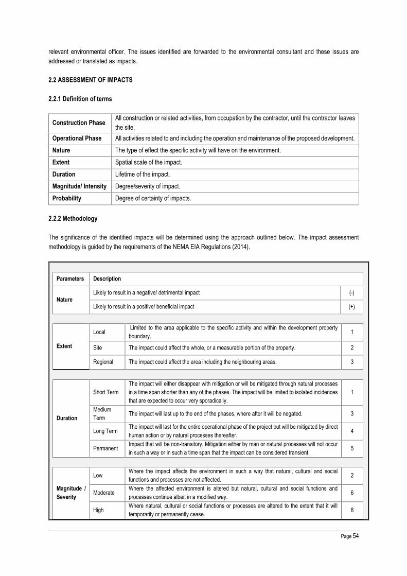
Page 54
relevant environmental officer. The issues identified are forwarded to the environmental consultant and these issues areaddressed or translated as impacts.
2.2 ASSESSMENT OF IMPACTS
2.2.1 Definition of terms
Construction Phase All construction or related activities, from occupation by the contractor, until the contractor leavesthe site.
Operational Phase All activities related to and including the operation and maintenance of the proposed development.
Nature The type of effect the specific activity will have on the environment.
Extent Spatial scale of the impact.
Duration Lifetime of the impact.
Magnitude/ Intensity Degree/severity of impact.
Probability Degree of certainty of impacts.
2.2.2 Methodology
The significance of the identified impacts will be determined using the approach outlined below. The impact assessmentmethodology is guided by the requirements of the NEMA EIA Regulations (2014).
Parameters Description
NatureLikely to result in a negative/ detrimental impact (-)
Likely to result in a positive/ beneficial impact (+)
Extent
Local Limited to the area applicable to the specific activity and within the development propertyboundary. 1
Site The impact could affect the whole, or a measurable portion of the property. 2
Regional The impact could affect the area including the neighbouring areas. 3
Duration
Short TermThe impact will either disappear with mitigation or will be mitigated through natural processesin a time span shorter than any of the phases. The impact will be limited to isolated incidencesthat are expected to occur very sporadically.
1
MediumTerm The impact will last up to the end of the phases, where after it will be negated. 3
Long Term The impact will last for the entire operational phase of the project but will be mitigated by directhuman action or by natural processes thereafter. 4
Permanent Impact that will be non-transitory. Mitigation either by man or natural processes will not occurin such a way or in such a time span that the impact can be considered transient. 5
Magnitude /Severity
Low Where the impact affects the environment in such a way that natural, cultural and socialfunctions and processes are not affected. 2
Moderate Where the affected environment is altered but natural, cultural and social functions andprocesses continue albeit in a modified way. 6
High Where natural, cultural or social functions or processes are altered to the extent that it willtemporarily or permanently cease. 8

Page 55
Probability
Improbable The possibility of the impact occurring is very low, due to the circumstances, design orexperience. 1
Probable There is a probability that the impact will occur to the extent that provision must be madetherefore. 2
HighlyProbable It is most likely that the impact will occur at some stage of the development. 4
DefiniteThe impact will take place regardless of any prevention plans, andthere can only be relied on mitigation actions or contingency plans to contain theeffect.
5
Reversibility
CompletelyReversible Reverses with minimal rehabilitation & negligible residual affects
Reversible Requires mitigation and rehabilitation to ensure reversibility
Irreversible Cannot be rehabilitated completely/rehabilitation not viable
Based on the above criteria, one can synthesise the ratings given to determine the overall significance of the impact. Addingthe extent, duration, probability and reversibility provides the significance of the impact.
S (significance) = (duration + extent + magnitude) x probabilityThe significance is described as:
Negligible The impact is non-existent or unsubstantial and is of no or little importance to any stakeholder and canbe ignored. < 20
Low
Impact is of a low order and therefore likely to have little real effect. In the case of adverse impacts:mitigation and/or remedial activity is either easily achieved or little will be required, or both. In the caseof beneficial impacts, alternative means for achieving this benefit are likely to be easier, cheaper, moreeffective, less time consuming, or some combination of these.
< 40
Moderate The impact is of importance to one or more stakeholders, and its intensity will be medium or high;therefore, the impact may materially affect the decision, and management intervention will be required. < 60
High
An impact which could influence the decision about whether or not to proceed with the projectregardless of any possible mitigation. In the case of adverse impacts: mitigation and/or remedial activityis feasible but difficult, expensive, time-consuming or some combination of these. In the case ofbeneficial impacts, other means of achieving this benefit are feasible but they are more difficult,expensive, time-consuming or some combination of these.
> 60
Cumulative Impact
Low Considering the potential incremental, interactive, sequential, and synergistic cumulativeimpacts, it is unlikely that the impact will result in spatial and temporal cumulative change.
Medium Considering the potential incremental, interactive, sequential, and synergistic cumulativeimpacts, it is probable that the impact will result in spatial and temporal cumulative change.
HighConsidering the potential incremental, interactive, sequential, and synergistic cumulativeimpacts, it is highly probable/definite that the impact will result in spatial and temporalcumulative change.
Irreplaceable loss ofresources
Low Where the impact is unlikely to result in irreplaceable loss of resources.
Medium Where the impact may result in the irreplaceable loss (cannot be replaced or substituted)of resources but the value (services and/or functions) of these resources is limited.
High Where the impact may result in the irreplaceable loss of resources of high value (servicesand/or functions).

Page 56
Briefly describe and compare the potential impacts (as appropriate), significance rating of impacts, proposed mitigation and significance rating of impacts after mitigation that are likely to occuras a result of the construction phase for the various alternatives of the proposed development. This must include an assessment of the significance of all impacts.
2.3 IMPACTS THAT MAY RESULT FROM THE CONSTRUCTION AND OPERATIONAL PHASE
Activity Potential Impact
Environmental Significance Score
Reve
rsib
ility
Cum
ulat
ive Im
pact
Irrep
lacea
ble l
oss
MitigationMeasures
Natur
e
Dura
tion
Exten
t
Magn
itude
Prob
abilit
y
Total
Ratin
gBefo
reMi
tigati
on
Ratin
gAfte
rMi
tigati
on
Environmental Component: Vegetation, Fauna, Soils and Ecological Support Areas (ESA)1. Clearing of Vegetation for Construction – Specialistconfirmed that the areas earmarked for construction donot accommodate any rare, threatened or endangeredspecies, or sensitive habitats or any other specificfeatures of special conservation value. Considering thatthe wetland is classified as Class E (Seriously Modified)and that large section of the wetland will be destroyedduring the K54 road construction the impact isinsignificant.
Therefore, there is no risk of loss, destruction and/ordisturbance of rare, threatened or endangered plantspecies or communities as a result of vegetationclearance.
Habitatdestruction, lossof speciesdiversity andhabitatcharacteristics
(-)
5 1 6 5 60
Moderate- High
Moderate -Low Irreversible Medium Low See Section 2.3.1
5 1 2 5 40
2. Clearing of vegetation for construction - Impact onnatural movement of species through the construction ofbarriers to animal movement or migration.
Habitatfragmentation (-)
5 1 6 5 60 Moderate- High
Moderate -Low Irreversible Medium Medium See Section 2.3.2
5 1 2 5 40
3. During the vegetation clearance and excavationprocess for the construction of the project and associatedinfrastructure soil will be exposed which could lead to thefollowing potential impacts:
Soil erosion andcompaction (-)
5 3 8 5 80
High Moderate -Low Irreversible Low Medium See Section 2.3.3
2 2 6 4 40

Page 57
Activity Potential Impact
Environmental Significance Score
Reve
rsib
ility
Cum
ulat
ive Im
pact
Irrep
lacea
ble l
oss
MitigationMeasures
Natur
e
Dura
tion
Exten
t
Magn
itude
Prob
abilit
y
Total
Ratin
gBefo
reMi
tigati
on
Ratin
gAfte
rMi
tigati
on
Loss of soil integrity as a result of soil disturbance(e.g. topsoil stripping and trenching).
Compaction of soil as a result of movement ofpeople and vehicles over exposed soils.
4. Movement of vehicles on site during construction. Contamination of soil resources through fuels,
waste, spills or leaks of sewage, cement and otherpotential contaminants, including possibleindiscriminate disposal of solid waste andwastewater.
Soil contamination (-)
4 3 6 4 52
Moderate Low Reversible Medium Medium See Section 2.3.33 2 2 4 28
5. Generation of dust as a result of vegetation clearing andearthworks.
Dustcontamination (airpollution)
(-)3 2 6 5 55
Moderate Low CompletelyReversible Low Low See Section 2.3.4
3 2 2 4 28
6. Continued movement of personnel and vehicles on andoff the site during the construction phase, as well asoccasional delivery of materials.
Spread of alieninvasive species (-)
5 2 6 4 52Moderate Negligible Reversible Medium Medium See Section 2.3.5
3 2 2 2 14
7. Construction activitiesNegative effect ofhuman activitieson flora.
(-)3 2 6 4 44
Moderate Negligible CompletelyReversible Low Low See Section
3 2 2 2 14
8. Continued movement of vehicles on and off the siteduring the construction phase, as well as occasionaldelivery of materials.
Fauna mortalityon roads (-)
3 2 6 4 44Moderate Low Completely
Reversible Low Low See Section 2.3.1and 2.3.33 2 2 4 14
Environmental Component: Sensitive Environments _ Wetlands9. Construction of roads / infrastructure in wetland or inclose proximity. Considering that the wetland is classifiedas Class E (Seriously Modified) and that large section ofthe wetland will be destroyed during the K54 roadconstruction the impact is insignificant.
Loss of wetlandand riparianhabitat
(-)(+)
5 1 8 5 70
(-) High (+) High Irreversible High High See Section 2.3.65 2 6 5 65

Page 58
Activity Potential Impact
Environmental Significance Score
Reve
rsib
ility
Cum
ulat
ive Im
pact
Irrep
lacea
ble l
oss
MitigationMeasures
Natur
e
Dura
tion
Exten
t
Magn
itude
Prob
abilit
y
Total
Ratin
gBefo
reMi
tigati
on
Ratin
gAfte
rMi
tigati
on
The proposed stormwater management measures andwetland rehabilitation including bio-retention ponds,artificial wetland areas, sediment traps, litter traps andbuffers will have a positive impact on ecological and flowconnectivity.10. Surface water runoff. Impact of uncontrolled stormwater on the
surrounding environment. Contaminated storm water discharge into the
environment. Surface and ground watercontamination may occur during the constructionphase as a result of negligence, inappropriateplanning, lack of supervision and general handlingerrors. Pollutants include hydrocarbons i.e. diesel orhydraulic oils from construction machinery, storedfuels and cement in solution and leaching ofpollutants (e.g. septic tank and soak-away).
Contaminated discharges may reach sensitiveecosystems. If the accumulation of pollutants issignificant, certain flora and fauna species may beimpacted upon.
Soil and watercontamination,erosion andsedimentation
(-)
5 3 8 5 80
High Moderate -Low Reversible Medium High See Section 2.3.7
2 2 6 4 40
11. Large construction vehicles contributing substantiallydue to oil and fuel spillages; building waste, batchingplants, sewage and domestic waste; stripping of topsoil
Water pollutionfrom spillages anddust
(-)
4 3 6 4 52
Moderate Low Reversible Medium High See Section 2.3.8
3 2 2 4 28

Page 59
Activity Potential Impact
Environmental Significance Score
Reve
rsib
ility
Cum
ulat
ive Im
pact
Irrep
lacea
ble l
oss
MitigationMeasures
Natur
e
Dura
tion
Exten
t
Magn
itude
Prob
abilit
y
Total
Ratin
gBefo
reMi
tigati
on
Ratin
gAfte
rMi
tigati
on
12. Continued movement of personnel and vehicles onand off the site during the construction phase, as well asoccasional delivery of materials required for maintenance
Spread of alieninvasive speciesin wetlandsystems
(-)
5 2 6 4 52
Moderate Negligible Reversible Medium High See Section 2.3.5
3 2 2 2 14
Component: Agricultural Potential13. Township development.According to the Gauteng Agricultural Potential Atlas(GAPA Version 3), the proposed development site is notsituated within a region delineated as an Agricultural Hub.
Loss of highpotentialagricultural land.
(-)5 1 2 2 16
Negligible Negligible Irreversible Low Low No Mitigation5 1 2 2 16
Component: Existing Pig Farm Decommissioning
14. Existing Pig Farm Decommissioning: Generation ofliquid and solid waste
Land, air andwater pollutionthrough poorwastemanagementpractises.
(-)
1 3 6 5 50
Low Negligible Reversible Low Low See Section 2.3.9
1 1 2 2 6

Page 60
ALTERNATIVE 1: STORM WATER DESIGN
Activity Potential Impact
Environmental Significance Score
Reve
rsib
ility
Cum
ulat
ive Im
pact
Irrep
lacea
ble l
oss
MitigationMeasures
Natur
e
Dura
tion
Exten
t
Magn
itude
Prob
abilit
y
Total
Ratin
g Befo
reMi
tigati
on
Ratin
g Afte
rMi
tigati
on
Environmental Component: Wetland
Alternative 1: Lined storm water channelpositioned parallel and on the western side of theproposed K54.
Permanent loss ofwetland and theirassociated functions
(-) 5 2 8 5 75 High HighPositive Irreversible Medium High See Section 2.3.1
Alternative 2 (preferred): Wetland rehabilitationincluding bio-retention ponds, artificial wetlandareas, sediment traps, litter traps and buffers.
A large section of the wetland will be destroyedduring the K54 road construction.
The proposed stormwater management measuresas part of the Pienaarspoort Extension 15 and 16township development will include wetlandrehabilitation including bio-retention ponds, artificialwetland areas, sediment traps, litter traps andbuffers which will have a positive impact on theecological and flow connectivity of the watercourse.
Wetland rehabilitation -Rehabilitation,conservation andmaintenance ofthis landscape andhabitat – benefit tolocal and regionalbiodiversity.
(+) 5 2 6 4 52 Moderate -Positive Reversible Low Low See Section 2.3.2

Page 61
NO GO:
No-Go Alternative
The No- Go alternative is the option of not implementing the activities. This implies that the site be left as is and that nodevelopment be done.
This option has the following potential impacts:
The proposed project objectives will not materialise; which implies a significant loss of opportunity for the developmentof the site and creation of a safe living environment for the community who will be living in the township development.
The potential to provide housing, social and public facilities, which appears to be in accord with the prevailing landuse regime in the area and the City of Tshwane Metropolitan Municipality’s desired urban form and patterns for theregion, will be lost.
Many direct and indirect spin-off benefits, such as job creation, capacity building, rates for the municipality and theupgrading of supply of services will not be realised.
Invasive vegetation would probably continue to spread in areas where land is vacant and not actively used in itsentirety.
If not developed, the site will derive no income and will not contribute to the services and total income of the area. Illegal squatters are becoming increasingly interested in using this site and are posing more of a threat to local
inhabitants. They are setting up temporary structures on unsupervised areas of the site that are well hidden. If thiscontinues unchecked, it may spread and the land may become unmanageable.
The current pig farming activities are incompatible with the surrounding residential land use and will re-locate toanother farm.
Given the fact that the site will eventually degenerate if left unmanaged, and the fact that it is most likely unsuitable to beutilised for grazing or agricultural purposes due to its location, it is reasonable to state that the no-go option is lessfavourable than some of the other options presented. Furthermore, should this property not be developed it would be leftas an isolated and disconnected land due to all the surrounding areas to be developed as residential townships.
2.3 MITIGATION MEASURES
2.3.1 Clearing of Vegetation for Construction – Habitat Destruction
Consider the selective trimming of branches to allow for free vehicle and pedestrian movement before opting to removeany trees.
Access to vegetated areas outside of the development footprint must be minimised by marking areas with orange plasticmesh or hazard tape from the development.
The Contractor shall identify and eradicate all declared alien and invasive plant species occurring on site. The detail of vegetation clearing shall be subject to the Project Manager`s approval and shall occur in consultation with
the ECO. Clearance of vegetation shall be restricted to that which is required to facilitate the execution of the works. No vegetation located outside the construction site shall be destroyed or damaged. Before construction commences, all sensitive habitats, such as rivers and wetlands must be clearly demarcated with
fencing or orange mesh netting. Barricading measures to be utilised should not restrict the movement of the fauna in thearea.
Large trees to be retained or transplanted must be marked and protected against damage by construction activities.

Page 62
No fires may be ignited with the intent to destroy the flora on site and surrounding properties. The Contractor or Contractor’s Environmental Officer should monitor trenches/excavations at the start and end of each
working day to check if any small animals are trapped. On no account shall any hunting or fishing activity of any kind be allowed. This includes the setting of traps, or the killing
of any animal caught in construction works. On no account shall any animal, reptile or bird of any sort be killed. This specifically includes snakes or other creatures
considered potentially dangerous discovered on site. If such an animal is discovered on site an appropriately skilledperson should be summoned to remove the creature from site. Consideration should be given to selection and nominationof such a person prior to site establishment. If no-one is available, training should be provided to at least two site staffmembers. Firewood - The Contractor shall provide adequate facilities for all his staff. The Contractor shall ensure thatenergy sources are available at all times for construction and supervision personnel for heating and cooking purposes.
2.3.2 Clearing of Vegetation for Construction - Habitat Fragmentation
Sufficient open space and corridors must be provided for within new developments to ensure the realisation of theTshwane OSF and the ecological, socio-economic and placemaking functioning of open space resources.
The development must ensure the integration of identified sensitivities within the open space network. Stormwater servitudes can only be accepted in lieu of socio-economic open space provisioning, should an area in excess
of 10m be provided for on either side of the defined stormwater servitude, for passive recreational purposes.
2.3.3 Soil Erosion and Compaction
Soil Management and Stockpiling All site construction activities / components, including access, site clearing, lay down areas, site camp and excavation
activities, shall be accommodated within the perimeter of the area earmarked for development. The area to be transformedshall be clearly demarcated and the size of the construction phase footprint shall be limited to the areas required for actualworks.
The detail of vegetation clearing shall be subject to the Construction Manager`s approval and shall occur in consultationwith the Environmental Control Officer.
Clearance of vegetation shall be restricted to that which is required to facilitate the execution of the works. No vegetation located outside the construction site shall be destroyed or damaged. Before site clearance takes place, vegetation surveys will be conducted and protected species identified. Any area to be used for stockpiling or material laydown shall be stripped of all topsoil. Topsoil shall be stripped from all areas that are to be utilized during the construction period and where permanent
structures and access is required. These areas will include permanent works, pipeline trenches, stockpiles, access roads,construction camps and laydown areas. Topsoil shall be stripped after clearing of woody vegetation and before excavationor construction commences.
Topsoil removed for vegetation clearance must be stripped to a minimum depth of 150 mm and stockpiled on thedemarcated topsoil stockpile areas.
Herbaceous vegetation, overlying grass and other fine organic matter shall not be removed from the stripped soil. Stockpiling may only take place in designated areas indicated on the approved site layout plan. Sensitive areas shall be
avoided in this regard. Soil stockpiles shall be located away from drainage lines, watercourses and areas of temporaryinundation.
Temporary soil stockpiles must not be higher than 2,5 m (to avoid compaction) and the slopes of soil stockpiles shall notbe steeper than 1 vertical to 1,5 m horizontal. Stockpiles are to be turned monthly to ensure the seed bank is retained.
No vehicles shall be allowed access onto the stockpiles after the topsoil has been placed. Stockpiled soil shall be protected by adequate erosion-control measures. Excavated subsoil, where not contaminated, must be used for backfilling and topsoil for landscaping and rehabilitation of
disturbed areas.

Page 63
Where topsoil has become mixed with subsoil or is not up to the original standard, fertiliser or new topsoil shall be providedby the Contractor.
As far as is reasonably practicable, existing roads must be used for access to the site.
Soil Contamination Mitigation Measures Cement, fuels, oil and lubricants must be stored in a safe, clearly designated area of the construction terrain. Storage
areas should be bunded with a storage capacity of 110% of the maximum volume they will store and have a sump tocollect any spilled liquid.
Any spillage must be cleared immediately, by removing contaminated soil and dispose of at a licenced hazardous wastedisposal site. Waste manifests will be kept on record to prove legal disposal.
Handling and Batching of Concrete and Cement: Concrete batching shall only be conducted in demarcated areas which have been approved by the Project / Construction
Manager. Such areas shall be fitted with a containment facility for the collection of cement-laden water. This facility shall be bunded
and have an impermeable surface protection so as to prevent soil and groundwater contamination. Drainage of thecollection facility will be separated from any infrastructure that contains clean surface runoff.
The batching facility will not be placed in areas prone to floods or the generation of stagnant water. Hand mixing of cement and concrete shall be done on mortarboards and/or within the bunded area with impermeable
surface or concrete slab. Bulk and bagged cement and concrete additives will be stored in an appropriate facility at least 32m away from any
watercourse, gullies and drains. Waste water collected in the containment facility shall be left to evaporate. The Contractor shall monitor water levels to
prevent overflows from the facility. Water can be pumped into sealed drums for temporary storage and must be disposedof as liquid hazardous waste.
All concrete washing equipment, such shovels, mixer drums, concrete chutes, etc. shall be done within the washoutfacility. Water used for washing shall be restricted as afar as practically possible.
Ready-mix concrete trucks are not allowed to wash out anywhere other than in an area designated for this purpose. The Contractor shall periodically clean out hardened concrete from the wash-out facility or concrete mixer, which can
either be reused or disposed of as per accepted waste management procedures. Empty cement and bags, if temporarily stored on site, must be collected and stored in weatherproof containers. Used
cement bags may not be used for any other purpose and must be disposed of on a regular basis in accordance with theContractor`s solid waste management system.
Sand and aggregates containing cement will be kept damp to prevent the generation of dust. Concrete and cement or any solid waste materials containing concrete and cement will be disposed of at a registered
disposal facility. Where disposal facilities for general waste are utilised, written consent from the relevant municipalitymust be obtained.
Handling, Storage and Management of Hazardous Substances All hazardous materials/substances shall be stored in a secured, designated area that is fenced and has restricted entry. All storage shall take place using suitable containers to the approval of the Construction Manager. All hazardous liquids shall be located in a secure, demarcated area and an adequate bund wall (110% of the total volume
stored) shall be provided. The floor and wall of the bund area shall be impervious to prevent infiltration of any spilled/leakedliquids into the soil.
No possible spillages or accumulated stormwater within this bunded area will be allowed to be flushed from the bund intothe surrounding area. All fluids accumulated within the bunded area shall be removed and disposed of.
Hazard signs indicating the nature of the stored materials shall be displayed on the storage facility or containmentstructure.
Weigh bills of hazardous substances shall be sourced from suppliers and kept on site for inspection by the ECO.

Page 64
The Contractor must provide a method statement detailing the hazardous substances that are to be used duringconstruction, as well as the storage, handling and disposal procedures for each substance. Emergency procedures in theevent of misuse or spillage that might negatively affect the environment must be specified.
2.3.4 Air Quality Impact - Generation of dust as a result of vegetation clearing and earthworks
During construction, efforts should be made to retain as much natural vegetation as possible on the site, to reducedisturbed areas and maintain plant cover, thus reducing dust and erosion risks.
Dust suppression methods, such as wetting, must be applied. Water for dust control shall only be taken from approvedsources.
Dust is to be controlled on unpaved access roads and site roads using sprayed water. Material in transit should be loaded and contained within the load bin of the vehicle in such a way as to prevent any
spillage onto the roads and the creation of dust clouds. If necessary, the bin of the vehicle shall be covered with a tarpaulinto prevent dust.
Sand, stone and cement are to be stored in demarcated areas, and covered or sealed to prevent wind erosion andresultant deposition of dust on surrounding indigenous vegetation.
Some dust control measures which are normally applied during construction are presented in this section for inclusion bythe Contractor in his Dust Control Method Statement:
o Operate vehicles within speed limits, where no speed limit has been specified the limit shall be 20 km/h.o Wash paved surfaces within the construction area twice a week.o Minimise haulage distances.o Apply water to gravel roads with a spraying truck when required.o Environmentally friendly soil stabilisers may be used as additional measures to control duct on gravel roads and
construction areas.o Dust suppression measures will also apply to inactive construction areas. (An inactive construction site is one on which
construction will not occur for a month or more).o Construction material being transported by trucks must be suitably moistened or covered to prevent dust generation.o Minimise disturbance of natural vegetation during right-of-way construction (e.g. transmission lines and erection of fences)
to reduce potential erosion, runoff, and air-borne dust.o The ambient air quality standard of the National Environmental Management: Air Quality Act must be complied with (GNR
1210 of December 2009), specifically pertaining to particulate matter (PM10).
2.3.5 Increased Risk of Alien Plant Invasion
The Contractor shall identify and eradicate all declared alien and invasive plant species occurring on site. After construction programme, monitoring and control of alien weeds and invaders through hand removal; slashing
(annuals) or chemical control (perennials). Chemical control may only be done upon approval from the Environmental Control Officer. Many portions of the site are ecologically degraded and the landowner needs to take steps to remove all the alien invasive
plant species and employ further restrictions and control, as specified by CARA Regulations. Plants growing naturally on the site must, as far as possible, be retained and incorporated into landscaping. When
additional plant species are used for landscaping, special emphasis should be focused on forage and host plants requiredby herbivores and pollinators present in the area and must otherwise only be limited to those indigenous to South Africa.
Two watercourses are present on site. It is imperative that these sensitive habitats are subject to as little disturbance aspossible. Both systems have been heavily invaded by exotic vegetation. An effort should be made to remove these plantsin order to return these areas to a healthier level of ecosystem functioning.

Page 65
2.3.6 Sensitive Environments: Wetlands: Loss of Wetland and Riparian Habitat
Before construction commences, all sensitive habitats, such as watercourses and ridges must be clearly demarcated withfencing or orange mesh netting.
The overall alluvial characteristics of the proposed stormwater canals (balance between sand, gravel and stone) must besimilar to before construction to ensure natural systems of flooding and sedimentation deportation and conveyance occur.The stormwater for the K54 road should be addressed by the developers of the K54 road as well as the PienaarspoortX15 and 16 townships;
The use of cement lined channels must be avoided at all costs and lining must be done with Loffel stones (or Amourflexstones) or similar products. This is to prevent the loss of habitat to aquatic organisms living in the system;
The ramps for the in- and out flows from the construction site must be lined with Reno mattresses and or gabions toprevent structure undermining and to ensure flow is dispersed and mitigated. Vertical steps should not exceed 500 mm,to ensure aquatic fauna movement and migration.
The use of gabion structures, well keyed into the surrounding bank walls and secured to the ground is recommended. If any construction activity must occur within the riparian areas then it must commence from upstream proceeding
downstream with proper sedimentation barriers in place to prevent sediments and pollution moving downstream from thesite. This includes non-perennial systems.
The velocity of storm water must be attenuated and spread. As far as possible the link between the wetland and the localenvironment must be maintained. This is to ensure water movement into the soils and ensuring the survival of associatedvegetation.
Clearing of vegetation should be scheduled for the drier winter months and limited to areas immediately needed forconstruction. Vegetation stripping should occur in parallel with the progress of construction to minimise erosion and/orrun-off. Large tracts of bare soil will either cause dust pollution or quickly erode and then cause sedimentation in the lowerportions of the catchment.
All development activities should be restricted to the footprint areas of the proposed development. The Environment SiteOfficer (ESO) should demarcate and control these areas. Storage of road-building equipment, fuel and other materialsshould be limited to demarcated areas.
Layouts should be adapted to fit natural patterns rather than imposing rigid geometries.
2.3.7 Surface Water Runoff
Stormwater Management The conditions of the WUL are integrated into the proposed Pienaarspoort Extension 15 and Pienaarspoort Extension 16
townships’ storm water management system. The proposed residential development to be known as PienaarspoortExtension 15 and 16 situated on Portions 28, 29, 36 and 39 of the farm Donkerhoek no 365-JR and portions 33, and 34of Pienaarspoort 339-JR, will provide approx. 8,9 ha of open space as part of the wetland offset strategy.
The Contractor shall be aware that, apart from runoff from overburden emplacements and stock piles, storm water canalso be contaminated from batch plants, workshops, vehicle wash-down pads, etc., and that contaminants duringconstruction may include hydrocarbons from fuels and lubricants, sewerage from employee ablutions and excess fertiliserfrom rehabilitated areas, etc.
Storm water leaving the site downstream must be clean and of the same quality as in situ before it enters the constructionsite (upstream). Preconstruction measures must be in place to ensure sediments are trapped.
The Contractor shall take note that discharges to controlled waters such as watercourses and groundwater or to seweragesystems are controlled under South African Water Legislation. The following specific measures are required:o Temporary drainage must be established on site during the construction period until permanent drainage is in place.
Contractors are responsible for maintaining the temporary drainage in their areas. Contractors must providesecondary drainage that prevents erosion.
o Contractors must employ good housekeeping in their areas to prevent contamination of drainage water.o The Contractor shall clear stagnant water.

Page 66
o The Contractor shall ensure that no contaminated surface water flows off-site as a result of Contractor operations.Silt traps shall be constructed to ensure retention of silt on site and cut-off ditches shall be constructed to ensure norunoff from the site except at points where slit traps are provided. The Contractor shall be responsible for checkingand marinating all silt traps for the duration of the project.
o If applicable, the Contractor shall be responsible for collection, management, and containment within the siteboundaries of all dewatering from all general site preparation activities. The dewatering water shall be containedwithin the site boundaries by sequentially pumping or routing water to and from sub-area within the site as theconstruction activities precede. No discharge/dewatering to off-site land or surface water bodies will be allowed.
o On-site drainage shall be accomplished through gravity flow. The surface drainage system shall consist of mildoverland slopes, ditches, and culverts. The graded areas adjacent to buildings shall be sloped away with a 5 %.Other areas shall have a minimum slope of 0.2% or as otherwise indicated.
o Ditches shall be designed to carry a 25-year storm event with velocities in accordance to minimise erosion. Erosionprotection shall consist of suitable stabilising surfaces in all ditches. Culverts shall be designed to ensure passageof the 50-year storm peak runoff flow.
2.3.8 Storm Water Contamination
A Stormwater Management Method Statement must be developed for the construction phase by the Contractor. Fuels and chemicals used during the construction phase must be stored safely on site and in bunded areas. Fuel and
chemical storage containers must be inspected to ensure that any leaks are detected early. All stockpiles must be protected from erosion and stored on flat areas where runoff will be minimised. Divert stormwater runoff from uncovered bulk construction waste piles to suitable collection / treatment systems. Erosion and sedimentation into water bodies must be minimised through effective stabilisation (such as silt traps, gabions
and Reno mattresses). Reinforce soil slopes to minimise erosion during rehabilitation (as needed, and once construction in a specific area has
ceased). Perform periodic inspections and maintenance of soil erosion measures and stormwater control structures. Monitor construction equipment and machinery daily to ensure that no fuel spillage takes place. Spilled fuel, oil or grease must be retrieved where possible, and the contaminated soil removed, cleaned and replaced. Contaminated soil must be collected by the Contractor and disposed of at a registered waste facility designated for this
purpose. The contractor shall be responsible for providing all sanitary arrangements for his labour force. A minimum of one chemical
toilet shall be provided per 10 persons. Waste resulting from the use of chemical toilets shall be disposed of at a suitablelocation in a manner whereby no pollution/degradation of the environment shall be brought about by such disposal. Theconstruction site is to be maintained in a sanitary condition and all toilet facilities shall be maintained in good order.Abluting anywhere other than in the toilets shall not be permitted.
Waste manifests will be kept on record to prove legal disposal. Use of chemicals - The mixing of any herbicides, solvents, asphalt, sealants, adhesives, paints, chemicals or other noxious
materials shall only be undertaken in designated areas on aprons that have spillage control channels and separate storageareas. The mixing of materials will not be permitted in the general areas of the site. All surplus or waste materials are tobe removed from the site.
Mixing of cement - Where cement/concrete, etc. is mixed on site, this shall be done in specified areas on aprons or onprotective plastic linings and provision shall be made to contain spillage or overflows onto soils. Residue shall be regardedas waste and be handled accordingly.
2.3.9 Existing Pig Farm Decommissioning: Generation of Liquid and Solid Waste
Recyclable waste shall be collected by a recognised recycling service provider for appropriate recycling purposes. Scrapmetal will be sold to scrap yards. Scrap metals, steel, and glass will be collected in separate waste skips and eachcontainer intended for identified recyclable waste will be clearly marked, i.e. scrap metals.

Page 67
All non-recycled general waste will be removed by a registered waste contractor and taken to a licensed general wastelandfill site. According to South African Waste Information Centre (SAWIC), the closest registered General Waste landfillsite is Hatherley Landfill Site.
The solidified liquid waste and the pig manure will be sold to a local compost manufacturer. Solid waste, generated from demolition and/or construction and land clearing (e.g. vegetation debris, sand, gravel, rocks,
bricks, concrete and spoil material) will be used for filling, rehabilitation and storm water protection features whererequired. Other litter and waste (including packaging, plastics, off-cuts, paper, material containers etc) generated duringthe decommissioning phase will be removed from the site.
Waste manifests will be kept on record to prove legal disposal. A hazardous waste, if any, will be collected by a registered hazardous waste contractor and taken to a licensed hazardous
waste disposal site. No waste is allowed to be burnt on site.
List any specialist reports that were used to fill in the above tables. Such reports are to be attached in the appropriate Appendix.
i) A Biodiversity Impact Assessment for the Proposed Township Establishment, August 2015 (Exigo Sustainability). Referto Appendix G.
ii) A Wetland and Riparian Delineation and Functionality Assessment for the Proposed Township Establishment, August2015 (Exigo Sustainability). Refer to Appendix G.
Describe any gaps in knowledge or assumptions made in the assessment of the environment and the impacts associated withthe proposed development.
Assumptions
In undertaking this BAR, it has been assumed that:
o All requirements from the local authority will be met by the proponent as a separate undertaking to the EIA process;o The information provided by the proponent and the project planning team / specialists is accurate and discloses all
information relevant to EIA, proposed project and possible impacts.o Where supporting or baseline information was unavailable, a precautionary approach is adopted.
Gaps in Knowledge
All specialist studies are conducted to certain levels of confidence, but in all instances known methodologies have beenused and confidence levels are generally high. This means that in most cases the situation described in the pre-constructionenvironment is accurate at high certainty levels, but there exists a low probability that some issues have not been identifiedduring the studies. Furthermore, statistical analyses and mathematical models are merely tools which assist the researcherin assessing field observations and have innate assumptions which can reduce objectivity of the results obtained. This isnot seen as a major flaw but should always be considered when assessing results.
Gaps in knowledge known to Delron at this time, includes:
o Predicting the impact to the socio-economic and bio-physical environment for the life-cycle of the proposed project(i.e. 25-50 years).

Page 68
3. IMPACTS THAT MAY RESULT FROM THE DECOMMISSIONING & CLOSURE PHASE
Briefly describe and compare the potential impacts (as appropriate), significance rating of impacts, proposed mitigation and significance rating of impacts after mitigation that are likely to occuras a result of the decommissioning and closure phase for the various alternatives of the proposed development. This must include an assessment of the significance of all impacts.
1) Pienaarspoort Extension 15 and Pienaarspoort Extension 16
The development represents the establishment of residential townships and associated infrastructure, as such no decommissioning phase is envisaged with the foreseeable future. Should certainof the project components be decommissioned in future, the environmental and other relevant legislation applicable to those activities at that time will need to be complied with.
2) Existing Pig Farm Decommissioning
Activity Potential Impact
Environmental Significance Score
Reve
rsib
ility
Cum
ulat
ive Im
pact
Irrep
lacea
ble l
oss
MitigationMeasures
Natur
e
Dura
tion
Exten
t
Magn
itude
Prob
abilit
y
Total
Ratin
gBefo
reMi
tigati
on
Ratin
gAfte
rMi
tigati
on
Component: Existing Pig Farm DecommissioningApplicable Listed Activities:
Contamination of soils, surface water and groundwaterdue to incorrect handling and disposal of demolition wastematerials.
Land, air andwater pollutionthrough poorwastemanagementpractises.
(-)
1 3 6 5 50
Low Negligible Reversible Low Low See Section 3.1
1 1 2 2 6
3.1 Mitigation Measures: Proposed Handling and Disposal of Solid Waste
Recyclable waste shall be collected by a recognised recycling service provider for appropriate recycling purposes. Scrap metal will be sold to scrap yards. Scrap metals, steel, and glass willbe collected in separate waste skips and each container intended for identified recyclable waste will be clearly marked, i.e. scrap metals.

Page 69
All non-recycled general waste will be removed by a registered waste contractor and taken to a licensed general waste landfill site. According to South African Waste Information Centre(SAWIC), the closest registered General Waste landfill site is Hatherley Landfill Site.
The solidified liquid waste and the pig manure will be sold to a local compost manufacturer.
Solid waste, generated from demolition and/or construction and land clearing (e.g. vegetation debris, sand, gravel, rocks, bricks, concrete and spoil material) will be used for filling, rehabilitationand storm water protection features where required. Other litter and waste (including packaging, plastics, off-cuts, paper, material containers etc) generated during the decommissioningphase will be removed from the site.
Waste manifests will be kept on record to prove legal disposal.
A hazardous waste, if any, will be collected by a registered hazardous waste contractor and taken to a licensed hazardous waste disposal site.
No waste is allowed to be burnt on site.
List any specialist reports that were used to fill in the above tables. Such reports are to be attached in the appropriate Appendix.
Not Applicable
Where applicable indicate the detailed financial provisions for rehabilitation, closure and ongoing post decommissioning management for the negative environmental impacts.Not Applicable

Page 70
4. CUMULATIVE IMPACTS
Describe potential impacts that, on their own may not be significant, but is significant when added to the impact of otheractivities or existing impacts in the environment. Substantiate response:
Cumulative impacts are assessed with the combination effects of the Project with current and future development in theimmediate area of the Project site. The cumulative impacts assessed depend on the status of other projects and the level ofdata available to characterise the magnitude of the impacts.
The majority of surrounding land is or has been utilised for residential developments and as such it would make sense for theseproperties to be used for this purpose. In terms of density, the general typology of housing in the area consists of medium tohigher density housing. This would fit in with the property prices and affordability of property in the area.
Cumulative Impacts
Litter and Waste
Activities associated with use of the site results in littering. Similarly the building process generates wastes that could pollutethe site and its surrounds. For this reason it is important that a waste management plan must be developed. The litter will reduceas the construction phase ends. This will not result in a cumulative impact.
Vegetation and Fauna
The proposed development will totally transform the site and will lead to the complete loss of habitat for any potential plant ofanimal species. This is considered to be an impact of no significance as the site is currently transformed and limited opportunityexists to improve ecological function by not developing the site. The cumulative impact is non-existent.
Stormwater Runoff
The development of hard surfaces will give rise to greater volumes and velocity of runoff waters during high peak flows. Thiswater will drain into the roads and stormwater management system. Localised flooding may result on negative impacts on bedand banks of the stream course due to the cumulative effects.
Sensitive Environments: Wetlands: Loss of Wetland and Riparian Habitat
A large section of the wetland will be destroyed during the K54 road construction. The proposed stormwater managementmeasures as part of the Pienaarspoort Extension 15 and 16 township development will include wetland rehabilitation includingbio-retention ponds, artificial wetland areas, sediment traps, litter traps and buffers which will have a positive impact on theecological and flow connectivity of the watercourse.
5. ENVIRONMENTAL IMPACT STATEMENT
Taking the assessment of potential impacts into account, please provide an environmental impact statement that sums up theimpact that the proposal and its alternatives may have on the environment after the management and mitigation of impactshave been taken into account with specific reference to types of impact, duration of impacts, likelihood of potential impactsactually occurring and the significance of impacts.

Page 71
ProposalA review of the information contained herein shows that the proposed development does not have a significantly detrimentalimpact on the environment. The development is located within the City of Tshwane Metropolitan Municipality’s UrbanDevelopment Boundary, which is earmarked for densification and development into a residential area.
The development is similar in character to what is currently occurring in the surrounding area. There is no fatal flaw associatedwith this development, especially when making use of the mitigation measures proposed. It is therefore necessary to ensurethat an Environmental Management Plan, along with proactive planning is used to minimise the potential impacts of theproposed impacts of the proposed development. The accuracy of this document is based on information that was available atthe time of writing the report.
As reflected in Section 2 and 3, there is a clear indication that the effects of the proposed development during construction andoperation on the environment are of NEGLIGIBLE – MODERATE LOW significance after mitigation in terms of the followingnegative impacts:
Habitat destruction, loss of species diversity and habitat characteristics; Habitat fragmentation; Soil erosion and compaction; Soil contamination; Dust contamination (air pollution); Spread of alien invasive species; Negative effect of human activities on flora; Fauna mortality on roads; Loss of wetland and riparian habitat; Soil and water contamination, erosion and sedimentation; Water pollution from spillages and dust; Spread of alien invasive species in wetland systems; Loss of high potential agricultural land; and Land, air and water pollution through poor waste management practices.
The following positive implications of MODERATE - HIGH significance of the proposed development have been identified duringthis assessment:
A large section of the wetland will be destroyed during the K54 road construction. The proposed stormwater managementmeasures as part of the Pienaarspoort Extension 15 and 16 township development will include wetland rehabilitationincluding bio-retention ponds, artificial wetland areas, sediment traps, litter traps and buffers which will have a positiveimpact on the ecological and flow connectivity of the watercourse.
Eradication of alien and invasive plant species.
Alternative 1: Stormwater Design AlternativesStormwater Design Alternatives Alternative 2 (preferred):
Alternative 2 proposes to formalise the existing tributary by creating inter alia artificial wetlands, open storm water channels andbio-retention dams. The storm water system proposed will not include concrete lined channels but rather vegetation linedchannels with low velocities with the focus placed on environmental friendly designs.
The storm water outlet structures will cater for energy breakers at the outlets to minimize the possibility of erosion at the pointof discharge. Silt traps will also be incorporated with outlet structure designs.

Page 72
Bio-retention dams will have to be incorporated to prevent high velocity discharge direct into the proposed artificial wetlandarea. With rainfall intensities increasing over the last decade and more occurrences of flooding it was decided to include thebio-detention dams which will also act as storm water attenuation dams.
As already indicated, a large section of the wetland will be destroyed during the K54 road construction. The proposed stormwatermanagement measures as proposed as alternative 2 will include wetland rehabilitation including bio-retention ponds, artificialwetland areas, sediment traps, litter traps and buffers which will have a positive impact on the ecological and flow connectivityof the watercourse.
Alternative 2Not Applicable
No-go (compulsory)
The No-Go alternative is the option of not implementing the activities. This implies that the site be left as is and that nodevelopment be done. This option has the following potential impacts:
The proposed project objectives will not materialise; which implies a significant loss of opportunity for the development ofthe site and creation of a safe living environment for the community who will be living in the township development.
The potential to provide housing, social and public facilities, which appears to be in accord with the prevailing land useregime in the area and the City of Tshwane Metropolitan Municipality's desired urban form and patterns for the region, willbe lost.
Many direct and indirect spin-off benefits, such as job creation, capacity building, rates for the municipality and theupgrading of supply of services will not be realised.
Invasive vegetation would probably continue to spread in areas where land is vacant and not actively used in its entirety. If not developed, the site will derive no income and will not contribute to the services and total income of the area. Illegal squatters are becoming increasingly interested in using this site and are posing more of a threat to local inhabitants.
They are setting up temporary structures on unsupervised areas of the site that are well hidden. If this continuesunchecked, it may spread and the land may become unmanageable.
The current pig farming activities are incompatible with the surrounding residential land use and will re-locate to anotherfarm.
Given the fact that the site will eventually degenerate if left unmanaged, and the fact that it is most likely unsuitable to be utilisedfor grazing or agricultural purposes due to its location, it is reasonable to state that the no-go option is less favourable thansome of the other options presented. Furthermore, should this property not be developed it would be left as an isolated anddisconnected land due to all the surrounding areas to be developed as residential townships.
6. IMPACT SUMMARY OF THE PROPOSAL OR PREFERRED ALTERNATIVE
For proposal:
The site of the proposed project is not considered to be environmentally sensitive and the proposed township establishmentswill therefore not adversely affect environmental processes provided the relevant Environmental Management Programme isimplemented throughout construction, operations and decommissioning. The significance of impacts during the construction,operation and decommissioning phases are summarised below:

Page 73
Potential ImpactSignificance Ratingof Impacts BeforeMitigation
SignificanceRating of ImpactsAfter Mitigation
DESIGN, CONSTRUCTION & OPERATIONAL PHASEHabitat destruction, loss of species diversity and habitat characteristics Moderate - High Moderate - LowHabitat fragmentation Moderate - High Moderate - LowSoil erosion and compaction High Moderate - LowSoil contamination Moderate LowDust contamination (air pollution) Moderate LowSpread of alien invasive species Moderate NegligibleNegative effect of human activities on flora Moderate NegligibleFauna mortality on roads Moderate LowLoss of wetland and riparian habitat (-) High (+) HighSoil and water contamination, erosion and sedimentation High Moderate - LowWater pollution from spillages and dust Moderate LowSpread of alien invasive species in wetland systems Moderate NegligibleLoss of high potential agricultural land Negligible NegligibleDECOMMISSIONINGLand, air and water pollution through poor waste management practices Low Negligible
For alternative:
Not Applicable
Having assessed the significance of impacts of the proposal and alternative(s), please provide an overall summary and reasonsfor selecting the proposal or preferred alternative.
Having assessed the significance of the potential impacts of the activities (infilling, depositing, excavation, removal or movingof soil of more than 5 cubic metres into a watercourse, the clearance of an area of 1 hectares or more of indigenous vegetation,residential development on agricultural land inside an urban area and the decommissioning of the pig farm) associated with theproposed township establishments), the explanations below provide the rationale for the EAP’s reasoning that the project shouldbe granted Environmental Authorisation:
The development proposal is consistent with the development guidelines of the City of Tshwane Metropolitan Municipality'sRSDF of Region 6;
The site is situated within the urban edge adjacent to existing and proposed urban infrastructure, service and amenities; According to the specialist study the site sensitivity is mainly low, modified and degraded land; The habitats have been severely degraded and fragmented. The close proximity to the informal settlements and townships
have further caused reduction in habitat as a result of wood harvesting, alien species invasion and poaching; No red listed species were found; The site includes a wetland environment, classified as an unchanneled valley bottom wetland and man-made depressions
(dams) with riparian woodland. A specialist investigation confirmed that the wetlands at the proposed development site arein a Class E “Seriously Modified” condition, mainly as a result of alien invasive species, sedimentation and road crossings.These wetlands are not ecologically important and sensitive at any scale. The biodiversity of these wetlands is ubiquitousand not sensitive to flow and habitat modifications.
Considering that the wetland is classified as Class E (Seriously Modified) and that large section of the wetland will bedestroyed during the K54 road construction, the focus of mitigation should rather be on wetland rehabilitation.

Page 74
The proposed stormwater management measures as proposed as alternative 2 will include wetland rehabilitation includingbio-retention ponds, artificial wetland areas, sediment traps, litter traps and buffers which will have a positive impact onthe ecological and flow connectivity of the watercourse.
The conditions of the WUL are integrated into the proposed Pienaarspoort Extension 15 and Pienaarspoort Extension 16townships’ storm water management system. The proposed residential development to be known as PienaarspoortExtension 15 and 16 situated on Portions 28, 29, 36 and 39 of the farm Donkerhoek no 365-JR and portions 33, and 34 ofPienaarspoort 339-JR, will provide approx. 8,9 ha of open space as part of the wetland offset strategy.
According to the Gauteng Agricultural Potential Atlas (GAPA Version 3), the proposed development site is not situatedwithin a region delineated as an Agricultural Hub.
The application of buffers will have no practical implementation or function. During decommissioning of the pig farm all components, structures and infrastructure will have to be demolished,
disassembled, removed and re-used and/or recycled as far as possible.
There are no major impacts due to the proposed township establishment that cannot be mitigated and/or managed to withinreasonable levels.
7. SPATIAL DEVELOPMENT TOOLS
Indicate the application of any spatial development tool protocols on the proposed development and the outcome thereof.
Tshwane Regional Spatial Development Framework – Region 6 (2012 and 2013)
The Tshwane Regional Spatial Development Framework - Region 6 was compiled by the City of Tshwane MetropolitanMunicipality and aims to ensure that the desired urban form and patterns are established within the region.
The subject properties, and the surrounding area, have been earmarked for purposes of future urban development. From the Region 6 SDF Plan it would appear as if the Urban Edge bisects the properties, implying that a part of the
site assembly is situated inside the urban Edge Area, and a part outside the area. The Urban Edge delineation is however indicative (given the scale of the SDF Plan). The principle that is applied under
the circumstances is that where a cadastral unit is bisected by the Urban Edge delineation, the total area of saidcadastral unit can be regarded as being included.
It would further appear as if the intention of the delineation was to use the Magaliesberg Mountain Range as effectivephysical barrier (edge) to the eastern extensions of the Region under consideration.
The construction of the K54 Road (in near future) will evidently result in more development pressure on the areasurrounding the subject properties, for the reason that said road infrastructure will make the area more accessible andcould “unlock” the potential of the area in the short term.
From the above it is evident that the development proposal finds support in the context of the development guidelinesof the Region 6 Regional Spatial Development Framework.
References:Motivating Memorandum in Support of an Application for Township Establishment in terms of Section 96 of theTownplanning and Townships Ordinance, 1986 (Ordinance 15 Of 1986), February 2014, Origin Town Planning Group (Pty)Ltd

Page 75
8. RECOMMENDATION OF THE PRACTITIONER
Is the information contained in this report and the documentation attached hereto sufficient to make adecision in respect of the activity applied for (in the view of the Environmental Assessment Practitioner asbound by professional ethical standards and the code of conduct of EAPASA).
YES X NO
If “NO”, indicate the aspects that require further assessment before a decision can be made (list the aspects that require furtherassessment):
Not Applicable
If “YES”, please list any recommended conditions, including mitigation measures that should be considered for inclusion in anyauthorisation that may be granted by the competent authority in respect of the application:
It is recommended that, based on the findings of the EIR and supplemental specialist information that:Should the project applicant obtain the necessary environmental authorisation for the proposed activities, an EnvironmentalManagement Programme (EMPr) must be implemented for the construction and operational phases of the development.
All mitigation measures as described in this report and specialist reports are adhered to by the developer (these measureswill be made part of the EMP).
The conditions of the Environmental Authorisation from GDARD be written into the EMP and be implemented as such. The design and implementation of the infrastructure and services provision are to be done in accordance with engineering
specifications so as to comply with the regulations and standards of the local controlling authority. The construction of all structures, roads and implementation of services must be in accordance with the specifications of
the geotechnical engineering assessment. Such specification will be in response to site specific soil characteristics,gradient and anticipated runoff.
An integrated waste management approach must be used that is based on best practises and should incorporate reduction,recycling, re-use and disposal, where appropriate.
Waste generated during the construction, operation and decommission phases must be removed from site and bedisposed of safely and responsibly at a landfill licensed in terms of section 20 of the Environmental Conservation Act, 1989(Act No. 73 of 1989).
Exotic plants present on the site, which are listed in CARA (Conservation of Agricultural Resources Act 43 of 1983) mustbe progressively removed from the site; and the site must be kept free of these plants by conducting regular follow-upclearing operations for the duration of the project lifetime.
Only indigenous plant species, preferably species that are indigenous to the natural vegetation of the area, should be usedfor landscaping in communal open space areas.
A Water Use Licence must be applied for and designs must be integrated water GAUTRANS designs. All requirements from the Department of Water Affairs must be adhered to including:o GAUTRANS and the Township Developers surrounding the wetland must design with nature and draw up an
integrated holistic Master Plan for the protection and rehabilitation of the wetland open space system recognising allflow drivers, water quality, geomorphology, habitat, biota, quality of life of people living in the area and aesthetics.Different scenarios can be proposed. The master plan must show that the hierarchy of impacts has been investigated.
o The Stormwater Management Plan must compliment the wetland and open space system with bio retention dischargepoints.
o A Wetland Rehabilitation Plan drawing must be drawn up by a wetland specialist, landscape architect or botanist andsubmitted for approval.
o A Plant Species Plan must be drawn up by a landscape architect, botanist, wetland specialist and submitted forapproval.
o A Landscape Maintenance Plan must be submitted for approval.

Page 76
o A Monitoring and Auditing Plan and programme must be submitted for approval.o A Sewage and waste management plan must be submitted for approval.
9. THE NEEDS AND DESIRABILITY OF THE PROPOSED DEVELOPMENT (as per notice 792 of 2012, orthe updated version of this guideline)
Need The need for development on the subject properties is acknowledged and promoted in the land use policies of the City of
Tshwane Metropolitan Municipality applicable to the area under consideration, and is therefore self-evident. Development trends indicate that there is a definite need for the development of residential housing opportunities in the
area, as informal settlements have already established adjacent to the subject properties. When the development typology of the residential extensions in close proximity, as well as that of the informal settlements,
is considered, it is evident that single dwelling houses (Residential 1 configuration) are the most preferred option. There is, however, also a need for high density residential units (flats) as is evident from the popularity of these units in
certain parts of Mamelodi. Those Units are more affordable for first time home buyers and does not require a lot ofmaintenance as far as gardens are concerned.
The need for public and social facilities is self-evident, when considered that approximately 2 500 housing opportunitieswill be created on the subject properties.
The need for these facilities is also confirmed by the guidelines for Human Settlement Planning and Design Compiledunder patronage of the Department of Housing (by the CSIR).
These guidelines determine that certain facilities are required when a certain threshold is reached in term of density ofpopulation in certain geographic area.
In the above regard we confirm that the proposed development complies with the mentioned guidelines. Although the provision of transport facilities is not specifically required in the context of the above-mentioned guidelines, it
is regarded as necessary and desirable to provide a Transport Terminus for purposes of the intended development. Thedevelopment caters for the lower LSM categories and it is anticipated that a substantial number of residents will make useof public transport.
The need for the Business Component (shopping Centre) stems from the number of occupants that will reside in theproposed township. Retail facilities are required in residential neighbourhoods to fulfil some of the most basic needs ofresidents (products and services).
The provision of a shopping centre as part of the development will also create a number of much needed job opportunitiesduring the construction and operational phase of the development.
The shopping centre will not only provide goods and services to the occupants of the proposed development, but will alsobenefit the local community and surrounding area.
The prioritisation of the K 54 route by Gautrans further serves as an indication that the area under consideration is deemedfor development and expansion. Upon completion of the K 54 route it is expected that the current settlements of Mamelodiand Pienaarspoort will filter towards the south as the urban edge and the mountain rage is prohibiting further expansiontowards the east.
Given the ancillary and subservient uses being proposed, the proposed township will serve a larger area especially withits retail, transport and educational opportunities. The need for these types of facilities is evident when the current facilities(or lack thereof) in the area are considered.
Desirability The approval of this application for township establishment will promote the development objectives of the Municipality, as
it is consistent with the development guidelines of the RSDF of Region 6. The development proposed on the subjectproperties will contribute positively to the improvement of the existing character of the area.
The proposed land use rights are consistent with policy guidelines of prevailing land use policies of the City of TshwaneMetropolitan Municipality and the desirability of the proposed land use rights is therefore self-evident.

Page 77
With reference to the existing land use regime of the area under consideration it is confirmed that the development of thesubject properties for the intended purpose will not negatively affect the amenity of the area, but will rather contributepositively to the image of the area and may lead to positive spin-offs. Job creation (for those involved in the localconstruction and maintenance industries) may be a direct result of the approval of this application.
The development proposal takes the form of an integrated development where social and public facilities are provided inclose proximity to residential opportunities. Integration of land uses reduces trip generation and results in an overallreduction of negative impacts of development.
The proposed development will connect to the formal engineering services infrastructure of the Municipality, implying thatfuture occupants will have access to proper basic services.
The geotechnical conditions of the properties are suitable for purposes of the intended development. The proposed development will be subject to environmental authorisation to ensure that the development would be
regarded as being desirable and responsible from an environmental perspective. The layout of the proposed development takes cognisance of the road master planning proposals for the area and the
layout promotes these proposals, confirming the desirability of the development from a roads and transport perspective. The development typology proposed in the application is consistent with the demand in the area, which bodes well for the
desirability of the development proposal.
References:Motivating Memorandum in Support of an Application for Township Establishment in terms of Section 96 of the Townplanningand Townships Ordinance, 1986 (Ordinance 15 Of 1986), February 2014, Origin Town Planning Group (Pty) Ltd
10. THE PERIOD FOR WHICH THE ENVIRONMENTAL AUTHORISATION IS REQUIRED(CONSIDER WHEN THE ACTIVITY IS EXPECTED TO BE CONCLUDED)
11. ENVIRONMENTAL MANAGEMENT PROGRAMME (EMPR) (must include post construction monitoringrequirements and when these will be concluded.)
If the EAP answers “Yes” to Point 7 above then an EMP is to be attached to this report as an Appendix
EMPr attached YES
10 years

Page 78
SECTION F: APPENDIXES
The following appendixes must be attached as appropriate (this list is inclusive, but not exhaustive):
It is required that if more than one item is enclosed that a table of contents is included in the appendix
A LOCALITY MAP
B SITE PHOTOGRAPHS
C LAYOUT PLAN
D FACILITY ILLUSTRATION
E PUBLIC PARTICIPATION
E.1 PROOF OF SITE NOTICE
E.2 WRITTEN NOTICES ISSUED
E.3 PROOF OF NEWSPAPER ADVERTISEMENTS
E.4 COMMUNICATIONS TO AND FROM I&APS
E.5 MINUTES OF ANY PUBLIC AND/OR STAKEHOLDER MEETINGS
E.6 COMMENTS AND RESPONSES REPORT
E.7 COMMENTS FROM I&APS ON BASIC ASSESSMENT (BA) REPORT
E.8 COMMENTS FROM I&APS ON AMENDMENTS TO THE BA REPORT
E.9 COPY OF THE REGISTER OF I&APS
E.10 LIST OF STATE DEPARTMENTS
F WATER USE LICENSE(S) AUTHORISATION, SAHRA INFORMATION, SERVICE LETTERS FROMMUNICIPALITIES, WATER SUPPLY INFORMATION
G SPECIALIST REPORTS
H EMPR
I OTHER INFORMATION
CHECKLIST
To ensure that all information that the Department needs to be able to process this application, please check that:
Where requested, supporting documentation has been attached; All relevant sections of the form have been completed.

Page 79
APPENDIX A: LOCALITY MAP 1: 2528 CB Silverton & 2528 CD Rietvleidam
The Proposed Development

Page 80
APPENDIX B: SITE PHOTOGRAPHS
5
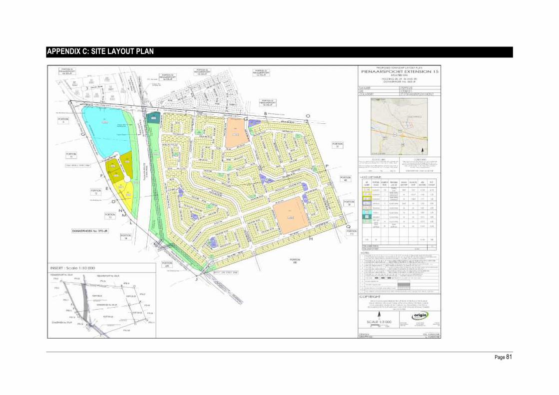
Page 81
APPENDIX C: SITE LAYOUT PLAN

Page 82
APPENDIX D: FACILITY ILLUSTRATION: NOT APPLICABLE
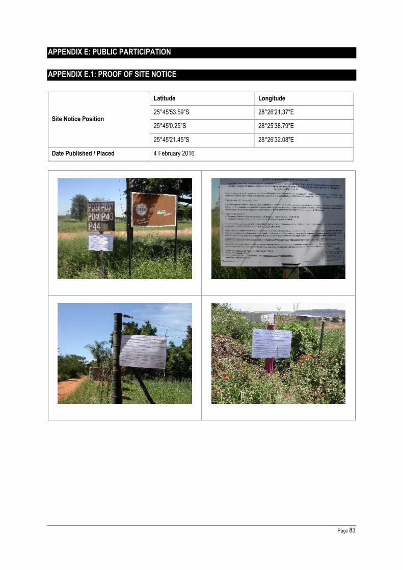
Page 83
APPENDIX E: PUBLIC PARTICIPATION
APPENDIX E.1: PROOF OF SITE NOTICE
Site Notice Position
Latitude Longitude
25°45'53.59"S 28°26'21.37"E
25°45'0.25"S 28°25'38.79"E
25°45'21.45"S 28°26'32.08"E
Date Published / Placed 4 February 2016

Page 84
APPENDIX E.2: WRITTEN NOTICES ISSUED

Page 85
APPENDIX E.3: PROOF OF NEWSPAPER ADVERTISEMENTS
Publication Name Beeld and Pretoria News
Date Published 5 February 2016 - Pretoria News8 February 2016 - Beeld

Page 86
APPENDIX E.4: COMMUNICATIONS TO AND FROM I&APS

Page 87
APPENDIX E.5: MINUTES OF ANY PUBLIC AND/OR STAKEHOLDER MEETINGS
One-on-one meetings with key I&APs, to be held upon request. No public meeting or focus group meeting were conductedat this stage.

Page 88
APPENDIX E.6: COMMENTS AND RESPONSES REPORT
Annexure E6 Comments and Response Report
PROPOSED TOWNSHIPS: 1) PIENAARSPOORT EXTENSION 15 SITUATED ON PORTIONS 28, 29, 36 AND 39 OF THE FARM DONKERHOEK NO 365-JR; AND 2) PIENAARSPOORTEXTENSION 16 SITUATED ON PORTIONS 33 AND 34 OF THE FARM PIENAARSPOORT NO 339-JR WITHIN THE CITY OF TSHWANE METROPOLITAN MUNICIPALITY
Gauteng Department of Agriculture, Rural Development (GDARD)
Basic Assessment Report
Comments and Response Report
Version 1
All written and oral submissions received from Interested and Affected Parties (I&APs) are summarised in this report in table format. I&APs issues and concerns are listed in Column A, with thenames of the I&AP’s in Column B and the issue or concern was raised as well as the correspondence method used, in Column C. Responses to all concerns are provided in Column D.
A B C D
Comments, Questions and Issues Comment By: Date Response(s)
a) The Gauteng Provincial Environmental Management Frame (GPEMF) November 2014provide the following conditions which are applicable in Zone 1: Urban development zone:
Development in this area must be sustainable in respect to the capacity of the environmentand specifically the hydrological system to absorb additional sewage and stormwater loadsas a result of increased densities;
Existing open spaces and urban parks should be retained as open space to cater for theopen space needs the of foreseen increased densities; and
Stormwater drainage must be in accordance with the Water Research Commission Report,2012 and the South African Guidelines for Sustainable Drainage Systems.
City of TshwaneMunicipality:EnvironmentalManagementServicesDepartment: Mr. TMphephu
14 March 2016
Noted. The proposed project can beconsidered as a sustainable developmentthat will prevent pollution and ecologicaldegradation whilst promoting justifiableeconomic and social development.

Page 89
The conditions mentioned above must be adhered to, as per the requirements of the GPEMF.
b) All the recommendations and mitigation measures in the report and specialist studies in theattached appendix must be adhered to and implemented as part of the design, planning andconstruction phase of the development.
City of TshwaneMunicipality:EnvironmentalManagementServicesDepartment: Mr. TMphephu
14 March 2016
Noted. Should the project proponent obtainthe necessary environmental authorisationfor the proposed activities, an EnvironmentalManagement Plan (EMPr) will beimplemented for the design, constructionand operational phases of the development.
c) The area within the class 2 ridge line should not be development; such area should bedesignated as open space and shown as such in the layout plan to be attached to the finalbasic assessment report.
City of TshwaneMunicipality:EnvironmentalManagementServicesDepartment: Mr. TMphephu
14 March 2016Noted. No development is proposed withinthe Class 2 ridge line.
d) The Stormwater Management Plan attached within the draft Basic Assessment Report (BAR)should meet the requirements of the City of Tshwane Roads and Storm Water Division.Comments on the attached Stormwater Management Plan from the City’s Roads and StormWater Division are as follows:
The proposed layout plans for Pienaarspoort Extension 15 & 16 are not acceptable. Theexisting 1:50 year flood plain of the Pienaarspoort Spruit (Tributary of the Edendale Spruit) aswell as the associated wetlands with the buffer zones must be accommodated in the layoutplan of the township;
The proposed channelization of the Pienaarspoort Spruit (Tributary of the Edendale Spruit) isnot acceptable;
Contours must be clearly shown on the proposed layout plans, All areas with seasonal shallow ground water, perched ground water and surface seepage
must be clearly be indicated on the proposed layout plan and zoned open space; The proposed layout Plans for Pienaarspoort Extension15 & as well as the “Stormwater
Management Report for the Formalization of the Tributary of the Edendale Spruit” preparedby Civilconsult Consulting Engineers, must by amended by reflect the above.
City of TshwaneMunicipality:EnvironmentalManagementServicesDepartment: Mr. TMphephu
14 March 2016
An amended Stormwater Management Planis attached as Appendix I: Storm WaterManagement Report for the Formalisation ofthe Tributary of the Edendale Spruit (RouteK54), September 2016.
During a meeting on 19 September 2016with CoTMM is was confirmed that Mr.Gawie Jansen van Vuuren (Chief Engineer:Integrated Stormwater Planning) approvedthe amended Stormwater ManagementPlan.

Page 90
e) Confirmation of service capacity (water, electricity, stormwater and sewer) from the relevantservice providers must be included within the final Basic Assessment Report. Should nocapacity exist for any of these services, an alternative should be discussed within the Report.
City of TshwaneMunicipality:EnvironmentalManagementServicesDepartment: Mr. TMphephu
14 March 2016Noted: Refer to Appendix G for theEngineering Services Report.
f) It is the reasonability of the applicant to comply with the Water Use legislation and apply forwater-use licences and authorisation from Department of Water and Sanitation (DWS)according to the National Water Act where necessary with respect to any activities occurringwithin the wetland, riparian and river boundaries. Comments from DWS should be obtainedand attached in the Final Basic Assessment Report.
City of TshwaneMunicipality:EnvironmentalManagementServicesDepartment: Mr. TMphephu
14 March 2016
A Water Use License (Ref:01/A23A/CI/4300) was issued to theGauteng Department of Roads andTransport for the K54 Road between the K22and K69 as well as the Section of Road 2561from the K54 to Tsamaya Road in Mamelodi.
The water uses authorised are:
3) The impeding or diverting of flow in awater course – Section 21 c; and
4) Altering of bed, banks or characteristicsof a watercourse – Section 21 i.
The conditions of the WUL are integratedinto the proposed Pienaarspoort Extension15 and Pienaarspoort Extension 16townships’ storm water managementsystem.
g) Any form of waste material and rubble generated during the construction must be disposedof at a facility registered in terms of section 20(b) of the National Environmental Management:Waste Act, 2008 (Act N.59 of 2008), if it cannot be responsibly re-used or recycled on site oroffsite. No waste material of any kind may be bruised or burnt.
City of TshwaneMunicipality:EnvironmentalManagementServices
14 March 2016
Noted. All general waste will be removed bya registered waste contractor and taken to alicensed general waste landfill site.According to South African WasteInformation Centre (SAWIC), the closest

Page 91
Department: Mr. TMphephu
registered General Waste landfill site isHatherley Landfill Site.
h) A complete waste handling and separation procedure for the decommissioning phasecompiled and include within the final Basic Assessment Report. The procedure shouldindicate the handling, storing and disposal of any waste in the area.
City of TshwaneMunicipality:EnvironmentalManagementServicesDepartment: Mr. TMphephu
14 March 2016 Refer to Appendix H: EnvironmentalManagement Plan (EMPr).
i) The Geotechnical Investigation and Traffic Impact Study Report should be included withinthe final Basic Assessment report for the perusal.
City of TshwaneMunicipality:EnvironmentalManagementServicesDepartment: Mr. TMphephu
14 March 2016Geotechnical Investigation and TrafficImpact Study Report are attached underAppendix I.
j) According to City of Tshwane Green Building By-laws (July 2013), the proposed developmentshould adhere to the following green building guidelines and be included in the final BAReport:
Provide a site plan that indicates the external hard surface areas, including roofs. Annotatethis plan to indicate that type of surface, the absorptance value.
Provide a table of internal spaces that indicates the number of light fittings and respectivepower ratings.
Provide a table that contains all external light fitting and type of controls. A renewable energy generation report that indicates the building’s predicted renewable
energy generation in kWh/annum, the building’s total predicted annual energy consumptionsourced from renewable sources.
Provide a table that indicates all the flush toilets in the building. This should include themanufacturer and product type, the flush volumes and the respective numbers.
Provide a table that indicates all hand wash basin taps in the building. This should includethe manufacturer and product, the flow rate and the respective numbers.
City of TshwaneMunicipality:EnvironmentalManagementServicesDepartment: Mr. TMphephu
14 March 2016
Noted. The following energy savingsmethods shall be investigated for possibleimplementation for theproposed development: Use of energy efficient lighting, Use of day light wherever possible in
lieu of artificial lighting, Use of renewable solar powered
lighting for external lighting, Switching off of all electrical appliances
at night and times not in use, Use of high-efficient HVAC systems, Use of solar water heating, Setting thermostats of water heaters at
the most efficient level,

Page 92
Provide a plan drawing that indicates hot water pipe runs from the generating devices to theconsumption point(s).
Provide a plan drawing that indicates the rainwater harvesting tank and the linked waterconsumption areas.
An on-site storm water retention report that indicates the predicted on-site storm waterretention performance of the project should be provided. This should show that at least 80%of run-off volume is retained on-site.
Insulation of hot water pipes and hotwater storage tanks,
Use of low-flow shower heads.
1. Page 26 & 46 of the report indicate that the proposed townships are within 500m from boundaryof a wetland, please note that these trigger Section 21 (c) and (i) wateruse of National Water Act,1998 (Act NO.36 of 1998) which require authorisation by the Department.
Department ofWater andSanitation:Llmpopo-NW CMA
31 March 2016
A Water Use License (Ref:01/A23A/CI/4300) was issued to theGauteng Department of Roads andTransport for the K54 Road between the K22and K69 as well as the Section of Road 2561from the K54 to Tsamaya Road in Mamelodi.
The water uses authorised are:
5) The impeding or diverting of flow in awater course – Section 21 c; and
6) Altering of bed, banks or characteristicsof a watercourse – Section 21 i.
The conditions of the WUL are integratedinto the proposed Pienaarspoort Extension15 and Pienaarspoort Extension 16townships’ storm water managementsystem.
Refer to Appendix F: Water Use License(Ref: 01/A23A/CI/4300)
2. Page 02 & 03 of the report indicate that the proposed townships will receive sanitation andwater services from City of Tshwane Metropolitan Municipality, an agreement between themunicipality and the applicant must be submitted to this Department for record purposes.
Department ofWater and
31 March 2016Noted. Should the project proponent obtainthe necessary environmental authorisationfor the proposed activities, a Services

Page 93
Sanitation facilities should be provided for employees during construction, preferably chemicaltoilets and the contents should be disposed to an authorised sewage work facility.
Sanitation:Llmpopo-NW CMA
Agreement will be submitted to theDepartment for record purposes
3. All waste materials (including non-biodegradable and biodegradable) generated during theactivity should be disposed of at a permitted landfill site and an agreement between themunicipality and the contractor must be submitted to this office regarding the disposal of suchwaste material.
Department ofWater andSanitation:Llmpopo-NW CMA
31 March 2016
Noted. All general waste will be removed bya registered waste contractor and taken to alicensed general waste landfill site.According to South African WasteInformation Centre (SAWIC), the closestregistered General Waste landfill site isHatherley Landfill Site.
4. Any oil spillages, diesel or any other hazardous substance should be treated anddisposed of at a permitted hazardous landfill site and the Department must be notifiedwithin 24 hours.
Department ofWater andSanitation:Llmpopo-NW CMA
31 March 2016 Noted.
5. No construction or development should take place within the scale of 1:100 year flood line andor riparian area without an authorisation from this Department.
Department ofWater andSanitation:Llmpopo-NW CMA
31 March 2016
A Water Use License (Ref:01/A23A/CI/4300) was issued to theGauteng Department of Roads andTransport for the K54 Road between the K22and K69 as well as the Section of Road 2561from the K54 to Tsamaya Road in Mamelodi.
The water uses authorised are:
7) The impeding or diverting of flow in awater course – Section 21 c; and
8) Altering of bed, banks or characteristicsof a watercourse – Section 21 i.
The conditions of the WUL are integratedinto the proposed Pienaarspoort Extension15 and Pienaarspoort Extension 16townships’ storm water managementsystem.
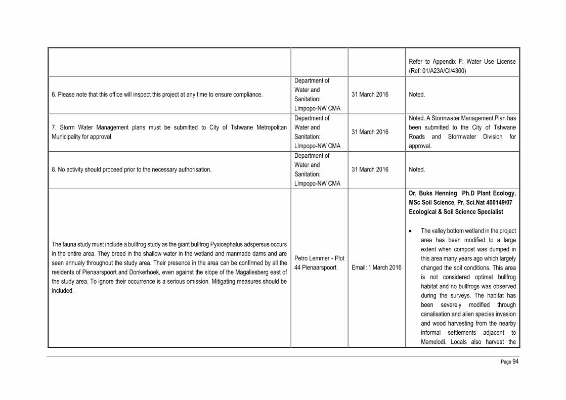
Page 94
Refer to Appendix F: Water Use License(Ref: 01/A23A/CI/4300)
6. Please note that this office will inspect this project at any time to ensure compliance.
Department ofWater andSanitation:Llmpopo-NW CMA
31 March 2016 Noted.
7. Storm Water Management plans must be submitted to City of Tshwane MetropolitanMunicipality for approval.
Department ofWater andSanitation:Llmpopo-NW CMA
31 March 2016
Noted. A Stormwater Management Plan hasbeen submitted to the City of TshwaneRoads and Stormwater Division forapproval.
8. No activity should proceed prior to the necessary authorisation.
Department ofWater andSanitation:Llmpopo-NW CMA
31 March 2016 Noted.
The fauna study must include a bullfrog study as the giant bullfrog Pyxicephalus adspersus occursin the entire area. They breed in the shallow water in the wetland and manmade dams and areseen annualy throughout the study area. Their presence in the area can be confirmed by all theresidents of Pienaarspoort and Donkerhoek, even against the slope of the Magaliesberg east ofthe study area. To ignore their occurrence is a serious omission. Mitigating measures should beincluded.
Petro Lemmer - Plot44 Pienaarspoort Email: 1 March 2016
Dr. Buks Henning Ph.D Plant Ecology,MSc Soil Science, Pr. Sci.Nat 400149/07Ecological & Soil Science Specialist
The valley bottom wetland in the projectarea has been modified to a largeextent when compost was dumped inthis area many years ago which largelychanged the soil conditions. This areais not considered optimal bullfroghabitat and no bullfrogs was observedduring the surveys. The habitat hasbeen severely modified throughcanalisation and alien species invasionand wood harvesting from the nearbyinformal settlements adjacent toMamelodi. Locals also harvest the

Page 95
bullfrogs where they still occur and as aresult most of the bullfrogs in the areasadjacent to Mamelodi townships havedisappeared;
The pig farm sludge dams do notpresent habitat for bullfrogsconsidering the dams to be very deepalong its edges creating very littlesuitable and shallow bullfrog habitat,while the water quality in the sludgedams is aso considered inadequate tosupport populations and breeding ofbullfrogs;
It is acknowledged that bullfrogs mightoccur in the larger area, although thedegradation of habitat to the north ofthe N4 makes the probability of findingany bullfrogs here much lower,compared to the more natural areas tothe south of the N4.

Page 96
APPENDIX E.7: COMMENTS FROM I&APS ON BASIC ASSESSMENT (BA) REPORT
APPENDIX E.8: COMMENTS FROM I&APS ON AMENDMENTS TO THE BA REPORT
Any comments received from I&APs on the DBAR will be included in the Final Basic Assessment Report.

Page 97
APPENDIX E.9: REGISTER OF I&APS
NAMEAFFILIATION / KEY
STAKEHOLDERSTATUS
PHYSICAL ADDRESS POSTAL ADDRESS TELEPHONE / CELL PHONE EMAIL ADDRESS
NATIONAL AUTHORITIESSouth Africa Heritage ResourceAgencyAttention: The Chief Executive OfficerMr. Andrew Solomon
Heritage OfficerArchaeology
111 Harrington StreetCape Town
8001
P.O. Box 4637Cape Town
8000
Tel: 021 462 4502Fax: 021 462 4509
Department of Water AffairsAttention: Regional Head: North WestMr. Thato Mjona
InstitutionalEstablishment: Water
Resource Management
185 Francis Baard StreetBothongo Pleza East
15th FloorPretoria
0001
Private Bag X313Pretoria
0001
Tel: 012 336 8217Fax: 012 336 6608
PROVINCIAL AUTHORITIESGauteng Department of Agriculture,Rural DevelopmentAttention: Office of the Head ofDepartmentMs. Thandeka Mbassa
Department Director:Strategic Administration
Support
Diamond Building11 Diagonal Street
NewtownJohannesburg
P. O. Box 8769Johannesburg
2000
Tel: 011 240 2500Fax: 011 240 2700
LOCAL AUTHORITYCity of Tshwane MetropolitanMunicipalityAttention: Executive Director:Environmental Management and ParksDivisionMr. Livhuwani Siphuma
EnvironmentalManagement Service
department
4th Floor,11 Francis Baard Street
Pretoria
P.O Box 1454Pretoria
0001
Tel: 012 358 8871Fax: 012 358 8934
WARD COUNCILLOR
Mr. Christopher Mantual MahlaseAttention: Councillor Ward Ward 100 -
P.O Box 440Pretoria
0001
Tel: 012 358 7911Cell: 083 744 9139Fax: 012 323 5117
ADJACENT LANDOWNER
Ms. Magegretha Embrensia Jooste Ptn 43 Pienaarspoort339-JR
Plot 43, Pienaarspoort,Pretoria, 0002
P.O Box 792,Faerie Glen
Tel: 012 802 0270Cell: 072 180 2988 -

Page 98
NAMEAFFILIATION / KEY
STAKEHOLDERSTATUS
PHYSICAL ADDRESS POSTAL ADDRESS TELEPHONE / CELL PHONE EMAIL ADDRESS
0043
Ms. Petro Lemmer Ptn 44 Pienaarspoort 339-JR
44 Hoewe,Cullinan
1000
P.O Box 912878,Silverton
0127
Tel: 012 802 0727Cell: 078 332 4427 [email protected]
Mr. Heinrich Schulte Ptn 40 Pienaarspoort 339-JR [email protected]
Barry MacDougall on behalf ofAvondzon Trust cc Ptn 108, 111, 112 & 113 Cell: 079 880 2131 [email protected]
Donald Evers Tel: +27 (0)12 679 9470 |Mobile: + 27 (0)82 829 6681 [email protected]
Mr HD Kehler Ptn 42 Pienaarspoort 339-JR [email protected]
Mr. William Frederick Towsen Ptn 37 Donkerhoek 365-JR
211 Moller Street,Meyerspark
0184- Tel: 012 802 0292
Cell: 072 373 1099 -
Mr. Hendrik Cornelius Beukes Ptn 38 Donkerhoek 365-JR
23 Torint AvenueEast Lynne
0186
P.O Box 35631Menlo Park
0102
Tel: 012 333 3122Cell: 083 468 4002 [email protected]
Mr. George Von Welfling Eybers Ptn 105 Donkerhoek 365-JR
591 Mitchell StreetPretoria West
0183- Tel: 012 327 0630
Cell: 072 640 8951 -
Little Swift Investment 360 (Pty) Ltd Ptn 106 Donkerhoek 365-JR
Plot 375Swavelpoort
Pretoria0081
Private Bag X90006Garsfontein
0042
Tel: 012 841 4609/012 841 4607
Cell: 083 258 2586
Five Lions Trust Ptn 240 Donkerhoek 365-JR - - - -
City of Tshwane MetropolitanMunicipality Ptn 3 Donkerhoek 370-JR - - - -
Transnet Ltd Ptn 11 Donkerhoek 370-JR
47th FloorCarlton CentreJohannesburg
P.O Box 72501,Parkview,
JohannesburgTel: 011 308 3000 -

Page 99
NAMEAFFILIATION / KEY
STAKEHOLDERSTATUS
PHYSICAL ADDRESS POSTAL ADDRESS TELEPHONE / CELL PHONE EMAIL ADDRESS
2001 2122
Transnet Ltd Ptn 12 Donkerhoek 370-JR
47th FloorCarlton CentreJohannesburg
2001
P.O Box 72501Parkview
Johannesburg2122
Tel: 011 308 3000 -
Transnet Ltd Ptn 13 Donkerhoek 370-JR
47th FloorCarlton CentreJohannesburg
2001
P.O Box 72501Parkview
Johannesburg2122
Tel: 011 308 3000 -
Transnet Ltd Ptn 14 Donkerhoek 370-JR
47th FloorCarlton CentreJohannesburg
2001
P.O Box 72501Parkview
Johannesburg2122
Tel: 011 308 3000 -
Mr & Ms GroenewaldMr & Mrs JacobsMr & Ms SteenkampJT Burke (Portion 106, Rietfontein,Rayton)
Karen van Zyl Portion 106, Rietfontein,Rayton 082 975 8352 [email protected]
Herman Louw P.O.Box 75010,Lynwoodridge 0040 082 800 2694 [email protected]
Danie B Pretorius 079 523 4818 [email protected]
Mr & Mrs Van Zyl - -P.O Box 2372
Zwavelpoort0036
Cell: 082 829 7177 [email protected]
Ms. Taryn – Lee Kearney Plot 83, Plaas Rietfontein,Donkerhoek
Plot 83,Plaas Rietfontein
Donkerhoek- Tel: 012 940 8184 [email protected]
Mr. Kobus VermaakPlot 121, Plaas
Rietfontein,Donkerhoek
Plot 121,Plaas Rietfontein
Donkerhoek- Tel: 012 736 2412
Cell: 082 772 9983 [email protected]

Page 100
NAMEAFFILIATION / KEY
STAKEHOLDERSTATUS
PHYSICAL ADDRESS POSTAL ADDRESS TELEPHONE / CELL PHONE EMAIL ADDRESS
Mr / Mrs Van der Merwe Plot 109 Rietfontein Plot 109 Rietfontein - Tel: 012 736 2046 [email protected]
Cullinan ConservancyAttention: J-L Du Toit
Chairperson :NE Representative
Gauteng Conservancy &Stewardship Association
P.O. 1000Rayton
1001- Tel: 012 736 2069
Cell: 082 681 5122 [email protected]

Page 101
APPENDIX E.10: LIST OF STATE DEPARTMENTS
NAMEAFFILIATION / KEY
STAKEHOLDERSTATUS
PHYSICAL ADDRESS POSTAL ADDRESS TELEPHONE / CELL PHONE EMAIL ADDRESS
NATIONAL AUTHORITIESSouth Africa Heritage ResourceAgencyAttention: The Chief Executive OfficerMr. Andrew Solomon
Heritage OfficerArchaeology
111 Harrington StreetCape Town
8001
P.O. Box 4637Cape Town
8000
Tel: 021 462 4502Fax: 021 462 4509
Department of Water AffairsAttention: Regional Head: North WestMr. Thato Mjona
InstitutionalEstablishment: WaterResource Management
185 Francis Baard StreetBothongo Pleza East
15th FloorPretoria
0001
Private Bag X313Pretoria
0001
Tel: 012 336 8217Fax: 012 336 6608
PROVINCIAL AUTHORITIESGauteng Department of Agriculture,Rural DevelopmentAttention: Office of the Head ofDepartmentMs. Thandeka Mbassa
Department Director:Strategic AdministrationSupport
Diamond Building11 Diagonal Street
NewtownJohannesburg
P. O. Box 8769Johannesburg
2000
Tel: 011 240 2500Fax: 011 240 2700
LOCAL AUTHORITYCity of Tshwane MetropolitanMunicipalityAttention: Executive Director:Environmental Management and ParksDivisionMr. Livhuwani Siphuma
EnvironmentalManagement Servicedepartment
4th Floor,11 Francis Baard Street
Pretoria
P.O Box 1454Pretoria
0001
Tel: 012 358 8871Fax: 012 358 8934
WARD COUNCILLOR
Mr. Christopher Mantual MahlaseAttention: Councillor Ward Ward 100 -
P.O Box 440Pretoria
0001
Tel: 012 358 7911Cell: 083 744 9139Fax: 012 323 5117

Page 102
APPENDIX F: WATER USE LICENSE(S) AUTHORISATION, SAHRA INFORMATION, SERVICELETTERS FROM MUNICIPALITIES, WATER SUPPLY INFORMATION

Page 103
APPENDIX G:1: SPECIALIST REPORT: A BIODIVERSITY IMPACT ASSESSMENT FOR THEPROPOSED TOWNSHIP ESTABLISHMENT, EXIGO SUSTAINABILITY, AUGUST 2015

Page 104
APPENDIX G:2: SPECIALIST REPORT: A WETLAND AND RIPARIAN DELINEATION ANDFUNCTIONALITY ASSESSMENT FOR THE PROPOSED TOWNSHIP ESTABLISHMENT, EXIGOSUSTAINABILITY, AUGUST 2015

Page 105
APPENDIX G:3: SPECIALIST REPORT: ARCHAEOLOGICAL IMPACT ASSESSMENT (AIA), EXIGOSUSTAINABILITY, AUGUST 2015

Page 106
APPENDIX H: EMPR

Page 107
APPENDIX I.1: OTHER INFORMATION: ENGINEERING SERVICES REPORT

Page 108
APPENDIX I.2: OTHER INFORMATION: STORMWATER MANAGEMENT PLAN

Page 109
APPENDIX I.3: OTHER INFORMATION: GEOTECHNICAL REPORT