racine county wisconsin - sewrpc · community assistance planning report number 270 a park and open...
TRANSCRIPT

COMMUNITY ASSISTANCE
PLANNING REPORT NO. 270
A PARK AND OPENSPACE PLAN FORTHE CITY OF RACINE
RACINE COUNTYWISCONSIN
S O U T H E A S T E R N W I S C O N S I N R E G I O N A L P L A N N I N G C O M M I S S I O N

SOUTHEASTERN WISCONSIN
REGIONAL PLANNING COMMISSION
KENOSHA COUNTY RACINE COUNTY
MILWAUKEE COUNTY WALWORTH COUNTY
WASHINGTON COUNTY
LeonT. DregerThomas J. GorlinskiSheila M. Siegler
Richard A. Hansen,Secretary
Jean M. JacobsonJames E. Moyer
Daniel J. DilibertiWilliam R. Drew,Vice Chairman
Linda J. Seemeyer
Anthony F. Balestrieri
Allen L. MorrisonGregory L. Holden
Robert A. BrooksThomas H. Buestrin,Chairman
Gus W. Wirth, Jr.
OZAUKEE COUNTY
WAUKESHA COUNTY
Kenneth F. MillerDaniel S. Schmidt
Duane H. Bluemke,
Kenneth C. HerroPaul G. Vrakas
Treasurer
SOUTHEASTERN WISCONSIN REGIONAL
PLANNING COMMISSION STAFF
CITY OF RACINE OFFICIALS
Philip C. Evenson,AICP . . . . . . . . . . . . . . Executive Director
Kenneth R.Yunker, PE . . . . . . . . . . . . . . . . . . DeputyDirector
Robert P. Biebel, PE, PH . . . . . Chief Environmental Engineer
Leland H. Kreblin, RLS . . . . . . . . . . Chief Planning Illustrator
ElizabethA. Larsen. . . . . . . . . . . . . . . . . . Business Manager
John G. McDougall . . . . . . . . . . . . . Geographic InformationSystems Manager
John R. Meland . . . . Chief Economic Development Planner
Dr. Donald M. Reed. . . . . . . . . . . . . . . . . . . . . Chief Biologist
William J. Stauber,AICP. . . . . . . . . . Chief Land Use Planner
Special acknowledgment is due SEWRPC Planner Robbie L.Robinson for his contributions to the preparation of thisreport.
Nancy M.Anderson,AICP . . . . . . . . . . . . . Chief CommunityAssistance Planner
Robert E. Beglinger. . . . . . . . Chief Transportation Engineer
MAYOR
Gary Becker
PARKS, RECREATION, AND
CULTURAL SERVICES BOARD
DIRECTOR OF PARKS, RECREATION,
AND CULTURAL SERVICES
ASSISTANT DIRECTOR OF PARKS,
RECREATION, AND CULTURAL SERVICES
CITY CLERK
Dan Baran, ChairmanSusan BarbeeKaren Bayer
Jeff CoeWillard Eickhorst
John EngelBrian Jennings
Andrew KindsvaterJulie McKennaRichard Polzin
Daniel Sharkozy
Donnie Snow
Jack Schumann
Karen Norton

COMMUNITY ASSISTANCE PLANNING REPORT NUMBER 270
A PARK AND OPEN SPACE PLAN FOR THE CITY OF RACINE
RACINE COUNTY, WISCONSIN
Prepared by the
Southeastern Wisconsin Regional Planning Commission P.O. Box 1607
W239 N1812 Rockwood Drive Waukesha, Wisconsin 53187-1607
www.sewrpc.org
July 2003
Inside Region $ 5.00 Outside Region $10.00

(This page intentionally left blank)

iii
TABLE OF CONTENTS
Page
Chapter I—INTRODUCTION ........................ 1 Plan Context ........................................................ 1 City Request ........................................................ 2 Advisory Committee ........................................... 2 Planning Area ...................................................... 2 Report Format...................................................... 2 Chapter II—INVENTORY FINDINGS .......... 5 Introduction ......................................................... 5 Resident Population............................................. 5 Land Use Base..................................................... 5 Park and Open Space Sites .................................. 6 Existing Park and Open Space Sites ................ 6 City of Racine Park System .......................... 8 BI-Centennial Gardens.................................. 8 Brose Park..................................................... 8 Builders Park................................................. 8 Carlson Park.................................................. 8 Carre Hogle Park........................................... 8 Case-Harmon Park ........................................ 12 Cedar Bend Park ........................................... 12 Cheska Park .................................................. 12 City Hall........................................................ 12 City Land ...................................................... 12 Clayton Park.................................................. 12 Colbert Park .................................................. 12 Colonial Park ................................................ 13 Crosswalk Park ............................................. 13 De Koven Woods.......................................... 13 Dr. Hamilton Park......................................... 13 Dr. Martin Luther King, Jr. Park................... 13 Dr. Martin Luther King, Jr. Plaza ................. 13 Dr. Pierce Park .............................................. 13 Dodge Park ................................................... 13 Douglas Park................................................. 13
Page Erskine Park .................................................. 13 Festival Park .................................................. 13 Franklin Park ................................................. 13 Fuller Park ..................................................... 13 Gaslight Pointe .............................................. 13 Graceland Cemetery ...................................... 18 Grand Park..................................................... 18 Greencrest Park ............................................. 18 Hagerer Park.................................................. 18 Hantschel Park............................................... 18 Harris Plaza ................................................... 18 Harvey Park................................................... 18 Highland Park................................................ 18 Horlick Athletic Field.................................... 18 Humble Park.................................................. 19 Island Park..................................................... 19 Jay-Eye-See Park........................................... 19 Johnson Park Dog Run .................................. 19 Johnson Park and Golf Course ...................... 19 John Thompson Park ..................................... 19 Jonas Park...................................................... 19 Jones Park...................................................... 19 Lakeview Park ............................................... 19 Lee Park......................................................... 19 Lincoln Park .................................................. 19 Lockwood Park.............................................. 20 Maple Grove Park.......................................... 20 Marino Park................................................... 20 Marquette Park .............................................. 20 Mary Ellen Helgren Johnson Preserve .......... 20 Mat Matson Park ........................................... 20 Monument Square ......................................... 20 Mound Cemetery ........................................... 20 North Beach................................................... 20 Oak Park ........................................................ 20

iv
Page
Olsen Prairie.................................................. 20 Park Place ..................................................... 20
Parker Park.................................................... 20 Pedar Back Park............................................ 20 Pershing Park ................................................ 21 Pierce Woods Park........................................ 21 Pugh Recreation Area ................................... 21 Racine Zoological Gardens........................... 21 Randolph Park............................................... 21 Reservoir Park............................................... 21 Riverside Park............................................... 21 Robert G. Heck Park ..................................... 21 Rooney Recreation Area ............................... 21 Roosevelt Park .............................................. 21 Sam Azarian Overlook.................................. 21 Samuel Myers Park ....................................... 21 Shoop Park Golf Course ............................... 22 Simonson Park .............................................. 22 Solbraa Park .................................................. 22 Springvale East Park ..................................... 22 Springvale West Park.................................... 22 State-Hamilton Park...................................... 22 Wallis Park.................................................... 22 Washington Park Bowl ................................. 22 Washington Park Golf Course ...................... 22 Washington Park Community Center ........... 22 Wellington Park ............................................ 22 West Park ...................................................... 22 Wustum Museum.......................................... 22 Racine County Parks ........................................ 23 Trail Facilities .................................................. 23 Natural Resource Features................................... 23 Environmental Corridors and Isolated Natural Resource Areas .................... 23 Primary Environmental Corridors................. 25 Secondary Environmental Corridors and Isolated Natural Resource Areas .......... 27 Natural Areas and Critical Species Habitat Sites...................... 27 Summary ............................................................. 30 Chapter III—FRAMEWORK FOR PLAN DEVELOPMENT ................................ 31 Plans Affecting the City Park and Open Space Plan ......................................... 31 Lake Michigan Pathway Master Plan............... 31 Other Local Plans ............................................. 33 County and Regional Plans .............................. 33
Page Regional and County Park and Open Space Plans ......................... 33 Regional Natural Areas ................................. 34 Objectives, Principles, and Standards .................. 34 Park and Open Space Needs ................................ 35 Forecast Population .......................................... 35 Community and Neighborhood Parks............... 35 Site Needs Based on Per Capita Standards....................................... 36 Site Needs Based on Service Area Standards................................... 36 Facility Needs Based on Per Capita Standards....................................... 36 Facility Needs Based on Service Area Standards................................... 37 Baseball Diamonds........................................ 37 Basketball Goals............................................ 40 Playfields ....................................................... 40 Playgrounds ................................................... 44 Soccer Fields ................................................. 44 Softball Diamonds (League).......................... 44 Tennis Courts ................................................ 44 Swimming Pool or Beach.............................. 44 Other Site and Facility Need Considerations....................................... 44 Open Space Preservation Needs ....................... 44 Summary .............................................................. 49 Chapter IV—PARK AND OPEN SPACE PLAN ...................................... 51 Introduction.......................................................... 51 Areawide Park and Open Space Recommendations.......................... 52 Major Parks and Trail Facilities........................ 52 Open Space Preservation ..................................... 54 Primary Environmental Corridors .................... 54 Secondary Environmental Corridors ................ 57 Isolated Natural Resource Areas....................... 57 Critical Species Habitat Sites and Geological Sites ....................................... 57 City Park and Open Space Recommendations ................................... 59 Existing Park and Open Space Sites and Facilities .......................................... 59 Open Space Preservation .................................. 63 Bicycle and Pedestrian Route and Trail System............................................. 63 Plan Implementation ............................................ 63 Wisconsin Department of Natural Resources ... 63

v
Page
Wisconsin Department of Transportation ........ 64 Racine County.................................................. 64 City of Racine .................................................. 64 Plan Costs......................................................... 65 Summary ............................................................. 65
Page
Chapter V—SUMMARY .................................. 67 Inventory Findings ............................................... 67 Park and Open Space Objectives, Principles, and Standards and Needs Analysis .................... 68 Adopted Plan........................................................ 68
LIST OF APPENDICES Appendix Page
A Outdoor Recreation and Open Space Planning, Objectives, Principles, and Standards ................... 73 B Capital Improvement Program for the City of Racine Parks-Related Items: 2003-2007 ................. 83 C Ordinance of the Common Council of the City of Racine Adopting the 2020 Park and Open Space Plan for the City ............................................................. 85
LIST OF TABLES Table Page
Chapter II 1 Resident Population of the City of Racine: 1900-2000.................................................................... 6 2 Land Uses in the City of Racine Planning Area: 2000..................................................................... 8 3 Park and Open Space Sites in the City of Racine Planning Area: 2001........................................... 10 4 Selected Outdoor Recreation Facilities for General Use in the City of Racine Planning Area: 2001 .................................................................. 16 5 Environmental Corridors and Isolated Natural Resource Areas in the City of Racine Planning Area: 1995....................................................................................... 27 6 Critical Species Habitat Sites and Geological Sites in the City of Racine Planning Area: 1994 .............................................................................. 28
Chapter III 7 Per Capita Acreage Requirements for Community and Neighborhood Parks in the City of Racine Planning Area ............................................................... 37 8 Per Capita Requirements for Selected Outdoor Recreation Facilities in the City of Racine Planning Area ............................................................... 40
Chapter IV 9 Existing and Proposed Ownership of Environmental Corridors in the City of Racine Planning Area................................................................................. 57 10 Recommended Protection of Critical Species Habitat Sites and Geological Sites in the City of Racine Planning Area............................................................... 58 11 Proposed Improvements at Existing Parks in the City of Racine: 2003-2007.................................. 60 12 Proposed Facility Development at Existing Parks in the City of Racine: 2008-2020 ...................... 61 13 Estimated Yearly Costs of the Capital Improvement Program for the City of Racine: 2003-2007 ..................................................................................... 66

vi
LIST OF FIGURES Figure Page
Chapter II 1 Historical Population Levels in the City of Racine: 1900-2000....................................................... 6
LIST OF MAPS Map Page
Chapter I 1 Location of the City of Racine Planning Area in the Southeastern Wisconsin Region.................... 3
Chapter II 2 Generalized Historical Urban Growth in the City of Racine: 1850-1995 ........................................ 7 3 Existing Land Uses in the City of Racine Planning Area: 2000....................................................... 9 4 Park and Open Space Sites in the City of Racine Planning Area: 2001........................................... 14 5 Existing Trails in the City of Racine Planning Area: 2002 .............................................................. 24 6 Environmentally Significant Lands in the City of Racine Planning Area: 1995.............................. 26 7 Critical Species Habitat Sites and Geological Sites in the City of Racine Planning Area: 1994 .............................................................................. 29
Chapter III 8 The Proposed Lake Michigan Pathway within the City of Racine: 2002......................................... 32 9 Planned Residential Areas in the City of Racine Planning Area Not Adequately Served by a Community Park................................................................................. 38 10 Planned Residential Areas in the City of Racine Planning Area Not Adequately Served by a Neighborhood Park............................................................................. 39 11 Planned Residential Areas in the City of Racine Planning Area Not Adequately Served by a Baseball Diamond .............................................................................. 41 12 Planned Residential Areas in the City of Racine Planning Area Not Adequately Served by a Basketball Goal .................................................................................. 42 13 Planned Residential Areas in the City of Racine Planning Area Not Adequately Served by a Playfield ............................................................................................. 43 14 Planned Residential Areas in the City of Racine Planning Area Not Adequately Served by a Playground.......................................................................................... 45 15 Planned Residential Areas in the City of Racine Planning Area Not Adequately Served by a Soccer Field........................................................................................ 46 16 Planned Residential Areas in the City of Racine Planning Area Not Adequately Served by a League Softball Diamond................................................................... 47 17 Planned Residential Areas in the City of Racine Planning Area Not Adequately Served by a Tennis Court ....................................................................................... 48
Chapter IV 18 Outdoor Recreation Element of the Racine County Park and Open Space Plan: 2020.................... 53 19 Outdoor Recreation Plan for the City of Racine Planning Area: 2020............................................. 55 20 Open Space Preservation Plan for the City of Racine Planning Area .............................................. 56
Chapter I
INTRODUCTION PLAN CONTEXT Broadly defined, recreation is an activity or experience undertaken solely for the pleasure or satisfaction derived from it. Recreation can be experienced indoors or outdoors and encompasses a wide variety of human activities and permits the opportunity for participation in many resource and nonresource-oriented activities. It includes both mental and physical exercise, personal enjoyment, enhances the quality of life, and includes various social, environmental, and economical benefits. Such benefits can improve physical health, contribute to mental well-being, protect biological communities, enhance air quality, provide attraction for tourism, make communities more desirable for development, and increase property values. Although recreational preferences may vary from individual to individual, recreation occupies a necessary and significant place in every person's life. For the purpose of this report, recreation will be viewed in a narrower framework as including only those recreational activities typically carried on outdoors. The intent of the park and open space plan for the City of Racine is to guide the preservation and development of land for park, outdoor recreation, and related open space purposes as needed to satisfy the recreational needs of City residents and to protect and enhance the important natural resources within the City. The plan seeks to provide a variety of recreational sites and facilities that will offer opportunities for City residents to participate in an appropriate range of active and passive recreational pursuits. Owing to the importance of outdoor recreation sites and areas for natural resource protection, park and open space development and use have long been issues of concern to public officials and citizen leaders. On December 1, 1977, the Southeastern Wisconsin Regional Planning Commission adopted SEWRPC Planning Report No. 27, A Regional Park and Open Space Plan for Southeastern Wisconsin: 2000, which identifies existing and probable future park and open space needs within the Region and recommends a system of large resource-oriented parks, recreational corridors, a regional trail system, smaller nonresource-oriented urban parks, and attendant recreational facilities. The regional park and open space plan was refined and detailed within Racine County through preparation of a park and open space plan for the County in 1988. An updated Racine County Park and Open Space Plan was adopted by the County Board in May 2001. That plan, with a design year of 2020, was adopted as an amendment to the regional plan by the Southeastern Wisconsin Regional Planning Commission in December 2001. The City of Racine Plan Commission endorsed the County plan in January 2002.

2
CITY REQUEST The City of Racine, in January 2000, requested that the Regional Planning Commission assist in the preparation of a new City park and open space plan. The plan is to reflect recent park and open space acquisition and development activities within the City and determine if additional recreational sites or facilities are needed. The plan is also intended to establish City eligibility to apply for and receive Federal and State aids in partial support of the development of park and open space sites and facilities. The requested new plan is documented in this report. This plan updates a park plan prepared by the City in 1988. ADVISORY COMMITTEE The planning process was conducted under the guidance of the City of Racine Parks, Recreation and Cultural Services Board. The Board consists of government officials and citizens. A complete membership list of the Parks, Recreation, and Cultural Services Board is provided on the inside front cover of this report. PLANNING AREA The planning area, as shown on Map 1, consists of the entire City of Racine, including Johnson Park and Golf Course and the Johnson Park Dog Run, which are within the City’s corporate limits, but detached from the rest of the City, and Shoop Park Golf Course, which is owned by the City but located in the Village of Wind Point. The planning area is located in U.S. Public Land Survey Townships 2 and 3 North and Ranges 22 and 23 East in the eastern portion of Racine County along the Lake Michigan shoreline. The planning area encompasses 10,087 acres, or about 16 square miles, including 10,024 acres within the City of Racine corporate limits and 63 acres within Shoop Park Golf Course. The City is bounded on the north by the Town of Caledonia and the Village of Wind Point, on the east by Lake Michigan and the Village of North Bay, on the south by the Village of Elmwood Park, and on the south and west by the Town of Mount Pleasant. REPORT FORMAT The findings and recommendations of the City park and open space plan are set forth in this report. Following this introductory chapter, Chapter II presents information about the City pertinent to park and open space planning, including information on the resident population, the land use pattern, and natural resources within the planning area. An inventory of existing park and open space sites and facilities within the planning area is also included in Chapter II. Chapter III sets forth the framework for plan development, including the forecast population and regional, county, and City plans affecting the park system. Chapter III also presents the objectives, principles, and supporting standards which served as the basis for the needs analysis and the design of the park plan. The adopted park and open space plan is presented in Chapter IV. Chapter V presents a summary of the plan.

Source: SEWRPC.
Map 1
LOCATION OF
THE CITY OF RACINE
PLANNING AREA IN THE
SOUTHEASTERN WISCONSIN REGION
PLANNINGAREA
3
EAST
WHITEWATER
DELAVAN
DARIEN
SHARON
FONTANA ON
GENEVA LAKE
WALWORTH
WILLIAMS BAY
LAKEGENEVA
GENOA
CITY
ELKHORN
TROY
TroyLa GrangeWhitewater
Richmond Sugar Creek Lafayette Spring Prairie
LyonsDelavanDarien
Sharon Walworth Linn
Geneva
Bloomfield
East Troy
WALWORTH CO. WISCONSINILLINOIS
WA
LWO
RT
H C
O.
WA
LWO
RT
H
CO
.
Randall
Wheatland
Brighton
Bristol
Somers
Paris
Salem KENOSHA CO.
KE
NO
SH
A C
O.
PLEASANT PRAIRIE
KENOSHAPADDOCK LAKE
SILVER
LAKE
TWIN
LAKES
Dover
Norway Raymond Caledonia
Mount PleasantYorkville
Burlington
Waterford
Rochester
ROCHESTER
BURLINGTON
UNIONGROVE
ELMWOOD PARK
NORTH BAY
WIND
POINT
STURTEVANT
RACINE
WATERFORD
RACINE CO.KENOSHA CO.
RA
CIN
E
C
O.
RACINE CO.
MILWAUKEE CO.
BROWN
DEERRIVER
HILLS
BAYSIDE
FOX
POINT
GLEN-DA LE
WHITEFISH
BAY
SHOREWOOD
MILWAUKEE
WAUWATOSA
WEST
MILWAUKEE
WESTALLIS
ST. FRANCIS
CUDAHY
GREENFIELD
GREEN-
DALE
HALES
CORNERS
FRANKLINOAK CREEK
SOUTHMILWAUKEE
Belgium
Port washington
Saukville
GraftonCedarburg
OZAUKEE CO.
OZAUKEEMILWAUKEE
OZ
AU
KE
E
CO.CO.
CO
.
MEQUON
CEDARBURG
GRAFTON
SAUKVILLE
FREDONIA
Fredonia
BELGIUM
PORTWASHINGTON
THIENSVILLE
LA
KE
MIC
HIG
AN
Wayne
Kewaskum
Farmington
Barton
TrentonWest bendAddison
Hartford Polk Jackson
RichfieldErin
WASHINGTON
WA
SH
ING
TO
N
WA
SH
ING
TO
N
CO
.
CO
.
CO.
GERMANTOWN
Germantown
BEND
WEST
KEWASKUM
NEWBURG
JACKSONSLINGERHARTFORD
Lisbon
BROOKFIELD
Brook-
field
Waukesha
Vernon
Genesee
Mukwonago
Ottawa
Eagle
Merton
DelafieldSummit
Oconomowoc
WASHINGTON CO.WAUKESHA CO.
WAUKESHA CO.
WA
UK
ES
HA
C
O.
WA
UK
ES
HA
C
O.
MIL
WA
UK
EE
C
O.
WALWORTH CO.
MENOMONEE FALLS
BUTLER
ELM
GROVE
NEW BERLIN
MUSKEGO
BIG
BENDMUKWONAGO
NORTH
PRAIRIE
EAGLE
LANNONSUSSEX
MERTON
CHENEQUA
NASHOTAH
DELAFIELD
OCONO-
MOWOC
LAKE
OCONOMOWOC
LAC LA BELLE
DOUSMAN
WALESWAUKESHA
PEWAUKEE
PEWAUKEE
HARTLAN D
GRAPHIC SCALE
0
0
1
5
2
10
3
15
4
20
5
25
6 MILES
30 35 40,000 FEET

(This page intentionally left blank)

5
Chapter II
INVENTORY FINDINGS INTRODUCTION The proper formulation of a sound park and open space plan requires the collection of inventory data related to population and population distribution, the pattern of land use development, existing park and open space sites and facilities, and natural resources within the City of Racine planning area. The inventory findings for the planning area are presented in this chapter. RESIDENT POPULATION Resident population levels are an important consideration in any park and open space planning effort. Data on the historical and existing resident population of the City are presented in Table 1 and shown in Figure 1. As indicated in Table 1, the resident population of the City of Racine increased between 1900 and 1920 from 29,102 persons to 58,593 persons. From 1930 to 1940 the population decreased from 67,542 persons to 67,195 persons. From 1950 to 1960 the population increased rather dramatically from 71,193 persons to 89,144 persons. Between 1970 and 1980, the population decreased dramatically from 95,162 persons to 85,725 persons, and the population continued to decrease in 1990 to 84,298 persons. The resident population level for 2000, based on U.S. Census data, is 81,855 persons, a decrease of 2,443 persons, or about 3 percent, from 1990. LAND USE BASE Land use is an important determinant of both the supply of, and the demand for, outdoor recreation and related open space facilities. Accordingly, an understanding of the amount, type, and spatial distribution of urban and nonurban land uses within the planning area is an important consideration in this park and open space planning effort. This section presents a description of the historical urban development and the existing land use base within the planning area. The historic pattern of urban growth in the City of Racine is shown on Map 2. This map identifies areas of the City where residential structures or other buildings have been constructed in relatively compact groups, thereby indicating concentrations of residential, commercial, industrial, governmental, institutional, or other urban land uses. Development started in 1850 at the mouth of the Root River and along the Lake Michigan shoreline. Development occurred in a relatively compact and concentric pattern outward from this area into the 1960s. Development since 1970 has occurred in scattered locations on the outskirts of the City.

6
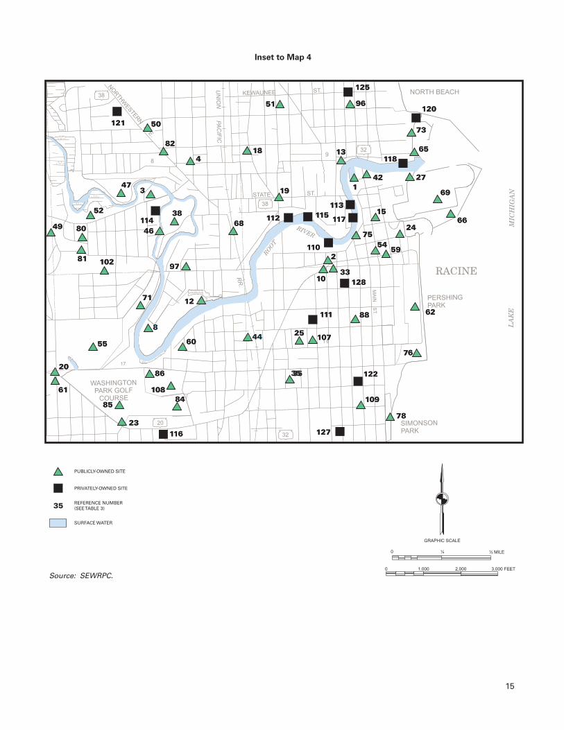
Information on the amount of land devoted to the various types of land uses in the planning area in 2000 is presented in Table 2 and shown on Map 3. As previously noted, the City of Racine planning area encompasses 10,087 acres, or about 16 square miles. Residential uses occupied 3,649 acres, or about 36 percent of the planning area; with the majority being devoted to single-family residential, which occupies 2,994 acres, or about 30 percent of the planning area. Lands devoted to other urban uses, including commercial, industrial, transportation, governmental and institutional, and recreational, encompassed 5,074 acres, or about 51 percent of the planning area, with the largest amount devoted to transportation, communication, and utilities, which occupied 2,360 acres, or about 23 percent of the planning area. Open, undeveloped areas accounted for 719 acres, or about 7 percent of the planning area. In all, 9,442 acres, comprising about 94 percent of the planning area, were devoted to urban uses in 2000. Nonurban uses included the Kestrel Hawk Park Landfill, which occupied 259 acres, or about 3 percent of the planning area. Wetlands and woodlands together encompassed 258 acres, or about 2 percent of the planning area, and surface water accounted for 128 acres, or about 1 percent of the planning area. Thus, 645 acres, comprising about 6 percent of the planning area, were devoted to nonurban uses in 2000. The City of Racine is served by a well-developed highway transportation system. Important arterial streets and highways serving the City include STH 11 (Durand Avenue), STH 20 (Washington Avenue), STH 32, STH 38, Spring Street, State Street, Main Street, Northwestern Avenue, and Racine Street. Also, the Union Pacific Railroad traverses the City from north to south. PARK AND OPEN SPACE SITES Existing Park and Open Space Sites An inventory of existing park and open space sites and outdoor recreation facilities in the City of Racine planning area was conducted in 2001. As indicated in Table 3 and shown on Map 4, there were 128 park and open space sites, which encompassed about 1,438 acres, or about 14 percent of the planning area. There were 109 publicly owned sites that encompassed 1,381 acres, or about 96 percent of the total park and open space site acreage. The remaining 19 sites, encompassing 57 acres, or 4 percent of the total park and open space site acreage, were privately owned.
Figure 1
HISTORICAL POPULATION LEVELS
IN THE CITY OF RACINE: 1900-2000
Source: U.S. Census Bureau and SEWRPC.
Table 1
RESIDENT POPULATION OF
THE CITY OF RACINE: 1900-2000
Change From
Preceding Census
Year Population Number Percent
1900 29,102 - - - - 1910 38,002 8,900 30.6 1920 58,593 20,591 54.2 1930 67,542 8,949 15.3 1940 67,195 -347 -0.5 1950 71,193 3,998 5.9 1960 89,144 17,951 25.2 1970 95,162 6,018 6.3 1980 85,725 -9,437 -9.9 1990 84,298 -1,427 -1.7 2000 81,855 -2,443 -2.9
Source: U.S. Census Bureau and SEWRPC.
YEAR
1900
100,000
90,000
80,000
70,000
60,000
50,000
40,000
30,000
20,000
10,000
01910 1920 1930
PO
PU
LAT
ION
1940 1950 1960 1970 1980 1990 2000

Map 2
GENERALIZED HISTORICAL URBAN GROWTH INTHE CITY OF RACINE: 1850-1995
7
Source: SEWRPC.
0 2,000 4,000 6,000 FEET
0 1/2
GRAPHIC SCALE
1 MILE
1850
1880
1900
1920
1940
1950
1963
1970
1975
1980
1985
1990
1995
CITY OF RACINE CORPORATE LIMITS (2001)
SHOOP PARK
VILLAGES OF ELMWOOD PARK,NORTH BAY, AND WIND POINT

8
Table 3 includes sites owned by Racine County, the City of Racine, and the Racine Unified School District as public sites. School events and school district policies may limit the availability and use of facilities located on public school grounds to the general public. As indicated in Table 4, in 2001 the following publicly owned recreational facilities were located in the City of Racine planning area: six baseball diamonds, 11 league ball diamonds, 29 sandlot ball diamonds, 30 tennis courts, 54 playgrounds, 43 playfields, 98 basketball goals, 15 soccer fields, two ice skating rinks, and one swimming beach. Other significant outdoor recreation facilities available within the planning area include volleyball courts, an 18-hole regulation golf course, two nine-hole regulation golf courses, fishing ponds, a skate park, sledding hills, trails for hiking or walking, and six community centers. Recreational facilities available at privately owned sites included three sandlot ball diamonds, four playfields, eight playgrounds, 19 basketball goals, one soccer field, a volleyball court, and one community center. City of Racine Park System In 2001, the City of Racine owned 85 park and open space sites, encompassing a total of 1,143 acres, or about 11 percent of the planning area. Park and open space sites owned by the City are listed in Table 3. A brief description of each of the 85 City-owned sites is presented below. BI-Centennial Gardens BI-Centennial Gardens is a 5,227 square-foot passive use site located in the eastern portion of the City. Brose Park Brose Park is a six-acre neighborhood park centrally located within the City along the Root River. Existing facilities include a playfield and picnic area. The park includes about two acres of primary environmental corridor. Builders Park Builders Park is a 9,148 square-foot park centrally located within the City. The park includes a playground. Carlson Park Carlson Park is an eight-acre neighborhood park located in the northeastern portion of the City. Existing facilities include a sandlot ball diamond, a playfield, and a playground. Carre Hogle Park Carre Hogle Park is a seven-acre neighborhood park located along the Lake Michigan shoreline in the southeastern portion of the City. The park is encompassed within a primary environmental corridor.
Table 2
LAND USES IN THE CITY OF RACINE
PLANNING AREA: 2000
Land Use Category Acresa Percent of Subtotal
Percent of Planning
Area
Urban Residential Single-Family Residential ......... 2,994 31.7 29.7 Multi-Family Residentialb ......... 655 7.0 6.5 Commercial .................................... 691 7.3 6.9 Industrial......................................... 606 6.4 6.0 Transportation, Communications, and Utilitiesc ................................ 2,360 25.0 23.4 Governmental and Institutional .... 649 6.9 6.4 Recreationald ................................. 768 8.1 7.6 Open Landse .................................. 719 7.6 7.1
Subtotal 9,442 100.0 93.6
Nonurban Wetlands......................................... 116 18.0 1.1 Woodlands ..................................... 142 22.0 1.4 Surface Water ................................ 128 19.8 1.3 Landfill ............................................ 259 40.2 2.6
Subtotal 645 100.0 6.4
Total 10,087 - - 100.0 aIncludes associated off-street parking areas for each land use category. bIncludes two-family dwellings.
cIncludes railroad and street rights-of-way and airport, communication, utility, and transit station properties. dIncludes only those lands developed and used for intensive recreational use (ballfields, picnic areas, etc.). Developed land within park sites used for hiking trails or other passive uses is included in the “open lands” category. eIncludes undeveloped lands associated with urban areas, such as excess street rights-of way, undeveloped platted lots, and residual lands or outlots attendant to existing urban development. Source: SEWRPC.

0 2,000 4,000 6,000 FEET
0 1/2
GRAPHIC SCALE
1 MILE
SINGLE-FAMILYRESIDENTIAL
MULTI-FAMILYRESIDENTIAL
COMMERCIAL
INDUSTRIAL
TRANSPORTATION,COMMUNICATION,AND UTILITIES
GOVERNMENTALAND INSTITUTIONAL
PARKS AND RECREATION
WOODLANDS
WETLANDS
LANDFILL
SURFACE WATER
OPEN LANDS
STREETS AND HIGHWAYS
CITY OF RACINE CORPORATE LIMITS (2001)
SHOOP PARK
VILLAGES OF ELMWOOD PARK,NORTH BAY, AND WIND POINT
Map 3
EXISTING LAND USES INTHE CITY OF RACINE PLANNING AREA: 2000
9
Source: SEWRPC.

10
Table 3
PARK AND OPEN SPACE SITES IN THE CITY OF RACINE PLANNING AREA: 2001
Number on Map 4 Site Name Location Ownership
Size (acres)a
Public 1 Belle Harbor Marina......................................... T3N, R23E, Section 9 Racine County 1 2 BI-Centennial Gardens..................................... T3N, R23E, Section 9 City of Racine 1 3 Brose Park......................................................... T3N, R23E, Section 8 City of Racine 6 4 Builders Park .................................................... T3N, R23E, Section 8 City of Racine 1 5 Carlson Park ..................................................... T4N, R23E, Section 33 City of Racine 5 6 Carre Hogle Park .............................................. T3N, R23E, Section 21 City of Racine 7 7 Case-Harmon Park ........................................... T3N, R23E, Section 20 City of Racine 5 8 Cedar Bend Park............................................... T3N, R23E, Section 17 City of Racine 2 9 Cheska Park ...................................................... T4N, R23E, Section 33 City of Racine 8
10 City Hall............................................................. T3N, R23E, Section 9 City of Racine 2 11 City Land........................................................... T3N, R23E, Section 16 City of Racine 1 12 Clayton Park ..................................................... T3N, R23E, Section 17 City of Racine 14 13 Colbert Park ...................................................... T3N, R23E, Section 9 City of Racine 1 14 Colonial Park .................................................... T3N, R23E, Section 7 City of Racine 73 15 Crosswalk Park ................................................. T3N, R23E, Section 9 City of Racine 1 16 De Koven Woods ............................................. T3N, R23E, Section 21 City of Racine 7 17 Dr. Hamilton Park ............................................ T3N, R23E, Section 21 City of Racine 2 18 Dr. Martin Luther King Jr. Park ....................... T3N, R23E, Section 9 City of Racine 2 19 Dr. Martin Luther King Jr. Plaza...................... T3N, R23E, Section 9 City of Racine 1 20 Dr. Pierce Park .................................................. T3N, R23E, Section 18 City of Racine 1 21 Dodge Park ....................................................... T3N, R23E, Section 21 City of Racine 5 22 Douglas Park .................................................... T3N, R23E, Section 5 City of Racine 6 23 Erskine Park ...................................................... T3N, R23E, Section 17 City of Racine 7 24 Festival Park ..................................................... T3N, R23E, Section 9 City of Racine 3 25 Franklin Park..................................................... T3N, R23E, Section 16 City of Racine 4 26 Fuller Park......................................................... T3N, R23E, Section 20 City of Racine 1 27 Gaslight Pointe................................................. T3N, R23E, Section 9 City of Racine 3 28 Graceland Cemetery ........................................ T3N, R23E, Section 7 City of Racine 46 29 Grand Park........................................................ T3N, R23E, Section 21 City of Racine 1 30 Greencrest Park................................................ T3N, R23E, Section 29 City of Racine 5 31 Hagerer Park..................................................... T3N, R23E, Section 4 City of Racine 1 32 Hantschel Park.................................................. T3N, R22E, Section 24 City of Racine 8 33 Harris Plaza....................................................... T3N, R23E, Section 9 City of Racine 1 34 Harvey Park ...................................................... T3N, R23E, Section 7 City of Racine 2 35 Highland Park ................................................... T3N, R23E, Section 16 City of Racine 1 36 Horlick Athletic Field........................................ T3N, R23E, Section 5 City of Racine 9 37 Humble Park ..................................................... T3N, R23E, Section 19 City of Racine 17 38 Island Park ........................................................ T3N, R23E, Section 8 City of Racine 19 39 Jay-Eye-See Park ............................................. T3N, R23E, Section 20 City of Racine 1 40 Johnson Park Dog Run.................................... T4N, R22E, Section 26 City of Racine 28 41 Johnson Park and Golf Course ....................... T4N, R22E, Sections 25, 26, 35 City of Racine 337 42 John Thompson Park ...................................... T3N, R23E, Section 9 City of Racine 1 43 Jonas Park ........................................................ T3N, R23E, Section 4 City of Racine 1 44 Jones Park ........................................................ T3N, R23E, Section 17 City of Racine 1 45 Lakeview Park................................................... T3N, R23E, Section 4 City of Racine 4 46 Lee Park ............................................................ T3N, R23E, Section 8 City of Racine 1 47 Lincoln Park ...................................................... T3N, R23E, Section 8 City of Racine 22 48 Lockwood Park ................................................. T3N, R23E, Section 7 City of Racine 40 49 Maple Grove Park ............................................ T3N, R23E, Section 7 City of Racine 4 50 Marino Park ...................................................... T3N, R23E, Section 8 City of Racine 3 51 Marquette Park................................................. T3N, R23E, Section 9 City of Racine 1 52 Mary Ellen Helgren Johnson Preserve........... T3N, R23E, Section 8 City of Racine 3 53 Mat Matson Park .............................................. T4N, R23E, Section 33 City of Racine 2 54 Monument Square........................................... T3N, R23E, Section 9 City of Racine 1 55 Mound Cemetery ............................................. T3N, R23E, Section 17 City of Racine 49 56 North Beach...................................................... T3N, R23E, Section 4 City of Racine 48 57 Oak Park............................................................ T3N, R23E, Section 19 City of Racine 5 58 Olsen Prairie ..................................................... T3N, R23E, Section 29 City of Racine 18 59 Park Place ......................................................... T3N, R23E, Section 9 City of Racine 1

11
Table 3 (continued)
Number on Map 4 Site Name Location Ownership
Size (acres)a
60 Parker Park........................................................ T3N, R23E, Section 17 City of Racine 3 61 Pedar Back Park................................................ T3N, R23E, Section 18 City of Racine 1 62 Pershing Park ................................................... T3N, R23E, Section 16 City of Racine 37 63 Pierce Woods Park ........................................... T3N, R23E, Section 19 City of Racine 7 64 Pritchard Park ................................................... T3N, R22E, Section 24 Racine County 79 65 Pugh Recreation Area...................................... T3N, R23E, Section 9 City of Racine 1 66 Racine Harbor Park .......................................... T3N, R23E, Section 9 Racine County 17 67 Racine Zoological Gardens ............................. T3N, R23E, Section 4 City of Racine 28 68 Randolph Park .................................................. T3N, R23E, Section 8 City of Racine 1 69 Reef Point Marina ............................................ T3N, R23E, Section 9 Racine County 40 70 Reservoir Park .................................................. T3N, R23E, Section 30 City of Racine 20 71 Riverside Park................................................... T3N, R23E, Section 17 City of Racine 14 72 Robert G. Heck Park ......................................... T3N, R23E, Section 5 City of Racine 3 73 Rooney Recreation Area.................................. T3N, R23E, Section 9 City of Racine 1 74 Roosevelt Park.................................................. T3N, R23E, Section 21 City of Racine 13 75 Sam Azarian Overlook..................................... T3N, R23E, Section 9 City of Racine 1 76 Samuel Myers Park.......................................... T3N, R23E, Section 16 City of Racine 7 77 Shoop Park and Golf Course........................... T4N, R23E, Section 27 City of Racine 63 78 Simonson Park ................................................. T3N, R23E, Section 16 City of Racine 5 79 Solbraa Park ..................................................... T3N, R23E, Section 18 City of Racine 3 80 Springvale East Park........................................ T3N, R23E, Section 8 City of Racine 1 81 Springvale West Park ...................................... T3N, R23E, Section 8 City of Racine 1 82 State-Hamilton Park......................................... T3N, R23E, Section 8 City of Racine 1 83 Wallis Park ........................................................ T3N, R23E, Section 20 City of Racine 2 84 Washington Park Bowl .................................... T3N, R23E, Section 17 City of Racine 11 85 Washington Park Golf Course......................... T3N, R23E, Section 17 City of Racine 53 86 Washington Park Recreation Center .............. T3N, R23E, Section 17 City of Racine 2 87 Wellington Park................................................ T3N, R23E, Section 20 City of Racine 1 88 West Park.......................................................... T3N, R23E, Section 16 City of Racine 3 89 Wustum Museum ............................................ T3N, R23E, Section 5 City of Racine 10 90 Fine Arts School............................................... T3N, R23E, Section 21 Racine School District 1 91 Fratt School ...................................................... T3N, R23E, Section 18 Racine School District 1 92 Giese School .................................................... T3N, R22E, Section 24 Racine School District 7 93 Gilmore School ................................................ T3N, R23E, Section 5 Racine School District 8 94 Goodland School ............................................. T3N, R22E, Section 12 Racine School District 5 95 Horlick High School and Wadewitz School T3N, R23E, Section 5 Racine School District 21 96 Janes School .................................................... T3N, R23E, Section 9 Racine School District 1 97 Jefferson School .............................................. T3N, R23E, Section 8 Racine School District 1 98 Jerstad Agerholm School ............................... T4N, R23E, Section 33 Racine School District 9 99 Johnson School ............................................... T3N, R23E, Section 19 Racine School District 10
100 Jones School.................................................... T3N, R23E, Section 30 Racine School District 2 101 Knapp School ................................................... T3N, R23E, Section 20 Racine School District 4 102 McKinley School .............................................. T3N, R23E, Section 8 Racine School District 2 103 Mitchell School ................................................ T3N, R23E, Section 20 Racine School District 3 104 Red Apple School ............................................ T3N, R23E, Section 4 Racine School District 1 105 Starbuck Middle School .................................. T3N, R22E, Section 13 Racine School District 13 106 Theodore Roosevelt School............................ T3N, R23E, Section 4 Racine School District 2 107 Walden III Alternative School ......................... T3N, R23E, Section 16 Racine School District 2 108 Washington Park High School ........................ T3N, R23E, Section 17 Racine School District 7 109 Winslow School ............................................... T3N, R23E, Section 16 Racine School District 1
Subtotal - 109 Sites - - - - 1,381
Private 110 Azarian Marina ................................................. T3N, R23E, Section 9 Private 15 111 Bray Center....................................................... T3N, R23E, Section 16 Organizational 1 112 Fifth Street Yacht Club..................................... T3N, R23E, Section 9 Private 3 113 Harbor Lite Yacht Club .................................... T3N, R23E, Section 9 Private 1 114 Lincoln Lutheran High School ........................ T3N, R23E, Section 8 Organizational 5 115 Mauer’s Marina ................................................ T3N, R23E, Section 9 Private 1 116 Our Saviorsb .................................................... T3N, R23E, Section 17 Private 1 117 Palmer Johnson ............................................... T3N, R23E, Section 9 Private 1

12
Table 3 (continued)
Number on Map 4 Site Name Location Ownership
Size (acres)a
118 Pugh Marina ..................................................... T3N, R23E, Section 9 Private 11 119 Racine Christian School .................................. T3N, R23E, Section 18 Organizational 1 120 Racine Yacht Club ............................................ T3N, R23E, Section 9 Private 3 121 Sacred Heart..................................................... T3N, R23E, Section 8 Organizational 4 122 St. Catherine’s High School ............................ T3N, R23E, Section 16 Organizational 3 123 St. Edward School ........................................... T3N, R23E, Section 18 Organizational 1 124 St. John Nepomuk School .............................. T3N, R23E, Section 4 Organizational 1 125 St. John’s Lutheran School............................. T3N, R23E, Section 9 Organizational 1 126 St. Lucy’s School.............................................. T3N, R23E, Section 29 Organizational 2 127 St. Richard School ........................................... T3N, R23E, Section 16 Organizational 1 128 Wisconsin Lutheran School ............................ T3N, R23E, Section 16 Organizational 1
Subtotal - 19 Sites - - - - 57
- - Total - 128 Sites - - - - 1,438
aSites smaller than one acre were rounded up to one acre on this table. The narrative provides the exact size for City-owned sites less than one acre. bThe outdoor play area at this site is leased to the City of Racine. Source: City of Racine Parks, Recreation, and Cultural Services Department and SEWRPC. Case-Harmon Park Case-Harmon Park is a five-acre neighborhood park located in the southeastern portion of the City. Existing facilities include a sandlot ball diamond, a playfield, and a playground. Cedar Bend Park Cedar Bend Park is a two-acre park centrally located within the City along the Root River. The park includes three tennis courts. The park is encompassed within a primary environmental corridor. Cheska Park Cheska Park is an eight-acre neighborhood park located in the northern portion of the City. Existing facilities include a playfield and a playground. City Hall City Hall is located on a two-acre site in the eastern portion of the City. City Land The City owns a 10,890 square-foot site along the Lake Michigan shoreline in the eastern portion of the City. The land is encompassed within a primary environmental corridor. Clayton Park Clayton Park is a 14-acre neighborhood park centrally located within the City along the Root River. Existing facilities include a playfield, a playground, and one basketball goal. The park is encompassed within a primary environmental corridor consisting of wetlands. Colbert Park Colbert Park is a 13,939 square-foot park located in the eastern portion the City.

13
Colonial Park Colonial Park is a 73-acre conservancy area located along the Root River in the western portion of the City. The park includes hiking trails and about 68 acres of primary environmental corridor consisting of wetlands. Crosswalk Park Crosswalk Park is a 6,970 square-foot park located in the eastern portion of the City. De Koven Woods De Koven Woods is a seven-acre conservancy area located in the eastern portion of the City. Dr. Hamilton Park Dr. Hamilton Park is a two-acre park located in the southeastern portion of the City. Existing facilities include a playground and a restroom. Dr. Martin Luther King, Jr. Park Dr. Martin Luther King, Jr. Park is a two-acre park centrally located within the City. Existing facilities include a playground, one basketball goal, and the Dr. Martin Luther King, Jr. Community Center. Dr. Martin Luther King, Jr. Plaza Dr. Martin Luther King, Jr. Plaza is a 14,810 square-foot historical exhibit centrally located within the City. Dr. Pierce Park Dr. Pierce Park is a 5,227 square-foot passive use park centrally located within the City. Dodge Park Dodge Park is a five-acre passive use park located along the Lake Michigan shoreline in the southeastern portion of the City. The park is encompassed within a primary environmental corridor. Douglas Park Douglas Park is a six-acre neighborhood park located in the northern portion of the City. Existing facilities include a league baseball diamond, a playfield, a playground, two basketball goals, and the Chavez Community Center. Erskine Park Erskine Park is a 17-acre neighborhood park centrally located within the City. The park includes picnic areas and is encompassed within an isolated natural resource area consisting of woodlands. Festival Park Festival Park is a three-acre park located in the eastern portion of the City. This site is developed with a playground. Franklin Park Franklin Park is a four-acre neighborhood park centrally located within the City. Existing facilities include a playground and four basketball goals. Fuller Park Fuller Park is a one-acre park located in the eastern portion of the City. Existing facilities include a playfield and a playground. Gaslight Pointe Gaslight Pointe is a three-acre park located along the Lake Michigan shoreline in the eastern portion of the City. The park is encompassed within a primary environmental corridor.

Map 4
PARK AND OPEN SPACE SITES INTHE CITY OF RACINE PLANNING AREA: 2001
14
Source: SEWRPC.
0 2,000 4,000 6,000 FEET
0 1/2
GRAPHIC SCALE
1 MILE
SURFACE WATER
PUBLICLY-OWNED SITE
PRIVATELY-OWNED SITE
REFERENCE NUMBER(SEETABLE 3)
116
2116
90
1729
26 7
87
83
58
36
103
37
126
12
119
6399
70
57 101
79105
919448
2834
14
89 93 36 10443 31
56
45
67106
12422
72
53
98
59
7740
41
116
2116
90
1729
74
39
26 7
87
83
58
36
100
103
37
126
12
119
6399
64
70
57 101
79105
919448
2834
14
89 93 36 10443 31
56
45
67106
12422
72
53
98
59
7740
41
95
9232
SEE INSETSEE INSET
35
CITY OF RACINE CORPORATE LIMITS (2001)
SHOOP PARK
VILLAGES OF ELMWOOD PARK,NORTH BAY, AND WIND POINT
20
WASHINGTON
PARK GOLF
COURSE
SIMONSON
PARK
PERSHING
PARK
NORTH BEACH38
RIVER
LA
KE
MIC
HIG
AN
RACINE
NO
RTHW
ESTERN
AVE.
MA
INS
T.
17
1 6
98
ROO
T
38
32
32
STATE ST.
KEWAUNEE ST.UN
ION
PA
CIF
IC
RR
.
Inset to Map 4
15
Source: SEWRPC.0 1,000 2,000 3,000 FEET
0 ¼
GRAPHIC SCALE
½ MILE
SURFACE WATER
PUBLICLY-OWNED SITE
PRIVATELY-OWNED SITE
REFERENCE NUMBER(SEETABLE 3)35
121
114
116
120
118
113
117
110
111
128
122
127
115112
125
8049
52
97
50
82
418
51 96
13
142
73
65
27
69
6615
2475
5459
2
1033
68
19
76
6288
1072544
35
109
78
60
8
55
20
61
85
86
10884
23
1271
473
38
46
10281
121
114
116
120
118
113
117
110
111
128
122
127
115112
125
8049
52
97
50
82
418
51 96
13
142
73
65
27
69
6615
2475
5459
2
1033
68
19
76
6288
1072544
35
109
78
60
8
55
20
61
85
86
10884
23
1271
473
38
46
10281

16
Table 4
SELECTED OUTDOOR RECREATION FACILITIES FOR GENERAL USE IN THE CITY OF RACINE PLANNING AREA: 2001
Number on Map 4 Site Name
Baseball Diamonds
Softball-League
Diamonds
Softball- Sandlot
Diamonds Playfield Playground Tennis Courts
Basketball Goals
Soccer Field
Ice Skating
Rink Pool or Beach Other
Public 1 Belle Harbor Marina - - - - - - - - - - - - - - - - - - - - Marina 2 BI-Centennial Gardens - - - - - - - - - - - - - - - - - - - - Passive Use 3 Brose Park - - - - - - X - - - - - - - - - - - - Picnic Area 4 Builder’s Park - - - - - - - - X - - - - - - - - - - - - 5 Carlson Park - - - - 1 X X - - - - - - - - - - - - 6 Carre Hogle Park - - - - - - - - - - - - - - - - - - - - Passive Use 7 Case-Harmon Park - - - - 1 X X - - - - - - - - - - - - 8 Cedar Bend Park - - - - - - - - - - 3 - - - - - - - - - - 9 Cheska Park - - - - - - X X - - - - - - - - - - - -
10 City Hall - - - - - - - - - - - - - - - - - - - - Passive Use 11 City Land - - - - - - - - - - - - - - - - - - - - Passive Use 12 Clayton Park - - - - - - X X - - 1 - - - - - - - - 13 Colbert Park - - - - - - - - - - - - - - - - - - - - Passive Use 14 Colonial Park - - - - - - - - - - - - - - - - - - - - Conservatory,
Hiking Trails 15 Crosswalk Park - - - - - - - - - - - - - - - - - - - - Passive Use 16 De Koven Woods - - - - - - - - - - - - - - - - - - - - Conservatory Area 17 Dr. Hamilton Park - - - - - - - - X - - - - - - - - - - Restrooms 18 Dr. Martin Luther King Jr.
Park - - - - - - - - X - - 1 - - - - - - Community Center
19 Dr. Martin Luther King Jr. Plaza
- - - - - - - - - - - - - - - - - - - - Historical Exhibit
20 Dr. Pierce Park - - - - - - - - - - - - - - - - - - - - Passive Use 21 Dodge Park - - - - - - - - - - - - - - - - - - - - Passive Use 22 Douglas Park - - 1 - - X X - - 2 - - - - - - Community Center 23 Erskine Park - - - - - - - - - - - - - - - - - - - - Picnic Area 24 Festival Park - - - - - - - - X - - - - - - - - - - - - 25 Franklin Park - - - - - - - - X - - 4 - - - - - - - - 26 Fuller Park - - - - - - X X - - - - - - - - - - - - 27 Gaslight Pointe - - - - - - - - - - - - - - - - - - - - Passive Use 28 Graceland Cemetery - - - - - - - - - - - - - - - - - - - - Cemetery 29 Grand Park - - - - - - - - X - - - - - - - - - - - - 30 Greencrest Park - - - - - - - - X - - 2 - - - - - - - - 31 Hagerer Park - - - - - - - - X - - - - - - - - - - - - 32 Hantschel Park - - - - 1 X X - - - - - - - - - - Restrooms 33 Harris Plaza - - - - - - - - - - - - - - - - - - - - Passive Use 34 Harvey Park - - - - 1 X X - - - - - - - - - - - - 35 Highland Park - - - - - - - - X - - - - - - - - - - - - 36 Horlick Athletic Field 1 - - - - X - - - - - - - - - - - - Football Field 37 Humble Park 1 2 - - X X 3 1 - - - - - - Restrooms,
Volleyball, Community Center
38 Island Park - - 2 1 X X 3 - - - - - - - - Restrooms, Picnic Area
39 Jay-Eye-See Park - - - - - - - - X - - - - - - - - - - - - 40 Johnson Park Dog Run - - - - - - - - - - - - - - - - - - - - Dog Walking Area 41 Johnson Park and
Golf Course - - - - - - X X - - - - 1 - - - - 18-Hole Golf Course,
Picnic Area, Fishing Pond, Driving Range, Restrooms
42 John Thompson Park - - - - - - - - - - - - - - - - - - - - Passive Use 43 Jonas Park - - - - - - - - - - - - - - - - - - - - Historical Exhibit 44 Jones Park - - - - - - X X - - - - - - - - - - - - 45 Lakeview Park - - - - 1 X X 3 2 - - - - - - Community Center 46 Lee Park - - - - - - - - - - - - - - - - - - - - Passive Use 47 Lincoln Park 1 - - - - X X - - - - - - - - - - Wisconsin-DNR
Steelhead Facility, Picnic Shelter, Restrooms
48 Lockwood Park 1 - - - - X X 4 2 1 X - - Volleyball, Sledding Hill, Restrooms
49 Maple Grove Park - - - - - - - - - - - - - - - - - - - - Passive Use 50 Marino Park - - - - 1 X X - - 2 - - - - - - Restrooms 51 Marquette Park - - - - - - - - X - - 4 - - - - - - Restrooms 52 Mary Ellen Helmgren
Johnson Preserve - - - - - - - - - - - - - - - - - - - - Conservatory Area
53 Mat Matson Park - - - - 1 X X - - 1 - - X - - Restrooms 54 Monument Square - - - - - - - - - - - - - - - - - - - - Historical Exhibit 55 Mound Cemetery - - - - - - - - - - - - - - - - - - - - Cemetery 56 North Beach - - - - - - X X - - - - - - - - X Sand Volleyball
Courts, Picnicking, Restrooms
57 Oak Park - - - - - - X X - - - - - - - - - - - - 58 Olsen Prairie - - - - - - - - - - - - - - - - - - - - Hiking Trails 59 Park Place - - - - - - - - - - - - - - - - - - - - Passive Use 60 Parker Park - - - - - - - - X - - - - - - - - - - - - 61 Pedar Back Park - - - - - - - - - - - - - - - - - - - - Passive Use 62 Pershing Park - - - - 1 X - - - - - - 2 - - - - Skate Park, Football
Field, 12 Drive-in Boat Launches, Fish Cleaning Station
63 Pierce Woods Park - - - - - - - - X - - - - - - - - - - Restrooms

17
Table 4 (continued)
Number on Map 4 Site Name
Baseball Diamonds
Softball-League
Diamonds
Softball- Sandlot
Diamonds Playfield Playground Tennis Courts
Basketball Goals
Soccer Field
Ice Skating
Rink Pool or Beach Other
64 Pritchard Park - - 2 - - X X - - - - 1 - - - - Fishing Pond, Picnic Area, Trail, Restrooms
65 Pugh Recreation Area - - - - - - - - - - - - - - - - - - - - Fishing 66 Racine Harbor Park - - - - - - - - - - - - - - - - - - - - Marina, Fish
Cleaning Station, Fishing, Restrooms
67 Racine Zoological Gardens
- - - - - - - - X - - - - - - - - - - Zoo
68 Randolph Park - - - - - - - - - - - - - - - - - - - - Passive Use 69 Reef Point Marina - - - - - - - - - - - - - - - - - - - - Marina 70 Reservoir Park - - - - - - - - - - - - - - - - - - - - Sledding 71 Riverside Park - - - - - - - - - - - - - - - - - - - - Passive Use 72 Robert G. Heck Park - - - - 1 X X - - - - - - - - - - Restrooms 73 Rooney Recreation Area - - - - - - - - - - - - - - - - - - - - Fishing, Harbor
Access 74 Roosevelt Park - - 2 - - X X - - 2 - - - - - - Restrooms,
Community Center 75 Sam Azarian Overlook - - - - - - - - - - - - - - - - - - - - Scenic Overlook 76 Samuel Myers Park - - - - - - - - - - - - - - - - - - - - Fishing, Drive-in
Boat Launch 77 Shoop Park Golf Course - - - - - - - - - - - - - - - - - - - - Nine-Hole Golf
Course 78 Simonson Park - - - - - - - - - - - - - - - - - - - - Passive Use 79 Solbraa Park - - 1 - - X X - - 2 - - - - - - Restrooms 80 Springvale East Park - - - - - - - - X - - - - - - - - - - - - 81 Springvale West Park - - - - - - - - - - - - - - - - - - - - Passive Use 82 State-Hamilton Park - - - - - - - - - - - - - - - - - - - - Historical Exhibit 83 Wallis Park - - - - - - - - - - - - - - - - - - - - Passive Use 84 Washington Park Bowl 1 1 - - X - - - - - - - - - - - - - - 85 Washington Park
Golf Course - - - - - - - - - - - - - - - - - - - - Nine-Hole Golf
Course, Restrooms 86 Washington Park
Community Center - - - - - - - - X - - - - - - - - - - Community Center
87 Wellington Park - - - - - - - - X - - - - - - - - - - - - 88 West Park - - - - - - - - X - - - - - - - - - - - - 89 Wustum Museum - - - - - - - - - - - - - - - - - - - - Passive Use 90 Fine Arts School - - - - - - X X - - 3 - - - - - - - - 91 Fratt School - - - - 2 X X - - 2 - - - - - - - - 92 Giese School - - - - 2 X X - - 4 - - - - - - - - 93 Gilmore School - - - - 3 X - - - - - - 1 - - - - - - 94 Goodland School - - - - 1 X X - - 6 - - - - - - - - 95 Horlick High School and
Wadewitz School 1 - - - - X X 8 6 2 - - - - Running Track
96 Janes School - - - - - - X - - - - 2 - - - - - - - - 97 Jefferson School - - - - - - - - X - - 5 - - - - - - - - 98 Jerstad Agerholm School - - - - 1 X X 3 4 1 - - - - - - 99 Johnson School - - - - 1 X X - - 4 1 - - - - - -
100 Jones School - - - - 3 X X - - 4 1 - - - - - - 101 Knapp School - - - - 2 X X - - 5 1 - - - - - - 102 McKinley School - - - - - - X - - - - 3 - - - - - - Running Track 103 Mitchell School - - - - 2 X - - - - 7 - - - - - - - - 104 Red Apple School - - - - - - - - X - - 2 - - - - - - - - 105 Starbuck Middle School - - - - 1 X - - 3 6 - - - - - - - - 106 Theodore Roosevelt
School - - - - 1 X X - - 4 - - - - - - - -
107 Walden III Alternative School
- - - - - - X - - - - 2 - - - - - - - -
108 Washington Park High School
- - - - - - - - - - - - - - 3 - - - - Running Track, Football Field
109 Winslow School - - - - - - - - X - - 3 - - - - - - - -
Subtotal-109 Sites 6 11 29 43 54 30 98 15 2 1 - -
Private 110 Azarian Marina - - - - - - - - - - - - - - - - - - - - Marina 111 Bray Center - - - - - - - - X - - - - - - - - - - Community Center 112 Fifth Street Yacht Club - - - - - - - - - - - - - - - - - - - - Yacht Club, Drive-in
Boat Launch 113 Harbor Lite Yacht Club - - - - - - - - - - - - - - - - - - - - Yacht Club, Drive-in
Boat Launch 114 Lincoln Lutheran
High School - - - - - - X - - - - - - 1 - - - - - -
115 Mauer’s Marina - - - - - - - - - - - - - - - - - - - - Marina 116 Our Saviorsa - - - - - - - - X - - - - - - - - - - - - 117 Palmer Johnson - - - - - - - - - - - - - - - - - - - - Marina 118 Pugh Marina - - - - - - - - - - - - - - - - - - - - Marina 119 Racine Christian School - - - - 2 X X - - 1 - - - - - - - - 120 Racine Yacht Club - - - - - - - - - - - - - - - - - - - - Marina 121 Sacred Heart - - - - 1 X X - - 6 - - - - - - - - 122 St. Catherine’s
High School - - - - - - X - - - - - - - - - - - - - -
123 St. Edward School - - - - - - - - X - - 4 - - - - - - - - 124 St. John Nepomuk
School - - - - - - - - - - - - 3 - - - - - -
- -

18
Table 4 (continued)
Number on Map 4 Site Name
Baseball Diamonds
Softball-League
Diamonds
Softball- Sandlot
Diamonds Playfield Playground Tennis Courts
Basketball Goals
Soccer Field
Ice Skating
Rink Pool or Beach Other
125 St. John’s Lutheran School
- - - - - - - - X - - 2 - - - - - - - -
126 St. Lucy’s School - - - - - - - - X - - - - - - - - - - Volleyball 127 St. Richard School - - - - - - - - - - - - 3 - - - - - - - - 128 Wisconsin Lutheran
School - - - - - - - - X - - - - - - - - - -
- -
Subtotal-19 Sites - - - - 3 4 8 - - 19 1 - - - - - -
- - Total-128 Sites 6 11 32 47 62 30 117 35b 2 1 - - aThis site is leased to the City of Racine and the City owns all of the outdoor recreation facilities at this site. bIncludes four soccer fields located at Caledonia-Mt. Pleasant Memorial Park and 15 soccer fields located at the Soccer Complex of Racine. Both sites are located in the Town of Caledonia. Source: City of Racine Parks, Recreation, and Cultural Services Department and SEWRPC.
Graceland Cemetery Graceland Cemetery is 46-acre cemetery located in the western portion of the City. Citizens use the streets within the cemetery for walking or jogging. Grand Park Grand Park is a 6,534 square-foot park located in the southeastern portion of the City. The park includes a playground. Greencrest Park Greencrest Park is a five-acre neighborhood park located in the southern portion of the City. Existing facilities include a playground and two basketball goals. Hagerer Park Hagerer Park is a 13,939 square-foot park located in the eastern portion of the City. The park includes a playground. Hantschel Park Hantschel Park is an eight-acre neighborhood park located in the western portion of the City. Existing facilities include a sandlot ball diamond, a playfield, a playground, and a restroom. Harris Plaza Harris Plaza is a 3,920 square-foot passive use site centrally located within the City. Harvey Park Harvey Park is a two-acre neighborhood park located in the western portion of the City. Existing facilities include a sandlot ball diamond, a playfield, and a playground. Highland Park Highland Park is an 11,326 square-foot park located in the eastern portion of the City. The park includes a playground. Horlick Athletic Field Horlick Athletic Field is a nine-acre site located in the northern portion of the City. Existing facilities include a baseball diamond, a playfield, and a football field.

19
Humble Park Humble Park is a 17-acre neighborhood park located in the southern portion of the City. Existing facilities include a baseball diamond, two league ball diamonds, a playfield, a playground, one basketball goal, three tennis courts, a volleyball court, a restroom, and the Humble Park Community Center. Island Park Island Park is a 19-acre neighborhood park centrally located within the City along the Root River. Existing facilities include two league ball diamonds, a sandlot ball diamond, a playfield, a playground, three tennis courts, a restroom, and picnic areas. The park is encompassed within a primary environmental corridor. Jay-Eye-See Park Jay-Eye-See Park is a 12,632 square-foot park located in the southeastern portion of the City. The park includes a playground. Johnson Park Dog Run Johnson Park Dog Run is a 28-acre special use park located east of STH 38 and adjacent to the Root River, and is surrounded by the Town of Caledonia. The park is used for dog walking and includes about 13 acres of primary environmental corridor consisting of wetlands. Johnson Park and Golf Course Johnson Park and Golf Course is a 337-acre major park located north of STH 38, and is surrounded by the Town of Caledonia. Existing facilities include a playfield, a playground, a soccer field, an 18-hole golf course, driving range, picnic areas, and a restroom. The park also encompasses a pond that provides for fishing in the summer. The park includes 49 acres of primary environmental corridor consisting of wetlands and woodlands located along the Root River, and 35 acres of isolated natural resource area consisting of woodlands. The park also contains portions of the Caledonia Sanitary Sewer Right-of-Way and Root River Bluff critical species habitat sites. John Thompson Park John Thompson Park is a one-acre passive use site located in the eastern portion the City. Jonas Park Jonas Park is a 13,068 square-foot historical exhibit located in the northern portion of the City. Jones Park Jones Park is a one-acre park centrally located within the City. Existing facilities include a playfield and a playground. Lakeview Park Lakeview Park is a four-acre neighborhood park located in the eastern portion of the City. Existing facilities include a sandlot ball diamond, a playfield, a playground, two basketball goals, three tennis courts, and the Lakeview Park Community Center. Lee Park Lee Park is a one-acre park centrally located within the City along the Root River. The park is encompassed within a primary environmental corridor. Lincoln Park Lincoln Park is a 22-acre community park centrally located in the City along the Root River. Existing facilities include a baseball diamond, a playfield, a playground, a restroom, and a picnic shelter. The park also includes the Wisconsin Department of Natural Resources Steelhead Facility. The park includes about six acres of primary environmental corridor consisting of wetlands.

20
Lockwood Park Lockwood Park is a 40-acre community park located in the western portion of the City. Existing facilities include a baseball diamond, a playfield, a playground, two basketball goals, four tennis courts, a soccer field, ice skating, a volleyball court, a sledding hill, and a restroom. Maple Grove Park Maple Grove Park is a four-acre park centrally located within the City. The park includes about four acres of isolated natural resource area consisting of woodlands. Marino Park Marino Park is a three-acre neighborhood park centrally located within the City. Existing facilities include a sandlot ball diamond, a playfield, a playground, two basketball goals, and a restroom. Marquette Park Marquette Park is a 16,553 square-foot park centrally located within the City. Existing facilities include four basketball goals, a playground, and a restroom. Mary Ellen Helgren Johnson Preserve Mary Ellen Helgren Johnson Preserve is a three-acre conservancy area centrally located within the City. The site includes about one acre of primary environmental corridor consisting of wetlands located along the Root River. Mat Matson Park Mat Matson Park is a two-acre neighborhood park located in the northern portion of the City. Existing facilities include a sandlot ball diamond, a playfield, a playground, a basketball goal, ice skating, and a restroom. Monument Square Monument Square is a 27,007 square-foot historical exhibit located in the eastern portion of the City. Mound Cemetery Mound Cemetery is a 49-acre cemetery centrally located within the City. Citizens use the streets within the cemetery for walking or jogging. North Beach North Beach is a 48-acre park located along the Lake Michigan shoreline in the eastern portion of the City. Existing facilities include a beach, sand volleyball courts, restrooms, a playfield, a playground, and a picnic area. The park is encompassed within a primary environmental corridor. Oak Park Oak Park is a five-acre neighborhood park located in the southern portion of the City. The park includes a playfield and a playground. Olsen Prairie Olsen Prairie is a 19-acre conservancy area located in the southeastern portion of the City. The site includes hiking trails. Park Place Park Place is a two-acre site located in the eastern portion of the City. Parker Park Parker Park is a three-acre park centrally located within the City. The park includes a playground. Pedar Back Park Pedar Back Park is a 14,810 square-foot park centrally located within the City.

21
Pershing Park Pershing Park is a 37-acre community park located along the Lake Michigan shoreline in the eastern portion of the City. Existing facilities include a sandlot ball diamond, a playfield, two soccer fields, a skate park, a football field, a 12-lane boat launch, and a fish cleaning station. The park includes about 35 acres of primary environ-mental corridor. Pierce Woods Park Pierce Woods Park is a seven-acre neighborhood park located in the southern portion of the City. Existing facilities include a playground and a restroom. The park is encompassed within an isolated natural resource area consisting of woodlands. Pugh Recreation Area Pugh Recreation Area is a one-acre site located along the Lake Michigan shoreline in the eastern portion of the City. The site provides harbor access and shoreline fishing. The site is encompassed within a primary environmental corridor. Racine Zoological Gardens Racine Zoological Gardens is a 28-acre community park located along the Lake Michigan shoreline in the eastern portion of the City. The site is developed with a zoo, a playground, and picnic facilities. The park includes 16 acres of primary environmental corridor. Randolph Park Randolph Park is a 4,356 square-foot passive use site centrally located within the City. Reservoir Park Reservoir Park is a 20-acre undeveloped park located in the southwestern portion of the City. The site provides areas for sledding. Riverside Park Riverside Park is a 14-acre neighborhood park centrally located within the City along the Root River. The park includes about 12 acres of primary environmental corridor consisting of woodlands. Robert G. Heck Park Robert G. Heck Park is a three-acre neighborhood park located in the northern portion of the City. Existing facilities include a sandlot ball diamond, a playfield, a playground, and a restroom. Rooney Recreation Area Rooney Recreation Area is a one-acre site located along the Lake Michigan shoreline in the eastern portion of the City. The site provides harbor access and shoreline fishing. The site is encompassed within a primary environmental corridor. Roosevelt Park Roosevelt Park is a 13-acre neighborhood park located in the southeastern portion of the City. Existing facilities include two league ball diamonds, a playfield, a playground, two basketball goals, a restroom, and the John Bryant Community Center. Sam Azarian Overlook Sam Azarian Overlook is a 2,178 square-foot scenic overlook located in the eastern portion the City. This site provides scenic views of the Root River. Samuel Myers Park Samuel Myers Park is a seven-acre park located along the Lake Michigan shoreline in the eastern portion of the City. The site includes a sandy beach. The park is encompassed within a primary environmental corridor.

22
Shoop Park Golf Course Shoop Park Golf Course is a 63-acre golf course located adjacent to Lighthouse Drive in the eastern portion of the Village of Wind Point along the Lake Michigan shoreline. Existing facilities include a nine-hole golf course. The site also contains the Wind Point critical species habitat site located within about 10 acres of primary environmental corridor. Simonson Park Simonson Park is a five-acre park located along the Lake Michigan shoreline in the eastern portion of the City. The park is encompassed within a primary environmental corridor. Solbraa Park Solbraa Park is a three-acre neighborhood park located in the western portion of the City. Existing facilities include a league ball diamond, a playfield, a playground, two basketball goals, and a restroom. Springvale East Park Springvale East Park is an 18,295 square-foot park located west of the downtown area. The park includes a playground. Springvale West Park Springvale West Park is a one-acre park located west of the downtown area. State-Hamilton Park State-Hamilton Park is a 17,424 square-foot historical exhibit located along STH 38 northwest of the down-town area. Wallis Park Wallis Park is a two-acre park located in the southeastern portion of the City. Washington Park Bowl Washington Park Bowl is an 11-acre neighborhood park centrally located within the City. Existing facilities include a baseball diamond, a league ball diamond, and a playfield. The park includes less than one acre of an isolated natural resource area. Washington Park Golf Course Washington Park Golf Course is a 53-acre golf course centrally located within the City. Existing facilities include a nine-hole golf course. The site includes about 36 acres of primary environmental corridor consisting of wetlands and woodlands located along the Root River, including the Washington Park Woods critical species habitat site. The site also includes about three acres of isolated natural resource area. Washington Park Community Center Washington Park Community Center is a two-acre special use site centrally located within the City. The site includes a playground. Wellington Park Wellington Park is a one-acre park located in the southeastern portion of the City. The park includes a playground. West Park West Park is a three-acre neighborhood park located in the eastern portion of the City. The park includes a playground. Wustum Museum Wustum Museum is a 10-acre special use site located in the western portion of the City.

23
Racine County Parks Racine County owns four park sites within the City of Racine. Pritchard Park is located north of STH 11 and west of Ohio Street in the southwestern portion of the City. The park encompasses 79 acres and includes two league ball diamonds, a soccer field, a playground, picnicking, a hiking trail, and restrooms. The park encompasses a pond that provides opportunities for fishing in the summer. The park also includes woodlands within an isolated natural resource area. The other County-owned park site is Racine Harbor Park, located in the eastern portion of the City along the Lake Michigan shoreline and the Racine Harbor. The park encompasses 17 acres and includes a marina, areas for shoreline fishing, and a fish cleaning station. The County also owns two marinas, Belle Harbor Marina and Reef Point Marina. Belle Harbor Marina is a one-acre site located west of Main Street and south of the Root River in the eastern portion of the City. Reef Point Marina is a 40-acre site located in the Racine Harbor in the eastern portion of the City. The County also owns a park located adjacent to the City of Racine. Quarry Lake Park is a 40-acre park located south of STH 38 and east of the Root River, adjacent to the western City limits. The park includes a beach, a sand volleyball court, a fishing pier, and picnicking facilities. The park also contains the Horlickville Bluffs and Quarries, a 30-acre geological area of statewide or greater significance identified in the regional natural areas plan.1 Trail Facilities Opportunities for trail related outdoor recreation activities, such as bicycling, hiking, nature study, and cross-country skiing are provided at trail facilities within park and open space sites in the planning area, as noted on Table 4. The City also provides a pathway along the Root River for biking and hiking. Racine County maintains the Lake Michigan MRK Trail and the Racine-Burlington Trail, which accommodate hiking and biking. Portions of each trail are located within the City. Existing trails outside parks are shown on Map 5. NATURAL RESOURCE FEATURES The natural resources of an area are important determinants of the ability of an area to provide a pleasant and habitable environment for all forms of life and to maintain its social and economic well being. The park and open space plan should seek to preserve the most significant remaining aspects of the natural resource base to help retain the ecological balance and natural beauty of the City of Racine planning area. A description of the natural resource base of the planning area, including surface water resources, wetlands, woodlands, environmental corridors, and natural areas is presented in this section. Environmental Corridors and Isolated Natural Resource Areas Ecological balance and natural beauty are important determinants of the ability of an area to provide a pleasant and habitable environment for all forms of life and to maintain its social and economic well being. Preservation of the most significant aspects of the natural resource base is therefore essential to the well being of an area. This section presents a description of the environmental corridors in the City of Racine planning area. One of the most important tasks completed under the regional planning program for southeastern Wisconsin has been the identification and delineation of those areas in the Region in which concentrations of the best remaining elements of the natural resource base occur. The protection and preservation of such areas in essentially natural, open uses is crucial in maintaining both the ecological balance and natural beauty of the Region and the planning area.
–––––––––––– 1Documented in SEWRPC Planning Report No. 42, A Regional Natural Areas and Critical Species Habitat Protection and Management Plan for Southeastern Wisconsin, September 1997.

Map 5
EXISTINGTRAILS INTHE CITY OF RACINE PLANNING AREA: 2002
24
Source: City of Racine Parks, Recreation, and Cultural Services Department and SEWRPC.
0 2,000 4,000 6,000 FEET
0 1/2
GRAPHIC SCALE
1 MILE
EXISTING COUNTYTRAIL
EXISTING CITYTRAIL
CITY OF RACINE CORPORATE LIMITS (2001)
SHOOP PARK
VILLAGES OF ELMWOOD PARK,NORTH BAY, AND WIND POINT

25
Identification of environmental corridors is based upon the presence of one or more of the following important elements of the natural resource base: 1) rivers, streams, lakes, and associated shorelands and floodplains; 2) wetlands; 3) woodlands; 4) prairies; 5) wildlife habitat areas; 6) wet, poorly drained, and organic soils; and 7) rugged terrain and high relief topography. The presence of elements that are closely related to the natural resource base, including park and open space sites, natural areas, historic sites, and scenic viewpoints, are also considered in the delineation of environmental corridors.2 The delineation of these natural resource and resource-related elements on a map results in an essentially linear pattern of relatively narrow, elongated areas which have been termed “environmental corridors” by the Regional Planning Commission. Primary environmental corridors include a wide variety of the important natural resource and resource-related elements and are at least 400 acres in size, two miles in length, and 200 feet in width. Secondary environmental corridors serve to link primary environmental corridors, or encompass areas containing concentrations of natural resources between 100 and 400 acres in size. Where secondary corridors serve to link primary environmental corridors, no minimum area or length criteria apply; secondary corridors that do not connect to primary corridors are at least 100 acres in size and one mile long. Isolated natural resource areas consist of smaller concentrations of natural resource base elements, have a minimum of five acres, and are separated physically from the environmental corridors by intensive urban or agricultural land uses. In any consideration of environmental corridors and isolated natural resource areas, it is important to note that the preservation of such resources can assist in flood flow attenuation, water pollution abatement, and favorable climate modification. In addition, because of the many interacting relationships between living organisms and their environment, the destruction or deterioration of any one element of the natural resource base may lead to a chain reaction of deterioration and destruction of other elements. The draining and filling of wetlands, for example, may destroy fish spawning grounds, wildlife habitat, groundwater recharge areas, and the natural filtration action and flood water storage functions of interconnecting stream systems. The resulting deterioration of surface water quality may, in turn, lead to deterioration of the quality of groundwater, which serves as a source of domestic, municipal, and industrial water supply and on which low flows in rivers and streams may depend. Similarly, the destruction of woodland cover may result in soil erosion and stream siltation, more rapid stormwater runoff and attendant increased flood flows and stages, and destruction of wildlife habitat. Although the effects of any one of these environmental changes may not in and of itself be overwhelming, the combined effects will eventually create serious environmental and developmental problems. These problems include flooding, water pollution, deterioration and destruction of wildlife habitat, loss of groundwater recharge areas, and destruction of the unique natural beauty of the area. The need to maintain the integrity of the remaining environmental corridors and isolated natural resource areas thus becomes apparent. Primary Environmental Corridors As shown on Map 6, primary environmental corridors are located along the Lake Michigan shoreline within the City and Shoop Park Golf Course and along the Root River within the City. As indicated in Table 5, these corridors encompassed a total area of 663 acres, or about 7 percent of the planning area. The primary environmental corridors include the best remaining woodlands, wetlands, and wildlife habitat areas, and are, in effect, composites of the best remaining residual elements of the natural resource base of the planning area. These corridors have truly immeasurable environmental and recreational value. The protection of the primary environmental corridors from intrusion by incompatible rural and urban uses, and thereby from degradation and destruction, should be one of the principal objectives of the City park and open space plan. Their preservation in an essentially open, natural state, including park and open space uses and very low density
–––––––––––– 2A detailed description of the process of refining the delineation of environmental corridors in Southeastern Wisconsin is presented in SEWRPC Technical Report, Vol. 4, No. 2, pages 1 through 21, Refining the Delineation of Environmental Corridors in Southeastern Wisconsin, March 1981.

Map 6
ENVIRONMENTALLY SIGNIFICANT LANDS INTHE CITY OF RACINE PLANNING AREA: 1995
26
Source: SEWRPC.
0 2,000 4,000 6,000 FEET
0 1/2
GRAPHIC SCALE
1 MILE
PRIMARY ENVIRONMENTALCORRIDOR
SECONDARY ENVIRONMENTALCORRIDOR
ISOLATED NATURALRESOURCE AREA
SURFACE WATER
CITY OF RACINE CORPORATE LIMITS (2001)
SHOOP PARK
VILLAGES OF ELMWOOD PARK,NORTH BAY, AND WIND POINT

27
residential uses, will serve to maintain a high level of environmental quality in the planning area, protect its natural beauty, and provide valuable recreation opportunities. Secondary Environmental Corridors and Isolated Natural Resource Areas In addition to the primary environmental corridors, other concentrations of natural resource base elements exist within the planning area. Although sep arate from the primary environmental corridors, secondary environmental corridors and isolated natural resource areas may provide surface water drainage, maintain pockets of natural resource features, provide wildlife habitat and corridors for the movement of wildlife, and may provide good locations for local trails. Although not as important as primary environmental corridors, secondary environmental corridors and isolated natural resource areas should also be preserved in essentially open, natural uses to the extent practicable. As shown on Map 6 and indicated in Table 5, secondary environmental corridors encompass a small area along the Pike River in the western portion of the City for a total of 16 acres, or less than 1 percent of the planning area. There are 116 acres of isolated natural resource areas associated with various wetlands, woodlands, and surface water areas scattered throughout the planning area. Natural Areas and Critical Species Habitat Sites Natural areas are defined as tracts of land or water so little modified by human activity, or sufficiently recovered from the effects of such activity, that they contain intact native plant and animal communities believed to be representative of the landscape before European settlement. Critical species habitat sites are defined as areas outside natural areas that support rare, threatened, or endangered plant or animal species. A comprehensive inventory of natural area sites and critical species habitat sites in Southeastern Wisconsin was completed in 1994 by the Wisconsin Department of Natural Resources and the Regional Planning Commission.3 Five critical species habitat sites were identified within the planning area. These sites, which are identified in Table 6 and shown on Map 7, encompass about 50 acres within the planning area. No natural areas were identified within the planning area. Aquatic habitat areas consist of rivers, streams, and lakes that support endangered, threatened, or rare fish, herptile, or mussel species; support extensive beds of mussel species; or are located within or adjacent to a natural area. Based on a ranking system developed as part of the regional natural areas plan, aquatic areas were designated as AQ-1, aquatic areas of statewide or greater significance; AQ-2, aquatic areas of countywide or regional significance; or AQ-3, aquatic areas of local significance. Two aquatic habitat areas were identified within the planning area. Both of these areas are considered to be of local significance. These aquatic habitat areas are also identified in Table 6 and shown on Map 7 and encompass about 27 acres of surface water, and approximately three linear miles. In addition, one geological area, covering approximately four acres, was identified within the planning area. This site, Wind Point, has been identified as a geological area of countywide or regional significance. The Wind Point geological area is located in Shoop Park Golf Course, a park site owned by the City of Racine within the Village of Wind Point. This site is also identified in Table 6 and shown on Map 7. –––––––––––– 3The findings of this inventory are documented in SEWRPC Planning Report No. 42, A Regional Natural Areas Critical Species Habitat Protection and Management Plan for Southeastern Wisconsin, September 1997.
Table 5
ENVIRONMENTAL CORRIDORS AND
ISOLATED NATURAL RESOURCE AREAS IN
THE CITY OF RACINE PLANNING AREA: 1995
Corridor Type Acres Percenta
Primary Environmental Corridor......... 663 6.6
Secondary Environmental Corridor .... 16 0.2
Isolated Natural Resource Area........... 116 1.1
Total 795 7.9
aPercent of the planning area (10,087 acres) within corridor. Source: SEWRPC.

28
Table 6
CRITICAL SPECIES HABITAT SITES AND GEOLOGICAL SITES
IN THE CITY OF RACINE PLANNING AREA: 1994
Number on Map 7 Area Name
Classification Codea Location Ownership
Size(acres) Description and Comments
1 Caledonia Sanitary Sewer Right-of-Way
CSH T4N, R22E Section 25
City of Racine, Racine County, the Caledonia Conservancy, and other Privateb
15d Site contains blue-stemmed goldenrod (Solidago caesia), a State-designated endangered species and hoptree (Ptelea trifoliata) and heart-leaved skullcap (Scutellaria ovata), State-designated special concern species
2 Pritchard Park Woods CSH T3N, R22E Section 24
Racine County 10 Site contains red trillium (Trillium recurvatum), a State-designated special concern species
3 Root River Bluff CSH T4N, R22E Section 26
City of Racine and Privatec
7e Site contains hoptree (Ptelea trifoliata), a State-designated special concern species
4 Washington Park Woods
CSH T3N, R23E Section 17
City of Racine 14 Site contains blue-stemmed goldenrod (Solidago caesia), a State-designated endangered species
5 Wind Point CSH T4N, R23E Section 27
City of Racine 4 Site contains sea rocket (Cakile edentula), a State-designated special concern species
6 Root River downstream from Nicholson Road to STH 38
AQ-3 (RSH)
T4N, R22E Sections 25 and 26 T4N, R23E Section 31 T3N, R23E Section 6
- - 2.0f miles
Critical herptile species habitat
7 Root River downstream from STH 38 to Spring Street
AQ-3 (RSH)
T3N, R23E Sections 7 and 8
- - 1.4f miles
Critical herptile species habitat
8 Wind Point GA-2 T4N, R23E Section 27
City of Racine 4g Low natural outcrops, exposing highly fossiliferous Racine Dolomite reef rock, extending several hundred feet along Lake Michigan shore
aCSH identifies Critical Species Habitat sites AQ-3 identifies Aquatic Areas of local significance RSH, or Rare Species Habitat, identifies those Aquatic Areas which support habitat for endangered, threatened, or ”special concern” species officially designated by the Wisconsin Department of Natural Resources GA-2 identifies Geological Areas of countywide or regional significance.
bAreas within Johnson Park Golf Course are under City ownership and areas outside Johnson Park Golf Course are under private ownership.
cAreas within Johnson Park Golf Course and Johnson Park Dog Run are under City ownership and areas outside Johnson Park Golf Course and Johnson Park Dog Run are under private ownership.
dTotal acreage is 66 acres. Racine County owns a five-acre portion of the site and the Caledonia Conservancy owns a 13-acre portion of the site. All remaining acreages are under private ownership.
eTotal acreage is 44 acres. A portion of the site extends outside of Johnson Park and Golf Course and Johnson Park Dog Run and is under private ownership.
fPortion of the site extends outside of the planning area and miles given are entirely within the planning area.
gTotal acreage is five acres. A portion of site extends outside of the planning area.
Source: Wisconsin Department of Natural Resources and SEWRPC.

Map 7
CRITICAL SPECIES HABITAT SITES AND GEOLOGICAL SITES INTHE CITY OF RACINE PLANNING AREA: 1994
29
Source: SEWRPC.
0 2,000 4,000 6,000 FEET
0 1/2
GRAPHIC SCALE
1 MILE
3
6
1
8
5
7
4
2
CRITICAL SPECIESHABITAT SITE
AQUATIC HABITAT AREA
GEOLOGICAL SITE
REFERENCE NUMBER(SEETABLE 6)
SURFACE WATER
3
61
8
5
7
4
2
CITY OF RACINE CORPORATE LIMITS (2001)
SHOOP PARK
VILLAGES OF ELMWOOD PARK,NORTH BAY, AND WIND POINT
5

30
SUMMARY This chapter has presented a general description of the City of Racine planning area, including a description of population levels and land use, existing park and open space sites, and natural resource features such as environmental corridors and critical species habitat sites. The key components of this chapter are as follows:
• The City population in 2000 was 81,855 persons, based on U.S. Census Bureau data. This represents a decrease of 2,443 persons, or 3 percent, from the 1990 population of 84,298 persons.
• In 2000, the City of Racine planning area encompassed about 10,087 acres. Of this total, 9,442 acres,
or about 94 percent of the planning area, were in urban uses. The remaining 645 acres, or about 6 percent of the planning area, were in nonurban uses.
• An inventory of the existing park and open space sites and outdoor recreation facilities in the
planning area in 2001 found that there were 128 such sites, which together encompassed about 1,438 acres, or about 14 percent of the planning area. There were 85 City-owned sites, encompassing 1,143 acres, or 11 percent of the planning area.
• In the City of Racine planning area in 1995, primary environmental corridors encompassed 663 acres,
or about 7 percent of the planning area. Secondary environmental corridors encompassed 16 acres, or less than 1 percent of the planning area. Isolated natural resource areas encompassed 116 acres, or about 1 percent of the planning area.
• The planning area includes five critical species habitat sites and one geological site together
encompassing 54 acres, and two aquatic habitat areas encompassing about three linear miles of the Root River.
31
Chapter III
FRAMEWORK FOR PLAN DEVELOPMENT The previous chapter of this report presented the results of inventories of population, existing land use, natural resources, and park and open space sites in the City of Racine. This chapter sets forth additional important factors to be considered in the preparation of a new park and open space plan for the City and the objectives, principles, and standards used to develop the plan. This chapter describes pertinent City, County, and regional plan recommendations; probable future population levels in the City in the year 2020; and a set of park and open space objectives, principles, and standards which will be used as a guide in the preparation of the new plan. Needs identified through the application of the standards are also identified in this chapter. Recommendations intended to provide the needed sites and facilities are presented in Chapter IV. PLANS AFFECTING THE CITY PARK AND OPEN SPACE PLAN Sound planning practice requires that each community plan or plan element be properly related to adopted local, county, and regional plans. Plans that should be considered and appropriately incorporated into this new park and open space plan include the Lake Michigan Pathway Master Plan, the Racine County Park and Open Space Plan, and the natural areas plan for Southeastern Wisconsin. Lake Michigan Pathway Master Plan The City of Racine Plan Commission adopted the Lake Michigan Pathway Master Plan1 in May 2002. The Lake Michigan Pathway is a proposed 11-mile trail that will extend from the City’s northern limits to the City’s southern limits, with the majority of the trail providing scenic views of Lake Michigan. The Master Plan is focused on providing access along and to Lake Michigan. The plan also proposes connections to other trails, such as the Root River Pathway and the Racine County Lake Michigan MRK Trail; encourages multiple use of the trail; and promotes nonmotorized transportation options for recreational users and commuters. Map 8 depicts the proposed Lake Michigan Pathway within the City of Racine. The pathway is proposed to include a combination of on-street bike lanes and off-street paths, and will include amenities such as signage, path location maps, interpretive stations, benches, and lighting.
–––––––––––– 1The plan is documented in a report entitled Lake Michigan Pathway Master Plan, City of Racine, prepared by SmithGroup JJR, March 2002.

Map 8
THE PROPOSED LAKE MICHIGAN PATHWAY WITHINTHE CITY OF RACINE: 2002
32
Source: City of Racine Parks, Recreation, and Cultural Services Department, SmithGroup JJR, and SEWRPC.
0 2,000 4,000 6,000 FEET
0 1/2
GRAPHIC SCALE
1 MILE
PROPOSED LAKE MICHIGANPATHWAY ROUTE
PROPOSED LAKE MICHIGANPATHWAY ALTERNATE ROUTE
CITY OF RACINE CORPORATE LIMITS (2001)
SHOOP PARK
VILLAGES OF ELMWOOD PARK,NORTH BAY, AND WIND POINT

33
Other Local Plans In April 2002, the City of Racine reached an agreement with nearby communities regarding future sewer service to those communities. Under the agreement, the existing City sewage treatment plant will be upgraded and expanded to provide additional sewer service capacity to the Village of Sturtevant and the Towns of Caledonia, Mt. Pleasant, Raymond, and Yorkville. The additional capacity will accommodate future growth in those five communities. As part of the agreement, the City of Racine has agreed not to annex lands from the Towns of Caledonia or Mt. Pleasant, and has also agreed not to contest the incorporation of either Town, should either or both decide to pursue incorporation. In return, the Towns of Caledonia and Mt. Pleasant have agreed to share some of the benefits of anticipated tax base growth with the City through annual revenue sharing. Based on the agreement, this park and open space plan will focus on providing park and open space sites and recreational facilities within the current limits of the City of Racine, rather than a larger urban service area that would include portions of the adjacent towns. County and Regional Plans Regional and County Park and Open Space Plans The adopted regional park, outdoor recreation, and related open space plan, as described in SEWRPC Planning Report No. 27, A Regional Park and Open Space Plan for Southeastern Wisconsin: 2000, November 1977, identifies existing and probable future park and open space needs within the Region and recommends a system of large regional resource-oriented parks, recreation corridors, and smaller urban parks, together with their attendant recreational facility requirements, to meet these needs. The portion of the regional park plan that applies to Racine County, including the City of Racine, was revised in 1988 through the preparation and adoption of a County park and open space plan. An updated County park and open space plan was adopted by the County Board in 2001.2 That plan consists of both an open space preservation element and an areawide outdoor recreation element, intended to, respectively, protect areas containing important natural resources and to provide resource-oriented recreational sites and facilities, including trails. The outdoor recreation sites recommended within the City of Racine by the Racine County Park and Open Space Plan include one existing major park site within the City, Pritchard Park. The plan recommends that Pritchard Park continue to be maintained by Racine County and that picnic areas with appropriate support facilities be developed by the County. The plan also recommends that the County develop an ice arena to enable participation in such activities such as ice hockey, figure skating, or casual skating. Pritchard Park was identified by the County as a potential location for the ice arena; however, there are no immediate plans for the construction of an arena. The plan further recommends that the County continue to maintain other County-owned sites within the City of Racine, including Racine Harbor Park, Belle Harbor Marina, and Reef Point Marina. The County park plan recommends the establishment of a trail along Lake Michigan. Within the City, a portion of the trail has been developed on a former interurban railroad right-of-way, known as the Lake Michigan MRK Trail, and currently encompasses approximately four linear miles. The Lake Michigan Pathway proposed by the City will complete the trail within Racine County. The County plan recommends the continued development and maintenance of the Racine-Burlington Trail. Currently, about a two-mile segment of the trail has been completed within the City of Racine from West Boulevard to STH 31. A one-mile segment of the railway that extends from STH 31 westward to the existing Union Pacific Railroad is abandoned, and is proposed to be developed as a westward extension from the existing trail. Should the remainder of the railway be abandoned, it is recommended that the County develop a trail extending to the City of Burlington.
–––––––––––– 2Documented in SEWRPC Community Assistance Planning Report No. 134, 2nd Edition, A Park and Open Space Plan for Racine County, Wisconsin, July 2001.
34
The County plan also recommends that the County develop a Root River Trail. The Root River Trail would encompass about 12 linear miles within Racine County along the Root River, including portions of the trail proposed to extend through the City of Racine. The City is developing a three-mile portion of the trail from Lake Michigan to Cedar Bend Park. The City proposes to extend the trail north along the Root River as far as Colonial Park. Regional Natural Areas Plan Natural areas in Southeastern Wisconsin were identified in 1994 as part of the regional natural areas study.3 The inventory of natural area sites identified five critical species habitat sites in the City, encompassing 50 acres, and two aquatic habitat areas that encompasses approximately three linear miles of stream within the City. The planning area also includes a four-acre portion of a geological site. The critical species and aquatic habitat sites and the geological site are shown on Map 7 and described on Table 6 in Chapter II. The primary purpose of the natural areas plan is to identify the most significant remaining natural areas and critical species habitat sites in the Region, and to recommend means for their protection and management. The plan identifies potential sites to be placed in public or private protective ownership, and other sites to be protected, insofar as it is possible, through zoning and other regulatory means without protective ownership. It also recommends that a detailed management plan be prepared and implemented for each site placed under protective ownership. The City currently owns the entire 14-acre Washington Park Woods critical species habitat site, a 15-acre portion of the Caledonia Sanitary Sewer Right-of-Way critical species habitat site that is partially located in Johnson Park and Golf Course, and a seven-acre portion of the Root River Bluff critical species habitat site that is partially located in Johnson Park and Golf Course and Johnson Park Dog Run. The City also owns the four-acre Wind Point critical species habitat site and a four-acre portion of the Wind Point geological area, both located in Shoop Park Golf Course in the Village of Wind Point. Racine County currently owns the entire 10-acre Pritchard Park Woods critical species habitat site and a five-acre portion of the Caledonia Sanitary Sewer Right-of-Way critical species habitat site that is located within the Root River Parkway. The regional natural areas plan and the County park plan recommends that the County acquire the remainder of the Caledonia Sanitary Sewer Right-of-Way and Root River Bluff critical species habitat sites, in which portions of each are outside the planning area and would become part of the Root River Parkway. The two aquatic critical species habitat sites, both within the Root River, are protected under State regulations enforced by the Wisconsin Department of Natural Resources. OBJECTIVES, PRINCIPLES, AND STANDARDS The Regional Planning Commission, as part of the regional park and open space planning program completed in 1977, formulated a comprehensive set of park and related open space preservation, acquisition, and development objectives. Because the study viewed all park and open space sites and facilities as an integral part of an areawide system, the objectives addressed neighborhood, community, and multi-community or regional park and open space sites and facilities. The objectives, principles, and standards developed for the Regional Park and Open Space Plan were used to prepare this City park plan. The regional standards have been modified to incorporate recent State regulations regarding lake access and to incorporate a standard for soccer fields. The regional park and open space objectives, principles, and standards are set forth in Appendix A.
–––––––––––– 3Documented in SEWRPC Planning Report No. 42, A Regional Natural Areas and Critical Species Habitat Protection and Management Plan for Southeastern Wisconsin, September 1997.

35
The attainment of all objectives is considered desirable to provide residents of the City with opportunities for high-quality recreational experiences. Under the regional park and open space plan and the Racine County park and open space plan described earlier in this chapter, the responsibility for providing the necessary parks, open space lands, and associated recreational facilities is shared among various levels of government. The responsibility for acquisition and development of major resource-oriented parks and recreational facilities4 is largely delegated to the state and county levels of government, although larger cities, such as the City of Racine, sometimes provide major parks. The need for major parks will be met within the City of Racine by the continued maintenance of Johnson Park and Golf Course by the City and the continued maintenance and development of Pritchard Park by Racine County. The responsibility for providing smaller community and neighborhood parks and facilities for intensive outdoor recreational activities is delegated to the cities, village, and towns. The need for community and neighborhood parks and associated recreational facilities in the City of Racine is described in the following sections. PARK AND OPEN SPACE NEEDS Forecast Population The need for outdoor recreation sites and facilities within the planning area is determined by applying the standards set forth in Appendix A for the size, number, and spatial distribution of public parks and outdoor recreation facilities to the anticipated future resident population of the City of Racine. As noted in Chapter II, the 2000 City population, according to the U.S. Census Bureau, was 81,855 persons, a decrease of 2,443 residents from the 1990 population of 84,298 persons. The anticipated resident population of the City of Racine under the adopted 2020 regional land use plan is about 83,320 persons, which is the population level upon which the needs analysis presented in this chapter is based. Community and Neighborhood Parks The standards set forth under Objective No. 2 in Appendix A are concerned with the provision of adequate sites and facilities for nonresource-oriented recreation activities. Nonresource-oriented activities are those that do not depend upon the presence of such natural resources as woodlands, slopes, lakes, or wide expanses of land. Nonresource-oriented facilities include ball diamonds, soccer fields, tennis courts, swimming pools, and basketball courts and goals, which are typically provided at community and neighborhood parks and public schools. Community parks range in size from 25 to 99 acres, have a service radius of two miles, and generally provide community-oriented facilities such as baseball diamonds, softball diamonds, and swimming pools. Neighborhood parks range in size from five to 24 acres and have a service radius of 0.5 miles in high-density residential areas, such as the City of Racine. Neighborhood parks provide facilities for children’s outdoor recreation activities, such as playground and playfield activities, basketball, and other court games. Community parks can fill the need for neighborhood parks because community parks generally include typical neighborhood park facilities (playfields and playgrounds) in addition to community park facilities (baseball diamonds and swimming pools). Both community and neighborhood parks should also provide landscaped areas for passive recreation uses such as picnicking, walking, and general relaxation. School outdoor recreation sites, while not generally perceived as parks, provide areas for the pursuit of nonresource-related activities in urban areas. Public school outdoor recreation sites are, therefore, taken into account in the application of the per capita acreage standards for urban outdoor recreation sites and facilities and
–––––––––––– 4Resource-oriented recreational facilities include camping, golfing, picnicking, skiing, and beach swimming. Such facilities are dependent on the natural resources, such as woodlands and water bodies, of the site in which they are located. Facility requirements for these activities are set forth under Objective No. 3 in Appendix A.

36
in the application of service area standards for recreation facilities. Because school sites generally do not provide areas for picnicking and other passive uses, school sites are not considered when applying the service area standards for outdoor recreation sites. Even though the Racine Unified School District sites are public, events and policies of the District may limit the availability and use of certain facilities to the general public. As previously noted, neighborhood park sites provide facilities for children’s outdoor recreation activities. Such facilities should be accessible through a convenient and safe pedestrian circulation pattern. In the accessibility analysis for neighborhood parks, features such as rivers and railroads were considered as barriers preventing pedestrian access from residential areas to neighborhood parks and recreation facilities, unless a bridge or street provided convenient access across the river or railroad. Arterial streets were also considered barriers to neighborhood parks, except in cases where stop signs or signals provided convenient pedestrian access to the parks from surrounding residential areas. Site Needs Based on Per Capita Standards The result of applying the per capita standards for the amount of land needed for community and neighborhood parks to serve City residents in the year 2020 is presented in Table 7. The 2020 population forecast of 83,320 City residents is based on the 2020 regional land use plan adopted by the Regional Planning Commission. Application of the per capita standards indicates a need for about 104 additional acres of public outdoor recreation lands at public school sites within the City. Because the amount of acreage in existing public park sites compensates for the relatively low amount of recreation land at public school sites, there is no need for additional park land to meet the per capita standard. Even when per capita acreage standards are met, however, additional parks may be needed if the distribution of existing parks does not provide convenient access for current and future residents. The accessibility, or service area, analysis is provided in the following section. Site Needs Based on Service Area Standards The accessibility or service area standards are intended to ensure that public parks are spatially distributed in a manner that is convenient and efficient for the population they are intended to serve. It is important to note that areas developed with nonresidential uses need not be served with community or neighborhood parks. Those areas developed with commercial, industrial, and institutional uses are, therefore, not considered in determining the need for additional park sites. As shown on Map 9, application of the two-mile service area radius to existing parks providing community facilities indicates that the northeastern portion of the City is not adequately served by a community park. The existing parks providing community park facilities utilized in this analysis were: Johnson Park and Golf Course, Lincoln Park, Lockwood Park, Pershing Park, and Pritchard Park, all in the City of Racine; and Quarry Lake Park and Stewart McBride Park in the Town of Mount Pleasant. As shown on Map 10, application of the 0.5-mile service area radius to existing parks providing neighborhood facilities indicates that limited portions of the City are not adequately served by a neighborhood park. In addition, there are limited areas within the City which, although within the 0.5-mile service area radius, are considered inadequately served due to accessibility barriers. Existing neighborhood parks used in this analysis were: Brose Park, Carlson Park, Carre Hogle Park, Case-Harmon Park, Cheska Park, Clayton Park, Douglas Park, Erskine Park, Franklin Park, Greencrest Park, Hantschel Park, Harvey Park, Humble Park, Island Park, Lakeview Park, Marino Park, Mat Matson Park, Oak Park, Pierce Woods Park, Racine Harbor Park, Riverside Park, Robert G. Heck Park, Roosevelt Park, Solbraa Park, Washington Park Bowl, and West Park, all in the City of Racine; and the community parks noted above. Facility Needs Based on Per Capita Standards The facility standards set forth under Objective No. 2 in Appendix A are concerned with providing an adequate number and distribution of outdoor recreation facilities to afford City residents adequate opportunities to participate in intensive outdoor recreation activities such as baseball, softball, and tennis. The results of applying the adopted per capita facility standards to the estimated population level for the City of Racine, according to the

37
Table 7
PER CAPITA ACREAGE REQUIREMENTS FOR COMMUNITY
AND NEIGHBORHOOD PARKS IN THE CITY OF RACINE PLANNING AREA
Per Capita Acreage Requirements
Existing 2000 Population:
81,855 Residents Planned 2020 Population:
83,320 Residents
Park and School Sites
Minimum Standard Net
Acreage Requirements
(acres per 1,000 persons)a
Existing Net Acreage
Net Acreage Requirementd
Net Acreage Neede
Net Acreage Requirementd
Net Acreage Neede
Parks................... 3.9 799b 319 - - 325 - - Schools .............. 2.5 101c 205 104 208 107
Total 6.4 900 524 - - 533 - -
aStandard per capita acreage requirements are set forth under Objective No. 1 in Appendix A. bThis total includes acreage within 29 City-owned major, community, and neighborhood park sites. Also included in this total are two sites owned by Racine County and one site owned by the Town of Mt. Pleasant which provide community and neighborhood recreational facilities to City residents: Pritchard Park, Quarry Lake Park, and Stewart McBride Park. cThis total includes acreage used for outdoor recreation purposes at 20 public school sites within the City of Racine. dThe acreage requirement for park and school sites was determined by multiplying the standard acreage requirement times the appropriate population in thousands of persons. eAcreage need was determined by subtracting the existing acres from the acreage requirement. If the remainder was a negative number, the minimum acreage requirement was exceeded and no per capita acreage was identified. Source: SEWRPC.
adopted 2020 regional land use plan, are presented in Table 8. The existing quantity of each facility includes those located in public and private sites within the planning area. Facilities at public sites include those at community parks, neighborhood parks, and public schools. Facilities at private sites include those at private schools and commercial and organizational recreation sites. As shown in Table 8, a need was identified through the application of the standards for 36 additional soccer fields, 11 additional tennis courts, and one additional softball diamond. In cases where the number of private facilities falls below the recommended standard, a need for additional public facilities to fulfill the need was identified, as the public sector has no control over the provision of additional privately-owned recreation facilities. Facility Needs Based on Service Area Standards In addition to meeting the per capita acreage standards, the spatial distribution of outdoor recreation facilities should provide ready access by City residents. Application of the service radius standards set forth under Objective No. 2 in Appendix A determined which portions of the City of Racine planning area lack adequate access to selected nonresource-oriented outdoor recreation facilities. Portions of the City are not adequately served by such facilities are identified below. Baseball Diamonds As shown on Map 11, baseball diamonds were provided at six public outdoor recreation sites in the City of Racine planning area in 2001. Baseball diamonds were also located at the County-owned Haban Park in the Town of Mt. Pleasant. Since the maximum service radius of a baseball diamond is two miles, application of the accessibility requirement indicates that areas in the northeastern portion of the City are not served by the existing distribution of baseball diamonds.

Map 9
PLANNED RESIDENTIAL AREAS INTHE CITY OF RACINE PLANNING
AREA NOT ADEQUATELY SERVED BY A COMMUNITY PARK
38
Source: SEWRPC.
0 2,000 4,000 6,000 FEET
0 1/2
GRAPHIC SCALE
1 MILE
EXISTING COMMUNITY PARK
COMMUNITY PARKSERVICE RADIUS
PLANNED RESIDENTIAL AREANOT ADEQUATELY SERVEDBY A COMMUNITY PARK
PLANNED URBAN NON-RESIDENTIAL DEVELOPMENT
ENVIRONMENTALLYSIGNIFICANT LANDS
LANDS OUTSIDETHE CITYOF RACINE PLANNING AREA
CITY OF RACINE CORPORATE LIMITS (2001)
SHOOP PARK
VILLAGES OF ELMWOOD PARK,NORTH BAY, AND WIND POINT

Map 10
PLANNED RESIDENTIAL AREAS INTHE CITY OF RACINE PLANNING
AREA NOT ADEQUATELY SERVED BY A NEIGHBORHOOD PARK
39
Source: SEWRPC.
0 2,000 4,000 6,000 FEET
0 1/2
GRAPHIC SCALE
1 MILE
EXISTING NEIGHBORHOOD PARK
NEIGHBORHOOD PARKSERVICE RADIUS
PLANNED RESIDENTIAL AREANOT ADEQUATELY SERVEDBY A NEIGHBORHOOD PARK
PLANNED URBAN NON-RESIDENTIAL DEVELOPMENT
ENVIRONMENTALLYSIGNIFICANT LANDS
LANDS OUTSIDETHE CITYOF RACINE PLANNING AREA
CITY OF RACINE CORPORATE LIMITS (2001)
SHOOP PARK
VILLAGES OF ELMWOOD PARK,NORTH BAY, AND WIND POINT

40
Table 8
PER CAPITA REQUIREMENTS FOR SELECTED OUTDOOR
RECREATION FACILITIES IN THE CITY OF RACINE PLANNING AREA
Minimum Per Capita Facility Requirementsa
Activity Facility Owner Facility per
1,000 Residents Facility
Requirementb Existing Number
of Facilities Facility Needc
Baseball Diamond Public Nonpublic Total
0.09 0.01 0.10
7 1 8
13d 0
13
- -
Basketball Goal Public Nonpublic Total
0.91 0.22 1.13
76 18 94
98 25
123
- -
Playfield Activities
Playfield Public Nonpublic Total
0.39 0.11 0.50
32 9 41
42 5 47
- -
Playground Activities
Playground Public Nonpublic Total
0.35 0.07 0.42
29 6 35
54 8 62
- -
Soccer Field Public Nonpublic Total
0.69 0.17 0.86
57 14 71
19 16e 35
36 Public
Softball Diamond Public Nonpublic Total
0.53 0.07 0.60
44 6 50
45d 4 49
1 Public
Tennis Court Public Nonpublic Total
0.41 0.09 0.50
34 7 41
30 0 30
11 Public
aPer capita facility requirements are set forth under Objective No. 2 in Appendix A. bThe facility requirement was determined by multiplying the facility requirement per 1,000 residents anticipated under the adopted 2020 regional land use plan (83,320 residents). cThe facility need was determined by subtracting the existing number of facilities from the facility requirement. In cases where the existing number of facilities exceeds the facility requirement, no facility need was identified. In cases where either the number of existing public facilities or the total number of facilities was less than the number called for under the standards, a need for additional public facilities to fulfill the requirement was identified. dIncludes baseball and softball diamonds at the County-owned Haban Park located in the Town of Mt. Pleasant. eIncludes soccer fields at the Soccer Complex of Racine and at the Caledonia-Mt. Pleasant Memorial Park in the Town of Caledonia. Source: SEWRPC. Basketball Goals As shown on Map 12, basketball goals were provided at 31 public outdoor recreation sites in the City of Racine planning area in 2001. Since the maximum service radius of a basketball goal is 0.5 mile, application of the accessibility requirement indicates that limited portions of the City are not served by the existing distribution of basketball goals. Playfields As shown on Map 13, playfields were provided at 43 public outdoor recreation sites in the City of Racine planning area in 2001. Since the maximum service radius of a playfield is 0.5 mile, application of the accessibility requirements indicates that limited portions of the City are not served by the existing distribution of playfields.

Map 11
PLANNED RESIDENTIAL AREAS INTHE CITY OF RACINE PLANNING
AREA NOT ADEQUATELY SERVED BY A BASEBALL DIAMOND
41
Source: SEWRPC.
0 2,000 4,000 6,000 FEET
0 1/2
GRAPHIC SCALE
1 MILE
EXISTING BASEBALL DIAMOND
BASEBALL DIAMONDSERVICE RADIUS
PLANNED RESIDENTIAL AREANOT ADEQUATELY SERVEDBY A BASEBALL DIAMOND
PLANNED URBAN NON-RESIDENTIAL DEVELOPMENT
ENVIRONMENTALLYSIGNIFICANT LANDS
LANDS OUTSIDETHE CITYOF RACINE PLANNING AREA
CITY OF RACINE CORPORATE LIMITS (2001)
SHOOP PARK
VILLAGES OF ELMWOOD PARK,NORTH BAY, AND WIND POINT

Map 12
PLANNED RESIDENTIAL AREAS INTHE CITY OF RACINE PLANNING
AREA NOT ADEQUATELY SERVED BY A BASKETBALL GOAL
42
Source: SEWRPC.
0 2,000 4,000 6,000 FEET
0 1/2
GRAPHIC SCALE
1 MILE
EXISTING BASKETBALL GOAL
BASKETBALL GOALSERVICE RADIUS
PLANNED RESIDENTIAL AREANOT ADEQUATELY SERVEDBY A BASKETBALL GOAL
PLANNED URBAN NON-RESIDENTIAL DEVELOPMENT
ENVIRONMENTALLYSIGNIFICANT LANDS
LANDS OUTSIDETHE CITYOF RACINE PLANNING AREA
CITY OF RACINE CORPORATE LIMITS (2001)
SHOOP PARK
VILLAGES OF ELMWOOD PARK,NORTH BAY, AND WIND POINT

Map 13
PLANNED RESIDENTIAL AREAS INTHE CITY OF RACINE PLANNING
AREA NOT ADEQUATELY SERVED BY A PLAYFIELD
43
Source: SEWRPC.
0 2,000 4,000 6,000 FEET
0 1/2
GRAPHIC SCALE
1 MILE
EXISTING PLAYFIELD
PLAYFIELDSERVICE RADIUS
PLANNED RESIDENTIAL AREANOT ADEQUATELY SERVEDBY A PLAYFIELD
PLANNED URBAN NON-RESIDENTIAL DEVELOPMENT
ENVIRONMENTALLYSIGNIFICANT LANDS
LANDS OUTSIDETHE CITYOF RACINE PLANNING AREA
CITY OF RACINE CORPORATE LIMITS (2001)
SHOOP PARK
VILLAGES OF ELMWOOD PARK,NORTH BAY, AND WIND POINT

44
Playgrounds As shown on Map 14, playgrounds were provided at 54 public outdoor recreation sites in the City of Racine planning area in 2001. Since the maximum service radius for a playground is 0.5 mile, application of the accessibility requirement indicates that limited portions of the City are not served by the existing distribution of playgrounds.
Soccer Fields As shown on Map 15, public soccer fields were provided at 11 public outdoor recreation sites in the City of Racine planning area in 2001. Public soccer fields were also provided at the Caledonia-Mt. Pleasant Memorial Park and private fields were located nearby at the Soccer Complex of Racine, both sites located in the Town of Caledonia. Since the maximum service radius of a soccer field is one mile, application of the accessibility requirement indicates that areas in the northwestern and eastern portions of the City are not served by the existing distribution of soccer fields.
Softball Diamonds (League) As shown on Map 16, league softball diamonds were provided at seven public outdoor recreation sites in the City of Racine planning area in 2001. League softball diamonds were also located at the County-owned Haban Park in the Town of Mt. Pleasant. Since the maximum service radius for a softball diamond is one mile, application of the accessibility requirement indicates that areas in the northern, northwestern, and southern portions of the City are not served by the existing distribution of league softball diamonds.
Tennis Courts As shown on Map 17, tennis courts were provided at eight public outdoor recreation sites in the City of Racine planning area in 2001. Since the maximum service radius for a tennis court is one mile, application of the accessibility requirement indicates that areas in the northwestern and southern portions of the City are not served by the existing distribution of tennis courts.
Swimming Pool or Beach One public beach was provided in the City of Racine planning area in 2001; North Beach, which is located on Lake Michigan. Beaches along Lake Michigan have a 10-mile service radius; hence, the entire planning area would be served by the existing distribution of public beaches in the City.
Other Site and Facility Need Considerations The preceding sections described per capita and accessibility needs for urban parks and selected outdoor recreation facilities in the City of Racine planning area. These needs were based on the application of standards presented under Objectives 1 and 2 in Appendix A of this report. In addition, the City of Racine Parks, Recreation, and Cultural Services Board and staff identified a need to rehabilitate or replace older and outdated recreational facilities with new, modernized equipment and facilities at various park sites.
Open Space Preservation Needs The need to preserve and protect the natural resource base of the City of Racine planning area is set forth under Objective No. 6 in Appendix A. As noted in Chapter II, most of the remaining natural resources within the planning area are located within environmental corridors and isolated natural resource areas. By preserving these environmentally sensitive areas in essentially natural, open uses, flood damage can be reduced, water supplies protected, air cleansed, and continued opportunities provided for educational and recreational pursuits.
The need to protect the environmentally sensitive areas cannot be related to per capita or accessibility requirements, since the achievement of the open space preservation objective is essentially independent of any population level or distribution and relates rather to the location and character of natural resources.

Map 14
PLANNED RESIDENTIAL AREAS INTHE CITY OF RACINE PLANNING
AREA NOT ADEQUATELY SERVED BY A PLAYGROUND
45
Source: SEWRPC.
0 2,000 4,000 6,000 FEET
0 1/2
GRAPHIC SCALE
1 MILE
EXISTING PLAYGROUND
PLAYGROUNDSERVICE RADIUS
PLANNED RESIDENTIAL AREANOT ADEQUATELY SERVEDBY A PLAYGROUND
PLANNED URBAN NON-RESIDENTIAL DEVELOPMENT
ENVIRONMENTALLYSIGNIFICANT LANDS
LANDS OUTSIDETHE CITYOF RACINE PLANNING AREA
CITY OF RACINE CORPORATE LIMITS (2001)
SHOOP PARK
VILLAGES OF ELMWOOD PARK,NORTH BAY, AND WIND POINT

Map 15
PLANNED RESIDENTIAL AREAS INTHE CITY OF RACINE PLANNING
AREA NOT ADEQUATELY SERVED BY A SOCCER FIELD
46
Source: SEWRPC.
0 2,000 4,000 6,000 FEET
0 1/2
GRAPHIC SCALE
1 MILE
EXISTING SOCCER FIELD
SOCCER FIELDSERVICE RADIUS
PLANNED RESIDENTIAL AREANOT ADEQUATELY SERVEDBY A SOCCER FIELD
PLANNED URBAN NON-RESIDENTIAL DEVELOPMENT
ENVIRONMENTALLYSIGNIFICANT LANDS
LANDS OUTSIDETHE CITYOF RACINE PLANNING AREA
CITY OF RACINE CORPORATE LIMITS (2001)
SHOOP PARK
VILLAGES OF ELMWOOD PARK,NORTH BAY, AND WIND POINT

Map 16
PLANNED RESIDENTIAL AREAS INTHE CITY OF RACINE PLANNING
AREA NOT ADEQUATELY SERVED BY A LEAGUE SOFTBALL DIAMOND
47
Source: SEWRPC.
0 2,000 4,000 6,000 FEET
0 1/2
GRAPHIC SCALE
1 MILE
EXISTING LEAGUESOFTBALL DIAMOND
LEAGUE SOFTBALLDIAMOND SERVICE RADIUS
PLANNED RESIDENTIAL AREANOT ADEQUATELY SERVEDBY A LEAGUE SOFTBALL DIAMOND
PLANNED URBAN NON-RESIDENTIAL DEVELOPMENT
ENVIRONMENTALLYSIGNIFICANT LANDS
LANDS OUTSIDETHE CITYOF RACINE PLANNING AREA
CITY OF RACINE CORPORATE LIMITS (2001)
SHOOP PARK
VILLAGES OF ELMWOOD PARK,NORTH BAY, AND WIND POINT

Map 17
PLANNED RESIDENTIAL AREAS INTHE CITY OF RACINE PLANNING
AREA NOT ADEQUATELY SERVED BY ATENNIS COURT
48
Source: SEWRPC.
0 2,000 4,000 6,000 FEET
0 1/2
GRAPHIC SCALE
1 MILE
EXISTINGTENNIS COURT
TENNIS COURTSERVICE RADIUS
PLANNED RESIDENTIAL AREANOT ADEQUATELY SERVEDBY ATENNIS COURT
PLANNED URBAN NON-RESIDENTIAL DEVELOPMENT
ENVIRONMENTALLYSIGNIFICANT LANDS
LANDS OUTSIDETHE CITYOF RACINE PLANNING AREA
CITY OF RACINE CORPORATE LIMITS (2001)
SHOOP PARK
VILLAGES OF ELMWOOD PARK,NORTH BAY, AND WIND POINT

49
SUMMARY This chapter has presented information concerning the areawide framework for preparation of the plan, and an analysis of the need for park and open space sites and facilities in the City of Racine. Needs identified by the City of Racine Parks, Recreation, and Cultural Services Board and City staff were taken into account, in addition to the park planning standards developed by SEWRPC. The key components of this chapter are as follows:
• The park and open space objectives, principles, and standards used to prepare the plan are set forth in Appendix A.
• Major trails to be provided within the City include three trails recommended by the County park plan:
the Racine-Burlington Trail, the Root River Trail, and the Lake Michigan MRK Trail. The City is currently developing a three-mile portion of the Root River Trail between Lake Michigan and Cedar Bend Park. The City has also developed a plan to provide that portion of the Lake Michigan Trail located within the City, which would connect to the existing Racine County Lake Michigan MRK Trail north and south of the City. A portion of the Racine-Burlington Trail located within the City has been developed by Racine County. When developed, these three trails will fulfill the need for access to the regional trail network by City residents.
• The need for major parks has been addressed in the Racine County Park and Open Space Plan. Under
that plan, Pritchard Park and Johnson Park and Golf Course are identified as major parks. No additional need for major parks exists within the City of Racine planning area.
• Application of the service area standards for community and neighborhood parks indicates that the
northeastern portion of the City is not adequately served by a community park. Additionally, limited portions of the City are not adequately served by a neighborhood park due to arterial streets acting as access barriers.
• Application of the per capita standards for recreation facilities indicates a need for 36 additional
soccer fields, 11 additional tennis courts, and one additional softball diamond.
• Application of the service area standards for recreation facilities indicates that several areas are not adequately served by the existing distribution of basketball goals, playfields, playgrounds, tennis courts, and league softball diamonds.
• In addition to park and recreation needs identified through application of the standards, the City of
Racine Parks, Recreation, and Cultural Services Board and City staff identified a need to rehabilitate or replace older and outdated recreational facilities with new, modernized equipment and facilities at various park sites.
• The maintenance of environmental corridors and isolated natural resource areas in essentially natural,
open uses, would generally serve to meet open space preservation needs within the planning area.

(This page intentionally left blank)

51
Chapter IV
PARK AND OPEN SPACE PLAN INTRODUCTION The primary purpose of this park and open space plan for the City of Racine is to provide a sound and workable plan to guide the development of facilities to meet the outdoor recreation needs of City residents, and to protect and enhance the underlying and sustaining natural resource base. The recommended park and open space plan is presented in this chapter. The plan has a design year of 2020. This plan is intended to provide a long-range vision and a guide to assist City officials and staff in making the day-to-day decisions needed for continued development of the City’s park and open space system. To assist in implementation of the plan, both long-term recommendations, for the next 20 years, and a shorter-term “action plan” are presented in this chapter. The action plan sets forth priorities for implementation of the park and open space plan over the five-year period from 2003 through 2007. Important preliminary steps in the development of this plan included the collection of inventory information regarding land use, population, natural resources, and park and open space sites and facilities within the planning area. New or changed conditions affecting park and open space sites and recreational facilities, including pertinent recommendations from the City of Racine Lake Michigan Pathway Master Plan, were also identified and incorporated, as appropriate, into this plan. The implementation of recommendations directed at meeting the park and open space objectives is generally the responsibility of several levels of government. Resource-oriented outdoor recreation objectives requiring the provision of large parks, areawide trail facilities, and facilities for such activities as golfing, camping, and boating, are typically the responsibility of the State and County levels of government, although in larger municipalities, such as the City of Racine, the local municipality often provides parks and recreational facilities that tend to serve surrounding communities. Nonresource-oriented outdoor recreation objectives requiring the provision of smaller local parks for activities such as softball, tennis, soccer, and children’s playground activities are typically the responsibility of the local level of government. Natural resource base preservation objectives intended to protect important natural resource features, including environmental corridors and isolated natural resource areas, are the responsibility of all levels of government. The first part of this chapter summarizes the areawide park and open space plan recommendations for the planning area, which are presented in SEWRPC Community Assistance Planning Report No. 134, 2nd Edition, A Park and Open Space Plan for Racine County, July 2001. Included in that plan are recommendations for the provision of resource-oriented outdoor recreation sites and facilities and the protection of environmental
52
corridors and isolated natural resource areas in Racine County, including areas in and adjacent to the City of Racine. The second section of this chapter sets forth recommendations for the provision of City park and open space sites and facilities. A third section describes actions needed to implement the plan, including a proposed five-year capital improvement program. A summary of the chapter is included in the last section. AREAWIDE PARK AND OPEN SPACE RECOMMENDATIONS The regional park and open space plan, as amended by the park and open space plan for Racine County, contains recommendations which, if implemented, would provide residents of Racine County with opportunities to participate in a wide range of resource-oriented outdoor recreation activities. Those recommendations, which have been incorporated into this City plan, are concerned with the provision of major parks, which provide opportunities for intensive resource-oriented outdoor recreation activities, and recreation corridors, which provide opportunities for various trail-oriented activities. In addition, the plan contains recommendations for the protection and preservation of open space lands, including natural resource features such as woodlands, wetlands, and floodplains, located within environmental corridors and isolated natural resource areas. Major Parks and Trail Facilities The outdoor recreation element of the Racine County park and open space plan is shown on Map 18. The plan recommends that a total of eight major public outdoor recreation sites be provided in the County. Two major parks, Johnson Park and Golf Course and Pritchard Park, currently exist within the City of Racine, and would continue to be provided and maintained by the City of Racine and Racine County, respectively. The County plan recommends the development of additional picnic areas with necessary support facilities at Pritchard Park. The plan also recommends that the County develop an ice arena to enable participation in such activities such as ice hockey, figure skating, or casual skating. Pritchard Park was identified by the County as a potential location for the ice arena; however, there are no immediate plans for the construction of an arena. The County plan further recommends the continued maintenance of other County-owned park and open space sites within the City, including Racine Harbor Park, Belle Harbor Marina, and Reef Point Marina. Also recommended is the continued maintenance of Quarry Lake Park, a 40-acre County-owned park located in the Town of Mt. Pleasant adjacent to the City of Racine corporate limits. The County plan also recommends that about 70 miles of recreational trails be provided in the County as part of the 500-mile regionwide trail system. As shown on Map 18, two portions of the 18-mile Lake Michigan trail corridor, also known as the MRK Trail, currently exist in the northern and southern portions of the City. The trail segments are located near the Lake Michigan shoreline within a WE Energies right-of-way and connect to the City of Racine Bicycle Route at the northern City limits and to the Kenosha County North Shore Trail at the Racine-Kenosha County line on the south. The City of Racine has proposed development of a Lake Michigan Pathway, which would provide a connection to the County’s Lake Michigan MRK Trail through the City. The County plan recommends that the County develop and maintain a trail from the City of Racine to the City of Burlington. The Racine-Burlington Trail would be located within the right-of-way of the former Chicago, Milwaukee, St. Paul and Pacific Railroad, now the Canadian Pacific Railway, should the railway become abandoned. Recreational activities proposed for the trail include biking, hiking, dog walking, and cross-country skiing. The 22-mile trail would include approximately three miles within the City of Racine. Currently, about a two-mile segment of the trail has been completed on an abandoned portion of the railway within the City of Racine, from West Boulevard westward to STH 31. A one-mile segment of the former railway that extends from STH 31 westward to the existing Union Pacific Railroad is also abandoned, and is proposed to be developed as a westward extension of the existing trail. As for the remainder of the railway, 12 miles of railway from the existing Union Pacific Railroad westward to Kansasville are currently active, and the remaining eight miles of the railway from Kansasville westward to the City of Burlington are abandoned. The County plan further recommends that the County acquire primary environmental corridor lands along the Root River north of the City limits to protect environmentally sensitive areas and to serve as the basis for a Root River parkway and trail system. The trail is proposed to extend south from the Milwaukee-Racine County line

Map 18
OUTDOOR RECREATION ELEMENT OF THE RACINE COUNTY PARK AND OPEN SPACE PLAN: 2020
Source: SEWRPC.
OTHER COUNTYTRAILS
PROPOSED TRAIL
EXISTINGTRAIL
RECREATION CORRIDORS
PROPOSED RECREATIONTRAIL(GENERAL LOCATION)
MAJOR PARKS
PROPOSED COUNTY
COUNTY
PROPOSED COUNTY
EXISTING RECREATIONTRAIL
OTHER PARKS
EXISTING COUNTY
CITY OF RACINE
OTHER EXISTING COUNTY PARKS NOT SPECIFICALLYRECOMMENDED FOR IMPROVEMENT OR EXPANSIONUNDERTHE PLAN ARE NOT SHOWN.
BOAT ACCESS FACILITIES
EXISTING FACILITY MEETINGDNR STANDARDS
LAKE NEEDING NEW OREXPANDED FACILITY
EXISTING FACILITY NOT MEETINGDNR STANDARDS
NOTE:
53
0 8,000 12,0004,000 16,000 FEET
0 1
GRAPHIC SCALE
2 MILE
BUSHNELLPARKBUSHNELLPARK
CASE EAGLE PARKCASE EAGLE PARK
CLIFFSIDEPARKCLIFFSIDEPARK
IVES GROVEGOLF LINKSIVES GROVEGOLF LINKS
PRITCHARDPARKPRITCHARDPARK
SANDERSPARKSANDERSPARK
W.R. WADEWITZNATURE CAMPW.R. WADEWITZNATURE CAMP
PROPOSED MAJORCOUNTY PARKPROPOSED MAJORCOUNTY PARK
PROPOSEDCOUNTYPARK
PROPOSEDCOUNTYPARK
PROPOSED 18-HOLECOUNTY GOLF COURSEPROPOSED 18-HOLECOUNTY GOLF COURSE
JOHNSONPARKJOHNSONPARK
EAGLE LAKE PARKEAGLE LAKE PARK
ROOT RIVER(COUNTY)ROOT RIVER(COUNTY)
BONGRECREATIONAREA (STATE)
BONGRECREATIONAREA (STATE)
FOX RIVER(COUNTY)FOX RIVER(COUNTY)
FOX RIVER(COUNTY)FOX RIVER(COUNTY)
HONEY CREEK(STATE)HONEY CREEK(STATE)
LAKE MICHIGAN(COUNTY)LAKE MICHIGAN(COUNTY)
LAKE MICHIGAN(COUNTY)LAKE MICHIGAN(COUNTY)
WATERFORD-WIND LAKETRAIL(COUNTY)
WATERFORD-WIND LAKETRAIL(COUNTY)
RACINE-BURLINGTONTRAIL(COUNTY)
RACINE-BURLINGTONTRAIL(COUNTY)
BROWNS LAKEGOLF COURSE
BUSHNELLPARK
CASE EAGLE PARK
CLIFFSIDEPARK
IVES GROVEGOLF LINKS
PRITCHARDPARK
SANDERSPARK
W.R. WADEWITZNATURE CAMP
PROPOSED MAJORCOUNTY PARK
PROPOSEDCOUNTYPARK
PROPOSED 18-HOLECOUNTY GOLF COURSE
JOHNSONPARK
EAGLE LAKE PARK
ROOT RIVER(COUNTY)
BONGRECREATIONAREA (STATE)
FOX RIVER(COUNTY)
FOX RIVER(COUNTY)
HONEY CREEK(STATE)
LAKE MICHIGAN(COUNTY)
LAKE MICHIGAN(COUNTY)
WATERFORD-WIND LAKETRAIL(COUNTY)
RACINE-BURLINGTONTRAIL(COUNTY)

54
along the Root River in the Town of Caledonia and extend through the City to Lake Michigan. The City is currently developing a three-mile portion of the trail from Lake Michigan to Cedar Bend Park. The City proposes to extend the trail north along the Root River as far as Colonial Park. The County would be responsible for developing those portions of the trail outside the City of Racine. In 1995, the Commission adopted a regional bicycle and pedestrian plan1 which recommends a network of on- and off-street bicycle ways within the County. Bikeways recommended by the regional bicycle plan are included on Map 19, in addition to the trails recommended to be developed by the City and described in a later section of this chapter. OPEN SPACE PRESERVATION The location and extent of the important open space lands in the City of Racine, including wetlands, floodplains, woodlands, and environmental corridors and isolated natural resource areas are described in Chapter II of this report. The preservation of these open space lands in essentially natural, open uses would serve to maintain environmental quality in, and protect the natural beauty of, the City of Racine, as well as provide valuable recreational opportunities for residents of the City. The open space preservation plan for the City is shown on Map 20. About 84 percent, or 569 acres of the 677 acres of environmental corridors and isolated natural resource areas within the City, are publicly owned. As shown on Table 9, about 557 acres of primary environmental corridors and isolated natural resource areas are owned by the City within City park sites and about 12 acres of isolated natural resource area are owned by Racine County within Pritchard Park. Publicly-owned environmental corridor lands and isolated natural resource areas should be maintained in public ownership and preserved in open space. It is recommended that 56 acres of primary environmental corridors and 15 acres of secondary environmental corridors that are not owned by the public be protected through conservancy zoning. Consideration should also be given to applying conservancy zoning to 37 acres of isolated natural resource areas that are privately owned. Because the City zoning ordinance currently does not include conservancy zoning districts, other than floodplain and shoreland-wetland regulations, it is proposed that the City consider adopting and applying regulations to protect environmental corridor lands. Such regulations should limit development in wetland and floodplain areas to open space uses, and limit development in upland wooded areas to very low density residential use or compatible recreational uses. Primary Environmental Corridors The planned primary environmental corridors, shown on Map 20, encompass approximately 524 acres of land, and are located along the Lake Michigan shoreline and the Root River within the City and Shoop Park Golf Course. This represents a decrease of about 139 acres from the primary environmental corridors identified in 1995. The decrease is due to areas along the Lake Michigan shoreline being reclassified to a more appropriate land use and to the continuing erosion of the shoreline. Under the park and open space plan, all remaining primary environmental corridors would be preserved in essentially natural, open uses. As shown on Table 9, of the approximately 524 acres of primary environmental corridor, 468 acres are currently in existing public ownership in City parks and are proposed to be retained in such ownership for resource protection purposes. The other 56 acres are privately owned, and are recommended to be protected through conservancy zoning or zoning for compatible recreational uses.
–––––––––––– 1Documented in SEWRPC Planning Report No. 43, A Regional Bicycle and Pedestrian Facilities Plan for Southeastern Wisconsin: 2010, January 1995. An update to the plan is documented in a report entitled Amendment to the Regional Bicycle and Pedestrian Facilities System Plan for Southeastern Wisconsin: 2020, December 2001.

Map 19
OUTDOOR RECREATION PLAN FORTHE CITY OF RACINE PLANNING AREA: 2020
55
Source: SEWRPC.
0 2,000 4,000 6,000 FEET
0 1/2
GRAPHIC SCALE
1 MILE
DD
D
D
D
D
D
D
DD
D
D
DD
D D
DD
D
D
D
DD
D
D
D
EXISTING CITY OF RACINESPECIAL-USE OR OTHER PARK
EXISTING MAJOR PARK(CITY-OWNED)
EXISTING RACINE COUNTYSPECIAL-USE PARK
EXISTING ON-STREETBICYCLE WAY
PROPOSED ON-STREETBICYCLE WAY
EXISTING OFF-STREETTRAIL
PROPOSED OFF-STREETTRAIL
EXISTING CITY OF RACINECOMMUNITY ORNEIGHBORHOOD PARK
ADDITIONAL DEVELOPMENTPROPOSED
EXISTING MAJOR PARK(COUNTY-OWNED)
PLANNED RESIDENTIALDEVELOPMENT
PLANNED NONRESIDENTIALDEVELOPMENT
ENVIRONMENTALLYSIGNIFICANT LANDS
LANDS OUTSIDETHE CITYOF RACINE PLANNING AREA
SURFACE WATER
D
DD
D
D
D
D
D
D
D DD
D
D
DD
D D
DD
D
D
D
DD
D
D
D
CITY OF RACINE CORPORATE LIMITS (2001)
SHOOP PARK
VILLAGES OF ELMWOOD PARK,NORTH BAY, AND WIND POINT
D

Map 20
OPEN SPACE PRESERVATION PLAN FORTHE CITY OF RACINE PLANNING AREA
56
Source: SEWRPC.
0 2,000 4,000 6,000 FEET
0 1/2
GRAPHIC SCALE
1 MILE
EXISTING OWNERSHIPCITY OF RACINE
OPEN SPACE LANDSTO BEPROTECTEDTHROUGHCONSERVANCY ZONING
CRITICAL SPECIESHABITAT SITE
SURFACE WATER
PRIMARY ENVIRONMENTALCORRIDOR
ISOLATED NATURALRESOURCE AREA
SECONDARY ENVIRONMENTALCORRIDOR
EXISTING OWNERSHIPRACINE COUNTY
CITY OF RACINE CORPORATE LIMITS (2001)
SHOOP PARK
VILLAGES OF ELMWOOD PARK,NORTH BAY, AND WIND POINT

57
Table 9
EXISTING AND PROPOSED OWNERSHIP OF ENVIRONMENTAL
CORRIDORSa IN THE CITY OF RACINE PLANNING AREA
Area in Existing Public
Ownershipb (acres)
Corridor Type City of Racine
Racine County
Area to Be Protected through Zoning (acres)
Total (acres)
Primary Environmental Corridor.................... 468 - - 56 524 Secondary Environmental Corridor ............... - - - - 15 15 Isolated Natural Resource Area...................... 89 12 37 138
Total 557 12 108 677
aIncludes planned primary environmental corridors, planned secondary environmental corridors, and planned isolated natural resource areas. bIncludes existing ownership in 2001. Source: SEWRPC. Secondary Environmental Corridors The planned secondary environmental corridors, shown on Map 20, encompass approximately 15 acres of land. This represents a decrease of about one acre over the secondary environmental corridors identified in 1995. The secondary environmental corridor is located along the Pike River in the western portion of the City, and consists of floodplain associated with the Pike River. It is recommended that the entire 15 acres be protected through conservancy and floodplain zoning. Isolated Natural Resource Areas The planned isolated natural resource areas, shown on Map 20, encompass about 138 acres. This represents an increase of about 22 acres from the number of acres in isolated natural resource areas identified in 1995 and described in Chapter II. The increase is due to the addition of two existing City-owned conservancy areas, the seven-acre DeKoven Woods and the 18-acre Olsen Prairie. Other isolated natural resource areas in protective ownership are located within Pritchard Park, Maple Grove Park, Pierce Woods Park, Johnson Park and Golf Course, and Washington Park Golf Course. Isolated natural resource areas not currently in public ownership are located within the Batten Airport grounds, north of the Regency Mall, and in the southern portion of the City. As shown on Table 9, of the approximately 138 acres of isolated natural resource area, 101 acres are currently in existing public protective ownership and are proposed to be retained in such ownership for resource protection purposes. The remaining 37 acres of isolated natural resource area should be maintained in essentially natural, open uses to the extent practicable. Consideration should be given to protecting privately-owned isolated natural resource areas through conservancy zoning. Critical Species Habitat Sites and Geological Sites Recommendations developed through the regional natural areas plan, as documented in SEWRPC Planning Report No. 42, A Natural Areas and Critical Species Habitat Protection and Management Plan for Southeastern Wisconsin, have been incorporated into the City’s park and open space plan. As noted in Chapter II, there are five critical species habitat sites, two aquatic areas, and one geological site within the planning area. Those portions of the critical species habitat sites and the geological site located within the City of Racine planning area are currently under protective ownership. Table 10 sets forth the size of each site and the unit of government responsible for managing each site.

58
Table 10
RECOMMENDED PROTECTION OF CRITICAL SPECIES HABITAT SITES
AND GEOLOGICAL SITES IN THE CITY OF RACINE PLANNING AREA
Site Identification Site Area (acres)
Number on Map 7 Area Name
Classification Codea
Existing Protective Ownership
Proposed to Be Acquired Total
Management Agencyb
1 Caledonia Sanitary Sewer Right-of-Way
CSH 15 - - 15c City of Racine
2 Pritchard Park Woods CSH 10 - - 10 Racine County
3 Root River Bluff CSH 7 - - 7d City of Racine
4 Washington Park Woods CSH 14 - - 14 City of Racine
5 Wind Point CSH 4 - - 4 City of Racine
6 Root River downstream from Nicholson Road to STH 38
AQ-3 - - - - 2.0 milese State of Wisconsin
7 Root River downstream from STH 38 to Spring Street
AQ-3 - - - - 1.4 milese State of Wisconsin
8 Wind Point GA-2 4 - - 4f City of Racine
- - Total – 8 Sites - - 54 - - 54 - -
aCSH identifies critical species habitat sites AQ-3 identifies Aquatic Areas of local significance GA-2 identifies Geological Areas of countywide or regional significance. bRefers to the management agency for that portion of the site located in the planning area. cThe Caledonia Sanitary Sewer Right-of-Way critical species habitat site occupies a total of 66 acres. Fifteen acres are located within the planning area, and are owned by the City of Racine as part of Johnson Park and Golf Course. Of the 51 acres located outside the planning area, five acres are owned by Racine County and 13 acres are owned by the Caledonia Conservancy. The remaining 33 acres, which are not currently under protective ownership, are proposed to be acquired by Racine County as part of the proposed Root River Parkway. dThe Root River Bluff critical species habitat site occupies a total of 44 acres. Seven acres are located within the planning area, and are owned by the City of Racine as part of Johnson Park and Golf Course and the Johnson Park Dog Run. The remaining 37 acres, which are not currently under protective ownership, are proposed to be acquired by Racine County as part of the proposed Root River Parkway. ePortion of the site extends outside of the planning area and miles given are entirely within the planning area. fFour acres of this five-acre Geological Area are encompassed by the Wind Point critical species habitat site, which is located within the City of Racine’s Shoop Park Golf Course. The remaining one acre is the site of the Wind Point lighthouse located in the Village of Wind Point. It is recommended that the Village of Wind Point acquire the one-acre lighthouse site, if it becomes available. Source: SEWRPC.
Specific aquatic habitat area plan recommendations were not formulated under the natural areas planning effort since such habitats are under the direct management authority of the Wisconsin Department of Natural Resources. The natural areas plan, as well as this City park plan, recommend that the Department of Natural Resources implement management and regulatory efforts necessary to ensure the long term viability of the aquatic habitats and their critical species. Portions of the Caledonia Sanitary Sewer Right-of-Way and the Root River Bluff critical species habitat sites extend outside the City. It is recommended that Racine County acquire those portions of each site that extend outside the City and are not currently under protective ownership.

59
About one acre of the Wind Point Geological Area also extends outside the planning area and is not currently under protective ownership. It is recommended that the Village of Wind Point acquire the remaining acre of the site. CITY PARK AND OPEN SPACE RECOMMENDATIONS The results of the analysis of outdoor recreation needs, presented in Chapter III of this report, indicated that there is a need in the City of Racine for additional neighborhood park sites and associated facilities, including additional softball diamonds, soccer fields, and tennis courts. Such parks and facilities are intended to meet the outdoor recreation needs of the residents of the City of Racine and are recommended to be provided by the City to the extent possible. It should also be noted that a need for 36 additional soccer fields within the City was identified as part of the needs analysis presented in Chapter III. The plan does not recommend the development of additional soccer fields, due in part to a lack of available land within the City, but primarily due to an apparent lack of demand for soccer fields by City residents. Should the demand increase in the future, it is recommended that the City work cooperatively with the Towns of Caledonia and Mt. Pleasant to develop additional soccer fields within those communities that could be used by City residents. It is recommended that the City develop neighborhood park facilities at Carlson, Case-Harmon, Cheska, Clayton, Greencrest, Hantschel, and Roosevelt parks. It is also recommended that neighborhood park facilities be developed at Reservoir Park, which is currently undeveloped. The park plan further recommends a system of bicycle and pedestrian routes and paths throughout the City providing access to City parks and connecting to the regional trail system. The outdoor recreation element of the City park and open space plan is shown on Map 19. It is also recommended that the City continue its efforts to maintain existing parks and special use sites, including upgrading deficient recreational facilities, modernizing outdated facilities, and correcting health and safety hazards. The Capital Improvement Program for the City, set forth in Appendix B, includes park-related improvements to Clayton Park, Colonial Park, Dr. Hamilton Park, Douglas Park, Greencrest Park, Highland Park, Horlick Athletic Field, Humble Park, Island Park, Lakeview Park, Lincoln Park, Lockwood Park, Marino Park, Marquette Park, North Beach, Pershing Park, Pierce Woods Park, the Racine Zoological Gardens, Samuel Myers Park, Solbraa Park, Washington Park Bowl, and the Wustum Museum during the next five years from 2003 through 2007. Existing Park and Open Space Sites and Facilities Under the park and open space plan for the City of Racine, it is recommended that the City develop additional outdoor recreational facilities or make improvements to facilities at 28 existing park sites, as described below. Table 11 lists those projects that are included in the City’s Capital Improvement Program and are expected to be completed during the next five-year period. Table 12 lists additional new facilities and improvements that are proposed by this plan. Such facilities and improvements would likely be developed after 2007.
• Carlson Park: Carlson Park is an eight-acre neighborhood park located in the northeastern portion of the City of Racine. Existing facilities include a sandlot softball diamond, a playfield, and a playground. It is recommended that two tennis courts be provided at the park.
• Case-Harmon Park: Case-Harmon Park is a five-acre neighborhood park located in the southeastern portion of the City of Racine. Existing facilities include a sandlot softball diamond, a playfield, and a playground. It is recommended that two tennis courts be provided at the park.
• Cheska Park: Cheska Park is an eight-acre partially developed neighborhood park located in the northern portion of the City of Racine. Existing park facilities include a playfield and a playground. Recommended facilities at the park include adding a league softball diamond, a sandlot softball diamond, a basketball court, and a new playground to replace the existing outdated playground.

60
Table 11
PROPOSED IMPROVEMENTS AT EXISTING PARKS
IN THE CITY OF RACINE: 2003-2007
Site Name Proposed Improvement Development Cost
Clayton Park Repair Play Equipment $ 19,500 Colonial Park Repair Shelter Roof $ 10,000 Pave Parking Lot 70,000 Subtotal $ 80,000 Dr. Hamilton Park Renovate Shelter Roof $ 13,000 Douglas Park Update Electrical System $ 7,000 Greencrest Park Renovate Shelter $ 85,000 Highland Park Surface Playground $ 18,400 Horlick Athletic Field Repair Bleachers $ 385,000 Humble Park Replace Tennis Courts $ 580,000 Update Electrical System 14,000 Subtotal $ 594,000 Island Park Resurface Play Area $ 23,000 Lakeview Park Replace Tennis Courts $ 262,000 Lincoln Park Pave Parking Lot $ 50,000 Lockwood Park Pave Parking Lot $ 125,000 Marino Park Renovate Shelter $ 100,000 Resurface Playground 24,000 Subtotal $ 124,000 Marquette Park Replace Shelter Roof $ 23,000 North Beach Pave Parking Lot $ 85,000 Pershing Park Replace Boat Ramp Piers $ 50,000 Pierce Woods Park Resurface Parking Lot $ 16,000 Racine Zoological Gardens Repair Cat House Roof and Chimney $ 40,000 Replace Gift Shop Roof 26,000 Replace Flamingo House 425,000 Construct a New Welcome Center 800,000 Replace the North Water Meter Pit 50,000 Remodel the Penguin/ Otter Exhibit 182,000 Engineer and Replace the Pond Bridge 104,000 Remodel Monkey Island 310,000 Dredge the Pond and Fountain 450,000 Pave Walking Paths in the Zoo 42,000 Subtotal $2,429,000 Samuel Myers Park Pave Parking Lot $ 60,000 Solbraa Park Update Lighting System $ 60,000 Update Electrical System 7,000 Renovate Shelter 90,000 Subtotal $ 157,000 Washington Park Bowl Update Lighting System $ 60,000 Wustum Museum Replace Classroom Windows $ 14,000 Renovate First Floor HVAC System 31,000 Renovate Barn 85,000 Renovate ADA Access Areas 90,000 Update the Electrical System
on the First and Second Floors
75,000 Pave the Rear Parking Lot 90,000 Subtotal $ 385,000 Total – 22 Sites - - $5,050,900a
aThe total development cost includes proposed improvements to site specific City-owned park and special use sites. Additional improvements and costs listed in the City’s Capital Improvement Program for 2003 through 2007 that are not park-related or site specific include the renovation of the Hampton Building ($115,000), the replacement of sidewalks within various parks ($58,800), and the planting of trees within parkways ($23,000). The development costs associated with these three improvements and the total development cost listed above equals the total cost for parks-related projects in the City’s Capital Improvement Program ($5,247,700). Source: City of Racine Parks, Recreation, and Cultural Services Department and SEWRPC.

61
• Clayton Park: Clayton Park is a 14-acre neighborhood park located in the central portion of the City of Racine along the Root River. Existing park facilities include a basketball goal, a playfield, and a playground. Recommended facili-ties include adding a sandlot softball diamond/playfield and a basketball court, which would replace the existing basket-ball goal. It is also recommended that the play equipment be repaired at the park.
• Colonial Park: Colonial Park is a 73-acre conservancy area centrally located within the City of Racine along the Root River. Hiking trails and a shelter are located within the park. Recommended improvements include repairing the shelter roof and paving the parking lot at the park.
• Dr. Hamilton Park: Dr. Hamilton Park is a two-acre park located in the southeastern portion of the City of Racine. Existing facilities include a playground and a restroom/shelter. It is recommended that the shelter roof be renovated at the park.
• Douglas Park: Douglas Park is a six-acre neighborhood park located in the northern portion of the City of Racine. Existing facilities include a league softball diamond, a playfield, a playground, and two basketball goals. The Chavez Community Center is also located at the park. It is recommended that the electrical system be updated at the park.
• Greencrest Park: Greencrest Park is a five-acre neighborhood park located in the southern portion of the City of Racine. Existing park facilities include two basketball goals, a playground, and a shelter. Recommendations include the addition of two tennis courts and the renovation of the shelter at the park.
• Hantschel Park: Hantschel Park is an eight-acre neighborhood park located in the western portion of the City of Racine. Existing park facilities include a sandlot softball diamond, a playfield, a playground, and a restroom. It is recommended that two tennis courts be provided at the park.
• Highland Park: Highland Park is a 11,326 square-foot park located in the eastern portion of the City of Racine. Existing park facilities include a playground. It is recommended that the playground area be surfaced at the park.
• Horlick Athletic Field: Horlick Athletic Field is a nine-acre site located in the northern portion of the City of Racine. Existing park facilities include a baseball diamond, a playfield, and a football field. It is recommended that the bleachers be repaired at the park.
• Humble Park: Humble Park is a 17-acre neighborhood park located in the southern portion of the City of Racine. Existing park facilities include a baseball diamond, two league ball diamonds, two basketball goals, a playfield, a playground, a basketball goal, three tennis courts, a volleyball court, a restroom, and the Humble Park Community Center. Recommendations include replacing the tennis courts and updating the electrical system at the park.
Table 12
PROPOSED FACILITY DEVELOPMENT AT EXISTING
PARKS IN THE CITY OF RACINE: 2008-2020
Site Name Proposed Facility Development
Carlson Park Two Tennis Courts
Case-Harmon Park Two Tennis Courts
Cheska Park League Softball Diamond Sandlot Softball Diamond Basketball Court Playground
Clayton Park Sandlot Softball Diamond/Playfield Basketball Court
Greencrest Park Two Tennis Courts
Hantschel Park Two Tennis Courts
Marquette Park Resurface Basketball Courts
North Beach Replace Existing Playground
Pershing Park Resurface Skate Park
Reservoir Park Playground Playfield
Roosevelt Park Two Tennis Courts Source: City of Racine Parks, Recreation, and Cultural Services Department and SEWRPC.

62
• Island Park: Island Park is a 19-acre neighborhood park located along the Root River in the central portion of the City of Racine. Existing park facilities include two league ball diamonds, a sandlot ball diamond, a playfield, a playground, three tennis courts, a restroom, and picnic areas. It is recommended that the play area be resurfaced at the park.
• Lakeview Park: Lakeview Park is a four-acre neighborhood park located in the eastern portion of the City of Racine. Existing park facilities include a sandlot ball diamond, a playfield, a playground, three tennis courts, and two basketball goals. The Lakeview Park Community Center is also located at the park. It is recommended that the tennis courts be replaced at the park.
• Lincoln Park: Lincoln Park is a 22-acre community park located in the central portion of the City of Racine along the Root River. Existing park facilities include a baseball diamond, a playfield, a playground, a picnic shelter, and a restroom. The park also includes the Wisconsin Department of Natural Resources Steelhead Facility. It is recommended that the parking lot be paved at the park.
• Lockwood Park: Lockwood Park is a 40-acre community park located in the western portion of the City of Racine. Existing park facilities include a baseball diamond, two basketball goals, four tennis courts, a soccer field, a playfield, a playground, ice skating, a volleyball court, a sledding hill, and a restroom. It is recommended that the parking lot be paved at the park.
• Marino Park: Marino Park is a three-acre neighborhood park located in the central portion of the City of Racine. Existing facilities include a sandlot ball diamond, a playfield, a playground, two basketball goals, and a restroom/shelter. It is recommended that the shelter be renovated and the playground be resurfaced at the park.
• Marquette Park: Marquette Park is a 16,553 square-foot park located in the central portion of the City of Racine. Existing facilities include four basketball goals, a playground, and a restroom/shelter. It is recommended that the shelter roof be replaced and the basketball courts be resurfaced at the park.
• North Beach: North Beach is a 48-acre park located along Lake Michigan. Existing facilities include a beach, sand volleyball courts, restrooms, a playfield, a playground, and a picnic area. It is recommended that the parking lot be paved and the existing playground be replaced at the park.
• Pershing Park: Pershing Park is a 37-acre community park located along Lake Michigan located in the eastern portion of the City of Racine. Existing facilities include a sandlot ball diamond, a playfield, two soccer fields, a skate park, a football field, a 12-lane boat launch, and a fish cleaning station. It is recommended that the boat ramp piers be replaced and the skate park be resurfaced at the park.
• Pierce Woods Park: Pierce Woods Park is a seven-acre neighborhood park located in the southern portion of the City of Racine. Existing facilities include a playground and a restroom. It is recommended that the parking lot be resurfaced at the park.
• Racine Zoological Gardens: The Racine Zoological Gardens is a 28-acre special use site. Existing facilities include a zoo, a playground, and picnic facilities. The City has proposed substantial improvements at the zoo, to be funded in part with funds collected through a revenue-sharing agreement made with neighboring towns and villages. Proposed improvements include repairing the cat house roof and chimney, replacing the gift shop roof, replacing the flamingo house, constructing a new Welcome Center, replacing the north water meter pit, remodeling the penguin/otter exhibit, engineering and replacing the pond bridge, remodeling monkey island, dredging the pond and fountain, and paving walking paths throughout the zoo.
• Reservoir Park: Reservoir Park is a 20-acre undeveloped neighborhood park. The park would serve residents in the southwestern portion of the City of Racine. The site currently provides areas for sledding. Recommended facilities include adding a playground and a playfield at the park.

63
• Roosevelt Park: Roosevelt Park is a 13-acre neighborhood park located in the southeastern portion of the City of Racine. Existing park facilities include two league ball diamonds, two basketball goals, a playfield, a playground, and a restroom. The John Bryant Community Center is also located at the park. It is recommended that two tennis courts be developed at the park.
• Samuel Myers Park: Samuel Myers Park is a seven-acre park located along Lake Michigan. The park includes a sand beach. It is recommended that the parking lot be paved at the park.
• Solbraa Park: Solbraa Park is a three-acre neighborhood park located in the western portion of the City of Racine. Existing park facilities include a league ball diamond, a playfield, a playground, two basketball goals, and a restroom/shelter building. It is recommended that the lighting and electrical system be updated and that the existing shelter be renovated at the park.
• Washington Park Bowl: Washington Park Bowl is an 11-acre neighborhood park located in the central portion of the City of Racine. Existing park facilities include a baseball diamond, a league ball diamond, and a playfield. It is recommended that the lighting system be updated at the park.
• Wustum Museum: Wustum Museum is a 10-acre special use site. Improvements to the museum will also be funded, in part, with funds collected through a revenue-sharing agreement made with neighboring towns and villages. Proposed improvements include replacing classroom windows, renovating the first floor heating and cooling system, renovating a barn, improving accessibility for the disabled, updating the electrical system on the first and second floors, and paving the rear parking lot.
Open Space Preservation As shown on Map 20 and Table 9, the City currently owns 468 acres of primary environmental corridor lands and 89 acres of isolated natural resource areas, for a total of 557 acres. It is proposed that these lands be maintained in City ownership and preserved in essentially natural, open space uses. It is also recommended that the City enact conservancy zoning regulations and apply those regulations to primary and secondary environmental corridor lands that are privately owned. Consideration should also be given to protecting privately-owned isolated natural resource areas through conservancy zoning. The regulations should be designed to protect the natural resources within the corridors and isolated natural resource areas. The preservation of the remaining environmental corridor lands and isolated natural resource areas through a combination of public ownership and conservancy zoning regulations would help maintain a high level of environmental quality and natural beauty in the City. Bicycle and Pedestrian Route and Trail System It is recommended that the City cooperate with Racine County, the Wisconsin Department of Transportation, and adjoining local governments to develop a system of bicycle and pedestrian routes and paths. It is envisioned that this system would interconnect major parks in the City and connect to trails in adjacent municipalities. The City is currently developing a trail along that portion of the Root River located within the City. The Root River Trail currently traverses three linear miles and is located on off-road trails along the Root River, including about one mile within primary environmental corridor lands. The City proposes to extend the Root River trail north two additional miles along the Root River to Colonial Park. It is also recommended that the City develop an additional mile within Johnson Park and Golf Course to complete that portion of the Root River Trail within the City. The trail would eventually connect to the Root River Trail proposed to be developed by Racine County in the Town of Caledonia. The City has developed plans to provide that portion of the Lake Michigan Trail within the City. The trail, designated by the City as the Lake Michigan Pathway, would travel 11 linear miles and would include both on-and off-street routes and trails. The development of the pathway within the City will provide a connection with the Racine County MRK Trail on the north and south sides of the City, thus completing the Lake Michigan Trail through Racine County.

64
In addition to the trails described above, the regional bicycle and pedestrian facilities system plan recommends the development of on-street bikeways along 34 miles of streets within the City. Bikeways along three miles of State trunk highways are recommended to be developed by the Wisconsin Department of Transportation, three miles along County trunk highways are recommended to be developed by Racine County, and 28 miles along City streets are recommended to be developed by the City of Racine. Also, it is recommended that the City develop four miles of off-street trails located within environmentally significant lands or other open space lands within the City. PLAN IMPLEMENTATION The park and open space plan is not complete until the steps required to implement the plan have been specified. This section includes a description of the actions required by the Wisconsin Department of Natural Resources, the Wisconsin Department of Transportation, Racine County, and by the City of Racine to implement the park and open space plan for the City. Wisconsin Department of Natural Resources The Wisconsin Department of Natural Resources (DNR) has authority and responsibility for park development, natural resources protection, water quality management, and water use regulation. Certain DNR functions have particular importance in the implementation of county and local park and open space plans. The Department has the obligation to prepare a comprehensive Statewide outdoor recreation plan and to develop long-range water resource management plans; the authority to protect, develop, and regulate the use of State parks, forests, fish and game, lakes and streams, certain plant life, and other natural resources; and the authority to administer the Wisconsin Stewardship Program and the Federal grant program known as the Land and Water Conservation (LAWCON) fund program. The LAWCON fund and the Stewardship programs are intended to assist in the acquisition and development of local parks and trails and urban green spaces. More specifically, relative to the implementation of the City park and open space plan, it is important that the Department endorse the plan, thus qualifying the City to apply for and receive available State and Federal outdoor recreation grants in support of plan implementation. Wisconsin Department of Transportation It is recommended that the Wisconsin Department of Transportation (WisDOT) construct the bicycle ways proposed by this park and open space plan to be provided within the right-of-way of a State trunk highway or connecting highway at the time the street or highway is constructed or reconstructed. It is recognized that major bicycle-related improvements, such as the addition of bicycle lanes, may not be able to be accommodated at the time the street is simply resurfaced. However, consideration should be given to restriping the street or making other improvements to better accommodate bicycle travel, be it utilitarian or recreational in nature. It is anticipated that paving highway shoulders to accommodate bicycle travel will be accomplished at the time a street or highway is resurfaced. The State should make proper arrangements to provide for the maintenance of bicycle facilities, including, if necessary, entering into operating or maintenance agreements with other units or agencies of government. It is recommended that the Wisconsin Department of Transportation continue to make transportation grants available for the construction of the proposed bikeways, including those proposed to be located off-street and on County and local streets. Racine County The Racine County park and open space plan sets forth implementation responsibilities for Racine County. With respect to parks and facilities within the City, it is recommended that the County continue to provide and maintain existing facilities at Pritchard Park and that the County develop additional picnic areas with necessary support facilities at Pritchard Park. It is also recommended that Racine County continue to maintain other County-owned park and open space sites within the City, including Racine Harbor Park, Belle Harbor Marina, and Reef Point Marina. Also recommended is the continued maintenance of Quarry Lake Park, a 40-acre County-owned park located in the Town of Mt. Pleasant adjacent to the City of Racine corporate limits.

65
It is recommended that the County continue to maintain the Racine County Lake Michigan MRK Trail located in the northern and southern portions of the City and that the County continue to develop and maintain the Racine-Burlington Trail. The County plan also recommends that the County develop those portions of the Root River Trail north of the City. City of Racine Under the park and open plan for the City, shown on Map 19 and Map 20, the City of Racine would have responsibility for the provision of a variety of outdoor recreation sites and facilities, including the development of recreation trails and bikeways, the improvement and maintenance of all existing City park sites and facilities, and the development of additional recreational facilities as identified on Table 11 and Table 12. Implementation of these recommendations would meet the outdoor recreation needs of City residents, and protect areas having important natural resources. Improvement and maintenance activities include, as necessary, repair and resurfacing of parking lots and walkways; the resurfacing of court areas, such as volleyball, basketball, and tennis courts; the provision, repair, or replacement of such support facilities as sport field lighting, park benches, picnic tables, and drinking fountains; the repair or replacement of restroom facilities, water supply facilities, maintenance buildings, and picnic shelters; and the maintenance of lawns and other landscape plantings. In addition, such maintenance activities would also include the provision of additional playground equipment, playfield areas, picnic tables and areas for passive recreational use. It is also recommended that any existing outdoor recreation facility not meeting the accessibility requirements set forth in Federal law in the Americans with Disabilities Act be brought into compliance in a timely fashion. Furthermore, under the park and open space plan for the City of Racine, it is recommended that the City develop the Lake Michigan Pathway, a proposed 11-mile pathway located along the Lake Michigan shoreline within the City that would connect to existing portions of the Racine County MRK Trail on the north and south sides of the City. The plan also recommends that the City continue to develop the six-mile portion of the Root River Trail within the City. The City has completed a three-mile portion of the trail from Lake Michigan westward to Cedar Bend Park. The City would also be responsible for the development of 28 miles of on-street bikeways within the City. Plan Costs Implementation of the park and open space plan for the City of Racine, as presented herein and summarized in Table 11, would entail a total cost to the City of $5,050,900 over the five-year plan implementation period from 2003 through 2007. This includes all park-related improvements included in the City’s five-year Capital Improvement Program. Costs associated with maintaining existing park facilities are not included in that total. A summary of the yearly estimated costs related to development of the City’s park system is presented on Table 13. The information is taken from the City’s Capital Improvement Program for the years 2003 through 2007, and is categorized by proposed spending for parks, recreation programs, the Racine Zoological Gardens, and the Wustum Museum. The City’s five-year Capital Improvement Program for 2003-2007 for park-related expenses is included in Appendix B. SUMMARY The key components of the City of Racine park and open space plan are as follows:
• The Wisconsin Department of Natural Resources should endorse the plan, thus qualifying the City to apply for and receive available State and Federal grants in support of plan implementation.
• The Wisconsin Department of Transportation should give consideration to bicyclists when constructing or reconstructing State trunk highways or connecting highways.
• Racine County should continue to provide and maintain one major park, Pritchard Park, within the City, and develop additional picnic areas at the park. The County should also continue to maintain

66
Table 13
ESTIMATED YEARLY COSTS OF THE CAPITAL IMPROVEMENT
PROGRAM FOR THE CITY OF RACINE: 2003-2007
Source: City of Racine Parks, Recreation, and Cultural Services Department and SEWRPC. Racine Harbor Park, Belle Harbor Marina, and Reef Point Marina within the City. It is also
recommended that the County maintain Quarry Lake Park, a county-owned park located adjacent to the City limits in the Town of Mt. Pleasant. The County should continue to maintain the Lake Michigan MRK Trail, develop and maintain the Racine-Burlington Trail, and develop a Root River Trail north of the City to connect with the Root River Trail being developed by the City. The County should also acquire and protect critical species habitat sites as called for in the regional natural areas plan and the County park and open space plan.
• The City should adopt conservancy zoning regulations and apply those regulations to those portions of primary and secondary environmental corridors that are not publicly owned. Considera-tion should also be given to protecting privately-owned isolated natural resource areas through conservancy zoning.
• The park and open space plan recommends the development of recreational facilities at eight existing City-owned parks to help ensure that recreational facilities are well-distributed throughout the City and thereby convenient to all residents.
• The park and open space plan also recommends improvements to 22 existing City-owned parks to upgrade deficient recreational facilities and modernize outdated facilities. Park-related improvements are contained within the City’s Capital Improvement Program for 2003 through 2007.
• The park and open space plan further recommends that the City of Racine develop and maintain an 11-mile pathway located along the Lake Michigan shoreline, and continue to develop and maintain the Root River Trail. It is also recommended that the City cooperate with the Wisconsin Department of Transportation and Racine County to develop the on-street bikeways recommended by the regional bicycle and pedestrian facilities system plan.
• The cost to the City to implement the park and open space plan would be $5,050,900 over the five-year period from 2003 through 2007. Costs for additional park facility development recommended by the plan beyond 2007 would be determined through the City’s Capital Improvement Program process.
Year
Capital Improvement Program 2003 2004 2005 2006 2007
Total Cost
Recreation ....................... $120,000 $310,000 $262,000 $ 28,000 $ 665,000 $1,385,000 Racine Zoological Gardens......................... 116,000 208,000 416,000 439,000 1,250,000 2,429,000 Wustum Museum........... 45,000 85,000 90,000 90,000 75,000 385,000 Parks ................................ 202,300 136,400 228,000 184,000 298,000 1,048,700
Total $483,300 $739,400 $996,000 $741,000 $2,288,000 $5,247,700

67
Chapter V
SUMMARY In January 2000, the City of Racine Parks, Recreation, and Cultural Services Board requested that the Regional Planning Commission prepare a park plan for the City. The resulting plan, which has a design year of 2020, is documented in this report. This plan is intended to provide a long-range vision and a guide to assist City officials and staff in making the day-to-day decisions needed for continued development of the City’s park and open space system. To assist in implementation of the plan, both long-term recommendations, for the next 20 years, and a shorter-term “action plan” are presented. The action plan sets forth priorities for implementation of the park and open space plan over the five-year period from 2003 through 2007. Important preliminary steps in the development of this plan included the collection of inventory information regarding land use, population, natural resources, and park and open space sites and facilities within the City. This plan also reflects recommendations from applicable regional and County plans, including the Racine County Park and Open Space Plan and the regional natural areas plan. 1 The City of Racine Parks, Recreation, and Cultural Services Board and City staff helped guide the necessary planning work. A public informational meeting was held on June 4, 2003. This plan was adopted by the City Parks, Recreation, and Cultural Services Board on June 4, 2003, and by the City Plan Commission on June 25, 2003. The plan was adopted by the City of Racine Common Council on July 15, 2003. The adopting Common Council resolution is included in Appendix C. INVENTORY FINDINGS The City of Racine planning area encompasses about 10,087 acres, or about 16 square miles, which includes 10,024 acres within the City of Racine and 63 acres within Shoop Park Golf Course, which is located in the Village of Wind Point. The City had a 2000 population level of 81,855 persons. In 2000, about 9,442 acres, or about 94 percent of the planning area, was developed for urban use. Residential land uses encompassed 3,649 acres, or about 36 percent of the planning area. Transportation, communication, and utility land uses encompassed 2,360 acres, or about 23 percent of the planning area, while commercial, manufacturing, governmental, institutional, and recreational land uses encompassed 2,714 acres, or about 27 percent of the planning area. Open space lands encompassed 719 acres, or about 7 percent of the planning area.
–––––––––––– 1The referenced regional plan is documented in SEWRPC Planning Report No. 42, A Regional Natural Areas and Critical Species Habitat Management and Protection Plan for Southeastern Wisconsin, September 1997.

68
In 2000, nonurban areas encompassed 645 acres, or about 7 percent of the planning area. Natural resource areas including woodlands, wetlands, and surface waters encompassed 386 acres, or about 4 percent of the planning area. The remaining 259 acres, or about 3 percent of the planning area, were occupied by the Kestrel Hawk Landfill located on the west side of the City. An inventory of existing outdoor recreation and open space sites and facilities was conducted in 2001. The inventory identified 128 such sites encompassing 1,438 acres, or about 14 percent of the planning area. Of the 128 outdoor recreation and open space sites, 109 sites encompassing 1,381 acres, or about 96 percent of the area devoted to outdoor recreation and open space uses, were publicly owned. The City of Racine owned 85 sites, encompassing a total of 1,143 acres, or about 11 percent, of the planning area. Five critical species habitat sites encompassing 50 acres were identified in the planning area in 1994. These sites are located within the primary environmental corridors and isolated natural resource areas. The planning area also contains two aquatic habitat sites within the Root River and one geological area encompassing four acres. PARK AND OPEN SPACE OBJECTIVES, PRINCIPLES, AND STANDARDS AND NEEDS ANALYSIS Seven park and open space preservation, acquisition, and development objectives were formulated under the regional park and open space planning program. These objectives were adapted for use in the development of the park and open space plan for the City of Racine. Each of the objectives is accompanied by a set of standards which provide specific measures that were used to design the plan. Both per capita and accessibility standards were formulated and used to help determine the number, size, and distribution of outdoor recreation sites and facilities needed to serve the existing and probable future resident population of the City. The objectives and standards are presented in Appendix A. The responsibility for acquisition and development of major parks and other natural resource-oriented outdoor recreation and open space sites and facilities is largely delegated to the state and county levels of government, although in larger municipalities, such as the City of Racine, the local municipality often provides parks and recreational facilities that may serve surrounding communities. Recommendations relating to the improvement and maintenance of major parks will be met within the City of Racine by the continued maintenance of Johnson Park and Golf Course by the City and the continued maintenance and development of Pritchard Park by Racine County. Responsibility for providing community and neighborhood parks and nonresource-oriented recreational facilities rests with local units of government. The need for community and neighborhood parks and associated recreational facilities in the City of Racine was determined by applying the park and open space standards to the 2020 regional land use plan population forecast of 83,320 persons within the City in 2020. Accessibility, or service radius, standards were also applied to ensure that community and neighborhood parks will be well-distributed throughout the City and convenient to City residents. The results of the needs analysis are presented in Chapter III. The need to protect the natural resources of the City cannot be determined on the basis of per capita or accessibility standards, since such need is related directly to the location and character of the natural resources concerned rather than to population levels or distribution. The maintenance of the environmental corridors and isolated natural resource areas in essentially natural, open uses would generally serve to meet the natural resource preservation and protection objectives within the City. ADOPTED PLAN Upon full implementation of this park and open space plan for the City of Racine, the City would provide a variety of parks and related outdoor recreation facilities to meet the outdoor recreation needs of City residents, and protect areas having important natural resources. Specific recommendations regarding the City park and open space system include:

69
• The development of neighborhood park facilities at Carlson, Case-Harmon, Cheska, Clayton,
Greencrest, Hantschel, Reservoir, and Roosevelt parks;
• Additional improvements to recreational facilities at 22 existing parks and special use sites, including those park-related improvements identified in the City’s Capital Improvement Program for 2003 through 2007, as presented in Appendix B;
• Continued maintenance at all existing City-owned park and special use sites; and
• Continued development and maintenance of the Root River Trail, the development of the Lake
Michigan Pathway, and the development of on-street bike routes within the City. The most important features of the natural resource base in the City of Racine, including the best remaining woodlands, wetlands, wildlife habitat areas, and undeveloped floodplains, are located within the primary and secondary environmental corridors and isolated natural resource areas. The plan proposes that the City protect the natural resources associated with the environmental corridors and isolated natural resource areas located within City parks. It is further recommended that the City adopt and apply conservancy zoning regulations to protect primary and secondary environmental corridors within the City that are privately owned. Consideration should also be given to protecting privately-owned isolated natural resource areas through conservancy zoning. It is recommended that the Wisconsin Department of Natural Resources endorse the plan, thereby making the City eligible to apply for and receive Federal and State grants for the development of outdoor recreation facilities. Racine County should continue to maintain County-owned parks within the City, and develop additional picnicking facilities at Pritchard Park. It is also recommended that the County continue to maintain existing portions of the Lake Michigan MRK and the Racine-Burlington trails, and extend the Racine-Burlington Trail and develop the Root River Trail north of the City as called for by the County park and open space plan. The plan documented in this report is intended to provide a long-range vision and a guide to assist City officials and staff in making the day-to-day decisions needed for continued development of the City’s park and open space system. To assist in implementation of the plan, both long-term recommendations, for the next 20 years, and a shorter-term “action plan” are presented. The action plan sets forth priorities for implementation of the park and open space plan over the five-year period from 2003 through 2007, which would entail a cost of about $5.1 million. Implementation of the plan over time would help to ensure a pleasant, healthful environment with diverse recreational opportunities for City residents and visitors.

(This page intentionally left blank)

APPENDICES

(This page intentionally left blank)
73
Appendix A
OUTDOOR RECREATION AND OPEN SPACE PLANNING OBJECTIVES, PRINCIPLES, AND STANDARDS
OBJECTIVE NO. 1
To provide an integrated system of public general-use outdoor recreation sites and related open space areas which allow the resident population of the Region adequate opportunities to participate in a wide range of outdoor recreation and outdoor education activities.
PRINCIPLE
Attainment and maintenance of good physical and mental health is an inherent right of all residents of the Region. The provision of public general use outdoor recreation sites and related open space areas contributes to the attainment and maintenance of physical and mental health by providing opportunities to participate in a wide range of both intensive and extensive outdoor recreation activities. Moreover, an integrated park and related open space system properly related to the natural resource base, such as the existing surface water network, can generate the dual benefits of satisfying recreational demands in an appropriate setting while protecting and preserving valuable natural resource amenities. Finally, an integrated system of public general use outdoor recreation sites and related open space areas can contribute to the orderly growth of the Region by lending form and structure to urban development patterns. A. PUBLIC OUTDOOR RECREATION SITES
PRINCIPLE
Public general use outdoor recreation sites promote the maintenance of proper physical and mental health both by providing opportunities to participate in such athletic recreational activities as baseball, swimming, tennis, and ice-skating—activities that facilitate the maintenance of proper physical health because of the exercise involved—as well as opportunities to participate in such less athletic activities such as pleasure walking, picnicking, or just rest and reflection. These activities tend to reduce everyday tensions and anxieties and thereby help maintain proper physical and mental well being. Well designed and properly located public general-use outdoor recreation sites also provide a sense of community, bringing people together for social and cultural as well as recreational activities, and thus contribute to the desirability and stability of residential neighborhoods and therefore the communities in which such facilities are provided.
STANDARDS
1. The public sector should provide general use outdoor recreation sites sufficient in size and number to meet the recreation demands of the resident population. Such sites should contain the natural resource or man-made amenities appropriate to the recreational activities to be accommodated therein and be spatially distributed in a manner which provides ready access by the resident population. To achieve this standard, the following public general use outdoor recreation site requirements should be met as indicated below:

74
Publicly Owned Park and School Sites
Parks Schoolsa Maximum Service
Radius (miles)b Maximum Service
Radium (miles)c
Site Type Size (gross acres)
Minimum per Capita Public Requirements
(acres per 1,000 persons)d Typical Facilities Urbane Rural
Minimum per Capita Public Requirements
(acres per 1,000 persons)f
Typical Facilities Urbane Rural
Ig Regional 250 or more 5.3 Campsites, swimming beach, picnic areas, golf course, ski hill, ski-touring trail, boat launch, nature study area, playfield, softball diamond, passive- activity areah
10.0 10.0 - - - - - - - -
III Multi-Community
100-249 2.6 Campsites, swimming pool or beach, picnic areas, golf course, ski hill, ski-touring trail, boat launch, nature study area, playfield, softball and/or baseball diamond, passive- activity areah
4.0j 10.0j - - - - - - - -
IIIk Community 25-99 2.2 Swimming pool or beach, picnic areas, boat launch, nature study area, softball and/or baseball diamonds, soccer fields and other playfields, tennis courts, passive- activity areah
2.0l - - 0.9 Playfield, baseball diamond, softball diamond, tennis court
0.5-1.0m - -
IVn Neighborhood Less than 25 1.7 Wading pool, picnic areas, softball and/or baseball diamonds, soccer fields and other playfields, tennis court, play-ground, basketball goal, ice-skating rink, passive-activity areah
0.5-1.0o - - 1.6 Playfield, playground, baseball diamond, softball diamond, tennis court, basketball goal
0.5-1.0m - -
2. Public general use outdoor recreation sites should, as much as possible, be located within the designated primary environmental corridors of the Region.
B. RECREATION RELATED OPEN SPACE
PRINCIPLE
Effective satisfaction of recreation demands within the Region cannot be accomplished solely by providing public general use outdoor recreation sites. Certain recreational pursuits such as hiking, biking, pleasure driving, and ski touring are best provided for through a system of recreation corridors located on or adjacent to linear resource-oriented open space lands. A well-designed system of recreation corridors offered as an integral part of linear open space lands can also serve to physically connect existing and proposed public parks, thus forming a truly integrated park and recreation related open space system. Such open space lands, in addition, satisfy the human need for natural surroundings, serve to protect the natural resource base, and ensure that many scenic areas and areas of natural, cultural, or historic interest assume their proper place as form determinants for both existing and future land use patterns. STANDARDS The public sector should provide sufficient open space lands to accommodate a system of resource-oriented recreation corridors to meet the resident demand for extensive trail-oriented recreation activities. To fulfill these requirements the following recreation-related open space standards should be met: 1. A minimum of 0.16 linear miles of recreation related open space consisting of linear recreation corridorsp should be provided for each 1,000 persons in the Region. 2. Recreation corridors should have a minimum length of 15 miles and a minimum width of 200 feet. 3. The maximum travel distance to recreation corridors should be five miles in urban areas and 10 miles in rural
areas.

75
4. Resource-orientated recreation corridors should maximize the use of:
a. Primary environmental corridors as locations for trail-oriented recreation activities.
b. Outdoor recreation facilities provided at existing public park sites.
c. Existing trail-type facilities within the Region. OBJECTIVE NO. 2 To provide sufficient outdoor recreation facilities to allow the resident population of the Region adequate opportunities to participate in intensive nonresource-oriented outdoor recreation activities. PRINCIPLE Participation in intensive nonresource-oriented outdoor recreation activities including basketball, baseball, ice-skating, soccer, playfield and playground activities, softball, pool swimming, and tennis provides an individual with both the opportunity for physical exercise and an opportunity to test and expand his or her physical capability. Such activities also provide an outlet for mental tension and anxiety as well as a diversion from other human activities. Competition in the various intensive nonresource-related activities also provides an opportunity to share recreational experiences, participate in team play, and gain understanding of other human beings. STANDARD A sufficient number of facilities for participation in intensive nonresource-oriented outdoor recreation activities should be provided throughout the Region. To achieve this standard, the following per capita requirements and design criteria for various facilities should be met as indicated below:
Minimum per Capita Facility Requirementsq
Design Standards
Activity Facility Owner
Facility per 1,000
Urban Residents
Typical Location of Facility
Facility Requirements
(acres per facility)
Additional Suggested Support Facilities
Support Facility Requirements
(acres per facility)
Total Land Requirement
(acres per facility)
Service Radius
of Facility(miles)r
Baseball Diamond Public Nonpublic Total
0.09 0.01 0.10s
Types II, III and IV general use site
2.8 acres per diamond
Parking (30 spaces per diamond) Night lightingt Concessions and bleacherst Buffer and landscape
0.28 acre per diamond - -
0.02 acre minimum 1.40 acres per diamond
4.5 2.0
Basketball Goal Public Nonpublic Total
0.91 0.22 1.13
Type IV general use site
0.07 acre per goal
- - - - 0.07 0.5
Ice-Skating Rink Public Nonpublic Total
0.15u - -
0.15
Type IV general use site
0.30 acre per rink minimum
Warming house 0.05 acre - -
0.35 minimum
0.5
Playfield Activities
Playfield Public Nonpublic Total
0.39 0.11 0.50
Type IV general use site
1.0 acre per playfield minimum
Buffer area 0.65 acre minimum 1.65 minimum
0.5
Playground Activities
Playground Public Nonpublic Total
0.35 0.07 0.42
Type IV general use site
0.25 acre per playground minimum
Buffer and landscape 0.37 acre 0.62 minimum
0.5
Soccer Field Public Nonpublic Total
0.69 0.17 0.86
Multi-community, community, and neighborhood parks
1.0 acre minimum
Buffer .65 acre 1.65 1.0
Softball Diamond Public Nonpublic Total
0.53 0.07 0.60
Type II, III, and IV general use site
1.70 acre per diamond
Parking (20 spaces per diamond) Nighttime lightingt Buffer
0.18 acre per diamond - - 0.80 acre per diamond
2.68 1.0
Swimming Pool Public Nonpublic Total
0.015v
- - 0.015
Type II and III general use site
0.13 acre per pool minimum
Bathhouse and concessions Parking (400 square feet per space) Buffer and landscaping
0.13 acre minimum 0.26 acre minimum 0.70 acre minimum
1.22 minimum
3.0 3.0
Tennis Court Public Nonpublic Total
0.50 0.10 0.60
Type II, III, and IV general use site
0.15 acre per court
Parking (2.0 spaces per court) Nighttime lightingt
Buffer
0.02 acre per court - - 0.15 acre per court
0.32 1.0

76
OBJECTIVE NO. 3
To provide sufficient outdoor recreation facilities to allow the resident population of the Region adequate opportunities to participate in intensive resource-oriented outdoor recreation activities.
PRINCIPLE
Participation in intensive resource-oriented outdoor recreation activities including camping, golf, picnicking, downhill skiing, and stream and lake swimming provides an opportunity for individuals to experience the exhilaration of recreational activity in natural surroundings as well as an opportunity for physical exercise. In addition, the family can participate as a unit in certain intensive resource-orientated activities such as camping, picnicking, and beach swimming.
STANDARD
A sufficient number of facilities for participation in intensive resource-oriented outdoor recreation activities should be provided throughout the Region. To meet this standard, the following per capita requirements and design criteria for various facilities should be met as indicated below:
Minimum per Capita Facility Requirementw Design Standards
Activity Facility Owner
Per Capita Requirements
(facility per 1,000 residents)
Typical Location of Facility
Facility Requirements
(acres per facility)
Additional Suggested
Support Facilities
Support Facility
Requirements (acres per
facility)
Total Land Requirements
(acres per facility)
Resource Requirements
Service Radius
of Facility (miles)x
Camping Campsite Public Nonpublic Total
0.35 1.4
1.82
Type I and II general use sites
0.33 acre per campsite
Rest rooms-showers Utility hookups Natural area backup lands
- -
- - 1.5 acres per campsite
1.83 Ungrazed wooded areaPresence of surface water Suitable topography and soils
25.0
Golf Regulation 18-hole course
Public Nonpublic Total
0.013 0.027 0.040
Type I and II general use sites
135 acres per course
Clubhouse, parking, maintenance Practice area Woodland or water areas Buffer
8.0 acres per course 5.0 acres per course 35.0 acres per course 2.0 acres per course
185.0 Suitable topography and soils Presence of surface water Form-giving vegetation desirable
10.0
Picnicking Tables Public Nonpublic Total
6.35y 2.39 8.74
Type I, II, III, and IV general use sites
0.07 acre per table minimum
Parking Shelters and grillsBuffer and parking overflow
0.02 acre per table (1.5 space per table) - - 0.02 acre per table
0.11 Topography with scenic views Shade trees Presence of surface water desirable Suitable soils
10.0
Skiing Developed slope (acres)
Public Nonpublic Total
0.010 0.090 0.100
Type I, II, III general use sites
1.0 acre per acre of developed slope
Chalet Parking Ski tows (and lights) Buffer and maintenance Landscape
0.13 acre minimum 0.25 acre per acre of slope 0.40 acre per acre of slope 0.40 acre per acre of slope 0.35 acre per acre of slope
2.1 Suitable topography and soils (20 percent slope minimum) North or northeast exposure
25.0
Major Inland Lakes
Lake
Michigan
Swimming Beach (linear feet)
Public Nonpublic Total
6 12 18
16 - - 16
Type I, II, III general use sites
40 square feet per linear foot (average)
Parking Bathhouse-concessions Buffer areas
0.2 acre per acre of beach 0.10 acre minimum 10 square feet per linear foot
- -z Natural beach Good water quality
10.0
OBJECTIVE NO. 4
To provide sufficient outdoor recreation facilities to allow the resident population of the Region adequate opportunities to participate in trail-related and other extensive land-based outdoor recreation activities. PRINCIPLE Participation in extensive land-based outdoor recreation activities including biking, hiking, horseback riding, nature study, pleasure driving, ski-touring, and snowmobiling provides opportunity for contact with natural, cultural, historic, and scenic features. In addition, such activities can increase an individual’s perception and intensify awareness of the surroundings, contribute to a better understanding of the environment, and provide a wider range of vision and

77
comprehension of all forms of life both as this life may have existed in the past and as it exists in the present. Similar to intensive resource-orientated activity, the family as a unit also can participate in extensive land based recreation activities; such participation also serves to strengthen social relationships within the family. For activities like biking, hiking, and nature study, participation provides an opportunity to educate younger members of the family in the importance of environmental issues which may become of greater concern as they approach adulthood.
STANDARD
A sufficient number of facilities for participation in land-based outdoor recreation activities should be provided throughout the Region. Public facilities provided for these activities should be located within the linear resource-orientated recreation corridors identified in Objective No. 1. To meet this standard, the following per capita standards and design criteria should be met as indicated below:
Minimum per Capita Public Facility Requirementsaa Design Standards
Activity Facility
Per Capita Requirements
(linear mile per 1,000 residents)
Typical Location of Facility
Minimum Facility
Requirements (acres per
linear mile)
Suggested Support Facilities and Backup Lands
Minimum Support Facility Requirements
(acres per linear mile) Resource Requirements
Biking Route Trail
- - bb
0.16 Scenic roadways Recreation corridor
- - 1.45
Route markers Backup lands with resource amenities
- - 24.2
- - Diversity of scenic, historic, natural, and cultural features Suitable topography (5 percent slope average maximum) and soils
Hiking Trail 0.16 Recreation corridor 0.73 Backup lands with resource amenities
24.2 Diversity of scenic, historic, natural, and cultural features Suitable topography and soils
Horseback Riding
Trail 0.05 Recreation corridor Type I general use site
1.21 Backup lands with resource amenities
24.2 Diversity of scenic, historic, natural, and cultural features Suitable topography and soils
Nature Study Center Trail
1 per Region
0.02
Type I, II, III general use sites
Recreation corridor Type I, II, III general
use sites
- -
0.73
Interpretive center Building Parking Backup lands with resource amenities
- -
24.2
Diversity of natural features, including a variety of plant and animal species Suitable topography and soils Diversity of natural features, including a variety of plant and animal species, suitable topography and soils
Pleasure Driving Route - -cc Scenic roadways Recreation corridor
- - Route markers - - - -
Ski-touring Trail 0.02 Recreation corridor Types I and II general
use sites
0.97 Backup lands with resource amenities
24.2 Suitable natural and open areas Rolling topography
Snowmobiling Trail 0.11 Private lands (leased for public use)
1.45 Backup lands, including resource amenities and open lands
24.2 Suitable natural and open areas Suitable topography (8 percent slope average maximum) and soils
OBJECTIVE NO. 5 To provide sufficient surface water access areas to allow the resident population of the Region adequate opportunities to participate in water-based outdoor recreation activities on major inland lakes and rivers and on Lake Michigan, consistent with safe and enjoyable surface water use and the maintenance of good water quality. PRINCIPLE The major inland lakes and rivers of the Region and Lake Michigan accommodate participation in extensive water-based recreation activities, including canoeing, fishing, ice fishing, motorboating, sailing, and water-skiing, which may involve unique forms of physical exercise or simply provide opportunities for rest and relaxation within a particularly attractive natural setting. Participation in extensive water-based recreation activities requires access to the major inland lakes and rivers and Lake Michigan and such access should be available to the general public. STANDARDS 1. Access sites available for use by the general public on streams and major lakes, that is, lakes of 50 acres or larger, should be provided in accordance with the requirements established by the Wisconsin Department of Natural Resources in Sections NR 1.90 and NR 1.91 of the Wisconsin Administrative Code. 2. Access sites providing parking should be provided on major streams throughout the Region. The maximum interval between access points on major canoeable streamsdd should be 10 miles.

78
OBJECTIVE NO. 6 To preserve sufficient high-quality open space lands for protection of the underlying and sustaining natural resource base and enhancement of the social and economic well-being, environmental quality, and biodiversityee of the Region.
PRINCIPLE Ecological balance and natural beauty within the Region are primary determinants of the ability to provide a pleasant and habitable environment for all forms of life and to maintain the social and economic well being of the Region. Preservation of the most significant aspects of the natural resource base, that is, primary environmental corridors, natural areas and critical species habitat sites, and prime agricultural lands, contributes to the maintenance of ecological balance, natural beauty, and economic well being of the Region. A. PRIMARY ENVIRONMENTAL CORRIDORS
PRINCIPLE The primary environmental corridors are a composite of the best individual elements of the natural resource base including surface water, streams, and rivers and their associated floodlands and shorelands; woodlands, wetlands, wildlife habitat; areas of groundwater discharge and recharge; organic soils, rugged terrain, and high relief topography; and significant geological formations and physiographic features. By protecting these elements of the natural resource base, flood damage can be reduced, soil erosion abated, water supplies protected, air cleansed, wildlife population enhanced, biological diversity preserved, and continued opportunities provided for scientific, educational, and recreational pursuits.
STANDARD All remaining nonurban lands within the designated primary environmental corridors in the Region should be preserved in essentially natural open uses. B. NATURAL AREAS AND CRITICAL SPECIES HABITATS
PRINCIPLE Natural areas and critical species habitats are important in a number of ways--including economically, insofar as they support advances in agriculture and medicine; functionally, insofar as they enhance surface water and groundwater quality, minimize erosion, and enhance air quality; educationally; recreationally; aesthetically; in basic scientific research; and in maintaining biological and genetic diversity. In a less tangible but equally important way, natural areas and critical species habitats contribute to mental well-being and to the overall quality of human life.
STANDARDS
The remaining natural areas and critical species habitat areas should be preserved.
C. PRIME AGRICULTURAL LANDS
PRINCIPLE Prime agricultural lands, in addition to providing food and fiber, can supply significant wildlife habitat; contribute to maintaining an ecological balance between plants and animals; offer locations close to urban centers for the production of certain food commodities which may require nearby population concentrations for an efficient production-distribution relationship; provide opportunities for agricultural and agriculture-related employment; provide open spaces which give form and structure to urban development; and serve to maintain the natural beauty and unique cultural heritage of the Region.
79
STANDARDS
1. Prime agricultural lands should be preserved for agricultural use. 2. Agricultural lands surrounding adjacent high-value scientific, educational, or recreational resources should be considered for preservation to provide a buffer between such resources and urban development.
OBJECTIVE NO. 7 To satisfy outdoor recreation and related open space needs in an efficient and economical way.
PRINCIPLE The total resources of the Region are limited, and any undue investment in park and open space lands must occur at the expense of other public investment.
STANDARD
The sum total of all expenditures required to meet park demands and open space needs should be minimized. ____________
Footnotes
aIn urban areas facilities for intensive nonresource-oriented recreational activities are commonly located in Type III or Type IV school outdoor recreation sites. These facilities often provide a substitute for facilities usually located in parks by providing opportunities for participation in intensive nonresource-orientated activities. It is important to note, however, that school outdoor recreation sites do not generally contain natural areas, which provide space for passive recreational use. bThe identification of a maximum service radius for each park type is intended to provide another guideline to assist in the determination of park requirements and to assure that each resident of the Region has ready access to the variety of outdoor recreation facilities commonly located in parks, including space and facilities for both active and passive outdoor recreational use. cThe identification of a maximum service radius for each school site is intended to assist in the determination of active outdoor recreation facility requirements and to assure that each urban resident has ready access to the types of active intensive nonresource-oriented facilities commonly located in school recreation areas. dFor Type I and Type II parks, which generally provide facilities for resource-orientated outdoor recreation activities for the total population of the Region, the minimum per capita acreage requirements apply to the total resident population of the Region. For Type III and Type IV sites, which generally provide facilities for intensive nonresource-oriented outdoor recreation activities primarily in urban areas, the minimum per capita acreage requirements apply to the resident population of the Region residing in urban areas. eUrban areas are defined as areas containing a closely spaced network of minor streets which include concentrations of residential, commercial, industrial, governmental, or institutional land uses having a minimum total area of 160 acres and a minimum population of 500 persons. Such areas usually are incorporated and are served by sanitary sewerage systems. These areas have been further classified into the following densities: low-density urban areas or areas with 0.70 to 2.29 dwelling units per net residential acre, medium-density urban areas or areas with 2.30 to 6.99 dwelling units per net residential acre, and high-density urban areas or areas with 7.00 to 17.99 dwelling units per net residential acre. fFor public school sites, which generally provide facilities for intensive nonresource-orientated outdoor recreation activities, the minimum per capita acreage requirements apply to the resident population of the Region residing in urban areas. gType I sites are defined as large outdoor recreation sites with a multi-County service area. Such sites rely heavily for their recreational value and character on natural resource amenities and provide opportunities for participation in a wide variety of resource-oriented outdoor recreation pursuits.

80
hA passive activity area is defined as an area within an outdoor recreation site that provides an opportunity for such less athletic recreational pursuits as pleasure walking, rest and relaxation, and informal picnicking. Such areas are generally located in parks or in urban open space sites, and usually consist of a landscaped area with mowed lawn, shade trees, and benches. iType II sites are defined as intermediate size sites having a Countywide or multi-community service area. Like Type I sites, such sites rely for their recreational value and character on natural resource amenities. Type II parks, however, usually provide a smaller variety of recreational facilities and have smaller areas devoted to any given activity. jIn general, each resident of the Region should reside within 10 miles of a Type I or Type II park. It should be noted, however, that within urban areas, having a population of 40,000 or greater, each urban resident should reside within four miles of a Type I or Type II park. kType III sites are defined as intermediate size sites having a multi-neighborhood service area. Such sites rely more on the development characteristics of the area to be served than on natural resource amenities for location. lIn urban areas the need for a Type III park is met by the presence of a Type II or Type I park. Thus, within urban areas having a population of 7,500 or greater, each urban resident should be within two miles of a Type III, II, or I park. mThe service radius of school outdoor recreation sites, for park and open space planning purposes, is governed primarily by individual outdoor recreation facilities within the school site. For example, school outdoor recreation sites which provide such facilities as playfields, playgrounds, and basketball goals typically have a service radius of one-half mile, which is the maximum service radius assigned to such facilities (see standards presented under Objective 2). As another example school outdoor recreation sites which provide tennis courts and softball diamonds typically have a service radius of one mile, which is the maximum service radius assigned to such facilities (see standards presented under Objective 2). It is important to note that areas which offer space for passive recreational use are generally not provided at school outdoor recreation sites and therefore Type III and Type IV school sites generally do not meet Type III and Type IV park accessibility requirements. nType IV sites are defined as small sites that have a neighborhood as the service area. Such sites usually provide facilities for intensive nonresource-oriented outdoor recreation activities and are generally provided in urban areas. Recreation lands at the neighborhood level should most desirably be provided through a joint community-school district venture, with the facilities and recreational land area required to be provided on one site available to serve the recreation demands of both the school student and resident neighborhood population. Using the Type IV park standard of 1.7 acres per thousand residents and the school standard of 1.6 acres per thousand residents, a total of 3.3 acres per thousand residents or approximately 21 acres of recreation lands in a typical medium-density neighborhood would be provided. These acreage standards relate to lands required to provide for recreation facilities typically located in a neighborhood and are exclusive of the school building site and associated parking area and any additional natural areas which may be incorporated into the design of the park site such as drainageways and associated storm water retention basins, areas of poor soils, and floodland areas. oThe maximum service radius of Type IV parks is governed primarily by the population density in the vicinity of the park. In high-density urban areas, each urban resident should reside within 0.5 mile of a Type IV park; in medium-density urban areas, each resident should reside within 0.75 mile of a Type IV park; and in low-density urban areas, each resident should reside within one mile of a Type IV park. It should be noted that the requirement for a Type IV park also is met by a Type I, II, or III park within 0.5-1.0 mile service radius in high-, medium-, and low-density urban areas, respectively. Further, it should be noted that in the application of the service radius criterion for Type IV sites, only multi-use parks five acres or greater in area should be considered as satisfying the maximum service radius requirement. Such park sites generally provide areas which offer space for passive recreational uses, as well as facilities which provide opportunities for active recreational uses. pA recreation corridor is defined as a publicly owned continuous linear expanse of land which is generally located within scenic areas or areas of natural, cultural, or historical interest and which provides opportunities for participation in trail-oriented outdoor recreational activities especially through the provision of trails designated for such activities as biking, hiking, horseback riding, nature study, and ski-touring. qFacilities for intensive nonresource-oriented outdoor recreation activities generally serve urban areas. The minimum per capita requirements for facilities for intensive nonresource-oriented outdoor recreation activities, therefore, apply to the total resident population in each urban area of the Region.

81
rFor each facility for intensive nonresource-oriented activity, the service radius indicates the maximum distance a participant should have to travel from his or her place of residence to participate in the corresponding activity. sEach urban area having a population of 2,500 or greater should have at least one baseball diamond. tSupport facilities such as night lighting, concessions, and bleachers generally should not be provided in Type IV sites. These sites typically do not contain sufficient acreage to allow an adequate buffer between such support facilities and surrounding neighborhood residences. uEach urban area should have at least one ice-skating rink. vEach urban area having a population of 7,500 or greater should have one public swimming pool or beach. wFacilities for intensive resource-orientated activities serve both rural and urban residents of the Region. The minimum per capita requirements for facilities for intensive resource-oriented activities, therefore, apply to the total resident population of the Region. xParticipants in intensive resource-oriented recreational activities travel relatively long distances from their home. The approximate service radius indicates the normal maximum distance a participant in the respective resource-oriented activity should have to travel from his or her place of residence to participate in the corresponding activity. yThe allocation of the 6.35 picnic tables per thousand residents to publicly owned general-use sites is as follows: 3.80 tables per thousand residents of the Region to be located in Type I and Type II parks to meet the resource-oriented picnicking needs of the Region and 2.55 tables per thousand residents of urban areas in the Region to be located in Type III and Type IV parks to meet local picnicking needs in urban areas of the Region. zA picnic area is commonly provided adjacent to a swimming beach as a support facility. Thus, the total amount of acreage required for support facilities must be determined on a site-by-site basis. aaBoth urban and rural residents of the Region participate in extensive land-based outdoor recreation activities. Thus, minimum per capita requirements for trails for extensive land-based activities apply to the total resident population of the Region. bbBike routes are located on existing public roadways; therefore, no requirement is indicated. ccPleasure-driving routes are located on existing public roadways; therefore, no requirement is provided. However, a recreation corridor may provide a uniquely suitable area for the development of a system of scenic driving routes. ddMajor canoeable streams are defined as those streams which have a minimum width of 50 feet over a distance of at least 10 miles. eeBiodiversity refers to the number and abundance of animal and plant species, their genetic composition and variability, and the ecological connection between and among species. Source: SEWRPC.

(This page intentionally left blank)

83
Appendix B
CAPITAL IMPROVEMENT PROGRAM FOR THE CITY OF RACINE FOR PARKS-RELATED ITEMS: 2003-2007
Recreation
Project Description and Location 2003 2004 2005 2006 2007 Total Cost Funding Source Percent
Recreational Facilities Improvements
Colonial Park Roof - - - - - - - - $ 10,000 $ 10,000 City Funds 100.0 Washington Park Bowl East Lights
$ 60,000 - - - - - - - - 60,000 City Funds 100.0
Horlick Athletic Field Football Bleachers
- - - - - - - - 385,000 385,000 City Funds 100.0
Solbraa Park Lights 60,000 - - - - - - - - 60,000 City Funds 100.0 Subtotal $120,000 - - - - - - $ 395,000 $ 515,000 - - - - Recreation Land Improvements Update Electric at Douglas, Solbraa, and Humble northwest and southeast parks
- - - - - - $ 28,000 - - $ 28,000 City Funds 100.0
Lakeview Park Tennis Court Replacement
- - - - $262,000 - - - - 262,000 City Funds 100.0
Humble Park Tennis Court Replacement
- - $310,000 - - - - 270,000 580,000 City Funds 100.0
Subtotal - - $310,000 $262,000 $ 28,000 $ 270,000 $ 870,000 - - - - Total $120,000 $310,000 $262,000 $ 28,000 $ 665,000 $1,385,000 - - - - Method of Financing City Funds $120,000 $310,000 $262,000 $ 28,000 $ 665,000 $1,385,000 - - - - Assessments - - - - - - - - - - - - - - - - Other Funding Sources - - - - - - - - - - - - - - - - Total Cost $120,000 $310,000 $262,000 $ 28,000 $ 665,000 $1,385,000 - - - -
Zoological Gardens
Project Description and Location 2003 2004 2005 2006 2007 Total Cost Funding Source Percent
Zoo Building and Improvements Cat House Roof and Chimney Repair
$ 40,000 - - - - - - - - $ 40,000 - - - -
Replace Gift Shop Roof 26,000 - - - - - - - - 26,000 - - - - Flamingo House - - - - - - $425,000 - - 425,000 Private Funds 100.0 New Welcome Center - - - - - - - - $ 800,000 800,000 Private Funds 100.0 Subtotal $ 66,000 - - - - $425,000 $ 800,000 $1,291,000 - - - - Zoo Exhibits Replace North Water Meter Pit $ 50,000 - - - - - - - - $ 50,000 - - - - Penguin/Other Remodeling - - $182,000 - - - - - - 182,000 - - - - Pond Bridge Engineering - - 12,000 - - - - - - 12,000 - - - - Pond Bridge Replacement - - - - $ 92,000 - - - - 92,000 - - - - Monkey Island Remodel - - - - 310,000 - - - - 310,000 Private Funds 100.0 Pond Dredging and Fountain - - - - - - - - $ 450,000 450,000 - - - - Subtotal $ 50,000 $194,000 $402,000 - - $ 450,000 $1,098,000 - - - - Zoo Pavement Projects Blacktop Paths through Zoo - - $ 14,000 $ 14,000 $ 14,000 - - $ 42,000 - - - -
Subtotal - - $ 14,000 $ 14,000 $ 14,000 - - $ 42,000 - - - - Totals $116,000 $208,000 $416,000 $439,000 $1,250,000 $2,429,000 - - - - Method of Financing City Funds $116,000 $208,000 $106,000 $ 14,000 $ 450,000 $ 894,000 - - - - Assessments - - - - - - - - - - - - - - - - Other Funding Sources - - - - 310,000 425,000 800,000 1,535,000 - - - - Total Cost $116,000 $208,000 $416,000 $439,000 $1,250,000 $2,429,000 - - - -
Wustum Museum
Project Description and Location 2003 2004 2005 2006 2007 Total Cost Funding Source Percent
Wustum Museum Building Improvements
Replace Classroom Windows $14,000 - - - - - - - - $ 14,000 - - - - Renovate First Floor HVAC 31,000 - - - - - - - - 31,000 - - - - Renovate Barn - - $ 85,000 - - - - - - 85,000 - - - - Renovate for ADA Access - - - - $90,000 - - - - 90,000 - - - - Update Electric on First and Second Floor
- - - - - - - - $ 75,000 75,000 - - - -
Subtotal $45,000 $ 85,000 $90,000 - - $ 75,000 $ 295,000 - - - -

84
Appendix B (continued)
Wustum Museum (continued)
Project Description and Location 2003 2004 2005 2006 2007 Total Cost Funding Source Percent
Wustum Museum Paving Projects Rear Parking Lot Pavement - - - - - - $ 90,000 - - $ 90,000 - - - - Subtotal - - - - - - $ 90,000 - - $ 90,000 - - - - Totals $ 45,000 $85,000 $ 90,000 $ 90,000 $ 75,000 $ 385,000 - - - - Method of Financing City Funds $ 45,000 $85,000 $ 90,000 $ 90,000 $ 75,000 $ 385,000 - - - - Assessments - - - - - - - - - - - - - - - - Other Funding Sources - - - - - - - - - - - - - - - - Total Cost $ 45,000 $85,000 $ 90,000 $ 90,000 $ 75,000 $ 385,000 - - - -
Parks
Project Description and Location 2003 2004 2005 2006 2007 Total Cost Funding Source Percent
Pershing Boat Ramp Improvements
Replace Boat Ramp Piers - - $ 25,000 $ 25,000 - - - - $ 50,000 - - - - Subtotal - - $ 25,000 $ 25,000 - - - - $ 50,000 - - - - Parks Building Improvements Hampton Building Renovation $115,000 - - - - - - - - $ 115,000 - - - - Hampton Park Roof Replacement
- - $ 13,000 - - - - - - 13,000 Federal-CDBG 100.0
Greencrest Park Shelter Renovation
- - - - $ 85,000 - - - - 85,000 - - - -
Solbraa Park Shelter Renovation - - - - - - $ 90,000 - - 90,000 - - - - Marino Park Shelter Renovation - - - - - - - - $ 100,000 100,000 Federal-CDBG 100.0 Marquette Park Roof Replacement
- - - - - - - - 23,000 23,000 Federal-CDBG 100.0
Subtotal $115,000 $ 13,000 $ 85,000 $ 90,000 $ 123,000 $ 426,000 - - - - Parks Pavement Projects Sidewalk Replacement Parks- CDBG
$ 6,900 $ 6,900 - - - - - - $ 13,800 Federal-CDBG 100.0
Highland Park Playground Surface CDBG
18,400 - - - - - - - - 18,400 Federal-CDBG 100.0
Pierce Woods Park Parking Resurface
16,000 - - - - - - - - 16,000 - - - -
Sidewalk Replacement in Parks 15,000 10,000 $ 10,000 $ 10,000 - - 45,000 - - - - Colonial Park Parking Lot Asphalt
- - 70,000 - - - - - - 70,000 - - - -
Island Park Play Area Resurfacing
- - - - 23,000 - - - - 23,000 Federal-CDBG 100.0
North Beach Parking Lot Asphalt - - - - 85,000 - - - - 85,000 - - - - Marino Park Playground Resurface
- - - - - - 24,000 - - 24,000 Federal-CDBG 100.0
Samuel Myers Park Parking Lot Asphalt
- - - - - - 60,000 - - 60,000 - - - -
Lincoln Park Parking Lot Asphalt - - - - - - - - $ 50,000 50,000 - - - - Lockwood Park Parking Lot Asphalt
- - - - - - - - 125,000 125,000 - - - -
Subtotal $ 56,300 $ 86,900 $118,000 $ 94,000 $ 175,000 $ 530,200 - - - - Land Improvements Parkway Tree Planting CBDG $ 11,500 $ 11,500 - - - - - - $ 23,000 Federal-CDBG 100.0 Clayton Park Play Equipment CDBG
19,500 - - - - - - - - 19,500 Federal-CDBG 100.0
Subtotal $ 31,000 $ 11,500 - - - - - - $ 42,500 - - - - Total $202,300 $136,400 $228,000 $184,000 $ 298,000 $1,048,700 - - - - Method of Financing City Funds $146,000 $105,000 $205,000 $160,000 $ 175,000 $791,000 - - - - Assessments - - - - - - - - - - - - - - - - Other Funding Sources 56,300 31,400 23,000 24,000 123,000 257,700 Total Cost $202,300 $136,400 $228,000 $184,000 $ 298,000 $1,048,700 - - - - Overall Total Cost $483,300 $739,400 $996,000 $741,000 $2,288,000 $5,247,700 - - - -
Source: City of Racine Parks, Recreation, and Cultural Services Department.

Appendix C
ORDINANCE OF THE COMMON COUNCIL OF THE CITY OF RACINEADOPTING THE 2020 PARK AND OPEN SPACE PLAN FOR THE CITY
85