quick facts project components project site aerial
TRANSCRIPT
QUICK FACTS
SANTA ANITA DAM
HEADWORKSWILDERNESS PARK CULVERT CROSSING
DEBRIS DAM
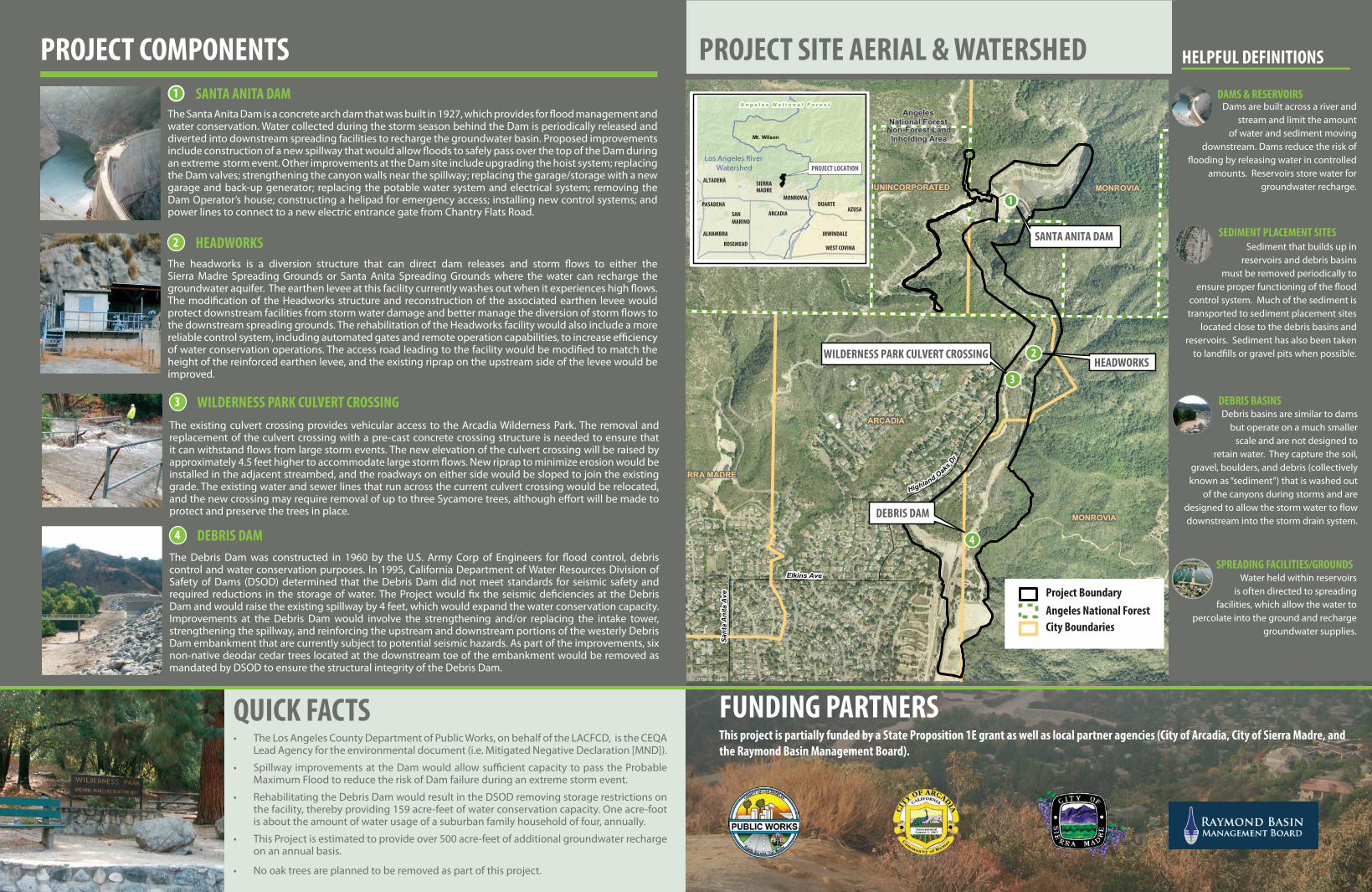
Project BoundaryAngeles National ForestCity Boundaries
Mt. Wilson
A n g e l e s N a t i o n a l F o r e s t
PROJECT LOCATION
ALTADENA SIERRAMADRE
MONROVIADUARTE
AZUSASANMARINO
PASADENA
ALHAMBRA
ROSEMEAD
IRWINDALE
Los Angeles River Watershed
WEST COVINA
ARCADIA
4
2
1
3
FILLER TEXT
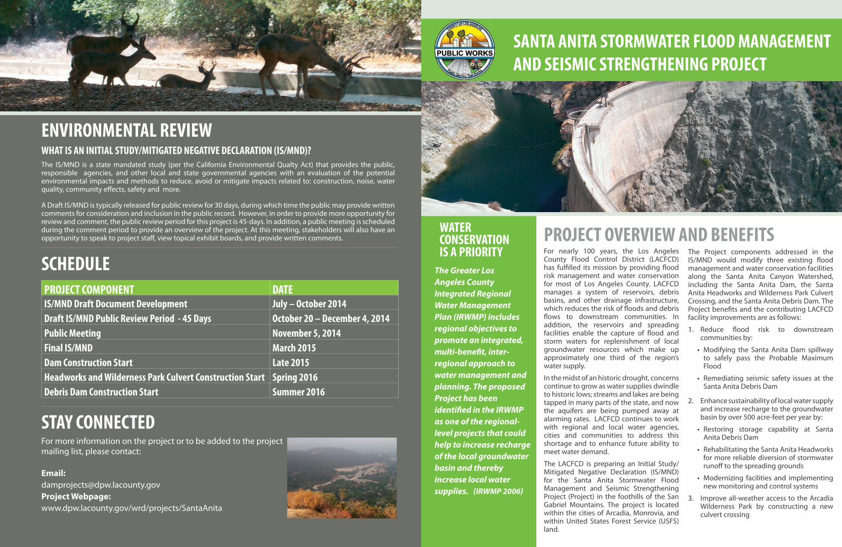
The Santa Anita Dam is a concrete arch dam that was built in 1927, which provides for �ood management and water conservation. Water collected during the storm season behind the Dam is periodically released and diverted into downstream spreading facilities to recharge the groundwater basin. Proposed improvements include construction of a new spillway that would allow �oods to safely pass over the top of the Dam during an extreme storm event. Other improvements at the Dam site include upgrading the hoist system; replacing the Dam valves; strengthening the canyon walls near the spillway; replacing the garage/storage with a new garage and back-up generator; replacing the potable water system and electrical system; removing the Dam Operator’s house; constructing a helipad for emergency access; installing new control systems; and power lines to connect to a new electric entrance gate from Chantry Flats Road.
1 SANTA ANITA DAM
3 WILDERNESS PARK CULVERT CROSSING
2 HEADWORKS
DEBRIS DAM4
The Debris Dam was constructed in 1960 by the U.S. Army Corp of Engineers for �ood control, debris control and water conservation purposes. In 1995, California Department of Water Resources Division of Safety of Dams (DSOD) determined that the Debris Dam did not meet standards for seismic safety and required reductions in the storage of water. The Project would �x the seismic de�ciencies at the Debris Dam and would raise the existing spillway by 4 feet, which would expand the water conservation capacity. Improvements at the Debris Dam would involve the strengthening and/or replacing the intake tower, strengthening the spillway, and reinforcing the upstream and downstream portions of the westerly Debris Dam embankment that are currently subject to potential seismic hazards. As part of the improvements, six non-native deodar cedar trees located at the downstream toe of the embankment would be removed as mandated by DSOD to ensure the structural integrity of the Debris Dam.
The headworks is a diversion structure that can direct dam releases and storm �ows to either the Sierra Madre Spreading Grounds or Santa Anita Spreading Grounds where the water can recharge the groundwater aquifer. The earthen levee at this facility currently washes out when it experiences high �ows. The modi�cation of the Headworks structure and reconstruction of the associated earthen levee would protect downstream facilities from storm water damage and better manage the diversion of storm �ows to the downstream spreading grounds. The rehabilitation of the Headworks facility would also include a more reliable control system, including automated gates and remote operation capabilities, to increase e�ciency of water conservation operations. The access road leading to the facility would be modi�ed to match the height of the reinforced earthen levee, and the existing riprap on the upstream side of the levee would be improved.
The existing culvert crossing provides vehicular access to the Arcadia Wilderness Park. The removal and replacement of the culvert crossing with a pre-cast concrete crossing structure is needed to ensure that it can withstand �ows from large storm events. The new elevation of the culvert crossing will be raised by approximately 4.5 feet higher to accommodate large storm �ows. New riprap to minimize erosion would be installed in the adjacent streambed, and the roadways on either side would be sloped to join the existing grade. The existing water and sewer lines that run across the current culvert crossing would be relocated, and the new crossing may require removal of up to three Sycamore trees, although e�ort will be made to protect and preserve the trees in place.
PROJECT COMPONENTS
• The Los Angeles County Department of Public Works, on behalf of the LACFCD, is the CEQA Lead Agency for the environmental document (i.e. Mitigated Negative Declaration [MND]).
• Spillway improvements at the Dam would allow su�cient capacity to pass the Probable Maximum Flood to reduce the risk of Dam failure during an extreme storm event.
• Rehabilitating the Debris Dam would result in the DSOD removing storage restrictions on the facility, thereby providing 159 acre-feet of water conservation capacity. One acre-foot is about the amount of water usage of a suburban family household of four, annually.
• This Project is estimated to provide over 500 acre-feet of additional groundwater recharge on an annual basis.
• No oak trees are planned to be removed as part of this project.
PROJECT SITE AERIAL & WATERSHED HELPFUL DEFINITIONS
Water held within reservoirs is often directed to spreading
facilities, which allow the water to percolate into the ground and recharge
groundwater supplies.
SEDIMENT PLACEMENT SITES
DEBRIS BASINS
SPREADING FACILITIES/GROUNDS
Sediment that builds up in reservoirs and debris basins
must be removed periodically to ensure proper functioning of the �ood
control system. Much of the sediment is transported to sediment placement sites
located close to the debris basins and reservoirs. Sediment has also been taken
to land�lls or gravel pits when possible.
Debris basins are similar to dams but operate on a much smaller
scale and are not designed to retain water. They capture the soil,
gravel, boulders, and debris (collectively known as “sediment”) that is washed out
of the canyons during storms and are designed to allow the storm water to �ow downstream into the storm drain system.
FUNDING PARTNERSThis project is partially funded by a State Proposition 1E grant as well as local partner agencies (City of Arcadia, City of Sierra Madre, and the Raymond Basin Management Board).
Dams are built across a river and stream and limit the amount
of water and sediment moving downstream. Dams reduce the risk of
�ooding by releasing water in controlled amounts. Reservoirs store water for
groundwater recharge.
DAMS & RESERVOIRS
SANTA ANITA STORMWATER FLOOD MANAGEMENT AND SEISMIC STRENGTHENING PROJECT
PROJECT OVERVIEW AND BENEFITSFor nearly 100 years, the Los Angeles County Flood Control District (LACFCD) has ful�lled its mission by providing �ood risk management and water conservation for most of Los Angeles County. LACFCD manages a system of reservoirs, debris basins, and other drainage infrastructure, which reduces the risk of �oods and debris �ows to downstream communities. In addition, the reservoirs and spreading facilities enable the capture of �ood and storm waters for replenishment of local groundwater resources which make up approximately one third of the region’s water supply.
In the midst of an historic drought, concerns continue to grow as water supplies dwindle to historic lows; streams and lakes are being tapped in many parts of the state, and now the aquifers are being pumped away at alarming rates. LACFCD continues to work with regional and local water agencies, cities and communities to address this shortage and to enhance future ability to meet water demand.
The LACFCD is preparing an Initial Study/Mitigated Negative Declaration (IS/MND) for the Santa Anita Stormwater Flood Management and Seismic Strengthening Project (Project) in the foothills of the San Gabriel Mountains. The project is located within the cities of Arcadia, Monrovia, and within United States Forest Service (USFS) land.
The Project components addressed in the IS/MND would modify three existing �ood management and water conservation facilities along the Santa Anita Canyon Watershed, including the Santa Anita Dam, the Santa Anita Headworks and Wilderness Park Culvert Crossing, and the Santa Anita Debris Dam. The Project bene�ts and the contributing LACFCD facility improvements are as follows:
1. Reduce �ood risk to downstream communities by:
• Modifying the Santa Anita Dam spillway to safely pass the Probable Maximum Flood
• Remediating seismic safety issues at the Santa Anita Debris Dam
2. Enhance sustainability of local water supply and increase recharge to the groundwater basin by over 500 acre-feet per year by:
• Restoring storage capability at Santa Anita Debris Dam
• Rehabilitating the Santa Anita Headworks for more reliable diversion of stormwater runo� to the spreading grounds
• Modernizing facilities and implementing new monitoring and control systems
3. Improve all-weather access to the Arcadia Wilderness Park by constructing a new culvert crossing
WATER CONSERVATION IS A PRIORITY
The Greater Los Angeles County Integrated Regional Water Management Plan (IRWMP) includes regional objectives to promote an integrated, multi-bene�t, inter-regional approach to water management and planning. The proposed Project has been identi�ed in the IRWMP as one of the regional-level projects that could help to increase recharge of the local groundwater basin and thereby increase local water supplies. (IRWMP 2006)
The IS/MND is a state mandated study (per the California Environmental Qualty Act) that provides the public, responsible agencies, and other local and state governmental agencies with an evaluation of the potential environmental impacts and methods to reduce, avoid or mitigate impacts related to: construction, noise, water quality, community e�ects, safety and more.
A Draft IS/MND is typically released for public review for 30 days, during which time the public may provide written comments for consideration and inclusion in the public record. However, in order to provide more opportunity for review and comment, the public review period for this project is 45-days. In addition, a public meeting is scheduled during the comment period to provide an overview of the project. At this meeting, stakeholders will also have an opportunity to speak to project sta�, view topical exhibit boards, and provide written comments.
For more information on the project or to be added to the project mailing list, please contact: Email: [email protected] Webpage: www.dpw.lacounty.gov/wrd/projects/SantaAnita
STAY CONNECTED
WHAT IS AN INITIAL STUDY/MITIGATED NEGATIVE DECLARATION (IS/MND)?
PROJECT COMPONENT DATEIS/MND Draft Document Development July – October 2014Draft IS/MND Public Review Period - 45 Days October 20 – December 4, 2014Public Meeting November 5, 2014 Final IS/MND March 2015Dam Construction Start Late 2015Headworks and Wilderness Park Culvert Construction Start Spring 2016Debris Dam Construction Start Summer 2016
SCHEDULE
ENVIRONMENTAL REVIEW