quaternary science reviews - rutgers university · g department of anthropology, rutgers...
TRANSCRIPT

lable at ScienceDirect
Quaternary Science Reviews 174 (2017) 1e12
Contents lists avai
Quaternary Science Reviews
journal homepage: www.elsevier .com/locate/quascirev
Invited review
Gradual or abrupt? Changes in water source of Lake Turkana (Kenya)during the African Humid Period inferred from Sr isotope ratios
H.J.L. van der Lubbe a, *, J. Krause-Nehring b, A. Junginger c, Y. Garcin d, J.C.A. Joordens a, e,G.R. Davies a, C. Beck f, C.S. Feibel g, T.C. Johnson h, H.B. Vonhof i
a Faculty of Science, Geology and Geochemistry, Vrije Universiteit (VU, Amsterdam), De Boelelaan 1085, 1081 HV Amsterdam, The Netherlandsb Formerly: Faculty of Science, Geology and Geochemistry, Vrije Universiteit (VU, Amsterdam), De Boelelaan 1085, 1081 HV Amsterdam, The Netherlandsc Eberhard Karls Universit€at Tübingen, Department of Earth Sciences, Senckenberg Center for Human Evolution and Palaeoenvironment (HEP-Tübingen),H€olderlinstraße 12, 72074 Tübingen, Germanyd Institut für Erd- und Umweltwissenschaften, Universit€at Potsdam, Karl-Liebknechtstraße 24-25, 14476 Potsdam-Golm, Germanye Faculty of Archaeology, Leiden University, Einsteinweg 2, 2333 CC Leiden, The Netherlandsf Geosciences, Hamilton College, Taylor Science Center 1024, 13323 Clinton, NY, USAg Department of Anthropology, Rutgers University, Biological Sciences Building, Douglass Campus, 131 George Street, 08901-1414 New Brunswick, NJ, USAh Large Lakes Observatory, University of Minnesota Duluth, 1049 University Drive, 55812 Duluth, MN, USAi Max Planck Institute of Chemistry, Hahn-Meitnerweg 1, 55128, Mainz, Germany
a r t i c l e i n f o
Article history:Received 1 February 2017Received in revised form12 July 2017Available online 23 August 2017
1. Introduction
Spatiotemporal reconstruction of wetting and drying in Africarelated to the Holocene African Humid Period (hereafter AHP) isimportant for understanding African hydroclimate dynamics, andfor projection of the effects of future global warming on wateravailability and its societal impact in Africa (e.g. IPCC, 2014). TheAHP roughly spans the interval from ~14.5 to 4.5 ka BP (Gasse,2000). It is linked to the orbitally-induced northern hemispheresummer insolationmaximum increasing the strength of the AfricanMonsoon and thus causing generally humid conditions in northernand equatorial Africa (Rossignol-Strick, 1983; Barker et al., 2004).The dynamics of the AHP termination, however, are subject toongoing debate (e.g. deMenocal, 2008; Shanahan et al., 2015), sincesome proxy records and climate models show an abrupt
* Corresponding author.E-mail addresses: [email protected] (H.J.L. van der Lubbe), jacquelinekn@
hotmail.com (J. Krause-Nehring), [email protected](A. Junginger), [email protected] (Y. Garcin), [email protected] (J.C.A. Joordens), [email protected] (G.R. Davies), [email protected] (C. Beck), [email protected] (C.S. Feibel), [email protected](T.C. Johnson), [email protected] (H.B. Vonhof).
http://dx.doi.org/10.1016/j.quascirev.2017.08.0100277-3791/© 2017 Elsevier Ltd. All rights reserved.
termination (Claussen et al., 1999; deMenocal et al., 2000; McGeeet al., 2013; Tierney and deMenocal, 2013; Van Rampelberghet al., 2013), whereas others indicate more gradual transition (e.g.Renssen et al., 2003; Jung et al., 2004; Tjallingii et al., 2008).
Proxy records from Lake Turkana (northwestern Kenya; Fig. 1a)suggest an abrupt lake-level decline starting at ~5.3 ka BP (Garcinet al., 2012; Forman et al., 2014; Bloszies et al., 2015), which maysupport the rapid AHP termination hypothesis. Non-linear pro-cesses breaching thresholds could, however, have accelerated thehydrological response of lake levels to gradual climate forcing(Trauth et al., 2010). For instance, the probable disconnection of theChew Bahir and Suguta Basins from the Turkana Basin at the end ofthe AHP may have accelerated lake-level changes of Lake Turkana(Fig. 1b, c and d). In the present study, we aim to assess such non-linear processes in African lake-level reconstructions. Using thestrontium isotope composition of paleo-lake Turkana across theAHP and its termination, we constrained temporal changes in themagnitude of the hydrological contribution of various sub-basins tothis lake, offering new insights into the drivers of its past hydro-logical variability.
Radiogenic strontium isotope ratios (87Sr/86Sr) are particularlyuseful for water provenance studies in brackish water (Anderssonet al., 1992; Ingram and Sloan, 1992; Ingram and DePaolo, 1993;Holmden et al., 1997; Reinhardt et al., 1998; Vonhof et al., 2003;Joordens et al., 2009; Lougheed et al., 2016) and freshwater set-tings (Yang et al., 1996; Hart et al., 2004; Williams et al., 2006;Joordens et al., 2011, 2013; Doebbert et al., 2014). The advantageof the radiogenic Sr isotope technique is that it involves a frac-tionation correction during measurement that essentially removesthe effects of analytical and natural isotope fractionation inducedby biological or environmental variation. Due to this correction,biologically-mediated and inorganic carbonates that incorporate

H.J.L. van der Lubbe et al. / Quaternary Science Reviews 174 (2017) 1e122
H.J.L. van der Lubbe et al. / Quaternary Science Reviews 174 (2017) 1e12 3
dissolved Sr from the ambient water provide 87Sr/86Sr ratios thatare identical to those of their host waters (Palmer and Edmond,1989). Moreover, the residence time of Sr in lake waters willgenerally exceedmixing times due to the conservative geochemicalbehavior of Sr. As Lake Turkana lacks extensive dissolved strontiumsinks (like rapid tufa deposition), and annual dissolved Sr fluxes tothe lake are much smaller than the lake's dissolved Sr reservoir, itshould typically behave chemically conservative. Such behaviorideally results in spatially homogenous 87Sr/86Sr ratios in the lakeand a relative insensitivity to seasonal changes in the Sr fluxes,while remaining sensitive to changes at decadal to millennial time-scales. In Lake Turkana, the 87Sr/86Sr ratios of lacustrine carbonatesthus reflect the weighted average fluxes of dissolved Sr weatheredfrom soils and bedrock material in the various sub-catchments tothe lake. The regional geological variations, both in terms of age androck type, have produced sub-catchments with significant varia-tions in bedrock 87Sr/86Sr ratios. Any temporal changes in therelative contribution from these sub-catchments will result instratigraphic shifts in the 87Sr/86Sr composition of the lacustrinefossil record (Joordens et al., 2011).
2. Background
With a surface area of ~6500 km2, present-day Lake Turkana isone of the largest lakes in Africa. It occupies the topographicallylowest part of the East African Rift System (EARS), the so-calledTurkana depression (Morley et al., 1992). Most (~80e90%) of thewater in Lake Turkana is delivered by the Omo River that drains thehumid Ethiopian Highlands at >1000 m above sea-level (Yuretichand Cerling, 1983). The ephemeral Turkwel and Kerio Rivers thatrise at the Kenyan Plateau provide the remaining input into LakeTurkana (~10e20%) (Fig. 1). Smaller ephemeral rivers andnumerous streams that drain the lake margins have a negligibleeffect on the hydrological balance of Lake Turkana (Yuretich andCerling, 1983). Today, Lake Turkana is an alkaline terminal lakesituated ~80 m below its overflow level (Yuretich and Cerling,1983). The annual evaporative water loss, in the order of~17.5 � 109 m3 from the lake surface, roughly balances the inputfrom the Omo, Kerio, and Turkwel rivers (Yuretich and Cerling,1983). Lake Turkana serves as a unique source of food and waterin a generally arid region, and as such is vital to communities thatlive along the lake margins (e.g. Gownaris et al., 2015).
Due to basin geometry and high evaporation rates, lakes in theEARS are and were extremely sensitive to hydroclimatic variations,leading to rapid lake level fluctuations, flooding and/or sub-aerialexposure of large surface areas (e.g. Owen and Renaut, 1986;Trauth et al., 2010; Garcin et al., 2012). During the late Pleisto-cene and Holocene, repeated rapid lake level fluctuations includinghighstands of several tens of meters above the present-day levelhave been documented in the lacustrine sedimentary record of theTurkana Basin (Butzer et al., 1972; Owen et al., 1982; Garcin et al.,2012; Forman et al., 2014; Bloszies et al., 2015). During the early-to-middle Holocene, the Turkana Basin was occupied by a largefreshwater lake (>22.500 km2), which frequently reached its
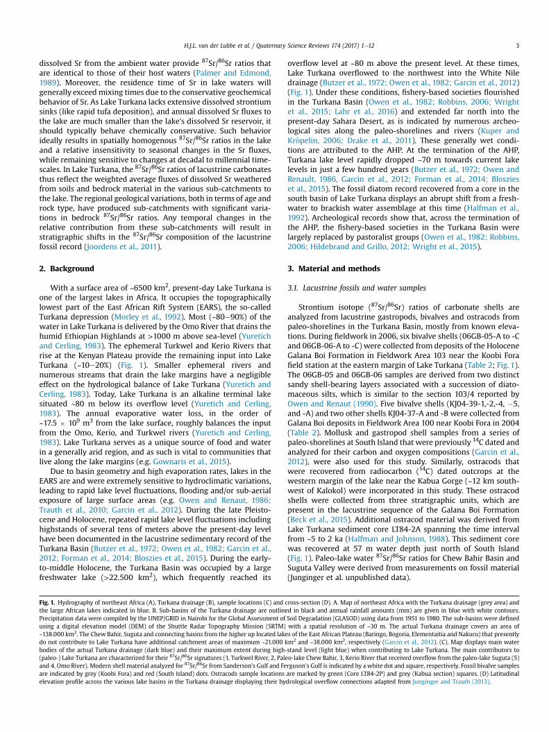
Fig. 1. Hydrography of northeast Africa (A), Turkana drainage (B), sample locations (C) and cthe large African lakes indicated in blue. B. Sub-basins of the Turkana drainage are outlinePrecipitation data were compiled by the UNEP/GRID in Nairobi for the Global Assessment ofusing a digital elevation model (DEM) of the Shuttle Radar Topography Mission (SRTM)~138.000 km2. The Chew Bahir, Suguta and connecting basins from the higher up located lakedo not contribute to Lake Turkana have additional catchment areas of maximum ~21.000 kbodies of the actual Turkana drainage (dark blue) and their maximum extent during high-(paleo-) Lake Turkana are characterized for their 87Sr/86Sr signatures (1, Turkwel River, 2, Paleand 4, Omo River). Modern shell material analyzed for 87Sr/86Sr from Sanderson’s Gulf and Feare indicated by grey (Koobi Fora) and red (South Island) dots. Ostracods sample locationselevation profile across the various lake basins in the Turkana drainage displaying their hy
overflow level at ~80 m above the present level. At these times,Lake Turkana overflowed to the northwest into the White Niledrainage (Butzer et al., 1972; Owen et al., 1982; Garcin et al., 2012)(Fig. 1). Under these conditions, fishery-based societies flourishedin the Turkana Basin (Owen et al., 1982; Robbins, 2006; Wrightet al., 2015; Lahr et al., 2016) and extended far north into thepresent-day Sahara Desert, as is indicated by numerous archeo-logical sites along the paleo-shorelines and rivers (Kuper andKr€opelin, 2006; Drake et al., 2011). These generally wet condi-tions are attributed to the AHP. At the termination of the AHP,Turkana lake level rapidly dropped ~70 m towards current lakelevels in just a few hundred years (Butzer et al., 1972; Owen andRenault, 1986, Garcin et al., 2012; Forman et al., 2014; Bloszieset al., 2015). The fossil diatom record recovered from a core in thesouth basin of Lake Turkana displays an abrupt shift from a fresh-water to brackish water assemblage at this time (Halfman et al.,1992). Archeological records show that, across the termination ofthe AHP, the fishery-based societies in the Turkana Basin werelargely replaced by pastoralist groups (Owen et al., 1982; Robbins,2006; Hildebrand and Grillo, 2012; Wright et al., 2015).
3. Material and methods
3.1. Lacustrine fossils and water samples
Strontium isotope (87Sr/86Sr) ratios of carbonate shells areanalyzed from lacustrine gastropods, bivalves and ostracods frompaleo-shorelines in the Turkana Basin, mostly from known eleva-tions. During fieldwork in 2006, six bivalve shells (06GB-05-A to -Cand 06GB-06-A to -C) were collected from deposits of the HoloceneGalana Boi Formation in Fieldwork Area 103 near the Koobi Forafield station at the eastern margin of Lake Turkana (Table 2; Fig. 1).The 06GB-05 and 06GB-06 samples are derived from two distinctsandy shell-bearing layers associated with a succession of diato-maceous silts, which is similar to the section 103/4 reported byOwen and Renaut (1990). Five bivalve shells (KJ04-39-1,-2,-4, �5,and -A) and two other shells KJ04-37-A and -B were collected fromGalana Boi deposits in Fieldwork Area 100 near Koobi Fora in 2004(Table 2). Mollusk and gastropod shell samples from a series ofpaleo-shorelines at South Island that were previously 14C dated andanalyzed for their carbon and oxygen compositions (Garcin et al.,2012), were also used for this study. Similarly, ostracods thatwere recovered from radiocarbon (14C) dated outcrops at thewestern margin of the lake near the Kabua Gorge (~12 km south-west of Kalokol) were incorporated in this study. These ostracodshells were collected from three stratigraphic units, which arepresent in the lacustrine sequence of the Galana Boi Formation(Beck et al., 2015). Additional ostracod material was derived fromLake Turkana sediment core LT84-2A spanning the time intervalfrom ~5 to 2 ka (Halfman and Johnson, 1988). This sediment corewas recovered at 57 m water depth just north of South Island(Fig. 1). Paleo-lake water 87Sr/86Sr ratios for Chew Bahir Basin andSuguta Valley were derived from measurements on fossil material(Junginger et al. unpublished data).
ross-section (D). A. Map of northeast Africa with the Turkana drainage (grey area) andd in black and annual rainfall amounts (mm) are given in blue with white contours.Soil Degradation (GLASOD) using data from 1951 to 1980. The sub-basins were definedwith a spatial resolution of ~30 m. The actual Turkana drainage covers an area ofs of the East African Plateau (Baringo, Bogoria, Elementaitia and Nakuru) that presentlym2 and ~38.000 km2, respectively (Garcin et al., 2012). (C). Map displays main waterstand level (light blue) when contributing to Lake Turkana. The main contributors too-lake Chew Bahir, 3, Kerio River that received overflow from the paleo-lake Suguta (5)rguson’s Gulf is indicated by a white dot and square, respectively. Fossil bivalve samplesare marked by green (Core LT84-2P) and grey (Kabua section) squares. (D) Latitudinaldrological overflow connections adapted from Junginger and Trauth (2013).
H.J.L. van der Lubbe et al. / Quaternary Science Reviews 174 (2017) 1e124
Modern shells of the bivalve Chambardia wahlbergi (SG-13 andDD68 Sangulf), collected from Sanderson's Gulf in 1968, werepreviously provided by Dirk van Damme (Ghent University,Belgium) (Vonhof et al., 2013). A modern Lake Turkana ostracodsample was collected from Ferguson's Gulf (Beck et al., 2015). Srisotope ratios and concentrations for several Omo, Turkwel andKerio river water samples, were kindly provided by Thure Cerling(pers. comm., Table 1). Additionally, awater samplewas taken for Srisotope analysis from the Loiyangalani hot spring in the summer2006, which located, northeast of South Island, at the eastern shoreof Lake Turkana (Fig. 1c).
3.2. Radiocarbon age determination
For this study, bivalve samples, 06GB-05-C, 06GB-06-C, KJ04-37-A and KJ04-39-A were radiocarbon-dated at the Center forIsotope Research (CIO) of the University of Groningen (theNetherlands). The 14C ages of the shell material from South Islandwere previously obtained by Garcin et al. (2012). Radiocarbon agesof ostracods from Kabua were obtained by Beck et al. (2015). Thechronology of the ostracod samples from core LT8-2P was derivedby linear interpolation between 14C based age-depth points(Halfman et al., 1994; Berke et al., 2012). For this study, all 14C ageswere converted to calibrated ages (ka BP) using CALIB version 6.11(Stuiver and Reimer, 1993; Reimer et al., 2004) with the IntCal09curve. Due to the high exchange rate between CO2 in the lake waterand atmospheric CO2, no 14C reservoir age correction is applied forLake Turkana (Halfman et al., 1994; Berke et al., 2012; Garcin et al.,2012).
3.3. Strontium isotope analysis
Prior to sample dissolution for Sr isotope analysis, discretefragments of shell carbonate were leached in 5N acetic acid for afew minutes and rinsed several times with MilliQ water to removelabile, secondary carbonates that could reside on the surface of thesample. Thewater sample from Loiyangalani received no other pre-treatment than filtering, before drying down on a hot plate. Fromeach sample, a split containing ~0.2e1.0 mg of Sr was dissolved in3N HNO3 and Sr was extracted using Eichrom Sr spec ion exchangeresin. 87Sr/86Sr ratios were analyzed using either a Finnigan MAT262 Thermal Ionization Mass Spectrometry (TIMS) or a ThermoTRITON Plus TIMS at the Vrije Universiteit Amsterdam. All 87Sr/86Srratios were corrected for Rb interference and for mass fractionation
Table 187Sr/86Sr fluxes of water source areas in the Turkana drainage that were used as input fo
Water source 87Sr/86Sr Discharg(Mm3/yr
Turkwel River 0.7083d 600a
Kerio River 0.7054d 157a
Omo River 0.7051d 16600a
Loiyangalani hot spring 0.7039f unknownPaleo-lake Chew Bahir overflow 0.7064e unknownPaleo-lake Suguta overflow 0.7047e unknown
87Sr/86Sr Water re(Mm3)
Lake Turkana Modern 0.7051f 237000b
Paleolake Turkana at overflow level variable 1350000
Mm3 ¼ 106 m3.a Avery (2012).b Hopson (1982).c Cerling (1986).d Cerling (pers comm.).e Junginger et al. (unpublished data).f This study.
by normalization to an 86Sr/88Sr ratio of 0.1194. The NBS-987standard that is routinely analyzed in duplicate for each run gavean average 87Sr/86Sr ratio of 0.710236 ± 0.000006 (2s; n ¼ 4),which is within the statistical error of the long-term average of theFinnigan MAT 262 TIMS. The NBS-987 standard was analyzed induplicate or triplicate for each run at the Thermo TRITON Plus, andgave an 87Sr/86Sr ratio of 0.710264 ± 0.000006 (2s; n¼ 6), which, iswithin error, of the long-term average 87Sr/86Sr ratio of0.710266 ± 0.000015 (2s; n ¼ 14). The reported 87Sr/86Sr ratioswere normalized to the accepted 87Sr/86Sr ratio of the NBS-987standard of 0.710245. Procedural blanks yield <35 pg of Sr, whichis in the order of 0.01% of the Sr in a sample, and thereforenegligible.
3.4. Sr isotope mass balance model
In order to evaluate the sensitivity of the Sr isotope budget ofLake Turkana to changes in Sr fluxes from the different sub-catchments of the Turkana Basin, mass balance model calcula-tions were performed using the equation provided by Richter andTurekian (1993):
dR/dt ¼ S(FiRi/N) e S(Fi/N)Ro (1)
Whereby R equals the Sr isotope ratio of the lake, Fi represents theflux of Sr to the lake from a source i, Ri represents the 87Sr/86Sr ratioof each of these fluxes and N equals the Sr budget of Lake Turkana.Ro corresponds to the initial 87Sr/86Sr ratio of the lake. The modelwas set up to perform mass balance calculations incorporatingthree endmembers supplying dissolved Sr to the lake (Table 1). Therate of change of the lake water 87Sr/86Sr signature was calculatedbased on variations in one or more of the endmember fluxes.Required isotope ratios and concentrations of dissolved Sr in thedifferent end-members are taken from Table 1.
4. Results
4.1. Sr isotope values of the Turkana Basin
The 87Sr/86Sr ratios of modern and fossil shell carbonates, aswell as from the rivers discharging into the lake, are shown inTables 1 and 2 and Fig. 2. These data show that modern shells andwater from the lake have comparable Sr isotope values of0.7049e0.7051, and that these values are consistent across the lake.
r the Sr isotope mass balance model.
e)
Sr concentration(ppm)
Dissolved Sr flux(moles/yr)
0.1d 6.85Eþ050.08d 1.44Eþ050.1d 1.52Eþ070.28 unknownunknown unknownunknown unknown
servoir Sr concentration(ppm)
Dissolved Sr reservoir(moles)
0.08 2.16Eþ08c 0.08 1.23Eþ09

Table 2Sample codes, carbonate shell material, measured 14C ages with uncertainty levels, location, coordinates, elevation, mean calibrated 14C ages with 95% lower and upperconfidence limits, 87Sr/86Sr values with 2s uncertainty levels. The ages for core LT80-2Pwere obtained by linearly interpolation of 14C the ages (Halfman et al.,1994; Berke et al.,2012). 1)Thermo TRITON Plus TIMS, 2)MAT 262 TIMS.
Material 14C kyr BP Latitude Longitude Elevation (m.a.s.l.) ka BP (�/+) 87Sr/86Sr
South Island (Garcin et al., 2012)Melanoides tuberculata 8180 ± 45 2.6611 36.5879 454 9125 (109/143) 0.705401 ± 0.000081
Etheria elliptica 9740 ± 50 2.6611 36.5879 459 11182 (299/64) 0.706063 ± 0.000091
Melanoides tuberculata 4645 ± 35 2.6272 36.5720 438 5406 (99/62) 0.705320 ± 0.000081
Melanoides tuberculata 4330 ± 30 2.6261 36.5712 427 4892 (49/76) 0.705261 ± 0.000081
Melanoides tuberculata 4680 ± 35 2.6255 36.5716 418 5400 (84/175) 0.705373 ± 0.000091
Melanoides tuberculata 4370 ± 35 2.6247 36.5715 410 4931 (76/108) 0.705305 ± 0.000131
Bivalve shell 4910 ± 35 2.6237 36.5713 405 5635 (45/79) 0.705244 ±0.000101
Melanoides tuberculata 4695 ± 35 2.6192 36.5711 393 5403 (84/176) 0.705213 ± 0.000081
Kabua (Beck et al., 2015)Kabua 22a Limnocythere sp. (short) 11670 ± 40 438 13521 (144/161) 0.706008 ± 0.000051
Kabua 26 Ilyocypris gibba 10790 ± 40 442 12668 (95/142) 0.706223 ± 0.000051
Kabua 30 Limnocythere sp. (juvenile) 9740 ± 40 445 11188 (85/50) 0.706008 ± 0.000041
Kabua 1 Potamocypris sp. 9530 ± 40 418 10869 (175/214) 0.706134 ± 0.000071
Ferguson's GulfFG3: 80-79 cm Potamocypris sp. 360 ± 70 3.5171 35.9094 360 405 (113/113) 0.705024 ± 0.000051
FG3: 45-44 cm Potamocypris sp. modern 3.5171 35.9094 363 0.705064 ± 0.000041
Sanderson's GulfSG13 Chambardia wahlbergi modern 0.704910 ± 0.000092
DD68 Sangulf-(juvenile) Chambardia wahlbergi modern 0.704977 ± 0.000162
DD68 Sangulf (adult) Chambardia wahlbergi modern 0.705015 ± 0.000132
Koobi Fora (Eastern Turkana)KJ04-37-A Bivalve shell 5045 ± 35 5818 (154/86) 0.705340 ± 0.000072
KJ04-37-B Bivalve shell “ “ “ 0.705363 ± 0.000122
Average: 5818 (154/86) 0.705352KJ04-39A Bivalve shell
(Corbicula sp.)9880 ± 40 3.9522 39.2888 11271 (58/119) 0.706055 ± 0.000102
KJ04-39-1 “ “ “ “ “ “ 0.705956 ± 0.000092
KJ04-39-2 “ “ “ “ “ “ 0.706002 ± 0.000072
KJ04-39-4 “ “ “ “ “ “ 0,706003 ± 0.000192
KJ04-39-5 “ “ “ “ “ “ 0.706025 ± 0.000092
Average: 11271 (58/119) 0.70601006GB-05 Bivalve shell 5440 ± 35 3.9222 39.2423 6242 (53/55) 0.705454 ± 0.000092
06GB-05-C “ “ “ “ “ “ 0.705380 ± 0.000092
06GB-05-B “ “ “ “ “ “ 0.705430 ± 0.000102
06GB-05-A “ “ “ “ “ “ 0.705457 ± 0.000102
Average: 6242 (53/55) 0.70542206GB-06-C Bivalve shell 5130 ± 35 3.9222 39.2423 5888 (138/54) 0.705336 ± 0.000082
06GB-06-B “ “ “ “ “ “ 0.705304 ± 0.000092
06GB-06-A “ “ “ “ “ “ 0.705273 ± 0.000072
Average: 5888 (138/54) 0.705304Southern BasinLT80-2P-67 cm Ostracod shell 2.7125 36.5370 1490 0.705092 ± 0.000102
LT80-2P-156 cm “ “ “ 1842 0.705092 ± 0.000092
LT80-2P-258 cm “ “ “ 2245 0.705093 ± 0.000102
LT80-2P-362 cm “ “ “ 2656 0.705133 ± 0.000112
LT80-2P-471 cm “ “ “ 3086 0.705155 ± 0.000102
LT80-2P-561 cm “ “ “ 3451 0.705177 ± 0.000092
LT80-2P-674 cm “ “ “ 3913 0.705179 ± 0.000072
LT80-2P-774 cm “ “ “ 4322 0.705246 ± 0.000072
LT80-2P-844 cm “ “ “ 4608 0.705271 ± 0.000102
LT80-2P-962 cm “ “ “ 5090 0.705298 ± 0.000112
H.J.L. van der Lubbe et al. / Quaternary Science Reviews 174 (2017) 1e12 5
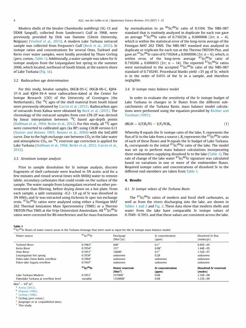
The 87Sr/86Sr ratios of the modern lake are closest to those of theOmo River, which has an 87Sr/86Sr ratio of 0.7051. These observa-tions are in line with the previously inferred dominance of OmoRiver input on Turkana Lake chemistry (Yuretich and Cerling, 1983).At a value of 0.7083, the 87Sr/86Sr ratio of the Turkwel River rep-resents the most radiogenic source area discharging to Lake Tur-kana. The nearby Kerio River has an 87Sr/86Sr ratio of 0.7054, whichis lower than the Turkwel River, but still more radiogenic than87Sr/86Sr ratios of the Omo River.
An estimate for the 87Sr/86Sr composition of possible overflowfrom paleo-lake Chew Bahir (Fig. 1) into Lake Turkana is providedby the average value of 14 87Sr/86Sr measurements of shell and fishfossils, which are obtained from sediment core CB-01 spanning theinterval between 15 and 5 ka BP. The 87Sr/86Sr range of these paleo-
lake Chew Bahir fossils is relatively narrow, with values between0.7060 and 0.7065 averaging at 0.7064 (Table 1; Junginger, un-published data).
An additional source area of overflow into Lake Turkana ispaleo-lake Suguta (Fig. 2). Fifteen shell and fish fossils collectedfrom several lacustrine outcrops in the Suguta Valley wereanalyzed, spanning the interval between 14 and 7 ka BP, whenpaleo-lake Suguta was at its maximum extent (Junginger et al.,2014) (Figs. 1c and 3c). The total 87Sr/86Sr range of these fossils isbetween 0.7040 and 0.7050 having an average value of 0.7047(Table 1; Junginger, unpublished data).
The 87Sr/86Sr record of Lake Turkana shows a clear temporaltrend (Fig. 2b). The 87Sr/86Sr ratios of ostracods younger than ~2 kaBP (from Kabua and sediment core LT84-2P, Southern Basin) are
Fig. 2. Strontium isotope systematics of the Turkana drainage. (A) Simplified geological map of the Turkana basin with outlines of sub-basins. The geological units were obtainedfrom a digital geological map [Geological Survey of Canada, 1995]. (B) Record of 87Sr/86Sr ratios of lacustrine carbonate shells (gastropods, bivalves and ostracods) over the last 14 kaBP in comparison to (modern) 87Sr/86Sr ratios of the various sub-basins of the Turkana drainage.
H.J.L. van der Lubbe et al. / Quaternary Science Reviews 174 (2017) 1e126
comparable to modern lacustrine carbonates. Between ~6.2 and ~2ka BP, the 87Sr/86Sr ratios record a decrease from ~0.7054 towards~0.7050. During this interval, the 87Sr/86Sr ratios in gastropods andmolluscs from South Island are comparable to 87Sr/86Sr ratios ob-tained from ostracods of the nearby lacustrine core LT84-2P (Fig. 2).The 87Sr/86Sr ratios of bivalves that were collected from paleo-shoreline deposits from the eastern margin of Lake Turkana fitthe stratigraphic trend in 87Sr/86Sr ratios deduced from the otherrecords. Except for a single sample that is dated at 9.1 ka BP, nolacustrine carbonates were available in the time interval between10.8 and 6.3 ka BP. Between 13.5 and 10.9 ka BP, 87Sr/86Sr ratiosrange from 0.7060 to 0.7062 in ostracods of Kabua, mollusks fromSouth Island and the eastern margin of Lake Turkana, which isconsiderably more radiogenic than the younger samples. Thesedata indicate that Lake Turkana experienced considerable
hydrographic changes over time, not only in the amount of runoff,but also the provenance (i.e., geographical source areas) of inflowover the last ~14 kyrs.
5. Discussion
5.1. Strontium isotope systematics of modern Turkana Basin
Today, the major water source to Lake Turkana is the Omo River,which drains the southern Ethiopian Highlands. This plateau isformed by Eocene-Oligocene flood basalts that have relatively low87Sr/86Sr ratios, typically between 0.7032 and 0.7045 (e.g. Pik et al.,1999) (Fig. 2a). The modern Omo 87Sr/86Sr ratio of 0.7051 is at thehigh end of the range of flood basalts (Table 1), which might beexplained by a minor contribution of runoff from Precambrian

Fig. 3. Hydrographic records of the Turkana region in comparison to solar insolationand W-E Indian Ocean sea surface temperature (SST) gradient. From top to bottom: a)Potassium (K) record of the Chew Bahir Basin indicative for the degree of chemicalweathering, and in turn humidity in the catchment area (Foerster et al., 2012); b)Simplified Turkana lake level record (Garcin et al., 2012) with shell material analyzedby this study using same legend as Fig. 2; c) Lake record of the paleo-lake Suguta(Junginger et al., 2014); d) 87Sr/86Sr record of Lake Turkana (this study) using samelegend as Fig. 2; e) Western (Bard et al., 1997) minus eastern (Mohtadi et al., 2010)Indian Ocean sea surface temperature gradient. f) Summer northern hemisphereinsolation at 20�N (Berger and Loutre, 1991).
H.J.L. van der Lubbe et al. / Quaternary Science Reviews 174 (2017) 1e12 7
basement rocks, which occur in the lower part of the Omo Catch-ment (Fig. 2a) (Peccerillo et al., 1998; Teklay et al., 1998). Addi-tionally, strontium leached from bedrock and soil material mayhave slightly higher 87Sr/86Sr ratios than the protolith, since 87Sr isusually more abundant in minerals that are more susceptible tochemical weathering (e.g. Jung et al., 2004). Relative to the OmoRiver, a slightly more radiogenic 87Sr/86Sr ratio of 0.7054 is char-acteristic for discharge of the Kerio River, which drains the south-western part of the Turkana Basin that includes volcanic andPrecambrian basement rocks. The nearby Turkwel River deliversdistinctly more radiogenic strontium with an 87Sr/86Sr ratio of0.7083, which reflects a much higher proportion of Precambrianbasement rock in its catchment.
Since all riverine Sr concentrations are roughly comparable toeach other (Table 1), the balances calculated for the Sr isotopebudget relate directly to water discharge from these catchments.The measured 87Sr/86Sr ratios of 0.7049e0.7051 for (sub-)moderncarbonate shells of Lake Turkana are close to the calculated isotopicbalance of the various riverine inputs to the lake with a dominant(95%) input of the Omo River and a minor (5%) contribution fromthe Turkwel and Kerio drainages (Fig. 2b).
It is noteworthy, however, that the Sr isotope values in modernlacustrine carbonates are somewhat lower than obtained frommodernwater samples of the Omo River. This apparent discrepancymight be explained by 1) input of thermal springs and/or 2)anthropogenic activities in the Omo drainage.
Hydrothermal springs, which occur at the lake floor and alongthe lake margins (Johnson et al., 1987) are a potential source ofunradiogenic Sr with 87Sr/86Sr ratios as low as 0.7039 as measuredfor the Loiyangalani hot spring at the SE lakemargin (Table 1). Massbalance calculations indicate, however, that modern lake waterchemistry can largely be explained without input from hydrother-mal sources (Yuretich and Cerling, 1983), and observable dischargefrom hydrothermal sources around the lake seems to be relativelysmall. Therefore, we consider the impact of hydrothermal Sr onlacustrine 87Sr/86Sr values to be insufficient to cause the discrep-ancy in the calculated Sr isotope mass balance for Lake Turkana.
Perhaps a more plausible explanation is that modern Omo RiverSr isotope ratios in recent years are increased slightly by agricultureand potentially also by the recent hydroelectric dam construction inthe Omo drainage. Particularly, the use of mineral fertilizers is awell-known cause for elevated riverine Sr isotope ratios (e.g.B€ohlke and Horan, 2000). As determined by extrapolating the slopeof the stratigraphic Sr isotope data in Fig. 2b to the present-day, aprojected pre-anthropogenic Omo River Sr isotope ratio of 0.7049 issuggested, which indicates that the anthropogenic increase of OmoRiver 87Sr/86Sr values still is rather small. This is supported by thefact that the lowest 87Sr/86Sr values (0.7049) are found in the sub-modern (1968) pre-anthropogenic shells from Sanderson's Gulf(Table 2), which seasonally received major inflow from the OmoRiver (Vonhof et al., 2013).
Generally, the 87Sr/86Sr lake signal is faithfully recorded in car-bonate shells across the lake, independent of geographical location,habitat, genus and foraging behavior of the shell-bearing organ-isms. This supports our premise that Lake Turkana is well-mixed fordissolved Sr, due to the conservative behavior of dissolved Sr insuch large waterbodies (Palmer and Edmond, 1989; Vonhof et al.,2003; Hart et al., 2004; Joordens et al., 2011) and validates theuse of Sr isotope ratios measured on carbonates to infer pastchanges in source waters to Lake Turkana.
5.2. Strontium isotope signatures of Suguta and Chew Bahir sub-basins
In the AHP, two additional sources of strontium to Lake Turkana

Fig. 4. Modelled rates of change of the dissolved 87Sr/86Sr values in Lake Turkana froman initial equilibrium, at which the Sr flux from the Omo River is equal to that of theTurkwel and Kerio rivers combined (which mimics the AHP 87Sr/86Sr value), followedat t ¼ 0 by an abrupt drop of the Turkwel-Kerio Sr flux to 10% of the initial value (whichmimics the modern situation). The blue line shows the relatively sluggish responsebased on the larger Sr budget of Lake Turkana at overflow level. The red line shows thesame calculation based on the present lake volume. Note that even in the latter case, alarge and sudden change in input parameters takes several years to significantly alterthe lacustrine Sr isotope budget. At overflow level, it takes close to a decade or longerto do that. Relevant Sr isotope ratios and fluxes used in the calculation are given inTable 1.
H.J.L. van der Lubbe et al. / Quaternary Science Reviews 174 (2017) 1e128
have to be taken into consideration. First, there is evidence for lakelevel highstands in the Suguta Valley during the AHP (Figs. 1c and3c) with occasional overflow to Lake Turkana before ~6.8 ka BP(Junginger et al., 2014). Fossil shell carbonate of paleo-lake Sugutaprovides consistently lower 87Sr/86Sr ratios (~0.7047) than shellcarbonate from Lake Turkana at any time in the last 14 kyrs, whichis in line with the dominance of young volcanic rocks and signifi-cant hydrothermal activity in the Suguta catchment area (Fig. 2a).
Contemporaneously, perennial, shallow lake conditions havebeen documented in the Chew Bahir Basin (Fig. 1c), based on thepresence of gastropod shells (Melanoides tuberculata), freshwaterdiatoms and fish bones (Foerster et al., 2012). A high resolutionrecord of hydrographic conditions of the Chew Bahir Basin isdeduced from lithogenic elemental contents from sediment coreCB-01 (Foerster et al., 2012) (Fig. 3a) indicating lacustrine condi-tions for most of the AHP. An overflow pathway of unknown agefrom the Chew Bahir Basin into Lake Turkana is visible on satelliteimagery as a channel running from the overflow sill towards KoobiFora. Since the overflow sill lies at ~50 m above the present basinfloor, paleo-lake Chew Bahir potentially discharged through thischannel into Lake Turkana during wettest conditions of the AHP.Such overflow of nutrient-rich, sediment-starved water frompaleo-lake Chew Bahir may explain the diatomaceous AHP depositsat the outflow of this channel that are observed in fieldwork area103 near Koobi Fora (Owen and Renault, 1986).
A relatively radiogenic 87Sr/86Sr ratio of ~0.7062 was obtainedfrom fossils from paleo-lake Chew Bahir reflecting a mixture ofPrecambrian basement rock and younger volcanics in the ChewBahir catchment to the northeast of Lake Turkana.
All Sr isotope values obtained from fossils from Lake Turkana fallwithin the range of possible end-member fluxes to the Lake(Fig. 2b), establishing that the observed Sr isotope variations can beexplained bymixtures of the end-members. The temporal variationin 87Sr/86Sr ratios of Lake Turkana displays decreasing Sr isotopevalues from the AHP to the present. This means that the relativecontribution of radiogenic sources must have been significantlyhigher in the AHP than it is today. From this observation, we inferthat the AHP highstand and overflow from the Suguta Valley intoLake Turkanawas apparently not the dominant source of strontiumto the lake, as it would have led to lower, instead of higher AHP87Sr/86Sr values for Lake Turkana. Overflow from paleo-lake ChewBahir may have contributed to the higher Sr isotope ratios of LakeTurkana during the AHP. If Chew Bahir overflow was the onlysource of radiogenic Sr that caused the elevated Sr isotope ratios inthe AHP, then the mass balance calculation for Lake Turkana re-quires nearly 100% of the lake water to be contributed by ChewBahir overflow, since the Sr isotope values of Lake Turkana between15 and 11 ka BP, overlap with the 87Sr/86Sr value inferred for ChewBahir overflow. This is unrealistic, because evidence for outflow ofthe Omo catchment during the AHP is provided by the laminatedsedimentary record of the Holocene Kibish Formation (Brown andFuller, 2008). Furthermore, high lake levels of paleo-lake Sugutaduring the AHP (Junginger et al., 2014) also imply generally wetconditions in the neighboring catchments of the Kerio and TurkwelRivers, which must have resulted in significant discharge fromthese two rivers in this time interval. Independent evidence forsignificant input from the Kerio and Turkwel Rivers during the AHPis available in the form of a large paleo-delta of the Turkwel River at~445e460 m.a.s.l. (Brown and Fuller, 2008; Nutz and Schuster,2016). Therefore, the higher Sr isotope ratios of Lake Turkana inthe AHP require significant contribution of radiogenic Sr from theTurkwel catchment, even if Chew Bahir contributed at the sametime.
If we consider a scenario, in which Chew Bahir is not contrib-uting runoff to Lake Turkana at all, it would still be possible to
produce the observed lacustrine 87Sr/86Sr ratios in the AHP basedon a 50:50%mix of runoff from the Omo and Turkwel Rivers. On thebasis of Sr isotope data alone, we cannot further quantify therelative contribution of these catchments to Lake Turkana duringthe AHP.
At the AHP termination, lake levels in Suguta Valley and ChewBahir dropped significantly; the lakes dried out and overflow toLake Turkana ceased (Foerster et al., 2012; Junginger et al., 2014).Probably as a response to the decoupling of these sub-basins, LakeTurkana rapidly dropped by ~70 m at ~5.3 ka BP and the catchmentconfiguration became similar to the modern situation (Butzer et al.,1972; Owen et al., 1982; Garcin et al., 2012; Forman et al., 2014;Bloszies et al., 2015).
The Sr isotope record of Lake Turkana shows a gradual shift tolower values from 6.2 ka BP to the present, the time period thatincludes the rapid drop in lake level. There is no significant changein the slope of the 87Sr/86Sr record to indicate accelerated Sr isotopechange in response to disconnection of these sub-basins (Figs. 2band 3d). This raises the question whether this 87Sr/86Sr trend: 1)reflects the delayed response of the lacustrine Sr budget to a rapiddecoupling of possibly Chew Bahir overflow at ~6.8 ka BP due to thechemically conservative behavior of dissolved strontium in LakeTurkana or 2) is controlled by gradual climate forcing slowlyreducing the radiogenic input from the SW rivers, which remainedactive after Chew Bahir input was disconnected.
5.3. Rate of 87Sr/86Sr change in Lake Turkana
To answer this question, the rates of 87Sr/86Sr change in LakeTurkana, when the end-member proportions are forced out ofequilibrium for modern and AHP scenarios, were calculated usingequation (1) (Fig. 4). In these calculations, we assume that the lake'sSr concentration remained constant through time, meaning thatremoval of dissolved Sr from the lake by, for example, CaCO3 pre-cipitation balances the riverine input. The rate of change in LakeTurkana is to a large extent determined by the buffering effect ofdissolved Sr present in the lake. Generally, the annual riverine Srfluxes to the lake are an order of magnitude smaller than thestrontium reservoir in the lake. This causes the Sr isotope

H.J.L. van der Lubbe et al. / Quaternary Science Reviews 174 (2017) 1e12 9
composition of the lake to have a delayed response to forcing of theinput parameters. When, for example, a major and sudden changeis applied to the Sr discharge of one of the rivers contributing to thelake, the model shows a typical “tailing” reaction taking tens tohundreds of years to reach a new equilibrium 87Sr/86Sr ratio (Fig. 4).Realistic variations in the input parameters to this model have onlya minor influence on the typical rates of change of calculatedlacustrine Sr isotope values. This leads us to infer that “noise” onseasonal and even inter-annual time scales is essentially filteredfrom the Turkana Basin lacustrine 87Sr/86Sr record. On centennialand longer time-scales, however, the response of the lake Sr isotopevalue to external forcing is essentially direct, and not dampened.The 87Sr/86Sr trend across the termination of the AHP can thereforenot be the delayed effect of the relatively sudden disconnection ofChew Bahir overflow. Instead, it can only be attributed to a gradualdecrease of discharge from the SW riverine catchments of theTurkwel and Kerio Rivers, relative to discharge from the OmoCatchment. This highlights the importance of radiogenic Sr inputfrom the SW catchment of Lake Turkana for the Sr isotope massbalance of the lake in the Pleistocene (Joordens et al., 2011). Thelowest recorded 87Sr/86Sr values occur over the last ~2 ka BP,indicating that at this time the modern input distribution betweenthe Omo River and the Turkwel-Kerio River stabilized for LakeTurkana. Thesemodel results thus confirm that the long-term trendin 87Sr/86Sr values observed across the termination of the AHP canbest be explained by a scenario of a slow hydroclimate forcing,apparently in pace with the summer insolation curve (Fig. 3f).
5.4. Climate linkages
Our data demonstrate that the Lake Turkana 87Sr/86Sr record isin phase with the precessionally-driven northern hemispheresummer insolation (Fig. 3f). In the Turkana drainage, the long rainyseason lasts from March to May, whereas shorter and less intenserains occur in OctobereNovember (Levin et al., 2009). These tworainy seasons are associated with the migration of the E-W orien-tated Intertropical Convergence Zone (ITCZ), which follows thelatitudinal position of maximum insolation (Nicholson, 1996). TheITCZ separates the relatively dry NE and the wet SE Indian OceanMonsoons and reaches its northernmost position in boreal summer(Levin et al., 2009). The NE-SW orientated Congo Air Boundary(CAB) moves in concert with the ITCZ and divides the E and Wmonsoons from the equatorial Indian and Atlantic Ocean, respec-tively. Today, precipitation in the Turkana drainage originatesalmost exclusively from the Indian Ocean, except rainfall in themost southwestern part of the Omo drainage, which is derivedfrom the Atlantic Ocean and partly recycled over western African(Levin et al., 2009) (Fig. 5a and b). Most of the inter-annual rainfallvariation is related to the zonal sea surface temperature (SST)pattern in the equatorial Indian Ocean (e.g. Tierney and deMenocal,2013). The anomalous warming of W Indian Ocean and cooling ofthe E Indian Ocean (so-called positive Indian Ocean Dipole events)causes high rainfall and subsequently increased levels of LakeTurkana (Mercier et al., 2002).
During the early AHP, the high northern hemisphere summerinsolation enhanced the land-sea pressure gradients and, in turn,the advection of moisture from Indian and Atlantic Oceans onto thecontinents. Additionally, the latitudinal range of the ITCZ wasshifted to the North due to the insolation-induced, weakening ofthe thermal gradient at the northern hemisphere and the enhancedtemperature contrast between the tropics (Rossignol-Strick, 1983).The Lake Turkana 87Sr/86Sr record indicates relatively wet condi-tions in the SW river drainages relative to the Omo river catchmentduring the early AHP, which at first glance appears to be at oddswith a northward shift of the ITCZ and associated rainfall belt at
that time.It has recently been postulated, however, that as the ITCZ lies
more to the North during the AHP, the CAB shifts in tandem east-wards, crossing the East African and Ethiopian Plateaus (Jungingerand Trauth, 2013), something which rarely occurs nowadays(Camberlin, 1997). Additionally, the reconstructed more positiveW-E Indian Ocean SST gradient implies an enhanced Indianmonsoon during the AHP (Berke et al., 2012; Johnson et al., 2016),which probably also contributed to the enhanced rainfall in SWpart of the Turkana catchment (Morrissey and Scholz, 2014). Theoverall trend of our 87Sr/86Sr record comprising the termination ofthe AHP aligns well with the gradually decreasing Indian OceanW-E SST gradient over that time period (Fig. 3e) suggesting that notonly the rainfall amount, but also the inferred northward shift ofthe rainfall center over the Turkana Basin across the termination ofthe AHP can be linked to zonal SST changes in the Indian Ocean.
6. Conclusions
� The Sr isotope composition of Lake Turkana water reflects thebalance of dissolved Sr input to the lake from the different sub-catchments of Lake Turkana. For themodern lake, the Omo Rivercatchment is the dominant dissolved Sr source. In the AHP, theOmo catchment provided a smaller Sr contribution to the lakerelative to that of the southwestern rivers.
� The Lake Suguta overflow had no noticeable effect on the Srisotope composition of Lake Turkana, whereas the Chew Bahiroverflow may have played a role in the earlier part of the AHP.
� The Lake Turkana 87Sr/86Sr record is in phase with theprecessionally-driven northern hemisphere summer insolationand reflects considerable changes inwater source areas over thelast 14 kyrs, which are related to a relative decrease in thecontribution of the southwestern Turkwel River to the lakewater input.
� The observed shift in 87Sr/86Sr ratios through the Holocene,indicating increasing relative amounts of discharge from theOmo catchment, does not correspond to the northward shift ofthe ITCZ and the associated rain belt over that time interval. Thisindicates that shifting of the ITCZ was not the main cause of theisotopic variations. Instead, the CAB and related E-W adjust-ments in the atmospheric circulations appear to be the domi-nant control on rainfall patterns in the Turkana catchment overthe last 14 kyrs.
� The relative decrease in rainfall over the SW catchment is likelydue to reduced flux of moisture from the Indian Ocean related tothe zonal changes in SST gradient over the Indian Ocean, whichappears to be in phase with the northern hemisphere summerinsolation.
� 87Sr/86Sr signatures in carbonate fossils from lake drainageswith contrasting bedrock geology such as in the East African Riftare insensitive to interannual timescale fluctuations, but faith-fully document long-term orbital-induced hydrographicvariations.
� Simple mass balance calculations indicate that the 87Sr/86Srrecord of Lake Turkana across the termination of the AHP is notthe result of abrupt climate forcing, but is governed by slowclimate forcing.
� The Turkana 87Sr/86Sr record demonstrates that the forcing ofthe end of the AHP was gradual, however the response to suchforcing (i.e. lake level changes in African lakes) can be abruptdue to non-linear responses and crossing of thresholds.
Acknowledgements
We gratefully acknowledge the Government of Kenya and the

Fig. 5. A) Monthly average precipitation (above 50 mm in blue), surface wind directions for the 925 hPa pressure level (arrows reflect speed proportional to the vectors) and seasurface temperature contours (black lines) are derived from NCEP reanalysis (http://iridl.ldeo.columbia.edu) for northeastern Africa in boreal summer (July). The red and blue starsindicate the core location of GeoB10038-4 (Mohtadi et al., 2010) and MD-85668 (Bard et al., 1997), respectively. The sea surface temperature (SST) difference between these coringsites is plotted in Fig. 3e. B) Lake Turkana and Victoria are indicated as well as the Turkana drainage (in grey) in conjunction with the Intertropical Convergence Zone (ITCZ) andCongo Air Boundary (CAB).
H.J.L. van der Lubbe et al. / Quaternary Science Reviews 174 (2017) 1e1210
National Museums of Kenya for facilitating our research in theKoobi Fora, Ileret and West Turkana regions. This study was sup-ported by the Netherlands Organisation for Scientific Research(NWO; grant no. 824.01.005) and the Leakey Foundation (grants toCSF in 2009 and to JCAJ in 2012). We thank the Turkana BasinInstitute (TBI; notably Louise Leakey and Meave Leakey) for logis-tical support and collaboration in the field. We are grateful to ThureCerling for kindly providing unpublished data, and to Dirk vanDamme for making shell material available for analysis. Mathijs vande Ven and Janne Koornneef provided analytical assistance at theVU University Amsterdam. The constructive comments of two
anonymous reviewers further improved the previous version ofthis manuscript.
References
Andersson, P.S., Wasserburg, G., Ingri, J., 1992. The sources and transport of Sr andNd isotopes in the Baltic Sea. Earth Planet. Sci. Lett. 113 (4), 459e472.
Avery, S., 2012. Lake Turkana & the Lower Omo: Hydrological Impacts of Major Damand Irrigation Developments. African Studies Centre, the University of Oxford.
Bard, E., Rostek, F., Sonzogni, C., 1997. Interhemispheric Synchrony of the LastDeglaciation Inferred from Alkenone Palaeothermometry.
Barker, P.A., Talbot, M.R., Street-Perrott, F.A., Marret, F., Scourse, J., Odada, E.O., 2004.In: Battarbee, R.W., Gasse, F., Stickley, C.E. (Eds.), Late Quaternary Climatic
H.J.L. van der Lubbe et al. / Quaternary Science Reviews 174 (2017) 1e12 11
Variability in Intertropical Africa. Past Climate Variability through Europe andAfrica. Springer Netherlands, Dordrecht, pp. 117e138.
Beck, C.C., Feibel, C.S., Beyin, A., 2015. Living in a swampy paradise: associationsbetween archaeology and marches from the African Humid Period, West Tur-kana, Kenya. Geol. Soc. Am. Abstr. Programs 47 (7), 441.
Berger, A., Loutre, M.-F., 1991. Insolation values for the climate of the last 10 millionyears. Quat. Sci. Rev. 10 (4), 297e317.
Berke, M.A., Johnson, T.C., Werne, J.P., Grice, K., Schouten, S., Sinninghe Damst�e, J.S.,2012. Molecular records of climate variability and vegetation response since thelate Pleistocene in The lake Victoria basin, east Africa. Quat. Sci. Rev. 55, 59e74.
Bloszies, C., Forman, S.L., Wright, D.K., 2015. Water level history for lake Turkana,Kenya in the past 15,000 years and a variable transition from the African humidperiod to holocene aridity. Glob. Planet. Change 132, 64e76.
B€ohlke, J.K., Horan, M., 2000. Strontium isotope geochemistry of groundwaters andstreams affected by agriculture, Locust Grove, MD. Appl. Geochem. 15 (5),599e609.
Brown, F.H., Fuller, C.R., 2008. Stratigraphy and tephra of the Kibish Formation,southwestern Ethiopia. J. Hum. Evol. 55 (3), 366e403.
Butzer, K.W., Isaac, G.L., Richardson, J.L., Washbourn-Kamau, C., 1972. Radiocarbondating of East African lake levels. Science 175 (4026), 1069e1076.
Camberlin, P., 1997. Rainfall anomalies in the source region of the Nile and theirconnection with the Indian summer monsoon. J. Clim. 10 (6), 1380e1392.
Cerling, T.E., 1986. A mass-balance approach to basin sedimentation: constraints onthe recent history of the Turkana basin. Palaeogeogr. Palaeoclimatol. Palaeoecol.54 (1e4), 63e86.
Claussen, M., Kubatzki, C., Brovkin, V., Ganopolski, A., Hoelzmann, P., Pachur, H.-J.,1999. Simulation of an abrupt change in Saharan vegetation in the Mid-Holo-cene. Geophys. Res. Lett. 26 (14), 2037e2040.
deMenocal, P., Ortiz, J., Guilderson, T., Adkins, J., Sarnthein, M., Baker, L.,Yarusinsky, M., 2000. Abrupt onset and termination of the African HumidPeriod:: rapid climate responses to gradual insolation forcing. Quat. Sci. Rev. 19(1e5), 347e361.
deMenocal, P.B., 2008. End of the African humid period. Science 320, 765e768.Doebbert, A.C., Johnson, C.M., Carroll, A.R., Beard, B.L., Pietras, J.T., Carson, M.R.,
Norsted, B., Throckmorton, L.A., 2014. Controls on Sr isotopic evolution inlacustrine systems: Eocene green river formation, Wyoming. Chem. Geol. 380,172e189.
Drake, N.A., Blench, R.M., Armitage, S.J., Bristow, C.S., White, K.H., 2011. Ancientwatercourses and biogeography of the Sahara explain the peopling of thedesert. Proc. Natl. Acad. Sci. 108 (2), 458e462.
Foerster, V., Junginger, A., Langkamp, O., Gebru, T., Asrat, A., Umer, M., Lamb, H.F.,Wennrich, V., Rethemeyer, J., Nowaczyk, N., Trauth, M.H., Schaebitz, F., 2012.Climatic change recorded in the sediments of the Chew Bahir basin, southernEthiopia, during the last 45,000 years. Quat. Int. 274, 25e37.
Forman, S.L., Wright, D.K., Bloszies, C., 2014. Variations in water level for lakeTurkana in the past 8500 years near Mt. Porr, Kenya and the transition from theAfrican humid period to holocene aridity. Quat. Sci. Rev. 97, 84e101.
Garcin, Y., Melnick, D., Strecker, M.R., Olago, D., Tiercelin, J.-J., 2012. East Africanmid-Holocene wetedry transition recorded in palaeo-shorelines of Lake Tur-kana, northern Kenya Rift. Earth Planet. Sci. Lett. 331, 322e334.
Gasse, F., 2000. Hydrological changes in the African tropics since the last glacialmaximum. Quat. Sci. Rev. 19 (1e5), 189e211.
Gownaris, N.J., Pikitch, E.K., Ojwang, W.O., Michener, R., Kaufman, L., 2015. Pre-dicting species' vulnerability in a massively perturbed system: the fishes of lakeTurkana, Kenya. PLoS One 10 (5), e0127027.
Halfman, J.D., Jacobson, D.F., Cannella, C.M., Haberyan, K.A., Finney, B.P., 1992. Fossildiatoms and the mid to late holocene paleolimnology of Lake Turkana, Kenya: areconnaissance study. J. Paleolimnol. 7 (1), 23e35.
Halfman, J.D., Johnson, T.C., 1988. High-resolution record of cyclic climatic changeduring the past 4 ka from Lake Turkana, Kenya. Geology 16 (6), 496e500.
Halfman, J.D., Johnson, T.C., Finney, B.P., 1994. New ams dates, stratigraphic corre-lations and decadal climatic cycles for the past 4-ka at Lake turkana, Kenya.Palaeogeogr. Palaeoclimatol. Palaeoecol. 111 (1e2), 83e98.
Hart, W.S., Quade, J., Madsen, D.B., Kaufman, D.S., Oviatt, C.G., 2004. The 87Sr/86Srratios of lacustrine carbonates and lake-level history of the Bonneville paleo-lake system. Geol. Soc. Am. Bull. 116 (9e10), 1107e1119.
Hildebrand, E.A., Grillo, K.M., 2012. Early herders and monumental sites in easternAfrica: dating and interpretation. Antiquity 86 (332), 338e352.
Holmden, C., Creaser, R., Muehlenbachs, K., 1997. Paleosalinities in ancient brackishwater systems determined by 87 Sr/86 Sr ratios in carbonate fossils: a casestudy from the Western Canada Sedimentary Basin. Geochimica CosmochimicaActa 61 (10), 2105e2118.
Hopson, A.J., 1982. Lake Turkana. A Report on the Findings of the Lake TurkanaProject, 1972-1975.
Ingram, B., Sloan, D., 1992. Strontium isotopic composition of estuarine sedimentsas paleosalinity-paleoclimate indicator. Science 255 (5040), 68.
Ingram, B.L., DePaolo, D.J., 1993. A 4300 year strontium isotope record of estuarinepaleosalinity in San Francisco Bay, California. Earth Planet. Sci. Lett. 119 (1),103e119.
IPCC, 2014. In: Pachauri, R.K., Meyer, L.A. (Eds.), Synthesis Report. Contribution ofWorking Groups I, II and III to the Fifth Assessment Report of the Intergov-ernmental Panel on Climate Change. Core Writing Team. IPCC, Geneva,Switzerland, p. 151.
Johnson, T.C., Halfman, J.D., Rosendahl, B.R., Lister, G.S., 1987. Climatic and tectoniceffects on sedimentation in a rift-valley lake: evidence from high-resolution
seismic profiles, Lake Turkana, Kenya. Geol. Soc. Am. Bull. 98 (4), 439e447.Johnson, T.C., Werne, J.P., Brown, E.T., Abbott, A., Berke, M., Steinman, B.A., Halbur, J.,
Contreras, S., Grosshuesch, S., Deino, A., Scholz, C.A., Lyons, R.P., Schouten, S.,Damst�e, J.S.S., 2016. A progressively wetter climate in southern East Africa overthe past 1.3 million years. Nature 537 (7619), 220e224.
Joordens, J.C., Wesselingh, F.P., de Vos, J., Vonhof, H.B., Kroon, D., 2009. Relevance ofaquatic environments for hominins: a case study from Trinil (Java, Indonesia).J. Hum. Evol. 57 (6), 656e671.
Joordens, J.C.A., Dupont-Nivet, G., Feibel, C.S., Spoor, F., Sier, M.J., van derLubbe, H.J.L., Nielsen, T.K., Knul, M.V., Davies, G.R., Vonhof, H.B., 2013. Improvedage control on early Homo fossils from the upper Burgi Member at Koobi Fora,Kenya. J. Hum. Evol. 65 (6), 731e745.
Joordens, J.C.A., Vonhof, H.B., Feibel, C.S., Lourens, L.J., Dupont-Nivet, G., van derLubbe, H.J.L., Sier, M.J., Davies, G.R., Kroon, D., 2011. An astronomically-tunedclimate framework for hominins in the Turkana Basin. Earth Planet. Sci. Lett.307 (1e2), 1e8.
Jung, S.J.A., Davies, G.R., Ganssen, G.M., Kroon, D., 2004. Stepwise Holocene aridi-fication in NE Africa deduced from dust-borne radiogenic isotope records. EarthPlanet. Sci. Lett. 221 (1e4), 27e37.
Junginger, A., Roller, S., Olaka, L.A., Trauth, M.H., 2014. The effects of solar irradiationchanges on the migration of the Congo Air Boundary and water levels of paleo-Lake Suguta, Northern Kenya Rift, during the African Humid Period (15e5 kaBP). Palaeogeogr. Palaeoclimatol. Palaeoecol. 396, 1e16.
Junginger, A., Trauth, M.H., 2013. Hydrological constraints of Paleo-lake Suguta inthe northern Kenya rift during the African humid period (15e5 ka BP). Glob.Planet. Change 111, 174e188.
Kuper, R., Kr€opelin, S., 2006. Climate-controlled holocene occupation in the Sahara:motor of Africa's evolution. Science 313 (5788), 803e807.
Lahr, M.M., Rivera, F., Power, R.K., Mounier, A., Copsey, B., Crivellaro, F., Edung, J.E.,Fernandez, J.M.M., Kiarie, C., Lawrence, J., Leakey, A., Mbua, E., Miller, H.,Muigai, A., Mukhongo, D.M., Van Baelen, A., Wood, R., Schwenninger, J.L.,Grün, R., Achyuthan, H., Wilshaw, A., Foley, R.A., 2016. Inter-group violenceamong early Holocene hunter-gatherers of West Turkana, Kenya. Nature 529(7586), 394e398.
Levin, N.E., Zipser, E.J., Cerling, T.E., 2009. Isotopic composition of waters fromEthiopia and Kenya: insights into moisture sources for eastern Africa.J. Geophys. Res. Atmos. 114 (D23) n/a-n/a.
Lougheed, B.C., Lubbe, H., Davies, G.R., 2016. 87Sr/86Sr as a quantitative geochemicalproxy for 14C reservoir age in dynamic, brackish waters: assessing applicabilityand quantifying uncertainties. Geophys. Res. Lett. 43 (2), 735e742.
McGee, D., deMenocal, P.B., Winckler, G., Stuut, J.B.W., Bradtmiller, L.I., 2013. Themagnitude, timing and abruptness of changes in North African dust depositionover the last 20,000 yr. Earth Planet. Sci. Lett. 371e372, 163e176.
Mercier, F., Cazenave, A., Maheu, C., 2002. Interannual lake level fluctuations(1993e1999) in Africa from Topex/Poseidon: connections with oceaneatmo-sphere interactions over the Indian Ocean. Glob. Planet. Change 32 (2e3),141e163.
Mohtadi, M., Lückge, A., Steinke, S., Groeneveld, J., Hebbeln, D., Westphal, N., 2010.Late Pleistocene surface and thermocline conditions of the eastern tropicalIndian Ocean. Quat. Sci. Rev. 29 (7e8), 887e896.
Morley, C.K., Wescott, W., Stone, D., Harper, R., Wigger, S., Karanja, F., 1992. Tectonicevolution of the northern Kenyan rift. J. Geol. Soc. 149 (3), 333e348.
Morrissey, A., Scholz, C.A., 2014. Paleohydrology of lake Turkana and its influence onthe nile river system. Palaeogeogr. Palaeoclimatol. Palaeoecol. 403, 88e100.
Nicholson, S.E., 1996. A Review of Climate Dynamics and Climate Variability inEastern Africa. The limnology, climatology and paleoclimatology of the EastAfrican lakes, pp. 25e56.
Nutz, A., Schuster, M., 2016. Stepwise drying of Lake Turkana at the end of theAfrican Humid Period: an example of forced regression modulated by solaractivity? Solid Earth Discuss. 2016, 1e20.
Owen, R., Renaut, R., 1986. Sedimentology, stratigraphy and palaeoenvironments ofthe holocene Galana Boi Formation, NE lake Turkana, Kenya. Geol. Soc. Lond.Spec. Publ. 25 (1), 311e322.
Owen, R.B., Barthelme, J.W., Renaut, R.W., Vincens, A., 1982. Paleolimnology andarchaeology of holocene deposits northeast of lake Turkana, Kenya. Nature 298(5874), 523e529.
Owen, R.B., Renaut, R.W., 1990. Nitrate deposition in the Turkana Basin of northernKenya. J. Afr. Earth Sci. 10 (4), 701e706.
Palmer, M., Edmond, J., 1989. The strontium isotope budget of the modern ocean.Earth Planet. Sci. Lett. 92 (1), 11e26.
Peccerillo, A., Mandefro, B., Solomon, G., Bedru, H., Tesfaye, K., 1998. The Precam-brian rocks from Southern Ethiopia: petrology, geochemistry and their inter-action with the recent volcanism from the Ethiopian Rift Valley. Neues Jahrb.für Mineralogie-Abhandlungen 237e262.
Pik, R., Deniel, C., Coulon, C., Yirgu, G., Marty, B., 1999. Isotopic and trace elementsignatures of Ethiopian flood basalts: evidence for plumeelithosphere in-teractions. Geochimica Cosmochimica Acta 63 (15), 2263e2279.
Reimer, P.J., Baillie, M.G., Bard, E., Bayliss, A., Beck, J.W., Bertrand, C.J., Blackwell, P.G.,Buck, C.E., Burr, G.S., Cutler, K.B., 2004. IntCal04 Terrestrial Radiocarbon AgeCalibration, 0e26 Cal Kyr BP.
Reinhardt, E.G., Stanley, D.J., Patterson, R.T., 1998. Strontium isotopic-paleontological method as a high-resolution paleosalinity tool for lagoonalenvironments. Geology 26 (11), 1003e1006.
Renssen, H., Brovkin, V., Fichefet, T., Goosse, H., 2003. Holocene climate instabilityduring the termination of the African humid period. Geophys. Res. Lett. 30 (4).
H.J.L. van der Lubbe et al. / Quaternary Science Reviews 174 (2017) 1e1212
Richter, F.M., Turekian, K.K., 1993. Simple models for the geochemical response ofthe ocean to climatic and tectonic forcing. Earth Planet. Sci. Lett. 119 (1),121e131.
Robbins, L.H., 2006. Lake Turkana archaeology: the holocene. Ethnohistory 53 (1),71e93.
Rossignol-Strick, M., 1983. African monsoons, an immediate climate response toorbital insolation. Nature 304 (5921), 46e49.
Shanahan, T.M., McKay, N.P., Hughen, K.A., Overpeck, J.T., Otto-Bliesner, B.,Heil, C.W., King, J., Scholz, C.A., Peck, J., 2015. The time-transgressive termina-tion of the African humid period. Nat. Geosci. 8 (2), 140e144.
Stuiver, M., Reimer, P.J., 1993. Extended 14 C data base and revised CALIB 3.0 14 Cage calibration program. Radiocarbon 35, 215e230.
Teklay, M., Kr€oner, A., Mezger, K., Oberh€ansli, R., 1998. Geochemistry, Pb Pb singlezircon ages and Nd Sr isotope composition of Precambrian rocks from southernand eastern Ethiopia: implications for crustal evolution in East Africa. J. Afr.Earth Sci. 26 (2), 207e227.
Tierney, J.E., deMenocal, P.B., 2013. Abrupt shifts in horn of Africa hydroclimatesince the last glacial maximum. Science 342 (6160), 843e846.
Tjallingii, R., Claussen, M., Stuut, J.-B.W., Fohlmeister, J., Jahn, A., Bickert, T., Lamy, F.,Rohl, U., 2008. Coherent high- and low-latitude control of the northwest Afri-can hydrological balance. Nat. Geosci. 1 (10), 670e675.
Trauth, M.H., Maslin, M.A., Deino, A.L., Junginger, A., Lesoloyia, M., Odada, E.O.,Olago, D.O., Olaka, L.A., Strecker, M.R., Tiedemann, R., 2010. Human evolution ina variable environment: the amplifier lakes of Eastern Africa. Quat. Sci. Rev. 29(23e24), 2981e2988.
Van Rampelbergh, M., Fleitmann, D., Verheyden, S., Cheng, H., Edwards, L., DeGeest, P., De Vleeschouwer, D., Burns, S.J., Matter, A., Claeys, P., Keppens, E.,2013. Mid- to late holocene Indian Ocean monsoon variability recorded in fourspeleothems from socotra Island, Yemen. Quat. Sci. Rev. 65, 129e142.
Vonhof, H.B., Wesselingh, F., Kaandorp, R., Davies, G., Van Hinte, J., Guerrero, J.,R€as€anen, M., Romero-Pittman, L., Ranzi, A., 2003. Paleogeography of MioceneWestern Amazonia: isotopic composition of molluscan shells constrains theinfluence of marine incursions. Geol. Soc. Am. Bull. 115 (8), 983e993.
Vonhof, H.B., Joordens, J.C.A., Noback, M.L., van der Lubbe, H.J.L., Feibel, C.S.,Kroon, D., 2013. Environmental and climatic control on seasonal stable isotopevariation of freshwater molluscan bivalves in the Turkana Basin (Kenya).Palaeogeogr. Palaeoclimatol. Palaeoecol. 383, 16e26.
Williams, M., Talbot, M., Aharon, P., Abdl Salaam, Y., Williams, F., IngeBrendeland, K., 2006. Abrupt return of the summer monsoon 15,000 years ago:new supporting evidence from the lower White Nile valley and Lake Albert.Quat. Sci. Rev. 25 (19e20), 2651e2665.
Wright, D.K., Forman, S.L., Kiura, P., Bloszies, C., Beyin, A., 2015. Lakeside view:sociocultural responses to changing water levels of lake Turkana, Kenya. Afr.Archaeol. Rev. 32 (2), 335e367.
Yang, C., Telmer, K., Veizer, J., 1996. Chemical dynamics of the “St. Lawrence”riverine system: dD H2O, d18O H2O, d 13 C DIC, d 34 S sulfate, and dissolved 87Sr/86 Sr. Geochimica Cosmochimica Acta 60 (5), 851e866.
Yuretich, R.F., Cerling, T.E., 1983. Hydrochemistrry of Lake Turkana, Kenya - massbalance and mineral reactions in an alkaline lake. Geochimica CosmochimicaActa 47 (6), 1099e1109.