quantifying the spatial distribution of soil mass wasting...
TRANSCRIPT

Remote Sensing of Environment 114 (2010) 761–771
Contents lists available at ScienceDirect
Remote Sensing of Environment
j ourna l homepage: www.e lsev ie r.com/ locate / rse
Quantifying the spatial distribution of soil mass wasting processes after the 2008earthquake in Wenchuan, ChinaA case study of the Longmenshan area
Baofeng Di a,c,⁎, Hongjuan Zeng b, Minghua Zhang c, Susan L. Ustin c, Ya Tang a, Zhaoyin Wang d,Ningsheng Chen e, Bin Zhang f
a Department of Architecture & Environment, Sichuan University, Chengdu 610065, Chinab School of Geography, Beijing Normal University, Beijing 100875, Chinac Department of Land, Air, and Water Resources, University of California Davis, CA 95616, USAd State Key Lab of Hydroscience and Engineering, Tsinghua University, Beijing 100084, Chinae Chengdu Institute of Mountain Hazards and Environment, CAS, Chengdu 610041, Chinaf Land and Resources College, China West Normal University, Nanchong 637002, China
⁎ Corresponding author. Department of ArchitectuUniversity, Chengdu 610065, China.
E-mail address: [email protected] (B. Di).
0034-4257/$ – see front matter © 2009 Elsevier Inc. Aldoi:10.1016/j.rse.2009.11.011
a b s t r a c t
a r t i c l e i n f oArticle history:Received 31 March 2009Received in revised form 18 November 2009Accepted 21 November 2009
Keywords:Wenchuan EarthquakeLongmenshan scenic area (LMSS)Mass wasting of soilLandslidesRSGIS
The beautiful Longmenshan area is one of the main tourist attractions in Sichuan Province, China. Theepicenter of a catastrophic earthquake measured at 8.0 Ms (China Seismological Bureau), occurred withinthis area at Wenchuan (31°01′16″N, 103°22′01″E) at 14:28 May 12, 2008 (Beijing time). The earthquaketriggered numerous types of landslide transport and hazards, including soil and debris avalanches, rockfalls,slumps, debris flows, creation of barrier lakes and slope flattenings. This paper examines the landslidehazards in the Longmenshan area caused by the earthquake using remotely sensed images, mainly Beijing-1Microsatellite data before and after the earthquake, compared to digital elevation maps and slope gradientmaps, land use and vegetation cover maps. Areas of erosion and loss of vegetation were compared from pre-and post-earthquake data, from which were calculated changes in vegetated areas, bare slopes, and massmovement during the earthquake. These events occurred over altitudes from 1000 to 4000 m and on slopeangles between 25 and 55°. The results show that the total area of erosion and land movement due to theearthquake increased by 86.3 km2 (19.2% of the study area). Compared with pre-earthquake, the areas ofvery low intensity soil erosion and moderate intensity soil erosion were respectively reduced by 3.6 km2,24.3 km2 and 30.9 km2. On the other hand, the areas of severe and very severe intensity soil erosion weresubstantially increased by 45.8 km2 and 99.2 km2. In the post-earthquake stage, the bare areas (vegetationcover b15%) have increased by 65.8 km2. Without vegetation, the denuded earthquake damaged slopes andother high risk sites have become severe erosion problems. Thus, it is essential to continue long-termmonitoring of mass wasting in the denuded areas and evaluate potential risk sites for future landslides anddebris flows. We anticipate that these results will be helpful in decision making and policy planning forrecovery and reconstruction in the earthquake-affected area.
re & Environment, Sichuan
l rights reserved.
© 2009 Elsevier Inc. All rights reserved.
1. Introduction
1.1. Wenchuan Earthquake
A catastrophic earthquake measuring 8.0 on the Richter scalestruck Sichuan Province in southwestern China on May 12, 2008, thecountry's worst natural disaster in more than 30 years, with 87,419killed or missing and 374,176 injured (Xinhua News Agency, July 21,2008). The Wenchuan Earthquake affected 417 cities and districts of
10 autonomous prefectures and municipalities throughout Sichuan,Gansu, Shanxi, Chongqing, Yunnan Provinces, covering a total area ofapproximately 500,000 km2 (Fig. 1). The core impact region of theearthquake extended from Wenchuan County to the north and east,along the three main faults in Longmenshan. The hardest hit regionpassed through Wenchuan, Beichuan, Mianzhu, Shifang, Qingchuan,Mao Xian, An Xian, Dujiangyan, Pingwu, and Pengzhou.
1.2. Mass wasting of soil and its effects
Earthquakes cause enormous human and economic losses,triggering cascading disasters of landslides and debris flows thatadversely impact the environment (Perotto-Baldiviezo et al., 2004;

Fig. 1. Location (left) of the study area in the Longmenshan region and shaded relief map (right) with infrastructure and rivers identified in the study area.
762 B. Di et al. / Remote Sensing of Environment 114 (2010) 761–771
Lin et al., 2006). The powerful Wenchuan Earthquake, the mostdestructive in 100 years (Xu et al., 2009) caused significant ecologicaland human disasters in this populated region, because of extensivesoil and rock transport in avalanches, landslides, rockfalls, debrisflows, granular flows, formation and release of barrier lakes, and slopeflattening, all of which occurredmany times following the earthquake.In China, the terms describing these forms of mass wasting andlandslide processes are defined as different types of soil erosion basedon the forcing agent: water erosion, wind erosion, freezing erosion,gravity erosion, glacier erosion, and mixed erosion (Yang et al., 2002).Debris avalanches, landslides, rockfalls and slope flattening are specialtypes of gravity erosion. Debris flows, granular flows and formation ofbarrier lakes are special types of mixed erosion. Here, we use theencompassing term “mass wasting of soil” to generally identify any ofthese types of land movement.
These mass movements were unleashed by the rupture of a morethan 200-kilometer long section of the Yingxiu–Beichuan fault in theLongmenshan fault zone. According to the investigation by the SoilandWater Conservation Bureau of the Ministry of Water Resources ofthe People's Republic of China (PRC), more than 11,000 landslides andavalanche sites were identified in the Longmenshan area. The damageto drainage infrastructure created at least 256 barrier lakes in the area,flooding and water pollution. After the earthquake, potential floodingcaused by the breaching of 32 barrier lakes was one of the mostserious and urgent emergency problems in the earthquake-hit area(Xu et al., 2009; Cui et al., 2009). Although there are significantdifferences in the magnitude of mass wasting of soil from one area toanother, the extent of mass wasting and land degradation hasincreased throughout the earthquake region since the initial earth-quake. The steep slopes of this mountainous area were substantiallydegraded and have become highly erodible. In addition, there waslarge scale damage to woodlands, forests, farmlands and grasslands bythe Wenchuan Earthquake. The area of forest, grassland and wetlandecosystems was reduced by 122,136 hm2 (Ouyang et al., 2008). As aresult, the functionality of these ecosystems, in terms of loss ofbiological resources, soil, and water conservation has decreased. Forexample, 65,584 hm2 of giant panda habitat (5.9% of total pandahabitat) was lost in the earthquake (Ouyang et al., 2008). Further-
more, long-term effects of erosion on site fertility include soil loss,changes in soil texture, and nutrient loss (Tripathi & Singh, 1993;Absalom & Nomndeni, 2008).
Many researchers have concentrated on evaluating earthquakeimpacts using direct observation from remote sensing (RS) andmathematical methods to extract information from different parts ofthe electromagnetic spectrum (Hansen & Franks, 1991; David, 1994;Scira, 2001; Lin et al., 2004; Bruce et al., 2004; Koi et al., 2008; Ferah,2008). After the Wenchuan Earthquake, most immediate studiesfocused on barrier lakes (Chen et al., 2008a; Tong, 2008.), generalcharacteristics of the disaster (Huang, 2008; Xie et al., 2008), impactinvestigation (Fan et al., 2008; Wang et al., 2008), and disastermitigation (Cui et al., 2008). However, there is little information aboutthe types of mass wasting processes, the location of landscapechanges, and mapping of the devastatingly scarred area requires thataccurate information is available. Availability of this information isnecessary for appropriate decision making. Thus, we chose theLongmenshan scenic area (LMSS) as a case study, employing RS andGIS (geographic information system) methods, to quantitativelyassess changes in the mass wasting types caused by the May 12thEarthquake.
1.3. Objective of research
The objectives of this study were 1) to quantify changes in masswasting of soil in the study area from pre-earthquake (2007) to post-earthquake (2008), and 2) to map erosion intensities. We expect thatthis analysis can provide a methodology for quantifying the regionalscale distribution of mass wasting of soil after earthquakes.
2. Materials and methods
2.1. Study area
The Yuleishan area of Longmenshan, lies in the northwestChengdu Plain, located between 103°40′–04°55′ eastern longitudeand 30°8′–31°26′ northern latitude (Fig. 1). It is 20 km fromWenchuan, covering an area of 450 km2. Yuleishan is a mountainous
763B. Di et al. / Remote Sensing of Environment 114 (2010) 761–771
region of steep topography and intertwining channels. Elevationranges from 870 m to 4810 m with a north–south decline. The areanorth of Pengzhou City, near the towns of Longmenshan andXiaoyudong experienced the most severe earthquake damage in thegreater Longmenshan area. This region is remarkably rich inbiodiversity and important scenic areas, such as YinchanggouNational Geological Park, Yinchanggou 4A Grade Scenery, BaishuiheNational Forest Park, and Baishuihe National Nature Reserve. Forexample, Class I protected animals include giant panda, goldenmonkey, leopard and clouded leopard, cattle ling, golden eagles, andother birds such as the Green-Tailed Rainbow Pheasant, and morethan 25 Class II animals like the Red panda, monkeys, red fox, leopardcat, tufted deer and other endemic species.
Geographically, the region lies in the transition between theTibetan Plateau and the Chengdu Plains, thus, both geology andgeomorphology conditions are complex. In the LMSS, the climate istypically humid subtropical monsoon, with mild winters, hotsummers, and a long frost-free period with plentiful rainfall. Theannual rainfall is 1225.7 mm, with 88% occurring between May andOctober. The yearly average temperature and yearly average sunlightduration are 15.7 °C and 1131 h, respectively.
The main river, the Jianjiang, is more than 18 km long forming apinnate network pattern. Much of the standing vegetation in theprimary branches of the Jianjiang was completely destroyed,especially in Yinchanggou and Baishuihe (Chen et al., 2008b).
The natural vegetation is classified as subtropical evergreen broad-leaf forest. Plant biodiversity is high with more than 634 species,including several protected species like Davidia involucrata, Cercidi-phyllum japonicum, and Ginkgo biloba.
2.2. Data sources
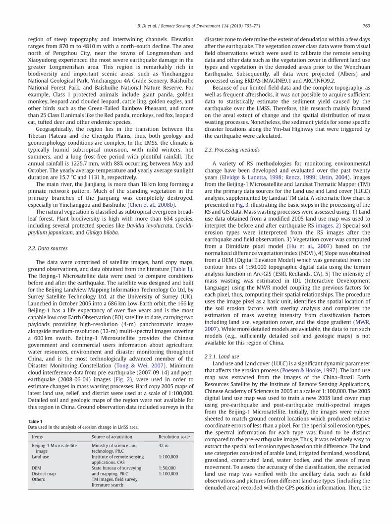
The data were comprised of satellite images, hard copy maps,ground observations, and data obtained from the literature (Table 1).The Beijing-1 Microsatellite data were used to compare conditionsbefore and after the earthquake. The satellite was designed and builtfor the Beijing Landview Mapping Information Technology Co Ltd, bySurrey Satellite Technology Ltd. at the University of Surrey (UK).Launched in October 2005 into a 686 km Low-Earth orbit, the 166 kgBeijing-1 has a life expectancy of over five years and is the mostcapable low cost Earth Observation (EO) satellite to date, carrying twopayloads providing high-resolution (4-m) panchromatic imagesalongside medium-resolution (32-m) multi-spectral images coveringa 600 km swath. Beijing-1 Microsatellite provides the Chinesegovernment and commercial users information about agriculture,water resources, environment and disaster monitoring throughoutChina, and is the most technologically advanced member of theDisaster Monitoring Constellation (Tong & Wei, 2007). Minimumcloud interference data from pre-earthquake (2007-09-14) and post-earthquake (2008-06-04) images (Fig. 2), were used in order toestimate changes in mass wasting processes. Hard copy 2005 maps oflatest land use, relief, and district were used at a scale of 1:100,000.Detailed soil and geologic maps of the region were not available forthis region in China. Ground observation data included surveys in the
Table 1Data used in the analysis of erosion change in LMSS area.
Items Source of acquisition Resolution scale
Beijing-1 Microsatelliteimage
Ministry of science andtechnology. PR.C
32 m
Land use Institute of remote sensingapplications. CAS
1:100,000
DEM State bureau of surveyingand mapping. PR.C
1:50,000District map 1:100,000Others TM images, field survey,
literature search
disaster zone to determine the extent of denudationwithin a few daysafter the earthquake. The vegetation cover class data were from visualfield observations which were used to calibrate the remote sensingdata and other data such as the vegetation cover in different land usetypes and vegetation in the denuded areas prior to the WenchuanEarthquake. Subsequently, all data were projected (Albers) andprocessed using ERDAS IMAGINE9.1 and ARC/INFO9.2.
Because of our limited field data and the complex topography, aswell as frequent aftershocks, it was not possible to acquire sufficientdata to statistically estimate the sediment yield caused by theearthquake over the LMSS. Therefore, this research mainly focusedon the areal extent of change and the spatial distribution of masswasting processes. Nonetheless, the sediment yields for some specificdisaster locations along the Yin-bai Highway that were triggered bythe earthquake were calculated.
2.3. Processing methods
A variety of RS methodologies for monitoring environmentalchange have been developed and evaluated over the past twentyyears (Elvidge & Lunetta, 1998; Rencz, 1999; Ustin, 2004). Imagesfrom the Beijing-1 Microsatellite and Landsat Thematic Mapper (TM)are the primary data sources for the Land use and Land cover (LULC)analysis, supplemented by Landsat TM data. A schematic flow chart ispresented in Fig. 3, illustrating the basic steps in the processing of theRS and GIS data. Mass wasting processes were assessed using: 1) Landuse data obtained from a modified 2005 land use map was used tointerpret the before and after earthquake RS images. 2) Special soilerosion types were interpreted from the RS images after theearthquake and field observation. 3) Vegetation cover was computedfrom a Dimidiate pixel model (Hu et al., 2007) based on thenormalized difference vegetation index (NDVI), 4) Slopewas obtainedfrom a DEM (Digital Elevation Model) which was generated from thecontour lines of 1:50,000 topographic digital data using the terrainanalysis function in Arc/GIS (ESRI, Redlands, CA), 5) The intensity ofmass wasting was estimated in IDL (Interactive DevelopmentLanguage) using the MWR model coupling the previous factors foreach pixel, thus, computing their spatial relationships. The procedureuses the image pixel as a basic unit, identifies the spatial location ofthe soil erosion factors with overlay analysis and completes theestimation of mass wasting intensity from classification factorsincluding land use, vegetation cover, and the slope gradient (MWR,2007). While more detailed models are available, the data to run suchmodels (e.g., sufficiently detailed soil and geologic maps) is notavailable for this region of China.
2.3.1. Land useLand use and Land cover (LULC) is a significant dynamic parameter
that affects the erosion process (Poesen & Hooke, 1997). The land usemap was extracted from the images of the China–Brazil EarthResources Satellite by the Institute of Remote Sensing Applications,Chinese Academy of Sciences in 2005 at a scale of 1:100,000. The 2005digital land use map was used to train a new 2008 land cover mapusing pre-earthquake and post-earthquake multi-spectral imagesfrom the Beijing-1 Microsatellite. Initially, the images were rubbersheeted to match ground control locations which produced relativecoordinate errors of less than a pixel. For the special soil erosion types,the spectral information for each type was found to be distinctcompared to the pre-earthquake image. Thus, it was relatively easy toextract the special soil erosion types based on this difference. The landuse categories consisted of arable land, irrigated farmland, woodland,grassland, constructed land, water bodies, and the areas of massmovement. To assess the accuracy of the classification, the extractedland use map was verified with the ancillary data, such as fieldobservations and pictures from different land use types (including thedenuded area) recorded with the GPS position information. Then, the

Fig. 2. The pre-earthquake and post-earthquake images from the Beijing-1 Microsatellite. Shades of green are vegetated areas and magenta are bare ground.
764 B. Di et al. / Remote Sensing of Environment 114 (2010) 761–771
2005 land use map was used to extract the preexisting land covertypes and the post-2008 earthquake types, which were updated usingour field data from May 2008. The loss of land use classes was
Fig. 3. Data processing flow chart.
determined by overlaying the image based map of post-earthquakemass wasting sites over the 2005 land use map.
2.3.2. Vegetation coverVegetation cover is the erosion risk variable that is most affected by
human manipulation, and thus it is an important component of anypredictive model (Sahin & Kurum, 2002; Trimble, 1990). In a holisticsense, each vegetation cover type integrates and incorporates past landuse, mass wasting processes, and other environmental parameters.
NDVI is sensitive to differences in canopy greenness and biomass.It is used to rank the relative magnitude of vegetation density as wellas vegetation cover. In order to acquire high precision vegetationcover data, we cross-calibrated 2007 pre-earthquake and 2008 post-earthquake Beijing-1 Microsatellite images using uniform, invariantpolygons in the thematic maps, because there are no calibrationparameters for Beijing-1 Microsatellite images. The calibrationprocedure is based on the universal equation (Chen et al., 2008c)
L = VgainVDN + Voffset ð1Þ
where L is the surface radiation; Vgain is the sensor's gain parameter;VDN is the measured pixel value in the respective remote sensingimage; and Voffset is the sensor's compensation parameter.
First, the Beijing-1 Microsatellite data was matched to theprojection and resolution of the Landsat TM images; the root meansquare error was kept within 0.5 pixels. We randomly selected 4000corresponding pixels in each image. Afterwards, a regression wascreated between the Digital Number of selected pixels and thecalibration equations for the Near-Infrared (NIR) band and RED bandof Beijing-1 Microsatellite, as follows:
For pre� earthquake : NIR : L = 0:7313�DN + 28:89 R2 = 0:5548
ð2Þ

Table 3The classification of vegetation cover.
Class Vegetation cover(%)
1 N752 60–753 45–604 30–455 15–306 b15
765B. Di et al. / Remote Sensing of Environment 114 (2010) 761–771
RED : L = 1:3317�DN + 12:577 R2 = 0:6693 ð3Þ
For post� earthquake : NIR : L = 1:6598�DN + 0:7457 R2 = 0:5986
ð4Þ
RED : L = 4:6819�DN + 15:832 R2 = 0:6844 ð5Þ
Subsequently, NDVI was calculated in pre- and post-earthquakeimages with the cross-calibrated NIR and RED bands of Beijing-1Microsatellite based on Eq. (6) (Justice et al., 1985). Consequently, thevegetation cover was estimated based on Eq. (7).
NDVI =NIR−REDNIR + RED
: ð6Þ
f =NDVI−NDVIsNDVIv−NDVIs
ð7Þ
where f is the vegetation cover; NDVIV is the NDVI of fully vegetationcover; and NDVIS is the NDVI of bare soil land cover (denuded area).
In this study, the land use map and field observation data werecompared and used to select 20 forest areas of best growth, taking theaverage NDVI of the best growth as NDVIV; and similarly selected 20denuded lands where the soil or rock were exposed, and used theaverage NDVI as NDVIS. Afterward, the vegetation cover was calculatedand calibrated using the field measurements, which included 23samples from 5 land use types that were located along the Yin-baiHighway and identified by visual inspection (Table 2). The comparisonshows that the precision in the vegetation cover estimate is about 87.0%.Subsequently, six different classes of vegetation cover were extractedfrom the vegetation cover map and used in this study (Table 3).
2.3.3. SlopeThe slope gradient, characterizes the rate of elevation change in
the direction of steepest descent, which affects the velocity of bothsurface and subsurface flow, and hence erosion potential. As the slopeangle increases, shear stress in soil or other unconsolidated materialgenerally increases as well (Lee et al., 2004). The slope gradient wascalculated from the DEM. The GIS was used to generate a gradient
Table 2Comparison between predicted vegetation cover class from RS images and field observatio
Order no. Longitude (°) Latitude (°) Land use type
1 103.7605 31.2225 Constructed la2 103.7822 31.2247 Arable land3 103.7908 31.2376 Water bodies4 103.8001 31.2514 Arable land5 103.7993 31.2555 Constructed la6 103.7841 31.2559 Constructed la7 103.8047 31.2572 Arable land8 103.8197 31.2643 Water bodies9 103.8091 31.2671 Arable land10 103.8193 31.2687 Arable land11 103.8259 31.2723 Arable land12 103.8263 31.2851 Arable land13 103.8377 31.2932 Woodland14 103.8476 31.2948 Woodland15 103.8660 31.3019 Woodland16 103.8671 31.3076 Woodland17 103.8682 31.3132 Woodland18 103.8743 31.3201 Arable land19 103.8646 31.3219 Woodland20 103.8738 31.3262 Constructed la21 103.8730 31.3326 Woodland22 103.8641 31.3348 Grassland23 103.8801 31.3471 Woodland
classification map with the following classes: b5°, 5–8°, 8–15°, 15–25°,25–35°, N35° (MWR, 2007; Tian et al., 2009).
2.4. Evaluation criteria of mass wasting of soil
The analysis of mass wasting intensity distribution is based on anexpert knowledge method which connects spatial information withthemain soil erosion factors, including land use, vegetation cover, andslope gradient. Expert knowledge was derived from the SL190-96Standards for Classification and Gradation of Soil Erosion of the PRC,which was established in 1997 and revised in 2007 (MWR, 2007). TheSL190-96 Standards were successfully used to monitor soil erosion atnational and regional scales in China (Zhao et al., 2002; Chen et al.,2005). In the MWR standard, a set of knowledge-based rules, forassessing soil erosion in this heterogeneous hilly catchment weredefined by multi-disciplinary resource-experts with knowledge of thelocal catchment resources, in addition to the field observations. Soilerosion intensity was divided into six grades (non-erosion, very low,low, moderate, severe and very severe.) by the affecting factors andthe input parameters required by the model, which are easilyproduced by GIS and RS techniques. Different grades of soil erosionare clarified by the annual average soil erosion modulus defined fromlong-term field observations, which are b500 t/km2 (non-erosion),500–2500 t/km2 (very low), 2500–5000 t/km2 (low), 5000–8000 t/km2 (moderate), 8000–15,000 t/km2 (severe), N15,000 t/km2 (verysevere), respectively. Additionally, the special soil erosion types(avalanches, landslides, rockfalls, debris flows, granular flows, andslope flattenings) and collapsed buildings triggered by the earthquakeare considered to be a severe erosion class. Based on these premises, a
ns by visual inspection.
Vegetation cover class Remark
Simulated Field measurements
nd 1 13 31 12 2
nd 2 1nd 1 1 Landslide
3 31 13 33 33 32 34 41 1 Barrier lake4 42 23 33 35 5
nd 1 13 21 1 Avalanche1 1 Landslide

Table 4Classification criteria of mass wasting intensity.
Land usetype
Vegetationcover rate(%)
Slope gradient (degrees)
5–8 8–15 15–25 25–35 N35
WoodlandGrassland
60–75 VL VL VL L L45–60 VL VL L L M30–45 VL L L M Sb30 L L M S VS
Arable land VL L M S VSIrrigated farmland,construction land,water body
N N N N N
Special soil erosion VS VS VS VS VSCollapsed buildings b20% 20–40% 40–60% 60–80% N80%
VL L M S VS
Mass wasting intensity: N, non-erosion; VL, very low; L, low; M, moderate; S, severe;VS, very severe.
766 B. Di et al. / Remote Sensing of Environment 114 (2010) 761–771
conceptual model used to estimate soil erosion intensity is defined asthe following:
E = f ðL; S;C; SPÞ ð8Þ
where E is the soil erosion intensity, L the land use type, S the slope, Cthe vegetation cover, and SP the special erosion types.
Fig. 4. Mass wasting maps of pre- and post-earthquake in the
Table 5Comparison of mass wasting area (km2) between 2007 and 2008.
Item Non-erosion Very low Low
Area % Area % Area %
2007 147.02 32.67 30.08 6.68 113.80 25.292008 60.72 13.49 26.45 5.88 89.53 19.90Change 86.30 19.18 3.63 0.80 24.26 5.39
In general, a change can be determined from the E value. The soilerosion intensity classification criteria listed in Table 4 was used toqualitatively determine six categories of soil erosion intensity.
3. Results
Using the classification criteria in Table 4, the GIS overlay analysisof vegetation cover, land use and slope gradient maps for pre- andpost-earthquake was used to determine the mass wasting maps forpre- and post-earthquake that are presented in Fig. 4.
Total area of soil erosion before the earthquake was 302.98 km2,accounting for 67.3% of the study area. As seen in Table 5, the non-movement zone, comprising the largest proportional area, accountsfor 32.7% of the study area, the very low intensity zone accounts for6.7%, the low intensity zone accounts for 25.3%, the moderateintensity zone accounts for 21.8%, the severe intensity zone accountsfor 7.5%, and the very severe intensity zone accounts for 6.1%.
After the earthquake, the total area of mass wasting increased by28.5% to 389.28 km2, which accounts for 86.5% of the study area. Asseen in Table 5, the non-mass wasting zone accounted for only 13.5%,the very low intensity zone accounted for 5.9%, the low intensity zoneaccounted for 19.9%, the moderate intensity zone accounted for 14.9%,the severe intensity zone accounted for 17.7%, and the very severeintensity zone, with the second largest area, accounted for 28.1%.
Longmenshan area. Colors indicate soil erosion classes.
Moderate Severe Very severe
Area % Area % Area %
98.00 21.78 33.88 7.53 27.22 6.0567.12 14.91 79.72 17.71 126.46 28.1030.88 6.87 −45.84 −10.18 −99.24 −22.05

Table 6Conversion matrix of mass wasting area (km2) of different mass wasting intensities.
Item 2008 Total(2007)
Non-erosion Verylow
Low Moderate Severe Verysevere
2007Non-erosion 53.62 4.28 23.69 18.59 21.15 25.69 147.02Very low 1.86 19.28 7.83 1.12 0.00 0.00 30.08Low 3.30 2.75 49.86 20.15 23.17 14.57 113.80Moderate 0.84 0.14 5.48 19.72 15.69 56.13 98.00Severe 0.34 0.00 2.20 4.94 13.84 12.56 33.88Very severe 0.77 0.00 0.48 2.60 5.86 17.51 27.22Total (2008) 60.72 26.45 89.53 67.12 79.72 126.46 450.00
767B. Di et al. / Remote Sensing of Environment 114 (2010) 761–771
The mass wasting results are presented in Table 5. Compared withpre-earthquake, the total area of mass wasting in the post-earthquakeperiod sharply increased from 302.98 km2 to 389.28 km2, an increaseof 86.30 km2 (accounting for 19.2% of the study area). For differentmovement intensities, the very low erosion, low erosion, andmoderate erosion aerial extents were all respectively reduced by3.63 km2, 24.26 km2 and 30.88 km2. In contrast, the areas of severeand very severe mass wasting substantially increased by 45.84 km2
and 99.24 km2. Obviously, the area of mass wasting changed in twoways: the area of strong mass wasting increased, while the area ofweak mass movement decreased. For instance, a non-erosion pre-quake area of 46.84 km2 changed into severe and very severe post-earthquake levels, respectively to 21.15 and 25.69 km2 (Table 6). Onthe whole, Table 5 demonstrates that tremendous changes took place
Fig. 5. Changes in the area of mass wastin
in the non-mass wasting, severe and very severe mass wastingcategories.
4. Discussion
4.1. Spatial characteristics of mass wasting changes
In general, distribution of earthquake-triggered landslides is moststrongly influenced by slope steepness, geology and shaking intensity(Wang et al., 2007). Accordingly, we observed that a combination ofelevations and slopes may have contributed most frequently to thedistribution of mass wasting triggered by the Wenchuan Earthquake.A statistical analysis of soil erosion distributions was conducted forthe landslides that were concentrated in the study area.
Five elevation ranges were defined to investigate mass wastingintensity: b1000 m, 1000–2000 m, 2000–3000 m, 3000–4000 m andN4000 m. Some changes with elevation were revealed from GISoverlays (Fig. 5). For severe and very severe erosion, the area ofmovement increased in all elevation ranges, and these increases werecorroborated by calculating changes between 1000 m and 4000 m. Formoderate erosion, clear changes were seen between 3000 and4000 m, with minimal change at elevations below 3000 m. For lowsoil erosion, a detectable decreasewas seen in this class between 2000and 4000 m. There was insignificant change in the very low erosionarea. Compared with pre-earthquake for the non-erosion area, thepost-earthquake area decreased at all elevation ranges with thebiggest change occurring between 1000 m and 4000 m. Summarizingall of these changes, we concluded that the greatest change in soil
g classes in different elevation zones.

768 B. Di et al. / Remote Sensing of Environment 114 (2010) 761–771
erosion occurred between 1000 m and 4000 m, while negligiblechange occurred below 1000 m and above 4000 m.
Following the earthquake, the eight soil erosion intensity sloperange parameters revealed some changes (Fig. 6). The areas for severeand very severe erosion increased sharply in zones with slopes from25° to 55°. For moderate erosion, there was a clear increase between8° and 35°, while there was a remarked decrease for slopes between35°and 55°. For low erosion classes, a decrease was distinguishablebetween 25° and 55°. There was inconspicuous change in the lowesterosion levels. The area of the non-erosion class decreased, comparedwith pre-earthquake, with the biggest change occurring in slopesbetween 25° and 55°. We concluded that the greatest changes in soilerosion were seen in slopes between 25° and 55°, while negligiblechanges were evident at slopes below 8 °and above 55°.
4.2. Mass wasting of soil change driving forces
The area of mass wasting increased dramatically in the study areafrom pre- to post-earthquake as illustrated in the LMSSmaps (Figs. 2, 4and 7). Thus, areas which pre-earthquake exhibited no erosion becameclassified as areas of high erosion. The driving force for these changes ismainly the consequences of the specialmasswasting soil types. Thebareareas (vegetation cover b15%) in pre- and post-earthquake shown inFig. 7, show that thepreviousdenudedareawas17.46 km2but increasesto 83.26 km2 after the earthquake. The denuded area increased65.81 km2, mostly attributed to the Wenchuan Earthquake.
From field surveys, it was possible to ascertain that denuded siteswerewidely distributed throughout the study area.We estimated that
Fig. 6. Changes in the area of mass wast
more than 7% of the ecosystem area consisting of forest, shrub,meadow, river and farmland land cover types were destroyed by theearthquake. Especially in the northern region of the LMSS, the fractionof degraded area reached 30% to 40% in some parts of the core impactregion (Fig. 8).
Numerous special soil erosion types were triggered by theearthquake. However, due to the complex topography and inaccessibleconditions, as well as frequent aftershocks, a complete and accuratesurvey of the special soil erosion type disasters over the full region wasnot possible. A few of the denuded sites, however, were accessible andsurveyed along the Yin-bai Highway. For small denuded sites, thelength, width and average thickness of the mass moved can be directlyestimated in the field. Otherwise, for large denuded sites, we can extractthe area of mass movement from the Beijing-1 Microsatellite imagesand estimate the average thickness from thefield survey. Then, for thesesites, the volume of soil movement can be calculated from theseparameters. There were 59 denuded sites accessible from the highwayfor which field measurements found 5540×104 m3 of transportedsediment. As shown in Table 7, there were 22 sites with landslides,which comprised the greatest sediment yield, accounting for 52.2% ofthe total. Avalanches occurred at 15 sites (28.5% of the sediment yield),slope flattening at 5 sites (16.7%) and debris flows at 17 sites (2.6%). Forthe Jiufengshan landslide (No.7 in Fig. 9), more than 350×104 m3 ofsediment was released.
Unstable sites of soil erosion were mainly located at slope toesalong the Yin-bai Highway and denuded soils and rocks wedged inriver valleys or piled on hillslopes along the highway. Analysis of sometypical high risk sites (Table 8) showed that they triggered extensive
ing classes in different slope ranges.

Fig. 7. Bare area (vegetation cover b15%) maps of pre- and post-earthquake Longmenshan area.
769B. Di et al. / Remote Sensing of Environment 114 (2010) 761–771
and cascading mass wasting problems. The Wenchuan Earthquakedramatically altered the natural geology and landforms across most ofthe LMSS. Many rock and soil avalanches, landslides, and giant debrisflows were deposited in steep-sloped valley and gully areas whichincrease the potential for mass wasting to continue in the down-slopedirection. The earthquake, released a large mass of soil and rockmaterial into the river beds joined to the steep slopes that serve asenergy sources for eruption of new debris flows, which will continueto occur for several years after this earthquake.
For example, steep slopes along the Shajin River have accumulatedhuge amounts of material in the stream branches that substantiallyincreasemass and energy sources for eruption of newdebrisflows. After
Fig. 8. Landslides and avalanches induced by the 2008 earthquake in the valley of the Shajinbefore the Wenchuan Earthquake. The vegetation was previously distributed over the lowe
the earthquake, therewerefive reporteddebrisflowevents triggeredbymonsoon storms in the studyareabetween JuneandSeptember in 2008.Some of these debris flow events demolished houses, damaged the Yin-bai Highway, blocked traffic, buried farmland, and further endangeredhuman life andproperty. Our investigation inYinchanggou, showed thatseveral debris flows, combined with landslides and a flood, occurred onthe night of July 14, 2008. The deposits contained a large amount of soiland rock mass that blocked eight roads and damaged several buildings.Similar debris flows and landslides occurred in this area in summer2009. It is clear from these anecdotes that there is considerableincreased and continuing risk of debris flows, especially during therainy monsoon season. Considering current conditions, it is likely that
River (Left) and Yinchang Gou gully (Right). Both areas had mature forest vegetationr hillslopes, crest lines, and along the downslopes.

Table 7The number and sediment of mass wasting sites on Yin-bai Roadsides.
Landslide Avalanche Slopeflattening
Debrisflow
Total
Number 22 15 5 17 59Sediment (104 m3) 2892.05 1576.80 925.00 143.40 5537.25
770 B. Di et al. / Remote Sensing of Environment 114 (2010) 761–771
continued landslides and debris flows will be the major types of masswasting in Longmenshan. Therefore, mitigation of debris flow andlandslide occurrence by natural restoration and managed reconstruc-tion is definitely needed.
Fig. 9. Jiufengshan landslide occurring in July 2009 is one of the largest landslides in the LMSmovements as it fell from the upper steep slopes. This landslide entirely buried the Number 7main river channel.
Table 8Features of special erosion sites on Yin-bai Roadsides.
Type Order no. Longitude (°) Latitude (°)
Landslide 1 103.5015 31.17032 103.5156 31.18343 103.4931 31.17064 103.4917 31.00005 103.5051 31.17546 103.4815 31.16217 103.5049 31.1728
Avalanche 1 103.5240 31.19442 103.5356 31.20463 103.4612 31.13284 103.4524 31.1100
Slope flattening 1 103.4645 31.13582 103.4601 31.10333 103.4649 31.1457
Debris flows 1 103.4941 31.16112 103.4920 31.1549
5. Conclusion
To understand the dynamics of mass wasting over time and space,better understanding of the changes in the earthquake-affected area isnecessary. Quantitative estimates of mass wasting of soil have beenlacking in the Longmenshan area after the May 12th earthquake,because there little detailed data are available. However, because therapid erosion processes are still underway it is important to begin tobuild such understanding to prevent future disasters of this magnitude.The Beijing-1 Microsatellite can observe locations of mass movementcontinuously for 24 h thus providing high temporal and high spatialresolution digital imagery that is needed for effective disaster
S. It is estimated that the upper sliding body collided forcefully and induced more massvillage and caused almost 70 deaths. The resulting 15° deposit slope also obstructed the
Sediment (104 m3) Description
140 Threatened highway with an extent of 200 m.140 Threatened highway with an extent of 300 m.150 Destroyed highway.220 Threatened highway with an extent of 200 m.200 Destroyed highway300 Clogged river. Threatened villages.350 The deposit slope was 15°. Barred river.50 Threatened highway72 Threatened highway and river.
600 Destroyed highway750 Destroyed highway60 Threatened highway and villages
360 Threatened highway and villages500 Destroyed highway and market town38 Threatened 100 people's safety22 Threatened 35 people's safety

771B. Di et al. / Remote Sensing of Environment 114 (2010) 761–771
monitoring and response. Using RS and GIS techniques as the primarymethods, we estimated mass wasting processes by effectively couplingexpert knowledge and data on the factors that influence soil erosion.
Enormous regional changes were induced mostly by the specialsoil erosion types (avalanches, landslides, rockfalls, debris flows,granular flows and slope flattening) and collapsed buildings triggeredby the earthquake. The greatest soil erosion occurred between 1000 mand 4000 m elevation and on slopes between 25° and 55°, whilenegligible change occurred at elevations below 1000 m and above4000 m and on slopes below 8°and above 55°. Compared to the pre-earthquake condition, the total area of soil erosion increased by86.30 km2 (19.2% of the study area). Areas of non-erosion experiencedthe greatest areal reduction, while the severe and very severe erosionclasses exhibited the greatest areal increases.
Without vegetation cover, the topsoil and sediment in theearthquake denuded areas and other high risk areas will continue tobe unstable in the coming years. During the rainy season, largequantities of sediment are transported into rivers from these areas.Consequently, there is continuing need to monitor the high risk andpotential risk mountain sites for soil erosion hazards.
Acknowledgements
Thisworkwas supportedbyNational “973”Project (2008CB425803),Mountain Hazard & the Earth's Surface Processes Key laboratory, CAS(LF08006), the National Key Technologies R&D project “Ecologicalprotection and technology demonstration of debris flow and landslideprevention for large hydropower project area in South-West China” (No.2006BAC10B04) and 111 Project (No. B08037). The satellite imageswere provided by Beijing Landview Mapping Information TechnologyCo. Ltd. The authors gratefully acknowledge to Dr. Zhiguang Li, ProfessorPeng Cui for their help and direction. What's more, we also appreciateChen Ye, Heather Sturman, Fabio, Professor Earl Bossard and ProfessorCarla Bossard for help in revisions.
References
Absalom, M. M., & Nomndeni, N. (2008). Mapping of soil erosion using remotely senseddata in Zombodze South, Swaziland. Physics and Chemistry of the Earth, 33,800−806.
Bruce, D. M., Donald, L. T., Fausto, G., & Paola, R. (2004). Landslides, earthquakes, anderosion. Earth and Planetary Science Letters, 229, 45−59.
Chen, X. Q., Cui, P., Cheng, Z. L., You, Y., Zhang, X. G., He, S. M., & Dang, C. (2008a).Emergency risk assessment of dammed lakes caused by the Wenchuan Earthquakeon May 12, 2008.Earth Science Frontiers, 15, 244−249 China.
Chen, N. S., Di, B. F., Li, Z. L., & Li, H. (2008b). The features and measures of mountainhazards triggered by earthquake in Longmenshan Mountains.Journal of MountainScience, 26, 272−275 China.
Chen, Z. C., Liu, X., Li, J. S., Luo, W. F., Zhang, J., Zhang, J., Zhang, X., & Zhang, B. (2008c).The cross calibration of Beijing-1 Microsatellite multispectral sensors.Journal ofAstronautical, 29, 637−643 China.
Chen, W. H., Liu, L. Y, Zhang, C., Pan, Y. C., Wang, J. H., & Wang, J. D. (2005). The fastmethod of soil erosion investigation based on remote sensing. Research in Soil andWater Conservation, 12, 8−10.
Cui, P., Zhu, Y. Y., Han, Y. S., Chen, X. Q., & Zhuang, J. Q. (2009). The 12 May Wenchuanearthquake-induced landslide lakes: Distribution and preliminary risk evaluation.Landslides, 6, 209−223.
Cui, P., Wei, F. Q., He, S. M., You, Y., Chen, X. Q., Li, Z. L., Dang, C., & Yang, C. L. (2008).Mountain disasters induced by the earthquake of May 12 in Wenchuan and thedisasters mitigation.Journal of Mountain Science, 26, 280−282 China.
David, K. K. (1994). The importance of earthquake-induced landslides to long-term slopeerosion and slope-failure hazards in seismically active regions. Geomorphology, 10,265−284.
Elvidge, C. D., & Lunetta, R. (Eds.). (1998). Remote sensing change detection:Environmental monitoring applications and methods MI: Ann Arbor Press.
Fan, J. R., Tian, B. W., Cheng, G. W., Tao, H. P., Zhang, J. Q., Yan, D., Su, F. H., & Liu, B. T.(2008). Investigation on damming object induced by the earthquake of Wenchuanon May 12 based on multi-platform remote sensing.Journal of Mountain Science, 26,257−262 China.
Ferah, Akinci (2008). The aftermath of disaster in urban areas: An evaluation of the1999 earthquake in Turkey. G.U. Journal of Science, 21(2), 43−49.
Hansen, A., & Franks, C. A. M. (1991). Characterisation and mapping of earthquaketriggered landslides for seismic zonation. Proc.4th Int. Conf. on Seismic Zonation,Stanford, California, 1 (pp. 149−195).
Huang, R. Q. (2008). Characteristics of geological disasters of 5·12Wenchuan Earthquakeand recommendation on its impact on reconstruction.Chinese Geological Education, 2,21−24 China.
Hu, Z. Q., He, F. Q., Yin, J. Z., Lu, X., Tang, S. L., Wang, L. L., & Li, X. J. (2007). Estimation offractional vegetation cover based on digital camera survey data and a remotesensing model. Journal of China University of Mining and Technology, 17, 116−120.
Justice, C. O., Townshend, J. R. G., Holben, B. N., & Tucker, C. J. (1985). Analysis of thephenology of global vegetation using meteorological satellite data. InternationalJournal of Remote Sensing, 6, 1271−1318.
Koi, T., Hotta, N., Ishigaki, I., & Matuzaki, N. (2008). Prolonged impact of earthquake-induced landslides on sediment yield in a mountain watershed: The Tanzawaregion, Japan. Geomorphology, 101, 692−702.
Lee, S., Choi, J., & Min, K. (2004). Probabilistic landslide hazard mapping using GIS andremote sensing data at Boun, Korea. International Journal of Remote Sensing, 25(11),2037−2052.
Lin, C. Y., Lo, H. M., Chou, W. C., & Lin, W. T. (2004). Vegetation recovery assessment atthe Jou-Jou Mountain landslide area caused by the 921 Earthquake in centralTaiwan. Ecological Modelling, 176, 75−81.
Lin, W. T., Lin, C. Y., & Chou, W. C. (2006). Assessment of vegetation recovery and soilerosion at landslides caused by a catastrophic earthquake: A case study in CentralTaiwan. Ecological Engineering, 28, 79−89.
MWR (Ministry of Water Resources, PRC) (2007). National professional standards forclassification and gradation of soil erosion (SL190-2007) (pp. 10−15). Beijing: ChinaHydraulic and Hydropower Press.
Ouyang, Z. Y., Xu, W. H., Wang, X. Z., Wang, W. J., Dong, R. C., Zheng, H., Li, D. H., Li, Z. Q.,Zhang, H. F., & Zhuang, C. W. (2008). Impact assessment of Wenchuan Earthquakeon ecosystems. ACTA ECOLOGICA SIN ICA, 28(12), 5801−5809.
Perotto-Baldiviezo, H. L., Thurow, T. L., Smith, C. T., Fisher, R. F., & Wu, X. B. (2004). GIS-based spatial analysis and modeling for landslide hazard assessment in steep lands,southern Honduras. Agriculture Ecosystems & Environment, 103, 165−176.
Poesen, J. W. A., & Hooke, J. M. (1997). Erosion, flooding and channel management inMediterranean environments of southern Europe. Progress in Physical Geography,21, 157−199.
Rencz, A. (Ed.). (1999). Remote sensing for the Earth sciences, 3rd Edition Manual ofremote sensing, Vol. 3. (pp. ) New York: John Wiley and Sons.
Scira, Menoni (2001). Chains of damages and failures in a metropolitan environment:Some observations on the Kobe earthquake in 1995. Journal of Hazardous Materials,86, 101−119.
Sahin, S., & Kurum, E. (2002). Erosion risk analysis by GIS in environmental impactassessments: A case study—Seyhan Köprü Dam construction. Journal of Environ-mental Management, 66, 239−247.
Tian, Y. C., Zhou, Y.M.,Wu, B. F., & Zhou,W. F. (2009). Risk assessment ofwater soil erosionin upper basin of Miyun Reservoir, Beijing, China. Environmental Geology, 57,937−942.
Tong, L. Q. (2008). Emergency remote sensing investigation of barrier lakes at the quakecenter area caused by“5·12”Wenchuan strong earthquake.Remote sensing for Land& Resources, 3, 71-64 China.
Tong, Q. X., & Wei, Z. (2007). Beijing-1 Microsatellite and its data application.SpacecraftEngineering, 16(2), 1−5 China.
Tripathi, R. P., & Singh, H. P. (1993). Soil erosion and conservation India. New Delhi:Wiley Eastern Limited pp. 305.
Trimble, W. S. (1990). Geomorphic effects of vegetation cover and management: Sometime and space considerations in predicting of erosion and sediment yield. In J. B.Thornes (Ed.), Vegetation and erosion UK: John Wiley and Sons Ltd.
Ustin, S. L. (Ed.). (2004). Remote sensing for natural resource management andenvironmental monitoring. ASPRSManual of remote sensing, Vol. 4. (pp. ) New York:John Wiley and Sons 736p. +cd.
Wang, W. J., Pan, Y. Z., Xu, W. H., Wang, J. J., & Bai, X. (2008). Analysis on ecosystemdestroy and its ecological impact caused by earthquake in Wenchuan, SichuanProvince.Research of Environmental Sciences, 21, 110−116 China.
Wang, H. B., Sassa, K., & Xu, W. Y (2007). Analysis of a spatial distribution of landslidestriggered by the Chuetsu earthquakes of Niigata Prefecture. Japan Natural Hazards, 41,43−60.
Xie, H., Wang, S. G., & Kong, J. M. (2008). Distribution and characteristics of mountainhazards induced by the earthquake of May 12 in Wenchuan.Journal of MountainScience, 26, 396−401 China.
Xu, Q., Fan, X. M., Huang, R. Q., & Cee, V. W. (2009). Landslide dams triggered by theWenchuan Earthquake, Sichuan Province, south west China. Bulletin of Engineeringand Geological Environment, 68, 373−386.
Yang, A. M., Wang, H., Tang, K. W., & Sun, G. (2002). Soil erosion characteristics andcontrol measures in China. Proceedings of 12th International Soil, ConservationOrganization Conference, May 26–31, Beijing, China, 1, 463−469.
Zhao, X. L., Zhang, Z. X., Liu, B., & Wang, C. Y. (2002). Method of monitoring soil erosiondynamic based on remote sensing and GIS. Bulletin of Soil and Water Conservation,22, 29−32.