q - usgsearth science information management and delivery, and geographic research and applications....
TRANSCRIPT

Q.C
N

CIVIL APPLICATIONS COMMITTEE
The Civil Applications Committee (CAC) is an interagency committee that provides Federal civil agencies with access to classified imagery information needed to support agency missions. Established in 1975 by the Office of the President and chaired by the Department of the Interior through the USGS, the CAC is made up of 10 Federal departments and independent agencies:
DEPARTMENT OF AGRICULTURE
DEPARTMENT OF COMMERCE
DEPARTMENT OF ENERGY
DEPARTMENT OF THE INTERIOR
DEPARTMENT OF TRANSPORTATION
FEDERAL EMERGENCY MANAGEMENT AGENCY
NATIONAL AERONAUTICS AND SPACE ADMINISTRATION
U.S. ARMY CORPS OF ENGINEERS
U.S. ENVIRONMENTAL PROTECTION AGENCY
NATIONAL SCIENCE FOUNDATION
The CAC is chartered to facilitate access to and dissemination of classified remote sensing data, over see the proper use of these data by the civil community, coordinate research activities related to data applications and new technologies, and act as the civil agency interface with the military and intelligence communities.
The use of classified remote sensing data by CAC member agencies has expanded beyond traditional mapping programs to include a broad spectrum of environmental and scientific applications that meet civil agency missions. Some examples are monitoring volcanoes; detecting wild fires; responding to emergencies caused by natural disasters, such as hurricanes, earthquakes, and floods; and monitoring ecosystems.

TABLE OF CONTENTS
EXECUTIVE SUMMARY 2
Part 1. The National Civil Applications Program Yesterday and Today 3Definition 4
Mission 4
History 4
The 1990s 5
Today 5
Part 2. The Future Environment and a Vision of the National Civil Applications Program's Future 7Vision 8
Data and Data Sources 8
Customer Needs 8
Technology and Exploitation ' 8
Part 3. Goals and Strategic Actions for the Future . 11Strategic Direction 12Strategic Goals and Thrusts 12
Customer Strategic Goal 12Program Strategic Goal 13People Strategic Goal 14Operations Strategic Goal 14
Part 4. Next Steps for the National Civil Applications Program 17

The National Mapping Division (NMD) has developed this comprehensive strategic plan to chart the course of the National Civil Applications Program (NCAP) over the next 5 years. To meet the challenges of the future, the NCAP is changing its pro gram emphases, methods of responding to .customer needs, and business practices. The NCAP Strategic Plan identifies the new direction for the program through a series of strategic thrusts and goals for managers to use in formulating plans, establishing program emphases, and determining resource needs and allocations.
This plan refines the NCAP mission on the basis of several key issues that the program must face in the next 5 years. The first of these issues is the continuing advancement of technology and telecom munications. Related to this is the evolution of geoscience tools, including geographic information systems (GIS) and image pro cessing and analysis software, and the accompanying growth in the Government's use of GIS as a decision support tool. Equally important is the impending prolif eration of Earth-observing satellites (both Government and commercial) that is expected to yield an unprecedented volume and variety of high-resolution imagery, providing a myriad of choices to users. Of particular concern is the need to quickly establish policies and procedures for mix ing and merging classified and unclassified Government data sources with the emerg ing commercial and foreign sources in a way that protects national security, protects the rights of the commercial sector, maxi mizes value to the taxpayer, and ensures the availability of the best possible data to solve critical problems. Finally, the NCAP customer base is becoming broader, and demand for NCAP products and services is increasing as restrictions on the use and distribution of classified data are reduced.
In accordance with the strategic goals of the U.S. Geological Survey (USGS), this plan assumes that programmatic emphasis for the NCAP will shift increasingly to geographic process analysis, modeling, and prediction, as well as to new sensors and tools to provide a better understanding
of scientific issues and improved derivative products that will help decision makers deal with hazards and environmental problems. At the same time, this plan recognizes that the NCAP must continue to support tradi tional, long-standing requirements of the Federal civil community for classified data collection and management services and continue to provide the secure facilities and analytical tools that are required to exploit the data to accomplish agency missions.
To meet these evolving programmatic goals, the NCAP business model must evolve. It is assumed that the NCAP will rely increasingly on partnerships with other Government agencies, academia, and the private sector to leverage resources, mini mize duplication of effort, and enhance the exchange of ideas. This plan calls for significantly greater emphasis on customer awareness and service, including the imple mentation of systematic processes and procedures to define, understand, and increase the NCAP customer base, increase customer satisfaction, and advocate and market NCAP and related Civil Appli cations Committee (CAC) activities. It recognizes the importance of a diversi fied, quality workforce and recommends steps to improve employee skills, reward achievement, and implement flexible staffing policies. Lastly, it recommends an integrated, long-term infrastructure plan that effectively distributes facilities, capa bilities, and staff among the secure sites around the country and provides for advanced communications capabilities link ing NCAP functions throughout the Nation.
To ensure consistency with the USGS strategic direction, the actions recom mended in the NCAP Strategic Plan are organized to nest within the four main goals specified by the USGS Strategic Plan (Customer, Program, People, Operations). In addition, all aspects of the NCAP Strategic Plan were carefully reviewed to ensure consistency with the NMD Strategic Plan, and particularly with goal 14 and its four associated actions that specify the high-level strategic direction for the NCAP from the Division's perspective.


The National Civil Applications Program (NCAP) Yesterday and Today
NATIONAL MAPPING DIVISION STRATEGIC PLAN
Goal 14: The National Mapping Division (NMD) is the national civilian agency leader for coordination of the access, management and application of classified data and information.
Action 1 : Use the Civil Applications Committee and other means as appropriate to build advocacy within the Department of the Interior and the Federal civil community for using classified data and systems in civil applications.
Action 2: Provide leadership to the Federal civil community injhe understanding and use of classified assets through chairing the Civil Applications Committee and pursue opportunities to obtain reimbursable income from partners, customers, and stakeholders of the National Civil Applications Program.
Action 3: Provide an infrastructure and expert application staff to support a wide range of civil appli cations utilizing classified data and assets.
Action 4: Build an integrated network that provides Federal civil agencies with access to classified remote sensing data and systems, and derivative information, to address land and resource management, environ mental hazards, and other scientific issues.
DEFINITIONThe NCAP is a component of the USGS National Mapping Program (NMP). The NCAP encompasses all NMP activities addressing and supporting Federal civil agency involvement with classified remote sensing systems, data, and programs. As a crosscutting activity of the USGS NMD, the NCAP provides for the organization and integration of diverse elements that tran scend the three NMD budget subactivities: Mapping Data Collection and Integration, Earth Science Information Management and Delivery, and Geographic Research and Applications. Collectively, the NCAP provides an infrastructure, including facili ties, image processing and analysis systems, data archives, communications networks, source acquisition, security services, and staff to support a wide range of innovative research, development, and applications of classified remote sensing data and systems by the NMD, other USGS Divisions, and other Federal civil agencies.
Under the NCAP, the USGS supports the CAC. The CAC is a Presidentially chartered interagency committee that provides over sight for the collection and use of classified remote sensing data by facilitating image acquisition, coordinating research and policy activities, providing an interface to the military and intelligence communities, and ensuring the proper use of classified information. The Department of the Interior (DOI) delegates the Chair of the CAC toJheJJSGS. The NCAP staffs the CAC Secretariat and provides security, facilities, source management, and .other services to CAC members.
MISSIONThe NCAP serves Federal civil agencies by providing for the acquisition, dissemina tion, and exploitation of classified remote sensing systems and data to address land and resource management, environmental, socioeconomic, hazards, disasters, and other geospatial scientific and policy issues.
HISTORYThe origins of the NCAP can be traced to1966. when the Special Assistant to the President for Science and Technology began a formal study on the use of aerial intelligence photographs for "civil" (that is, nonmilitary or intelligence) purposes. The study resulted in the establishment, in1967. of a steering committee in the Office of the President's Science Adviser, with membership from the Departments of the Interior, Commerce, and Agriculture, the National Aeronautics and Space Admin istration, and other interested Federal agencies. At the request of this steering committee, the Director of Central Intelligence agreed to provide intelligence photographs to civil agencies, provided that there would be no interference with intelli gence needs and no significant cost increase.
Civil applications of classified remotely sensed imagery (including remotely sensed imagery from both aircraft and satellite platforms) began in earnest in 1969, when the USGS opened a special facility (known as E-l) in leased space in Reston, Va. The purpose of E-l was to provide Federal civil
agencies with access to the imagery for use in various applications, including mapping, charting, geodesy, and management of the Nation's lands and resources. More than a half-dozen agencies participated from the start, and activity at the E-l facility quickly grew to the point that the need for an orga nized oversight committee became appar ent. In 1975, the Rockefeller Commission (which was impaneled to review CIA activ ities within the United States) formally recommended the establishment of a committee of Federal agencies to coordi nate and oversee the civil uses of remotely sensed intelligence information. The Office of the President accordingly directed that the CAC be established. The USGS, through the Secretary of the Interior, was delegated responsibility to chair the CAC and has done so continuously since 1975.
During the 1970s and the early 1980s, classified remotely sensed imagery was used by the USGS and other Federal civil agencies predominantly to update topo graphic maps, compile land use maps, update navigational charts, and map remote Federal lands. Although remote sensing technology, particularly satellite- based remote sensing, was advancing rapidly, civil applications during this period depended largely on conventional manual techniques of cartography and photogrammetry and used hardcopy images almost exclusively to produce and update conventional printed maps and charts. Civil applications began to evolve to more advanced, computer-based map ping techniques in the latter half of the 1980s in response to continuing dramatic advances in remote sensing capabilities and growth in computer processing and related technical capabilities. These advances enabled the development and proliferation of sophisticated GIS and digi tal mapping capabilities, which were incor porated into the E-l facility. Mapping and map revision, however, remained the primary focus, although the underlying techniques were now increasingly digital. A few environmental applications were undertaken during this period, but these were the exception and not the rule.
THE NATIONAL CIVIL APPLICATIONS PROGRAM YESTERDAY AND TODAY
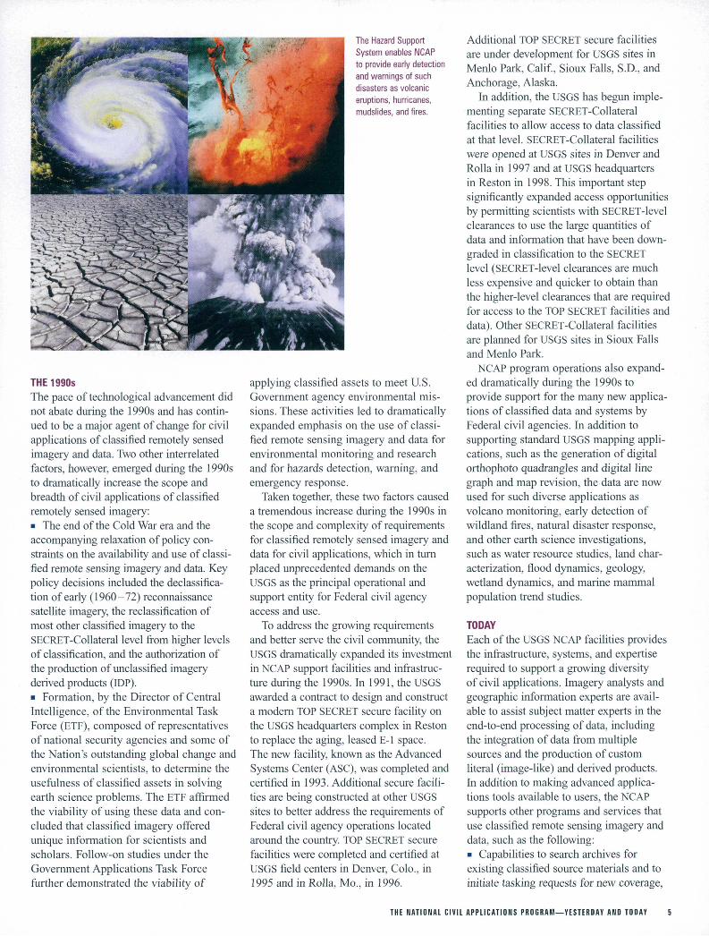
The Hazard Support System enables NCAP to provide early detection and warnings of such disasters as volcanic eruptions, hurricanes, mudslides, and fires.
THE 1990sThe pace of technological advancement did not abate during the 1990s and has contin ued to be a major agent of change for civil applications of classified remotely sensed imagery and data. Two other interrelated factors, however, emerged during the 1990s to dramatically increase the scope and breadth of civil applications of classified remotely sensed imagery: The end of the Cold War era and the accompanying relaxation of policy con straints on the availability and use of classi fied remote sensing imagery and data. Key policy decisions included the declassifica- tion of early (1960-72) reconnaissance satellite imagery, the reclassification of most other classified imagery to the SECRET-Collateral level from higher levels of classification, and the authorization of the production of unclassified imagery derived products (IDP). Formation, by the Director of Central Intelligence, of the Environmental Task Force (ETF), composed of representatives of national security agencies and some of the Nation's outstanding global change and environmental scientists, to determine the usefulness of classified assets in solving earth science problems. The ETF affirmed the viability of using these data and con cluded that classified imagery offered unique information for scientists and scholars. Follow-on studies under the Government Applications Task Force further demonstrated the viability of
applying classified assets to meet U.S. Government agency environmental mis sions. These activities led to dramatically expanded emphasis on the use of classi fied remote sensing imagery and data for environmental monitoring and research and for hazards detection, warning, and emergency response.
Taken together, these two factors caused a tremendous increase during the 1990s in the scope and complexity of requirements for classified remotely sensed imagery and data for civil applications, which in turn placed unprecedented demands on the USGS as the principal operational and support entity for Federal civil agency access and use.
To address the growing requirements and better serve the civil community, the USGS dramatically expanded its investment in NCAP support facilities and infrastruc ture during the 1990s. In 1991, the USGS awarded a contract to design and construct a modern TOP SECRET secure facility on the USGS headquarters complex in Reston to replace the aging, leased E-l space. The new facility, known as the Advanced Systems Center (ASC), was completed and certified in 1993. Additional secure facili ties are being constructed at other USGS sites to better address the requirements of Federal civil agency operations located around the country. TOP SECRET secure facilities were completed and certified at USGS field centers in Denver, Colo., in 1995 and in Rolla, Mo., in 1996.
Additional TOP SECRET secure facilities are under development for USGS sites in Menlo Park, Calif, Sioux Falls, S.D., and Anchorage, Alaska.
In addition, the USGS has begun imple menting separate SECRET-Collateral facilities to allow access to data classified at that level. SECRET-Collateral facilities were opened at USGS sites in Denver and Rolla in 1997 and at USGS headquarters in Reston in 1998. This important step significantly expanded access opportunities by permitting scientists with SECRET-level clearances to use the large quantities of data and information that have been down graded in classification to the SECRET level (SECRET-level clearances are much less expensive and quicker to obtain than the higher-level clearances that are required for access to the TOP SECRET facilities and data). Other SECRET-Collateral facilities are planned for USGS sites in Sioux Falls and Menlo Park.
NCAP program operations also expand ed dramatically during the 1990s to provide support for the many new applica tions of classified data and systems by Federal civil agencies. In addition to supporting standard USGS mapping appli cations, such as the generation of digital orthophoto quadrangles and digital line graph and map revision, the data are now used for such diverse applications as volcano monitoring, early detection of wildland fires, natural disaster response, and other earth science investigations, such as water resource studies, land char acterization, flood dynamics, geology, wetland dynamics, and marine mammal population trend studies.
TODAYEach of the USGS NCAP facilities provides the infrastructure, systems, and expertise required to support a growing diversity of civil applications. Imagery analysts and geographic information experts are avail able to assist subject matter experts in the end-to-end processing of data, including the integration of data from multiple sources and the production of custom literal (image-like) and derived products. In addition to making advanced applica tions tools available to users, the NCAP supports other programs and services that use classified remote sensing imagery and data, such as the following: Capabilities to search archives for existing classified source materials and to initiate tasking requests for new coverage,
THE NATIONAL CIVIL APPLICATIONS PROGRAM YESTERDAY AND TODAY

The Hazard Support System (HSS) for early detection and warning of wlldland fire events in the United States and of volcanic events (including ash clouds) worldwide, The Global Fiducials Library (GFL) of classified remotely sensed data for more than 500 environmentally sensitive sites worldwide, Security indoctrination and technical training for civil community scientists and specialists, and Research, development, and integration of new systems and prototyping of new derivative products.
On the eve of the millennium, the NCAP is a complex and evolving program. It would be virtually unrecognizable to someone who knew the program only during its infancy in the early 1970s or even as recently as the early 1990s. The NCAP today serves increasingly varied and complex Federal civil agency require ments. The program is committed to expanding the availability and use of classified remote sensing imagery, data, and technology in order to find unique solutions to policy, management, and scientific issues, such as the development
of economic and environmental intelli gence to support the Nation's foreign and national security policy makers.
The quality and quantity of data available from civil Government, commercial, and many foreign remote sensing programs will continue to improve. This will provide both opportunities and challenges to NCAP. Thus, it is imperative that the NCAP proac- tively seek a productive synergy with its civil Government counterpart programs and with the emerging commercial and appropriate foreign satellite remote sensing programs.
NCAP COMPONENTS
A variety of activities form the foundation of the NCAP. These program components support the needs of the entire Federal civil community in the use of classified remote sensing data.
COLLECTION MANAGEMENTAll requests for classified data by Federal civil agencies are reviewed, assigned priorities, and submitted by the CAC through the collection management team at the USGS ASC. Collection management functions also include assisting CAC member agencies with denning and document ing their data requirements, tasking for classified data, performing quality assurance checks on received data, and disseminating data to the customer.
SECURITY SERVICESSecurity provides policy and operational oversight of a risk management program to protect facilities, systems, information, and staff from the com promising of classified and sensitive information. The security staff at each NCAP facility ensures that proper procedures are observed for the granting and passing of clearances, shipping and receipt of materials, and archiving, inventory, and protection of classified data, systems, and materials.
DATA ARCHIVINGThe USGS acquires, archives, and manages a vast amount of classified data in hardcopy and softcopy format on behalf of the entire civil community. The amount of data being managed is growing as a result of increasing collection requests by civil agencies and increasing avail
ability of softcopy data.The USGS is also responsible for the storage and dissemination of data
collected for the Global Fiducials Program (GFP). Under the GFP, data will be collected for 500 environmentally significant "fiducial" sites worldwide over long periods of time to support long-term scientific studies of global climate change. These data will be stored in the GFL.
It is expected that all of the collected data (agency-requested collections and GFP) will reside in a holding archive at the ASC for an interim period and then be transmitted to the the EROS Data Center to reside in a long- term archive.
HAZARD SUPPORT SYSTEMThe HSS is a sophisticated detection and warning system that is being developed to focus on domestic wildfires and worldwide volcanic activity and ash clouds. The system will fuse the input from a variety of sensors to provide near real-time event detection and warning to civil customers. When fully operational, the system will provide critical information on
national and international disasters to Federal, State, local, and tribal governments, resulting in substantial savings to life and property.
IMAGE DATA EXPLOITATIONAdvanced data exploitation and product generation systems are developed and made available under the NCAP to support the data production and analysis requirements of the USGS and the exploitation needs of other Federal civil agencies. The Digital Cartographic Production System sup ports the production of USGS formatted digital orthophoto quadrangles from classified hardcopy sources. The Rapid Exploitation System (REx) combines state-of-the-art hardware and software to provide end-to-end data processing, including the ingestion of a variety of data from different systems, the performance of advanced data processing functions, and the generation of custom EDPs. The REx system supports unique environmental and scientific applications, as well as disasters and hazards management applications. The NCAP exploitation staff work directly with CAC customers to create prototype new products and to train users in relevant technologies.
DATA DISSEMINATION AND COMMUNICATIONS NETWORKSThe success of NCAP in meeting the needs of Federal civil users for rapid and efficient access to classified remote sensing data depends on the abili ty to provide advanced communications networks and systems that elec tronically transfer data between multiple sites. To support the present and future data access and dissemination requirements of the civil community, the NCAP is developing near real-time, high-speed, high-volume data access and direct connectivity to data sources and among regional facili ties, including internal networks to allow data transfer among systems. Robust communications networks are critical to the ability of the NCAP to support detection, monitoring, and mitigation efforts in response to natural disasters and hazards and to assess the impacts of disaster events.
CAC SECRETARIAT SUPPORTIn 1975, by Presidential memorandum, the DOI was assigned to establish and lead the CAC. The CAC is made up of 10 Federal civil departments and agencies. It advocates and oversees the use of classified remote sensing data by the Federal civil community. Since the CAC's inception, the USGS has provided the committee chairmanship and the secretariat support staff to operate the committee and its various working groups. The CAC secretariat staff support monthly committee meetings, provide technical and policy guidance to the CAC, develop and distribute educa tional and informational materials, and represent the CAC at a variety of civil, military, and intelligence committee and policy forums.
THE NATIONAL CIVIL APPLICATIONS PROGRAM YESTERDAY AND TODAY


The Future Environment and a Vision of National Civil Applications Program's Future
VISIONThrough the National Civil Applications Program, the USGS leads Federal civil agencies by ensuring timely access to and capable management, exploitation.and dissemination of information derived from U.S. classified remote sensing assets.
The NMD Strategic Plan, published in 1997, states in a segment on future environment and vision for the future:
"In the future, computer technology and telecommunications will advance exponen tially. The ability to transmit large data sets between geographically dispersed sites will be the norm. GIS and image processing software will evolve from specialized applications for the professional community to full integration with many other applica tions and will become commonplace in the home and workplace. Government use of GIS as an aid in decision making will continue to grow. Geospatial data will be used increasingly in visualization and animation applications.... The proliferation of Earth-observing satellites (both public and private) will yield an infusion of diverse imagery into society. These condi tions will lead to a burgeoning geospatial data marketplace that capitalizes on the demands for data created by the widespread use of data-dependent applications.... The continuing revolution in technology will change the mix of NMD's customers, their areas of interest, and their expectations for service. The customer base for geospa tial data will grow as applications drive the demand for these data.... Customers will want data and information that they can readily integrate and manipulate to suit each of their unique applications." , This assessment of future conditions
certainly has held true for the NMP in the 2 years since the NMD Strategic Plan was written, and the plan rerfiains accurate as a current assessment of the future environ ment. Several of the cited factors also are key drivers for the future NCAP environ ment, particularly the following: The exponential advancement of comput er technology and telecommunications capa bilities and a concurrent decline in unit costs,
Evolution of geoscience tools, including image processing, GIS, visualization, and decision support systems, and accompany ing growth in Government use of these tools to support decision makers, « Proliferation of Earth-observing satellites (both public and commercial), yielding an infusion of high-resolution imagery avail able to more users, and Changes in the mix of customers, their areas of interest, and their expectations for service.
For the NCAP, these drivers can be cate gorized as changes in data and data sources, customer needs, and technology and exploitation. By the year 2005, the success of the NCAP and its viability as a program will depend on how it has adapted to the changes occurring in these key areas.
DATA AND DATA SOURCESThe focus of the NCAP is on accessing, managing, exploiting, and disseminating information from U.S. classified remote sensing assets. The quantity and complexity of the data that are made available to Federal civil agencies through the NCAP from these unique assets are increasing rapidly and will continue to increase in coming years. As remote sensing tech nology continues to advance, new satellites carrying even more sophisticated sensors will be launched. The volume of data flowing from these classified assets (all of which must be ingested, processed, and stored) will increase dramatically. Data complexity will also increase, and new, more robust data models and formats will be developed. Institutionalized processes for long-term archiving and dissemination of both hardcopy and digital data will become more important as a growing num ber of users demand historical and current data to support long-term change studies.
CUSTOMER NEEDSCustomers of the NCAP are primarily Federal civil agencies that are members of the CAC and, indirectly, decision makers at the State and local government levels who receive derived products from these Federal agencies, particularly for environmental
hazards mitigation and disaster response. Customer needs include data, technical assistance, training, applications and product development, and data exploitation and analysis services. The NCAP customer base will expand in the coming years as more data and tools are made available at the SECRET level, as additional older data are declassified completely, and as data dissemination and distribution restrictions are gradually reduced. Customers will expect the NCAP to respond more quickly to requirements, particularly in public emergencies. They will want the best available data for an application, regardless of the source.
As commercial high-resolution remote sensing systems become available, many emerging customer needs will be satisfied. Thus it is essential that NCAP customer ser vices form effective partnerships with civil, unclassified programs in the Federal and private sectors. At the same time that customer demand is increasing, however, resource constraints and the availability of commercial satellite data and applications capabilities will increase pressure for the recovery of NCAP costs from customers and will stimulate greater public-private partner ships. These partnerships will include increasing reliance on commercial satellite data sources and services.
TECHNOLOGY AND EXPLOITATIONRapid advancements in remote sensing and in data integration technology will continue to be major driving forces for the NCAP. New sensors will be conceived and devel oped and new platforms flown, both by Federal agencies and the commercial sector. These new sources of imagery and other data will provide the NCAP with expanded opportunities to serve as a data integrator and exploiter; as such, it will be able to pro vide critical, timely information to scientists and decision makers for the analysis and solution of environmental problems and for crisis and disaster warning and mitigation. The NCAP will be challenged to support the CAC in its role as an effective advocate for the Federal civil community to ensure that the community's needs are considered in the
THE FUTURE ENVIRONMENT AND A VISION OF THE NATIONAL CIVIL APPLICATIONS PROGRAM'S FUTURE

design of new sensors and other capabilities, continue to increase. Connectivity betweenThe unit cost of hardware and software for sites for high-speed, high-capacity securedata collection, processing, exploitation and data transmission and communications,analysis, and communications will continue which is lacking today, will become theto decrease, even as capacities and speeds norm in the next 5 years. Total costs to
provide and evolve responsive, state-of-the- art NCAP capabilities will be significant, both in human resources and dollars, and must be recognized as a major component of the long-term USGS resource plan.
NATIONAL CIVIL APPLICATIONS PROGRAM CHANGE OVER TIME
LATE 1990s YEAR 2005
GENERAL PROGRAM EMPHASES
FUNDING
FEDERAL SKILL MIX
FACILITIES/CLASSIFICATION
PARTNERSHIPS
PRIVATE SECTOR INVOLVEMENT
STRATEGIC PLANNING
DATA SOURCES
DATA MANAGEMENT
DATA DISSEMINATION
CUSTOMER INTERFACE
Revised maps and data; ad hoc scientific issue analysis
Appropriated funds
Digital cartography and GIS
TOP SECRET-SCI, some SECRET-Collateral
Limited
Contractor staffing of selected functions
Annual NCAP crosscut plan
National Technical Means (NTM)
Working archive at the ASC
Courier and mail
Ad hoc project planning and management
Revised maps and data; long-term scientific studies; hazards and disasters
Appropriated funds supplemented by cost share, full repay, and in-kind contributions supplemented by appropriated funds
GIS, image analysis, data integration, modeling and forecasting, and telecommunications
Increasing emphasis on SECRET-Collateral
Multiple, sustained, and flexible
Optimized contractor-Federal employee mix; increased reliance on commercial data sources
5-year visionary strategic plan maintained annually; yearly revision of midterm goals and annual operating plan
NTM, Future Image Architecture, nonimage sources, and other civil and commercial sources
Centralized long-term archive at EROS Data Center
High-bandwidth communications network linking all USGS and other CAC secure facilities
Customer service team with automated tracking and status-reporting capability
THE FUTURE ENVIRONMENT AND A VISION OF THE NATIONAL CIVIL APPLICATIONS PROGRAM'S FUTURE

8.irnnj aip JDJ SUOJPV oiBaie-iis pue sjeog

Goals and Strategic Actions for the Future
STRATEGIC DIRECTIONFor the foreseeable future, the NCAP will continue to focus on providing the Federal civil agencies timely access to classified remote sensing data and making available to them the most advanced analytical systems to exploit the unique characteristics of these data. To keep pace with the dramat ic changes that are taking place in remote sensing, information processing, geospatial applications, and user expectations, the NCAP must evolve its business, scientific, and technical approaches to remain a viable and responsive program.
During the next decade, the NMD, through the NCAP, will exercise a leader ship role in the acquisition, archiving, dis semination, and use of classified remote sensing data. Through research and the development of systems and procedures, the NCAP will make increasing volumes of classified remote sensing data available more quickly. Developing long-term data archives and more flexible information dis semination policies will ensure the accessi bility of these data. The NCAP also will capitalize on the investments that already have been made to evolve and modernize secure facilities, build better communica tions links, research advanced systems, and support new and growing numbers of appli cations. Decisions on infrastructure and starring will be made to achieve the opti mum resource mix at all NCAP facilities, including active promotion of the appro priate use of contractor capabilities.
The NCAP will be a source of expertise in the geographic sciences, particularly as an exploiter, integrator, and manager of scientific geospatial data, to support the growing number of civil applications of classified remote sensing data. The NCAP will assume a leadership role in developing and supporting applications in mapping, land and resource management, environ mental monitoring and change detection, hazards detection and mitigation, and other unique scientific applications. The NCAP will lead the civil community in technology transfer and will ensure access to advanced systems and capabilities for data analysis and the generation of custom derived
products. It will expand research and applications programs by developing partnerships with the civil community, the military and intelligence communities, and the private sector.
The NCAP will further expand and improve its customer support by developing procedures and tools that will manage NCAP projects efficiently from beginning to end. The systematic evolution of NCAP facilities and infrastructure, the creation of new, secure, high-capacity communications links between all NCAP facilities and between these facilities and other sites, and the creation of a business process to ensure knowledge of and sensitivity to customer requirements will ensure respon sive, quality service to NCAP customers.
The NCAP will attract and develop a cadre of highly qualified Federal and con tract personnel with the expertise required to support its activities. Expertise will be needed in image analysis, GIS, map and data production, source management, security, customer service, archive man agement, telecommunications, and information technology. NCAP staff will support in-house production applications and research, and they will further com munity-wide knowledge and understanding of classified data, exploitation tools, and applications by providing training and technical assistance to personnel from CAC member agencies. In addition to iden tifying specific skills and the employee mix needed for the future, the NCAP will be committed to providing the resources and using innovative human resource pro grams and quality-of-life measures to retain a highly qualified workforce.
STRATEGIC GOALS AND THRUSTSTo ensure that the NCAP strategic direction is aligned with the long-term direction of the USGS and the NMD, this plan recom mends strategic thrusts and goals struc tured within the framework of the four strategic goals and the associated long-term goals specified by the USGS Strategic Plan. In addition, each of the long-term goals specified for the NCAP is cross-referenced to the strategic goals from the NMD
Strategic Plan that are directly supported by that particular NCAP goal.
Customer Strategic GoalUSGS Goal:Optimize service to our customers (usersof our information) and broaden customerbase with timely, innovative products andeffective interaction as outlined in ourmission.NMD Goals:Goal 3: The NMD makes increasing useof partnerships with other Federal agencies,State and local governments, and academiato accomplish its mission.Goal 4: The NMD optimizes service tocustomers and continually broadens itscustomer base through timely, innovativeproducts and effective interaction.Goal 6: The NMD is widely recognizedby many audiences as a respected sourceof geospatial information and geographicscience.Goal 7: The NMD seeks more efficientbusiness practices and empowers fieldcenters.Goal 14: The NMD is the national civilianagency leader for coordination of theaccess, management, and application ofclassified data and information.NCAP Thrusts Actively advocate and market the NCAP and related CAC activities Increase customer satisfaction with NCAP products and services Define customer base for classified remote sensing data and derived products Increase customer base by developing partnerships and cost-sharing relationships with other Federal civil agencies and with the defense and intelligence communities. Customer Long-Term Goals1. Measurement Framework Establish a framework to characterize the NCAP customer base, its requirements, and the volume, nature, and satisfaction level of its interaction with the NCAP. (Supports NMD Goal 4)2. Products and Services Identify key NCAP customers that require critical and timely data, informa tion, and products before, during, and after
12 GOALS AND STRATEGIC ACTIONS FOR THE FUTURE
IMAGERY DERIVED PRODUCTS
Imagery Derived Products (IDPs) are representations derived from classi fied remote sensing data. Literal IDPs are image-like products such as photomosaics or orthophotographs. Non-literal IDPs are graphic products, such as CIS layers, line drawings, elevation models, and textual and statis tical data. IDPs must be created in secure environments and generated by advanced data exploitation systems and tools, such as those of the Digital Cartographic Production System and the REx system found in NCAP- supported facilities.
IDPs are classified SECRET until permission has been granted to release them at the unclassified level for official Government use only. To obtain declassified IDPs, a civil user must certify that the IDP is being used to support a civil agency mission and that other commercial sources are not available or feasible to use. Civil agencies can use IDPs in a wide variety of mission-related activities. Appropriate civil uses include land and resource management, environmental analysis, scientific studies, and
disaster assessment and relief applications. IDPs may never be used, however, to police, monitor, or regulate the activities of U.S. persons. Once declassified, IDPs may be used outside of secure facilities and shared with personnel that do not have security clearances. However, even though they are no longer classified, IDPs often carry restrictions on who can use them and for what purposes. These handling requirements are determined on a case-by-case basis, and it is important that all personnel using IDPs know and understand the limitations placed on using these products.
Even with their varying restrictions, IDPs have proved to be useful in a wide variety of activities. IDPs have been especially useful in the disaster response and mitigation activities of Federal civil agencies, where IDPs can be used at disaster sites and distributed to appropriate personnel to assess damages and plan relief operations. Requests for declassified IDPs continue to grow as Federal civil agencies discover their value and possi bilities for their use.
disaster-related activities. (Supports NMD Goal 4) Increase the NCAP customer base by establishing effective customer service policies, procedures, and tools for responsive project management, including requirements for gathering, scheduling, tracking, status reporting, and timely delivery of data, information, and products. (Supports NMD Goal 4) Provide a mechanism to receive customer feedback and assessments of relevance, responsiveness, and quality of NCAP services and products. (Supports NMD Goal 4) 3. Customer Engagement Define opportunities for and establish strong mutually beneficial relationships between the NCAP and its Federal civil agency, defense, and intelligence communi ty customers, especially those concerned with national and global hazards and disas ters topics. (Supports NMD Goals 3, 4, 7) Establish programs, including Web sites for the CAC and NCAP, to increase community awareness and assist Federal civil users in understanding how to acquire and use classified remote sensing data. (Supports NMD Goals 4, 6, 14) Increase the amount of revenues through increased partnerships and innovative cost- sharing strategies. (Supports NMD Goals 3,4,7)
Program Strategic GoalUSGS Goal:Provide science for a changing world in response to present and anticipated needs. NMD Goals:Goal 7: The NMD seeks more efficient busi ness practices and empowers field centers.
Goal 11: Availability and maintenance of basic geospatial data and products are accomplished by coordinating activities with other producers, contracting with the private sector, and maintaining appropri ate in-house production. Goal 12: The NMD is a national leader, providing access to and delivery of geoscience and bioscience data and information products, printed and digital information, and customer services. Goal 13: The NMD is a center of excel lence for archiving, preserving, and pro cessing land remote sensing and other geospatial data.Goal 14: The NMD is the national civilian agency leader for coordination of the access, management, and application of classified data and information. Goal 16: The NMD conducts relevant and scientifically excellent research in geog raphy, cartography, information science, and related disciplines. Goal 17: The NMD is a leader in research and applications that develop and apply integrated geospatial data and understand ing to a wide range of biophysical and socipeconomic models and applications created in partnership with customers and other stakeholders within and outside the Federal Government. NCAP Thrusts Establish NCAP leadership in the research, access, archiving, dissemina tion, and exploitation of classified data and systems, including the creation of IDPs Serve as an effective advocate to encourage and facilitate the use of classified assets by the civil sector
Optimize the mix of long-term data and monitoring, research and develop ment, and assessments and applications to target increases in the customer base Further develop applications activities incorporating classified data on the analysis, modeling, prediction, and moni toring of events in real time and near real time, with emphasis on issues involving land and resource management, ecosys tems, environmental impact studies, haz ards, disasters, and emergency response Develop research activities incorp orating classified data to address the long-term monitoring, trends analysis, modeling, and prediction of key indica tors of geospatial processes Integrate classified and unclassified sources and tools, including commercial data, to enhance both scientific and data production applications at regional, national, and global scales Support the data programs' of the NMP by providing accurate, timely, and complete geospatial information derived wholly or in part from classified sources Program Long-Term Goals 1. Hazards and Disasters Expand the HSS from an initial proof- of-concept to an advanced, fully opera tional system with phased integration of new sources and capabilities. (Supports NMD Goals 14,16) Expand mission responsibilities to pro vide hazards and disasters warnings, miti gation, operations support, and analyses to Federal civil agencies and to provide back-up capabilities to the intelligence and military communities. (Supports NMD Goals 14,16)
GOALS AND STRATEGIC ACTIONS FOR THE FUTURE 13

Research and develop new products using commercial, civil, foreign, and classi fied systems data sources and capabilities to support hazard- and disaster-related activities and environmental analyses. (Supports NMD Goals 16,17) Identify, assess, and integrate new data sources, tools, and methods to expand the scope and relevance of NCAP activities supporting hazard- and disaster-related activities. (Supports NMD Goals 16,17) Increase the amount of real-time and near real-time data delivered and decrease the delivery time to support critical NCAP capabilities that can minimize loss of life and property in hazard and disaster situa tions. (Supports NMD Goals 12,14)2. Environment and Natural Resources Develop and support programs that ensure the long-term continued availability and use of classified remote sensing data in civil environmental and natural resource applications. (Supports NMD Goals 13,14,16) Establish and maintain a long-term archive of classified data, with advanced browse and dissemination tools, to support global change and other ongoing studies that depend on the monitoring and detection of environmental changes over extended time periods. (Supports NMD Goals 13,14,16) Identify new opportunities to apply cur rent source materials and long-term archive content to land and resource management, ecosystem, and environmental issues by demonstrating and prototyping applications, identifying appropriate data sources, and creating new and innovative derivative products. (Supports NMD Goals 14,16,17) Research and develop new tools and methods to integrate classified remote sensing data with other data types and with civil, foreign, and commercial data to support investigations into resource and environmental policy, land management, and scientific analysis. (Supports NMD Goal 16)3. Mix of Science Activities Assess current activities related to the use of classified assets, and manage the mix of data collection, research and devel opment, and applications activities to accommodate growth areas and provide enhanced products and services to NCAP customers. (Supports NMD Goal 7) Support research investigations on methods and techniques to further the inte gration of classified remote sensing data into traditional applications and to find new uses for remote sensing data that are rele vant to civil agency missions. (Supports NMD Goals 16,17)
Provide critical assessment of techniques for automating the production of IDPs and of policies and procedures for IDP planning and approval. (Supports NMD Goals 14,16) Identify opportunities for the further declassification and downgrading of classi fied remote sensing source materials and for the further dissemination of information and products derived from classified sources; advocate and support policy initia tives to pursue these opportunities. (Supports NMD Goals 11,14) Investigate and evaluate new systems, sensors, emerging technologies, and proto type applications for such activities as time-sensitive disaster and hazard detection and warning, and environmental analysis. (Supports NMD Goals 16,17)
People Strategic GoalUSGS Goal:Attract and maintain a diversified, quality workforce with the skills that enhance our programs and serve our customers. NMD Goals:Goal 1: The NMD has an effective workforce to accomplish its mission. Goal 5: The NMD makes appropriate use of the private sector to accomplish its mission and develops mutually beneficial relationships throughout the private sector. NCAP Thrusts Recruit, train, and maintain a highly qualified, multidisciplinary workforce Develop and use innovative and flexible human resource options Promote understanding of the NCAP throughout all levels of the workforce Promote initiatives that enhance the workforce quality of life and maximize personal and professional growth opportunities.People Long-Term Goals1. Skills Improve and update employee skill mix of the NCAP workforce to reflect changing technologies and missions. (Supports NMD Goal 1) Enhance the scientific and technical skills of the NCAP workforce through training, career development programs, and rotational assignments; capitalize on contractor and other Federal agency skills as appropriate. (Supports NMD Goal 1)2. Reward System Identify and reward key individual or team contributions that support the strategic goals of the NCAP. (Supports NMD Goal 1)
3. Flexibility Seek adequate resources to effectively staff and train new and present NCAP Government and contractor employees. (Supports NMD Goal 1) Assess and balance the number and mix of Government and contractor employees dedicated to NCAP activities. (Supports NMD Goals 1, 5) Create and implement a strategy for providing a pool of capable and trained employees who have security clearances at the required level(s) and who are interested in working in a classified environment. (Supports NMD Goal 1) Cross-train NCAP staff to provide back up support in times of crisis and to accom modate changing priorities and mission emphases within the full realm of NCAP activities. (Supports NMD Goal 1) Support innovative management tech niques and human resource initiatives, such as Alternative Work Schedule, that ensure the flexibility and improve the job satisfaction and performance of the NCAP workforce. (Supports NMD Goal 1)4. Leadership Identify leadership training opportunities and promote development programs, such as supervision, team building, outreach, project management, and personal develop ment. (Supports NMD Goal 1)
Operations Strategic GoalUSGS Goal:Continually improve our infrastructure and business practices to efficiently and effectively support our people, programs, and customers. NMD Goals:Goal 6: The NMD is widely recognized by many audiences as a respected source of geospatial information and geographic science.Goal 7: The NMD seeks more efficient business practices and empowers field centers.Goal 8: The NMD implements a well- integrated, long-term strategy for computer systems and technology procurement, man agement, and maintenance that ensures high availability of state-of-the-art systems. Goal 11: The availability and maintenance of basic geospatial data and products are accomplished by coordinating activities with other producers, contracting with the private sector, and maintaining appropriate in-house production.Goal 12: The NMD is a national leader, pro viding access to and delivery of geoscience
14 GOALS AND STRATEGIC ACTIONS FOR THE FUTURE

and bioscience data and information prod ucts, printed and digital information, and customer services.Goal 13: The NMD is a center of excel lence for archiving, preserving, and pro cessing land remote sensing and other geospatial data.Goal 14: The NMD is the national civilian agency leader for coordinating access to, and management and application of, classi fied data and information. Goal 15: A Bureau-wide integrated infor mation management strategy exists for all Bureau geoscience and bioscience data and information. NCAP Thrusts Provide secure facilities and infrastruc ture, and effectively distribute capabilities and staff to support civil agency access and use of classified data and resources Identify and solve technological prob lems/issues to provide leading-edge data access and exploitation systems Plan, structure, and conduct efficient operations and implement program plans that are responsive to customer needs for quality, quantity, and timeliness Develop a communications strategy to build and deliver accurate, up-to-date, and consistent messages about the NCAP. Operations Long-Term Goals 1. Information Infrastructure Acquire timely and accurate scientific data that support the requirements of NCAP customers. (Supports NMD Goal 11) Establish sound data management practices to ensure the ready availability of scientific data to all NCAP customers. (Supports NMD Goals 12, 13,14)
Establish long-term data archives and develop efficient and secure methods for data access and dissemination. (Supports NMD Goals 8, 13, 14) Define and implement a capable commu nications infrastructure linking NCAP functions throughout the Nation. (Supports NMD Goals 8, 14)2. Operational Processes and Practices Accrue cost savings by developing and using efficient and cost-effective operational practices and technologies. (Supports NMD Goals 7, 8) Build community awareness of effective risk management strategies to ensure the protection of classified resources, consistent with initiatives to broaden data access and participation by Federal civil agencies. (Supports NMD Goal 14) Find better ways to serve the NCAP constituency by linking NCAP capabilities with other USGS initiatives, such as the Earth Science Information Centers (ESIC), the Center for the Integration of Natural Disaster Information (CINDI), and civil satellite data archives at the EROS Data Center. (Supports NMD Goals 6, 15)3. Facilities Infrastructure Determine the location and distribution of classified facilities to ensure the most efficient use of systems, capabilities, and resources to provide effective community- wide support. (Supports NMD Goals 7, 8, 14) Identify the role of each classified facility in supporting the NCAP. Ensure that each has the appropriate level of advanced systems and technology infra structure (systems capabilities, secure networks/ archives), staff, and resources
to successfully carry out its NCAP respon sibilities. (Supports NMD Goals 7, 8,14) Maintain a technological infrastructure that is connected to and integrated with the intelligence and military communities to ensure reasonable compatibility of tools, ability to leverage community developments, and mutual support on issues of common interest. (Supports NMD Goals 8, 14) 4. Communication Develop effective external and internal communications about the NCAP and its strategic direction and about its relation
ships to other programs within the USGS, other DOI offices and agencies, and civil, military, and intelligence partners. (Supports NMD Goal 6) On a regular basis, define, document, and maintain an NCAP management plan that clearly states roles and responsibilities and that is shared throughout the USGS with all levels of the workforce and with USGS strategic partners. (Supports NMD Goal 7) Implement a strategy to revise and dis seminate the NCAP Strategic Plan periodi cally, to prepare and revise midterm goals and performance measures, and to build an annual operating plan that is consistent with NMD program and funding realities and that clearly states NCAP objectives. (Supports NMD Goal 7) Build advocacy within the civil, military, and intelligence communities for the use of classified remote sensing data in civilian applications. (Supports NMD Goal 14)
GOALS AND STRATEGIC ACTIONS FOR THE FUTURE 15

Next Steps for the National Civil Applications Program
The NCAP must perform several tasks to lead the civil community in building a more capable and responsive program with the broadest possible base of participation. It must continually seek to support the CAC as the community's advocate for access to classified remote sensing data and for capa bilities to use that data. It must find ways to achieve a synthesis of classified data and capabilities with unclassified Government and commercial sector data to address a wide range of scientific, policy, and man agement issues. The NCAP must continually reposition itself to be an effective two-way interface between the civil community and the intelligence and military communities and to work with the full range of potential partners in achieving the most economical and effective capabilities and applications. It must seek to maintain and enhance its facilities and infrastructure to provide state-of-the-art capabilities and maintain and improve its underlying resource base. It must continually assess customer needs and act on them, seek innovative and viable technical means to carry out its mission and achieve its vision, and, above all, build on and retain a dedicated and unified Government and contractor workforce that has the vision, skills, and enthusiasm
needed to conduct business in an ever- changing environment.
Documentation of the NCAP Strategic Plan is a significant accomplishment. However, the most demanding part of executing the program has just begun. Now this plan must be used as part of a sustained strategic planning and manage ment process that will carry the NCAP for ward. The goals and actions in the plan set a strategic direction for the NCAP within the context of the NMD and USGS Strategic Plans. The NCAP Strategic Plan must be reassessed and revised annually to accom modate these realities and to take advan tage of emerging trends and opportunities. The NCAP Steering Committee must implement the long-term goals by prepar ing midterm objectives and annual goals and performance measures that can be used to evaluate progress. It is critical that strategic planning be seen as an ongoing activity in which the full NCAP constituen cy must participate. Each CAC member and all NMD Government and contractor staff have important responsibilities and oppor tunities to translate the plan into achievable objectives and to implement actions that will make the plan a reality.
18 NEXT STEPS FOR THE NATIONAL CIVIL APPLICATIONS PROGRAM