putting nature on the map through landscape level mitigation greenprints to ramp: a multiple benefit...
TRANSCRIPT

Putting Nature on the Map Through Landscape Level Mitigation
Greenprints to RAMP: A Multiple Benefit Approach
Liz O’DonoghueThe Nature Conservancy
California ChapterOctober 24, 2014


The Problem• Population increase
– Infrastructure development– Increased impact on natural and agricultural
resources– Increased demand for natural resources and food
resources
• Climate change– Stress on ecosystems
• Land use and infrastructure planning focuses primarily on the built environment without sufficient regard for natural and agricultural resources

Goal and Hypothesis
• Goal: to avoid impacts on California’s precious ecosystems from infrastructure development and to develop funding streams for conservation
• By: integrating conservation early in infrastructure planning and development and land use decisions
• Through: • A regional and strategic approach to mitigation

What and Why Mitigation?
• Infrastructure projects must compensate for unavoidable impacts to species, habitat and waters
- Mitigation hierarchy: Avoid – Minimize – Offset
• Typically 5-35% of the cost of the project
• Opportunity: • integrate plans into conservation greenprints• provide infrastructure agencies with habitat

• Traditional or Unplanned Mitigation Approaches and Ineffective
• Trend: Landscape Scale, In Advance

Traditional or Unplanned Mitigation Approaches Ineffective
• Infrastructure:– Inefficient project-by-project analysis– Costly and difficult to manage mitigation sites– Delayed project delivery
• Environment:– Isolated islands of habitat– Lost opportunities due to conversion– Inconsistent success rate

“Both/And”
Ecological benefits
• Promotes avoidance and minimization
• More effective conservation
• Contributes to climate goals
• Leverages other sources of funds
• Reduced Risk
Infrastructure benefits
• Fosters coordination among agencies and with public
• Better project predictability
• Faster project delivery• More cost effective• Reduced Risk

AASHTO 2005

FHWA 2006

Traditional = Project by project
Midway = Some sort of evaluation of landscape setting, single
function assessment
Progressive = robust ecosystem analysis, multispecies,
mitigation to contribute to the conservation priorities
TRB 2011

Integrated Ecological Framework
• TRB 2010
• Practitioner’s Guide July 2014
• Grants to states for implementation

Sec. Jewell’s Mitigation Order and Strategy
1. Landscape-Scale2. Full Hierarchy3. Promote Certainty4. Advance Mitigation Planning5. Science and Tools6. Foster Resilience7. Durability8. Transparency9. Collaboration10. Monitoring

Common elements
• Early integration of conservation data into infrastructure project planning
• Drive mitigation to implement a scientifically developed conservation greenprint
• Mitigation in advance of impacts

Regional Conservation Greenprint
• A necessary component of Regional and Strategic Mitigation Planning
• A mechanism for broader impact

Streams, grasslands, T&E speciesforests, estuaries, wetlands, etc.
FarmlandsGrazing landsTimberlandsLocal parks
State ParksRegional TrailsFederal parks and lands
Healthy residentsGreen infrastructure
Carbon storageGroundwater storage
Nature’s Goods and Services:
Water filtration Flood risk reduction
Habitat
Working lands
Complete Communities
Parks andopen space
Wildlife viewing, fishing, hunting
Recreation, Refuge,Exercise
Fresh, healthy food Market
for goods
Wild pollinatorsIrrigation waterPest control
Wildlife connectivity

18
Institutionalize conservation in infrastructure agency and government plans, policies and projects, resulting in an affinity for and protection of the natural and agricultural resources in a region:
– Developing and encouraging adoption of a regional conservation greenprint representing natural habitat, agricultural land, recreation and water
– Revealing the many benefits of these values to local and regional communities
– Promoting the greenprint in local and regional land use and infrastructure policies.
Regional Greenprint Goal: Imbed conservation in agency actions

A “Need to Have…”
• A regional greenprint:– Integrates conservation with other community values
and plans
– Demonstrates the value of nature to communities
– Provides a baseline of information for regional land use and infrastructure development decisions
– Provides a roadmap for conservation investment
– Guides mitigation decisions


Santa Clara Valley Open Space Authority

Maryland’s “Smart, Green and Growing”
GreenPrintAgPrint GrowthPrint

Shelby County TN Regional Greenprint

Implementation Opportunities
• County General Plans
• Regional Transportation Plans
• Infrastructure Mitigation: – Regional Advance Mitigation Planning

Regional Advance Mitigation Planning
Goal: align mitigation hierarchy and conservation priorities to avoid impacts, achieve meaningful conservation outcomes and expedite project delivery
“Regional:” consider multiple projects and cumulative impacts, align with regional conservation priorities
“Advance:” integrate conservation in planning and project design and mitigate potential project impacts before they occur

U.S. DEPARTMENT OF COMMERCE
NAT
ION
AL
OCE
ANIC
AND ATMOSPHERIC
ADMIN
IST R
ATIO
N
A B
C D
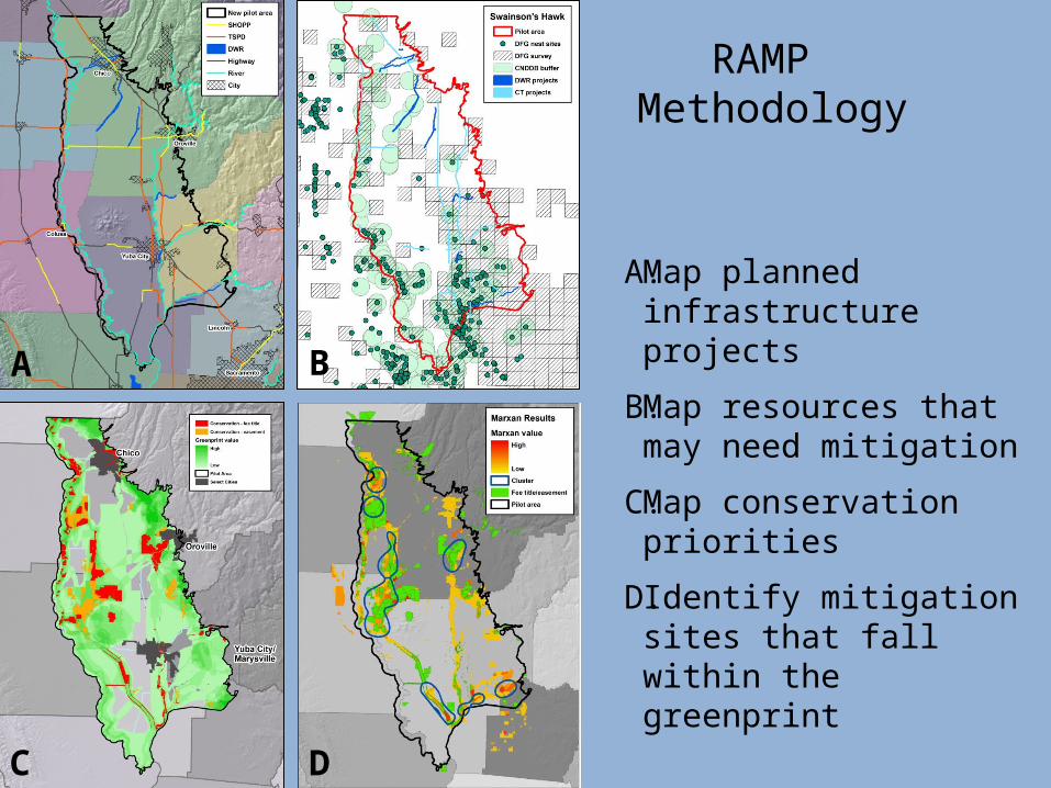
RAMP Methodology
A. Map planned infrastructure projects
B. Map resources that may need mitigation
C. Map conservation priorities
D. Identify mitigation sites that fall within the greenprint

Essential Elements• Agencies’ cooperation and support
• Funding: robust, available early
• Institutional and political support
• Sufficient information for analyses
• Agreed upon science and planning methodologies

RAMP Fundamental Challenges
• Funding
• Policies
• Available information
• Agency capacity, practices and culture

Infrastructure/Habitat Funding• NCCP’s: 2 million acres conserved in California
• San Diego County: $850m
• Orange County: $247m
• Renewable energy pilot: $10m
• To come:
– High Speed Rail Authority
– San Francisco Bay Area
– More NCCP’s

Federal Policy Advancements
• Federal Transportation bill (2012)
• Water Resources Development Act (2014)

Questions?Liz O’Donoghue
Director, Infrastructure and Land UseThe Nature Conservancy – California Chapter