putnam countypds.putnam-fl.com/wp-content/uploads/2017/05/pc_trails_plan.pdf · ms. dana jones,...
TRANSCRIPT
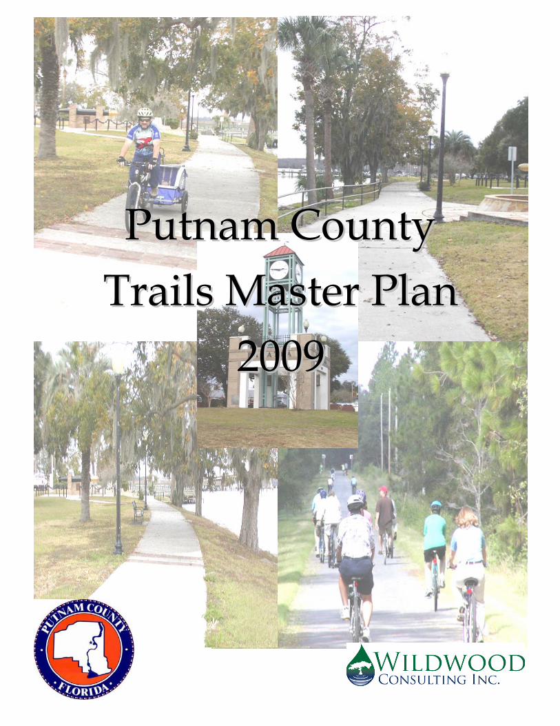
PPuuttnnaamm CCoouunnttyy TTrraaiillss MMaasstteerr PPllaann
22000099
Putnam County
Trails Master Plan 2009
Adopted by the Putnam County Board of County Commissioners on March 24, 2009
Prepared By: Wildwood Consulting
134 Riberia St. St. Augustine, Florida


i
Acknowledgements We would like to thank the following people for their guidance and willingness to share their knowledge, experience, expertise and information in the development of this plan: Putnam County Board of County Commissioners Mr. Brad Purcell – District 5 Commissioner, Putnam County Mr. Brian Hammons- Director, Planning and Development Services, Putnam County Mr. Kraig McLane, - Chairman of the Putnam County Trails Committee Ms. Kim Paxton, GIS Manager, Putnam County Ms. Dana Jones, Executive Vice President, Putnam County Chamber of Commerce Ms. Julie Linton, Vice President for Tourism, Putnam County Chamber of Commerce Mr. Stephen Miller, Coordinator of Trails Development, Rails to Trails Conservancy,
Washington D.C. Mr. Ken Bryan, Florida State Director, Rails to Trails Conservancy, Tallahassee Mr. Boyd Thompson, Ride Solutions Inc., Putnam County Ms. Myra Strange, Ride Solutions Inc., Putnam County Ms. Mary Anne Koos, Florida Department of Transportation Ms. Melissa Hollis, Florida Department of Transportation Mr. Don Jacobovitz P.E., Director, Public Works, Putnam County Ms. Barbara Meyers, Brevard County, MPO Mr. Ray Spofford, England, Thims and Miller Inc. Mr. Scott Crosby, Forestry Supervisor, Etoniah Creek State Forest Mr. Nels Parson, Land Manager, St. Johns River Water Management District Mr. Doug Alderson, Florida Paddling Trails Coordinator, Office of Greenways and Trails Mr. David Anderson, Project Manager, Florida Department of Transportation Ms. Robin Turner, Regional Coordinator, FDEP, Office of Greenways and Trails Mr. Jim Wood, Asst. Dir., FDEP, Office of Greenways and Trails Mr. James Boyle, Regional Transportation Manager, Jacksonville Transportation Authority Mr. Felipe Rivera Jr., Civil Engineer III, Putnam County Public Works Department Ms. Linda Crider Ph.D., Executive Director, Florida Traffic and Bicycle Safety Education
Program - Bike Florida Mr. Jeffrey S. Olsen, Co-Director of the Initiative for Healthy Infrastructure, University of
Albany, State University of New York and Principal with Alta Planning and Design Mr. Bob Searns, Chairman, Board of Directors for American Trails, Colorado.

ii
Table of Contents
List of Acronyms ....................................................................................................................................... vi
Executive Summary ................................................................................................................................ vii
Section 1 – Introduction ............................................................................................................................ 1
Vision Statement ..................................................................................................................................... 1
Goals of the Putnam County Trails Planning and Development Effort ......................................... 1
Benefits of Trails ..................................................................................................................................... 1
Economic Benefits ............................................................................................................................... 1
Environmental Benefits of a Bike and Pedestrian Friendly Community .................................... 3
Social and Health Benefits of Promoting Walking and Bicycling in Our Community ............. 3
General Conditions and Trends ........................................................................................................... 4
History of Trail Planning Efforts in Putnam County ........................................................................ 5
Plan Scope and Purpose ........................................................................................................................ 6
Section 2 – Assessment of Current Conditions ...................................................................................... 7
Community Demographics Affecting Trails Development ............................................................. 7
Population ............................................................................................................................................ 7
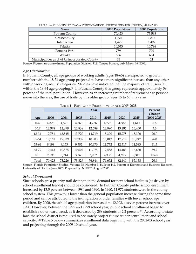
Age Distribution ................................................................................................................................. 8
School Enrollment ............................................................................................................................... 8
Existing Trails and Transportation Network ..................................................................................... 9
Existing Trails Inventory ................................................................................................................... 9
Road Network ................................................................................................................................... 12
Public Transportation ....................................................................................................................... 12
Rail Facilities ...................................................................................................................................... 12
Section 3 - Trail Prioritization ................................................................................................................. 14
Prioritization of Planned and Future Trails ...................................................................................... 14
Cost Estimates ....................................................................................................................................... 14
Section 4 –Plans, Programs and Policies Associated with Trails Development .............................. 30
Statewide Plans and Programs ........................................................................................................... 30
Florida Transportation Plan ............................................................................................................ 30
Florida Communities Trust ............................................................................................................. 31
Office of Greenways and Trails ...................................................................................................... 31
Florida Recreational Trails Program .............................................................................................. 32
Florida Greenways and Trails Land Acquisition Program ......................................................... 32
iii
Local Plans, Programs, Initiatives, Regulations and Institutions .................................................. 33
County Comprehensive Plan .......................................................................................................... 33
Interlocal Agreement between the Putnam County School Board and Other Local Governments ..................................................................................................................................... 33
Land Development Review ............................................................................................................. 33
Concurrency Management System ................................................................................................ 34
Plan, Policy and Program Improvement Recommendations ......................................................... 34
Community Trails Development .................................................................................................... 34
Comprehensive Plan ........................................................................................................................ 35
Interlocal Agreement between the Putnam County School Board and Other Local Governments ..................................................................................................................................... 35
Land Development Code ................................................................................................................. 35
Concurrency Management System ................................................................................................ 35
Coordination Recommendations ....................................................................................................... 36
Putnam County Trails Council ....................................................................................................... 36
Internal Coordination- Putnam County ........................................................................................ 38
External Coordination ...................................................................................................................... 39
Section 5 – Implementation Plan ............................................................................................................ 40
Proposed Trail Improvement Schedule ............................................................................................ 40
Funding Opportunities ........................................................................................................................ 42
Federal Funding .................................................................................................................................... 43
SAFETEA-LU .................................................................................................................................... 43
Recreational Trails Program (RTP) ................................................................................................. 44
National Scenic Byways Grants Program ...................................................................................... 45
Alternative Transportation in Parks and Public Lands ............................................................... 46
Land and Water Conservation Fund (LWCF) .............................................................................. 46
Community Development Block Grants (CDBG) ........................................................................ 46
Historic Preservation Funding Sources ......................................................................................... 47
Conservation Reserve Program ...................................................................................................... 48
State Funding ........................................................................................................................................ 48
Florida Communities Trust Program ............................................................................................. 48
Florida Greenways & Trails Acquisition Program ...................................................................... 48
Florida Recreational Development Assistance Program (FRDAP) ........................................... 49
Florida Department of States Division of Historical Resources ................................................. 49
Local Funding ....................................................................................................................................... 50
iv
Local Tax Measures .......................................................................................................................... 50
Tourist Development Taxes ............................................................................................................ 50
Development Impact Fees and Transportation Concurrency Exception Areas (TCEAs) ...... 51
Municipal Service Taxing And Benefit Units ............................................................................... 51
Private Funding .................................................................................................................................... 52
The Eastman Kodak American Greenways Awards ................................................................... 52
Phillips Petroleum Environmental Partnership Awards ............................................................ 52
Coors Pure Water 2000 ..................................................................................................................... 52
The Harder Foundation ................................................................................................................... 53
The Bikes Belong Coalition .............................................................................................................. 53
Other Supplemental Funding Opportunities ................................................................................... 53
Leasing of Potential Uses ................................................................................................................. 53
Salvaging Materials from Rails to Trails Corridors ..................................................................... 54
In-Kind Contributions ...................................................................................................................... 54
Campaigns and Donations .............................................................................................................. 54
Trust Funds or Endowments ........................................................................................................... 54
Private Grants .................................................................................................................................... 54
Public Outreach and Involvement ..................................................................................................... 54
References ................................................................................................................................................. 56
Appendix A: Roadways Associated with Trails .................................................................................. 58
Appendix B: Goals, Objectives and Policies of the Putnam County Comprehensive Plan that May Affect Trails Development ............................................................................................................. 64
Appendix C: General Design Guidelines ............................................................................................. 70
Appendix D: Creating a Bicycling Friendly Community ................................................................... 75
Appendix E: Example Trails and Bicycle Related Language from the Alachua County Unified Land Development Code ........................................................................................................................ 78
List of Tables
Table 1 – Components of Population Growth, 2000-2006 .................................................................... 7 Table 2 – Putnam County, Florida Population Projections, 2006-2030 ............................................... 7 Table 3 – Municipalities as a Percentage of Unincorporated County, 2000-2005 ............................. 8 Table 4 – Population Projections by Age, 2005-2025 ............................................................................. 8 Table 5 – Putnam School District Enrollment, 2002-2010 ..................................................................... 9 Table 6 – Existing Trails within Putnam County ................................................................................... 9 Table 7 – Per Mile Construction Cost Estimates .................................................................................. 15 Table 8 –Prioritization Matrix for Proposed Multi-Use Trails and Bike Routes ............................. 18 Table 9 – Prioritization Matrix for Proposed Equestrian, Hiking, and Paddling Trails ................ 26 Table 10 – Estimated Costs of Proposed Bike Routes and Multi-Use Trails .................................... 40
v
Table 11 – Estimated Costs of Equestrian, Hiking, OHV, and Paddling Trails .............................. 42
List of Figures Figure 1 – Trailside Businesses along the Pinellas Trail, Florida ........................................................ 3 Figure 2 – Location of the Existing Trails ............................................................................................. 11 Figure 3 – Public Transportation Routes .............................................................................................. 13 Figure 4 – Location of Planned and Proposed Multi-Use Trails ....................................................... 16 Figure 5 – Location of Proposed Bike Routes ....................................................................................... 17 Figure 6 – Prioritization of Proposed Multi-Use Trails and Bike Routes ......................................... 23 Figure 7 – Location of Proposed Equestrian and Hiking Trails ........................................................ 24 Figure 8 – Location of Proposed Paddling Trails ................................................................................ 25 Figure 9 – Prioritization of Proposed Hiking and Equestrian Trails ................................................ 29 Figure 10 - Proposed Trails in Palatka .................................................................................................. 77
vi
List of Acronyms
ARC Association of Retarded Citizens CDBG Community Development Block Grants CDC Center for Disease Control and Prevention C.R. County Road FDEP Florida Department of Environmental Protection FGCC Florida Greenways Coordinating Council FIHS Florida Intrastate Highway System FNST Florida National Scenic Trail FRDAP Florida Recreational Development Assistance Program FRTC Florida Recreational Trails Council HRS Health and Rehabilitative Services JTA Jacksonville Transportation Authority LOS Levels of Service LWCF Land and Water Conservation Fund MSTU (MSBU) Municipal Service Taxing (Benefit) Unit NTEC National Transportation Enhancements Clearinghouse OGT Office of Greenways and Trails OHV Off-Highway Vehicle PD&E Project Development & Environment ROW Right-of-Way RTP Recreational Trails Program SAFETEA-LU Safe, Accountable, Flexible, Efficient Transportation Equity Act: A
Legacy for Users SIS Strategic Intermodal Systems S.R. State Road TCEA Transportation Concurrency Exception Areas TD Transportation Disadvantaged TE Transportation Enhancements USDA U.S. Department of Agriculture WMA Wildlife Management Area

vii
Executive Summary
This Master Plan continues the efforts of the Putnam County Trails Committee and its earlier planning efforts by providing consolidated documentation of previously identified trail components, providing prioritization of those components, providing an updated list of funding sources and making recommendations for improving local plans, land development regulations and processes. The information in this plan is an important step in developing more detailed design and engineering studies of the individual trails and should be useful to county planning staff during the trails planning process. It is also intended to assist the general public with understanding the current status of trails planning and implementation in Putnam County. The vision for trails in Putnam County is “To establish Putnam County as the trail hub of Florida while enhancing and enriching the quality of life of Putnam County citizens through the development of cycling, pedestrian, equestrian, paddling and other trails that serve as recreational amenities, alternative connectors to community destinations and economic stimuli." The overarching goals of the trails development effort are:
• Provide unique recreational experiences for cyclists, roller-bladers, joggers, equestrians, walkers and commuters to and from work.
• Provide important alternative connecting paths between neighborhoods, schools, parks, public lands, business/retail and downtown centers.
• Offer unique eco-tourism experiences for visitors and to promote Putnam County’s historical, recreational and downtown destinations. (1)
According to the National Association of Homebuilders “…Prospective homebuyers consider trails to be the most important amenity they seek when choosing a place to live.” Additionally, studies from the National Recreation and Parks Association indicate that closer proximity to greenways and conservation corridors increase property values. Bicycling and walking are inexpensive means of transportation. Walking is essentially free, and bicycles are readily available. In contrast, owning and maintaining an automobile can be very expensive. Carbon emissions come from sources like large industrial operations and from less intensive but more widespread daily activities like driving. Climate change has become an increasingly important policy issue. Encouraging people to walk or bicycle when making short trips can help cut down on harmful auto emissions and reduce noise pollution. Greenways and trails protect important habitat and provide wildlife corridors. They also improve air and water quality by providing safe options to driving. Protecting land along rivers, streams and lakes prevents soil erosion and stormwater runoff entering those waterbodies. Greenways and trails utilizing pervious surfaces like gravel or crushed stone can also be incorporated into floodplain protection and management plans to reduce runoff and increase floodplain storage. And, finally, trails and greenways serve as hand-on environmental classrooms where people can connect with the natural world from which they often feel removed. (11)
viii
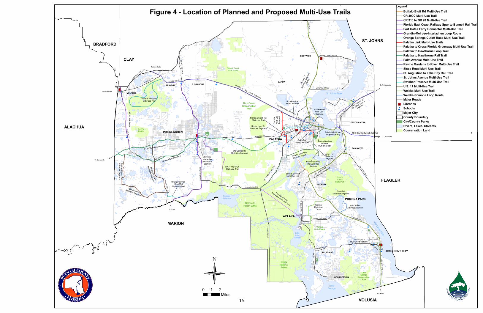
The social benefits of enhanced pedestrian and bicycling opportunities within a community, though more subjective, are no less compelling than those associated with the economic and environmental benefits. Simply having more people outside in our public spaces gives the community a lively air that can generate more social and commercial activity. The obesity epidemic is hitting children especially hard. Living in a bicycle and pedestrian friendly community can play a significant part in leading children to exercise more and to develop healthy habits for life. To promote healthy lifestyles and combat the rising trend of obesity and inactivity in the United States, the Center for Disease Control and Prevention (CDC) recommends that Americans get 30 minutes of moderate physical activity at least five days a week. The CDC’s emphasis is less on grueling workouts at the gym, and more on encouraging Americans to be active during their everyday lives. Trails play an important role in achieving the CDC’s recommendation. Several demographic factors affect the demand for trails including the age of the user population and the anticipated demand for new school facilities. Specific demographics affect future demand for trails and serve as indicators of the type and location of trails such as population growth, age distribution and school enrollment. Population growth is important to the planning of recreational trails due to the increased demand on recreational facilities created by such growth. Natural changes in population are not expected to be a major factor in population growth in Putnam County and the population of Putnam County is projected to continue to increase through 2030 at an average annual rate of approximately three percent. In Putnam County, all age groups of working adults (ages 18-65) are expected to grow in number with the 18-34 age group projected to have a more significant increase than any other. Studies have indicated that the majority of trail users fall within the 18-34 age grouping.(5) In Putnam County this group represents approximately 58 percent of the total population. However, as an increasing number of retirement age persons move into the area the use of trails by this older group (ages 55 to 65) may rise. Since schools are a priority trail destination the demand for new school facilities (as driven by school enrollment trends) should be considered. Between the 1995 and 1999 school year, public school enrollment began to establish a downward trend,(21) while the overall population of the county is increasing the number of students per household has decreased.(14) Currently, Putnam County does not have any schools with utilization (enrollment ÷ capacity) exceeding 100 percent (14) which indicates that, at this time, the development of additional schools is not a requirement. One of the goals of the Trails Master Plan is to establish priorities for trail development within the county. Proposed trail projects have been grouped into High, Medium and Low priority rankings. This prioritization follows a general progression from a (spoke) system of primary trails to medium priority trails that link primary trails together or create loop trails to those that lead to single destinations. Table 8 presents a general trail prioritization structure for biking and multi-use trails as well as planning level cost estimates. Figure 4 shows planned and proposed multi-use trails and Figure 5 shows the proposed bike routes within Putnam County. For the purposes of this effort a planned trail is one that has been identified for development and planning or design has been initiated for that individual trail. A proposed trail is one that has
ix
had no official action taken such as individual planning or design work or placing it into a work schedule for funding. Multi-use trails (or shared-use facilities) are those which may be used for cycling, skating, walking and, depending upon local circumstances, may have associated equestrian paths as well. Generally, multi-use trails are separate from roadways. Multi-use trails are on exclusive right of ways, usually paved, and ideally situated with minimal cross flow by motor vehicles. These facilities can serve a variety of purposes by connecting neighborhoods, providing school age children or bicyclists with shortcuts through residential neighborhoods, recreation opportunities, or linear parks. They can be located adjacent to canals, rivers or streams, along abandoned railroad corridors or utility easements, and other scenic areas. Bike Lanes are a portion of a roadway (typically 4 - 5 ft.) which has been designated by signing and pavement markings for the preferential or exclusive use by bicyclists. Bike routes are a system of roads and ways that are linked by signs to aid bicyclists. Bike routes are ineffectual unless signs are highly specific, giving a clear indication of destination.(34) Figure 7 shows proposed hiking and equestrian trails and Figure 8 shows proposed paddling trails. Hiking trails are moderate length trails oriented towards pedestrians that provide an opportunity to study interesting plants or natural features at the user’s leisure. These trails are generally unpaved and located within a natural setting such as a conservation area, park, forest or other natural resource open to the public. Equestrian trails are typically dedicated to equestrian use or may be incorporated into multi-use (shared-use) trails. Minimum recommended widths for equestrian trails are 10 feet with a similar minimum height. Trail surfaces are natural soil, mulch or other soft surface that may be easily maintained and smoothed. Paddling trails are trails along waterways such as rivers, streams, or lakes for use by canoes, kayaks or other non-motorized water craft. Paddling trails can also be referred to as blueways. Routes are marked with signs, buoys, or other means to guide users. Access to the water body is a critical component of such a trail. Table 9 lists the general prioritization of these trails as well as planning level cost estimates. These trails vary greatly in type, length and connectivity to other trails or roads. Generally, highest priority was assigned to lengthier trails and trails that (when grouped) formed more significant networks, especially if readily accessible by road. Lower priority was given to more isolated and/or smaller trails. Due to their unique nature, paddling trails were not ranked. Cost estimates were derived from a combination of 2007-2008 FDOT State Estimates Office and Rails to Trails Conservancy estimates for 10’ to 12’ wide trails (for multi-use trails) and 4’-5’ road widening (for bike lanes) projects. Estimates are provided on an average cost per mile basis. They are on an order of magnitude level, developed for planning purposes and are provided to allow a relative comparison of potential costs among trails or trail types. Final cost estimates will result from new information and data collected during the engineering and design of the recommended trail alignments. Not included in cost estimates are land acquisition and costs due to escalation among others. Costs associated with padding trails are also extremely variable but are generally much lower than other trails. A number of plans and programs affecting greenways and trails development at the state, regional and local levels are summarized. Trails development is driven by local desires and community needs. Many of these programs focus on providing expertise and funding assistance so many of the entities listed are also included as potential funding sources. Key
x
state programs include those administered by the Florida Communities Trust and the Office of Greenways and Trails, among others. Of key importance are local planning and land development review processes. The county’s comprehensive plan, land development code, concurrency management system and interlocal agreement with the School Board were reviewed to determine where they may impact trails development. These recommendations are continued in Section 4 and within Appendix B. Appendix E provides some example language as exists within Alachua County’s Land Development Code. Of particular interest is language contained in section 400.04 (c) that discusses payment in lieu of construction to a fund for the purposes of trails construction. Recommendations for potential amendments to strengthen trail-related linkages among these key programs include the following:
• The county has been assessing opportunities to develop intra-county trails linking various points of interest (downtown districts, recreational areas such as state parks, national forests etc.) in conjunction with the state and county road systems. Linking this intra-county trail system with community trails would further allow Putnam County citizens to access these trails and utilize the trails system for day-to day activities such as commuting to work, schools, shopping and other daily destinations. It is recommended that the County create and/or review for adequacy current levels of service for trails and incorporate requirements for meeting those standards into its land development code and concurrency management system. In addition it is recommended that the County consider creating or improving incentives for the provision of greenways, trails and open space within these documents and programs. This might include policies such as providing or increasing open space credits for lands set aside for greenways and trails. Land development agreements could also be used to codify commitments for greenways and trails.
• The interlocal agreement between the Putnam County School Board and other local governments provides the avenue needed to ensure that the development, improvement and maintenance of community trails associated with the public schools meets concurrency standards and that the costs associated with those facilities are appropriately shared between the county and the School Board. However, it may be worthwhile to undertake a review of the specific concurrency standards to ensure that they adequately address bikeways and trails.
• The county may desire to review its land development code to further encourage the development of greenways and trails and bring the code into closer alignment with many of the goals, objectives and policies contained in the Comprehensive Plan. This would be especially applicable to the development of community trails during reviews of new development or redevelopment applications. The development of trail-related LOS may also be considered to help guide the application of trails development by development interests.
• The concurrency management system references levels of service for public facilities included in the Capital Improvements Element of the Comprehensive Plan. It also defines public facilities to include, among others, recreation and road facilities.
xi
Confirmation that bikeways, bike routes, trails and/or greenways are public facilities for concurrency purposes, either explicitly or implicitly, within the development plans is recommended should the county wish to strengthen its capability to enlist development or redevelopment interests in supporting the creation of new trails and the maintenance of existing trails.
• During the creation of this plan it has become evident that consistent and on-going
coordination of trail related issues would greatly assist the future development of trails within the county. The history of trail planning supports this conclusion. A primary recommendation of the Putnam County Chamber of Commerce’s Trails Committee to the Board of County Commissioners in 2007 was to establish a Putnam Trails Council to serve as a focal point and to advocate for trails in Putnam County.
• It is recommended that the County dedicate resources to the on-going support of the Council. If it is not practicable for the County to support the Council the Chamber of Commerce (which has served an active and vital role in continuing trails efforts) may also serve as the trails coordinating group. The Council’s purpose, goals and targeted activities will undoubtedly evolve through time. However, the following is provided as an initial list of action to consider.
o High Priority
Identify top priority projects and develop individual plans of action with a goal of initiating construction of those projects within a five-year timeframe. It is suggested that the initiation of the top priority projects identified in Table 8 be considered. Action plans may contain components such as:
• A description of the current status of each project; • Challenges such as acquisition needs such as funding and political
hurdles to be overcome; • Improved cost estimates (to the extent possible); • An ideal schedule for development; • Identification of key organizations and individuals and their roles in the
accomplishment of the project; and • Assignment of responsibilities for Council members.
Develop public education and outreach strategy including:
• Materials describing current trail, biking, equestrian etc. opportunities within Putnam (this would have to be consistently updated).
• Materials describing the benefits of trails and the current status of trails development within the county.
• Consistently working with local entities to educate them about and assist them with being a “Bike Friendly Community”(Appendix D).
o Medium Priority
Conduct a detailed analysis of the County Comprehensive Plan, Land Development Code and Concurrency Management System and provide specific
xii
recommendations for improvements relative to trails. These would include examining the possibility of providing incentives for the provision of trails by development interests and/or the direct contribution of funds for community trails development. The creation of a trails development fund, the provision of open space credits for trails provided by the developer and meeting specific standards and direct requirements for trails development may be considered. Work with the Chamber of Commerce to examine the possibility of expanding the Tourist Development Tax in a way that equitably increases revenue received from entities that would benefit from trails and setting a certain percentage of the tax aside for trails development and/or the provision of “Bike Friendly Community” amenities.
o Low Priority Formalize Council membership and operating procedures.
• Numerous county departments and organizations have a role in trail planning and
development within Putnam County. The Public Works Department oversees the execution of a large part of the county’s capital improvement schedule, including county executed or sponsored roadwork. This schedule is an important consideration during the annual budget development process and also helps the county to identify external funding needs and opportunities that it wishes to pursue such as FDOT funding. Ensuring that trails that are prioritized within this plan and future trails planning documentation is included in the county’s capital planning process is critical to ensuring that trails development, especially that associated with roadways, is adequately funded.
• Other organizations within Putnam County may interface with trails planning and development efforts. To ensure maximum effectiveness of the future trail network future trail alignments should be coordinated with these entities, including the following:
• Putnam County Chamber of Commerce; • Ride Solutions Inc.; • CSX and Florida East Railways; and • Trust for Public Lands/Greenprinting • East Coast Greenway
• Additionally, the Putnam Land Conservancy is engaged with acquiring and managing
conservation lands within the county that could contain future trails. That organization should be kept apprised of trail development needs.
• Numerous entities, both public and private, are involved with trails planning and development at the state and regional levels. Consistent communication with these groups and staying informed about their funding application cycles is critical to ensuring that all potential opportunities for funding are maintained.

xiii
Table 10 provides trail improvement schedule based on the prioritization ranking. It utilizes a 5-year planning horizon in order to more easily coordinate with other planning cycles. Project phase costs associated with acquisition, planning, design and construction are provided. Construction costs utilize the previously discussed (per mile) cost estimates. For planning purposes, planning costs are assumed to be 5% of total estimated construction costs and design is estimated at 15%. The most common method for funding greenways is to combine local, public-sector, and private-sector funds with state and federal resources. Many communities involved with greenway implementation are choosing to leverage local money as a match for outside funding sources, in essence multiplying their resources. In future greenway development, the county should rely on local advocates including its Trail Council to pursue a variety of funding sources for land acquisition and greenway construction. The programs that are listed focus primarily on acquisition and construction of greenways and trails. However, numerous other funding sources are available for activities such as the development of innovative planning strategies to improve transportation networks while protecting the environment and providing public education.

1
Section 1 – Introduction Vision Statement “To establish Putnam County as the trail hub of Florida while enhancing and enriching the quality of life of Putnam County citizens through the development of cycling, pedestrian, equestrian, paddling and other trails that serve as recreational amenities, alternative connectors to community destinations and economic stimuli." Goals of the Putnam County Trails Planning and Development Effort
• Provide unique recreational experiences for cyclists, roller-bladers, joggers, equestrians, walkers and commuters to and from work.
• Provide important alternative connecting paths between neighborhoods, schools, parks, public lands, business/retail and downtown centers.
• Offer unique eco-tourism experiences for visitors and to promote Putnam County’s historical, recreational and downtown destinations. (1)
Benefits of Trails Economic Benefits Bicycling and walking are inexpensive means of transportation. Walking is essentially free, and bicycles are readily available. In contrast, owning and maintaining an automobile can be very expensive. In 2004 the average cost of operating a car for one year was about $7,800; and families, on average, spent 18% of their income on owning and maintaining a single automobile.(2) Rising fuel costs have likely increased these estimates. The average family makes ten trips by car every day, and the average American spends the equivalent of 55 eight-hour workdays behind the wheel of a car every year.(3) Community leaders are realizing the economic potential of trails as highly desirable destinations that bring dollars into the places they serve. In addition to preserving critical open space and providing important transportation options, trails and greenways attract visitors from near and far—visitors who facilitate job growth in tourism-related opportunities like restaurants, local stores and lodging. Based on the well-known National Main Streets economic model, Trail Towns are literally inviting trail users to spend time and dollars in their community. Researchers have found that the economic impact of this approach is significant. (4) Bicycle tourists, a growing, affluent segment of the tourist market, contribute significantly to local businesses that are well-connected to trails. The Virginia Creeper Trail, for instance, generates $1.59 million in annual spending, supporting approximately 27 new fulltime jobs. (5) Across the country, trails and greenways are stimulating tourism and recreation spending. This spending is a catalyst to revitalization. Examples include:
• The Washington and Old Dominion Trail (W&OD) is a 45-mile long transportation and recreation corridor running from Arlington, Virginia, west to Purcellville. An estimated 1.7 million adult W&OD users spent in total about $12 million annually related to their use recreational use of the trail. Of this amount, about $7 million was spent directly in the northern Virginia economy by locals and non-locals using the trail. The estimated 1.6
2
million local visits accounted for about $5.3 million of spending directly related to the use of the W&OD.(6)
• The North Carolina Department of Transportation (NCDOT) Division of Bicycle and
Pedestrian Transportation (DBPT) commissioned a study to examine the value of public investment in bicycle facilities.
The economic benefits identified in that study included:
• Bicycling activity in the northern Outer Banks provides substantial economic benefits to the area: an estimated $60 million annually.
• The bicycle facilities in the area are an important factor for many tourists in deciding to visit the region.
• Investment in bicycle facilities improves the safety of the transportation system for all users and also benefits health and fitness, quality of life, and the environment.
• 53% report bicycling as a strong influence in decision to return for subsequent visit. • 43% report bicycling as an important factor in selecting this area for vacation. (7)
Access to trails and greenways has even been shown to have a positive effect on property values. Some examples are:
• Increased property values associated with a single greenway were estimated to result in $13.64 million of new property tax revenue in Austin, Texas. (8)
• Developers of the Shepherd’s Vineyard housing development in Apex, N.C., added $5,000 to the price of 40 homes adjacent to the regional greenway. Those homes were the first to sell.(9)
The economic benefit of providing safe and convenient access for customers to commercial centers is self-evident. New businesses often consider quality of life issues when choosing new locations. The quality of life that comes with enhanced bicycle, pedestrian and equestrian activity is likely to produce various other indirect economic benefits. Policies and improvements that make walking and bicycling more attractive can cut down on the number of car trips and can, in some instances, eliminate the need for a second car. Excellent bicycle and pedestrian facilities can draw tourists to Putnam County, both as a stop en route to other places and as an end destination.
3
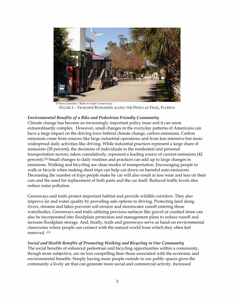
© Franz Gimmler / Rails-to-Trails Conservancy
FIGURE 1 – TRAILSIDE BUSINESSES ALONG THE PINELLAS TRAIL, FLORIDA Environmental Benefits of a Bike and Pedestrian Friendly Community Climate change has become an increasingly important policy issue and it can seem extraordinarily complex. However, small changes in the everyday patterns of Americans can have a large impact on the driving force behind climate change, carbon emissions. Carbon emissions come from sources like large industrial operations and from less intensive but more widespread daily activities like driving. While industrial practices represent a large share of emissions (28 percent), the decisions of individuals in the residential and personal transportation sectors, taken cumulatively, represent a leading source of current emissions (42 percent).(10) Small changes to daily routines and practices can add up to large changes in emissions. Walking and bicycling are clean modes of transportation. Encouraging people to walk or bicycle when making short trips can help cut down on harmful auto emissions. Decreasing the number of trips people make by car will also result in less wear and tear on their cars and the need for replacement of both parts and the car itself. Reduced traffic levels also reduce noise pollution. Greenways and trails protect important habitat and provide wildlife corridors. They also improve air and water quality by providing safe options to driving. Protecting land along rivers, streams and lakes prevents soil erosion and stormwater runoff entering those waterbodies. Greenways and trails utilizing pervious surfaces like gravel or crushed stone can also be incorporated into floodplain protection and management plans to reduce runoff and increase floodplain storage. And, finally, trails and greenways serve as hand-on environmental classrooms where people can connect with the natural world from which they often feel removed. (11) Social and Health Benefits of Promoting Walking and Bicycling in Our Community The social benefits of enhanced pedestrian and bicycling opportunities within a community, though more subjective, are no less compelling than those associated with the economic and environmental benefits. Simply having more people outside in our public spaces gives the community a lively air that can generate more social and commercial activity. Increased

4
walking and biking can also help people gain a deeper understanding and appreciation of the built and natural environment. Increased walking and biking would have a positive effect on the overall health of the community by improving fitness and cutting down on the growing health care costs that are plaguing so many areas. The obesity epidemic is hitting children especially hard. Living in a bicycle and pedestrian friendly community can play a significant part in leading children to exercise more and to develop healthy habits for life. To promote healthy lifestyles and combat the rising trend of obesity and inactivity in the United States, the Center for Disease Control and Prevention (CDC) recommends that Americans get 30 minutes of moderate physical activity at least five days a week. This can happen in a number of ways: walking or biking to work, running errands on foot instead of by car, or taking a quick bike ride or stroll through a park. The CDC’s emphasis is less on grueling workouts at the gym, and more on encouraging Americans to be active during their everyday lives. Trails play an important role in achieving the CDC’s recommendation. Trails not only provide a designated place to walk and bike; we are also much more likely to exercise and be active when safe, welcoming environments like trails are available. (12) Trails and greenways can also connect us to our heritage through the preservation of historic places and by providing and encouraging access to them. Trails allow a more leisurely and thorough exploration of historic sites such as the location of a community’s founding, battlefields or important transportation routes such as railways and historic paths and roads. General Conditions and Trends Many factors affect trails demand such as anticipated population and housing growth, school enrollment, and proximity of housing to shopping, parks, schools, libraries and other public facilities. Putnam County contains an area of 533,702 acres including the incorporated municipalities of Crescent City, Interlachen, Palatka, Pomona Park and Welaka. It is characterized by many wetlands, lakes and other water bodies, primarily the St. Johns River which runs through the eastern portion of the county and the City of Palatka. Land elevations range from 16.4 feet along the St. Johns River to 180.45 feet in the highlands west of Interlachen; however, most of the county has a reasonably gentle topography. (13) In 2000, unincorporated Putnam County had a population of 55,764. By the year 2015, the population in all of Putnam is projected to be 79,700 residents and unincorporated Putnam is expected to reach 63,560, including seasonal population. This represents a fourteen percent increase of population in the fifteen-year period from 2000 to 2015. Including seasonal population increases, the unincorporated area is projected to have 71,657 people and the total county to have 88,362 people. (13)
Nineteen public schools, including ten elementary schools, five middle schools, two senior high schools, and two combination schools, are operated by the Putnam County School District. (14) There are also ten private schools in Putnam County. (15) During the 2006-2007 school year there were 11,961 students enrolled on the Putnam County School District. (16) There were 24,338
5
dwelling units in 2002 in the unincorporated portion of Putnam County. It is estimated that there will be a total of 27,048 households by 2015.(13) The county’s traffic circulation system is not only composed of state and county roads, but also includes an airport facility, a barge port facility and rail lines. The major transportation routes to Putnam County are U.S. 17 (S.R. 15), S.R. 19, S.R. 20, S.R. 100, and S.R. 207. The Florida Department of Transportation maintains these primary roads which account for approximately 133 miles (36 percent) of the total 372 miles of the primary road system in the county.(17)
Putnam County maintains the county roads, except those under dedication. As of September, 2000, the existing secondary county road system had 1,665 miles of paved and unpaved roads, of which 1,190.5 miles (71.5 percent) are unpaved and only 474.5 miles (28.5 percent) are paved.(17) As of July 2008 the number of unpaved roadway miles had been reduced to 1,137 miles, 273 of which are maintained by the county.(28) The county’s park system includes 17 parks encompassing approximately 174.6 acres classified based on a hierarchy of park facilities. These include regional parks, community parks, neighborhood parks and mini-parks (Tot-Lots).(18) History of Trail Planning Efforts in Putnam County In 2003, the Putnam County Chamber of Commerce applied for the Kodak American Greenways Award Grant to fund a series of public workshops to gain community input for a Master Plan for Trails Development. The Putnam County Chamber of Commerce Trails Development Committee, chaired by Kraig McLane, has developed a Preliminary Draft Master Plan for Trails Development in Putnam County. That plan identified the existing trails in Putnam County along with a series of proposed trails and blueways that link to the existing trails and public lands in Putnam County and to regional and state trails. The Putnam County Chamber of Commerce has conceptually approved the plan for further development by seeking mapping assistance from the county and to seek public support for the development of the plan. There has been a strong desire from the community and Chamber members to develop trails that link the downtown areas (including commerce, recreational facilities and transportation sources) with the Cross Florida Greenway, the Florida National Scenic Trail, the Palatka to Lake Butler State Trail, and the St. Johns River. The Preliminary Draft Master Plan identified the following existing trails (19):
• Ravine Gardens State Park Trails – connects with Old Palatka Waterworks (1.8-mile loop trail).
• Florida National Scenic Trail – connects the Cross Florida Greenway and the Ocala National Forest.
• Welaka Fish Hatchery – Beechers Spring Trail (0.9 mile loop trail). • Dunn’s Creek Conservation Area – located on North Bank of Dunn’s Creek across from
Dunn’s Creek State Park. • Lake George Recreation Area – Multi Use Trails, located at south end of county. Link to
proposed C.R. 309 Trail and Crescent City. • Caravelle Ranch Trails – Multi Use Trails, proposed link to Cross Florida Greenway.
6
• Welaka State Forest Trails – Four (4) Multi Use Trails. Proposed trail connection with C.R. 309 and C.R. 308 to Hwy 17 (Dunn’s Creek State Park).
The Preliminary Draft Master Plan identified the Palatka to Lake Butler Rail Trail as being the first project. This proposed trail will run along the old rail line adjacent to S.R. 100 from Palatka to Keystone Heights in Clay County and will eventually link Lake City with St. Augustine. It will be a multi-purpose trail and uses may include hiking, biking, and horseback riding. The rail corridor has been purchased by the Florida Department of Environmental Protection, Division of Recreation and Parks.(19)
From 2003 through 2006 the master planning effort proceeded intermittently as an additional draft plan was developed in 2004. That draft (the Draft Master Trails Plan) was never finalized. However, in January 2007 the Trails Committee of the Putnam County Chamber of Commerce presented its findings and recommendations for next steps in implementing the Draft Master Trails Plan for Putnam County. The committee identified potential funding sources and made recommendations for future activities including:
• Establishing a Putnam Trails Council; • Updating the County Comprehensive Plan and Land Development Codes to implement
the Master Plan; and • Prioritizing trail corridors and pursuing acquisition and trail development funding.
The county also completed a review of its comprehensive plan with the intent to improve land acquisition, parks, trails and other recreational amenities development policies and objectives. Included in this review were policies related to inter-governmental coordination needed to foster implementation of recreational amenities such as parks and trails. As a result, the Board of County Commissioners adopted, on June 24, 2008, a number of amendments to improve the Conservation, Recreation, and Intergovernmental Coordination elements of the County Comprehensive Plan.(20) Plan Scope and Purpose This Master Plan continues the efforts of the Putnam County Trails Committee and its earlier planning efforts by providing consolidated documentation of previously identified trail components, providing prioritization of those components, providing an updated list of funding sources and making recommendations for improving local plans, land development regulations and processes. The information in this plan is an important step in developing more detailed design and engineering studies of the individual trails and should be useful to county planning staff during the trails planning process. It is also intended to assist the general public with understanding the current status of trails planning and implementation in Putnam County.
7
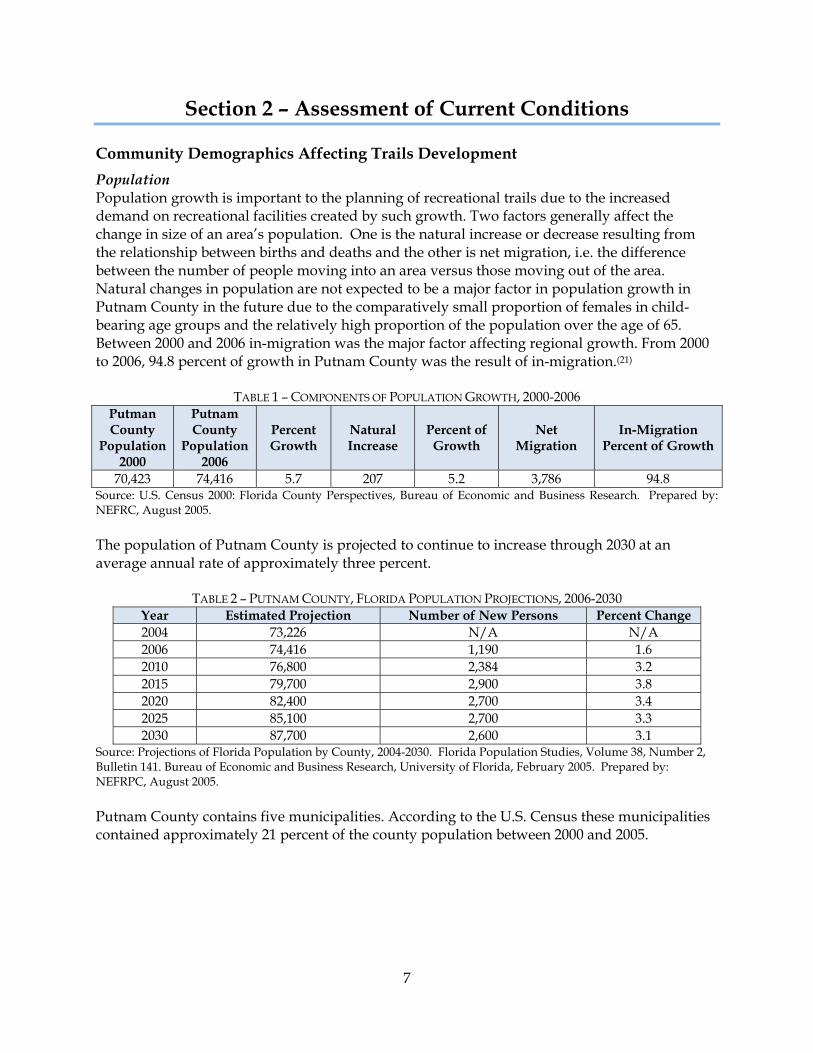
Section 2 – Assessment of Current Conditions Community Demographics Affecting Trails Development Population Population growth is important to the planning of recreational trails due to the increased demand on recreational facilities created by such growth. Two factors generally affect the change in size of an area’s population. One is the natural increase or decrease resulting from the relationship between births and deaths and the other is net migration, i.e. the difference between the number of people moving into an area versus those moving out of the area. Natural changes in population are not expected to be a major factor in population growth in Putnam County in the future due to the comparatively small proportion of females in child-bearing age groups and the relatively high proportion of the population over the age of 65. Between 2000 and 2006 in-migration was the major factor affecting regional growth. From 2000 to 2006, 94.8 percent of growth in Putnam County was the result of in-migration.(21)
TABLE 1 – COMPONENTS OF POPULATION GROWTH, 2000-2006 Putman County
Population 2000
Putnam County
Population 2006
Percent Growth
Natural Increase
Percent of Growth
Net Migration
In-Migration Percent of Growth
70,423 74,416 5.7 207 5.2 3,786 94.8 Source: U.S. Census 2000: Florida County Perspectives, Bureau of Economic and Business Research. Prepared by: NEFRC, August 2005. The population of Putnam County is projected to continue to increase through 2030 at an average annual rate of approximately three percent.
TABLE 2 – PUTNAM COUNTY, FLORIDA POPULATION PROJECTIONS, 2006-2030 Year Estimated Projection Number of New Persons Percent Change 2004 73,226 N/A N/A 2006 74,416 1,190 1.6 2010 76,800 2,384 3.2 2015 79,700 2,900 3.8 2020 82,400 2,700 3.4 2025 85,100 2,700 3.3 2030 87,700 2,600 3.1
Source: Projections of Florida Population by County, 2004-2030. Florida Population Studies, Volume 38, Number 2, Bulletin 141. Bureau of Economic and Business Research, University of Florida, February 2005. Prepared by: NEFRPC, August 2005. Putnam County contains five municipalities. According to the U.S. Census these municipalities contained approximately 21 percent of the county population between 2000 and 2005.
8
TABLE 3 – MUNICIPALITIES AS A PERCENTAGE OF UNINCORPORATED COUNTY, 2000-2005 Name 2000 Population 2005 Population
Putnam County 70,423 73,568 Crescent City 1,776 1,817 Interlachen 1,475 1,497
Palatka 10,033 10,796 Pomona Park 789 799
Welaka 586 604 Municipalities as % of Unincorporated County 21 21
Source: Figures are approximate; Population Division, U.S. Census Bureau, pub. March 16, 2006. Age Distribution In Putnam County, all age groups of working adults (ages 18-65) are expected to grow in number with the 18-34 age group projected to have a more significant increase than any other within working adults’ categories. Studies have indicated that the majority of trail users fall within the 18-34 age grouping.(5) In Putnam County this group represents approximately 58 percent of the total population. However, as an increasing number of retirement age persons move into the area, the use of trails by this older group (ages 55 to 65) may rise.
TABLE 4 – POPULATION PROJECTIONS BY AGE, 2005-2025 Year Percent
Change (2000-2025) Age 2000 2004 2005 2010 2015 2020 2025
0-4 4,326 4,521 4,563 4,756 4,778 4,682 4,611 6.6 5-17 12,978 12,879 12,838 12,689 12,890 13,286 13,450 3.6
18-34 12,751 13,545 13,720 14,719 15,309 15,278 15,300 20.0 35-54 19,161 19,339 19,359 18,983 18,012 17,719 18,247 -4.8 55-64 8,198 9,153 9,382 10,670 11,772 12,317 11,583 41.3 65-79 10,413 10,575 10,602 11,075 12,558 14,483 16,630 59.7 80+ 2,596 3,214 3,365 3,952 4,333 4,675 5,317 104.8
Total 70,423 73,226 73,829 76,844 79,652 82,440 85,138 20.9 Source: Florida Population Studies, Volume 38, Number 3, Bulletin 142. Bureau of Economic and Business Research, University of Florida, June 2005. Prepared by: NEFRC, August 2005. School Enrollment Since schools are a priority trail destination the demand for new school facilities (as driven by school enrollment trends) should be considered. In Putnam County public school enrollment increased by 13.5 percent between 1980 and 1990. In 1990, 11,972 students were in the county school system. This growth is lower than the general population increase during the same time period and can be attributed to the in-migration of older families with fewer school age children. By 2000, the school age population increased to 12,903, a seven percent increase over 1990. However, between the 1995 and 1999 school year, public school enrollment began to establish a downward trend, as it decreased by 288 students or 2.2 percent.(21) According to state law, the school district is required to accurately project future student enrollment and school capacity.(14) Table 5 below summarizes enrollment data beginning with the 2002-03 school year and projecting through the 2009-10 school year.
9
TABLE 5 – PUTNAM SCHOOL DISTRICT ENROLLMENT, 2002-2010
School Year
Actual Enrollment
Projected Enrollment
Percent Change from Previous Year
2002-03 12,055 2003-04 11,790 -2.2 2004-05 11,948 1.3 2005-06 11,698 -2.1 2006-07 11,756 0.5 2007-08 11,406 -3.0 2008-09 11,496 0.8 2009-10 11,235 -2.3
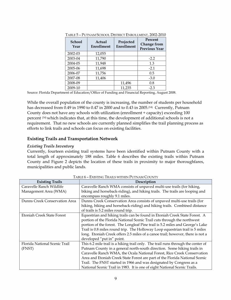
Source: Florida Department of Education/Office of Funding and Financial Reporting, August 2008. While the overall population of the county is increasing, the number of students per household has decreased from 0.49 in 1990 to 0.47 in 2000 and to 0.43 in 2005.(14) Currently, Putnam County does not have any schools with utilization (enrollment ÷ capacity) exceeding 100 percent (14) which indicates that, at this time, the development of additional schools is not a requirement. That no new schools are currently planned simplifies the trail planning process as efforts to link trails and schools can focus on existing facilities. Existing Trails and Transportation Network Existing Trails Inventory Currently, fourteen existing trail systems have been identified within Putnam County with a total length of approximately 188 miles. Table 6 describes the existing trails within Putnam County and Figure 2 depicts the location of these trails in proximity to major thoroughfares, municipalities and public lands.
TABLE 6 – EXISTING TRAILS WITHIN PUTNAM COUNTY Existing Trails Description
Caravelle Ranch Wildlife Management Area (WMA)
Caravelle Ranch WMA consists of unpaved multi-use trails (for hiking, biking and horseback-riding), and hiking trails. The trails are looping and encompass roughly 9.1 miles.
Dunns Creek Conservation Area
Dunns Creek Conservation Area consists of unpaved multi-use trails (for hiking, biking and horseback-riding) and hiking trails. Combined distance of trails is 5.2 miles round trip.
Etoniah Creek State Forest
Equestrian and hiking trails can be found in Etoniah Creek State Forest. A portion of the Florida National Scenic Trail cuts through the northwest portion of the forest. The Longleaf Pine trail is 5.2 miles and George’s Lake Trail is 0.8 miles round trip. The Holloway Loop equestrian trail is 5 miles long. Etoniah Creek offers 2.5 miles of a canoe trail; however, there is not a developed “put in” point.
Florida National Scenic Trail (FNST)
This 6.2 mile trail is a hiking trail only. The trail runs through the center of Putnam County in a general north-south direction. Some hiking trails in Caravelle Ranch WMA, the Ocala National Forest, Rice Creek Conservation Area and Etoniah Creek State Forest are part of the Florida National Scenic Trail. The FNST started in 1966 and was designated by Congress as a National Scenic Trail in 1983. It is one of eight National Scenic Trails.
10
Existing Trails Description Lake George Conservation Area
The trails in the Lake George Conservation are unpaved multi-use trails. The distance from the trailhead to Barrs Landing and back is 8.0 miles.
Marjorie Harris Carr Cross Florida Greenway
The Putnam County portion of the Cross Florida Greenway extends from the from the north border of the Ocala National Forest northeastward towards the St. Johns River. This portion of the greenway includes the Florida National Scenic Trail, a hiking trail 32 miles long; conservation lands; loop hiking trails; remnants of the barge canal, locks, etc.; and Lake Rodman and Ocklawaha River.
Murphy Creek Conservation Area
This area consists of hiking trails and unpaved multi-use trails. The looping trail is 1.8 miles long. Murphy Island is accessible by boat/canoe and offers 4.3 miles of hiking trails.
Ocala National Forest - Ocala North Off-Highway Vehicle (OHV) Trails
The Florida Trail enters the Ocala National Forest from the north. This is an unpaved hiking trail. The OHV trails in the forest total 71 miles. Portions of the Longleaf Trail and the Delancy Loop are in Putnam County.
Ocklawaha River Paddling Trail
The Ocklawaha River extends from Rodman Reservoir to Little Lake George. The trail is 19 miles long but unmarked.
Ravine Gardens State Park
Ravine Gardens State Park has hiking and paved biking trails. A 1.8 mile paved road winds around the ravine for motorists and bicyclists.
St. Johns South This area includes 1.7 miles of hiking trails along the St. Johns River east of the intersection of S.R. 19 and C.R. 310. This trail is part of the Cross Florida Greenway.
Welaka State Forest
Welaka State Forest offers 6.2 miles unpaved multi-use and hiking trails and a six and a half mile equestrian loop.
Yelvington Road This is a paved biking route that extends 0.98 miles along Yelvington Road to the county line.
State Road 26 This is a paved biking route along 5.9 miles of S.R. 26 from S.R. 100 to the county line.

n
n
nn
n
n
nnn
n
n
n
n
n
n
nn
n
n
n
n
n
n
n
n
n
n
n
n
n
n
n
n
"J
"J
"J
"J
"J
St. Johns River
Cresce
nt Lake
RodmanReservoir
LakeGeorge
LittleLake
GeorgeOcala
National Forest
Dunn's CreekState Park
Caravelle RanchWMA Trails
Rice CreekConservation
Area
Etoniah CreekState Forest Trails
Levy'sPrairie
Lake GeorgeConservationArea Trails
Dunn's CreekConservation Area
Trails
Florida National Scenic Trail
Florida National Scenic TrailOcala NorthOHV Trails
Murphy CreekConservation Area
Trails
Ravine GardensState Park Trails
St. JohnsSouth Trails
Yelvington RoadBike Route
Welaka State Forest Trails
Ocklawaha RiverPaddling Trail
Cross Florida Greenway
MELROSE
GRANDINFLORAHOME
BARDIN
BOSTWICK
EAST PALATKA
SAN MATEO
SATSUMA
GEORGETOWN
FRUITLAND
SR 26 Bike Route
To Gainesville
To Ocala
To Bunnell
PALATKA
INTERLACHEN
POMONA PARK
WELAKA
CRESCENT CITY
STATE RD 20
STAT
E RD
19 S
STATE RD 100
HIGHW
AY 17
N
REID ST
COUNTY RD 315 N
STATE RD 21
COUN
TY R
D 31
5 S
COUNTY RD 310
STATE RD 207
COUN
TY R
D 30
9COUNTY RD 21 S
STATE RD 26
KEUKA RD
COUNTY RD 308
STATE RD 100 E
WEST RIVER RD
HIGHWAY 17 S
COUNTY RD 219
PALMETTO BLUFF RD
COUNTY RD 308B
3RD AV
COUN
TY R
D 30
9C
MAIN ST
HIGHWAY 17 S
COUN
TY R
D 30
9
LegendExisting Trails
Bike RoutesEquestrianHikingMulti-Use (Paved)Multi-Use (Unpaved)PaddlingOHVMajor Roads
"J Librariesn Schools
Major CityCounty BoundaryCity/County ParksRivers, Lakes, StreamsConservation Land
Ü
Figure 2 - Location of the Existing Trails
0 1 2Miles
CLAY
ALACHUA
MARION
VOLUSIA
FLAGLER
ST. JOHNS
BRADFORD
11
12
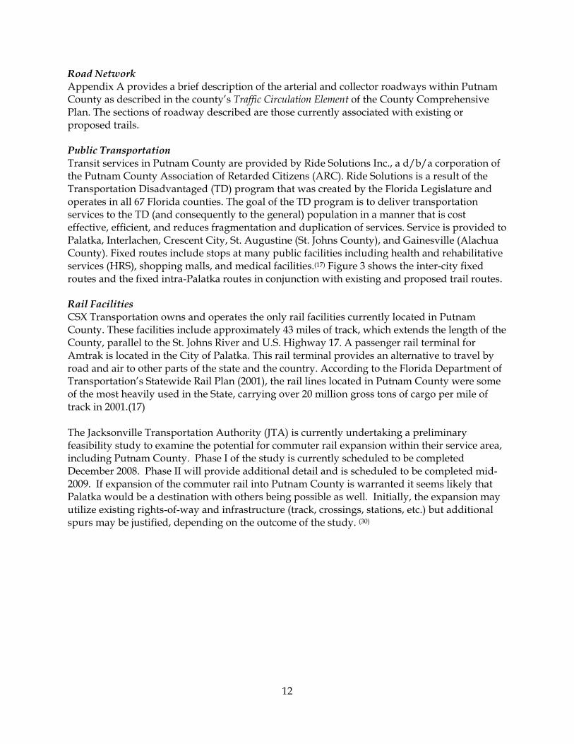
Road Network Appendix A provides a brief description of the arterial and collector roadways within Putnam County as described in the county’s Traffic Circulation Element of the County Comprehensive Plan. The sections of roadway described are those currently associated with existing or proposed trails. Public Transportation Transit services in Putnam County are provided by Ride Solutions Inc., a d/b/a corporation of the Putnam County Association of Retarded Citizens (ARC). Ride Solutions is a result of the Transportation Disadvantaged (TD) program that was created by the Florida Legislature and operates in all 67 Florida counties. The goal of the TD program is to deliver transportation services to the TD (and consequently to the general) population in a manner that is cost effective, efficient, and reduces fragmentation and duplication of services. Service is provided to Palatka, Interlachen, Crescent City, St. Augustine (St. Johns County), and Gainesville (Alachua County). Fixed routes include stops at many public facilities including health and rehabilitative services (HRS), shopping malls, and medical facilities.(17) Figure 3 shows the inter-city fixed routes and the fixed intra-Palatka routes in conjunction with existing and proposed trail routes. Rail Facilities CSX Transportation owns and operates the only rail facilities currently located in Putnam County. These facilities include approximately 43 miles of track, which extends the length of the County, parallel to the St. Johns River and U.S. Highway 17. A passenger rail terminal for Amtrak is located in the City of Palatka. This rail terminal provides an alternative to travel by road and air to other parts of the state and the country. According to the Florida Department of Transportation’s Statewide Rail Plan (2001), the rail lines located in Putnam County were some of the most heavily used in the State, carrying over 20 million gross tons of cargo per mile of track in 2001.(17) The Jacksonville Transportation Authority (JTA) is currently undertaking a preliminary feasibility study to examine the potential for commuter rail expansion within their service area, including Putnam County. Phase I of the study is currently scheduled to be completed December 2008. Phase II will provide additional detail and is scheduled to be completed mid-2009. If expansion of the commuter rail into Putnam County is warranted it seems likely that Palatka would be a destination with others being possible as well. Initially, the expansion may utilize existing rights-of-way and infrastructure (track, crossings, stations, etc.) but additional spurs may be justified, depending on the outcome of the study. (30)
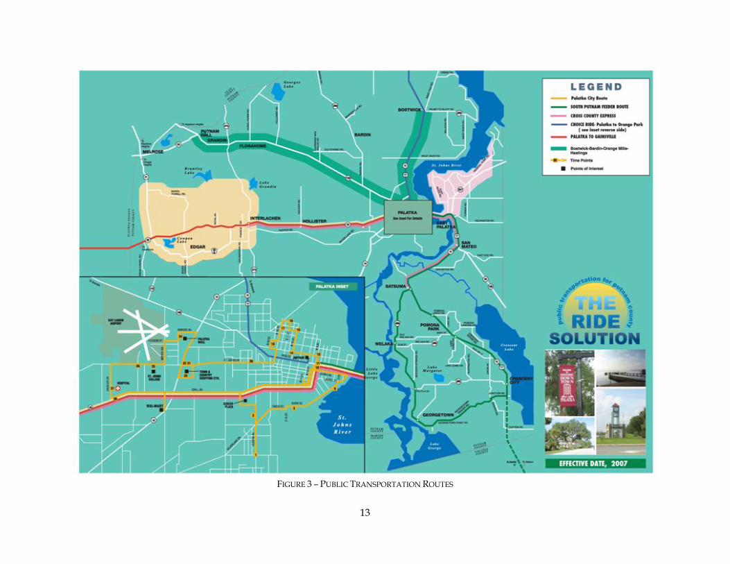
13
FIGURE 3 – PUBLIC TRANSPORTATION ROUTES
14
Section 3 - Trail Prioritization Prioritization of Planned and Future Trails One of the goals of the Trails Master Plan is to establish priorities for trail development within the county. When establishing priorities the manner in which a given trail fits within an overarching strategy for trail development may be considered. To further define priorities information such as ownership, jurisdiction, school connections, park connections, cultural/historic connections, connections to other trails, population served (e.g. urban, suburban, rural) , retail connections (e.g. downtown, plaza etc.), funding sources (e.g. grants, partnerships, legislative funds, ad valorem, etc.) Right-of-way (ROW) requirements, estimated cost, etc. may also be considered. Table 8 presents a general trail prioritization structure for biking and multi-use trails and additional information that may be used in the prioritization process. Table 8 groups proposed trail projects into High, Medium and Low priority rankings. This prioritization follows a general progression: 1) a (spoke) system of primary trails; 2) medium priority trails that link primary trails together or create loop trails; and 3) trails that lead to single destinations. Figure 6 shows this prioritization of the multi-use trails and bike routes. Figure 4 shows planned and proposed multi-use trails and Figure 5 shows proposed bike routes within Putnam County. For the purposes of this effort a planned trail is one that has been identified for development and planning or design has been initiated for that individual trail. A proposed trail is one that has had no official action taken such as individual planning or design work or placing it into a work schedule for funding. Multi-use trails are those which may be used for cycling, skating, walking and, depending upon local circumstances, may have associated equestrian paths as well. Generally, multi-use trails are separate from roadways. Bike routes are bike paths on roadway shoulders that occur at the time of construction with new roads and with existing roads at the time of roadway widening. Figure 7 shows proposed hiking and equestrian trails and Figure 8 shows proposed paddling trails. Table 9 lists the general prioritization of these trails. These trails vary greatly in type, length and connectivity to other trails or roads and are categorized as High or Medium priority only. Due to their unique nature, paddling trails were not ranked. Generally, higher priority was assigned to lengthier trails and trails that (when grouped) formed more significant networks, especially if readily accessible by road. Lower priority was given to more isolated and/or smaller trails. Figure 9 shows the prioritization of the proposed hiking and equestrian trails. Cost Estimates Cost estimates were derived from a combination of 2007-2008 FDOT State Estimates Office and Rails to Trails Conservancy estimates for 10’ to 12’ wide trails and 4’-5’ road widening projects (for bike paths) utilizing general design standards as found in Appendix C. Estimates are provided on an average cost per mile basis (Table 7). They are on an order of magnitude level, developed for planning purposes and are provided to allow a relative comparison of potential costs among trails or trail types.
15
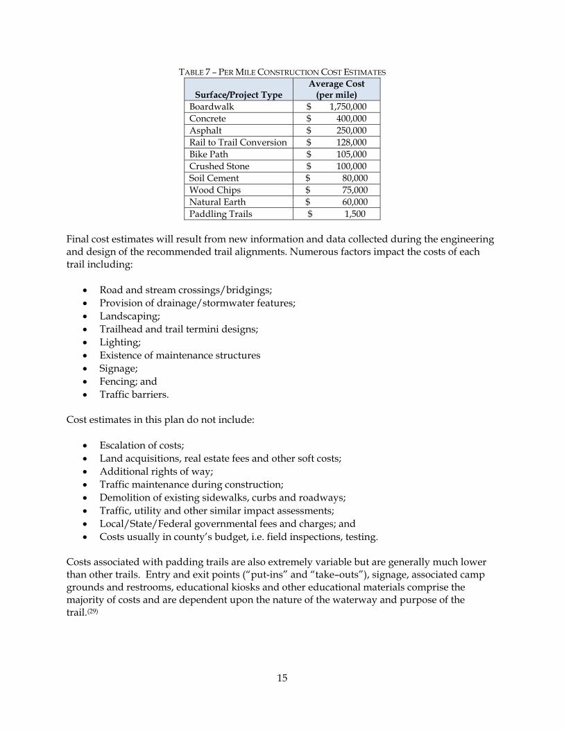
TABLE 7 – PER MILE CONSTRUCTION COST ESTIMATES
Surface/Project Type Average Cost
(per mile) Boardwalk $ 1,750,000 Concrete $ 400,000 Asphalt $ 250,000 Rail to Trail Conversion $ 128,000 Bike Path $ 105,000 Crushed Stone $ 100,000 Soil Cement $ 80,000 Wood Chips $ 75,000 Natural Earth $ 60,000 Paddling Trails $ 1,500
Final cost estimates will result from new information and data collected during the engineering and design of the recommended trail alignments. Numerous factors impact the costs of each trail including:
• Road and stream crossings/bridgings; • Provision of drainage/stormwater features; • Landscaping; • Trailhead and trail termini designs; • Lighting; • Existence of maintenance structures • Signage; • Fencing; and • Traffic barriers.
Cost estimates in this plan do not include:
• Escalation of costs; • Land acquisitions, real estate fees and other soft costs; • Additional rights of way; • Traffic maintenance during construction; • Demolition of existing sidewalks, curbs and roadways; • Traffic, utility and other similar impact assessments; • Local/State/Federal governmental fees and charges; and • Costs usually in county’s budget, i.e. field inspections, testing.
Costs associated with padding trails are also extremely variable but are generally much lower than other trails. Entry and exit points (“put-ins” and “take–outs”), signage, associated camp grounds and restrooms, educational kiosks and other educational materials comprise the majority of costs and are dependent upon the nature of the waterway and purpose of the trail.(29)
n
n
nn
n
n
nnn
n
n
n
n
n
n
nn
n
n
n
n
n
n
n
n
n
n
n
n
n
n
n
n
"J
"J
"J
"J
"J
St. Johns River
Cresce
nt Lake
RodmanReservoir
LakeGeorge
LittleLake
George
Ocala National
Forest
Dunn's Creek
State Park
LakeGeorge
ConservationArea
CaravelleRanch WMA
Rice CreekConservation
Area
Etoniah CreekState Forest
Levy'sPrairie
US Hw
y 17
Multi-
Use S
egme
nt(No
rth)
East Palatka to
St. Johns County
Segment
FEC Spur to Bunnell Rail Trail
St. Johns River
to Sea Loop Segment
Welaka Multi-Use
Trail
POMONA PARK
WELAKA
CRESCENT CITY
PALATKA
INTERLACHEN
SR 19
Multi-Use
Trail
Palatka Mulit-Use
Segment (South) Lundy Rd Multi-Use Segment
Palatka Multi-Use Segment (East)
Old GainesvilleMulti-Use Segment
CR 30
9CMu
lti-Us
eSe
gmen
t
Johnson Rail Segment
SR 20 Multi-Use Segment
CR 315InterlachenMulti-UseSegment
Sisco Rd Multi-Use Segment
St. Johns AveMulti-Use TrailPalatka Urban Segment
Palatka to Clay County Segment
To Lake Butler
To Gainesville
To Gainesville
To Ocala
To Deland
To Bunnell
To St. Augustine
WelakaState Forest
MELROSE
GRANDIN FLORAHOMEBARDIN
BOSTWICK
EAST PALATKA
SAN MATEO
SATSUMA
GEORGETOWN
FRUITLAND
SR 21 Bike Route
Fort Gates Ferry
Connector Multi-Use Trail
Buffalo Bluff RdMulti-Use Trail
Swisher PreserveMulti-Use Trail
Main Street Multi-Use Segment
Crescent CityMulti-Use Segment
Palm AveMulti-Use Trail
Round Lake RdMulti-Use Segment
Crill AvenueMulti-Use Segment
Ravine Gardensto River
Multi-Use Trail
Browns Landing Rd Multi-Use
Segment
Gordon Chapel RdMulti-Use Segment
Lake Susan RdMulti-Use Segment
County Road 21
Multi-Use Segment Orange Springs Cutoff Rd
Multi-Use Trail
CR 310 to SR20Multi-Use Trail
Francis Church RdMulti-Use Trail
STATE RD 20
STAT
E RD
19 S
STATE RD 100
HIGHWAY 17 N
REID ST
COUNTY RD 315 N
STATE RD 21
COUN
TY R
D 31
5 S
COUNTY RD 310
STATE RD 20
7
COUN
TY R
D 30
9
COUNTY RD 21 S
STATE RD 26
KEUKA RD
COUNTY RD 308
STATE RD 100 E
WEST RIVER RD
HIGHWAY 17 S
COUNTY RD 219
PALMETTO BLUFF RD
COUNTY RD 308B
3RD AV
HIGHWAY 17 S
COUN
TY R
D 30
9
LegendBuffalo Bluff Rd Multi-Use TrailCR 309C Multi-Use TrailCR 310 to SR 20 Multi-Use TrailFlorida East Coast Railway Spur to Bunnell Rail TrailFort Gates Ferry Connector Multi-Use TrailGrandin-Melrose-Interlachen Loop RouteOrange Springs Cutoff Road Multi-Use TrailPalatka Link Multi-Use TrailsPalatka to Cross Florida Greenway Multi-Use TrailPalatka to Hawthorne Loop TrailPalatka to Hawthorne Rail TrailPalm Avenue Multi-Use TrailRavine Gardens to River Multi-Use TrailSisco Road Multi-Use TrailSt. Augustine to Lake City Rail TrailSt. Johns Avenue Multi-Use TrailSwisher Preserve Multi-Use TrailU.S. 17 Multi-Use TrailWelaka Multi-Use TrailWelaka-Pomona Loop RouteMajor Roads
"J Librariesn Schools
Major CityCounty BoundaryCity/County ParksRivers, Lakes, StreamsConservation Land
Ü0 1 2
Miles
CLAY
ALACHUA
MARION
VOLUSIA
FLAGLER
ST. JOHNSBRADFORD
Figure 4 - Location of Planned and Proposed Multi-Use Trails
16

n
n
nn
n
n
nnn
n
n
n
n
n
n
nn
n
n
n
n
n
n
n
n
n
n
n
n
n
n
n
n
"J
"J
"J
"J
"J
St. Johns River
Cresce
nt Lake
RodmanReservoir
LakeGeorge
LittleLake
George
Ocala National
Forest
Dunn's Creek
State Park
LakeGeorge
ConservationArea
CaravelleRanch WMA
Rice CreekConservation
Area
Etoniah CreekState Forest
Levy'sPrairie
CR 209Bike Route
Federal Point
Bike Route
East PalatkaBike Route
East SR 100 Bike Route
South Putnam Bike Route
CR 308B Bike Route
POMONA PARK
WELAKA
CRESCENT CITY
PALATKA
INTERLACHEN
SR 19 Bike Route (South)
SR 19
Multi-Use
Trail
CR 310 Bike Route
CR 315 Bike Route
To Ocala
To Eustis
To Bunnell
CR 315 Bike Route
CR 209ABike Route
WelakaState Forest
MELROSE
GRANDIN FLORAHOMEBARDIN
BOSTWICK
EAST PALATKA
SAN MATEO
SATSUMA
GEORGETOWN
FRUITLAND
SR 19 Bike Route
(North)
STATE RD 20
STAT
E RD
19 S
STATE RD 100
HIGHWAY 17 N
REID ST
COUNTY RD 315 N
STATE RD 21
COUN
TY R
D 31
5 S
COUNTY RD 310
COUN
TY R
D 30
9COUNTY RD 21 S
STATE RD 26
KEUKA RD
COUNTY RD 308
STATE RD 100 E
WEST RIVER RD
CRILL AV
HIGHWAY 17 S
COUNTY RD 219
COUNTY RD 308B
3RD AV
COUN
TY R
D 30
9C
HIGHWAY 17 S
COUN
TY R
D 30
9
LegendCR 310 Bike RouteEast River Bike RouteEast SR 100 Bike RouteGrandin-Melrose-Interlachen Loop RouteSouth Putnam Bike RouteState Road 19 Bike RouteWelaka-Pomona Loop RouteWest River Loop RouteMajor Roads
"J Librariesn Schools
Major CityCounty BoundaryCity/County ParksRivers, Lakes, StreamsConservation Land
Ü0 1 2
Miles
CLAY
ALACHUA
MARION
VOLUSIA
FLAGLER
ST. JOHNS
BRADFORD
Figure 5 - Location of Proposed Bike Routes
17
18
TABLE 8 –PRIORITIZATION MATRIX FOR PROPOSED MULTI-USE TRAILS AND BIKE ROUTES
Trail Name D
escr
iptio
n
Stat
us
Trai
l Len
gth
(mile
s)
Cro
ssin
gs w
ith
Maj
or R
oads
Brid
ging
s
Juri
sdic
tion
Scho
ol
Con
nect
ions
Libr
ary
Con
nect
ions
C
onne
ctio
ns to
Pu
blic
Lan
d/Pa
rk
Cul
tura
l/His
tori
c C
onne
ctio
ns
Con
nect
ions
to
Oth
er T
rails
Ret
ail C
onne
ctio
ns
Popu
latio
n Se
rved
Estim
ated
Cos
t (P
lann
ing
Leve
l O
nly)
HIGH PRIORITY (Primary Spoke Trails) St. Augustine to Lake City Rail Trail
Palatka Urban Trail Segment Multi-Use Planned 2.4 2 0 Palatka,
County Indirect No Yes Yes Yes Yes Urban-Palatka $9.0M
Palatka to Clay County Trail Segment Multi-Use Planned 19.0 1 0 OGT, Palatka,
County Yes No Yes No Yes No Rural $4.8M
East Palatka to St. Johns County Trail Segment Multi-Use Planned 7.1 0 0 FDOT, County Yes Yes No No Yes No Rural $1.8M
U.S. 17 Multi-Use Trail U.S. 17 Multi-Use Trail
Segment (North to Green Cove Springs)
Multi-Use Proposed 17.0 4 1 Palatka, County Yes No No Yes Yes Yes
Urban, Suburban,
Rural $4.2M
St. Johns River to Sea (Quincentennial) Loop
Multi-Use Trail Segment Multi-Use Planned 26.9 4 0
Crescent City, Pomona Park,
San Mateo, County
Yes Yes Yes Yes Yes Yes Urban,
Suburban, Rural
$6.7M
Crescent City Multi-Use Trail Segment Multi-Use Planned 1.4 1 0 Crescent City,
County Yes Yes Yes Yes Yes Yes Urban $0.35M
Palatka to Hawthorne Rail Trail Old Gainesville Multi-Use
Trail Segment Multi-Use Proposed 8.6 1 0 Interlachen, County No No Yes No Yes No Rural $2.1M
S.R. 20 Multi-Use Trail Segment Multi-Use Proposed 13.7 2 0 Interlachen,
County No No No Yes Yes Yes Urban,
Suburban, Rural
$3.4M
Johnson Rail Trail Segment (Alternative route for Palatka-Hawthorne)
Multi-Use Proposed 11.1 2 0 Interlachen, County No No No No Yes No Rural $2.8M
19
Trail Name
Des
crip
tion
Stat
us
Trai
l Len
gth
(mile
s)
Cro
ssin
gs w
ith
Maj
or R
oads
Brid
ging
s
Juri
sdic
tion
Scho
ol
Con
nect
ions
Libr
ary
Con
nect
ions
C
onne
ctio
ns to
Pu
blic
Lan
d/Pa
rk
Cul
tura
l/His
tori
c C
onne
ctio
ns
Con
nect
ions
to
Oth
er T
rails
Ret
ail C
onne
ctio
ns
Popu
latio
n Se
rved
Estim
ated
Cos
t (P
lann
ing
Leve
l O
nly)
Palatka to Cross Florida Greenway Multi-Use Trail Palatka Multi-Use (South)
Trail Segment Multi-Use Proposed 4.6 0 0 County No No Yes No Yes No Suburban, Rural $1.2M
Lundy Road Multi-Use Trail Segment Multi-Use Proposed 1.6 0 0 Palatka,
County No No Yes Yes Yes Yes Urban,
Suburban, Rural
$0.4M
Palatka Multi-Use (East) Trail Segment Multi-Use Proposed 2.0 0 0 Palatka,
County No No Yes Yes Yes Yes Urban,
Suburban, Rural
$0.5M
State Road 19 Multi-Use Trail Segment Multi-Use Proposed 5.0 1 0 County No No Yes No Yes No Suburban,
Rural $1.3M
Browns Landing Multi-Use Trail Segment Multi-Use Proposed 1.2 0 0 County No No Yes No Yes No Suburban,
Rural $0.3M
Florida East Coast Railway Spur to Bunnell Rail Trail FEC Railway Spur to
Bunnell Trail Multi-Use Proposed 5.0 1 0 County No Yes No No Yes No Rural $1.2M
MEDIUM PRIORITY (Spoke Connectors and Loop Trails) St. Johns Avenue Multi-Use Rail Trail St. Johns Avenue Multi-Use
Trail Multi-Use Proposed 3.7 1 0 Palatka Yes No No Yes Yes Yes Urban, Suburban $0.9M
Palatka Link Multi-Use Trail C.R. 309C Multi-Use Trail
Segment Multi-Use Proposed 2.4 0 0 Palatka, County Yes No No No Yes No Rural,
Suburban $0.6M
Round Lake Road Multi-Use Trail Segment Multi-Use Proposed 2.0 1 0 Palatka,
County Yes No No No Yes No Rural, Suburban $0.5M
Crill Avenue Multi-Use Trail Segment Multi-Use Proposed 2.7 1 0 Palatka,
County Yes No Yes No Yes No Rural, Suburban $0.7M
Francis Church Road Multi-Use Trail Multi-Use Proposed 0.7 0 0 Palatka,
County No No No No Yes No Suburban, Rural $0.2M

20
Trail Name
Des
crip
tion
Stat
us
Trai
l Len
gth
(mile
s)
Cro
ssin
gs w
ith
Maj
or R
oads
Brid
ging
s
Juri
sdic
tion
Scho
ol
Con
nect
ions
Libr
ary
Con
nect
ions
C
onne
ctio
ns to
Pu
blic
Lan
d/Pa
rk
Cul
tura
l/His
tori
c C
onne
ctio
ns
Con
nect
ions
to
Oth
er T
rails
Ret
ail C
onne
ctio
ns
Popu
latio
n Se
rved
Estim
ated
Cos
t (P
lann
ing
Leve
l O
nly)
Sisco Road Multi-Use Trail Sisco Road Multi-Use Trail
Segment Multi-Use Proposed 2.9 0 0 County No No Yes No Yes No Rural $0.7M
Main Street Multi-Use Trail Segment Multi-Use Proposed 2.8 0 0 Pomona Park,
County No No Yes No Yes No Rural $0.7M
Fort Gates Ferry Connector Multi-Use Trail Fort Gates Ferry Connector
Multi-Use Trail Multi-Use Proposed 6.2 0 2 Welaka, County No No Yes No Yes No Rural $1.6M
Grandin – Melrose - Interlachen Loop Route
C.R. 315 Bike Route Biking Proposed 18.1 1 0 Interlachen, County Yes Yes No Yes Yes Yes Rural,
Suburban $2.3M
C.R. 315 Interlachen Multi-Use Trail Segment Multi-Use Proposed 2.4 1 0 Interlachen Yes Yes No Yes Yes Yes Urban $0.3M
S.R. 21 Bike Route Biking Proposed 7.8 1 0 County Yes No Yes No Yes No Rural $2.0M C.R. 310 Bike Route
C.R. 310 Bike Route Biking Proposed 7.8 0 1 County No No Yes No Yes No Rural $1.0M West River Loop Route
C.R. 209 Bike Route Biking Proposed 11.9 0 0 County No Yes No No Yes No Rural, Suburban $1.5M
C.R. 209A Bike Route Biking Proposed 1.2 0 0 County No Yes No No Yes No Suburban $0.2M East River Bike Route
East Palatka Bike Route Biking Proposed 7.3 0 0 County Yes No No No Yes No Rural, Suburban $0.9M
Federal Point Bike Route Biking Proposed 6.8 0 0 County Yes No No Yes Yes No Rural $0.9M State Road 19 Bike Route
S.R. 19 Bike Route (North) Biking Proposed 11.4 0 0 Palatka, County No No Yes No Yes No Rural $2.9M
S.R. 19 Bike Route (South) Biking Proposed 3.9 0 2 County No No Yes No Yes No Rural $1.0M
21
Trail Name
Des
crip
tion
Stat
us
Trai
l Len
gth
(mile
s)
Cro
ssin
gs w
ith
Maj
or R
oads
Brid
ging
s
Juri
sdic
tion
Scho
ol
Con
nect
ions
Libr
ary
Con
nect
ions
C
onne
ctio
ns to
Pu
blic
Lan
d/Pa
rk
Cul
tura
l/His
tori
c C
onne
ctio
ns
Con
nect
ions
to
Oth
er T
rails
Ret
ail C
onne
ctio
ns
Popu
latio
n Se
rved
Estim
ated
Cos
t (P
lann
ing
Leve
l O
nly)
South Putnam Bike Route
South Putnam Bike Route Biking Proposed 21.9 1 0 Welaka,
Crescent City, County
No No Yes Yes Yes Yes Urban,
Suburban, Rural
$5.5M
C.R. 308B Bike Route Biking Proposed 5.3 0 0 Welaka,
Pomona Park, County
No No No Yes Yes Yes Rural, Suburban $0.7M
Palatka to Hawthorne Loop Trail Gordon Chapel Road Multi-
Use Segment Multi-Use Proposed 4.0 0 0 County No No No No Yes No Rural $1.0M
Lake Susan Road Multi-Use Segment Multi-Use Proposed 6.4 0 0 County No No No No Yes No Rural $1.6M
County Road 21 Multi-Use Segment Multi-Use Proposed 4.6 0 0 County No No No No Yes No Rural $1.2M
Orange Springs Cutoff Road Multi-Use Trail Orange Springs Cutoff Road Multi-Use Trail Multi-Use Proposed 2.1 0 0 County No No No No Yes No Rural $0.5M
LOW PRIORITY (Single Destination Trails) Welaka Multi-Use Trail
Welaka Multi-Use Trail Multi-Use, Unpaved Proposed 5.2 1 0 Welaka No No No No Yes No Rural $1.3M
East S.R. 100 Bike Route East S.R. 100 Bike Route Biking Proposed 5.7 0 0 County Yes No Yes No Yes No Rural $0.7M
Buffalo Bluff Road Multi-Use Trail Buffalo Bluff Road Multi-
Use Trail Multi-Use Proposed 2.4 0 0 County No No Yes No Yes No Rural, Suburban $0.6M
Swisher Preserve Multi-Use Trail Swisher Preserve Multi-Use
Trail Multi-Use, Unpaved Proposed 12.6 0 0 County No No Yes No Yes No Rural $0.8M
22
Trail Name
Des
crip
tion
Stat
us
Trai
l Len
gth
(mile
s)
Cro
ssin
gs w
ith
Maj
or R
oads
Brid
ging
s
Juri
sdic
tion
Scho
ol
Con
nect
ions
Libr
ary
Con
nect
ions
C
onne
ctio
ns to
Pu
blic
Lan
d/Pa
rk
Cul
tura
l/His
tori
c C
onne
ctio
ns
Con
nect
ions
to
Oth
er T
rails
Ret
ail C
onne
ctio
ns
Popu
latio
n Se
rved
Estim
ated
Cos
t (P
lann
ing
Leve
l O
nly)
Palm Avenue Multi-Use Trail Palm Avenue Multi-Use
Trail Multi-Use Proposed 1.0 0 0 Palatka No No No No Yes No Suburban $0.3M
Ravine Gardens to River Multi-Use Trail Ravine Gardens to River
Multi-Use Trail Multi-Use, Unpaved Proposed 0.25 0 0 County No No Yes No Yes No Rural,
Suburban $0.1M
County Road 310 to State Road 20 Multi-Use Trail C.R. 310 to S.R. 20 Multi-
Use Trail Multi-Use, Unpaved Proposed 8.3 0 1 County No No Yes No Yes No Rural $0.5M
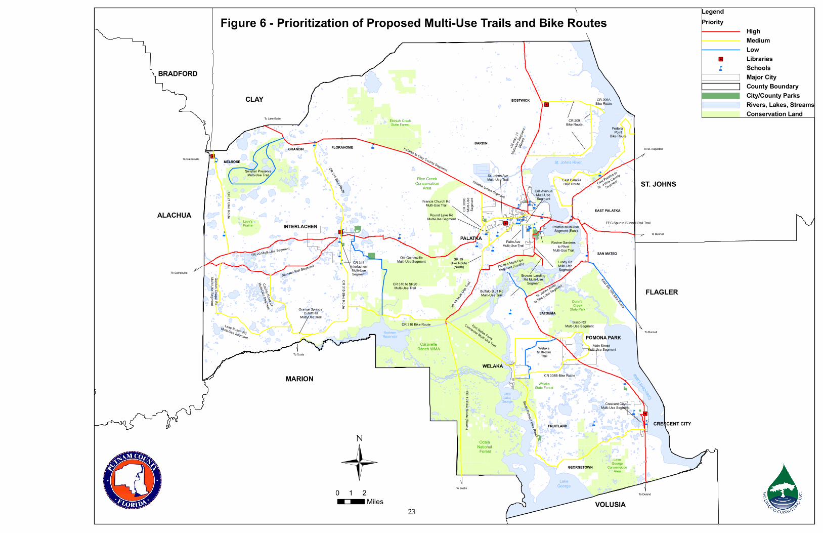
n
n
nn
n
n
nnn
n
n
n
n
n
n
nn
n
n
n
n
n
n
n
n
n
n
n
n
n
n
n
n
"J
"J
"J
"J
"J
St. Johns River
Cresce
nt Lake
RodmanReservoir
LakeGeorge
LittleLake
George
Ocala National
Forest
Dunn's Creek
State Park
LakeGeorge
ConservationArea
CaravelleRanch WMA
Rice CreekConservation
Area
Etoniah CreekState Forest
Levy'sPrairie
US Hw
y 17
Multi-
Use S
egme
nt(No
rth)
CR 209Bike Route
Federal Point
Bike Route
East PalatkaBike Route East Palatka to
St. Johns County
Segment
FEC Spur to Bunnell Rail Trail
St. Johns River
to Sea Loop Segment
East SR 100 Bike Route
South Putnam Bike Route
CR 308B Bike Route
Welaka Multi-Use
Trail
POMONA PARK
WELAKA
CRESCENT CITY
PALATKA
INTERLACHEN
SR 19 Bike Route (South)
SR 19
Multi-Use
Trail
CR 310 Bike Route
Palatka Mulit-Use
Segment (South) Lundy Rd Multi-Use Segment
Palatka Multi-Use Segment (East)
Old GainesvilleMulti-Use Segment
CR 30
9CMu
lti-Us
eSe
gmen
t
CR 315 Bike Route
Johnson Rail Segment
SR 20 Multi-Use Segment
CR 315InterlachenMulti-UseSegment
Sisco Rd Multi-Use Segment
St. Johns AveMulti-Use TrailPalatka Urban Segment
Palatka to Clay County Segment
To Lake Butler
To Gainesville
To Gainesville
To Ocala
To EustisTo Deland
To Bunnell
To Bunnell
To St. Augustine
CR 315 Bike Route
CR 209ABike Route
WelakaState Forest
MELROSE
GRANDIN FLORAHOMEBARDIN
BOSTWICK
EAST PALATKA
SAN MATEO
SATSUMA
GEORGETOWN
FRUITLAND
SR 19 Bike Route
(North)
SR 21 Bike Route
Fort Gates Ferry
Connector Multi-Use Trail
Buffalo Bluff RdMulti-Use Trail
Swisher PreserveMulti-Use Trail
Main Street Multi-Use Segment
Crescent CityMulti-Use Segment
Palm AveMulti-Use Trail
Round Lake RdMulti-Use Segment
Crill AvenueMulti-Use Segment
Ravine Gardensto River
Multi-Use Trail
Browns Landing Rd Multi-Use
Segment
Gordon Chapel RdMulti-Use Segment
Lake Susan RdMulti-Use Segment
County Road 21
Multi-Use Segment Orange Springs Cutoff Rd
Multi-Use Trail
CR 310 to SR20Multi-Use Trail
Francis Church RdMulti-Use Trail
LegendPriority
HighMediumLow
"J Librariesn Schools
Major CityCounty BoundaryCity/County ParksRivers, Lakes, StreamsConservation Land
Ü0 1 2
Miles
CLAY
ALACHUA
MARION
VOLUSIA
FLAGLER
ST. JOHNS
BRADFORD
Figure 6 - Prioritization of Proposed Multi-Use Trails and Bike Routes
23
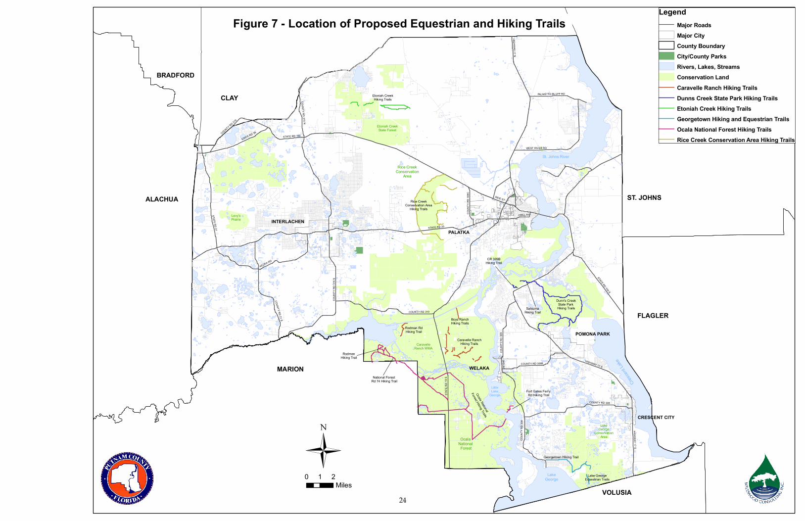
St. Johns River
Cresce
nt Lake
LakeGeorge
LittleLake
George
Ocala National
Forest
Dunn's CreekState Park Hiking Trails
LakeGeorge
ConservationArea
CaravelleRanch WMA
Rice CreekConservation
Area
Etoniah CreekState Forest
Levy'sPrairie
Etoniah CreekHiking Trails
POMONA PARK
WELAKA
CRESCENT CITY
PALATKAINTERLACHEN
Lake GeorgeEquestrian Trails
Georgetown Hiking Trail
Caravelle RanchHiking Trails
Ocala National
Forest Hiking Trails
RodmanHiking Trail
Rice CreekConservation Area
Hiking Trails
National Forest Rd 74 Hiking Trail
Fort Gates Ferry Rd Hiking Trail
SatsumaHiking Trail
CR 309BHiking Trail
Boys RanchHiking Trails
Rodman RdHiking Trail
STATE RD 20
STAT
E RD
19 S
STATE RD 100
HIGHWAY 17 N
REID ST
COUNTY RD 315 N
STATE RD 21
COUN
TY R
D 31
5 S
COUNTY RD 310
COUN
TY R
D 30
9
COUNTY RD 21 S
STATE RD 26
KEUKA RD
COUNTY RD 308
STATE RD 100 E
WEST RIVER RD
CRILL AV
HIGHWAY 17 S
COUNTY RD 219
PALMETTO BLUFF RD
COUNTY RD 308B
3RD AV
COUN
TY R
D 30
9C
HIGHWAY 17 S
COUN
TY R
D 30
9
LegendMajor RoadsMajor CityCounty BoundaryCity/County ParksRivers, Lakes, StreamsConservation LandCaravelle Ranch Hiking TrailsDunns Creek State Park Hiking TrailsEtoniah Creek Hiking TrailsGeorgetown Hiking and Equestrian TrailsOcala National Forest Hiking TrailsRice Creek Conservation Area Hiking Trails
Ü
Figure 7 - Location of Proposed Equestrian and Hiking Trails
0 1 2Miles
CLAY
ALACHUA
MARION
VOLUSIA
FLAGLER
ST. JOHNS
BRADFORD
24

St. Johns River
Cresce
nt Lake
Rodman Reservoir
Paddling Trails
LakeGeorge
LittleLake
George
Ocala National
Forest
LakeGeorge
ConservationArea
CaravelleRanch WMA
Rice CreekConservation
Area
Etoniah CreekState Forest
Levy'sPrairie
POMONA PARKWELAKA
CRESCENT CITY
PALATKAINTERLACHEN
Seven SistersPaddling Trails
St. Johns River Paddling Trails
St. Johns River Paddling Trails
Cross Florida Greenway Paddling Trail
Murphy, Polly & RatIslands Paddling Trails
Dunns CreekPaddling Trail
Crescent Lake
Paddling Trail
KenwoodPaddling Trail
Simms/EtoniahPaddling Trails
Cedar CreekPaddling Trail
Dog BranchPaddling Trail
Mill BranchPaddling Trail
OcklawahaPaddling Trail
Deep CreekPaddling Trail
Little Orange CreekPaddling Trail
STATE RD 20
STAT
E RD
19 S
STATE RD 100
HIGHWAY 17 N
REID ST
COUNTY RD 315 N
STATE RD 21
COUN
TY R
D 31
5 S
COUNTY RD 310
COUN
TY R
D 30
9
COUNTY RD 21 S
STATE RD 26
KEUKA RD
COUNTY RD 308
STATE RD 100 E
WEST RIVER RD
CRILL AV
HIGHWAY 17 S
COUNTY RD 219
PALMETTO BLUFF RD
COUNTY RD 308B
3RD AV
COUN
TY R
D 30
9C
HIGHWAY 17 S
COUN
TY R
D 30
9
LegendMajor RoadsMajor CityCounty BoundaryCity/County ParksRivers, Lakes, StreamsConservation LandCedar Creek Paddling TrailCrescent Lake Paddling TrailCross Florida Greenway Paddling TrailDeep Creek Paddling TrailDog Branch Paddling TrailDunns Creek Paddling TrailKenwood Paddling TrailLittle Orange Creek Paddling TrailMill Branch Paddling TrailMurphy Island Paddling TrailOcklawaha Paddling TrailPolly Island Paddling TrailRat Island Paddling TrailRodman Reservoir Paddling TrailsSeven Sisters Paddling TrailsSimms/Etoniah Paddling TrailsSt. Johns River Paddling Trails
Ü
Figure 8 - Location of Proposed Paddling Trails
0 1 2Miles
CLAY
ALACHUA
MARION
VOLUSIA
FLAGLER
ST. JOHNS
BRADFORD
25

26
TABLE 9 – PRIORITIZATION MATRIX FOR PROPOSED EQUESTRIAN, HIKING, AND PADDLING TRAILS
Trail Name
Des
crip
tion
Stat
us
Trai
l Len
gth
(mile
s)
Cro
ssin
gs w
ith
Maj
or R
oads
Brid
ging
s
Juri
sdic
tion
Scho
ol
Con
nect
ions
Libr
ary
Con
nect
ions
C
onne
ctio
ns to
Pu
blic
Lan
d/Pa
rk
Cul
tura
l/His
tori
c C
onne
ctio
ns
Con
nect
ions
to
Oth
er T
rails
Ret
ail C
onne
ctio
ns
Popu
latio
n Se
rved
Estim
ated
Cos
t (P
lann
ing
Leve
l O
nly)
HIGH PRIORITY Ocala National Forest Hiking Trails
Ocala National Forest Hiking Trails Hiking Potential 21.6 2 0 County No No Yes No Yes No Rural $1.30M
Rodman Hiking Trail Hiking Potential 1.6 0 0 County No No Yes No Yes No Rural $0.10M National Forest Road 74
Hiking Trail Hiking Potential 2.9 0 0 County No No Yes No Yes No Rural $0.17M
Fort Gates Ferry Road Hiking Trail Hiking Potential 1.1 0 0 County No No Yes No No No Rural $0.07M
Dunns Creek State Park Hiking Trails Dunns Creek State Park
Hiking Trails Hiking Potential 12.2 0 0 County No No Yes No Yes No Rural $0.73M
Satsuma Hiking Trail Hiking Potential 2.5 1 0 County No No Yes No Yes No Rural $0.15M C.R. 309B Hiking Trail Hiking Potential 0.6 0 0 County No No Yes No No No Rural $0.40M
Rice Creek Conservation Area Rice Creek Conservation
Area Hiking Trails Hiking Potential 15.1 0 0 County No No Yes No Yes No Rural $0.91M
Georgetown Hiking and Equestrian Hiking Trails Georgetown Hiking Trail Hiking Potential 4.1 0 0 County No No Yes No Yes No Rural $0.25M Lake George Equestrian
Trail Equestrian Potential 1.6 0 0 County No No Yes No Yes No Rural $0.10M
MEDIUM PRIORITY Caravelle Ranch Hiking Trails Caravelle Ranch Hiking
Trails Hiking Potential 5.4 0 0 County No No Yes No No No Rural $0.32M
Boys Ranch Hiking Trail Hiking Potential 1.4 0 0 County No No Yes No No No Rural $0.08M
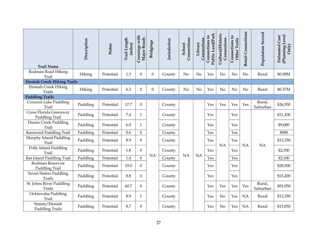
27
Trail Name
Des
crip
tion
Stat
us
Trai
l Len
gth
(mile
s)
Cro
ssin
gs w
ith
Maj
or R
oads
Brid
ging
s
Juri
sdic
tion
Scho
ol
Con
nect
ions
Libr
ary
Con
nect
ions
C
onne
ctio
ns to
Pu
blic
Lan
d/Pa
rk
Cul
tura
l/His
tori
c C
onne
ctio
ns
Con
nect
ions
to
Oth
er T
rails
Ret
ail C
onne
ctio
ns
Popu
latio
n Se
rved
Estim
ated
Cos
t (P
lann
ing
Leve
l O
nly)
Rodman Road Hiking Trail Hiking Potential 1.3 0 0 County No No Yes No No No Rural $0.08M
Etoniah Creek Hiking Trails Etoniah Creek Hiking
Trails Hiking Potential 6.2 0 0 County No No Yes No No No Rural $0.37M
Paddling Trails Crescent Lake Paddling
Trail Paddling Potential 17.7 0
NA
County
NA NA
Yes Yes Yes Yes Rural, Suburban $26,550
Cross Florida Greenway Paddling Trail Paddling Potential 7.4 1 County Yes
NA
Yes
NA NA
$11,100
Dunns Creek Paddling Trail Paddling Potential 6.0 1 County Yes Yes $9,000
Kenwood Paddling Trail Paddling Potential 0.6 0 County Yes Yes $900 Murphy Island Paddling
Trail Paddling Potential 8.9 0 County Yes Yes $13,350
Polly Island Paddling Trail Paddling Potential 1.8 0 County Yes Yes $2,700
Rat Island Paddling Trail Paddling Potential 1.4 0 County Yes Yes $2,100 Rodman Reservoir
Paddling Trail Paddling Potential 19.0 0 County Yes Yes $28,500
Seven Sisters Paddling Trails Paddling Potential 8.8 0 County Yes Yes $13,200
St. Johns River Paddling Trails Paddling Potential 60.7 0 County Yes Yes Yes Yes Rural,
Suburban $91,050
Ocklawaha Paddling Trail Paddling Potential 8.9 1 County Yes No Yes NA Rural $13,350
Simms/Etoniah Paddling Trails Paddling Potential 8.7 0 County Yes No Yes NA Rural $13,050
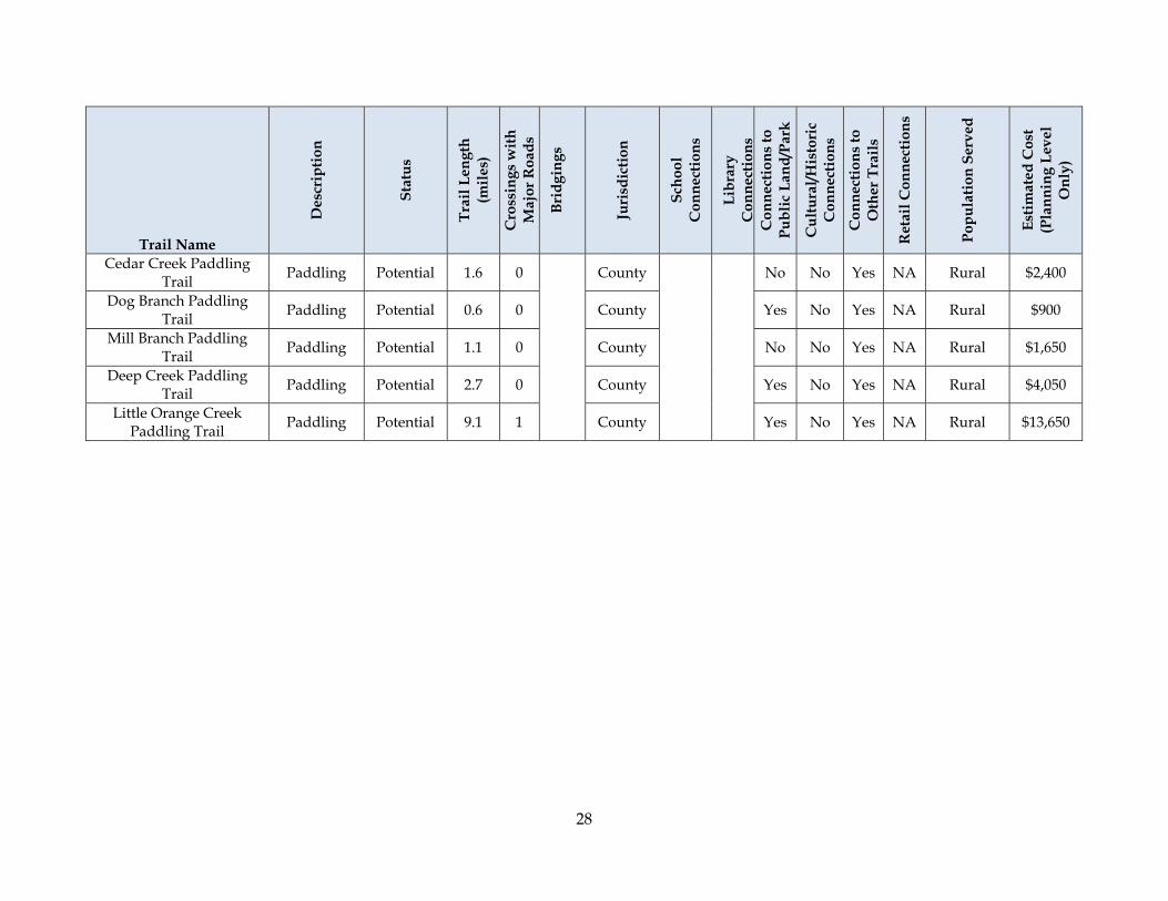
28
Trail Name
Des
crip
tion
Stat
us
Trai
l Len
gth
(mile
s)
Cro
ssin
gs w
ith
Maj
or R
oads
Brid
ging
s
Juri
sdic
tion
Scho
ol
Con
nect
ions
Libr
ary
Con
nect
ions
C
onne
ctio
ns to
Pu
blic
Lan
d/Pa
rk
Cul
tura
l/His
tori
c C
onne
ctio
ns
Con
nect
ions
to
Oth
er T
rails
Ret
ail C
onne
ctio
ns
Popu
latio
n Se
rved
Estim
ated
Cos
t (P
lann
ing
Leve
l O
nly)
Cedar Creek Paddling Trail Paddling Potential 1.6 0 County No No Yes NA Rural $2,400
Dog Branch Paddling Trail Paddling Potential 0.6 0 County Yes No Yes NA Rural $900
Mill Branch Paddling Trail Paddling Potential 1.1 0 County No No Yes NA Rural $1,650
Deep Creek Paddling Trail Paddling Potential 2.7 0 County Yes No Yes NA Rural $4,050
Little Orange Creek Paddling Trail Paddling Potential 9.1 1 County Yes No Yes NA Rural $13,650

St. Johns River
Cresce
nt Lake
LakeGeorge
LittleLake
George
Ocala National
Forest
Dunn's CreekState Park Hiking Trails
LakeGeorge
ConservationArea
CaravelleRanch WMA
Rice CreekConservation
Area
Etoniah CreekState Forest
Levy'sPrairie
Etoniah CreekHiking Trails
POMONA PARK
WELAKA
CRESCENT CITY
PALATKAINTERLACHEN
Lake GeorgeEquestrian Trails
Georgetown Hiking Trail
Caravelle RanchHiking Trails
Ocala National
Forest Hiking Trails
RodmanHiking Trail
Rice CreekConservation Area
Hiking Trails
St. Johns River Paddling Trails
National Forest Rd 74 Hiking Trail
Fort Gates Ferry Rd Hiking Trail
SatsumaHiking Trail
CR 309BHiking Trail
Boys RanchHiking Trails
Rodman RdHiking Trail
STATE RD 20
STAT
E RD
19 S
STATE RD 100
HIGHWAY 17 N
REID ST
COUNTY RD 315 N
STATE RD 21
COUN
TY R
D 31
5 S
COUNTY RD 310
STATE RD 20
7
COUN
TY R
D 30
9
COUNTY RD 21 S
STATE RD 26
KEUKA RD
COUNTY RD 308
STATE RD 100 E
WEST RIVER RD
CRILL AV
HIGHWAY 17 S
COUNTY RD 219
PALMETTO BLUFF RD
COUNTY RD 308B
COUN
TY R
D 30
9C
HIGHWAY 17 S
LegendMajor RoadsMajor CityCounty BoundaryCity/County ParksRivers, Lakes, StreamsConservation Land
PriorityHighMedium
Ü
Figure 9 - Prioritization of Proposed Hiking and Equestrian Trails
0 1 2Miles
CLAY
ALACHUA
MARION
VOLUSIA
FLAGLER
ST. JOHNS
BRADFORD
29

30
Section 4 –Plans, Programs and Policies Associated with Trails Development
Statewide Plans and Programs This section highlights a few of the primary plans and programs affecting greenways and trails development at the state level. For the most part trails development is driven by local desires and community needs. Many of these programs focus on providing expertise and funding assistance. Therefore some of the entities listed in this section are also included in the Funding Opportunities section below. Florida Transportation Plan The 2025 Florida Transportation Plan(23) identifies numerous challenges facing Florida and its transportation system as it moves though the first quarter of the 21st century. Numerous challenges are highlighted in the plan including:
• Providing for a sustainable environment - Encroachment into important wildlife habitats, recreation areas, and other environmentally sensitive land is increasing the need for effective regional cooperation on a range of issues from transportation to land use to water resources is critical to ensuring that future growth is balanced with environmental sustainability.
• Creating more livable communities - New residents and visitors increasingly are attracted to Florida’s vibrant urban areas, well-planned suburban communities, and authentic rural villages – particularly those places where transportation systems support community visions.
• Addressing inadequate intermodal connectivity - The weakest links often are the connections between modes, such as access from seaports, airports, and other passenger and freight terminals to highways, rail corridors, waterways, and other transportation hubs.
• Developing the balance between transportation and community livability - Transportation investments have focused on the fast movement of vehicles without adequate consideration of community livability. Rising housing and land costs, as well as some zoning and land regulations adopted in urban areas, encourage sprawling development and longer commuting patterns, adding to the strain on the transportation system and deteriorating the quality of life for residents and visitors.
To address these challenges the plan calls for numerous actions including, among others:
• Enhancing mobility options - Investment in additional transportation capacity should be focused on critical needs including but not limited to expanding travel options, providing for greater use of public transportation; providing more efficient transfers between facilities; and addressing major gaps in connectivity and service.
• Ensuring that the transportation system supports community livability and is implemented in an environmentally responsible manner - The transportation system should encourage conservation of natural resources and sustainable development
31
patterns. Transportation investments at the local level primarily should enhance the livability of Florida’s communities.
While these issues and recommendations do not reference trails directly the numerous benefits of trails certainly address many of the stated concerns and support the desired outcomes of transportation planning within the state. Florida Communities Trust Florida Communities Trust is a state land acquisition grant program that provides funding to local governments and eligible non-profit environmental organizations for acquisition of community-based parks, open space and greenways that further outdoor recreation and natural resource protection needs identified in local government comprehensive plans. Approximately $66 million (unless otherwise allocated by the legislature) is available each funding cycle. Funding is primarily from the Florida Forever Trust Fund.
A management plan is required for all project sites acquired under the Florida Communities Trust Program. A management plan is typically between 15 and 30 pages depending upon the natural resources and the extent of development on the project site. The management plan lays out the short and long range management objectives, site development plans, resource protection activities and long term monitoring of the project site. The management plan must set forth the following:
• How the site will be managed to further the purpose of the project; • Description of planned improvements to the project site; • Costs and funding sources; and • The management entity and its funding source.
State agencies such as water management districts and the Florida Department of Environmental Protection, utilize Florida Forever Funding for land acquisition, water resource development, stormwater management, water body restoration, recreational facility construction, public access improvements, invasive plant control, and related projects. Trail development may not be the primary focus of many of the land acquisition efforts and projects funded through these agencies however, through close coordination they may provide ancillary benefits that can be included in the goals and objectives associated with these efforts. Office of Greenways and Trails The Office of Greenways and Trails (OGT) was established in 1993 to manage the Marjorie Harris Carr Cross Florida Greenway State Recreation and Conservation Area (Cross Florida Greenway). By 1994, OGT’s scope had expanded to include administration of the greenways and trails acquisition program. The Greenways & Trails Land Acquisition Program receives 1.5 percent ($4.5 million) of the Florida Forever annual distribution. Title to acquired land is held by the Board of Trustees of the Internal Improvement Trust Fund (Governor and Cabinet), then leased to OGT. Many properties are then subleased to local governments for management. OGT also accepted responsibility for administering the Florida Recreational Trails Council (FRTC). (31)
32
The 1995 Florida Legislature designated the Department of Environmental Protection (DEP) as the lead state agency for developing and implementing a statewide system of greenways and trails (Chapter 253.787, Florida Statutes). In addition to administering the newly created Florida Greenways Coordinating Council (FGCC), this legislation called for OGT to develop an implementation plan for a statewide system of greenways and trails. (31) The overarching purpose of the plan is to create a system of greenways crisscrossing the state, connecting communities and conservation areas. Key recommendations of the plan that directly benefit local governments promote the provision of additional resources for local, regional, state and federal agencies and private landowners to acquire, protect, develop, manage and maintain lands for greenways and trails.(24) The plan was endorsed by the FRTC and the FGCC in September of 1998. Modified during the 1998 legislative session, Chapter 260, Florida Statutes, empowered OGT to establish a designation program to assist with the implementation of the statewide system of greenways and trails. (31) Florida Recreational Trails Program The Office of Greenways and Trails administers the Recreational Trails Program (RTP). Municipal or county governments, Indian tribal governments and organizations among others that are recognized and approved by the State or federal government may apply for funding under the RTP. The RTP is a competitive program which provides matching grants for projects that provide or renovate recreational trails, trailhead and trailside facilities. Funding for the program is federally based through the Safe, Accountable, Flexible, Efficient Transportation Equity Act: A Legacy for Users (SAFETEA-LU). Project proposals may address the following recreational trail interests:
• Motorized Trails; • Non-motorized Trails; and • Mixed-Use projects (either motorized, non-motorized or a combination of both).
Florida Greenways and Trails Land Acquisition Program Florida Forever provides $300 million annually through 2010 to the Greenways and Trails Land Acquisition Program. The Greenways and Trails Land Acquisition Program receives 1.5 percent ($4.5 million) of the Florida Forever annual distribution. Regional coordinators work with agencies, organizations and citizens to plan and acquire projects that help establish Florida's statewide network of greenways and trails. Proposal for acquisition originate with local entities and are brought before OGT for evaluation. No local matching funds are required. Any appropriate project may be considered, regardless of estimated property value. Projects submitted for funding must meet the following criteria:
• The project meets statutory definition of greenway or trail. • The project must be located within or adjacent to an opportunity segment identified on
the OGT’s recreational opportunity maps. • At least 80% of project has to have a willing seller(s). • The project has to have a willing manager.
Title to property acquired through this program is retained by the State of Florida and is subleased to the local managing entity for trail development, operation and maintenance.
33
Local Plans, Programs, Initiatives, Regulations and Institutions County Comprehensive Plan The Putnam County Comprehensive Plan contains goals, objectives and policies, to guide and manage future development and growth. As such, it is appropriate to review the plan with a view to incorporating the use of trails and greenways. The review contained in Appendix B is intended to serve two purposes. First, to identify specific goals, objectives and policies which may currently or could affect trails development. The second purpose is to provide some initial recommendations for strengthening the plan with regard to greenways and trails development and improve the linkages with other key planning and regulatory documents. These recommendations are provided for consideration only. Additional review of the comprehensive plan and related documents is beyond the scope of this exercise but may be worth consideration to identify alternate or additional means of accomplishing these recommendations in the most effective manner. Interlocal Agreement between the Putnam County School Board and Other Local Governments The Putnam County School Board, the Board of County Commissioners for Putnam County, the Commissions for the cities of Palatka and Crescent City and the Councils for the towns of Interlachen, Pomona Park and Welaka have entered into an interlocal agreement related to public school facility planning. This agreement describes procedures for coordinating land use and other facilities related planning for public schools facilities. Land Development Review Article 7 of the Land Development Code(25) contains development design and improvement standards applicable to all development activity within the county. Unless otherwise provided, costs associated with improvements required by this code are to be paid by the developer. The provisions of the Land Development Code are intended to ensure healthy, functional, safe and attractive development and are to first take into account the protection of natural resources. Numerous aspects of development are controlled by the code including the dimensional requirements of structures, landscaping, required buffers, open space requirements, parking and access requirements. What is less obvious, is whether the entire array of possible trails types is adequately addressed and if specific Levels of Service (LOS) exist to adequately enforce trail requirements. Examples listed below show that various sections of the code address the possible accommodation of bicycles however, trails for bicycling, equestrian purposes, hiking and walking purposes are not specifically addressed.
• Section 7.07.02 addresses requirements for the provision of bicycle parking spaces. • Section 7.10.03 addresses minimum right-of-way widths indicating minimum widths
and stating that these may be increased to allow sufficient width for drainage facilities, utilities, sidewalks, bicycle paths, or other appurtenances.
• Section 7.10.04 addresses minimum lane widths. Minimum lane widths are established for bicycles for major collector roadways with shoulder widths being identical (4-5 feet) for all roadway classifications.
• Section 7.10.06 addresses roadway drainage and does account for drainage designs promoting bicycle safety.
34
• Section 7.10.08 establishes minimum widths for sidewalks serving as multi-purpose paths, including use by bicycles. The minimum width indicated for sidewalks on major or minor collectors is 5 feet with 6 feet for high traffic areas and 7 feet where sidewalks are to be used as multipurpose walks with bicycles.
Concurrency Management System Article 5 of the Land Development Code(27) describes the Concurrency Management System for the county. This Section establishes standards and procedures to ensure that public facilities are adequate and available to handle the impacts of development and maintain the county's adopted LOS for impacted facilities. The referenced level of service standards are those contained within the Capital Improvement Element of the Comprehensive Plan. Plan, Policy and Program Improvement Recommendations Local governments across the nation face similar issues related to integrating open space, trails and greenways into their comprehensive planning, land and infrastructure development programs. These challenges generally center on developing appropriate program authorities and funding mechanisms. The fiscal and political environment occurring at the time that a program is being implemented dictates what is considered to be feasible at the time of implementation. This section discusses a number of options that may be considered as the trails program in Putnam County evolves. Community Trails Development The county has been assessing opportunities to develop intra-county trails linking various points of interest (downtown districts, recreational areas such as state parks, national forests, etc.) in conjunction with the state and county road systems. Linking this intra-county trail system with community trails would further allow Putnam County citizens to access these trails and utilize the trails system for day-to day activities such as commuting to work, schools, shopping and other daily destinations. These community trails would connect areas of concentrated population such as sub-divisions and downtowns with daily destinations and may be provided, in large measure, by new development or redevelopment. Further review of specific areas of potential trails connectivity is recommended. Many of the following recommendations address the development of community trails. The Comprehensive Plan, Land Development Code, and the Concurrency Management System are the primary means by which the county directs growth. It is recommended that the county create and/or review for adequacy current levels of service for trails and incorporate requirements for meeting those standards into its land development code and concurrency management system. In addition it is recommended that the county also consider creating or improving incentives for the provision of greenways, trails and open space within these documents and programs. This might include policies such as providing or increasing open space credits for lands set aside for greenways and trails. The county utilizes development agreements to codify commitments made by developers during the plans review process. These agreements could also be used to codify commitments for greenways and trails.
35
Comprehensive Plan The Future Land Use, Conservation, Traffic Circulation, Recreation, Intergovernmental Coordination, and Capital Improvements Elements of the Comprehensive Plan were reviewed. See Appendix B for considerations of possible amendments to the Comprehensive Plan. Interlocal Agreement between the Putnam County School Board and Other Local Governments Sub-section 4.3 of the agreement describes the criteria to be considered when evaluating new school sites. Item (b) of that Sub-section specifically addresses bikeways and trails, stating “The linkages of schools, parks, libraries and other public facilities with bikeways, trails, and sidewalks.”(26) Sub-section 4.5 states that local governments affected by a school development or renovation project shall enter into a written agreement stipulating, among other things, the parties responsible for constructing, operating and maintaining the improvements. Section 5 addresses coordination of School Board’s capital facilities plans with the other local governments comprehensive plans and the assurance of a district-wide school concurrency system as required by State law. It appears that this agreement provides the avenue needed to ensure that the development, improvement and maintenance of community trails associated with the public schools meets concurrency standards and that the costs associated with those facilities may be appropriately shared between the county and the School Board. However, it may be worthwhile to undertake a review of the specific concurrency standards to ensure that they adequately address bikeways and trails. Land Development Code According to the National Association of Homebuilders “…Prospective homebuyers consider trails to the most important amenity they seek when choosing a place to live.” Additionally, studies from the National Recreation and Parks Association indicate that closer proximity to greenways and conservation corridors increase property values. The county may desire to review its Land Development code to further encourage the development of greenways and trails and bring the code into closer alignment with many of the goals, objectives and policies contained in the Comprehensive Plan. This would be especially applicable to the development of community trails during reviews of new development or redevelopment applications. The development of trail-related LOS may also be considered to help guide the application of trails development by development interests. Concurrency Management System As stated above the Concurrency Management System references levels of service for public facilities included in the Capital Improvements Element of the Comprehensive Plan. It also defines public facilities to include, among others, recreation and road facilities. However, it is not clear whether bikeways, bike routes, trails and/or greenways are included within this definition for concurrency purposes during development review. An analysis of whether these facilities are included, either explicitly or implicitly, within the development plans review process could prove beneficial should the county wish to strengthen its capability to enlist development or redevelopment interests in supporting the creation of new trails and the maintenance of existing trails.
36
Coordination Recommendations The previous review of county policies and programs indicates that, for the most part, the basic elements needed to enact the trail development plan exist within the county growth management, land development review and capital improvements system. Some specific recommendations for improvements have been made and certain elements have been identified for further review to provide more specific recommendations. For reference, Appendix E also provides some example language as exists within Alachua County’s Land Development code. Putnam County Trails Council During the creation of this plan it has become evident that consistent and on-going coordination of trail related issues would greatly assist the future development of trails within the county. The history of trail planning supports this conclusion. A primary recommendation of the Putnam County Chamber of Commerce’s Trails Committee to the Board of County Commissioners in 2007 was to establish a Putnam Trails Council to serve as a focal point and to advocate for trails in Putnam County. Membership of the Council may include, among others, at least one representative from each of the following:
• Board of County Commissioners • Chamber of Commerce • Crescent City, Interlachen, Pomona Park, Welaka, and Palatka (Ideally, this would
include both elected officials and city staff such as city managers or planning directors, as appropriate.)
• County Planning and Development Services • County Parks and Recreation • County Public Works Department • St. Johns River Water Management District • U.S. Army Corps of Engineers • Florida Department of Transportation • Florida Department of Environmental Protection - Office of Greenways and Trails
Creation of the Trails Council was approved by the County Commission January of 2007. However, since then, the Council has languished due to a lack of dedicated staff to support it. It is recommended that the County dedicate resources to the on-going support of the Council. If it is not practicable for the County to support the Council the Chamber of Commerce (which has served an active and vital role in continuing trails efforts) may also serve as the trails coordinating group. Regardless, it is highly recommended that some group with consistent support be developed and maintained. The Council’s role would be to serve as a focal point for trails issues within Putnam County. The Council would be the forum where community leaders regularly come together to learn and stay informed about local, regional, state and national trends in trails development, coordinate local trails activities, provide input into those activities, advocate for them and develop educational programs.

37
The Council’s purpose, goals and targeted activities will undoubtedly evolve through time. However, the following is provided as an initial list of action to consider. High Priority Identify top priority projects and develop individual plans of action with a goal of initiating construction of those projects within a five-year timeframe. It is suggested that the initiation of the top priority projects identified in Table 8 be considered. Action plans may contain components such as:
• A description of the current status of each project; • Challenges such as acquisition needs such as funding and political hurdles to be
overcome; • Improved cost estimates (to the extent possible); • An ideal schedule for development; • Identification of key organizations and individuals and their roles in the
accomplishment of the project; and • Assignment of responsibilities for Council members.
Develop public education and outreach strategy including:
• Materials describing current trail, biking, equestrian etc. opportunities within Putnam (this would have to be consistently updated).
• Materials describing the benefits of trails and the current status of trails development within the county.
• Consistently working with local entities to educate them about and assist them with being a “Bike Friendly Community”(Appendix D).
Medium Priority Conduct a detailed analysis of the County Comprehensive Plan, Land Development Code and Concurrency Management System and provide specific recommendations for improvements relative to trails. These would include examining the possibility of providing incentives for the provision of trails by development interests and/or the direct contribution of funds for community trails development. The creation of a trails development fund, the provision of open space credits for trails provided by the developer and meeting specific standards and direct requirements for trails development may be considered. Work with the Chamber of Commerce to examine the possibility of expanding the Tourist Development Tax in a way that equitably increases revenue received from entities that would benefit from trails and setting a certain percentage of the tax aside for trails development and/or the provision of “Bike Friendly Community” amenities. Low Priority Formalize Council membership and operating procedures.
38
Internal Coordination- Putnam County Numerous county departments and organizations have a role in trail planning and development within Putnam County. Foremost is the Planning and Development Services Department which oversees long-term comprehensive planning through the County Comprehensive Plan and the implementation of the Land Development Code and Concurrency Management System. These interdependent aspects of the planning and development review process establish guidelines for future development and monitor current development efforts to ensure their compliance with established standards and Levels of Service. Numerous policies, goals, objectives and standards address bicycling and other trails. It is somewhat less clear however, whether LOS have been established for trails. As future growth occurs a primary means of developing and maintaining new trails (particularly community trails) will occur through the application of standards for new development. Complete coordination between these constantly evolving planning mechanisms is critical to ensuring that the vision for an integrated trails system throughout the county becomes a reality. A primary goal of an integrated trail system is to provide a safe environment that encourages children to ride or walk to and from school. The county and other local governments within the county and the Putnam School Board have an interlocal agreement to foster coordination of planning, siting, construction and improvement activities associated with proposed and existing schools. This provides an excellent opportunity for cost sharing of community trails with school connections and should be actively pursued as trail planning and development proceeds. The Public Works Department oversees the execution of a large part of the county’s capital improvement schedule, including county executed or sponsored roadwork. The development of the capital improvement schedule emanates from multiple departments and is coordinated by the Planning and Development Services Department. This schedule is an important consideration during the annual budget development process and also helps the county to identify external funding needs and opportunities that it wishes to pursue such as FDOT funding. Ensuring that trails that are prioritized within this plan and future trails planning documentation is included in the county’s capital planning process is critical to ensuring that trails development, especially that associated with roadways, is adequately funded. Other organizations within Putnam County may interface with trails planning and development efforts. These organizations may operate facilities that interface with trails by bringing trail users to the county or serving as interconnected modes of transportation with the trail system. To ensure maximum effectiveness of the future trail network future trail alignments should be coordinated with these entities:
• Putnam County Chamber of Commerce; • Ride Solutions Inc.; • CSX and Florida East Railways; and • Putnam Land Conservancy. • Trust for Public Lands/Greenprinting • East Coast Greenway
39
Additionally, the Putnam Land Conservancy is engaged with acquiring and managing conservation lands within the county that could contain future trails. That organization should be kept apprised of trail development needs. External Coordination Numerous entities, both public and private, are involved with trails planning and development at the state and regional levels. Many of these have been described including:
• The Florida Department of Environmental Protection’s Office of Greenways and Trails; • The Florida Department of Transportation; • The St. Johns River Water Management District; • Florida Department of Agriculture, Division of Forestry, Etoniah Creek State Forest; • The Rails to Trails Conservancy; • Florida Communities Trust; and • Florida Department of Environmental Protection’s Office of Information and Recreation
Services.
Consistent communication with these groups and staying informed about their funding application cycles is critical to ensuring that all potential opportunities for funding are maintained. For example it is important that needed trail elements pertinent to FDOT projects be included in FDOT’s 5-year work plan to ensure that their planning and design efforts take into account trail needs. Similarly, the Office of Greenways & Trails maintains and updates the Recreational Trails Opportunity Maps. These maps delineate the long-term vision for Florida's connected trails network and are also used to determine eligibility for funding under the Florida Greenways & Trails Acquisition Program. Putnam County’s top trail priorities are currently represented within the map series. However, as Putnam County trail priorities evolve, those changes need to be properly communicated to the Office and Greenways and Trails.
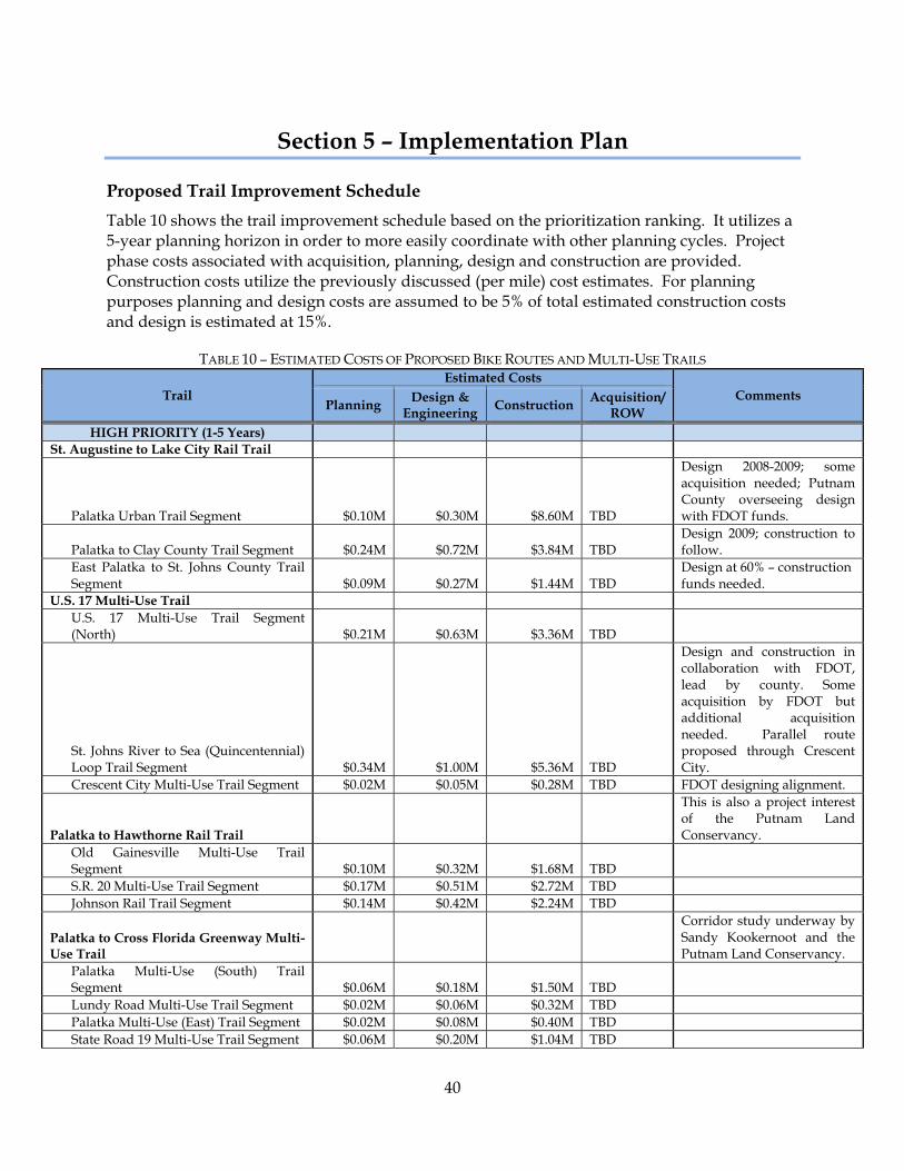
40
Section 5 – Implementation Plan
Proposed Trail Improvement Schedule Table 10 shows the trail improvement schedule based on the prioritization ranking. It utilizes a 5-year planning horizon in order to more easily coordinate with other planning cycles. Project phase costs associated with acquisition, planning, design and construction are provided. Construction costs utilize the previously discussed (per mile) cost estimates. For planning purposes planning and design costs are assumed to be 5% of total estimated construction costs and design is estimated at 15%.
TABLE 10 – ESTIMATED COSTS OF PROPOSED BIKE ROUTES AND MULTI-USE TRAILS
Trail Estimated Costs
Comments Planning Design &
Engineering Construction Acquisition/ ROW
HIGH PRIORITY (1-5 Years) St. Augustine to Lake City Rail Trail
Palatka Urban Trail Segment $0.10M $0.30M $8.60M TBD
Design 2008-2009; some acquisition needed; Putnam County overseeing design with FDOT funds.
Palatka to Clay County Trail Segment $0.24M $0.72M $3.84M TBD Design 2009; construction to follow.
East Palatka to St. Johns County Trail Segment $0.09M $0.27M $1.44M TBD
Design at 60% – construction funds needed.
U.S. 17 Multi-Use Trail U.S. 17 Multi-Use Trail Segment (North) $0.21M $0.63M $3.36M TBD
St. Johns River to Sea (Quincentennial) Loop Trail Segment $0.34M $1.00M $5.36M TBD
Design and construction in collaboration with FDOT, lead by county. Some acquisition by FDOT but additional acquisition needed. Parallel route proposed through Crescent City.
Crescent City Multi-Use Trail Segment $0.02M $0.05M $0.28M TBD FDOT designing alignment.
Palatka to Hawthorne Rail Trail
This is also a project interest of the Putnam Land Conservancy.
Old Gainesville Multi-Use Trail Segment $0.10M $0.32M $1.68M TBD S.R. 20 Multi-Use Trail Segment $0.17M $0.51M $2.72M TBD Johnson Rail Trail Segment $0.14M $0.42M $2.24M TBD
Palatka to Cross Florida Greenway Multi-Use Trail
Corridor study underway by Sandy Kookernoot and the Putnam Land Conservancy.
Palatka Multi-Use (South) Trail Segment $0.06M $0.18M $1.50M TBD Lundy Road Multi-Use Trail Segment $0.02M $0.06M $0.32M TBD Palatka Multi-Use (East) Trail Segment $0.02M $0.08M $0.40M TBD State Road 19 Multi-Use Trail Segment $0.06M $0.20M $1.04M TBD
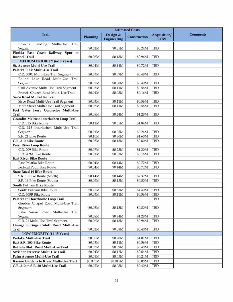
41
Trail Estimated Costs
Comments Planning Design &
Engineering Construction Acquisition/ ROW
Browns Landing Multi-Use Trail Segment $0.01M $0.05M $0.24M TBD
Florida East Coast Railway Spur to Bunnell Trail $0.06M $0.18M $0.96M TBD
MEDIUM PRIORITY (6-10 Years) St. Avenue Multi-Use Trail $0.04M $0.14M $0.72M TBD Palatka Link Multi-Use Trail
C.R. 309C Multi-Use Trail Segment $0.03M $0.09M $0.48M TBD Round Lake Road Multi-Use Trail Segment $0.02M $0.08M $0.40M TBD Crill Avenue Multi-Use Trail Segment $0.03M $0.11M $0.56M TBD Francis Church Road Multi-Use Trail $0.01M $0.03M $0.16M TBD
Sisco Road Multi-Use Trail Sisco Road Multi-Use Trail Segment $0.03M $0.11M $0.56M TBD Main Street Multi-Use Trail Segment $0.03M $0.11M $0.56M TBD
Fort Gates Ferry Connector Multi-Use Trail $0.08M $0.24M $1.28M TBD Grandin-Melrose-Interlachen Loop Trail
C.R. 315 Bike Route $0.11M $0.35M $1.84M TBD C.R. 315 Interlachen Multi-Use Trail Segment $0.01M $0.05M $0.24M TBD S.R. 21 Bike Route $0.10M $0.30M $1.60M TBD
C.R. 310 Bike Route $0.05M $0.15M $0.80M TBD West River Loop Route
C.R. 209 Bike Route $0.07M $0.23M $1.20M TBD C.R. 209A Bike Route $0.01M $0.03M $0.16M TBD
East River Bike Route East Palatka Bike Route $0.04M $0.14M $0.72M TBD Federal Point Bike Route $0.04M $0.14M $0.72M TBD
State Road 19 Bike Route S.R. 19 Bike Route (North) $0.14M $0.44M $2.32M TBD S.R. 19 Bike Route (South) $0.05M $0.15M $0.80M TBD
South Putnam Bike Route South Putnam Bike Route $0.27M $0.83M $4.40M TBD C.R. 308B Bike Route $0.03M $0.11M $0.56M TBD
Palatka to Hawthorne Loop Trail TBD Gordon Chapel Road Multi-Use Trail Segment $0.05M $0.15M $0.80M TBD Lake Susan Road Multi-Use Trail Segment $0.08M $0.24M $1.28M TBD C.R. 21 Multi-Use Trail Segment $0.06M $0.18M $0.96M TBD
Orange Springs Cutoff Road Multi-Use Trail $0.02M $0.08M $0.40M TBD
LOW PRIORITY (11-15 Years) Welaka Multi-Use Trail $0.06M $0.20M $1.01M TBD East S.R. 100 Bike Route $0.03M $0.11M $0.56M TBD Buffalo Bluff Road Multi-Use Trail $0.03M $0.09M $0.48M TBD Swisher Preserve Multi-Use Trail $0.04M $0.12M $0.64M TBD Palm Avenue Multi-Use Trail $0.01M $0.05M $0.24M TBD Ravine Gardens to River Multi-Use Trail $0.005M $0.015M $0.08M TBD C.R. 310 to S.R. 20 Multi-Use Trail $0.02M $0.08M $0.40M TBD
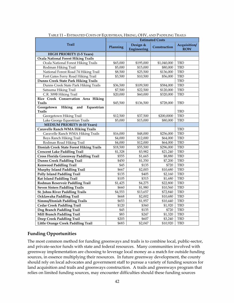
42
TABLE 11 – ESTIMATED COSTS OF EQUESTRIAN, HIKING, OHV, AND PADDLING TRAILS
Trail Estimated Costs
Planning Design & Engineering Construction Acquisition/
ROW HIGH PRIORITY (1-5 Years)
Ocala National Forest Hiking Trails Ocala National Forest Hiking Trails $65,000 $195,000 $1,040,000 TBD Rodman Hiking Trail $5,000 $15,000 $80,000 TBD National Forest Road 74 Hiking Trail $8,500 $25,500 $136,000 TBD Fort Gates Ferry Road Hiking Trail $3,500 $10,500 $56,000 TBD
Dunns Creek State Park Hiking Trails TBD Dunns Creek State Park Hiking Trails $36,500 $109,500 $584,000 TBD Satsuma Hiking Trail $7,500 $22,500 $120,000 TBD C.R. 309B Hiking Trail $20,000 $60,000 $320,000 TBD
Rice Creek Conservation Area Hiking Trails $45,500 $136,500 $728,000 TBD Georgetown Hiking and Equestrian Trails TBD
Georgetown Hiking Trail $12,500 $37,500 $200,0000 TBD Lake George Equestrian Trails $5,000 $15,000 $80,000 TBD MEDIUM PRIORITY (6-10 Years)
Caravelle Ranch WMA Hiking Trails TBD Caravelle Ranch WMA Hiking Trails $16,000 $48,000 $256,000 TBD Boys Ranch Hiking Trail $4,000 $12,000 $64,000 TBD Rodman Road Hiking Trail $4,000 $12,000 $64,000 TBD
Etoniah Creek State Forest Hiking Trails $18,500 $55,500 $296,000 TBD Crescent Lake Paddling Trail $1,328 $3,982 $21,240 TBD Cross Florida Greenway Paddling Trail $555 $1,665 $8,880 TBD Dunns Creek Paddling Trail $450 $1,350 $7,200 TBD Kenwood Paddling Trail $45 $135 $720 TBD Murphy Island Paddling Trail $667 $2,003 $10,680 TBD Polly Island Paddling Trail $135 $405 $2,160 TBD Rat Island Paddling Trail $105 $315 $1,680 TBD Rodman Reservoir Paddling Trail $1,425 $4,275 $22,800 TBD Seven Sisters Paddling Trails $660 $1,980 $10,560 TBD St. Johns River Paddling Trails $4,553 $13,657 $72,840 TBD Ocklawaha Paddling Trail $668 $2,002 $10,680 TBD Simms/Etoniah Paddling Trails $653 $1,957 $10,440 TBD Cedar Creek Paddling Trail $120 $360 $1,920 TBD Dog Branch Paddling Trail $45 $135 $720 TBD Mill Branch Paddling Trail $83 $247 $1,320 TBD Deep Creek Paddling Trail $203 $607 $3,240 TBD Little Orange Creek Paddling Trail $683 $2,047 $10,920 TBD
Funding Opportunities The most common method for funding greenways and trails is to combine local, public-sector, and private-sector funds with state and federal resources. Many communities involved with greenway implementation are choosing to leverage local money as a match for outside funding sources, in essence multiplying their resources. In future greenway development, the county should rely on local advocates and government staff to pursue a variety of funding sources for land acquisition and trails and greenways construction. A trails and greenways program that relies on limited funding sources, may encounter difficulties should these funding sources
43
change or disappear. The funding sources cited below represent a few of the major trails and greenways funding opportunities that have been pursued by other communities. This list provides an outline to help organize funding for greenway and trail implementation. The following listing of potential funding sources was derived, in part, from the Rails to Trails Conservancy: Financing and Funding Toolbox (website address below), from the Draft Master Trails Plan, dated 2004, by England, Thims and Miller as well as original sources.
Website: http://www.railstotrails.org/whatwedo/trailbuilding/technicalassistance/toolbox/20080710_funding_financing.html.
This listing focuses primarily on programs associated with acquisition and construction of greenways and trails. However, numerous other funding sources are available for activities such as the development of innovative planning strategies to improve transportation networks while protecting the environment and providing public education among other purposes. Another general source of funding information may be found on the Florida Greenways and Trails website under the Communities Assistance section.
Website: http://www.dep.state.fl.us/gwt/community/. Federal Funding SAFETEA-LU This is the most recent federal transportation funding law and makes federal trail funding available through a variety of programs.
Website: http://www.fhwa.dot.gov/tea21/
Transportation Enhancements (TE)-This program is the largest source of funding for trails, sidewalks, and other bicycle/pedestrian facilities. TE activities are projects that, according to the National Transportation Enhancements Clearinghouse (NTEC), "expand travel choices and enhance the transportation experience by improving the cultural, historic, aesthetic and environmental aspects of our transportation infrastructure."
Website: http://www.enhancements.org/index.asp Eligible Types of Projects: To be eligible for TE funds, a project must be one of the 12 TE activities and relate to surface transportation. Purpose of Funding: Provide funding for any of the following activities:
1. Pedestrian and bicycle facilities. 2. Pedestrian and bicycle safety and educational activities. 3. Acquisition of scenic or historic easements and sites. 4. Scenic or historic highway programs including tourist and welcome centers. 5. Landscaping and scenic beautification.

44
6. Historic preservation. 7. Rehabilitation and operation of historic transportation buildings, structures or facilities. 8. Conversion of abandoned railway corridors to trails. 9. Inventory, control, and removal of outdoor advertising. 10. Archaeological planning & research. 11. Environmental mitigation of runoff pollution and provision of wildlife connectivity. 12. Establishment of transportation museums.
Contact: Bob Crim
State Environmental Development Engineer Office of Environmental Management Department of Transportation 605 Suwannee Street MS 37 Tallahassee, FL 32399-0450 Tel: 850-414-5269 Fax: 850-414-4443 [email protected]
Recreational Trails Program (RTP) This program funds trails by using a portion of federal gas taxes attributable to off-road recreation. As stated above, the Office of Greenways and Trails administers the RTP in Florida. Municipal or county governments, Indian tribal governments and organizations among others that are recognized and approved by the State or federal government may apply for funding under the RTP. The RTP is a competitive program which provides matching grants for projects that provide or renovate recreational trails, trailhead and trailside facilities. Project proposals may address the following recreational trail interests:
• Motorized Trails; • Non-motorized Trails; and • Mixed-Use projects (either motorized, non-motorized or a combination of both).
Eligible Types of Projects: Projects that construct renovate or maintain recreational trails, trailhead and trailside facilities and the purchase of trail construction or maintenance equipment. Purpose of Funding: Funding motorized, non-motorized or diverse (i.e. two or more types of trail activities, motorized and/or non-motorized) recreational trail projects. Submission Period: Annually – usually scheduled for January each calendar year but can vary e.g. submission was during March in 2008. Special Conditions and Other Information: Program is administered per Chapter 62S-2, Florida Administrative Code (Appendix D).
45
The Recreational Trails Program Advisory Committee evaluates projects. The Priority List is submitted to the Secretary of the Florida Department of Environmental Protection for approval prior to submittal to the Federal Highway Administration for final approval. The LWCF Section 6(f) protection can be afforded to the project sites, should the land managing agency choose. Environmental and cultural impacts are evaluated through the Project Development & Environment (PD&E) process. A grant implementation workshop is typically conducted in August for all project sponsors.
Contact: FDEP Office of Greenways and Trails
3900 Commonwealth Blvd., MS 795 Tallahassee, FL 32399-3000 Phone: (850) 245-2052 or SC 205-2052 E-mail: [email protected] Web: http://www.FloridaGreenwaysAndTrails.com
National Scenic Byways Grants Program This grant program for designated FHA National Scenic Byways includes projects that improve bicycle and pedestrian safety along the byway corridor. There are eight categories of projects. Eligible Types of Projects:
1. State and Tribal Programs - An activity related to the planning, design, or development of a State or Indian tribe scenic byway program.
2. Corridor Management Plans - Development and implementation of a corridor management plan to maintain the scenic, historical, recreational, cultural, natural, and archaeological characteristics of a byway corridor while providing for accommodation of increased tourism and development of related amenities.
3. Safety Improvements - Safety improvements to a State Scenic Byway, Indian tribe scenic byway, National Scenic Byway, or All-American Road to the extent that the improvements are necessary to accommodate increased traffic and changes in the types of vehicles using the highway as a result of the designation as a State scenic byway, Indian tribe scenic byway, National Scenic Byway, or All-American Road.
4. Byway Facilities - Construction along a scenic byway of a facility for pedestrians and bicyclists, rest area, turnout, highway shoulder improvement, overlook, or interpretive facility.
5. Access to Recreation - An improvement to a scenic byway that will enhance access to an area for the purpose of recreation, including water-related recreation.
6. Resource Protection - Protection of scenic, historical, recreational, cultural, natural, and archeological resources in an area adjacent to a scenic byway.
7. Interpretive Information - Development and provision of tourist information to the public, including interpretive information about a scenic byway.
8. Marketing Program- Development and implementation of a scenic byway marketing program.

46
Website: http://www.bywaysonline.org/grants/application/. Alternative Transportation in Parks and Public Lands The purpose of this program is to enhance the protection of national parks and federal lands and increase the enjoyment of those visiting them. The goals of the program are to conserve natural, historical, and cultural resources; reduce congestion and pollution; improve visitor mobility and accessibility; enhance visitor experience; and ensure access to all, including persons with disabilities.
Eligible Types of Projects: The program funds capital and planning expenses for alternative transportation systems such as shuttle buses and bicycle trails in national parks and public lands. Makes National Forest System lands explicitly eligible and includes bicycle, pedestrian and non-motorized watercraft projects in the definition of alternative transportation.
Website: http://www.fta.dot.gov/funding/grants/grants_financing_6106.html
Land and Water Conservation Fund (LWCF) This 50/50 matching grant program is administered by state agencies in cooperation with the National Park Service. The LWCF program provides matching grants to States and local governments for the acquisition and development of public outdoor recreation areas and facilities. The program is intended to create and maintain a nationwide legacy of high quality recreation areas and facilities and to stimulate non-federal investments in the protection and maintenance of recreation resources across the United States.
Website: http://www.nps.gov/lwcf/ Eligible Types of Projects: Projects for the acquisition or development of land for public outdoor recreation. This includes beaches, picnic areas, trails, ball fields, tennis and basketball courts and playgrounds along with associated support facilities such as lighting, parking, restrooms and landscaping and the acquisition of lands for recreational purposes.
Contact: Department of Environmental Protection Division of Recreation & Parks Office of Information and Recreation Services 3900 Commonwealth Boulevard, MS #585 Tallahassee, Florida 32399-3000 Phone (850) 245-2501 Fax (850) 245-3038 Website: http://www.dep.state.fl.us/parks/OIRS/default.htm
Community Development Block Grants (CDBG) This program provides annual grants on a formula basis to local governments and states.
47
Eligible Types of Projects: Projects must be used for activities that benefit low- and moderate-income persons, prevent or eliminate slums or blight, and address community development needs having a particular urgency.
Website: http://www.hud.gov/offices/cpd/communitydevelopment/programs/ Portions of the program are state administered.
Website: http://www.hud.gov/local/index.cfm?state=fl
Historic Preservation Funding Sources Many trail corridors contain historic structures, often of regional or national significance. Sometimes, the corridor itself is of historic significance. The following are a few federal programs targeting areas that have been designated as being of historic significance. Preserve America: This is a 50/50 grant program that will match non-federal funds. It is administered by the National Park Service and focuses on education and heritage tourism, grants to designated Preserve America communities and state Historic Preservation Offices (SHPOs).
Website: http://www.nps.gov/history/hps/hpg/PreserveAmerica/
Save America’s Treasures: This program is administered by the National Park Service, Grants can be used only to preserve properties and sites listed in the National Register of Historic Places that are of national significance or designated as a National Historic Landmark. NPS also administers the Historic Preservation Fund, which awards matching grants-in-aid to the states for the restoration of properties on the National Register of Historic Places.
Website: http://www.nps.gov/history/hps/treasures/
Historic Landscape Initiative: The Historic Landscape Initiative promotes responsible preservation practices that protect historic landscapes, including farms, parks, gardens, rural villages and industrial sites. Preserving these landscapes provides scenic, economic, ecological, social, recreational, and educational opportunities to understand ourselves as a nation. The program provides technical assistance, workshops, and publications to professional planners, landscape architects, historic property managers, homeowners, academics, and students to help communities preserve historical landscapes. Website: http://www.nps.gov/history/HPS/hli/index.htm
Contact: National Park Service Heritage Preservation Services, NC330 1849 C Street NW Washington, DC 20240 (202) 343-9597
48
Conservation Reserve Program The U.S. Department of Agriculture (USDA), through its Agriculture Stabilization and Conservation Service, provides payments to farm owners and operators to place highly erodible or environmentally sensitive landscapes into a 10-15 year conservation contract. The participant, in return for annual payments during this period, agrees to implement a conservation plan (approved by the local conservation district) for converting these sensitive lands to a less intensive use. Individuals, associations, corporations, estates, trusts, cities, counties and other entities are eligible for this program. This program can be used to fund the maintenance of open space and non-public use greenways along water bodies and ridge lines.
Contact: USDA
Malcolm Henning, National Program Manager (202) 720-1872
State Funding Florida Communities Trust Program Florida Communities Trust is a state land acquisition grant program that provides funding to local governments and eligible non-profit environmental organizations for acquisition of community-based parks, open space and greenways that further outdoor recreation and natural resource protection needs identified in local government comprehensive plans. Eligible Types of Projects: Acquisition of lands to be used for greenways, trails and related access locations. Purpose of Funding: Land acquisition grants for community based projects, parks, open spaces that further the outdoor recreation and natural resource protection needs identified in local government comprehensive plans. The program is intended to:
• Emphasize funding projects in low-income or otherwise disadvantaged communities. • Direct at last 30 percent of its funding to projects in Metropolitan Areas and half of that
amount within the built-up urban area. • Use no less than 5 percent to acquire lands for recreational trail systems.
Contact: Florida Department of Community Affairs
Florida Communities Trust Program Ken Reecy [1-850-922-1701; [email protected]]
2555 Shumard Oak Boulevard Tallahassee, FL 32399-2100 Phone: (850) 488-8466 or SC 292-2207 Web: http://www.dca.state.fl.us
Florida Greenways & Trails Acquisition Program Eligible Types of Projects: Acquisition of lands to be used for greenways and trails.
Purpose of Funding: To acquire components within the statewide greenways and trails system as identified on the OGT Recreational Trails Prioritization Maps.

49
Submission Period: Typically once a year.
Application Process: Prior to submittal of an Application for acquisition of Land, an applicant must first apply for and receive a Certificate of Eligibility.
Contact: Cindy Radford
Florida Department of Environmental Protection Office of Greenways and Trails 3900 Commonwealth Blvd., MS 795 Tallahassee, FL 32399-3000 Phone: (850) 245-2052 of SC 205-2052 E-Mail: [email protected] Web: http://www.FloridaGreenwaysAndTrails.com
Florida Recreational Development Assistance Program (FRDAP) FRDAP is a competitive program which provides grants for acquisition or development of land for public outdoor recreation use or to construct or renovate recreational trails.
Contact: Office of Information and Recreation Services 3900 Commonwealth Boulevard, Mail Station #585 Tallahassee, Florida 32399-3000 Phone: 850/245-2501 Fax: 850/245-3038
Website: http://www.dep.state.fl.us/parks/OIRS/default.htm. Putnam County contact: Lee Ann Zimmerman
Florida Department of States Division of Historical Resources The Division of Historical Resources provides grants to support the preservation of important historic/archaeological sites as well as the creation of historic and cultural trails. The Division can provide technical assistance and information about sites and areas that could be incorporated into greenways and trails. The National Register of Historic Places Program, administered by the National Park Service and the State Historic Preservation Officer with the Florida Department of State, Division of Historical Resources, assists local governments and nonprofit organizations in preparing nominations and provides funding for protecting historic and cultural resources through the Florida Historic Preservation Grants Program.
Contact: Bureau of Historic Preservation
Supervisor: Sharyn Heiland 1-850-245-6333 www.flheritage.com Grant Section: 1-800-847-7278
50
Local Funding Local Tax Measures Due to the increasing recognition of trails as an economic stimulus for local communities, public expenditures for trails infrastructure is increasingly being viewed as an investment in future growth rather than a cost to be suffered. Recognizing the importance of adequate recreational opportunities, numerous communities around the country have implemented specific local taxes and/or fees to provide dedicated funding for open space, parks, recreation and trails. A few examples include: Mammoth Lakes, California – The Town of Mammoth Lakes adopted a Trail System Plan in May of 1991. Several planning goals within the town’s 2007 General Plan directly support the establishment of an integrated transporation system with a primary focus on pedestrian and alternative transportation methods. Mobility Goal (M.3.) states “Emphasize feet first, public transportation second, and car last in planning the community transportation system while still meeting Level of Service standards. Goal (M.4.) states “Encourage feet first by providing a linked year-round recreational and commuter trail system that is safe and comprehensive.” Simultaneously, Parks, Recreation and Open Space Goal (P.3.) states “Create a Master Plan for an integrated trail system that will maintain and enhance convenient public access to public lands from town.” While goal (P.5.) states the need to “Link parks and open space with a well-designed year-round network of public corridors and trails within and surrounding Mammoth Lakes.” Measure R is a half-cent sales tax initiative to raise and secure a stable funding source for local trails, parks, and recreation in The Town of Mammoth Lakes. Measure R passed with a greater than two-thirds vote on June 3, 2008. Funds may be used for planning, construction, maintenance, safety and education. This local funding can also be used to leverage additional funding sources that require a minimum local match.(33) Colorado Springs, Colorado – Adopted a Trails, Opens Space and Parks (TOPS) ordinance and voters passed the TOPS Sales Tax, a 1/10% sales tax to support acquisition, development and preservation of open space and parks. To provide needed long-term maintenance of funding for recreational infrastructure the city also developed, and voters passed, dedicated maintenance districts (Specialized Improvement and Maintenance Districts). Davis, California – Passed an Open Space Protection Tax to protect open space and agricultural resources in the Davis area. This provided funding to acquire lands identified in the Comprehensive Bicycle Plan. Revenue generated through these tax measures replace general funds that had been allotted to these purposes. Public opinion surveys are typically conducted prior to the introduction of these measures to determine a “willingness to pay” for these amenities. Tourist Development Taxes In 1994, based on a request from Lake County, the Attorney General of Florida determined that section 125.0104, Florida Statutes allows expenditures from tourist development tax revenues for the acquisition and construction of public recreational trails.
51
Development Impact Fees and Transportation Concurrency Exception Areas (TCEAs) Impact fees shift the cost of providing additional public facilities that are required to meet the needs of new development to that new development. Putnam County already utilizes impact fees in some areas such as for the provision of road improvements needed to maintain levels of service identified within the comprehensive plan. The charge represents a partial or total reimbursement for the capital costs of providing additional facilities and services to meet the needs of the new development. While Putnam County currently imposes impact fees on new development to increase road capacity, they could also be used to fund portions of bicycle and pedestrian facilities development. They can be used to finance the capital costs for sidewalks and bike lanes that are required by new development or to finance greenway and trail development. As Putnam strives to attract new, quality, development it will necessarily need to plan for additional transportation and recreational amenities, including greenways. However, the prerequisite for providing such facilities is the ability to pay the cost of the improvements. Impact fees are one way to address the demands associated with growth, while not increasingly burdening taxpayers. Impact fees are enacted by the local government by first adopting an ordinance which designates the use of the funds that are raised. Impact fee ordinances have become less objectionable to the development community since recent legislation was passed by the Florida Legislature to allow for impact fee credits if developments are planned in a way that promotes multi-modalism or mixed-use development. In addition, Transportation Concurrency Exception Areas (TCEAs) or regional activity centers can also be utilized to provide impact fee credits to specific developments. A TCEA is a designated geographic area that is exempted from traditional concurrency requirements for transportation facilities provided that they mitigate transportation impacts by promoting alternative transportation modes or by providing facilities on-site. Through the exception of traditional concurrency requirements, TCEAs promote redevelopment and urban infill, as well as alternative modes of transportation. Municipal Service Taxing And Benefit Units(32) A Municipal Service Taxing Unit (MSTU) is a special improvement district created for the purpose of obtaining specific municipal services. Additional taxes are levied upon properties located within the designated geographic area which is to receive the municipal service. The MSTU may encompass the entire unincorporated area or a portion of the unincorporated area. All or part of a municipal boundary may be included within the district as well, subject to the consent of the municipality’s governing body. Typically, the taxes, paid on a monthly or annual basis, are small because the improvements are amortized over a 30-year period. Ad valorem taxes may be levied to provide these municipal services, with a limit of ten mills, pursuant to s.200.071, F.S. A Municipal Service Benefit Unit (MSBU) is also a special district that provides property owners in unincorporated areas with an opportunity to acquire essential services for their communities. MSBU differs from a MSTU in that the funding mechanism for the municipal services is attained from sources other than taxes, such as service charges or special assessments. Numerous MSBUs exist around the state for the provision of services such as fire protection and
52
solid waste collection and disposal services. For example, Seminole County in Florida uses MSBUs to fund for sidewalk construction. Funding is initially provided by the County through the MSBU program and is later collected as non-ad valorem taxes from the property owners benefiting from the services. Lee County, Florida, also provides MSBU services to the unincorporated areas of the County by building sidewalks and landscaping on the streets. Private Funding The Eastman Kodak American Greenways Awards A partnership project of Kodak, The Conservation Fund, and the National Geographic Society provides small grants to stimulate the planning and design of greenways in communities throughout America. The annual awards program was instituted in response to the President’s Commission on Americans Outdoors recommendation to establish a national network of greenways. Made possible by a generous grant from Eastman Kodak, the program also honors groups and individuals whose ingenuity and creativity foster the creation of greenways.
• Develop new, action-oriented greenways projects; • Assist grassroots greenway organizations; • Leverage additional money for conservation and greenway development; and • Recognize and encourage greenway proponents and organizations.
Contact: Jennifer White, Coordinator American Greenways Program The Conservation Fund National Office Address:
1655 N. Fort Meyers Dr. Suite 1300 Arlington, VA 22209-3199 (703) 525-6300 www.conservationfund.org
Phillips Petroleum Environmental Partnership Awards Phillips Environmental Partnerships awards grants to public and private primary and secondary schools, adult non-profit community organizations, and nature centers for programs meeting a local environmental need. Grants ranging from $500-$5,000 are awarded for projects like stream restorations. Matching funds are required.
Contact: Phillips Petroleum Company 16 D1 PB Bartlesville, OK 74004 e-mail: [email protected]
Coors Pure Water 2000 This program provides non-profit groups nationwide with small grants for water quality improvement projects. These include projects such as river cleanups, restoration projects and educational programs.
Contact: Coors Pure Water 2000
53
311 Tenth Street Golden, CO 80401 (800) 642-6116
http://millercoors.com/what-we-believe/community-partners/funding-guidelines.aspx
The Harder Foundation A small foundation that funds environmental action projects in support of habitat protection, especially prime habitat areas facing immediate threats on public lands. Some of the Harder Foundation’s grants involve acquisition of natural areas, especially when they are of regional biological significance. Forty percent of their grants in aggregate are made to grantees in the states of Washington and Oregon. Write for “Guidelines for Grant Proposals.”
Contact: Del Langbauer, President 401 Broadway, Suite 303 Tacoma, WA 98402-3904 (253) 593-2121 www.theharderfoundation.org E-mail: [email protected]
The Harder Foundation will invite letters of inquiry and proposals from organizations working to protect public lands and waters in Alaska, Washington, Oregon, Idaho, Montana, Wyoming, and Colorado. Limited invitations for grant proposals are made each year to groups in Florida.
The Bikes Belong Coalition Grants of up to $10,000 each are provided to assist local organizations, agencies, and citizens in developing bicycle facilities projects that will be funded by TEA-21, the Transportation Equity Act for the 21st Century.
Contact: Bikes Belong Coalition Mailing Address:
P.O. Box 2359 Boulder, CO 80306 Physical Address: 1920 13th Street, Suite A Boulder, CO 80302 (303) 442-2936
Grants & Research Director, Elizabeth Train (303) 449-4893 ext 3, [email protected] www.bikesbelong.org
[email protected] Other Supplemental Funding Opportunities Leasing of Potential Uses A growing source of trail development funds is the leasing of subsurface rights for fiber-optic cables and other utilities. Compatible "joint uses" of a rail-trail corridor include sewer, water

54
and natural gas. Utility companies have also bought abandoned corridors and then donated the land to the state for trail use. Salvaging Materials from Rails to Trails Corridors The rails, ties, ballast and other improvements made to the corridor, if not needed for the trail, may have salvage value and should not be overlooked. Revenue generated from the sale of these items varies widely, depending on local markets, the length of the corridor, and the quantity of salvageable materials. In-Kind Contributions Many grant programs require a local match to help demonstrate the community’s commitment to the project. Often this “match” requirement can be met with what is referred to as an “in-kind” contribution. In-kind contributions are non-monetary donations of labor, equipment and materials to the overall cost of completing a project that can be translated to a dollar value used to meet the matching requirement. Volunteer labor for tasks such as clearing, grading, and construction can go a long way towards meeting local match requirements when applying for grants.
Business leaders must also be recruited to support this plan. Businesses may be able to provide in-kind support through trail building, financial contributions or possibly adopting sections of trail. Businesses are a key part of the community fabric and should be included in building and maintaining the greenways and blueways trail system. Trails add to desirability of a community and can enhance a business’ ability to attract customers to an area. Campaigns and Donations Communities across the country have raised money for development and maintenance of their trails and greenways through various fundraising campaigns. For example, some groups have "sold" pieces of trail, providing each donor with a "deed" for their segment of the trail. Other groups have also sold trail amenities, such as benches and trees. Trust Funds or Endowments These can be set up to aid funding for acquisition, construction or maintenance and can be administered by a nonprofit group or local commission. Funds can be contributed to a trust fund from government sources, private grants and gifts. Private Grants Many foundations and companies provide grants for trail and greenway projects, open space preservation, community development and community health. The development of a funding proposal is suggested. Public Outreach and Involvement Public outreach and education is an important component to developing and implementing any trail plan and the projects contained within the plan. A comprehensive approach will gather public input at the beginning of the planning process, educate people concerning the benefits of the plan and its projects, help allay concerns and create needed trail advocates to support trail development funding.

55
Trails and greenways are community-based projects, and every project needs broad community support to be a success. Initial public input into the planning and design process is critical to helping the plan become part of the community vision. Through this process local knowledge is gathered that can greatly improve the plan’s value to the community. Additionally, initial concerns may be identified and addressed. Few things can delay or stop a trail project more than an adjacent property owner who learns about a proposed trail in his or her backyard from the local newspaper rather than from trail advocates themselves. Some rail-trail conversions face opposition from landowners living alongside or near the corridors. Lack of information and unanswered criticism of trail proposals usually fuel this opposition and lead to misconceptions, including confusion related to property rights issues, concerns that property values will drop and liability will increase, and fears of increased crime such as littering, trespassing, burglary and vandalism. A large majority of trail opponents find that their fears about the trail never materialize and numerous studies have documented that these fears rarely materialize after a trail is built. An effective public input and review process is the first and probably most important way of addressing concerns early and has the potential to turn opponents into advocates. Many trail development projects are cooperative efforts between trail advocates, local municipalities and state agencies. There are two ways to start reaching out to local officials and agencies. One is to make one-on-one contacts with local municipal leaders through informal get-togethers where project benefits can be discussed. These meetings can also help refine plan and project presentations by uncovering questions or concerns that may not have been considered initially. The other means is through formal presentations. Formal presentations to town or city councils, county commissions and agencies are also important to publically document support that may be needed for funding requests and to obtain needed regulatory approvals. In many cases, state agencies are funding sources for trail design and construction. A well organized public outreach and education program will identify key officials early in the process and maintain consistent and open communication with them. Some suggested ways for developing awareness and building support are:
• Organized Trail Events—Getting people out on a trail can get them excited about the vision of what other trails will be like.
• Media Relations—Build awareness through the press. Get supporters to write editorials and letters to the editor of local newspapers that advocate for the project.
• Develop Strong Advocates—Getting support from elected officials and community leaders add legitimacy and visibility to the project.
• Using Technology—It's helpful to have all the information about your trail project readily available and in one place. Web sites are places that many people now access to obtain their information. Find volunteers to create a site or perhaps a supportive local government can assist.
• Visioning – People tend to get excited about things that they understand and can envision. A vision document compiles the information about a trail plan or project in one place, and in an easily circulated form. This document is essential when you're working on building support and awareness. This plan is a start. Additional vision documents may help obtain support for specific projects.

56
References 1. Putnam County Chamber of Commerce. Presentation of the Putnam County Multi-Use Trail Plan to the Board of County Commissioners. 2007. 2. Bicyclinginfo.org. http://www.bicyclinginfo.org/why/benefits_economic.cfm. [Online] 3. Benfield, F. Kaid, Raimi, Matthew D. and Chen., and Donald. Once There Were Greenfields. New York : National Resources Defense Council, 1999. 4. Rails to Trails Conservancy. Trail Towns to TrOD: Trails and Economic Development, Fact Sheet. Washington, D.C. : Rails to Trails Conservancy, August 2007. 5. U.S. Department of Agriculture. The Virginia Creper Trail: An Assessment of User Demographics, Preferences, Preferences and Economics. 2004. 6. Virginia Dept. of Conservation. Washington and Old Dominion Trails in Virginia. 2004. 7. North Carolina Department of Transportation. A Case Study of the North Carolina Northern Outer Banks Trail. Institute for Transportation Research and Education at North Carolina State University, 2004. 8. Nicholls, Sarah and Crompton, John. The Impact of Greenways on Property Values Evidence from Austin, Texas (cited in From Trail Towns to TrOD:Trails and Economic Development; A fact sheet from Rails to Trails Consevancy, Washington, DC). s.l. : Journal of Leisure Research, 2005. 9. Hopey, Don. Prime Location on the Trail. s.l. : Rails to Trails Conservancy Magazine, 1999. 10. U.S. EPA. Inventory of U.S. Greenhouse Gas Emissions and Sinks: 1990-2005. 2007. 11. Trails and Greenways Clearinghous. Benefits of Trails and Greenways. 1998. 12. Rails to Trails Conservancy. Healthy Places for Healthy People-Active Transportation and Health . 2007. 13. Putnam County. County Comprehensive Plan:Future Land Use Element. September 8, 2006. 14. —. County Comprehensive Plan:Public Schools Facilities Element. June 24, 2008. 15. —. County Comprehensive Plan:Capital Improvements Element. September 8, 2006. 16. Florida Department of Education. Florida Schools Indicator Report for 2006-2007. 17. Putnam County. County Comprehensive Plan:Traffic Circulation Element. September 8, 2006. 18. —. County Comprehensive Plan: Recreation and Open Space Element. September 8, 2006. 19. Putnam County Chamber of Commerce. Preliminary Draft Master Trails Plan. May 2003. 20. Putnam County. An Ordinance Adopting Certain Amendments to Text of the Conservation, Recreation and Inter-Governmental Coordination Elements of the Putnam County Comprehensive Plan. 2008. 21. —. County Comprehensive Plan: Economic Development Element. September 8, 2006. 22. England, Thims and Miller. Preliminary Draft Master Trails Plan. 2004. 23. Florida Department of Transportation. 2025 Florida Transportation Plan. 2005. 24. Florida Dept. of Environmental Protection. Connecting Florida's Communities with Greenways and Trails: A Summary of the Five-Year Implementation Plan for the Florida Greenways and Trails System. 1999. 25. Putnam County, Planning and Development Services. Article 7 - Development Design and Improvment Standards. 2006. 26. School Board of Putnam County, Interlocal Agreement for Coordinated Land Use and Public School Facility Planning, 2008.
57
27. Putnam County, Article 5- Facilities and Services, Concurrency and Development Exactions, 2008. 28. Putnam County Public Works Department, Report to the Transportation Committee of the Board of County Commissioners, 2008. Mr. Brian Hammons, Director Planning and Development Services, Putnam County, personal communication September 2008. 29. Mr. Doug Alderson, Florida Paddling Trails Coordinator, Office of Greenways and Trails, personal communication September 2008. 30. Mr. James Boyle, Regional Transportation Manager, Jacksonville Transportation Authority, personal communication September 2008. 31. Florida Department of Environmental Protection. 2006-2007 Annual Report, Office of Greenways and Trails, 2007. 32. Ocala/Marion County Transportation Planning Organization, Ocala/Marion County 2015bicycle And Pedestrian Master Plan Update, 2004 Prepared by Kimley-Horn and Associates Inc. 33. Town of Mammoth Lakes, California, Draft Trail System Master Plan, 2008 34. Florida Department of Transportation, Florida Bicycle Facilities Planning and Design Handbook, 2000

58
Appendix A: Roadways Associated with Trails
The following table includes descriptions of the roadways associated with the existing trails as well as the roads that would be associated with the proposed trails.
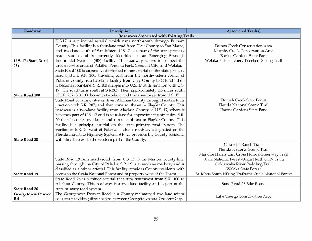
59
Roadway Description Associated Trail(s) Roadways Associated with Existing Trails
U.S. 17 (State Road 15)
U.S.17 is a principal arterial which runs north-south through Putnam County. This facility is a four-lane road from Clay County to San Mateo; and two-lane south of San Mateo. U.S.17 is a part of the state primary road system and is currently identified as an Emerging Strategic Intermodal Systems (SIS) facility. The roadway serves to connect the urban service areas of Palatka, Pomona Park, Crescent City, and Welaka.
Dunns Creek Conservation Area Murphy Creek Conservation Area
Ravine Gardens State Park Welaka Fish Hatchery-Beechers Spring Trail
State Road 100
State Road 100 is an east-west oriented minor arterial on the state primary road system. S.R. 100, traveling east from the northwestern corner of Putnam County, is a two-lane facility from Clay County to C.R. 216 then it becomes four-lane. S.R. 100 merges into U.S. 17 at its junction with U.S. 17. The road turns south at S.R.207. Then approximately 2.6 miles south of S.R. 207, S.R. 100 becomes two-lane and turns southeast from U.S. 17.
Etoniah Creek State Forest Florida National Scenic Trail Ravine Gardens State Park
State Road 20
State Road 20 runs east-west from Alachua County through Palatka to its junction with S.R. 207, and then runs southeast to Flagler County. This roadway is a two-lane facility from Alachua County to U.S. 17, where it becomes part of U.S. 17 and is four-lane for approximately six miles. S.R. 20 then becomes two lanes and turns southeast to Flagler County. This facility is a principal arterial on the state primary road system. The portion of S.R. 20 west of Palatka is also a roadway designated on the Florida Intrastate Highway System. S.R. 20 provides the County residents with direct access to the western part of the County.
State Road 19
State Road 19 runs north-south from U.S. 17 to the Marion County line, passing through the City of Palatka. S.R. 19 is a two-lane roadway and is classified as a minor arterial. This facility provides County residents with access to the Ocala National Forest and to property west of the Forest.
Caravelle Ranch Trails Florida National Scenic Trail
Marjorie Harris Carr Cross Florida Greenway Trail Ocala National Forest-Ocala North OHV Trails
Ocklawaha River Paddling Trail Welaka State Forest
St. Johns South Hiking Trails-the Ocala National Forest
State Road 26
State Road 26 is a minor arterial that runs southwest from S.R. 100 to Alachua County. This roadway is a two-lane facility and is part of the state primary road system.
State Road 26 Bike Route
Georgetown-Denver Rd
The Georgetown-Denver Road is a County-maintained two-lane minor collector providing direct access between Georgetown and Crescent City. Lake George Conservation Area
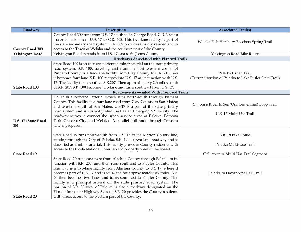
60
Roadway Description Associated Trail(s)
County Road 309
County Road 309 runs from U.S. 17 south to St. George Road. C.R. 309 is a major collector from U.S. 17 to C.R. 308. This two-lane facility is part of the state secondary road system. C.R. 309 provides County residents with access to the Town of Welaka and the southern part of the County.
Welaka Fish Hatchery-Beechers Spring Trail
Yelvington Road Yelvington Road extends from U.S. 17 east to St. Johns County. Yelvington Road Bike Route Roadways Associated with Planned Trails
State Road 100
State Road 100 is an east-west oriented minor arterial on the state primary road system. S.R. 100, traveling east from the northwestern corner of Putnam County, is a two-lane facility from Clay County to C.R. 216 then it becomes four-lane. S.R. 100 merges into U.S. 17 at its junction with U.S. 17. The facility turns south at S.R.207. Then approximately 2.6 miles south of S.R. 207, S.R. 100 becomes two-lane and turns southeast from U.S. 17.
Palatka Urban Trail (Current portion of Palatka to Lake Butler State Trail)
Roadways Associated With Proposed Trails
U.S. 17 (State Road 15)
U.S.17 is a principal arterial which runs north-south through Putnam County. This facility is a four-lane road from Clay County to San Mateo; and two-lane south of San Mateo. U.S.17 is a part of the state primary road system and is currently identified as an Emerging SIS facility. The roadway serves to connect the urban service areas of Palatka. Pomona Park, Crescent City, and Welaka. A parallel trail route through Crescent City is proposed.
St. Johns River to Sea (Quincentennial) Loop Trail
U.S. 17 Multi-Use Trail
State Road 19
State Road 19 runs north-south from U.S. 17 to the Marion County line, passing through the City of Palatka. S.R. 19 is a two-lane roadway and is classified as a minor arterial. This facility provides County residents with access to the Ocala National Forest and to property west of the Forest.
S.R. 19 Bike Route
Palatka Multi-Use Trail
Crill Avenue Multi-Use Trail Segment
State Road 20
State Road 20 runs east-west from Alachua County through Palatka to its junction with S.R. 207, and then runs southeast to Flagler County. This roadway is a two-lane facility from Alachua County to U.S 17, where it becomes part of U.S. 17 and is four-lane for approximately six miles. S.R. 20 then becomes two lanes and turns southeast to Flagler County. This facility is a principal arterial on the state primary road system. The portion of S.R. 20 west of Palatka is also a roadway designated on the Florida Intrastate Highway System. S.R. 20 provides the County residents with direct access to the western part of the County.
Palatka to Hawthorne Rail Trail
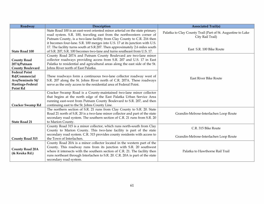
61
Roadway Description Associated Trail(s)
State Road 100
State Road 100 is an east-west oriented minor arterial on the state primary road system. S.R. 100, traveling east from the northwestern corner of Putnam County, is a two-lane facility from Clay County to C.R. 216 then it becomes four-lane. S.R. 100 merges into U.S. 17 at its junction with U.S. 17. The facility turns south at S.R.207. Then approximately 2.6 miles south of S.R. 207, S.R. 100 becomes two-lane and turns southeast from U.S. 17.
Palatka to Clay County Trail (Part of St. Augustine to Lake City Rail Trail)
East S.R. 100 Bike Route
County Road 207A/Putnam County Boulevard
County Road 207A and Putnam County Boulevard are two-lane minor collector roadways providing access from S.R. 207 and U.S. 17 in East Palatka to residential and agricultural areas along the east side of the St. Johns River north of East Palatka.
East River Bike Route
Federal Point Rd/Commercial Ave/Seminole St/ Hastings-Federal Point Rd
These roadways form a continuous two-lane collector roadway west of S.R. 207 along the St. Johns River north of C.R. 207A. These roadways serve as the only access to the residential area of Federal Point.
Cracker Swamp Rd
Cracker Swamp Road is a County-maintained two-lane minor collector that begins at the north edge of the East Palatka Urban Service Area running east-west from Putnam County Boulevard to S.R. 207, and then continuing east to the St. Johns County Line.
State Road 21
The northern section of S.R. 21 runs from Clay County to S.R. 20. State Road 21 north of S.R. 20 is a two-lane minor collector and part of the state secondary road system. The southern section of C.R. 21 runs from S.R. 20 to Marion County.
Grandin-Melrose-Interlachen Loop Route
County Road 315
County Road 315 is a minor collector, which runs north-south from Clay County to Marion County. This two-lane facility is part of the state secondary road system. C.R. 315 provides county residents with access to the Town of Interlachen.
C.R. 315 Bike Route
Grandin-Melrose-Interlachen Loop Route
County Road 20A (& Keuka Rd.)
County Road 20A is a minor collector located in the western part of the County. This roadway runs from its junction with S.R. 20 southwest where it intersects with the southern section of C.R. 21. The facility then runs northeast through Interlachen to S.R. 20. C.R. 20A is part of the state secondary road system.
Palatka to Hawthorne Rail Trail

62
Roadway Description Associated Trail(s)
State Road 207
State Road 207 is a principal arterial that runs northeast from U.S. 17 through St. Johns County. This facility provides Putnam County residents with access to I-95. S.R. 207 is a four-lane facility and is part of the state primary road system as a Florida Intrastate Highway System (FIHS) facility.
East Palatka to St. Johns County Trail (Part of St. Augustine to Lake City Rail Trail)
County Road 209
County Road 209 is a minor collector located in the northeast part of the County. This two-lane facility runs east from U.S. 17 for 3.5 miles, then runs north for 4.6 miles until it turns west for 3.2 miles to its junction with U.S. 17. C.R. 209 is part of the state secondary road system. West River Loop Route
County Road 209A County Road 209A connects C.R. 209 to the St. Johns River on the east at Clay Landing.
Georgetown-Denver Rd
The Georgetown-Denver Road is a County-maintained two-lane minor collector providing direct access between Georgetown and Crescent City. South Putnam Bike Route
(Crescent City-Georgetown-Fruitland Trail)
County Road 309
County Road 309 runs from U.S. 17 south to St. George Road. C.R. 309 is a major collector from U.S. 17 to C.R. 308. This two-lane facility is part of the state secondary road system. C.R. 309 provides County residents with access to the Town of Welaka and the southern part of the County.
Nashua & Sisco Roads Local roads connecting U.S. Hwy 17 at Pomona Park and C.R. 309.
County Road 308B Bike Route
County Road 308B
County Road 308B, located in the southeast section of the county, runs east from C.R. 309 to U.S. 17. This two lane paved facility has been classified as a minor collector and is part of the state secondary road system. C.R. 308B provides County residents access to Welaka and Pomona Park.
Local Roads in Welaka and County
This trail utilizes various local roads within Welaka and the County as well as portions of 308B in the vicinity of the National Fish Hatchery.
County Road 309C
County Road 309C is a two-lane minor collector roadway providing access between S.R. 20 and S.R. 100 just west of the City of Palatka. It also provides access between the County’s business park near the Kay Larkin Airport and the major roadway network.
Palatka Link Multi-Use Trail
County Road 310
County Road 310, located in the south central part of the county, runs east from C.R. 315 to S.R. 19. This two-lane facility is a minor collector and is part of the state secondary road system.
County Road 310 Bike Route
Yelvington Road Yelvington Road extends from U.S. 17 east to St. Johns County. Florida East Coast Railway Spur to Bunnell
Lundy Road Lundy Road extends from incorporated City of Palatka south to the boat ramp across from Polly Island on the St. Johns River.
Palatka to Cross Florida Greenway Multi-Use Trail
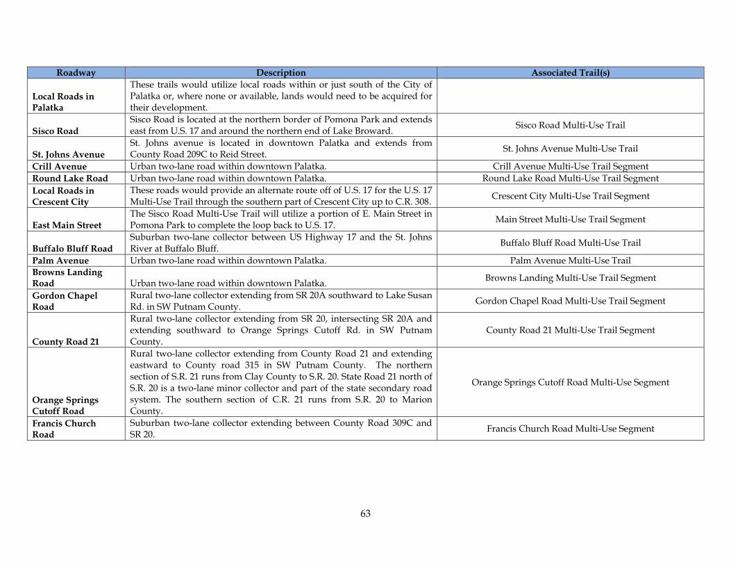
63
Roadway Description Associated Trail(s)
Local Roads in Palatka
These trails would utilize local roads within or just south of the City of Palatka or, where none or available, lands would need to be acquired for their development.
Sisco Road Sisco Road is located at the northern border of Pomona Park and extends east from U.S. 17 and around the northern end of Lake Broward. Sisco Road Multi-Use Trail
St. Johns Avenue St. Johns avenue is located in downtown Palatka and extends from County Road 209C to Reid Street. St. Johns Avenue Multi-Use Trail
Crill Avenue Urban two-lane road within downtown Palatka. Crill Avenue Multi-Use Trail Segment Round Lake Road Urban two-lane road within downtown Palatka. Round Lake Road Multi-Use Trail Segment Local Roads in Crescent City
These roads would provide an alternate route off of U.S. 17 for the U.S. 17 Multi-Use Trail through the southern part of Crescent City up to C.R. 308. Crescent City Multi-Use Trail Segment
East Main Street The Sisco Road Multi-Use Trail will utilize a portion of E. Main Street in Pomona Park to complete the loop back to U.S. 17. Main Street Multi-Use Trail Segment
Buffalo Bluff Road Suburban two-lane collector between US Highway 17 and the St. Johns River at Buffalo Bluff. Buffalo Bluff Road Multi-Use Trail
Palm Avenue Urban two-lane road within downtown Palatka. Palm Avenue Multi-Use Trail Browns Landing Road Urban two-lane road within downtown Palatka. Browns Landing Multi-Use Trail Segment
Gordon Chapel Road
Rural two-lane collector extending from SR 20A southward to Lake Susan Rd. in SW Putnam County. Gordon Chapel Road Multi-Use Trail Segment
County Road 21
Rural two-lane collector extending from SR 20, intersecting SR 20A and extending southward to Orange Springs Cutoff Rd. in SW Putnam County.
County Road 21 Multi-Use Trail Segment
Orange Springs Cutoff Road
Rural two-lane collector extending from County Road 21 and extending eastward to County road 315 in SW Putnam County. The northern section of S.R. 21 runs from Clay County to S.R. 20. State Road 21 north of S.R. 20 is a two-lane minor collector and part of the state secondary road system. The southern section of C.R. 21 runs from S.R. 20 to Marion County.
Orange Springs Cutoff Road Multi-Use Segment
Francis Church Road
Suburban two-lane collector extending between County Road 309C and SR 20. Francis Church Road Multi-Use Segment
64
Appendix B: Goals, Objectives and Policies of the Putnam County Comprehensive Plan that May Affect Trails
Development The following goals, objectives and policies may impact land use and other planning decisions relative to greenways and trails. Underlined text is suggested additions, strikethrough text indicates suggested deletions to current wording, and italicized text provides general recommendations . These suggestions are provided for discussion purposes. Future Land Use Element Objective A.1.2 [9J-5.006(3)(b)2]: Putnam County shall provide incentives for the redevelopment of blighted properties, and underdeveloped sites through implementing the following policies. Objective A.1.4 [9J-5.006(3)(b)4]: Putnam County shall manage natural resources through implementing the following policies.
Policy A.1.4.15 The County shall encourage the development of trails and greenways, by public or private entities, that result in the protection of natural areas including water resources, serve as wildlife corridors and educate citizens about the natural resources of the county. This support includes the pursuit of public or private funding to develop such greenways and trails.
Objective A.1.5 [9J-5.006(3)(b) 4; FS 187.201(16)(a)(b) 5]: The County shall adopt Land Development Regulations, and upon plan adoption, shall implement the following policies, which provide incentives to maintain and restore historically significant areas and structures within Putnam County.
Policy A.1.5.6 The County shall encourage the development of greenways and trails that encourage visitation to historically significant areas. This support includes the pursuit of public or private funding to develop such greenways and trails.
Policy A.1.9.3 Land use categories described within this policy may be reviewed to ensure that they do not discourage the development of greenways and trails and, preferably, encourage them as preferred features, where appropriate. Policy A.1.9.4 The scoring methodology may be reviewed, and possibly be revised, to further encourage the development of greenways and trails. The provision of on-site recreation is listed as an allowable points credit. Specifically detailing, and providing additional credit for, the provision of integrated trails and/or greenways could further encourage their development by private developers. Objective A.1.13: Locate schools in a manner consistent with the Putnam County Comprehensive Plan, proximate to urban residential areas and collocate them with public facilities such as parks, trails, libraries and community centers with schools to the extent possible.

65
Traffic Circulation Element Policy B.1.1.3 [9J-5.007(3)(c)1]: The County will continue to expand, as needed, the County Transportation Plan for prioritizing the needs for paving the unpaved roads within the County (i.e. Better Place Plan Dirt to Road Plan). To the extent possible paving priorities will also consider any identified priorities for the development of shared use paths. Also, to the extent possible, road widths will be planned to accommodate such multi-uses. Policy B.1.1.4 [9J-5.007(3)(c)3]: All developments shall comply with County road design standards. These standards will include a requirement to pave all internal roadways for all new subdivisions over a certain size, as determined in the Land Development Code, and participate in access road improvements caused by the proposed development project including the development of bicycle and pedestrian road lanes, walkways or trails to link with existing adjacent road lanes, walkways or trails. Policy B.1.1.5 [9J-5.007(3)(c)3]: Pursuant to the County’s Concurrency Management System as adopted in the Land Development Code, the County shall ensure that the necessary transportation infrastructure are in place when a development permit is issued, including bicycle and pedestrian road lanes, walkways or trails or are subject to the condition that the necessary transportation facilities will be in place when the impacts of development occur. Policy B.1.1.6 [9J-5.007(3)]: The County shall maximize the traffic-carrying capacity and operational efficiency of a roadway through Transportation System Management (TSM) measures incorporated into the Land Development Code. A list of such measures includes, but is not limited to: encourage off-peak use of transportation facilities by providing information to those concerned on any efforts by the NEFRC in a regional TSM program (i.e. staggered work hours), improve signal timings through continued dialogue with FDOT, reduce the number of curb and median cuts, reduce on-street parking, and improve bicycle and pedestrian access and alternative transportation methods such as through the development of an effective community trails network. Policy B.1.1.7 [9J-5.007(3)(c)1]: The County shall pursue federal, state, and local funding sources which could supplement the Putnam County Public Works budget for road and trail construction and maintenance. Objective B.1.2 [9J-5.007(3)(b)1]: Putnam County shall continue to identify transportation improvement needs, including road paving and trails development, and establish a priority schedule, which will be updated annually. Objective B.1.3 [9J-5.007(3)(b)2,4]: The County shall identify collector and arterial right-of-way needs and establish a priority schedule for acquisition of future right-of-way and protection of existing and future right-of-way from building encroachment. Right-of-way needs will include those required for the development of shared use paths. Policy B.1.4.5 [9J-5.007(3)(c)5]: Putnam County shall review all plans for new residential subdivisions or commercial development as well as proposed highway improvements for the

66
potential of connecting residential areas to park and recreation areas, schools and major shopping centers, to determine actively promote the need for pedestrian ways and bikeways consistent with the County’s Land Development Code. Policy B.1.4.6 [9J-5.007(3)(c)5]: Pursuant to the County Land Development Code, the County will review all proposed subdivision or commercial developments located on State or County Roads for their accommodation of bicycle and pedestrian traffic needs and the County shall provide comments to FDOT for any proposed widening projects on State roadways. Objective B.1.5 [9J-5.007(3)(b)2]: In cooperation with its five municipalities, adjacent Counties, and the FDOT, the County will plan and develop a transportation system that preserves environmentally sensitive areas and historic properties, conserves energy and natural resources and promotes community aesthetic values. Objective B.1.6 [9J-5.007(3)(b)3]: Putnam County shall pursue the execution of interlocal agreements with FDOT, its five municipalities, and the seven adjacent counties in an effort to coordinate with related local, state, regional, and federal agencies for an integrated, cost effective transportation system including an integrated trails system. Conservation Element Policy E.1.1.3 [9J-5.013(2)(c)]: The County shall protect and enhance air quality by: A. Maintaining adopted roadway levels of service; B. Supporting alternative modes of transportation; C. Requiring efficient on-site circulation movement within new developments. D. Promoting mixed-use communities within new development which combine living/shopping/working in close proximity, including the incorporation of multi-use trails to connect these areas in a manner that promotes alternative means of transportation. E. Establishing a program to reduce the number of miles of unpaved roads through a paving program and closing unnecessary roadway rights-of-way. F. Providing incentives to minimize land clearing and planting additional trees. Policy E.1.1.6 The County shall coordinate and participate with any available public or private educational programs or grants which will help to educate County residents and businesses regarding the general benefits of greenways and trails. Policy E.1.3.7 [9J-5.013(2)(c)3, 6]: In the process of reviewing land use actions including comprehensive plan amendments and rezonings, the County shall assess the compatibility of future land use activities and development on parcels adjacent to the Ocala National Forest, Wildlife Management Areas, State or Private Preserves, or other State and Federal natural resource areas and existing or proposed greenways and trails. Policy E.1.3.8 [9J-5.013(2)(c)7]: The County shall ensure that land use changes or development activities proposed adjacent to recreational including greenways and trails sites are compatible with the recreation land use.
67
Policy E.1.3.9 [9J-5.013(2)(c)8]: The County shall negotiate interlocal agreements with adjacent local jurisdictions and state/federal agencies to conserve and protect unique vegetative communities that are located within and extend beyond the immediate County line including the use of greenways and trails to promote such conservation and protection. Policy E.1.4.2 [9J-5.013(2)(c)3,5,6,9]: The County shall request technical assistance from State agencies to study the feasibility of designating viable wildlife corridors, and greenways and trails including a corridor between Rice Creek Swamp and the Ocala National Forest. Once identified, the County shall work with environmental groups and FDEP to acquire corridor properties as conservation designated land or to protect through other means such as conservation easements, development standards or maintenance of low density land uses. Policy E.1.4.4: In coordination with public and private conservation entities, the County shall identify, enhance and promote a greenways and trails that includes lands that are environmentally valuable, or provide recreational opportunities or promote community environmental benefits in Putnam County. Recreation Element The County may want to ensure that greenways and trails are considered to be recreational facilities for the purposes of interpreting this plan element. Policy F.1.1.1 [9J-5.014(3)(c)3]: The County shall implement a program to acquire and develop rights-of-way for access to public parks and facilities where it is shown that deficiencies exist. The County Commission shall assign the Recreation Department the responsibility to identify, by 2007 access deficiencies to public parks and facilities. Upon the identification of access needs, the Recreation Department shall determine ownership of property and property values for land needed to improve existing access. The County may wish to review the criteria used to determine whether an access deficiency exists and incorporate criteria related to access via greenways and trails. Policy F.1.2.1 [9J-5.014(2)(c)2]: The County shall implement the directives of this Comprehensive Plan that provides incentives for new development to provide recreational facilities and open space to satisfy the demand created by new development. Guidelines and incentives for the provision of additional recreation and open space facilities are included in the Future Land Use Element. Concurrency requirements of the Land Development Regulations will be utilized for the provision of additional recreation and open space components. The County may want to review the concurrency requirements of its land development regulations to ensure that greenways and trails are considered to be recreational facilities and that new development is encouraged to develop greenways and trails that link to others or have the potential to be linked in the future. Policy F.1.2.5: The County will enter into interlocal agreements or other such cooperative efforts with the School District, the municipalities, regional agencies, and the state and federal governments to enhance park and recreational facilities and programs. Policy F.1.3.1 The County shall ensure that there are sufficient park lands to meet adopted levels of service in accordance with its Concurrency Management System. The County may wish
68
to review the Concurrency Management System to determine whether appropriate levels of service have been identified for greenways and trails. Policy F.1.4.3: The County shall support the Putnam County Chamber of Commerce’s efforts to encourage cooperation with the private sector in meeting recreational/open space needs of County residents; particularly, those needs that cannot efficiently be provided by the public sector, such as movie theaters, bowling alleys, golf courses greenways, trails and other recreational opportunities. Policy F.1.5.1: The Parks and Recreation Master Plan will provide an inventory and evaluation of the County’s park acreage, type and amount of facilities and general condition of facilities including greenways and trails. Policy F.1.5.5: The Parks and Recreation Master Plan will include a prioritization of capital improvements including those needed for the development and maintenance of greenways and trails that will be coordinated with and included in the County’s Five Year Schedule of Capital Improvements. Objective F.1.6: Level of Service Updates. The County shall review and, if necessary, update the Parks level of service standards every five years.
Policy F.1.6.1: The County Parks and Recreation Department shall provide a written report every five (5) years justifying or proposing amendments to the level of service standards for parks and recreation facilities. This policy appears to contemplate the addition of new facilities and associated levels of service.
Intergovernmental Coordination Element Policy G.1.6.1 [9J-5.015(3)(c)12 & 14, Ch. 163.31777]: Amend the interlocal agreement with the School Board to ensure inclusion of: coordination of public school facilities element; review of population projection figures; corroboration on public school facilities siting, infrastructure and safety needs of schools; adoption of level of service standards; creation of a public school capital facilities program; definition of the geographic application of school concurrency; the use of schools by the public, including use as emergency shelters; and for outlining public school concurrency requirements for future development. The County may wish to review this agreement to determine if it contemplates the possibility of jointly funding portions of trails linking schools to other community trails. Capital Improvements Element The Capital Improvement Element contains a Five-Year Capital Improvements Plan for road and bridge, and other, capital facilities improvements. To ensure that trails and greenways are fully integrated into the County’s budgetary discussions each year the trails and bike routes described in this plan, its subsequent revisions and any other appropriate plans should be incorporated into the Capital Improvements Plan. This element contains level of service standards utilized by the Concurrency Management System of the Land Development Code. It is not clear whether bikeways, bike routes, trails and/or greenways are

69
adequately identified for concurrency review purposes. An analysis of whether these facilities are included, either explicitly or implicitly, within the development plans review process could prove beneficial should the county wish to strengthen its capability to enlist development or redevelopment interests in supporting the creation of new trails and the maintenance of existing trails.
70
Appendix C: General Design Guidelines
The following design guidelines are provided for consideration during development of land development code amendments and as initial guidance for future trail design efforts. These guidelines were derived primarily from the City of Leesburg Trails Master Plan and the Florida Bicycle Facilities Planning and Design Manual. Other sources utilized by the City of Leesburg planning team of Hoke Planning and Design and Reynolds Smith and Hills include, Americans with Disabilities Act, Florida Office of Greenways and Trails Reference and Resource Guide, FDOT Roadway and Traffic Design Standards, FDOT Trails Intersection Design Handbook, Manual on Uniform Traffic Control Devices, Florida Bicycle Laws, FDOT Traffic Engineering Manual and the FDOT Greenbook. General Design Notes Pedestrians, bicyclists, and in-line skaters do not mix well in restricted space, therefore adequate design standards should be utilized to reduce conflicts, increase safety and enhance the overall experience of trails users. Potentially conflicting uses should be separated. Sidewalks are generally not adequate for higher speed bicycle traffic. Joggers, walkers and in-line skaters are often erratic in their path of travel and speed. Bicyclists typically travel at higher speeds and have insufficient time to react to avoid collisions with these other users. Designers should avoid assigning sidewalks for use by bicycles unless adequate width and curve radii are provided for the higher speeds of bicycles. Motorized recreational vehicles should not be permitted on multi-use trails. Avoid mixing bicycles and horses on the same trail. If cyclists and equestrians must use the same right of way adequate separation (at least 8 feet) must be guaranteed. Utilize streetscape and traffic calming solutions in more urbanized areas with constrained rights of ways that can create urban connections to shared use paths. Trail Widths
• Standard minimum width for a two-directional multi-use trail is 12 feet; however, 15 feet is the suggested width. This width is required because most paths are heavily used and are shared by a variety of users.
• When the trail is a link or connection, a minimum width of 8 feet is acceptable. This minimum width should only be used under the following conditions:
o When trail traffic is low, even on peak days or during peak hours. o When mixing of activities (i.e., bicyclists, inline skaters and pedestrians) is not
expected to be more than occasional. o When there will be good horizontal and vertical alignment providing safe
passing opportunities. o When the trail will not be used by maintenance vehicles. o When the trail corridor is constrained in this area and it is the most viable route.
• Where the right-of-way exists, recreational trails should have separate sections for bicycles, pedestrians, and equestrians.
• One-way trails are not recommended because they inevitably are used as two-way paths.

71
• Under certain conditions the width of a trail can be increased up to 22 feet. Conditions include heavy bicycle volume or mix of uses, steep grades, sharp curves, or use by large maintenance vehicles.
Horizontal Clearances
• A minimum 2-foot graded shoulder should be maintained on both sides of the trail. • A minimum 4 feet of clearance (or clear zone) is desirable on either side of the trail to
provide distance from lateral obstructions such as trees, walls, fences, poles, signs, guardrails, etc. This clear zone includes the 2-foot graded shoulder described above.
• A minimum 6-foot lateral separation is required from any embankment that would create difficulty for trail users (greater than or equal to a 3:1 slope). If this separation is not possible, a barrier such as dense landscaping or safety railing should be provided.
• Culverts and other drainage and piping structures should be located at least 10 feet from the sides of the trail. A guard rail or other barrier when 10 feet is not possible should be provided.
• In areas where trail widths are held to the minimum because of existing conditions or right-of-way conflicts, a wider grass or graded area on either side of the trail can serve as a jogging path. Where this is done, any edge drop-off should be eliminated.
• A minimum 8 foot separation from a roadway is desirable to establish the trail as an independent way and for optimum safety of the trail user.
• If there is less than 8 feet between the road and the trail, a physical divider should be considered. This divider serves to keep trail users on the trail while reinforcing the concept that the trail is not for motorized vehicles. If dividers are used, they should be a minimum of 4.5 feet high.
Vertical Clearances
• A minimum of 8 feet of vertical clearance should be provided for tree canopy or other overhead structures.
• Equestrian trails should be designed with a 10 foot vertical clearance. • Vertical clearances may need to be greater to permit passage of maintenance vehicles
and, in underpasses and tunnels a clearance of 10 feet is desirable. Horizontal Alignment
• Cross slope should not exceed 2% to meet ADA requirements, accommodate all types of trail users and for adequate drainage.
• A minimum 95’ radius should be provided on curves to address the handling characteristics of bicycles. When substandard radius curves must be used, warning signs and supplemental pavement markings should alert users to the sharp curve. Widening the pavement in these curves assists in mitigating the effects of a substandard curve.
Grades
• Grades on shared use paths should be kept to a minimum, especially on long inclines. Grades greater than 5% are not recommended because ascents are difficult for many bicyclists, in-line skaters, and wheel chairs and descents may cause some users to exceed the speeds at which they are competent.
72
• Per ADA guidelines a level area (10 feet every 30 feet) should be provided on inclines and bridges. Level areas should also be provided at the base to allow for adequate recovery before an intersection, turn, or other potential conflict point.
• Water should be channeled on the uphill side of the trail whenever possible for proper drainage.
• Grab rails should be added at the bottom of hills for in-line skaters. Surfacing Materials
• Trail surfaces should provide for smooth riding by bicyclists, joggers, inline skaters, and other users. Hard all weather pavement surfaces are preferred over those of crushed aggregate, sand, clay, or stabilized earth.
• Soil sterilization should be used to discourage vegetation emergence through the pavement.
• Asphalt is preferred over other materials because of its durability, cost, and versatility; a variety of users can utilize the smooth surface for recreational uses. Asphalt should be 1 inch thick and laid over a 6 inch compacted subgrade extended to the edge of trail shoulder.
• If concrete is used, the expansion joints should have spacing at 2 times the pavement width. Broom finish or burlap drag is the preferred concrete finish if concrete is to be used as the trail surface.
Intersections Intersection designs should be consistent with the FDOT Intersection Design Handbook standards. The following are some general intersection guidelines.
• If alternate locations for a multi-use trail are available, the alignment with the most favorable intersection conditions should be selected.
• Crossings should be classified as mid-block (between traffic signals), parallel path (trail adjacent to roadway), and signalized or complex intersections.
• Some form of regulatory traffic control devices should be installed at all trail roadway or driveway junctions. The following techniques can be used to control traffic at intersections.
o Regulatory signs should only be used when the legal requirement is not otherwise apparent. The yield sign may be used for the trail or road if there is available sight distance in a safe critical approach speed that exceeds 10 mph. Signs should be informative, but not placed to cause diminished views.
o Warning signs should be placed on the trail at least twice the minimum stopping distance for bicyclists and in-line skaters from an intersection. Signs should announce all crossings for trail users as well as for vehicles on adjacent roadways.
o Rights-of-way should be assigned and sight distances provided to minimize the potential for conflict.
o Bollards are not a recommended measure at intersections. If motorized vehicles present a problem after the trail is in operation, bollards may then be added.
o Trail medians should be used at all road intersections and non o Single-family use driveways.
The following guidelines address crossing treatment considerations.
73
• Two-lane roads are considered minor crossings, and major crossings involve three (3) or more lanes.
• Tighter turning radii should be used on roadways in order to shorten crossing distances and slow turning vehicles.
• Turning conflicts are reduced if the trail crossing is placed as close to the intersection as possible.
• Trail crossings should be at 90 degrees. • Traffic signal cycles should be responsive to trail users and not require an excessive
wait. Signals should also be timed to allow the crossing of all trail users of all abilities and ages. Median refuge areas should be incorporated into at grade crossings of 3 or more lanes of traffic. The minimum median width is 10 feet to serve as a refuge. Advance warning signs should be placed on the trail to warn trail users of the approaching intersection.
• Crosswalks should be within 2 feet of the intersection. • Ramps for curb cuts at intersections should be the same width as the trail. An alternative
treatment is to install a speed table at the crossing where the crossing is raised to the level of the trail. This treatment also works as a traffic calming device and warns drivers of the approaching crossing.
• Stopping sight distances at intersections should be determined and warning should be given to allow trail users to stop before reaching the intersection, especially on downgrades.
• Flashing lights at trail crossings can be used at intersections instead of traffic lights. Pedestrian actuation signals should be installed near the path about 4 feet above the ground. Another activation device could be a detector loop fed into the signal.
• Use warning signs to inform motorist or trail users of unusual or unexpected conditions. Place these signs to allow for adequate response time. Advance “Trail Crossing” signs should be installed about 750 feet in advance of the crossing location in areas with high speed; about 250 feet in congested areas where the speed is lower. The standard size sign is 30 inches x 30 inches.
Signs and Markings
• General guidance on signing and marking is provided in the Manual on Uniform Traffic Control Devices (MUTCD). Care should be exercised in the choice of pavement marking materials. Some materials become slippery when wet and should be avoided in favor of skid resistant materials.
• Centerline striping should be considered at intersection approaches, on vertical and horizontal curves.
• Information as well as regulatory signs and trail rules should be incorporated into trail design.
• A trail location identifier system should be designed and installed to allow a trail user to inform emergency personnel of the trail user’s location in case of a problem and/or emergency.
• All trail crossings should have crosswalk markings. Include unpainted sections within the crosswalk that provide a smooth surface for in-line skaters.
74
• Signs should be clearly readable, easy to understand, concise and direct. Legibility is determined by visibility, user comprehension, sign shape, color contrast, text character height, and proportion.
• Effective viewing distance for multi-use trail signs is between 20 and 150 feet (warning signs require greater distances). Effective text height for most trail signs is between 3 and 6 inches.
• Contrasting colors with light images on dark backgrounds makes signs easier to read. Keep in mind that nearly 12% of the population is colorblind.
• Post signs in a clear unobscured area. Post-mounted signs should be placed at least 4 feet from the sign edge to trail edge. However, if the intent of the sign is for educational purposes and will attract groups of people, the sign should be placed at least 8 feet from the edge of the trail so that the corridor will not be blocked.
• Signs should be raised 4 to 5 feet off the ground. Trailheads and Amenities
• Provide frequent places to rest, about every 1,200 feet. • A rest stop should provide a bench, shade, bike rack and a trash receptacle. • A restroom and water source should be provided at one or more rest stops along the
trail. • Recreational trail maps and signage offering users trail routing information is essential.
Equestrian Trails
• Provide a variety of trail types and conditions, i.e. narrow (one horse wide) wooded trails, open areas for side by side riding, shade, etc.
• Trails should be substantial in length to provide several hours of enjoyment. • Parking areas should be designed to accommodate trucks and trailers and to minimize
conflicts with other trail users and their vehicles. • Water and hitching posts at trailheads should be provided. • Equestrian uses should be separated from other uses by at least 8’ when located next to
other recreational uses.
75
Appendix D: Creating a Bicycling Friendly Community
Provided by Linda B. Crider, Ph.D., Executive Director, Florida Traffic and Bicycle Safety Education Program - Bike Florida Here are 12 “Cheaper by the dozen” things that make bicyclists feel welcome in your town:
1. Well located, secure and visible BIKE RACKS…EVERYWHERE! (covered when possible).
2. Good places to ride: • Grid pattern roadway system (helps cyclists avoid main “car” streets) • Designated bicycle “boulevards” and pathway systems • Bike LANES and paved shoulders on main arterials and collectors • Connections between residential areas and parks/schools, shopping places • Designated bicycle “routes” with traffic calming and good signage • Trail head(s) with water fountains, restrooms & car parking
3. Signs (marquis for storefronts, restaurants, motels) with “Bicyclists Welcome.” Flags on downtown light posts with bicycle friendly designs (i.e. Town logos like City of Celebration and Davis, California).
4. Bike Shop(s) in good location with friendly helpful management, bike rental, used bike repair services, “Earn-a-bike” programs for youth sponsored by community or school board.
5. Special events to encourage bicycling i.e. Bicycle Parades, Bike Florida event, Bike-to-work day, Walk/bike to school day (international celebration in beginning of October each year).
6. Bicycle friendly media; articles on bicycling, perhaps special weekly column in local paper. Radio PSA’s re safety, and encouragement
7. Tourism packages from Chamber or VCB with cycling maps, designated tours with points of interest, transportation packages (Amtrak/Bike, Bike/Bus, Bike ‘n Boat or water taxi; etc.).
8. Car rentals with bike racks (get local rental agency to “co-sponsor” and provide racks. 9. Support from “Decision Makers” of the community (i.e. city manager, Mayor, Council
members, county public works director, police chief, country sheriff, etc.) including some of whom ride a bike to work as role models, including a “Cops on Bikes” force that is visible and active.
10. Maintenance plan for sweeping bike lanes, bridges, shoulders…keep bicycle parking areas clean and racks well-maintained.
11. Have directory and map for cyclists with points of interest, B & B’s, Motels, Restaurants, food stores, library, post office (put out by Chamber of Commerce).
12. Have a well located (open till 9:00 pm) bicycle friendly ICE CREAM SHOP!

76
13. The overall courtesy and friendliness of the people in a town convey a message to bicyclists that they are welcome and respected. This must be modeled and reinforced by the community leaders. Control of motor vehicle speed and behavior is the overriding critical factor that conveys a message to bicyclists and pedestrians “You are welcome here and we’ll watch out for your safety.”
Figure 10 below shows two proposed trail loops for Palatka. Numerous other urban bike routes are possible within the vicinity of Palatka and should be developed and advertised as part of the “Bicycle Friendly Community” effort.
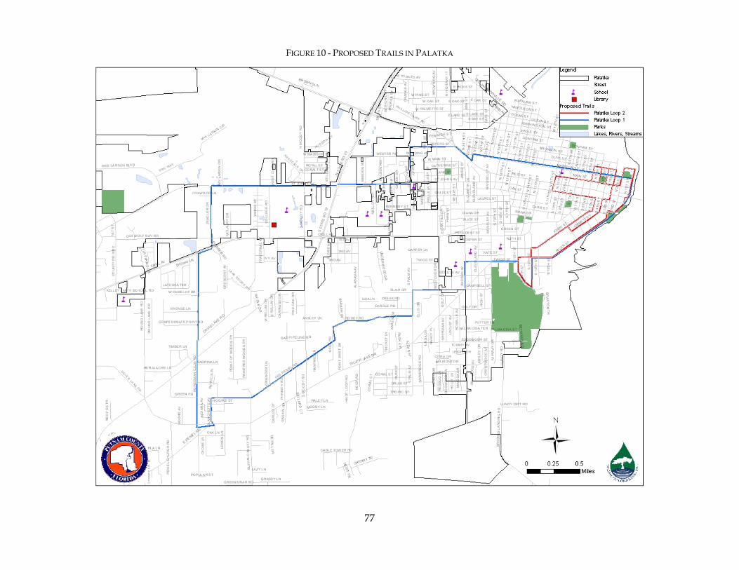
77
FIGURE 10 - PROPOSED TRAILS IN PALATKA
78
Appendix E: Example Trails and Bicycle Related Language from the Alachua County Unified Land Development Code
There are numerous local governments with comprehensive plans, land development codes, and other growth management programs that proactively address trails development. This appendix highlights trails and bicycle related language found in the Unified Land Development Code of neighboring Alachua County. This information is provided simply as example of language used by another Florida county. Other nationally recognized examples of pro-trails planning exist including the cities of Seattle, Washington, Portland, Oregon, Sacramento, California, Davis, California, Colorado Springs, Colorado, Raleigh, North Carolina and the county of Anne Arundel, Maryland. Local examples include the City of Ocala in Marion County and to some degree the City of Leesburg, St. Johns County, and Brevard County. With respect to trails planning and development efforts these jurisdictions generally have a few characteristics in common:
• They have a trails master plan. • They have officially recognized the importance of proper trails development to the
community and established it as a priority within their overall community development plans.
• They have developed or re-vamped their individual growth management programs and regulations to proactively address trails and greenways development.
• They have integrated their individual programs and regulations in a manner to avoid conflicts with regard to trails and greenways development.
• They have identified options for ongoing local funding sources and are working to put these in place or have adopted them already. These funds are utilized for local projects and to leverage outside dollars for those projects.
• They support a trails and/or greenways coordinating body to provide consistent guidance.
Alachua County Unified Land Development Code
As Adopted
December 8, 2005 (Ord.05-10) Amended:
July 11, 2006 (Ord.06-12) July 20, 2006 (Ord.06-14)
November 14, 2006 (Ord.06-36) January 23, 2007 (Ord.07-01)
April 24, 2007 (Ord.07-07) August 14, 2007 (Ord.07-13)
September 11, 2007 (Ord.07-15) March 25, 2008 (Ord. 08-04) April 22, 2008 (Ord. 08-06)
Unified Land Development Code ADOPTED AS ORD. 07-07
Alachua County, Florida i 04/24/2007
Table of Contents
Chapter 400 General Provisions................................................................ 400-1 Article 1 General................................................................................................................. 400-1 Article 2 Official Zoning Map and Zoning Districts............................................................. 400-5 Article 3 Transitional Provisions.......................................................................................... 400-6
Chapter 401 Development Review Bodies ................................................... 401-1 Article 1 General Provisions................................................................................................ 401-1 Article 2 Board of County Commissioners .......................................................................... 401-2 Article 3 Planning Commission........................................................................................... 401-3 Article 4 Board of Adjustment ............................................................................................. 401-7 Article 5 Development Review Committee ....................................................................... 401-12 Article 6 Development Review Departments .................................................................... 401-14
Chapter 402 Development Application Review Procedures .............................. 402-1 Article 1 Applicability and General Provisions.................................................................... 402-1 Article 2 Common Development Application Elements ...................................................... 402-3 Article 3 Preliminary Procedures for All Applications ......................................................... 402-7 Article 4 Notice of Hearings................................................................................................ 402-9 Article 5 Neighborhood Workshops.................................................................................. 402-14 Article 6 Time Limitations for Development Orders.......................................................... 402-16 Article 7 Comprehensive Plan Amendment ...................................................................... 402-17 Article 8 Unified Land Development Code Text Amendments.......................................... 402-21 Article 9 Development Agreement.................................................................................... 402-23 Article 10 Development Plan Review ................................................................................. 402-24 Article 11 Interpretation of Regulations............................................................................... 402-27 Article 12 Platting ............................................................................................................... 402-28 Article 13 Rezoning ............................................................................................................ 402-33 Article 14 Rezoning, Planned Development District ........................................................... 402-36 Article 15 Activity Centers .................................................................................................. 402-40 Article 16 Special Area Plans .............................................................................................. 402-47 Article 17 Special Exceptions .............................................................................................. 402-51 Article 18 Special Use Permits ............................................................................................ 402-54 Article 19 TND and Village Center Applications................................................................. 402-57 Article 20 Development inside the Urban Cluster but outside the Urban Services Line ...... 402-59 Article 21 Water or Sewer Extension outside the Urban Cluster Line .................................. 402-61 Article 22 Building Permits ................................................................................................. 402-63 Article 23 Family Homestead Exceptions ............................................................................ 402-64 Article 24 Temporary Placement Permits ............................................................................ 402-68 Article 25 Temporary Use Permits ...................................................................................... 402-70 Article 26 Variances............................................................................................................ 402-72 Article 27 Vested Rights ...................................................................................................... 402-75 Article 28 Appeal Procedures.............................................................................................. 402-83
Chapter 403 Zoning Districts ................................................................... 403-1 Article 1 Establishment of Zoning Districts.......................................................................... 403-1 Article 2 Rural/Agricultural Districts.................................................................................... 403-4 Article 3 Residential Zoning Districts .................................................................................. 403-6 Article 4 Commercial Districts .......................................................................................... 403-11
ADOPTED AS ORD. 07-07 Unified Land Development Code
04/24/2007 ii Alachua County, Florida
Article 5 Industrial Districts............................................................................................... 403-12 Article 6 Special Purpose Districts..................................................................................... 403-15
Chapter 404 Use Regulations ................................................................... 404-2 Article 1 General Provisions................................................................................................ 404-2 Article 2 Use Table ............................................................................................................. 404-2 Article 3 Agriculture.......................................................................................................... 404-15 Article 4 Household Living ............................................................................................... 404-21 Article 5 Group Housing................................................................................................... 404-26 Article 6 Adult and Child Care .......................................................................................... 404-28 Article 7 Educational Facilities .......................................................................................... 404-30 Article 8 Community Services........................................................................................... 404-32 Article 9 Health and Medical Facilities ............................................................................. 404-35 Article 10 Transportation Terminals .................................................................................... 404-37 Article 11 Utilities ............................................................................................................... 404-38 Article 12 Personal Wireless Services Facilities ................................................................... 404-39 Article 13 Home-Based Businesses ..................................................................................... 404-50 Article 14 Entertainment and Recreation ............................................................................. 404-54 Article 15 Food and Beverage ............................................................................................. 404-58 Article 16 Overnight Accommodations............................................................................... 404-59 Article 17 Retail Sales and Service ...................................................................................... 404-60 Article 18 Self-Service Storage Facilities .............................................................................. 404-63 Article 19 Vehicles Sales and Service.................................................................................. 404-63 Article 20 Outdoor Storage and Display ............................................................................. 404-64 Article 21 Wholesaling, Warehousing, Storage and Distribution......................................... 404-66 Article 22 Light Industrial.................................................................................................... 404-67 Article 23 Waste-Related Services ....................................................................................... 404-68 Article 24 Mining or Excavation and Fill Operations........................................................... 404-71 Article 25 Public Fairground ............................................................................................... 404-86
Chapter 405 Special Districts and Activity Centers ........................................ 405-1 Article 1 Activity Centers and Special Area Studies ............................................................. 405-1 Article 2 Activity Center Development and Design Standards............................................. 405-3 Article 3 Springhills Design Guidelines Overlay District................................................... 405-10 Article 4 Cross Creek Village Special Area Study .............................................................. 405-26 Article 5 Idylwild/Serenola Special Area Study.................................................................. 405-34 Article 6 13th Street Corridor Design Standards ................................................................ 405-45 Article 7 Airport Impact Regulations ................................................................................. 405-50 Article 8 Preservation Buffer Overlay District.................................................................... 405-57 Article 9 Scenic Road Corridors Overlay........................................................................... 405-61 Article 10 (RESERVED) ........................................................................................................ 405-67
Chapter 406 Natural and Historic Resources Protection .................................. 406-1 Article 1 General................................................................................................................. 406-1 Article 2 Trees and Native Vegetation............................................................................... 406-13 Article 3 Significant Plant and Wildlife Habitat ................................................................. 406-16 Article 4 Listed Plant and Animal Species Habitat............................................................. 406-25 Article 5 Strategic Ecosystems ........................................................................................... 406-30 Article 6 Surface Waters and Wetlands ............................................................................. 406-34 Article 7 100-Year Floodplains.......................................................................................... 406-43
Unified Land Development Code ADOPTED AS ORD. 07-07
Alachua County, Florida iii 04/24/2007
Article 8 Springs - RESERVED............................................................................................ 406-51 Article 9 High Aquifer Recharge Areas.............................................................................. 406-52 Article 10 Wellfield Protection............................................................................................ 406-54 Article 11 Wells and Septic Tanks....................................................................................... 406-59 Article 12 Wastewater Treatment Facilities ......................................................................... 406-62 Article 13 Historic Structures and Sites................................................................................ 406-68 Article 14 Archaeological Resources................................................................................... 406-70 Article 15 Paleontological Resources .................................................................................. 406-72 Article 16 Significant Geologic Features.............................................................................. 406-74 Article 17 Conservation Management Areas ....................................................................... 406-78 Article 18 Preservation Management Areas......................................................................... 406-84 Article 19 Wildfire Hazard Mitigation - RESERVED............................................................. 406-85 Article 20 Management Plans.............................................................................................. 406-86 Article 21 Avoidance, Minimization, Mitigation and Monitoring ........................................ 406-88
Chapter 407 General Development Standards .............................................. 407-1 Article 1 Setbacks, Height and Other Standards .................................................................. 407-1 Article 2 Parking, Loading and Stacking .............................................................................. 407-5 Article 3 Signs ................................................................................................................... 407-13 Article 4 Landscaping........................................................................................................ 407-29 Article 5 Open Space ........................................................................................................ 407-49 Article 6 Performance Standards ....................................................................................... 407-54 Article 7 Traditional Neighborhood Development and Village Center.............................. 407-58 Article 8 Subdivision Regulations...................................................................................... 407-75 Article 9 Stormwater Management .................................................................................. 407-108 Article 10 Building Design................................................................................................ 407-120 Article 11 Water and Wastewater Service ......................................................................... 407-122 Article 12 Concurrency Management................................................................................ 407-127 Article 13 Access Management ......................................................................................... 407-133
Chapter 408 Nonconformities .................................................................. 408-1 Article 1 General................................................................................................................. 408-1 Article 2 Nonconforming Structures.................................................................................... 408-3 Article 3 Nonconforming Uses............................................................................................ 408-4 Article 4 Nonconforming Lots ............................................................................................. 408-7 Article 5 Other Nonconformities......................................................................................... 408-9
Chapter 409 Violations, Penalties and Enforcement....................................... 409-1 Article 1 Violations Defined................................................................................................ 409-1 Article 2 Penalties and Remedies ........................................................................................ 409-2
Chapter 410 Definitions ......................................................................... 410-1 Article 1 General................................................................................................................. 410-1 Article 2 Abbreviations ....................................................................................................... 410-1 Article 3 Defined Terms ...................................................................................................... 410-2
Appendix ................................................................................................. A-i
Unified Land Development Code ADOPTED AS ORD. 05-10
Alachua County, Florida 400-1 12/08/2005
Chapter 400 General Provisions
Contents Article 1 General................................................................................................................. 400-1 Article 2 Official Zoning Map and Zoning Districts............................................................. 400-5 Article 3 Transitional Provisions.......................................................................................... 400-6
Article 1 General
400.01 Title
The rules and regulations hereby adopted shall be known and cited as the “Unified Land Development Code of Alachua County, Florida” and may be referred to as “this ULDC.”
400.02 Purposes
This ULDC is adopted for the purpose of promoting the public health, safety and general welfare of the residents and property owners of Alachua County, and to encourage the orderly, harmonious and judicious use of land, consistent with the goals, policies and strategies of the Alachua County Comprehensive Plan. More specifically, this ULDC is adopted to accomplish the following purposes:
(a) To carry out the purpose and intent of and exercise the authority set out in Florida Statutes 163.3202 and to implement the adopted principles, strategies, goals, objectives, policies and maps of the Comprehensive Plan related to the regulation of use and development of land and structures, and apply these standards to guide decisions affecting land use and development within the County.
(b) To protect and conserve property values and property rights, consistent with Florida law and the Constitutions of the State of Florida and the United States.
(c) To provide for adequate light, air and privacy; secure safety from fire, flood and other dangers and from human-made hazards; protect and enhance the aesthetics and character of all parts of the County; and avoid traffic congestion on streets, eliminate conflicts between pedestrian and vehicular movements, and encourage multimodal development.
(d) Without limitation but as a matter of emphasis, to carry out the following more specific purposes:
1. Promote sustainable land development that provides for a balance of economic opportunity, social equity including environmental justice and protection of the natural environment.
2. Base new development upon the provision of necessary services and infrastructure. Focus urban development in a clearly defined area and strengthen the separation of rural and urban uses.
3. Recognize residential neighborhoods as a collective asset for all residents of the County.
4. Create and promote cohesive communities that provide for a full range and mix of land uses.
Chapter 400. General Provisions Article 1. General
Unified Land Development Code ADOPTED AS ORD. 05-10
Alachua County, Florida 400-4 12/08/2005
5. Minimize the conversion of land from rural to urban uses by maximizing the efficient use of available urban infrastructure, while preserving environmentally sensitive areas.
6. Promote land development that maximizes the use of public investments in facilities and services, ensures a proper level of public services for all new development and preserves existing amenities.
7. Promote the spatial organization of neighborhoods, districts and corridors through urban design codes that serve as predictable guides for community development.
8. Prevent or minimize conflicts among different land uses and structures.
9. Establish zoning districts, restricting and regulating therein the construction, reconstruction, alteration and use of buildings, structures and land for residential, commercial, industrial and other specified uses.
10. Provide development standards, criteria and regulations consistent with the Comprehensive Plan for the establishment of uses within the various zoning districts.
11. Provide a range of densities, intensities and uses to implement the future land use categories.
12. Allow clustering and other flexible design options within conventional zones.
13. Ensure that gross density is consistent with the Future Land Use Element, while allowing for provision of unit bonuses for clustering where consistent with the Comprehensive Plan.
14. Encourage mixed-use development.
15. Protect natural resources and conservation areas during the land use planning and development review process through specific provisions for their protection, with an emphasis on designing with nature.
16. Provide performance standards for development in and adjacent to conservation and preservation areas to protect and enhance the natural, physical, biological, ecological, aesthetic and recreational functions of these areas.
17. Provide design standards for the development of streets in a manner consistent with the Corridor Design Manual.
400.03 Application Jurisdiction
Unless otherwise provided in this ULDC, all applicable standards and requirements shall apply to all structures and uses permitted within the unincorporated area of the County as well as to newly annexed areas until the municipality amends its comprehensive plan to include the annexed areas and the amendments are in effect.
400.04 Applicability
(a) The construction, moving, placement, erection, alteration or occupancy, of any building or structure, the use of any building or land, the disturbance of any water, the division of land and the development of land shall take place only in accordance with the requirements of this ULDC.
(b) The construction, or major reconstruction, of all streets in any zoning district, whether public or private, shall conform to, and include the design elements of, the
Chapter 400. General Provisions Article 1. General
Unified Land Development Code ADOPTED AS ORD. 07-13
Alachua County, Florida 400-5 08/14/2007
Alachua County Corridor Design Manual. In addition, all streets must meet the minimum Design and Construction Standards for Streets and Drainage Systems outlined in §407.80 of this ULDC.
(c) In all zoning districts, the Minimum Design and Construction Standards for Pedestrian Networks outlined in §407.81 of this ULDC shall be met. However, if the Development Review Committee determines that an existing or anticipated sidewalk network will not be constructed within a reasonable time to which the subject development could connect, the Developer, at its option, may pay to the County, in lieu of constructing the external sidewalk segment, a cash amount equivalent to the estimated cost of the sidewalk construction. As an incentive to the Developer, the County will reduce the cash amount by five percent (5%) of the estimated cost of construction of the sidewalk. Payment in lieu of construction would be placed into a fund that can be used only for construction of bicycle or pedestrian facilities in an alternative location to be determined by the County.
(d) Ongoing agriculture and silviculture farming operations that are not part of a development application and that meet the provisions and criteria pursuant to F.S. Chapter 163.3162, the Agricultural Lands and Practices Act, or F.S. 823.14(6), the Right to Farm Act, shall be exempt from any provisions of this ULDC that were not in existence as of July 1, 2003.
400.05 Minimum or Maximum Requirements
The provisions of this ULDC shall be the minimum or maximum requirements, as applicable, adopted for the promotion of the public health, safety or general welfare.
400.06 Conflicting Provisions
Wherever any requirement of this ULDC conflicts with the requirements of any other regulation or ordinance, the most restrictive requirement or that imposing the higher standards shall govern unless otherwise specifically provided.
400.07 Deed Restrictions
The enforcement and interpretation of this ULDC shall not be affected by deed restrictions, covenants or easements, other than those made as a condition of approval of a development application under this ULDC or any predecessor ordinance.
400.08 Effective Date
This ULDC shall become effective as of January 30, 2006, but not before the date a certified copy of the ordinance adopting this ULDC is filed with the Department of State, as provided in Chapter 125.66, Florida Statutes.
400.09 Designees
Unless otherwise specified in this ULDC, the identification of certain officials, including the County Manager, Director of Growth Management, County Attorney or any other Department Director or County Official to perform a task or carry out a specific responsibility, shall also include the designee of such official. Unless otherwise specified in this ULDC, the term “Director” shall mean the Director of Growth Management and the term “Department “shall mean the Department of Growth Management.
Chapter 402. Development Application Review Procedures Article 1. Applicability and General Provisions
Unified Land Development Code ADOPTED AS ORD. 05-10
Alachua County, Florida 402-1 12/08/2005
Chapter 402 Development Application Review Procedures
Contents
Article 1 Applicability and General Provisions.................................................................... 402-1 Article 2 Common Development Application Elements ...................................................... 402-3 Article 3 Preliminary Procedures for All Applications ......................................................... 402-7 Article 4 Notice of Hearings................................................................................................ 402-9 Article 5 Neighborhood Workshops.................................................................................. 402-14 Article 6 Time Limitations for Development Orders.......................................................... 402-16 Article 7 Comprehensive Plan Amendment ...................................................................... 402-17 Article 8 Unified Land Development Code Text Amendments.......................................... 402-21 Article 9 Development Agreement.................................................................................... 402-23 Article 10 Development Plan Review ................................................................................. 402-24 Article 11 Interpretation of Regulations............................................................................... 402-27 Article 12 Platting ............................................................................................................... 402-28 Article 13 Rezoning ............................................................................................................ 402-33 Article 14 Rezoning, Planned Development District ........................................................... 402-36 Article 15 Activity Centers .................................................................................................. 402-40 Article 16 Special Area Plans .............................................................................................. 402-47 Article 17 Special Exceptions .............................................................................................. 402-51 Article 18 Special Use Permits ............................................................................................ 402-54 Article 19 TND and Village Center Applications................................................................. 402-57 Article 20 Development inside the Urban Cluster but outside the Urban Services Line ...... 402-59 Article 21 Water or Sewer Extension outside the Urban Cluster Line .................................. 402-61 Article 22 Building Permits ................................................................................................. 402-63 Article 23 Family Homestead Exceptions ............................................................................ 402-64 Article 24 Temporary Placement Permits ............................................................................ 402-68 Article 25 Temporary Use Permits ...................................................................................... 402-70 Article 26 Variances............................................................................................................ 402-72 Article 27 Vested Rights ...................................................................................................... 402-75 Article 28 Appeal Procedures.............................................................................................. 402-83
Article 1 Applicability and General Provisions
402.01 Purpose
The purpose of this Chapter is to provide the procedures and general standards for review of development, development activity and other applications that are submitted to officers or bodies of Alachua County for review under this ULDC. Unless otherwise provided in this Chapter or this ULDC, the Director shall establish the detailed procedures for development review, including the following:
(a) dates and deadlines for submitting applications;
(b) application forms;
(c) required documents and information to accompany application forms;
(d) public notice;
(e) completeness review;
(f) sufficiency review;
Chapter 402. Development Application Review Procedures Article 5. Neighborhood Workshops
ADOPTED AS ORD.08-06 Unified Land Development Code
4/22/2008 402-14 Alachua County, Florida
Article 5 Neighborhood Workshops
402.17 Neighborhood Workshop
(a) Purpose
The purpose of a neighborhood workshop is to ensure early citizen participation in an informal forum in conjunction with development applications, and to provide an applicant the opportunity to understand and try to mitigate any impacts an application may have on an affected community. These workshops ensure that citizens and property owners have an adequate opportunity to learn about applications that may affect them and to work with the applicant to resolve any concerns at an early stage of the process. A neighborhood workshop is not intended to produce complete consensus on all applications, but to encourage applicants to be good neighbors and to allow for informed decision making. If an applicant fails to hold a required neighborhood meeting, the Department shall not accept that development application for review.
(b) Public Notice
Public notice of a neighborhood workshop shall be provided as indicated below.
1. Notice to Director
An applicant holding a neighborhood workshop shall coordinate with the Director prior to scheduling the workshop.
2. Notice Required
a. The applicant shall provide notification by mail according to Article 4, Notice of Hearings, of this Chapter. The Director shall provide a mailing list to the applicant. The applicant shall mail these notices with proper postage a minimum of 15 days before the workshop.
b. The applicant shall publish notice of the workshop according to Article 4, Notice of Hearings, of this Chapter, in a newspaper of general circulation a minimum of 10 days before the workshop. The advertisement shall be a minimum of two columns wide and four inches long. The ad shall be titled “Public Notice,” with a description of the request, a location map and contact information.
3. Postponed Workshops
New public notice consistent with Section above shall be provided for any rescheduled workshop.
402.18 General Requirements
(a) Workshop Time and Location
The workshop shall start between 6:00 p.m. and 8:00 p.m. on a weekday or between 9:00 a.m. and 5:00 p.m. on a weekend. The initial workshop shall be held within the general area of the subject property. Additional workshops may be held but are not required.
(b) Workshop Summary
The applicant shall submit to the Department, as part of the application, a summary of the materials presented at the workshop, the issues raised by those in attendance, the suggestions and concerns of those in attendance, a copy of the sign-in sheet, a

Chapter 402. Development Application Review Procedures Article 5. Neighborhood Workshops
Unified Land Development Code ADOPTED AS ORD. 05-10
Alachua County, Florida 402-15 12/08/2005
copy of the workshop advertisement and a copy of the mailed notices sent to property owners.
(c) Workshop Elements
At the workshop, the applicant shall present the following, as applicable:
1. A general concept plan for the use of all included lands. Such plans shall indicate the general location of residential areas (including density and unit types), open space, active or resource-based recreation areas, natural areas (including wetlands and flood plains), and non-residential areas (including maximum square footage and maximum height).
2. A plan of vehicular, bicycle, and pedestrian circulation showing the general locations and right-of-way widths of roads, sidewalks and access points to the external and internal thoroughfare network.
3. Drawings indicating the conceptual architectural theme or appearance and representative building types.

Chapter 402. Development Application Review Procedures Article 14. Rezoning, Planned Development District
ADOPTED AS ORD. 05-10 Unified Land Development Code
12/08/2005 402-36 Alachua County, Florida
Article 14 Rezoning, Planned Development District
402.80 Processing
Applications for a rezoning for a planned development district (PD) shall be processed in accordance with Article 13, Rezoning, of this Chapter.
402.81 Pre-application Conference
Prior to the submittal of an application for a rezoning for a planned development district, the applicant shall request and participate in a pre-application conference with the Department.
402.82 Neighborhood Workshop
An applicant shall hold a neighborhood workshop prior to submittal of an application for a rezoning for a planned development district in accordance with Article 5, Neighborhood Workshops, of this Chapter.
402.83 Required Public Notice
Prior to a public hearing on a rezoning, published, posted and mailed notice is required in accordance with the procedures in Article 4, Notice of Hearings, of this Chapter.
402.84 Application Requirements
(a) Basic Application Requirements
An application for a planned development district rezoning shall be submitted in accordance with Article 2, Common Development Application Elements, of this Chapter.
(b) Additional Application Requirements
In addition, the application for a planned development shall include a proposed PD master plan for the property. The required elements of a PD master plan shall be established by the Director.
402.85 Action upon Rezoning and Zoning Master Plan Approval
Prior to submitting a preliminary development plan for an approved PD or any phase of an approved PD, the applicant shall submit six copies of the approved zoning master plan to the Department for signatures from the Development Review Departments. The zoning master plan shall contain all changes and conditions approved by the Board of County Commissioners.
402.86 Implementation of Zoning Master Plan
(a) Development Plan Required
An approved PD master plan, including individual phases of such plan, shall be implemented by a development plan, which shall be submitted in accordance with Article 10, Development Plan Review, of this Chapter. A copy of the approved PD master plan, signed by the Development Review Departments, shall be submitted with each application for development plan approval. Any development plan approval shall be consistent with the approved PD master plan.
Pre-
Application
Submit
Application
Board of County Commissioners Public Hearing & Final Action
Report and
Recommendation
Planning Commission
Public Hearing &
Recommendation
Neighborhood
Workshop
Completeness & Sufficiency Review
Chapter 402. Development Application Review Procedures Article 14. Rezoning, Planned Development District
Unified Land Development Code ADOPTED AS ORD. 05-10
Alachua County, Florida 402-37 12/08/2005
(b) Progress Report
With each application for development plan approval, the developer of a planned development shall submit a progress report to the review body. At a minimum, the progress report shall include the following information listed below.
1. Updated Master Zoning Plan
An updated zoning master plan for the entire development indicating the status of approvals, phasing schedule, undeveloped areas and within developed areas, the number, size, type and locations of all structures and improvements that have been installed or constructed.
2. Subsequent Developers or Owners
The names of any subsequent developers and owners of any increments, phases or portions of the planned development.
3. Failure to File or Update Progress Report
If the required progress report is not up to date or is not filed, additional development approvals shall not be granted.
402.87 Covenants, Grants, and Easements
(a) As part of the approval for any development plan, the plan shall include the substance and exact language of covenants, grants, easements or other restrictions to be imposed on the use of the land, buildings and structures pursuant to this ULDC, including proposed easements for public and private utilities.
(b) Prior to final approval of the development plan, the language of all covenants, grants, easements or other restrictions, including any required homeowners' associations and deed restrictions, shall be approved by the County Attorney.
402.88 Other Restrictions
(a) Limit on Occupancy Permits
Occupancy permits exceeding 50 percent of the total number of approved dwelling units shall not be issued unless and until the homeowners' association and all applicable and agreed-upon covenants or deed restrictions have become operational or are imposed to the satisfaction of the County Attorney.
(b) Development Plan Approval Requisite for Permits
Permits shall not be issued for any phase of a planned development, nor shall any public facility or improvement be constructed therein, until a development plan and/or plat has been approved for the planned development or phase of such development.
402.89 Revision of Zoning Master Plan
Specific changes to the location and distribution of uses within the development, if specifically authorized on the approved zoning master plan or authorized in an approved condition, shall not be considered a change to the zoning master plan.
(a) Minor Amendment to Planned Development District Approval
An amendment to an existing planned development shall be considered minor where it will not cause an expansion to the existing use or additional impacts to surrounding properties, natural resources, or public infrastructure. A minor amendment to an existing planned development shall not require a Planning
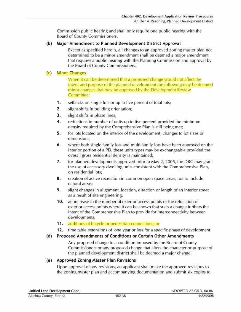
Chapter 402. Development Application Review Procedures Article 14. Rezoning, Planned Development District
Unified Land Development Code ADOPTED AS ORD. 08-06
Alachua County, Florida 402-38 4/22/2008
Commission public hearing and shall only require one public hearing with the Board of County Commissioners.
(b) Major Amendment to Planned Development District Approval
Except as specified herein, all changes to an approved zoning master plan not determined to be a minor amendment shall be deemed a major amendment that requires a public hearing with the Planning Commission and approval by the Board of County Commissioners.
(c) Minor Changes
When it can be determined that a proposed change would not affect the intent and purpose of the planned development the following may be deemed minor changes that may be approved by the Development Review Committee:
1. setbacks on single lots or up to five percent of total lots;
2. slight shifts in building orientation;
3. slight shifts in phase lines;
4. reductions in number of units up to five percent provided the minimum density required by the Comprehensive Plan is still being met;
5. for lots located on the interior of the development, changes to lot sizes or dimensions;
6. where both single family lots and multi-family lots have been approved on the interior portion of a PD, these units types may be exchangeable provided the overall gross residential density is maintained;
7. for planned developments approved prior to May 2, 2005, the DRC may grant the use of accessory dwelling units consistent with the Comprehensive Plan, on residential lots;
8. creation of active recreation in common open space areas, not to include natural areas;
9. slight changes in alignment, location, direction or length of an interior street as a result of site engineering;
10. an increase in the number of exterior access points or the relocation of exterior access points where it can be shown that such a change furthers the intent of the Comprehensive Plan to provide for interconnectivity between developments;
11. additions of bicycle or pedestrian connections; or
12. time table extensions of one year or less for a specific phase of development.
(d) Proposed Amendments of Conditions or Certain Other Amendments
Any proposed change to a condition imposed by the Board of County Commissioners or any proposed change that alters the character or purpose of the planned development district shall be deemed a major change.
(e) Approved Zoning Master Plan Revisions
Upon approval of any revisions, an applicant shall make the approved revisions to the zoning master plan and accompanying documentation and submit six copies to

Chapter 402. Development Application Review Procedures Article 15. Activity Centers
ADOPTED AS ORD. 07-07 Unified Land Development Code
4/24/2007 402-40 Alachua County, Florida
Article 15 Activity Centers
402.92 Activity Centers
Activity Centers provide for the concentration of mixtures of higher intensity and density land uses through designation of Activity Centers on the Future Land Use Map. Development within or changes to an existing activity center or the creation of new activity centers shall follow the procedures of this Article.
402.93 Activity Center Master Plan
(a) General.
1. All activity centers shall be governed by a Master Plan, as described in this Article, and as required by Policy 2.1.7 of the Future Land Use Element of the Comprehensive Plan.
2. The regulations contained herein are intended to provide a means of incorporating the general activity center development standards contained in the adopted Comprehensive Plan into Master Plans for all activity centers.
3. Master Plans shall ensure that development within activity centers is coordinated in such a way that promotes the creation of pedestrian-friendly compact centers that are economically viable, served by adequate public facilities, connected to a multi-modal transportation system and are integrated with surrounding and internal land uses.
(b) Intent of Master Plan Review
In addition to meeting the requirements of the Comprehensive Plan, the intent of Master Plan review is as follows:
1. To provide an initial review of proposed development and its basic development concepts prior to proceeding with phase-by-phase development plan and/or plat review within activity centers. It is intended that the level of information needed for Master Plan review will not require extensive site engineering, but will require basic analysis of existing site conditions and future planning considerations for the overall activity center, and
2. To provide a mechanism to facilitate the provision of shared infrastructure within activity centers, including but not limited to, multi-modal transportation facilities, stormwater facilities, open space, and civic space.
(c) Standards for Approval of Master Plans
1. Master Plans shall be consistent with all applicable policies of the Alachua County Comprehensive Plan.
2. Master Plans shall be consistent with Chapter 405, Article 2, Activity Center Development and Design Standards, of this ULDC.
3. Master Plans shall be consistent with all applicable general development standards of Chapter 407 of this ULDC.
4. All necessary public facilities (both on and off site), such as transportation, sanitation, water, sewer, stormwater, emergency services, education, recreation, and civic space shall be adequate to serve the proposed land uses in the Master Plan area.

Chapter 402. Development Application Review Procedures Article 15. Activity Centers
ADOPTED AS ORD. 07-07 Unified Land Development Code
4/24/2007 402-42 Alachua County, Florida
b. is consistent with all general activity center policies contained in the Comprehensive Plan’s Future Land Use Element 2.0 Urban Activity Center Policies.
3. Retail establishments of 100,000 square feet Gross Floor Area (GFA) or more require adoption of Master Plan.
(f) Master Plan Elements
An activity center Master Plan shall provide for a specific plan of development for each activity center to implement the general activity center policies and existing activity center plans contained in the Comprehensive Plan’s Future Land Use Element 2.0 Urban Activity Center Policies. Master Plans shall be adopted under the provisions of Article 8 of this Chapter, Unified Land Development Code Text Amendments, into this ULDC, and may be in the form of text regulations, maps, and/or illustrations. The Master Plan shall, at a minimum, address the following considerations:
1. Permitted land use types, including:
a. A range of gross floor area and type of non-residential uses, and
b. A range of the number and type of residential dwelling units.
2. General arrangement and location of permitted land use types.
3. Infrastructure planning, including identification of needs, means of financing, phasing, and opportunities for shared infrastructure for the Master Plan area.
4. General Development standards for the Master Plan area including arrangement of buildings and streets, setbacks, building heights, lot coverage, floor area ratio, and building design.
5. Estimate of the required parking for the proposed land use types, general location of parking areas, and opportunities for shared parking if applicable.
6. Landscaping and buffering standards.
7. General location, dimensions, and type of stormwater facilities that will serve all land uses within the Master Plan area. Opportunities for shared stormwater facilities shall be identified at the master plan stage.
8. General standards for signage within the Master Plan area.
9. General location, dimensions, and type of open space areas that will serve all land uses within the Master Plan area. This shall include any opportunities for shared open space if applicable.
10. General location, dimensions, and type of civic use areas that will serve all land uses within the Master Plan area. This shall include any opportunities for shared civic use areas if applicable.
11. Traffic circulation plan for the Master Plan area including automobile, transit, bicycle, and pedestrian circulation. The traffic circulation plan shall provide for multi-modal connections throughout the activity center and into surrounding areas. The traffic circulation plan shall also provide for proposed access points to the activity center from the surrounding road network.
(g) Minimum Land Area for Master Plans
An activity center Master Plan shall apply to at least one quadrant within the activity center, but should apply to the entire activity center, where feasible. For the

Chapter 402. Development Application Review Procedures Article 15. Activity Centers
Unified Land Development Code ADOPTED AS ORD. 05-10
Alachua County, Florida 402-43 4/24/2007
purpose of this Article, a quadrant is the division of an Activity Center made by the intersection of the two major roadways within the Activity Center.
(h) Master Plan Participants
1. The Master Planning process shall be a collaborative effort between the County, property owners, and the public.
2. Activity Center Master Plans may be initiated by the County, a property owner, or group of property owners.
(i) Master Plan Application Requirements
An application for an Activity Center Master Plan shall include the following:
1. all of the requirements of Article 2, Common Development Application Elements, of this Chapter.
2. all of the requirements of Article 8, Unified Land Development Code Text Amendments, of this Chapter.
3. all of the items listed above in §402.93(f), Master Plan Elements.
4. Multi-modal Transportation Impact Analysis
A multi-modal transportation analysis shall be prepared by a qualified traffic engineer. This analysis shall provide detailed information on the availability of facilities to accommodate multiple modes of transportation, including but not limited to, vehicle roadways, bicycle thoroughfares, pedestrian infrastructure, and transit service. For proposed retail establishments of 100,000 square feet GFA or more, the transportation study should include the effect the proposed retail establishment would have on average vehicle miles traveled.
5. Infrastructure Plan
An infrastructure plan shall provide a general analysis of the infrastructure needs for the Master Plan area at buildout conditions, and a phasing and financing plan for any needed infrastructure improvements associated with development in the Master Plan area. Infrastructure shall include, but is not limited to multi-modal transportation facilities, stormwater management facilities, utilities, open space, and civic space. Mechanisms for implementing shared infrastructure shall be provided.
6. Market Feasibility Analysis and Employment Study
a. A market feasibility analysis must demonstrate that the proposed land uses and development intensities for the activity center are economically feasible and needed in light of existing and future development of similar types as well as existing and future populations within the market area of the activity center. The market area shall be delineated in the analysis. For retail establishments of 100,000 square feet GFA or more, adjoining market areas shall also be delineated, if applicable. At a minimum, all market feasibility studies shall take into account the following:
i. Current population of the market area of an activity center, future population of the market area of an activity center, the number of people the center is estimated to serve, existing residential development within the market area, and future residential
Chapter 402. Development Application Review Procedures Article 16. Special Area Plans
Unified Land Development Code ADOPTED AS ORD. 05-10
Alachua County, Florida 402-47 4/24/2007
Article 16 Special Area Plans
402.96 Purpose
Special Area Plans are established as one mechanism to protect unique environmental, historic, or cultural resources within strategic ecosystems, significant habitat areas, listed species habitat areas, or to address specific needs and circumstances in other areas designated by the Board of County Commissioners in order to enhance livability, protect the character of a neighborhood, provide amenities, plan for traffic management, and facilitate joint planning with municipalities. Where a Special Area Plan is required, the process is designed to facilitate the collaborative planning of these areas in order to provide integrated protection of resources and to provide for shared infrastructure and common open space.
402.97 Applicability
The adoption of a Special Area Plan is required for:
(a) Strategic ecosystems, as identified within the KBN/Golder Associates report, “Alachua County Ecological Inventory Project” (1996), and mapped generally on the KBN/Golder Ecological Inventory Map adopted in the Future Land Use Element of the Comprehensive Plan; except as provided in Article 5, Strategic Ecosystems, of Chapter 406.
(b) Other areas specifically designated by the Board of County Commissioners as part of a community and neighborhood planning program effort to address specific needs and circumstances.
(c) Properties containing significant habitat areas or listed species habitat areas if required by Chapter 406, Article 3.
402.98 Special Area Planning Process
The process required for the development or expansion of a Special Area Plan may be initiated by the County, a property owner, or group of property owners within an individual strategic ecosystem, adjacent strategic ecosystems, or other areas designated for Special Area Planning. The Special Area Planning process consists of the following basic components:
(a) A scope of work that defines the geographic extent of the study and the level of detail of the planning effort;
(b) A Special Area Study that includes a public participation process, a scientific assessment of resources, analysis of infrastructure, and a land use analysis;
(c) A Special Area Plan that provides a specific land use and resource protection plan, including development guidelines, to direct the type, manner, and location of future activities, and to plan for infrastructure needs.
402.99 Pre-Application Conference
Prior to the initiation of the Special Area Planning process, an applicant shall request and participate in a pre-application conference with the Department. At this conference, the Department will identify specific issues that must be addressed during the process.
Chapter 402. Development Application Review Procedures Article 16. Special Area Plans
Unified Land Development Code ADOPTED AS ORD. 05-10
Alachua County, Florida 402-49 4/24/2007
2. Approval with modifications; or
3. Denial.
402.101 Special Area Study
After the scope of work is approved, the Special Area Study shall be conducted in accordance with the approved scope of work to create a ground-truthed resource assessment and an infrastructure and land use analysis that will provide the supporting data and analysis for the Special Area Plan. This process shall be a collaborative effort between the County, property owners, and the public, and shall involve the following steps.
(a) Stakeholders Workshop
All property owners within the area defined by the scope of the Special Area Study, as well as other registered stakeholders, shall be notified in writing of the intent to develop a plan for the area, and shall be encouraged to participate in the planning process. Prior to the submittal of an application for a Special Area Plan, an applicant, including the County, shall hold a stakeholders workshop. The workshop shall be conducted and documented in accordance with Article 5, Neighborhood Workshops, of this Chapter.
(b) Ground-Truthing of Site
Site-specific ground-truthing of natural resources shall be conducted to evaluate critical system functions and values in accordance with the requirements of the natural and historic resources assessment (see Chapter 406, §406.04). For Special Area Studies within strategic ecosystems, site-specific ground-truthing shall be conducted using the KBN/Golder report, background mapping and historical data, and other specific factors identified in Article 5 of Chapter 406, as a guide to develop a current scientific assessment of the systems involved. The location and extent of specific natural resources, as well as higher and lower valued portions of the strategic ecosystem(s), shall be delineated within the study area, and with respect to surrounding ecosystems. Those areas found not to contain strategic ecosystem resources shall be eligible for consideration for development as part of a development plan or Special Area Plan provided the ecological integrity of the strategic ecosystem as a whole will be sufficiently protected.
(c) Public Infrastructure and Services
The study shall identify potential access to public infrastructure and services, and issues and needs related to public infrastructure and services.
(d) Land Use Analysis
The study participants shall determine one or more scenarios for the future uses of land within the area of study and identify the most appropriate locations for various types of land use, including as applicable, agriculture or silviculture activities and conservation areas. Parcel ownership and management considerations shall be evaluated in order to develop a scenario that balances protection of the natural and historic resources with ownership interests and protection of private property rights.
402.102 Special Area Plan
Once completed, a Special Area Study shall form the basis for the submittal of a Special Area Plan. The Special Area Plan shall be in the form of text regulations, illustrations, and maps that are adopted into this Unified Land Development Code, and as necessary, adopted into the
Chapter 402. Development Application Review Procedures Article 16. Special Area Plans
Unified Land Development Code ADOPTED AS ORD. 08-06
Alachua County, Florida 402-50 4/22/2008
Comprehensive Plan. General development standards shall be consistent with the requirements of Chapters 406 and 407. The Special Area Plan shall, at a minimum, address the following considerations:
(a) Permitted land use types, including:
1. A range of gross floor area and type of non-residential uses, and
2. A range of the number and type of residential dwelling units.
(b) General arrangement and location of permitted land use types and their density or intensity.
(c) Infrastructure planning, including identification of needs, phasing, and opportunities for shared infrastructure.
(d) Landscaping and buffering standards.
(e) General location and type of stormwater facilities that will serve all land uses within the Special Area Plan.
(f) General location, dimensions, and type of open space areas that will serve all land uses within the Special Area Plan.
(g) Transportation circulation plan including automobile, transit, bicycle, and pedestrian circulation. The transportation circulation plan shall provide for proposed access points to the development from the surrounding road network.
(h) Description of protection methods and management strategies for conservation management areas, including conservation easements or management plans. Specific discussion of how important ecosystem values are maintained long-term.
(i) A set of specific resource standards shall be prepared consistent with the goals and policies of the Conservation and Open Space Element of the Comprehensive Plan. They shall be based upon information developed from the special area study and relate to all of a natural resources and processes of the strategic ecosystem or other relevant natural and community resources. These standards will ensure the continued functioning of natural processes by considering cumulative impact information generated from the study’s impact assessments.
402.103 Adoption of Special Area Plans
A Special Area Plan shall be adopted through public hearings, as amendments to this ULDC, in accordance with Article 8, Unified Land Development Code Text Amendments, of this Chapter. The Comprehensive Plan may require map or text amendments in connection with the adoption of a Special Area Plan, in order to permit the land uses and development types. Such amendments shall be processed in accordance with Article 7, Comprehensive Plan Amendment, of this Chapter. Once adopted, the Special Area Plan will govern all subsequent development requests within its boundaries.
402.104 Implementation of Special Area Plans
Development plan applications within established Special Area Plans shall be submitted and processed in accordance with Article 10 of this Chapter, Development Plan Review. If a Special Area Plan has been adopted that applies to the parcels proposed for development, the applicant shall be required to demonstrate compliance with the adopted Special Area Plan.
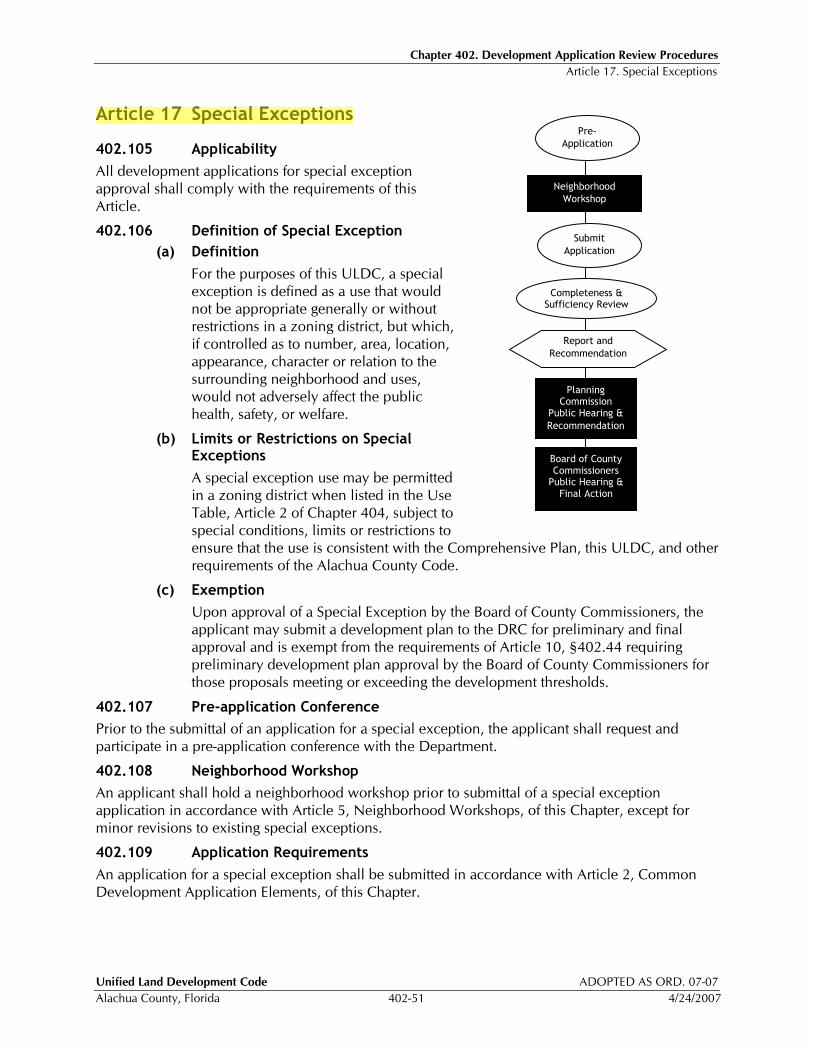
Chapter 402. Development Application Review Procedures Article 17. Special Exceptions
Unified Land Development Code ADOPTED AS ORD. 07-07
Alachua County, Florida 402-51 4/24/2007
Article 17 Special Exceptions
402.105 Applicability
All development applications for special exception approval shall comply with the requirements of this Article.
402.106 Definition of Special Exception
(a) Definition
For the purposes of this ULDC, a special exception is defined as a use that would not be appropriate generally or without restrictions in a zoning district, but which, if controlled as to number, area, location, appearance, character or relation to the surrounding neighborhood and uses, would not adversely affect the public health, safety, or welfare.
(b) Limits or Restrictions on Special Exceptions
A special exception use may be permitted in a zoning district when listed in the Use Table, Article 2 of Chapter 404, subject to special conditions, limits or restrictions to ensure that the use is consistent with the Comprehensive Plan, this ULDC, and other requirements of the Alachua County Code.
(c) Exemption
Upon approval of a Special Exception by the Board of County Commissioners, the applicant may submit a development plan to the DRC for preliminary and final approval and is exempt from the requirements of Article 10, §402.44 requiring preliminary development plan approval by the Board of County Commissioners for those proposals meeting or exceeding the development thresholds.
402.107 Pre-application Conference
Prior to the submittal of an application for a special exception, the applicant shall request and participate in a pre-application conference with the Department.
402.108 Neighborhood Workshop
An applicant shall hold a neighborhood workshop prior to submittal of a special exception application in accordance with Article 5, Neighborhood Workshops, of this Chapter, except for minor revisions to existing special exceptions.
402.109 Application Requirements
An application for a special exception shall be submitted in accordance with Article 2, Common Development Application Elements, of this Chapter.
Pre-
Application
Submit
Application
Board of County Commissioners Public Hearing & Final Action
Report and
Recommendation
Planning Commission
Public Hearing &
Recommendation
Neighborhood
Workshop
Completeness & Sufficiency Review
Chapter 402. Development Application Review Procedures Article 17. Special Exceptions
ADOPTED AS ORD. 05-10 Unified Land Development Code
12/08/2005 402-52 Alachua County, Florida
402.110 Public Notice Requirements
Mailed notice, published notice and posted notice shall be required before the first public hearing on any application for special exception or for revision of an existing special exception, in accordance with the procedures outlined in Article 4, Notice of Hearings, of this Chapter. Any subsequent public hearing shall require only published and posted notice.
402.111 Review by the Planning Commission
(a) Planning Commission Public Hearing
All development applications for special exception approval shall be considered by the Planning Commission at a public hearing, prior to a public hearing or action by the Board of County Commissioners.
(b) Consideration of Special Exception Applications
The Planning Commission shall consider a proposed special exception utilizing the criteria for approval listed in §402.113.
(c) Planning Commission Recommendation
A recommendation shall be prepared and forwarded to the Board of County Commissioners. The recommendation shall indicate if the proposed special exception should be approved, approved with conditions or denied.
402.112 Action by the Board of County Commissioners
(a) Public Hearing
Upon receipt of the recommendations from the Planning Commission, the Board of County Commissioners shall hold a public hearing to consider a proposed special exception.
(b) Action by the Board of County Commissioners
Following the public hearing, the Board of County Commissioners may take one of the following actions:
1. approve the special exception application;
2. approve the special exception application with conditions and limitations; or
3. deny the special exception application.
402.113 Criteria for Approval
The Board of County Commissioners shall, as part of a decision to approve an application for special exception, make a finding that an application complies with both the general criteria and the review factors listed below.
(a) the proposed use is consistent with the Comprehensive Plan and ULDC;
(b) the proposed use is compatible with the existing land use pattern and future uses designated by the Comprehensive Plan;
(c) the proposed use shall not adversely affect the health, safety, and welfare of the public; and
(d) satisfactory provisions and arrangements have been made concerning the following matters, where applicable:
1. ingress and egress to the property and proposed structures thereon with particular reference to automotive, bicycle, and pedestrian safety and convenience, traffic flow and control and access in case of fire or catastrophe;
Chapter 402. Development Application Review Procedures Article 18. Special Use Permits
Unified Land Development Code ADOPTED AS ORD. 05-10
Alachua County, Florida 402-54 12/08/2005
Article 18 Special Use Permits
402.117 Applicability
All development applications for a special use permit approval shall comply with the requirements of this Article.
402.118 Pre-application Conference
Prior to the submittal of an application for a special use permit, the applicant shall request and participate in a pre-application conference with the Department.
402.119 Neighborhood Workshop
An applicant shall hold a neighborhood workshop prior to submittal of a special use permit application in accordance with Article 5, Neighborhood Workshops, of this Chapter.
402.120 Application Requirements
An application for a special use permit shall be submitted in accordance with Article 2, Common Development Application Elements, of this Chapter.
402.121 Public Notice Requirements
Mailed notice, published notice and posted notice shall be required for any application for a special use permit in accordance with the procedures in Article 4, Notice of Hearings, of this Chapter.
402.122 Review by the Planning Commission
(a) Planning Commission Public Hearing
All development applications for special use permits shall be considered by the Planning Commission at a public hearing, prior to a public hearing or action by the Board of County Commissioners.
(b) Consideration of Special Use Permit Applications
The Planning Commission shall consider a proposed special use permit utilizing the criteria for approval listed in §402.114.
(c) Planning Commission Recommendation
A recommendation shall be prepared and forwarded to the Board of County Commissioners. The recommendation shall indicate if the proposed special use permit should be approved, approved with conditions or denied.
402.123 Action by the Board of County Commissioners
(a) Public Hearing
Upon receipt of the recommendation from the Planning Commission, the Board of County Commissioners shall hold a public hearing to consider a proposed special use permit.
(b) Action by the Board of County Commissioners
Following the public hearing, the Board of County Commissioners may take one of the following actions:
1. approve the special use permit application;
2. approve the special use permit application with conditions and limitations; or
3. deny the special use permit application.
Chapter 402. Development Application Review Procedures Article 18. Special Use Permits
Unified Land Development Code ADOPTED AS ORD. 07-07
Alachua County, Florida 402-55 4/24/2007
(c) Development Plan Approval Exemption
Upon approval of a Special Use Permit by the Board of County Commissioners, the applicant may submit a development plan to the DRC for preliminary and final approval and is exempt from the requirements of Article 10, §402.44 requiring preliminary development plan approval by the Board of County Commissioners for those proposals meeting or exceeding the development thresholds.
402.124 Criteria for Approval
The Board of County Commissioners shall, as part of a decision to approve an application for a special use permit, make a finding that an application complies with both the general criteria and the review factors listed below:
(a) the proposed use is consistent with the Comprehensive Plan and ULDC;
(b) the proposed use is compatible with the existing land use pattern and future uses designated by the Comprehensive Plan;
(c) the proposed use shall not adversely affect the health, safety, and welfare of the public; and
(d) satisfactory provisions and arrangements have been made concerning the following matters, where applicable:
1. ingress and egress to the property and proposed structures thereon with particular reference to automotive, bicycle, and pedestrian safety and convenience, traffic flow and control and access in case of fire or catastrophe;
2. off-street parking and loading areas where required, with particular attention to item 1 above;
3. the noise, glare or odor effects of the special exception on surrounding properties;
4. refuse and service areas, with particular reference to location, screening and items 1 and 2 above;
5. Utilities, with reference to location and availability;
6. Screening and buffering with reference to type, dimensions and character;
7. Signs, if any, and proposed exterior lighting with reference to glare, traffic safety and compatibility with surrounding properties;
8. Required yards and other open space;
9. General compatibility with surrounding properties; and
10. Any special requirements set forth in this ULDC for the particular use involved.
402.125 Conditions and Safeguards
In granting any special use permit, the Board of County Commissioners may prescribe appropriate conditions and safeguards in order to protect public health, safety, and welfare, in conformity with this ULDC. Failure to comply with the conditions adopted as part of a special use permit shall constitute a violation punishable by the penalties and remedies outlined in Chapter 409 of this ULDC.
Unified Land Development Code ADOPTED AS ORD. 05-10
Alachua County, Florida 403-1 12/08/2005
Chapter 403 Zoning Districts
Contents Article 1 Establishment of Zoning Districts.......................................................................... 403-1 Article 2 Rural/Agricultural Districts.................................................................................... 403-4 Article 3 Residential Zoning Districts .................................................................................. 403-6 Article 4 Commercial Districts .......................................................................................... 403-11 Article 5 Industrial Districts............................................................................................... 403-12 Article 6 Special Purpose Districts..................................................................................... 403-15
Article 1 Establishment of Zoning Districts
This Chapter provides for the establishment of zoning districts that implement the Future Land Use Designations adopted on the Future Land Use Map 2020. These zoning districts also implement the goals, objectives and policies of the Alachua County Comprehensive Plan and adopted maps. Zoning district standards, dimensional and area requirements are established in this Chapter. Permitted uses are provided for in Chapter 404 of this ULDC.
403.01 Official Zoning Map Adopted
The Official Zoning Map of Alachua County, Florida on file in the Department of Growth Management (Department), together with all explanatory matter thereon, is hereby adopted and made a part of this ULDC.
403.02 Establishment of Zoning Districts
(a) The following zoning districts are established as listed in Table 403.02.1, Zoning Districts.
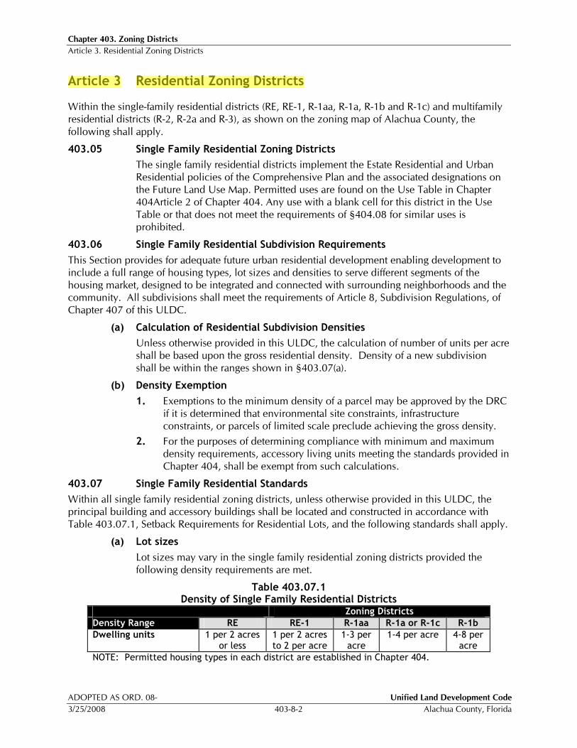
Chapter 403. Zoning Districts Article 3. Residential Zoning Districts
ADOPTED AS ORD. 08- Unified Land Development Code
3/25/2008 403-8-2 Alachua County, Florida
Article 3 Residential Zoning Districts
Within the single-family residential districts (RE, RE-1, R-1aa, R-1a, R-1b and R-1c) and multifamily residential districts (R-2, R-2a and R-3), as shown on the zoning map of Alachua County, the following shall apply.
403.05 Single Family Residential Zoning Districts
The single family residential districts implement the Estate Residential and Urban Residential policies of the Comprehensive Plan and the associated designations on the Future Land Use Map. Permitted uses are found on the Use Table in Chapter 404Article 2 of Chapter 404. Any use with a blank cell for this district in the Use Table or that does not meet the requirements of §404.08 for similar uses is prohibited.
403.06 Single Family Residential Subdivision Requirements
This Section provides for adequate future urban residential development enabling development to include a full range of housing types, lot sizes and densities to serve different segments of the housing market, designed to be integrated and connected with surrounding neighborhoods and the community. All subdivisions shall meet the requirements of Article 8, Subdivision Regulations, of Chapter 407 of this ULDC.
(a) Calculation of Residential Subdivision Densities
Unless otherwise provided in this ULDC, the calculation of number of units per acre shall be based upon the gross residential density. Density of a new subdivision shall be within the ranges shown in §403.07(a).
(b) Density Exemption
1. Exemptions to the minimum density of a parcel may be approved by the DRC if it is determined that environmental site constraints, infrastructure constraints, or parcels of limited scale preclude achieving the gross density.
2. For the purposes of determining compliance with minimum and maximum density requirements, accessory living units meeting the standards provided in Chapter 404, shall be exempt from such calculations.
403.07 Single Family Residential Standards
Within all single family residential zoning districts, unless otherwise provided in this ULDC, the principal building and accessory buildings shall be located and constructed in accordance with Table 403.07.1, Setback Requirements for Residential Lots, and the following standards shall apply.
(a) Lot sizes
Lot sizes may vary in the single family residential zoning districts provided the following density requirements are met.
Table 403.07.1 Density of Single Family Residential Districts
Zoning Districts
Density Range RE RE-1 R-1aa R-1a or R-1c R-1b
Dwelling units 1 per 2 acres or less
1 per 2 acres to 2 per acre
1-3 per acre
1-4 per acre 4-8 per acre
NOTE: Permitted housing types in each district are established in Chapter 404.

Chapter 403. Zoning Districts Article 3. Residential Zoning Districts
Unified Land Development Code ADOPTED AS ORD. 08-
Alachua County, Florida 403-8 3/25/2008
403.09 Multifamily Residential Standards
Within all multifamily residential zoning districts, principal buildings and accessory buildings shall be located and constructed in accordance with Table 0.1.
Table 403.09.1
Standards for Multifamily Districts Zoning District
Standards R-2 R-2a R-3
Density Range - Dwelling units per acre 4 - 8 8 - 14 14 - 24
Width at front building line, min
1-2 units (ft) 50 50 50
3 or more units (ft) 100 100 100
Depth, min (ft) 90 90 90
Setbacks around the Perimeter of the Development
Front, min (ft) 25 25 25
Rear, min (ft) 20 20 20
Interior side, min (ft) 10 101 101
Street side, min (ft) 25 25 25
Building Standards
Units per building, max 8 16 Unlimited
Height, max (feet) 35 45 60
Building coverage, max (percent of gross land area)
35% 35% 35%
1Six additional inches of setback shall be required for each foot of building height over 35 feet.
403.10 Multifamily Residential Requirements
All multifamily residential development within the R-2, R-2a, and R-3 zoning districts shall meet the following requirements.
(a) Building spacing shall meet the requirements of the Florida Building Code, Table 600.
(b) Direct access to a paved arterial or collector road shall be provided. The County Commission may approve a Planned Development with local street access in the Medium and Medium-high density land use categories provided the following requirements are met:
1. The access road shall have a limited number of single family driveways between the proposed development and the collector or arterial road. The exact number of existing single-family access points allowed shall be determined at development plan review based on the design of the roadway, traffic counts, and the size of the proposed multi-family development.
2. Sidewalks shall be provided on the access road that extends from the project to the primary road network.
3. The following collector road design elements shall be addressed in the PD application and shall be considered as potential conditions of the PD approval for the access road:
a. curb and gutter,
b. pedestrian scale street lighting

Chapter 403. Zoning Districts Article 3. Residential Zoning Districts
Unified Land Development Code ADOPTED AS ORD. 08-
Alachua County, Florida 403-8-1 3/25/2008
c. shade trees,
d. transit stops with benches,
e. pedestrian activated crossing signals at signalized intersections, and
f. bicycle lanes
(c) The access road shall meet the minimum street design specifications based on projected ADT, as outlined in Section 407.80(a-g).
(d) A minimum of five percent of the development, beyond the required 20% of pervious open space, shall be designated for developed recreational open space, such as community fields, greens, plazas, squares or outdoor sports facilities. Such recreational open space shall be designed for use by residents of the development.
(e) Bus shelters shall be provided for each multifamily development and shall be located on an adjacent street and where there are planned or existing bus routes.
(f) A continuous pedestrian circulation system shall be provided throughout the entire development. The system shall link all units to all developed recreational open space, parking, planned or existing bus facilities, and to existing public sidewalks or public right-of-way that is located adjacent to the development.
Unified Land Development Code ADOPTED AS ORD. 05-10
Alachua County, Florida 405-1 12/08/2005
Chapter 405 Special Districts and Activity Centers
Contents Article 1 Activity Centers and Special Area Studies ............................................................. 405-1 Article 2 Activity Center Development and Design Standards............................................. 405-3 Article 3 Springhills Design Guidelines Overlay District................................................... 405-10 Article 4 Cross Creek Village Special Area Study .............................................................. 405-26 Article 5 Idylwild/Serenola Special Area Study.................................................................. 405-34 Article 6 13th Street Corridor Design Standards ................................................................ 405-45 Article 7 Airport Impact Regulations ................................................................................. 405-50 Article 8 Preservation Buffer Overlay District.................................................................... 405-57 Article 9 Scenic Road Corridors Overlay........................................................................... 405-61 Article 10 (RESERVED) ........................................................................................................ 405-67
Article 1 Activity Centers and Special Area Studies
405.01 General
(a) Intent
1. Activity Centers
The intent of the urban activity centers is to provide for the concentration of mixtures of higher intensity and density land uses through designation of Activity Centers, with standards to ensure pedestrian-friendly compact centers connected to multi-modal transportation systems and integrated with surrounding uses in the urban area.
2. Special Area Studies
The intent of the special area studies is to provide specific policies, standards, and guidelines that address significant cultural, historic, and environmental resources and characteristics of unique areas and communities within Alachua County.
(b) Establishment of Activity Center Plan and Special Area Study Overlay Districts
The following activity center and special area study overlay districts have been established in the Comprehensive Plan to implement policies in the Future Land Use Element:
Chapter 405. Special Districts and Activity Centers Article 2. Activity Center Development and Design Standards
Unified Land Development Code ADOPTED AS ORD. 05-10
Alachua County, Florida 405-3 12/08/2005
Article 2 Activity Center Development and Design Standards
405.02 General
(a) This Article shall apply to all new development and redevelopment within activity centers as designated on the Future Land Use Map. This Article shall also apply to activity center Master Plans as described herein and in Article 15, Activity Centers, of Chapter 402 of this ULDC.
(b) The intent of this Section is to implement the activity center policies of the Comprehensive Plan by providing standards to ensure pedestrian-friendly compact activity centers that are connected to a multi-modal transportation system and integrated with surrounding land uses.
405.03 New and Expanded Activity Centers
(a) New activity centers may be established, or existing centers’ boundaries expanded, through the Comprehensive Plan amendment process as described in Article 7 of Chapter 402 of this Code. All new or expanded activity centers shall have a level and type designation.
(b) Descriptions of the levels of activity centers are as follows:
1. High activity centers have cumulative development at the level of a regional shopping center, or have an equivalent concentration of a mix of office, commercial, institutional, or industrial activities.
2. Medium activity centers have cumulative development at the level of a community shopping center or have an equivalent concentration of a mix of commercial, offices, institutional, or industrial activities.
3. Low activity centers have cumulative development at the level of a neighborhood shopping center, or have an equivalent concentration of a mix of commercial, offices, institutional, or light industrial activities.
(c) Types of activity centers shall be further characterized by the concentration of primary and secondary land uses:
1. Retail oriented activity centers shall have commercial activities as the primary use.
2. Employment oriented activity centers shall have institutional, industrial, or office as the primary use.
3. Secondary uses for activity centers may include residential, retail, service, institutional, or office.
(d) The following factors shall be considered when establishing and determining the level of each new, expanded, or amended activity center:
1. Current Comprehensive Plan policies
2. Existing and future market area population
3. Compatibility with existing and future surrounding land uses
4. Anchor type (e.g., grocery store, drug store, office, etc.)
5. Distance from nearest activity center
6. Economic relationship to adjacent activity centers
7. Functional classification and capacity of roadways serving the activity center
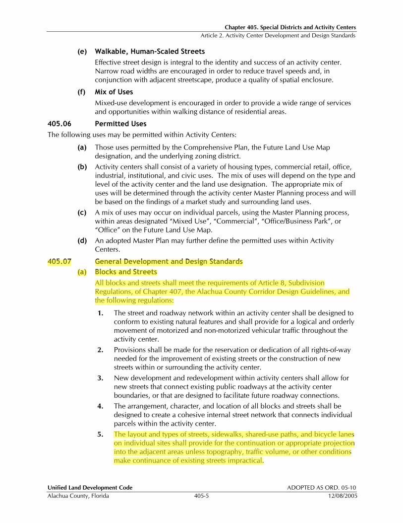
Chapter 405. Special Districts and Activity Centers Article 2. Activity Center Development and Design Standards
Unified Land Development Code ADOPTED AS ORD. 05-10
Alachua County, Florida 405-5 12/08/2005
(e) Walkable, Human-Scaled Streets
Effective street design is integral to the identity and success of an activity center. Narrow road widths are encouraged in order to reduce travel speeds and, in conjunction with adjacent streetscape, produce a quality of spatial enclosure.
(f) Mix of Uses
Mixed-use development is encouraged in order to provide a wide range of services and opportunities within walking distance of residential areas.
405.06 Permitted Uses
The following uses may be permitted within Activity Centers:
(a) Those uses permitted by the Comprehensive Plan, the Future Land Use Map designation, and the underlying zoning district.
(b) Activity centers shall consist of a variety of housing types, commercial retail, office, industrial, institutional, and civic uses. The mix of uses will depend on the type and level of the activity center and the land use designation. The appropriate mix of uses will be determined through the activity center Master Planning process and will be based on the findings of a market study and surrounding land uses.
(c) A mix of uses may occur on individual parcels, using the Master Planning process, within areas designated “Mixed Use”, “Commercial”, “Office/Business Park”, or “Office” on the Future Land Use Map.
(d) An adopted Master Plan may further define the permitted uses within Activity Centers.
405.07 General Development and Design Standards
(a) Blocks and Streets
All blocks and streets shall meet the requirements of Article 8, Subdivision Regulations, of Chapter 407, the Alachua County Corridor Design Guidelines, and the following regulations:
1. The street and roadway network within an activity center shall be designed to conform to existing natural features and shall provide for a logical and orderly movement of motorized and non-motorized vehicular traffic throughout the activity center.
2. Provisions shall be made for the reservation or dedication of all rights-of-way needed for the improvement of existing streets or the construction of new streets within or surrounding the activity center.
3. New development and redevelopment within activity centers shall allow for new streets that connect existing public roadways at the activity center boundaries, or that are designed to facilitate future roadway connections.
4. The arrangement, character, and location of all blocks and streets shall be designed to create a cohesive internal street network that connects individual parcels within the activity center.
5. The layout and types of streets, sidewalks, shared-use paths, and bicycle lanes on individual sites shall provide for the continuation or appropriate projection into the adjacent areas unless topography, traffic volume, or other conditions make continuance of existing streets impractical.
Chapter 405. Special Districts and Activity Centers Article 2. Activity Center Development and Design Standards
ADOPTED AS ORD. 05-10 Unified Land Development Code
12/08/2005 405-6 Alachua County, Florida
(b) Stormwater Facilities
1. The design and construction of stormwater facilities shall be in accordance with Article 9, Stormwater Management, of Chapter 407 and other applicable regulations, ordinances, resolutions and rules. The stormwater management system shall also be consistent with applicable activity center Master Plans, special area studies and the standards herein.
2. A stormwater plan will be required as part of an activity center Master Plan. The stormwater plan shall provide data on the stormwater retention needs for the entire Master Plan area (minimum of one quadrant within the activity center) at build out conditions, and provide a mechanism for shared stormwater facilities, where feasible.
3. Stormwater facilities shall be designed to provide a physical or visual amenity within an activity center, as public open space, or as an aesthetic feature to resemble natural areas with native landscaping, consistent with Article 5, Open Space, and Article 9, Stormwater Management, of Chapter 407 of this ULDC.
4. The use of shared stormwater facilities to accommodate multiple developments within the activity center is encouraged.
(c) Parking
1. A parking plan shall be prepared for the entire Master Plan area at build out conditions, and shall include the locations for parking facilities and the types of parking facilities (e.g., surface, structure, or on-street).
2. Buildings and land uses within activity centers may utilize shared parking areas to serve complementary uses and activities. Provisions for shared parking may be addressed through the development of an activity center Master Plan. Where a Master Plan has not been adopted or is not required, development plan applications that will include shared parking facilities shall be in accordance with §407.17 of this ULDC.
3. Reductions in the required number of paved parking spaces may be permitted in accordance with §407.18 of this ULDC, or through the Master Plan process.
4. Parking Design Standards
Off-street parking and loading areas shall be provided in accordance with Article 2, Parking, Loading and Stacking, of Chapter 407 of this ULDC. In addition, the following shall apply:
a. Surface parking shall be located to the rear or sides of building sites that abut public streets, unless otherwise specified in an adopted Master Plan.
b. All surface-parking areas are encouraged to be located in the interior of blocks.
c. Parking structures on sites that abut a public street shall have at least 50 percent of the ground floor street frontage developed for office, commercial, or civic uses.
(d) Transit Facilities
Transit facilities include bus stops (school, public, or private), pull-out lanes, benches, transit-related signage, shelters, and bicycle racks for transit users.
Chapter 405. Special Districts and Activity Centers Article 2. Activity Center Development and Design Standards
Unified Land Development Code ADOPTED AS ORD. 05-10
Alachua County, Florida 405-7 12/08/2005
1. Any development plan with required parking of more than 200 spaces shall be required to provide on-site transit facilities if such facilities are not located within one-quarter mile of the development site, unless otherwise specified in an adopted Master Plan.
2. Where transit facilities are required, transit easements shall be provided on the development plan.
3. Transit facilities shall be located so as to minimize conflict with vehicular, bicycle, or pedestrian traffic.
4. Transit facilities should be oriented to the entrance of the primary or anchor building on sites within the activity center and/or to the central core of the activity center. The placement of transit facilities should not be limited only to the edges of the activity center.
5. Signage shall clearly indicate the location of transit stops.
6. In order to be consistent with county-wide public transportation, the size, design, and location of transit facilities shall be determined in coordination with the Gainesville Regional Transit System and the Alachua County Department of Public Works.
(e) Pedestrian Circulation and Amenities
Activity center roadways shall be designed to accommodate pedestrians in a safe, comfortable and convenient manner, as follows:
1. Commercial retail, office, civic and multiple-family buildings shall provide pedestrian walkways that connect all buildings at their primary entrances.
2. Pedestrian walkways connecting buildings within an activity center shall minimize crossing of vehicular areas.
3. Pedestrian walkways, not less than five feet in width, shall be provided where a lot abuts a public right-of-way.
4. At least one continuous pedestrian walkway must be provided from any public right-of-way to the primary entrance of all commercial retail, office and multiple family buildings. Pedestrian connections shall also be provided between adjacent parcels and uses, with exceptions for instances where:
a. the adjacent use is an individual single family lot;
b. there are topographic or other physical limitations preventing a connection; or
c. a connection would not be consistent with the protection of natural or historic resources.
5. All pedestrian crosswalks shall be distinguished from all parking and vehicle maneuvering areas through the use of contrasting surface materials such as pavers, brick or scored concrete, striping using high durability paints, or other techniques approved by the Development Review Committee or provided in a Master Plan.
(f) Bicycle Circulation and Amenities
1. Bicycle lanes shall be provided on primary public roads within an activity center. These bicycle lanes shall provide continuous connection between existing bicycle lanes on surrounding public streets and any commercial, office, multiple-family residential, or civic uses within activity center sites.
Chapter 405. Special Districts and Activity Centers Article 2. Activity Center Development and Design Standards
ADOPTED AS ORD. 05-10 Unified Land Development Code
12/08/2005 405-8 Alachua County, Florida
2. Where bicycle lanes are required, they shall be at least five feet in width.
3. Bicycle parking shall be provided at all structures within activity centers, and the parking requirements shall apply to all land uses except single-family detached residential uses, in accordance with §407.15.
(g) Building Design Standards
Building design within activity centers shall be in accordance with the general building design standards contained in Article 10, Building Design, of Chapter 407 and any additional standards contained in an adopted Master Plan.
(h) Open Space
1. Open space, landscape, and buffer areas shall be provided on at least 20% of an activity center site in accordance with Article 5, Open Space, of this ULDC. The required open space may be provided on a site-by-site basis through the development review process, or on an overall activity center basis through the use of the activity center Master Planning process.
2. Land designated for open space shall be accessible from all areas of the activity center.
(i) Civic Space
1. A minimum of 500 square feet of civic space per acre of land must be provided within an activity center. This requirement may be met through the provision of one or more centrally located spaces within the activity center using the master plan process, or on an individual development basis through the development plan review process.
2. Where civic space is required, it may be in the form of police stations, libraries, day cares, fire stations, meeting halls, governmental buildings, museums, schools, performing arts centers, religious buildings, community centers, amphitheaters, public squares, parks, landscaped plazas, courtyards or similar elements approved by the Development Review Committee or Board of County Commissioners.
3. Civic space may be used to satisfy up to 50 percent of the required open space for an activity center site if the civic space otherwise meets the open space requirements of this ULDC and the Comprehensive Plan. At least 25% of the required civic space for an activity center site must be in the form of civic structures or usable open space.
4. Civic space shall provide linkages between buildings and land uses within the activity center.
5. Civic uses should be located on prominent sites throughout the activity center and serve as focal points and landmarks for the community.
(j) Mixed Use Structures
1. Mixed use structures may be provided within activity centers in the following manner:
a. Vertical Mixed Use
Individual structures with the ground floor used for commercial or office uses and the above floors used for office or residential uses.
Chapter 405. Special Districts and Activity Centers Article 3. Springhills Design Guidelines Overlay District
ADOPTED AS ORD. 05-10 Unified Land Development Code
12/08/2005 405-10 Alachua County, Florida
Article 3 Springhills Design Guidelines Overlay District
405.08 Springhills Design Guidelines Overlay District
(a) Description of District
This district includes all real property within the Springhills Development of Regional Impact according to Map H of the Springhills Development Order and the Future Land Use Map of Alachua County.
(b) Intent
The intent of this Section is to create an environmentally sustainable, pedestrian-friendly, mixed-use development. The development will reflect a distinctive overall organization and architectural character that is harmonious with the traditional character of Alachua County. The purpose of design guidelines is to set forth design standards for streetscapes, architectural styles and the Master Plan for the Springhills Development of Regional Impact to be administered by the Springhills Architectural Review Board (ARB). Provisions of this Section shall apply to all new development within the Springhills Design Guidelines Overlay District. Proposed modifications to existing development shall be evaluated for compliance with this Section on a site specific basis.
(c) Consistency
All projects shall conform to the standards set forth in the Alachua County Unified Land Development Code. If any provisions of this Section are in conflict with any applicable local code, ordinances and regulations as set by city, county, state and federal statute, the most stringent criteria shall apply.
405.09 Building Design and Architectural Character Standards
(a) Architectural Criteria
Specific architectural styles are found within the supplemental Springhills
Development Design Control Guidelines, dated April 2000, as may be amended from time-to-time as being consistent with this Section.
1. Compatible Use of Materials
There shall be a compatible use of materials on structures within a given site. Accessory buildings shall adhere to the intent of these guidelines.
a. Structures shall be designed with equal priority given to all facades that are exposed to view.
b. Service areas on commercial and office buildings shall be designed to minimize the impact of these functions on surrounding development. All service and trade areas and equipment, including mechanical and electrical equipment, antennae and similar roof or ground mounted protrusions, shall be screened via parapet walls or other methods that are consistent with the architectural character of the building.
c. Freestanding antennae or towers shall not be permitted unless completely screened from view of adjacent properties and roadways.
Chapter 405. Special Districts and Activity Centers Article 3. Springhills Design Guidelines Overlay District
Unified Land Development Code ADOPTED AS ORD. 05-10
Alachua County, Florida 405-11 12/08/2005
d. Where fencing is required as a screening device, such fencing shall be compatible with the building and site. Chain-link fencing shall not be permitted.
e. Gutters and downspouts will be designed to be hidden from primary views whenever possible. Where exposed to primary views, gutters shall be integrated into the overall design via the use of matching colors.
405.10 Landscape and Open Space Guidelines and Standards
(a) Intent
It is the intent of the landscape and open space guidelines to establish visual, spatial, and design standards that create a conceptual framework for the spatial organization and quality of the Springhills development. The overall character of the landscape of the Springhills development shall be based on the enhancement of the pedestrian quality of the environment through landscape vegetation and the promotion of local and regional qualities through preservation of existing vegetation and use of native species. Where areas are auto-oriented, traditional design features such as street trees and landscaping, location of parking, and building orientation shall be incorporated to the greatest extent practicable in order to increase the pedestrian-friendliness and visual quality of those areas.
1. General Criteria
a. Existing Vegetation
All areas of the site shall be appropriately landscaped except those areas to be maintained in their natural condition.
i. The developer or builder may elect to selectively remove dead or non-native vegetation from such natural areas.
ii. All development shall be planned and sited to preserve existing trees and vegetation to the greatest extent practicable.
b. Temporary Construction Fencing/Tree Barricades
Temporary construction fencing shall be installed according to standard forestry practices for existing trees to be preserved prior to any site work. Such fencing shall be maintained intact throughout the construction period.
c. Site Soils
Proper soil management techniques shall be used to provide viable, high-quality plant growing and living conditions for all vegetative materials. All planting shall include soil amendments to improve permeability, drainage, and provide proper nutrients.
d. Site Interior Landscaping
A minimum of 20 percent of the total developed area of any parcel or property shall be devoted to landscape. Landscape planting for paved areas and tree credit and replacement criteria shall comply with the minimum requirements of the Alachua County Unified Land Development Code.

Chapter 405. Special Districts and Activity Centers Article 3. Springhills Design Guidelines Overlay District
ADOPTED AS ORD. 05-10 Unified Land Development Code
12/08/2005 405-16 Alachua County, Florida
(a) The pine clusters shall contain a minimum of three pine trees each with a height of 8-10 feet.
(b) Low screening shrubs shall be provided around the pine trees to help buffer the views to parking lots but allow glimpses of commercial, hotel, or office uses which may lie beyond.
ii. A continuous shrub hedge or combination shrub hedge and earth berm shall be required to provide a three foot high screen within two years to visually screen a minimum of 75 percent of any parking areas as viewed from the right-of-way.
d. Streetscape Treatment Type 5 (Traditional Neighborhood Area)
Detailed design of the streetscape shall be accomplished in concert with the architectural design and shall incorporate the following standards:
i. Parking Standards
(a) Parking lots shall be located at the rear or side of street-front uses and shall be screened from the streets, sidewalk, and open spaces by low walls, fences, vegetation, low berms, or any combination providing at least a three foot high screen. Walls or fences may be softened through use of vegetation.
(b) On-street parking shall be allowed and encouraged to fulfill parking requirements.
(c) Parking lots and parking garages shall not abut street intersections, be adjacent to squares or parks, or occupy lots that terminate a vista, except when specifically designed to incorporate massing, scale, and detail that contributes to the adjoining public space.
(d) Adjacent parking lots shall have vehicular connections and shared street access wherever possible.
(e) All shopfront and workplace streets shall have parallel or diagonal parking on the street, as well as parking behind or to the side.
ii. Land Use Standards
(a) Open spaces, including public, conservation, and community spaces, shall be a focal element around which other land uses are organized.
(b) Provisions for alternative transportation shall be included in the overall design. Accommodation for mass transit facilities shall be provided and integrated into the overall design plan.
(c) Development shall be divided into an interconnected grid system.
iii. Streets
(a) Streets and roads shall be fronted by land uses which define and contribute to the street character, including buildings,
Chapter 405. Special Districts and Activity Centers Article 3. Springhills Design Guidelines Overlay District
Unified Land Development Code ADOPTED AS ORD. 05-10
Alachua County, Florida 405-17 12/08/2005
buffers, and setbacks, not by uses which ignore or negate the street character, such as high walls, building service areas, etc.
(b) All major interior streets shall have termination with either a specifically designed building facade or a transition to an ensuing space.
(c) All major streets shall have clearly defined edges created by the use of building facades or landscaped buffers.
(d) Streets shall terminate at other streets within the development or connect to existing and projected through streets outside the development.
(e) Steady and even build-to lines, within minimum and maximum variation limits, shall be established along all streets and public space frontages to determine the desired width for each street or public space.
(f) All pedestrian/bicycle access shall connect to existing pedestrian/bicycle access or be appropriately located so as to encourage a continuous system of pedestrian/bicycle access.
iv. Landscaping
(a) Trees shall be planted within right-of-ways parallel to the streets along all streets, and coordinated with planned utility infrastructure, or in such a way that shall not interfere with existing utility infrastructure.
(b) Tree spacing shall be determined by species type.
405.11 Lighting Standards
(a) Purpose and Intent
It is the intent of the lighting standards to encourage lighting practices and systems that will:
1. minimize glare, light trespass, and light pollution;
2. conserve energy and resources while maintaining nighttime safety, utility, security and productivity; and
3. curtail the degradation of the nighttime visual environment.
(b) Lighting Intensity
Lighting shall be designed to prevent light spillage and glare on to adjacent streets, public areas, sites, and toward the sky.
405.12 Signage Control
(a) Purpose and Intent
The following signage control criteria are intended to improve the overall aesthetic quality of individual buildings as well as the entire Springhills development. With respect to signs advertising business uses, it is specifically intended to prevent excessive competition and clutter among sign displays. Signage design and placement shall be incorporated in the overall architectural design and theme of buildings.
Chapter 405. Special Districts and Activity Centers Article 9. Scenic Road Corridors Overlay
Unified Land Development Code ADOPTED AS ORD. 06-14
Alachua County, Florida 405-61 7/20/2006
Article 9 Scenic Road Corridors Overlay
405.34 Objectives of Article
The objectives of this Article are as follows:
(a) To promote the convenience and enjoyment of public travel on the highways, roadways, and other travel corridors of the county.
(b) To protect the natural and cultural heritage scenic road corridors of the county and to enhance their resource values for the enjoyment of future generations.
(c) To protect the public investment in scenic road corridors from activities, land uses, signs, etc., which impair both the integrity of the corridor, its capacity for traffic, and its visual qualities.
(d) To provide safe facilities for leisure driving, hiking, and biking.
(e) To provide access to and protect outstanding visual experiences representative of the county's variety of landscape resources and cultural attractions.
(f) To contribute to the environmental and historical appreciation of the county and education of the residents and visitors.
(g) To attract visitors to the county by preserving natural beauty along the scenic road corridors.
(h) To expose scenic views and vistas along the travel corridor.
405.35 Guidelines for Designation
To measure the significance of the scenic, historical, and cultural value of scenic road corridors, the following guidelines shall apply:
(a) The quality of its scenic, historic, or cultural resources is unique and/or of sufficient magnitude to merit regional or county recognition;
(b) A variety and diversity of visual experience created by land form, changes in terrain, natural vegetation, type of landscape and/or land use activity is provided;
(c) Access between or to recreation areas or points of scenic, cultural, historical, or scientific interest occur as part of the system;
(d) The immediate roadside or corridor is relatively free of commercial or other development restrictive of scenic quality; and
(e) The scenic road corridor's natural, scenic, and cultural resources are not damaged beyond their recognition and it is relatively easy to restore their initial resource value.
405.36 Specific Criteria for Designation
To receive the designation of scenic road corridor, one or more of the following criteria must apply:
(a) Scenic Resource Significance
1. Interesting geomorphic formations.
2. Type of natural vegetation.
3. Presence or nearness of water bodies (by type).
4. Overall landscape composition.
Chapter 405. Special Districts and Activity Centers Article 9. Scenic Road Corridors Overlay
ADOPTED AS ORD. 05-10 Unified Land Development Code
12/08/2005 405-62 Alachua County, Florida
(b) Archaeological Resource Significance
Area of archaeological importance.
(c) Historical Resource Significance
1. Road developed prior to era of interstate development.
2. Sites of historical importance.
(d) Cultural Resource Significance
1. Unspoiled character of resource (no adverse land uses and structures).
2. Amenability for multiple recreational uses for pedestrian, equestrian, or bicycle paths, and passive recreation.
(e) Priority of Criteria
1. Scenic quality.
2. Variety of recreation experience.
3. Compatibility with other corridor users.
4. Harmony with other land use.
5. Access to parks and other recreation.
6. Popular demand.
7. Degree of urgency if the corridor is to be protected.
8. Protection of ecology.
9. Suitability for use by other transportation modes (bus, pedestrian, equestrian, bicycles).
10. Type of developmental possibilities.
11. Resource vulnerability to incompatible land use.
405.37 Protected Area Along Scenic Road Corridors
The area within 100 feet of the right-of-way lines or the limits of the County’s prescriptive use on any road designated as a scenic road corridor shall be the protected area of the corridor.
405.38 Restrictions Along Scenic Road Corridors
The County Commission may designate by resolution or ordinance scenic road corridors for purposes of preservation. In preserving a scenic road corridor, the County Commission shall have the power to impose restrictions along the corridor, including, but not limited to, the following:
(a) Providing and erecting markers designating Scenic Road Corridors.
(b) Prohibition of outdoor advertising signs within the protected area except small (7 1/2-square-foot maximum) signs advertising residential development or homes for sale on lots or parcels of property immediately adjacent to the corridor and subdivision entryway signs constructed in accordance with Article 3 of Chapter 407.
(c) The setting and posting of speed limits.
(d) The setting and posting of maximum weight limits and classes of vehicular travel.
(e) Prohibiting the removal of trees which have attained a diameter of eight inches or more at a point 4 1/2 feet above average ground level within the protected area except under circumstances where trees have died or the over-grown trees have hindered sight lines and safety factors creating traffic hazards in accordance with the requirements of §406.12(b) of this ULDC, or where no access to the property is available without removal of such trees.
Chapter 405. Special Districts and Activity Centers Article 9. Scenic Road Corridors Overlay
ADOPTED AS ORD. 05-10 Unified Land Development Code
12/08/2005 405-64 Alachua County, Florida
405.39 Maintenance of Corridors and Scenic Quality
The County Engineer shall implement the following guidelines for scenic road corridor maintenance:
(a) Conserve and restore the high quality of natural resources and unique features such as tree canopy, ground cover, animals and geological features in their natural state.
(b) Preserve cultural and historical character.
(c) Clear cutting of vegetation in the scenic road corridor right-of-way shall not be permitted, except as authorized in subsection (d) of this section, and except under such circumstances where the sight lines are obstructed and contributing to traffic hazards after fulfilling procedures in §405.41(c)3; provided, however, that one annual clear cutting shall be permitted, if necessary, to restore scenic vistas along a corridor.
(d) Selective vegetation cutting may be permitted to open up and enhance views and vistas within the scenic road corridor right-of-way upon recommendation of the Committee and approval of the County Commission.
(e) Where proper permits have been obtained controlled burning may be practiced where necessary to encourage vegetation growth and control insect and pest occurrence.
(f) Mowing shall be permitted in drainage ditches to prevent clogging and overflow.
(g) Trees and other vegetation damaged beyond the restoration stage, either by natural causes or accidents, should be removed. Attempts should be made to replant such areas to bring them to their original state.
(h) In cases where recreation access and/or facilities (scenic overlook, picnic areas, multi-purpose trails, unpaved parking) are provided, they shall be maintained on a regular basis.
405.40 Variances
The County Commission may grant variances from the terms of this Chapter if serving the public interest and where, due to special conditions, a literal enforcement of the provisions would result in unnecessary and undue hardship or a safety hazard. Public notice shall be provided in accordance with Article 4 in Chapter 402 of this ULDC. In granting variances, the County Commission shall make a finding that:
(a) Special conditions and circumstances exist which are peculiar to the land, such as size, shape or topography, which are not applicable to other lands in the protected area;
(b) The special conditions and circumstances do not result from the actions of the applicant;
(c) The variance, if granted, is the minimum variance that will make possible the reasonable use of the land, building, or structure; and
(d) The variance is necessary to promote public safety.
405.41 Procedure for Designation
(a) Scenic Road Corridors Advisory Committee
1. Appointment
There is herein established a Scenic Road Corridors Advisory Committee, hereinafter referred to as the "Committee."

Chapter 406. Natural and Historic Resources Protection Article 1. General
Unified Land Development Code ADOPTED AS ORD. 05-10
Alachua County, Florida 406-1 12/08/2005
Chapter 406 Natural and Historic Resources Protection
Contents Article 1 General................................................................................................................. 406-1 Article 2 Trees and Native Vegetation............................................................................... 406-13 Article 3 Significant Plant and Wildlife Habitat ................................................................. 406-16 Article 4 Listed Plant and Animal Species Habitat............................................................. 406-25 Article 5 Strategic Ecosystems ........................................................................................... 406-30 Article 6 Surface Waters and Wetlands ............................................................................. 406-34 Article 7 100-Year Floodplains.......................................................................................... 406-43 Article 8 Springs - RESERVED............................................................................................ 406-51 Article 9 High Aquifer Recharge Areas.............................................................................. 406-52 Article 10 Wellfield Protection............................................................................................ 406-54 Article 11 Wells and Septic Tanks....................................................................................... 406-59 Article 12 Wastewater Treatment Facilities ......................................................................... 406-62 Article 13 Historic Structures and Sites................................................................................ 406-68 Article 14 Archaeological Resources................................................................................... 406-70 Article 15 Paleontological Resources .................................................................................. 406-72 Article 16 Significant Geologic Features.............................................................................. 406-74 Article 17 Conservation Management Areas ....................................................................... 406-78 Article 18 Preservation Management Areas......................................................................... 406-84 Article 19 Wildfire Hazard Mitigation - RESERVED............................................................. 406-85 Article 20 Management Plans.............................................................................................. 406-86 Article 21 Avoidance, Minimization, Mitigation and Monitoring ........................................ 406-88
Article 1 General
406.01 Purpose
It is the purpose of this Chapter to:
(a) Preserve, protect, and improve the public health, safety, general welfare, and quality of life of the citizens of Alachua County, by conserving, managing, restoring, or enhancing natural and human-related resources that provide potable water, clean air, productive soils, and a healthful array of human, plant and animal life;
(b) Implement the Comprehensive Plan, with particular emphasis on preserving and protecting biodiversity and the ecological values and functions of uplands, wetlands, open bodies of water and flowing streams, floodplains, groundwater, springs, caves, and other significant geologic features, soils and slopes, and flora and fauna; and
(c) Protect the natural resources, open spaces, and historic character of the community in a manner that preserves and cultivates a unique sense of place while fostering economic well-being, maintaining adequate quality and quantity of water and land, and minimizing the present and future vulnerability to natural and man-made hazards.
Chapter 406. Natural and Historic Resources Protection Article 1. General
Unified Land Development Code ADOPTED AS ORD. 05-10
Alachua County, Florida 406-5 12/08/2005
406.04 Resources Assessment Requirements
All applications for proposals with potential adverse impact to natural or historic resources, including but not limited to applications for land use change, zoning change, and development plan approval, shall include an assessment of natural and historic resource information. The assessment shall be complete at or before the preliminary development review stage where applicable. The assessment shall be prepared by person(s) qualified in the appropriate fields of study, conducted according to professionally accepted standards, and based on data that is considered to be recent with respect to the resource. Names, qualifications, and resumes of all personnel involved in the assessment, and their roles with respect to the assessment, shall be attached, if not already on file with the County.
(a) Methodology
The assessment shall use and report professionally accepted scientific methodology specific to each natural and historic resource onsite, in order to assess the actual and potential presence of natural and historic resources. The assessment shall include background research and analysis of available existing data, as well as ground-truthing. Field surveys shall be conducted during the seasons, times of day, and field conditions under which each natural and historic resource characteristic would most likely be observed, otherwise presence will be presumed.
(b) Minimum Contents
The assessment shall include site-specific identification, mapping, and analysis of each natural and historic resource or characteristic present on the site, and background research and analysis with aerial map review and fence line ground-truthing of resources adjacent to the site (same or contiguous tax parcels). At a minimum, the following shall also be provided:
1. Cover letter and/or executive summary, including written explanation of the need and intent of the project, description of construction or alteration methodologies, and signed statement as to the likely presence of regulated natural or historic resources.
2. Maps drawn to scale, including a north arrow and scale showing the following:
a. Location of project site in relation to major roads or other readily identifiable landmarks, showing parcel boundaries with dimensions.
b. Existing roads, structures, wells, utilities, and other existing conditions and noteworthy features.
c. Identification of all regulated natural and historic resources, labeled by resource type.
d. General vegetation characteristics and quality.
e. General soil types.
f. Proposed location of protected conservation resources and open space.
g. Potential connections to existing green space, open space, trails, and adjacent preservation or conservation resources.
3. Data and analysis that includes assessment and evaluation of the following:
a. Existing quality and characteristics of regulated natural or historic resources.
Chapter 406. Natural and Historic Resources Protection Article 7. 100-Year Floodplains
Unified Land Development Code ADOPTED AS ORD. 05-10
Alachua County, Florida 406-43 12/08/2008
Article 7 100-Year Floodplains
406.52 Purpose
It is the purpose of this Chapter to implement policies contained in the Alachua County Comprehensive Plan to protect and maintain the natural functions of floodplains, floodways, and all other natural areas having hydrological characteristics of the one hundred (100)-year flood elevation.
406.53 Protection and Maintenance of Natural Functions
The natural functions of floodplains, floodways, and all other natural areas having hydrological characteristics of the one hundred (100)-year flood elevation shall be protected and maintained. Natural functions include water purification, flood hazard mitigation, water supply, and wildlife habitat and connectivity. Protections applicable to conservation areas under this Chapter shall apply to 100-year floodplains and floodways. Specific protections may be required to prevent erosion and maintain the existing topography of slopes along natural banks and shores.
406.54 Disclaimer of Liability
The degree of flood protection required by this Chapter is considered reasonable for regulatory purposes and is based on scientific and engineering considerations. Floods greater than the base flood can and will occur on rare occasions. Flood heights may be increased by man-made or natural causes. This Chapter does not imply that land outside the areas of special hazard or uses permitted within such areas will be free from flooding or flood damages. This Chapter shall not create liability on the part of the County or by any officer or employee thereof for any flood damages that result from reliance on this Chapter or any decision lawfully made hereunder.
406.55 Designation of Areas of Special Flood Hazard
(a) The areas of special flood hazard identified by the Federal Emergency Management Agency in its Flood Insurance Rate Maps (FIRM), with accompanying maps and other supporting data, and any revisions thereto are hereby adopted by reference and declared to be a part of this Chapter. The County Engineer may also obtain, review, and reasonably utilize base flood elevation and floodway data from any source to determine areas of special flood hazard, including, specifically, the following:
1. The "Water and Flood Plain Management Study for the Gainesville Metropolitan Area," conducted by Sverdrup, Parcel and Associates, Inc., for the North Central Florida Regional Planning Council, 1974, including any update to such study;
2. The United States Geological Survey map series entitled "Map of Flood Prone Areas," which covers the County; and
3. Maps of the Suwannee River Water Management District or the St. Johns River Water Management District.
(b) In all instances, the more precise map shall take precedence over less precise maps, as determined by the Public Works Department. In the case of floodplain elevation differences between maps of the same relative precision, the highest floodplain elevation shall be used. The County Engineer shall have the right to require any applicant for a permit or variance to submit information to verify and/or establish the areas of special flood hazard. An applicant may also elect to submit information to verify and/or establish the areas of special flood hazard.
Chapter 406. Natural and Historic Resources Protection Article 7. 100-Year Floodplains
Unified Land Development Code ADOPTED AS ORD. 05-10
Alachua County, Florida 406-45 12/08/2008
and certified by same. When floodproofing is utilized for a particular building, said certification shall be prepared by or under the direct supervision of a professional engineer or architect and certified by same. Any work done within the 21-calendar-day period and prior to submission of their certification shall be at the permit holder's risk. The Director and the Flood Plain Administrator shall review the floor elevation survey data submitted. Deficiencies detected by such review shall be corrected by the permit holder prior to any further work being allowed to proceed. Failure to submit the survey or failure to make said corrections required shall be cause to issue a stop work order for the project structure; and
g. When an applicant proposes a subdivision of land as regulated by Article 8, Subdivision Regulations, of Chapter 407, or when an applicant proposes to develop a manufactured or mobile home park not requiring approval under the subdivision ordinance, the areas designated as areas of special flood hazard shall be shown on the plat and development plan in accordance with the requirements of §407.87, Special Flood Zone Criteria, of this ULDC.
2. Review by Flood Plain Administrator
The Flood Plain Administrator shall review all applications for completeness; shall request additional information, if needed, as provided in this Chapter; and shall verify the accuracy of the information provided.
3. Stop Work Orders
The Flood Plain Administrator or the Director shall issue a stop work order for any floodplain development found ongoing without a Flood Hazard Area permit or in any way noncompliant with the provisions of this ULDC and/or the conditions of an approved permit. Disregard of a stop work order shall subject the violator to the penalties described in this ULDC.
406.57 Flood Hazard Reduction Standards
The Development Review Committee and the Flood Plain Administrator may grant a Flood Hazard Area permit to allow development in an area of special flood hazard, providing that the following minimum standards, where applicable, are met:
(a) Adverse Effects
The proposed development shall not adversely affect the flood-carrying capacity and/or flood storage capacity of an area of special flood hazard. For the purpose of this Section, "adversely affect" means damage to adjacent properties because of rises in flood stages attributable to physical changes of the stream or depression basin. Without limiting the foregoing, a development other than a stream crossing is presumed to adversely affect the flood-carrying and/or flood storage capacity if it involves the filling of land in an area of special flood hazard without simultaneously providing additional flood-carrying and flood storage capacities to compensate for that capacity which is lost because of such filling. The final verification of grades for compensation area purposes in a flood prone area must be certified by a professional land surveyor.

Chapter 406. Natural and Historic Resources Protection Article 7. 100-Year Floodplains
Unified Land Development Code ADOPTED AS ORD. 05-10
Alachua County, Florida 406-49 12/08/2008
(l) Development Adjacent to Outstanding Florida Waters
In addition to the minimum standards established in §406.56, all development in areas of special flood hazard adjacent to Outstanding Florida Waters (OFWs), including those uses and structures set out in §406.57(n), shall adhere to the following standards:
1. All development activities, except as expressly provided in this Chapter or as approved by Alachua County, must take place landward from the OFWs buffer distance for Outstanding Florida Waters found in Table 406.43.1 of this Chapter. Vegetation waterward of such buffer distance shall be preserved in a manner consistent with the requirements of this Chapter.
2. The appropriate water management district shall be notified of all development proposals within the 100-year floodplain along any Outstanding Florida Waters.
(m) Imposition of Additional Conditions
The development review committee may impose such additional conditions which it deems are in the public interest.
(n) Uses Allowed Without Permit
The following uses shall be allowed without a permit, to the extent they are not prohibited by any other ordinance, or any other provisions of this Article, unless any filling or structure associated with such use requires a Flood Hazard Area permit in accordance with this Article:
1. Agricultural and silvicultural uses conducted in accordance with all applicable best management practices, in accordance with the provisions of §406.05(c);
2. Private and public recreational uses such as golf courses, driving ranges, archery ranges, picnic grounds, boat ramps, natural swimming areas (excluding swimming pools), parks, wildlife and nature preserves, game farms, shooting preserves, target ranges, trap and skeet ranges, hunting and fishing areas, and hiking and horseback riding trails; or
3. Lawns, gardens, grassed parking, and play areas.
4. Notwithstanding that any of the foregoing uses are permitted within an area of special flood hazard, no use shall adversely affect the efficiency or unduly restrict the capacity of depression basins or stream basins, or of any stormwater management facility or system; and, to the extent any use would so adversely affect or unduly restrict, such use is prohibited unless a permit is obtained as required by §406.56.
(o) Duties of the Flood Plain Administrator
A representative of the Public Works Department shall serve as the Local Flood Plain Administrator to administer and implement this Chapter. The Flood Plain Administrator shall provide for the following:
1. Notify adjacent communities and the Florida Department of Community Affairs prior to any alteration or relocation of a watercourse and submit evidence of such notification to the Federal Emergency Management Agency;
Chapter 406. Natural and Historic Resources Protection Article 17. Conservation Management Areas
ADOPTED AS ORD. 05-10 Unified Land Development Code
12/08/2005 406-78 Alachua County, Florida
Article 17 Conservation Management Areas
406.95 Purpose
The purpose of this Article is to provide for the conservation and management of natural resources when undergoing review as part of a development application. Regulated natural and historic resources shall be protected onsite in the form of conservation management areas as set forth below.
406.96 Size
The amount of land to be protected within a conservation management area shall include the entire regulated natural or historic resource, as well as additional areas such as buffers, setbacks and linkages that preserve natural systems functions.
406.97 Site Selection and Design
Conservation management areas shall be designed and maintained in areas with intact vegetation, including canopy, understory and groundcover where applicable, in functional, clustered arrangement, with logical contiguous boundaries to eliminate or minimize fragmentation to the greatest extent practicable. Where alternative sites exist, the site or sites selected for onsite protection shall be the best suited to preserve ecological integrity, maximize use by wildlife and maintain the long-term viability of natural plant or animal communities. The selection shall be based upon the following:
(a) Function and value of natural resources;
(b) Quality and condition of natural resources;
(c) Protectability and manageability;
(d) Size and shape (emphasis should be on avoiding enclaves of development or areas fragmented by development; and, on providing, where appropriate, adequate buffers from the secondary impacts of development and adequate wildlife corridors);
(e) Contiguity with adjacent existing habitat, functional wetland system, floodplain, or habitat corridor;
(f) Existing species population sizes and life history requirements;
(g) Proximity and accessibility to other populations of the same species;
(h) Compatibility of conservation with adjacent land uses; and
(i) Recommendations from the Florida Fish and Wildlife Conservation Commission and other appropriate agencies.
406.98 Location
Conservation management areas shall be located in one or a combination of the following configurations:
(a) Common open space;
(b) Entirely within the boundaries of a single individual lot; or
(c) Across multiple agricultural lots greater than 200 acres in size, designed to minimize impact to conservation resources and allowed as part of an approved Special Area Plan.
Chapter 406. Natural and Historic Resources Protection Article 17. Conservation Management Areas
Unified Land Development Code ADOPTED AS ORD. 05-10
Alachua County, Florida 406-79 12/08/2005
406.99 Permitted Uses
The use of conservation management areas shall be limited to that which is compatible with protection of the ecological integrity of the protected resources. The following uses may be permitted as part of an approved management plan, provided they do not adversely affect natural resource function and ecological integrity:
(a) Nature trails (mulched walking paths, elevated wooden walkways);
(b) Low intensity, passive recreational activities such as wildlife viewing and hiking;
(c) Scientific and educational activities (interpretive trails, observation points);
(d) Site investigative work such as surveys, soil logs, and percolation tests;
(e) Scenic, historic, wildlife, or scientific preserves;
(f) Ongoing agricultural and silvicultural activities that:
1. are consistent with the protection of the natural resource(s) identified on the site for protection under the management plan; and
2. to the extent consistent with the protection of such resources, follow certification programs or Best Management Practices as set forth in §406.05(c);
(g) Single-family residential dwellings established as part of an approved management plan, special area plan, or as adopted within a Rural Lands Stewardship Area;
(h) Constructing fences where no fill activity is required; and
(i) Other uses demonstrated to be compatible with natural resource protections as outlined in the management plan.
406.100 Prohibited Activities
The following activities are prohibited unless part of an approved management plan:
(a) Construction or placing of buildings, roads, signs, billboards or other advertising, utilities, or other structures on or above the ground.
(b) Dumping or placing of soil or other substance or material as landfill or dumping or placing of trash, waste, or unsightly or offensive materials.
(c) Removal or destruction of native trees, shrubs, or other vegetation.
(d) Excavation, dredging, or removal of loam, peat, gravel, soil, rock, or other material substance in such manner as to affect the surface.
(e) Surface use except for purposes that permit the land or water area to remain predominantly in its natural condition.
(f) Activities detrimental to drainage, flood control, water conservation, erosion control, soil conservation, or fish and wildlife habitat preservation.
(g) Acts or uses detrimental to such retention of land or water areas.
(h) Acts or uses detrimental to the preservation of the structural integrity or physical appearance of sites or properties of historical, architectural, archaeological, or cultural significance.
406.101 Discharges to Protected Areas
Wastewater and stormwater discharges to conservation management areas are generally prohibited. Discharges may be allowed only in surface waters, wetlands and significant geologic features if the following criteria are satisfied:
Unified Land Development Code ADOPTED AS ORD. 07-01
Alachua County, Florida 407-1 1/23/2007
Chapter 407 General Development Standards
Contents Article 1 Setbacks, Height and Other Standards .................................................................. 407-1 Article 2 Parking, Loading and Stacking .............................................................................. 407-5 Article 3 Signs ................................................................................................................... 407-13 Article 4 Landscaping........................................................................................................ 407-29 Article 5 Open Space ........................................................................................................ 407-49 Article 6 Performance Standards ....................................................................................... 407-54 Article 7 Traditional Neighborhood Development and Village Center.............................. 407-58 Article 8 Subdivision Regulations...................................................................................... 407-75 Article 9 Stormwater Management .................................................................................. 407-108 Article 10 Building Design................................................................................................ 407-120 Article 11 Water and Wastewater Service ......................................................................... 407-122 Article 12 Concurrency Management................................................................................ 407-127 Article 13 Access Management ......................................................................................... 407-133
Article 1 Setbacks, Height and Other Standards
407.01 Principal Building on Lot
(a) Except in commercial and industrial districts, or as provided in these regulations and §404.24, Accessory Living Units, only one principal building and its customary accessory buildings may be erected on any lot of record. Any dwelling shall be deemed to be the principal building on the lot upon which it is located. An addition to any building shall not be construed as a principal building.
(b) Housing developments of two or more single- or multiple-family dwellings constructed on a lot under single ownership of one acre or more, not subdivided in the customary streets and lots, and which shall not be so subdivided, may be developed in any R-2, R-2a, R-3, RP or PD district, provided that:
1. Maximum percent of lot coverage shall not exceed that which is required for the district in which the project is located.
2. Height limits and front, side or rear seatback requirements shall be met in accordance with the district in which such housing is permitted.
407.02 Permitted Building Area
The principal building on any lot or parcel of land shall be erected within the area bounded by the building lines established by setback or yard requirements. Accessory buildings may be erected within any building line established for the principal building or as may be otherwise provided in this ULDC.
407.03 Setbacks from Major Road Centerlines, Section and Half-Section Lines
(a) No building or structure shall be erected closer than 75 feet from any section line, half-section line, or from the centerline of any route designated and officially adopted for a major road as shown on the Future Traffic Circulation Map for the zoning districts of Alachua County, Florida, unless a waiver is approved by the Development Review Committee.

Chapter 407. General Development Standards Article 2. Parking, Loading and Stacking
Unified Land Development Code ADOPTED AS ORD. 05-10
Alachua County, Florida 407-5 12/08/2005
Article 2 Parking, Loading and Stacking
407.12 Purpose
The purpose of this Article is to provide standards to reduce traffic congestion and require parking and loading facilities in proportion to the parking demand for each use in order to ensure functionally adequate, aesthetically pleasing and secure off-street parking and loading facilities.
407.13 Applicability
Every use of a building or land hereafter established shall provide the minimum parking and loading spaces as required by this Article in addition to the Florida Accessibility Code and the Fair Housing Act. Changes in use, changes in intensity of use, and building expansions shall comply with all applicable requirements. Re-striping or re-paving of such spaces shall comply with Florida Accessibility Code and The Fair Housing Act. Except as noted, the requirements of this Article are minimums. Where nonconforming on-site parking has been found to be inadequate by causing a recurring hazard or nuisance off-site, the owner shall be responsible for increasing the number of parking spaces or decreasing the need for parking spaces by limiting the amount, kind or intensity of use.
407.14 Parking Schedule
In all districts, the minimum parking shall be provided in accordance with Table 407.14.1.
Table 407.14.1
Parking Schedule Use Minimum Spaces
Residential Uses
Single-family, attached and detached 2 per dwelling unit
Multiple-family dwelling One-bedroom units Two or more bedroom units
1.5 per dwelling unit, plus 1 per 10 bedrooms 2 per dwelling unit, plus 1 per 10 bedrooms
Rooming house, dormitory, fraternity or sorority 1 per 2 beds
Assisted living facility 1 per 2 persons of licensed capacity
Manufactured home park 2 per unit space
Nursing home 1 per 2 beds
Community residential homes 1 per 3 persons of licensed capacity, plus one per employee
Public and Civic Uses
Auditorium 1 per 5 seats of maximum seating capacity in the principal area of assembly
College or university/Vocational, business or technical school
1 per employee plus one space per 4 students of design capacity
Child Care Center, Adult Day Care 1 per 6 persons of licensed capacity
Elementary or middle school 10 plus 2 per classroom
Fire station 1 per person on duty on the largest shift
High school 1.5 spaces per employee plus one space per ten students of design capacity
Hospital 1 per bed
Library, museum, art gallery 1 per 400 sq ft of gross floor area
Medical or dental office/Medical clinic 1 per 200 sq ft GFA
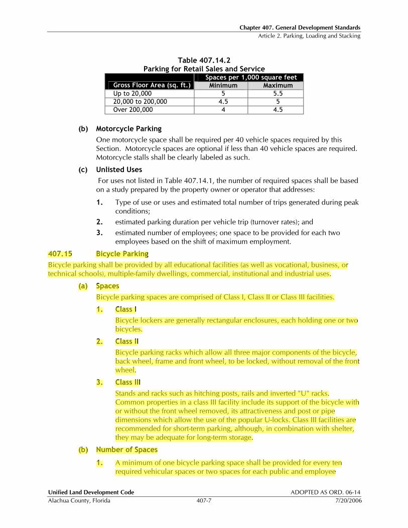
Chapter 407. General Development Standards Article 2. Parking, Loading and Stacking
Unified Land Development Code ADOPTED AS ORD. 06-14
Alachua County, Florida 407-7 7/20/2006
Table 407.14.2
Parking for Retail Sales and Service Spaces per 1,000 square feet
Gross Floor Area (sq. ft.) Minimum Maximum
Up to 20,000 5 5.5
20,000 to 200,000 4.5 5
Over 200,000 4 4.5
(b) Motorcycle Parking
One motorcycle space shall be required per 40 vehicle spaces required by this Section. Motorcycle spaces are optional if less than 40 vehicle spaces are required. Motorcycle stalls shall be clearly labeled as such.
(c) Unlisted Uses
For uses not listed in Table 407.14.1, the number of required spaces shall be based on a study prepared by the property owner or operator that addresses:
1. Type of use or uses and estimated total number of trips generated during peak conditions;
2. estimated parking duration per vehicle trip (turnover rates); and
3. estimated number of employees; one space to be provided for each two employees based on the shift of maximum employment.
407.15 Bicycle Parking
Bicycle parking shall be provided by all educational facilities (as well as vocational, business, or technical schools), multiple-family dwellings, commercial, institutional and industrial uses.
(a) Spaces
Bicycle parking spaces are comprised of Class I, Class II or Class III facilities.
1. Class I
Bicycle lockers are generally rectangular enclosures, each holding one or two bicycles.
2. Class II
Bicycle parking racks which allow all three major components of the bicycle, back wheel, frame and front wheel, to be locked, without removal of the front wheel.
3. Class III
Stands and racks such as hitching posts, rails and inverted "U" racks. Common properties in a class III facility include its support of the bicycle with or without the front wheel removed, its attractiveness and post or pipe dimensions which allow the use of the popular U-locks. Class III facilities are recommended for short-term parking, although, in combination with shelter, they may be adequate for long-term storage.
(b) Number of Spaces
1. A minimum of one bicycle parking space shall be provided for every ten required vehicular spaces or two spaces for each public and employee

Chapter 407. General Development Standards Article 2. Parking, Loading and Stacking
ADOPTED AS ORD. 07-07 Unified Land Development Code
04/24/2007 407-8 Alachua County, Florida
entrance, whichever is greater. The Development Review Committee may require additional spaces for Educational Facilities, libraries and recreational facilities.
2. For multiple-family dwellings, a minimum of 25 percent of the required spaces shall be Class I bicycle lockers or sheltered Class II or III facilities to provide for long term storage.
3. For nonresidential developments requiring 20 or more spaces, a minimum of 25 percent of the required spaces shall be Class I bicycle lockers or sheltered Class II or III facilities.
4. New retail, office, institutional and industrial buildings of more than 50,000 square feet in area shall provide employee showers, lockers and changing areas to facilitate bicycle and pedestrian commuting. Buildings with a single shower shall have a secure unisex facility. Buildings with multiple showers shall have gender specific facilities.
(c) Location of Facilities
All bicycle parking facilities shall be located to provide for convenient bicycle parking which shall be separated from automobile parking by a physical barrier or by a minimum of five feet. Bicycle parking facilities shall be located on the same lot or parcel of land as the use for which such facilities are required and as close to the public and employee entrances as possible without interfering with the flow of pedestrian and vehicular traffic. For nonresidential developments, any sheltered spaces required shall be connected to the building where possible without interfering with the flow of pedestrian and vehicular traffic.
(d) Surfacing
The minimum parking area shall be provided with a hard-surface, all-weather pavement of asphalt or concrete, and shall be so graded and drained as to provide for the adequate runoff and disposal of surface water. Supplemental parking may be on alternative surfaces.
(e) Access to Facilities
Convenient access to bicycle parking facilities shall be provided and shall minimize travel distances from adjoining sidewalks and pathways to the bicycle parking facilities. Where access is via a sidewalk or pathway, curb ramps shall be installed as appropriate.
407.16 Signage and Marking
All required parking areas shall be striped or marked to show parking spaces and driving aisles. Spaces for motorcycles, persons with disabilities, and bicycles shall be clearly marked. Parking lot signage and marking shall conform with the Manual of Uniform Traffic Control Devices and the Americans with Disabilities Act and shall contain no commercial messages.
407.17 Shared Parking
The Development Review Committee may authorize a reduction in the number of required parking spaces for a mixed use project or for uses which are located adjacent to one another and which have different peak parking demands and operating hours. In determining whether to approve a reduction for shared parking, the following shall be considered.
Chapter 407. General Development Standards Article 4. Landscaping
Unified Land Development Code ADOPTED AS ORD. 07-07
Alachua County, Florida 407-29 4/24/2007
Article 4 Landscaping
407.40 Applicability
(a) The standards established in this Article are to be considered the minimum requirements for the design, plant selection, installation and maintenance of landscape elements and site improvements and shall apply to all new development, except for Family Homestead Subdivisions approved in accordance with §407.75.
(b) The requirements of this Article shall also apply to the redevelopment, reconfiguration, expansion or change of use of a previously developed site, unless any of the following exemptions apply:
1. The existing developed impervious area is 5,000 square feet or less, and the proposed expansion of impervious surface is 500 square feet or less.
2. The existing developed impervious area is greater than 5,000 square feet, and the proposed expansion of impervious surface is less than 2,000 square feet, and also less than ten percent of the existing impervious area on the parcel or lot.
3. If at any time during a five-year period, expansions exceed the aggregate of the allowable exemptions listed above, the permit for construction that exceeds the exempted amount shall require full compliance with this Article.
(c) Prior to the installation of any landscaping within public rights-of-ways, a right-of-way use permit shall be obtained through the Alachua County Public Works Department.
(d) In the event that a principal use and some or all of the parking area (required or otherwise) serving the principal use are located on separate parcels, as permitted by this ULDC, the open space and landscape required by this Article may be apportioned among all parcels in complementary use as approved by the DRC on the landscape or planting plan.
407.41 Landscape and Planting Plan Objectives
Landscape and planting plans shall be designed to achieve the following objectives:
(a) Continuity of on-site and off-site open space and greenway systems.
(b) Preservation of the natural environment to the greatest extent possible.
(c) Use of native plant material to the extent feasible in conjunction with appropriate soils and moisture regimes.
(d) Integrate the landscape and stormwater management areas of the proposed development with existing topography, hydrology and soils.
(e) Integrate the functional systems, particularly the drainage systems and internal circulation systems, with the landscape or planting plan.
(f) Promote water conservation through xeriscaping.
(g) Design stormwater management facilities to resemble natural areas in form and function resulting in a facility that is not required to be fenced.
(h) Limit stormwater management facilities to the area of the site to the maximum extent practicable through the reduction of impervious surfaces.
(i) Minimize the impact of utility service installations on mature trees.
Chapter 407. General Development Standards Article 4. Landscaping
Unified Land Development Code ADOPTED AS ORD. 05-10
Alachua County, Florida 407-30 12/08/2005
(j) Address visual privacy, acoustical privacy, noise attenuation and the maintenance of important view sheds relative to adjacent developed properties.
(k) Ensure reduction of noise, heat, glare, water runoff and other conditions concomitant with the construction of expanses of building or pavement within the parcel.
(l) Demonstrate that within 20 years 30 percent of the site will be under mature canopy.
(m) Deciduous tree canopy should be concentrated along the southern and western exposures of buildings so as to enhance shading and energy conservation.
407.42 Types of Plans
All development that requires development plan approval by the Development Review Committee requires submittal and approval of one of the following:
(a) Landscape Plan
For all uses requiring the installation of more than 2,000 square feet of new planted areas, a landscape plan shall be submitted and prepared by a state registered landscape architect.
(b) Planting Plan
For all uses requiring the installation of less than 2,000 square feet of new planted areas, a planting plan may be submitted by either a landscape designer or a state registered landscape architect.
407.43 Open Space, Buffer, Landscaping and Tree Planting Requirements
(a) Open Space
Pervious open space shall be provided on at least 20 percent of the total development site as detailed in Article 5, Open Space, in this Chapter.
(b) Project Boundary Buffers
1. General Provisions
a. Project Boundary Buffers shall be located along the outer perimeter of the parcel to be developed extending inward from the parcel boundaries. The DRC has the authority to approve the placement of a buffer at an adequate distance from the parcel boundary when it can be shown that a conflict exists with an existing utility easement.
b. Buffers on residential developments shall be designated as common areas and shall not be included within lots.
c. Buffers on nonresidential sites may be included within lots and counted toward setback requirements.
d. No structures are permitted in buffers except fire hydrants, concrete valve markers, underground utility markers, switches, bus shelters or benches, incidental signs not exceeding two square feet in area, and screening.
e. No parking is permitted within a buffer area.
f. Buffer areas may include portions of the stormwater management system if the applicant demonstrates that the character and intent of the buffer is
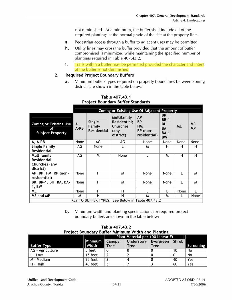
Chapter 407. General Development Standards Article 4. Landscaping
Unified Land Development Code ADOPTED AS ORD. 06-14
Alachua County, Florida 407-31 7/20/2006
not diminished. At a minimum, the buffer shall include all of the required plantings at the normal grade of the site at the property line.
g. Pedestrian access through a buffer to adjacent uses may be permitted.
h. Utility lines may cross the buffer provided that the amount of buffer compromised is minimized while maintaining the specified number of plantings required in Table 407.43.2.
i. Trails within a buffer may be permitted provided the character and intent of the buffer is not diminished.
2. Required Project Boundary Buffers
a. Minimum buffers types required on property boundaries between zoning districts are shown in the table below:
Table 407.43.1
Project Boundary Buffer Standards
Zoning or Existing Use Of Adjacent Property Zoning or Existing Use
of Subject Property
A A-RB
Single Family Residential
Multifamily Residential; Churches (any district)
AP BP HM RP (non-residential)
BR BR-1 BH BA BA-1 BW
ML MS MP
A, A-RB None AG AG None None None None
Single Family Residential
AG None L M H H H
Multifamily Residential Churches (any district)
AG M None L M H H
AP, BP, HM, RP (non-residential)
None H M None None L M
BR, BR-1, BH, BA, BA-1, BW
None H M None None L M
ML None H H L L None L
MS and MP M H H M M L None
KEY TO BUFFER TYPES: See Below in Table 407.43.2
b. Minimum width and planting specifications for required project boundary buffers are shown in the table below:
Table 407.43.2
Project Boundary Buffer Minimum Width and Planting Plant Material per 100 Linear Ft
Buffer Type Minimum Width
Canopy Tree
Understory Tree
Evergreen Tree
Shrub Screening
AG – Agriculture 5 feet 0 0 0 10 No
L – Low 15 feet 2 2 0 0 No
M – Medium 25 feet 3 4 0 40 Yes
H – High 40 feet 5 7 3 60 Yes
Chapter 407. General Development Standards Article 5. Open Space
Unified Land Development Code ADOPTED AS ORD. 07-07
Alachua County, Florida 407-49 4/24/2007
Article 5 Open Space
407.51 Purpose
This Article implements the open space policies contained in the Future Land Use, Stormwater and the Conservation and Open Space Elements of the Alachua County Comprehensive Plan and provides for open space areas designed to protect and enhance natural resources, promote pedestrian connectivity and enhance recreational opportunities.
407.52 Minimum Open Space Requirement
Open space shall be provided on at least 20 percent of a development and shall be delineated on all development plans and plats. Within rural clustered subdivisions, as described in §407.77(b) of this Chapter, open space shall be provided on at least 50 percent of a development.
407.53 Primary Open Space Areas
When land development involves a parcel that contains any of the conservation areas listed in subsection (a), the open space requirements shall first be fulfilled with these areas and the required buffers. When the minimum requirement is not fulfilled with conservation areas, the requirements shall then be fulfilled with Natural Areas as listed in subsection (b).
(a) Conservation Areas and Associated Buffers
1. Wetlands;
2. Surface waters within private ownership;
3. 100 year floodplains;
4. Listed species habitat;
5. Strategic ecosystems; and
6. Significant geologic features.
(b) Natural Areas
Significant habitat or other natural features such as steep slopes, ridges, sinkhole areas, or areas that potentially could be utilized to enhance or restore natural features on or adjacent to the development site. This open space shall be useable to the extent consistent with the character and protection of the resource.
407.54 Secondary Open Space Areas
After conservation areas and associated buffers and other natural areas have been set aside as open space, any remaining required open space may then be fulfilled with the qualifying areas listed in this Section, based upon the type of development.
(a) Residential Developments
Within residential developments, the following areas shall be credited toward open space requirements:
1. Community Green Spaces
Pervious open spaces designed as active or passive recreation areas intended primarily for recreational or pedestrian use, such as community fields, greens, and pervious areas of plazas or squares. Pedestrian amenities and other minor structures that enhance the open space may be permitted within these qualifying open space areas.

Chapter 407. General Development Standards Article 5. Open Space
ADOPTED AS ORD. 05-10 Unified Land Development Code
12/08/2005 407-50 Alachua County, Florida
2. Pedestrian Trails
Paved or mulched pedestrian trails located within a qualifying open space may be counted towards the required open space area.
3. Stormwater Management Areas
Stormwater management areas that are designed consistent with §407.56 and §407.57 may be considered as credit for up to one half of the required open space.
(b) Non-Residential Developments
Within non-residential developments, the following areas shall be credited toward open space requirements:
1. Community Green Spaces
Pervious open spaces designed as active or passive recreation areas intended primarily for recreational or pedestrian use, such as community fields, greens, and pervious areas of plazas or squares. Pedestrian amenities and other minor structures that enhance the open space may be permitted within these qualifying open space areas.
2. Landscaped areas
Landscaped areas with a minimum area of 500 square feet and a minimum width of 20 feet containing native species canopy and understory trees, shrubs, and groundcovers consistent with xeriscape principles.
3. Stormwater Management Areas
All portions of stormwater management areas that are designed consistent with §407.56 and §407.57 may be considered as credit for the required open space.
(c) Quality Mixed-Use Developments
All Community Green Spaces, Pedestrian Trails, Landscaped Areas as described above, as well as buffers, squares, parks, plazas, and all portions of stormwater management areas that are designed consistent with §407.56 and §407.57 shall be credited toward the required open space, for mixed-use developments that meet all of the following standards:
1. Achieve a gross residential density of at least six dwelling units per acre or a minimum of 90% of the maximum density allowed in the urban residential land use category designated on the Future Land Use Map.
2. Contain non-residential uses at a ratio of at least 150 square feet per each residential unit within the development.
3. Establish a vertical mixture of uses with a minimum of 10% of the non-residential square footage having residential uses above.
4. Meet all of the design and development standards for Traditional Neighborhood Developments outlined in Article 7, Chapter 407.
(d) Other Mixed-Use Developments
Within mixed-use developments that do not meet the standards in subsection (c) above, all Community Green Spaces and Pedestrian Trails as described above shall be credited toward the required open space. The proportion of residential to non-
Chapter 407. General Development Standards Article 5. Open Space
Unified Land Development Code ADOPTED AS ORD. 07-07
Alachua County, Florida 407-51 4/24/2007
residential development will determine the portion of stormwater management areas that shall be credited, in accordance with subsections (a) and (b) above.
407.55 Designation of Open Space Areas
(a) Prior to submitting a development plan or as part of the Pre-application conference, when applicable, an applicant shall consult with staff to identify the most appropriate portion of the development site to be designated as open space.
(b) In addition to the specific standards and priorities set forth in this Article, the following goals shall guide the designation of open space:
1. Open space areas shall be useable and contiguous to the extent consistent with the character and protection of the resource.
2. Open spaces should be contiguous to greenways, trails, public parks, or other open spaces on adjoining parcels in order to promote the creation of larger open spaces with greater usability, resource protection, and connectivity.
407.56 Requirements for Stormwater Management Areas used as Open Space
Stormwater management systems shall be designed in accordance with Article 9 of this Chapter and must complement and be integrated with the other required open space areas. In addition to the design requirements of Article 9 for stormwater management areas, the following criteria shall apply in order to be considered as credit toward the open space requirement:
(a) Stormwater management facilities shall be designed to provide a greater biological diversity, enhanced stormwater treatment, and a variety of hydrologic conditions by incorporating the following design features:
1. Provide staged elevations within the treatment volume of the basin. The initial tier, or forbay, should be designed to capture the majority of the sediments. Additionally, baffles, islands, berms, channels and other similar measures may be incorporated to maximize the contact of the stormwater with the surfaces of the basin.
2. At a minimum, one tree shall be planted for every 35 linear feet, or part thereof, of basin perimeter. Within the basin bottom, a variety of native trees shall be provided at an average of one tree every 35 feet on center. Spacing of trees may be closer when trees are planted in groups. Certified apparently weed free sod shall be used.
(b) Retention/detention basins shall be designed with irregular shorelines to increase the overall length of shoreline.
(c) A 12-foot-wide maintained pedestrian path shall be provided around the perimeter of the basin and be connected to pedestrian paths in other open spaces. No clearing, mowing or removal of native, non-invasive vegetation shall take place interior to this path. As an alternative, a designed landscape plan may be approved by the Development Review Committee that would provide greater or equal biological diversity and enhanced stormwater treatment.
(d) Stormwater facilities designated as open space shall be managed to maintain no more than 5% cover of invasive nonnative plants.
407.57 Access to Open Space
(a) Required open space shall be accessible from the development, with the exception of Family Homestead Subdivisions as described in subsection (d) of this Section.
Chapter 407. General Development Standards Article 7. Traditional Neighborhood Development and Village Center
ADOPTED AS ORD. 05-10 Unified Land Development Code
12/08/2005 407-58 Alachua County, Florida
Article 7 Traditional Neighborhood Development and Village Center
407.62 Purpose
(a) Traditional Neighborhood Development
The Traditional Neighborhood Development (TND) is intended to provide flexibility in development, encourage a mix of residential housing types, and create the sense of community common in neighborhoods planned in accordance with traditional design principles and the policies of the Comprehensive Plan.
(b) Traditional Neighborhood Development with Village Center
The option for a Village Center within a Traditional Neighborhood Development allows for limited mixed-use centers integrated into new residential neighborhoods or a combination of new and existing residential neighborhoods, in accordance with the Comprehensive Plan.
407.63 General Standards - TND
(a) Where Permitted
TND shall be located on property with urban residential land use designation within the Urban Cluster, in accordance with the Comprehensive Plan. Properties in the R-1aa, R-1a, R-1c, and R-1b single-family zoning districts may be developed to include multifamily units, provided that they follow the development standards for a TND outlined in this Article.
(b) Other General Standards
1. There is no minimum area required for a TND.
2. The TND shall promote the protection of the natural environment and integration with the topography and natural features of the site.
3. The TND shall promote the creation of usable interconnected open space and recreational facilities on the site; safe, comfortable, and convenient pedestrian and bicycle access; the possibility of transit facilities when warranted; a system of interconnecting streets and blocks providing multiple routes between destinations; and denser development to provide the efficient use of infrastructure.
4. The TND shall promote an integrated range of housing types, lots sizes and civic uses to serve a variety of age and income groups.
5. The TND is created to promote development with well-defined centers and edges, with public or civic spaces as an organizing element around which other development is located.
6. Multi-family residential and other high density residential shall be located at the center of the development. Lower density residential shall be located along the perimeter of the development to provide a transition to surrounding development.
407.64 General Standards – Village Centers
(a) Where Permitted
1. Village Centers shall only be located within a TND with a minimum area of 30 acres.
Chapter 407. General Development Standards Article 7. Traditional Neighborhood Development and Village Center
ADOPTED AS ORD. 06-14 Unified Land Development Code
7/20/2006 407-70 Alachua County, Florida
407.70 Street and Transit Standards
All streets shall meet the requirements of Article 8 of this Chapter, the Alachua County Corridor Design Manual and the requirements of this Section. If the provisions of this Section conflict with these other requirements, the requirements of this Section shall control. All streets that are owned and maintained by FDOT shall follow all FDOT standards.
(a) Connectivity
1. Street stubs shall be provided to adjacent open land to provide for future connections. Signs shall be posted, at the expense of the developer, advising residents of the intent and purpose of the stubbed street. Cul-de-sacs shall be permitted only where environmental concerns or existing development makes a street connection impracticable. Cul-de-sacs shall not exceed 250 feet in length and shall be accessed from a street providing internal or external connectivity.
2. Minimum Connectivity Ratio
The street network within a TND subdivision shall maintain a minimum “connectivity ratio”. For the purposes of this Section, “connectivity ratio” is the number of street links divided by the number of nodes. The required connectivity ratio is 1.4.
3. Calculation of Connectivity Ratio
a. Nodes are any point of intersection of two or more roads. Connections with existing streets, alleys and stub outs to adjacent properties to accommodate future street connections shall not be considered nodes.
b. Links are the segments of road connecting nodes. Alleys shall not be considered links.
c. Use the following formula to calculate the connectivity ratio: links/nodes=connectivity ratio.

Chapter 407. General Development Standards Article 7. Traditional Neighborhood Development and Village Center
ADOPTED AS ORD. 05-10 Unified Land Development Code
12/08/2005 407-72 Alachua County, Florida
(c) Transit Standards
Development within TND subdivisions shall provide for efficient transit service.
1. Transit stops shall be integrated into the design of a TND development, and be located as close as possible to the highest residential densities and to commercial and civic uses and shall be located on existing or planned transit routes.
2. Transit stops shall be located along the street, and pedestrian connections shall be provided to nearby sidewalks and multi-use trails and to adjacent multi-family, commercial, and recreational areas.
3. Connections between transit stops and sidewalks or multi-use trails shall be paved and main entry points for nearby multi-family and commercial buildings and recreational areas shall be clearly marked.
4. The design of transit stops and connections shall be consistent with the pedestrian accessibility provisions contained in the 1997 Florida Accessibility Code, as revised in 2001 and incorporated by reference in Rule 9B-7.0042, F.A.C., and available from the Department of Community Affairs, and with the Americans with Disabilities Act (ADA) requirements.
(d) Blocks
The perimeter of all blocks within the TND and Village Center shall not exceed 1,800 linear feet. A block side shall have a maximum of 500 linear feet of street frontage. Blocks that have a mid-block pedestrian path through the block may have a perimeter up to 2,400 linear feet with a maximum block length of 700 linear feet.
(e) Street Signs
All street signs shall be installed by the developer prior to the issuance of the first Certificate of Occupancy. All street signs shall conform to the requirements in Article 8, Subdivision Regulations, of this Chapter. Decorative poles and accessories are acceptable where they meet the height, size, and reflectivity standards of the latest edition of the Manual on Uniform Traffic Control Devices for Streets and Highways and shall be maintained by the Homeowners’ Association.
(f) Street Hierarchy Classification
Each street within a TND and Village Center shall be classified according to the following:
1. Arterial
This street provides access to commercial or mixed-use buildings, and is also part of the major street network.
2. Collector
This street provides primary access to individual residential properties and neighborhood streets.
3. Neighborhood Street
This street provides primary access to individual residential properties and feeds into collector streets. Traffic volumes are relatively low, with a design speed of 20 mph.
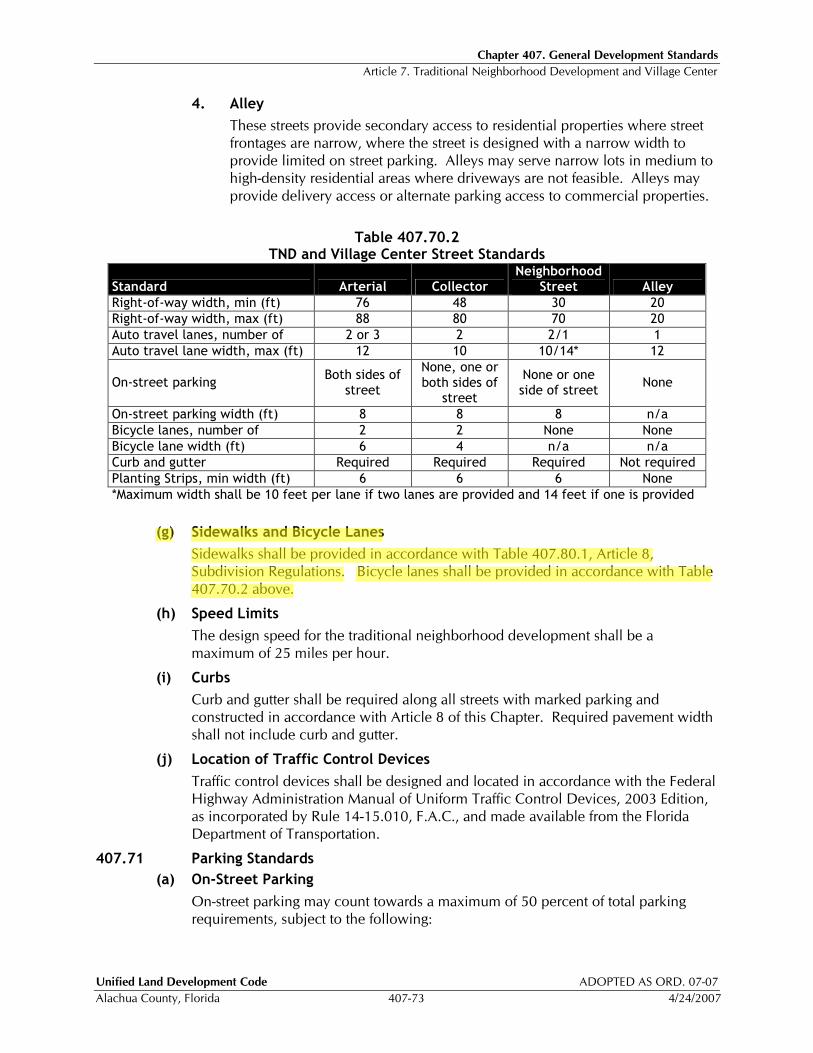
Chapter 407. General Development Standards Article 7. Traditional Neighborhood Development and Village Center
Unified Land Development Code ADOPTED AS ORD. 07-07
Alachua County, Florida 407-73 4/24/2007
4. Alley
These streets provide secondary access to residential properties where street frontages are narrow, where the street is designed with a narrow width to provide limited on street parking. Alleys may serve narrow lots in medium to high-density residential areas where driveways are not feasible. Alleys may provide delivery access or alternate parking access to commercial properties.
Table 407.70.2
TND and Village Center Street Standards
Standard Arterial Collector Neighborhood
Street Alley
Right-of-way width, min (ft) 76 48 30 20
Right-of-way width, max (ft) 88 80 70 20
Auto travel lanes, number of 2 or 3 2 2/1 1
Auto travel lane width, max (ft) 12 10 10/14* 12
On-street parking Both sides of
street
None, one or both sides of
street
None or one side of street
None
On-street parking width (ft) 8 8 8 n/a
Bicycle lanes, number of 2 2 None None
Bicycle lane width (ft) 6 4 n/a n/a
Curb and gutter Required Required Required Not required
Planting Strips, min width (ft) 6 6 6 None
*Maximum width shall be 10 feet per lane if two lanes are provided and 14 feet if one is provided
(g) Sidewalks and Bicycle Lanes
Sidewalks shall be provided in accordance with Table 407.80.1, Article 8, Subdivision Regulations. Bicycle lanes shall be provided in accordance with Table 407.70.2 above.
(h) Speed Limits
The design speed for the traditional neighborhood development shall be a maximum of 25 miles per hour.
(i) Curbs
Curb and gutter shall be required along all streets with marked parking and constructed in accordance with Article 8 of this Chapter. Required pavement width shall not include curb and gutter.
(j) Location of Traffic Control Devices
Traffic control devices shall be designed and located in accordance with the Federal Highway Administration Manual of Uniform Traffic Control Devices, 2003 Edition, as incorporated by Rule 14-15.010, F.A.C., and made available from the Florida Department of Transportation.
407.71 Parking Standards
(a) On-Street Parking
On-street parking may count towards a maximum of 50 percent of total parking requirements, subject to the following:

Chapter 407. General Development Standards Article 8. Subdivision Regulations
Unified Land Development Code ADOPTED AS ORD. 08-06
Alachua County, Florida 407-75 4/22/2008
Article 8 Subdivision Regulations
407.72 Purpose
It is the purpose of this Article to provide criteria for the subdivision of land for residential purposes and to implement policies of the Alachua County Comprehensive Plan.
407.73 General Provisions
(a) All subdivision applicants are required to file a plat in accordance with Article 12 of Chapter 402 except as provided for below in subsection (f) and §407.75.
(b) All subdivisions located within areas designated Rural/Agriculture on the Future Land Use Map 2020 and containing 25 or more lots shall be designed as a Rural/Agriculture Clustered Subdivision consistent with §407.77 of this Article.
(c) For subdivisions located within areas designated Rural/Agriculture and not designed as a Rural/Agriculture Clustered Subdivision as provided in §407.77, no more than 150 lots smaller than eight acres in size, shall be authorized in a calendar year.
(d) No subdivision may be created without paved public road access and all subdivisions created must have internal paved roads that meet county standards, except as provided in §407.75 and §407.76.
(e) No person may divide a lot of record, which does not meet the definition of parent tract unless they comply with these subdivision regulations.
(f) A parent tract may be divided once without complying with these subdivision regulations provided all of the conditions below are met:
1. The tract has frontage on and has direct access to an existing publicly maintained street and the lots have frontage greater than 250 feet. Existing lots not meeting this frontage requirement must provide access to both lots by means of a single joint-access driveway. The one split may provide joint driveway access to the public street in lieu of public street frontage for both lots upon approval by the County Engineer. Access to a privately-maintained road that meets minimum width, stabilization, and maintenance requirements as determined by the Public Works Department and for which the applicant can provide proof of legal access may be used in lieu of a common driveway connection to the public road. A parent tract that was created by means of a variance granted by the Board of Adjustment or a variance granted by the Board of County Commissioners, may not be split, unless the variance was approved prior to October 2, 1991 and the purpose of the split is for a Family Homestead Exception in accordance with Chapter 402Article 23.
2. The new lots created meet the requirements of this ULDC.
3. The lot split must be memorialized in a document recorded in the public record. For purposes of these regulations, lots created by a plat recorded in a deed book and/or government lots established prior to June 1, 1960 may be divided once provided they meet the public road frontage requirements and shall not be subject to the replat requirements or full compliance with this Article but must be memorialized in a document recorded in the public record.
4. Any further division of a parent tract shall be deemed a subdivision and shall comply with these regulations.

Chapter 407. General Development Standards Article 8. Subdivision Regulations
ADOPTED AS ORD. 05-10 Unified Land Development Code
12/08/2005 407-80 Alachua County, Florida
viii. one residential unit used as a homestead immediately prior to the creation of the Rural/Agriculture Clustered Subdivision can continue to be used as a homestead within the open space area and will not be counted toward the total number of units allowed in the rural clustered subdivision.
b. Prohibited uses in any Rural/Agriculture Clustered Subdivision include the more intensive agriculture uses such as concentrated animal density generally associated with milking barns, feed lots, chicken houses, or holding pens.
2. Permanent Protection of the Open Space Areas
a. All open space shall be maintained and remain undeveloped in perpetuity using a legal instrument that runs with the land to set forth conditions and restrictions on use.
b. All open space area and lots shall be restricted from further subdivision through an instrument in a form acceptable to the county and duly recorded in the public record which assures the preservation and continued maintenance of the open space.
c. The boundaries of designated open space areas shall be clearly delineated on plans, including record plats, and marked in the field to distinguish these areas from developed areas.
3. Ownership and Maintenance of the Open Space Areas
Ownership and maintenance of open space shall be by one or a combination of the following:
a. Original landowner at the time of plat recording;
b. Homeowners association;
c. Established land trust;
d. Non-profit conservation organization;
e. Alachua County, with county approval;
f. Other public agency (e.g. Water Management District).
If the open space is not properly maintained, the County may assume responsibility of maintenance and charge the property owner or homeowners association a fee which covers maintenance and administrative costs.
4. Management Plan
A final development plan for a Rural/Agriculture Clustered Subdivision shall include an open space management plan. The management plan shall establish management objectives, outline procedures, and define the roles and responsibilities for managing the open space. Management shall include wildfire mitigation.
407.78 Rural/Agriculture Clustered Subdivision Design Process
In addition to the design process described in §407.74, the following steps shall be taken in the design of a Rural/Agriculture Clustered Subdivision.
Chapter 407. General Development Standards Article 8. Subdivision Regulations
Unified Land Development Code ADOPTED AS ORD. 05-10
Alachua County, Florida 407-81 12/08/2005
(a) Identify Developable Area and Locate Lots
The following standards shall apply to all developable areas within clustered subdivisions.
1. The developable area shall be located outside the designated open space area.
2. Within the developable area, development of residences and infrastructure shall accommodate, to the extent possible, existing natural features, including site topography, water courses, wetland, sinkholes, tree and vegetation lines and similar natural resources.
3. Developable area and lot locations shall be identified in accordance with Table 407.78.1.
4. The developed area of any Rural/Agriculture Clustered Subdivision shall be designed to minimize the visibility of structures from public roadways located at the perimeter of the subdivision through the use of one or more of the following techniques:
a. centralizing the developed area in the interior of the property, if consistent with the protection of open space;
b. use of extensive setbacks from the perimeter of the subdivision to any developed area;
c. use of roadway alignments that minimize visibility;
d. use of buffering, including the planting of additional trees and vegetation;
e. use of fences and walls constructed using materials, colors and styles consistent with the character and context of the area in which located; and
f. retention of trees and understory on individual lots.
(b) Buffering of Conservation and Preservation Areas
When located adjacent to a conservation or preservation area, a Rural/Agriculture Clustered Subdivision shall provide a buffer as indicated in Chapter 406 of this ULDC.
(c) Location of Roads
Within a Rural/Agriculture Clustered Subdivision, the location and construction of roads shall be dependent upon the location of designated open space areas, the identification of most appropriate developed areas, and the anticipated location of individual lots based upon location criteria for such sites. Criteria applicable to the location of roads to serve a Rural/Agriculture Clustered Subdivision are listed below.
1. Construction Specifications
The roads within a clustered subdivision shall be designed to meet the narrowest road profile contained in Table 407.80.1 that shall be adequate to carry projected traffic, considering required connections to roads serving other residential development, and connections to public roads located along the perimeter of the development.

Chapter 407. General Development Standards Article 8. Subdivision Regulations
Unified Land Development Code ADOPTED AS ORD. 05-10
Alachua County, Florida 407-82 12/08/2005
2. Buffers and Setbacks
Roads shall be installed to comply with the minimum buffer and setback requirements from surface waters and wetlands established in Chapter 406, Article 6.
3. Site Location
All roads shall be located so as to minimize alteration of existing terrain, and shall comply with the criteria listed below.
a. Use of Existing Topography
Roads shall be located to follow the natural topography and terrain, rather than to be located so as to require extensive alteration by cut and fill or other construction methods.
b. Use of Existing Natural Features
In addition to following existing topography, roads shall be located adjacent to field edges or tree lines, to avoid excessive removal of natural trees and vegetation.
c. Use of Existing Paths or Trails
The use of existing vehicular access roads, paths or trails is encouraged.
d. Connectivity
Roads shall connect internally with adjacent residential development.
4. Road Improvements
All internal, connecting and local roads shall comply with applicable County standards for width and paving, including paved access to public roads. In addition, all roads shall comply with the following criteria:
a. the roads shall be dedicated for maintenance purposes to an entity approved by the Development Review Committee, and may include the County, a homeowners’ association, other public agency or similar entity; and
b. the roads shall be designed to minimize the number of driveways or similar connections to rural collector and arterial streets.
(d) Protection of Agricultural Activities
1. Buffering Required
a. When located adjacent to agricultural activities that exist either on an adjacent property or within all or part of the open space area of the Rural/Agriculture Clustered Subdivision, buffering shall be provided. The width and type of buffer, is to be determined on an individual basis for each Rural/Agriculture Clustered Subdivision and in no case shall be less than forty feet in width. A minimum buffer width of two hundred feet shall be provided when the developed area is adjacent to intensive agricultural uses. Determination of the width and type of buffer shall be based on the following factors:
i. the location, type and scale of agricultural activities;
ii. the location of the developed area in relation to the agricultural activities.

Chapter 407. General Development Standards Article 8. Subdivision Regulations
ADOPTED AS ORD. 08-06 Unified Land Development Code
4/22/2008 407-84 Alachua County, Florida
2. Variances to Property Development Regulations Prohibited
The Board of Adjustment shall not grant a variance to reduce any property development regulation established by this Section.
(h) Density Incentives for Rural/Agriculture Clustered Subdivisions
Maximum density as provided in Table 407.78.1 above may be increased in accordance with Table 407.78.2 for a parent tract established prior to October 2, 1991 and with the criteria in subsection (i) below.
Table 407.78.2
Maximum Rural/Agricultural Residential Density POTENTIAL ADDITIONALUNITS ALLOWED* REQUIREMENT
2 units for each subdivision Minimum of 50% permanent open space
1 additional unit Per 10 acres of conservation area permanently protected as open space
1 additional unit Per 20 acres of permanent non- conservation area permanently protected as open space
Note: Parcels that include or are adjacent to conservation or preservation areas shall not receive higher density or intensity consideration than the currently adopted designations unless adequate natural resources protection is ensured pursuant to Comprehensive Plan policies and requirements Chapter 406.
(i) Residential Homestead Exception
In addition to the provisions for additional units established by this Section, a dwelling unit that was used as a homestead prior to the creation of the clustered subdivision:
1. may continue to be used as a homestead;
2. may be located in a designated open space area; and
3. shall not be included within the calculation of maximum gross density for the subdivision.
407.79 Traditional Neighborhood Development Standards
Traditional neighborhood developments shall be developed in accordance with the street, open space and design standards contained in Article 7. Where the subdivision standards of this Article would result in a different standard of design, the standards in Article 7 shall prevail for TND or Village Center development.
407.79.5 Subdivision Street Network Standards
All streets shall be designed to meet the design elements of the Alachua County Corridor Design Manual.
(a) External Connectivity
1. No direct access shall be permitted from any lots in subdivisions to any street or highway on the county or state system, which is functionally classified in accordance with F.S. 335.04 at a level of major collector or higher except where the construction of an internal street is not technically feasible as determined by the Development Review Committee or the development
Chapter 407. General Development Standards Article 8. Subdivision Regulations
Unified Land Development Code ADOPTED AS ORD. 05-10
Alachua County, Florida 407-85 12/08/2005
creates only two lots fronting on the street and the lots have frontage greater than 250 feet and are served by a common access driveway.
2. All new lots in subdivisions shall be accessed via a paved public street or a private paved street constructed to county specifications.
3. No lot shall access an unpaved road except for lots meeting the requirements in §407.75.
4. All subdivisions with frontage on a public road shall access the public road except where infeasible due to original tract dimensions or topography.
5. For subdivisions containing 25 or more lots, there shall be a minimum of two functional access points located on different sides of the subdivision except where infeasible due to original tract dimensions, topography or existing development patterns.
6. For subdivision containing only one access, an emergency service access shall be provided in addition to the primary access and shall be maintained, unless a waiver is granted in subsection (a)8 below. The following apply to an emergency service access:
a. it shall be available prior to the issuance of the first certificate of occupancy in the subdivision;
b. it shall have a clear zone of 20 foot horizontal area and 14 foot vertical area; and
c. it shall be stabilized to a limerock bearing ratio of 35.
7. In addition, an emergency service access may:
i. be grassed;
ii. be landscaped with traversable vegetation. The County shall have the right to clear the easement when needed for emergency service access;
iii. be gated provided gates are equipped with Opticom Systems or are locked using a chain and key or combination lock for access by emergency service vehicles.
8. The Development Review Committee may grant a waiver from the requirement for a secondary emergency access in subsection (a)6 above when not feasible due to original tract dimensions, topography, or existing development patterns, provided that a full disclosure statement is placed as a notation on the plat by the applicant, and provided to the initial buyer (and subsequent buyers) informing them that a waiver was granted from the requirement and could potentially prevent the response of fire service, emergency medical service, and emergency management at this location. Buyers shall sign attesting that they understand the impact of this waiver.
9. The layout and types of streets in a subdivision must provide for the continuation or appropriate projection of stub streets and sidewalks to adjacent properties by constructing the improvement as close to the property line as is practicable. Signs shall be posted, at the expense of the developer, advising residents of the intent and purpose of the stubbed street. In addition, where a proposed subdivision abuts an existing development with a stub street, the street system in the proposed subdivision must connect to the
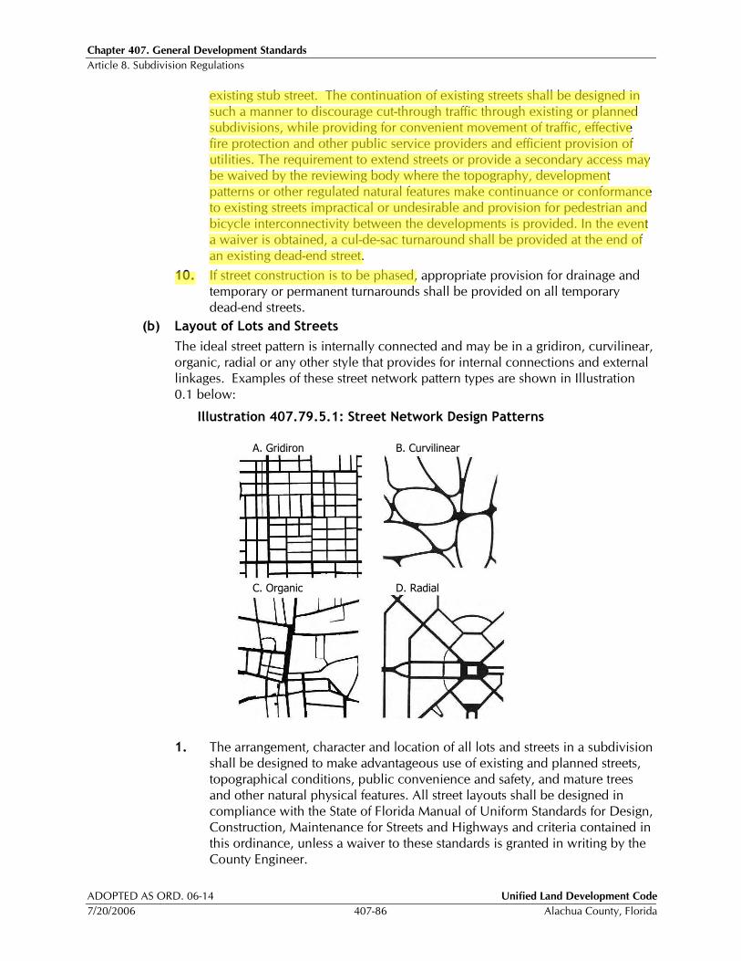
Chapter 407. General Development Standards Article 8. Subdivision Regulations
ADOPTED AS ORD. 06-14 Unified Land Development Code
7/20/2006 407-86 Alachua County, Florida
existing stub street. The continuation of existing streets shall be designed in such a manner to discourage cut-through traffic through existing or planned subdivisions, while providing for convenient movement of traffic, effective fire protection and other public service providers and efficient provision of utilities. The requirement to extend streets or provide a secondary access may be waived by the reviewing body where the topography, development patterns or other regulated natural features make continuance or conformance to existing streets impractical or undesirable and provision for pedestrian and bicycle interconnectivity between the developments is provided. In the event a waiver is obtained, a cul-de-sac turnaround shall be provided at the end of an existing dead-end street.
10. If street construction is to be phased, appropriate provision for drainage and temporary or permanent turnarounds shall be provided on all temporary dead-end streets.
(b) Layout of Lots and Streets
The ideal street pattern is internally connected and may be in a gridiron, curvilinear, organic, radial or any other style that provides for internal connections and external linkages. Examples of these street network pattern types are shown in Illustration 0.1 below:
Illustration 407.79.5.1: Street Network Design Patterns
A. Gridiron B. Curvilinear
C. Organic D. Radial
1. The arrangement, character and location of all lots and streets in a subdivision shall be designed to make advantageous use of existing and planned streets, topographical conditions, public convenience and safety, and mature trees and other natural physical features. All street layouts shall be designed in compliance with the State of Florida Manual of Uniform Standards for Design, Construction, Maintenance for Streets and Highways and criteria contained in this ordinance, unless a waiver to these standards is granted in writing by the County Engineer.

Chapter 407. General Development Standards Article 8. Subdivision Regulations
Unified Land Development Code ADOPTED AS ORD. 06-14
Alachua County, Florida 407-87 7/20/2006
2. Dead-end streets or cul-de-sacs shall not exceed 250 feet in length except where alternative improved emergency service access is provided pursuant to (a)6 above. In no case, shall a dead-end street or cul-de-sac exceed 1,000 feet in length except for unpaved roads developed in accordance with §407.75. Turning radii of a cul-de-sac shall reflect the minimum required for 90-degree turns for WB30’ design vehicles.
3. An intersection shall occur on every street with bordering lots within the subdivision a minimum of every 1,000 feet.
4. Street layouts shall provide for intersecting streets at right angles, 90 degrees, but under no circumstances shall streets intersect at less than 75 degrees, unless a roundabout or traffic circle is adequately designed. Street intersections shall be adequately spaced to prevent conflict or mutual interference of traffic flow. Generally, centerline offsets of less than 150 feet shall be prohibited.
5. On streets with designated on-street parking, bulb-outs shall be provided at the street ends. The resulting bulb-out shall be landscaped with a street tree.
6. Appropriate design speeds shall be identified by the applicant’s Engineer and agreed to by the County Engineer in conjunction with the street and lot layout of the subdivision and shall be in accordance with the Alachua County Corridor Design Manual. The selection of an appropriate design speed shall be based upon a rational prediction of the probable maximum operating speed on the street. The topography, general roadway geometry, surrounding land use, degree of access, use of traffic calming techniques and desired posted speed limits shall be considered.
(c) Dedication of Future Rights-of-Way
All Subdivisions located adjacent to or along an existing or future alignment of a collector or arterial roadway, as identified on the Future Highway Functional Classification Map adopted by Alachua County, shall provide dedication of right-of-way for the alignment. The County Engineer may waive the dedication requirement, if there is a substitute dedication that would serve the same purpose, if due to the location and layout of the subdivision, there is no public need for a dedication.
(d) Waiver of Requirement for Dedication of Roads
The Board of County Commissioner’s, upon recommendation of the Development Review Committee, may waive the requirement for the dedication of public streets and allow the streets to remain privately maintained upon finding that by reason of its location and anticipated use, the road will not serve a public purpose or provide connectivity to other platted or unplatted lands. However, the street to be privately owned shall be designed and constructed in accordance with the provisions of this Chapter. All streets to be privately owned shall be dedicated to a Property Owners Association or other maintenance entity acceptable to the County for ownership and maintenance
407.80 Minimum Design & Construction Standards for Streets and Drainage Systems
The purpose of this Section is to identify street design and construction standards required as a condition of final subdivision approval.
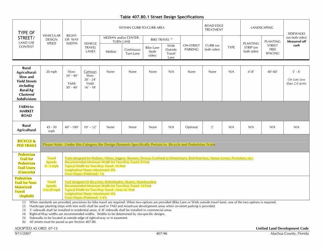
Table 407.80.1 Street Design Specifications
WITHIN CURB-TO-CURB AREA
ROAD EDGE TREATMENT
LANDSCAPING
MEDIAN and/or CENTER-TURN LANE
BIKE TRAVEL (1)
TYPE OF STREET/ LAND USE CONTEXT
VEHICULAR DESIGN SPEED
RIGHT- OF- WAY WIDTH VEHICLE
TRAVEL LANES Median
Continuous Turn-Lane
Bike Lane (both sides)
Wide Outside Travel Lane
ON-STREET PARKING
CURB (on both sides)
TYPE PLANTING STRIP (on both sides)
PLANTING STREET TREE
SPACING
SIDEWALKS (on both sides) Measured off
curb
ADOPTED AS ORD. 07-15 Unified Land Development Code
9/11/2007 407-96 Alachua County, Florida
Rural
Agricultural:
Slow and
Yield Streets
including
Rural/Ag
Clustered
Subdivisions
20 mph
Slow:
34’ - 40’
Yield: 30’ - 40’
Cartways
Slow: 20’ - 24’ Yield:
16’ - 18’
None
None
None
N/A
None
None
N/A
4’-8’
40’-60’
5’ - 6’
On Lots Less
than 2.0 acres
FARM-to-
MARKET
ROAD
Rural
Agricultural
45 - 50 mph
60’ - 100’
10’ – 12’
None
None
None
N/A
Optional
2’
N/A
N/A
N/A
N/A
BICYCLE &
PED TRAILS
Please Note: Under this Category the Design Elements Specifically Pertain to Bicycle and Pedestrian Trials
Pedestrian
Trail for
Pedestrian
Trail Users
(Concrete)
Travel
Speeds: 0 - 5 mph
Trails designed for Walkers, Hikers, Joggers, Runners, Persons Confined to Wheelchairs, Bird-Watchers, Nature Lovers, Picnickers, etc.: Recommended Minimum Width for Two-Way Travel: 8 Feet Typical Width for Two-Way Travel: 10 Feet Longitudinal Slopes (Maximum): 8% Cross Slopes (Preferred): 1%
Pedestrian
Trail for Non-
Motorized
Travel
(Asphalt)
Travel
Speeds: 5-to-20 mph
Trail designed for Bicyclists, Rollerbladers, Skaters, Skateboarders Recommended Minimum Width for Two-Way Travel: 10 Feet Typical Width for Two-Way Travel: 14-to-16 Feet Longitudinal Slopes (Maximum): 8% Cross Slopes (Preferred): 1-4%
(1) When standards are provided, provisions for bike travel are required. When two options are provided (Bike Lane or Wide outside travel lane), one of the two options is required. (2) Hardscape planting strips with tree wells shall be used in TND and mixed-use development areas when on-street parking is provided. (3) 5’ sidewalk shall be installed in residential areas, 6’-8’ sidewalk shall be installed in commercial areas. (4) Right-of-Way widths are recommended widths. Widths to be determined by site-specific designs. (5) Sidewalks to be located at outside edge of right-of-way or in easement. (6) All streets must be paved as per Section 407.80.
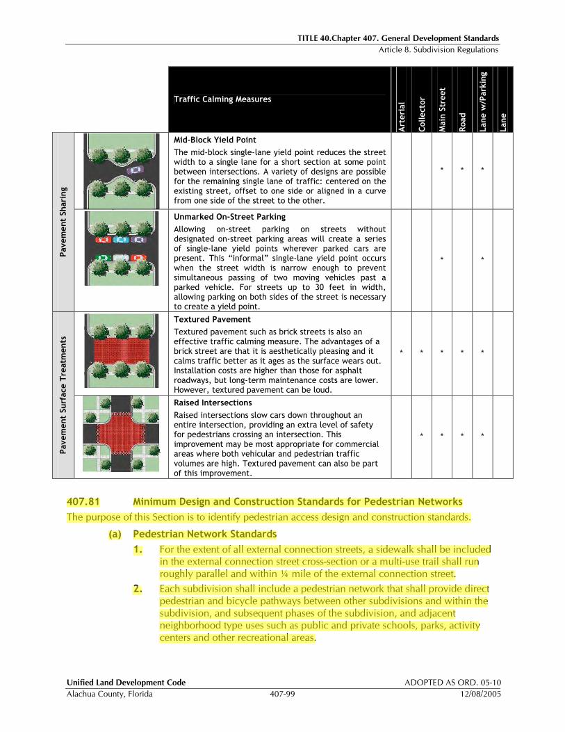
TITLE 40.Chapter 407. General Development Standards Article 8. Subdivision Regulations
Unified Land Development Code ADOPTED AS ORD. 05-10
Alachua County, Florida 407-99 12/08/2005
Traffic Calming Measures
Art
erial
Collecto
r
Main
Str
eet
Road
Lane w
/Park
ing
Lane
Mid-Block Yield Point
The mid-block single-lane yield point reduces the street width to a single lane for a short section at some point between intersections. A variety of designs are possible for the remaining single lane of traffic: centered on the existing street, offset to one side or aligned in a curve from one side of the street to the other.
* * *
Pavem
ent Sharing
Unmarked On-Street Parking
Allowing on-street parking on streets without designated on-street parking areas will create a series of single-lane yield points wherever parked cars are present. This “informal” single-lane yield point occurs when the street width is narrow enough to prevent simultaneous passing of two moving vehicles past a parked vehicle. For streets up to 30 feet in width, allowing parking on both sides of the street is necessary to create a yield point.
* *
Textured Pavement
Textured pavement such as brick streets is also an effective traffic calming measure. The advantages of a brick street are that it is aesthetically pleasing and it calms traffic better as it ages as the surface wears out. Installation costs are higher than those for asphalt roadways, but long-term maintenance costs are lower. However, textured pavement can be loud.
* * * * *
Pavem
ent Surf
ace T
reatm
ents
Raised Intersections
Raised intersections slow cars down throughout an entire intersection, providing an extra level of safety for pedestrians crossing an intersection. This improvement may be most appropriate for commercial areas where both vehicular and pedestrian traffic volumes are high. Textured pavement can also be part of this improvement.
* * * *
407.81 Minimum Design and Construction Standards for Pedestrian Networks
The purpose of this Section is to identify pedestrian access design and construction standards.
(a) Pedestrian Network Standards
1. For the extent of all external connection streets, a sidewalk shall be included in the external connection street cross-section or a multi-use trail shall run roughly parallel and within ¼ mile of the external connection street.
2. Each subdivision shall include a pedestrian network that shall provide direct pedestrian and bicycle pathways between other subdivisions and within the subdivision, and subsequent phases of the subdivision, and adjacent neighborhood type uses such as public and private schools, parks, activity centers and other recreational areas.

TITLE 40.Chapter 407. General Development Standards Article 8. Subdivision Regulations
Unified Land Development Code ADOPTED AS ORD. 05-10
Alachua County, Florida 407-101 12/08/2005
(c) Multi-Use Paths
Multi-use Paths shall conform to the following standards.
1. Vehicle/Path Separation
Where multi-use paths are parallel and adjacent to a driveway or street (public or private), they shall be raised six inches and curbed, or separated from the driveway or street by a 5-foot minimum strip within bollards, a landscape berm or other physical barrier. If a raised path is used, the ends of raised portions shall be equipped with curb ramps.
2. Housing and Path Separation
Multi-use paths shall be separated a minimum of 5 feet from all residential living areas on the ground floor, except at building entrances. Separation is measured from the path edge to the closest dwelling unit.
3. Crosswalks
Where paths cross a parking area, driveway or street (“crosswalk”), they shall be clearly marked with contrasting paving material, humps, raised crossing or painted striping. An example of contrasting paving material is the use of a concrete crosswalk through an asphalt driveway. If painted striping is used, it shall consist of thermo-plastic striping or similar type of durable application.
4. Path Surface
Path surfaces shall be concrete, asphalt, brick/masonry pavers or other durable surfaces, and shall comply with the Americans with Disabilities Act (ADA) requirements.
407.82 Minimum Design and Construction Standards for Other Capital Improvements
The purpose of this Section is to identify design and construction standards for capital improvements other that streets and pedestrian networks.
(a) Street Trees, Landscaping and Irrigation and Subdivision Entry Signs
All subdivision entry signs, landscaping and irrigation that are proposed within county right-of-way shall require a Right-of-Way Use Permit from the Alachua County Public Works Department. Specifications are available from the County Engineer. Where required by the County, street trees must be installed within the public right-of-way in accordance with Article 4, Landscaping, of this Chapter.
(b) Signs
1. Street name and regulatory signs shall be furnished and installed, at the applicant's expense, by the County for all streets to be maintained by the County. For private streets, the regulatory signs shall be purchased from the County; however, the applicant shall be responsible for the installation. All street name and regulatory signs shall comply with the Manual of Uniform Traffic Control Devices.
2. All signs shall be installed prior to final acceptance or release of the streets.
(c) Fire Suppression/Protection
All subdivisions in the urban service area designated on the Future Land Use Map 2020, shall provide a water supply served by hydrants and the fire/suppression protection service level shall be at the ISO (Insurance Service Office) class
TITLE 40.Chapter 407. General Development Standards Article 12. Concurrency Management
Unified Land Development Code ADOPTED AS ORD. 06-36
Alachua County, Florida 407-127 11/14/2006
Article 12 Concurrency Management
407.117 Purpose
The purposes of this Article are to implement the Alachua County Comprehensive Plan’s adopted level of service standards for roads, potable water, sanitary sewer, parks, solid waste, stormwater management, and mass transit.
407.118 Requirements for Concurrency
No final development order shall be approved, except for the development that is defined as exempt or vested pursuant to this Chapter, unless it is determined that the necessary public facilities will be available concurrent with the impacts of the proposed development. The burden of meeting this concurrency requirement will be on the applicant requesting a final development order. The criteria for determining whether the public facilities affected by the development will be available based on the level of service standards adopted for each public facility are as follows:
(a) For potable water, sanitary sewer, solid waste, and stormwater management facilities:
1. The necessary facilities and services are in place at the time a development permit is issued; or
2. A development permit is issued subject to the condition that the necessary facilities will be in place when the impacts of development occur; or
3. The necessary facilities are under construction at the time a development permit is issued and will be in place when the impacts of development occur; or
4. The necessary facilities and services are guaranteed in an enforceable development agreement that includes the provisions in §407.118(a)1, 2 or 3 above. An enforceable development agreement may include, but is not limited to: (1) development agreements pursuant to F.S. § 163.3220, or (2) an agreement or development order issued pursuant to F.S. Chapter 380. Any such agreement must guarantee that the necessary facilities and services will be in place when the impacts of development occur.
(b) For parks and recreational facilities, in addition to meeting one of the criteria defined under subsection §407.118(a) , above, the requirement for concurrency may be met if:
1. At the time the development permit is issued, the necessary facilities and services are the subject of a binding executed contract which provides for the commencement of actual construction of the required facilities or the provision of services within one year of the issuance of the development permit; or
2. The necessary facilities and services are guaranteed in an enforceable development agreement which requires commencement of construction of the facilities within one year of the issuance of the applicable development permit. Such enforceable development agreements may include, but are not limited to, development agreements pursuant to F.S. § 163.3220, or an agreement or development order issued pursuant to F.S. Chapter 380.
(c) For roads and mass transit facilities, in addition to meeting one of the criteria under §407.118(a) or (b) above, the requirement for concurrency, in accordance with
TITLE 40.Chapter 407. General Development Standards Article 12. Concurrency Management
ADOPTED AS ORD. 06-36 Unified Land Development Code
11/14/2006 407-132 Alachua County, Florida
concurrency management official and approved or denied within 45 days of the receipt of the request for reconsideration.
(b) Proposal to Address Denial
Upon receipt of an initial CLSC denial notice, the applicant may submit a proposal to address an initial CLSC denial to the concurrency management official. Such proposal will identify proposed options to remedy the deficiency or deficiencies identified by the county as the basis for the initial CLSC denial. These options may include:
1. Modification of the density, intensity, or timing of the proposed development with identification of how the modifications will remedy the deficiency that was the basis for the initial CLSC denial; or
2. Measures to mitigate the deficiency, including an action plan to reduce the impacts of the proposed development on the affected public facilities that were determined not to be concurrent; such action plans may include special demand management measures to be incorporated as conditions of the final development order; or
3. Proposed improvements to the affected public facility that will be sufficient to offset the impacts of the proposed development resulting in the failure to meet concurrency. Such improvements may be included by the applicant as part of a development agreement or proposed as an amendment to the comprehensive plan in the form of projects to be included in the capital improvement program of the comprehensive plan or amendments to adopted level of service standards.
4. Pay a proportionate fair-share contribution as defined in §407.126.1 of this Chapter.
(c) Response to Proposal
The CMO shall respond to the proposal within 45 days of receipt with an indication of whether the proposal, if implemented, would allow the proposed development to meet the concurrency requirement. If the proposal would require further action by the DRC or by the Board of County Commissioners, the applicant will be informed of the process to be followed to apply for such approval.
407.125.5 Proportionate Fair Share Contribution
(a) Purpose and Intent
The purpose of this Section is to establish a method whereby the impacts of development on transportation facilities can be mitigated by the cooperative efforts of the public and private sectors, to be known as the Proportionate Fair-Share Program, as required by and in a manner consistent with §163.3180(16), F.S.
(b) Findings
Alachua County finds and determines that transportation capacity is a commodity that has a value to both the public and private sectors and the Alachua County Proportionate Fair-Share Program:
1. Provides a method by which the impacts of development on transportation facilities can be mitigated by the cooperative efforts of the public and private sectors;
TITLE 40.Chapter 407. General Development Standards Article 12. Concurrency Management
Unified Land Development Code ADOPTED AS ORD. 06-36
Alachua County, Florida 407-132-1 11/14/2006
2. Allows developers to proceed under certain conditions, notwithstanding the failure of transportation concurrency, by contributing their proportionate fair-share of the cost of transportation facilities;
3. Contributes to the provision of adequate public facilities for future growth and promotes a strong commitment to comprehensive facilities planning, thereby reducing the potential for moratoria or unacceptable levels of traffic congestion;
4. Maximizes the use of public funds for adequate transportation facilities to serve future growth, and may, in certain circumstances, allow Alachua County to expedite transportation improvements by supplementing funds currently allocated for transportation improvements in the Comprehensive Plan Capital Improvements Element CIE).
5. Is consistent with §163.3180(16), F.S., and supports the policies in the Alachua County Comprehensive Plan, Policy 1.1.8 of the Transportation Mobility Element and the Capital Improvements Element.
(c) Applicability
The Proportionate Fair-Share Program shall apply to all developments in Alachua County that have been notified of a lack of capacity to satisfy transportation concurrency on a transportation facility in the Alachua County Concurrency Management System (CMS), including transportation facilities maintained by FDOT or another jurisdiction that are relied upon for concurrency determinations. The Proportionate Fair-Share Program does not apply to developments of regional impact (DRIs) using proportionate share under §163.3180(12), F.S., developments exempted from concurrency as provided in Policy 1.1.8 of the Alachua County Comprehensive Transportation Mobility Element, or developments exempted in §407.124 above.
(d) Fair-Share Mitigation Options
1. An applicant may choose to satisfy the transportation concurrency requirements of Alachua County by making a proportionate fair-share contribution, pursuant to the following requirements:
a. The proposed development is consistent with the Alachua County Comprehensive Plan and applicable Unified Land Development Code (ULDC) regulations.
b. The five-year schedule of capital improvements in the Alachua County Comprehensive Plan CIE or the long-term schedule of capital improvements for an adopted long-term Concurrency Management System (CMS) includes a transportation improvement(s) that, upon completion, will satisfy the requirements of the Alachua County Concurrency Management System (CMS). The provisions of §407.125.5(d)2 may apply if a project or projects needed to satisfy concurrency are not presently contained within the Alachua County Comprehensive Plan Capital Improvements Element or an adopted long-term schedule of capital improvements.
2. Alachua County may choose to allow a developer to satisfy transportation concurrency through the Proportionate Fair-Share Program by contributing to an improvement that, upon completion, will satisfy the requirements of the
TITLE 40.Chapter 407. General Development Standards Article 12. Concurrency Management
ADOPTED AS ORD. 06-36 Unified Land Development Code
11/14/2006 407-132-2 Alachua County, Florida
Alachua County Concurrency Management System (CMS), but is not contained in the five-year schedule of capital improvements in the Alachua County Comprehensive Plan Capital Improvements Plan or a long-term schedule of capital improvements for an adopted long-term Concurrency Management System (CMS), where the following apply:
a. Alachua County adopts, by resolution or ordinance, a commitment to add the improvement to the five-year schedule of capital improvements in the Alachua County Comprehensive Plan CIE or long-term schedule of capital improvements for an adopted long-term CMS no later than the next regularly scheduled update. To qualify for consideration under this Section, the proposed improvement must be reviewed by the Alachua County Board of County Commissioners, and determined to be financially feasible pursuant to §163.3180(16)(b)1, F.S., consistent with the Alachua County Comprehensive Plan, and in compliance with the provisions of this Section. Financial feasibility for this Section means that additional contributions, payments or funding sources are reasonably anticipated during a period not to exceed 10 years to fully mitigate impacts on the transportation facilities.
b. If the funds identified in the five-year Alachua County Comprehensive Plan CIE or financially feasible adopted long-term CMS are insufficient to fully fund construction of a transportation improvement required by the CMS, Alachua County may still enter into a binding proportionate fair-share agreement with the developer authorizing construction of that amount of development on which the proportionate fair-share is calculated if the proportionate fair-share amount in such agreement is sufficient to pay for one or more improvements which will, in the opinion of the governmental entity maintaining the transportation facilities, significantly benefit the impacted transportation system. The improvement(s) funded by the proportionate fair-share agreement shall be adopted into the five-year CIE or the long-term schedule of capital improvements for an adopted long-term CMS at the next annual CIE update.
c. Any transportation capacity project proposed to meet the developer’s fair-share obligation must meet the design standards of both Alachua County and FDOT.
(e) Intergovernmental Coordination
Pursuant to policies in the IntergovernmentalCoordination Element of the Alachua County Comprehensive Plan, Alachua County shall coordinate with affected jurisdictions, including FDOT, regarding mitigation to impacted facilities not under the jurisdiction of the local government receiving the application for proportionate fair-share mitigation. An interlocal Agreement may be established with other affected jurisdictions for this purpose. The interlocal Agreement may include provisions to allow for local governments to provide Alachua County proportionate fair-share contributions from Developers to address deficiencies on County maintained roadways that are within the boundary of a local jurisdiction or are impacted by development within the local jurisdiction. Pursuant to §163.3180(16)(e), F.S., proposed proportionate fair-share mitigation for

TITLE 40.Chapter 407. General Development Standards Article 12. Concurrency Management
Unified Land Development Code ADOPTED AS ORD. 06-36
Alachua County, Florida 407-132-3 11/14/2006
development impacts to facilities on the Strategic Intermodal System (SIS) requires the concurrence of the FDOT.
(f) Application Process
1. Upon notification of a lack of capacity to satisfy transportation concurrency, the applicant shall also be notified in writing of the opportunity to satisfy transportation concurrency through the Proportionate Fair-Share Program.
2. Prior to submitting an application for a proportionate fair-share agreement, a pre-application meeting shall be held to discuss eligibility, application submittal requirements, potential mitigation options, and related issues. If the impacted facility is on the Strategic Intermodal System (SIS), then the FDOT will be notified and invited to participate in the pre-application meeting.
3. Eligible applicants shall submit an application to Alachua County that includes an application fee and the following information:
a. Name, address and phone number of owner(s), developer and agent;
b. Property location, including parcel identification numbers;
c. Legal description and survey of property; Project description, including type, intensity and amount of development;
d. Phasing schedule, if applicable;
e. Trip generation and distribution analysis; and
f. Description of requested proportionate fair-share mitigation method(s).
4. The Concurrency Management Official shall review the application and certify that the application is sufficient and complete within 15 business days. If an application is determined to be insufficient, incomplete or inconsistent with the general requirements of the Proportionate Fair-Share Program, then the applicant will be notified in writing of the reasons for such deficiencies within 15 business days of submittal of the application. If such deficiencies are not remedied by the applicant within 30 days of receipt of the written notification, then the application will be deemed abandoned. The Concurrency Management Official may, in its discretion, grant an extension of time not to exceed 60 days to cure such deficiencies, provided that the applicant has shown good cause for the extension and has taken reasonable steps to effect a cure.
5. Pursuant to §163.3180(16)(e), F.S., proposed proportionate fair-share mitigation for development impacts to facilities on the SIS requires the concurrence of the FDOT. The applicant shall submit evidence of an agreement between the applicant and the FDOT for inclusion in the proportionate fair-share agreement.
6. When an application is deemed sufficient, complete and eligible, the Applicant shall be advised in writing and a proposed proportionate fair-share obligation and Binding Agreement will be prepared by the applicant with direction from Alachua County and delivered to the appropriate parties for review, including a copy to the FDOT for any proposed proportionate fair-share mitigation on a SIS facility, no later than 60 days from the date at which the applicant received the notification of a sufficient application and no fewer

TITLE 40.Chapter 407. General Development Standards Article 12. Concurrency Management
Unified Land Development Code ADOPTED AS ORD. 06-36
Alachua County, Florida 407-132-4 11/14/2006
than 30 days prior to the Alachua County Board of County Commissioners meeting when the Agreement will be considered.
7. Alachua County shall notify the Applicant regarding the date of the Alachua County Board of County Commissioners meeting when the agreement will be considered for final approval. No proportionate fair-share agreement will be executed until approved by the Board of County Commissioners and final development plan approval has been granted. Approval of the agreement shall not be binding upon the decision on the application for final development plan approval.
8. The Public Notice requirement for a proportionate fair-share agreement shall be the same as the public notice requirements for development plans as stated in Chapter 402, Chapter 402Article 4, Public Hearings, Table 402.12.1.
(g) Determining Proportionate Fair-Share Obligation
1. Proportionate fair-share mitigation for concurrency impacts may include, without limitation, separately or collectively, private funds, contributions of land, and construction and contribution of facilities.
2. A development shall not be required to pay more than its proportionate fair-share. The fair market value of the proportionate fair-share mitigation for the impacted facilities shall not differ regardless of the method of mitigation.
3. The methodology used to calculate an Applicant’s proportionate fair-share obligation shall be as provided for in §163.3180(12), F.S., as follows:
“The cumulative number of Peak Hour trips from the proposed development expected to reach the impacted roadways from the complete build out of a stage or phase being approved, divided by the change in the Peak Hour Maximum Service Volume (MSV) of roadways resulting from construction of an improvement necessary to maintain the adopted LOS, multiplied by the construction cost, at the time of developer payment, of the improvement necessary to maintain the adopted LOS.”
OR
Proportionate Fair Share = ∑[ [( Development Tripsi ) / ( SV Increasei )] x Costi]
Where:
Development Trips i = Total number of trips from the stage or phase of development under review (minus pass-by, internal capture, and multi-modal trips) that are assigned to roadway segment “I” and have triggered a deficiency per the CMS;
SV Increase i = The increase in capacity provided by the improvement to the roadway segment “i” (The FDOT Generalized Tables shall be used to establish the base capacity and future year capacity with improvements);
Cost i = Cost of the additional capacity. Cost shall include all improvements and associated costs, such as design, right-of-way acquisition, planning, engineering, maintenance of traffic, utility relocation, inspection, contingencies, stormwater facilities, turn lanes, traffic control devices, bicycle and pedestrian facilities, and physical development costs directly associated with construction at the anticipated cost in the year it will be incurred.
TITLE 40.Chapter 407. General Development Standards Article 12. Concurrency Management
Unified Land Development Code ADOPTED AS ORD. 06-36
Alachua County, Florida 407-132-7 11/14/2006
(h) Proportionate Fair-Share Agreement
1. The Applicant shall provide a draft Proportionate Fair-Share Agreement to Alachua County which contains all required documentation within this Section prior to issuance of a Preliminary Certificate of Level of Service Compliance (CLSC). If the draft Agreement is acceptable to Alachua County, then a Preliminary CLSC may be issued with the condition that, “Prior to the issuance of a Final Certificate of Level of Service Compliance, the applicant shall enter into a Binding Proprotionate Fair-Share Agreement approved by the Alachua County Board of County Commissioners.”
2. Upon acceptance by the Alachua County Board of County Commissioners of a Proportionate Fair-Share Agreement the applicant shall receive a Final CLSC consistent with the provisions of §407.122. Should the applicant fail to apply for a final development permit within 12 months, or as otherwise established in a binding Agreement, then the Agreement shall be considered null and void, and the applicant shall be required to reapply.
3. Applicants may submit a letter to withdraw from the Proportionate Fair-Share Agreement at any time prior to the execution of the Agreement. The application fee and any associated advertising costs to Alachua County will be nonrefundable. The applicant will lose its Preliminary CLSC approval upon withdrawal from the Proportionate Fair-Share Agreement.
4. The Proportionate Fair-Share Agreement shall specify the following:
a. The Payment of the proportionate fair-share contribution shall be due in full prior to issuance of the final development order or recording of the final plat and shall be non-refundable. If the payment is submitted more than 12 months from the date of execution of the Agreement, then the proportionate fair-share cost shall be recalculated at the time of payment based on the best estimate of the construction cost of the required improvement at the time of payment and adjusted accordingly. The acceptable form of payment of the contribution shall also be specified.
b. All developer transportation capacity projects authorized under this Section must be completed prior to issuance of a building permit, or as otherwise established in a binding Agreement that is accompanied by a security instrument that is sufficient to ensure the completion of all required improvements. It is the intent of this Section that any required improvements be completed before issuance of building permits.
c. Dedication of necessary right-of-way for transportation capacity projects purusuant to a Proportionate Fair-Share Agreement shall be completed prior to issuance of the final development order or recording of the final plat. The dedication and supporting documentation shall be completed at no expense to Alachua County.
d. Any requested change to a development project subsequent to a development order may be subject to additional proportionate fair-share contributions to the extent the change would generate additional traffic that would require mitigation.
e. Time frame that the Development is vested for concurrency, to include any phasing provisions or development thresholds.

TITLE 40.Chapter 407. General Development Standards Article 12. Concurrency Management
Unified Land Development Code ADOPTED AS ORD. 06-36
Alachua County, Florida 407-132-8 11/14/2006
f. Process for addressing amendments to the Agreement after the Agreement has been accepted by the Alachua County Board of County Commissioners.
g. Provisions for withdrawal of the Agreement after the Agreement has been accepted by the Alachua County Board of County Commissioners. Upon commencement of development, withdrawal shall not be allowed unless the applicant can clearly demonstrate that the development commenced has complied with all applicable concurrency requirements and that the traffic impact of the development has been acceptably mitigated.
5. Alachua County may enter into a Proportionate Fair-Share Agreement with multiple applicants for selected corridor capacity projects to facilitate collaboration with multiple applicants and allow for shared transportation capacity projects.
6. Pursuant to §163.3180(16)(e), F.S., proposed proportionate fair-share mitigation for development impacts to facilities on the SIS requires the concurrence of the FDOT.
(i) Appropriation of Proportionate Fair-Share Revenues
1. Proportionate fair-share contributions shall be placed in the appropriate project account for funding of scheduled improvements in the five-year Capital Improvement Plan or Long Term Concurrency Management System Plan, or as otherwise established in the terms of the proportionate fair-share agreement. At the discretion of the local government, proportionate fair-share revenues may be used for operational improvements prior to construction of the capacity project from which the proportionate fair-share revnues were derived. Proportionate fair-share revenues may also be used as the 50% local match for funding under the FDOT Transportation Regional Incentive Program (TRIP).
2. In the event a scheduled facility improvement is removed from the five-year Capital Improvement Plan or Long Term Concurrency Management System Plan, then the revenues collected for its construction may be applied toward the construction of another improvement within that same corridor or sector that would mitigate the impacts of development.
3. Where an impacted regional facility has been designated as a regionally significant transportation facility in an adopted regional transportation plan as provided in Section 339.155, F.S., Alachua County may coordinate with other impacted jurisdictions and agencies to apply proportionate fair-share contributions and public contributions to seek funding for improving the impacted regional facility under the FDOT TRIP. Such coordination shall be ratified by the Alachua County Board of County Commissioners through an interlocal agreement that establishes a procedure for earmarking of the developer contributions for this purpose.
4. Where a Developer constructs a transportation facility that exceeds the developer’s proportionate fair-share obligation, Alachua County may elect to establish an account for the developer for the purpose of reimbursing the

TITLE 40.Chapter 407. General Development Standards Article 12. Concurrency Management
ADOPTED AS ORD. 06-36 Unified Land Development Code
11/14/2006 407-132-10 Alachua County, Florida
document, its intent for the use of the concurrency funds to be paid by the applicant.
(k) Impact Fee Credit
Impact Fee Credits for proportionate fair-share contributions shall be provided per the Alachua County Impact Fee Ordinance and shall be consistent with §163.3180(16)(b.)2., F.S.
407.126 Appeals
Any person with legal standing who wishes to challenge a final CLSC or a proportionate share final determination may do so in accordance with the procedures outlined in Chapter 402, Article 28, Appeal Procedures.
407.127 Enforcement
A violation of this Chapter shall be a misdemeanor punishable according to law; however, in addition to or in lieu of any criminal prosecution, Alachua County shall have the power to sue in civil court to enforce the provisions of this Chapter. Violations of this Chapter may also be referred to the Alachua County Codes Enforcement Board for enforcement in accordance with F.S. ch. 162 and chapter 24 of the Alachua County Code of Ordinances, which relate to the Codes Enforcement Board.
Unified Land Development Code ADOPTED AS ORD. 05-10
Alachua County, Florida 410-1 12/08/2005
Chapter 410 Definitions
Contents Article 1 General................................................................................................................. 410-1 Article 2 Abbreviations ....................................................................................................... 410-1 Article 3 Defined Terms ...................................................................................................... 410-2
Article 1 General
410.01 Construction of Words and Phrases
(a) Terms not defined in this Chapter shall be construed in accordance their customary usage and meaning.
(b) The following general rules of construction shall govern the interpretation of words and phrases used in this ULDC.
1. May
The term “may'' is permissive.
2. Shall and Will
The terms “shall,'' “will” and “must” are mandatory.
3. Singular and Plural
The singular word or number includes the plural, and the plural word or number includes the singular.
4. Tenses
The present tense includes the future tenses.
Article 2 Abbreviations
EPD: Alachua County Environmental Protection Department
AASHTO: American Association of State Highway and Transportation Officials
TND: Traditional Neighborhood Development
FDEP: Florida Department of Environmental Protection
BOCC: Alachua County Board of County Commissioners
DRC: Development Review Committee
BOA: Board of Adjustment
ADT: Average daily traffic
WB30’: 30-foot wheel base
VPH: Vehicles per hour
TDR: Transfer of development rights

TITLE 40.Chapter 410. Definitions Article 3. Defined Terms
ADOPTED AS ORD. 08-06 Unified Land Development Code
4/22/2008 410-2 Alachua County, Florida
Article 3 Defined Terms
10-Year Storm Event: A rainfall event having a 10 percent probability of occurrence during any given year.
25-Year Storm Event: A rainfall event having a four percent probability of occurrence during any given year.
100-Year Storm Event: A rainfall event having a one percent probability of occurrence during any given year.
100-Year Floodplain: Areas subject to inundation by a flood having a one percent probability of occurrence in any given year. The 100-year flood elevation is the highest elevation of flood waters during the 100-year storm event and is calculated or estimated from the best available information.
Access: Ingress and egress to land bordering on public streets.
Accessory living unit: An additional dwelling unit, including separate kitchen, sleeping and bathroom facilities, attached or detached from the primary residential unit, on a single family lot. Accessory living units are subordinate in size and location to the primary unit.
Accommodations, overnight: Any hotel, motel, bed and breakfast, rooming house, RV park or campground that is intended to be used for overnight lodging, rented for a period of no more than thirty days.
Activity Center: Area designated on the Future Land Use Map where higher intensity and density land uses are concentrated.
Administrative permit: Any permit that may be granted by Alachua County staff without a public hearing before a development review body, including but not limited to building permits, construction permits, sign permits, and tree removal permits.
Adult day care: Any building, buildings, or part of a building, whether operated for profit or not, in which is provided through its ownership or management, for a part of a day, basic services to three or more persons who are 18 years of age or older, who are not related to the owner or operator, and who require such services.
Advanced treatment: Effluent that has received high level disinfection and contains not more, on an annual average basis, than the following concentrations:
(1) Biochemical oxygen demand (CBOD5): Five mg/l.
(2) Suspended solids: Five mg/l.
(3) Total nitrogen, expressed as N: Three mg/l.
(4) Total phosphorus, expressed as P: One mg/l.
Adverse impact (upon a natural resource): Direct contamination, alteration, or destruction, or that which contributes to the contamination, alteration, or destruction of a natural resource, or portion thereof, to the degree that its environmental benefits are or will be eliminated, reduced or impaired.
Adverse stormwater impacts: Runoff from heavy precipitation that can result in flooding outside of normal floodplains, erosion and loss of property or life.
Adverse visual impact: As used in Chapter 404, Article 12, the negative visual effect of a PWSF on its surroundings. Being able to see a PWSF does not necessarily equate to a negative visual effect.

TITLE 40.Chapter 410. Definitions Article 3. Defined Terms
Unified Land Development Code ADOPTED AS ORD. 08-06
Alachua County, Florida 410-7 4/22/2008
Average daily traffic (ADT): The number of vehicles traveling in all directions over a segment of a road during a 24-hour period.
Beacon: Any light with one or more beams directed into the atmosphere or directed at one or more points not on the same development site as the light source; also, any light with one or more beams that rotate or move.
Bed and breakfast: An owner-occupied dwelling unit where lodging, with or without meals, is provided for compensation, and including customary accessory uses in connection with the principal use.
Beneficiation: The process whereby Matrix is washed to separate the mineral from the earthen materials with which it is naturally combined, and specifically, in phosphate mining, means the Processing of Matrix to separate phosphate rock from the sand and clay soils in which it exists in a natural state.
Best Management Practices (BMPs): A series of guidelines or minimum standards adopted for areawide application, typically associated with agricultural, silvicultural, golf course, and similar operations, designed primarily to prevent soil erosion and water pollution, and to protect certain wildlife habitat values in riparian and wetland areas.
Bicycle lane: A bicycle lane is a lane dedicated for the use of bicycles. A bicycle lane shall be a minimum of four feet wide and shall be measured from the edge of a vehicular traffic lane to the beginning of the shoulder or gutter line. The shoulder or gutter shall not be used in calculating the four foot dimension. Bicycle lanes shall be striped and marked according to AASHTO Standards.
Billboard: An off-site sign located within 660 feet of the right-of-way of Interstate Highway I-75.
Biodiversity (Biological diversity): The variety, distribution and abundance of living organisms in an ecosystem. Maintaining biodiversity is believed to promote stability, sustainability and resilience of ecosystems.
Biosolids: The solid, semisolid, or liquid residue generated during the treatment of domestic wastewater in a domestic wastewater treatment facility or domestic septic tank. Not included is the treated effluent or reclaimed water from a domestic wastewater treatment plant. Also not included are solids removed from pump stations and lift stations, screenings and grit removed from the preliminary treatment components of domestic wastewater treatment facilities, Class AA residuals as defined in Rule 62-640, F.A.C., other solids as defined in Rule 62-640.200(24), F.A.C., and ash generated during the incineration of residuals.
Block: An area composed of private/public lots and alleys surrounded by public streets.
Block Face: Any segment of a block fronting a public street.
Borrow pit: Subsurface excavation of earth materials such as sand, clay or limerock for use as fill material in any type of construction activity.
Buffer: An area of planted or natural vegetation or open space maintained for various purposes, including reduction of erosion and siltation along surface waters and wetlands, reduction of poaching and wind erosion along roads and field edges, provision of wildlife travel corridors and habitat, and for separation of adjacent land uses or properties from one another.
Building: Any structure constructed or used for residence, business, industry, or other public or private purposes or accessory thereto and including tents, lunch wagons, dining cars, trailers, mobile homes, sheds, garages, carports, animal kennels, storerooms, gasoline pumps, and similar structures, whether stationary or movable.

TITLE 40.Chapter 410. Definitions Article 3. Defined Terms
ADOPTED AS ORD. 05-10 Unified Land Development Code
12/08/2005 410-24 Alachua County, Florida
other customary accessory uses and facilities. Overnight accommodations may be provided at these facilities only by special exception.
Marquees and canopies: Any shelter, cover, or protection extending beyond the outer face of the building wall, of either rigid or nonrigid construction, designed and intended to be used for the purpose of shelter or protection for entrances and walkways.
Massage: Touch, stroking, kneading, stretching, friction, percussion and vibration, and includes holding, positioning, causing movement of the soft tissues and applying manual touch and pressure to the body (excluding an osseous tissue manipulation or adjustment).
Massage therapy: The profession in which the practitioner applies massage techniques with the intent of positively affecting the health and well-being of the client, and may adjunctively (i) apply allied modalities, heat, cold, water and topical preparations not classified as prescription drugs, (ii) use hand held tools or devices designed as t-bars or knobbies, and (iii) instruct self care and stress management. "Manual" means by use of hand or body.
Materials recovery facility: A solid waste management facility where recyclable materials are extracted from mixed, municipal solid waste. Nonrecyclable materials are transferred from the materials recovery facility and disposed of as solid waste.
Matrix (geological): The combination of natural earth materials in which any mineral resource is embedded.
Maximum service volume: The maximum capacity of a public facility based on the adopted LOS standard. For the purposes of roadway capacity, maximum service volume shall be determined by the latest Florida Department of Transportation (FDOT) generalized tables, a more detailed analysis such as FDOT's Arterial Planning software, or the Highway Capacity Manual. Any such detailed analysis shall be subject to acceptance/approval by the Alachua County Public Works Department.
Media: Anything printed or written, or any picture, drawing, photograph, motion picture, film, videotape or videotape production, or pictorial representation, or any electrical or electronic reproduction of anything which is or may be used as a means of communication. Media includes but shall not necessarily be limited to books, newspapers, magazines, movies, videos, sound recordings, cd-roms, other magnetic media, and undeveloped pictures.
Median: The portion of a road separating the travel lanes for traffic.
Medical clinic: An institution providing services of a medical nature to human patients, and including related facilities such as out-patient departments and staff offices, but not including facilities for extended overnight care.
Mineral resource: The subsurface deposits of economic value, including but not limited to clay, limestone, peat, phosphate and sand.
Minimal Impact Activities: Activities that will have no significant adverse impact on the resource. Such activities may include installation of navigational aids marked consistent with the requirements of Section 327.40, Florida Statutes; construction and maintenance of public or private nature trails not more that ten (10) feet in width; installation of docks not in excess of one thousand (1,000) square feet in size, subject to performance standards, and other similar activities.
Minimum Descent Altitude: The lowest altitude, expressed in feet above mean sea level, to which descent is authorized on final approach or during circling-to-land maneuvering in execution of a standard instrument approach procedure for which no electronic glide slope is provided.