pumicestone passage key sheet
TRANSCRIPT

Maritime Safety Queensland
Beacon to Beacon GuidePumicestone Passage
Golden Beach, Caloundra
Published byMaritime Safety Queensland© Copyright The State of Queensland (Department of Transport and Main Roads) 2021
To view a copy of this licence, visit https://creativecommons.org/licenses/by/4.0/
For commercial use terms and conditionsPlease visit the Maritime Safety Queensland website at www.msq.qld.gov.au
‘How to’ use this guideUse this Beacon to Beacon Guide with the ‘How to’ and legend booklet available from www.msq.qld.gov.au
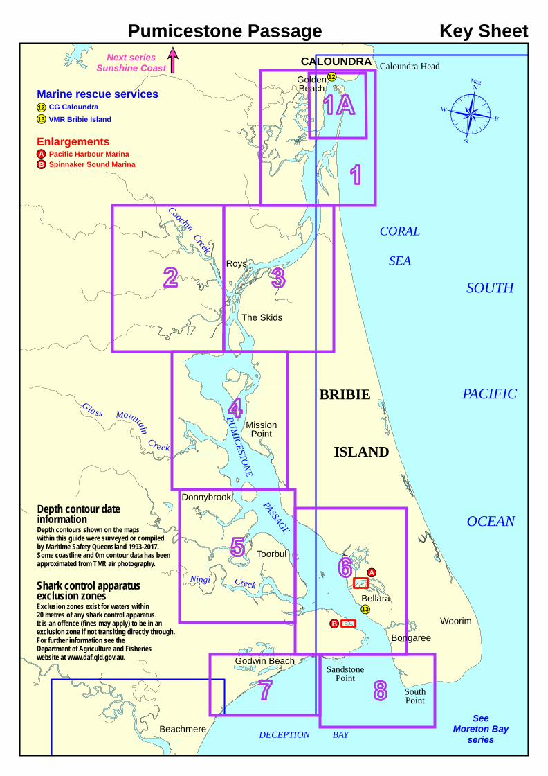
Key SheetPumicestone Passage
SOUTH
PACIFIC
OCEAN
CORALSEA
Caloundra Head12
CALOUNDRA
PUMICESTONE
GoldenBeach
RoysPASSAGE
Donnybrook
Toorbul
Bongaree
Beachmere
BRIBIE
ISLAND
SandstonePoint
Woorim13
The Skids
Coochin Creek
MissionPoint
Ningi CreekBellara
SouthPoint
DECEPTION BAY
Godwin Beach
Glass Mountain
Creek
A
B
SeeMoreton Bay
series
Next seriesSunshine Coast
Marine rescue servicesCG CaloundraVMR Bribie Island13
12
Enlargements Pacific Harbour Marina Spinnaker Sound MarinaAB
Shark control apparatusexclusion zonesExclusion zones exist for waters within20 metres of any shark control apparatus.It is an offence (fines may apply) to be in anexclusion zone if not transiting directly through.For further information see theDepartment of Agriculture and Fisherieswebsite at www.daf.qld.gov.au.
Depth contour dateinformationDepth contours shown on the mapswithin this guide were surveyed or compiledby Maritime Safety Queensland 1993-2017.Some coastline and 0m contour data has beenapproximated from TMR air photography.
Bells Creek
HallsBay
Lamerough
Creek
Lamerough Canal
LakeMagellan
PASSA
GE
PUMI
CEST
ONE
BRIBIE
ISLAND
Bribie IslandNational Park
DeepwaterPoint
Breakers
Breakers
Fl G 2.5s
Fl G 3s
Fl Y 2.5s
Fl G 3s
Fl R 3sFl R 2.5s
Fl Y 2.5s9m 6.5M
QBu (F day)& QG
Iso Bu 2s 27m(FY day)
Fl G 2.5s
Fl R 2.5s
Fl G 2.5s
COOCHINCREEK
CALOUNDRAWEST
PELICANWATERS
CALOUNDRA
Pelican Waters
CaloundraPower BoatClub
Nelson Street
RocksBlueHole
Line of leads 328.5° T
12
PFD
3.85m
Blvd
Pelican
Waters
Blvd
Blvd
Bledis
loe
Mahogany Drive
Kings
BeachCaloundraAerodrome
SOUTH
PACIFIC
OCEAN
NORTHWEST
CHANNEL
Weir and lock
9.6m
9.8m
Coast GuardCaloundra
Pontoon
Fl Y 2.5s
PASS
AGE
Line of leads 328.5° T
Annin
g
Blvd
153°8'E153°7'E153°6'E
26°49
'S26
°50'S
26°51
'S26
°52'S
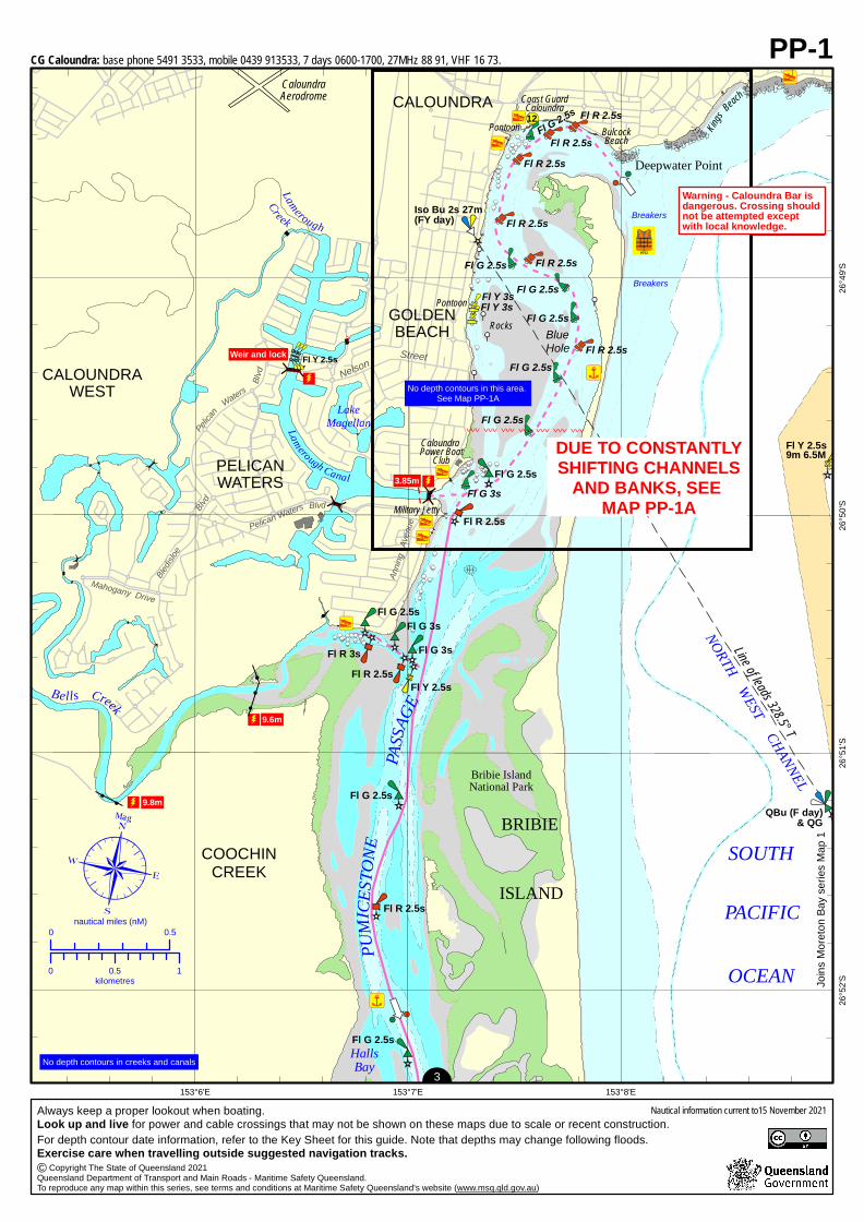
PP-1
0 0.5nautical miles (nM)
0 0.5 1kilometres
3
Joins
More
ton Ba
y seri
es M
ap 1
No depth contours in creeks and canals
Warning - Caloundra Bar isdangerous. Crossing shouldnot be attempted exceptwith local knowledge.
Street
GOLDENBEACH
Iso Bu 2s 27m(FY day)
CALOUNDRA12
Coast GuardCaloundra
Caloundra Power BoatClub
BreakersBreakers
Rocks BlueHole
Annin
g Ave
nue
Military Jetty
Deepwater Point
Kings
Beach
PontoonFl R 2.5s
Fl R 2.5sFl G 2.5s
Fl R 2.5s
Fl R 2.5s
Fl R 2.5s
Fl Y 3sFl Y 3s
Fl G 2.5s
Fl R 2.5s
Fl G 2.5s
Fl G 2.5s
Pontoon
BulcockBeach
Fl G 2.5s
Fl G 2.5s
Fl G 2.5s
Fl G 3s
Fl R 2.5s
Warning - Caloundra Bar isdangerous. Crossing shouldnot be attempted exceptwith local knowledge.
PFD
Breakers
Breakers
No depth contours in this area. See Map PP-1A
3.85m
DUE TO CONSTANTLYSHIFTING CHANNELS
AND BANKS, SEE MAP PP-1A
CG Caloundra: base phone 5491 3533, mobile 0439 913533, 7 days 0600-1700, 27MHz 88 91, VHF 16 73.
For depth contour date information, refer to the Key Sheet for this guide. Note that depths may change following floods.Exercise care when travelling outside suggested navigation tracks. Copyright The State of Queensland 2021Queensland Department of Transport and Main Roads - Maritime Safety Queensland.To reproduce any map within this series, see terms and conditions at Maritime Safety Queensland's website (www.msq.qld.gov.au)©
Always keep a proper lookout when boating.Look up and live for power and cable crossings that may not be shown on these maps due to scale or recent construction.
Nautical information current to15 November 2021

Deepwater Point
Breakers
Fl G 2
.5s
Fl G 2.5s
Iso Bu 2s 27m(FY day)
Fl R 2.5s
Fl R 2.5s
Fl G 2.5s
Fl R 2.5s
Fl R 2.5s
Fl G 2.5s
Coast GuardCaloundra
CALOUNDRA
12
PFD
3.85m
SOUTH
PACIFIC
Fl R 2.5s
Fl R 2.5s
Fl Y 3s
Fl Y 3s
PUMICESTO
NE
PASSA
GE
Fl G 3
s
Fl R 3
sFl
Y 3s
Fl R 2.5s
OCEAN
Caloundra Road
Esplan
ade
Landsb
orough
P
arade
Nelson Street
GOLDENBEACH
Kings Be
ach
Lamerough Canal
Breakers
Breakers
Breakers
North West Channel
LakeMagellan
Line of leads 328.5° TF Bu F Bu
TMR photography 2020
PontoonBulcock Beach
Pontoon
Military Jetty
CaloundraPower BoatClub
Fl G 2.5s
RocksBlueHole
Fl G 2.5s
Fl G 2.5s
Fl G 3
s
153°8'E153°7'E
26°49
'S26
°50'S
0 0.5nautical miles (nM)
0 0.5 1kilometres
1
Joins
More
ton Ba
y seri
es M
ap 1
Warning - Caloundra Bardangerous. Crossing shouldnot be attempted exceptwith local knowledge.
PP-1A
11CG Caloundra: base phone 5491 3533, mobile 0439 913533, 7 days 0600-1700, 27MHz 88 91, VHF 16 73.
For depth contour date information, refer to the Key Sheet for this guide. Note that depths may change following floods.Exercise care when travelling outside suggested navigation tracks. Copyright The State of Queensland 2021Queensland Department of Transport and Main Roads - Maritime Safety Queensland.To reproduce any map within this series, see terms and conditions at Maritime Safety Queensland's website (www.msq.qld.gov.au)©
Always keep a proper lookout when boating.Look up and live for power and cable crossings that may not be shown on these maps due to scale or recent construction.
Nautical information current to 15 November 2021
!!
!!
!
!
! !
!
!! !
!!
!
!!
!
!!
!!
!!
!!
!
!
!
!!
!! !
!!
!!!
!
!
!!!!!!!!
!!
!!
!
!
!
!
!
!
!!!
!!!
!
!
!!
!!!!!
!
!!
!!
!!
!!
!!
!!
!
!
!
!
!
!
!
!!
!!
!!
!!
!!
!!
!!
!!
!!
!!
!!
!!
!
! ! ! ! ! !!
!
!
!
!
!!
!!
!!
!!
!!
!!
!
!
!
!!
!!
!!
!!
!
!
!
!
!
!
!
!!
!
!
!
!
!!
!!
!!
!
!
!
!!!!!!
!!
!!
!!
!!
!
!
!
!!!
!!
!!
!
!!!!
!!
!!
!!
!
!
!
!
!
!!
!!
!!
!!
!!
!!
!!
!!
!
!!
!!
!!
!!
!!!!!!!!!!!!!!
!!
!!
!!
!!
!!
!!
!!
!!
!
!!
!
!
!
!
!!!!!
!
!
!
!
!
!
!
!
!
!!
!!
!!
!
!
!
!
!
!!
!!!
!!
!
!
!!
!
!!
!!
!!
!
!!
!
!!
! !
!!
!
!
!
!!
!
!
!
!
!
! ! ! ! ! ! ! ! ! ! !!
! !
!
!! ! ! ! ! !
!
!
!!
!
!
!
!
!
!
!
!
!
!
!
!!
!!
!
!
!
!
!!
!!
! ! !!
!!
!!
!
!!
!
!
"d
TibrogarganHussey Creek
Tripcony Bight
Saltwater Creek
Coonowrin
Creek
Freshwater Creek
MellumCreek
Creek
Coochin
Coochin
Creek
StateForest
CAMPBELLVILLEState
ForestRoys
Road
Creek
PUMI
CEST
ONE
PASS
AGE
Camping
Johnston Road
¸BR
UCE
HIGHW
AY
153°4'E153°3'E153°2'E153°1'E
26°53
'S26
°54'S
26°55
'S26
°56'S
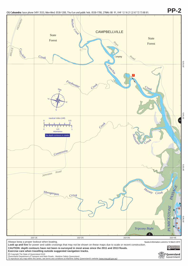
PP-2
0 0.5nautical miles (nM)
0 0.5 1kilometres
N
4
N
3
No depth contours in creeks
¶Mag
AP
P
P
P
PP
PP
PP
PP
PP
PP
PP
PP
CG Caloundra: base phone 5491 3533, Mon-Wed. 0530-1200, Thu-Sun and public hols. 0530-1700, 27MHz 88 91, VHF 12 16 21 22 67 72 73 80 81.
Always keep a proper lookout when boating.Look up and live for power and cable crossings that may not be shown on these maps due to scale or recent construction.
© Copyright The State of Queensland 2019Queensland Department of Transport and Main Roads - Maritime Safety Queensland.To reproduce any map within this series, see terms and conditions at Maritime Safety Queensland's website (www.msq.qld.gov.au)
CAUTION: depth contours have not been re-surveyed in most areas since the 2011 and 2013 floods.Exercise care when travelling outside suggested navigation tracks.
Nautical information current to 14 March 2019

!!
!!
!
!
! !
!
!! !
!!
!
!!
!
!!
!!
!!
!!
!
!
!
!!
!! !
!!
!!!
!
!
!!!!!!!!
!!
!!
!
!
!
!
!
!
!!!
!!!
!
!
!!
!!!!!
!
!!
!!
!!
!!
!!
!!
!
!!
!
!
!
!
!!
!!
!!
!!
!!
!!
!!
!!
!!
!!
!!
!
!!
! ! ! ! ! !!
!
!
!
!
!!
!!
!!
!!
!!
!!
!
!
!
!!
!!
!!
!!
!
!!
!!
!!
!
!
!!
!
!! ! ! ! ! ! !
! ! ! !! !
! !! !
!!
!!
!!
!!
!!
!!
!!
!!
!!
!
!
!
! !
!
!!!!!
!
!
!!
!
!
!
!
!!
!!
!!
!
!!
!!
!
!!
!!
!!
!
! ! !
!
!!
!!
!!
!!
!!
!!
!
!
!!
!!
!
! ! ! ! ! ! ! !
!
!
!
!!
!!
!
! !
!!!
!
!
!
!
!
!
!!
!
!
!
!!
!!
!!
!!
!!
!!
!!
!
!!
!!!!
!
!
!
!!
!!
!
!
!
!!!
!!!
!!!
!!
!!
!
!
!
!
!
!
!!
!
!
!
!
!!
!!
!!
!
!
!
!!!!!!
!!
!!
!!
!!
!
!
!
!!!
!!
!!
!
!!!!
!!
!!
!!
!
!
!
!
!
!!
!!
!!
!!
!!
!!
!!
!!
!
!!
!!
!!
!!
!!!!!!!!!!!!!!
!!
!!
!!
!!
!!
!!
!!
!!
!
!!
!
!
!
!
!!!!!
!
!
!
!
!
!
!
!
!
!!
!!
!!
!
!
!
!
!
!!
!!!
!!
!
!
!!
!
!!
!!
!!
!
!!
!
!!
! !
!!
!
!
!
!!
!
!
!
!
!
! ! ! ! ! ! ! ! ! ! !!
! !
!
!! ! ! ! ! !
!
!
!!
!
!
!
!
!
!
!
!
!
!
!
!!
!!
!
!
!
!
!!
!!
! ! !!
!!
!!
!
!!
!
!
!
!3
!3
!3
!3
!3
!3
!3
!3
!3
!3
"d
HallsCreek
HallsBay
Fl G 2.5s
EggIsland
StateForest
Coochin Creek
LongIsland
BRIBIE
ISLANDThe Skids
Fl G 2.5s
Fl G 2.5s
Fl R 2.5s
Fl R 2.5s
Fl G 2.5s
BribieIsland
NationalPark
Roys
Road
Roys
The NarrowsThe W 's
¸
¸
WestawaysCreek
go slowzone
MarineNational ParkZone
PASSAGE
go slowzone
Husse
yCk
PUMICEST
ONE
MarineNational ParkZone
153°7'E153°6'E153°5'E153°4'E
26°53
'S26
°54'S
26°55
'S26
°56'S
PP-3
0 0.5nautical miles (nM)
0 0.5 1kilometres
N
4
N2
N1
¶Mag
AP
PP
P
PP
PP
PP
PP
PP
PP
PP
PP
Caution - shoaling may occurto less than half a metre LATin this area.
Caution - shoaling may occurto less than half a metre LATin this area.
CG Caloundra: base phone 5491 3533, Mon-Wed. 0530-1200, Thu-Sun and public hols. 0530-1700, 27MHz 88 91, VHF 12 16 21 22 67 72 73 80 81.
Always keep a proper lookout when boating.Look up and live for power and cable crossings that may not be shown on these maps due to scale or recent construction.
Nautical information current to 14 March 2019
© Copyright The State of Queensland 2019Queensland Department of Transport and Main Roads - Maritime Safety Queensland.To reproduce any map within this series, see terms and conditions at Maritime Safety Queensland's website (www.msq.qld.gov.au)
CAUTION: depth contours have not been re-surveyed in most areas since the 2011 and 2013 floods.Exercise care when travelling outside suggested navigation tracks.
Joins
More
ton Ba
y seri
es M
ap 1

!!
!!
!
!
! !
!
! ! !
!!
!
!!
!
!!
!!
!!
!!
!
!
!
!!
!! !
!!
!!!
!
!
!!!!!!!!
!!
!!
!
!
!
!
!
!
!!!
!!!
!
!
!!
!!!!
!!
!!
!!
!!
!!
!!
!!
!
!
!
!
!
!
!
!!
!!
!!
!!
!!
!!
!!
!!
!!
!!
!!
!
!!
! ! ! ! ! !!
!
!
!
!
!!
!!
!!
!!
!!
!!
!
!
!
!!
!!
!!
!!
!
!
!
!
!
!
!
!!
!
!
!
!
!!
!!
!!
!
!
!
!!!!!!
!!
!!
!!
!!
!
!
!
!!!
!!
!!
!
!!!!
!!
!!
!!
!!
!
!
!
!!
!!
!!
!!
!!
!!
!!
!!
!
!!
!!
!!
!!
!!!!!!!!!!!!!!
!!
!!
!!
!!
!!
!!
!!
!!
!!
!
!
!
!
!
!!!!!
!
!
!
!
!
!
!
!
!
!!
!!
!!
!
!
!
!
!
!!
!!!
!!
!
!
!!
!
!!
!!
!!
!
!!
!
!!
! !
!!
!
!
!
!!
!
!!
!
!
! ! ! ! ! ! ! ! ! ! !!
!!
!
!! ! ! ! ! !
!
!
!!
!
!
!
!
!
!
!
!
!
!
!
!!
!!
!
!
!
!
!!
!!
! ! !!
!!
!!
!
!!
!3
!3
!3
!3
!3
!3
!3
!3 !
3
!3
!3
!3
!3
!3
!3
!3
!3
Fl R 2.5s
TripconyBight
LongIsland
ThoolooraIsland
PUMICESTONE
Glass Mountain
Creek
Little GoatIsland
PASSAGE
Poverty Point
MissionPoint
Poverty Creek
DONNYBROOK
CowieBank
Bribie IslandNational Park
StateForest BRIBIE
ISLAND
Stockyards
LimePocket
Fl G 2.5s
Fl G 2.5s
Fl G 2.5sFl R 2.5s
Fl R 2.5s
Fl R 2.5s
Fl G 2.5s
Fl R 2.5s
Fl Y 2.5s
Alice
Stree
t
Tonys Gutter
Dunlops Gutter
¸
¸
¸
Camping
Camping
Camping
Burke
Road
Road
Red
go slowzone
go slowzoneMarineNational ParkZone
MarineNational ParkZone
153°6'E153°5'E153°4'E153°3'E
26°57
'S26
°58'S
26°59
'S27
°0'S
PP-4
0 0.5nautical miles (nM)
0 0.5 1kilometres
N
5
N2 N3
¶Mag
AP
P
P
P
PP
PP
PP
PP
PP
PP
PP
PP
No depth contours in creeks
Always keep a proper lookout when boating.Look up and live for power and cable crossings that may not be shown on these maps due to scale or recent construction.
Nautical information current to 14 March 2019
© Copyright The State of Queensland 2019Queensland Department of Transport and Main Roads - Maritime Safety Queensland.To reproduce any map within this series, see terms and conditions at Maritime Safety Queensland's website (www.msq.qld.gov.au)
CAUTION: depth contours have not been re-surveyed in most areas since the 2011 and 2013 floods.Exercise care when travelling outside suggested navigation tracks.
CG Caloundra: base phone 5491 3533, Mon-Wed. 0530-1200, Thu-Sun and public hols. 0530-1700, 27MHz 88 91, VHF 12 16 21 22 67 72 73 80 81.VMR Bribie Island: base phone 3408 7596, 7 Days. 0500-1800, 27MHz 88 86 90, VHF 16 21 67 73 81.
??????????????????????????????????????????????????????????????????????
!!
!
! !
!
!
!
!
!
!
!
!
!
!
!
/
/
/
!3
!3
!3
!3
"d
"d
"d
"d
"d
DonnybrookRoad
Bullo
ckCr
eek
RoadMeldale
Road
Pumicestone
Road
MELDALE
DONNYBROOK
Bestmann
Road
Road
Bribie
Freem
anRo
ad
Causeway
TOORBUL
Piles(hazard)
Jetties
Jetties
Fl R 2.5s
Fl Y 2.5s
NINGI
BRIBIEISLAND
GallagherPoint
ParrotIsland
Bullock CreekConservation
Park
LittleGoatIsland
PASSAGE
PUMICESTONE
Elimbah
Creek
Elimbah
NingiIsland
Ningi
Creek
BullockCreek
Gallaghe r Gutter
Tonys Gutter
Jetties
Fl R 2.5s
Fl R 2.5s
Fl G 2.5s
Fl G 2.5s
¸
¸
Rocks ¸
Moffatt Esp
Camping
Relesah
Otto
Road
Bishop Pde
Willmer Road
Island
Drive
GutterDunlops
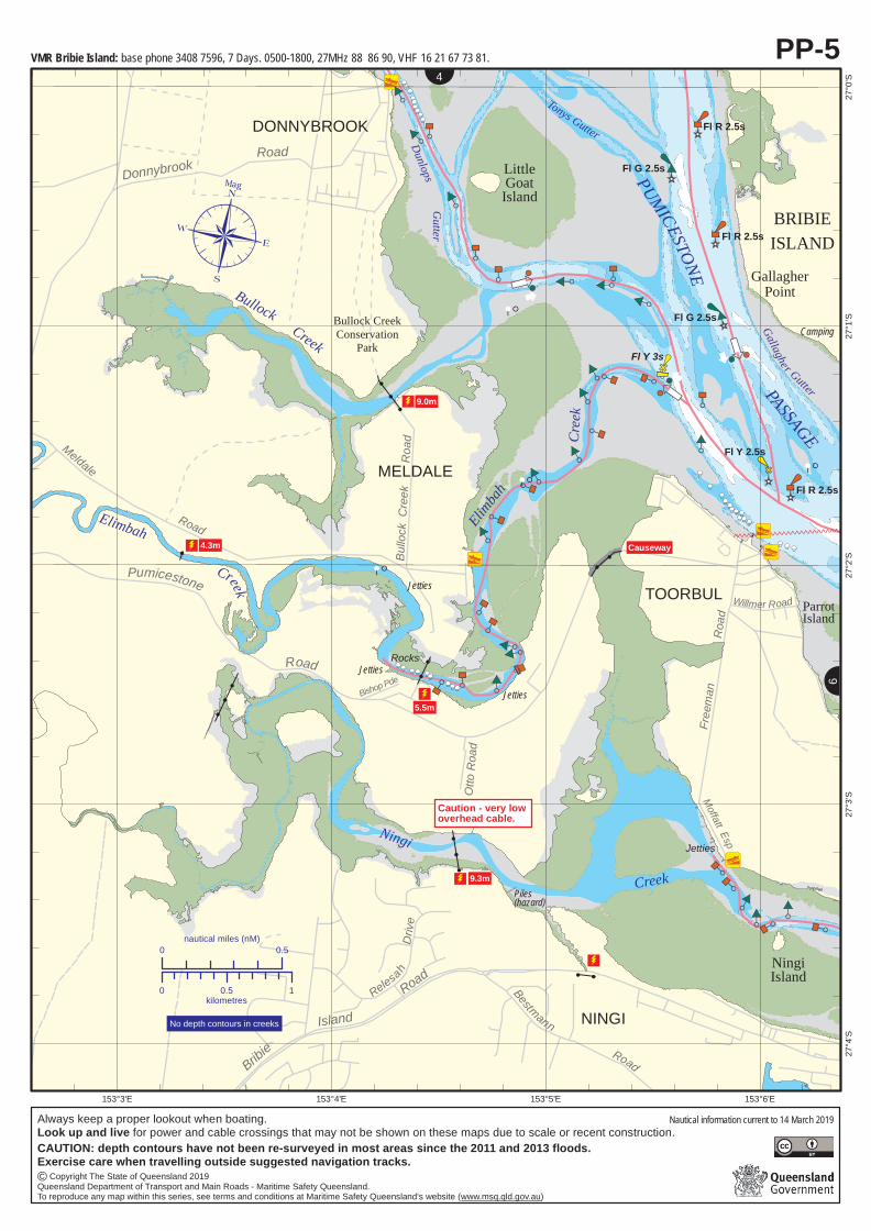
4.3m
5.5m
9.3m
9.0m
Fl Y 3s
Creek
Jetties
153°6'E153°5'E153°4'E153°3'E
27°0'
S27
°1'S
27°2'
S27
°3'S
27°4'
S
PP-5
0 0.5nautical miles (nM)
0 0.5 1kilometres
N
6
N4
¶Mag
AP
P
P
P
PP
PP
PP
PP
PP
PP
PP
PP
Caution - very lowoverhead cable.
No depth contours in creeks
VMR Bribie Island: base phone 3408 7596, 7 Days. 0500-1800, 27MHz 88 86 90, VHF 16 21 67 73 81.
Always keep a proper lookout when boating.Look up and live for power and cable crossings that may not be shown on these maps due to scale or recent construction.
Nautical information current to 14 March 2019
© Copyright The State of Queensland 2019Queensland Department of Transport and Main Roads - Maritime Safety Queensland.To reproduce any map within this series, see terms and conditions at Maritime Safety Queensland's website (www.msq.qld.gov.au)
CAUTION: depth contours have not been re-surveyed in most areas since the 2011 and 2013 floods.Exercise care when travelling outside suggested navigation tracks.
???????????????????????????
??
?
??
?
??
?
??
?
??
?
??
?
??
?
??
?
??
?
??
?
??
?
??
?
??
?
??
?
??
?
??
?
??
? ,
,??????????????????????????????????????????????????????????????????????
,
,
!!
??????????????????????????
,,
???
,
,
!
!
!
!
!
!
!
,, ? ??
!
!
!
???????
, ,
,
,
,
,
,
,
,,
??
,,
????
!
,
,
!
???
,,
!
!
//
//
//
/
!3
!3
!3
!3
!3
!3
!3
!3
!3
!3
!3
!3
!3
!3
PP
P
!
"d
"d
"d
"d
"d
"d
"d
Ningi Creek
Wrights Ck
Gallagher Gutter
PASSAGE
Bribie IslandNational Park
BRIBIEISLAND
National Park RangersHeadquarters
WHITEPATCH
WELSBY
NINGI
TOORBUL
BANKSIABEACH
PacificHarbourParrotIsland
Neds Gutter
Rocks
BELLARA
Bribie
Road Goodwin
Drive
Esp
Sylvan
VMR Bribie Island
Fl R 2.5s
13
Sunderland
Sylvan Beach
BanksiaBeach
Footbridge
Fl Y 2.5s
Fl R 2.5s
Fl R 2.5s
Fl Y 2.5s
Fl Y 2.5s
Fl G 2.5s
'Avon'
Fl G 2.5s
Fl G 2.5s
Fl G 2.5s
¸
¸
3.22m
5.0m
Water towerReservoir ¸
ToorbulPoint
Fl G 2.5s
Water tower(conspic) 33mPEBBLEBEACH
CreelBendFl G 2.5s
F Bu
F Bu
Fl Y 2.5s
Fl R 2.5s F Bu
JettyLock Entry
Road
Pde
Groyne
TigerRock
5.0m
2.0mF Bu
Welsby
Bestmann
Jetty
Bribie Bridge
PUMICESTONE
SolanderEsp
Endeavour Dr
Voyage
rsCanal
WelsbyBridge
BONGAREE
Beach
Skippers
Cana
l
Causeway
Fl R 2.5sFl G 2.5sIsland
DriveFl Y 4s
153°9'E153°8'E153°7'E 153°10'E
27°1'
S27
°2'S
27°3'
S27
°4'S
27°5'
S
0 0.5nautical miles (nM)
0 0.5 1kilometres
N
N5
¶Mag
AP
P
P
P
PP
PP
PP
PP
PP
PP
PP
PP
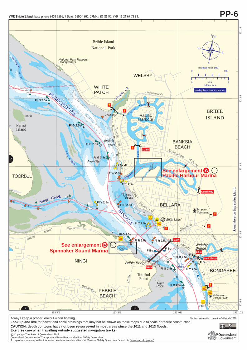
See enlargement Spinnaker Sound Marina
PP-6
8
See enlargement Pacific Harbour Marina
N
7
No depth contours in canals
!B
!A
Always keep a proper lookout when boating.Look up and live for power and cable crossings that may not be shown on these maps due to scale or recent construction.
Nautical information current to 14 March 2019
© Copyright The State of Queensland 2019Queensland Department of Transport and Main Roads - Maritime Safety Queensland.To reproduce any map within this series, see terms and conditions at Maritime Safety Queensland's website (www.msq.qld.gov.au)
CAUTION: depth contours have not been re-surveyed in most areas since the 2011 and 2013 floods.Exercise care when travelling outside suggested navigation tracks.
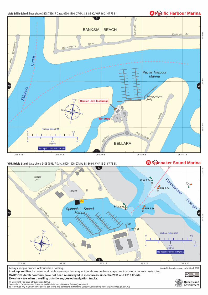
VMR Bribie Island: base phone 3408 7596, 7 Days. 0500-1800, 27MHz 88 86 90, VHF 16 21 67 73 81.
Joins
More
ton Ba
y seri
es M
ap 1

,,
ÐÐ ÐÐ
Ð
!3
//
!(
South Point
Sandstone Point
DECEPTION BAY
BONGAREE
PUMICESTONE
Fl G 2.5s
Q(6) & LFl 15s
Fl G 2.5s
Buckleys HoleConservation Park
BuckleysHole
Jetty
Cooks Rocks ¸PASSAGE
BRIBIE
ISLAND
Fl Y 3s MORETON BAY
Marin
e Na
tiona
l Par
k Zo
ne
153°10'E153°9'E153°8'E
27°5'
S27
°6'S
27°7'
S
0 0.5nautical miles (nM)
0 0.5 1kilometres 
Mag
AP
P
P
P
PP
PP
PP
PP
PP
PP
PP
PP
PP-8
N7
!3
!3
DECEPTION BAYFl Y 3s
BEACHMERE
GODWIN BEACH
Campbell
PdeMarineNational ParkZone
Bisho
p
R
oad
Esplanade
153°7'E153°6'E153°5'E153°4'E
27°5'
S27
°6'S
PP-7N
8
N6
¶Mag
AP
P
P
P
PP
PP
PP
PP
PP
PP
PP
PP
0 0.5nautical miles
0 0.5 1kilometersJoins Moreton Bay series Map 4
Joins Moreton Bay series Map 4 Joins Moreton Bay series Map 7
Joins
More
ton Ba
y seri
es M
ap 1
Always keep a proper lookout when boating.Look up and live for power and cable crossings that may not be shown on these maps due to scale or recent construction.
Nautical information current to 14 March 2019
© Copyright The State of Queensland 2019Queensland Department of Transport and Main Roads - Maritime Safety Queensland.To reproduce any map within this series, see terms and conditions at Maritime Safety Queensland's website (www.msq.qld.gov.au)
CAUTION: depth contours have not been re-surveyed in most areas since the 2011 and 2013 floods.Exercise care when travelling outside suggested navigation tracks.
VMR Bribie Island: base phone 3408 7596, 7 Days. 0500-1800, 27MHz 88 86 90, VHF 16 21 67 73 81.CG Redcliffe: base phone 3203 5522, Mon-Fri 0600-1800, Sat-Sun and public hols. 0400-2000, 27MHz 88 91, VHF 16 67 21 73 81, MF/HF 4125 2182 2524.
VMR Bribie Island: base phone 3408 7596, 7 Days. 0500-1800, 27MHz 88 86 90, VHF 16 21 67 73 81.CG Redcliffe: base phone 3203 5522, Mon-Fri 0600-1800, Sat-Sun and public hols. 0400-2000, 27MHz 88 91, VHF 16 67 21 73 81, MF/HF 4125 2182 2524.
Harbour
Promenade The
Quay
Cosmos AvCosm
os
Tradewinds Drive
Teal
Pacific HarbourMarina
Skipp
ersCa
nal
BANKSIA BEACH
BELLARA
No entry
Sewage pumpoutfacility
Av
Boule
vard
153°8.7'E153°8.6'E153°8.5'E153°8.4'E153°8.3'E
27°2.
9'S27
°3'S
27°3.
1'S
0 0.1nautical miles (nM)
0 100 200metres
N
N6
¶Mag
AP
P
P
P
PP
PP
PP
PP
PP
PP
PP
PP
No depth contours in canals
Pacific Harbour Marina
6
N6
N
6
Caution - low footbridge
Fl R 2.5s
Fl R 2.5s
Fl G 2.5s
Fl G 2.5sSpinnaker SoundMarina
CabooltureBribie
IslandRoad
Kal-Ma-Kuta DrCaravan
park
Car park
¸
Pumicestone Passage
FuelTravel lift
153°8.3'E153°8.2'E153°8.1'E153°8'E153°7.9'E
27°4.
1'S27
°4.2'S
Spinnaker Sound Marina
N
6
NN
6 6
0 0.1nautical miles (nM)
0 100 200metres
No depth contours in Marina
N6
¶Mag
AP
P
P
P
PP
PP
PP
PP
PP
PP
PP
PP
!B
!A
Always keep a proper lookout when boating.Look up and live for power and cable crossings that may not be shown on these maps due to scale or recent construction.
Nautical information current to 14 March 2019
© Copyright The State of Queensland 2019Queensland Department of Transport and Main Roads - Maritime Safety Queensland.To reproduce any map within this series, see terms and conditions at Maritime Safety Queensland's website (www.msq.qld.gov.au)
CAUTION: depth contours have not been re-surveyed in most areas since the 2011 and 2013 floods.Exercise care when travelling outside suggested navigation tracks.
VMR Bribie Island: base phone 3408 7596, 7 Days. 0500-1800, 27MHz 88 86 90, VHF 16 21 67 73 81.
VMR Bribie Island: base phone 3408 7596, 7 Days. 0500-1800, 27MHz 88 86 90, VHF 16 21 67 73 81.