published quarterly by utah geological and …
TRANSCRIPT

PUBLISHED QUARTERLY BY UTAH GEOLOGICAL AND MINERAL SURVEY
SURVEY NOTES Vol. 15, No. 4 Service to the State of Utah November 1981
OILING THE "HINGELINE" A Quick Summary By HOWARD R. RITZMA
Another magic word - "Hingeline" -J-\. with its companion term, thrust or overthrust , conjures up a heady but confused image in the minds of the public - lease brokers, stock brokers, bankers, land owners, housewives with dreams of sudden affluence, and even geologists, especially those from far-off places like Houston, Denver, and Casper.
The Thrust Belt ( or Overthrust Belt) seems fairly well defined as far as its structure is concerned, but many disagree on its exact geographic extent, especially its western limits (Figure 1 ). The "Hingeline" on the other hand, seems almost nebulous in meaning and area, and nobody agrees on much except that it has pumped a lot of welcome revenues into the economy of central Utah.
The Hingeline is an ancient geologic feature with three separate aspects, depositional, structural and topographic. But that is getting ahead of the story.
From north to southwest, slightly west of center, across Utah there has been a line or narrow zone of weakness for more than half a billion years. West of this line the crust subsided steadily and very thick sediments accumulated in the seaways that lapped up on the continental margin to the east. Across the line or zone where the subsidence was hinged - the Hingeline - the thick sedimentary formations of eastern Nevada and western Utah abruptly become thinner, and some sequences were not deposited at all. For selected intervals of geologic time from late Precambrian through medial Paleozoic, the thickness differences are six to twelve times more on the
FIGURE 1. Hingeline area with drilling activities.
west side of the "hinge" than to the east, for example 50,000 feet versus 5,000 feet.
This pattern of thick to the west versus thin to the east persisted with occasional variations and fluctuations until the close of the Triassic time ( early Mesozoic) about 180 million years ago . Then, quite suddenly, as geologic events take place, narrow, north - south, fault-bounded basins developed along the Hingeline area. These filled with a mixture of non-marine and marine sediments and thick beds of salt . The salt, which shows up today as the Arapien Formation (Jurassic age), at Salina and Redmond in
(see page 4)
EXECUTIVE CHANGES ATDNR&E*
The executive leadership of the Department of Natural Resources and
Energy brings together the kind of broad experience and formal educational background necessary to guide our state's natural resource programs during a period of increased growth and development. The department was reorganized and given greater responsibilities by the legislature in the 1981 general session.
Temple A. Reynolds, Jr. was appointed executive director by Gov. Scott M. Matheson in June of this year. He had served as deputy director of the department prior to former executive director Gordon Harmston's retirement. Known as "Temp" by friends and associates, he has extensive experience in natural resource management and a similarly strong educational background. Temp's undergraduate degree was earned at Pennsylvania State University and his graduate degree from Utah State University.
His employment in the resource management field began with the Utah
(see page 8)
*Ed. Note: Information provided by Public Affairs Office, Department of Natural Resources and Energy.
IN THIS ISSUE
Oiling the "Hingeline" . . .. . . .. . ... 1 Executive Changes at DNR & E . ..... 1 Director's Desk .......... ... . . . 2 New Publications . . ... . ... . . . ... 2 Tar Sand Pilot Plant . . . .. . ... .. . . 3 Underground Storage . .. ...... ... 6 Mining Landmark . . . . . . . . . . . . . . . 7 DNR & E Building Dedication . ...... 8 Dike Investigation . .. .... .. .. . .. 9 Utah Toponyms . . . . .. .. .... . . 10 Publication Sales Specials . . .. . . . . . 11 Mineral Activity, 1981 .... . .. . ... 14 Staff Changes ... . ..... .. . . ... 16

( Page 2 SURVEY NOTES
FROM THE DIRECTOR'S DESK
THE UGMS AND PROJECT BOLD
E arly in 1981, Governor Scott M. Matheson and Secretary of Interior James G. Watt agreed to pursue the possibility of exchanging federal lands located
within Utah for state owned lands and lands promised by U.S. Congress to Utah before statehood (1894). Such an exchange anticipates a "blocking" of up to 3 million acres into state management, and relinquishing state management of sections in military reserves, national parks, Indian reservations, certain national forests, wilderness study areas, and, possibly, Utah's scattered state sections. "Project BOLD" is the process of identifying the lands for possible ownership exchange, i.e., those that the state would block out to acquire and those that the state would relinquish.
Many political decisions and local preferences will play a dominant role in selecting those areas for state management, but several natural resources and geologic factors should influence such decisions. The Utah Geological and Mineral Survey has been and continues to play a role in the decision making process.
Economic potential of lands Early on in the Project BOLD process, Howard R. Ritzma and Hellmut H.
Doelling compiled maps and supporting information identifying those areas which appeared to have highest potential for resource development. The UGMS has recommended that federal land in these areas be considered for state acquisition .
Petroleum lands ~ Over 95 percent of the resource royalty from state lands is generated by petroleum development. Some BLM lands in Rich County have proven potential and are UGMS's first choice for state acquisition. The UGMS also identified areas along the projection of the Thrust Belt in Sevier, Sanpete, and Millard counties between the Wasatch Plateau and Fishlake National Forest.
Oil shale and tar sands lands are "area intensive;" the resource underlies most of the area under its surface boundaries. Economic return is potentially high acre for acre. The UGMS identified lands in the Uinta Basin in Uintah County and the Tar Sands Triangle in Wayne and Garfield counties as areas for possible state acquisition.
Potash also is area intensive. An area with good potash reserves was identified in southeastern San Juan County.
Coal lands are well defined as economic resources. The UGMS identified certain areas in the Book Cliffs, the Emery and Alton coal fields, for short-term economic return to the state and 200,000 acres of Kaiparowits coal for long term investment. Three billion minable tons of Kaiparowits coal cannot be overlooked indefinitely.
Uranium is less area intensive than coal, oil shale, or tar sand . Good uranium lands are characterized by ore bodies that underlie less than five percent of a leased area. The UGMS identified areas along the San Rafael River in Emery County; the Henry Mountains and Shootaring area of Garfield County; in Dry Valley, Lisbon Valley, North Lisbon, and La Sal area in San Juan County; and Great Basin potential in the Deep Creek Mountains, Spar Mountain, Wah Wah Mountain and Marysvale area. (see page 6)
November 1981)
NEW PUBLICATIONS
From Utah Geological & Mineral Survey: • Map 60, Utah Land Status with Pro
jected Magnetic Declinations; by U.S. Department of Interior, Bureau of Land Management October 1981, 8½ x 11 inches, multi-color; available for .75 cents over-the-counter.
•Muddy Creek Coal Drilling Project, Wasatch Plateau, Utah, by Archie D. Smith, Utah Geological and Mineral Survey Special Studies 55, October 1981, 57 p.,4 figs., 11 tables, 5 plates; price is $ 7 .50 over-the-counter.
During this project, 27 drill holes successfully tested the lower Blackhawk Formation coal zones and penetrated the Star Point Sandstone on the Wasatch Plateau. Reserve calculations show a total in-place measured, indicated, and inferred tonnage of 561,572,000 short tons of coal; perhaps, half of that amount may be recoverable from three coal beds. The rank of the coal is high volatile C bituminous; the report also lists methane content, ultimate, sulfur forms, and trace element analysis.
• Map 61, Oil and Gas Fields and Pipelines of Utah, including the Thrust Belt Area of Southwestern Wyoming, Janurary 1982, by Karl W. Brown, scale 1 :750,000 (26½ x 32½ inches), multi-color; available for $5.00 overthe-counter. Map 61 is a very attractive map and is a complete revision and enlargement of Map 45 (July 1, 1982).
eMap 63A, Land Control and Resources of the Book Cliffs Coal Field, January 1982, by Steven N. Sommer, Hellmut H. Doelling, and Archie D. Smith, scale 1 inch = 1 mile (24 x 32 inches) , single color; price is $5.00 over-the-counter; after January 4, 1982. Map 63A is a thorough revision of Map 48A. Maps 48B and 48C are currently being revised and will be available on or about March 1, 1982.
(see page I 3, col. I)
A current price list of all available UGMS and UGA publications including an order form , is provided for your convenience with this issue.

( November 1981 SURVEY NOTES
Tar Sand Pilot Plant Dedicated
Apilot plant, partially financed by a grant from the State of Utah and
operated by the Enercor Company, was dedicated November 9 in the northern part of Salt Lake. The initial support for the plant was a $500,000 appropriation made by . the 1981 Utah legislature augmented by $ l ,0Q0,000 invested by Mobil Oil and Southern California Edison. Governor Scott M. Matheson cut the ribbon to officially open the facility.
The plant makes use of the University of Utah process for extraction of heavy oil from oil-impregnated sandstone. The technology, developed during nearly a decade of experimental work by Drs. Alex Oblad and Jan Miller of the Fuels Engineering Department, the University of Utah, is a hot water - alkali assisted process which also uses mineral dressing techniques. It is similar to the hot water process successfully applied in two large commercial plants in Alberta, Canada, but adapted to the different "oil-wet" sands common to Utah.
Research work at the University of Utah was sparked by the mapping and sampling program of UGMS from 1967 into the 1970's which revealed for the first time the magnitude of Utah's tar sand deposits and some of the chemical peculiarities of the heavy oils contained in the sands. Much of the material used in early extraction experiments came from outcrop samples obtained by UGMS and also from a large batch of leftover oil-rich cores from the 1973 UGMS coring program in the P. R. Spring deposit.
The Enercor plant will process about 125 tons per day of raw tar sand and, depending on grade, extract about 50 to 100 barrels per day of heavy oil. Raw material will be shipped in from a number of Utah deposits for testing, including P. R. Spring, Sunnyside and Whiterocks. ■
FIGURES 1-3 (from top to bottom): 1. Ore feed system; 2. Conditioning and floatation; 3. Inside view of pilot plant building (2200 North 11th West, Salt Lake City).
By HOW ARD R. RITZMA
Page 3)
( Page 4 SURVEY NOTES November 1981)
9000' WASATCH MONOCLINE
SANPETE VALLEY
6000'
5000'
..._ __ ......_ __ ....._ __ _._ __ _._ ___________ __.Jl Ml LE
LEGEND
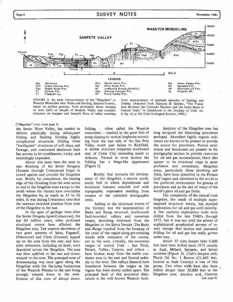
Qal Alluvium Ktn North Horn Fm. Ka Allen Valley Fm. Tch Crazy Hollow Fm. Kp Price River Fm. Ks Sanpete Fm. Tgu Green River Fm. Ki Indianola Group (Undiff.) Jm Morrison (?) Fm. Tc Colton Fm. Ksx Sixmile Canyon Fm. Ja Arapien Sh. Tf Flagstaff Ls. Kf Funk Falley Fm.
FIGURE 2. An early interpretation of the "Hingeline" or Wasatch Monocline near Wales and Sterling, Sanpete County, based on surface geology. Note prominent down warping to west (left) on margin of Sanpete Valley and complex structure on margins and beneath floor of valley resulting
from superposition of multiple episodes of faulting and folding. (Adapted from Edmund M. Spieker, "The Transition Between the Colorado Plateaus and the Great Basin in Central Utah," in Guidebook to the Geology of Utah, no. 4, fig. 10, p. 69, Utah Geological Society, 1949.)
("Hingeline" cont. from page 1)
the Sevier River Valley, has tended to deform plastically during subsequent folding and faulting forming highly complicated structures. Drilling these "toothpaste" structures of soft clays, salt flowage, and overturned sandstone beds has proven to be troublesome, tricky, and exceedingly expensive.
About this same time the west to east thrusting of the Sevier Orogeny (Jurassic through Cretaceous) began to crowd against and override the Hingeline area. Mostly by coincidence, the leading edge of the thrusting from the west seems to end at the hingeline zone except to the north where the thrusts have overridden the Hingeline by as much as 35 to 50 miles. It was during Cretaceous time that the seaways switched position from west of the Hio.geline to the east.
In the span of geologic time after the Sevier Orogeny (post-Cretaceous), the last 60 million years, other profound structural events have affected the Hingeline area. The western shorelines of two great systems of lakes, Flagstaff, (Paleocene) and Uinta (Eocene), lapped up on the area from the east; and lacu- · stine sediments, including oil shale, were deposited across the Hingeline. The area was then uplifted to the east and downwarped to the west. The principal zone of downwarping was once again along the Hingeline with the flat-lying formations of the Wasatch Plateau to the east being strongly warped down to the west. Erosion of this zone of abrupt down-
folding - often called the Wasatch monocline - resulted in the great belt of steep-dipping to vertical hogbacks extending from the east side of the San Pete Valley south past Salina to Richfield. A similar structure reappears southward east of Cedar City extending south to Arizona. Viewed in cross section the folding has a hinge-like appearance (Figure 2).
Briefly, that recounts the development of the Hingeline, a narrow northsouth belt in which depositional and structural features coincide and with topographic expression resulting from erosion of the upturned stratigraphic units.
Adding to the structural events of the Tertiary was the superposition of Basin and Range structure, north-south fault-bounded valleys and mountain ranges, stretching westward from the Hingeline to the Sierra Nevada. The Basin and Range resulted from the breakup of the crust of the region along pre-exisiting trends with extension of the continent to the west. Literally, the mountain ranges of central Utah - San Pitch, Pavant, Valley, Canyon, and others -have broken away from the stable continent area to the east and floated sedately to the west. The valleys (basins) have foundered between the ranges as the region has been slowly pulled apart. The principal fault of this structural dislocation is the well known Wasatch fault.
Analysis of the Hingeline area has long intrigued the discerning petroleum geologist. Abundant highly organic sediments are known to be present to provide the source for petroleum. Porous sandstones and limestones are present in the stratigraphic section to provide reservoirs for oil and gas accumulation; there also appear to be structural traps in great profusion and complexity. Hingeline areas, particularly those involving salt folds, have been identified in the Persian Gulf region and elsewhere in the world as the preferred environment for genesis of petroleum and as the site of many of the world's giant oil and gas fields.
The complexity of the central Utah hingeline, the result of multiple superimposed structural events, has stymied exploration for oil and gas until recently. A few cautious exploratory wells were drilled from the late 1940's through 1975, but it was not until the advent of sophisticated geophysical surveys of recent vintage that serious and sustained drilling for oil and gas has really gotten under way.
About 35 tests deeper than 8,000 feet have been drilled since 1975, mostly in Juab, Millard, Sanpete, and Sevier counties (Figure 3). Utah's deepest well, Placid Oil No. 1 Barton (21,845 feet, located in Juab County) is one of this group. Two other wells have also been drilled deeper than 20,000 feet in the Hingeline area. Another well, Chevron
(see page 6)

( November 1981 SURVEY NOTES Page 5) T. 11 S. (
r
~ 3E f(Jo· 4E
I 9W SW 7W 6W 5W 4W 3W I) 2E 3E Utah ,12w :_j1W 1E ~-- 6E
I '-----'•-....--,·-~·-- r-r:,.----~•r i'\ Sanpete Co.
Ii T. 12 S. '!,\)•'O .,
I NEPHI ~-_j I Pl .d • f<l-_ Phillips ,r 2½
T. 13 S. aci r 1 Neilson
I 2 Howard . 9502 Placid 10,759 (Completing) i ' I -
I r,
1A Howardvv T. 14 S. 12,150 oJ o +-~ Juab Co. . ./'\ uu
i ---••i-----i•• "½ i Millard Co. Argonaut ~ " J ..
-~Ii I Placid () ~E
G ◊ Hanson T. 15 S. ◊ 1 Fed tr· ~
2 State !¢' 1-AX Moroni __ j_ I 11,266 . 13,509 ~ B ()H 21 ,264
I I '? ► I Gulf I y ) A Co '<>. T. 16 S. < 1 Gronning
I 8061 J~ < u -~
Mobil
:0 I 1 Larson
I f I
LPlacid Chev;on -<; 10,043
L .. 9jo T. 17 S, . ~- 1 Barton 1 Chriss Canyon uu I .. ,. 21,845 : Ir ~--, I r DEEPEST WELL- IIMANTI I T. ◊ Placid INUrH 18 s. 1 Henley
I 13,106 : :
rV ■ l> Arco _IPlacid {
Phillips I; T. 19S. I Pavant Butte ,(>! 1-2 WXC-USA 1E USA C E
I 0 '18,266 \ ,(> 20450 "1iw
I
I I Cominco Williams I l
~I T. 20S. ◊ 2 Beaver Rvr 1 Monroe◊•
I 9,250 15,369 . tv··-·;1 San Co. __ ......i
I 1½ -•-r-~ ·--c:-~---1er o. I
I ,.j 1 Forest
I T. 21 S. ■FILLMORE
I ~-- ,Phillips I 2½ . 1 Sigurd
I 1 USA-0 I Arco Shell V 9.098 14,444 T. 22S. ) 1 Hole-ln•Rock 1 Unit◊
1<> i I 10,990 8,962 Chevron O ¢- I I 1 Salina Canyon Phillips O I I Gulf T. 23 S.
RICHFilf 1 Maple Spgs
◊ 1 Johnson i I I I 11,080
I I
I I . ~ / 1E 2E 3E 4E 5E i 6E T. 24S. ~ ., I acid~
~ ~-.r .: 0 1 Paxton LEGEND I T. 25S,
f 5W 4:/ ~
9W SW 7W 6W 4½ 3W 2W 1W Operator (
iJ ◊ No. Name (or Lessor) Dry hole Millard- -Co. I
Total depth .ii---.--· Beaver Co. , I'" 0 Drilling Well (10-31-81) T. 26S. ~ I
, ___ ··----·- ti-■-•- ~..!!!_ • .-..£2:.. -- KEY TO LETTERED WELLS
I j Piute Co.
i/ (NORTHEAST AREA) T. 27 S. \ .• \ I A. Placid 13-7 Monroe 15,727
I " B. Placid 1-WXC-State 13,888
Badger
~ 1a C. Amoco 1 Sevier Bridge (drilling)
T. 28S. 1 Lulu-State D. Standard 1 Levan 7,526 I 11,3~7 ·1 I
j E. AMO 16-34 Chicken Cr. 13,515
I V I I I
It F. Dixel 1 Gunnison - State 15,833 BEAVER 5 0 5 10 15 20 G. Tennessee 1 Irons 9,995 T. 29S. • b R d I I I I I i;t H. Phillips 1 Price 12,332
MILES Compiled by : K. W. Brown (11/81) Cartography by: D. E. Powers, UGMS
FIGURE 3. Test wells drilled (and being drilled) in central Utah "Hingeline" area.

( Page 6
Public entities, for reason of protection, space, cost, access, security, etc.,
may turn to the underground environment for storage of such commodities as fuel, files, and food. Increasing emphasis upon energy efficiency will place additional attention upon creation of underground space. Constant temperature and humidity can be maintained with relative ease. Escalating costs for land mean that not only are there pressures to bu11d . upward, but also downward.
SIGHTS ON PUBLIC FACILITY SITES Seventh article in a continuing series
Wherever possible, existing underground openings, whether natural or man made, may be utilized. Increasingly, we shall see purposeful excavation of underground openings for storage space. Siting of the facility will need to consider the
(Director's Desk cont. from page 2)
SURVEY NOTES
Underground Storage By BRUCE N. KALISER
excavation and handling characteristics of the rock or soil material, moisture content and water table depth, ground support, and use for the excavated material.
If the excavated material can be used for aggregate, rip rap, ballast, etc., the cost of the whole operation will be considerably reduced. The closer to the market the more valuable it is. ·
Physical characteristics of the material affect the design of the opening. If in rock, _fracture systems, mineral veins and rock types will govern the technique of mining and the support .system required.
Groundwater in the vicinity can be a problem, or in some cases a potential resource of self sufficiency. An existing storage vault situated in the mountain block east of Salt Lake City has a spring issuing from an open joint in the igneous
Metal -and non-metallic mineral deposits are not area intensive; these deposits are often small and scattered. "Good" areas have mineral deposits underlying less than one percent of the area. In the western desert such lands with high
. potential include the Newfoundland Range and Crater Island in -Box Elder County; Stansbury Island and the northern portion of the Cedar Mountains in Tooele County; Gold Hill, and the Deep Creek Range in Tooele and Juab counties; Thomas Range, and Drum Mountain in Juab County; the Wah Wah and Indian Springs mountains in Beaver County; the western pa:tt of Iron County; the Henry Mountains and the western slope of the San Rafael Swell in Emery County; and areas south of Interstate-70 in Grand County.
Progress Report In addition to UGMS input, the Project BOLD staff received priority
criteria from local governments, public interest groups, and public land users including current lease and claim holders. They drew up maps of lands that might be exchanged to and from state ownership. Some areas correspond with UGMS suggestions; others do not. The process is well underway but far from over. The Division of State Lands is revising its initial selections of lands and will request comments on the new maps in early 1982 in order to present a final package to the U. S. Congress for ratification in late 1982.
Many natural resource issues will be considered to resolve questions of potential accessibility of lands for mineral dev~lopment, immediate versus long term and unknown mineral resource lands, direct:versus indirect economic returns to the State of Utah, "unitizing" of revenues from government lands, and protection of existing patented and unpatented mining claims and mineral leases, to name just a few.
It is not a simple task to consider a major realignment of land ownership patterns in Utah. Whatever the outcome, Project BOLD represents an attempt to address public land ownership and management issues. I would urge Utah's geologic community to become familiar with · this land exhange proposal and would welcome unofficial comments and advice by telephone or letter. ■
November 1981)
stock which provides water of culinary quality year round.
Storage of records of all types including vital statistics, taxes, maps and photographs becomes an ever more cumbersome task. Underground openings are additionally required for transit systems, jails and operations centers, especially for civil defense. These, too, are all public facilities.
Mistakes in judgement of subsurface conditions can be costly, indeed. An unanticipated zone of weakness or water condition can require a total redesign. For this reason, pilot boring, preferably under the auspices of a geological engineer, may be essential.
For t)ile most part underground structures are relatively earthquake resistant as well as resistant to man caused disasters. They should enjoy an extended lifo as a functional facility. ■
("Hingeline" cont. from page 4)
No. 1 Chriss Canyon, in Sanpete County , now drilling, is planned to penetrate to a new record depth of 22,500 feet. One company, Placid Oil, is now drilling its ,ninth well ahng the central Utah hingeline, and sources in the oil industry estimate that this drilling campaign has cost upwards of $65,000,000. The total costs of drilling, seismic work, leasing, and other exploratory activity by oil and gas companies in the area is estimated as close to half a billion dollars over the past seven years.
· To date success has eluded these sophisticated exploration programs conducted across central Utah's valleys and mountain ridges. But the tremendous new oil and gas reserves being discovered and developed in a similar geologic environment only 100 miles northeast are sufficient encouragement and incentive to keep the exploration programs rolling for years to come. One big well could make Millard or Sanpete as well known as Summit or San Juan amorig Utah's oil-producing counties.
One Salt Lake petroleum geologist remarked recently, "It's surprising how many people on Wall Street know about Juab County. They may not know how to pronounce it, but they certainly know · where it is." ■

( November 1981
MINING LANDMARK GONE
By BRUCE N. KALISER
A tragic fire in Park City on July 20 I"'\.. completely destroyed the Silver King Ore-Loading Station constructed in 1901 and listed on the National Register of Historic Landmarks (Figure 1 ). Though deserted, the prominent heavytimbered structure was admired by miners and nonminers alike.
A mile-long tramway linked the station to the mine, which was located at an elevation of 8,100 feet. The tramway entered the facility at the fourth floor level and ran by gravity. The weight of the ore descending from the mine gave the conveyor enough momentum to carry it back up to the mine loaded with fuel or supplies on the return trip. Buckets attached to the tramway cable dumped ore from the top level of the loading station into hoppers. From the hoppers, the ore then dropped down chutes into railroad cars drawn up below for shipment to the smelters. High grade and low grade silver ore entered the station at separate portals. ■
FIGURE 1. Cross section of old Silver King Ore-Loading Station, Park City, Utah (from T. A. Sande, Industrial Archeology, Harmondsworth, England: Penguin Books Ltd., 1976, p. 4).
SURVEY NOTES
_o, ..... _
--~ !ntll,Mlt(,a"-M,1~/--
/
_,/_,,/'
Page 7)
Water Issues From Fault Scarp
A sudden appearance of approximately 200 g.p.m. of water along the foot
wall of the Hot Springs branch of the Wasatch fault in Salt Lake City in October brought a request from the City for UGMS assistance.
Groundwater in the vicinity was sampled for partial chemical analysis and water temperatures were taken for comparison purposes.
City water crews discovered a leak in a water line during the evening of October 21. The break occurred about 400 feet east of the springs and at an elevation about 70 feet higher.
According to Bruce N. Kaliser, Chief, Hazards Section, considerable anomaly was demonstrated between the City water and new springs. Lower pH (6.9 vs 8.2) for the latter source, higher
Publications
Make Excellent
Holiday
alkalinity (256 vs 212), considerably greater hardness (448 vs 210), and considerably higher temperature (59°F vs 45°F) were recorded.
Other sampled groundwater discharge points included upward seepage from the floor of the Victory Road reservoir site, a hill spring issuing from a point approximately 100 yards north of the pipe break ( unconnected with the break), and water from the Hot Springs itself, from which the fault has been named.
No explanation can presently be provided for the difference in water chemistries but Kaliser speculated that mixing must have occurred between the City water and shallow groundwater east of Victory Road in the course of its flow path toward the new springs. ■

( Page 8
(Executive Changes cont. fr oil) page 1)
Division of Wildlife Resources (Fish and Game Department in those days) in 1955. Ten years later he went to work for the newly created federal government Heritage Conservation and Recreation Service. Temp's new career in the Federal Government saw him moving to progressively more responsible jobs in San Francisco and Washington, D. C. While in Washington, D. C. in 1969 he became staff assistant in the Secretary of Interior's Office. His desire to return to the west prompted a move to the National Park Service as assistant superintendent at Lake Mead National Recreation Area in late 1970.
After a three-year assignment at Lake Mead, Temp was promoted to superintendent at Glen Canyon National Recreation Area. He directed and supervised the overall management and operation of the nearly 1.25 million acre recreation area and Rainbow Bridge National Monument. His last stop with the Park Service before returning to Utah was as associate regional director for the Pacific Northwest Region.
Deputy director is Jack Lyman and his selection brought an energy and engineering background to the department.
Jack has been a construction superintendent for a major coal company and a sales engineer for an energy equipment
SURVEY NOTES
> ~ "' .., :,-0
0
FIGURES 1 and 2. Scenes from dedication activities. Temp Reynolds (above) and Gov. Matheson addressing crowd (below).
for Thiokol Corporation he was responsible for a major project in the Trident Missile Program.
Prior to his becoming deputy director Jack was director of the Utah Energy Office. His respomibilties included preparing special studies and comprehensive reports for the Governor and Energy Development and Conservation Council, supervisory functions and
(see page 13, col. 2)
November 1981)
DEPARTMENT OF NATURAL RESOURCES AND ENERGY
BUILDING DEDICATION
Some 400 guests and employees gathered on November 9 to formally
dedicate and open the new Natural Resources and Energy Building at 1636 West North Temple in Salt Lake City.
Highlights of the ceremony included the planting of three honey locust trees near the main entrance to the building by Governor Scott M. Matheson, former department executive director Gordon E. Harmston, and current executive director Temple A. Reynolds, Jr.
Housed in the building are the Departmental Administration and four Divisions, including the Outdoor Recreation Agency, Parks and Recreation, Water Resources, and Water Rights. Adjacent to the new building is the Division of Wildlife Resources.
By the end of November, three department divisions will move to new quarters in the State Office Building. Those divisions are Oil, Gas and Mining, State Lands and Forestry, and the Utah Energy Office. The Utah Geological and Mineral Survey remains at Research Park on the University of Utah campus.
Funds for the $4 million Department headquarters were appropriated by the 1978 Utah State Legislature. ■

( November 1981 SURVEY NOTES Page 9 )
Dike Investigation Helped By Chopper Lift By HOWARD R. RITZMA
I nvestigation of the igneous dikes in the eastern Uinta Mountains was given
a big lift in mid-September when the Air National Guard transported Howard R. Ritzma and Hellmut H. Doelling by helicopter into an isolated cirque basin northeast of 13 ,442-foot Gilbert Peak. Just before Labor Day, Ritzma, with two young assistants, backpacked to dike outcrops in Gunsight Pass northeast of Kings Peak, 13,528 feet, Utah's highest. However, this expedition was cut short by the Labor Day storm that deluged the Uintas with rain and snow. The inclement weather made necessary the return trip by helicopter to complete the mapping and sampling.
The dikes examined in Utah's highest high country are on the east boundary of the High Uintas Primitive Area and extend a short distance into the area to the west (Figure 1 ). Discontinuous exposures of the dike and associated mineralization have been mapped and sampled by the Utah Geological and Mineral Survey for 30 miles east of the Gilbert Peak and Gunsight Pass exposures across an area proposed for wilderness status.
U. S. Geological Survey Bulletin 1230-1, Mineral Resources of the High Uintas Primitive Area, Utah by Crittenden et al, 1967, makes no mention of the dikes and states that igneous rocks are completely absent in the area (p. 20). However, the map accompanying the bulletin shows "mafic dikes" and one assay in Table 1 of the bulletin is described as being from "hornfels adjoining dike." This inconsistency in the geologic data used for evaluation of the area as wilderness prompted the "second look" by UGMS.
Outcrops of the dikes are of small areal extent and mostly inconspicuous. Despite this, evidence of prospecting, some quite old, is found on almost all outcrops. The outcrop visited by Ritzma and Doelling is unusual in that it forms a wall about 100 feet high jutting upward from the floor of the cirque. This locality, inexplicably, shows no signs of prospecting (Figure 2) .
Mineralization along the dikes is minor, but the intrusive rock and the
(see page 13, col. 3)
0 Miles 50
I I I I
I I I I I
I I
I
0 50 Kilometers
LEGEND
UTAH LOCALITIES GP= Gunsight Pass* BCBP = Gilbert Creek Basin and Gilbert Peak* CL= Chepeta Lake (abundant float - no
outcrops) RR= Rose Ridge (Northwest part of Whiterocks
Lake Basin) DLB = Deadman Lake Basin LB= Lakeshore Basin
COLORADO LOCALITY LC = Ladore Canyon
* Localiti es GP (Gunsight Pass) and GCBP (Gilbert Creek Basin and Gilbert Peak) are on the east edge and extend a short distance into the High Uintas Primitive Area . Other localities in Utah are all within proposed eastward extension of the primitive area.
FIGURE 1. Igneous dike localities eastern Uinta Mountains.
FIGURE 2. Prominent exposure of dike protrudes from headwall of unnamed cirque basin 1.7 miles east of Gilbert Park. Exposure is at 12,000 feet, about 600 feet above timber line. Line of vegetation north (to left) of lake in background marks the fracture zone in which dike is emplaced.
::c 0 ~ ., a. r'
~ N
3 ..

( Page 10 SURVEY NOTES
[utf h Toponyms 8Y KtAt:JS-D. GURGEL
DAVID E. MILLER HILL A New Place Name On Fremont Island
On October 8, 1981 the Utah State Committee on Geographic Names
formally dedicated David E. Miller Hill on the southeast end of Fremont Island in the Great Salt Lake (Figure 1). The hill, elevation 1,435 m (4,708 ft.), is located 26 km (16 mi) west of Roy in Weber County, Utah; secs. 17 and 20, T. 5 N., R. 4 W., Salt Lake Base and Meridian; 41°09'17"N., 112°19'45"W. It was named in honor of the late Dr. Miller, formerly a professor of history at the University of Utah, and one of Utah's most widely respected historians. Involved with Utah geographic names from the time of his university appointment in 1947, he participated in the organization of the Utah State Geographic Names Committee and served as its first chairman.
Dr. Miller was born in Syracuse, Davis County, Utah, on June 5, 1909; he died August 21, 1978. His scholarly interest in the Great Salt Lake began with his Ph.D. dissertation on the Great Salt Lake ("Great Salt Lake, its history
and economic development," University of Southern California, 194 7). Dr. Miller authored many Utah history books and scholarly papers, including one book and several essays on Great Salt Lake. Perhaps his latest article, published posthumously as "Great Salt Lake: A Historical Sketch," is contained in Great Salt Lake: A Scientific, Historical and Economic Overview, edited by Dr. J. W. Gwynn and published by the Utah Geological and Mineral Survey in 1980 (see SPECIALS insert on the following page for further details).
Fremont Island was first explored by Captain John C. Fremont on September 9, 1843. On that occasion, Fremont, with four companions, launched his "India rubber boat" on the lower Weber River and paddled out to the island which now bears his name. From his Report of Exploring Expedition, Washington, D.C., 1845, we get the following account of the expedition: " ... we ascended to the highest point of the island - a bare rocky peak, 800 feet above the lake ... On
GREAT
SALT
LAKE
0 1 Mile ~--~ Scale
November 1981)
FIGURE 1.
which there is neither water nor trees ... In the first disappointment we felt, I called this Disappointment Island." The island was later renamed in his ·9onor.
Fremont's 1845 report mentioned that he had left the cover of his spy glass on the island's summit. The brass cap was eventually found by Jacob Miller, an ancestor of Dr. Miller, in the mid l 860's when the Miller brothers of Farmington, Utah, were using the island as a stock range (prior to naming the island formally
;." Fremont Island, the area was also known ~ as Miller Island).
In an earlier decision, the Utah State Committee on Geographic Names was instrumental in naming the northernmost point of the island Miller Point. In addition, there is now a small brass plate imbedded on top of David E. Miller Hill.
FIGURE 2. Utah State Committee on Geographic Names party resting on David E. Miller Hill after site dedication . Members in photo include (from left to right): Melvin T. Smith, Theron H. L~ke, Keith Rosevear, Howard R. Ritzma (with white hat), James L. Jacobs, Jay M. Haymond (standing), Anne Miller Eckman and Lawrence L. Eckman.
Kent Malan of the U.S. Forest Service in Ogden and chairman of the place name committee, offered a simple dedication at the site.
Present at the ceremony were, among others, Dr. Miller's daughter, Anne Miller Eckman, and Howard R. Ritzma, a committee member and chief, petroleum section of the Utah Geological and Mineral Survey (Figure 2). Also present was Paul A. Sturm, Utah Geological and Mineral Survey geologist and photographer, who helped make arrangements for the "boat-lift" to the island by Parks and Recreation personnel and craft.
■

SPECIALS FOR THE HOLIDAY SHOPPERS, HIKERS, CAMPERS, HISTORIANS, AND ROCKHOUNDS
Great Salt Lake is one of the seven natural wonders of the world - and it is in our own
backyard. Great Salt Lake: A Scientific, Historical and Economic Overview, edited by Dr. J. W. Gwynn, contains 40 essays written by specialists on the history of Great Salt Lake from the time of the early Indians through the coming of the Mormon pioneers. It also has essays on the wildlife in and around it; the geology; the industries that depend on the lake, and the political problems that are involved in its ownership. And, of course, the growing recreation possibilities - not only bathing but sailing, hiking, nature study, camping, and sand drags.
Great Salt Lake is hardbound, in light blue color, has 400 pages, numerous photographs and maps, and a sixteen-page color section by the noted photographer Peter G. Czerny that belies the first impression that Great Salt Lake is without life and color. The regular price (as of December 1, 1981) is $20.00; if you order now you may obtain it for the special price of $16.00 over-the-counter.
A must for hikers, rockhounds, and history ~ buffs is Geology, Ore Deposits, and History of Big Cottonwood Canyon, by Laurence P. James. This bulletin describes the old mines in the Cottonwood district, and tells something of the rip-roaring days of its early prospecting
PUBLICATION ORDER FORM; GOOD THROUGH JANUARY 15, 1982
Date _______ _
Please send to: Oty . Series & No.
Name
Address
City
State/Province Zip Code Postage Rates:
and promotion. A colored geologic map shows the locations of the mines and describes the kind and age of rock in which the silver, lead and zinc veins were found. The bulletin is soft cover, 100 pages, illustrated with maps, photos, and original drawings. It sells regularly for $10.00, special sales price is $6.50 over-the-counter. The map can be purchased separately, for $4.50.
Another gem for the rockhound on your list: ~ Minerals and Mineral Localities of Utah, by Kenneth Bullock, describes the minerals found in each of Utah's mining districts. A map is included ( 1: 1,000,000 scale) which shows the locations of the mining districts. The minerals are also listed alphabetically and by county. Available now for $6.50 over-the-counter (instead of the regular price of $10.00) from the UGMS sales office.
F or a real stocking stuffer, we offer the new Geologic Map of Utah, by Dr. Lehi F.
Hintze. It is a mine of information and comes in a blaze of color. The map sells regularly for $15 .00 but you can now purchase it for $10.00 over-the-counter. The map scale is 1: 500,000 (about eight miles to the inch) and it is about 40 by 48 inches in size. With it comes, also in color, a second sheet showing seven lithologic sections and seven geologic cross sections representative of the stratigraphy and structure of the state.
UTAH GEOLOGICAL AND MINERAL SURVEY 606 BLACK HAWK WAY
SALT LAKE CITY, UTAH 84108
Title of Publication Price Total Each
·-
Subtotal PLEASE ENCLOSE FULL PAYMENT Insufficient payment may delay your order. Remember to include postage (and Utah sales tax, where applit:ablel.
Less than $ 10.00 add $ 1.50 5% Sales tax (Utah
UGMS will send your order by U.P.S. whenever possible. Make checks payable to:
UTAH GEOLOGICAL AND MINERAL SURVEY
THANK YOU FOR YOUR ORDER
$10.00 - 24.99 add $ 3.00 $25.00 - 100.00 add $ 5.00 More than $100.00 add $10.00
Add $1.50 for tube for rolled map (maximum of 2 maps per tube).
residents only)
Postage for books and folded maps
Postage for rolled maps TOTAL

UTAH GEOLOGICAL AND MINERAL SURVEY 606 BLACKHAWK WAY SALT LAKE CITY, UT 84108
STAMP

( November 1981
(New Publications cont. from page 2)
From Brigham Young University: eLloyd F. Gunther and Val G. Gunther,
"Some Middle Cambrian Fossils of Utah," BYU Geology Studies, Vol. 28, Part 1.
This work is a compilation of 6 7 plates illustrating and describing the common trilobite and related fossils from the Cambrian of western Utah. Each plate includes a restored drawing and two photographs, at full scale, of each of the common trilobite fossils as well as associated sponges, echinoderms, brachiopods, and other arthropods. The book is designed as a field manual for collecting and identifying Cambrian fossils. Order directly from: Department of Geology, Brigham Young University, 258 ESC, Provo, Utah 84602; price is $5.00; BYU pays postage if orders are prepaid.
From U.S. Bureau of Land Management eThe U. S. Bureau of Land Management
has compied a new land status map ( 1: 126,720 scale or ½ inch equals 1 mile). It embraces the principal oil shale areas of eastern Uintah County and extends a short distance into northern Grand County. The area covered is Townships 4 through 15 S., and Ranges 20 through 25 E. A map of the area to the west extending into Duchesne County is in preparation. The map is entitled "Uinta Basin Oil Shale Status, " and shows basic land ownership but not lease status. Cost is $3 .00 from the BLM State Office in the University Club Building, Salt Lake City, over-the-counter or by mail, folded or in a tube. ■
UGMS LIBRARY REPORT
Since the Utah Seismic Safety Advisory Council was recently dissolved,
UGMS has become the repository of their publications and papers. The height of these materials reach six feet. All papers are now being catalogued by the librarian and should be available by January for public use.
The Utah Geological and Mineral Survey also houses a sizeable collection of Reports of Investigations prepared by its professional staff. The public is invited to make use of these papers as well. Library services are available from Monday through Friday between the hours of 8:00 am - 5:00 pm. ■
SURVEY NOTES
(Executive Changes cont. from page 8)
administering a $6 million annual budget. The Department's two associate
directors are Bree Cooke and Milo Barney. These two men fill principal staff positions and are responsible for planning, policy coordination, and program implementation. ■
UGA HISTORICAL ITEMS NEEDED
T he collection of historical items relating to the Utah Geological
Association is slowly accumulating in the office of Howard R. Ritzma at the Utah Geological and Mineral Survey. The work of bringing together the records, mementos, and miscellany that chronicle the geological profession's organized activities in Utah and surrounding states has been carried on intermittently by Ritzma and others in UGA for about seven years.
Although the Utah Geological Association is only 11 years old, it was formed from the merger of the Utah Geological Society (founded in 1946) and the Intermountain Association of Petroleum Geologists (founded in 1949). Thus the history of UGA stretches back 35 years, some of them not too well recorded.
Contribution of correspondence, photographs, slides, old newsletters, and the like will be greatly appreciated to bring the project to completion. ■
UGA SUPPORTS COLLEGE STUDENTS
The Utah Geological Association recently contributed a total of $2,200
to support geological work at four of Utah's colleges and universities. Ulrich Brunhart, a junior at The University of Utah received a $1,000 grant, $500 each went to Edward Deputy, a graduate student at Utah State University and to James F. Jackson, a senior from Weber State College. A $200 grant went to Gregg Hunt, .a Brigham Young University senior ; the latter was matched by a $200 gift from Charles B. Hunt. Leland Davis, chairman of UGA's Education Committee, made arrangements for the contributions.
UGA also provided three $25 awards at the Salt Lake Metropolitan Science Fair. Wendy Mabey and Bruno Alto served as judges of the geology exhibits. ■
Page 13)
(Dike Investigation cont. from page 9)
altered Precambrian metasediments and fault gouge in the contact zone are consistently enriched in titanium. Four samples of dike rock from the two localities on the east border of the Primitive Area yielded 18.3 to 20.1 percent Ti02 ( determined colori-. metrically). Preliminary examination of the dikes indicates the rock is mainly diorite. Radiometric dating places the intrusive activity at about 500 million years, close to the Cambro-Ordovician boundary. The early Paleozoic age of the dikes is almost identical to the age of diamond-bearing diatremes discovered in southeast Wyoming in recent years. ■
NOSE COUNT OF SEISMIC CREWS
In the area of Utah from Provo south to St. George, eight (possibly nine) seismic crews are reported busy at work . Five crews are headquartered in or near Cedar City, contributing considerably to off-season "tourist" income in the area. ■
1 981 UGA FIELD TRIP NOTES
The annual Utah Geological Association Field Trip was held on Sept
ember 18th. It was organized and conducted by Bruce N. Kaliser, Chief, Hazard Section, UGMS. Attention of the day long excursion focused upon dam safety, seismotectonics, engineering geology, geothermal prospects as well as mine development in the central Wasatch Range.
The banquet, held the evening prior to the field trip, and the successful excursion were well attended by members and nonmembers alike.
Copies of the field trip guide, are still available from the UGMS sales office. ■
UGA ELECTS FOR 1981-82
New officers of the Utah Geological Association for 1981-82 are : Dianne
R. Nielson, President; Donald R. Olsen, President-elect; Duane L. Whiting, Program Chairman; Duncan Foley, Secretary; and Jan F. Carlston, Treasurer. Ted Arnow is immediate past president. ■

( Page 14 SURVEY NOTES
~ Mineral Activity, 1981 By MARTHA RYDER SMITH*
BRICK(Clay and Shale) Interstate Brick and Tile Company
has built the largest brick kiln "in the western hemisphere." The 509-foot long kiln will be able to produce 80 million brick equivalents (I 6-inch Atlas brick size) per year. Cost was about $ 12 million.
COAL Pacific Gas and Electric is looking
for a buyer for its 250 million tons of coal reserves in the Book Cliffs area of Carbon County. The coal was originally intended for the proposed 1,600 megawatt Montezuma, California power station which has been deferred indefinitely.
Coastal States Energy Company opened its lower mine, Skyline No. 3, this fall. Three mines in Emery County, employing 800-900 people, will be operating within the next ten years. Coastal States Energy was also the winning bidder for 1,158 acres of federal coal lease in Sevier County.
The Denver and Rio Grande Western Railroad plans to build a new 63-mile track line in Emery County to serve coal mines in the area. Estimated cost will be $47 million.
Union Pacific Railroad plans to spend $22 million to increase capacity of its main line between Utah and southern California to handle the surge in coal and other shipments destined for Asian markets. By August 1981 more than 350 trainloads of coal had been shipped .
The coal gasification plant planned by Mountain Fuel Resources, Mono Power and Conoco Coal Corporation will not be as big as originally planned. Present plans are for a plant to use 1.8 million tons per year instead of 2 .6 million. Construction is to begin in late 1984.
Price River Coal Company started a $40 million mine improvement project at Crandall Canyon in Carbon County; annual production will increase from .54 million tons in 1980 to 1.5 million tons in 1982.
Carbonera Mining Company of Grand Junction, Colorado, has signed an
•compiled from the Utah Mining Association's Management Digest, from local newspapers and trade periodicals.
agreement to purchase the Atlas Dirty Devil Coal Mine in Wayne County. Carbonera is owned by a group of Saudi Arabian investors. It plans to resume full production at the open pit strip mine, northwest of Hanksville, in 1982.
After an 82-day strike in the spring, the United Mine Workers returned to work in the coal mines. The new pact raises wages by 37 .5 percent over the next 40 months .
Gulf Oil Company agreed to buy all outstanding stock of the Kemmerer Coal Company, which owns 50 percent interest in the Emery Mine, Emery County.
Coal-fired power plants Deseret Generation and Transmis
sion Corporation has broken ground for its new coal-fired plant near Bonanza in Uintah County. The Rural Electrification Administration has approved a $900 million loan guarantee.
COPPER-GOLD-SIL VER-LEAD-ZINC Standard Oil of Ohio took over
Kennecott Minerals Corporation for $ 1. 77 billion in 1981. Standard plans to spend substantial sums on modernization and expansion including a new concentrator for the Utah Copper Division. A new underground ore body is being developed, and underground mining is being considered to replace the present open pit operation.
Park City Consolidated Mines reports that its properties, dormant since 1942, are seeing extensive activity. Noranda Mining Company is driving a tunnel toward Park City's Deer Valley properties to conduct exploration along the East Crescent Fissure .
Ranchers Exploration has started up its new mill at the Escalante Mine near Enterprise in Iron County. It also reports discovery of a new silver vein below the present workings. The mill is processing 500 tons of ore per day and expects to do 750 tons per day within a year. It is using a leaching process for the recovery of silver. The mine was initially prospected several decades ago.
American Strategic Minerals and BeO Limited have merged into American Consolidated Mining Company of Salt Lake City. The new company owns 6,000 acres in the Gold Hill area of western
November 1981)
Tooele County. Ores contain copper, tungsten, silver and gold.
Getty Minerals Resources has awarded a contract to the Davy McKee Corporation to put the Mercur Canyon Gold Mine back in operation . Projected reserves are in excess of 10 million tons of ore, based on drilling. The mine and processing facilities are expected to produce 100,000 ounces of gold a year by 1984. Development costs are expected to be $70-80 million. A visitors center will be built at the mine to explain the mining process and the history of the area. Getty will use a proprietary oxidation process preceding cyanidation to make the operation economically feasible. Getty Minerals is the operator and 75 percent owner; Gold Standards, Inc. holds a 25 percent interest. The venture holds 9,200 acres in eastern Tooele County.
Sunshine Mining Company expects final agreement with Metallgesellschaft A. G. of West Germany to develop the Burgin lead-zinc-silver mine on property owned by Chief Consolidated Mining Company in the Tintic District. Recent drilling blocked out major mineralization near the old workings.
Yankee Gold and Silver, Inc., of Salt Lake City, developer of the Silver Belle Mine in American Fork Canyon in Utah County, has acquired 1,200 acres of silver properties at Lion Hill in the Ophir Mining District in Tooele County. The fully-developed Lion Hill Mine will be put back into production.
Chief Consolidated Mining Company reports that Kennecott has hit mineralization in the first I 7 holes drilled in the northern part of the Trixi Mine in the Tintic Mining District, Utah County. This may be a new silver-gold body, trending from the Eureka Standard Fault toward the Burgin Mine.
Noranda Mining Company changed from production-development to development-exploration at the Ontario Mine in Park City, Summit County , in mid-1981 . This stage is planned to last for the next two years.
Horn Silver Mines, Inc., of Salt Lake City, is planning to rehabilitate the King David shaft of the old Horn Silver Mine in Beaver County.
Bullion Monarch of Nevada acquired Commonwealth Resource Corporation's and Ophir Mining Company's silver-lead properties in the Rush Valley Mining District of eastern Tooele County.

( November 1981
Kennecott's Utah Copper Division set a world record for hard rock mining in the spring of 1981 : 638 ,649 tons of ore were loaded and hauled in a 24-hour period. The previous record was 574,776 tons , set in South Africa , in 1980.
ASARCO has begun renovation work and underground drilling in the Chief Consolidated Company's old No . 2 Shaft in the main Tintic Mining District.
GYPSUM Transamerican Minerals Company
reported a rich deposit of very pure pharmaceutical grade gypsum near St. George in Washington County. Mining is to begin before the end of 1981 .
OIL SHALE Tosco Corp has approved plans to
begin oil shale development at its Sand Wash project, 35 miles south of Vernal in Uintah County. A 2000-foot shaft will be sunk to confirm sub-surface conditions. A pilot program is expected to employ about 60 people between spring 1982 and 1984. Commercial scale production of 48,000 barrels-per-day is expected by 1988:
The White River Shale Project mined Utah's first underground oil shale in November from a tunnel in Hell's Hole Canyon, south of Bonanza, Uintah County. The shale was sent to Los Angeles for testing. White River is planning the world's largest underground mining processs, in Federal Lease Tracts Ua and Ub, within the next 20 years .
Chevron Research has built and successfully tested a 350 barrel-per-day oil shale pilot plant at its refinery in North Salt Lake, using a retorting process designed by Chevron . The pilot is designed to product 300 barrels of oil per day ; approval has been granted for Chevron to issue $100 million in tax-free pollution control revenue bonds to finance a full scale refining plant adjoining its present refinery near Woods Cross, to extract oil from oil shale on a commercial scale.
PHOSPHATE Chevron Chemical Company paid
$130 million to purchase Stouffer Chemical Company's phosphate mine near Vernal, Uintah County . Chevron plans a major fertilizer complex in the Intermountain area, to combine phosphate
SURVEY NOTES
from the Vernal plant, sulfur from its sour gas wells in Wyoming, and potash from Great Salt Lake. At year's end a $13 million improvement project, including a new grinding mill and additional concentration plant equipment, was being installed. It will be ready for operation in February 1982 and will increase capacity from 450,000 tons-per-year to 750,000 tons-per-year of phosphate concentrates.
POTASH E. A. Development Company, a
United States subsidiary of Elf-Aquitaine Group (a French oil company) made a $2 .8 billion cash offer for the stock of Texas Gulf. Texas Gulf owns the Cane Creek potash mine and mill west of Moab, Grand County.
TAR SANDS Enercor has built a $1 .5 million
pilot plant for processing tar sands in North Salt Lake. The successful removal of the tar by a hot water extraction process was demonstrated this fall. Enercor plans a 50,000 barrel per day operation by the late l 980's (see related stocy on page 3).
ITT Research Institute of Chicago announced successful extraction of tar from tar sand at its field test site on Asphalt Ridge, northeast of Vernal in Uintah County. It is using an in-situ radio-frequency heating process.
Great National Corporation of Dallas is considering building a tar sand demonstration project in Draper (south of Salt Lake City) on land owned by Staker Asphalt.
Western Tar Sands has gained permission from the state to begin limited construction of its bitumen processing pilot plant near Vernal.
URANIUM Rio Algom Corporation has an
nounce a 50 percent cut back in its staff and work force at its Lisbon Mine and Mill near Moab in Grand County. The mine and mill have been in operation since 1972. The currently depressed market for uranium has caused the closing of many uranium mines in the Colorado Plateau region.
Plateau Resources stopped construction of its $3 7 million Tica boo Uranium Mill in Kane County until design, engineering, and construction
Page 15)
problems are solved. In mid 1981, development was still continuing at Plateau's Tony M. Mine north of Ticaboo. The mine will have a capacity of 750 tons per day .
Nuclear Power Plant Proposed -The federal government is studying the possibility of building a nuclear power plant near the Green River area. If this is approved, the South East Utah Association of Local Governments expects the population of Green River could reach 28,000 by 1995. ■
AASG/USGS CENTRAL REGION CLUSTER MEETING
T he 1981 AASG/USGS Cluster Meeting was held on October 4-7 at the
scenic Snowbird Resort, some 20 miles southeast of Salt Lake City . More than 30 professional papers and discussions were presented during the conference.
The highlight of the meeting was a day long field trip that followed the paper session . Entitled "Structural Imprints in the Wasatch Range ," the scenic tour commenced at Snowbird with an overview of the geology that can be seen from the resort parking area . The group then proceeded down Little Cottonwood Canyon, a magnificent, U-shaped glacial gorge carved through the Little Cottonwood Stock (quartz monzonite), across the Wasatch fault into the Salt Lake Valley and continued northward along the fault trace at the base of the Wasatch Range .
Detours up Big Cottonwood and Parleys canyons afforded a look at the stratigraphy of the Wasatch Range, and stops at "This is the Place" Monument and the UGMS Building combined history and an overview of regional geology. The tour proceeded to the Monroe gravel pits in North Salt Lake for a look at the Hot Springs Branch of the Wasatch fault and then to the state park on Antelope Island for a scenic and geologic stop combined with box lunches and beverages. Part of the group had to leave on early planes,
but many were able to visit the Bingham copper mine before returning to Snowbird. ■

( Page 16 SURVEY NOTES
UGMS Staff Changes Klaus D. Gurgel has been appointed
as the new editor of the UGMS. He holds a B. A. (magna cum laude, 1971) and an M. A. (1972) in geography from the University of Utah and is currently a Ph. D. candidate at Syracuse University. Prior to joining the UGMS, Klaus worked for 13 years in the graphic arts field and was affiliate·d with Weber State College since 1977 where he taught in the Department of Geology-Geography. · His magnum opus is the just-published, five-color Atlas of Utah, a work in preparation for over four years, and for which he was a principal author, Cartographic Editor and Production Manager. In addition to operating the editorial department, his duties also include management of the illustration section which recently merged with editorial.
William F. Case has recently been added as a geologist to the Hazards Section. Bill earned his Bachelor's Degree in geology from Westminster College in 1967. He has a background in mathematics , computer science, remote sensing, and urban geography. Before coming to UGMS he was an instructor at Westminster College. Bill's departmental responsibilities include compilation of seismic, hydrologic, sedimentary, and structural data for seismic-hazard maps of Utah.
Sue Ann Finch, our new administrative assistant, has been employed in Utah state government since 1977. She
worked in the Governor's office tracking legislation for the Governor's staff, and has an extensive knowledge of the Executive Branch. Sue has also worked in the Utah Energy Office, where she worked with the Energy Conservation and Development Council, the Tar Sands Task Force, and the Inter-agency Task Force on Facility Siting. She is currently working on her degree in Business Administration at the University of Utah.
Nancy A. Close has joined our editorial staff as a composer operator; Brenda S. Tata is our newest employee, in charge of sales. Alice Fisher, receptionist, has transferred to Public Affairs in the Department of Natural Resources and Energy.
Welcome aboard, all new employees!
GREAT SALT LAKE LEVEL
BOAT HARBOR SALl~E DATE (South Arm) (North Arm)
August 1 4199.25 4197.95 August 15 4198.90 4197.80 September 1 4198.65 4197.55 September 15 4198.45 4197.40 October 1 4198.20 4197.20 October 15 4198.40 4197.35 November 1 4198.45 4197.25 November 15 4198.50 4197 .30
State of Utah-Department of Natural Resources and Energy UT AH GEOLOGICAL AND MINERAL SURVEY
606 Black Hawk Way Salt Lake City, Utah 84108
Address Correction Requested
Account No. 016103 Approval No. 810047
November 1981]
IMA GE~~
* * * UTAH GEOLOGICAL AND
MINERAL SURVEY SUR VEY NOTES
State of Utah . . . . . . Scott M. Matheson Governor
Department of Natural Resources and Energy ....... Temple A. Reynolds
Executive Director Utah Geological and Mineral Survey ..... Genevieve Atwood
Director Editor . . . . . . . . . . . . Klaus D. Gurgel Editorial Staff. . . . Trena L. Worthington
Nancy A. Close Senior illustrator ....... Brent R. Jones Illustrators . ....... Sandra Stewart and
Donald Powers