public draft ea, uae af pilot training in f-5 aircraft at...
TRANSCRIPT
FINDING OF NO SIGNIFICANT IMPACT 1
FOR 2
UNITED ARAB EMIRATES AIR FORCE PILOT TRAINING IN F-5 AIRCRAFT AT 3
FORT WORTH ALLIANCE AIRPORT, FORT WORTH, TEXAS 4
AGENCY: Department of the Air Force, Headquarters Air Education and Training 5
Command, Randolph Air Force Base (AFB), Texas. 6
COOPERATING AGENCIES: United States Navy, Naval Air Station Joint Reserve 7
Base Fort Worth (NAS JRB Fort Worth), Texas; Department of the Air Force, 301 Fighter 8
Wing (Air Force Reserve Command), NAS JRB Fort Worth, Texas; and Headquarters, 9
United States Army Garrison Fort Sill (USAG Fort Sill), Oklahoma. 10
PROPOSED ACTION AND ALTERNATIVE: The proposed action includes 11
establishing an intermediate-level pilot training program using F-5 A/B aircraft at Fort 12
Worth Alliance Airport (AFW), Forth Worth, Texas, for United Arab Emirates (UAE) Air 13
Force pilots. The program would include the beddown of 15 F-5 A/B aircraft, employment 14
of approximately 93 support personnel, and improvement of existing AFW facilities. 15
Portions of the flying training would take place off-site, at three other airfields near AFW 16
(NAS JRB Fort Worth, Meacham International Airport, and Waco Regional Airport) and 17
within Military Training Airspace (Falcon Range, Brady Military Operations Area, 18
Brownwood Military Operations Area, and Military Training Routes). Under the no action 19
alternative, implementation of the IFF pilot training program would not occur. The UAE 20
requested the pilot training through the United States Government's Foreign Military Sales 21
(FMS) Program. The FMS Program is part of Security Assistance authorized by the Arms 22
Export Control Act (Title 22, United States Code, Chapter 39), and includes training as 23
well as the sale of equipment. The UAE specifically requested that Lockheed Martin 24
Corporation provide the IFF pilot training program at AFW. There is only one way to 25
establish the pilot training program for UAE pilots because the requirements of the 26
program (i.e., training provider and location) are so specific. Consequently, this EA only 27
identifies and analyzes the potential environmental impacts associated with the proposed 28
action and no action alternative. 29
SUMMARY OF FINDINGS: An Environmental Assessment (EA) was completed and is 30
attached and incorporated by reference. Direct, indirect, and cumulative impacts regarding 31
noise, airspace management and air traffic control, land use, earth resources, water 32
resources, hazardous materials and waste, biological resources, utilities and infrastructure, 33
socioeconomics and environmental justice, cultural resources, and air quality were all 34
analyzed. There are no significant impacts anticipated as a result of implementation of the 35
proposed action. Environmental impacts are discussed in detail in the attached EA. 36
SUMMARY OF PUBLIC, INTERAGENCY, AND INTERGOVERNMENTAL 37
REVIEW: The Draft EA and Draft Finding of No Significant Impact were made available 38
to the public during a 30-day review period at the following locations: Carnegie Library of 39
Ballinger, Ballinger, Texas; Richards Memorial Library, Brady, Texas; Brownwood Public 40
Library, Brownwood, Texas; Coleman Public Library, Coleman, Texas; Comanche Public 41
Library, Comanche, Texas; Fort Worth Public Library, Fort Worth, Texas 76102; Jennie 42
Trent Dew Library, Goldthwaite, Texas; Tom Green Co. Library, San Angelo, Texas; 43
Rylander Memorial Library, San Saba, Texas; and Lawton Library, Lawton, Oklahoma. 44
Notification of the 30-day comment period detailing the availability of the document for 1
public review was placed in the Ballinger Ledger (Runnels County), Brady Standard-2
Herald (McCulloch County), Brownwood Bulletin (Brown County), Democrat Voice 3
(Coleman County), Comanche Voice (Comanche County), Fort Worth Star-Telegram 4
(communities surrounding AFW), The Goldthwaite Eagle (Mills County), San Angelo 5
Standard-Times (Concho County), San Saba News & Star (San Saba County), and The 6
Lawton Constitution (communities surrounding Falcon Range in Fort Sill, Oklahoma). 7
Copies of the Draft EA and Draft Finding of No Significant Impact (FONSI) with letters 8
requesting review and comment were provided to 18 governmental agencies. The review 9
period afforded the public and appropriate federal, state, and local agencies the opportunity 10
to review and comment on the EA. Comments received on the Draft EA were used in the 11
preparation of the Final EA. 12
Headquarters Air Education and Training Command is the lead agency and United States 13
Navy (NAS JRB Fort Worth), the 301st Fighter Wing (Air Force Reserve Command), and 14
United States Army (USAG Fort Sill) are cooperating agencies. Each of the cooperating 15
agencies reviewed the EA and join in issuing this FONSI. The cooperating agencies will 16
sign the FONSI as follows: United States Navy on page 3, the 301 Fighter Wing on page 4, 17
and USAG Fort Sill on page 5. The lead agency and cooperating agencies will sign four 18
original copies of the FONSI so that each agency can maintain a signed copy of the 19
document. Each of the signed copies is considered by the agencies to be an original 20
document and all four copies are equally valid. 21
FINDING OF NO SIGNIFICANT IMPACT: Based on my review of the facts and 22
analysis in the EA, I conclude that the proposed action will not have a significant impact 23
either by itself or considering cumulative impacts. Accordingly, the requirements of the 24
National Environmental Policy Act, the Council on Environmental Quality Regulations, 25
and Title 32, Code of Federal Regulations, Part 989 have been fulfilled, and an 26
environmental impact statement is not required and will not be prepared. 27
28
29
MARK A. WELSH III Major General, USAF Vice Commander Air Education and Training Command
Date

1
2
IAN MCINTYRE, Captain, USN Commanding Officer Naval Air Station Joint Reserve Base Fort Worth
Date

1
2
KEVIN E. POTTINGER, Colonel, USAF Commander 301 Fighter Wing
Date

1
2
ROBERT S. BRIDGFORD, Colonel, USA Commander United States Army Garrison Fort Sill
Date
3
DRAFT
ENVIRONMENTAL ASSESSMENT
UAE PILOT TRAINING IN F-5 AIRCRAFT AT FORT WORTH ALLIANCE AIRPORT,
FORT WORTH, TEXAS
Department of the Air Force HQ AETC/A7CPP 266 F Street West
Randolph Air Force Base, Texas
December 2007

DRAFT
ACRONYMS AND ABBREVIATIONS
°F degrees Fahrenheit % percent µg/m3 micrograms per cubic meter A/A Air to Air A/G Air to Ground AACE Alliance Aviation Center of
Excellence ACAM Air Conformity Applicability Model AETC Air Education and Training Command AFB Air Force Base AFI Air Force Instruction AFW Fort Worth Alliance Airport AGE aircraft ground equipment AGL above ground level ANG Air National Guard ANSI American National Standards Institute AQCR Air Quality Control Region ARTCC Air Route Traffic Control Center AST aboveground storage tank ATC Air Traffic Control ATCAA Air Traffic Control Assigned Airspace BMP best management practices BNSF Burlington Northern Santa Fe CAA Clean Air Act CBOD carbonaceous biochemical demand CEQ Council on Environmental Quality CFR Code of Federal Regulations CO carbon monoxide CWA Clean Water Act dB decibel dBA A-weighted decibel DCRWS Denton Creek Regional Wastewater
System DFW Dallas-Fort Worth DL Federally Delisted DoD Department of Defense DoS Department of State
DSCA Defense Security Cooperation Agency
E State Listed Endangered EA Environmental Assessment EIS Environmental Impact Statement EO Executive Order FAA Federal Aviation Administration FAR Federal Aviation Regulation FHWA Federal Highway Administration
FICON Federal Interagency Committee on Noise
FICUN Federal Interagency Committee on Urban Noise
FIP Federal Implementation Plan FL Flight Level FM Farm to Market FMS Foreign Military Sales FY fiscal year HAP hazardous air pollutant Hillwood Hillwood Development Company,
LLC HQ Headquarters hr hour Hz hertz IFF Introduction to Fighter Fundamentals IFR Instrument Flight Rules INM Integrated Noise Model IR Instrument Flight Rules Military
Training Route KCAS knots calibrated air speed LAER lowest achievable emission rate Ldn Day-Night Average Sound Level Ldnmr Onset-rate Adjusted Monthly Day-
Night Average Sound Level LE Federally Listed Endangered Lmax maximum sound level LTO landing and takeoff M-F Monday through Friday mg/l milligrams per liter mg/m3 milligrams per cubic meter
continued on back cover
DRAFT
This Report Printed on 20% Recycled Paper
Environmental Assessment
United Arab Emirates Pilot Training in F-5 Aircraft at Fort Worth Alliance Airport, Fort Worth, Texas
Department of the Air Force HQ AETC/A7CPP 266 F Street West
Randolph Air Force Base, Texas
December 2007

DRAFT
THIS PAGE INTENTIONALLY LEFT BLANK 1

Cover Sheet

DRAFT
COVER SHEET 1
Responsible Agency: Department of the Air Force, Headquarters Air Education and 2
Training Command (HQ AETC), Randolph Air Force Base (AFB), Texas. 3
Cooperating Agencies: United States Navy, Naval Air Station Joint Reserve Base (NAS 4
JRB) Fort Worth, Texas; 301 Fighter Wing (Air Force Reserve Command), NAS JRB Fort 5
Worth, Texas; and Headquarters, United States Army Garrison Fort Sill, Oklahoma 6
Proposed Action: Introduction to Fighter Fundamentals for United Arab Emirates (UAE) 7
Air Force pilots. Training will use F-5 aircraft and be conducted at Fort Worth Alliance 8
Airport (AFW). Training would include use of Military Training Airspace in the vicinity 9
of AFW and a military range at Fort Sill, Oklahoma. 10
Point of Contact: Mr. Ronald Voorhees, HQ AETC/A7CPP, 266 F Street West, 11
Randolph AFB, Texas, 78150-4319, (210) 652-1961. 12
Report Designation: Draft Environmental Assessment 13
Abstract: The United States Air Force (USAF) proposes to establish an intermediate-level 14
pilot training program using F-5 A/B aircraft at Fort Worth Alliance Airport (AFW), Forth 15
Worth, Texas, for UAE Air Force pilots. The intermediate-level pilot training, 16
Introduction to Fighter Fundamentals (IFF), would be conducted by Lockheed Martin 17
Corporation (Lockheed Martin) pursuant to a contract the Air Force enters into with 18
Lockheed Martin. Lockheed Martin would provide instructor pilots, support personnel, 19
equipment, and the facilities to sustain the IFF pilot training program. USAF personnel 20
would perform contracting duties, including surveillance of contract performance to ensure 21
USAF training standards are met. The program would be conducted at the Alliance 22
Aviation Center of Excellence located on AFW, and would include the beddown of 15 F-5 23
A/B aircraft, employing approximately 93 support personnel, and improvement of existing 24
airport facilities at the airport. Portions of the flying training would take place off-site, at 25
three other airfields in the vicinity of AFW (Naval Air Station Joint Reserve Base Fort 26
Worth, Meacham International Airport, and Waco Regional Airport) and within existing 27
Military Training Airspace (Falcon Range, Brady Military Operations Area, Brownwood 28
Military Operations Area, and Instrument Flight Rules Military Training Route [IR]-103, 29
IR-105, Visual Flight Rules Military Training Route [VR]-104, and VR-118). The 30
proposed pilot training program would train approximately 22 UAE Air Force pilots per 31
year for a 2-year period that would begin in fiscal year 2008 (the federal government’s 32
fiscal year 2008 ends on September 30, 2008). However, there would be an option to 33
extend the pilot training program to a total of 5 years. Resources considered in the impact 34
analysis were noise, airspace management and air traffic control, land use, earth resources, 35
water resources, hazardous materials and waste, biological resources, utilities and 36
infrastructure, socioeconomics and environmental justice, cultural resources, and air quality. 37

DRAFT
THIS PAGE INTENTIONALLY LEFT BLANK1

Contents
DRAFT UAE Pilot Training in F-5 Aircraft Contents Alliance Airport, Fort Worth, Texas
i
CONTENTS Page
Chapter 1 Purpose of and Need for Action................................................................. 1-1
1.1 Purpose of and Need for Action .............................................................................. 1-1
1.2 Location..................................................................................................................... 1-2
1.3 Scope of the Environmental Review ............................................................................. 1-2
1.4 Environmental Justice ............................................................................................. 1-6
1.5 Applicable Regulatory Requirements...................................................................... 1-6
1.6 Introduction to the Organization of the Document.................................................. 1-6
1.7 Public Involvement Summary ................................................................................. 1-7
Chapter 2 Description of Proposed Action and Alternatives.................................... 2-1
2.1 Introduction ............................................................................................................. 2-1
2.2 History of the Formulation of Alternatives ............................................................. 2-1
2.3 Identification of Alternatives Eliminated from Consideration................................ 2-1
2.4 No Action Alternative ............................................................................................. 2-1
2.5 Detailed Description of the Proposed Action.......................................................... 2-2
2.5.1 Aircraft Beddown and Flight Operations........................................................... 2-2 2.5.2 Student Load ...................................................................................................... 2-4 2.5.3 Manpower Requirements ................................................................................... 2-4 2.5.4 Facility Requirements ........................................................................................ 2-4
2.6 Past, Present, and Reasonably Foreseeable Actions in the Region of Influence..... 2-5
2.7 Comparison Matrix of Environmental Effects of All Alternatives ......................... 2-5
Chapter 3 Affected Environment ................................................................................ 3-1
3.1 Introduction ............................................................................................................. 3-1
3.2 Facility History and Current Mission ...................................................................... 3-1
DRAFT UAE Pilot Training in F-5 Aircraft Contents Alliance Airport, Fort Worth, Texas
ii
3.3 Description of the Affected Environment ............................................................... 3-2
3.3.1 Noise .................................................................................................................. 3-2 3.3.1.1 Definition of the Resource ......................................................................... 3-2 3.3.1.2 Existing Conditions .................................................................................... 3-6 3.3.1.3 Noise Associated with Aircraft Activity at Fort Worth Alliance Airport .. 3-6 3.3.1.4 Noise Associated with Aircraft Activity in Military Training Airspace.... 3-8 3.3.1.5 Other Ground-based Activity ................................................................... 3-10
3.3.2 Airspace Management and Air Traffic Control ............................................... 3-12 3.3.2.1 Definition of Resource ............................................................................. 3-12 3.3.2.2 Existing Conditions .................................................................................. 3-14
3.3.3 Land Use .......................................................................................................... 3-16 3.3.3.1 Definition of the Resource ....................................................................... 3-16 3.3.3.2 Fort Worth Alliance Airport Land Use .................................................... 3-16 3.3.3.3 Fort Worth Alliance Airport Adjacent Land Use..................................... 3-17
3.3.4 Earth Resources ............................................................................................... 3-17 3.3.4.1 Geology .................................................................................................... 3-18 3.3.4.2 Soils .......................................................................................................... 3-18 3.3.4.3 Topography .............................................................................................. 3-18
3.3.5 Water Resources .............................................................................................. 3-18 3.3.5.1 Definition of the Resources...................................................................... 3-18 3.3.5.2 Surface Water ........................................................................................... 3-19 3.3.5.3 Floodplains ............................................................................................... 3-19
3.3.6 Hazardous Materials and Hazardous Waste .................................................... 3-19 3.3.6.1 Hazardous Materials................................................................................. 3-19 3.3.6.2 Hazardous Waste...................................................................................... 3-20
3.3.7 Biological Resources........................................................................................... 3-20 3.3.7.1 Vegetation and Wildlife................................................................................ 3-20
3.3.7.1.1 Flora..................................................................................................... 3-20 3.3.7.1.2 Fauna................................................................................................. 3-21 3.3.7.1.3 Critical Habitats ................................................................................. 3-21 3.3.7.1.4 Federally-listed and State-listed Threatened or Endangered Species 3-22
3.3.8 Utilities and Infrastructure ............................................................................... 3-24 3.3.8.1 Electricity ................................................................................................. 3-24 3.3.8.2 Natural Gas............................................................................................... 3-25 3.3.8.3 Wastewater Collection System................................................................. 3-25 3.3.8.4 Solid Waste Management......................................................................... 3-25 3.3.8.5 Transportation .......................................................................................... 3-26 3.3.8.5 Transportation .......................................................................................... 3-26 3.3.8.6 Stormwater Drainage................................................................................ 3-28 3.3.8.7 Potable Water ........................................................................................... 3-28
3.3.9 Socioeconomics and Environmental Justice.................................................... 3-29 3.3.9.1 Population................................................................................................. 3-29 3.3.9.2 Economy................................................................................................... 3-32
3.3.10 Cultural Resources ......................................................................................... 3-32

DRAFT UAE Pilot Training in F-5 Aircraft Contents Alliance Airport, Fort Worth, Texas
iii
3.3.10.1 Definition of the Resource ..................................................................... 3-32 3.3.10.2 Existing Conditions ................................................................................ 3-33
3.3.11 Air Quality ..................................................................................................... 3-33 3.3.11.1 Definition of the Resource ..................................................................... 3-34
3.3.11.1.1 Federal Air Quality Standards ......................................................... 3-34 3.3.11.1.2 State Air Quality Standards ............................................................. 3-35 3.3.11.1.3 General Conformity ......................................................................... 3-38 3.3.11.1.4 Stationary Source Operating Permits............................................... 3-39
3.3.11.2 Existing Condition.................................................................................. 3-40 3.3.11.2.1 Climate............................................................................................. 3-40 3.3.11.2.2 Regional Air Quality........................................................................ 3-44 3.3.11.2.3 Current Air Emissions ..................................................................... 3-49
Chapter 4 Environmental Consequences ................................................................... 4-1
4.1 Introduction ............................................................................................................. 4-1
4.2 Description of the Effects of All Alternatives on the Affected Environment ......... 4-1
4.2.1 Noise .................................................................................................................. 4-1 4.2.1.1 No Action Alternative ................................................................................ 4-2 4.2.1.2 Proposed Action ......................................................................................... 4-2 4.2.1.3 Cumulative Impacts.................................................................................... 4-6 4.2.1.4 Measures to Reduce Impacts...................................................................... 4-7
4.2.2 Airspace Management and Air Traffic Control ................................................. 4-7 4.2.2.1 No Action Alternative ................................................................................ 4-7 4.2.2.2 Proposed Action ......................................................................................... 4-7 4.2.2.3 Cumulative Impacts.................................................................................... 4-8 4.2.2.4 Measures to Reduce Impacts...................................................................... 4-8
4.2.3 Land Use ............................................................................................................ 4-8 4.2.3.1 No Action Alternative .............................................................................. 4-10 4.2.3.2 Proposed Action ....................................................................................... 4-10 4.2.3.4 Cumulative Impacts.................................................................................. 4-10 4.2.3.5 Measures to Reduce Impacts.................................................................... 4-11
4.2.4 Earth Resources ............................................................................................... 4-11 4.2.4.1 No Action Alternative .............................................................................. 4-11 4.2.4.2 Proposed Action ....................................................................................... 4-11 4.2.4.3 Cumulative Impacts.................................................................................. 4-12 4.2.4.4 Measures to Reduce Impacts..................................................................... 4-12
4.2.5 Water Resources .............................................................................................. 4-12 4.2.5.1 Surface Water ............................................................................................ 4-12
4.2.5.1.1 No Action Alternative......................................................................... 4-12 4.2.5.1.2 Proposed Action.................................................................................. 4-12 4.2.5.1.3 Cumulative Impacts ............................................................................ 4-13 4.2.5.1.4 Measures to Reduce Impacts .............................................................. 4-13
DRAFT UAE Pilot Training in F-5 Aircraft Contents Alliance Airport, Fort Worth, Texas
iv
4.2.5.2 Groundwater.............................................................................................. 4-13 4.2.5.2.1 No Action Alternative......................................................................... 4-13 4.2.5.2.2 Proposed Action.................................................................................. 4-13 4.2.5.2.3 Cumulative Impacts ............................................................................ 4-13 4.2.5.2.4 Measures to Reduce Impacts .............................................................. 4-13
4.2.5.3 Floodplains ................................................................................................ 4-13 4.2.6 Hazardous Materials and Waste....................................................................... 4-14
4.2.6.1 No Action Alternative ............................................................................... 4-14 4.2.6.2 Proposed Action ........................................................................................ 4-14 4.2.6.3 Cumulative Impacts................................................................................... 4-14 4.2.6.4 Measures to Reduce Impacts..................................................................... 4-15
4.2.7 Biological Resources ....................................................................................... 4-15 4.2.7.1 Vegetation and Wildlife ........................................................................... 4-15
4.2.7.1.1 No Action Alternative........................................................................ 4-15 4.2.7.1.2 Proposed Action................................................................................. 4-15 4.2.7.1.3 Cumulative Impacts ............................................................................ 4-16 4.2.7.1.4 Measures to Reduce Impacts .............................................................. 4-16
4.2.8 Utilities and Infrastructure ............................................................................... 4-16 4.2.8.1 Electricity and Natural Gas ...................................................................... 4-17
4.2.8.1.1 No Action Alternative........................................................................ 4-17 4.2.8.1.2 Proposed Action.................................................................................. 4-17 4.2.8.1.3 Cumulative Impacts ............................................................................ 4-17 4.2.8.1.4 Measures to Reduce Impacts .............................................................. 4-17
4.2.8.2 Wastewater ............................................................................................... 4-17 4.2.8.2.1 No Action Alternative........................................................................ 4-17 4.2.8.2.2 Proposed Action.................................................................................. 4-17 4.2.8.2.3 Cumulative Impacts ............................................................................ 4-18 4.2.8.2.4 Measures to Reduce Impacts ............................................................. 4-18
4.2.8.3 Solid Waste Management......................................................................... 4-18 4.2.8.3.1 No Action Alternative........................................................................ 4-18 4.2.8.3.2 Proposed Action................................................................................. 4-19 4.2.8.3.3 Cumulative Impacts ........................................................................... 4-19 4.2.8.3.4 Measures to Reduce Impacts ............................................................. 4-19
4.2.8.4 Transportation .......................................................................................... 4-19 4.2.8.4.1 No Action Alternative........................................................................ 4-19 4.2.8.4.2 Proposed Action................................................................................. 4-20 4.2.8.4.3 Cumulative Impacts ........................................................................... 4-20 4.2.8.4.4 Measures to Reduce Impacts ............................................................. 4-20
4.2.8.5 Stormwater Drainage................................................................................ 4-20 4.2.8.5.1 No Action Alternative........................................................................ 4-20 4.2.8.5.2 Proposed Action................................................................................. 4-20 4.2.8.5.3 Cumulative Impacts ........................................................................... 4-20 4.2.8.5.4 Measures to Reduce Impacts ............................................................. 4-21
4.2.8.6 Potable Water ........................................................................................... 4-21 4.2.8.6.1 No Action Alternative........................................................................ 4-21
DRAFT UAE Pilot Training in F-5 Aircraft Contents Alliance Airport, Fort Worth, Texas
v
4.2.8.6.2 Proposed Action................................................................................. 4-21 4.2.8.6.3 Cumulative Impacts ........................................................................... 4-21 4.2.8.6.4 Measures to Reduce Impacts ............................................................. 4-21
4.2.9 Socioeconomics and Environmental Justice.................................................... 4-21 4.2.9.1 No Action Alternative .............................................................................. 4-22 4.2.9.2 Proposed Action ....................................................................................... 4-22 4.2.9.3 Cumulative Impacts.................................................................................. 4-23 4.2.9.4 Measures to Reduce Impacts.................................................................... 4-23
4.2.10 Cultural Resources ......................................................................................... 4-23 4.2.11 Air Quality ..................................................................................................... 4-23
4.2.11.1 Methodology .......................................................................................... 4-23 4.2.11.2 No Action Alternative ............................................................................ 4-25 4.2.11.3 Proposed Action ..................................................................................... 4-25
4.2.11.3.1 Nonattainment Area - General Conformity ..................................... 4-25 4.2.11.3.2 Attainment Areas ............................................................................. 4-30
4.2.11.4 Cumulative Impacts................................................................................ 4-34 4.2.11.5 Measures to Reduce Impacts.................................................................. 4-34
Chapter 5 List of Preparers .......................................................................................... 5-1
Chapter 6 Persons and Agencies Consulted.............................................................. 6-1
6.1 Federal Agencies ..................................................................................................... 6-1
6.2 State Agencies ......................................................................................................... 6-1
6.3 Local and regional Governmental Agencies ........................................................... 6-1
Chapter 7 References ................................................................................................... 7-1
APPENDICES
A Interagency and Intergovernmental Coordination for Environmental Planning B Air Pollutant Emission Calculation Methodology and Calculations
Conformity Applicability Analysis

DRAFT UAE Pilot Training in F-5 Aircraft List of Figures Alliance Airport, Fort Worth, Texas
vi
FIGURES Page
Figure 1-1 Fort Worth Alliance Airport, Fort Worth, Texas ............................................ 1-3 Figure 1-2 Regional Location Map, Fort Worth Alliance Airport and Naval Air
Station Joint Reserve Base Fort Worth, Texas ............................................... 1-4 Figure 1-3 Military Training Routes and Military Operating Areas................................. 1-5 Figure 2-1 Proposed F-5 Facility ...................................................................................... 2-6 Figure 3-1 Baseline Noise Contours, Fort Worth Alliance Airport,
Fort Worth, Texas........................................................................................... 3-9 Figure 3-2 Baseline Noise Contours, Falcon Range, Oklahoma .................................... 3-11 Figure 3-3 Transportation System, Fort Worth Alliance Airport,
Fort Worth, Texas......................................................................................... 3-27 Figure 3-4 Dallas-Fort Worth 8-Hour Ozone Nonattainment Area and
Military Training Airspace ........................................................................... 3-41 Figure 3-5 Annual Wind Rose for Fort Worth Alliance Airport .................................... 3-44 Figure 4-1 Proposed Action Noise Contours, Fort Worth Alliance Airport,
Fort Worth, Texas............................................................................................ 4-3 Figure 4-2 Proposed Action Noise Contours, Falcon Range, Oklahoma ......................... 4-9
DRAFT UAE Pilot Training in F-5 Aircraft List of Tables Alliance Airport, Fort Worth, Texas
vii
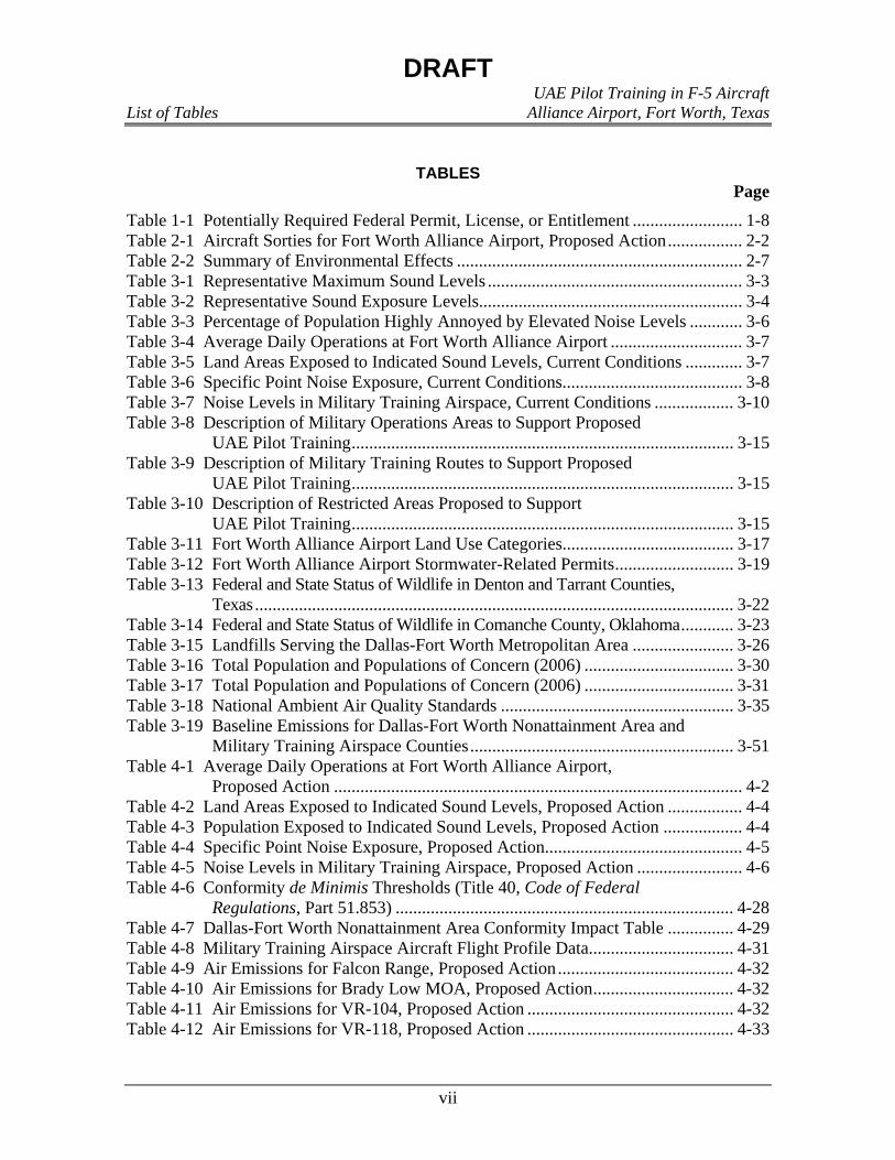
TABLES Page
Table 1-1 Potentially Required Federal Permit, License, or Entitlement ......................... 1-8 Table 2-1 Aircraft Sorties for Fort Worth Alliance Airport, Proposed Action................. 2-2 Table 2-2 Summary of Environmental Effects ................................................................. 2-7 Table 3-1 Representative Maximum Sound Levels .......................................................... 3-3 Table 3-2 Representative Sound Exposure Levels............................................................ 3-4 Table 3-3 Percentage of Population Highly Annoyed by Elevated Noise Levels ............ 3-6 Table 3-4 Average Daily Operations at Fort Worth Alliance Airport .............................. 3-7 Table 3-5 Land Areas Exposed to Indicated Sound Levels, Current Conditions ............. 3-7 Table 3-6 Specific Point Noise Exposure, Current Conditions......................................... 3-8 Table 3-7 Noise Levels in Military Training Airspace, Current Conditions .................. 3-10 Table 3-8 Description of Military Operations Areas to Support Proposed
UAE Pilot Training....................................................................................... 3-15 Table 3-9 Description of Military Training Routes to Support Proposed
UAE Pilot Training....................................................................................... 3-15 Table 3-10 Description of Restricted Areas Proposed to Support
UAE Pilot Training....................................................................................... 3-15 Table 3-11 Fort Worth Alliance Airport Land Use Categories....................................... 3-17 Table 3-12 Fort Worth Alliance Airport Stormwater-Related Permits........................... 3-19 Table 3-13 Federal and State Status of Wildlife in Denton and Tarrant Counties,
Texas............................................................................................................. 3-22 Table 3-14 Federal and State Status of Wildlife in Comanche County, Oklahoma............ 3-23 Table 3-15 Landfills Serving the Dallas-Fort Worth Metropolitan Area ....................... 3-26 Table 3-16 Total Population and Populations of Concern (2006) .................................. 3-30 Table 3-17 Total Population and Populations of Concern (2006) .................................. 3-31 Table 3-18 National Ambient Air Quality Standards ..................................................... 3-35 Table 3-19 Baseline Emissions for Dallas-Fort Worth Nonattainment Area and
Military Training Airspace Counties............................................................ 3-51 Table 4-1 Average Daily Operations at Fort Worth Alliance Airport,
Proposed Action ............................................................................................. 4-2 Table 4-2 Land Areas Exposed to Indicated Sound Levels, Proposed Action ................. 4-4 Table 4-3 Population Exposed to Indicated Sound Levels, Proposed Action .................. 4-4 Table 4-4 Specific Point Noise Exposure, Proposed Action............................................. 4-5 Table 4-5 Noise Levels in Military Training Airspace, Proposed Action ........................ 4-6 Table 4-6 Conformity de Minimis Thresholds (Title 40, Code of Federal
Regulations, Part 51.853) ............................................................................. 4-28 Table 4-7 Dallas-Fort Worth Nonattainment Area Conformity Impact Table ............... 4-29 Table 4-8 Military Training Airspace Aircraft Flight Profile Data................................. 4-31 Table 4-9 Air Emissions for Falcon Range, Proposed Action........................................ 4-32 Table 4-10 Air Emissions for Brady Low MOA, Proposed Action................................ 4-32 Table 4-11 Air Emissions for VR-104, Proposed Action ............................................... 4-32 Table 4-12 Air Emissions for VR-118, Proposed Action ............................................... 4-33

DRAFT UAE Pilot Training in F-5 Aircraft List of Tables Alliance Airport, Fort Worth, Texas
viii
Table 4-13 Air Emissions for IR-103, Proposed Action................................................. 4-33 Table 4-14 Air Emissions for IR-105, Proposed Action................................................. 4-33 Table 1 Conformity de Minimis Thresholds (Title 40, Code of Federal
Regulations, Part 51.853) ............................................................................... 9-3 Table 2 Dallas-Fort Worth Nonattainment Area Conformity Impact Table..................... 9-6 Table 3 Military Training Airspace Aircraft Flight Profile Data...................................... 9-9

Chapter 1
Purpose of and Need for Action
DRAFT UAE Pilot Training in F-5 Aircraft
Purpose of and Need for Action Alliance Airport, Fort Worth, Texas
1-1
December 2, 2007
1
CHAPTER 1 2
3
PURPOSE OF AND NEED FOR ACTION 4
The United States Air Force (USAF) proposes to establish an intermediate-level pilot 5
training program using F-5 A/B aircraft at Fort Worth Alliance Airport, Forth Worth, Texas, for 6
United Arab Emirates (UAE) Air Force pilots. The intermediate-level pilot training, 7
Introduction to Fighter Fundamentals (IFF), would be conducted by Lockheed Martin 8
Corporation (Lockheed Martin) pursuant to a contract the Air Force enters into with Lockheed 9
Martin. Lockheed Martin would provide instructor pilots, support personnel, equipment, and the 10
facilities to sustain the IFF pilot training program. USAF personnel would perform contracting 11
duties, including surveillance of contract performance to ensure USAF training standards are 12
met. The program would be conducted at the Alliance Aviation Center of Excellence (AACE). 13
The USAF is the lead Federal Agency for this Environmental Assessment (EA) and there are 14
three cooperating agencies which manage existing Special Use Airspace that would be used by 15
UAE pilots: the United States Navy at Naval Air Station Joint Reserve Base (NAS JRB) Fort 16
Worth, Texas; the 301 Fighter Wing (Air Force Reserve Command) at NAS JRB Fort Worth; 17
and Headquarters, United States Army Garrison Fort Sill (USAG Fort Sill), Oklahoma. The 18
proposed pilot training program would train approximately 22 UAE Air Force pilots per year for 19
a 2-year period that would begin in fiscal year (FY) 2008 (ending on September 30, 2008). 20
However, there would be an option to extend the pilot training program to a total of 5 years. 21
This chapter presents the purpose of and need for the action, a description of the location, a 22
description of the scope of the environmental review, an overview of environmental requirements, 23
an introduction to the organization of this document, and a summary of public involvement. 24
1.1 PURPOSE OF AND NEED FOR ACTION 25
The proposed action would provide intermediate-level training for UAE pilots in F-5 A/B 26
aircraft in preparation for follow-on training in F-16 fighter aircraft at the 162 Fighter Wing of 27
the Arizona Air National Guard (ANG), located at the Tucson International Airport, Tucson, 28
Arizona. The UAE requested this training through the United States (U.S.) Government's 29
Foreign Military Sales (FMS) Program. The FMS Program is part of Security Assistance 30
authorized by the Arms Export Control Act (Title 22, United States Code [USC], Chapter 39), 31
and includes training as well as the sale of equipment. The UAE specifically requested that 32
Lockheed Martin provide the IFF pilot training program at Fort Worth Alliance Airport (AFW) 33
because Lockheed Martin manufactures the F-16 fighter aircraft used in the follow-on UAE pilot 34
training conducted at the 162 Fighter Wing of the ANG. 35
The UAE Air Force has purchased F-16 aircraft from Lockheed Martin, and must train their 36
pilots to fly the newly acquired aircraft. Contractor-provided training is necessary because the 37
USAF currently does not have the training capacity to provide the pilot training at the necessary 38
rate within the required timeframe to support the UAE Air Force’s transition. Providing the 39

DRAFT UAE Pilot Training in F-5 Aircraft
Purpose of and Need for Action Alliance Airport, Fort Worth, Texas
1-2
December 2, 2007
requested training to the UAE would further U.S. Security Assistance and Regional Security 1
Cooperation objectives. As well, providing the training would contribute to U.S. foreign policy 2
and national security by helping improve security of a foreign country that has been and continues 3
to be an important force for political stability and economic progress in the Middle East. 4
Air Education and Training Command (AETC) trains all USAF pilots. Therefore, AETC is 5
best equipped to provide oversight of the requested IFF pilot training program. Regardless, 6
AETC is the Department of Defense (DoD) organization tasked to implement the international 7
agreement executed by representatives of the U.S. and UAE Governments in response to the 8
UAE's request for security assistance. 9
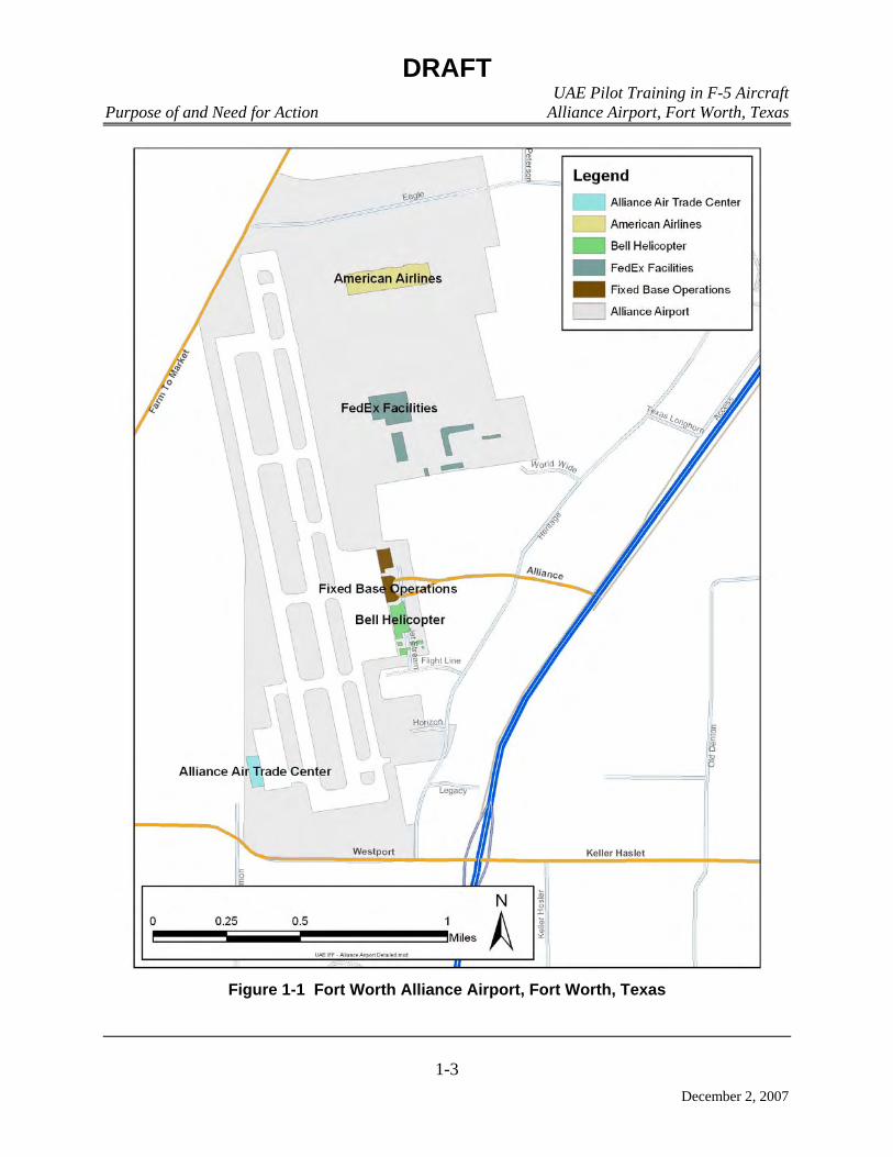
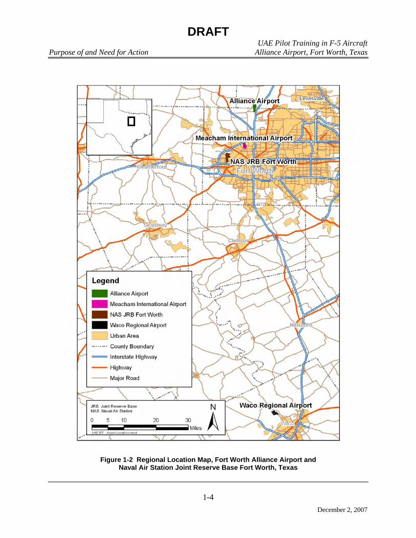
1.2 LOCATION 10
AFW is located in Tarrant County, approximately 15 miles north of downtown Fort Worth, 11
Texas (Figure 1-1). The proposed training would occur at AFW and three other airfields in the 12
vicinity of AFW: (1) Naval Air Station Joint Reserve Base Fort Worth (NAS JRB Fort Worth), 13
(2) Meacham International Airport, and (3) Waco Regional Airport (Figure 1-2). 14
Portions of the proposed training would also take place within Military Training Routes 15
(MTR), Military Operations Areas (MOA), and Restricted Areas (Figure 1-3). These types of 16
airspace are designated areas developed by the Federal Aviation Administration (FAA) and the 17
DoD to alert non-military aircraft of military activities that could be considered hazardous to 18
non-participating aircraft. Section 2.5 presents the proposed action, including a detailed 19
definition of each type of airspace and an explanation of the specific types of training proposed 20
for each area of airspace. 21
1.3 SCOPE OF THE ENVIRONMENTAL REVIEW 22
The National Environmental Policy Act of 1969 (NEPA, Title 42, USC, Chapter 55), as 23
amended, requires federal agencies to consider environmental consequences in the decision-24
making process. The President’s Council on Environmental Quality (CEQ) issued regulations to 25
implement NEPA that include provisions for both the content and procedural aspects of the 26
required environmental analysis. 27
The USAF Environmental Impact Analysis Process is accomplished through adherence to 28
the procedures set forth in CEQ and Air Force regulations (Title 40, Code of Federal Regulations 29
[CFR], Sections 1500-1508 and Title 32, CFR, Part 989). These federal regulations establish the 30
administrative process and substantive scope of the environmental impact evaluation that are 31
designed to ensure that deciding authorities have a proper understanding of the potential 32
environmental consequences of a contemplated course of action. The USAF plans to prepare an 33
EA for this proposal. The CEQ regulations require that an EA: 34
• Provide sufficient evidence and analysis for determining whether to prepare an 35
Environmental Impact Statement (EIS) or a Finding of No Significant Impact. 36
• Facilitate the preparation of an EIS when required. 37
DRAFT UAE Pilot Training in F-5 Aircraft
Purpose of and Need for Action Alliance Airport, Fort Worth, Texas
1-3
December 2, 2007
Figure 1-1 Fort Worth Alliance Airport, Fort Worth, Texas
DRAFT UAE Pilot Training in F-5 Aircraft
Purpose of and Need for Action Alliance Airport, Fort Worth, Texas
1-4
December 2, 2007
Figure 1-2 Regional Location Map, Fort Worth Alliance Airport and Naval Air Station Joint Reserve Base Fort Worth, Texas

DRAFT UAE Pilot Training in F-5 Aircraft
Purpose of and Need for Action Alliance Airport, Fort Worth, Texas
1-5
December 2, 2007
Figure 1-3 Military Training Routes and Military Operating Areas

DRAFT UAE Pilot Training in F-5 Aircraft Purpose of and Need for Action Alliance Airport, Fort Worth, Texas
1-6
December 2, 2007
This EA identifies, describes, and evaluates the potential environmental impacts that may 1
result from implementation of the UAE IFF pilot training program (the proposed action) and the 2
no action alternative. As appropriate, the affected environment and environmental consequences 3
of the proposed action and alternatives may be described in terms of site-specific descriptions or 4
a regional overview. Finally, the EA identifies measures to reduce impacts or best management 5
practices to prevent or minimize environmental impacts. 6
The resources that could be impacted and will therefore be analyzed in the EA include noise, 7
aircraft operations, airspace, land use, earth resources, water resources, hazardous materials and 8
waste, biological resources, utilities and infrastructure, socioeconomics and environmental 9
justice, air quality, and cultural resources. Assessment of safety and health impacts is not 10
included in this document; all contractors would be responsible for compliance with applicable 11
Occupational Safety and Health Administration (OSHA) regulations concerning occupational 12
hazards and specifying appropriate protective measures for all employees. 13
1.4 ENVIRONMENTAL JUSTICE 14
Executive Order (EO) 12898, Federal Actions to Address Environmental Justice in Minority 15
Populations and Low-Income Populations, was issued by the President on February 11, 1994. In 16
the EO, the President instructed each federal agency to make “. . . achieving environmental 17
justice part of its mission by identifying and addressing, as appropriate, disproportionately high 18
and adverse human health or environmental effects of its programs, policies, and activities on 19
minority populations and low-income populations.” Adverse is defined by the Federal 20
Interagency Working Group on Environmental Justice as “. . . having a deleterious effect on 21
human health or the environment that is significant, unacceptable, or above generally 22
accepted norms.” 23
Proposed activities would occur on or near AFW and NAS JRB Forth Worth and nearby 24
MTRs/MOAs. Activities would also occur in MTRs/MOAs on and in the vicinity of Falcon 25
Range, near Fort Sill, Oklahoma. Any potential impacts to the human environment would be 26
limited to the airport or airspace used for flying training (e.g., noise, land use, etc.) or evenly 27
distributed across the region of influence. Therefore, the proposed action would not be expected 28
to target any particular demographic area. The existing conditions with regard to environmental 29
justice will be described, and the potential impacts of the proposed action to low-income or 30
minority populations will be analyzed. 31
1.5 APPLICABLE REGULATORY REQUIREMENTS 32
Regulatory requirements potentially applicable to the proposed action and alternatives are 33
presented in Table 1-1. 34
1.6 INTRODUCTION TO THE ORGANIZATION OF THE DOCUMENT 35
This EA is organized into seven chapters. Chapter 1 contains a statement of the purpose of 36
and need for action, the location of the proposed action, a summary of the scope of the 37
environmental review, identification of applicable regulatory requirements, and a description of 38
DRAFT UAE Pilot Training in F-5 Aircraft Purpose of and Need for Action Alliance Airport, Fort Worth, Texas
1-7
December 2, 2007
the organization of the EA. Chapter 2 contains a brief introduction, a description of the history 1
of the formation of alternatives, describes the alternatives eliminated from further consideration, 2
provides a detailed description of the proposed action, identifies other action alternatives, 3
summarizes other known actions for AFW, provides a comparison matrix of environmental 4
effects for all alternatives, identifies the preferred alternative, and identifies mitigation 5
requirements, if required. Chapter 3 contains a general description of the biophysical resources 6
that potentially could be affected by the proposed action or alternatives. Chapter 4 is an analysis 7
of the environmental consequences. Chapter 5 lists preparers of this document. Chapter 6 lists 8
persons and agencies consulted in the preparation of this EA. Chapter 7 is a list of source 9
documents relevant to the preparation of this EA. 10
Appendix A contains all interagency correspondence regarding the proposed action, and 11
Appendix B contains the air pollutant emission calculation methodology and calculation details. 12
1.7 PUBLIC INVOLVEMENT SUMMARY 13
The Draft EA and Draft Finding of No Significant Impact are available at the following 14
locations to provide public access to the document during the 30-day public comment period, 15
which begins on December 2, 2007 and will end on December 31, 2007: 16
Carnegie Library of Ballinger, 204 N. 8th St., Ballinger, TX 76821, 325-365-3616 17
Richards Memorial Library, 1106 S. Blackburn St., Brady, TX 76825, 325-597-2617 18
Brownwood Public Library, 600 Carnegie Blvd., Brownwood, TX 76801, 325-646-0155 19
Coleman Public Library, 402 Commercial Ave., Coleman, TX 76834, 325-625-3043 20
Comanche Public Library, 311 N. Austin St., Comanche, TX 76442, 325-356-2122 21
Fort Worth Public Library, 500 W. 3rd St., Fort Worth, TX 76102, 817-871-7706 22
Jennie Trent Dew Library, 1101 Hutchings St., Goldthwaite, TX 76844, 325-648-2447 23
Tom Green Co. Library, 113 W. Beauregard Ave., San Angelo, TX 76903, 325-655-7321 24
Rylander Memorial Library, 103 S. Live Oak St., San Saba, TX 76877, 325-372-3079 25
Lawton Library, 110 S.W. 4th St., Lawton, OK 73501, 580-581-3450 26
Notification of this 30-day review and comment period announcing the availability of the 27
document for public review was placed in the Ballinger Ledger (serving Runnels County), Brady 28
Standard-Herald (serving McCulloch County), Brownwood Bulletin (serving Brown County), 29
Democrat Voice (serving Coleman County), Comanche Voice (serving Comanche County), Fort 30
Worth Star-Telegram (serving the communities surrounding AFW), The Goldthwaite Eagle 31
(serving Mills County), San Angelo Standard-Times (serving Concho County), San Saba News & 32
Star (serving San Saba County), and The Lawton Constitution (serving the communities 33
surrounding Falcon Range in Fort Sill, Oklahoma). A summary of the proposed action and 34
copies of the Draft EA with letters requesting review and comment were provided to 18 35
interested parties (Appendix A). Any comments received during the public review period are to 36
be addressed in the Final EA. 37

DRAFT UAE Pilot Training in F-5 Aircraft Purpose of and Need for Action Alliance Airport, Fort Worth, Texas
1-8
December 2, 2007
Table 1-1 Potentially Required Federal Permit, License, or Entitlement Federal Permit,
License, or Entitlement
Typical Activity, Facility, or Category of Persons Required to Obtain the Federal Permit, License, or
Entitlement
Resources affected by UAE
Pilot Training
Authority Regulatory Agency
Title V permit under the CAA
Sources subject to the Title V permit program include: Any major source: (1) A stationary source that emits or has the potential to emit 100 tpy of any pollutant (major source threshold can be lower in nonattainment areas), (2) A major source of air toxics regulated under Section 112 of Title III (sources that emit or have the potential to emit 10 tpy or more of a hazardous air pollutant or 25 tpy or more of any combination of hazardous air pollutants). Any “affected source” as defined in Title IV (acid rain) of the CAA. Any source subject to New Source Performance Standards under Section 111 of the CAA. Sources required to have new source or modification permits under Parts C [Prevention of Significant Deterioration (attainment areas)] or D [New Source Review (nonattainment areas)] of Title I of the CAA. Any source subject to standards, limitations, or other requirements under Section 112 of the CAA. Other sources designated by USEPA in the regulations.
Air emissions from increased air traffic supporting the UAE pilot training.
Title V of CAA, as amended by the 1990 CAA Amendments
USEPA; TCEQ
National Pollutant Discharge Elimination System permit
Discharge of pollutant from any point source into navigable waters of the United States.
Potential of increases in wastewater discharge due to increased personnel in support of the UAE pilot training.
§402 of CWA; 33 USC, §1342
USEPA; TCEQ
CAA Clean Air Act UAE United Arab Emirates CWA Clean Water Act USC Unites States Code TCEQ Texas Commission on Environmental Quality USEPA United States Environmental Protection Agency tpy tons per year USFWS United States Fish and Wildlife Service

DRAFT UAE Pilot Training in F-5 Aircraft Purpose of and Need for Action Alliance Airport, Fort Worth, Texas
1-9
December 2, 2007
Table 1-1, Continued
Federal Permit, License, or Entitlement
Typical Activity, Facility, or Category of Persons Required to Obtain the Federal Permit, License, or
Entitlement
Resources affected by UAE
Pilot Training
Authority Regulatory Agency
Endangered Species Act §7 consultation
Taking endangered or threatened wildlife species; engaging in certain commercial trade of endangered or threatened plants or removing such plants on property subject to federal jurisdiction.
Mission requirements may affect areas inhabited by endangered or threatened species.
§7 of Endangered Species Act, 16 USC §1539; 50 Code of Federal Regulations 17 Subparts C, D, F, and G
USFWS, Texas Parks and Wildlife
CWA §404 permit Actions to reduce the risk of flood loss to minimize the impact of
floods on human safety, health, and welfare; to restore and preserve the natural and beneficial values served by floodplains; actions to minimize destruction, loss, or degradation of wetlands; and to preserve and enhance the natural and beneficial values of wetlands.
Construction of any structures for the UAE pilot training would adhere to planning guidelines.
Executive Orders 11988 and 11990, §404 of CWA, 33 USC §1251
United States Army Corps of Engineers, USFWS
CAA Clean Air Act UAE United Arab Emirates CWA Clean Water Act USC Unites States Code TCEQ Texas Commission on Environmental Quality USEPA United States Environmental Protection Agency tpy tons per year USFWS United States Fish and Wildlife Service

DRAFT UAE Pilot Training in F-5 Aircraft Purpose of and Need for Action Alliance Airport, Fort Worth, Texas
1-10
December 2, 2007
THIS PAGE INTENTIONALLY LEFT BLANK

Chapter 2
Description of Proposed Action and Alternatives

DRAFT UAE Pilot Training in F-5 Aircraft
Description of Proposed Action and Alternatives Alliance Airport, Fort Worth, Texas
2-1
December 2, 2007
1
CHAPTER 2 2
3
DESCRIPTION OF PROPOSED ACTION AND ALTERNATIVES 4
2.1 INTRODUCTION 5
This chapter is composed of seven sections: an introduction, a brief history of the 6
formulation of alternatives, identification of alternatives eliminated from further consideration, a 7
description of the no action alternative, a detailed description of the proposed action, projects 8
that may affect cumulative impact analysis, and a comparison matrix of environmental effects of 9
all alternatives. 10
2.2 HISTORY OF THE FORMULATION OF ALTERNATIVES 11
The alternatives that have been developed for the proposed action at AFW are meant to 12
capture the Department of State (DoS) and Defense Security Cooperation Agency (DSCA) 13
approved training program. Based on this analysis, two viable alternatives were identified: 14
• No Action Alternative: take no action associated with the implementation of a UAE 15
pilot training program at AFW. 16
• Proposed Action: implement the DoS and DSCA approved UAE pilot training 17
program as it relates to AFW, to include the beddown of 15 F-5 A/B aircraft, 18
employing approximately 93 support personnel, and improvement of existing airport 19
facilities. 20
2.3 IDENTIFICATION OF ALTERNATIVES ELIMINATED FROM CONSIDERATION 21
The UAE’s request for Security Assistance specifically identified the necessary type of pilot 22
training, required training location, and training provider to be used by the USAF. Because the 23
requirements of this request are so specific, there is only one way to provide the pilot training 24
support requested by the UAE. Consequently, analysis was not accomplished for the use of any 25
different contractors and/or different aircraft training facilities other than those identified by the 26
UAE in its request for assistance (namely, Lockheed Martin and AFW). Therefore, this EA only 27
identifies and analyzes the potential environmental impacts associated with the proposed action 28
and no action alternative. 29
2.4 NO ACTION ALTERNATIVE 30
Under the no action alternative, the beddown of aircraft, addition of support personnel, and 31
improvement of existing airport facilities at AFW would not occur. This alternative would not 32
allow for the beddown of 15 F-5 A/B aircraft to support compliance with DoS and DSCA as 33
directed by Congress. The no action alternative would eliminate the need for the USAF to 34
provide surveillance as there would be no FMS Program training mission. There would be no 35
change from existing conditions at AFW. 36

DRAFT UAE Pilot Training in F-5 Aircraft
Description of Proposed Action and Alternatives Alliance Airport, Fort Worth, Texas
2-2
December 2, 2007
2.5 DETAILED DESCRIPTION OF THE PROPOSED ACTION 1
Under the proposed action, the USAF proposes to oversee conduct of an IFF pilot training 2
program of UAE pilots in F-5 A/B aircraft at AFW (Figure 1-1). The proposed action consists of 3
the beddown of 15 contractor owned and operated F-5 A/B aircraft, employment of 4
approximately 93 support personnel, and improvement of existing airport facilities. The details 5
of the proposed action are described in the following paragraphs. 6
2.5.1 Aircraft Beddown and Flight Operations 7
The proposed action includes the addition of 15 contractor owned and operated F-5 A/B 8
aircraft at AFW to conduct the IFF pilot training program. A USAF-approved UAE IFF course 9
syllabus will be used. UAE student pilots would be taught by flight instructors who are 10
Lockheed Martin employees. 11
The beddown of 15 F-5 A/B aircraft at AFW would result in a subsequent increase in 12
aircraft operations at the facility. Table 2-1 summarizes the annual sorties associated with the 13
proposed beddown. (A sortie is a single military aircraft flight from initial take-off through final 14
landing.) 15
Table 2-1 Aircraft Sorties for Fort Worth Alliance Airport, Proposed Action 16
Description Sorties1 Hours
Student Training 3,370 3,202 Instructor Continuation Training 374 355
Total 3,744 3,557 1Sortie - a single military aircraft flight from initial take-off through final landing
Of note, the proposed action does not include any aircraft operations during “nighttime” 17
hours (i.e., after 10 p.m. and before 7 a.m.). Overall, to support implementation of the IFF pilot 18
training portion of the proposed action, neither changes to existing flight tracks nor establishment 19
of new flight tracks would be required. 20
The proposed IFF pilot training program is an intermediate-level flying program involving 21
Low-altitude Tactical Navigation Training, Air to Air (A/A), and Air to Ground (A/G) training. 22
The initial IFF pilot training would include Instrument and Transition Training, consisting of 23
aircraft operations specifically designed to assist the student pilots in adapting to the 24
instrumentation of the new training aircraft (the F-5 A/B). Instrument and Transition Training 25
would include runway approaches using instruments only, flying various patterns overhead at the 26
airfield, touch-and-go landings, low runway approaches, full stop landings, procedures for flying 27
and landing with simulated engine failure, and flying and landing with simulated loss of flap 28
control. Air Traffic Control (ATC) and airborne traffic permitting, this training would occur at 29
AFW and three other airfields in the vicinity of AFW: (1) NAS JRB Fort Worth, (2) Meacham 30
International Airport, and (3) Waco Regional Airport (Figure 1-2). As well, a total of eleven 31
sorties annually would be conducted divided among these four airfields for UAE Flight Lead and 32

DRAFT UAE Pilot Training in F-5 Aircraft
Description of Proposed Action and Alternatives Alliance Airport, Fort Worth, Texas
2-3
December 2, 2007
Instructor Upgrades, and a total of 26 sorties annually would be conducted divided among these 1
four airfields in support of the UAE IFF pilot training program. 2
UAE pilots would fly the F-5 A/B aircraft through MTRs to obtain Low-altitude Tactical 3
Navigation Training. F-5 A/B aircraft flying from AACE would operate on the following 4
NAS JRB Fort Worth MTRs: Instrument Flight Rules Military Training Route (IR)-103, IR-105, 5
Visual Flight Rules Military Training Route (VR)-104, and VR-118 (Figure 1-3). 6
The NAS JRB Fort Worth and the 301 Fighter Wing manage and schedule all North Texas 7
Special Use Airspace (SUA) to include MOAs, Restricted Airspace, and MTRs for low-level 8
navigation training. The UAE IFF pilot training program would coordinate with the USAF, 9
U.S. Navy, 301 Fighter Wing, and the regional Dallas-Fort Worth (DFW) FAA airspace office to 10
sign an Airspace and Range scheduling Letter of Agreement or Memorandum of Understanding. 11
At that time, the NAS JRB Fort Worth and FAA would coordinate daily SUA training and 12
acknowledge any restrictions or prohibitions. 13
A/A training would be conducted within MOAs. MOAs are areas of defined joint 14
commercial and military use airspace that have specified vertical and lateral limits. These areas 15
are identified so that commercial air traffic is aware of areas where certain non-hazardous 16
military activities are conducted, and air traffic controllers can keep commercial air traffic clear 17
of the area if necessary. The proposed MOAs for IFF A/A training (MOAs Brady and 18
Brownwood) are located approximately 15-20 minutes (flying time) from AFW (Figure 1-3). 19
The resulting airspace after these two MOAs are combined has a geographical extent of 20 by 30 20
nautical miles. Available vertical airspace ranges from 10,900 to 22,500 feet. The minimum and 21
maximum altitudes in the Brownwood MOA are 7,000 and 17,900 feet above ground level 22
(AGL), respectively. The minimum and maximum altitudes in the Brady MOA are 500 and 23
23,000 feet AGL, respectively (FAA 2007a). 24
The proposed IFF A/A pilot training would be conducted at a maximum of 500 knots 25
calibrated air speed (KCAS). The number of aircraft participating in a single training mission 26
would range from one to four. Specific Air Combat Maneuvers that would be incorporated in 27
the course would include Advanced Handling, Basic Fighter Maneuvers, and Air Combat 28
Maneuvers. In Advanced Handling training, student pilots would perform aggressive flight 29
maneuvers to gain familiarity with the aircraft’s handling. Basic Fighter Maneuvers training 30
would consist of missions based on two pilots flying against each other. Air Combat Maneuvers 31
training would consist of missions based on two aircraft attacking a single aircraft. 32
The IFF A/G pilot training would be conducted in a Restricted Area. A Restricted Area is 33
designated airspace that supports ground or flight activities that could be hazardous to non-34
participating aircraft. The proposed Restricted Area for IFF A/G training is Falcon Range 35
(which is located within Restricted Area R-5601C). Falcon Range is located on Fort Sill, near 36
Lawton, Oklahoma (Figure 1-3). The USAF would coordinate with the U.S. Army to sign a use 37
and scheduling agreement for use of Falcon Range. Approximately 790 sorties a year are 38
proposed to be conducted at Falcon Range, and a Range Control Officer would oversee IFF A/G 39
sorties when required. The primary IFF A/G pilot training would consist of simulated bombing 40

DRAFT UAE Pilot Training in F-5 Aircraft
Description of Proposed Action and Alternatives Alliance Airport, Fort Worth, Texas
2-4
December 2, 2007
missions conducted at high airspeeds (up to 450 KCAS). Several types of simulated weapons 1
deliveries would occur under the proposed action; no live weapons training would occur but 2
training results would be calculated by an electronic scoring system. 3
2.5.2 Student Load 4
The length of the proposed IFF pilot training program is 23 weeks, and eleven students 5
would attend each training course. Two IFF pilot training courses would be programmed per 6
year, for a maximum annual throughput of 22 students. Students would live in existing lodging 7
facilities in the immediate area of AFW. 8
2.5.3 Manpower Requirements 9
Under the proposed action, approximately 93 personnel would be employed at AFW to 10
support the UAE IFF pilot training program. Three persons would work for AETC: one AETC 11
Introduction to Fighter Fundamentals Instructor pilot who would serve as a Standardization and 12
Evaluation Flight Examiner, and two AETC maintainers who would provide aircraft 13
maintenance quality assurance program support. The remaining 90 personnel would work for 14
AACE: 20 flight instructors and 70 maintenance personnel. These personnel would be added 15
beginning in FY2008, and all personnel would be in place by the end of the FY. No additional 16
personnel increases would be experienced after the end of FY2008. 17
2.5.4 Facility Requirements 18
Specific improvements to existing airport facilities would be required to support the 19
proposed IFF pilot training program. The AACE would provide all infrastructure and services to 20
support the proposed action via AFW and Alliance Aviation Services. All AACE training 21
operations, maintenance, and supply functions would be housed in the existing 99,000-square 22
foot Alliance Air Trade Center facility located on AFW. The Alliance Air Trade Center facility 23
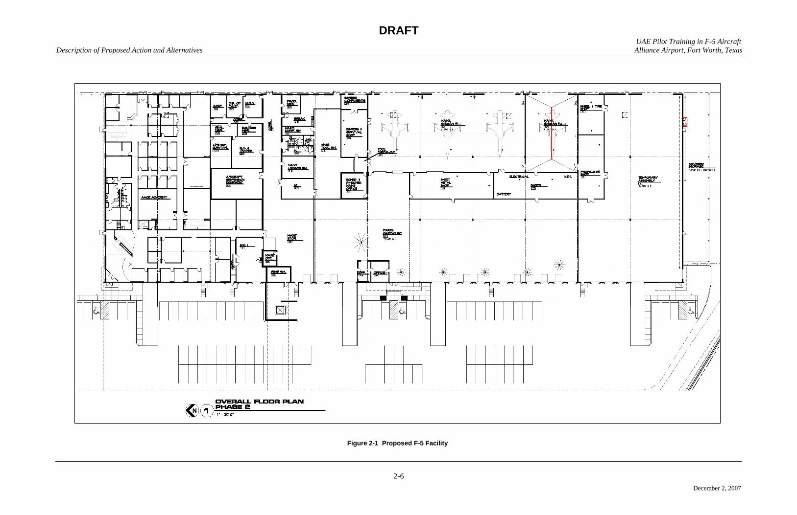
would be completed by Northern General Leasing, LLC (NGL) in compliance with all applicable 24
federal, state, county, and municipal building codes requirements in order to house the AACE 25
(Figure 2-1). Lockheed Martin would take out a renewable lease on the completed facility from 26
NGL for the duration of the training. All AACE partners and students supporting the proposed 27
action would work from the facility. An aircraft parking area would be located on the east side 28
of the building, and would include 15 parking points and 45 tie downs. Aircraft would be parked 29
in accordance with Air Force Instruction (AFI) 11-218, with four rows, nose to nose, north to 30
south. Specific AACE facility requirements are listed below: 31
• Operations Area: would house training course operations support. 32
• Aircraft Maintenance Unit: would house maintenance technicians and provide an 33
aircraft maintenance support area to prepare aircraft for training missions. 34
• Supply Area: would provide storage area for replacement and spare aircraft parts, 35
maintenance supplies, and materials. 36

DRAFT UAE Pilot Training in F-5 Aircraft
Description of Proposed Action and Alternatives Alliance Airport, Fort Worth, Texas
2-5
December 2, 2007
• F-5 Storage Area: would provide storage of F-5 A/B aircraft. 1
• F-5 Egress Component Storage Room: would provide storage of munitions such as 2
flares used as decoys in training exercises and the small explosive cartridges used to 3
launch aircraft emergency ejection seats. 4
• Aircraft Ground Equipment pad: would house aircraft ground equipment (e.g., carts, 5
jacks, lifts, stairs, wheel chocks, tow bars, and power units). 6
2.6 PAST, PRESENT, AND REASONABLY FORESEEABLE ACTIONS IN THE REGION OF 7 INFLUENCE 8
A cumulative impact, as defined by the CEQ (Title 40, CFR, Part 1508.7), is the “. . . impact 9
on the environment which results from the incremental impact of the action when added to other 10
past, present, and reasonably foreseeable future actions regardless of which agency (federal or 11
non-federal) or person undertakes such actions. Cumulative impacts can result from individually 12
minor but collectively significant actions taking place over a period of time.” Other actions or 13
potential actions in the region of influence (ROI) that may be concurrent with the proposed 14
action could contribute to cumulative impacts. The environmental impacts of these other actions 15
are addressed in this EA only in the context of potential cumulative impacts, if any. The 16
following paragraphs describe specific projects planned for AFW or within the ROI that have the 17
potential to add to cumulative impacts. There are no construction projects planned for the area in 18
or around Falcon Range. 19
Several projects are planned in the ROI in the near future for the area surrounding AFW. 20
An expansion of the runway on AFW is planned. The planned expansion would increase the 21
length of runway 16L/34R from 9,600 feet to 11,000 feet and increase length of runway 16R/34L 22
from 8,220 feet to 11,000 feet. To support the runway expansion, taxiway A will be increased 23
from 9,600 feet to 11,000 feet. Avenues of transportation near the runway expansion will need 24
to be updated to accommodate the longer runways. Portions of the Burlington Northern Santa Fe 25
(BNSF) Railway will be relocated to 12.7 acres of land, 104.5 acres of land will be dedicated to 26
relocating Farm to Market (FM) Road 156, and 3.3 acres will be used for the realignment of 27
Eagle Parkway. 28
2.7 COMPARISON MATRIX OF ENVIRONMENTAL EFFECTS OF ALL ALTERNATIVES 29
Table 2-2 summarizes the impacts of the no action alternative and the proposed action. 30
DRAFT UAE Pilot Training in F-5 Aircraft
Description of Proposed Action and Alternatives Alliance Airport, Fort Worth, Texas
2-6
December 2, 2007
Figure 2-1 Proposed F-5 Facility
DRAFT UAE Pilot Training in F-5 Aircraft
Description of Proposed Action and Alternatives Alliance Airport, Fort Worth, Texas
2-7
December 2, 2007
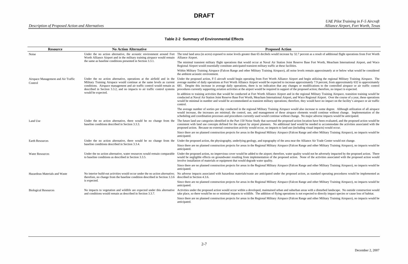
Table 2-2 Summary of Environmental Effects
Resource No Action Alternative Proposed Action Noise Under the no action alternative, the acoustic environment around Fort
Worth Alliance Airport and in the military training airspace would remain the same as baseline conditions presented in Section 3.3.1.
The total land area (in acres) exposed to noise levels greater than 65 decibels would increase by 32.7 percent as a result of additional flight operations from Fort Worth Alliance Airport. The minimal transient military flight operations that would occur at Naval Air Station Joint Reserve Base Fort Worth, Meacham International Airport, and Waco Regional Airport would essentially constitute anticipated transient military traffic at these facilities. Within Military Training Airspace (Falcon Range and other Military Training Airspace), all noise levels remain approximately at or below what would be considered the ambient acoustic environment.
Airspace Management and Air Traffic Control
Under the no action alternative, operations at the airfield and in the Military Training Airspace would continue at the same levels as current conditions. Airspace management and air traffic control would remain as described in Section 3.3.2, and no impacts to air traffic control systems would be expected.
Under the proposed action, F-5 aircraft would begin operating from Fort Worth Alliance Airport and begin utilizing the regional Military Training Airspace. The average number of daily operations at Fort Worth Alliance Airport would be expected to increase approximately 7.9 percent, from approximately 632 to approximately 681. Despite this increase in average daily operations, there is no indication that any changes or modifications to the controlled airspace or air traffic control procedures currently supporting aviation activities at the airport would be required in support of the proposed action; therefore, no impact is expected. In addition to training activities that would be conducted at Fort Worth Alliance Airport and in the regional Military Training Airspace, transition training would be conducted at Naval Air Station Joint Reserve Base Fort Worth, Meacham International Airport, and Waco Regional Airport. Over the course of a year, these operations would be minimal in number and would be accommodated as transient military operations; therefore, they would have no impact on the facility’s airspace or air traffic control. The average number of sorties per day conducted in the regional Military Training Airspace would also increase to some degree. Although utilization of all airspace would increase, the increases are minimal; the control, use, and management of these airspace elements would continue without change. Implementation of the scheduling and coordination processes and procedures currently used would continue without change. No major adverse impacts would be anticipated.
Land Use Under the no action alternative, there would be no change from the baseline conditions described in Section 3.3.3.
The future land use categories identified in the Part 150 Noise Study that surround the proposed action location have been evaluated, and the proposed action would be consistent with land use concepts defined for the airport by airport planners. No additional land would be needed to accommodate the activities associated with the proposed action. Because no external construction activity would occur, no impacts to land use (including visual impacts) would occur. Since there are no planned construction projects for areas in the Regional Military Airspace (Falcon Range and other Military Training Airspace), no impacts would be anticipated.
Earth Resources Under the no action alternative, there would be no change from the baseline conditions described in Section 3.3.4.
Under the proposed action, the physiography, underlying geology, and topography of the area near the Alliance Air Trade Center would not change. Since there are no planned construction projects for areas in the Regional Military Airspace (Falcon Range and other Military Training Airspace), no impacts would be anticipated.
Water Resources Under the no action alternative, water resources would remain comparable to baseline conditions as described in Section 3.3.5.
Under the proposed action, no impervious cover would be added to the airport; therefore, water quality would not be adversely impacted by the proposed action. There would be negligible effects on groundwater resulting from implementation of the proposed action. None of the activities associated with the proposed action would involve installation of materials or equipment that would degrade water quality. Since there are no planned construction projects for areas in the Regional Military Airspace (Falcon Range and other Military Training Airspace), no impacts would be anticipated.
Hazardous Materials and Waste No interior build-out activities would occur under the no action alternative; therefore, no change from the baseline condition described in Section 3.3.6 is expected.
No adverse impacts associated with hazardous materials/waste are anticipated under the proposed action, as standard operating procedures would be implemented as described in Section 4.3.6. Since there are no planned construction projects for areas in the Regional Military Airspace (Falcon Range and other Military Training Airspace), no impacts would be anticipated.
Biological Resources No impacts to vegetation and wildlife are expected under this alternative and conditions would remain as described in Section 3.3.7.
Activities under the proposed action would occur within a developed, maintained urban and suburban areas with a disturbed landscape. No outside construction would take place, so there would be no or minimal impacts to wildlife. The addition of flying operations is not expected to directly impact species or cause loss of habitat. Since there are no planned construction projects for areas in the Regional Military Airspace (Falcon Range and other Military Training Airspace), no impacts would be anticipated.
DRAFT UAE Pilot Training in F-5 Aircraft
Description of Proposed Action and Alternatives Alliance Airport, Fort Worth, Texas
2-8
December 2, 2007
Table 2-2, Continued
Resource No Action Alternative Proposed Action Utilities and Infrastructure Under the no action alternative, there would be no interior construction or
changes in current activities associated with Alliance Air Trade Center. Therefore, there would be no effect on electricity and natural gas as described in Sections 3.3.8.1 and 3.3.8.2, the wastewater collection and treatment system as described in Section 3.3.8.3, solid waste management as described in Section 3.3.8.4, baseline transportation conditions as described in Section 3.3.8.5, stormwater drainage as described in Section 3.3.8.6, or the potable water system as described in Section 3.3.8.7.
Because the existing electrical and natural gas infrastructure and supplies to Alliance Air Trade Center exceed the requirements described in Section 2.5, there would be no adverse effect on those resources as a result of the implementation of the proposed action. Population changes at AFW are associated with the proposed action, which would add 93 permanent personnel and have a total annual throughput of 22 students. The net result is the equivalent of an additional 115 persons for 8 hours per day. Assuming the worst-case scenario that 115 people were to move into the DCRWS service area (representing an additional 115 residents loading the regional system), the load on the system would only increase by approximately 0.2 percent (the current system has a 50,000-person capacity). Therefore, there would be little adverse effect on these resources as a result of the implementation of the proposed action. Debris generated by the interior build-out of the Alliance Air Trade Center would not appreciably reduce the life expectancy of the Fort Worth C&D Landfill or any of the other 24 active regional landfills in the 16-county NCTCOG region. The proposed action would result in a slight increase in the number of permanent employees at AFW. As a result, there would also be a minor increase in commuter traffic to the airport; however, the volume of traffic should remain close to the current baseline. Because no new construction of pavements would occur, water quality would not be adversely impacted by the proposed action. As indicated in Section 3.3.8.3, the City of Haslet public water supply capacity exceeds current potable water demand by more than 300 percent (on a daily basis) and the delivery pressures and amounts already meet requirements for fire protection at Alliance Air Trade Center, AFW, and other facilities in the region. Therefore, there would be little adverse effect on potable water as a result of the implementation of the proposed action. Since there are no planned construction projects for areas in the Regional Military Airspace (Falcon Range and other Military Training Airspace), no impacts would be anticipated.
Socioeconomics and Environmental Justice Under the no action alternative, population on base and in the region of influence would not be affected. In addition, construction-related employment and earnings impacts associated with the proposed action would not occur. No impacts to socioeconomic resources would occur under implementation of the no action alternative, and conditions would remain as described in Section 3.3.9.
Under the proposed action, employment at AFW would experience a net increase of 93 personnel, representing an increase of 0.01 percent to the existing labor force in Tarrant County. It is assumed that potential employees would be drawn from Dallas-Fort Worth-Arlington MSA, therefore, no impacts to the local economy, housing, or school districts would occur. As presented in Section 3.3.9.1, minority and low-income population ratios are generally consistent with the region. There are no known concentrated areas of concern where children might be subject to special health or safety risks. In addition, potential environmental health or safety hazards were examined to assess potential special risks to children. These environmental analyses indicate that no adverse environmental impacts to the human population of the affected environments (AFW and Falcon Range) are anticipated under the proposed action. As a result, no disproportionate environmental justice impacts would occur, nor would there be any special health or safety risks to children.
Cultural Resources Under the no action alternative, there will be no change from baseline conditions as described in Section 3.3.10.
Because no construction would be associated with the proposed action, no impacts would be anticipated to any historical, architectural, archeological, or cultural resources; therefore, no analysis of these resources will be conducted. Since there are no planned construction projects for areas in the Regional Military Airspace (Falcon Range and other Military Training Airspace), no impacts would be anticipated.
Air Quality Under the no action alternative, emissions would be identical to current baseline emissions presented in Section 3.3.11.
Analysis under the requirements of the General Conformity Rule of volatile organic compounds and nitrogen oxide emissions projected to occur from the portion of the proposed action that would occur at Fort Worth Alliance Airport indicates that the proposed action is well below the required de minimis levels of 100 tons per year for each pollutant and well below 10 percent of the nonattainment area’s emissions inventory - indicating the proposed action is not a regionally significant action. Since the proposed action meets the conformity de minimis exemption requirements, no further analysis is required with regards to the General Conformity Rule. No major construction would be associated with the 99,000-square foot training, operations, maintenance, and supply facility because the building shell is already in place. Existing aboveground fuel storage tanks, aircraft parking, and vehicle parking are also in place. Interior building renovation and associated minor construction were assumed to have minimal air quality impacts. It should be noted that aircraft and other activities at Fort Worth Alliance Airport associated with the proposed action would not have an impact on current permits or permit status. Air quality effects on areas associated with Military Training Airspace would only occur during aircraft operations associated with the proposed action. The operational effects are only associated with low-level aircraft operations in Falcon Range, Brady Low Military Operations Area, VR-104, VR-118, IR-103, and IR-105 at altitudes below 3,000 feet above ground level. As discussed in Chapter 3, only those portions of the flying operation that take place below the atmospheric mixing height (3,000 feet above ground level) are considered as low level (these are the only emissions presumed to affect ground level concentrations). Because air emissions associated with this component of the proposed action would be generated solely from aircraft operations, emissions would not be concentrated at one location, but would be distributed over the counties associated with the training areas and the surrounding area. Overall, the effect to the area would be minimal due to the large area over which emissions would be dispersed. It is estimated that this action would neither cause any ambient air quality standard to be exceeded nor interfere with maintaining attainment status of federal and state ambient air quality standards.
Chapter 3
Affected Environment
DRAFT UAE Pilot Training in F-5 Aircraft
Affected Environment Alliance Airport, Fort Worth, Texas
3-1
December 2, 2007
1
CHAPTER 3 2
3
AFFECTED ENVIRONMENT 4
The affected environment is the baseline against which potential impacts caused by the 5
proposed action and no action alternative are assessed. This chapter focuses on the human 6
environment that has the potential to be affected by the proposed implementation of the UAE 7
IFF pilot training mission at AFW. As stated in Title 40, CFR, Section 1508.14, the potentially 8
affected human environment is interpreted comprehensively to include the natural and physical 9
resources and the relationship of people with those resources. The environmental baseline was 10
defined by first identifying potential issues and concerns related to the proposed action, as 11
discussed in Section 1.3. From this information, the relevant natural and physical resources were 12
selected for description in this chapter. 13
3.1 INTRODUCTION 14
This chapter provides baseline data describing the man-made and natural environmental 15
conditions likely to be affected by the implementation of the proposed action at AFW. 16
Information is presented in this section to the level of detail necessary to support the analysis of 17
potential impacts in Chapter 4, Environmental Consequences. 18
3.2 FACILITY HISTORY AND CURRENT MISSION 19
AFW was created in 1974 when the North Central Texas Airport System Plan recommended 20
a new airport be constructed in northern Tarrant County. Additional studies confirmed the need 21
for a new transportation category airport in the Fort Worth area, to serve general, cargo, 22
corporate, and military needs. Federal approval of subsequent environmental studies initiated the 23
construction of the airport and proposed airport improvements. The airport officially opened in 24
December 1989. 25
AFW is located approximately 15 miles north of downtown Fort Worth, Texas, and 15 miles 26
west of DFW International Airport. The facility includes approximately 912 acres. The airport 27
is owned by the City of Fort Worth and the infrastructure is managed by Alliance Air Services. 28
AFW operates around the clock and is Federal Aviation Regulation (FAR) Part 139 certified 29
(i.e., AFW holds an Airport Operating Certificate issued by the FAA certifying the airport meets 30
operational and safety standards). Within the FAA National Plan of Integrated Airport Systems, 31
which identifies airports that are significant to national air transportation, AFW is classified as a 32
Reliever Airport (FAA 2006a). Reliever Airports are airports designated by the FAA to relieve 33
congestion at Commercial Service Airports and to provide improved general aviation access to 34
the overall community (FAA 2007b). 35
DRAFT UAE Pilot Training in F-5 Aircraft
Affected Environment Alliance Airport, Fort Worth, Texas
3-2
December 2, 2007
3.3 DESCRIPTION OF THE AFFECTED ENVIRONMENT 1
3.3.1 Noise 2
3.3.1.1 Definition of the Resource 3
Noise is considered unwanted sound that interferes with normal activities or otherwise 4
diminishes the quality of the environment. It may be intermittent or continuous, steady or 5
impulsive. It may be stationary or transient. Stationary sources are normally related to specific 6
land uses, e.g., housing tracts or industrial plants. Transient noise sources move through the 7
environment, either along relatively established paths (e.g., highways, railroads, and aircraft 8
flight tracks around airfields and airports), or randomly. There is wide diversity in responses to 9
noise that not only vary according to the type of noise and the characteristics of the sound source, 10
but also according to the sensitivity and expectations of the receptor, the time of day, and the 11
distance between the noise source (e.g., an aircraft) and the receptor (e.g., a person or animal). 12
The physical characteristics of noise (or sound) include its intensity, frequency, and 13
duration. Sound is created by acoustic energy, which produces minute pressure waves that travel 14
through a medium, like air, and are sensed by the eardrum. This may be likened to the ripples in 15
water that would be produced when a stone is dropped into it. As the acoustic energy increases, 16
the intensity, or amplitude of these pressure waves increases, and the ear senses louder noise. 17
The unit used to measure the intensity of sound is the decibel (dB). Sound intensity varies 18
widely (from a soft whisper to the sound of a jet engine) and is measured on a logarithmic scale 19
to accommodate this wide range. The logarithm, and its use, is nothing more than a 20
mathematical tool that simplifies dealing with very large and very small numbers. For example, 21
the logarithm of the number 1,000,000 is 6, and the logarithm of the number 0.000001 is -6 22
(minus 6). As more zeros are added before or after the decimal point, converting these numbers 23
to their logarithms greatly simplifies calculations that use these numbers. 24
The frequency of sound is measured in cycles per second, or hertz (Hz). This measurement 25
reflects the number of times per second the air vibrates from the acoustic energy. Low frequency 26
sounds are heard as rumbles or roars, and high frequency sounds are heard as screeches. Sound 27
measurement is further refined through the use of “A-weighting.” The normal human ear can 28
detect sounds that range in frequency from approximately 20 Hz to 15,000 Hz. However, not all 29
sounds throughout this range are heard equally well. Because the human ear is most sensitive to 30
frequencies in the 1,000- to 4,000-Hz range, some sound meters are calibrated to emphasize 31
frequencies in this range. Sounds measured with these instruments are termed “A-weighted,” 32
and are indicated in terms of A-weighted decibels (dBA). The duration of a noise event and the 33
number of times a noise event occurs are also important considerations in assessing noise 34
impacts. As a basis for comparison when considering noise levels, it is useful to note that at 35
distances of about 3 feet, noise from normal human speech ranges from 63 to 65 dB, operating 36
kitchen appliances range from about 83 to 88 dB, and rock bands approach 110 dB. 37
The word “metric” is used to describe a standard of measurement. Many different types of 38
noise metrics have been developed by researchers attempting to represent the effects of 39
environmental noise. Each metric used in environmental noise analysis has a different physical 40
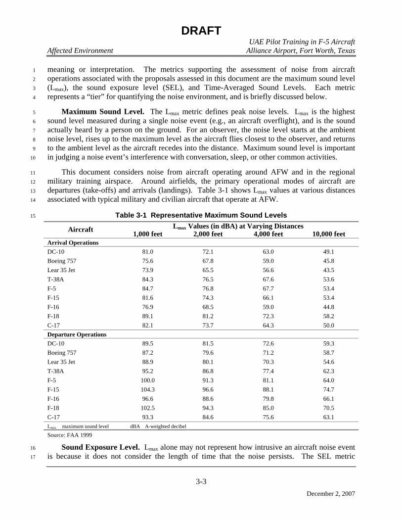
DRAFT UAE Pilot Training in F-5 Aircraft
Affected Environment Alliance Airport, Fort Worth, Texas
3-3
December 2, 2007
meaning or interpretation. The metrics supporting the assessment of noise from aircraft 1
operations associated with the proposals assessed in this document are the maximum sound level 2
(Lmax), the sound exposure level (SEL), and Time-Averaged Sound Levels. Each metric 3
represents a “tier” for quantifying the noise environment, and is briefly discussed below. 4
Maximum Sound Level. The Lmax metric defines peak noise levels. Lmax is the highest 5
sound level measured during a single noise event (e.g., an aircraft overflight), and is the sound 6
actually heard by a person on the ground. For an observer, the noise level starts at the ambient 7
noise level, rises up to the maximum level as the aircraft flies closest to the observer, and returns 8
to the ambient level as the aircraft recedes into the distance. Maximum sound level is important 9
in judging a noise event’s interference with conversation, sleep, or other common activities. 10
This document considers noise from aircraft operating around AFW and in the regional 11
military training airspace. Around airfields, the primary operational modes of aircraft are 12
departures (take-offs) and arrivals (landings). Table 3-1 shows Lmax values at various distances 13
associated with typical military and civilian aircraft that operate at AFW. 14
Table 3-1 Representative Maximum Sound Levels 15
Lmax Values (in dBA) at Varying Distances Aircraft 1,000 feet 2,000 feet 4,000 feet 10,000 feet Arrival Operations DC-10 81.0 72.1 63.0 49.1 Boeing 757 75.6 67.8 59.0 45.8 Lear 35 Jet 73.9 65.5 56.6 43.5 T-38A 84.3 76.5 67.6 53.6 F-5 84.7 76.8 67.7 53.4 F-15 81.6 74.3 66.1 53.4 F-16 76.9 68.5 59.0 44.8 F-18 89.1 81.2 72.3 58.2 C-17 82.1 73.7 64.3 50.0 Departure Operations DC-10 89.5 81.5 72.6 59.3 Boeing 757 87.2 79.6 71.2 58.7 Lear 35 Jet 88.9 80.1 70.3 54.6 T-38A 95.2 86.8 77.4 62.3 F-5 100.0 91.3 81.1 64.0 F-15 104.3 96.6 88.1 74.7 F-16 96.6 88.6 79.8 66.1 F-18 102.5 94.3 85.0 70.5 C-17 93.3 84.6 75.6 63.1 Lmax maximum sound level dBA A-weighted decibel
Source: FAA 1999
Sound Exposure Level. Lmax alone may not represent how intrusive an aircraft noise event 16
is because it does not consider the length of time that the noise persists. The SEL metric 17

DRAFT UAE Pilot Training in F-5 Aircraft
Affected Environment Alliance Airport, Fort Worth, Texas
3-4
December 2, 2007
combines intensity and duration into a single measure. It is important to note, however, that SEL 1
does not directly represent the sound level heard at any given time, but rather provides a measure 2
of the total exposure of the entire event. Its value represents all of the acoustic energy associated 3
with the event as though it was present for one second. Therefore, for sound events that last 4
longer than one second, the SEL value will be higher than the Lmax value. The SEL value is 5
important because it is the value used to calculate other time-averaged noise metrics. Table 3-2 6
shows SEL values that correspond to the aircraft and operations depicted in Table 3-1. 7
Table 3-2 Representative Sound Exposure Levels 8
Lmax Values (in dBA) at Varying Distances Aircraft 1,000 feet 2,000 feet 4,000 feet 10,000 feet Arrival Operations DC-10 87.5 81.1 74.0 63.0 Boeing 757 84.9 79.6 73.4 63.6 Lear 35 Jet 81.8 75.6 68.9 58.8 T-38A 90.7 84.7 77.6 66.0 F-5 91.4 85.2 78.0 66.1 F-15 89.2 83.6 77.3 66.9 F-16 84.8 78.2 70.5 58.6 F-18 95.2 89.1 82.0 70.3 C-17 89.3 82.7 75.1 63.2 Departure Operations DC-10 98.0 92.2 85.6 75.3 Boeing 757 95.9 90.8 85.1 76.5 Lear 35 Jet 97.1 90.6 83.0 70.3 T-38A 104.3 97.8 90.1 77.4 F-5 110.5 103.6 95.1 80.5 F-15 114.7 108.9 102.2 91.2 F-16 107.0 100.8 93.8 82.4 F-18 111.9 105.5 98.0 85.9 C-17 100.8 93.8 86.7 76.5 Lmax maximum sound level dBA A-weighted decibel
Source: FAA 1999
Time-Averaged Cumulative Noise Metrics. The number of times noise events occur 9
during given periods is also an important consideration in assessing noise impacts. The 10
“cumulative” noise metric that supports the analysis of multiple time-varying noise events are 11
the Day-Night Average Sound Level (Ldn). 12
Day-Night Average Sound Level. This metric sums the individual noise events and 13
averages the resulting level over a specified length of time. It is a composite metric that 14
considers the maximum noise levels, the duration of the events, the number of events that occur, 15
and the time of day during which they occur. This metric adds 10 dB to those events that occur 16
between 10:00 p.m. and 7:00 a.m. to account for the increased intrusiveness of noise events that 17

DRAFT UAE Pilot Training in F-5 Aircraft
Affected Environment Alliance Airport, Fort Worth, Texas
3-5
December 2, 2007
occur at night (when ambient noise levels are normally lower than during the daytime). This 1
cumulative metric does not represent the variations in the sound level heard. Nevertheless, it 2
does provide an excellent measure for comparing environmental noise exposures when there are 3
multiple noise events to be considered. 4
Using measured sound levels as a basis, the FAA developed computer programs to calculate 5
noise levels resulting from aircraft operations at airfields. These are referred to as the Integrated 6
Noise Model (INM). Sound levels calculated by these programs have been extensively validated 7
against measured data, and have been proven highly accurate. In this document, the sound levels 8
calculated for aircraft operations in the airfield environment are all presented in terms of daily 9
Ldn. Ldn metrics are the preferred noise metrics of the Department of Housing and Urban 10
Development, the Department of Transportation, the FAA, the United States Environmental 11
Protection Agency (USEPA), and the Department of Veterans Affairs (American National 12
Standards Institute [ANSI] 1980, ANSI 1988, USEPA 1974, Federal Interagency Committee on 13
Urban Noise [FICUN] 1980, Federal Interagency Committee on Noise [FICON] 1992). 14
Onset-rate Adjusted Day-Night Average Sound Level. This metric is a sub-set of the Ldn 15
metric. To account for the random and often sporadic nature of military flight training activities 16
in Military Training Airspace (MTA), some USAF-developed computer programs for the 17
calculation of noise levels created by these sporadic activities perform calculations based on a 18
monthly (rather than daily) period. As well, some of these programs may add as much 11 dBA 19
to the calculated noise levels to account for the rapid onset rate of the noise in consideration of 20
some of the unique aspects of noise created by low altitude, high-speed flight of military aircraft. 21
The resulting sound measurement metric is termed the Onset-rate Adjusted Monthly Day-Night 22
Average Sound Level (Ldnmr). 23
For this document, the USAF’s MOA Range Noise Assessment Program (MR_NMAP), 24
which is specifically designed to model noise in MOAs, Ranges, and MTRs, was used to 25
calculate sound levels in these airspace elements. The results are shown in terms of Ldnmr. 26
Excepting the onset-rate adjustment, it should be noted that calculations of Ldnmr and Ldn will 27
have the same results if the numbers of sound events (or aircraft operations considered) are 28
normalized to monthly as opposed to daily rates. 29
Finally, it should be noted that ambient background noise is not considered in the noise 30
calculations presented in this document. There are two reasons for this. First, ambient 31
background noise, even in wilderness areas, varies widely, depending on location and other 32
conditions. For example, studies conducted in an open pine forest in the Sierra National Forest 33
in California have measured up to a 10 dBA variance in sound levels simply due to an increase in 34
wind velocity (Harrison 1973). Therefore, assigning a value to background noise would be 35
arbitrary. Secondly, and probably most important, it is reasonable to assume that ambient 36
background noise in the project’s ROI would have little or no effect on the calculated Ldn. In 37
calculating noise levels, louder sounds dominate the calculations, and overall, aircraft and other 38
transportation-related noise would be expected to be the dominant noise sources characterizing 39
the acoustic conditions in the region. The ROI for the noise assessments is the area around AFW 40
and the MTA exposed to elevated noise levels caused by aviation-related noise. 41
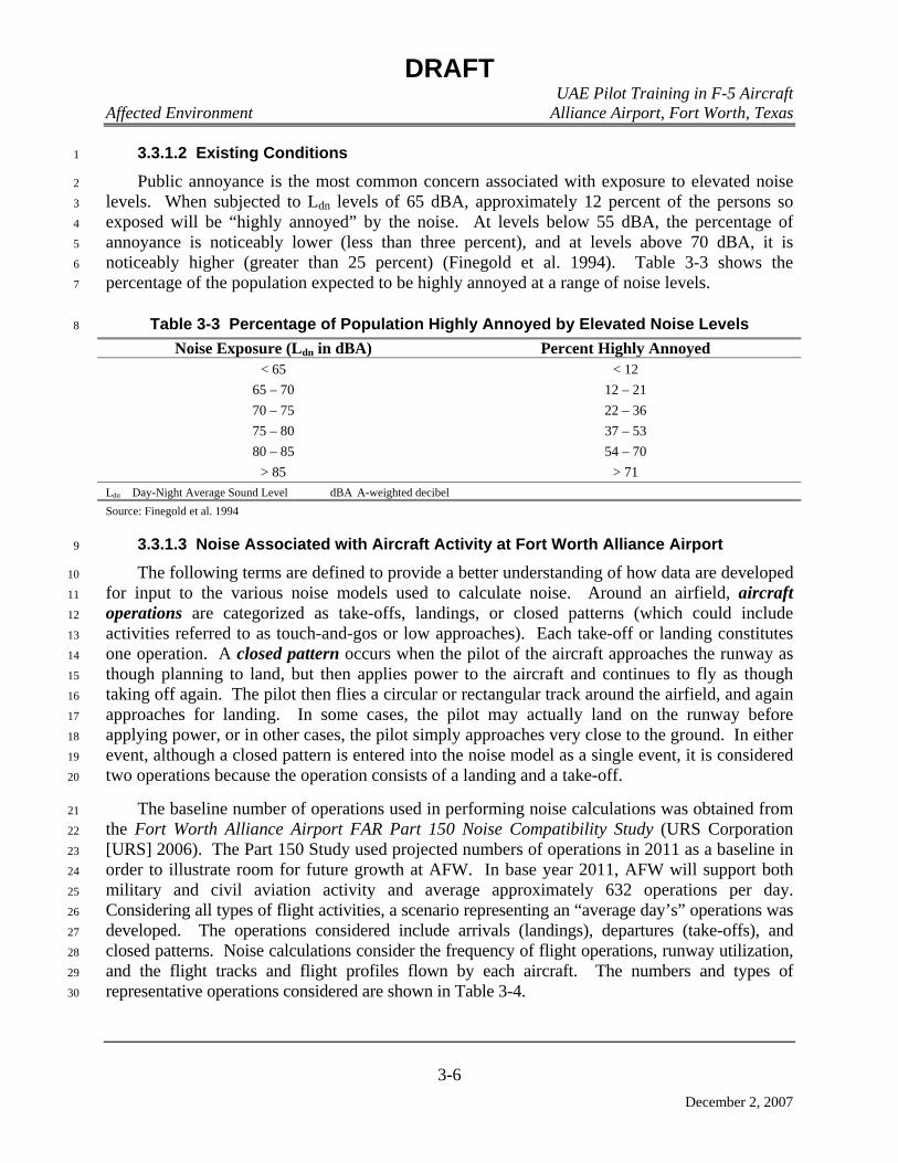
DRAFT UAE Pilot Training in F-5 Aircraft
Affected Environment Alliance Airport, Fort Worth, Texas
3-6
December 2, 2007
3.3.1.2 Existing Conditions 1
Public annoyance is the most common concern associated with exposure to elevated noise 2
levels. When subjected to Ldn levels of 65 dBA, approximately 12 percent of the persons so 3
exposed will be “highly annoyed” by the noise. At levels below 55 dBA, the percentage of 4
annoyance is noticeably lower (less than three percent), and at levels above 70 dBA, it is 5
noticeably higher (greater than 25 percent) (Finegold et al. 1994). Table 3-3 shows the 6
percentage of the population expected to be highly annoyed at a range of noise levels. 7
Table 3-3 Percentage of Population Highly Annoyed by Elevated Noise Levels 8
Noise Exposure (Ldn in dBA) Percent Highly Annoyed < 65 < 12
65 – 70 12 – 21 70 – 75 22 – 36 75 – 80 37 – 53 80 – 85 54 – 70
> 85 > 71 Ldn Day-Night Average Sound Level dBA A-weighted decibel Source: Finegold et al. 1994
3.3.1.3 Noise Associated with Aircraft Activity at Fort Worth Alliance Airport 9
The following terms are defined to provide a better understanding of how data are developed 10
for input to the various noise models used to calculate noise. Around an airfield, aircraft 11
operations are categorized as take-offs, landings, or closed patterns (which could include 12
activities referred to as touch-and-gos or low approaches). Each take-off or landing constitutes 13
one operation. A closed pattern occurs when the pilot of the aircraft approaches the runway as 14
though planning to land, but then applies power to the aircraft and continues to fly as though 15
taking off again. The pilot then flies a circular or rectangular track around the airfield, and again 16
approaches for landing. In some cases, the pilot may actually land on the runway before 17
applying power, or in other cases, the pilot simply approaches very close to the ground. In either 18
event, although a closed pattern is entered into the noise model as a single event, it is considered 19
two operations because the operation consists of a landing and a take-off. 20
The baseline number of operations used in performing noise calculations was obtained from 21
the Fort Worth Alliance Airport FAR Part 150 Noise Compatibility Study (URS Corporation 22
[URS] 2006). The Part 150 Study used projected numbers of operations in 2011 as a baseline in 23
order to illustrate room for future growth at AFW. In base year 2011, AFW will support both 24
military and civil aviation activity and average approximately 632 operations per day. 25
Considering all types of flight activities, a scenario representing an “average day’s” operations was 26
developed. The operations considered include arrivals (landings), departures (take-offs), and 27
closed patterns. Noise calculations consider the frequency of flight operations, runway utilization, 28
and the flight tracks and flight profiles flown by each aircraft. The numbers and types of 29
representative operations considered are shown in Table 3-4. 30

DRAFT UAE Pilot Training in F-5 Aircraft
Affected Environment Alliance Airport, Fort Worth, Texas
3-7
December 2, 2007
Table 3-4 Average Daily Operations at Fort Worth Alliance Airport 1
Arrivals Departures Closed Patterns Aircraft Day Night Day Night Day Night Totals
Commercial 6.4982 11.1523 6.6230 11.0267 4.1812 0.1996 39.6810 General Aviation
19.4050 3.9711 19.4060 3.9702 78.4260 4.8092 129.9875
Helicopters 30.6621 2.1066 30.6621 2.1066 325.7704 25.7728 417.0806 Military 10.1669 1.4464 10.1657 1.4463 19.5300 2.2668 45.0221
Total 66.7322 18.6764 66.8568 18.5498 427.9076 33.0484 631.7712 Note: Daily operations are based on averages of annual operations; therefore, numbers do not round. Source: AFW/URS 2007 Numbers of operations obtained from projected base year 2011 conditions in Fort Worth Alliance Airport FAR Part 150 Noise Compatibility Study, Appendix F (URS 2006)
These levels and types of activity are then combined with information on climatology, 2
maintenance activities, and aircraft flight parameters, and processed through the FAA’s INM 3
computer models to calculate Ldn. Once noise levels are calculated, they are plotted on a 4
background map in 5-dB increments from 65 dBA to 85 dBA, as applicable. Noise contours 5
associated with current activities at AFW are shown in Figure 3-1. The land areas (in acres) 6
encompassed by each contour both on- and off-airport for the current condition is shown in 7
Table 3-5. 8
Table 3-5 Land Areas Exposed to Indicated Sound Levels, Current Conditions 9
Acres of Land Sound Level (in
Ldn) On-airport Off-airport Total Population
Exposed to Elevated Noise
65 – 70 113 2142.6 2255.6 68 70 – 75 162.6 846.5 1009 16 75 – 80 173.1 262.5 435.6 4 80 – 85 147.6 45.4 193 0
> 85 298.5 40.6 339.1 0 Total > 65 894.8 3337.6 4232.3 88
Ldn Day-Night Average Sound Level Source: AFW/URS 2007 Notes: No persons live on the airport – all exposed population is located off airport land. Exposed population is estimated based on census tract population data and the relative proportion of the tract encompassed by given contour levels. Persons expected to be annoyed is estimated based on total population exposed, and the average percentage of that population expected to be annoyed by the indicated noise level (see Table 3-3). Data obtained from 2000 census information and Geographical Information System data.
In order to further assess noise exposure from aviation activity, several locations around the 10
airport were selected for specific analysis. These points represent land uses within the ROI that 11
could be potentially sensitive to elevated noise levels. Noise exposure at these points is shown in 12
Table 3-6, and the location of the points is depicted in Figure 3-1. 13

DRAFT UAE Pilot Training in F-5 Aircraft
Affected Environment Alliance Airport, Fort Worth, Texas
3-8
December 2, 2007
Table 3-6 Specific Point Noise Exposure, Current Conditions 1
Point Identification Location Noise Level in Ldn NSR1 Haslet Elementary School 55.4 NSR2 First Baptist Church – Haslet 55.0 NSR3 Alliance Health Center 75.7 NSR4 Northwest High School 63.0 NSR5 Residential (North of Fort Worth Alliance Airport) 56.9
Ldn Day-Night Average Sound Level Source: FAA 1999
Other Project Noise at AFW. Under the proposed action, additional activities at AFW 2
would involve repair, refurbishment, and construction; all of which will create noise. To assess 3
potential impacts of this noise, estimated on-site equipment usage was modeled using the Federal 4
Highway Administration’s Roadway Construction Noise Model (RCNM). The results calculated 5
by the model are conservative. Noise levels in the model originated from data developed by the 6
USEPA, and were refined using an “acoustical usage factor” to estimate the fraction of time each 7
piece of construction equipment is operating at full power (i.e., its loudest condition) during the 8
project (Department of Transportation 2006). 9
The RCNM collects acoustic data at identified receptor points, and reports equivalent noise 10
levels (Leq) at those points. Modeling of construction- and demolition-related operations indicate 11
that at some 500 feet off-site, noise levels are in the 50 to 55 dBA range. Very close to the site, 12
noise from construction would probably be heard, but would not be at any level considered 13
intrusive. At greater distances, calculated levels fall to or below ambient levels, considering the 14
overall acoustic environment in the area. 15
3.3.1.4 Noise Associated with Aircraft Activity in Military Training Airspace 16
The types of military training airspace associated with the proposals include MOAs, MTRs, 17
and Restricted Areas. Flight activities in blocks of airspace such as MOAs and Restricted Areas 18
are intentionally random and dispersed, reflecting typical combat maneuvers. Relatively well-19
defined flight tracks are also used on some ranges, as is the case at Falcon Range. In MOAs, the 20
altitude structure and size of the MOA influences the noise exposure on the ground, and 21
calculated noise represents uniformly distributed sound throughout the airspace. 22
MTRs and defined bombing tracks are corridors described by a centerline, with defined 23
horizontal limits on either side of the centerline. Along MTRs, it is recognized that pilots do not 24
always follow the centerline of the route. Rather, they fly some offset courses that have been 25
shown to follow a normal distribution around the centerline based on the route width. 26
The Brady High and Low MOAs overlap, and overlie land areas identified for avoidance of 27
direct low-altitude aircraft overflight. These land areas have been identified for overflight 28
avoidance because they have been designated for uses that would be considered sensitive to the 29
intrusive effects of loud and sudden noise or because other aviation activities occur in the area. 30

DRAFT UAE Pilot Training in F-5 Aircraft
Affected Environment Alliance Airport, Fort Worth, Texas
3-9
December 2, 2007
Figure 3-1 Baseline Noise Contours, Fort Worth Alliance Airport, Fort Worth, Texas

DRAFT UAE Pilot Training in F-5 Aircraft
Affected Environment Alliance Airport, Fort Worth, Texas
3-10
December 2, 2007
MR_NMAP, which is specifically designed to model noise in MOAs, MTRs, and ranges, 1
was used to calculate the uniformly distributed sound levels in MOAs and the maximum noise 2
levels along the centerline of MTRs and bombing tracks. These levels are shown in terms of 3
Ldnmr. Under current conditions, noise levels created by aircraft operations are shown in 4
Table 3-7. Noise contours associated with the use of Falcon Range are shown in Figure 3-2. 5
Table 3-7 Noise Levels in Military Training Airspace, Current Conditions 6
Airspace Uniformly Distributed Sound Level/ Range of Maximum Sound Levels (in Ldnmr)
BRADY HIGH MOA 44.1 BRADY LOW MOA 55.5
BRADY HIGH + BRADY LOW MOAs 55.81 BROWNWOOD MOA 25.5
IR-103 47.1 – 52.1 IR-105 47.0 – 52.0 VR-104 49.7 – 51.8 VR-118 45.7 – 50.1
Falcon Range 21.1 – 50.9 Ldnmr Onset-rate Adjusted Monthly Day-Night Average Sound Level MTR Military Training Route
IR Instrument Flight Rules Military Training Route VR Visual Flight Rules Military Training Route MOA Military Operations Area
Note: For MOAs, indicates uniformly distributed noise throughout the airspace; for MTRs indicates maximum noise level on route centerline. When applicable, a range of values reflects changes in the configuration of the route. 1Sound level in the three avoidance areas is 53.8 Ldnmr. Source: Lucas and Calamia 1996
The values presented in Table 3-7 reflect the mathematically calculated output of the 7
MR_NMAP model. Background noise in rural areas is normally considered to be approximately 8
40 dBA or greater. Normally, while calculated, noise levels at or below 40 dBA are not reported 9
since they are at or below anticipated ambient levels and indicate that there is little or no 10
observable noise contribution from aircraft in the region. These low values are due to the size of 11
the airspace, the relatively limited number of operations, and the altitudes at which these 12
operations are conducted. As shown in Figure 3-2, noise levels on Falcon Range are minimal, 13
and are localized as bombing tracks converge at the target area. 14
3.3.1.5 Other Ground-based Activity 15
Operations, maintenance, and industrial activities on AFW generate non-aircraft related 16
noise. Noise sources include transportation noise from the operation of ground-support 17
equipment. However, this noise is generally localized in industrial areas on or near the airfield, 18
or on established lines of communication supporting traffic to and from the airfield. Noise is 19
also generated from other commercial activities located near the airfield. Noise resulting from 20
aircraft operations remains the dominant noise source in the airfield region. 21

DRAFT UAE Pilot Training in F-5 Aircraft
Affected Environment Alliance Airport, Fort Worth, Texas
3-11
December 2, 2007
Figure 3-2 Baseline Noise Contours, Falcon Range, Oklahoma
DRAFT UAE Pilot Training in F-5 Aircraft Affected Environment Alliance Airport, Fort Worth, Texas
3-12
December 2, 2007
3.3.2 Airspace Management and Air Traffic Control 1
3.3.2.1 Definition of Resource 2
Airspace management involves the direction, control, and handling of flight 3
operations in the volume of air that overlies the geopolitical borders of the U.S. and its 4
territories. Airspace is a resource managed by the FAA, with established policies, 5
designations, and flight rules to protect aircraft in the airfield and en route. 6
The USAF manages airspace in accordance with processes and procedures detailed 7
in AFI 13-201, Air Force Airspace Management. AFI 13-201 implements Air Force 8
Planning Document 13-2, Air Traffic Control, Airspace, Airfield, and Range 9
Management, and DoD Directive 5030.19, DoD Responsibilities on Federal Aviation and 10
National Airspace System Matters. It addresses the development and processing of SUA, 11
and covers aeronautical matters governing the efficient planning, acquisition, use, and 12
management of airspace required to support USAF flight operations (USAF 2001). 13
The FAA has designated four main types of airspace: controlled, uncontrolled, 14
special use airspace, and other airspace (FAA 2001, FAA 2004, FAA 2007c, FAA 2007d, 15
and Air Safety Foundation 2007). 16
Controlled Airspace 17
Controlled airspace is categorized into five separate classes: Class A, B, C, D, and E 18
airspace. These classes identify airspace that is controlled, airspace that supports airport 19
operations, and designated airways affording en route transit from place to place. These 20
classes also dictate pilot qualification requirements, rules of flight that must be followed, 21
and the type of equipment necessary to operate within that airspace. 22
Class A Airspace 23
Class A airspace generally controls aircraft that fly above 18,000 feet above mean sea 24
level (MSL). 25
Class B Airspace 26
Class B airspace is generally defined as the airspace around the nation’s busiest 27
airports, within which to operate aircraft must receive a clearance. 28
Class C Airspace 29
Class C airspace generally requires that all aircraft operating within meet mandatory 30
communications requirements. 31
Class D Airspace 32
Class D airspace is generally defined as the airspace established around airports with 33
ATC towers. 34
DRAFT UAE Pilot Training in F-5 Aircraft Affected Environment Alliance Airport, Fort Worth, Texas
3-13
December 2, 2007
Class E Airspace 1
Class E airspace is controlled airspace that is not Class A, B, C, or D, including air 2
routes, transition areas, and other areas within which ATC services are provided. 3
Uncontrolled (Class G) Airspace 4
Airspace that has not been designated as Class A, B, C, D, or E airspace is 5
uncontrolled airspace (Class G), and has no specific prohibitions associated with its use. 6
Special Use Airspace 7
SUA is airspace designated to advise pilots of flight activities that require confinement 8
of participating aircraft or that require operating limitations be placed on non-participating 9
aircraft. SUA includes Restricted Areas and MOAs. 10
Restricted Areas 11
A Restricted Area is designated airspace that supports ground or flight activities that 12
could be hazardous to non-participating aircraft Restricted areas indicate the possibility of 13
unusual, often invisible, hazards to aircraft such as artillery firing or aerial gunnery. Most 14
restricted areas are designated “joint-use” and Instrument Flight Rules (IFR)/Visual Flight 15
Rules (VFR) operations in the area may be authorized by the controlling ATC facility 16
when it is not being utilized by the using agency. 17
Military Operations Areas 18
A MOA is airspace of defined vertical and lateral limits established to separate and 19
segregate certain non-hazardous military activities from IFR traffic and to identify for VFR 20
traffic where these activities are conducted. Examples of activities conducted in MOAs 21
include, but are not limited to air combat tactics, air intercepts, aerobatics, formation 22
training, and low-altitude tactics. MOAs are considered “joint use” airspace. When the 23
MOA is active for military use, non-participating aircraft operating under VFR are 24
permitted to enter a MOA. Aircraft operating under IFR must remain clear of an active 25
MOA unless approved by the responsible Air Route Traffic Control Center (ARTCC). 26
Flight by both participating and VFR non-participating aircraft is conducted under the 27
“see-and-avoid” concept, which stipulates that “when weather conditions permit, pilots 28
operating IFR or VFR are required to observe and maneuver to avoid other aircraft. The 29
responsible ARTCC provides separation service for aircraft operating under IFR and MOA 30
participants. The “see-and-avoid” procedures mean that if a MOA were active during 31
inclement weather, the general aviation pilot could not safely access the MOA airspace. 32
Other Airspace Areas 33
Other airspace consists of advisory areas, areas that have specific flight limitations or 34
designated prohibitions regarding use, areas designated for parachute jump operations, 35
MTRs, or Aerial Refueling tracks. This category also includes Air Traffic Control 36
Assigned Airspace (ATCAA). When not required for other needs, ATCAA is airspace 37
DRAFT UAE Pilot Training in F-5 Aircraft Affected Environment Alliance Airport, Fort Worth, Texas
3-14
December 2, 2007
authorized for military use by the managing ARTCC, usually to extend the vertical 1
boundary of SUA. 2
Military Training Routes 3
The MTR program is a joint venture by the FAA and DoD. MTRs are mutually 4
developed for use by the military for the purpose of conducting low-altitude (generally 5
below 10,000 feet above MSL), high-speed training (DoD 2005). They are described by a 6
centerline, with defined horizontal limits on either side of the centerline, and vertical limits 7
expressed as minimum and maximum altitudes along the flight track. MTRs vary 8
significantly in width and can extend several miles either side of the charted centerline. MTRs 9
are identified as VR or IR, and are used to conduct low-altitude (below 10,000 feet MSL) 10
navigation and tactical training at airspeeds that exceed 250 knots indicated air speed. VRs 11
are used to conduct training under VFR), and IRs are used to conduct training in both IFR 12
and VFR weather conditions (FAA 2004). 13
Air Traffic Control Assigned Airspace 14
An ATCAA is airspace of defined vertical and lateral limits, assigned by ATC, for the 15
purpose of providing air traffic segregation between the specified activities being 16
conducted within the assigned airspace and other IFR air traffic. This airspace, if not 17
required for other purposes, may be made available for military use. ATCAAs are 18
normally structured and used to extend the horizontal and/or vertical boundaries of SUA 19
such as MOAs and Restricted Areas. 20
3.3.2.2 Existing Conditions 21
The proposed UAE IFF pilot training program would be conducted from AFW and 22
would utilize existing MTA in the region. AFW is located west-northwest of DFW, and 23
lies within the Class B Controlled Airspace established around DFW. 24
MTA associated with this proposal includes MOAs, MTRs, and Restricted Areas. 25
These airspace elements are shown in Figure 1-2. Use of these airspace components is 26
normally scheduled by the owning/using agency, and is managed by the military or the 27
applicable ARTCC. 28
The primary MOAs proposed to support the proposed UAE IFF pilot training program 29
are detailed in Table 3-8. 30
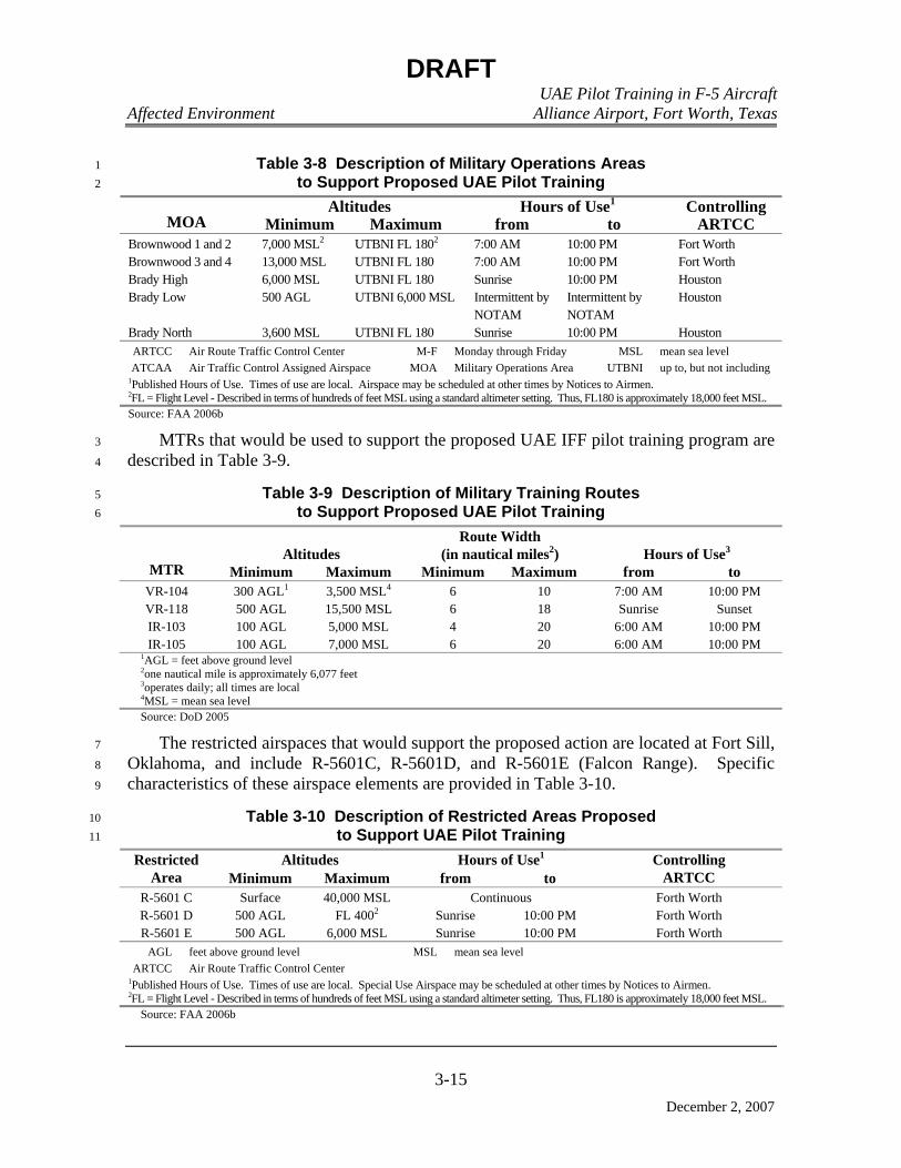
DRAFT UAE Pilot Training in F-5 Aircraft Affected Environment Alliance Airport, Fort Worth, Texas
3-15
December 2, 2007
Table 3-8 Description of Military Operations Areas 1 to Support Proposed UAE Pilot Training 2
Altitudes Hours of Use1 MOA Minimum Maximum from to
Controlling ARTCC
Brownwood 1 and 2 7,000 MSL2 UTBNI FL 1802 7:00 AM 10:00 PM Fort Worth Brownwood 3 and 4 13,000 MSL UTBNI FL 180 7:00 AM 10:00 PM Fort Worth Brady High 6,000 MSL UTBNI FL 180 Sunrise 10:00 PM Houston Brady Low 500 AGL UTBNI 6,000 MSL Intermittent by
NOTAM Intermittent by NOTAM
Houston
Brady North 3,600 MSL UTBNI FL 180 Sunrise 10:00 PM Houston ARTCC Air Route Traffic Control Center M-F Monday through Friday MSL mean sea level ATCAA Air Traffic Control Assigned Airspace MOA Military Operations Area UTBNI up to, but not including
1Published Hours of Use. Times of use are local. Airspace may be scheduled at other times by Notices to Airmen. 2FL = Flight Level - Described in terms of hundreds of feet MSL using a standard altimeter setting. Thus, FL180 is approximately 18,000 feet MSL. Source: FAA 2006b
MTRs that would be used to support the proposed UAE IFF pilot training program are 3
described in Table 3-9. 4
Table 3-9 Description of Military Training Routes 5 to Support Proposed UAE Pilot Training 6
Altitudes Route Width
(in nautical miles2) Hours of Use3 MTR Minimum Maximum Minimum Maximum from to
VR-104 300 AGL1 3,500 MSL4 6 10 7:00 AM 10:00 PM VR-118 500 AGL 15,500 MSL 6 18 Sunrise Sunset IR-103 100 AGL 5,000 MSL 4 20 6:00 AM 10:00 PM IR-105 100 AGL 7,000 MSL 6 20 6:00 AM 10:00 PM
1AGL = feet above ground level 2one nautical mile is approximately 6,077 feet 3operates daily; all times are local 4MSL = mean sea level Source: DoD 2005
The restricted airspaces that would support the proposed action are located at Fort Sill, 7
Oklahoma, and include R-5601C, R-5601D, and R-5601E (Falcon Range). Specific 8
characteristics of these airspace elements are provided in Table 3-10. 9
Table 3-10 Description of Restricted Areas Proposed 10 to Support UAE Pilot Training 11
Altitudes Hours of Use1 Restricted Area Minimum Maximum from to
Controlling ARTCC
R-5601 C Surface 40,000 MSL Continuous Forth Worth R-5601 D 500 AGL FL 4002 Sunrise 10:00 PM Forth Worth R-5601 E 500 AGL 6,000 MSL Sunrise 10:00 PM Forth Worth
AGL feet above ground level MSL mean sea level ARTCC Air Route Traffic Control Center
1Published Hours of Use. Times of use are local. Special Use Airspace may be scheduled at other times by Notices to Airmen. 2FL = Flight Level - Described in terms of hundreds of feet MSL using a standard altimeter setting. Thus, FL180 is approximately 18,000 feet MSL.
Source: FAA 2006b
DRAFT UAE Pilot Training in F-5 Aircraft Affected Environment Alliance Airport, Fort Worth, Texas
3-16
December 2, 2007
3.3.3 Land Use 1
3.3.3.1 Definition of the Resource 2
Land use comprises natural conditions or human-modified activities occurring at a 3
particular location. Human-modified land use categories include residential, commercial, 4
industrial, transportation, communications and utilities, agricultural, institutional, 5
recreational, and other developed use areas. The attributes of land use considered in this 6
analysis include general land use patterns, land ownership, land management plans, and 7
special use areas. 8
General land use patterns characterize the types of uses within a particular area 9
including agricultural, residential, military, and recreational. Land ownership is a 10
categorization of land according to type of owner. The major land ownership categories 11
include private, federal, and state. Management plans and zoning regulations determine 12
the type and extent of land use allowable in specific areas and are often intended to protect 13
specially designated or environmentally sensitive areas. 14
Noise is another factor in determining appropriate land uses since elevated sound 15
levels are incompatible with residential areas. As described in Section 3.3.1.1, sound 16
levels are typically measured in decibels using Ldn as the standard of measurement. 17
Numerous studies have shown a relationship between Ldn and the percentage of the 18
population likely to be highly annoyed. Residential areas are typically inconsistent with 19
noise levels above Ldn 65 dB. 20
Visual resources are the natural and man-made features that give a particular 21
environment its aesthetic qualities. In undeveloped areas, landforms, water surfaces, and 22
vegetation are the primary components that characterize the landscape. Man-made 23
elements such as buildings, fences, and streets may also be visible. These may dominate 24
the landscape or be relatively unnoticeable. In developed areas, the natural landscape is 25
more likely to provide a background for more obvious man-made features. The size, 26
forms, materials, and functions of buildings, structures, roadways, and infrastructure will 27
generally define the visual character of the built environment. These features form the 28
overall impression that an observer receives of an area or its landscape character. 29
Attributes used to describe the visual resource value of an area include landscape character, 30
perceived aesthetic value, and uniqueness. 31
The ROI for land use and visual resources includes AFW and the area surrounding the 32
airport that may be affected by aircraft noise. Land use is not considered for Falcon Range 33
on Fort Sill and proposed MTRs/MOAs since the proposed action does not include any 34
activities on or near the ground in or near the area. 35
3.3.3.2 Fort Worth Alliance Airport Land Use 36
AFW encompasses 912 acres and includes a variety of land use categories such as 37
airfield and aircraft operation and maintenance, industrial manufacturing, shipping, and, 38
commercial development (Hillwood Development Company, LLC [Hillwood] 2007a). 39
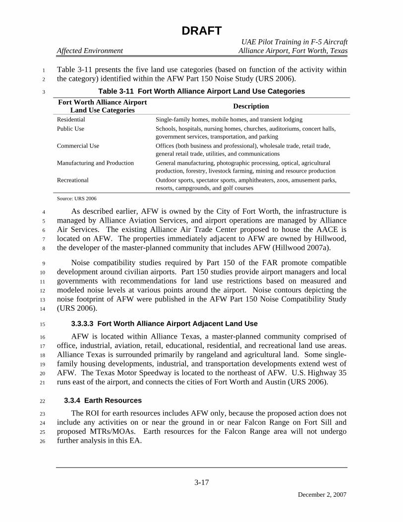
DRAFT UAE Pilot Training in F-5 Aircraft Affected Environment Alliance Airport, Fort Worth, Texas
3-17
December 2, 2007
Table 3-11 presents the five land use categories (based on function of the activity within 1
the category) identified within the AFW Part 150 Noise Study (URS 2006). 2
Table 3-11 Fort Worth Alliance Airport Land Use Categories 3
Fort Worth Alliance Airport Land Use Categories Description
Residential Single-family homes, mobile homes, and transient lodging Public Use Schools, hospitals, nursing homes, churches, auditoriums, concert halls,
government services, transportation, and parking Commercial Use Offices (both business and professional), wholesale trade, retail trade,
general retail trade, utilities, and communications Manufacturing and Production General manufacturing, photographic processing, optical, agricultural
production, forestry, livestock farming, mining and resource production Recreational Outdoor sports, spectator sports, amphitheaters, zoos, amusement parks,
resorts, campgrounds, and golf courses Source: URS 2006
As described earlier, AFW is owned by the City of Fort Worth, the infrastructure is 4
managed by Alliance Aviation Services, and airport operations are managed by Alliance 5
Air Services. The existing Alliance Air Trade Center proposed to house the AACE is 6
located on AFW. The properties immediately adjacent to AFW are owned by Hillwood, 7
the developer of the master-planned community that includes AFW (Hillwood 2007a). 8
Noise compatibility studies required by Part 150 of the FAR promote compatible 9
development around civilian airports. Part 150 studies provide airport managers and local 10
governments with recommendations for land use restrictions based on measured and 11
modeled noise levels at various points around the airport. Noise contours depicting the 12
noise footprint of AFW were published in the AFW Part 150 Noise Compatibility Study 13
(URS 2006). 14
3.3.3.3 Fort Worth Alliance Airport Adjacent Land Use 15
AFW is located within Alliance Texas, a master-planned community comprised of 16
office, industrial, aviation, retail, educational, residential, and recreational land use areas. 17
Alliance Texas is surrounded primarily by rangeland and agricultural land. Some single-18
family housing developments, industrial, and transportation developments extend west of 19
AFW. The Texas Motor Speedway is located to the northeast of AFW. U.S. Highway 35 20
runs east of the airport, and connects the cities of Fort Worth and Austin (URS 2006). 21
3.3.4 Earth Resources 22
The ROI for earth resources includes AFW only, because the proposed action does not 23
include any activities on or near the ground in or near Falcon Range on Fort Sill and 24
proposed MTRs/MOAs. Earth resources for the Falcon Range area will not undergo 25
further analysis in this EA. 26

DRAFT UAE Pilot Training in F-5 Aircraft Affected Environment Alliance Airport, Fort Worth, Texas
3-18
December 2, 2007
3.3.4.1 Geology 1
The sedimentary geologic formation outcrops in the vicinity of AFW are from the 2
Cretaceous systems. These outcrops consist of limestone, marl, gravel, sand, silt, and clay. 3
The most shallow bedrock unit is the Austin, Eagle Ford, Woodbine, and Upper Washita 4
Groups of the late Cretaceous System (Bureau of Economic Geology 1992). 5
3.3.4.2 Soils 6
The main soil type at AFW is the Sanger series for Denton County and the Ponder 7
series for portions of the airport over Tarrant County. 8
The Sanger series consists of very deep, very slowly permeable soils that formed in 9
clayey marine sediments. Slopes range from 1 to 12 percent, however slopes are typically 10
1 to 5 percent. Water enters rapidly when the soil is dry and cracked, and very slowly 11
when the soil is moist (Natural Resources Conservation Service [NRCS] 2007a). 12
The Ponder series consists of deep, moderately well drained, slowly permeable soils 13
that formed in calcareous marine sediments. These are nearly level to gently sloping soils 14
on stream divides and ancient stream terraces. Slopes on these soils range from 0 to 5 15
percent. The soils are moderately well drained, with medium runoff and slow permeability 16
(NRCS 2007b). 17
3.3.4.3 Topography 18
AFW is situated in the Blackland Prairie physiographic region characterized by gentle 19
slopes. Land elevations at AFW range from 650 to 720 feet above MSL (North Central 20
Texas Council of Governments [NCTCOG] 2007a). 21
3.3.5 Water Resources 22
As with earth resources, the ROI for water resources includes AFW only, because the 23
proposed action does not include any activities on or near the ground in or near Falcon 24
Range on Fort Sill and proposed MTRs/MOAs. Therefore, water resources in the Falcon 25
Range and proposed MTRs/MOAs areas will not be carried forward for further analysis. 26
3.3.5.1 Definition of the Resources 27
Water resources analyzed in this EA include surface water and groundwater quantity 28
and quality. Surface water resources comprise lakes, rivers, and streams and are important 29
for a variety of reasons, including economic, ecological, recreational, and human health. 30
Groundwater comprises the subsurface hydrologic resources of the physical environment 31
and is an essential resource. Groundwater properties are often described in terms of depth 32
to aquifer or water table, water quality, and surrounding geologic composition. Other 33
issues relevant to water resources include the downstream water and watershed areas 34
affected by existing and potential runoff and hazards associated with the 100-year 35
floodplain. 36

DRAFT UAE Pilot Training in F-5 Aircraft Affected Environment Alliance Airport, Fort Worth, Texas
3-19
December 2, 2007
3.3.5.2 Surface Water 1
AFW is situated in a drainage divide between Elizabeth Creek and Henrietta Creek, 2
which serve as the primary waterways that collect stormwater throughout the airport. 3
These creeks flow into Denton Creek to the southeast and eventually into the Elm Fork of 4
the Trinity River (FAA 2001). 5
The amount of impervious cover in an area has a direct relationship on the amount and 6
velocity of stormwater runoff. Impervious cover on AFW consists of buildings and 7
structures, roadways, runways, taxiways, airfield aprons, parking areas, and sidewalks. 8
Stormwater discharge from AFW is regulated by the permits listed in Table 3-12. 9
Table 3-12 Fort Worth Alliance Airport Stormwater-Related Permits 10
Description ID Number Texas Commission on Environmental Quality Multi-Sector General Permit of Storm Water Discharges Associated with Industrial Activities
TXR050000
Environmental Protection Agency Federal Multi-Sector General Permit (held by airport operator, Alliance Air Services)
TXR05M620
Environmental Protection Agency Federal Multi-Sector General Permit (held by airport owner, City of Fort Worth)
TXR154132
Source: URS 2006
3.3.5.3 Floodplains 11
No land on AFW is contained within the 100-year floodplain (FAA 2001). 12
3.3.6 Hazardous Materials and Hazardous Waste 13
The ROI for hazardous materials and hazardous waste analysis consists of AFW only, 14
because activities associated with the proposed action will not be conducted on or near the 15
ground in or near Falcon Range on Fort Sill and proposed MTRs/MOAs. Therefore, 16
hazardous materials and hazardous waste will not be analyzed further for these geographic 17
areas. 18
3.3.6.1 Hazardous Materials 19
Petroleum, oil, and lubricant (POL) products and other hazardous materials (e.g., 20
paints) would be used for maintenance operations and similar activities at AFW. These 21
materials would be stored in the proper containers, employing secondary containment as 22
necessary to prevent/limit accidental spills. All spills and accidental discharges of POLs, 23
hazardous materials, or hazardous waste would be reported. 24
The USEPA and the TCEQ administer RCRA Subtitle C (Title 40, CFR, Parts 260 25
through 270) regulations applicable to the management of hazardous waste. Hazardous 26
waste must be handled, stored, transported, disposed, or recycled in accordance with these 27
regulations. 28
DRAFT UAE Pilot Training in F-5 Aircraft Affected Environment Alliance Airport, Fort Worth, Texas
3-20
December 2, 2007
One petroleum storage tank (PST) registered with the Texas Commission on 1
Environmental Quality (TCEQ) (ID77455) is located on AFW (FAA 2001). PSTs are 2
regulated by the TCEQ. The Texas PST Program is a comprehensive regulatory program 3
for underground storage tanks (UST), and to a lesser extent, aboveground storage tanks 4
(AST). Regulated USTs are subject to extensive TCEQ administrative and technical 5
standards, including requirements for registration, installation, upgrades, repairs, removals, 6
release reporting, corrective action, financial assurance, fees, contractor registration, 7
reporting, and record keeping. Regulated ASTs are subject to registration, fees, release 8
reporting, corrective action, record keeping, and other reporting requirements. The statute 9
creating and governing the Texas PST Program is the Texas Water Code, Chapter 26, 10
Subchapters I and K. The PST Program regulates USTs and ASTs containing petroleum or 11
hazardous substances (TCEQ 2007a). 12
3.3.6.2 Hazardous Waste 13
Unless otherwise exempted by Comprehensive Environmental Response, 14
Compensation and Liability Act regulations, Resource Conservation and Recovery Act 15
(RCRA) Subtitle C (40 CFR Parts 260 through 270) regulations are administered by the 16
USEPA and are applicable to the management of hazardous wastes. Hazardous waste must 17
be handled, stored, transported, disposed, or recycled in accordance with these regulations. 18
Under existing regulations, nothing restricts the amount of waste that can be handled on 19
AFW as long as 90-day accumulation periods are not exceeded. 20
3.3.7 Biological Resources 21
3.3.7.1 Vegetation and Wildlife 22
3.3.7.1.1 Flora 23
AFW is located within the Texas Biotic Province, a transitional zone from the 24
southeastern forests to the southernmost extension of the Great Plains. The general region 25
reflects this mixture superficially. The area is characterized by open, rolling grasslands. 26
The majority of woody plants in the study area are found along the waterways and adjacent 27
fence lines that cross the area. Although historically a region of prairie vegetation, the 28
general drainage pattern has permitted the extension of corridors of woodland flora into the 29
general geographic region. Streams have eroded through the geology of the study area and 30
the resulting soils strongly favor the development of prairie (FAA 2001). 31
Vegetation on Fort Sill constitutes an ecological transition area where tall grass prairie 32
merges with short grass prairie. Mesquite and oak thickets occur on much of the western 33
two-thirds of the installation. Soil variation has created a diverse plant community. 34
Historically southwestern Oklahoma, including Fort Sill, was a grassland prairie traversed 35
by wooded streams. The native prairie was subsequently overgrazed as settlement 36
increased, somewhat changing the climax grassland communities. Riparian sites have 37
changed little and consist predominately of elm (Ulmus spp.), pecan (Carya illinoensis), 38
hackberry (Celtis occidentalis), and various species of oak (Quercus spp.). Mesquite 39
DRAFT UAE Pilot Training in F-5 Aircraft Affected Environment Alliance Airport, Fort Worth, Texas
3-21
December 2, 2007
(Prosopis glandulosa) has encroached on the prairie and is competing with native grasses. 1
Eastern red cedar (Juniperus virginiana) has encroached in wooded and prairie areas where 2
fire has been controlled, but this is relatively insignificant. Grassland communities 3
comprise over 70 percent of Fort Sill. Dense woodlands are found along streams and on 4
sandy, gravelly, and some stony upland areas (U.S. Army 2003). Since no proposed action 5
activities will occur on or near the ground in or near Falcon Range on Fort Sill, further 6
analysis in this section is limited to AFW. 7
3.3.7.1.2 Fauna 8
Historic fauna likely included a mixture of southern prairie animals, southeastern 9
woodland species, and a number of very widespread forms. Throughout the region, 10
agricultural practices have made extensive changes to the natural landscape, thus affecting 11
habitat and availability of natural resources. Wildlife species that cannot coexist with 12
human activity are typically displaced or have been extirpated from the county. 13
Cultivation has been the most significant source of grassland conversion. Pastures in the 14
area offer better, yet still altered, habitat for prairie plants and animals. The quality of 15
these pastures depends heavily upon current and historical grazing patterns. Cultivation, 16
overgrazing, and the introduction of non-native plants have all changed the region’s 17
remaining grasslands. Streamside forests and woodlands have been cleared to varying 18
degrees. Often, only abrupt changes in the topography of stream channels have preserved 19
wooded areas from being cleared for cultivation. Where streamside vegetation remains, 20
the understory has been modified by grazing. Despite these alterations, it is the woodlands 21
along the stream channels that currently provide the least altered and most diverse habitat 22
in the region (FAA 2001). 23
Fort Sill has a diversity of habitats that support a rich and diverse array of fauna. 24
Natural Resources and Enforcement files contain data on population numbers for high 25
priority species, generally game species. These species include Bobwhite Quail (Colinus 26
virginianus), white-tailed deer (Odocoileus virginianus), Mourning Dove (Zenaida 27
macroura), pheasants (Phasianus colchicus), elk (Cervus elaphus), raccoons (Procyon 28
lotor), waterfowl species, and coyotes (Canis latrans). Fauna species known to occur on 29
Fort Sill 24 mammalian species from 13 families and 71 avian species from 28 families 30
(U.S. Army 2003). Since no proposed action activities will occur on or near the ground in 31
or near Falcon Range on Fort Sill, further analysis in this section is limited to AFW. 32
3.3.7.1.3 Critical Habitats 33
A critical habitat is defined in section 3(5)(A) of the Endangered Species Act as: 34
the specific areas within the geographical area occupied by the species, at 35
the time it is listed in accordance with the provision of section 4 of this Act, 36
on which are found those physical or biological features (I) essential to the 37
conservation of the species and (II) which may require special management 38
considerations or protection; and (ii) specific areas outside the geographical 39
area occupied by the species at the time it is listed in accordance with the 40

DRAFT UAE Pilot Training in F-5 Aircraft Affected Environment Alliance Airport, Fort Worth, Texas
3-22
December 2, 2007
provisions of section 4 of this Act, upon a determination by the Secretary that 1
such areas are essential for the conservation of the species. 2
No Critical Habitats at either AFW or Falcon Range have been identified (Robinson 3
2007 and Hodgkins 2007). 4
3.3.7.1.4 Federally-listed and State-listed Threatened or Endangered Species 5
A list of Threatened or Endangered Species (TES) of potential occurrence in Denton 6
and Tarrant County was obtained from the Texas Parks and Wildlife Department (TPWD) 7
website (Table 3-13). The list includes 10 bird species, three mammal species, three 8
amphibian species, one plant species, and two reptile species (TPWD 2007). The list of 9
TES of potential occurrence in Comanche County was obtained from the 2006 10
supplemental EA for establishing SUA at Fort Sill and the Oklahoma Department of 11
Wildlife Conservation (ODWC) (Table 3-14). The list includes 10 bird species, 12
three mammal species, three amphibian species, one plant species, and two reptile species 13
(ODWC 2007). 14
Table 3-13 Federal and State Status of Wildlife in Denton and Tarrant Counties, Texas 15
Common Name Scientific Name Federal Status State Status Birds Henslow’s Sparrow Ammodramus henslowii - - Western Burrowing Owl Athene cunicularia hypugaea - - Peregrine Falcon Falco peregrinus DL E, T American Peregrine Falcon Falco peregrinus anatum DL E Arctic Peregrine Falcon Falco peregrinus tundrius DL T Whooping Crane Grus americana LE E Bald Eagle Haliaeetus leucocephalus DL T Wood Stork Mycteria americana - T White-faced Ibis Plegadis chihi - T Interior Least Tern Sterna antillarum athalassos LE E Mammals Gray wolf Canis lupus LE E Red Wolf Canis wolfus LE E Plains spotted skunk Spilogale putorius interrupta - - Plants Glen Rose yucca Yucca necopina - - Reptiles Texas garter snake Thamnophis sirtalis annectens - - Timber/Canebrake rattlesnake Crotalus horridus - T Texas horned lizard Phrynosoma cornutum - T - Rare, but with no regulatory listing status DL Federally Delisted E State Listed Endangered LE Federally Listed Endangered T State Listed Threatened Source: TPWD 2007
16
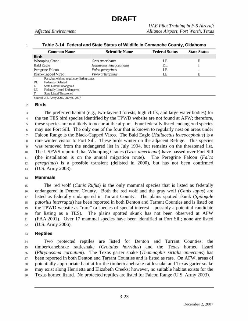
DRAFT UAE Pilot Training in F-5 Aircraft Affected Environment Alliance Airport, Fort Worth, Texas
3-23
December 2, 2007
Table 3-14 Federal and State Status of Wildlife in Comanche County, Oklahoma 1
Common Name Scientific Name Federal Status State Status Birds Whooping Crane Grus americana LE E Bald Eagle Haliaeetus leucocephalus DL T Peregrine Falcon Falco peregrinus LE - Black-Capped Vireo Vireo articapillus LE E - Rare, but with no regulatory listing status DL Federally Delisted E State Listed Endangered LE Federally Listed Endangered T State Listed Threatened Source: U.S. Army 2006, ODWC 2007
Birds 2
The preferred habitat (e.g., two-layered forests, high cliffs, and large water bodies) for 3
the ten TES bird species identified by the TPWD website are not found at AFW; therefore, 4
these species are not likely to occur at the airport. Four federally listed endangered species 5
may use Fort Sill. The only one of the four that is known to regularly nest on areas under 6
Falcon Range is the Black-Capped Vireo. The Bald Eagle (Haliaeetus leucocephalus) is a 7
rare winter visitor to Fort Sill. These birds winter on the adjacent Refuge. This species 8
was removed from the endangered list in July 1994, but remains on the threatened list. 9
The USFWS reported that Whooping Cranes (Grus americana) have passed over Fort Sill 10
(the installation is on the annual migration route). The Peregrine Falcon (Falco 11
peregrinus) is a possible transient (delisted in 2000), but has not been confirmed 12
(U.S. Army 2003). 13
Mammals 14
The red wolf (Canis Rufus) is the only mammal species that is listed as federally 15
endangered in Denton County. Both the red wolf and the gray wolf (Canis lupus) are 16
listed as federally endangered in Tarrant County. The plains spotted skunk (Spilogale 17
putorius interrupta) has been reported in both Denton and Tarrant Counties and is listed on 18
the TPWD website as “rare” (a species of special interest – possibly a potential candidate 19
for listing as a TES). The plains spotted skunk has not been observed at AFW 20
(FAA 2001). Over 17 mammal species have been identified at Fort Sill; none are listed 21
(U.S. Army 2006). 22
Reptiles 23
Two protected reptiles are listed for Denton and Tarrant Counties: the 24
timber/canebrake rattlesnake (Crotalus horridus) and the Texas horned lizard 25
(Phrynosoma cornutum). The Texas garter snake (Thamnophis sirtalis annectens) has 26
been reported in both Denton and Tarrant Counties and is listed as rare. On AFW, areas of 27
potentially appropriate habitat for the timber/canebrake rattlesnake and Texas garter snake 28
may exist along Henrietta and Elizabeth Creeks; however, no suitable habitat exists for the 29
Texas horned lizard. No protected reptiles are listed for Falcon Range (U.S. Army 2003). 30
DRAFT UAE Pilot Training in F-5 Aircraft Affected Environment Alliance Airport, Fort Worth, Texas
3-24
December 2, 2007
Plants 1
No federally listed threatened or endangered plant species exist at AFW. However, 2
the TPWD website lists the Glen Rose yucca Yucca necopina as a species of special 3
interest. Fort Sill has not located any federally threatened or endangered plant species in 4
spite of extensive efforts. Two special interest plant species potentially occurring at Fort 5
Sill are Hall’s bulrush (Scirpus hallii) and dodder (Cuscuta spp.). No federally listed 6
threatened or endangered plant species exist at Falcon Range (U.S. Army 2003). 7
3.3.8 Utilities and Infrastructure 8
Infrastructure consists of the systems and physical structures that enable a population 9
in a specified area to function. Infrastructure is wholly human-made with a high 10
correlation between the type and extent of infrastructure and the degree to which an area is 11
characterized as “urban” or developed. The ROI for utilities and infrastructure is limited to 12
of AFW only, because activities associated with the proposed action will not be conducted 13
on or near the ground in or near Falcon Range on Fort Sill and proposed MTRs/MOAs. 14
Therefore, analysis of utilities and infrastructure will not be carried forward for Falcon 15
Range and proposed MTRs/MOAs. 16
The availability of infrastructure and its capacity to support growth are generally 17
regarded as essential to economic growth of an area. As projects on AFW are 18
conceptualized and planned, project engineers and architects at Hillwood Properties 19
incorporate into those designs the infrastructure and utility specifications to meet all 20
applicable federal, state, and local building codes for fire, water, construction components, 21
mechanical, electrical, roofing, structural, energy, and hazardous materials, as required by 22
Tarrant County, Denton County, and the Cities of Haslet and Fort Worth, Texas. The 23
planned build-out of the existing 99,000-square foot facility (Alliance Air Trade Center) to 24
fully accommodate the enclosed space requirements of the proposed action is no exception 25
to these requirements. 26
The potable water supply and stormwater drainage infrastructure are provided by the 27
City of Haslet. The Trinity River Authority (TRA) provides wastewater collection and 28
treatment. Natural gas service is provided by TXU Energy. Electricity is provided by 29
Green Mountain Energy Company using local infrastructure owned and operated by Oncor 30
Electric Delivery. IESI Texas Corporation provides municipal solid waste disposal 31
services for the airport (Ash 2007). 32
3.3.8.1 Electricity 33
Green Mountain Energy Company supplies electrical service to AFW using local 34
infrastructure owned and operated by Oncor Electric Delivery. Power is currently supplied 35
to Alliance Air Trade Center via a 30 kilovolt-ampere transformer that provides 3-phase 36
power to the facility to run house lights, fire pump, and exterior lights (Ash 2007). The 37
existing infrastructure of Alliance Air Trade Center can accommodate future electrical 38
demand via an Oncor Electric Delivery-provided 1,500- to 2,500-kilovolt-ampere 39
DRAFT UAE Pilot Training in F-5 Aircraft Affected Environment Alliance Airport, Fort Worth, Texas
3-25
December 2, 2007
transformer that has 600-volt rated wire connections for as many as four separate metered 1
subsystems via individual 800-amp switches (Hillwood 2004). 2
3.3.8.2 Natural Gas 3
The natural gas system provides adequate supply and distribution to meet the gas 4
energy needs of existing and future facilities at AFW. Natural gas is supplied to the airport 5
by TXU Energy (Ash 2007). At the Alliance Air Trade Center facility, 12 gas-fired roof 6
furnaces currently operate and provide several interior connections from one 1.5-inch 7
diameter natural gas supply line that delivers 5 pounds per square inch (psi) gauge 8
pressure. Alliance Air Trade Center has existing infrastructure to accommodate three 9
additional 1.5-inch supply lines delivering 5-psi gauge pressure (Hillwood 2004). 10
3.3.8.3 Wastewater Collection System 11
Wastewater from the Alliance Air Trade Center facility flows from multiple 6-inch 12
diameter sewer connections from the building to a 10-inch sewer main serving other areas 13
of AFW, and flows into a 15-inch interceptor pipeline that leads to the Denton Creek 14
Regional Wastewater System operated by the TRA (Hillwood 2004). 15
The TRA’s Denton Creek Regional Wastewater System (DCRWS) serves Fort Worth, 16
Haslet, Roanoke, Southlake, the Circle T MUD Number (No.) 1 and 3, Keller, Northlake, 17
Flower Mound, Westlake, and Marshall Creek. The DCRWS is currently capable of 18
serving a population of 50,000. The Denton-Henrietta Creek Interceptor pipeline is a 15-19
inch line in the vicinity of AFW. The DCRWS facility is designed to achieve effluent 20
limitations of 10 milligrams per liter (mg/l) carbonaceous biochemical demand (CBOD) 21
from December to May and 7 mg/l CBOD from June to November. Other effluent 22
limitations include 15 mg/l total suspended solids, 6 mg/l dissolved oxygen, and 2 mg/l 23
ammonia nitrogen in the summer/5 mg/l in winter. Daily average flow design is 5 million 24
gallons per day (TRA 2007). 25
3.3.8.4 Solid Waste Management 26
IESI Texas Corporation provides municipal solid waste disposal services for the 27
airport (Ash 2007). IESI Texas Corporation (TCEQ RN101478790) operates a local 28
landfill in Tarrant County, the Fort Worth C&D Landfill (MSW Permit No. 1983B). IESI 29
Texas Landfill LP (TCEQ RN100617984) operates the Weatherford Landfill (MSW 30
Permit Nos. 47 and 47A) in Parker County. There are at least 22 other landfills in the 31
vicinity based on the NCTCOG list of active landfills serving the Dallas-Fort Worth 32
metropolitan area (NCTCOG 2007b). Table 3-15 lists these facilities. 33
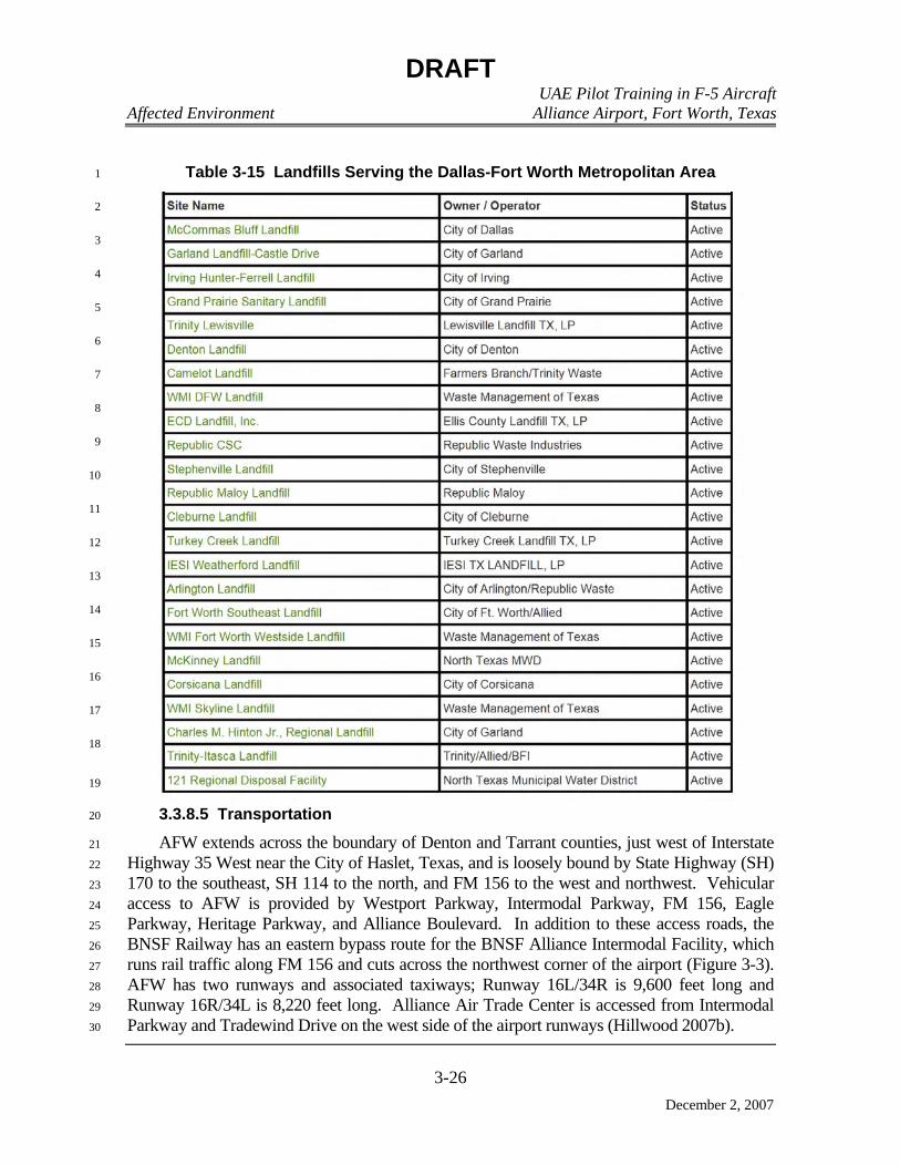
DRAFT UAE Pilot Training in F-5 Aircraft Affected Environment Alliance Airport, Fort Worth, Texas
3-26
December 2, 2007
Table 3-15 Landfills Serving the Dallas-Fort Worth Metropolitan Area 1
2
3
4
5
6
7
8
9
10
11
12
13
14
15
16
17
18
19
3.3.8.5 Transportation 20
AFW extends across the boundary of Denton and Tarrant counties, just west of Interstate 21
Highway 35 West near the City of Haslet, Texas, and is loosely bound by State Highway (SH) 22
170 to the southeast, SH 114 to the north, and FM 156 to the west and northwest. Vehicular 23
access to AFW is provided by Westport Parkway, Intermodal Parkway, FM 156, Eagle 24
Parkway, Heritage Parkway, and Alliance Boulevard. In addition to these access roads, the 25
BNSF Railway has an eastern bypass route for the BNSF Alliance Intermodal Facility, which 26
runs rail traffic along FM 156 and cuts across the northwest corner of the airport (Figure 3-3). 27
AFW has two runways and associated taxiways; Runway 16L/34R is 9,600 feet long and 28
Runway 16R/34L is 8,220 feet long. Alliance Air Trade Center is accessed from Intermodal 29
Parkway and Tradewind Drive on the west side of the airport runways (Hillwood 2007b). 30

DRAFT UAE Pilot Training in F-5 Aircraft Affected Environment Alliance Airport, Fort Worth, Texas
3-27
December 2, 2007
Figure 3-3 Transportation System, Fort Worth Alliance Airport, Fort Worth, Texas
Source: Hillwood 2007b

DRAFT UAE Pilot Training in F-5 Aircraft Affected Environment Alliance Airport, Fort Worth, Texas
3-28
December 2, 2007
Regional transportation planning in Denton and Tarrant counties is conducted by the 1
federally designated Metropolitan Planning Organization (MPO). The MPO is made up of 2
the NCTCOG Transportation Department, NCTCOG Executive Board, Regional 3
Transportation Council, and several technical committees. Major products produced by 4
the MPO include a long-range Metropolitan Transportation Plan, a shorter-term 5
Transportation Improvement Program, a Congestion Management Process, and a Unified 6
Planning Work Program. These products outline the transportation enhancement projects 7
and funding sources for the 16-county Dallas-Fort Worth Metropolitan Area (Federal 8
Highway Administration [FHWA] 2007, NCTCOG 2007c, NCTCOG 2007d). 9
3.3.8.6 Stormwater Drainage 10
The stormwater drainage infrastructure at AFW was built using 5-year 24-hour and 11
100-year 24-hour storm events for drainage area design, in accordance with City of Haslet 12
requirements and Texas Department of Transportation specifications (Hillwood 2004). 13
Alliance Air Trade Center is located in the portion of AFW that flows toward Henrietta 14
Creek. Stormwater is directed via curb and gutter, area drains and underground culverts, 15
overland flow, and open conveyances toward the south and west, away from the facilities 16
and airfield pavements. Stormwater from the northern end of AFW drains north and east 17
toward Elizabeth Creek, and the southern end of AFW drains south and west to Henrietta 18
Creek (Hillwood 2007b). Henrietta Creek flows into Elizabeth Creek northeast of the 19
airport; both creeks are unclassified tributaries in the drainage basin that contributes to 20
Grapevine Lake, located approximately 9 miles downstream to the northeast of AFW 21
(TCEQ 2007b). 22
3.3.8.7 Potable Water 23
Fire water and potable water are supplied to AFW by the City of Haslet via a 16-inch 24
public water supply line that runs parallel to Intermodal and Tradewind streets. The public 25
water supply line was tested in February of 2005 and resulted in a static pressure of 58-psi 26
gauge and a residual pressure of 45-psi gauge while flowing at 2,069 gallons per minute. 27
Potable water is currently supplied to the Alliance Air Trade Center by a single 3-inch pipe 28
diameter water connection. The three fire suppression system zones for Alliance Air Trade 29
Center are powered by a single 2,000 gallon per minute 120 psi electric fire pump supplied 30
by a 10-inch underground fire water supply line via pump suction (Hillwood 2004). 31
The City of Haslet public water supply (TCEQ RN101246411) source is local 32
groundwater. The permitted production capacity is 562,000 gallons per day; the system 33
has a pumping capacity of 864,000 gallons per day and a total storage capacity of 34
1,676,000 gallons (1,000,000 gallons in elevated storage). The average daily consumption 35
by the 527 connections and 1,581 members of the residential population serviced by the 36
city is 197,000 gallons per day, which is roughly equivalent to 35 percent of the city’s 37
permitted daily production capacity and 11 percent of the city’s storage capacity (City of 38
Haslet 2007). 39

DRAFT UAE Pilot Training in F-5 Aircraft Affected Environment Alliance Airport, Fort Worth, Texas
3-29
December 2, 2007
3.3.9 Socioeconomics and Environmental Justice 1
Socioeconomic resources are defined as the basic attributes associated with the human 2
environment, generally including factors associated with population, housing, education, 3
and the economy. Direct impacts to any of these factors may generate secondary effects on 4
other factors, resulting in a series of potential socioeconomic ramifications within the 5
affected area. AFW is situated north of the City of Fort Worth, in Tarrant County, Texas. 6
Fort Worth and Tarrant County are located in the Dallas-Fort Worth-Arlington 7
Metropolitan Statistical Area (MSA). Falcon Range is located to the northwest of Lawton, 8
Oklahoma, in Comanche County, Oklahoma. Tarrant County and Comanche County 9
constitute the socioeconomic region of analysis. 10
Concern that certain disadvantaged communities may bear a disproportionate share of 11
adverse health and environmental effects compared to the general population led to the 12
enactment in 1994 of EO 12898, Federal Actions to Address Environmental Justice in 13
Minority Populations and Low-Income Populations. This executive order directs federal 14
agencies to address disproportionate environmental and human health effects in minority 15
and low-income communities. EO 13045, Protection of Children from Environmental 16
Health Risks and Safety Risks, was enacted in 1997, directing federal agencies to identify 17
and assess environmental health and safety risks to children, coordinate research priorities 18
on children’s health, and ensure that their standards take into account special risks to 19
children. 20
Environmental justice analysis applies to adverse environmental impacts. Potential 21
disproportionate impacts to minority or low-income populations are assessed only when 22
adverse environmental consequences to the human population are anticipated, otherwise, 23
no analysis is required. The same is true for analysis of special risks to children, which 24
would be driven by adverse environmental impacts. If adverse impacts are not anticipated, 25
no special risks to children analysis is required. 26
3.3.9.1 Population 27
The Dallas-Fort Worth-Arlington MSA is composed of Collin County, Dallas County, 28
Delta County, Denton County, Ellis County, Hunt County, Kaufman County, Rockwall 29
County, Johnson County, Parker County, Tarrant County, and Wise County, and 30
encompasses 9,249 square miles (U.S. Bureau of the Census [USBC] 2007a). The Tarrant 31
County population increased an estimated 15.6 percent between 2000 and 2006 (from 32
1,446,219 people to 1,671,295), continuing the pattern of population growth experienced 33
between 1990 and 2000 (USBC 2007b). The state of Texas population increased by 12.7 34
percent in the period from April 1, 2000 to July 1, 2006 (USBC 2007c). The City of Fort 35
Worth, which accounts for 80 percent of the county population, has experienced similar 36
population trends, increasing from 534,694 persons in 2000 to an estimated 2006 37
population of 637,178. 38
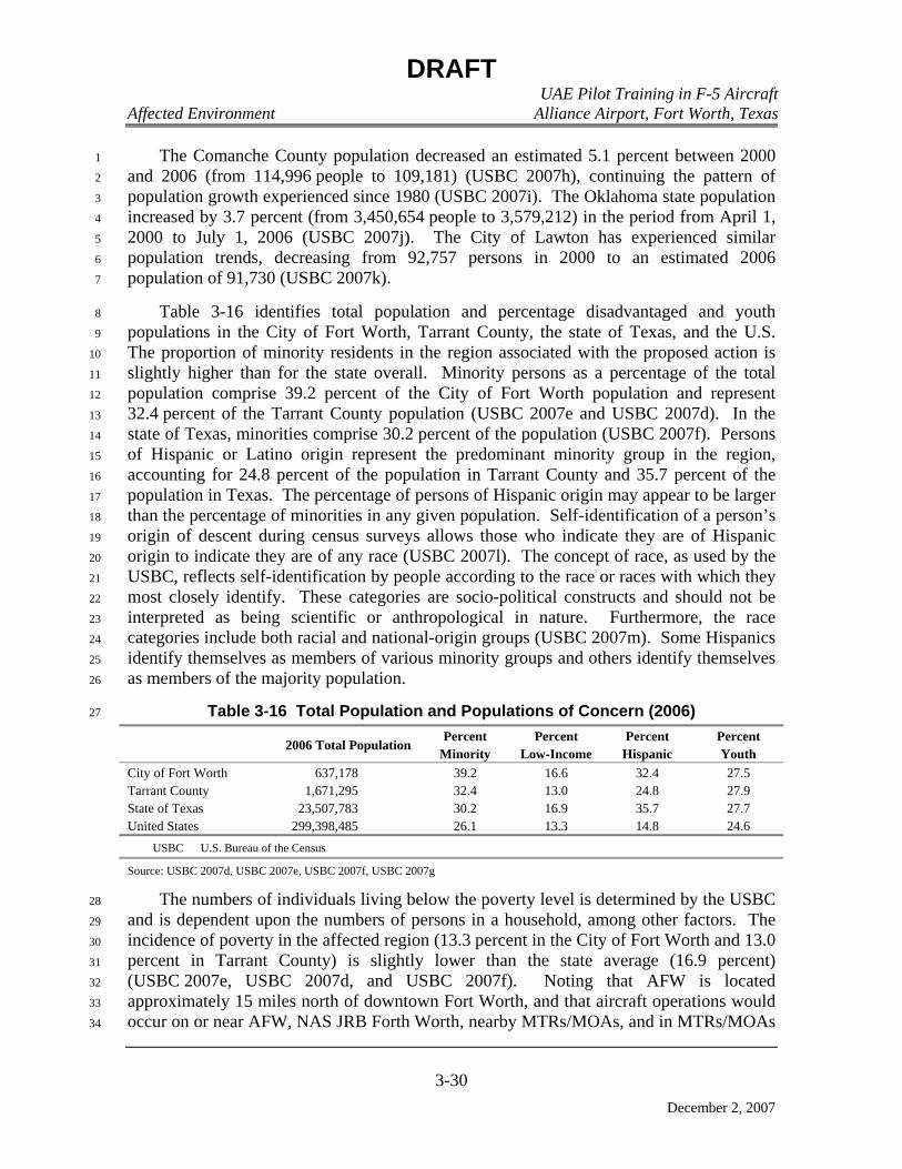
DRAFT UAE Pilot Training in F-5 Aircraft Affected Environment Alliance Airport, Fort Worth, Texas
3-30
December 2, 2007
The Comanche County population decreased an estimated 5.1 percent between 2000 1
and 2006 (from 114,996 people to 109,181) (USBC 2007h), continuing the pattern of 2
population growth experienced since 1980 (USBC 2007i). The Oklahoma state population 3
increased by 3.7 percent (from 3,450,654 people to 3,579,212) in the period from April 1, 4
2000 to July 1, 2006 (USBC 2007j). The City of Lawton has experienced similar 5
population trends, decreasing from 92,757 persons in 2000 to an estimated 2006 6
population of 91,730 (USBC 2007k). 7
Table 3-16 identifies total population and percentage disadvantaged and youth 8
populations in the City of Fort Worth, Tarrant County, the state of Texas, and the U.S. 9
The proportion of minority residents in the region associated with the proposed action is 10
slightly higher than for the state overall. Minority persons as a percentage of the total 11
population comprise 39.2 percent of the City of Fort Worth population and represent 12
32.4 percent of the Tarrant County population (USBC 2007e and USBC 2007d). In the 13
state of Texas, minorities comprise 30.2 percent of the population (USBC 2007f). Persons 14
of Hispanic or Latino origin represent the predominant minority group in the region, 15
accounting for 24.8 percent of the population in Tarrant County and 35.7 percent of the 16
population in Texas. The percentage of persons of Hispanic origin may appear to be larger 17
than the percentage of minorities in any given population. Self-identification of a person’s 18
origin of descent during census surveys allows those who indicate they are of Hispanic 19
origin to indicate they are of any race (USBC 2007l). The concept of race, as used by the 20
USBC, reflects self-identification by people according to the race or races with which they 21
most closely identify. These categories are socio-political constructs and should not be 22
interpreted as being scientific or anthropological in nature. Furthermore, the race 23
categories include both racial and national-origin groups (USBC 2007m). Some Hispanics 24
identify themselves as members of various minority groups and others identify themselves 25
as members of the majority population. 26
Table 3-16 Total Population and Populations of Concern (2006) 27
2006 Total Population Percent
Minority Percent
Low-Income Percent
Hispanic Percent Youth
City of Fort Worth 637,178 39.2 16.6 32.4 27.5 Tarrant County 1,671,295 32.4 13.0 24.8 27.9 State of Texas 23,507,783 30.2 16.9 35.7 27.7 United States 299,398,485 26.1 13.3 14.8 24.6
USBC U.S. Bureau of the Census
Source: USBC 2007d, USBC 2007e, USBC 2007f, USBC 2007g
The numbers of individuals living below the poverty level is determined by the USBC 28
and is dependent upon the numbers of persons in a household, among other factors. The 29
incidence of poverty in the affected region (13.3 percent in the City of Fort Worth and 13.0 30
percent in Tarrant County) is slightly lower than the state average (16.9 percent) 31
(USBC 2007e, USBC 2007d, and USBC 2007f). Noting that AFW is located 32
approximately 15 miles north of downtown Fort Worth, and that aircraft operations would 33
occur on or near AFW, NAS JRB Forth Worth, nearby MTRs/MOAs, and in MTRs/MOAs 34
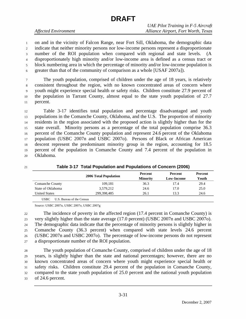
DRAFT UAE Pilot Training in F-5 Aircraft Affected Environment Alliance Airport, Fort Worth, Texas
3-31
December 2, 2007
on and in the vicinity of Falcon Range, near Fort Sill, Oklahoma, the demographic data 1
indicate that neither minority persons nor low-income persons represent a disproportionate 2
number of the ROI population when compared with regional and state levels. (A 3
disproportionately high minority and/or low-income area is defined as a census tract or 4
block numbering area in which the percentage of minority and/or low-income population is 5
greater than that of the community of comparison as a whole [USAF 2007a]). 6
The youth population, comprised of children under the age of 18 years, is relatively 7
consistent throughout the region, with no known concentrated areas of concern where 8
youth might experience special health or safety risks. Children constitute 27.9 percent of 9
the population in Tarrant County, almost equal to the state youth population of 27.7 10
percent. 11
Table 3-17 identifies total population and percentage disadvantaged and youth 12
populations in the Comanche County, Oklahoma, and the U.S. The proportion of minority 13
residents in the region associated with the proposed action is slightly higher than for the 14
state overall. Minority persons as a percentage of the total population comprise 36.3 15
percent of the Comanche County population and represent 24.6 percent of the Oklahoma 16
population (USBC 2007n and USBC 2007o). Persons of Black or African American 17
descent represent the predominant minority group in the region, accounting for 18.5 18
percent of the population in Comanche County and 7.4 percent of the population in 19
Oklahoma. 20
Table 3-17 Total Population and Populations of Concern (2006) 21
2006 Total Population Percent
Minority Percent
Low-Income Percent Youth
Comanche County 109,181 36.3 17.4 29.4 State of Oklahoma 3,579,212 24.6 17.0 25.0 United States 299,398,485 26.1 13.3 24.6
USBC U.S. Bureau of the Census
Source: USBC 2007n, USBC 2007o, USBC 2007g
The incidence of poverty in the affected region (17.4 percent in Comanche County) is 22
very slightly higher than the state average (17.0 percent) (USBC 2007n and USBC 2007o). 23
The demographic data indicate that the percentage of minority persons is slightly higher in 24
Comanche County (36.3 percent) when compared with state levels 24.6 percent 25
(USBC 2007n and USBC 2007o). The percentage of low-income persons do not represent 26
a disproportionate number of the ROI population. 27
The youth population of Comanche County, comprised of children under the age of 18 28
years, is slightly higher than the state and national percentages; however, there are no 29
known concentrated areas of concern where youth might experience special health or 30
safety risks. Children constitute 29.4 percent of the population in Comanche County, 31
compared to the state youth population of 25.0 percent and the national youth population 32
of 24.6 percent. 33
DRAFT UAE Pilot Training in F-5 Aircraft Affected Environment Alliance Airport, Fort Worth, Texas
3-32
December 2, 2007
3.3.9.2 Economy 1
AFW contributes to economic activity in the region through employee payrolls, local 2
procurements of goods and services, and other expenditures. The labor force in Tarrant 3
County included 884,101 persons in 2006, of which 820,956 were employed (USBC 4
2007e). The unemployment rate in 2006 was 7.0 percent. Median household income was 5
$51,813 and persons below the poverty level represented 13.0 percent of the population. 6
In the City of Fort Worth, 301,772 persons were employed, and the unemployment rate in 7
2006 was 7.7 percent 8
The economy of Fort Worth and Tarrant County economy is based on such diverse 9
business areas as aerospace and aviation, education, financial services, and manufacturing. 10
It has also become a major center for corporate relocation and expansion. The area offers 11
specialized office parks and master-planned developments (of which AFW is one), and 12
other incentives to corporations such as Pier 1 Imports and RadioShack to maintain their 13
presence in the MSA. As well, partnerships have been established to foster the area’s 14
growth in the broad life sciences market and life science research arena. Fort Worth and 15
the surrounding north Texas area are the home to several pharmaceutical and healthcare 16
companies, and offer significant technical education resources through more than 40 North 17
Texas colleges, universities, and special facilities. Prominent private employers in the 18
region include American Airlines, Lockheed Martin Aeronautics, and Bell Helicopter 19
Textron. 20
3.3.10 Cultural Resources 21
3.3.10.1 Definition of the Resource 22
Cultural resources are any prehistoric or historic district, site, or building, structure, or 23
object considered important to a culture, subculture, or community for scientific, 24
traditional, religious, or other purposes. They include archeological resources, historic 25
architectural and engineering resources, and traditional resources. Cultural resources are 26
protected by federal law when they meet established criteria for listing on the 27
National Register of Historic Places (NRHP). Such properties require consideration 28
regarding adverse impacts from a proposed undertaking. Both archeological and 29
architectural resources must be evaluated in light of the four NRHP eligibility criteria. The 30
criteria that prehistoric or historic sites, districts, buildings or structures must meet are as 31
follows (36 CFR Part 60.4): 32
• Properties that associate with events that have made a significant contribution to 33
the broad patterns of our history. 34
• Properties that associate with the lives of significant persons in our past. 35
• Properties that embody the distinctive characteristics of a type, period, or method 36
of construction; that represent the work of a master; that possess high artistic 37
values; or that represent a significant and distinguishable entity whose components 38
may lack individual distinction. 39

DRAFT UAE Pilot Training in F-5 Aircraft Affected Environment Alliance Airport, Fort Worth, Texas
3-33
December 2, 2007
• Properties that have yielded, or may be likely to yield, information important to 1
prehistory or history. 2
On November 21, 1999, the DoD promulgated its Native American and Alaska Native 3
Policy, which emphasizes the importance of respecting and consulting with tribal 4
governments on a government-to-government basis. The policy requires an assessment, 5
through consultation, of the affect of the proposed DoD actions that may have the potential 6
to significantly affect protected tribal resources, tribal rights, and Indian lands before 7
decisions are made by the services. 8
3.3.10.2 Existing Conditions 9
A cultural resources survey was conducted in 1992 to determine the existence of 10
archaeological and/or historic sites eligible for listing on the NRHP. At that time, 11 sites 11
and localities dating to the Historic Period were located in areas proposed for future 12
planned development at AFW. As part of the FAA 2001, another survey (including both 13
records searches and a field survey) was performed to confirm the re-validate of the 14
findings of the 1992 survey (which it did). None of the identified sites is located in 15
proximity to the Alliance Air Trade Center or any part of AFW that will be used if the 16
proposed action is implemented (FAA 2001). 17
Fort Sill’s cultural resource management program operates under the guidance of the 18
Integrated Cultural Resource Management Plan prepared in 2002. Fort Sill has conducted 19
extensive studies to identify significant cultural resources, including archeological sites 20
and architectural properties, and 878 buildings or structures have been recorded and 21
evaluated for eligibility for listing on the NRHP. Of the 94,220 acres on Fort Sill, 53,225 22
acres have been surveyed to identify archaeological resources and evaluate them for 23
eligibility. Within the boundaries of Fort Sill, 1,026 resources have been recorded, 24
including 878 architectural resources, one engineering feature, 324 archaeological sites and 25
three other sites (U.S. Army Corps of Engineers 2006). 26
3.3.11 Air Quality 27
This section discusses air quality considerations and conditions in the area 28
encompassing AFW and the following MTA: Falcon Range, Brady MOA, VR-104, 29
VR-118, IR-103, and IR-105. It addresses air quality standards and describes current air 30
quality conditions in the region of concern, specifically the counties surrounding AFW and 31
those below the MTA. These are the only counties that would be impacted by aircraft 32
landing/take-off operations, training/aircraft support activities, and low-level aircraft flight 33
activity Only those portions of the flying operations that take place below the atmospheric 34
mixing height (3,000 feet) are considered low-level operations (these are the only 35
emissions presumed to affect ground level concentrations). 36

DRAFT UAE Pilot Training in F-5 Aircraft Affected Environment Alliance Airport, Fort Worth, Texas
3-34
December 2, 2007
3.3.11.1 Definition of the Resource 1
3.3.11.1.1 Federal Air Quality Standards 2
Air quality in a given location is described by the concentration of various pollutants 3
in the atmosphere, generally expressed in units of parts per million or micrograms per 4
cubic meter. Air quality is determined by the type and amount of pollutants emitted into 5
the atmosphere, the size and topography of the air basin, and the prevailing meteorological 6
conditions. The significance of a pollutant concentration is determined by comparing it to 7
federal and state ambient air quality standards. These standards represent the maximum 8
allowable atmospheric concentration that may occur and still protect public health and 9
welfare, with a reasonable margin of safety. The national ambient air quality standards 10
(NAAQS) are established by the USEPA. 11
In order to protect public health and welfare, the USEPA has developed numerical 12
concentration-based standards or NAAQS for six “criteria” pollutants (based on health 13
related criteria) under the provisions of the Clean Air Act (CAA) (CAA Amendments of 14
1970). There are two kinds of NAAQS: primary and secondary standards. Primary 15
standards prescribe the maximum permissible concentration in the ambient air to protect 16
public health including the health of “sensitive” populations such as asthmatics, children, 17
and the elderly. Secondary standards prescribe the maximum concentration or level of air 18
quality required to protect public welfare including protection against decreased visibility, 19
damage to animals, crops, vegetation, and buildings. 20
National ambient air quality standards have been established for: (1) ozone (O3), 21
(2) nitrogen dioxide (NO2), (3) carbon monoxide (CO), (4) sulfur oxides (SOX: measured 22
in terms of sulfur dioxide [SO2]), (5) lead (Pb), and (6) particulate matter. Particulate 23
matter standards incorporate two particulate size classes: (1) particulate matter with an 24
aerodynamic diameter (diameter of a spherical particle having a density of 1 gm/cm3 that 25
has the same inertial properties (terminal settling velocity) in the gas as the particle of 26
interest) less than or equal to 10 microns (PM10), and (2) particulate matter with an 27
aerodynamic diameter less than or equal to 2.5 microns. The NAAQS are the cornerstone 28
of the CAA. Although not directly enforceable, they are the benchmark for the 29
establishment of emission limitations by the states for the pollutants that USEPA 30
determines may endanger public health or welfare. The federal ambient air quality 31
standards are presented in Table 3-18. 32
O3 (ground-level O3), a major component of “smog,” is not directly emitted into the 33
atmosphere but is formed in the atmosphere through the reactions of previously emitted 34
pollutants or precursors (volatile organic compounds [VOC] and nitrogen oxides [NOX]) in 35
the presence of sunlight. Large spatial and temporal separation can exist between the 36
emission sources of VOCs and NOX and the formation of O3. Since VOCs and NOX 37
participate in atmospheric photochemical reactions that produce O3, the attempt is made to 38
control O3 through the control of VOCs and NOX. For this reason, VOCs and NOX 39
emissions are calculated and reported in emissions inventories. 40
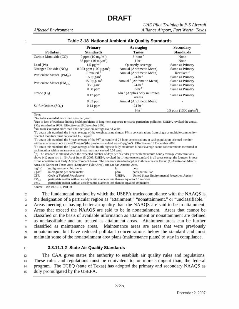
DRAFT UAE Pilot Training in F-5 Aircraft Affected Environment Alliance Airport, Fort Worth, Texas
3-35
December 2, 2007
Table 3-18 National Ambient Air Quality Standards 1
Pollutant Primary
Standards Averaging
Times Secondary Standards
9 ppm (10 mg/m3) 8-hour 1 None Carbon Monoxide (CO) 35 ppm (40 mg/m3) 1-hr 1 None
Lead (Pb) 1.5 µg/m3 Quarterly Average Same as Primary Nitrogen Dioxide (NO2) 0.053 ppm (100 µg/m3) Annual (Arithmetic Mean) Same as Primary
Revoked 2 Annual (Arithmetic Mean) Revoked 2 Particulate Matter (PM10) 150 µg/m3 24-hr 3 Same as Primary 15.0 µg/ m3 Annual 4 (Arithmetic Mean) Same as Primary Particulate Matter (PM2.5) 35 µg/m3 24-hr 5 Same as Primary 0.08 ppm 8-hr 6 Same as Primary
Ozone (O3) 0.12 ppm 1-hr 7 (Applies only in limited areas) Same as Primary
0.03 ppm Annual (Arithmetic Mean) - 0.14 ppm 24-hr 1 - Sulfur Oxides (SOX)
- 3-hr 1 0.5 ppm (1300 µg/m3) Note: 1Not to be exceeded more than once per year. 2Due to lack of evidence linking health problems to long-term exposure to coarse particulate pollution, USEPA revoked the annual PM10 standard in 2006. Effective on 18 December 2006. 3Not to be exceeded more than once per year on average over 3 years 4To attain this standard, the 3-year average of the weighted annual mean PM2.5 concentrations from single or multiple community-oriented monitors must not exceed 15.0 ug/m3. 5To attain this standard, the 3-year average of the 98th percentile of 24-hour concentrations at each population-oriented monitor within an area must not exceed 35 ug/m3 (the previous standard was 65 µg/ m3). Effective on 18 December 2006. 6To attain this standard, the 3-year average of the fourth-highest daily maximum 8-hour average ozone concentrations measured at each monitor within an area over each year must not exceed 0.08 ppm. 7(a) The standard is attained when the expected number of days per calendar year with maximum hourly average concentrations above 0.12 ppm is ≤ 1. (b) As of June 15, 2005, USEPA revoked the 1-hour ozone standard in all areas except the fourteen 8-hour ozone nonattainment Early Action Compact Areas. The one-hour standard applies to three areas in Texas: (1) Austin-San Marcos Area, (2) Northeast Texas Area (Longview-Tyler Area), and (3) San Antonio Area. mg/m3 milligrams per cubic meter hr hour µg/m3 micrograms per cubic meter ppm parts per million CFR Code of Federal Regulations USEPA United States Environmental Protection Agency PM2.5 particulate matter with an aerodynamic diameter less than or equal to 2.5 microns PM10 particulate matter with an aerodynamic diameter less than or equal to 10 microns Source: Title 40, CFR, Part 50
The fundamental method by which the USEPA tracks compliance with the NAAQS is 2
the designation of a particular region as “attainment,” “nonattainment,” or “unclassifiable.” 3
Areas meeting or having better air quality than the NAAQS are said to be in attainment. 4
Areas that exceed the NAAQS are said to be in nonattainment. Areas that cannot be 5
classified on the basis of available information as attainment or nonattainment are defined 6
as unclassifiable and are treated as attainment areas. Attainment areas can be further 7
classified as maintenance areas. Maintenance areas are areas that were previously 8
nonattainment but have reduced pollutant concentrations below the standard and must 9
maintain some of the nonattainment area plans (maintenance plans) to stay in compliance. 10
3.3.11.1.2 State Air Quality Standards 11
The CAA gives states the authority to establish air quality rules and regulations. 12
These rules and regulations must be equivalent to, or more stringent than, the federal 13
program. The TCEQ (state of Texas) has adopted the primary and secondary NAAQS as 14
duly promulgated by the USEPA. 15
DRAFT UAE Pilot Training in F-5 Aircraft Affected Environment Alliance Airport, Fort Worth, Texas
3-36
December 2, 2007
State Implementation Plan 1
The states have primary responsibility to implement the CAA; the primary vehicle for 2
this implementation is the State Implementation Plan (SIP). The CAA requires that each 3
state produce and regularly update a SIP. A SIP is an enforceable plan developed by the 4
state under section 110 of the CAA that explains how the state will comply with air quality 5
standards and other guidelines according to the federal CAA. The CAA also requires that 6
SIPs include a description of control strategies, or measures to deal with pollution, for 7
areas that fail to achieve the NAAQS. The SIP is essentially a collection of regulations 8
that explain how a state will clean up polluted areas under the CAA. 9
Each state is required to develop a SIP that sets forth how CAA provisions will be 10
imposed within the state. The SIP is the primary means for the implementation, 11
maintenance, and enforcement of the measures needed to attain and maintain the NAAQS 12
within each state and includes control measures, emissions limitations, and other 13
provisions required to attain and maintain the ambient air quality standards. The purpose 14
of the SIP is twofold. First, it must provide a control strategy that will result in the 15
attainment and maintenance of the NAAQS. Second, it must demonstrate that progress is 16
being made in attaining the standards in each nonattainment area. 17
TCEQ has a federally approved SIP, promulgated in Title 30 of the Texas 18
Administrative Code (TAC), Chapters 101, 106, 111-119, and 122. 19
New Source Review Permitting Program 20
Congress established the New Source Review (NSR) permitting program as part of the 21
1977 CAA Amendments. NSR is a preconstruction permitting program that serves to 22
ensure: 23
• Ambient air quality is not significantly degraded by the addition of new 24
facilities or modifications to existing facilities such as factories, industrial 25
boilers, and power plants. In nonattainment areas, NSR assures that new 26
emissions do not slow progress toward cleaner air. In areas with clean air, 27
especially pristine areas like national parks, NSR assures that new emissions 28
do not significantly worsen air quality. 29
• Any large new industrial sources or modifications to existing industrial sources 30
will be as clean as possible, and that advances in pollution control occur 31
concurrently with industrial expansion. 32
NSR permits are legal documents that the facility owners/operators must abide by. 33
The permit specifies allowable construction, emissions limits, and often, how the 34
emissions source must be operated. 35
Title I, Part D, Sections 171 through 193 of the CAA establishes the Nonattainment 36
NSR program. Nonattainment NSR applies to new major sources (sources that emit more 37

DRAFT UAE Pilot Training in F-5 Aircraft Affected Environment Alliance Airport, Fort Worth, Texas
3-37
December 2, 2007
than 100 tons per year [tpy]) or major modifications at existing sources located in 1
nonattainment areas. Nonattainment NSR requirements are specifically tailored for the 2
nonattainment area, and must include (1) the installation of the lowest achievable emission 3
rate (LAER), (2) emission offsets, and (3) opportunity for public involvement. 4
LAER is the most stringent emission limitation and is either (1) the most stringent 5
emission limitation contained in the SIP for the source class or category or (2) the most 6
stringent emission limitation achieved in practice by the source class or category. 7
Emissions rate reductions may result from a combination of emissions-limiting measures 8
such as (1) changes in the raw material processed, (2) process modifications, and (3) add-9
on controls. 10
Offsets are emission reductions that are generally acquired from existing sources 11
located near a proposed facility and (1) offset the emissions increase from the new source 12
or modification of an existing source and (2) provide a net air quality benefit. The purpose 13
for requiring offsets is to allow some industrial growth within areas that are moving 14
towards attainment of the NAAQS. 15
Prevention of Significant Deterioration 16
Title I, Part C, Sections 160 through 169 of the CAA establishes the Prevention of 17
Significant Deterioration (PSD) program. PSD applies to new major sources or major 18
modifications at existing sources for pollutants where the area the source is located in is in 19
attainment or unclassifiable with respect to the NAAQS. Major sources are defined as any 20
stationary pollutant source with potential to emit more than either 100 or 250 tpy, 21
depending upon the type of source. A major modification is a modification of a major 22
stationary source of emissions with respect to PSD. 23
The goal of the program is to: (1) protect public health and welfare from any adverse 24
effects which might occur even at pollutant levels better than the NAAQS; (2) insure 25
economic growth while preserving existing air quality; (3) preserve, protect, and enhance 26
the air quality in areas of special natural recreational, scenic, or historic value, such as 27
national parks and wilderness areas; and (4) assure that emissions from any source in a 28
state will not interfere with any portion of the applicable SIP to prevent significant 29
deterioration of air quality. Sources subject to PSD review are required by the CAA to 30
obtain a permit before commencing construction. The permit process requires an extensive 31
review of all other major sources within a 50-mile radius and of all Class I areas within a 32
62-mile radius of the facility. Emissions from any new or modified source must be 33
controlled using Best Available Control Technology (an emissions limitation that is based 34
on the maximum degree of control that can be achieved). 35
Section 162 of the CAA further established the goal of PSD of air quality in all 36
international parks; national parks which exceeded 6,000 acres; and national wilderness 37
areas and memorial parks which exceeded 5,000 acres if these areas were in existence on 38
August 7, 1977. These areas were defined as mandatory Class I areas, and all other 39
DRAFT UAE Pilot Training in F-5 Aircraft Affected Environment Alliance Airport, Fort Worth, Texas
3-38
December 2, 2007
attainment or unclassifiable areas were defined as Class II areas. National parks and 1
wilderness areas are designated as Class I areas, where any appreciable deterioration in air 2
quality is considered significant. Class II areas are those areas where moderate, 3
well-controlled industrial growth could be permitted. Class III areas allow for greater 4
industrial development. Currently there are no designated Class III areas in the U.S. There 5
are two Class I areas within Texas: (1) Big Bend National Park and (2) Guadalupe 6
Mountains National Park. These areas are on the borders of Mexico and New Mexico, 7
respectively. All other areas within the state are Class II areas. The closest Class I area to 8
AFW is the Big Bend National Park, which is located approximately 530 miles to the 9
southwest of the airport. 10
Visibility 11
The national visibility goal was established in Section 169A of the 1977 CAA 12
Amendments as “the prevention of any future, and the remedying of any existing, 13
impairment of visibility in mandatory Class I areas which impairment results from 14
manmade air pollution.” There are 156 mandatory Federal Class I areas identified for 15
visibility protection under this provision. The term visibility refers to the clarity with 16
which scenic vistas and landscape features are perceived at great distances. Visibility 17
impairment, quantified as light extinction, is caused by the scattering and absorption of 18
light by particles and gases in the atmosphere. Without the effects of human-caused air 19
pollution, a natural visual range is estimated to be about 140 miles in the western U.S. and 20
90 miles in the eastern U.S. (USEPA 2001). 21
Under the 1990 CAA Amendments, the USEPA promulgated the Regional Haze Rule 22
to protect visibility in the 156 mandatory Federal Class I areas (Regional Haze 23
Regulations, Final Rule 1999). The rule requires the states, in coordination with the 24
USEPA, the National Park Service, U.S. Fish and Wildlife Service, the U.S. Forest 25
Service, and other interested parties, to develop and implement air quality protection plans 26
to reduce the pollution that causes visibility impairment. Emissions levels are used to 27
qualitatively assess potential impairment to visibility in PSD Class I areas. Decreased 28
visibility may potentially result from elevated concentrations of PM10 and SO2 in the lower 29
atmosphere. 30
3.3.11.1.3 General Conformity 31
The DoD, like all federal agencies, is subject to the general conformity determination 32
as specified in Section 176 of the CAA, codified at 42 USC §7506(c). The conformity 33
determination is made in accordance with USEPA’s final rule, Determining Conformity of 34
General Federal Actions to State or Federal Implementation Plan, as published in the 35
Federal Register on November 30, 1993 and codified at Title 40, CFR, Part 51, 36
Subpart W. The federal general conformity rules required states to adopt and submit a 37
general-conformity SIP not later than November 30, 1994. Texas submitted such a SIP on 38
November 16, 1994. The federal rule was then incorporated into a state rule (Title 30, 39
TAC, Chapter 101.30, General Air Quality Rules, Conformity of General Federal Actions 40

DRAFT UAE Pilot Training in F-5 Aircraft Affected Environment Alliance Airport, Fort Worth, Texas
3-39
December 2, 2007
to State Implementation Plans). The specific purpose of Section 176(c) is to make 1
emissions from federal activities consistent with the air quality planning goals of the CAA. 2
The conformity rule applies only in those air basins or parts of air basins designated as 3
nonattainment for one or more of the NAAQS or attainment areas subject to maintenance 4
plans (maintenance area). A maintenance plan establishes measures and procedures to 5
control emissions to ensure that the air quality standard is maintained in areas that have been 6
redesignated from a previous nonattainment status to attainment. Federal actions occurring 7
in areas that are in attainment with the NAAQS are not subject to the conformity rule. 8
Conformity, as determined under the general conformity rule, prohibits a federal 9
agency from implementing, approving, or supporting any activity that fails to conform to 10
an approved SIP or USEPA-promulgated Federal Implementation Plan (FIP). The statute 11
provides that conforming to a SIP or FIP means that the activity will not: 12
• Cause or contribute to any new violation of the NAAQS for any criteria air 13
pollutant. 14
• Increase the frequency or severity of any existing violation of any standard in 15
the area. 16
• Delay timely attainment of any standard or any required interim emission 17
reductions or other milestones in any area. 18
The intent of the conformity rule is to encourage long range planning by evaluating 19
the air quality impacts from federal actions before the project is undertaken. If the 20
emissions from a federal action proposed in a nonattainment area exceed annual thresholds 21
identified in the rule, a conformity determination is required for that action. The 22
thresholds become more restrictive as the severity of the nonattainment status of the region 23
increases. 24
At this time, Collin, Dallas, Denton, Ellis, Johnson, Kaufman, Parker, Rockwall, and 25
Tarrant counties (DFW 8-Hour Ozone Nonattainment Area) have been designated by 26
USEPA as moderate nonattainment for the 8-hour O3 standard (Figure 3-4). Those 27
portions of the proposed action that originate at AFW (aircraft staging [i.e., landing/take-28
off], training, and other support functions) will be subject to the General Conformity Rule. 29
Because all other counties in Texas and Oklahoma that support low-level flight operations 30
are designated as attainment for all pollutants of concern, these activities will not be 31
subject to the General Conformity Rule. The General Conformity Rule is discussed further 32
in Chapter 4. 33
3.3.11.1.4 Stationary Source Operating Permits 34
Permits are legal documents that the emissions source must follow. They specify what 35
construction is allowed, what emission limits must be met, how the source must be 36
operated, and the reporting requirements that must be followed. They may contain 37
conditions to make sure that the source is built to match parameters in the application that 38

DRAFT UAE Pilot Training in F-5 Aircraft Affected Environment Alliance Airport, Fort Worth, Texas
3-40
December 2, 2007
the permit agency relied on in their analysis. For example, the permit may specify stack 1
heights that the permit agency used in their analysis of the source. Some limits in the 2
permit may be there at the request of the source to keep them out of other requirements. 3
To assure that sources follow the permit requirements, permits also contain monitoring, 4
recordkeeping, and reporting requirements. 5
The federal operating permit program (Title V permit, often called Part 70 permits 6
because the regulations that establish minimum standards for state permit programs are 7
found at Title 40, CFR, Part 70) requires that major industrial sources and certain other 8
sources obtain a permit that consolidates all of the applicable requirements for the facility 9
into one document. The purpose of Title V permits is to reduce violations of air pollution 10
laws and improve enforcement of those laws. Operating permits are legally enforceable 11
documents that permitting authorities (USEPA, state, local) issue to air pollution sources 12
after the source has begun to operate. Major is a term used to determine the applicability 13
of permitting regulations to specific sources. What constitutes a major source varies 14
according to what type of permit is involved, the pollutant(s) being emitted, and the 15
attainment designation of the area where the source is located. In general, a source is 16
major if its emissions exceed certain thresholds that are defined in terms of tpy. For 17
example, under Title V of the CAA, any source that emits or has the potential to emit 100 18
tpy or more of any criteria air pollutant, 25 tpy total hazardous air pollutants (HAP), or 10 19
tpy of any individual HAP is a major source and must obtain a Title V operating permit. 20
The Air Permits Division within TCEQ’s Office of Permitting, Remediation, and 21
Registration is responsible for implementing the federal and state laws and regulations 22
governing all aspects of permitting for the air, water, and waste programs. Various 23
facilities located on AFW maintain air permits that range from Title V operating permits to 24
New Source Review Permit by Rule (PBR) permits. 25
3.3.11.2 Existing Condition 26
3.3.11.2.1 Climate 27
AFW is located in the Grand Prairie region of north-central Texas. The topography is 28
gently rolling, with numerous low-eroded escarpments and dissected plains oriented 29
generally north-northeast and south-southwest. Several small streams and rivers traverse 30
the area; the principal rivers are the Trinity and the Brazos, which drain southeastward into 31
the Gulf of Mexico. 32

DRAFT UAE Pilot Training in F-5 Aircraft Affected Environment Alliance Airport, Fort Worth, Texas
3-41
December 2, 2007
Figure 3-4 Dallas-Fort Worth 8-Hour Ozone Nonattainment Area and Military Training Airspace
DRAFT UAE Pilot Training in F-5 Aircraft Affected Environment Alliance Airport, Fort Worth, Texas
3-42
December 2, 2007
The terrain within 100 miles slopes east to west from 200 feet to 2,000 feet above 1
MSL, resulting in micro-scale orographic or lifting effects. Polar outbreaks tend to give 2
AFW a northwest wind rather than a north or northeast wind, due to the Trinity River 3
basin, which results in a slight funneling action toward the southeast. Easterly winds 4
associated with warm fronts south of AFW result in low stratus clouds that form over the 5
slightly higher terrain to the west of AFW and then build toward the west. Four to five 6
mornings a year (during the cool months), low-lying ground fog may form if the ground is 7
wet and there are light south winds. 8
Early morning stratus clouds are most prevalent at AFW when strong south or 9
southeasterly winds are observed. Nighttime cooling plus the slight lifting caused by the 10
topography results in stratus cloud bases near 800 feet AGL with tops generally below 11
3,000 feet AGL. The early morning stratus clouds are most pronounced when the 12
Bermuda high-pressure system causes warm, moist air to flow from the Gulf of Mexico up 13
the plains of Texas. During the summer, when the prevalent wind direction is from east to 14
south, temperatures seldom reach 100 degrees Fahrenheit (ºF) due to increased low-level 15
moisture and cumulus formation. When a southwest wind occurs, the skies generally clear 16
and the summer temperatures reach the century mark. 17
The predominant air mass influencing AFW is Maritime Tropical. This moist air 18
originating from the Gulf of Mexico results in thunderstorm activity regardless of time of 19
year, and early morning stratus during the cool months. During the summer, the Maritime 20
Tropical air dominates this region except for an occasional intrusion of Continental 21
Tropical air from southwestern Texas. During the Continental Tropical periods, the sky 22
remains cloudless and a heat wave often persists for days, with maximum temperatures of 23
100 ºF or higher. 24
During January and February, Arctic air occasionally brings “Blue Northers” with 25
sudden temperature drops and minimum temperatures well below freezing on the second 26
night after frontal passage. These Continental Polar fronts result in temperatures near 27
freezing, and convey stratocumulus cloud shields southward, although the clouds do not 28
significantly influence local flying. Far more prevalent than Continental Polar frontal 29
passages are the Maritime Polar fronts from the Northwest. These fronts seldom bring 30
sub-freezing temperatures and often result in dry air and mild afternoon temperatures 31
during the spring months. The Maritime Polar fronts are the triggering action for most of 32
the severe thunderstorms at AFW. 33
The area directly north along the Red River, from Childress to Ardmore, has one of 34
the highest frequencies per unit area of tornadoes of any place in the world. The tornado 35
(and severe thunderstorm) season begins about March and generally lasts for three months. 36
Local severe thunderstorms may produce surface gusts to 65 knots and large hail, and 37
result in greater property damage in the AFW area than tornadoes, due to their higher 38
frequency of occurrence. 39
DRAFT UAE Pilot Training in F-5 Aircraft Affected Environment Alliance Airport, Fort Worth, Texas
3-43
December 2, 2007
Following the tornado season, the most predominant types of clouds are cumulus 1
clouds that form in the Maritime Tropical air mass around noon with bases near 3,000 feet 2
above MSL that lift to 5,000 feet by the late afternoon. Air mass thunderstorms are 3
isolated; however, occasionally a scattered area of middle-level thundershowers will move 4
in from West Texas during the early morning hours (2:00 a.m. to 7:00 a.m.). These 5
nocturnal thundershowers are the remnants of storms that formed over West Texas the 6
previous evening. Late summer and early fall is characterized by increased precipitation 7
and September is one of the wettest months at AFW. This fall weather is a direct result of 8
tropical storms. Hurricanes in the Gulf of Mexico generally result in middle-level clouds 9
at AFW; low-level clouds are typically only expected when a storm moves directly up the 10
Rio Grande valley or directly approaches north central Texas. On rare occasions, Pacific 11
hurricanes or tropical storms have produced sufficient moisture in the mid and upper levels 12
to cause widespread cloudiness and precipitation at AFW (TFRN 1982). 13
Average temperatures for the area range from 45 ºF in January to 86 ºF during July. 14
Average annual precipitation is 31.9 inches; May is the wettest month with 4.5 inches and 15
November and January are the driest with 1.8 inches. Average annual snowfall is 2.8 16
inches with January having the greatest amount with 1.3 inches. Winds are predominantly 17
from the south during March through November, and from the north during December 18
through February. Wind velocity at AFW averages 7 knots (Operational Climatic Data 19
Summary [OCDS] 1998). 20
Wind direction helps to locate a single source or multi-source area affecting a specific 21
location. From an air pollution perspective, low wind speeds are conducive to poor 22
pollutant dilution and are, therefore, associated with higher ambient pollutant 23
concentrations. During stable atmospheric conditions, the wind is often light or calm. 24
When stable conditions persist, the natural ambient conditions that effectively disperse 25
pollutants are suppressed and ambient pollutant concentrations are higher near sources or 26
source areas. 27
The characteristic patterns of local air movement in the AFW area are illustrated by 28
the annual wind rose shown in Figure 3-5 (Henning 2007). The wind rose provides a 29
graphical description of the prevailing winds giving the frequency of occurrence of the 30
wind speed and direction. The wind rose is a quantitative graphical summary of the wind 31
direction and speed over a given time period. It shows the number of wind speed and 32
direction observations, expressed as a percentage, which had a particular direction and 33
speed during the summary period. 34

DRAFT UAE Pilot Training in F-5 Aircraft Affected Environment Alliance Airport, Fort Worth, Texas
3-44
December 2, 2007
1
Figure 3-5 Annual Wind Rose for Fort Worth Alliance Airport 2
The “spokes” on the wind rose graph represent 16 points of the compass. The 3
percentage of time the wind blew from a given direction (without regard to speed) can be 4
determined from a percent scale located on the wind rose. For a particular wind direction, 5
the length of each segment of a spoke represents the percentage of time the wind was 6
within a particular wind speed interval. If a specific wind speed interval were summed for 7
all wind directions, the result would be the percentage of all hours the wind speed was 8
measured within that particular interval. The percentage of time during which the wind 9
was light and/or calm is provided separately on the rose. 10
3.3.11.2.2 Regional Air Quality 11
Collection and analysis of air quality data is a basic need of any effective air pollution 12
control program. TCEQ operates a network of 49 sophisticated continuous air analyzers 13
and 24-hour samplers in the Dallas-Fort Worth Metropolitan Area for the purpose of 14
measuring ambient air levels of PM, CO, SO2, NOX, and O3. 15
DRAFT UAE Pilot Training in F-5 Aircraft Affected Environment Alliance Airport, Fort Worth, Texas
3-45
December 2, 2007
This monitoring network serves many purposes including: 1
• Determines attainment and non-attainment areas for ground-level ozone and 2
particulate matter. 3
• Generates data to assist in determining methods to reduce visibility 4
obscuration. 5
• Supports ozone reduction programs and hazardous air pollutant programs. 6
• Determines general air quality trends. 7
DFW Nonattainment Area 8
Collin, Dallas, Denton, Ellis, Johnson, Kaufman, Parker, Rockwall, and Tarrant 9
Counties (DFW Nonattainment Area) are located in the Metropolitan Dallas-Fort Worth 10
Intrastate Air Quality Control Region (AQCR 215). AQCR 215 consists of the territorial 11
area encompassed by the boundaries of the following jurisdictions as described in Title 40, 12
CFR, Part 81.39: 13
Collin County, Cooke County, Dallas County, Denton County, Ellis County, 14
Erath County, Fannin County, Grayson County, Hood County, Hunt County, 15
Johnson County, Kaufman County, Navarro County, Palo Pinto County, Parker 16
County, Rockwall County, Somervell County, Tarrant County, Wise County 17
Designation: Unclassifiable/attainment for all pollutants except for the nine counties 18
located in the DFW Nonattainment Area. These nine counties (Collin, Dallas, Denton, 19
Ellis, Johnson, Kaufman, Parker, Rockwall, and Tarrant counties) are classified as 20
moderate nonattainment for the 8-hour (hr) ozone standard. 21
Falcon Range 22
Comanche County is located in the Southwestern Oklahoma Intrastate Air Quality 23
Control Region (AQCR 189). AQCR 189 consists of the territorial area encompassed by 24
the boundaries of the following jurisdictions as described in Title 40, CFR, Part 81.125: 25
Beckham County, Caddo County, Comanche County, Cotton County, Greer 26
County, Harmon County, Jackson County, Jefferson County, Kiowa County, 27
Stephens County, Tillman County, Washita County 28
Designation: Unclassifiable/attainment for all pollutants 29
DRAFT UAE Pilot Training in F-5 Aircraft Affected Environment Alliance Airport, Fort Worth, Texas
3-46
December 2, 2007
Brady Low MOA 1
San Saba and Mills Counties are located in the Austin-Waco Intrastate Air Quality 2
Control Region (AQCR 212). AQCR 212 consists of the territorial area encompassed by 3
the boundaries of the following jurisdictions as described in Title 40, CFR, Part 81.134: 4
Bastrop County, Bell County, Blanco County, Bosque County, Brazos County, 5
Burleson County, Burnet County, Caldwell County, Coryell County, Falls 6
County, Fayette County, Freestone County, Grimes County, Hamilton County, 7
Hays County, Hill County, Lampasas County, Lee County, Leon County, 8
Limestone County, Llano County, Madison County, McLennan County, Milam 9
County, Mills County, Robertson County, San Saba County, Travis County, 10
Washington County, Williamson County 11
Designation: Unclassifiable/attainment for all pollutants 12
McCulloch and Concho Counties are located in the Midland-Odessa-San Angelo 13
Intrastate Air Quality Control Region (AQCR 218). AQCR 218 consists of the territorial 14
area encompassed by the boundaries of the following jurisdictions as described in Title 40, 15
CFR, Part 81.137: 16
Andrews County, Borden County, Coke County, Concho County, Crane County, 17
Crockett County, Dawson County, Ector County, Gaines County, Glasscock 18
County, Howard County, Irion County, Kimble County, Loving County, Martin 19
County, Mason County, McCulloch County, Menard County, Midland County, 20
Pecos County, Reagan County, Reeves County, Schleicher County, Sterling 21
County, Sutton County, Terrell County, Tom Green County, Upton County, Ward 22
County, Winkler County 23
Designation: Unclassifiable/attainment for all pollutants 24
Runnels, Brown, Comanche, and Coleman Counties are located in the Abilene-25
Wichita Falls Intrastate Air Quality Control Region (AQCR 210). AQCR 210 consists of 26
the territorial area encompassed by the boundaries of the following jurisdictions as 27
described in Title 40, CFR, Part 81.132: 28
Archer County, Baylor County, Brown County, Callahan County, Clay County, 29
Coleman County, Comanche County, Cottle County, Eastland County, Fisher 30
County, Foard County, Hardeman County, Haskell County, Jack County, Jones 31
County, Kent County, Knox County, Mitchell County, Montague County, Nolan 32
County, Runnels County, Scurry County, Shackelford County, Stephens County, 33
Stonewall County, Taylor County, Throckmorton County, Wichita County, 34
Wilbarger County, Young County 35
Designation: Unclassifiable/attainment for all pollutants 36
DRAFT UAE Pilot Training in F-5 Aircraft Affected Environment Alliance Airport, Fort Worth, Texas
3-47
December 2, 2007
VR-104 1
Montague County is located in the Abilene-Wichita Falls Intrastate Air Quality 2
Control Region (AQCR 210). AQCR 210 consists of the territorial area encompassed by 3
the boundaries of the following jurisdictions as described in Title 40, CFR, Part 81.132: 4
Archer County, Baylor County, Brown County, Callahan County, Clay County, 5
Coleman County, Comanche County, Cottle County, Eastland County, Fisher 6
County, Foard County, Hardeman County, Haskell County, Jack County, Jones 7
County, Kent County, Knox County, Mitchell County, Montague County, Nolan 8
County, Runnels County, Scurry County, Shackelford County, Stephens County, 9
Stonewall County, Taylor County, Throckmorton County, Wichita County, 10
Wilbarger County, Young County 11
Designation: Unclassifiable/attainment for all pollutants 12
Love and Carter Counties (Oklahoma) are located in the Southeastern Oklahoma 13
Intrastate Air Quality Control Region (AQCR 188). AQCR 188 consists of the territorial 14
area encompassed by the boundaries of the following jurisdictions as described in Title 40, 15
CFR, Part 81.123: 16
Atoka County, Bryan County, Carter County, Choctaw County, Coal County, Garvin 17
County, Haskell County, Hughes County, Johnston County, Latimer County, Love 18
County, McIntosh County, Marshall County, Murray County, Okfuskee County, 19
Pittsburg County, Pontotoc County, Pushmataha County, Seminole County 20
Designation: Unclassifiable/attainment for all pollutants 21
Stephens, Caddo, Washita, Kiowa Counties (Oklahoma) are located in the 22
Southwestern Oklahoma Intrastate Air Quality Control Region (AQCR 189). AQCR 189 23
consists of the territorial area encompassed by the boundaries of the following jurisdictions 24
as described in Title 40, CFR, Part 81.125: 25
Beckham County, Caddo County, Comanche County, Cotton County, Greer 26
County, Harmon County, Jackson County, Jefferson County, Kiowa County, 27
Stephens County, Tillman County, Washita County 28
Designation: Unclassifiable/attainment for all pollutants 29
Grady County (Oklahoma) is located in the Central Oklahoma Intrastate Air Quality 30
Control Region (AQCR 184). AQCR 184 consists of the territorial area encompassed by 31
the boundaries of the following jurisdictions as described in Title 40, CFR, Part 81.47: 32
Canadian County, Cleveland County, Grady County, Lincoln County, Logan County, 33
Kingfisher County, McClain County, Oklahoma County, Pottawatomie County 34
Designation: Unclassifiable/attainment for all pollutants 35

DRAFT UAE Pilot Training in F-5 Aircraft Affected Environment Alliance Airport, Fort Worth, Texas
3-48
December 2, 2007
VR-118 1
Palo Pinto County is located in the Metropolitan Dallas-Fort Worth Intrastate Air 2
Quality Control Region (AQCR 215). AQCR 215 consists of the territorial area 3
encompassed by the boundaries of the following jurisdictions as described in Title 40, 4
CFR, Part 81.39: 5
Collin County, Cooke County, Dallas County, Denton County, Ellis County, 6
Erath County, Fannin County, Grayson County, Hood County, Hunt County, 7
Johnson County, Kaufman County, Navarro County, Palo Pinto County, Parker 8
County, Rockwall County, Somervell County, Tarrant County, Wise County 9
Designation: Unclassifiable/attainment for all pollutants. 10
Stephens County is located in the Abilene-Wichita Falls Intrastate Air Quality Control 11
Region (AQCR 210). AQCR 210 consists of the territorial area encompassed by the 12
boundaries of the following jurisdictions as described in Title 40, CFR, Part 81.132: 13
Archer County, Baylor County, Brown County, Callahan County, Clay County, 14
Coleman County, Comanche County, Cottle County, Eastland County, Fisher 15
County, Foard County, Hardeman County, Haskell County, Jack County, Jones 16
County, Kent County, Knox County, Mitchell County, Montague County, Nolan 17
County, Runnels County, Scurry County, Shackelford County, Stephens County, 18
Stonewall County, Taylor County, Throckmorton County, Wichita County, 19
Wilbarger County, Young County 20
Designation: Unclassifiable/attainment for all pollutants 21
IR-103 22
Archer, Baylor, Jack, and Wilbarger Counties are located in the Abilene-Wichita Falls 23
Intrastate Air Quality Control Region (AQCR 210). AQCR 210 consists of the territorial 24
area encompassed by the boundaries of the following jurisdictions as described in Title 40, 25
CFR, Part 81.132: 26
Archer County, Baylor County, Brown County, Callahan County, Clay County, 27
Coleman County, Comanche County, Cottle County, Eastland County, Fisher 28
County, Foard County, Hardeman County, Haskell County, Jack County, Jones 29
County, Kent County, Knox County, Mitchell County, Montague County, Nolan 30
County, Runnels County, Scurry County, Shackelford County, Stephens County, 31
Stonewall County, Taylor County, Throckmorton County, Wichita County, 32
Wilbarger County, Young County 33
Designation: Unclassifiable/attainment for all pollutants 34

DRAFT UAE Pilot Training in F-5 Aircraft Affected Environment Alliance Airport, Fort Worth, Texas
3-49
December 2, 2007
Tillman County is located in the Southwestern Oklahoma Intrastate Air Quality 1
Control Region (AQCR 189). AQCR 189 consists of the territorial area encompassed by 2
the boundaries of the following jurisdictions as described in Title 40, CFR, Part 81.125: 3
Beckham County, Caddo County, Comanche County, Cotton County, Greer 4
County, Harmon County, Jackson County, Jefferson County, Kiowa County, 5
Stephens County, Tillman County, Washita County 6
Designation: Unclassifiable/attainment for all pollutants 7
IR-105 8
Archer, Baylor, Hardeman, Jack, and Wilbarger Counties are located in the Abilene-9
Wichita Falls Intrastate Air Quality Control Region (AQCR 210). AQCR 210 consists of 10
the territorial area encompassed by the boundaries of the following jurisdictions as 11
described in Title 40, CFR, Part 81.132: 12
Archer County, Baylor County, Brown County, Callahan County, Clay County, 13
Coleman County, Comanche County, Cottle County, Eastland County, Fisher 14
County, Foard County, Hardeman County, Haskell County, Jack County, Jones 15
County, Kent County, Knox County, Mitchell County, Montague County, Nolan 16
County, Runnels County, Scurry County, Shackelford County, Stephens County, 17
Stonewall County, Taylor County, Throckmorton County, Wichita County, 18
Wilbarger County, Young County 19
Designation: Unclassifiable/attainment for all pollutants 20
Greer, Harmon, Jackson, and Kiowa Counties are located in the Southwestern 21
Oklahoma Intrastate Air Quality Control Region (AQCR 189). AQCR 189 consists of the 22
territorial area encompassed by the boundaries of the following jurisdictions as described 23
in Title 40, CFR, Part 81.125: 24
Beckham County, Caddo County, Comanche County, Cotton County, Greer 25
County, Harmon County, Jackson County, Jefferson County, Kiowa County, 26
Stephens County, Tillman County, Washita County 27
Designation: Unclassifiable/attainment for all pollutants 28
3.3.11.2.3 Current Air Emissions 29
An air emission inventory is an effort to qualitatively and quantitatively describe the 30
amount of emissions from a facility or within an area. Inventories are designed to locate 31
pollution sources, define the type and size of emission sources, define and characterize 32
emissions from each source, determine relative contributions to air pollution problems by 33
classes of sources and by individual sources, and determine the adequacy of regulations. 34
The air emissions inventory is an estimate of total mass emissions of pollutants generated 35
from a source or sources over a period of time, normally a year. Accurate inventories are 36

DRAFT UAE Pilot Training in F-5 Aircraft Affected Environment Alliance Airport, Fort Worth, Texas
3-50
December 2, 2007
needed for estimating the interrelationship between emission sources and air quality and 1
for determining whether an emission source requires an operating permit based on actual 2
emissions or the potential to emit. 3
Every three years, USEPA prepares a national database of air emissions referred to as 4
the National Emissions Inventory (NEI). The NEI is compiled using information from 5
numerous State and local air agencies, from tribes, and from industry. This database 6
contains information on stationary and mobile sources that emit criteria air pollutants and 7
their precursors. There are three classes of sources in the inventory: (1) point sources 8
(stationary sources of emissions, such as an electric power plant, that can be identified by 9
name and location); (2) area sources (small point sources such as a home or office 10
building, or a diffuse stationary source, such as wildfires or agricultural tilling); and 11
(3) mobile sources (any kind of vehicle or equipment with a gasoline or diesel engine; 12
airplane; or ship). The latest finalized version is for calendar year 2001. The calendar year 13
2001 NEI emissions inventory data for the counties of concern are presented in Table 3-19. 14
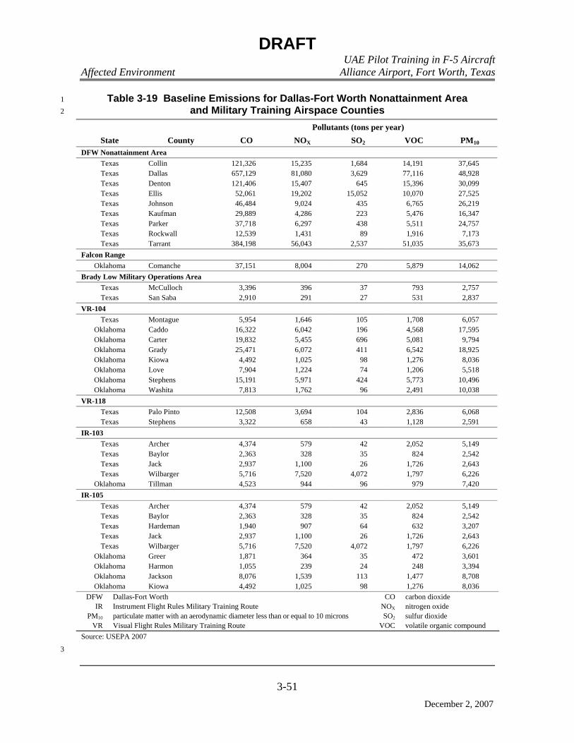
DRAFT UAE Pilot Training in F-5 Aircraft Affected Environment Alliance Airport, Fort Worth, Texas
3-51
December 2, 2007
Table 3-19 Baseline Emissions for Dallas-Fort Worth Nonattainment Area 1 and Military Training Airspace Counties 2
Pollutants (tons per year) State County CO NOX SO2 VOC PM10
DFW Nonattainment Area Texas Collin 121,326 15,235 1,684 14,191 37,645 Texas Dallas 657,129 81,080 3,629 77,116 48,928 Texas Denton 121,406 15,407 645 15,396 30,099 Texas Ellis 52,061 19,202 15,052 10,070 27,525 Texas Johnson 46,484 9,024 435 6,765 26,219 Texas Kaufman 29,889 4,286 223 5,476 16,347 Texas Parker 37,718 6,297 438 5,511 24,757 Texas Rockwall 12,539 1,431 89 1,916 7,173 Texas Tarrant 384,198 56,043 2,537 51,035 35,673
Falcon Range Oklahoma Comanche 37,151 8,004 270 5,879 14,062
Brady Low Military Operations Area Texas McCulloch 3,396 396 37 793 2,757 Texas San Saba 2,910 291 27 531 2,837
VR-104 Texas Montague 5,954 1,646 105 1,708 6,057
Oklahoma Caddo 16,322 6,042 196 4,568 17,595 Oklahoma Carter 19,832 5,455 696 5,081 9,794 Oklahoma Grady 25,471 6,072 411 6,542 18,925 Oklahoma Kiowa 4,492 1,025 98 1,276 8,036 Oklahoma Love 7,904 1,224 74 1,206 5,518 Oklahoma Stephens 15,191 5,971 424 5,773 10,496 Oklahoma Washita 7,813 1,762 96 2,491 10,038
VR-118 Texas Palo Pinto 12,508 3,694 104 2,836 6,068 Texas Stephens 3,322 658 43 1,128 2,591
IR-103 Texas Archer 4,374 579 42 2,052 5,149 Texas Baylor 2,363 328 35 824 2,542 Texas Jack 2,937 1,100 26 1,726 2,643 Texas Wilbarger 5,716 7,520 4,072 1,797 6,226
Oklahoma Tillman 4,523 944 96 979 7,420 IR-105
Texas Archer 4,374 579 42 2,052 5,149 Texas Baylor 2,363 328 35 824 2,542 Texas Hardeman 1,940 907 64 632 3,207 Texas Jack 2,937 1,100 26 1,726 2,643 Texas Wilbarger 5,716 7,520 4,072 1,797 6,226
Oklahoma Greer 1,871 364 35 472 3,601 Oklahoma Harmon 1,055 239 24 248 3,394 Oklahoma Jackson 8,076 1,539 113 1,477 8,708 Oklahoma Kiowa 4,492 1,025 98 1,276 8,036
DFW Dallas-Fort Worth CO carbon dioxide IR Instrument Flight Rules Military Training Route NOX nitrogen oxide
PM10 particulate matter with an aerodynamic diameter less than or equal to 10 microns SO2 sulfur dioxide VR Visual Flight Rules Military Training Route VOC volatile organic compound
Source: USEPA 2007
3
DRAFT UAE Pilot Training in F-5 Aircraft Affected Environment Alliance Airport, Fort Worth, Texas
3-52
December 2, 2007
THIS PAGE INTENTIONALLY LEFT BLANK1

Chapter 4
Environmental Consequences

DRAFT UAE Pilot Training in F-5 Aircraft Environmental Consequences Alliance Airport, Fort Worth, Texas
4-1
December 2, 2007
1
CHAPTER 4 2
3
ENVIRONMENTAL CONSEQUENCES 4
4.1 INTRODUCTION 5
This chapter describes potential impacts that could occur if the proposed action is 6
implemented at AFW. Additionally, potential impacts are addressed for the no action 7
alternative and cumulative impacts are analyzed for the additional actions proposed on or 8
around AFW. Criteria used to evaluate potential impacts are discussed at the beginning of 9
each resource area. 10
4.2 DESCRIPTION OF THE EFFECTS OF ALL ALTERNATIVES ON THE AFFECTED 11 ENVIRONMENT 12
4.2.1 Noise 13
In this section, noise levels associated with aircraft operations at AFW and in the 14
regional MTA associated with the proposed action are evaluated and compared with the 15
current conditions described in Sections 3.3.1.2 through 3.3.1.5 to assess potential impacts. 16
Data developed during this process also supports analyses in other resource areas. 17
Based on numerous sociological surveys and recommendations of federal interagency 18
councils, the most commonly used benchmark for noise is an Ldn of 65 dBA. This 19
threshold is often used to determine residential land use compatibility around airports and 20
airfields, highways, or other transportation corridors. Two other average noise levels are 21
also useful: 22
• An Ldn of 55 dBA has been identified by the USEPA as a level “requisite to 23
protect the public health and welfare with an adequate margin of safety” 24
(USEPA 1974). Noise may be heard, but there is no risk to public health or 25
welfare. 26
• An Ldn of 75 dBA is a threshold above which effects other than annoyance may 27
occur. It is 10 to 15 dBA below levels at which hearing damage is a known risk 28
(OSHA 1983). However, it is also a level above which some adverse health 29
effects cannot be categorically discounted. 30
Public annoyance is the most common impact associated with exposure to elevated 31
noise levels. When subjected to Ldn of 65 dBA, approximately 12 percent of persons so 32
exposed will be “highly annoyed” by the noise. At levels below 55 dBA, the percentage of 33
annoyance is substantially lower (less than 3 percent). The percentage of people annoyed 34
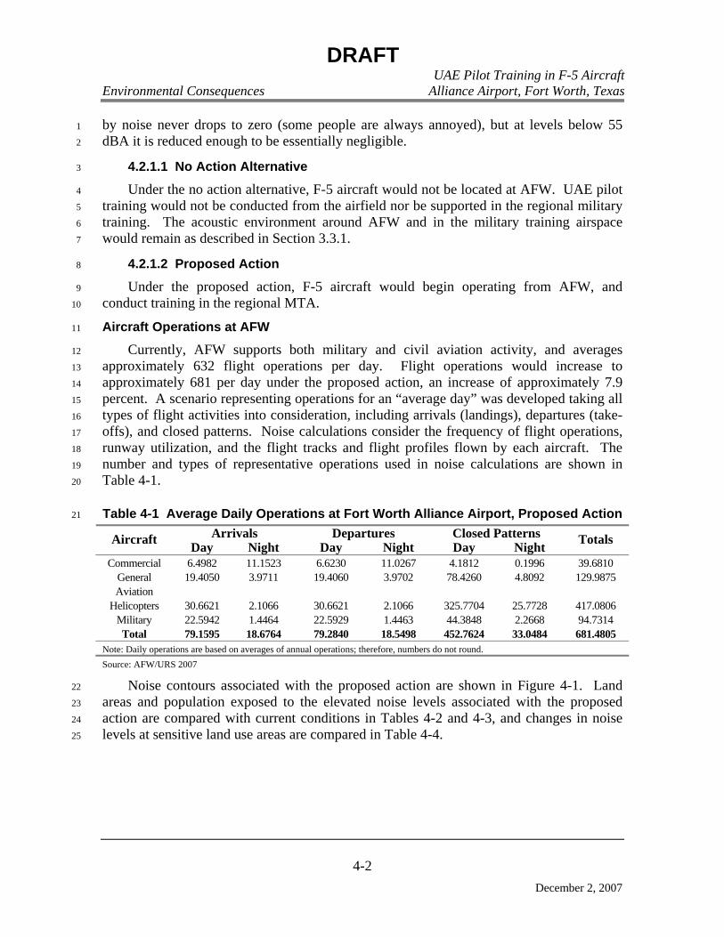
DRAFT UAE Pilot Training in F-5 Aircraft Environmental Consequences Alliance Airport, Fort Worth, Texas
4-2
December 2, 2007
by noise never drops to zero (some people are always annoyed), but at levels below 55 1
dBA it is reduced enough to be essentially negligible. 2
4.2.1.1 No Action Alternative 3
Under the no action alternative, F-5 aircraft would not be located at AFW. UAE pilot 4
training would not be conducted from the airfield nor be supported in the regional military 5
training. The acoustic environment around AFW and in the military training airspace 6
would remain as described in Section 3.3.1. 7
4.2.1.2 Proposed Action 8
Under the proposed action, F-5 aircraft would begin operating from AFW, and 9
conduct training in the regional MTA. 10
Aircraft Operations at AFW 11
Currently, AFW supports both military and civil aviation activity, and averages 12
approximately 632 flight operations per day. Flight operations would increase to 13
approximately 681 per day under the proposed action, an increase of approximately 7.9 14
percent. A scenario representing operations for an “average day” was developed taking all 15
types of flight activities into consideration, including arrivals (landings), departures (take-16
offs), and closed patterns. Noise calculations consider the frequency of flight operations, 17
runway utilization, and the flight tracks and flight profiles flown by each aircraft. The 18
number and types of representative operations used in noise calculations are shown in 19
Table 4-1. 20
Table 4-1 Average Daily Operations at Fort Worth Alliance Airport, Proposed Action 21
Arrivals Departures Closed Patterns Aircraft Day Night Day Night Day Night Totals
Commercial 6.4982 11.1523 6.6230 11.0267 4.1812 0.1996 39.6810 General Aviation
19.4050 3.9711 19.4060 3.9702 78.4260 4.8092 129.9875
Helicopters 30.6621 2.1066 30.6621 2.1066 325.7704 25.7728 417.0806 Military 22.5942 1.4464 22.5929 1.4463 44.3848 2.2668 94.7314 Total 79.1595 18.6764 79.2840 18.5498 452.7624 33.0484 681.4805
Note: Daily operations are based on averages of annual operations; therefore, numbers do not round. Source: AFW/URS 2007
Noise contours associated with the proposed action are shown in Figure 4-1. Land 22
areas and population exposed to the elevated noise levels associated with the proposed 23
action are compared with current conditions in Tables 4-2 and 4-3, and changes in noise 24
levels at sensitive land use areas are compared in Table 4-4. 25
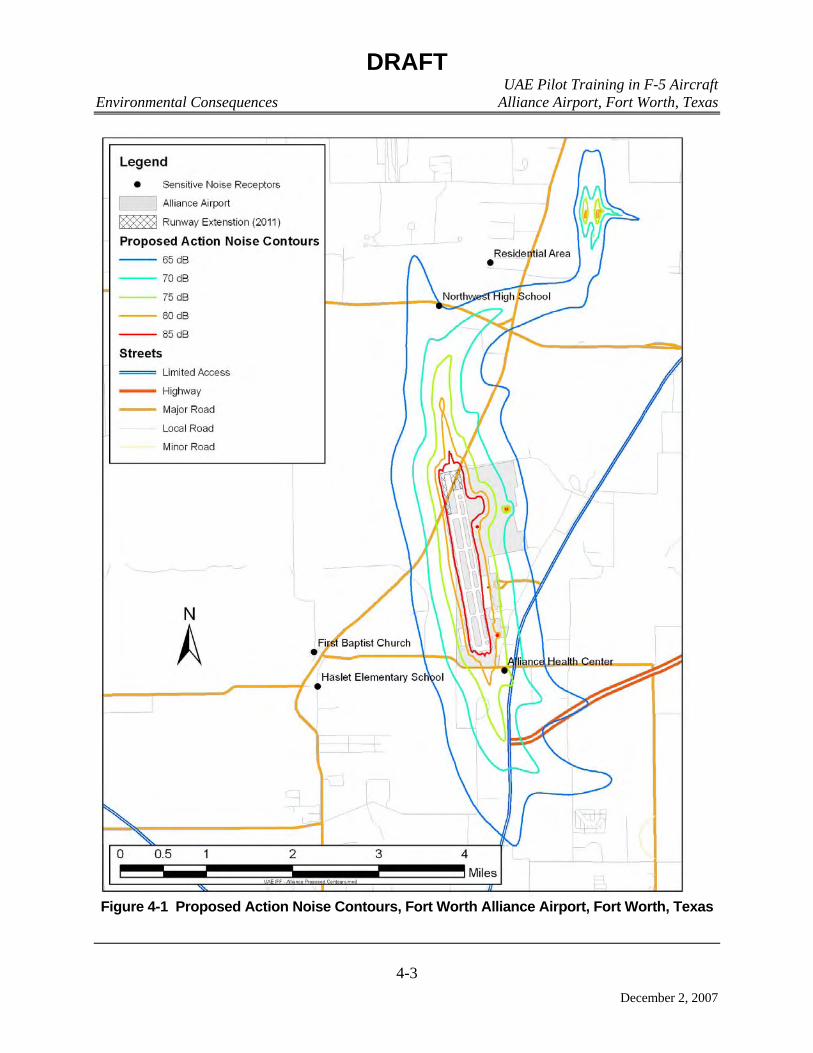
DRAFT UAE Pilot Training in F-5 Aircraft Environmental Consequences Alliance Airport, Fort Worth, Texas
4-3
December 2, 2007
Figure 4-1 Proposed Action Noise Contours, Fort Worth Alliance Airport, Fort Worth, Texas
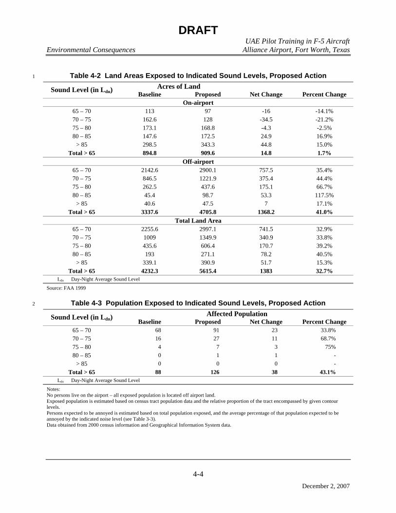
DRAFT UAE Pilot Training in F-5 Aircraft
Environmental Consequences Alliance Airport, Fort Worth, Texas
4-4
December 2, 2007
Table 4-2 Land Areas Exposed to Indicated Sound Levels, Proposed Action 1
Acres of Land Sound Level (in Ldn) Baseline Proposed Net Change Percent Change
On-airport 65 – 70 113 97 -16 -14.1% 70 – 75 162.6 128 -34.5 -21.2% 75 – 80 173.1 168.8 -4.3 -2.5% 80 – 85 147.6 172.5 24.9 16.9%
> 85 298.5 343.3 44.8 15.0% Total > 65 894.8 909.6 14.8 1.7%
Off-airport 65 – 70 2142.6 2900.1 757.5 35.4% 70 – 75 846.5 1221.9 375.4 44.4% 75 – 80 262.5 437.6 175.1 66.7% 80 – 85 45.4 98.7 53.3 117.5%
> 85 40.6 47.5 7 17.1% Total > 65 3337.6 4705.8 1368.2 41.0%
Total Land Area 65 – 70 2255.6 2997.1 741.5 32.9% 70 – 75 1009 1349.9 340.9 33.8% 75 – 80 435.6 606.4 170.7 39.2% 80 – 85 193 271.1 78.2 40.5%
> 85 339.1 390.9 51.7 15.3% Total > 65 4232.3 5615.4 1383 32.7%
Ldn Day-Night Average Sound Level Source: FAA 1999
Table 4-3 Population Exposed to Indicated Sound Levels, Proposed Action 2
Affected Population Sound Level (in Ldn) Baseline Proposed Net Change Percent Change
65 – 70 68 91 23 33.8% 70 – 75 16 27 11 68.7% 75 – 80 4 7 3 75% 80 – 85 0 1 1 -
> 85 0 0 0 - Total > 65 88 126 38 43.1%
Ldn Day-Night Average Sound Level Notes: No persons live on the airport – all exposed population is located off airport land. Exposed population is estimated based on census tract population data and the relative proportion of the tract encompassed by given contour levels. Persons expected to be annoyed is estimated based on total population exposed, and the average percentage of that population expected to be annoyed by the indicated noise level (see Table 3-3). Data obtained from 2000 census information and Geographical Information System data.

DRAFT UAE Pilot Training in F-5 Aircraft
Environmental Consequences Alliance Airport, Fort Worth, Texas
4-5
December 2, 2007
Table 4-4 Specific Point Noise Exposure, Proposed Action 1
Exposure (in Ldn)
Point Identification Description
Current Proposed
Change (in Ldn)
NSR1 Haslet Elementary School 55.4 55.8 + 0.4 NSR2 First Baptist Church – Haslet 55.0 55.5 + 0.5 NSR3 Alliance Health Center 75.7 77.4 + 1.7 NSR4 Northwest High School 63.0 64.9 + 1.9 NSR5 Residential (North of AFW) 56.9 58.4 + 1.5
Ldn Day-Night Average Sound Level dB decibel Source: FAA 1999
As shown, at this level of operations, with the exception of the Alliance Health Center, all 2
current land uses remain compatible. At the Alliance Health Center, the noise level for a land 3
use that is incompatible under current conditions is further exacerbated by a 1.7-dBA increase. 4
However, in accordance with zoning ordnances adopted by the City of Haslet, Texas “. . . 5
medical, dental, or optical clinics for the examination, consultation, or treatment of patients as 6
out-patients . . . operated by, or in connection with the Airport shall be permitted as a matter of 7
right in the Haslet Development Zone” (City of Haslet 1988). The Alliance Health Center 8
conforms to these guidelines. 9
Some portions of the transition pilot training would be conducted at the following regional 10
airports in addition to AFW: NAS JRB Fort Worth, Meacham International Airport, and Waco 11
Regional Airport. However, these operations would be minimal, and would essentially 12
constitute anticipated transient military traffic at these facilities. No specific noise impacts 13
would be expected to be associated with these operations. 14
Aircraft Operations in Military Training Airspace 15
Using the USAF’s MR_NMAP, which is specifically designed to model noise within MTA, 16
the uniformly distributed sound levels in MOAs and the maximum noise levels along the 17
centerline of MTRs and bombing tracks were calculated. The resulting noise levels are reported 18
as Ldnmr. The calculated noise levels created by proposed action aircraft operations in the MTA 19
are compared with current conditions in Table 4-5. Noise contours associated with the use of 20
Falcon Range are shown in Figure 4-2. 21

DRAFT UAE Pilot Training in F-5 Aircraft
Environmental Consequences Alliance Airport, Fort Worth, Texas
4-6
December 2, 2007
Table 4-5 Noise Levels in Military Training Airspace, Proposed Action 1
Airspace Uniformly Distributed Sound Level/ Range of Maximum Sound Levels (in Ldnmr)
Current Conditions Proposed Action BRADY HIGH MOA 44.1 44.1 BRADY LOW MOA 55.5 55.5
BRADY HIGH + BRADY LOW MOAs 55.8 55.81 BROWNWOOD MOA 25.5 25.8
IR-103 47.1–52.1 47.1–52.2 IR-105 47.0–52.0 47.0–52.0 VR-104 49.7–51.8 49.7–51.8 VR-118 45.7–50.1 45.7–50.1
Falcon Range 21.1–50.9 21.5–51.1 IR Instrument Flight Rules MTR Ldnmr Onset-Rate Adjusted Monthly Day-Night Average Sound Level MOA Military Operations Area MTR Military Training Route VR Visual Flight Rules MTR For MOAs, indicates uniformly distributed noise throughout the airspace; for MTRs indicates maximum noise level on route centerline. When applicable, a range of values reflects changes in the configuration of the route. 1Sound level in the three avoidance areas is 53.8 Ldnmr. Source: Lucas and Calamia 1996
The values presented in Table 4-5 reflect the mathematically calculated output of the 2
MR_NMAP model. Background noise in rural areas is normally considered to be approximately 3
40 dBA or greater. Normally, while calculated, noise levels at or below 40 dBA are not reported 4
since they are at or below anticipated ambient levels and indicate that there is little or no 5
observable noise contribution from aircraft in the region. These low values are due to the size of 6
the airspace, the relatively limited number of operations, and the altitudes at which these 7
operations are conducted. As shown in Table 4-5 and Figure 4-2, noise levels on Falcon Range 8
are minimal, and are localized as bombing tracks converge at the target area. Noise levels off-9
range are essentially at ambient levels. At Indiahoma, Oklahoma (approximately four miles 10
southwest of the range), levels are 42 Ldnmr; at Cache, Oklahoma (approximately five miles 11
southeast of the range), they are 37 Ldnmr. 12
In summary, overall noise impacts associated with the proposed action are inconsequential. 13
4.2.1.3 Cumulative Impacts 14
Past, present, and reasonably foreseeable future proposals in the ROI have the potential to 15
create noise impacts. For the projects identified, noise would result from construction activities 16
and other modified or added aviation activities. 17
Noise on construction sites normally results from the use of heavy equipment and other 18
vehicular movement. Construction would occur as part of the implementation of projects 19
identified in Section 2.6. Elevated noise levels resulting from construction are usually sporadic 20
and transitory, are relatively confined to the immediate vicinity of the construction site, and 21
cease at the completion of the project. Considering the usual levels of sound created by these 22
DRAFT UAE Pilot Training in F-5 Aircraft
Environmental Consequences Alliance Airport, Fort Worth, Texas
4-7
December 2, 2007
activities in comparison to aviation-related noise in the same areas, there should not be a 1
noticeable impact. While construction-related sound may be heard in close proximity to the 2
project, it is not usually excessive and noise from aircraft operations would be expected to 3
continue to dominate the acoustic character of the ROI. 4
4.2.1.4 Measures to Reduce Impacts 5
Since impacts that would result from the implementation of the proposed action would be of 6
little consequence, no specific mitigation measures are recommended. 7
4.2.2 Airspace Management and Air Traffic Control 8
The potential effects of the proposed action on the airspace environment were assessed by 9
considering the changes in airspace utilization that could result from implementation of the 10
alternatives. This assessment considered compliance with AFI 13-201 (Air Force Airspace 11
Management) and its supplements, as well as measures that could minimize potential impacts on 12
other regional air traffic and the ATC system. 13
The type, size, shape, and configuration of individual airspace elements in a region are based 14
upon, and are intended to satisfy, competing aviation requirements. Potential impacts could 15
occur if air traffic in the region and/or the ATC systems were encumbered by changed flight 16
activities associated with the proposed action. When any major change is planned, such as new 17
or revised defense-related activities within an airspace area or a change in the complexity or 18
density of aircraft movements, the FAA reassesses the airspace configuration. The FAA 19
reassessment includes an assessment to determine any impacts that could result if such changes 20
adversely affected (1) ATC systems and/or facilities; (2) movement of other air traffic in the 21
area; or (3) airspace already designated and used for other purposes supporting military, 22
commercial, or general aviation. 23
4.2.2.1 No Action Alternative 24
Under the no action alternative, no additional aircraft activity would occur at AFW Airport. 25
U.S. Government objectives in supporting allied military forces would not be satisfied. No F-5 26
aircraft would be transferred to AFW Airport, and no training of UAE pilots in F-5 aircraft 27
would be conducted from AFW and in the regional MTA. Operations at the airfield and in the 28
MTA would continue at the same levels as current conditions. Airspace management and air 29
traffic control would remain as described in Section 3.3.2.2, and no impacts to ATC systems 30
would be expected. 31
4.2.2.2 Proposed Action 32
Under the proposed action, which would implement the IFF training course for UAE pilots 33
in F-5 aircraft, F-5 aircraft would begin operating from AFW and begin utilizing the regional 34
MTA. The average number of daily operations at AFW would be expected to increase 35
approximately 7.9 percent, from approximately 632 to approximately 681. Despite this increase 36
in average daily operations, there is no indication that any changes or modifications to the 37

DRAFT UAE Pilot Training in F-5 Aircraft
Environmental Consequences Alliance Airport, Fort Worth, Texas
4-8
December 2, 2007
controlled airspace or ATC procedures currently supporting aviation activities at the airport 1
would be required in support of the proposed action; therefore, no impact is expected. 2
In addition to training activities that would be conducted at AFW and in the regional MTA, 3
transition training would be conducted at NAS JRB Fort Worth, Meacham International Airport, 4
and Waco Regional Airport. Over the course of a year, these operations would be minimal in 5
number and would be accommodated as transient military operations; therefore, they would have 6
no impact on the facility’s airspace or ATC. 7
The average number of sorties per day conducted in the regional MTA would also increase 8
to some degree. MOA utilization would increase, ranging from an average increase of 0.1 sortie 9
per day (within the Brady Low MOA) to an average increase of 4.6 sorties per day (within the 10
Brownwood MOA). Increases in utilization of MTRs would range from an average increase of 11
0.01 sortie per day (within MTR VR-118) to an average increase of 0.9 sortie per day (within 12
MTR IR-105). The increase in utilization at Falcon Range would average 4.7 sorties per day. 13
Although utilization of all airspace would increase, the increases are minimal; the control, use, 14
and management of these airspace elements would continue without change. Implementation of 15
the scheduling and coordination processes and procedures currently used would continue without 16
change. No major adverse impacts would be anticipated. 17
4.2.2.3 Cumulative Impacts 18
There are no known aviation-related projects in the ROI that would have the potential to 19
impact airspace availability or air traffic control. 20
4.2.2.4 Measures to Reduce Impacts 21
Since impacts that would result from the implementation of the proposed action are 22
essentially non-existent, no specific measures for minimization of impacts would be 23
recommended. 24
4.2.3 Land Use 25
Land use impacts can result if an action displaces an existing use or reduces the suitability of 26
an area for its current, designated, or formally planned use. In addition, a proposed activity may 27
be incompatible with local plans and regulations that provide for orderly development to protect 28
the general welfare of the public, or may conflict with management objectives of a federal or 29
state agency for an affected area. The methodology to assess impacts on individual land uses 30
requires identifying those uses, as well as affected land use planning and control policies and 31
regulations and determining the degree to which they would be affected by the proposal. 32
33
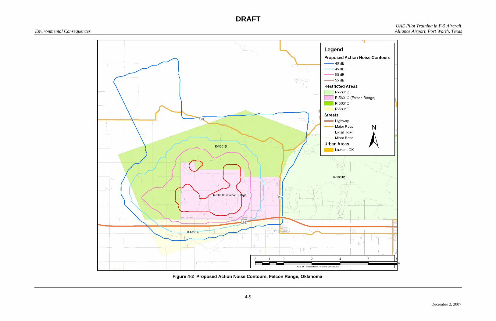
DRAFT UAE Pilot Training in F-5 Aircraft
Environmental Consequences Alliance Airport, Fort Worth, Texas
4-9
December 2, 2007
Figure 4-2 Proposed Action Noise Contours, Falcon Range, Oklahoma
DRAFT UAE Pilot Training in F-5 Aircraft Environmental Consequences Alliance Airport, Fort Worth, Texas
4-10
December 2, 2007
To assess impacts to visual resources, areas that have high visual value or low 1
tolerance for visible modification or have prescribed guidelines are identified. Visual 2
impacts are assessed by determining how, and to what extent, a proposed action would 3
alter the overall visual character of the area. 4
4.2.3.1 No Action Alternative 5
Under the no action alternative, there would be no change from the baseline 6
conditions described in Section 3.3.3. All of the existing facilities would remain, and 7
no new facilities would be constructed. No impacts to land use or visual resources are 8
expected. AFW would continue to manage development activity according to 9
established planning, architectural, landscaping, and civil engineering guidelines. AFW 10
coordination with local communities affected by overflight activity would continue in 11
compliance with Federal Aviation Regulations Airport Noise Compatibility Planning 12
(Part 150) activities. 13
4.2.3.2 Proposed Action 14
AFW has identified the need to finish out the interior space of the existing Alliance 15
Air Trade facility to house the UAE IFF pilot training program. The future land use 16
categories identified in the Part 150 Noise Study that surround the proposed action 17
location have been evaluated, and the proposed action would be consistent with land use 18
concepts defined for the airport by airport planners. No additional land would be 19
needed to accommodate the activities associated with the proposed action. Because no 20
external construction activity would occur, the overall visual character of the area 21
would not change. 22
The visual character of Falcon Range and the proposed MTRs/MOAs would 23
remain the same because no activities associated with the proposed action would occur 24
on or near the ground in or near Falcon Range or the proposed MTRs/MOAs. The 25
proposed action is consistent with current land use, and no additional land would be 26
necessary to accommodate the activities associated with the proposed action. 27
4.2.3.4 Cumulative Impacts 28
The extent of development associated with the proposed action would somewhat 29
alter the overall visual character of the area. Any development activity undertaken on 30
AFW would be consistent with established planning, architectural, landscaping, and 31
civil guidelines to ensure that the airport character and aesthetic qualities are retained. 32
33
DRAFT UAE Pilot Training in F-5 Aircraft Environmental Consequences Alliance Airport, Fort Worth, Texas
4-11
December 2, 2007
Other proposed and/or ongoing activities within the ROI, as described in Section 2.7, 1
are not expected to substantially modify or render existing land uses incompatible either at 2
AFW or in the general ROI. As well, there are no other proposed or ongoing activities in 3
the vicinity of Falcon Range and the proposed MTRs/MOAs that, in conjunction with the 4
proposed action, would affect land use or the visual characteristics of the areas. 5
4.2.3.5 Measures to Reduce Impacts 6
Land use impacts would not be anticipated at AFW for the proposed action. 7
Therefore, no formal mitigation measures would be required as a result of the 8
implementation of the proposed action or the no action alternative. However, any future 9
development activity undertaken on AFW would be consistent with the development’s 10
established planning, architectural, landscaping, and civil engineering guidelines 11
(contained within the Alliance Master Plan) to ensure that the airport’s character and 12
aesthetic qualities are retained. 13
4.2.4 Earth Resources 14
Protection of unique geologic features, minimization of soil erosion, and relation of 15
existing facilities to potential geologic hazards, soil limitations, and sharp topological 16
features are considered when evaluating impacts to earth resources. Generally, impacts 17
can be avoided or minimized if proper construction techniques, erosion control measures, 18
and structural engineering designs are incorporated into project development. 19
Analysis of potential impacts to geologic resources typically includes identification 20
and description of resources that could potentially be affected, examination of the potential 21
effects that an action may have on the resource, and provision of measures to reduce 22
impacts, if necessary. Analysis of impacts to soil resources resulting from proposed 23
activities examines the suitability of locations for proposed operations and activities. 24
Impacts to soil resources can result from earth disturbance that would expose soil to wind 25
or water erosion. 26
4.2.4.1 No Action Alternative 27
Under the no action alternative, the existing facilities on AFW would remain as is, and 28
the interior of the Alliance Air Trade Center would not be complete. No impacts to earth 29
resources would occur as a result of the no action alternative. Conditions would remain as 30
described in Section 3.3.4. 31
4.2.4.2 Proposed Action 32
Under the proposed action, the interior of the Alliance Air Trade Center would be 33
completed to house the UAE IFF pilot training program. The physiography, underlying 34
geology, and topography of the area near the Alliance Air Trade Center would not change. 35
DRAFT UAE Pilot Training in F-5 Aircraft Environmental Consequences Alliance Airport, Fort Worth, Texas
4-12
December 2, 2007
4.2.4.3 Cumulative Impacts 1
Cumulative impacts on earth resources are expected to be minor. The proposed 2
action, when considered in combination with other ongoing actions in the ROI, will not 3
contribute to cumulative impacts on earth resources because the proposed action 4
construction activity consists solely of the interior completion of the Alliance Air Trade 5
Center. 6
4.2.4.4 Measures to Reduce Impacts 7
Impacts to earth resources are not anticipated at AFW for the proposed action. 8
Therefore, no mitigation measures would be required as a result of the implementation of 9
the proposed action or the no action alternative. However, best management practices 10
(BMP) would be implemented to minimize potential erosion during construction activities 11
for ongoing and future projects in the ROI. Additionally, appropriate vegetation would be 12
reestablished on the sites to ensure rapid soil stabilization. 13
4.2.5 Water Resources 14
Criteria for evaluating impacts related to water resources are water availability, water 15
quality, and adherence to applicable regulations. Impacts are measured by the potential to 16
reduce water availability to existing users, endanger public health or safety by creating or 17
worsening health hazards or safety conditions, or violate laws or regulations adopted to 18
protect or manage water resources. 19
Water availability impacts are assessed by determining the potential increases in use 20
that may affect availability of water resources. Surface water impact analyses were 21
conducted by first identifying water bodies at AFW and their proximity to the site of the 22
proposed action. Next, analyses were done using relevant literature to calculate the 23
potential and the extent of all impacts in the affected areas. 24
4.2.5.1 Surface Water 25
4.2.5.1.1 No Action Alternative 26
Under the no action alternative, water resources would remain comparable to baseline 27
conditions as described in Section 3.3.5.2. 28
4.2.5.1.2 Proposed Action 29
Under the proposed action, the interior of the Alliance Air Trade Center would be 30
finished out to house the UAE IFF pilot training program. No impervious cover would be 31
added to the airport. Therefore, water quality would not be adversely impacted by the 32
proposed action. 33

DRAFT UAE Pilot Training in F-5 Aircraft Environmental Consequences Alliance Airport, Fort Worth, Texas
4-13
December 2, 2007
4.2.5.1.3 Cumulative Impacts 1
Because it is not expected to impact surface water, when considered with respect to 2
other ongoing actions, the proposed action is expected to have a minimal net cumulative 3
impact on surface water at AFW. 4
4.2.5.1.4 Measures to Reduce Impacts 5
Impacts to surface water resources are not anticipated at AFW for the proposed action. 6
Therefore, no mitigation measures would be required as a result of the implementation of 7
the proposed action or the no action alternative. 8
4.2.5.2 Groundwater 9
4.2.5.2.1 No Action Alternative 10
Under the no action alternative, there would be no change from the baseline conditions 11
described in Section 3.3.5.3. 12
4.2.5.2.2 Proposed Action 13
There would be negligible effects on groundwater resulting from implementation of 14
the proposed action. None of the activities associated with the proposed action would 15
involve installation of materials or equipment that would degrade water quality. 16
4.2.5.2.3 Cumulative Impacts 17
The proposed action, when combined with the other actions proposed in the area, 18
would result in a very slight increase in the use of water. Demand for water will continue 19
to increase in the future as both population and industry increase to grow in the region. 20
The majority of the water use related to the proposed action would be associated with 21
equipment and aircraft washing. The quantity of water used in these applications would be 22
miniscule when compared to current water use at AFW and in the ROI. The Tarrant 23
Regional Water District currently supplies water to the City of Fort Worth, and monitors 24
water usage to ensure that future water demands can be met. Minor cumulative impacts 25
are anticipated from implementation of the proposed action when considered with respect 26
to other ongoing actions in the ROI. 27
4.2.5.2.4 Measures to Reduce Impacts 28
Impacts to groundwater resources are not anticipated at AFW for the proposed action. 29
However, established BMPs will be implemented to ensure protection of groundwater 30
quantity and quality. 31
4.2.5.3 Floodplains 32
As defined in Title 40, CFR, Part 9.4, natural values of floodplains include natural 33
moderation of floods, water quality maintenance, groundwater recharge, habitats, open 34
DRAFT UAE Pilot Training in F-5 Aircraft Environmental Consequences Alliance Airport, Fort Worth, Texas
4-14
December 2, 2007
space, and recreation, among others. There are no 100-year floodplains on AFW (FAA 1
2001). Therefore, no additional analysis is required in the EA. 2
4.2.6 Hazardous Materials and Waste 3
The interior build-out of the Alliance Air Trade facility would be performed utilizing 4
normal construction methods, which would limit the use, to the extent possible, of 5
hazardous materials. Routine aircraft maintenance activities would be performed in and 6
adjacent to the Alliance Air Trade facility. Petroleum, oil, and lubricant (POL) products 7
and other hazardous materials (e.g., paints) would be used during these activities. These 8
materials would be stored in the proper containers, employing secondary containment as 9
necessary to prevent/limit accidental spills. All spills and accidental discharges of POLs, 10
hazardous materials, or hazardous waste would be reported. Aircraft deicing procedures 11
are performed at AFW; however, no deicing operations would be performed on aircraft 12
supporting the proposed IFF pilot training mission. All commercial operations that 13
perform deicing operations follow established standard operating procedures that comply 14
with applicable environmental regulations. 15
The USEPA and the TCEQ administer RCRA Subtitle C (Title 40, CFR, Parts 260 16
through 270) regulations applicable to the management of hazardous waste. Hazardous 17
waste must be handled, stored, transported, disposed, or recycled in accordance with these 18
regulations. There would be impacts to hazardous waste management if the federal action 19
resulted in noncompliance with applicable federal and Texas regulations or caused waste 20
generation that could not be accommodated by current AFW waste management capacities. 21
No impacts from hazardous materials and hazardous wastes are expected; AFW would 22
adhere to hazardous materials and hazardous waste management requirements and there 23
would be no increase in the quantity of hazardous waste generated at AFW as a result of 24
the alternatives. 25
4.2.6.1 No Action Alternative 26
No interior build-out activities would occur under the no action alternative. Therefore, 27
no adverse impacts are expected under this alternative. 28
4.2.6.2 Proposed Action 29
No adverse impacts associated with hazardous materials/waste are anticipated under 30
the proposed action, as standard operating procedures would be implemented as described 31
in Section 4.3.6. 32
4.2.6.3 Cumulative Impacts 33
No adverse impacts associated with hazardous materials or waste have been identified 34
with respect to the implementation of the proposed action. When considered with the other 35
ongoing activities, these activities would not contribute to any cumulative impacts 36
associated with hazardous materials and/or waste. 37
DRAFT UAE Pilot Training in F-5 Aircraft Environmental Consequences Alliance Airport, Fort Worth, Texas
4-15
December 2, 2007
4.2.6.4 Measures to Reduce Impacts 1
The following actions, as part of AFW standard operating procedures, would be 2
implemented as part of the alternatives to ensure that there are no impacts related to 3
potential issues discussed above: 4
• Contractors would be required to properly dispose of all hazardous materials in 5
accordance with Title 40, CFR, Part 261 and TCEQ requirements. 6
• All spills and accidental discharges of POL, hazardous materials, or hazardous 7
waste on AFW, regardless of quantity, would be reported to TCEQ and mitigated. 8
• AFW and contractors would coordinate with all local landfill operators prior to 9
generation of large quantities of solid waste generated from the interior build-out 10
of the Alliance Air Trade Center to minimize any potential impacts associated with 11
disposal of related debris. 12
4.2.7 Biological Resources 13
Potential impacts to biological resources were determined by analyzing the proposed 14
action within the context of the importance of the existing resources and the sensitivity of 15
those resources. In addition, impacts were evaluated based on whether the actions would: 16
• Affect threatened or endangered species. 17
• Substantially diminish natural habitats for a plant or animal species. 18
• Substantially interfere with wildlife movement or reproductive behavior. 19
• Infuse exotic plant or animal species. 20
4.2.7.1 Vegetation and Wildlife 21
4.2.7.1.1 No Action Alternative 22
Implementation of the UAE IFF pilot training program would not occur and the 23
interior of the Alliance Air Trade Center would not be completed under the no action 24
alternative. Therefore, no adverse impacts to vegetation and wildlife are expected under 25
this alternative. 26
4.2.7.1.2 Proposed Action 27
Activities under the proposed action at AFW would occur within a developed, 28
maintained urban and suburban areas with a disturbed landscape. No new facilities would 29
be constructed in association with the proposed action, so there would be no or minimal 30
impacts to wildlife at AFW or Falcon Range and proposed MTRs/MOAs. Because the 31
results of the noise analysis performed in Section 4.2.1 indicate that overall noise impacts 32
associated with the proposed action are inconsequential, addition of the proposed flying 33
operations is not expected to directly impact species or cause loss of habitat at AFW or 34
Falcon Range and proposed MTRs/MOAs. 35

DRAFT UAE Pilot Training in F-5 Aircraft Environmental Consequences Alliance Airport, Fort Worth, Texas
4-16
December 2, 2007
4.2.7.1.3 Cumulative Impacts 1
Localized loss of habitat or direct impacts to species can have a cumulative impact 2
when viewed on a regional scale if that loss or impact is compounded by other events with 3
the same end result. However, there would be no net loss of critical habitats at or around 4
AFW or Falcon Range and proposed MTRs/MOAs, because the proposed action would not 5
include construction of new facilities. The proposed and other ongoing actions would not 6
have incremental effects on the vegetation and wildlife of AFW, Falcon Range, proposed 7
MTRs/MOAs, or the local areas associated with these locations. 8
4.2.7.1.4 Measures to Reduce Impacts 9
No impacts to vegetation and wildlife are expected under the proposed action. 10
Therefore, no measures to reduce impacts would be required. 11
4.2.8 Utilities and Infrastructure 12
In evaluating impacts on infrastructure and utilities, several items were examined, 13
including (1) the degree to which a utility service would have to alter operating practices 14
and personnel requirements, (2) the degree to which the change in demands from 15
implementation of the proposed action and alternatives would impact a system’s capacity, 16
(3) the degree to which a transportation system would have to alter operating practices and 17
personnel requirements to support the action, (4) the capacity required from new or revised 18
transportation systems, (5) the degree to which the increased demands from the proposed 19
program would reduce the reliability of transportation systems, or aggravate already 20
existing adverse conditions in the AFW vicinity, and (6) the degree to which the proposed 21
action and alternatives change surface water runoff characteristics and erosion 22
characteristics. For the evaluation of potential impacts, the ROI for the infrastructure and 23
utilities resource area encompasses the existing Alliance Air Trade Center, supporting 24
infrastructure in the immediate vicinity of Alliance Air Trade Center at AFW, and any 25
regional systems supporting AFW. 26
The Alliance Air Trade Center is an existing multiuse industrial facility designed to 27
accommodate as many as 700 people and associated industrial (aircraft maintenance-28
related) activities. In comparison, the Alliance Texas development (which includes AFW 29
and surrounding industrial facilities) encompasses more than 26 million square feet and 30
supports over 140 corporate residents and 25,000 employees (Hillwood 2007a). 31
The proposed action would result in the build-out of approximately 78,000 of the 32
available 99,000 square feet of interior building space at Alliance Air Trade Center. 33
Approximately 36,000 square feet of the facility would be occupied by personnel and 34
approximately 42,000 square feet would be used for storage and maintenance. 35
Implementation of the proposed action would result in proposed action would result in a 36
population increase of 93 new personnel and 22 annual students, all of whom would reside 37
in nearby housing located outside of AFW property. 38
DRAFT UAE Pilot Training in F-5 Aircraft Environmental Consequences Alliance Airport, Fort Worth, Texas
4-17
December 2, 2007
4.2.8.1 Electricity and Natural Gas 1
4.2.8.1.1 No Action Alternative 2
Under the no action alternative, there would be no interior construction or changes in 3
current activities associated with Alliance Air Trade Center. Therefore, there would be no 4
effect on electricity and natural gas as described in Sections 3.3.8.1 and 3.3.8.2. 5
4.2.8.1.2 Proposed Action 6
The proposed build-out and occupation of Alliance Air Trade Center as described in 7
Section 2.5 and in the Alliance Air Trade Center plans represents only 16 percent of the 8
designed building occupancy by population, less than 79 percent of the available interior 9
space, less than 36 percent of the designed heated space, and less than 2 percent of the 10
available power infrastructure (Hillwood 2004). Because the existing electrical and natural 11
gas infrastructure and supplies to Alliance Air Trade Center exceed the requirements 12
described in Section 2.5, there would be no adverse effect on those resources as a result of 13
the implementation of the proposed action. 14
4.2.8.1.3 Cumulative Impacts 15
The projects described in Section 2.6, when combined with the proposed action, have 16
a negligible effect on enclosed building space and population; therefore, cumulative 17
impacts to the existing energy utilities supplies and infrastructure would be similar to those 18
already described for the proposed action. 19
4.2.8.1.4 Measures to Reduce Impacts 20
Mitigation measures for increased energy requirements would not be required for the 21
proposed action or cumulative projects. 22
4.2.8.2 Wastewater 23
4.2.8.2.1 No Action Alternative 24
Under the no action alternative, there would be no interior construction or other 25
changes in activities associated with Alliance Air Trade Center. Therefore, there would be 26
no effect on the wastewater collection and treatment system as described in 27
Section 3.3.8.3. 28
4.2.8.2.2 Proposed Action 29
Population changes at AFW are associated with the proposed action, which would add 30
93 permanent personnel and have a total annual throughput of 22 students. The net result 31
is the equivalent of an additional 115 persons for 8 hours per day. The net effect on the 32
wastewater infrastructure servicing AFW is that of approximately 39 additional persons for 33
24 hours per day. Assuming the scenario that 115 people were to move into the DCRWS 34
service area (representing an additional 115 residents loading the regional system), the load 35
DRAFT UAE Pilot Training in F-5 Aircraft Environmental Consequences Alliance Airport, Fort Worth, Texas
4-18
December 2, 2007
on the system would only increase by approximately 0.2 percent (the current system has a 1
50,000-person capacity). Therefore, there would be little adverse effect on these resources 2
as a result of the implementation of the proposed action. 3
4.2.8.2.3 Cumulative Impacts 4
The projects described in Section 2.6, when combined with the proposed action, have 5
a negligible effect on enclosed building space and population; therefore, the cumulative 6
impacts to the existing wastewater collection system would be similar to those already 7
described for the proposed action. The existing wastewater utilities can accommodate 8
anticipated demands associated with the proposed increases in wastewater generation. 9
4.2.8.2.4 Measures to Reduce Impacts 10
Mitigation measures for increased wastewater collection and treatment would not be 11
required for the proposed action. The available wastewater collection and treatment 12
services provided by DCRWS are capable of meeting the projected demand associated 13
with the proposed action. 14
4.2.8.3 Solid Waste Management 15
There are several items considered in analyzing solid waste impacts. These items 16
include evaluating the degree to which the proposed construction projects and demolition 17
projects could affect the existing solid waste management program and capacities of the 18
area landfills. Solid waste generated from the proposed interior build-out of Alliance Air 19
Trade Center would consist of waste building materials such metals (conduit, piping, and 20
wiring), lumber, and various interior finishing materials (e.g., sheetrock, wall coverings, 21
and floor coverings). Analysis of the cumulative impacts associated with implementation 22
of the proposed action and other actions is based on the following assumptions: 23
• Non-residential construction waste generation is 4.02 pounds per square foot. 24
Because the activities at Alliance Air Trade Center would be limited to interior build-25
out of an existing facility, it can be assumed that waste generation would be considerably 26
less than the standard 4.02 pounds per square foot factor used in estimating solid waste 27
generation. Nevertheless, coordination between AFW, waste contractors, developers, and 28
local landfill operators prior to construction would minimize any potential impacts 29
associated with disposal of the debris generated from the interior build-out of the existing 30
building shell. 31
4.2.8.3.1 No Action Alternative 32
Under the no action alternative, there would be no interior build-out of the existing 33
Alliance Air Trade Center facility or changes in activities at AFW related to the IFF pilot 34
training program. Therefore, there would be no effect on solid waste disposal resources as 35
described in Section 3.3.8.4. 36

DRAFT UAE Pilot Training in F-5 Aircraft Environmental Consequences Alliance Airport, Fort Worth, Texas
4-19
December 2, 2007
4.2.8.3.2 Proposed Action 1
The proposed action would result in the interior build-out of 78,000 square feet of 2
existing enclosed space at the 99,000-square foot Alliance Trade Center facility. Based on 3
this and the above waste generation rates, approximately 159 tons of construction waste 4
and related debris would be generated during the build-out of Alliance Air Trade Center. 5
Debris generated by the interior build-out of the Alliance Air Trade Center would not 6
appreciably reduce the life expectancy of the Fort Worth C&D Landfill or any of the other 7
24 active regional landfills in the 16-county NCTCOG region. 8
4.2.8.3.3 Cumulative Impacts 9
Other proposed projects within the ROI around AFW involve the relocation of a 10
stretch of existing 2-lane highway and BNSF railroad tracks, to include the demolition of 11
17,000 feet of roadway and base material (40 feet in width), the demolition of 11,000 feet 12
of rail line ballast and base material (15 feet by 11,000 feet), the construction of 24,680 13
feet of new 2-lane highway (1,984 tons of material), the construction of 6,000 feet of new 14
railroad line (181 tons), and the construction of 627,000 square feet of airfield pavements 15
for the runway proposed expansion (314 tons) (FAA 2001). 16
The impacts of the runway extensions were analyzed in the 2001 FAA EA. The 17
impact of the generation of solid waste from the interior build-out of the existing Alliance 18
Air Trade center (which would generate an estimated 156 tons of solid waste), when 19
combined with the other projects within the ROI (which will generate an estimated 75,571 20
tons of solid waste), would not have a measurable impact on the life of the landfills serving 21
the North Texas region. 22
4.2.8.3.4 Measures to Reduce Impacts 23
The recycling and reuse of interior build-out waste (to the extent practicable) is a BMP 24
that would be followed to reduce impacts caused by solid waste generated by the proposed 25
action. As the life expectancy of a landfill grows shorter, the state of Texas determines the 26
need for either providing a new landfill or routing waste to new landfills in the surrounding 27
area. Recycling and reuse of interior build-out waste debris would limit adverse and/or 28
cumulative impacts to local landfills to the extent practicable, thus helping to increase the 29
life of the area landfills. 30
4.2.8.4 Transportation 31
4.2.8.4.1 No Action Alternative 32
Under the no action alternative, there would be no implementation of the UAE IFF 33
pilot training program at AFW, including the associated interior build-out of Alliance Air 34
Trade Center. Consequently, baseline transportation conditions as described in 35
Section 3.3.8.5 would remain unchanged and no transportation impacts would occur 36
beyond those associated with ongoing activities. 37
DRAFT UAE Pilot Training in F-5 Aircraft Environmental Consequences Alliance Airport, Fort Worth, Texas
4-20
December 2, 2007
4.2.8.4.2 Proposed Action 1
The proposed action would result in a slight increase in the number of permanent 2
employees at AFW. As a result, there would also be a minor increase in commuter traffic 3
to the airport. However, the volume of traffic should remain close to the current baseline. 4
Increases in traffic would be most noticeable during the weekday peak morning hours. 5
This could impact both the affected public roads and the airport private drives. 6
4.2.8.4.3 Cumulative Impacts 7
The FM 156 and BNSF Railway relocation project described in Section 2.6 would be 8
expected to have a positive cumulative impact to transportation over the long-term because 9
it would enhance the flow of both aircraft and vehicular traffic in the vicinity of the airport. 10
4.2.8.4.4 Measures to Reduce Impacts 11
Interim measures to minimize any impacts to transportation would not be required as 12
part of the proposed action and other ongoing activities because only minimal changes in 13
traffic would be expected. Therefore, no other measures to reduce impacts would be 14
required. 15
4.2.8.5 Stormwater Drainage 16
4.2.8.5.1 No Action Alternative 17
Under the no action alternative, there would be no change from existing conditions; 18
therefore, there would be no effect on stormwater drainage as described in Section 3.3.8.6. 19
4.2.8.5.2 Proposed Action 20
Under the proposed action, the interior of the existing Alliance Air Trade Center 21
would be built out to support mission related activities. Because no new construction of 22
pavements would occur, water quality would not be adversely impacted by the proposed 23
action. 24
4.2.8.5.3 Cumulative Impacts 25
The cumulative actions outside of the proposed action would have minor adverse 26
impacts on stormwater drainage due to the relocation of FM 156 and the BNSF rail line. 27
Similar impacts might be expected from other construction activities as loose soil is 28
exposed to runoff during rain events. The net cumulative effect on stormwater at AFW 29
due to the proposed activities would be minimal when compared to the whole airport or the 30
drainage region. Sediment erosion would be controlled using best management practices 31
during construction and demolition, negating large-scale adverse effects on surface waters. 32
Therefore, minor cumulative impacts would be expected on stormwater resources. 33
DRAFT UAE Pilot Training in F-5 Aircraft Environmental Consequences Alliance Airport, Fort Worth, Texas
4-21
December 2, 2007
4.2.8.5.4 Measures to Reduce Impacts 1
Because no impacts on stormwater resources would occur from implementation of the 2
proposed action, no measures to reduce impacts would be required. 3
4.2.8.6 Potable Water 4
4.2.8.6.1 No Action Alternative 5
Under the no action alternative, the potable water system would not change from the 6
current conditions as described in Section 3.3.8.2. 7
4.2.8.6.2 Proposed Action 8
Population changes at AFW are associated with the proposed action, which would add 9
93 permanent personnel and have a total annual throughput of 22 students. The net result 10
is the equivalent of an additional 115 persons for 8 hours per day. The net effect on the 11
potable water infrastructure servicing AFW is that of approximately 39 additional persons 12
for 24 hours per day. Assuming the scenario that 115 people were to move into the City of 13
Haslet service area described in Section 3.3.8.3 (representing an additional 115 residents 14
loading the Haslet public water system), the load on the system would only increase by 15
less than 8 percent (the current system has a 1,581-person capacity). As indicated in 16
Section 3.3.8.3, the City of Haslet public water supply capacity exceeds current potable 17
water demand by more than 300 percent (on a daily basis) and the delivery pressures and 18
amounts already meet requirements for fire protection at Alliance Air Trade Center, AFW, 19
and other facilities in the region. Therefore, there would be little adverse effect on these 20
resources as a result of the implementation of the proposed action. 21
4.2.8.6.3 Cumulative Impacts 22
The efforts described in Section 2.6 are negligible in comparison to the proposed 23
action with respect to net changes in enclosed building space and population; therefore, the 24
cumulative impacts to the existing public water supply would be similar to those already 25
described for the proposed action. The existing potable water utilities would be able to 26
accommodate anticipated demands associated with the proposed personnel increases. 27
4.2.8.6.4 Measures to Reduce Impacts 28
Measures to protect health and welfare would not be required for the proposed action. 29
The available potable water supplies would be able to accommodate the projected demand 30
associated with the proposed action. 31
4.2.9 Socioeconomics and Environmental Justice 32
In order to assess the potential socioeconomic impacts of the proposed action, 33
demographic and economics characteristics of the City of Fort Worth, Tarrant County, and 34
Comanche County, as presented in Section 3.3.9, were analyzed. Potential socioeconomic 35
consequences were assessed in terms of effects of the proposed alternatives on the local 36
DRAFT UAE Pilot Training in F-5 Aircraft Environmental Consequences Alliance Airport, Fort Worth, Texas
4-22
December 2, 2007
economy, typically driven by changes in project personnel or expenditure levels. 1
Economic multipliers, migration ratios, and other factors are utilized to determine the total 2
economic effect of project-related changes on regional socioeconomic attributes. 3
For this environmental assessment, potential socioeconomic impacts are evaluated for 4
factors associated with the implementation of the UAE IFF pilot training program at AFW, 5
including the addition of 93 personnel and facility modifications. Personnel changes 6
associated with the action alternatives generate population changes in the region, and 7
related changes in housing and service demand, induced employment and income. 8
Construction activity associated with facility modifications often generates temporary 9
economic benefits to the region in terms of employment and income, lasting only for the 10
duration of the construction period. Increased aircraft operations at Falcon Range in 11
Comanche County were also analyzed. 12
4.2.9.1 No Action Alternative 13
Under the no action alternative, there would be no change in personnel at AFW, and 14
no facility modifications in support of the UAE IFF pilot training program. Population on 15
base and in the ROI would not be affected. In addition, construction-related employment 16
and earnings impacts associated with the proposed action would not occur. No impacts to 17
socioeconomic resources would occur under implementation of the no action alternative. 18
4.2.9.2 Proposed Action 19
Construction-Related Consequences 20
Under the proposed action, AFW would build out the interior of the Alliance Air 21
Trade Center (see Section 2.5). As stated in the methodology section above, construction 22
activities associated with facility development under the proposed action would generate a 23
number of jobs during the construction period, and contribute to local earnings and 24
induced spending. These effects would be temporary, occurring only for the duration of 25
the construction period. No construction associated with the proposed action would occur 26
at Falcon Range. 27
Operations-Related Consequences 28
Under the proposed action, employment at AFW would experience a net increase of 29
93 personnel, representing an increase of 0.01 percent to the existing labor force in Tarrant 30
County. It is assumed that potential employees would be drawn from Dallas-Fort Worth-31
Arlington MSA, therefore, no impacts to the local economy, housing, or school districts 32
would occur. 33
Increased aircraft operations would occur in Falcon Range (Comanche County) and 34
proposed MTRs/MOAs. However, because the aircraft operations would occur within an 35
active area of SUA, Comanche County would experience no adverse socioeconomic 36
impacts resulting from implementation of the proposed action. 37

DRAFT UAE Pilot Training in F-5 Aircraft Environmental Consequences Alliance Airport, Fort Worth, Texas
4-23
December 2, 2007
Environmental Justice 1
The potential for environmental justice concerns exists only if there is a 2
disproportional high and adverse environmental effect from the proposed action on 3
minority and low-income population groups. In order to address the possibility of 4
environmental justice concerns, potential health and safety factors associated with the 5
action alternatives were analyzed to determine whether any disproportionately high or 6
adverse human health or environmental impacts could affect minority and low-income 7
population groups. As presented in Section 3.3.9.1, minority and low-income population 8
ratios are generally consistent within the two regions analyzed. In addition, potential 9
environmental health or safety hazards were examined to assess potential special risks to 10
children. There are no known concentrated areas of concern where children might be 11
subject to special health or safety risks. 12
The increase in the number of aircraft operations within the area of active SUA would 13
not be noticeable, and no adverse environmental impacts to the human population are 14
anticipated under the proposed action. Therefore, implementation of the proposed action 15
would not result in an adverse effect predominantly borne by either a minority or low-16
income population. Accordingly, implementation of the proposed action would not result 17
in a disproportionately high or adverse effect on minority or low-income populations, nor 18
would there be any special health or safety risks to children. 19
4.2.9.3 Cumulative Impacts 20
There are beneficial economic effects from the planned interior build-out of the 21
Alliance Air Trade Center; however, these effects would be short-term only. With regard 22
to the cumulative effect of operational activities, under the proposed action the increase to 23
the county workforce would be negligible and contribute no noticeable socioeconomic 24
affect within the region. 25
4.2.9.4 Measures to Reduce Impacts 26
Because no measureable socioeconomics effects are anticipated, no mitigation 27
measures would be necessary. 28
4.2.10 Cultural Resources 29
Because no construction would be associated with the proposed action, no impacts 30
would be anticipated to any historical, architectural, archeological, or cultural resources. 31
In addition, flying activities are not expected to impact cultural resources. Therefore, no 32
impacts would be anticipated to cultural resources on AFW, Falcon Range, or proposed 33
MTRs/MOAs. 34
4.2.11 Air Quality 35
4.2.11.1 Methodology 36
Project-generated air emissions were analyzed to determine if: 37
DRAFT UAE Pilot Training in F-5 Aircraft Environmental Consequences Alliance Airport, Fort Worth, Texas
4-24
December 2, 2007
• any significance criteria (General Conformity) established by the Texas SIP was 1
exceeded; 2
• there would be a violation of a NAAQS; 3
• emissions contributed to an existing or projected air quality violation; 4
• sensitive receptors were exposed to substantial pollutant concentrations; 5
• there was an increase of 10 percent or more in criteria pollutants emissions in 6
those counties classified in attainment of the NAAQS; or 7
• a permit to operate was required. 8
Under existing conditions, the ambient air quality in DFW Nonattainment Area 9
(Collin, Dallas, Denton, Ellis, Johnson, Kaufman, Parker, Rockwall, and Tarrant Counties) 10
has been designated as moderate nonattainment for the 8-hour ozone standard as defined in 11
Title 40, CFR, Part 81.344. 12
Texas has developed a SIP as required by Section 110 of the CAA to provide for the 13
implementation, maintenance, and enforcement of the NAAQS for each air quality region 14
within the state. The SIP is the primary vehicle used by USEPA for enforcement of federal 15
air pollution legislation. 16
Section 176(c) of the CAA provides the basis for the relationship between the SIP and 17
federal projects. It states that no Federal agency shall support or approve any activity or 18
action that does not conform to an implementation plan after the plan has been approved or 19
promulgated under Section 110. This means that federally supported or funded activities 20
would not (1) cause or contribute to any new violation of any air quality standard, 21
(2) increase the frequency or severity of any existing violation of any standard, or (3) delay 22
the timely attainment of any standard or any required interim emission reductions or other 23
milestones in any area. In accordance with Section 176(c), USEPA promulgated the 24
General Conformity Rule that is codified at Title 40, CFR, Part 51, Subpart W. The 25
provisions of this rule apply to state review of all federal general conformity 26
determinations submitted to the state pursuant to Title 40, CFR, Part 51, Subpart W. 27
TCEQ has incorporated the General Conformity Rule into the SIP at Title 30, TAC, 28
Chapter 101.30. The General Conformity Rule only affects federal actions occurring in 29
nonattainment and maintenance areas. Since AFW operations are located in the DFW 30
Nonattainment Area, the USAF has prepared a conformity applicability analysis for this 31
part of the proposed action, which is presented in Appendix B. 32
Even though a conformity determination is not required for the aircraft activity taking 33
place in the MTAs, the federal action must still comply with the conformity requirements 34
of Section 176(c); that is, the federal action may not exceed the threshold and criteria 35
outlined above. For impacts screening in this analysis (attainment areas), a more 36
restrictive criteria than found in the General Conformity Rule was used. Rather than 37
comparing project emissions to 10 percent of the emissions inventory for the AQCR in 38

DRAFT UAE Pilot Training in F-5 Aircraft Environmental Consequences Alliance Airport, Fort Worth, Texas
4-25
December 2, 2007
which the counties are located (as required by the General Conformity Rule), emissions 1
were compared to 10 percent of each county’s year 2001 inventory (NEI) for each 2
pollutant, a more restrictive comparison. Therefore, the 10 percent criterion for each 3
pollutant has been selected to determine if the proposed project causes adverse impacts to 4
air quality in attainment areas. 5
Air quality effects would occur during operations associated with the proposed action. 6
Operational effects would occur from mobile sources (e.g., aircraft, aircraft ground 7
equipment [AGE], transport vehicles, personnel vehicles), and point/area sources (e.g., 8
building heating systems and fuel storage tanks). 9
The methods selected to analyze air quality effects depend on the type of emission 10
source being examined. The primary emission source categories associated with the 11
proposed action that are anticipated to significantly contribute to ambient air quality impact 12
are aircraft flight operations, aircraft engine trim checks, AGE, and vehicle traffic. Other 13
sources expected to contribute to a lesser degree include degreaser use during maintenance 14
activities and jet fuel loading operations. Analysis of these source emissions consists of 15
quantifying the emission and evaluating how these emissions would affect progress toward 16
attainment or maintenance of the NAAQS and state ambient air quality standards. 17
The algorithms embodied in the USAF Air Conformity Applicability Model (ACAM) 18
were used to calculate emissions from the various sources previously discussed. The 19
purpose of ACAM is to estimate air quality impacts from USAF actions, force structure 20
consolidations, and other unit/mission changes. The algorithms were used to calculate 21
pollutant emission rates for the following criteria pollutants and criteria pollutant 22
precursors: CO, NOX, SO2, PM10, and VOC. Emission factors used in the model were 23
obtained from established sources/computer models or were derived from available, 24
representative USAF installation emission factors data. For a more detailed discussion of 25
these algorithms and emission calculation methods, see the ACAM version 4.3 User’s 26
Guide and Technical Documentation (USAF 2005a and USAF 2005b). 27
4.2.11.2 No Action Alternative 28
Under the no action alternative, there would be no change in personnel at AFW, and 29
no facility modifications in support of the UAE IFF pilot training program. Therefore, 30
emissions would be identical to current baseline emissions presented in Chapter 3. 31
4.2.11.3 Proposed Action 32
4.2.11.3.1 Nonattainment Area - General Conformity 33
The General Conformity Rule establishes an elaborate process for analyzing and 34
determining whether a proposed federal action (proposed action) in a nonattainment area 35
conforms to the SIP. The process generally involves the following four steps. 36
First, the federal agency (the agency) must determine whether all or part of the 37
proposed action is specifically exempted from the General Conformity Rule pursuant to 38
DRAFT UAE Pilot Training in F-5 Aircraft Environmental Consequences Alliance Airport, Fort Worth, Texas
4-26
December 2, 2007
Title 40, CFR, Part 51.853(c) to (e). The rule exempts certain types of actions that (1) 1
would result in little or no emissions or that (2) undergo an air quality analysis (due to 2
requirements of other laws and regulations) that is functionally equivalent to a conformity 3
determination under the General Conformity Rule. 4
Secondly, the agency must determine whether all or part of the proposed action can be 5
presumed to conform pursuant to Title 40, CFR, Part 51.853(f). The General Conformity 6
Rule allows each agency to establish special categories of actions that can be presumed not 7
to result in nonconforming pollutant emissions or emissions exceeding certain threshold 8
(“de minimis”) amounts based on past experience. These categorical presumptions must 9
be proposed and published in the Federal Register by the agency prior to use. The 10
presumption that the proposed action conforms under this procedure can be challenged 11
when it is shown that the action does not in fact conform to the SIP. Additionally, an 12
action that otherwise may be presumed to meet conformance criteria but results in total 13
emissions that equal or exceed 10 percent of the AQCR’s emissions inventory for any 14
criteria pollutant would be considered a “regionally significant action” and could not be 15
presumed to conform. 16
Thirdly, if the entire proposed action cannot be excluded on the basis of an exemption 17
or presumption, the agency must determine whether the proposed action can be excluded 18
as a de minimis project. A de minimis project is one where the total of direct and indirect 19
emissions for reach type of nonattainment pollutant from the proposed action falls below 20
certain de minimis levels described in Title 40, CFR, Part 51.853(b). The de minimis 21
emission rates are listed in Table 4-6. 22
It should be noted that the TCEQ de minimis level for the DFW Nonattainment Area is 23
100 tpy for both VOCs and NOX. Regarding the regulatory status of NOX and NO2: NO2 is 24
regulated as a criteria pollutant, but it is rarely a problem; all of the proposed project 25
activities are in areas that comply with the NO2 standard. However, because NOX is an O3 26
precursor, sources that emit NOX are regulated as well as photochemically reactive VOCs 27
in areas designated as nonattainment for the O3 standard. 28
In determining a de minimis exclusion, the agency calculates the total of direct and 29
indirect emissions for each type of nonattainment pollutant resulting from the project on a 30
tpy basis. Direct emissions are the emissions of a criteria pollutant (or its precursors) 31
caused or initiated by the proposed action and occur at the same time and place as the 32
action. Indirect emissions are the emissions of a criteria pollutant (or its precursors) that 33
are caused by the proposed action but may occur later in time and/or may be further 34
removed in distance from the action itself but are still reasonably foreseeable and 35
practicably controllable. Total emissions exclude the emissions resulting from portions of 36
the project that can be exempted or presumed to conform, and reflect the “net” emissions 37
caused by the proposed action. The calculated total emission rates are compared to the de 38
minimis levels, and if the total is less than the de minimis levels, the action is exempt from 39
further analyses provided that the action’s emissions do not equal or exceed 10 percent of 40
DRAFT UAE Pilot Training in F-5 Aircraft Environmental Consequences Alliance Airport, Fort Worth, Texas
4-27
December 2, 2007
the AQCR’s emissions inventory for each nonattainment criteria pollutant (i.e., the action 1
would not be considered a regionally significant action). 2
Lastly, if the entire action has not satisfied any of previous exemptions or 3
presumptions, the agency must conduct a full-scale conformity analysis that concludes 4
with a conformity determination after allowing opportunity for review and comment by the 5
public and other interested federal, state, and local agencies. The analysis must 6
demonstrate that the project meets requirements of reasonable further progress and/or SIP 7
requirements under Title 40, CFR, Parts 51.858 and 51.859. If the action does not satisfy 8
the criteria in Title 40, CFR, Part 51.858, the agency must take mitigation measures 9
pursuant to Title 40, CFR, Part 51.860 to arrive at a positive conformity determination. 10
The General Conformity Rule only requires analysis of those criteria pollutants for 11
which an air basin or portion of an air basin is designated as a nonattainment or 12
maintenance area. For this proposed action, emissions of VOCs and NOX are the targeted 13
pollutants because the DFW Nonattainment Area is nonattainment for O3. 14
In evaluating this project for conformity, it was determined that the proposed action is 15
not specifically exempted pursuant to Title 40, CFR, Parts 51.853(c) - (e), nor is it 16
presumptively exempted under Title 40, CFR, Part 51.853 (f). In determining a de minimis 17
exclusion, calculations of the total direct emissions (e.g., aircraft operations, aerospace 18
ground equipment operations, fuel loading/storage maintenance activities) and indirect 19
emissions (e.g., vehicle traffic) for each of the ozone precursors (VOCs and NOX) resulting 20
from the action were performed on a tons per year basis. The calculated total emission 21
rates were then compared to the de minimis levels referenced in Title 40, CFR, Part 22
51.853(b) (refer to Table 4-6 above). A de minimis project is one where the total of direct 23
and indirect emissions for each one of the O3 precursors resulting from the project falls 24
below the specific de minimis level for the nonattainment area. In this case, the relevant 25
category for ozone precursors in Table 4-6 would be “Other ozone nonattainment areas 26
outside an ozone transport region.” The de minimis levels for this conformity applicability 27
analysis are 100 tpy each for VOC and NOX emissions. If the total falls below the de 28
minimis levels, the action is exempted from further conformity analyses pursuant to 29
Title 40, CFR, Part 51.853(c) provided that the projected emissions do not equal or exceed 30
10 percent of the AQCR’s emissions inventory for each of the precursors (i.e., it is not a 31
regionally significant action). Table 4-7 provides a summary of emissions for that part of 32
the proposed action occurring at AFW. 33
Analysis of VOC and NOX emissions projected to occur from the portion of the 34
proposed action that would occur at AFW indicates that the proposed action is well below 35
the required de minimis levels of 100 tpy for each pollutant and well below 10 percent of 36
the nonattainment area’s emissions inventory - indicating the proposed action is not a 37
regionally significant action. Since the proposed action meets the conformity de minimis 38
exemption requirements, no further analysis is required with regards to the General 39
Conformity Rule. 40
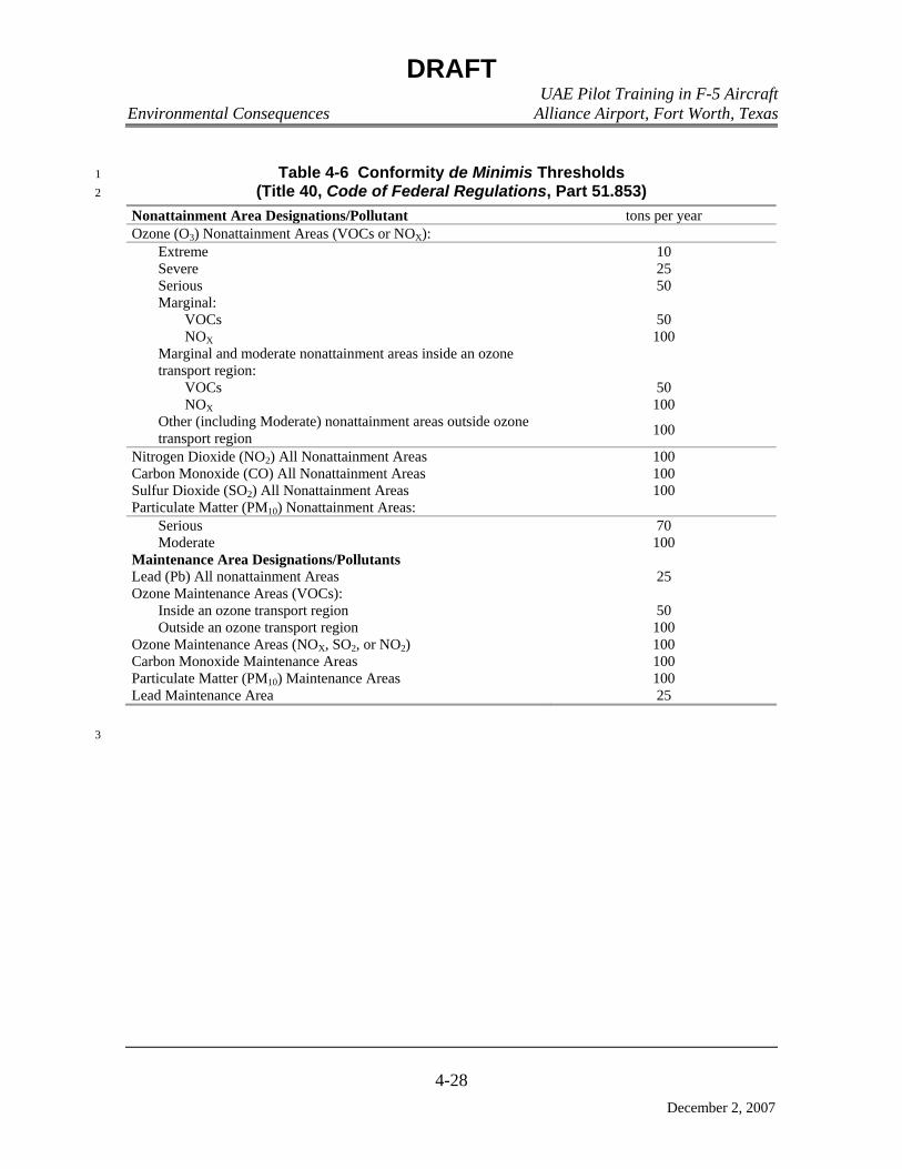
DRAFT UAE Pilot Training in F-5 Aircraft Environmental Consequences Alliance Airport, Fort Worth, Texas
4-28
December 2, 2007
Table 4-6 Conformity de Minimis Thresholds 1 (Title 40, Code of Federal Regulations, Part 51.853) 2
Nonattainment Area Designations/Pollutant tons per year Ozone (O3) Nonattainment Areas (VOCs or NOX): Extreme 10 Severe 25 Serious 50 Marginal: VOCs 50 NOX 100 Marginal and moderate nonattainment areas inside an ozone
transport region:
VOCs 50 NOX 100 Other (including Moderate) nonattainment areas outside ozone
transport region 100
Nitrogen Dioxide (NO2) All Nonattainment Areas 100 Carbon Monoxide (CO) All Nonattainment Areas 100 Sulfur Dioxide (SO2) All Nonattainment Areas 100 Particulate Matter (PM10) Nonattainment Areas: Serious 70 Moderate 100 Maintenance Area Designations/Pollutants Lead (Pb) All nonattainment Areas 25 Ozone Maintenance Areas (VOCs): Inside an ozone transport region 50 Outside an ozone transport region 100 Ozone Maintenance Areas (NOX, SO2, or NO2) 100 Carbon Monoxide Maintenance Areas 100 Particulate Matter (PM10) Maintenance Areas 100 Lead Maintenance Area 25
3

DRAFT UAE Pilot Training in F-5 Aircraft Environmental Consequences Alliance Airport, Fort Worth, Texas
4-29
December 2, 2007
Table 4-7 Dallas-Fort Worth Nonattainment Area Conformity Impact Table 1
Emissions (tons per year) State County CO NOX SO2 VOC PM10
DFW Nonattainment Area Texas Collin 121,326.00 15,235.00 1,684.00 14,191.00 37,645.00 Texas Dallas 657,129.00 81,080.00 3,629.00 77,116.00 48,928.00 Texas Denton 121,406.00 15,407.00 645.00 15,396.00 30,099.00 Texas Ellis 52,061.00 19,202.00 15,052.00 10,070.00 27,525.00 Texas Johnson 46,484.00 9,024.00 435.00 6,765.00 26,219.00 Texas Kaufman 29,889.00 4,286.00 223.00 5,476.00 16,347.00 Texas Parker 37,718.00 6,297.00 438.00 5,511.00 24,757.00 Texas Rockwall 12,539.00 1,431.00 89.00 1,916.00 7,173.00 Texas Tarrant 384,198.00 56,043.00 2,537.00 51,035.00 35,673.00
Nonattainment Area Total 1,462,750.00 208,005.00 24,732.00 187,476.00 254,366.00 AFW Operations
Aircraft Operations Trim Checks 15.94 1.12 0.32 0.81 0.41
Landing/Takeoff 192.98 3.93 1.77 18.44 5.56 AGE 0.65 3.14 0.07 0.24 0.10
Permanent Party Vehicles 17.08 0.61 0.00 1.01 0.00 Student Vehicles 0.75 0.03 0.00 0.04 0.00
Fuel Tanks (6) Loading/Unloading 0.00 0.00 0.00 0.06 0.00 Fuel Truck on Road 0.01 0.00 0.00 0.00 0.00
Fuel Truck Loading/Unloading 0.00 0.00 0.00 0.02 0.00 Aircraft Maintenance 0.00 0.00 0.00 1.62 0.00
Facility Heating 0.31 0.38 0.00 0.02 0.03 Proposed Action Total 227.72 9.21 2.16 22.26 6.10 Percent of Nonattainment Area Emissions 0.02% 0.00% 0.01% 0.01% 0.00%
DFW Dallas-Fort Worth CO carbon dioxide IR Instrument Flight Rules Military Training Route NOX nitrogen oxide
PM10 particulate matter with an aerodynamic diameter less than or equal to 10 microns SO2 sulfur dioxide VR Visual Flight Rules Military Training Route VOC volatile organic compound
Source: USEPA 2007
Emissions from source categories calculated for this conformity analysis include: 2
• F-5 aircraft operations (including landing/take-off and engine trim checks) 3
• Fuel loading operations 4
• Fuel storage tanks 5
• Privately-owned vehicles 6
• Fuel transport truck (on road) 7
• Fuel transport loading/unloading 8
• AGE 9
• Aircraft maintenance (degreasing vats) 10
• Facility heating 11

DRAFT UAE Pilot Training in F-5 Aircraft Environmental Consequences Alliance Airport, Fort Worth, Texas
4-30
December 2, 2007
No major construction would be associated with the 99,000-square foot training, 1
operations, maintenance, and supply facility because the building shell is already in place. 2
Existing aboveground JP-8 fuel storage tanks (20,000 gallons each), aircraft parking, and 3
vehicle parking are also in place. Interior building renovation and associated minor 4
construction were assumed to have minimal air quality impacts. 5
It should be noted that aircraft and other activities at AFW associated with the 6
proposed action would not have an impact on current permits or permit status. Because of 7
the minor types of maintenance activities associated with the proposed action, it is 8
anticipated that the facility can be exempted from obtaining a permit (would produce a de 9
minimis level of emissions), or at the least, be subject only to authorization through a PBR. 10
PBRs are state air authorizations for activities that produce more than a de minimis level of 11
emissions but less than other NSR permitting options. 12
4.2.11.3.2 Attainment Areas 13
Air quality effects on areas associated with MTAs would only occur during aircraft 14
operations associated with the proposed action. The operational effects are only associated 15
with low-level aircraft operations in Falcon Range, Brady Low MOA, VR-104, VR-118, 16
IR-103, and IR-105 at altitudes below 3,000 feet AGL. As discussed in Chapter 3, only 17
those portions of the flying operation that take place below the atmospheric mixing height 18
(3,000 feet AGL) are considered as low level (these are the only emissions presumed to 19
affect ground level concentrations). 20
The methods selected to analyze air quality effects depend on the type of emission 21
source being examined. Analysis of aircraft operations for this action includes estimating 22
emissions from flying activities only. No other aircraft operations in attainment areas are 23
associated with the proposed action (such as operation of ground support equipment, AGE, 24
or engine trim tests). 25
Fundamental steps in the evaluation of environmental effects on air quality are to 26
identify the sources of the effect, identify the quantitative measures for evaluating the 27
extent of the effect, and develop formulas for computing and assessing those measures. 28
These formulations are based on the types of data that are generally available or can easily 29
be collected for the proposed actions. For the MTA, only aircraft operations have been 30
targeted for analysis. The ACAM was used to calculate emissions from the various 31
sources previously discussed. 32
Under the proposed action, the MTAs would experience an increase in annual F-5 33
flight operations as shown in Table 4-8. 34
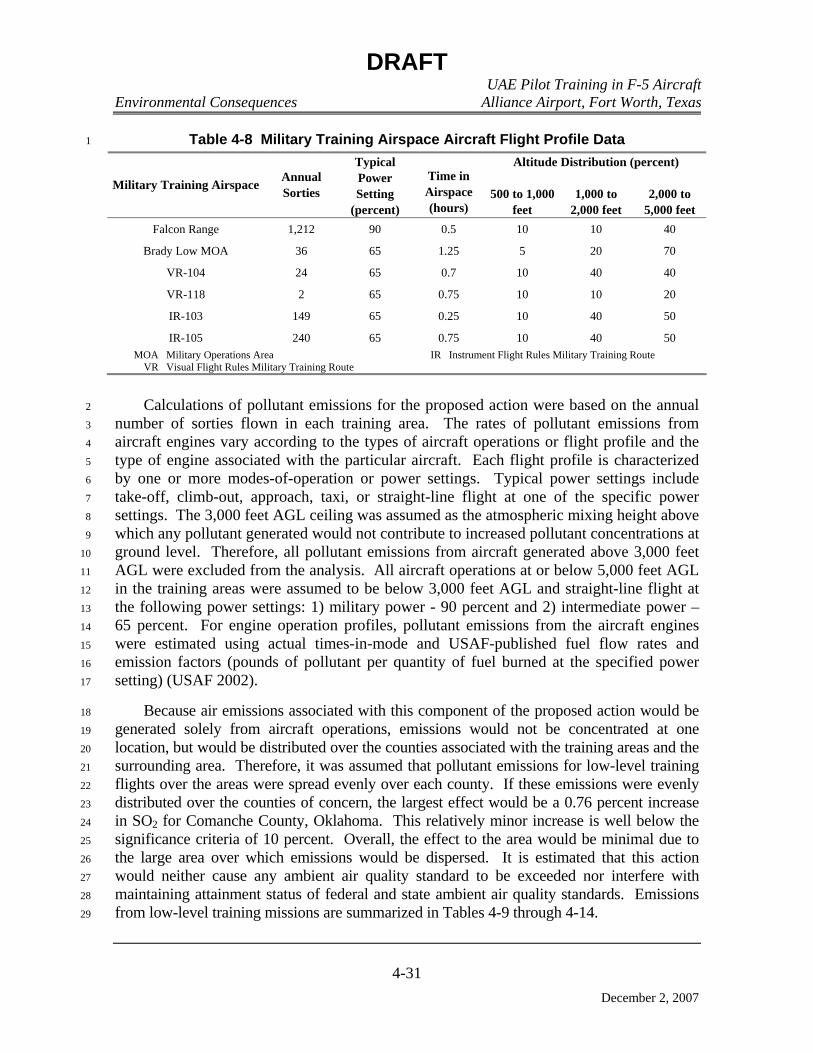
DRAFT UAE Pilot Training in F-5 Aircraft Environmental Consequences Alliance Airport, Fort Worth, Texas
4-31
December 2, 2007
Table 4-8 Military Training Airspace Aircraft Flight Profile Data 1
Altitude Distribution (percent)
Military Training Airspace Annual Sorties
Typical Power Setting
(percent)
Time in Airspace (hours)
500 to 1,000 feet
1,000 to 2,000 feet
2,000 to 5,000 feet
Falcon Range 1,212 90 0.5 10 10 40
Brady Low MOA 36 65 1.25 5 20 70
VR-104 24 65 0.7 10 40 40
VR-118 2 65 0.75 10 10 20
IR-103 149 65 0.25 10 40 50
IR-105 240 65 0.75 10 40 50 MOA Military Operations Area IR Instrument Flight Rules Military Training Route
VR Visual Flight Rules Military Training Route
Calculations of pollutant emissions for the proposed action were based on the annual 2
number of sorties flown in each training area. The rates of pollutant emissions from 3
aircraft engines vary according to the types of aircraft operations or flight profile and the 4
type of engine associated with the particular aircraft. Each flight profile is characterized 5
by one or more modes-of-operation or power settings. Typical power settings include 6
take-off, climb-out, approach, taxi, or straight-line flight at one of the specific power 7
settings. The 3,000 feet AGL ceiling was assumed as the atmospheric mixing height above 8
which any pollutant generated would not contribute to increased pollutant concentrations at 9
ground level. Therefore, all pollutant emissions from aircraft generated above 3,000 feet 10
AGL were excluded from the analysis. All aircraft operations at or below 5,000 feet AGL 11
in the training areas were assumed to be below 3,000 feet AGL and straight-line flight at 12
the following power settings: 1) military power - 90 percent and 2) intermediate power – 13
65 percent. For engine operation profiles, pollutant emissions from the aircraft engines 14
were estimated using actual times-in-mode and USAF-published fuel flow rates and 15
emission factors (pounds of pollutant per quantity of fuel burned at the specified power 16
setting) (USAF 2002). 17
Because air emissions associated with this component of the proposed action would be 18
generated solely from aircraft operations, emissions would not be concentrated at one 19
location, but would be distributed over the counties associated with the training areas and the 20
surrounding area. Therefore, it was assumed that pollutant emissions for low-level training 21
flights over the areas were spread evenly over each county. If these emissions were evenly 22
distributed over the counties of concern, the largest effect would be a 0.76 percent increase 23
in SO2 for Comanche County, Oklahoma. This relatively minor increase is well below the 24
significance criteria of 10 percent. Overall, the effect to the area would be minimal due to 25
the large area over which emissions would be dispersed. It is estimated that this action 26
would neither cause any ambient air quality standard to be exceeded nor interfere with 27
maintaining attainment status of federal and state ambient air quality standards. Emissions 28
from low-level training missions are summarized in Tables 4-9 through 4-14. 29
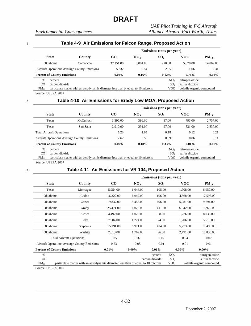
DRAFT UAE Pilot Training in F-5 Aircraft Environmental Consequences Alliance Airport, Fort Worth, Texas
4-32
December 2, 2007
Table 4-9 Air Emissions for Falcon Range, Proposed Action 1
Emissions (tons per year)
State County CO NOX SO2 VOC PM10
Oklahoma Comanche 37,151.00 8,004.00 270.00 5,879.00 14,062.00
Aircraft Operations Average County Emissions 59.32 9.54 2.05 1.06 2.31
Percent of County Emissions 0.02% 0.16% 0.12% 0.76% 0.02% % percent NOX nitrogen oxide
CO carbon dioxide SO2 sulfur dioxide PM10 particulate matter with an aerodynamic diameter less than or equal to 10 microns VOC volatile organic compound
Source: USEPA 2007
Table 4-10 Air Emissions for Brady Low MOA, Proposed Action 2
Emissions (tons per year)
State County CO NOX SO2 VOC PM10
Texas McCulloch 3,396.00 396.00 37.00 793.00 2,757.00
Texas San Saba 2,910.00 291.00 27.00 531.00 2,837.00
Total Aircraft Operations 5.23 1.05 0.18 0.12 0.21
Aircraft Operations Average County Emissions 2.62 0.53 0.09 0.06 0.11
Percent of County Emissions 0.09% 0.18% 0.33% 0.01% 0.00% % percent NOX nitrogen oxide
CO carbon dioxide SO2 sulfur dioxide PM10 particulate matter with an aerodynamic diameter less than or equal to 10 microns VOC volatile organic compound
Source: USEPA 2007
Table 4-11 Air Emissions for VR-104, Proposed Action 3
Emissions (tons per year)
State County CO NOX SO2 VOC PM10
Texas Montague 5,954.00 1,646.00 105.00 1,708.00 6,057.00
Oklahoma Caddo 16,322.00 6,042.00 196.00 4,568.00 17,595.00
Oklahoma Carter 19,832.00 5,455.00 696.00 5,081.00 9,794.00
Oklahoma Grady 25,471.00 6,072.00 411.00 6,542.00 18,925.00
Oklahoma Kiowa 4,492.00 1,025.00 98.00 1,276.00 8,036.00
Oklahoma Love 7,904.00 1,224.00 74.00 1,206.00 5,518.00
Oklahoma Stephens 15,191.00 5,971.00 424.00 5,773.00 10,496.00
Oklahoma Washita 7,813.00 1,762.00 96.00 2,491.00 10,038.00
Total Aircraft Operations 1.85 0.37 0.07 0.04 0.07
Aircraft Operations Average County Emissions 0.23 0.05 0.01 0.01 0.01
Percent of County Emissions 0.01% 0.00% 0.01% 0.00% 0.00% % percent NOX nitrogen oxide
CO carbon dioxide SO2 sulfur dioxide PM10 particulate matter with an aerodynamic diameter less than or equal to 10 microns VOC volatile organic compound
Source: USEPA 2007

DRAFT UAE Pilot Training in F-5 Aircraft Environmental Consequences Alliance Airport, Fort Worth, Texas
4-33
December 2, 2007
Table 4-12 Air Emissions for VR-118, Proposed Action 1
Emissions (tons per year) State County CO NOX SO2 VOC PM10 Texas Palo Pinto 12,508.00 3,694.00 104.00 2,836.00 6,068.00 Texas Stephens 3,322.00 658.00 43.00 1,128.00 2,591.00
Total Aircraft Operations 0.07 0.01 0.00 0.00 0.00 Aircraft Operations Average County Emissions 0.04 0.01 0.00 0.00 0.00 Percent of County Emissions 0.00% 0.00% 0.00% 0.00% 0.00%
% percent NOX nitrogen oxide CO carbon dioxide SO2 sulfur dioxide
PM10 particulate matter with an aerodynamic diameter less than or equal to 10 microns VOC volatile organic compound Source: USEPA 2007
Table 4-13 Air Emissions for IR-103, Proposed Action 2
Emissions (tons per year) State County CO NOX SO2 VOC PM10 Texas Archer 4,374 579 42 2,052 5,149 Texas Baylor 2,363 328 35 824 2,542 Texas Jack 2,937 1,100 26 1,726 2,643 Texas Wilbarger 5,716 7,520 4,072 1,797 6,226
Oklahoma Tillman 4,523 944 96 979 7,420 Total Aircraft Operations 4.56 0.91 0.16 0.10 0.18 Aircraft Operations Average County Emissions 0.91 0.18 0.03 0.02 0.04 Percent of County Emissions 0.04% 0.06% 0.12% 0.00% 0.00%
% percent NOX nitrogen oxide CO carbon dioxide SO2 sulfur dioxide
PM10 particulate matter with an aerodynamic diameter less than or equal to 10 microns VOC volatile organic compound Source: USEPA 2007
Table 4-14 Air Emissions for IR-105, Proposed Action 3
Emissions (tons per year) State County CO NOX SO2 VOC PM10 Texas Archer 4,374 579 42 2,052 5,149 Texas Baylor 2,363 328 35 824 2,542 Texas Hardeman 1,940 907 64 632 3,207 Texas Jack 2,937 1,100 26 1,726 2,643 Texas Wilbarger 5,716 7,520 4,072 1,797 6,226
Oklahoma Greer 1,871 364 35 472 3,601 Oklahoma Harmon 1,055 239 24 248 3,394 Oklahoma Jackson 8,076 1,539 113 1,477 8,708 Oklahoma Kiowa 4,492 1,025 98 1,276 8,036
Total Aircraft Operations 22 4 0.78 1 1 Aircraft Operations Average County Emissions 2.45 0.49 0.09 0.06 0.10 Percent of County Emissions 0.23% 0.20% 0.36% 0.02% 0.00%
% percent NOX nitrogen oxide CO carbon dioxide SO2 sulfur dioxide
PM10 particulate matter with an aerodynamic diameter less than or equal to 10 microns VOC volatile organic compound Source: USEPA 2007

DRAFT UAE Pilot Training in F-5 Aircraft Environmental Consequences Alliance Airport, Fort Worth, Texas
4-34
December 2, 2007
4.2.11.4 Cumulative Impacts 1
The portion of the proposed action occurring at AFW would contribute to air pollution 2
emissions in the DFW Nonattainment Area during flight and support operations. 3
However, the VOC and NOX emissions contributions from the project would be well 4
below the conformity de minimis level and well below the 10 percent regional significance 5
level. Therefore, any impacts would be negligible and would not impact air quality. 6
Within attainment areas, aircraft operations in the MTAs would affect regional air 7
quality goals and attainment standards, but the contribution from the project would be 8
negligible. This is demonstrated by the fact that emissions of all pollutants would be very 9
much less than the 10 percent annual emissions threshold established for each county. 10
Project emissions would not contribute to other county emissions in any appreciable 11
manner. 12
4.2.11.5 Measures to Reduce Impacts 13
The cumulative emissions of all pollutants would be significantly less than the 10 14
percent significance threshold for each county; therefore, the proposed action would not 15
impact air quality, and no mitigation measures will be required. 16
Chapter 5
List of Preparers
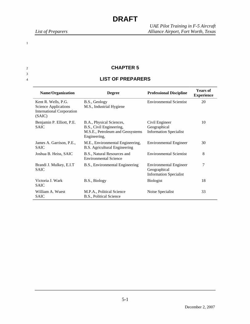
DRAFT UAE Pilot Training in F-5 Aircraft List of Preparers Alliance Airport, Fort Worth, Texas
5-1
December 2, 2007
1
CHAPTER 5 2
3
LIST OF PREPARERS 4
Name/Organization Degree Professional Discipline Years of Experience
Kent R. Wells, P.G. Science Applications International Corporation (SAIC)
B.S., Geology M.S., Industrial Hygiene
Environmental Scientist 20
Benjamin P. Elliott, P.E. SAIC
B.A., Physical Sciences, B.S., Civil Engineering, M.S.E., Petroleum and Geosystems Engineering,
Civil Engineer Geographical Information Specialist
10
James A. Garrison, P.E., SAIC
M.E., Environmental Engineering, B.S. Agricultural Engineering
Environmental Engineer 30
Joshua B. Heiss, SAIC B.S., Natural Resources and Environmental Science
Environmental Scientist 8
Brandi J. Mulkey, E.I.T SAIC
B.S., Environmental Engineering Environmental Engineer Geographical Information Specialist
7
Victoria J. Wark SAIC
B.S., Biology Biologist 18
William A. Wuest SAIC
M.P.A., Political Science B.S., Political Science
Noise Specialist 33
DRAFT UAE Pilot Training in F-5 Aircraft List of Preparers Alliance Airport, Fort Worth, Texas
5-2
December 2, 2007
THIS PAGE INTENTIONALLY LEFT BLANK 1

Chapter 6
Persons and Agencies Consulted

DRAFT UAE Pilot Training in F-5 Aircraft Persons and Agencies Contacted Alliance Airport, Fort Worth, Texas
6-1
December 2, 2007
1
CHAPTER 6 2
3
PERSONS AND AGENCIES CONSULTED 4
The following individuals and or agencies were consulted during the preparation of 5
this EA: 6
6.1 FEDERAL AGENCIES 7
Headquarters Air Education and Training Command 8
Erwin, Marion (Headquarters [HQ] AETC/A7CPP) 9
Voorhees, Ron (HQ AETC/A7CPP) 10
U.S. Fish and Wildlife Service 11
NEPA Program Coordinator 12
6.2 STATE AGENCIES 13
State Single Point of Contact 14
Francis, Denise S. 15
Texas Parks and Wildlife Department 16
Stone, Harold (Intergovernmental Affairs) 17
6.3 LOCAL AND REGIONAL GOVERNMENTAL AGENCIES 18
City of Fort Worth 19
Moncrief, Mike (Mayor) 20
North Central Texas Council of Governments 21
Promise, John (Director of Environment and Development) 22
Dallas-Fort Worth Airport, Environmental Affairs Department 23
Meacham International Airport 24
Cox, Ryan (Meacham International Airport System Director) 25
Waco Regional Airport 26
Howell, Richard (Waco Regional Airport Manager) 27
Brown County 28
Wood, Margaret (County Clerk) 29
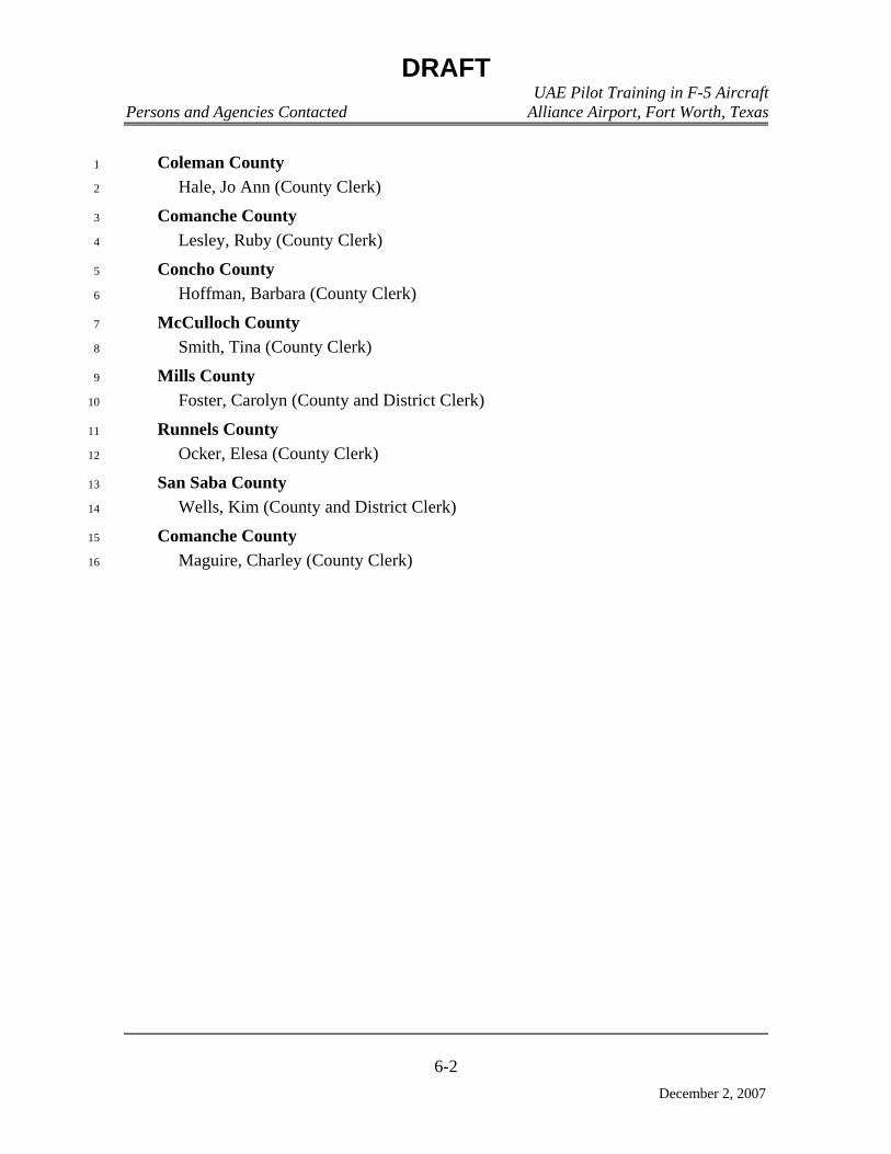
DRAFT UAE Pilot Training in F-5 Aircraft Persons and Agencies Contacted Alliance Airport, Fort Worth, Texas
6-2
December 2, 2007
Coleman County 1
Hale, Jo Ann (County Clerk) 2
Comanche County 3
Lesley, Ruby (County Clerk) 4
Concho County 5
Hoffman, Barbara (County Clerk) 6
McCulloch County 7
Smith, Tina (County Clerk) 8
Mills County 9
Foster, Carolyn (County and District Clerk) 10
Runnels County 11
Ocker, Elesa (County Clerk) 12
San Saba County 13
Wells, Kim (County and District Clerk) 14
Comanche County 15
Maguire, Charley (County Clerk) 16

Chapter 7
References
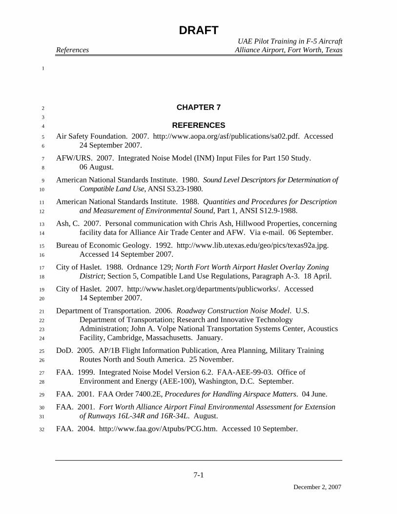
DRAFT UAE Pilot Training in F-5 Aircraft References Alliance Airport, Fort Worth, Texas
7-1
December 2, 2007
1
CHAPTER 7 2
3
REFERENCES 4
Air Safety Foundation. 2007. http://www.aopa.org/asf/publications/sa02.pdf. Accessed 5
24 September 2007. 6
AFW/URS. 2007. Integrated Noise Model (INM) Input Files for Part 150 Study. 7
06 August. 8
American National Standards Institute. 1980. Sound Level Descriptors for Determination of 9
Compatible Land Use, ANSI S3.23-1980. 10
American National Standards Institute. 1988. Quantities and Procedures for Description 11
and Measurement of Environmental Sound, Part 1, ANSI S12.9-1988. 12
Ash, C. 2007. Personal communication with Chris Ash, Hillwood Properties, concerning 13
facility data for Alliance Air Trade Center and AFW. Via e-mail. 06 September. 14
Bureau of Economic Geology. 1992. http://www.lib.utexas.edu/geo/pics/texas92a.jpg. 15
Accessed 14 September 2007. 16
City of Haslet. 1988. Ordnance 129; North Fort Worth Airport Haslet Overlay Zoning 17
District; Section 5, Compatible Land Use Regulations, Paragraph A-3. 18 April. 18
City of Haslet. 2007. http://www.haslet.org/departments/publicworks/. Accessed 19
14 September 2007. 20
Department of Transportation. 2006. Roadway Construction Noise Model. U.S. 21
Department of Transportation; Research and Innovative Technology 22
Administration; John A. Volpe National Transportation Systems Center, Acoustics 23
Facility, Cambridge, Massachusetts. January. 24
DoD. 2005. AP/1B Flight Information Publication, Area Planning, Military Training 25
Routes North and South America. 25 November. 26
FAA. 1999. Integrated Noise Model Version 6.2. FAA-AEE-99-03. Office of 27
Environment and Energy (AEE-100), Washington, D.C. September. 28
FAA. 2001. FAA Order 7400.2E, Procedures for Handling Airspace Matters. 04 June. 29
FAA. 2001. Fort Worth Alliance Airport Final Environmental Assessment for Extension 30
of Runways 16L-34R and 16R-34L. August. 31
FAA. 2004. http://www.faa.gov/Atpubs/PCG.htm. Accessed 10 September. 32

DRAFT UAE Pilot Training in F-5 Aircraft References Alliance Airport, Fort Worth, Texas
7-2
December 2, 2007
FAA. 2006a. http://www.faa.gov/airports_airtraffic/airports/planning_capacity/ 1
npias/reports/media/2007/NPIAS_2007_App_A_part_1.pdf. Accessed 2
18 September 2007. 3
FAA. 2006b. FAA Order 7400.8M, Special Use Airspace. 06 January. 4
FAA. 2007a. http://sua.faa.gov/sua/pans.do?selected=2&fromuf=UF. Accessed 5
12 September 2007. 6
FAA. 2007b. http://www.faa.gov/airports_airtraffic/airports/planning_capacity/ 7
passenger_allcargo_stats/categories/. Accessed 18 September 2007. 8
FAA 2007c. http://www.faa.gov/airports_airtraffic/air_traffic/publications/ATpubs/ 9
AIM/Chap3/aim0304.html. Accessed 18 September 2007. 10
FAA. 2007d. http://www.faa.gov/airports_airtraffic/air_traffic/publications/ATpubs/ 11
AIM/Chap3/aim0305.html. Accessed 18 September 2007. 12
FHWA. 2007. http://www.fhwa.dot.gov/ENVIRONMENT/freightaq/appendixc.htm. 13
Accessed 18 September 2007. 14
FICON. 1992. Federal Agency Review of Selected Airport Noise Analysis Issues. 15
FICUN. 1980. Guidelines for Considering Noise in Land Use Planning and Control. 16
Washington, D.C. NIIS PB83-184838. 17
Finegold, L.S., C.S. Harris, H.E. von Gierke. 1994. “Community Annoyance and Sleep 18
Disturbance: Updated Criteria for Assessing the Impacts of General Transportation 19
Noise on People.” Noise Control Engineering Journal, January – February. 20
Harrison. 1973. Forest Background Sound. Report to Record, ED&T 2428, USDA Forest 21
Service, Technology and Development Center, San Dimas, California. In: 22
Harrison, R.T., L.A. Hartmann, and W.J. Makel. 1990. Annoyance from Aircraft 23
Overflights in Wilderness. NOISE-CON 90, University of Texas. Austin, Texas. 24
October. 25
Henning, R. 2007. Personal communication with Richard Henning, 46 WS/WTS, 26
Eglin AFB, concerning climate data for Fort Worth NAS JRB. August. 27
Hillwood. 2004. Alliance Air Trade Center Plans. 28
Hillwood. 2007a. Fort Worth Alliance Airport (handout). 29
Hillwood. 2007b. AFW Master Plan. 30
Lucas, M.J. and P.T. Calamia. 1996. Military Operating Area and Range Noise Model 31
MR_NMAP Users Manual. Occupational and Environmental Health Directorate, 32
Bioenvironmental Engineering Division, Noise Effects Branch, Wright Patterson 33
AFB, OH. AL/OE-MN-1996-0001. June. 34
NRCS. 2007a. http://www2.ftw.nrcs.usda.gov/osd/dat/S/SANGER.html. Accessed 35
25 September 2007. 36

DRAFT UAE Pilot Training in F-5 Aircraft References Alliance Airport, Fort Worth, Texas
7-3
December 2, 2007
NRCS. 2007b. http://www2.ftw.nrcs.usda.gov/osd/dat/P/PONDER.html. Accessed 1
25 September 2007. 2
NCTCOG. 2007a. http://dfwmaps.com/index.asp?ExtentLeft=2329140&ExtentRight= 3
2332401&ExtentTop=7050672.46163495&ExtentBottom=7047728.89247978&id4
Cmd=&buffer=&x1=&x2=&y1=&y2=&tool=&click.x=&click.y=&product=&Req5
uests=on&selectpt.x=&selectpt.y=&selectpt.stat=&Address=&CityZip=&L. 6
Accessed 18 September 2007. 7
NCTCOG. 2007b. www.nctcog.org-envir-SEELT-disposal-facilities-landfills. Accessed 8
18 September 2007. 9
NCTCOG. 2007c. www.nctcog.org/trans/legislative/SAFETEA-LU_Projects.pdf. 10
Accessed 18 September 2007. 11
NCTCOG. 2007d. http://www.nctcog.org/trans/tip/index.asp. Accessed 18 September 2007. 12
OSHA. 1983. Occupational Noise Exposure Standard. Title 29, CFR, Part 1910, 13
Section 1910.95. 14
OCDS. 1998. Operational Climatic Data Summary, Fort Worth NAS Texas, Air Force 15
Combat Climatology Center. October. 16
ODWC. 2007. http://www.wildlifedepartment.com/endanger2.htm. Accessed 25 October 2007. 17
Robinson. 2007. Personal communication with Kathryn Robinson, Environmental 18
Scientist, KJR & Associates, Inc. 22 October 2007. 19
TCEQ. 2007a. http://www.tceq.state.tx.us/files/rg-411.pdf_4006396.pdf. Accessed 20
21 September 2007. 21
TCEQ. 2007b. DFW-Area.pdf_4027564.pdf. Accessed 18 September 2007. 22
TFRN. 1982. Terminal Forecast Reference Notebook, Detachment 22, 26th Weather 23
Squadron, Carswell AFB, Texas. May. 24
TPWD. 2007. http://www.tpwd.state.tx.us/landwater/land/maps/gis/ris/endangered_ 25
species.phtml. Accessed 28 September 2007. 26
TRA. 2007. http://www.trinityra.org/Facilities/facilities_wastewater_treatment3.htm. 27
Accessed 13 September 2007. 28
URS. 2006. Fort Worth Alliance Airport FAR Part 150 Noise Compatibility Study. 29
August. 30
USAF. 2001. AFI 13-201. Space, Missile, Command and Control. Air Force Airspace 31
Management. 20 September. 32

DRAFT UAE Pilot Training in F-5 Aircraft References Alliance Airport, Fort Worth, Texas
7-4
December 2, 2007
USAF. 2002. Air Emissions Inventory Guidance Document for Mobile Sources at Air 1
Force Installations (revised December 2003), IERA-RS-BR-SR-2001-0010. Air 2
Force Institute for Environment, Safety and Occupational Health Risk Analysis, 3
Risk Analysis Directorate, Environmental Analysis Division, Brooks AFB Texas. 4
January. 5
USAF. 2005a. United States Air Force Air Conformity Applicability Model, Version 4.3, 6
User’s Guide. Air Force Center for Environmental Excellence. December. 7
USAF. 2005b. United States Air Force Air Conformity Applicability Model, Version 4.3, 8
Technical Documentation. Air Force Center for Environmental Excellence. 9
December. 10
USAF. 2007. https://www.denix.osd.mil/denix/Public/ES-Programs/Planning/Eiap/ 11
eiap1.html#aa. Accessed 19 October 2007. 12
USACE. 2006. Final EA Implementation of Base Realignment and Closure 13
Recommendations at Fort Sill, Oklahoma. Fort Sill, Oklahoma. August. 14
U.S. Army. 2003. Integrated Natural Resources Management Plan, Fort Sill, Oklahoma. 15
U.S. Army. 2006. HQ U.S. Army Field Artillery Center and Fort Sill Supplemental 16
Amendment to Existing EA Rulemaking Proposal for Establishing SUA, Fort Sill, 17
Oklahoma. June. 18
U.S. Army. 2007. Personal communication with Toni Hodgkins, Natural Resources 19
Specialist, IMWE-SIL-PWE, Fort Sill, Oklahoma. 25 October 2007. 20
USBC. 2007a. http://www.census.gov/population/estimates/metro_general/List4.txt. 21
Accessed 29 September 2007. 22
USBC. 2007b. http://quickfacts.census.gov/cgi-bin/qfd/location. Accessed 29 September 2007. 23
USBC. 2007c. http://quickfacts.census.gov/qfd/states/48000.html. Accessed 29 September 2007. 24
USBC. 2007d. http://factfinder.census.gov/servlet/ACSSAFFFacts?_event=Search&geo_id=04000US48& 25
_geoContext=01000US%7C04000US48%7C05000US48439&_street=&_county=tarrant&_cityTo26
wn=tarrant&_state=04000US48&_zip=&_lang=en&_sse=on&ActiveGeoDiv=geoSelect&_useEV=27
&pctxt=fph&pgsl=040&_submenuId=factsheet_1&ds_name=ACS_2006_SAFF&_ci_nbr=null&qr_28
name=null®=null%3Anull&_keyword=&_industry=. Accessed 29 September 2007. 29
USBC. 2007e. http://factfinder.census.gov/servlet/ACSSAFFFacts?_event=Search&geo_id=&_geoContext 30
=&_street=&_county=fort+worth&_cityTown=fort+worth&_state=04000US48&_zip=&_lang=en&31
_sse=on&pctxt=fph&pgsl=010. Accessed 29 September 2007. 32
USBC. 2007f. http://factfinder.census.gov/servlet/ACSSAFFFacts?_event=Search&geo_id=&_geoContext 33
=&_street=&_county=&_cityTown=&_state=04000US48&_zip=&_lang=en&_sse=on&pctxt=fph&34
pgsl=010. Accessed 29 September 2007. 35
USBC. 2007g. http://factfinder.census.gov/servlet/ACSSAFFFacts?_submenuId=factsheet_1&_sse=on. 36
Accessed 29 September 2007. 37
DRAFT UAE Pilot Training in F-5 Aircraft References Alliance Airport, Fort Worth, Texas
7-5
December 2, 2007
USBC. 2007h. http://quickfacts.census.gov/qfd/states/40/40031.html. Accessed 24 October 2007. 1
USBC. 2007i. http://www.census.gov/population/cencounts/ok190090.txt. Accessed 24 October 2007. 2
USBC. 2007j. http://quickfacts.census.gov/qfd/states/40000.html). Accessed 24 October 2007. 3
USBC. 2007k. http://quickfacts.census.gov/qfd/states/40/4041850.html. Accessed 24 October 2007. 4
USBC. 2007l. http://www.census.gov/population/www/socdemo/hispanic/hispdef.html. 5
Accessed 13 November 2007. 6
USBC. 2007m. http://www.census.gov/population/cen2000/phc-2-a-B.pdf. Accessed 13 7
November 2007. 8
USBC. 2007n. http://factfinder.census.gov/servlet/ACSSAFFFacts?_event=Search&geo_id=04000US40 9
&_geoContext=01000US%7C04000US40&_street=&_county=comanche+county&_cityTown=co10
manche+county&_state=04000US40&_zip=&_lang=en&_sse=on&ActiveGeoDiv=geoSelect&_use11
EV=&pctxt=fph&pgsl=040&_submenuId=factsheet_1&ds_name=ACS_2006_SAFF&_ci_nbr=null12
&qr_name=null®=null%3Anull&_keyword=&_industry=. 13
USBC. 2007o. http://factfinder.census.gov/servlet/ACSSAFFFacts?_event=Search&geo_id=04000US40 14
&_geoContext=01000US%7C04000US40%7C05000US40031&_street=&_county=&_cityTown=15
&_state=04000US40&_zip=&_lang=en&_sse=on&ActiveGeoDiv=geoSelect&_useEV=&pctxt=fph16
&pgsl=040&_submenuId=factsheet_1&ds_name=ACS_2006_SAFF&_ci_nbr=null&qr_name=null17
®=null%3Anull&_keyword=&_industry= 18
USEPA. 1974. Information on Levels of Environmental Noise Requisite to Protect the 19
Public Health and Welfare with an Adequate Margin of Safety, EPA Report 20
550/9-74-004. 21
USEPA. 1995. AP-42 or Compilation of Air Pollutant Emission Factors, Fifth Edition, 22
Volume I: Stationary Point and Area Sources, including Supplements A through F, 23
Office of Air Quality Planning and Standards, Research Triangle Park, NC. 24
January. 25
USEPA. 1999. User’s Guide to TANKS, Storage Tank Emissions Calculations Software, 26
Version 4.0. September. 27
USEPA. 2001. Visibility in Mandatory Federal Class I Areas (1994-1998), EPA-452/R-28
01-008, U.S. Environmental Protection Agency, Office of Air Quality Planning and 29
Standards, Research Triangle Park, NC 27711. November. 30
USEPA. 2007. http://www.epa.gov/ttn/chief/net/2001inventory.html. 31
Accessed September. 32

DRAFT UAE Pilot Training in F-5 Aircraft References Alliance Airport, Fort Worth, Texas
7-6
December 2, 2007
THIS PAGE INTENTIONALLY LEFT BLANK 1
Appendix A
Interagency and Intergovernmental Coordination for Environmental
Planning Notices of Availability
DRAFT UAE Pilot Training in F-5 Aircraft Appendix A Alliance Airport, Fort Worth, Texas
December 2, 2007
APPENDIX A
INTERAGENCY AND INTERGOVERNMENTAL COORDINATION FOR ENVIRONMENTAL PLANNING
DRAFT UAE Pilot Training in F-5 Aircraft Appendix A Alliance Airport, Fort Worth, Texas
December 2, 2007
THIS PAGE INTENTIONALLY LEFT BLANK 1


Attachment 1
SUMMARY DESCRIPTION OF THE PROPOSED
UNITED ARAB EMIRATES (UAE) GRADUATE PILOT TRAINING PROGRAM ALLIANCE AIRPORT, FORT WORTH, TEXAS
The United States Air Force (USAF) proposes to conduct Introduction to Fighter Fundamentals (IFF)
pilot training for UAE pilots in F-5 aircraft at Alliance Airport in preparation for follow-on training in F-16 fighter aircraft by the Arizona National Guard in Tucson, Arizona. The UAE IFF pilot training would be conducted by Lockheed Martin, which would provide instructor pilots, support personnel, equipment, and the facilities to sustain the pilot training program. USAF personnel would perform contracting duties, including oversight and evaluation of contract performance to ensure USAF training standards are met.
The UAE requested this training through the United States Government's Foreign Military Sales (FMS) Program. The FMS Program is part of Security Assistance authorized by the Arms Export Control Act, and includes training as well as the sale of equipment. The UAE specifically requested that Lockheed Martin provide the IFF pilot training program at Alliance Airport because Lockheed Martin manufactures the F-16 fighter aircraft used in the follow-on UAE pilot training conducted in Arizona.
The UAE Air Force has purchased F-16 aircraft from Lockheed Martin through the FMS Program, and must train their pilots to fly the newly acquired aircraft. Contractor-provided training is necessary because the USAF currently does not have the capacity to conduct the pilot training at a rate and within the required timeframe necessary to support the UAE Air Force’s transition.
The proposed action consists of bed down of 15 F-5 aircraft, employment of approximately 93 support personnel, interior facility modifications of an existing building at Alliance Airport (Figure 1), and a classroom and flying program for approximately 22 UAE Air Force pilots per year for a 2-year period beginning in 2008. However, there would be an option to extend the pilot training program to a total of 5 years.
UAE student pilots would be taught by flight instructors who are both current Lockheed Martin employees and USAF reservists. A USAF approved training syllabus would be used. The proposed IFF pilot training program would be a graduate flying program involving Air to Air (A/A) and Air to Ground (A/G) training. UAE pilots would fly the F-5 aircraft in existing Special Use Airspace (SUA) managed by military units at Naval Reserve Station Joint Reserve Base Fort Worth and Fort Sill, Lawton Oklahoma. The proposed SUA for IFF A/A training are Military Operations Areas (MOA) Brady and Brownwood (Figure 2). The proposed SUA for IFF A/G training is Restricted Area R-5601C (Falcon Range) (Figure 2). F-5 aircraft flying from Alliance Airport would operate on the following Military Training Routes: IR-103, IR-105, VR-104, and VR-118 (Figure 2).
The bed down of 15 F-5 aircraft at Alliance Airport would result in a subsequent increase in aircraft operations at the facility, however, there would be no aircraft operations during “nighttime” hours (i.e., after 10 p.m. and before 7 a.m.). No changes to existing flight tracks or establishment of new flight tracks would be required.
Approximately 93 personnel would be employed in 2008 to support the proposed IFF pilot training program. Facility improvements would be required to support the proposed IFF pilot training program, specifically, an existing 99,000 square-foot building would need to be finished. The facility would provide space for offices, classrooms and training rooms, briefing rooms, aircraft maintenance and parts supply storage, and aircraft storage. An aircraft parking area would be located on the east side of the building.

Figure 1
Regional Location Map, All iance Airport and Naval Air Stat ion Joint Reserve Base Fort Worth, Texas

Figure 2
Military Training Routes, Military Operating Area, and Ranges, Proposed Action

Attachment 2
Distribution List UAE Pilot Training at Alliance Airport, Fort Worth Texas
Mike Moncrief Mayor of Fort Worth Fort Worth City Council City Hall 1000 Throckmorton Street Fort Worth, TX 76102
John Promise Director of Environment and Development North Central Texas Council of Governments 616 Six Flags Drive, Suite 200 Arlington, TX 76011
301 OG/RO Roy R. Queretaro Director Airspace, Ranges, Airfields 1654 Lyons Dr., Rm 142 NAS JRB Fort Worth, TX 76127-6200
NEPA Program Coordinator Environmental Affairs Department DFW Airport Administration Building 3200 E. Airfield Drive DFW Airport, TX 75261
Ryan Cox Meacham International Airport System Director 4201 N. Main St., Suite 200 Fort Worth, TX 76106-2749
Richard C. Howell, A.A.E. Waco Regional Airport Manager 7909 Karl May Drive Waco, TX 76708
Margaret Wood Brown County Clerk 200 South Broadway Brownwood, TX 76801-3136
Jo Ann Hale Coleman County Clerk 100 W. Live Oak Street, Suite 105 Coleman, TX 76834
Ruby Lesley Comanche County Clerk County Courthouse 101 West Central Comanche, TX 76442-3264
Barbara Hoffman Concho County District and County Clerk County Courthouse Paint Rock, TX 76866
Tina A. Smith McCulloch County Clerk County Courthouse Square Brady, TX 76825
Carolyn Foster Mills County District and County Clerk 1011 Fourth Street Goldthwaite, TX 76844
Elesa Ocker Runnels County Clerk 613 Courthouse Square Ballinger, TX 76821
Kim Wells San Saba County District and County Clerk Courthouse 500 East Wallace Street San Saba, TX 76877
Charley Maguire Comanche County Clerk Comanche County Courthouse 315 SW 5th Street, Room 304 Lawton, OK 73501
Denise S. Francis State Single Point of Contact Governor's Office of Budget and Planning State Insurance Building 1100 San Jacinto Austin, TX 78701
Harold Stone Intergovernmental Affairs Texas Parks and Wildlife Department 4200 Smith School Road Austin, TX 78744
NEPA Program Coordinator Texas Ecological Services Field Office U.S. Fish and Wildlife Service Compass Bank Bldg. 10711 Burnet Road, Suite 200 Austin, TX 78758

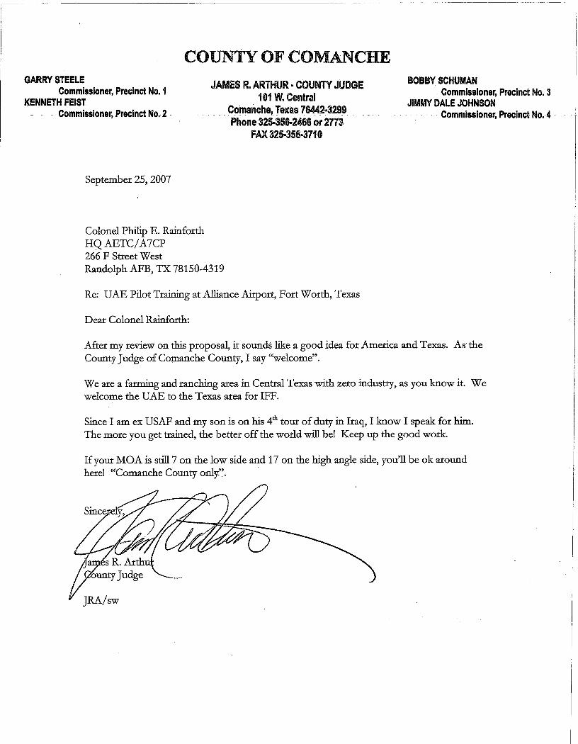


Appendix B
Air Pollutant Emission Calculation Methodology and Calculations
Conformity Applicability Analysis

DRAFT UAE Pilot Training in F-5 Aircraft Appendix B Alliance Airport, Fort Worth, Texas
December 2, 2007
APPENDIX B
AIR POLLUTANT EMISSION CALCULATION METHODOLOGY AND CALCULATIONS
CONFORMITY APPLICABILITY ANALYSIS

DRAFT UAE Pilot Training in F-5 Aircraft Appendix B Alliance Airport, Fort Worth, Texas
December 2, 2007
THIS PAGE INTENTIONALLY LEFT BLANK 1
DRAFT UAE Pilot Training in F-5 Aircraft Appendix B Alliance Airport, Fort Worth, Texas
B-1
December 2, 2007
CLEAN AIR ACT GENERAL CONFORMITY APPLICABILITY ANALYSIS 1
The purpose of this CAA conformity analysis is to document whether the proposed 2
UAE IFF pilot training program at AFW conforms to the current USEPA-approved portion 3
of the of the SIP for the DFW Nonattainment Area. Therefore, the objective of the 4
analysis is to assess the air quality impacts from all emissions-generating activities 5
associated with the proposed action and determine the ability of AFW to accept this 6
additional mission under the final General Conformity Rule. In accordance with 7
Section 176(c), USEPA promulgated the General Conformity Rule that is codified at 8
Title 40, CFR, Part 51, Subpart W. 9
On November 30, 1993, USEPA promulgated a final rule on conformity of federal 10
projects that are not related to transportation programs, plans, or projects. Such non-11
transportation projects are referred to as “general” projects, and hence, conformity of such 12
projects is referred to as “general conformity.” USEPA promulgated a separate rule on 13
conformity of transportation-related projects that is not relevant to the proposed training 14
program at AFW. 15
The analysis is limited to the criteria pollutants for which the DFW Nonattainment 16
Area is designated as nonattainment. The criteria pollutant of concern is O3, and the O3 17
precursors of concern are VOCs and NOX. 18
Section 176(c) of the CAA prohibits a federal agency from implementing, approving, 19
or supporting any activity that fails to conform to an approved SIP. The statute provides 20
that conforming to a SIP or FIP means that the activity will not: 21
1. Cause or contribute to any new violation of the NAAQS for any criteria air 22
pollutant. 23
2. Increase the frequency or severity of any existing violation of any standard in 24
the area. 25
3. Delay timely attainment of any standard or any required interim emission 26
reductions or other milestones in any area. 27
The DoD, like all federal agencies, is subject to the general conformity determination 28
as specified in Section 176I of the CAA, codified at 42 USC §7506(c). The conformity 29
determination is made in accordance with USEPA’s final rule, Determining Conformity of 30
General Federal Actions to State or Federal Implementation Plans, as published in the 31
Federal Register on November 30, 1993. The specific purpose of Section 176(c) is to 32
make emissions from federal activities consistent with the air quality planning goals of the 33
CAA. The conformity rule applies only in those air basins or parts of air basins designated 34
as nonattainment for one or more of the NAAQS or attainment areas subject to 35
maintenance plans (maintenance area). A maintenance plan establishes measures and 36

DRAFT UAE Pilot Training in F-5 Aircraft Appendix B Alliance Airport, Fort Worth, Texas
B-2
December 2, 2007
procedures to control emissions to ensure that the air quality standard is maintained in 1
areas that have been redesignated from a previous nonattainment status to attainment. 2
The General Conformity Rule establishes an elaborate process for analyzing and 3
determining whether a proposed federal action (proposed action) in a nonattainment area 4
conforms to the SIP. The SIP provides for the implementation, maintenance, and 5
enforcement of the NAAQS. The process generally involves the following four steps. 6
First, the federal agency (the agency) must determine whether all or part of the 7
proposed action is specifically exempted from the General Conformity Rule pursuant to 8
Title 40, CFR, Part 51.853(c) to (e). The rule exempts certain types of actions that (1) 9
would result in little or no emissions or that (2) undergo an air quality analysis (due to 10
requirements of other laws and regulations) that is functionally equivalent to a conformity 11
determination under the General Conformity Rule. 12
Secondly, the agency must determine whether all or part of the proposed action can be 13
presumed to conform pursuant to Title 40, CFR, Part 51.853(f). The General Conformity 14
Rule allows each agency to establish special categories of actions that can be presumed not 15
to result in nonconforming pollutant emissions or emissions exceeding certain threshold 16
(“de minimis”) amounts based on past experience. These categorical presumptions must be 17
proposed and published in the Federal Register by the agency prior to use. The 18
presumption that the proposed action conforms under this procedure can be challenged 19
when it is shown that the action does not in fact conform to the SIP. Additionally, an 20
action that otherwise may be presumed to meet conformance criteria but results in total 21
emissions that equal or exceed 10 percent of the AQCR’s emissions inventory for any 22
criteria pollutant would be considered a “regionally significant action” and could not be 23
presumed to conform. 24
Thirdly, if the entire proposed action cannot be excluded on the basis of an exemption 25
or presumption, the agency must determine whether the proposed action can be excluded 26
as a de minimis project. A de minimis project is one where the total of direct and indirect 27
emissions for reach type of nonattainment pollutant from the proposed action falls below 28
certain de minimis levels described in Title 40, CFR, Part 51.853(b). The de minimis 29
emission rates are listed in Table 1. 30
In determining a de minimis exclusion, the agency calculates the total of direct and 31
indirect emissions for each type of nonattainment pollutant resulting from the project on a 32
tpy basis. Direct emissions are the emissions of a criteria pollutant (or its precursors) 33
caused or initiated by the proposed action and occur at the same time and place as the 34
action. Indirect emissions are the emissions of a criteria pollutant (or its precursors) that 35
are caused by the proposed action but may occur later in time and/or may be further 36
removed in distance from the action itself but are still reasonably foreseeable and 37
practicably controllable. 38

DRAFT UAE Pilot Training in F-5 Aircraft Appendix B Alliance Airport, Fort Worth, Texas
B-3
December 2, 2007
Table 1 Conformity de Minimis Thresholds 1 (Title 40, Code of Federal Regulations, Part 51.853) 2
Nonattainment Area Designations/Pollutant tons per year Ozone (O3) Nonattainment Areas (VOCs or NOX): Extreme 10 Severe 25 Serious 50 Marginal: VOCs 50 NOX 100 Marginal and moderate nonattainment areas inside an ozone
transport region:
VOCs 50 NOX 100 Other (including Moderate) nonattainment areas outside ozone
transport region 100
Nitrogen Dioxide (NO2) All Nonattainment Areas 100 Carbon Monoxide (CO) All Nonattainment Areas 100 Sulfur Dioxide (SO2) All Nonattainment Areas 100 Particulate Matter (PM10) Nonattainment Areas: Serious 70 Moderate 100 Maintenance Area Designations/Pollutants Lead (Pb) All nonattainment Areas 25 Ozone Maintenance Areas (VOCs): Inside an ozone transport region 50 Outside an ozone transport region 100 Ozone Maintenance Areas (NOX, SO2, or NO2) 100 Carbon Monoxide Maintenance Areas 100 Particulate Matter (PM10) Maintenance Areas 100 Lead Maintenance Area 25
Total emissions exclude the emissions resulting from portions of the project that can 3
be exempted or presumed to conform, and reflect the “net” emissions caused by the 4
proposed action. The calculated total emission rates are compared to the de minimis levels, 5
and if the total is less than the de minimis levels, the action is exempt from further analyses 6
provided that the action’s emissions do not equal or exceed 10 percent of the AQCR’s 7
emissions inventory for each nonattainment criteria pollutant (i.e., the action would not be 8
considered a regionally significant action). 9
Lastly, if the entire action has not satisfied any of previous exemptions or 10
presumptions, the agency must conduct a full-scale conformity analysis that concludes 11
with a conformity determination after allowing opportunity for review and comment by the 12
public and other interested federal, state, and local agencies. The analysis must 13
demonstrate that the project meets requirements of reasonable further progress and/or SIP 14
requirements under Title 40, CFR, Parts 51.858 and 51.859. If the action does not satisfy 15
the criteria in Title 40, CFR, Part 51.858, the agency must take mitigation measures 16
pursuant to Title 40, CFR, Part 51.860 to arrive at a positive conformity determination. 17
DRAFT UAE Pilot Training in F-5 Aircraft Appendix B Alliance Airport, Fort Worth, Texas
B-4
December 2, 2007
The General Conformity Rule only requires analysis of those criteria pollutants for 1
which an air basin or portion of an air basin is designated as a nonattainment or 2
maintenance area. A criteria pollutant is a pollutant for which an NAAQS has been 3
established under the CAA. 4
In order to protect public health and welfare, the USEPA has developed numerical 5
concentration-based standards or NAAQS for six “criteria” pollutants (based on health 6
related criteria) under the provisions of the CAA (CAA Amendments of 1970). There are 7
two kinds of NAAQS: primary and secondary standards. Primary standards prescribe the 8
maximum permissible concentration in the ambient air to protect public health including 9
the health of “sensitive” populations such as asthmatics, children, and the elderly. 10
Secondary standards prescribe the maximum concentration or level of air quality required 11
to protect public welfare including protection against decreased visibility, damage to 12
animals, crops, vegetation, and buildings. 13
National ambient air quality standards have been established for: (1) O3, (2) NO2, (3) 14
CO, (4) SOX: measured in terms of sulfur dioxide (SO2), (5) Pb, and (6) particulate matter. 15
Particulate matter standards incorporate two particulate size classes: (1) particulate matter 16
with an aerodynamic diameter (diameter of a spherical particle having a density of 1 17
gm/cm3 that has the same inertial properties (terminal settling velocity) in the gas as the 18
particle of interest) less than or equal to 10 microns (PM10), and (2) particulate matter with 19
an aerodynamic diameter less than or equal to 2.5 microns. The NAAQS are the 20
cornerstone of the CAA. Although not directly enforceable, they are the benchmark for the 21
establishment of emission limitations by the states for the pollutants that USEPA 22
determines may endanger public health or welfare. 23
O3 (ground level O3), a major component of “smog,” is not directly emitted into the 24
atmosphere but is formed in the atmosphere through the reactions of previously emitted 25
pollutants or precursors (VOCs and NOX) in the presence of sunlight. 26
Regarding the regulatory status of NOX and NO2: NO2 is regulated as a criteria 27
pollutant, but it is rarely a problem; all of the proposed project activities are in areas that 28
comply the NO2 standard. However, because NOX is an O3 precursor, sources that emit 29
NOX are regulated as well as photochemically reactive VOCs in areas designated as 30
nonattainment for the O3 standard. 31
AFW is located in Tarrant County, located within the airshed designated by USEPA as 32
the Metropolitan Dallas-Fort Worth Intrastate AQCR 215. AQCR 215 consists of the 33
territorial area encompassed by the boundaries of the following jurisdictions as described 34
in Title 40, CFR, Part 81.39: 35
Collin County, Cooke County, Dallas County, Denton County, Ellis County, 36
Erath County, Fannin County, Grayson County, Hood County, Hunt County, 37
Johnson County, Kaufman County, Navarro County, Palo Pinto County, Parker 38
County, Rockwall County, Somervell County, Tarrant County, Wise County 39

DRAFT UAE Pilot Training in F-5 Aircraft Appendix B Alliance Airport, Fort Worth, Texas
B-5
December 2, 2007
Designation: Unclassifiable/attainment for all pollutants except for the nine counties 1
located in the DFW Nonattainment Area. These nine counties (Collin, Dallas, Denton, 2
Ellis, Johnson, Kaufman, Parker, Rockwall, and Tarrant counties) are classified as 3
moderate nonattainment for the 8-hr ozone standard. 4
The conformity analysis address the peak one-year period of emissions associated with 5
the proposed action (AFW) – flight training program operating at full capacity. In 6
evaluating this project for conformity, it was determined that the proposed action is not 7
specifically exempted pursuant to Title 40, CFR, Parts 51.853(c) - (e), nor is it 8
presumptively exempted under Title 40, CFR, Part 51.853 (f). In determining a de minimis 9
exclusion, calculations of the total direct emissions (e.g., aircraft operations, aerospace 10
ground equipment operations, fuel loading/storage maintenance activities) and indirect 11
emissions (e.g., vehicle traffic) for each of the ozone precursors (VOCs and NOX) resulting 12
from the action were performed on a tpy basis. The calculated total emission rates were 13
then compared to the de minimis levels referenced in Title 40, CFR, Part 51.853(b) (refer 14
to Table 1 above). A de minimis project is one where the total of direct and indirect 15
emissions for each one of the O3 precursors resulting from the project falls below the 16
specific de minimis level for the nonattainment area. In this case, the relevant category for 17
ozone precursors in Table 1 would be “Other ozone nonattainment areas outside an ozone 18
transport region.” The de minimis levels for this conformity applicability analysis are 19
100 tpy each for VOC and NOX emissions. If the total falls below the de minimis levels, 20
the action is exempted from further conformity analyses pursuant to Title 40, CFR, 21
Part 51.853(c) provided that the projected emissions do not equal or exceed 10 percent of 22
the AQCR’s emissions inventory for each of the precursors (i.e., it is not a regionally 23
significant action). 24
Analysis of VOC and NOX emissions projected to occur from the portion of the 25
proposed action that would occur at AFW indicates that the proposed action is well below 26
the required de minimis levels of 100 tpy for each pollutant and well below 10 percent of 27
the nonattainment area’s emissions inventory - indicating the proposed action is not a 28
regionally significant action. Since the proposed action meets the conformity de minimis 29
exemption requirements, no further analysis is required with regards to the General 30
Conformity Rule. Emissions from source categories calculated for this conformity analysis 31
include: 32
• F-5 aircraft operations (including landing/take-off and engine trim checks) 33
• AGE to support aircraft operations 34
• Fuel loading operations 35
• Fuel storage tanks 36
• Privately-owned vehicles 37
• Aircraft maintenance (degreasing vats) 38
• Facility heating 39
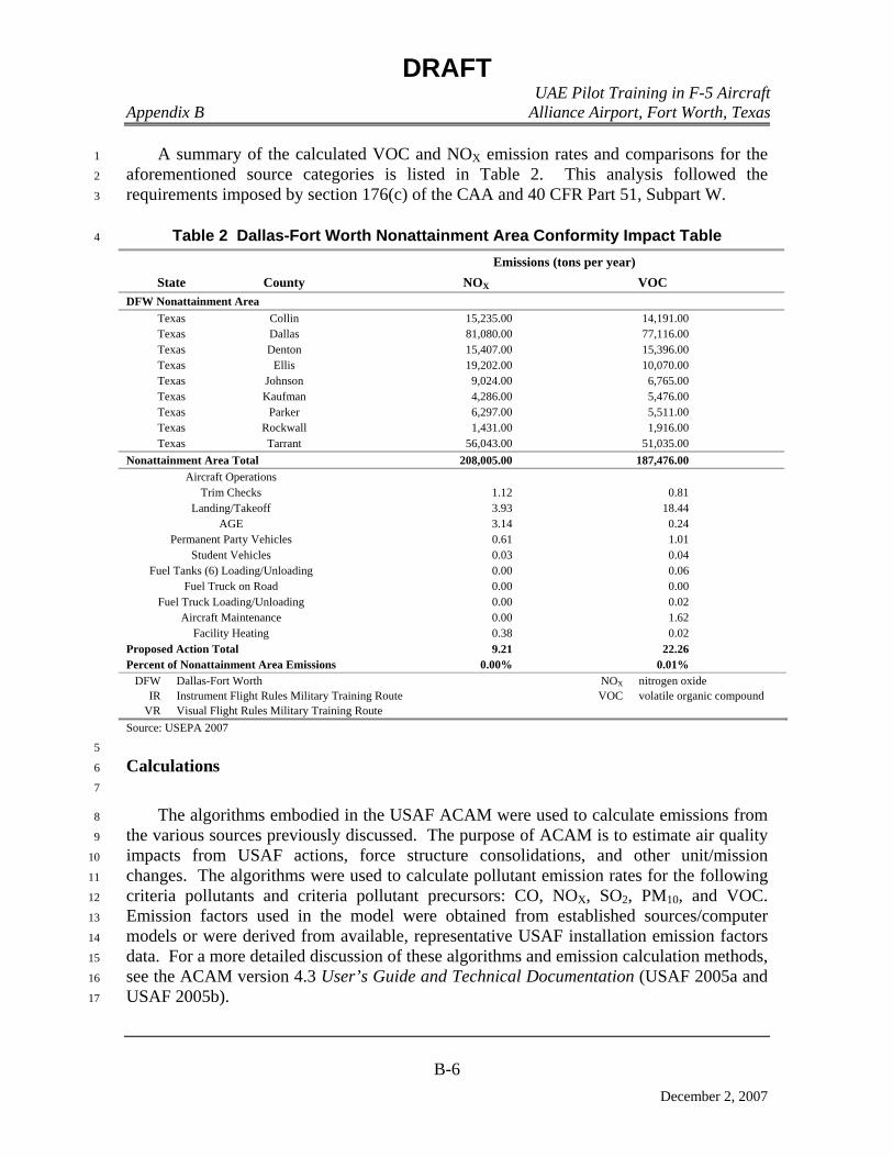
DRAFT UAE Pilot Training in F-5 Aircraft Appendix B Alliance Airport, Fort Worth, Texas
B-6
December 2, 2007
A summary of the calculated VOC and NOX emission rates and comparisons for the 1
aforementioned source categories is listed in Table 2. This analysis followed the 2
requirements imposed by section 176(c) of the CAA and 40 CFR Part 51, Subpart W. 3
Table 2 Dallas-Fort Worth Nonattainment Area Conformity Impact Table 4
Emissions (tons per year) State County NOX VOC
DFW Nonattainment Area Texas Collin 15,235.00 14,191.00 Texas Dallas 81,080.00 77,116.00 Texas Denton 15,407.00 15,396.00 Texas Ellis 19,202.00 10,070.00 Texas Johnson 9,024.00 6,765.00 Texas Kaufman 4,286.00 5,476.00 Texas Parker 6,297.00 5,511.00 Texas Rockwall 1,431.00 1,916.00 Texas Tarrant 56,043.00 51,035.00
Nonattainment Area Total 208,005.00 187,476.00 Aircraft Operations
Trim Checks 1.12 0.81 Landing/Takeoff 3.93 18.44
AGE 3.14 0.24 Permanent Party Vehicles 0.61 1.01
Student Vehicles 0.03 0.04 Fuel Tanks (6) Loading/Unloading 0.00 0.06
Fuel Truck on Road 0.00 0.00 Fuel Truck Loading/Unloading 0.00 0.02
Aircraft Maintenance 0.00 1.62 Facility Heating 0.38 0.02
Proposed Action Total 9.21 22.26 Percent of Nonattainment Area Emissions 0.00% 0.01%
DFW Dallas-Fort Worth NOX nitrogen oxide IR Instrument Flight Rules Military Training Route VOC volatile organic compound
VR Visual Flight Rules Military Training Route Source: USEPA 2007
5
Calculations 6
7
The algorithms embodied in the USAF ACAM were used to calculate emissions from 8
the various sources previously discussed. The purpose of ACAM is to estimate air quality 9
impacts from USAF actions, force structure consolidations, and other unit/mission 10
changes. The algorithms were used to calculate pollutant emission rates for the following 11
criteria pollutants and criteria pollutant precursors: CO, NOX, SO2, PM10, and VOC. 12
Emission factors used in the model were obtained from established sources/computer 13
models or were derived from available, representative USAF installation emission factors 14
data. For a more detailed discussion of these algorithms and emission calculation methods, 15
see the ACAM version 4.3 User’s Guide and Technical Documentation (USAF 2005a and 16
USAF 2005b). 17
DRAFT UAE Pilot Training in F-5 Aircraft Appendix B Alliance Airport, Fort Worth, Texas
B-7
December 2, 2007
1
Aircraft 2
3
Pollutant emissions from aircraft operations focus on a vertical column of air 4
extending from the ground surface up to an inversion layer that is assumed to be at an 5
altitude of 3,000 feet AGL. This column of air is known as the mixing zone and pollutant 6
emissions within this zone ultimately affect ambient air quality at ground level. The 7
aircraft operation of interest within the mixing zone is the landing and takeoff (LTO) cycle. 8
An LTO cycle is defined as an operation that begins when the aircraft descends from 9
cruising altitude during an approach to an airfield and enters the mixing zone at 10
3,000 feet AGL, lands, and taxis to the terminal or other designated area for off-loading. 11
The cycle continues when the aircraft departs the terminal and taxis out to the runway 12
threshold for subsequent take-off and climbout, and departs the mixing zone at 3,000 AGL. 13
The LTO is characterized by five modes of operation: 1) approach, 2) taxi in, 3) taxi out, 4) 14
take-off, and 5) climbout. 15
The LTO cycle is the basis for calculating aircraft pollutant emissions. For each mode 16
of operation during a LTO, an aircraft engine operates at a specified power setting, and 17
depending on the aircraft type, local meteorological conditions, and other operational 18
constraints at a particular airfield, each mode of operation is characterized by a specific 19
time-in-mode. Emissions for one complete LTO cycle for a particular aircraft are 20
calculated by knowing the specific aircraft engine pollutant emission factors for each mode 21
of operation, the mode of operation, the power setting or fuel flow rate, and the time-in-22
mode for each mode of operation. The USAF, FAA, and USEPA have published emission 23
factors applicable to specific aircraft engines, power settings, and representative time-in-24
mode value for both civilian and military aircraft operations. Emission factors used by 25
ACAM come from the USAF publication Air Emissions Inventory Guidance Document for 26
Mobile Sources at Air Force Installations (USAF 2002). 27
Engine trim checks are engine tests performed with the engines on the aircraft. All 28
engines on the aircraft are assumed to be tested the same number of times each year. 29
Emission calculations are similar to those for LTOs. 30
Numbers of annual flight operations at AFW and in the MTA were supplied by the 31
FMS UAE IFF pilot training program personnel. 32
Annual pollutant emission rates are calculated by multiplying engine emission factors 33
by the fuel flow rate, the aircraft specific time-in-mode values, and the annual number of 34
LTOs or engine runups (calculated by ACAM). 35

DRAFT UAE Pilot Training in F-5 Aircraft Appendix B Alliance Airport, Fort Worth, Texas
B-8
December 2, 2007
The following formula was used to calculate aircraft emissions from LTOs: 1
2
E = N * OPS * NUENG * TIM * EF/2,000 3
4
Where: 5
N = number of aircraft 6
OPS = number of operations (LTO) per year 7
TIM = time-in-mode for aircraft operating mode, hours 8
NUENG = number of engines for the aircraft 9
EF = emission factor for pollutant, pounds per hour 10
2,000 = conversion from pounds to tons 11
12
The following formula was used to calculate emissions from aircraft engine trim checks: 13
14
E = N * TRIMS * NUENG * TIM * EF/2,000 15
16
Where: 17
N = number of aircraft 18
TRIMS = number of trim checks per year 19
TIM = time-in-mode for aircraft operating mode, hours 20
NUENG = number of engines for the aircraft 21
EF = emission factor for pollutant, pounds per hour 22
2,000 = conversion from pounds to tons 23
24
Assumptions: 25
• Aircraft type: F-5 26
• Engine: J85-GE-13C/D (substitute T-38 engine data: J85-GE-5H) 27
• Number of aircraft: 15 28
• Annual sorties: 3,744 29
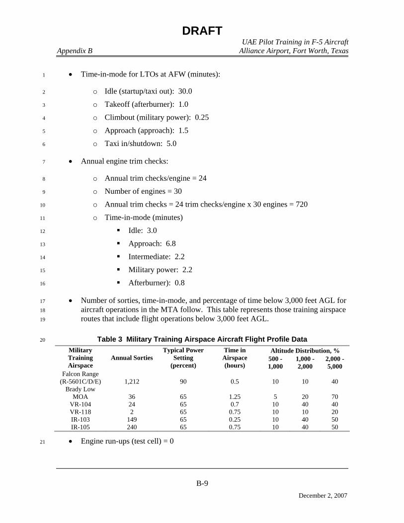
DRAFT UAE Pilot Training in F-5 Aircraft Appendix B Alliance Airport, Fort Worth, Texas
B-9
December 2, 2007
• Time-in-mode for LTOs at AFW (minutes): 1
o Idle (startup/taxi out): 30.0 2
o Takeoff (afterburner): 1.0 3
o Climbout (military power): 0.25 4
o Approach (approach): 1.5 5
o Taxi in/shutdown: 5.0 6
• Annual engine trim checks: 7
o Annual trim checks/engine = 24 8
o Number of engines = 30 9
o Annual trim checks = 24 trim checks/engine x 30 engines = 720 10
o Time-in-mode (minutes) 11
Idle: 3.0 12
Approach: 6.8 13
Intermediate: 2.2 14
Military power: 2.2 15
Afterburner): 0.8 16
• Number of sorties, time-in-mode, and percentage of time below 3,000 feet AGL for 17
aircraft operations in the MTA follow. This table represents those training airspace 18
routes that include flight operations below 3,000 feet AGL. 19
Table 3 Military Training Airspace Aircraft Flight Profile Data 20
Altitude Distribution, % Military Training Airspace
Annual Sorties Typical Power
Setting (percent)
Time in Airspace (hours)
500 - 1,000
1,000 - 2,000
2,000 -5,000
Falcon Range (R-5601C/D/E) 1,212 90 0.5 10 10 40
Brady Low MOA 36 65 1.25 5 20 70
VR-104 24 65 0.7 10 40 40 VR-118 2 65 0.75 10 10 20 IR-103 149 65 0.25 10 40 50 IR-105 240 65 0.75 10 40 50
• Engine run-ups (test cell) = 0 21
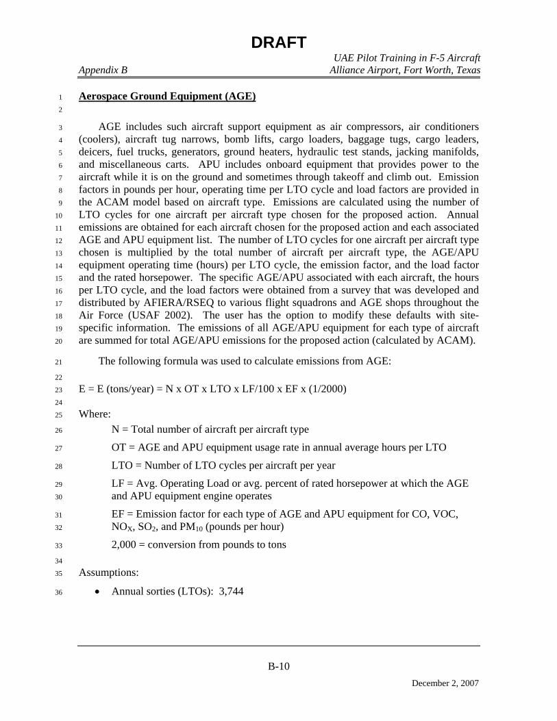
DRAFT UAE Pilot Training in F-5 Aircraft Appendix B Alliance Airport, Fort Worth, Texas
B-10
December 2, 2007
Aerospace Ground Equipment (AGE) 1
2
AGE includes such aircraft support equipment as air compressors, air conditioners 3
(coolers), aircraft tug narrows, bomb lifts, cargo loaders, baggage tugs, cargo leaders, 4
deicers, fuel trucks, generators, ground heaters, hydraulic test stands, jacking manifolds, 5
and miscellaneous carts. APU includes onboard equipment that provides power to the 6
aircraft while it is on the ground and sometimes through takeoff and climb out. Emission 7
factors in pounds per hour, operating time per LTO cycle and load factors are provided in 8
the ACAM model based on aircraft type. Emissions are calculated using the number of 9
LTO cycles for one aircraft per aircraft type chosen for the proposed action. Annual 10
emissions are obtained for each aircraft chosen for the proposed action and each associated 11
AGE and APU equipment list. The number of LTO cycles for one aircraft per aircraft type 12
chosen is multiplied by the total number of aircraft per aircraft type, the AGE/APU 13
equipment operating time (hours) per LTO cycle, the emission factor, and the load factor 14
and the rated horsepower. The specific AGE/APU associated with each aircraft, the hours 15
per LTO cycle, and the load factors were obtained from a survey that was developed and 16
distributed by AFIERA/RSEQ to various flight squadrons and AGE shops throughout the 17
Air Force (USAF 2002). The user has the option to modify these defaults with site-18
specific information. The emissions of all AGE/APU equipment for each type of aircraft 19
are summed for total AGE/APU emissions for the proposed action (calculated by ACAM). 20
The following formula was used to calculate emissions from AGE: 21
22
E = E (tons/year) = N x OT x LTO x LF/100 x EF x (1/2000) 23
24
Where: 25
N = Total number of aircraft per aircraft type 26
OT = AGE and APU equipment usage rate in annual average hours per LTO 27
LTO = Number of LTO cycles per aircraft per year 28
LF = Avg. Operating Load or avg. percent of rated horsepower at which the AGE 29
and APU equipment engine operates 30
EF = Emission factor for each type of AGE and APU equipment for CO, VOC, 31
NOX, SO2, and PM10 (pounds per hour) 32
2,000 = conversion from pounds to tons 33
34
Assumptions: 35
• Annual sorties (LTOs): 3,744 36

DRAFT UAE Pilot Training in F-5 Aircraft Appendix B Alliance Airport, Fort Worth, Texas
B-11
December 2, 2007
Privately Owned Vehicles 1
2
Emissions from privately owned vehicles were calculated using MOBIL6. MOBILE6 3
is USEPA’s software for estimating on-road mobile source emissions of NOX, CO, and 4
VOCs. On road base (Alliance Airport) employee commute vehicle miles traveled (VMT) 5
refers to the emissions from privately owned vehicles used by workers to commute back 6
and forth from AFW. With the exception of construction worker commuting, these are the 7
only POV emissions considered for conformity. On-road government (GOV – vehicles 8
owned by AFW) VMT refers to the GOV fleets on base. The additional VMTs from both 9
POV and GOV are assumed to be proportional to additional AFW personnel related to the 10
proposed action. 11
MOBILE6 is accessed from within the ACAM platform. Emission factors for NOX, 12
CO, and VOCs are determined from MOBILE6 and then saved to ACAM and used for the 13
conformity analysis. Emissions of PM10 and SO2 are not calculated in MOBILE6 and 14
therefore are not included in the conformity analysis. 15
The following formula was used to calculate emissions from POVs: 16
E = F * 2 * (N * COMDIST) * (1 – ONBASE) * WORKDAYS * EF/(450 * 2000) 17
18
Where: 19
N = Number of personnel realigned. 20
F = Fraction of the year the personnel operate. 21
COMDIST = One-way commute distance, miles, for off-base personnel. 22
ONBASE = Fraction of personnel living on base. 23
WORKDAYS = Number of workdays per year, assumed to be 230. 24
EF = Emission factor for pollutant, p, grams/mile. These factors were determined 25
from MOBILE6 for total hydrocarbons (VOCs), CO, and NOX for the chosen fleet 26
mix. 27
2 = Number of commutes per workday. 28
454 = Conversion factor from grams to pounds. 29
2000 = Conversion factor from pounds to tons. 30
31
Assumptions: 32
• Permanent party: 33
o 2 QA maintenance oversight 34
o 1 IP flight ops oversight (periodic TDY) 35
DRAFT UAE Pilot Training in F-5 Aircraft Appendix B Alliance Airport, Fort Worth, Texas
B-12
December 2, 2007
o 20 instructors 1
o 70 maintenance 2
o Assume total permanent party = 100 3
• Students 4
o 22 5
• 230 work days per year 6
• All personnel commute to work 7
• One-way commute distance: 8
o Training/support personnel: 15 miles 9
o Students: 3 miles 10
11
AFW Fuel Truck 12
13
The following formula was used to calculate emissions from on-road use of the fuel truck 14
that transports JP=8 from fixed base operator to training facility (calculated by ACAM). 15
16
E = N * F *GOVVMT * EF/(450 * 2000) 17
18
Where: 19
N = Number of personnel realigned. 20
F = Fraction of the year the personnel operate. 21
GOVVMT 22
EF = Emission factor for pollutant, grams/mile. These factors were determined 23
from MOBILE6 for total hydrocarbons (VOCs), CO, and NOX for the chosen fleet 24
mix. 25
454 = Conversion factor from grams to pounds. 26
2000 = Conversion factor from pounds to tons. 27
28
Assumptions: 29
• Fuel (JP-8) use 30
o Fuel used per sortie: 500 gal 31
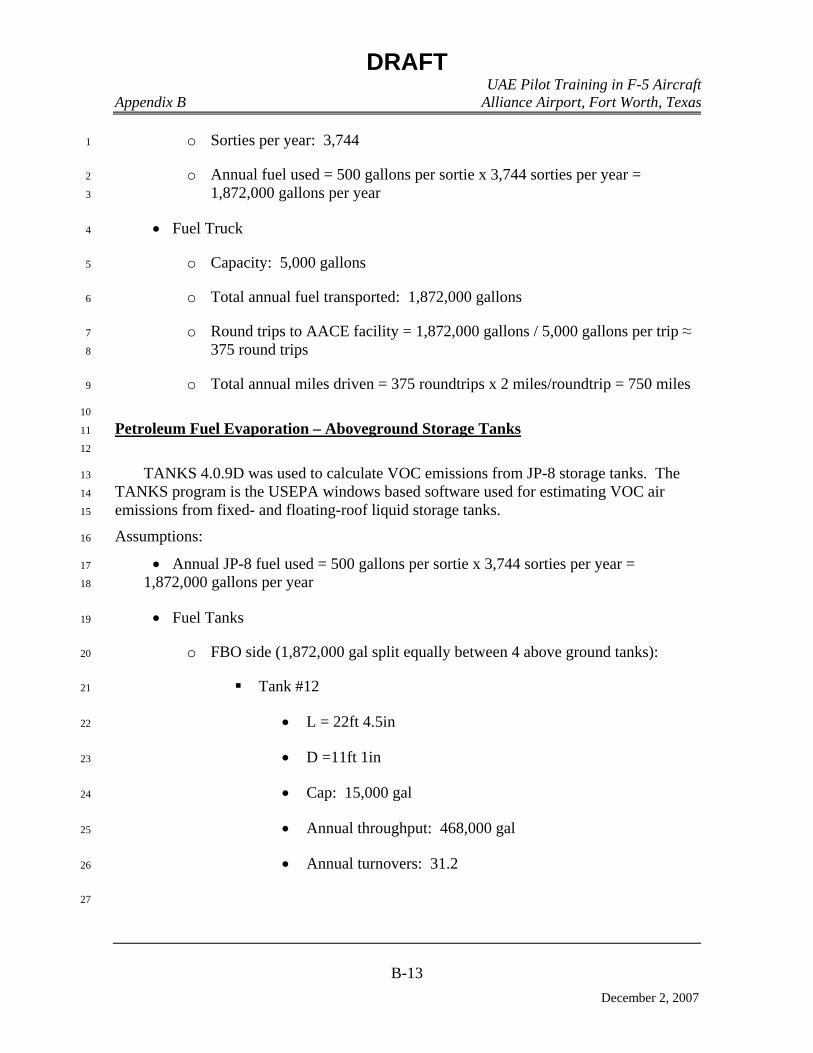
DRAFT UAE Pilot Training in F-5 Aircraft Appendix B Alliance Airport, Fort Worth, Texas
B-13
December 2, 2007
o Sorties per year: 3,744 1
o Annual fuel used = 500 gallons per sortie x 3,744 sorties per year = 2
1,872,000 gallons per year 3
• Fuel Truck 4
o Capacity: 5,000 gallons 5
o Total annual fuel transported: 1,872,000 gallons 6
o Round trips to AACE facility = 1,872,000 gallons / 5,000 gallons per trip ≈ 7
375 round trips 8
o Total annual miles driven = 375 roundtrips x 2 miles/roundtrip = 750 miles 9
10
Petroleum Fuel Evaporation – Aboveground Storage Tanks 11
12
TANKS 4.0.9D was used to calculate VOC emissions from JP-8 storage tanks. The 13
TANKS program is the USEPA windows based software used for estimating VOC air 14
emissions from fixed- and floating-roof liquid storage tanks. 15
Assumptions: 16
• Annual JP-8 fuel used = 500 gallons per sortie x 3,744 sorties per year = 17
1,872,000 gallons per year 18
• Fuel Tanks 19
o FBO side (1,872,000 gal split equally between 4 above ground tanks): 20
Tank #12 21
• L = 22ft 4.5in 22
• D =11ft 1in 23
• Cap: 15,000 gal 24
• Annual throughput: 468,000 gal 25
• Annual turnovers: 31.2 26
27
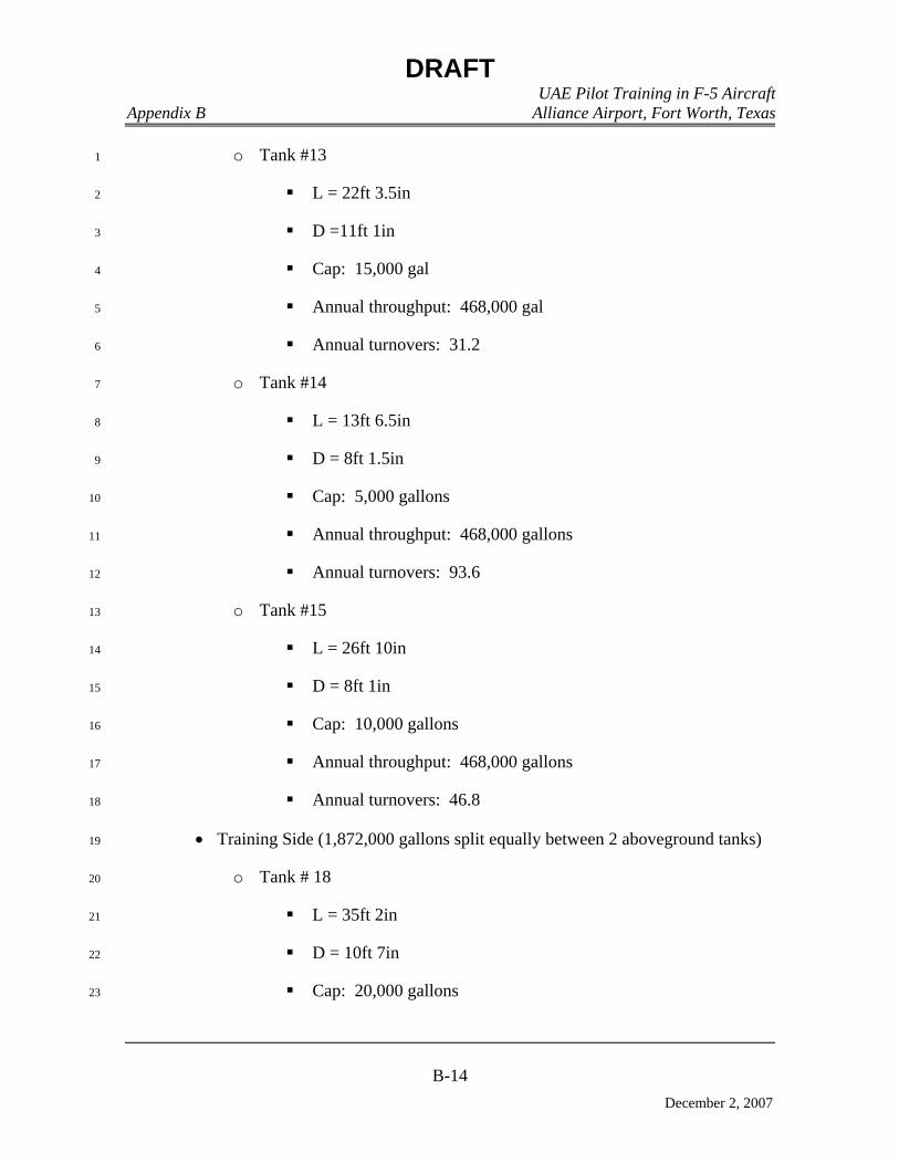
DRAFT UAE Pilot Training in F-5 Aircraft Appendix B Alliance Airport, Fort Worth, Texas
B-14
December 2, 2007
o Tank #13 1
L = 22ft 3.5in 2
D =11ft 1in 3
Cap: 15,000 gal 4
Annual throughput: 468,000 gal 5
Annual turnovers: 31.2 6
o Tank #14 7
L = 13ft 6.5in 8
D = 8ft 1.5in 9
Cap: 5,000 gallons 10
Annual throughput: 468,000 gallons 11
Annual turnovers: 93.6 12
o Tank #15 13
L = 26ft 10in 14
D = 8ft 1in 15
Cap: 10,000 gallons 16
Annual throughput: 468,000 gallons 17
Annual turnovers: 46.8 18
• Training Side (1,872,000 gallons split equally between 2 aboveground tanks) 19
o Tank # 18 20
L = 35ft 2in 21
D = 10ft 7in 22
Cap: 20,000 gallons 23
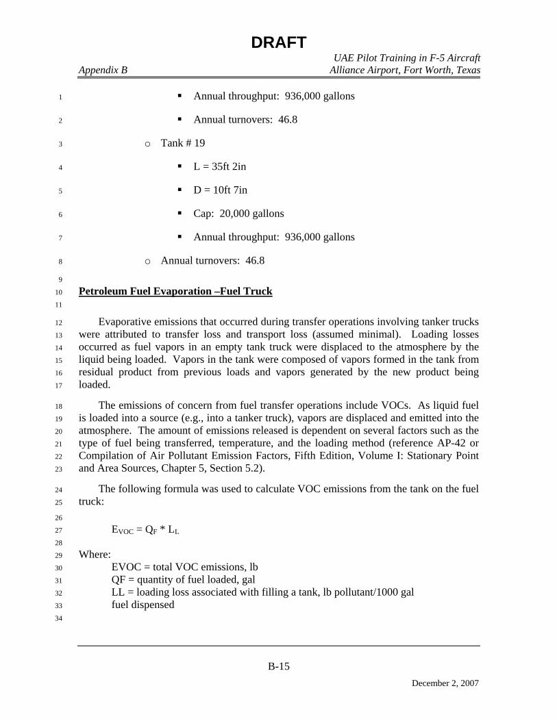
DRAFT UAE Pilot Training in F-5 Aircraft Appendix B Alliance Airport, Fort Worth, Texas
B-15
December 2, 2007
Annual throughput: 936,000 gallons 1
Annual turnovers: 46.8 2
o Tank # 19 3
L = 35ft 2in 4
D = 10ft 7in 5
Cap: 20,000 gallons 6
Annual throughput: 936,000 gallons 7
o Annual turnovers: 46.8 8
9
Petroleum Fuel Evaporation –Fuel Truck 10
11
Evaporative emissions that occurred during transfer operations involving tanker trucks 12
were attributed to transfer loss and transport loss (assumed minimal). Loading losses 13
occurred as fuel vapors in an empty tank truck were displaced to the atmosphere by the 14
liquid being loaded. Vapors in the tank were composed of vapors formed in the tank from 15
residual product from previous loads and vapors generated by the new product being 16
loaded. 17
The emissions of concern from fuel transfer operations include VOCs. As liquid fuel 18
is loaded into a source (e.g., into a tanker truck), vapors are displaced and emitted into the 19
atmosphere. The amount of emissions released is dependent on several factors such as the 20
type of fuel being transferred, temperature, and the loading method (reference AP-42 or 21
Compilation of Air Pollutant Emission Factors, Fifth Edition, Volume I: Stationary Point 22
and Area Sources, Chapter 5, Section 5.2). 23
The following formula was used to calculate VOC emissions from the tank on the fuel 24
truck: 25
26
EVOC = QF * LL 27
28
Where: 29
EVOC = total VOC emissions, lb 30
QF = quantity of fuel loaded, gal 31
LL = loading loss associated with filling a tank, lb pollutant/1000 gal 32
fuel dispensed 33
34
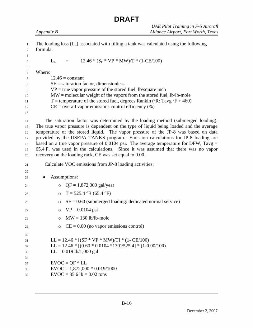
DRAFT UAE Pilot Training in F-5 Aircraft Appendix B Alliance Airport, Fort Worth, Texas
B-16
December 2, 2007
The loading loss (LL) associated with filling a tank was calculated using the following 1
formula. 2
3
LL = 12.46 * (SF * VP * MW)/T * (1-CE/100) 4
5
Where: 6
12.46 = constant 7
SF = saturation factor, dimensionless 8
VP = true vapor pressure of the stored fuel, lb/square inch 9
MW = molecular weight of the vapors from the stored fuel, lb/lb-mole 10
T = temperature of the stored fuel, degrees Rankin (ºR: Tavg ºF + 460) 11
CE = overall vapor emissions control efficiency (%) 12
13
The saturation factor was determined by the loading method (submerged loading). 14
The true vapor pressure is dependent on the type of liquid being loaded and the average 15
temperature of the stored liquid. The vapor pressure of the JP-8 was based on data 16
provided by the USEPA TANKS program. Emission calculations for JP-8 loading are 17
based on a true vapor pressure of 0.0104 psi. The average temperature for DFW, Tavg = 18
65.4 F, was used in the calculations. Since it was assumed that there was no vapor 19
recovery on the loading rack, CE was set equal to 0.00. 20
Calculate VOC emissions from JP-8 loading activities: 21
22
• Assumptions: 23
o QF = 1,872,000 gal/year 24
o T = 525.4 °R (65.4 °F) 25
o SF = 0.60 (submerged loading: dedicated normal service) 26
o VP = 0.0104 psi 27
o MW = 130 lb/lb-mole 28
o CE = 0.00 (no vapor emissions control) 29
30
LL = 12.46 * [(SF * VP * MW)/T] * (1- CE/100) 31
LL = 12.46 * [(0.60 * 0.0104 *130)/525.4] * (1-0.00/100) 32
LL = 0.019 lb/1,000 gal 33
34
EVOC = QF * LL 35
EVOC = 1,872,000 * 0.019/1000 36
EVOC = 35.6 lb = 0.02 tons 37
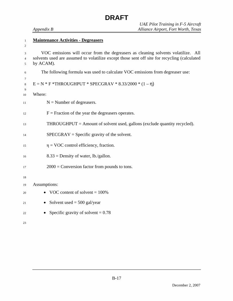
DRAFT UAE Pilot Training in F-5 Aircraft Appendix B Alliance Airport, Fort Worth, Texas
B-17
December 2, 2007
Maintenance Activities - Degreasers 1
2
VOC emissions will occur from the degreasers as cleaning solvents volatilize. All 3
solvents used are assumed to volatilize except those sent off site for recycling (calculated 4
by ACAM). 5
The following formula was used to calculate VOC emissions from degreaser use: 6
7
E = N * F *THROUGHPUT * SPECGRAV * 8.33/2000 * (1 – η) 8
9
Where: 10
N = Number of degreasers. 11
F = Fraction of the year the degreasers operates. 12
THROUGHPUT = Amount of solvent used, gallons (exclude quantity recycled). 13
SPECGRAV = Specific gravity of the solvent. 14
η = VOC control efficiency, fraction. 15
8.33 = Density of water, lb./gallon. 16
2000 = Conversion factor from pounds to tons. 17
18
Assumptions: 19
• VOC content of solvent = 100% 20
• Solvent used = 500 gal/year 21
• Specific gravity of solvent = 0.78 22
23
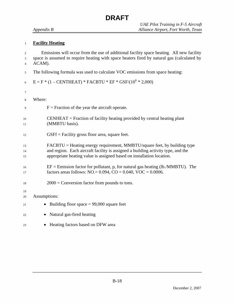
DRAFT UAE Pilot Training in F-5 Aircraft Appendix B Alliance Airport, Fort Worth, Texas
B-18
December 2, 2007
Facility Heating 1
Emissions will occur from the use of additional facility space heating. All new facility 2
space is assumed to require heating with space heaters fired by natural gas (calculated by 3
ACAM). 4
The following formula was used to calculate VOC emissions from space heating: 5
E = F * (1 – CENTHEAT) * FACBTU * EF * GSF/(106 * 2,000) 6
7
Where: 8
F = Fraction of the year the aircraft operate. 9
CENHEAT = Fraction of facility heating provided by central heating plant 10
(MMBTU basis). 11
GSFf = Facility gross floor area, square feet. 12
FACBTU = Heating energy requirement, MMBTU/square feet, by building type 13
and region. Each aircraft facility is assigned a building activity type, and the 14
appropriate heating value is assigned based on installation location. 15
EF = Emission factor for pollutant, p, for natural gas heating (lb./MMBTU). The 16
factors areas follows: NO.= 0.094, CO = 0.040, VOC = 0.0006. 17
2000 = Conversion factor from pounds to tons. 18
19
Assumptions: 20
• Building floor space = 99,000 square feet 21
• Natural gas-fired heating 22
• Heating factors based on DFW area 23

DRAFT
ACRONYMS AND ABBREVIATIONS (CONT.)
MOA Military Operations Area MPO Metropolitan Planning Organization MR_NMAP MOA Range Noise Assessment
Program MSA Metropolitan Statistical Area MSL mean seal level MTA Military Training Airspace MTR Military Training Route NAAQS National Ambient Air Quality Standards NAS JRB Fort Worth
Naval Air Station Joint Reserve Base Fort Worth
NCTCOG North Central Texas Council of Governments
NEI National Emissions Inventory NEPA National Environmental Policy Act NGL Northern General Leasing, LLC No. Number NO2 nitrogen dioxide NOX nitrogen oxides NRCS Natural Resources Conservation Service NRHP National Register of Historic Places NSR New Source Review O3 ozone OCDS Operational Climatic Data Summary OSHA Occupational Safety and Health
Administration Pb lead PBR Permit by Rule PM10 particulate matter equal to or less than
10 microns in aerodynamic diameter PM2.5 particulate matter equal to or less than
2.5 microns in aerodynamic diameter POL petroleum, oil, and lubricant ppm parts per million PSD Prevention of Significant Deterioration psi pounds per square inch PST petroleum storage tank RCRA Resource Conservation and Recovery
Act
RCNM Roadway Construction Noise Model ROI region of influence SAIC Science Applications International
Corporation SEL sound exposure level SH State Highway SIP State Implementation Plan SO2 sulfur dioxide SOX sulfur oxides SUA Special Use Airspace T State Listed Threatened TAC Texas Administrative Code TCEQ Texas Commission on Environmental
Quality TES Threatened or Endangered Species TPWD Texas Parks and Wildlife Department tpy tons per year TRA Trinity River Authority U.S. United States UAE United Arab Emirates URS URS Corporation USAF United States Air Force USBC U.S. Bureau of the Census USC United States Code USEPA United States Environmental Protection
Agency USFWS United States Fish and Wildlife Service UST underground storage tank UTBNI up to, but not including VFR Visual Flight Rules VOC volatile organic compound VR Visual Flight Rules Military Training
Route