pu 08 part 1 - michigan · map showing producing salt districts of michigan.21 ... are much wetter...
TRANSCRIPT

Publication 8, Geological Series 6 / Coal-Gypsum-Salt-Cement-Gold-Oil and Gas – Page 1 of 44
STATE OF MICHIGAN MICHIGAN GEOLOGICAL AND BIOLOGICAL SURVEY
Publication 8. Geological Series 6. Mineral Resources of Michigan with
Statistical Tables of production and value of mineral products for 1910 and prior years
PREPARED UNDER THE DIRECTION OF R. C. ALLEN
DIRECTOR, MICHIGAN GEOLOGICAL AND BIOLOGICAL SURVEY
PUBLISHED AS A PART OF THE ANNUAL REPORT 0F THE BOARD OF GEOLOGICAL AND BIOLOGICAL SURVEY FOR
1911
LANSING, MICHIGAN WYNKOOP HALLENBECK CRAWFORD CO., STATE
PRINTERS 1912
Contents Michigan Coal by R. A. Smith ........................................ 1 Michigan Gypsum by R. A. Smith................................ 14 The Salt Industry of Michigan by Chas. W. Cook ...... 18 Michigan Cement by Chas. W. Cook........................... 28 Michigan Gold by R. C. Allen ....................................... 34 Oil and Gas in Michigan by R. A. Smith...................... 39
Illustrations
Figures Figure 12. Map of the Michigan Coal Basin.............................3
Figure 13. Production and value curves for Michigan coal ....14
Figure 14. Sketch map showing location of gypsum producing areas and gypsum deposits............................................15
Figure 15. Graphic representation of the annual production of gypsum, gypsum products, and values, 1868-1910. ......17
Figure 16. Map showing producing salt districts of Michigan.21
Figure 17. Production curve for salt in Michigan and the United States. ............................................................................25
Figure 18. Map showing cement plants in Michigan, 1911. ...29
Figure 19. Map showing the location and direction of anticlines in lower Michigan............................................................44
Plates Plate XVI. A. Salt plant of the R. G. Peters Salt and Lumber
Company. .......................................................................20
Plate XVI. B. Anchor Salt Company plant, Ludington, Michigan. ........................................................................20
Plate XVII. A. Grainer block. Saginaw Plate Glass Company, Saginaw, Michigan. ........................................................20
Plate XVII. B. Chemical plant. Saginaw Plate Glass Company, Saginaw, Michigan........................................20
Plate XVIII. A. Plant of the Diamond Crystal Salt Company, St. Clair, Michigan. ..............................................................27
Plate XVIII. B. Grainer block. Diamond Crystal Salt Company, St. Clair, Michigan. .........................................................27
Plate XIX. A. Plant of the Delray Salt Company, Delray, Michigan.........................................................................27
Plate XIX. B. Plant of the Detroit Salt Company, Oakwood, Michigan.........................................................................28
Plate XX. A. Plant of the Peerless Portland Cement Company, Union City, Michigan. .....................................................33
Plate XX. B. Plant of the Michigan Portland Cement Company, Gray Village, Michigan. ..................................................33
Plate XXI. A. Plant of the Wolverine Portland Cement Company, Coldwater, Michigan. ....................................34
Plate XXI. B. Plant of the Wolverine Portland Cement Company, Quincy, Michigan. .........................................34
MICHIGAN COAL.1
BY R. A. SMITH.
CONTENTS. Chapter I. Occurrence and Extent of Coal Areas..........1 Chapter II. The Michigan Coal Basin. ...........................2
Thickness of Coal Measures ................................... 3 Variation in Michigan Coal Measures...................... 5 Areas Favorable for Coal Occurrence..................... 5
Chapter III. Tests And Analyses Of Michigan Coals. ....5 Heating Power -- Boiler Tests ................................. 6 Summary ................................................................. 7
Chapter IV. Erosion and Disturbance of Coal. ..............7 Drift Filled Channels ................................................ 8 Sandstone Channels ............................................... 8 Faults or Displacements .......................................... 9
Chapter V. Development of Coal Mines........................9 Principles to Guide Exploration ............................. 10 Methods of Exploration and Developing................ 10
Chapter VI. Value of Coal Lands and Coal Rights......10 Chapter VII. Production...............................................12 Chapter VIII. Mining Methods.......................................12
The Mines.............................................................. 13
CHAPTER I. OCCURRENCE AND EXTENT OF COAL AREAS. Occurrence. Coal occurs in beds associated with shale, fire clay, black band ore, limestone, and to a less extent with sandstone. The latter more often increase in abundance at the expense of the coal. This is a most significant fact. The coal may be in a single bed or in several, separated by beds of shale or so-called slate, fire clay, etc. These laminae of shale may be no wider

Publication 8, Geological Series 6 / Coal-Gypsum-Salt-Cement-Gold-Oil and Gas – Page 2 of 44
than a knife blade or may be many feet thick. Often thin veins of shale interbedded with the coals may thicken so that a single vein of coal becomes several distinct beds.
The upper coals of Michigan are very apt to show this phenomenon. This makes it very hard to correlate them because corresponding veins vary in level more or less with the thickening and thinning of the shale laminae. Sometimes these, though often very persistent even when thin and knife-like, disappear and several beds, distinctly separated at one place, become a single thick one at another. In other cases, the content of clayey matter increases gradually so that a coal vein grades vertically and laterally through cannel coal, bone coal to black shale. It is these shales with their gradation phases which many drillers confuse with true coal and thus are led to report great thicknesses of coal where little or even none exists. The shales, usually black, form in most cases, the roof of the coal seams. Shale forms an impervious roof, but is likely to be weak, and thus need a good deal of timbering, if close to the rock surface. An impervious roof is all important in Michigan as water is so abundant. At best, Michigan coal mines are much wetter than those of Ohio and Indiana, but the water conies chiefly from the coal—the foot wall. The cost of getting rid of the water is one of the chief factors that permits Ohio operators, in dull times, to lay down at a small profit their excess coal at the very tipples of Michigan mines at prices ruinous to Michigan operators. A sandstone roof is a very wet roof as in the case of the Gage No. 3 and no mine is known to have a real limestone roof. The Verne coals, however, are apt to have considerable limestone associated with them.
Extent. Coal beds in most districts are usually continuous for considerable distances and the existence of a coal bed can be predicted with some degree of certainty for some distance from known occurrences as in Pennsylvania and Ohio. In Michigan, such conditions do not obtain. The beds thicken and thin, divide or unite, and pinch out so rapidly, or are cut out by sandstone beds or by erosion so often, that the finding of a thick bed at lone place forms no proof that the same bed or other beds may be found a few hundred feet away. On the other hand, the absence of coal at a particular spot does not preclude the possibility of finding workable coal at astonishingly short distances away. At the Corunna Mine, a 4 ft. vein of coal was found and 200 feet away not a trace was discovered, the bed having been cut out by sandstone layers. This variation in thickness, extent, and number of veins demands more complete prospecting to determine the extent and value of a coal bed after having found it, than it would, were the beds more continuous and more uniform in thickness and character.
The explanation of the great variation in the Michigan deposits in contrast to those of Pennsylvania and other coal states, lies in the difference in the relative conditions under which the coals of the two areas were formed. After the Maxville limestone was laid down in the more or less inclosed Michigan sea, the region was
elevated above water bringing the Maxville within the reach of the erosive agents which cut it up into a network of river valleys. The Maxville on the southeast was wholly removed from Jackson nearly to Tuscola Co., the coal measures lying directly on the Marshall. In late Maxville time, the topography on the eastern side of the basin may have somewhat resembled that of eastern Kentucky. When the region was depressed these valleys became bays, lagoons, and estuaries possibly resembling the conditions of a drowned coast. It was in these depressions that vegetable material collected. Near Jackson, the Maxville forms the hills with the coal measures lying in between and flanking them. The Jackson trough was hardly more than 150 yds. wide and a few hundred feet long. From this it may readily be seen that in the southern and eastern parts of the basin, especially, few if any of the coal veins could be continuous for any great distance. 1Mainly an abstract of A. C. Lane's treatise in Vol. VIII, 1902, Michigan Geological Survey, with addition of statistical and other data.
CHAPTER II. THE MICHIGAN COAL BASIN. The Michigan coal basin, or the northern region of the Interior Basin, as it is now called, is the only one that lies in the Great Lakes drainage area. It comprises some 11,500 square miles and occupies almost the exact geographical centre of the Lower Peninsula. It is most ideally located, being in the heart of a thickly populated and rapidly growing manufacturing district. Not only this, but numerous railroads, Saginaw Bay and River, which penetrate to the very heart of the field, and the system of Great Lakes offer a means, of distribution unequaled anywhere. Indeed, it is largely due to the rapid growth of manufacturing cities along the lower Great Lakes and the easy access to their markets that Michigan, with thin and variable veins of low grade coal and wet mines, owed the sudden and wonderful development of her coal industry between 1897 and 1908. No where in the history of the coal industry of the United States; is there a like parallel in growth, unless we except the recent one of the Triassic basins of Virginia. The Coal Basin may be roughly outlined by drawing line (See Fig. 12) from Jackson, to the northeast of Bellevue, Eaton Co., through Lake Odessa, Ionia Co., Lowell and Rockford, Kent Co., Newaygo and Woodville, Newaygo Co., Big Rapids, Mecosta Co., Evart, Osceola Co., Temple, Clare Co., Beaver Lake and West Branch, Ogemaw Co., Omer, Arenac Co., along the south side of the lower course of Rifle River, across Saginaw Bay to the north and east of Sebewaing, Huron Co., through Caro, Tuscola Co., Belsay, Genesee Co., through the northwest corner of Oakland county, to Lakeland, Livingston county, thence to Chelsea, Washtenaw county, and through Grass Lake back to Jackson. Some of the places, as Bellevue, Lowell, Big Rapids and Caro are just outside of the limits of the coal basin, while Newaygo, West Branch, Sebewaing, and Jackson are just inside. The outline so drawn does not represent the irregularities or the outliers of the borders. The data,

except in certain localities on the eastern side, is too meagre to attempt anything more than an approximate representation of the outline of field. Coal formation undoubtedly exists outside of the area enclosed above and is lacking in other places inside.
Figure 12. Map of the Michigan Coal Basin. Portions colored black represent the areas of proven coal of commercial importance.
Naturally the border of the coal basin is not so regular as is indicated on the map, but is more or less continuous, depending in a great measure upon the amount of erosion after the beds were laid down. It must be kept in mind that the coal measures were elevated above water and, have been exposed to erosive agents for an enormous length of time. Streams cut deep valleys in them and then the ice invasion planed and more or less leveled off these irregularities. Many of the valleys were grooved deeper while others were filled up by glacial debris. One of the results of the successive glaciations was the covering up of the rock surface by glacial material varying from a thin screen of almost nothing to a blanket 600 or more feet thick. It is this blanket that makes the line of demarkation between the various formations most uncertain in many instances. Where the screen is thin, the bed rock is exposed in places as along streams, etc.; or wells penetrate it. Drillings for coal, brines, oil and gas, and water in Saginaw Valley, especially, have given a wealth of information. Thus the eastern and southeastern border of the basin is fairly well determined from the numerous well records and outcrops, but, on the western; northwestern and northern borders, the drift is so deep that outcrops do not occur and wells rarely reach bed rock. Here the border can only be guessed at from the few and perfect records of wells that reach bed-rock, from the occurrence of coal in the drift, or from inferred field relations with other formations.
The area outlined on the map occupies almost the exact geographical and the commercial center of the State. Commonly known as the Goal Basin it is the only formation in Michigan in which the beds do not dip toward and occur deeper at the center than at the margin. (See Fig. No. 12.) Apparently all other formations are true basins though shallow. The fact that the coal formations were laid down in a dissected or much cut up region probably has considerable bearing on the explanation.
At the base of the coal measures lies the Parma sandstone. Though not always present or recognizable, at some distance beneath this formation comes a sandstone, the Napoleon or Upper Marshall, which can be followed by outcrops or by well drillings, all the way from the sandstone bluffs of Huron county into Sanilac county and southwest past Island Lake into Hillsdale county, and thence in wells on to Grand Haven, Muskegon, and Ludington. Since it is full of water, it has been tapped many times for fresh water near its margin, and for salt and bromine waters toward the center. Such wells make it recognizable also at Tawas and to the northwest, thus for nearly two-thirds of the basin it has been followed fairly continuously.
The outcrop, or what would be an outcrop, were the glacial deposits stripped off, would be usually higher then the coal basin itself, thus it really makes a rim about the latter.* Below the Napoleon or outside it, no coal in commercial quantity has been or is ever likely to be found.
Many instances have occurred in Michigan where men have spent their time and money drilling for coal outside the coal basin. Often, the Devonian black shales have led drillers on a proverbial wild goose chase as far as the find of coal is concerned.
Early geologists supposed the coal beds of Michigan and Ohio to have been originally continuous and were then folded gently so that erosive agents removed the coal from the arches. Were this so, one could expect to find outliers of coal which had escaped destruction. The2 evidence is almost absolutely conclusive that these fields were never connected, thus exploration outside the coal basin in the hope of finding an outlier of coal is bound to be fruitless.
Thickness of Coal Measures. As noted on previous pages, the dip of the coal formations does not conform to the lower formations. The term basin referring to shape does not mean so much, when applied to the Coal Measures as when applied to the underlying formations. The Upper Marshall sandstone has been tapped at various places within the basin at depths varying from a, few hundred to more than 1,200 ft. The Michigan series lies just above, except where eroded, so that, calculating from the average thickness of this series, the Coal Measures should come at a 1,000 feet or more in the deepest drillings. On the contrary, nothing like the Coal Measures proper has ever been found much deeper1 than 800 ft.
Publication 8, Geological Series 6 / Coal-Gypsum-Salt-Cement-Gold-Oil and Gas – Page 3 of 44
Publication 8, Geological Series 6 / Coal-Gypsum-Salt-Cement-Gold-Oil and Gas – Page 4 of 44
Evidently the strata of the latter are more nearly horizontal than the Marshall and other underlying formations, which must have been slightly depressed in the centre before the coal formation was laid down. Near the margin, the coal formation becomes very thin from erosion, but near the centre there are known local thicknesses of more than 600 feet. Thus, whatever unfavorable factors may affect coal mining in Michigan, excessive depth probably will never be one of them.
Since the coal formation was laid down on the much eroded surface of the Maxville limestone, it is natural that we find the coal lying "In the minor undulations, independent of the general curve of the whole formation and the basin which it forms." These undulations are called by miners "kills" or "rises" and "valleys" or "swamps." The term "pockety" is applied to such occurrences. It is a practical rule of miners that the coal rises and falls in undulations.
In the lower part of the undulations, the coal is thicker and thins to the rise. Nearly every mine presents an almost invariable series of such occurrences. (See Sebewaing cross section, Fig. 3, Lane, Vol. VIII, pt. 2, p. 31.) This tends to make the deposits trough shaped. The latter phenomena are also common to other coal fields as noted by Bain & Keyes of Iowa and Orton of Ohio.
The lower and thicker parts of the troughs of coal are very apt to be capped by a smaller coal seam known as a rider. Dr. A. C. Lane noted this phenomenon in Michigan coal troughs but was not sure of its wide application to Michigan deposits. Later studies by him and Mr. W. F. Cooper3 seem to warrant a much more general application of the principle. In Bay county, riders seem to be almost universal. Sometimes these riders are locally thick enough to mine, but, they would require even more careful exploration than the coal troughs to determine their economic value.
Bain especially developed the law of coal riders. His explanation was that the lower coal, which, if 5 ft. thick, represents 50 to 60 ft. or more of peaty material, in settling and compacting made a shallow basin above in which the rider formed. Thus riders are not considered unfavorable signs for more coal below.
Dr. Lane divided the coal horizons into seven and Cooper in Bay county report added seven more, making fourteen in all. The full series are: Reese Coal? Unionville? Salzburg? Eider, Salzburg Coal, Upper Rider, Upper Verne, Lower Verne Eider, Lower Verne Coal, Middle Eider, Saginaw Coal, Lower Eider, Lower Coal, Bangor Coal, and Bangor Eider. Since the whole formation varies so rapidly in the thickness and nature of its beds, probably some horizons may be synonymous. All of the beds occur within a vertical distance of 400 feet and, since a seam may vary 20 ft. or more in elevation in a couple of hundred feet, and also vary greatly in thickness, little value should be placed on such a series of horizons. Doubtless ten or twelve of the above are distinct horizons.
The Bangor Coal and Eider form the lowermost veins, the mother seam being from 350 to nearly 400 feet below surface in Bay county. The rider is often 50 to 60 ft. above Dr. Lane thinks that these coals may be equivalent in part to his Lower Coals, the next horizons above. Not much is known of them but, from some of the deeper drill holes, the Bangor Coal appears to be of sufficient thickness for working, especially if it can be mined with the underlying fire clay. The roof is black shale.
The Lower Coal and Eider come next in order above and usually appear in the horizon lying between 240 and 325 ft. The mother seam has an observed maximum thickness of three feet. The usual foot and roof shales are apparently quite variable in thickness. This seam appears to be of probable commercial value.
The Saginaw Coal, one of the thickest and most extensive seams in the state, is probably the best vein in quality, though its coal is non-coking. Its thickness is often more than 3 feet and it forms the base of most of the mining in Saginaw county. The superior St. Charles coals come from this horizon. The Middle or Saginaw Rider also seems to be a seam of considerable thickness and possibly the East Saginaw mines have their shafts in this coal.
The Lower Verne is at some places so closely associated with the Upper Verne that the two could be worked as one seam. In other places they are 40 feet or more apart. This vein is of much lower grade than the Upper, for it has much ash and sulphur. The roof is usually none too good. The general average in thickness for the coal areas is somewhat near two feet and it would be the base of more extensive mining operations, were the coal of better grade.
The Upper Verne stands in the same relation to Bay county mining as the Saginaw Coal does to Saginaw county. Thicknesses above three and four feet are often found. As noted above, it is of much better grade than the Lower Verne, being much freer from ash and sulphur. It has another good quality in not having a high water content like the Saginaw. The fixed carbon is rather low, (see table of analyses, Chap. Ill) and the volatile matter high. This coal leans toward the coking and gas making coals, but trouble in handling or adapting it to the producers in use, and the rather poor quality of the coke have prevented any use of the coal for such purposes. According to analyses the Verne coals appear to be related to the lignite coals. Probably they were never subjected to deep burial, so still resemble the woody end of the coal family.
As so-called fire clay is a common foot wall, it may, in the future, give added value to the seams, so that the thinner ones can be profitably worked. Plans for using the fire clay and shale of an abandoned mine in Bay county are reported as already under way. The usual black shales form the roof.
The Upper Rider is often associated with the mother seam. It's thickness of 12-20 inches warrants the
Publication 8, Geological Series 6 / Coal-Gypsum-Salt-Cement-Gold-Oil and Gas – Page 5 of 44
supposition that locally it may be workable. "Washouts" often cut out this coal, and the roof is apt to be thin, weak, or wet, so care must be taken in proving up before beginning mining operations.
The Salzburg Coal and its rider are very often removed by erosion. It is only locally that the bed-rock surface is high enough to contain these horizons. As the thickness of the mother seam is more than two feet, and in some eases over three it has possibilities for profitable mining but the nearness to the rock surface makes in general unfavorable mining conditions.
The Reese and Unionville coal seams are little represented in drillings. Lying so high in the coal measures, erosion would have removed them in large part if they really ever existed.
Variation in Michigan Coal Measures. Without question, no bed of coal was ever continuous over the basin. Records at Alma, St. Louis, St. Johns, Ithaca show little or no coal. These, however, do not form conclusive evidence of the non-continuous character of the beds, as we know sandstone beds often replace the beds, showing that the coal was cut out after it was formed. A more significant fact lies in the occurrence of beds at all sorts of elevations above the Napoleon from 163 to 1,005 feet as at Sebewaing and Midland respectively. Deep wells near the center of the basin show black shales and bituminous limestones at the same horizons at which coal occurs at the margins. The beds are often of such local extent that it is never safe to attempt any exploitation of coal deposits without a proving of the area by thorough drilling, and even this is not always reliable. Too often a coal bed gives way to black shale horizontally and vertically or its place may be taken by sandstone. Cannel coal and bone coal are often observed as gradations from coal to black shale. The never ending alternation of sandstone and shale exists in every variety and the existence of coal even in the midst of a productive area cannot be predicted with any degree of certainty. Iowa as well as other coal fields seem to have similar, though not so extreme conditions of variation.
Areas Favorable for Coal Occurrence. A greater abundance of coal is found nearer the margin of the main coal basin, the coal beds diverging and thinning out with (increasing) depth and the coming in of the lower coals. The rest of the series thickens toward the center but, in other directions, irregular and sudden thinning is often the rule.
Jackson and Sebewaing are at the every edge of the basin. Though Williamston, Saginaw and Corunna are nearer the center, the basal sandstones are but little over 400 ft. below surface, so that they are not in the deeper parts of the basin.
A greater abundance of coal nearer the margin is to be expected. The areas most favorable for the growth of vegetable material is along the coasts, in lagoons, etc. Obviously, the region toward the center of the basin was more likely to be open sea and could hardly have other
deposits than muds and sands. One must remember that the land surface upon which the coal deposits were laid down was considerably cut up by erosion.
Dr. Lane thinks that the southeastern part of the basin may have been not unlike a drowned coast with all the attendant features of lagoon, estuary, drowned valley, etc. Around Jackson, the evidence points to such a conclusion for the Maxville limestone tops the hills, between which, and flanking them, lie the coal measures. The extreme "pockety" nature of the coal deposits around Owosso and Corunna seem to be even more suggestive of such conditions.
*Lane, Vol. VIII, pt. II, p. 26. 2See Lane Vol. VIII, pt. II, p. 27. 3Bay County Report 1905, p. 190.
CHAPTER III. TESTS AND ANALYSES OF MICHIGAN COALS. Tests and analyses of the earlier mined coals of Jackson, Corunna and Grand Ledge showed them to be of a decidedly low grade. They were as a rule light and friable, resulting in much slack or waste coal, high in ash, moisture, volatile combustible matter, and sulphur, and low in fixed carbon. The amount of fixed carbon was often only 40% and rarely over 45% with 2% to 3½% and more of sulphur and often over 10% of ash present. Then too the coals in burning would tend to run together on the grate, making them difficult of handling. Special grates have since been devised for such coals.
These early tests and analyses gave the general impression that all Michigan coal was alike and of very inferior grade. Thus in the commercial world Michigan coal has had a black eye which has been hard to remove.
Michigan coals vary greatly. The above mentioned coals are high in sulphur, those of the Saginaw seams are not. The heating power of the former is low to fair while the latter is decidedly high. Most of the coals lean toward gas and coking types, yet the high content of sulphur and moisture are objectionable features, affecting the quality of both the gas and the coke. The Verne seams are coking coals, but the coke is generally so poor that all of the coke made in Michigan is from Ohio or other imported coals. One quality, however, seems to be nearly in common; they all are fair to excellent steam and domestic coals. The coals of Corunna and Jackson were locally favorite steaming coals, that of the former being for years almost wholly consumed by the Pere Marquette railroad. The later mined coals of Saginaw valley, especially of the Saginaw seam, running well above fifty per cent in fixed carbon with little or no sulphur, are much higher in grade. Their steaming qualities are so superior that several mines successfully compete in markets beyond the limits of the state, in spite of the deeply rooted prejudice against Michigan coals. The Saginaw coal in comparative tests with Hocking Valley, a most famous steam coal, proved the
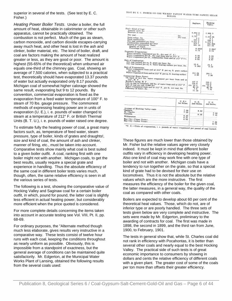
superior in several of the tests. (See test by E. C. Fisher.)
Heating Power Boiler Tests. Under a boiler, the full amount of heat, obtainable in calorimeter or other such apparatus, cannot be practically obtained. The combustion is not perfect. Much of the gas as steam, carbon monoxide, and carbon dioxide escapes-carrying away much heat, and other heat is lost in the ash and clinker, boiler material, etc. The kind of boiler, draft, and coal are factors making the amount of heat realized greater or less, as they are good or poor. The amount is highest (55-65% of the theoretical) when unburned air equals one-third of the chimney gas. Coal, showing an average of 7,500 calories, when subjected to a practical test, theoretically should have evaporated 13.37 pounds of water but actually evaporated only 8.17 pounds. Michigan coal of somewhat higher calorage showed the same result, evaporating but 9 to 12 pounds. By convention, commercial evaporation is fixed as the evaporation from a feed water temperature of 100° F. to steam of 70 lbs. gauge pressure. The commonest methods of expressing heating power are in units of evaporation (U. E.), i. e. pounds of water changed to steam at a temperature of 212° F. or British Thermal Units (B. T. U.), i. e. pounds of water raised one degree.
To estimate fully the heating power of coal, a great many factors such, as, temperature of feed water, steam pressure, type of boiler, kinds of grates and draughts!, size and kind of coal, the amount of ash and clinker, manner of firing, etc., must be taken into account. Comparative tests show mainly what coal is best suited to a given boiler outfit. A coal, ranking first with one boiler might not with another. Michigan coals, to get the best results, usually require a special grate and experience in handling. Thus the absolute efficiency of the same coal in different boiler tests varies much, though, often, the same relative efficiency is seen in all the various series of tests.
The following is a test, showing the comparative value of Hocking Valley and Saginaw coal for a certain boiler outfit, in which, pound for pound, the latter coal is slightly less efficient in actual heating power, but considerably more efficient when the price quoted is considered.
For more complete details concerning the items taken into account in accurate testing see Vol. VIII, Pt. II, pp. 68-69.
For ordinary purposes, the "Alternate method though much less elaborate, gives results very instructive in a comparative way. These tests consist of twelve hour runs with each coal, keeping the conditions throughout as nearly uniform as possible. Obviously, this is impossible from a standpoint of exactness, but the general average of conditions can be maintained quite satisfactorily. Mr. Edgerton, at the Municipal Water Works Plant of Lansing, obtained the following results from the several coals used:
These figures are much lower than those obtained by Mr. Fisher but the relative values agree very closely indeed. It must be kept in mind that different boiler outfits vary in efficiency in developing heating power. Also one kind of coal may work fine with one type of boiler and not with another. Michigan coals have a tendency to run together on the grate, so that a special kind of grate had to be devised for their use on locomotives. Thus it is not the absolute but the relative values which are the more instructive. The first measures the efficiency of the boiler for the given coal, the latter measures, in a general way, the quality of the coal as compared with other coals.
Boilers are expected to develop about 60 per cent of the theoretical heat values. Those, which do not, are of inferior type or are poorly handled. The three sets of tests given below are very complete and instructive. The sets were made by Mr. Edgerton, preliminary to the awarding of contracts for coal. The first was made in 1898, the second in 1899, and the third ran from June, 1900, to February, 1901.
The tests in general show that, while St. Charles coal did not rank in efficiency with Pocahontas, it is better than several other coals and nearly equal to the best Hocking Valley. The practical side of such tests is of great economic importance to consumers by showing in dollars and cents the relative efficiency of different coals with a given plant. The greater cost of some of the coals per ton more than offsets their greater efficiency.
Publication 8, Geological Series 6 / Coal-Gypsum-Salt-Cement-Gold-Oil and Gas – Page 6 of 44

Analyses of Coal. The analysis of a coal shows the amount of possible available combustible, but this does not mean that it is all used in combustion. The physical and chemical qualities of a coal affect its burning qualities very much. For instance the tendency of some Michigan coals to run together often causes very unsatisfactory results, for special grates and experience in handling such coals are required to insure the highest efficiency. The high content of water, vaporized into steam, carries away no negligible quantity of the heat generated. So many other kindred factors have to be taken into account, that analyses must be taken to represent more the probable value of a coal than its absolute.
The analyses of Michigan coals by different chemists vary considerably in the item of moisture and somewhat in volatile combustible for the same grade or vein of coal. This arises from the fact that analysts have not agreed at all in drawing the line between moisture and volatile combustible. Since the usual high hygroscopic
content of water is one of the factors affecting quite markedly the heating and gas making qualities of our coals, it is important to have rather accurate information. In some of the analyses of the Saginaw coals given in the table of analyses (Chap. Ill), the water content is much below the average (usually above 7%) for this coal and, very possibly, part of the moisture was included in the volatile combustible.
From the several analyses, it can be seen that some of the coals are remarkably low in ash. Many analyses, made by different investigators, seem to show that the sulphur, is always in almost exact proportion for combining with the iron. This means, no excess sulphur in the form of sulphates. A general principle can also be deduced for the relations between the ash, fixed carbon, and volatile combustible. The fixed carbon drops faster than the volatile combustible, when slate, bone, or cannel coal is introduced. The amount of ash is thus very indicative of the heating power of a coal.
Summary. Only three seams of the 10 to 12 or more seams have been well developed possibly excepting the Middle Rider. All are bituminous, rather high in moisture, inclining toward gas coals and passing into low grade cannel or bone coal. The Upper Verne or Monitor seam apparently is the only gassy one and is a coking coal though a poor one with a medium amount of sulphur. The Upper Eider and the Verne coals are near the lignite end of the bituminous group. Probably burial has been so shallow, that the original woody material has been little changed.
The Lower Verne, the next seam, often close enough to be mined with the Upper Verne is decidedly poorer in grade. It is a coking coal high in sulphur and ash and often below .50 in fixed carbon.
The Saginaw seam is of much higher grade, usually having well above 50% of fixed carbon, with little ash and sulphur. Its higher moisture content than the Verne coals is a bad quality, especially for gas making with ordinary producers. It is also unlike the Verne seams in not being a coking coal. Its other good qualities make it a fine domestic coal and a steaming coal much in favor with railroads, it is said.
Some of the East Saginaw mines possibly have their shafts in the middle Rider just above the Saginaw seam. The decidedly lower grade of the coal in some of these mines, certainly is indicative that the Saginaw seam either varies a great deal in quality in a short distance or that the mines in East and West Saginaw are in wholly different veins.
CHAPTER IV. EROSION AND DISTURBANCE OF COAL. After the formation of the beds of coal, present and past rivers have cut into them and carried them partly away. Some of the channels are occupied by our present rivers, others are filled with unconsolidated gravel, sand, till, etc., and still older channels are filled with rock,
Publication 8, Geological Series 6 / Coal-Gypsum-Salt-Cement-Gold-Oil and Gas – Page 7 of 44
Publication 8, Geological Series 6 / Coal-Gypsum-Salt-Cement-Gold-Oil and Gas – Page 8 of 44
usually sandstone. This gives rise to three kinds of channels,—open channels, gravel channels or "washouts," and sandstone channels.
Unfortunately, for the early development of coal mining in Michigan the open channels with exposures of coal along their sides are not at all numerous or deep. The development of the Saginaw and Bay county veins would have been tardier still had it not been for the numerous drillings for salt and water. As mentioned previously, the coal basin is covered with a thick mantle of drift varying from a few feet to six hundred or more, through which the bed rock exposes itself at few and scattered places, chiefly of course along stream courses. As the drift is thinner on the eastern, southern and southwestern parts of the basin, it is in these that most of the outcrops occur. Beginning on the east of Saginaw Bay, the first outcrop occurs along Coats Creek, near Tuscola where coal was dug for many years from the bank. Coal measure sandstones also occur in the bed of Cass River, a little way above the town. Going south the next exposures are on Flint River near Flushing and along the Shiawassee from just above Corunna down to Saginaw county. At intervals, other outcrops occur all along the southern border of the basin in the stream beds about Jackson, Chelsea, Baton Rapids, and Dimondale. Exposures also occur on the Cedar and the Grand from Williamston to nearly six miles below Grand Ledge. The thickening of the drift on the southwest allows only a few glimpses of coal measure sandstone as at Ionia and in Kent county. But, over the whole northwestern and northern parts of the coal basin, the 300-600 feet or more of drift completely conceals the bed rock from Kent county north around to Rifle river in Arenac county. The center of the coal basin is also covered heavily with drift.
None of the rivers, except the Grand at Grand Ledge, has cut valleys deep enough to expose coal on the banks, which can be effectively worked. The small mines near Grand Ledge are the only self draining mines in, the state. All the important ones are under a greater or less hydrostatic pressure and require costly pumping machinery to keep them from flooding. The abundance of water, one of Michigan's greatest blessings, is not such to the coal operator. The rivers in the states to the south, as in Ohio have cut much deeper valleys, extensively exposing the coal along the hillsides, so that mining is easy and inexpensive. It is this factor together with that of the much thicker veins that allows the Ohio operator in seasons of dull iron trade, to lay down, at a small profit, his excess coal at the tipples of Michigan mines, at prices ruinous to Michigan operators.
Drift Filled Channels. The states to the south were somewhat plastered over with drift, but Michigan received two full coats; first a rough one of gravel and till from the Ice Sheet itself and then a finishing coat from the deposits of the Great Lakes system, whose waters were 200 or more feet higher than now and flowed southwest from a lake in Saginaw Bay.
Previous to the invasion of the ice-sheet, pre-glacial streams had carved steep channels 100 to 150 ft. deep or more in the coal measures. Remove the drift and the coal would be well exposed along the channels. Many of these channels have been found by boring and the courses of some, have been fairly well determined wherever the borings have been numerous enough. In a general way, many of them, unite with a trunk channel which probably passes from near the head of the region of Saginaw Bay to the southwest toward Alma and then veers to the northwest, entering Lake Michigan below sea level somewhere between Manistee and Ludington.
These channels locally cut out a great deal of the coal, especially the upper veins, and, since bed rock is effectually concealed by the thick screen of drift, the amount and distribution of coal in a given tract is very uncertain. It may be nearly all cut out or but little. Drillers often find bed rock and coal at comparatively shallow depths, yet, a, few hundred feet away, bed rock is far beneath the surface, with no trace of coal. It is this uncertainty in finding the coal that makes it hazardous for explorers with limited means, to attempt proper development work.
In Ohio and Kentucky, the soil mantle is so thin that the coal is easily discovered and the areas are readily determined. The beds are thicker, more persistent, and have fewer washouts, thus require very little drilling for proving. Michigan areas require thorough proving by the drill before any approximation can be made of the amount and extent of workable coal.
"Toward an outcrop or washout, the coal is likely to rise" is a rule of possible practical value. This phenomenon, observed at Grand Ledge and at other places, may be due possibly to the fact that outcrops are more liable to appear in erosion channels along-faults or anticlines.
Sandstone Channels. Sandstone Channels, like the "washouts," cut out the coal, but unlike them, are filled with rock,—sandstone nearly always. These represent the channels of streams existent at the time the coal was formed or, at least, shortly after. These streams cut out the coal measures depositing sand, now sandstone, in the channels. But, in some cases, where we have a heavy sandstone cutting out the coal for a considerable distance, it is more probable that the coal was never laid down, the sandstone representing the ridge of land cutting off the lagoon or basin in which the coal was formed. Real sandstone channels, however, are positively known elsewhere, so doubtless they exist in the Michigan formations. For instance, Mr. Liken near Sebewaing found three feet of coal 36 feet from a previous boring, which, at the same level, was in the midst of over 20 feet of sandstone.
These sandstone beds give trouble as they let in much water and cut out the coal as well. If the absence of coal is due to a cutting down from above it is less liable to be cut out as extensively as it would in the case of a cutting out from below.
Publication 8, Geological Series 6 / Coal-Gypsum-Salt-Cement-Gold-Oil and Gas – Page 9 of 44
Faults or Displacements. Coal beds commonly show disturbance, interruption, or deterioration. Faults are displacements, which in coal beds are almost always normal, that is, the fault plane slopes toward the side which dropped, just as though the coal had slid down. The fault planes are usually occupied by clay seams or veins traversing the coal "sulphur partings," that is veins or seams of iron sulphide or "Spar seams" or veins of calcite, gypsum or other white mineral.
Miners use the term fault very loosely and apply it to anything that cuts out the coal, be it rolls, horsebacks, bars, channels, or sandstone. Faults are common, though usually of small throw or displacement in coal, as would be expected from the slumping due to the settling and compacting of the vegetable material in the process of coal formation. The faults at Sebewaing and Jackson are the two best known instances of faulting in Michigan. The throw is hardly more than two feet. The coal rises toward the faults as though there had been "drag," commonly observed in larger faults. The slipping along the fault plane has polished the surfaces of the coal and slate into bright shining faces called slickensides.
Sulphur partings are streaks of pyrite or marcasite more or less mixed with other impurities. They are found not only along fault planes but often they follow the partings of the coal or the bedding planes. These thin streaks affect the value of the coal as they are often the source of the high sulphur content of some coals like the Lower Verne. It is impossible to get the pyritous material all out, or to prevent the thin streak near the roof of the Lower Verne from being included. The waste pyrite of the Lower Verne seam is large enough to be of economic importance, if a practical way is devised for using it in fertilizers or for cheap large scale disinfection.
Before the Sebewaing mine was abandoned, an attempt was made to mine the pyrites for commercial purposes using the coal as a byproduct. This, however, was unsuccessful at the time, but may have future possibilities.
CHAPTER V. DEVELOPMENT OF COAL MINES. As has already been noted here and there on previous pages, there are some peculiarities in the occurrence of coal in Michigan, which have retarded and will continue to more or less retard its further development. All, but the unimportant "drift" coals around Grand Ledge, are below the water table and largely in artesian well country. Some coal areas are much wetter than others, because the overlying beds are porous sandstones and drift. Sometimes the roof is a porous sandstone or is full of fissures, allowing free circulation of water, but usually the water comes from the coal itself or from the foot-walls. The coal basin, is full of wet spots such as troughs, "washouts," and depressions, which act as catch basins. Slopes or troughs leading down to* the coal have been encountered in sinking shafts at Jackson, Elk, Williamston, and Corunna with disastrous
results, as the water could not be kept out. Heavy beds of sand and gravel in the drift carry a great deal of water and prove formidable obstacles to sinking shafts. The Auburn Coal Company lost two shafts in quicksand and nearly lost a third. (See Lane 1905.) At best, the amount of water to be handled will be a very serious problem. In the past, this problem has been a most annoying one and a cause of more than one failure, The heavy cost (of adequate machinery and of raising the water to the surface consumes a large part of the operator's margin of profit. For the most economic handling, shafts should be sunk into the lowest part of the coal, so that all of the water will run toward the pumping shafts. To find the most advantageous point for beginning mining operations requires much preliminary drilling.
Deep drift channels should not only be avoided because of their large water content, but, also, on account of the too often weak and treacherous roof over the coal under such, channels. Coal without an adequate roof to support the overlying strata is worthless as a mining proposition. This condition often obtains in drift filled channels, and near the margin of the coal basin. The early discoveries of coal along Rifle River come to naught on this account and several mines have had to be abandoned. Some of the larger mines have poor roofs of rotten shale or "slate" and require much timbering. Frequently a shale roof much desired from its impervious qualities, slakes with exposure to air and scales off, making work extremely hazardous. The Gage Mine No. 2 at St. Charles has such an unstable roof, that it has been a constant source of trouble and expense. A new shaft at Owosso, sunk by the Robert Gage Company, was abandoned on account of the poor "slate" roof.
The coal seams are some 10 or 12 in number with only three developed to any great extent. They are somewhat disturbed, quite variable in thickness, extent, quality and character. The thickest veins rarely run more than three to four feet and, while some of the others are locally of workable thickness, most of them are too prevailingly thin for possible exploitation under present economic conditions.
Dr. H. M. Chance reported to the State Tax Commission that veins in Michigan much below three feet in thickness could not be worked at a profit, at present prices, and under the average conditions. The thin veins at Grand Ledge owe their exploitation to their natural system of drainage and ventilation, or to their association with so-called fire clay, which is of far more value than the coal. Reported thicknesses of five to six feet of coal are almost always exaggerations. The four and five foot veins are few and far between. The old Wenona mine had one of the thickest veins in the state, being above 4 ft. 6 in. in thickness.
With all these discouraging conditions, Michigan operators, on the other hand, may be thankful, that fire damp and coal dust explosions are hardly known, while noxious gases suck as choke damp are little

Publication 8, Geological Series 6 / Coal-Gypsum-Salt-Cement-Gold-Oil and Gas – Page 10 of 44
troublesome, the mines are too wet for dust explosions. The United Coal Co. and the Pittsburg Coal Go. mines are the only ones which have had any gas. Good precautions as to thorough ventilation and examination of the working places have prevented any serious trouble. Only a few miners have ever been injured by such explosions in Michigan mines.
Principles to guide Exploration. 1. Favorable places for preliminary exploration lie in a belt a few miles within the coal margin. Nearer the center of the basin coal beds are liable to give way to shales, unless other beds of later and higher horizon come in. From records in Bay county there seem to be coals of higher horizons than the Salzburg, though their existence is inferred from rather meagre records. Coal nearer the margin is apt to be cut out by some channel or may lack sufficient roof.
2. Coal once located, though thin, may thicken especially in a direction parallel to the margin. Further borings may locate a workable area. If the money spent in haphazard drilling about the state, could have been used in proving known favorable areas, the results undoubtedly would have been far more satisfactory.
3. Coal generally rises toward the margin, except for minor undulations, thus shafts should not be located until the lowest part of the coal vein has been determined by drilling. This is essential for the most economic handling of the coal and water.
4. Up to the present, most of the exploration and development has been along the eastern and southeastern side of the basin. A line from Sebewaing to Jackson and a parallel one from just west of Bay City toward Grand Ledge would mark tow belts containing practically all the mines, which have mined coal in any quantity. The more recent prospecting and exploration has been to the west and northwest of Bay City toward and into Midland and Arenac counties. Explorations near Flint promise much and recent developments indicate a large body of workable coal. Along the southwestern margin the drift is comparatively thin and as coal has been found in several places northeast of Bellevue, Eaton county, in veins reported to be four to six (doubtless the higher figure is an exaggeration) feet thick. This part of the field looks promising and deserves further exploration. (See Fig. No. 12.) Much coal has been found in the drift of Montcalm county and the valley of the Upper Muskegon river. The coal must have come from underlying coal beds. The drift is so deep (300-600+), however, that little exploration has been attempted.
5. Most of the coal basin from the center westward and northward to the margin and beyond has been deeply covered with drift, so that exploration for coal alone would probably be too expensive to pay. Even if coal was found in good thickness and extent, the wealth of water in the drift to say nothing of the probably quicksand beds, would make the sinking of shafts very difficult indeed and the mining of the coal very expensive.
6. The finding of a good bed of coal near the surface is not an unfavorable sign of more coal below. Many prospectors stop at the first good seam, when the probabilities are that more coal could be found by going deeper. The suggestion also has been made that much of the drilling in the past has been altogether too shallow.
The map in Figure No. 12 gives a general idea of the proven areas of coal, and the possible ones, and shows how relatively small is the percentage of workable coal to the area of the whole basin. Either the workable beds are woefully insignificant in extent or there are many yet to be found. Probably there is a good deal of truth in both.
Methods of Exploration and Developing. In general, since the drift is so thick, test pitting or digging wells down to the coal is wholly impracticable. The abundance of water, treacherous veins of gravel and quicksand, and large boulders would form almost unsurmountable obstacles, except where the drift is very thin. Then the coal beds being on the whole near the horizontal would probably be concealed under heavy masses of sandstone. If exposed, they would be useless as a mining proposition from lack of good roof.
The early prospecting for coal in Michigan was mainly done by churn drills. These are very satisfactory for finding the coal and running it into a "valley" or "swamp," but do not give sufficiently accurate data concerning the thickness of the beds. Black shale usually occurs above and below the coal, and it is hard to tell by a churn drill just where the shale ends and the coal begins or vice versa. The records from churn drills always tend to exaggerate the thickness of a coal bed, so that many areas have never yielded nearly as much coal as had been previously estimated from the drill records.
In the last few years, core drills have been used very largely, especially in proving coal territory. They give much more reliable data concerning the thickness of beds and the estimates, based upon their records, more nearly approach the product actually realized afterwards in mining.
CHAPTER VI. VALUE OF COAL LANDS AND COAL RIGHTS.1
The value of coal lands in Michigan depends primarily upon the geographical position of the Coal Basin. It is the only one lying in the Great Lakes system, and is in the midst of a rich and populous manufacturing region. Further, the means for the distribution of the coal product is almost unparalleled through the network of railroads traversing the region, and the system of water routes with Saginaw River and Bay penetrating to the very heart of the most productive part of the Basin. It is this central position with, markets almost at the shafts of the mines, that made possible, during the years 1896 to 1907, the unparalleled growth of Michigan's coal industry, in spite of other most discouraging conditions.

Publication 8, Geological Series 6 / Coal-Gypsum-Salt-Cement-Gold-Oil and Gas – Page 11 of 44
It must be borne in mind, that Michigan Coal Measures are buried under a deep deposit of glacial materials, carrying heavy water bearing strata, and dangerous quicksands, that the workable areas are smaller, more irregular, scattered, more variable, thinner veined, and of lower grade then in other fields, and that the expense of prospecting and proving up the areas, of sinking shafts, of mining thin veins, of timbering the bad roof, and of handling the abundance of water is far greater than in the states to the south. Higher mining and wage scales, besides a more generous computation of the extra allowances for narrow work, etc., tends to swell the expense roll in Michigan mines.
As can be seen from the table of production the average cost of placing a ton of coal on the car in 1910 was $1.79 or about 60 to 80 cents more than that in West Virginia. Of course, a large part of this increased cost is due to keeping up the mines during the summer. The water makes it imperative that the pumps be kept working, so that many operators mine throughout the summer, marketing the coal at a loss.
As an offset, the Michigan operator has markets almost at his shaft, especially is this true in the region of Saginaw and Bay City, and the territory to the north and west. Thus the freight rates run from 25 cents up, and rarely exceed 70 cents, and the difference between these and the ones from Ohio and West Virginia forms a protective tariff. The rates from Ohio range from $1.40 to $1.50 and more per ton and $1.65 to $1.85 per ton from West Virginia. Subtracting from these the amount (70-80 cts.) of the increased cost of mining in Michigan, there is a net margin of protection for the Michigan operator, ranging from nothing for the more remote deliveries to 45 cents or more for purely local ones.
But, another factor has to be considered and this is the quality and the use of the coal. A ton of average Ohio and West Virginia coal is worth in actual heating power more than a ton of average Michigan coal. This difference in quality, measured in British Thermal Units (B. T. U.) has a money value ranging from 20 to 30 cents. Then obviously Michigan coals cannot compete with the former at the same prices. The high content of water and usually of sulphur and the generally lower average of fixed carbon do not make them as efficient for all around heating purposes as the dryer coals low in sulphur. For steaming purposes and domestic uses the Saginaw Goal is a very superior coal, but unfortunately a large part of our coal product comes from the Verne and other veins which are decidedly inferior to the first, yet the latter are what are called good steam and domestic coals.
For coking and gas making, Michigan coals are no competitors of those coming from Ohio or West Virginia. Not that coke or gas cannot be made from them for the Verne Coals are both coking and rich in gas, but that the water or sulphur content or both makes them less fitted for making coke and gas satisfactory for commercial purposes.
It is the lower quality that tends to wipe out the margin of protection so that in periods of depression in the iron trade as in 1908, the Ohio operator can place his excess coal at a small profit on the market at prices ruinous to the Michigan operators.
From the preceding facts it is seen that the Michigan coal lands have a value over and above their value as agricultural lands.* This may be reckoned at 10 cents per ton for coal to be immediately mined. This small value represents the difference between the average cost of putting the coal on the cars and the average price received. To find the total amount of coal per acre of an area, the average thickness must be known. The amount of available coal, that which can be mined at a possible profit, is hard to determine. Experience has shown that, in Michigan, hardly half of the computed tonnage is ever realized in actual mining. This is due partly to incomplete or unreliable drilling, which has not shown channels or sudden and unexpected variations in thickness, or revealed the presence of a weak or treacherous roof. The first reduces the total amount of coal present, the second, the amount of workable coal, and the third, the available coal. In the last case a large amount of coal must be left in pillars for the support of the roof. Indiana, Ohio, and West Virginia give yields per acre foot (an acre of coal 1 ft. thick) of 1,200 to 1,350 tons, but in Michigan the yield rarely runs much above 1,000 tons per acre foot. Thus a three foot vein of coal in Michigan would yield about 3,000 tons. With such a yield, at the base price of 10 cents per ton the coal land would be worth $300 per acre. But this is too high, for coal remote from the shaft may not be mined for a term of years and thus should be discounted for such estimated period. As undeveloped but proven mining properties sell at about half the price of developed ones, 5 cents a ton would represent the base price. But this must be discounted according to the length of time elapsing before mining begins and the number of years in the average life of a colliery, so that the present value of a ton of coal in undeveloped but proven property has been estimated at 1¼ cents a ton, giving a value of $37.50 per acre for coal land like that noted above. The average cost (See Ann. Rept. Michigan Bureau of Labor, 1911), of mining a ton of coal in 1910 was $1.79 and the average selling price (See U. S. Min. Resources, 1910), was $1.91, making an average net profit of 12 cents per ton. Some mines averaged better, some much less, and some sold at a loss. (See Production and Distribution.) The value given above for the cost is somewhat higher than that given by Chance, who quotes the cost at $1.60 per ton. If this is correct and the selling price, $1.91, is not correspondingly higher, the margin of profit would be considerably larger. This is hardly possible as such a margin would be large enough to successfully compete with outside coals under almost any conditions of trade. Unproven coal land can hardly have a value above that for agricultural, or purposes other than mining, when investors have not and do not now purchase mineral rights to such lands.

The map in Fig. No. 12 gives a general idea of the proven areas of coal. A glance is sufficient to observe the relatively small proportion of proven coal land as compared with the area of the whole basin. The areas plotted do not refer to the areas where coal is known to occur, but where it is known to occur in thicknesses great enough for profitable mining. The following table gives the area of proven coal lands by counties: This table and the map were prepared in 1911 by Mr. H. F. Lunt as a part of Dr. H. M. Chance's report to the State Board of Tax Commissioners, on The Value of Coal Property and Coal Eights in Michigan. The data necessary for such map and table was compiled from the mine and property maps of the operators or owners. Either the thicker areas are extremely limited in extent, or they remain as a hidden reward of discovery for future prospectors.
Publication 8, Geological Series 6 / Coal-Gypsum-Salt-Cement-Gold-Oil and Gas – Page 12 of 44
1H. M. Chance, Appraisal of Mining Properties, Report of State Board of Tax Commissioners, 1911, p. 66.
* See H. M. Chance, Appraisal of Mining Properties, 1911, pp. 66-75.
CHAPTER VII. PRODUCTION Although coal mining began in Michigan more than seventy-five years ago, it was not till 1896 that Michigan began to be reckoned among the coal producing states. As can be seen from table of production, there was a steady but extremely slow increase from 2,320 tons in I860, the first recorded production, to above 135,000 tons in 1882, the 100,000 ton mark being realized only in the years from 1880 to 1882 inclusive. The panic in the early eighties wholly demoralized the struggling industry, so that the production fell to about 35,000 tons. The recovery was very slow indeed. In fact, the years following, up to 1895 were ones of alternate indifferent success and failure. The severe financial depression of 1894 again reduced the production to little more than 45,000 tons or 10,000 tons less than it Avas twenty years before.
As has been noted on other pages, 1896 signalized the rapid sinking of shafts in Bay and Saginaw counties. The production of the year following is most suggestive of this activity in coal mining, as the production had increased from about 93,000 tons in 1896 to more than 223,000 tons. The production in 1901 was 13 times that of 1896, or over 1,240,000 tons. Each successive year saw the production grow by leaps and bounds until it
reached the high water mark of over 2,000,000 tons in 1907.
It will be recalled that the sale of Michigan coal is limited mainly to its home markets. It is true that the cities along the Lower Lakes, had been growing rapidly and consuming the coal product, but coal mining wholly outstripped them in the rapidity of its growth, so that, in 1907, production was much greater than their capacity to consume. The year following thus shows a decided falling off in production, which has continued to the present. Of course, other factors were influential in bringing about this condition of affairs. The capacity for consumption doubtless had been exceeded before this, but local strikes and those in other fields at different times, as in 1902 and 1906, tended to reduce any surplus and even cause deficits in the coal supplies, which allowed great increases in production without serious consequences. The banner production of 1907 glutted the coal markets so that coal prices fell to points ruinous to operators. To make matters worse, the dull iron season in 1908 following the financial depression of 1907, caused the Ohio operators to seek new markets for their surplus coal. With cheap mining facilities, they were able to put their product at a small profit upon Michigan markets at prices, that meant bankruptcy to Michigan operators.
With the increase in production, there grew up also the keenest competition among the numerous producers. As a result of local competition and that from the Ohio and West Virginia districts, some of the weaker operators were forced out of .business in 1909. In order to cut out the ruinous! local competition, to reduce mining costs, and to better adapt their output to the demands of trade, many of the operators had consolidated prior to 1906. The consolidation has continued with most evident good results, seen in the better equipped and better managed mines. The output also has been so adjusted to the demands of trade that equilibrium between production and demand seems nearly accomplished and Michigan operators may soon be enabled to earn profits on a par with those earned in other districts. It may not be too optimistic to believe that the coal mining industry is, in a fair way, of attaining a stable and satisfactory industrial basis.
CHAPTER VIII. MINING METHODS. The thin and variable seams of coal, the treacherous shale roofs, and the abundance of water are the three factors determining the methods of mining in Michigan.
The first means that, in general, operators must pin their faith to good pumps. The pumping shaft should reach the lowest part of the coal so that all water will run to the pumps, thus keeping the entries dry. In the case of' the dry mines of Ohio and West Virginia, the operators, during the summer months, when coal prices are lowest, can close down without facing a heavy pumping expense in the following fall. This also enables them to mine a minimum amount of coal with loss. In Michigan,

Publication 8, Geological Series 6 / Coal-Gypsum-Salt-Cement-Gold-Oil and Gas – Page 13 of 44
the wealth of water makes it imperative that the pumps be kept going. In order to keep the pumping charges at the lowest average, many of the mines are kept in operation at a loss during the summer.
The mines at Grand Ledge, due to the deep channel cut by the river, are dry and it is this fact together with a natural ventilation that has made the mining of such thin veins of low grade coal possible. The workings now have been extended so far from the shaft openings that water is beginning to be troublesome.
The roof of most of the seams in Michigan is a black shale. Unfortunately this, though apparently hard and firm when first exposed, often slakes with exposure to air and flakes off. Such roofs require a great deal of support. Usually large pillars of coal are left standing for this purpose, but these cut out a great deal of coal per acre. The low yield of about 1,000 tons per acre foot is largely due to the use of the room and pillar system. Timbering is more or less resorted to, but adequate timber is now not only very expensive but almost unobtainable, due to the exhaustion of the state's timber supplies. Heavy timbering must accompany robbery of the supporting pillars of coal.
From practical experience, a four foot vein can be worked as cheaply as one thicker. The mining of thinner veins is more expensive on account of the narrow working quarters and the greater amount of dead work. Naturally the average cost per ton in mining a 4 foot vein is less than that for a 3 ft. From Dr. H. M. Chance's investigations, it appears that veins less than 2 ft. 6 in. in thickness cannot possibly be mined at a profit under present mining and economic conditions. Seams less than three feet in thickness are doubtfully workable, unless under favorable conditions. Of course, in mines working beds more than 3 feet thick, it is very possible to extend operations into areas much thinner in thickness providing the coal is of good quality and the roof good.
Often, in the best of coal areas the veins decrease to less than workable thickness. This local thinning together with the general thinness of the seams in Michigan has much hindered the introduction of mining machines. Michigan operators have lagged behind in up-to-date methods of mining. Shooting from the solid in thin veins always results in much slack or waste coal. A small charge of explosive merely loosens up the coal, so that it would have to be tediously picked out. On the other hand, a larger charge shatters the coal, so that it quickly deteriorates upon exposure to the air and sun. Miners generally use the larger charge, resulting in a considerable loss to the operators.
Mining machines were originally designed to meet the conditions, obtaining in fields where the veins are much thicker, so they were not adapted to the narrow workings common in Michigan. Naturally, the first attempts to use these machines were far from satisfactory, and a wrong impression grew up among the operators as to their practical value, but some types were found to be better adapted to the conditions and have given very
satisfactory results. Some of the larger mines now use machines almost exclusively except in very narrow workings. Many of the smaller mines, and a few of the larger ones still persist in the old wasteful methods of shooting from the solid, though operators, in general, are now realizing that the best methods and the best equipments are absolutely necessary for successful mining in Michigan.
The first coal cutting machines were introduced in 1898 and materially increased the quality as well as the quantity of coal mined. They were so successful that twenty-five such machines were used the following year. The number gradually increased until 1908, when the maximum number of 120 was reached, but the rate of introduction of the cutting machines did not keep pace with the growth of the industry, so that, after 1905, the percentage (about 30%) of machine mined coal did not increase materially until the present year when the percentage was nearly forty.
The Mines. The mines are mainly in Saginaw and Bay counties, the first having sixteen and the latter twelve in active operation out of the total of thirty-seven for the state. These mines produced upwards of 92 per cent of the total mined in the state. Saginaw county up to the past year, had led by a good margin but the greater development in Bay county in the last year enabled the latter to take the lead as can be seen in Fig. 13. In order to mine coal the most economically and thus be able to compete more successfully with, outside coals, a number of mines prior to 1906 had consolidated under the firm name of The Consolidated Coal Company. The mines operated and controlled by this corporation includes the following active mines: Saginaw, Northern ("Jimtown"), Uncle Henry, Riverside, Central, Shiawassee, Barnard, Wolverine No. 2 and No. 3. This organization also has three new mines ready for operation as soon as the present market conditions improve.
The Robert Gage Coal Co., and the Handy Bros. Coal Co., are two other firms having a group of large mines. The three organizations own or control 18 of the 31 active mines. It is largely due to the united efforts of these three organizations that much of the progress in coal mining has been made. The management and the equipment in all three is much above that possible under the old regime of independent operators, each competing against the other, with disastrous consequences to all.
The general expenses are so much less in management, etc., and the ability to produce through up-to-date equipment is so much greater than formerly, that Michigan coal industry bids fair to hold its rightful share of the local trade against outside competitors.

Figure 13. Graphic representation of the annual production and value of coal in Michigan and by counties, 1860-1910. (Amounts read from the left margins and values on the right.)
A. Curve showing total annual production of coal in Michigan. B. Total annual value. C. Total annual production for Saginaw county. D. Total annual production for Bay county. E. (See inset) Total annual production for Jackson county, illustrating the decline of the industry in that county. F. Total annual production for Eaton county, showing effect of strikes upon local production.
GYPSUM AND GYPSUM PRODUCTS. BY R. A. SMITH.
CONTENTS. Composition of Gypsum. ............................................. 14 Varieties....................................................................... 14 Occurrence and Distribution in Michigan..................... 14 Geological Horizons. ................................................... 15 Origin. .......................................................................... 15 Manufacture of Calcined Gypsum. .............................. 16 Gypsum Products. ....................................................... 16 Production. .................................................................. 16
COMPOSITION OF GYPSUM. Gypsum is a hydrous sulphate of lime, containing one molecule of lime sulphate and two of water. Its chemical formula is thus: CaSO4, 2H2O, of which 79.1% is lime sulphate and 20.9% water. Workable deposits of gypsum rarely approach this degree of purity, as they commonly carry impurities of clay, limestone, iron oxide, etc., up to 20%.
Pure gypsum is usually white or translucent, when crystalline. The common fine grained, massive variety of the mine, such as occurs at Alabaster, Michigan, is usually white to reddish, gray or even brown. Gypsum is very soft, being easily scratched by the finger nail. It does not effervesce with acids. Heated above a certain temperature, it loses its water of crystallization and becomes a chalky white. Michigan gypsum varies in purity from the almost absolutely pure alabaster to that mixed with clay, shale and limestone.
VARIETIES. Rock gypsum is the ordinary massive kind. Alabaster is the pure fine grained massive rock gypsum used for statuary, etc. The term selenite is applied to the translucent crystalline variety, occuring here and there throughout massive deposits. These varieties are characteristic of Michigan gypsum, but the massive variety is by far the most important. The earthy gypsum, gypsum earth, or gypsite, which occurs in the west, contains earthy material up to 20%. White sands, or gypsum sands, occur in dunes or heaps in certain western states.
OCCURRENCE AND DISTRIBUTION IN MICHIGAN. Gypsum occurs usually in beds associated with salt deposits, limestone and shale. Often there are many layers intercalated in the shales and associated rocks. The beds are usually more or less lenticular, thickening and thinning and often pinching out. Sometimes the lentils unite and form one bed. They vary in thickness from a fraction of an inch to 50 feet or 'more, but usually commercial deposits as in Michigan run from 6 to 25 feet. There are three areas in Michigan where gypsum is mined or is known to occur in deposits of commercial importance; namely, the Grand Rapids-Grandville, the Alabaster or Alabaster-Turner, and the St. Ignace districts. (See figure 14.)
In the Grand Rapids-Grandville district there are usually three workable beds. The first, a 6-foot ledge, is quarried; the second, a 12-foot ledge, is both quarried and mined; and the third, a 22-foot bed, which is some 60 feet below the second, is mined. The upper ledge is often absent from erosion, and the second is sometimes very thin, apparently in some instances from solution. The various beds are overlain and separated mainly by shale, limestones, or sandstones. There are also many other smaller lentils of gypsum intercalated in the associated rocks. They vary in thickness from a few inches to 5 feet or more. The thick lower bed is really composed of two nearly equal beds, separated by a foot of dark shale. Up to 3 or 4 years ago, only the two upper beds had been developed, for it was currently supposed that water would be a serious obstacle to the mining of the deeper beds. Some of the companies, having exhausted their supply of easily accessible gypsum in the surface beds, sunk shafts into the 22-foot bed and
Publication 8, Geological Series 6 / Coal-Gypsum-Salt-Cement-Gold-Oil and Gas – Page 14 of 44

found ideal mining conditions, for little or no water was found. At Grandville this lower bed (or another one) was 14 feet thick. From drill records it appears to be continuous and very uniform in thickness and, doubtless, will form the base of extensive mining operations in the future.
Figure 14. Sketch map showing location of gypsum producing areas and gypsum deposits.
At Alabaster, there is quarried a single ledge 18 to 23 feet thick; covered toward Saginaw Bay only by 5 to 8 feet of gravel and toward the west by 9 to 11 feet of boulder clay. Toward the bay, the single thick bed was composed of two layers separated by a layer of hard fossiliferous limestone and shale which has disappeared with the progress of the quarrying to the westward. According to Prof. W. M. Gregory (Arenac county report, 1909), well drillers near Turner and Twining, Arenac county, have discovered the presence of another extensive bed of gypsum. Its depth below surface ranged from about 50 to 100 feet near Turner and Twining to that of an outcrop near the deserted village of Harmon City on Saginaw Bay. Drillers reported thicknesses varying from 6 to 22 feet. This bed, now called the Turner bed, generally lies from 50 to 100 feet or more above the Alabaster. Both beds are very persistent, and, dipping very gently to the southward, they almost certainly have been traced in wells into Bay City and Saginaw.
Prof. Gregory has mapped two probable workable areas, one of which includes the district about Turner and Twining and the other, the region from Harmon City westward several miles. As the drift is rarely less than 30 feet in thickness and sometimes more than a hundred, the Turner bed in most cases will have to be mined instead of quarried.
Beds 5, 13 and 21 feet thick have been reported from the St. Ignace area but their extent and commercial value are unknown. A few miles north of St. Ignace there are deposits which appear to be of probable great value, especially in the region of St. Martins island and Rabbits Back point.
The Salina, or Lower Monroe, formation outcrops in the north Beaver islands and, according to Dr. Lane, there are many indications that the gypsum formation of the St. Ignace area extends westward to these islands, and that gypsum may be found in commercial quantities. Gypsum and anhydrite beds also occur in the Salina in southeastern Michigan, but they are too deep to be of commercial value.
The size of the Grand Rapids area is not well known on account of the depth of the overlying drift to the west and north of the city. Its known area of commercial importance is about 25 square miles, though the gypsum formation extends over a much larger area. The workable area in the Alabaster district proper was formerly estimated at 10 to 15 square miles. But the discovery of the Turner bed to the south in Arenac county has added two more workable areas. Drillings indicate that the Alabaster-Turner district, as it may be called, has a workable area of possibly 30 to 40 square miles out of! a total area of 600 square miles of known gypsum formation in eastern Michigan.
The gypsum formation probably extends from Grand Rapids in an arc around to the north and connects with the Alabaster district on the eastern side of Michigan. The Alabaster area doubtless continues under Saginaw Bay into Huron county where gypsum has been found in wells and in the drift. Toward the south, in Tuscola county, the beds die out.
GEOLOGICAL HORIZONS. The commercially important gypsum deposits occur in the Lower Grand Rapids series of the Upper Carboniferous and in the Monroe formation of the Silurian. The Grand Rapids-Grandville district and the Alabaster-Turner are in the former, and the St. Ignace, in the latter.
ORIGIN. There are many theories explaining the formation of gypsum deposits such as "Deposition from sulphur springs and volcanic agencies," "Hunt's chemical theory," "Deposition through, action of pyrites upon limestone," "Precipitation in rivers," "Alteration of anhydrite to gypsum," and "Gypsum deposited by evaporation in a Mediterranean or closed sea." No one theory is applicable to all deposits, but the theory of deposition in a Mediterranean or closed sea seems most applicable to the larger rock gypsum deposits such as those in Michigan.
If, in an arid climate, an arm of the sea, like the Karaboghay on the eastern side of the Caspian, is
Publication 8, Geological Series 6 / Coal-Gypsum-Salt-Cement-Gold-Oil and Gas – Page 15 of 44

Publication 8, Geological Series 6 / Coal-Gypsum-Salt-Cement-Gold-Oil and Gas – Page 16 of 44
separated from the main body of water by a very shallow bar, we have conditions favorable for the deposition of gypsum. Evaporation is very great in the gulf and, as there are no rivers to supply the great loss from evaporation, a constant current flows (3 miles an hour) from the Caspian into the gulf. Conditions are thus like those in a huge evaporating pan with a constant inlet but no outlet. Concentration has already gone on until the amount of contained salts is many times that of the Caspian itself. Continued evaporation will eventually lead to a precipitation of salts as has already occurred in other, though smaller, arms of the Caspian.
In a closed sea, evaporation and consequent concentration would result in a deposition of all the salts. In Salt Lake we have such conditions, beds of salt being laid down during the dry season, muds and silts during the mountain freshets in spring. Thus there is an alteration of muds or sands and salt.
Gypsum is more soluble than limestone but less so than salt, so that, with increasing concentration, we would have limestone, gypsum, and salt deposited in order. Thus gypsum is usually below salt deposits.
The Michigan Sea was a great gulf for most of the time from the Ordovician to the end of the Carboniferous. At times, it approached the conditions of a Mediterranean or even a closed sea. In the Salina or Lower Monroe of the Silurian, conditions favored the deposition of both gypsum and salt. In the Lower Grand Rapids series of the Carboniferous, gypsum, but not salt, was deposited (unless afterwards carried away by solution), the concentration apparently not having been carried to such a degree as that in the Salina.
MANUFACTURE OF CALCINED GYPSUM. The rock is crushed first in a jaw crusher and then in a pot crusher. Next it goes to a rotary kiln drier, which drives out about 10% of the moisture. After seiving in a rather course trommel to get rid of the coarser material, which is afterwards ground to the proper fineness in a buhr mill, the dry product is boiled in a four-flue kettle, so constructed that the flues carry the heat to the bottom and sides of the kettle and upward to the stack. A shaft propels stirrers below the flues and mixing paddles above, until the boiling expels all of the remaining free moisture. This preliminary boiling must not be above 265° F., or the combined water-will 'begin to separate before the right conditions are obtained for proper calcination. To expel the necessary three-fourths of the water of crystallization, the heat is steadily raised up to a temperature varying from 330° F. to 420° F., but a temperature of 390° F. to 395° F. is more commonly employed. If the boiling is carried on at a temperature above 400° F. nearly all of the combined water will be driven off and the plaster will lose most of its setting properties. Such plaster is said to be "dead burnt" and is used where slow setting is required. When properly boiled, the plaster settles and is drawn off through a gate near the bottom of the kettle. It is then screened through
a fine sieve and the coarser residue is ground in a finishing buhr mill.
GYPSUM PRODUCTS. The numerous varieties of calcined plasters are made by the grinding and partial or complete dehydration of the crude product. There are two general classes of plasters, one partially and the other completely dehydrated.
All plasters burned at a temperature below 400° F. are quick setting, if pure, and may be included under the term plaster of Paris. If impure, either naturally or artificially, the plaster sets much more slowly. These are known as "cement plasters."
The class of plasters burned above 400° F. are completely dehydrated or "dead burnt." If pure, the gypsum rock produces flooring plaster. If certain substances (usually alum of borax) have been added to the pure gypsum, a hard finish plaster is the result.
There are various trade names given to special forms of the above plasters. Stucco is almost synonymous with plaster of Paris, though the latter is usually more finely ground. Wall plasters are made by adding hair or wood fibre, as well as retarder, to the calcined plaster. “Board plaster” or plaster-board, widely used because of its convenience, is pressed from plaster interlaminated with thin sheets of cardboard. Hollow blocks and tiles are made from plaster, mixed with suitable fibre, and these, as well as the plaster-board, are used in fire-proofing buildings.
Wall plasters are of two general grades, one a brown or gray coat, and the other a white or a tinted one for finishing. All gypsum wall plasters are commonly mixed with wood fibre or hair filler. These plasters are superior to the old time plasters, but their quick setting qualities makes experience in handling them necessary to get the best results.
Keene's "cement," Parian "cement," etc., belong to the group of dehydrated plasters and are used as hard finishes in buildings. Keene's cement is the base for artificial marble, oramental castings, etc.
Gypsum is also used in calsomines, water paints, and dry colors, such as the Venetian reds. Ordinary paints often contain so much gypsum that it is considered an adulterant.
PRODUCTION. In the early days, most of the gypsum mined was ground into land plaster. The unlimited supply of gypsum in Michigan soon enabled the producers to more than meet the demand for land plaster. The bulky nature and the low price of the product did not permit shipments for any great distances, so that the producers were forced to turn their attention to the manufacture of the calcined product. With the introduction of the new methods and the flue kilns from New York in 1871, the calcining of

gypsum became the more important industry. After 1887 the calcined product always exceeded in amount that of the land plaster which has now become a product of little importance, when compared with the former.
In 1892, the demand for gypsum plasters in the construction of the temporary buildings at the World's Fair at Chicago gave a great impetus to the industry. The wide spread use of such plasters as plaster of Paris, floor, "cement," and wall plaster, has since raised the production of 66,000 tons in 1895 to the high water mark of 394,000 tons in 1909. This was surpassed only by New York which mined 403,000 tons. In 1868 the total production was valued at $165,000, that of 1909 at more than $1,200,000. The total production in 1910 was considerably less, being but 357,000 tons. As the market price in Michigan was slightly lower in 1910, the value was correspondingly less, being only $667,000. New York, on the other hand, increased her production to more than 467,000 tons, valued at about $1,500,000.
Figure 15. Graphic representation of the annual production of gypsum, gypsum products, and values, 1868-1910.
A. Total mined. B. Total calcined into plaster. C. Total ground into land plaster. D. Total solid crude to cement and to glass factories, etc. E. Total value of gypsum and gypsum products.
Although the World's Fair trade gave a great impetus to the gypsum industry in Michigan, it was not until 1901 that the remarkable growth began. Up to this time, the industry was in the hands of individuals, or separate companies. Competition had kept profits down to such a point that proper equipments for mining and
manufacturing were not. possible. In 1901, the era of consolidation began with the incorporation of some of the mills with the United States Gypsum Company. The consolidation of interests has continued, until the gypsum industry has been placed upon a sound financial and industrial basis. The mines of the state are now owned or controlled by a few large companies which mine and manufacture with equipments much superior to those possible under the old regime of individual operators. A glance at the table of production (Figure 15) shows that the production of 1900 had been trebled in the short interval of nine years, following the consolidation in 1901.
Most of the crude gypsum mined in Michigan is calcined into the various plasters, such as plaster of Paris, stuccos, wall, floor, and "cement" plasters. Only a few thousand tons was ground into land plaster. A large amount of crude gypsum is sold to cement factories for use in making Portland cement. A smaller amount is sold to paint factories for use as a pigment. Glass factories use large quantities as a flux. The finer grade of the calcined plaster is used for bedding in grinding plate glass. A smaller quantity finds its way into dental cement. The Alabaster variety of gypsum is much used by sculptors and artisans in interior decorations.
Although Michigan has produced more than 5,300,000 tons of gypsum, valued at nearly $16,000,000, its deposits even in the two districts of Grand Rapids-Grandville and Alabaster-Turner have been hardly more
Publication 8, Geological Series 6 / Coal-Gypsum-Salt-Cement-Gold-Oil and Gas – Page 17 of 44

Publication 8, Geological Series 6 / Coal-Gypsum-Salt-Cement-Gold-Oil and Gas – Page 18 of 44
than opened up. The full extent of the minable gypsum in these areas is, as yet, unknown. The St. Ignace area has been little prospected, but it has gypsum deposits of very probable great commercial value. With these almost inexhaustible supplies and with the industry already on an established basis, Michigan bids fair, for many years to come, to be one of the leading gypsum producing states in the country.
THE SALT INDUSTRY OF MICHIGAN. BY C. W. COOK.
CONTENTS. Historical. ..................................................................... 18
Development along the St. Clair and Detroit rivers.....19 Raw Materials.............................................................19
Evaporating Methods................................................... 21 Inspection and Grading. .............................................. 21 List of Companies........................................................ 22
Buckley and Douglas Lumber Co ..........................22 Filer and Sons........................................................22 E. G. Peters Salt and Lumber Co ..........................22 Louis Sands Salt and Lumber Co ..........................22 Anchor Salt Co.......................................................22 Stearns Salt and Lumber Co .................................22 North American Chemical Co ................................23 Mershon, Bacon and Co ........................................23 Theo. Hime & Co ...................................................23 Saginaw Plate Glass Co ........................................23 Brand and Hardin Milling Co..................................23 Bliss and Van Auken..............................................23 E. Germain.............................................................23 Mershon, Eddy, Parker, Co ...................................23 S. L. Eastman Flooring Co.....................................23 Saginaw Salt Co ....................................................23 Peter Van Schaack and Sons................................24 Port Huron Salt Co.................................................24 Diamond Crystal Salt Co........................................24 Crystal Flake Salt Co. ............................................24 Davidson and Wonsey...........................................24 Michigan Salt Works ..............................................24 Delray Salt Co........................................................24 Worcester Salt Co..................................................24 Pennsylvania Salt Manufacturing Co.....................25 Detroit Salt Co........................................................25 Morton Salt Co .......................................................25 Peninsular Salt Co .................................................25 Walton Salt Association .........................................25
Production. .................................................................. 25 Bibliography................................................................. 27
HISTORICAL. Two periods of development are to be noted in the salt industry of Michigan; the first covering the time from the admission of Michigan into the Union until 1859, the second from 1859 to date. The first period was one of
governmental initiative and was a complete failure; the second period has been characterized very largely by private initiative and has been as markedly successful as the previous period was the reverse.
By the statehood act of 1836, the state of Michigan was permitted to reserve seventy-two sections of saline lands. Immediately, preparations were made for the selection and development of these lands, among which were areas on the Grand River in Kent county and on the Tittabawassee River in Saginaw county. The sinking of wells was begun at each of these localities but after the expenditure of considerable money both undertakings were abandoned. Next, an attempt was made to lease the lands to individuals on a royalty basis, but this was likewise unsuccessful.
Although the state attempted to stimulate the interest of individuals by offering a bounty on all salt produced within the state, yet the disgraceful action of the state in attempting to evade payment of the bounty, renders the less said of it the better. The first successful attempt to manufacture salt in Michigan was made by the East Saginaw Salt Manufacturing Co. in 1859. The success of this company led to a rapid development of the industry in the Saginaw Valley where the blocks were operated in connection with sawmills. The industry soon spread to Midland and St. Louis and the lumbering towns on the shores of Lake Huron, such as Caseville, Pt. Crescent, Pt. Austin, New River, Pt. Hope, Harbor Beach, and White Rock on the south side of Saginaw Bay; and Tawas City, East Tawas, Au Sable, and Oscoda to the north.
At first the kettle process was used, slabs and saw-dust being employed for fuel. The rapid development of the industry was however not confined to an increase in the number of blocks but improvements in manufacture soon appeared and the kettle process was forced to give way to the open pan and grainer processes.
That the salt industry was very largely dependent upon lumber is shown by its decline as the timber was used up. All of the lake shore plants have long since disappeared and in some instances such as Pt. Crescent and New River the towns themselves no longer exist. Within the Saginaw Valley itself, the industry is on the wane as is shown by the fact that now there is not one block where formerly there were ten.
Correlative with the decline of the industry in the Saginaw Valley, has been the rise of the Ludington-Manistee district and the region along the Detroit and St. Clair rivers.
As in the case of the Saginaw Valley, the production of salt in the Ludington-Manistee district has been very closely associated with the manufacture of lumber. Only one company, the Anchor Salt Co. of Ludington, is operated independent of the saw-mills. The history of the district also shows that when a company has cut all of its timber the salt block which was operated in connection with the saw-mill has been closed.

From the standpoint of improvements in manufacture, this district has made as rapid strides as it has in increasing its production. It was here that the vacuum pan was first employed in Michigan in the manufacture of salt and it was also the first district to employ the "double effect" and "triple effect" pans. As the last step, there has been installed during the past year a "quadruple pan."
The development of the industry along the St. Clair and Detroit rivers is distinguished from that of the other districts in that its growth has been independent of the lumber industry. This has been possible very largely through the manufacture of table salt, the entire output of which, for the state, comes from this district. Also this district has another advantage in a lower freight rate on coal. One feature of the industry here which has been developed nowhere else in the state is the sinking of a shaft to mine rock salt. The shaft is located at Oakwood in Wayne county and is fully described in the Engineering and Mining Journal for March 18, 1911, pp. 565-569.
RAW MATERIALS.
With the exception of the rocksalt produced at Oakwood, salt is manufactured in Michigan by the evaporation of brines, both natural and artificial. At various times, three different natural brines, each of which is obtained from a sandstone, has been employed. These brine-bearing sandstones are the Parma, the Napoleon, and the Berea.
The Parma brine, while no longer used on account of its being weaker than the underlying Napoleon brine, is characterized by its purity. As may be seen from the analyses in Table 1, it is distinguished from the Napoleon and Berea brines by a higher percentage of calcium sulphate relatively to the earthy chlorides. This brine was one of the first used in Michigan and its utilization was limited to the Saginaw Valley.
1, 2, 3, and 4 represents grams per kilogram.
5 represents grams per litre.
1. Parma brine from Gilmore well, Bay City, Michigan. Analysis, by Dr. A. C. Goesmann, October, 1862. (Geol. Sur. of Mich. Vol. Ill, p. 181.)
2. Napoleon brine from Saginaw Salt Co., St. Charles, Michigan. Analysis by J. C. Graves, furnished by O. C. Diehl.
3. Marshall brine from the Dow Chemical Co., Midland, Michigan. Analysis furnished by H. W. Dow.
4. Berea brine from the Ayres well, Pt Austin, Michigan. (Geol. Sur. of Mich., Vol. Ill, p. 183.)
5. Berea brine from the North American Chemical Co., Bay City, Michigan. (Geol. Sur. of Mich. report 1905, p. 388.)
The Napoleon brines (Nos. 2 and 3, Table 1) which are the source of the salt of the Saginaw Valley, are characterized by the small percentage of calcium sulphate and the presence of considerable amounts of bromine. It will be noted that the amount of bromine and earthy chlorides increases relatively to the sodium chloride as we go toward the center of the basin. While no analyses are available, Dr. Dow informs me that there is a considerable increase at Mt. Pleasant over Midland.
The Napoleon sandstone is found at a depth of about 650-800 feet at Saginaw, 800 feet at Bay City, 1,300 feet at Midland, and 1,400 feet at Mt. Pleasant.
Besides salt, a number of other products are obtained from this brine. The Dow Chemical Co., of Midland manufactures a large number of chemicals, among which may be mentioned, bromine, bromides, bleaching powder, and chloroform; the Van Schaack Calcium Works of Mt. Pleasant produces bromine and calicum chloride; the Saginaw Plate Glass Co. has recently installed apparatus to recover the calcium chloride from the mother liquors from the salt block; and the North American Chemical Co. of Bay City uses the brine in the preparation of chlorates.
The Berea brine (Nos 4 and 5, Table 1) was used by the plants along the lake shore in Huron and Iosco counties. It contains an appreciable amount of bromine, not shown in the analyses, which was recovered from the bittern at some of the plants.
The artificial brines, employed in the Ludington-Manistee and Detroit-St. Clair rivers districts, are formed by solution of the rock salt of the Salina formation. In the former the flow of ground water in the super-imposed strata is sufficient to form the brine and the pumping is done mostly with compressed air. At most of the plants in the southeastern part of the state, it is necessary to pump water into the wells and the brine when formed is forced up by water pressure.
At Ludington and Manistee the salt layer has a thickness of 20 to 30 feet and is found at a depth of about 1900 feet at Manistee and 2,300 feet at Ludington. It has been thought that but one bed existed in this district.1 However, the No. 4 well of the Anchor Salt Co. at Ludington shows the presence of four beds, respectively 20, 12, 7, and 5 feet in thickness. The extent of this area is not known, but wells at Frankfort and Muskegon, which should have pierced it had it been present, failed to disclose any salt.
The salt beds of the southeastern area are much greater both in number and thickness, one being over 250 feet thick. In a general way they seem to dip away from the Cincinnati anticline and to increase in thickness along the dip. How far this increase continues we do not
Publication 8, Geological Series 6 / Coal-Gypsum-Salt-Cement-Gold-Oil and Gas – Page 19 of 44

know, as no records are available beyond Royal Oak, where nine beds have an aggregate thickness of 609 feet.
Another area in which rock salt has been found in considerable quantities, but has not, as yet, been exploited, is in the vicinity of Alpena. Five beds of salt with streaks of anhydrite here show an aggregate thickness of over 300 feet.
Although we have no positive evidence on the subject, from a consideration of the general geology of the state and the apparent increase in thickness of the beds along tire dip, it seems reasonable to believe that these three areas are but portions of one larger area. Rock salt is therefore likely to be found anywhere within lines joining the outer limits of the different proved areas.
The composition of the brines may be seen from the following analyses:
The above represents grams per kilogram.
1. Filer and Sons, Filer City, Michigan. Analysis by W. and H. Heim, Saginaw, Michigan. Analysis furnished by Mr. E. G. Filer.
2. Michigan Salt Co., Marine City, Michigan. Analysis by Robt. E. Devine, Detroit, Michigan. Analysis furnished by Mr. S. C. McLouth.
Publication 8, Geological Series 6 / Coal-Gypsum-Salt-Cement-Gold-Oil and Gas – Page 20 of 44
1A. C. Lane, Geol. Sur. Mich., Ann. Rep. for 1908, p. 59.
Plate XVI. A. Salt plant of the R. G. Peters Salt and Lumber Company.
Plate XVI. B. Anchor Salt Company plant, Ludington, Michigan.
Plate XVII. A. Grainer block. Saginaw Plate Glass Company, Saginaw, Michigan.
Plate XVII. B. Chemical plant. Saginaw Plate Glass Company, Saginaw, Michigan.

EVAPORATING METHODS. Four different types of apparatus are employed in Michigan for the evaporation of the brines, namely, the open pan, the grainer, the vacuum pan, and the Allsberger system.
The open pan is made of quarter-inch boiler plate iron riveted together to form a shallow pan, 80 to 90 feet long, 18 to 20 feet wide, and about 12 inches deep, with flanging sides; bolted to draining boards, which are about three feet wide and inclined toward the pan. The pan is supported on three sides by brick walls, while the fourth side is occupied by the furnace. The two methods of applying the heat are in use. In one, the heat passes from the furnace at the front to the chimney in the rear; in the other, the space under the pan is partitioned off into three flues. Two of these pass from the furnace to the back of the pan, where they open into the third flue which returns the smoke and heated gases to the chimney, located beside the furnace.
As the evaporation takes place at or near the boiling point, the formation of the salt is very rapid, and it is raked onto the draining boards as fast as formed. This constant removal of salt is necessary not only to prevent its baking, but also because when left it forms a coating which retards the conduction of the heat to the brine and therefore increases the fuel consumption.
The grainer consists of a rectangular vat, 40 to 160 feet long, 8 to 18 feet wide, and 14 to 24 inches deep, near the bottom of which are placed pipes through which steam, either live or exhaust, is conducted. As the water evaporates from the brine, the salt crystalizes out at the surface and then sinks to the bottom of the grainer from which it is either constantly removed by automatic rakers or is allowed to accumulate for twenty-four or forty-eight hours and then removed with) shovels. The earlier grainers were constructed of wood. More recently, steel and cement have been employed in their construction.
The vacuum pan consists of a vertical steel cylinder tapering at both ends, in the middle of which is a steam belt, through which the brine tubes pass, with a large tube in the center. A partial vacuum is maintained in the pan so that the boiling point of the brine is considerably lowered. If the pan is run "single effect," the steam formed by the evaporation is taken care of by a con-denser. On the other hand, when two or more pans are run in "multiple effect" the steam formed in the first pan is conducted to the belt of the second pan on which a greater: vacuum is carried, and is used to furnish the heat for the second pan. The steam from the evaporation in the second pan may be carried to the belt of a third pan and so on. The quadruple effect pan is now in operation in Michigan although in this case the pans differ somewhat from the others in that they are rectangular in shape. The central opening in the steam belt is also rectangular and the brine tubes are inclined. The salt as it forms drops to the bottom of the pan and is removed by a bucket elevator.
The Allsberger system is employed by only one plant. The principle involved is that of preheating the brine under pressure and then running it into pans in which the deposition of the salt takes place without the further addition of heat. The ground plant of the pans resembles a figure eight, with a major diameter of 88 feet and a minor diameter of 44 feet. The depth is 12 inches. In each loop of the pan are revolving arms which sweep the salt into a well in the bottom of one loop from which well the salt is drawn off into a centrifuge and separated from the brine.
Figure 16. Map showing producing salt districts of Michigan.
Circles represent present producing districts. Crossed circles represent former producing districts.
INSPECTION AND GRADING. All salt manufactured in Michigan is subject to state inspection. This inspection is under the supervision of the state salt inspector and his deputies. It is their duty to see that the salt is properly aged, that the weights are correct, and to grade the product, the inspector placing his seal upon each package. The classification of salt used in Michigan is table and dairy, granulated, medium, and packers. Also the salt is graded on the basis of quality into No. 1, and No. 2, these grades applying only to the granulated, medium and packer's. No. 2 grade is any of the above which were intended for No. 1 but have been contaminated in some way so as to show discoloration. The classification into granulated, medium and packer's is on the basis of the size of the particles, the granulated being the finest and the packer's the coarsest. Table and dairy salt are made from either granulated or medium by drying and sizing, either with tubular screens or patent separators. In some instance small amounts of foreign substances are added to certain brands of table salt to prevent caking.
Publication 8, Geological Series 6 / Coal-Gypsum-Salt-Cement-Gold-Oil and Gas – Page 21 of 44

Publication 8, Geological Series 6 / Coal-Gypsum-Salt-Cement-Gold-Oil and Gas – Page 22 of 44
LIST OF COMPANIES. Buckley and Douglas Lumber Co., Manistee, Mich. Incorporated, December 31, 1892. Edward Buckley, Pres., Treas., and Gen. Mgr.; T. J. Elton, Sec.
The production of salt was begun in August, 1897 at what is now the No. 1 plant. As in the case of all the plants in the Manistee district, salt is manufactured from an artificial brine formed by dissolving the rock salt of the Salina formation. Both the vacuum pan and grainer processes are employed in evaporating the brine which is supplied by four wells, the salt being struck at 1,985 feet. The grainer block contains fifteen cement grainers (12' x 150' x 22") twelve of which produce medium salt and three (using the tail-water from the other grainers) produce packer's salt. The vacuum pan block contains two single effect pans with a diameter of eleven feet. Both exhaust and live steam are used to supply the heat and some coal is employed in addition to the offal from the saw-mill for fuel. The annual capacity of the plant is 672,000 barrels and the storage capacity, 450,000 barrels. 175 men are employed in operating the plant.
The No. 2 plant was formerly the plant of the State Lumber Co., which was taken over by the Buckley and Douglas Co. in the fall of 1910. At this plant, only the grainer process is employed. The evaporation is carried on in seventeen wooden grainers (10.5-12' x 170' x 14") the brine being furnished by three wells ranging in depth from 1,993 to 2,003 feet. The heat used in evaporating the brine is obtained chiefly from exhaust steam from the saw-mill. The annual capacity is 290,000 barrels and the storage capacity, 75,000 barrels. About sixty men are employed.
Filer and Sons, Filer City, Manistee county, Michigan. Not incorporated. E. G. Filer, Managing partner.
The production of salt by this company was begun in 1888. The salt block contains one B vacuum pan 13 feet in diameter with a daily capacity of 700 barrels. The brine is obtained from one well which reaches the rock salt at a depth of 1,955 feet, the salt bed having a thickness of 31 feet. The evaporation is carried on with exhaust steam from the saw-mill, the output being about 500 barrels per day when operating. The storage capacity is 80,000 barrels and 50 men are employed.
E. G. Peters Salt and Lumber Co., East Lake. Manistee county, Michigan. Incorporated, March 2, 1884. Capital Stock, $1,000,000. E. G. Peters, Pres.; Wm. H. Anderson, Vice-pres; A. W. Farr, Sec.; J. R. Peters, Asst. Sec. and Treas.
This plant which is operated in connection with the saw-mill contains both vacuum pan and grainer blocks. The grainer block contains twenty-one wooden grainers (16' x 120' x 22") with a daily capacity of 4,500 barrels of medium salt. They are operated at about 60i% capacity. The vacuum pan, block contains three pans, thirty feet in diameter, run "triple effect," with a daily capacity of 3,200 barrels. The vacuum pans are run at about 50% capacity. The brine is furnished by seven wells which
reach the rock salt at 1,980 to 1,985 feet. The thickness of the bed varies from 20 to 30 feet m the different wells with a tendency toward the lower value. The storage capacity is 325,000 barrels, and 220 men are employed in operating the plant.
Louis Sands Salt and Lumber Co., Manistee, Michigan. Incorporated March 16, 1906. Capital stock, $1,000,000. E, W. Smith, Pres.., and Gen. Mgr.; Isabella Sands, 1st Vice-Pres.; Louis M. Sands, 2nd Vice-President.; Geo. M. Clifton, See; Geo. M. Burr, Treas.
Two plants are operated by this company, both in connection with saw-mills. The No. 1 plant consists of a grainer block containing fifteen cement grainers (12' x 150'' x 22"). The brine is furnished by two wells, respectively 2,012 and 2,014 feet in depth. The annual capacity is 200,000 barrels and the storage capacity, 67,000 barrels. About 100 men are employed.
The No. 2 plant (formerly the Kietz plant and the first producer in the district) contains eleven grainers (10'-12' x 150' x 20"). The brine is supplied by two wells respectively 1,962 and 1,969 feet in depth. The thickness of the salt in these wells is 32 feet. The annual capacity is 175,000 barrels and the storage capacity, approximately 70,000 barrels.
Anchor Salt Co., Ludington, Michigan. Joy Morton, Pres.; Mark Morton, Vice-Pres.; Sterling Morton, Sec.; Daniel Peterkin, Treas.
This company is the only one in the Ludington-Manistee district operating independently of the lumber industry. The vacuum pan process is employed the evaporation being carried on in three pans (18, 19, and 20 feet in diameter), run "triple effect." Live steam is used entirely with coal for fuel. The brine which as in the case of the Manistee district, is formed by the solution of the rock salt of the Salina formation, is supplied by (five wells ranging in depth from 2,286 to 2,404 feet. The daily capacity of the plant is. 2,000 barrels and the storage capacity, 156,000 barrels. The plant is operated only a portion of the year and employes about sixty men.
Stearns Salt and Lumber Co., Ludington, Michigan. Capital stock, $500,000. J. S. Stearns, Pres.; W. T. Culver, Vice-Pres. and Gen. Mgr.; R, L. Stearns, Sec.-Treas.
The Stearns company operates two plants. The No, 1 plant contains both grainer and vacuum pan blocks. The grainer block consists of nineteen wooden grainers (12' x 150' x 22") with an average daily capacity of 1,000 barrels. The vacuum pan-block contains a single effect pan twelve feet in diameter. Exhaust steam is employed in both the grainer and vacuum pan blocks, the steam being obtained from the saw-mill arid the Steams Light and Power Co. The brine is furnished by five wells having a depth of about 2,300 feet. The storage capacity is 167,000 barrels. Eighty men are employed.
Publication 8, Geological Series 6 / Coal-Gypsum-Salt-Cement-Gold-Oil and Gas – Page 23 of 44
At the No. 1 plant an experimental quadruple effect vacuum pan of the Fallar type has been installed by the Rapid Evaporator Co., Detroit, Michigan, for the operation of which the Stearns company furnishes the brine and steam.
The No. 2 plant which is leased from the Cartier Lumber Co., contains six wooden grainers (12' x 150' x 22"). There are no wells connected with this plant, the brine being furnished by the No. 1 plant. The daily capacity is 400 barrels and the storage capacity, about 20,000 barrels. Twenty men are employed.
North American Chemical Co., Bay City, Michigan. Capital stock, $1,000,000. John Brock, Pres.; W. L. Davies, Gen. Mgr.
A grainer block and a vacuum pan block are operated by this company to utilize the exhaust steam from the chemical works. The grainer block contains eight wooden grainers (11' x 144' x 22") and the vacuum pan block contains two twelve-foot single effect pans. The brine which is the natural brine of the Napoleon sandstone, is furnished by twenty-five wells having an average depth of 950 feet. About thirty-five men are employed.
Mershon, Bacon and Co., Bay City, Michigan. Capital stock, $50,000. A. W. Bacon, Pres.; E. O. Mershon, Vice-Pres.; W. B. Mershon, Sec.-Treas.
This company operates a small grainer block in connection with their saw-mill. It consists of four wooden grainers (12' x 145' x 18") with a daily capacity of about 90 barrels of packer's salt. The Napoleon brine is employed and is supplied by three wells having a depth of approximately 1,000 feet. Five men are employed in the salt block.
Theo. Hime & Co., Bay City, Michigan.
This company operates in connection with a planing mill, a small salt block containing two wooden grainers, (12' x 150' x 18"). The brine (Napoleon) is furnished by one well. The capacity of the block is about 50 barrels per day and four men are employed.\
Saginaw Plate Glass Co., Saginaw, Michigan. Incorporated, December, 1909. W. J. Wicks, Pres.; A. D. Eddy, Vice-Fees.; Geo. C. Eastwood, Sec.-Treas.
The salt block of this company contains twelve grainers (12' x 150' x 18" sloping to 21"). Exhaust steam from the glass works is used to evaporate the brine which is that of the Napoleon sandstone and which is supplied by ten wells ranging in depth from 893 to 917 feet. A chemical plant for recovering the calcium chloride from the mother liquors was recently installed. The daily capacity is about 1,000 barrels, both, medium and packer's salt being manufactured. Fifteen men are employed.
Brand and Hardin Milling Co., Saginaw, Michigan. Incorporated, June 16, 1908. Capital stock, $50,000. J. F. Brand, Pres.; C. H. Brand, Vice-Pres.; W. E. DeWitt, Sec.-Treas.
The salt block of this company is the only one in the Saginaw Valley which is not operated in connection with some other industry. It contains two wooden grainers (10' x 120' x 22") with a daily capacity of 100 barrels. The brine is supplied by one well having a depth of about 800 feet. Live steam is used to evaporate the brine and the salt is removed from the grainers by hand. Six men are employed in operating the plant.
Bliss and Van Auken (Arron P. Bliss and W. G. Van Auken), Saginaw, Michigan.
This company operates, in connection with their saw-mill, a small salt block containing two wooden grainers (10’ x 170' x 18") with a daily capacity of 100 barrels. The brine is supplied by four wells ranging depth from 800 to 1,008 feet, and exhaust steam from the saw-mill is used in evaporating the brine. The storage capacity is 12,000 barrels. Six men are employed.
E. Germain, Saginaw, Michigan.
The salt block of E. Germain is operated in connection with a planing mill and a piano factory from which the exhaust steam used in evaporating the brine is obtained. There are four grainers (12' x 150' x 22") the brine for which is furnished by two wells 725 feet in depth. The daily capacity is about 100 barrels and the storage capacity., 8,400 barrels. Six men are employed.
Mershon, Eddy, Parker, Co., Saginaw, Michigan. Re-incorporated, February, 1909. Capital stock, $500,000. F. E, Parker, Pres.; C. A. Eddy, Vice-Pres.; A. H Hempstead, Sec.-Treas.
The plant of this company which is located in Carrollton Township, is operated in connection with the planing mill, box factory, etc., of the same company. The salt block contains four wooden grainers (10' x 112' x 18") with a daily capacity of 150 barrels. The brine is furnished by two wells with a depth of about 700 feet. The storage capacity of the plant is 5,500 barrels and five men are employed in operating the block.
S. L. Eastman Flooring Co., Saginaw, Michigan. Incorporated, January 1, 1904. Capital stock, $80,000. S. L. Eastman, Pres. and Treas.; W. H. Erwin, Sec.
The salt block of this company is located in Carrollton Township and contains four wooden grainers (8' x 110' x 18") with a daily capacity of 100 barrels. The brine is supplied by two wells, 740 feet in depth, the evaporation being carried on by exhaust steam from the flooring mill. Six men are employed.
Saginaw Salt Co., Offices, Bay City, Plant, St. Charles, Michigan. Capital stock, $50,000. Chas. Coryell, Pres.; F. T. Woodworth, Vice-Pres.; F. W. Urch, Sec.-Treas.
This company has two blocks located at the shafts of the Robt. Gage Coal Co., from which exhaust steam for evaporating the brine is obtained. Each block contains five wooden grainers (12' x 160' x 30") with a daily capacity of 150 barrels. The brine, that of the Napoleon sandstone, is furnished by two wells at each block. The

Publication 8, Geological Series 6 / Coal-Gypsum-Salt-Cement-Gold-Oil and Gas – Page 24 of 44
wells have a depth of about 800 feet. The storage capacity at each plant is 20,000 barrels. Formerly bromine was recovered from the bittern. This practice has been discontinued, however, for the present.
Peter Van Schaack and Sons, Offices, 140 Lake St., Chicago, Ill.; Plant, Mt. Pleasant, Michigan.
A small amount of salt is produced by this concern as a by-product in the manufacture of calcium chloride and bromine.
Port Huron Salt Co., Offices, 717 Ry. Exchange Bldg., Chicago, Ill.; Plant, .Port Huron, Michigan. Incorporated, January, 1900. Joy Morton, Pres.; Mark Morton, Vice-Pres.; Sterling Morton, Sec.; Daniel Peterkin, Treas.; Otto Huette, Gen. Mgr.
Two plants are operated by this company. The No. 1 plant is located at Port Huron and contains both a grainer and a vacuum pan block in addition to which the plant has apparatus for the manufacture of table salt. The grainer block contains nine grainers, five 18 feet wide and four 14 feet wide. The vacuum pan block contains one twelve-foot pan. Live steam supplied by fourteen Wicks boilers is employed in evaporating the brine which is obtained by dissolving the rocksalt of the Salina formation through the medium of eight wells. The wells have a depth of about 2,200 feet although the first salt bed is encountered between 1,500 and 1,600 feet. The annual production is about 400,000 barrels of which approximately one-half is table salt. The daily capacity is 3,000 barrels and the number of men employed is two hundred.
The Number 2 plant is located at St. Clair and was formerly operated by Thomson Bros. It is an open pan block containing five English direct heat pans (three, 18' x 77’ and two, 18' x 87'). The brine is furnished by one well, about 1,700 feet in depth. Coal is used for fuel and about 40 men are employed in operating the plant.
Diamond Crystal Salt Co., St. Clair, Michigan. Capital stock, $650,000. C. F. Moore, Pres.; P. B. Moore, Vice-Pres; F. Moore, Sec.-Treas.; H. Whiting, Gen. Mgr.
Three different processes, the vacuum pan, grainer, and the Allsberger, are employed by this company. The chief process is the Allsberger and the block contains five pans (44' x 88' x 12"). The grainer block contains six steel grainers and the vacuum pan block, one six-foot vacuum pan. Live steam, supplied by sixteen Wicks boilers, is used in evaporating the brine which is furnished by seven wells, ranging in depth from 1,630 to 2,200 feet. The daily capacity is 2,850 barrels. At present, the plant is operated at about fifty per cent capacity and about eighty per cent of the output is turned into table and dairy salt. 200 men are employed.
Crystal Flake Salt Co., Ltd., Plant, Marine City, Michigan; Offices, Minneapolis, Minnesota, J. E. Vebleu, Pres.
The plant operated by this company contains six cement grainers (12' x 128' x 22"). Live steam is employed in
evaporating the brine which is furnished by one well, 1,675 feet in depth. The average daily output is 45 tons of medium and 2.5 tons of packer's salt. The storage capacity is 1,600 tons and the number of employes, eight.
Davidson and Wonsey, Marine City, Michigan. Capital stock, $60,000. Jas. Davidson, Pres.; C. L. Doyle, Vice-Pres.; Palmer Davidson, Sec.-Treas.
The company operates a vacuum pan block containing two-single-effect pans, 12 feet in diameter. Live steam for the evaporation of the brine is furnished by five Marine boilers. The brine is supplied by two wells, respectively 1,750 and 1,900 feet in depth. The daily capacity is 140 tons and the storage capacity, 6,000 tons. Forty men are employed.
Michigan Salt Works, Marine City, Michigan. Re-incorporated, 1903. Capital stock, $100,000. Wm. A. Hazard, Pres.; Edwin J. O'Byran, Vice-Pres.; Sidney C. McLouth, Sec.-Treas.
The salt block is located about two miles south of Marine City and contains eight grainers, as follows: Two cement grainers (18' x 164' x 22"), two steel V-grainers (IS' x 100' x 6'), one wood and three cement grainers (12' x 120' x 22"). Steam for evaporating the brine is furnished by five Marine boilers. The brine is supplied by two wells, respectively 1,630 and 1,851 feet in depth. The daily capacity is 800 barrels about twenty per cent of the output being turned into tablesalt. The storage capacity is 60,000 barrels and the number of employes seventy-five.
Delray Salt Co., Delray, Michigan. Incorporated, 1901. Capital stock $100,000. N. W. Clayton, Pres.; A. A. Nelson, Sec.-Treas.; Jos. P. Tracy, Gen. Mgr.
This company operates both grainer and vacuum pan blocks and also manufactures table salt. The grainer block contains six cement grainers (16' x 160' x 22") and the vacuum pan block, three pans (respectively 9, 10, and 11 feet in diameter) run "triple effect." Live steam furnished by three 335 H. P. boiler is used in evaporating the brine supplied by two wells. The daily capacity is 2,000 barrels and the storage capacity 100,000 barrels. Fifty men are employed.
Worcester Salt Co., Ecorse, Michigan. Main offices, 168 Duane St., New York City, N. Y., Lorenzo Burdict, Pres. and Sec.
Both grainer and vacuum pan blocks are operated by this company. The grainer block contains eight iron grainers (12' x 140' x 22") and the vacuum pan block three ten-foot pans, two of which are run "double effect" and the third "single effect." Steam is furnished by six boilers and the brine is supplied by two wells, about 1,525 feet in depth. The company owns a third well but the derrick is down. The daily capacity is 2,500 barrels and table salt constitutes about forty per cent of the output. Fifty men are employed.

Pennsylvania Salt Manufacturing Co., Offices, 115 Chestnut St., Philadelphia, Pa.; Plant, Wyandotte, Michigan. Capital stock, $10,000,000. Theo. Armstrong, Pres.; Austin Purvis, Vice-Pres.; J. T. Lee, Sec.; Arthur E. Rice, Treas.
Salt is manufactured by this company only as a by-product in the manufacture of caustic and bleach, the exhaust steam from the chemical plant being employed to evaporate the brine. One twenty-foot single effect vacuum pan is operated with a daily capacity of 200 tons.
Detroit Salt Co., Offices, 11024 Penobscot Bldg., Detroit, Michigan; Plant, Oakwood, Michigan. J ohn M. Mulkey, Pres.; A. E. Jennings, Sec.; Owen W. Mulkey, Treas. Receiver appointed, March, 1911.
This company operates a pan block containing six open pans with a daily capacity of 1,000 barrels. The heat is applied directly to the pans and coal is used as fuel. The brine is supplied by three wells. About one-third of the output is table salt. The storage capacity is 30,000 barrels and 125 men are employed.
The salt shaft at Oakwood was also sunk by this company. The depth, of the shaft is 1,060 feet, the thickness of the salt bed at that point being twenty feet. For a complete description of the shaft and surface equipment the reader is referred to the Engineering and Mining Journal, March 18, 1911.
Morton Salt Co., Offices 717 Ry. Exchange Bldg., Chicago, Ill.; Plant, Wyandotte, Mich. Joy Morton, Pres.; Mark Morton, Vice-Pres.; Sterling Morton, Sec.; Daniel Peterkin, Treas.
This company owns a grainer plant containing five wooden grainers. The steam is supplied by twelve 150 H. P. boilers and the brine by four wells. The plant has not been operated for several years.
Peninsular Salt Co., Offices, Detroit, Mich.; Plant, Ecorse, Mich.
The plant of this company was open pan affair. It has not been operated for several years and is in such state of repair that it is doubtful if it will ever be operated again.
Walton Salt Association, Pearl Beach, St. Clair Co., Mich.
Operations were never satisfactory and were suspended several years ago.
PRODUCTION. The development of the salt industry in Michigan was so rapid, that, in 1876, after only sixteen years of production, the state became the leading producer of salt in the United States. This position it held until 1893, when New York reassumed first place. Since 1893, the leadership has vacillated between New York and Michigan, New York holding it during the years 1893-
1900, 1902, 1910; and Michigan, during the years 1901, and 1905-09.
The annual production of salt in Michigan, from the foundation of the industry to 1911, as reported by the state salt inspector is given in Table I, column 3. Since these figures represent inspection rather than actual production, they are only approximate. In column 4, the figures, as given in Mineral Resources, U. S. G. S., are shown. From 1893 on, these statistics were obtained directly from the manufactures and therefore represent the true annual production. They also include the salt in the brine used in the manufacture of soda ash, etc., or what is known as "brine salt." While this salt is not produced in the solid form, yet it should properly be considered as part of the saline wealth of the state. The large discrepancy between the production as given by the state salt inspector and that given by the United States Geological Survey is due very largely to the inclusion of the "brine salt" by the latter.
Column 2 represents the total production of the United States, and column 4, Michigan's percentage of the total, based on data given by the United States Geological Survey. From this it will be seen that, since 1880, Michigan has never produced much less than one-quarter, with a number of years approaching one-half, and an average of nearly two-fifths of the entire production.
Figure 17. Production curve for salt in Michigan and the United States.
The table shows, that with one or two exceptions, the growth of the industry in Michigan was steady up to 1887. Then for a period of about six years the production remained practically stationary. This was probably due to the drop in prices and also to the increased competition from new districts. The big decrease of nearly one million barrels, in 1893, is more apparent than real and was due to a change in method
Publication 8, Geological Series 6 / Coal-Gypsum-Salt-Cement-Gold-Oil and Gas – Page 25 of 44

of obtaining statistics. The decrease recorded in the inspection for 1804 was undoubtedly due to the tariff act of 1894, which placed salt on the free list. The competition of the imported salt with that of the eastern producers forced the eastern salt to seek a new outlet which brought it into closer competition with the western salt. By the tariff act of 1897, a duty was again placed on salt. The results of this act are reflected in the increased production of 1898, as shown by the increased inspection. The still greater increase recorded by the United States Geological Survey was due to the development of the soda ash industry in Wayne county. The sudden and enormous decrease of over three million barrels, in 1903, was due in part to the closing down of a large number of plants, as a result of the great drop in the market price the year previous, which resulted in a decrease in manufacture of nearly a million barrels. The balance represents the decrease in brine salt. Although there was a decreased inspection in 1909, the salt inspectors report shows that there was an increase in production of over four hundred thousand barrels, in spite of the fact that a number of plants were closed either the whole or part of the year. However in 1910, with a decreased inspection of 450,000 barrels there was a decreased production of approximately 1,100,000 barrels. The fluctuations in the Michigan production and their influence upon the United States production may be best seen from Fig. 17 in which the production curves for both Michigan and the United States are given.
The annual inspection of salt, since the adoption of the state inspection law, according to grades is given in Tables II and III. Previous to 1898, table salt was included under "fine." The figures given under "Table" in Table III include all fancy grades.
The Value of the Product. The total value of the product and the average net price per barrel are given in columns 6 and 7 of Table I. Previous to 1880, the value has been calculated from the average price given by the United States Geological Survey; and from that time to date the price has been determined from the total value. It should be pointed out that the values given for 1893 and the following date, the cost of the package is included. This not only explains the apparently great drop in price in 1893 but also gives fictitious values for the preceding years.
If we allow twenty cents as the cost of the barrel (this is probably below the present cost), we see that the price per barrel has decreased from $1.55 in 1868 to $0.244. It should be kept in mind that the above figures are the average for all grades. Table IV gives the production for 1906-10, classified as to grades with the corresponding values. From this table, it will be apparent, that while table and dairy salt have commanded, for 1910, an average price of $.708 per barrel, brine salt was worth but $0.051; common fine, $0.331; common coarse, $0.349; and packer's, $0.475 per barrel.
Publication 8, Geological Series 6 / Coal-Gypsum-Salt-Cement-Gold-Oil and Gas – Page 26 of 44

BIBLIOGRAPHY. Chatard, T. M. The salt-making processes in the United States; Seventh
Ann. Rept. U. S. Geol. Sur., 1888, pp. 491-535.
Cooper, W. F. Geological Report on Bay County; Geol. Sur. Mich., Rept, for 1905, pp. 388-9. 1906.
Garrigues, S. S. Geol. Sur. Mich., Vol. Ill, Part I, pp. 171-216. 1876.
Statistics Relating to the Salt Industry of Michigan, Lansing, 1881.
Hahn, H. C.
Berg-und-Huettenmaenische Zeitung, 1867, pp 46 seq.
Higgins, S. G. The Salt Industry in Michigan: Mich. Pol. Sc. Assoc., Vol. IV, No. 2, 1900.
Hubbard, L. L. The Origin of Salt, Gypsum, and Petroleum: Geol. Sur., Mich., Vol. V, Part II, pp. ix-xxiv., 1895.
Lane, A. C. Geol. Sur. Mich., Rept. for 1901, pp. 74-5, 135-6, 1902, Geol. Sur. Mich., Rept. for 1908, pp. 61-5, 75. 1909. Geol. Sur. Mich., Vol. VII, Part II, pp. 128, 135-6, 188-9, 224-5, 1900.
Lawton, Chas. D. Report of the Commissioner of Mineral Statistics for 1885, pp. 195-196.
McCracken, S. B. The State of Michigan embracing Sketches of its History, Position, Resources, arid Industries. Lansing, 1876, pp. 69-72.
Mineral Resources, U. S. Geol. Sur. 1882 to date.
Ochsenius, C. Die Bildung der Steinsalzlager und ihrer Mutterlaugensalze, Halle, 1877.
Reports of the State Salt Inspector, 1869 to date.
Winchell, A. Geol. Sur. Mich., First Biennial Report, pp. 144-50, 165-187. 1860.
On the Saliferous Rocks and Salt Springs of Michigan: Am. Jour. Sc. Vol. 34, 2nd Ser. pp. 307-311.
Plate XVIII. A. Plant of the Diamond Crystal Salt Company, St. Clair, Michigan.
Plate XVIII. B. Grainer block. Diamond Crystal Salt Company, St. Clair, Michigan.
Plate XIX. A. Plant of the Delray Salt Company, Delray, Michigan.
Publication 8, Geological Series 6 / Coal-Gypsum-Salt-Cement-Gold-Oil and Gas – Page 27 of 44

Plate XIX. B. Plant of the Detroit Salt Company, Oakwood, Michigan.
MICHIGAN CEMENT. BY C. W. COOK.
CONTENTS. Historical. ..................................................................... 28 Classification of cements............................................. 28
Pozzuolan ..............................................................28 Natural ...................................................................28 Portland..................................................................28
Raw materials.............................................................. 29 List of companies......................................................... 30
Burt Portland Cement Co.......................................30 Huron Portland Cement Co ...................................30 Michigan Portland Cement Co...............................31 New Aetna Portland Cement Co............................31 Newaygo Portland Cement Co ..............................31 Omega Portland Cement Co .................................31 Peerless Portland Cement Co ...............................31 Peninsular Portland Cement Co ............................31 Wolverine Portland Cement Co .............................31 Wyandotte Portland Cement Co ............................31 Alpena Portland Cement Co ..................................32 Egyptian Portland Cement Co. ..............................32 Elk Cement and Lime Co.......................................32 New Bronson Portland Cement Co........................32 The Hecla Co .........................................................32
Production. .................................................................. 32 Present outlook............................................................ 33 Bibliography................................................................. 34
HISTORICAL. As early as 1878, a vertical kiln plant was erected for the manufacture of cement near Kalamazoo. The venture was, however, a financial failure on account of the high cost of production, and the plant was abandoned in 1882.
No further attempt was made to manufacture cement in Michigan until the organization of the Peerless Portland Cement Co., at Union City, Branch Co., August 23, 1896. The original mill erected by the company was a vertical kiln plant, which was replaced in 1902 by a modern rotary kiln mill (Plate XX, A.). The following year, the Bronson Portland Cement Co., erected a mill at Bronson in Branch Co. In 1898, the Coldwater Portland Cement Co., the forerunner of the Wolverine Portland Cement Co., was organized and mills were erected, first, at Coldwater, and, later, at Quincy.
The years 1899-1901 may be called the "boom years" of the cement industry in Michigan. During these three years, no less than twenty different companies were organized for the manufacture of cement from marl. The plans laid out by some of them were very elaborate but the realization of their hopes was obtained in few, if any, instances. But ten of the twenty ever reached the stage of production and of these five are no longer in operation. Since the "boom days," a number of companies have been projected. Only three of them, however, have become realities.
As far as construction is concerned, the present year (1911) has been marked by the installation of a modern rotary kiln mill by the Michigan Portland Cement Co., replacing the old vertical kiln plant of the Milieu (formerly the White) Portland Cement Co. at Chelsea. These kilns are the largest in the state being nine feet in diameter and one hundred and twenty-five feet long. They are expected to have a daily capacity of twelve hundred barrels.
CLASSIFICATION OF CEMENTS. On the basis of raw materials, cement may be classified as Pozzuolan, natural, and Portland cements.
Pozzuolan cements are produced from a mixture of slaked lime and material containing silica and alumina. The chief sources of the silica and alumina are volcanic ash and blast furnace slag. In this country, the latter is the more important. However, there are no plants in Michigan manufacturing this type of cement.
Natural cements are manufactured by burning impure limestones containing aluminous silicates, without altering the proportions of the ingredients in the rock. Natural cements, therefore, have an indefinite and varying composition. No cements of this class are manufactured in Michigan.
Portland cements, the only class of cements, manufactured in Michigan, are made by burning an artificial mixture containing lime (CaO), silica (SiO2), and alumina (Al2O3) as the essential ingredients, small amounts of ferric oxide (Fe2O3), magnesia (MgO), and sulphuric anhydride (SO3) usually being present as impurities. The composition of the mixture may be seen from the following analyses, which represent actual mixtures ready for burning.1
Publication 8, Geological Series 6 / Coal-Gypsum-Salt-Cement-Gold-Oil and Gas – Page 28 of 44
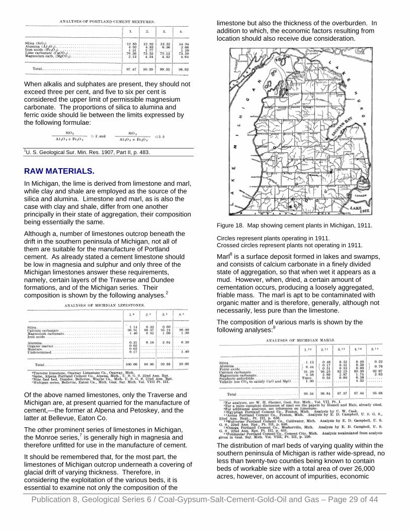
When alkalis and sulphates are present, they should not exceed three per cent, and five to six per cent is considered the upper limit of permissible magnesium carbonate. The proportions of silica to alumina and ferric oxide should lie between the limits expressed by the following formulae:
Publication 8, Geological Series 6 / Coal-Gypsum-Salt-Cement-Gold-Oil and Gas – Page 29 of 44
1U. S. Geological Sur. Min. Res. 1907, Part II, p. 483.
RAW MATERIALS. In Michigan, the lime is derived from limestone and marl, while clay and shale are employed as the source of the silica and alumina. Limestone and marl, as is also the case with clay and shale, differ from one another principally in their state of aggregation, their composition being essentially the same.
Although a, number of limestones outcrop beneath the drift in the southern peninsula of Michigan, not all of them are suitable for the manufacture of Portland cement. As already stated a cement limestone should be low in magnesia and sulphur and only three of the Michigan limestones answer these requirements, namely, certain layers of the Traverse and Dundee formations, and of the Michigan series. Their composition is shown by the following analyses.2
Of the above named limestones, only the Traverse and Michigan are, at present quarried for the manufacture of cement,—the former at Alpena and Petoskey, and the latter at Bellevue, Eaton Co.
The other prominent series of limestones in Michigan, the Monroe series,7 is generally high in magnesia and therefore unfitted for use in the manufacture of cement.
It should be remembered that, for the most part, the limestones of Michigan outcrop underneath a covering of glacial drift of varying thickness. Therefore, in considering the exploitation of the various beds, it is essential to examine not only the composition of the
limestone but also the thickness of the overburden. In addition to which, the economic factors resulting from location should also receive due consideration.
Figure 18. Map showing cement plants in Michigan, 1911.
Circles represent plants operating in 1911. Crossed circles represent plants not operating in 1911.
Marl8 is a surface deposit formed in lakes and swamps, and consists of calcium carbonate in a finely divided state of aggregation, so that when wet it appears as a mud. However, when, dried, a certain amount of cementation occurs, producing a loosely aggregated, friable mass. The marl is apt to be contaminated with organic matter and is therefore, generally, although not necessarily, less pure than the limestone.
The composition of various marls is shown by the following analyses:9
The distribution of marl beds of varying quality within the southern peninsula of Michigan is rather wide-spread, no less than twenty-two counties being known to contain beds of workable size with a total area of over 26,000 acres, however, on account of impurities, economic

considerations, etc. Not all of these beds are available for the manufacture of cement.
As in the case of limestone, there are a number of shales which outcrop in Michigan. Three of them have, thus far, been employed in the manufacture of cement,—namely, the Traverse, at Alpena, the Coldwater at Newaygo, Coldwater, and Quincy, and the Michigan at Bellevue. The composition of these shales is shown by the following analyses by H. Ries.15
Publication 8, Geological Series 6 / Coal-Gypsum-Salt-Cement-Gold-Oil and Gas – Page 30 of 44
Of the other shales, the Antrim and those of the Saginaw formation may be mentioned. The Antrim shale is characterized by a high percentage of silica relatively to the alumina and ferric oxide and also by a high percentage of organic matter, as is shown by the following analysis by W. H. Johnson:21
The shales of the Saginaw formation on the other hand are relatively low in silica. The following analyses are given by Russell :22
Although surface clays formed during the Pleistocene period of glaciation are widely distributed over the southern peninsula of Michigan, they are for the most part not especially satisfactory for use in the manufacture of cement. For that reason, a number of the mills in the southern part of the state import their clay from Ohio. The only Pleistocene clays of Michigan which are being used at present in the manufacture of cement occur near Corunna, Shiawassee Co., and Gray village, Washtenaw Co. The former is utilized by the
New Aetna, Portland Cement Co., Fenton, Mich., and the latter by the Michigan Portland Cement Co. A more complete discussion of this subject may be found in the papers by Ries, Hale, and Russell already cited. 2For other analyses see I. C. Russell, The Portland Cement Industry in Michigan, U. S. G. S. Ann. Rpt. Pt. II pp. 641-646; also David J. Hale and others, Geol. Sur. Mich. Vol. VIII Pt. Ill; also, W. H. Sherzer, Geol. Sur. Mich., Vol. VII, Pt. I; also E. C. Eckel U S G S Bul243, pp. 196-205. 7For analyses, see W. H. Sherzer, Geol. Sur. Mich., Vol. VII, Pt. I. 8For a more complete discussion of marl see the papers by Russell and Hale, already cited. 9For additional analyses, see references on limestone. 10Egyption Portland Cement Co., Fenton, Mich. Analysis by C. W. Cook. 11Aetna Portland Cement Co., Fenton, Michi. Analysis by E. D. Campbell, U. S. G. S., 22nd Ann. Rept., Pt. III, p. 650. 12Wolverine Portland Cement Co., Coldwater, Mich. Analysis by E. D. Campbell, U. S. G. S., 22nd Ann. Rpt., Pt. III, p. 650. 13Omega Portland Cement Co., Mosherville, Mich. Analysis by E. D. Campbell, U. S. G. S., 22nd Ann. Rpt., Pt. III, p. 651. 14Peninsular Portland Cement Co., Cement City, Mich. Analysis recalculated from analysis given in Geol. Sur. Mich. Vol. VIII, Pt. III, p. 236. 15U. S. G. S., Prof. Paper, No. 11 and Geol. Sur. Mich., Vol. VIII, Pt. I. 16Michigan Series, Grand Rapids, Mich., Geol. Surv. Mich., Vol. VII, Pt. I, p. 40. 17Michigan series, Grand Rapids, Mich., ibid, p. 41. 18Coldwater shale, Bronson, Mich., ibid, p. 41. 19Coldwater Shale, Coldwater, Mich., ibid, p. 43. 20Traverse shale, Alpena, Mich., ibid, p. 48. 21U. S. G. S., 22nd Ann. Rpt., Pt. III, p. 668. 22Ibid, p. 670.
LIST OF MILLS.23
Burt Portland Cement Co., Bellevue, Eaton Co., Mich. W. R. Burt, Pres.; Geo. R. Burt, Treas. and Gen. Mgr.
The dry process is employed, the raw materials being limestone and shale of the Michigan series. The shale occurs underneath the limestone and the two are mixed in quarrying, the proper mixture being obtained before burning by combining the mixture from different bins. The burning is done in rotary kilns of which there are eight (6.5' x 60') with a daily capacity of 1,500 barrels.
Huron Portland Cement Co., Alpena, Mich. Offices 1525 Ford Bldg., Detroit, Mich. Incorporated, January 26, 1907. Capital stock, preferred, $800,000; common $1,200,000. J . B. Ford, Pres.; E. L. Ford, Vice-Pres.; S-. T. Crapo, Sec. and Treas.
The dry process is used, limestone and shale being employed as the raw materials. The limestone is that of the Traverse formation and is obtained from the quarry of the Michigan Alkali Co., Alpena. The shale, also of Traverse age, is quarried on the company's lands in Sec. 30, T. 31 N., R. 7 E. The mill contains six rotary

Publication 8, Geological Series 6 / Coal-Gypsum-Salt-Cement-Gold-Oil and Gas – Page 31 of 44
kilns (8' x 110') with a daily capacity of 3,000 barrels. In as much as the mill is located on the shore of Thunder Bay, the company enjoys the advantage of water transportation for its fuel and also the finished product.
Michigan Portland Cement Co., Gray Village, Washtenaw Co., Mich. Plate XX, B.) Incorporated June 14, 1911. Capital stock, preferred $100,000, common, $400,000. N. S. Potter, Pres.; N. S. Potter, Jr., Vice-Pres. and Gen. Mgr.; C. Z. Potter, Sec.; K. L. Potter, Treas.
This company, which took over the property and vertical kiln plant of the Millen (formerly the White) Portland Cement Co., has constructed a rotary kiln plant. There are three kilns (8' x 125') with a daily capacity of 1,200 barrels. The wet process is employed with marl and clay as the raw materials. Both the clay and marl are obtained from lands near the plant.
New Aetna Portland Cement Co., Fenton, Mich. Offices, 50 Congress St., Boston, Mass., and 412 Union Trust Bldg., Detroit, Mich. Reincorporated under the laws of Maine, June, 1907. F. K, Johnson, Pres.; B. E. Payne, Sec. and Treas.; O. J. Lingermann, Gen. Mgr.
The mill of this company, which is the successor to the Detroit Portland Cement Co., and the Aetna Portland Cement Co., is located on the shores of Mud Lake, two miles west of Fenton, Genesee Co. The wet process is employed with marl and clay as the raw materials. The marl is obtained from Mud Lake and the clay is shipped in from Corunna, Shiawassee Co. The mill contains eight rotary kilns (6' x 60') with a daily capacity of 1,000 barrels.
Newaygo Portland Cement Co.,24 Newaygo, Newaygo Co., Mich. Incorporated May 12, 1899; reincorporated June 16, 1911, Capital stock, $500,000. D. McCool, Pres.; Wilder D. Stevens, Vice-Pres.; Clay H. Hollister, Sec. and Treas.; W. A. Ansorge, Asst. Sec. and Treas.
This company employs the wet process with limestone and shale as the raw materials. The plant was originally designed to manufacture cement from marl but the marl was found unsatisfactory and limestone was substituted. The Traverse limestone and the Coldwater shales, which are used, are purchased from the Petoskey Crushed Stone Co., the limestone quarries of which are located in Secs. 2 and 3, T. 34 N., R. 6 W., while the shale beds are in Sec. 26, T. 32 N., R. 8 W. The burning is done in rotary kilns of which there are eleven (1-6' x 60' and 10-6' x 90') with a daily capacity of 2,000 barrels. The plant is operated by electricity generated by water power from the Muskegon river.
Omega Portland Cement Co., Mosherville, Hillsdale Co., Mich. Incorporated February 18, 1899. Capital stock, $300,000. Bonds, $20,000. F. M. Stewart, Pres.; Walter Sawyer, Vice-Pres.; H. J. Tubbs, Sec.; Amos Kendall, Treas. and Gen. Mgr.
The wet process is employed with marl and clay as the raw materials. The marl is obtained from Cobb's Lake on the shores of which the plant is located. The clay is shipped in from Ohio. The mill contains five rotary kilns (6' x 60’) with a daily capacity of 500 barrels.
Peerless Portland Cement Co., Union City, Branch Co., Mich. Incorporated August 19, 1897; reincorporated March 22, 1906. Capital stock, preferred, $350,000, common, $500,000, bonds, $350,000. A. W. Wright, Pres.; S. O. Bush, Vice-Pres.; Wm. M. Hatch, Sec. and Treas.; J. R. Patterson, Gen. Mgr.
The plant employs the wet process with marl and shale as the raw materials. The marl is shipped in on the Michigan Central Railroad from Spring Arbor, T. 3 S., R. 2 W. The burning is done in nine rotary kilns (5.5’ and 6.5' x 70') with a daily capacity of 1,350 barrels.
Peninsular Portland Cement Co., Offices, Cooley Blk., Jackson; mill at Cement City, Lenawee Co., Mich. Incorporated June, 1899. Capital stock, preferred, $700,000; common, $593,000. Wm. F. Cowhan, Pres.; D. C. Griffin, Vice-Pres.; J. W. Shove, Sec.; N. S. Potter, Treas.
The wet process is employed with clay and marl as the raw materials. The marl is obtained from Goose Lake and the clay comes from Bryan, Ohio. The burning is done in nine rotary kilns (3-7' x 80' and 6-6’ x 60') with a daily capacity of 1,250 barrels.
Wolverine Portland Cement Co., Offices, Goldwater, Michigan; mills, Coldwater and Quincy, Michigan. Incorporated February, 1902. Capital stock, $1,000,000. L. M. Wing, Pres. and Gen. Mgr.; C. T. Jones, Vice-Pres.; E. R. Root, Sec, and Treas.
This company operates two mills, one at Coldwater, (Plate XXI A.) and one at Quincy, (Plate XXI B.). The wet process is employed at both points with marl and shale as the raw materials. The marl is obtained from lakes near the plant and the shale, the Coldwater, is quarried about an half mile from the Coldwater plant. The Coldwater plant contains fourteen kilns (6' x 60’) and the Quincy mill seven kilns (6' x 120'), each having a daily capacity of 1.500 barrels. 150 men are employed at the Coldwater plant and 120 at the Quincy plant.
Wyandotte Portland Cement Co., Offices, 1525 Ford Bldg., Detroit; plant, Wyandotte, Michigan. Incorporated, November 21, 1903. Capital stock, $1,000. S. T. Crapo, Pres. and Treas.; J. B. Ford, Vice-Pres.; H. J. Paxton, Sec. and Gen. Mgr.
Both wet and dry processes are employed, limestone and clay being used as the raw materials. The limestone is furnished by the Michigan Alkali Co., a portion being dry and a portion pulverized and wet. The clay is obtained from Millbury, Ohio. The burning is done in three rotary kilns (7' x 100') with a daily capacity of 1,000 barrels. 110 men are employed.
In addition to the above named plants, the following non-producing plants may be mentioned.

Alpena Portland Cement Co., Alpena, Mich. Organized, August 9, 1899. Capital stock, $500,000. Future operation doubtful.
Egyptian Portland Cement Co., Fenton, Mich. Incorporated, June 30, 1900. Capital stock, $1,050,000; bonds, $650,000. Reincorporated. Capital stock, preferred A, $35,000; preferred B, $500,000; common, $1,050,000; bonds, $200,000. This property has been ordered sold by the court. Future operation uncertain.
Elk Cement and Lime Co., Elk Rapids, Mich. Incorporated as the Elk Rapids Portland Cement Co., March 3, 1900. Reincorporated, December 8, 1904. Capital stock, 1st preferred, $50,000; 2nd preferred, $150,000; common, $300,000; bonds, $250,000. F. R. Williams was appointed receiver, January 4, 1911. Future operation is doubtful.
Publication 8, Geological Series 6 / Coal-Gypsum-Salt-Cement-Gold-Oil and Gas – Page 32 of 44
New Bronson Portland Cement Co., Bronson, Mich. Reincorporated, April 15, 1910. Capital stock, $110,000. F. M. Rudd, Pres.; J. S. Galloway, Vice-Pres.; C. H. Powley, Sec.; H. F. Mowery, Treas. This company purchased, at the receiver's sale, the plant of the Chamite Cement and Clay Product Co., (successor to the Bronson Portland Cement Co.). The present company has never operated the plant and future operations are doubtful.
The Hecla Co., (successor to the Hecla Portland Cement Co.), Bay City, Mich. Henry Hertz is receiver of this company and it is very doubtful if the plant will every be operated again.
In Table I is given a list of all mills built or projected, together with the important facts concerning each.
23For location of the various plants see Fig. 18. 24The name has recently been changed to the Grand Rapids Portland Cement Co. with, offices at Grand Rapids. Cement and Engineering News, October, 1911.
PRODUCTION. The annual production of cement in Michigan together with the value of the same from 1896 to 1910 is given in Table II. In column 1, is indicated the number of plants in operation, while column 4 shows the percentage of increase or decrease over the preceding year.
It will be seen that the maximum number of plants in operation was reached in 1904. However, the maximum production was not attained until 1906 when but 14 instead of 16 plants were operating. Following the maximum production of 1906, a decrease is shown for the next two years and, although increases are indicated for 1909 and 1910, the high water mark of 1906 has not been regained.
The figures for the number of plants in operation do not give the exact status of the case as in several instances the closing down of one plant has been offset by the opening of another.
In Table III, the Michigan production is compared with that of the United States. The Michigan production, the United States production, and Michigan’s percentage of the same are given in columns 1, 2, and 3. In columns 4, 5, and 6, are indicated the values of the product together with Michigan’s percentage.

It is to be noted that the percentage of value is generally somewhat higher than the percentage of product indicating that the price received per barrel for Michigan cement has been slightly in advance of the average price for the United States. This is also shown in Table IV which gives the annual price per barrel for Michigan and for the United States.
The decrease in the number of plants indicated in Table II is undoubtedly explained by the low price per barrel which the manufactures have received in recent years. That the average price per barrel is not far from the cost of manufacture is shown by the following compilation by Dr. F. M. Chance26 from the reports of seven companies.
PRESENT OUTLOOK It cannot be said that the present outlook is by any means promising. While the utilization of cement has increased very rapidly, yet it has by no means kept pace with the increased production.
The Michigan industry finds itself possessed of a very limited market due to its geographical position and the growth of the industry in adjacent states. This has narrowed the field practically to the confines of the state. The result is that such strong competition has been engendered among the Michigan companies that only those companies with exceptionally favorable conditions,
such as location near market, cheap transportation, utilization of by-products, freedom from indebtedness, etc., have been able to operate without a loss. In addition to the local competition, the Michigan plants have also had to compete with the mills of other-states which have used Michigan as a "dumping ground' for their surplus, while serving a better market, in other directions, from which Michigan is cut off by the high freight rates.
Plate XX. A. Plant of the Peerless Portland Cement Company, Union City, Michigan.
Plate XX. B. Plant of the Michigan Portland Cement Company, Gray Village, Michigan.
It is difficult to see any immediate relief from the above mentioned conditions. Attempts have been made to secure the reduction of freight rates to certain points but as yet nothing has been accomplished along that line. At present, it appears to be merely a case of survival of the fittest. It is possible that a considerable decrease in the number of producing plants might enable the remaining ones to earn a fait return on their investment.
Publication 8, Geological Series 6 / Coal-Gypsum-Salt-Cement-Gold-Oil and Gas – Page 33 of 44
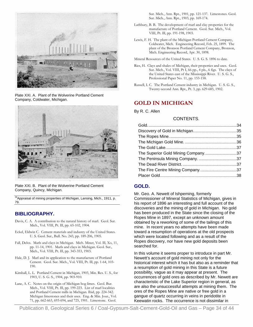
Plate XXI. A. Plant of the Wolverine Portland Cement Company, Coldwater, Michigan.
Plate XXI. B. Plant of the Wolverine Portland Cement Company, Quincy, Michigan.
Publication 8, Geological Series 6 / Coal-Gypsum-Salt-Cement-Gold-Oil and Gas – Page 34 of 44
26Appraisal of mining properties of Michigan, Lansing, Mich., 1911, p. 79.
BIBLIOGRAPHY. Davis, C. A. A contribution to the natural history of marl. Geol. Sur.
Mich., Vol. VIII, Pt. Ill, pp. 65-102, 1904.
Eckel, Eldwin C. Cement materials and industry of the United States. U. S. Geol. Sur., Bull. No. 243, pp. 189-206, 1905.
Fall, Delos. Marls and clays in Michigan. Mich. Miner, Vol. Ill, Xo, 11, pp. 11-14, 1901. Marls and clays in Michigan. Geol. Sur., Mich., Vol. VIII, Pt. Ill, pp. 343-353, 1903.
Hale, D. J. Marl and its application to the manufacture of Portland Cement. Geol. Sur. Mich., Vol. VIII, Pt. Ill, pp. 1-64, 103-190.
Kimball, L. L. Portland Cement in Michigan, 1903, Min. Res. U. S., for 1903, U. S. G. S., 1904, pp. 903-910.
Lane, A. C. Notes on the origin of Michigan bog limes. Geol. Bur. Mich., Vol. VIII, Pt. Ill, pp. 199-223. List of marl localities and Portland Cement mills in Michigan. Ibid, pp. 224-342. Michigan limestones and their uses. Eng. & Min. Jour., Vol. 71, pp. 662-663, 693-694, and 725, 1901. Limestone. Geol.
Sur. Mich., Ann. Rpt., 1901, pp. 121-137. Limestones. Geol. Sur. Mich., Ann. Rpt., 1903, pp. 169-174.
Lathbury, B. B. The development of marl and clay properties for the manufacture of Portland Cement. Geol. Sur. Mich., Vol. VIII, Pt. Ill, pp. 191-198, 1903.
Lewis, F. H. The plant of the Michigan Portland Cement Company, Coldwater, Mich. Engineering Record, Feb. 25, 1899. The plant of the Bronson Portland Cement Company, Bronson, Mich. Engineering Record, Apr. 30, 1898.
Mineral Resources of the United States. U. S. G. S. 1896 to date.
Ries, H. Clays and shales of Michigan, their properties and uses. Geol. Sur. Mich., Vol. VIII, Pt I, 66 pp., 4 pls., 6 figs. The clays of the United States east of the Mississippi River. U. S. G. S., Professional Paper No. 11, pp. 153-158.
Russell, I. C. The Portland Cement industry in Michigan. U. S. G. S., Twenty-second Ann. Rpt., Pt. 3, pp. 629-685, 1902.
GOLD IN MICHIGAN By R. C. Allen
CONTENTS. Gold..............................................................................34 Discovery of Gold in Michigan......................................35 The Ropes Mine...........................................................35 The Michigan Gold Mine. .............................................36 The Gold Lake..............................................................37 The Superior Gold Mining Company............................37 The Peninsula Mining Company. .................................37 The Dead River District. ...............................................37 The Fire Centre Mining Company. ...............................37 Placer Gold...................................................................38
GOLD. Mr. Geo. A. Newett of Ishpeming, formerly Commissioner of Mineral Statistics of Michigan, gives in his report of 1896 an interesting and full account of the discoveries and the mining of gold in Michigan. No gold has been produced in the State since the closing of the Ropes Mine in 1897, except an unknown amount obtained by a reworking of some of the tailings of this mine. In recent years no attempts have been made toward a resumption of operations at the old prospects which were located following and as a result of the Ropes discovery, nor have new gold deposits been searched for.
In this volume it seems proper to introduce in part Mr. Newett’s account of gold mining not only for the historical interest which it has but also as a reminder that a resumption of gold mining in this State is a future possibility, vague as it may appear at present. The occurrences of gold ores as described by Mr. Newett are characteristic of the Lake Superior region in general, as are also the unsuccessful attempts at mining them. The ores of the Ropes Mine are native or free gold in a gangue of quartz occurring in veins in peridotite in Keewatin rocks. The occurrence is not dissimilar in

Publication 8, Geological Series 6 / Coal-Gypsum-Salt-Cement-Gold-Oil and Gas – Page 35 of 44
general to those in the Porcupine district of Ontario where success in a large way seems about for the first time to be realized, if attained which will be all the more noteworthy in view of the long list of utter failures and near failures in past years in attempts to mine gold in the Lake Superior region. The following is a quotation of the essential parts of Mr. Newett's account written in 1896 to which reference is made above.
DISCOVERY OF GOLD IN MICHIGAN. As early as the time in which Dr. Douglass Houghton, Michigan's first State Geologist, was engaged in the task of examining the Upper Peninsula rocks, it was known that gold existed in this portion of the State. Dr. Houghton, upon one of his brief trips from the camp at which he was temporarily located, secured enough gold to fill an eagle's quill. The gold, as remembered by those who saw it, was very coarse, and the doctor said he had obtained it from the bed of a little stream of water. The unfortunate drowning of Dr. Houghton occurred before he had disclosed the secret of the whereabouts of the discovery. Those who accompanied him during his work in the Upper Peninsula are not clear as to the exact place in which the camp was located at the time, and many points have been chosen as the correct one. It is generally believed that the spot was not far from where the most active work has since been done in the way of developing the gold-bearing veins of this region.
In January, 1864, Dubois & Williams, analytical chemists, of Philadelphia, Pa., in assaying specimens of quartz for silver, from the Holyoke silver district, eight miles north of the present city of Ishpeming, were surprised to find gold, the quartz holding it at the rate of several hundred dollars per ton. They reported this, but little attention was given the story, and no searching resulted.
The first discovery that led to anything of practical kind, and the one from which has sprung all that has been done in the Michigan gold fields, was made by Mr. Julius Ropes, of Ishpeming. This gentlemen, a chemist, had noticed the presence of the metal in numerous rock samples he had taken, and he finally located a vein of quartz from which all subsequent excitement has resulted. This was in 1880, and the location was the south half of the northwest quarter of Section 29, 48-27, three miles northeast of Ishpeming City. It was in a range of serpentine rocks, and near the edge of a wet swamp. A company was formed, the fee of the mineral having been first purchased, and here
THE ROPES MINE. the first gold mine in the State of Michigan, was opened. It was not started on the spot at which the original find was made, but high ground, about 850 feet farther west, was selected, and here a shaft was sunk, a small mill erected, and the first milling work was done in 1882.
Since then the mill has been increased in size, and at one time 65 heads of Cornish stamps were dropping.
The Ropes was unfortunate in that it lacked sufficient funds to carry on its mining work as it should be done in order to secure the best results. In its earlier history there were many different managers who had charge of the business, and few of them were experienced in the work of milling. Like most gold mines, the Ropes had its peculiarities, and much time and money was expended in becoming familiar with them. About the time the best methods were learned, and the money had been spent, the people grew tired, the few assessments levied discouraged them. In 1896 they were mining and milling a ton of rock for about $1.85, which was certainly doing remarkably well considering the small amount treated per day, about 65 tons.
The Ropes rock is a hard one to stamp. It contains considerable talcose slate, this being sticky and soft, acting as a cushion under the heads. The rock has to be stamped fine, a 40-mesh screen being used, and the tonnage per head is small as compared to mines where a rock of different nature is met with. With all this understood, the management certainly made an excellent record, and deserved a better financial condition under which to labor.
The Ropes ore formation possesses a width of from 30 to 50 feet, and is made up of talcose slates in which the ore occurs in lenticular form and generally running transversely across the formation. Lenses are found in all imaginable positions, but the general course is as described. These lenses are made up of narrow bands of quartz and slate, and the minerals associated with the gold are galena, iron pyrites, gray and yellow copper ores. Occasionally one sees a speck of free gold, and at several places in the mine small vugs containing considerable free gold were found. At one such place about $400 worth of the native metal was taken. Generally, however, the ore bodies have been of low grade, the average yielding something like $2 or $3 per ton. Could the mine have been opened up differently, and a selecting of the rock made, this average could have been considerably improved.
There is one shaft to the 15th level, a vertical depth of 850 feet. To the 12th level the lode has a slight dip to the south, but from this point to the present lowest level it inclines slightly in the opposite direction, the wells being nearly vertical. The ore lenses have a pitch to the west. The bottom of the first main lens was found at the 5th level, that of the second at the 9th, and in 1896 they were working upon the fourth lens in the bottom levels, the work here being entirely upon the east side of the shaft whereas in the upper levels the stoping was done to the west. In the lens encountered on the 16th level, the slate mixture is almost entirely missing, the vein being almost solid quartz, and giving an average of about $6 per ton, this showing a better and stronger vein than has been found at any other point in the mine. The shaft does not reach to the bottom of this level, but stops at the 15th. An incline shaft was sunk at a distance of

Publication 8, Geological Series 6 / Coal-Gypsum-Salt-Cement-Gold-Oil and Gas – Page 36 of 44
150 feet east of the main shaft to secure the ore of this level. The hoisting was done from this sub-shaft by a small engine. They carried this shaft down until the shape of the new lens was determined. They had an idea that its westward pitch would carry it under the line of the main shaft, in which case the latter would have been continued downward and the lens would have been mined from this avenue. As the pitch of all the ore bodies thus far encountered has been westward, it is fair to argue that the position of this would prove no exception to the others.
The finding of ore of better quality, and in larger body than has heretofore been met with is particularly encouraging on this lowest level. It speaks well for the persistence of the gold, and offers substantial reasons why the Ropes should have been given a better show than was accorded it in the way of money to do business with.
A small territory was worked upon. A length of 550 feet on the trend of the lode embraces it all, and from this there was produced $605,056.95 worth of gold and silver. This is the gross yield, and I give it to show that there is gold in the rock of this mine. This embraces the product from the commencement up to the first of January, 1896. T he gold is generally free milling. What concentrates were saved were sent to Aurora, Ill., for treatment. Frue vanners were employed for the concentration. The bulk of the gold is held in the "quick” in the mortars and on the copper plates, the common form of amalgamation being observed.
An advantage the mine has is the "solid walls that need no timbering and the freedom from water. In the 16th level not a drop of water came from the level. The vein was stoped out on the overhand plan. The ground was drilled by machines. About 35 men were employed in 1896.
Another point of vantage was the cheapness with which the water supply was secured. The source is the Carp river something more than a mile distant. Here a dam was constructed, and, with a four-foot fall, a pump was operated by a turbine wheel that furnished all the water the mill needed, and the supply is ample for any future demand that may be made under a prosperous condition of things.
At the point where gold was first found by Mr. Ropes on this property, the vein was narrow, but very rich, giving about $200 per ton, by assay. There is the territory lying between this and the shaft at the mine upon which practically nothing has been done in the way of exploration and where there should be something valuable disclosed by practical testing of the ground. The fact that the ore lenses in the mine pitch to the west, and that gold was found on surface so far east, is an encouraging sign.
Several years after mining work was discontinued by the Ropes Gold & Silver Company, Mr. W. H. Rood, of Ishpeming, erected several large vats and attempted to reclaim the gold in the tailings that had been wasted into
the low ground immediately north of the mill. The cyanide process was employed, and the work was just fairly started when the death of Mr. Rood put an end to it. Several thousand dollars had been reclaimed and Mr. Rood stated that he was making a profit. Unfortunately, no one took up the cyaniding after this time. The plant was in the nature of an experiment and demonstrated the fact that the tailings could be successfully treated. Had the cyanide plant been operated simultaneously with mining and milling activities it might have enabled the company to secure the margin of profit necessary to success.
The product for 1895 was valued as follows: Gold, $34,838.69; silver, $1,373.16; Total, $36,211.85.
Two miles and a half west of the Ropes mine, on Section 35, town 48, Range 28 is
THE MICHIGAN GOLD MINE. This property has produced some of the finest specimens of free gold ever seen. Many of these yielded gold at the rate of $160,000 per ton. Indeed, so rich were they, that they offered too great a temptation to the miners who were employed there, and the trunk of one enterprising fellow who was all ready to take his departure for Europe was looked into and found to contain over two thousand dollar's worth of gold treasure, secured from this property when the eyes of the bosses were not upon him. How many thousands were stolen is not known, but there probably were many of them. This property was its busiest in 1890, and for a time there was lively trading in its shares. At a depth of about 80 feet in two shafts that were sunk, the gold had diminished to such a degree as to dishearten those who were conducting the exploration and work was abandoned. A little was done in 1895, but nothing of value accomplished. It consisted principally in making a test of some of the rock already mined.
The Michigan has several veins crossing its lands, and it was upon the largest of these that the work was done, although gold was found in the smaller ones. The veins are in diorite, differing in this respect from the Ropes. Their trend is nearly east and west, and they observe a nearly vertical position. There is little or no silver, and the gold where found is free milling, there being little mineral in the rock aside from the gold. The rock stamps freely, and under the ordinary Cornish head a large amount could be treated daily.
During the months of January, February, and March, 1890, the mine produced $12,675.35 worth of bullion, and this was the time when the excitement regarding it ran highest. The total yield is valued at $17,699.36. With the great diminished percentage of gold in the bottom of the exploring shafts interest also waned, and all work was finally abandoned, and those who invested in the shares of the company were out the money put in.
The shafts of the Michigan Gold Company were less than 100 feet in depth. What another one hundred feet

Publication 8, Geological Series 6 / Coal-Gypsum-Salt-Cement-Gold-Oil and Gas – Page 37 of 44
would have shown can but be conjectured. The property was well equipped with machinery, there were several creditable buildings, and everything was in shape in 1896 to resume work on short notice.
THE GOLD LAKE. This prospect is immediately west of the Michigan on lands belonging to the Lake Superior Iron Company. The latter company sunk a shaft, and secured many fine specimens, after which they leased it to the Gold Lake Company, by whom it was worked for a time in a very quiet manner. Specimens rich in gold, and comparing favorably with those from the Michigan, were secured. This vein is also in the diorite, and felsite shows in places cutting through the diorite. The vein "pinched” out at a depth of something like 60 feet, and its continuation was not sought beyond a few feet where it was lost sight of.
THE SUPERIOR GOLD MINING COMPANY. did some work on the northeast quarter of northwest quarter of Sections 35, 48-28. This was immediately east of the Michigan property, and the vein was in the diorite. Some fine specimens were secured, A but the work was given up soon after it was begun. The vein is said to have been cut out by the diorite.
THE PENINSULA MINING COMPANY. made up of Detroit, Michigan capitalists, did some work under the above title on the southwest quarter of the southwest quarter of Sections 25, 48-28. A shaft was sunk 70 feet. The quartz here is in granite and is in small stringers. Free gold was seen, and the company figured that they could treat all the granite impregnated with this quartz. Numerous assays were made and the company reported these to be satisfactory. They have not done anything in the way of equipping the property.
Other properties were worked more or less, the Grummett, Swains, Mocklers, Grayling and Giant being prominent at the time the excitement was at its height, but all work has stopped. These were all on the Michigan range.
THE DEAD RIVER DISTRICT. One of the most promising territories for the existence of gold is known under the above title. In the sixties there was great excitement in the field due to the discoveries of silver secured from the Holyoke mine, but the lead did not prove rich enough in the more precious metal, and all work was finally abandoned.
This district begins in the Dead River valley starting about eight miles north of Ishpeming and extending northward to Lake Superior. The particular portion of this field as thus far exploited can be located by a line drawn centrally through it from east to west, which line would agree with the line of town 49. The eastern
terminus can be placed at Lake Superior. Westward it extends several miles. The honor for first bringing this district to the attention of the people of the State was accorded Julius Ropes, who made his initial discovery here in June, 1890.
In town 27 there is a spur that leaves the main range, going at a sharp angle to the northwest. This is locally termed the north range, and the one from which it diverges, the south range. The south range appears to be the principal gold bearer so far as tests of the rock have been made. In width the range altogether is about three miles.
Small quartz seams are innumerable. The seams of quarts run in size from an inch to several feet, and many of them are gold-bearing. The predominating minerals are copper ore, iron pyrites, galena, and sometimes zinc. No refractory ores are discovered. Tellurium has also been found in a trachitic greenstone, and it is reported from no other portion of this region.
The configuration of the surface of this field is attractive. The granites and traps sometimes rise to a great height, forming deep defiles, reminding one of the canyons of the west. The schists and softer rocks have been gouged out, making the surface very rugged, full of gulleys and corresponding hills. It certainly is an attractive region, and one that has not commanded the attention from gold hunters which it deserves.
Following the discovery of Mr. Ropes in this field, a company was organized that secured options on a large tract of land and conducted explorations on Sections 35, 49-27 under the title of
THE FIRE CENTRE MINING COMPANY. Two shafts were sunk upon different veins in the granite, and were carried downward about 100 feet. At this depth there was a diminuation of gold in the rock and the company ceased operations much to the disappointment of the many who were interested. As in the case of other explorations in this region, those who undertook development work were unfamiliar with gold mining. They were too easily discouraged.
In the summer of 1892 a trial lot of rock was treated in the Ropes gold mine mill. This consisted of 254 tons, and from it were produced $2,063 worth of gold, about $8.12 per ton, a most gratifying result. The gold was 69*7 fine, and the percentage of saving in the mill, including concentrates, was 76.7, showing the free-milling qualities of the rock. The latter stamped very freely, much more readily than that of the Ropes mine. The Fire Centre Company ordered a Crawford mill, which .was set up and proved an utter failure. In the fall of 1898, the shafts having changed from pay quartz to barren work was stopped, and the place has been abandoned. I consider this the most promising of the several gold fields in this region, and believe if it has skilled men to direct operations a success would be

achieved. The tract is a large one, and little or nothing has been done.
I have been shown rich specimens that are said to have been taken from Baraga County, and from near Lake Michigamme. Nothing is now being done in that section.
Two miles north and east of the Ropes, Edward Robbins, of Ishpeming, found gold in the summer of 1895, and obtained many fine specimens showing the native metal.
This gold is associated with the iron ore-bearing formation.
PLACER GOLD. Placer gold from the fluvio-glacial deposits of the State has been reported from a number of localities, some of which are well authenticated. The source of the gold is doubtless in the gold-quartz veins which are known to occur widely distributed in the Archean rocks of the Lake Superior region.
What gold there is in the glacial drift of the Lower Peninsula has been transported from the north in the same manner as other materials of the glacial drift and should be put in the same category as "float" copper, and "float” iron ore, as being no indication whatever of the existence in this part of the State of the original source of the metal. Very lean placers may result from concentration by stream action of the gold particles in the glacial drift but we have no proof that any of the deposits reported have any value, commercially, nor is it thought that any of them either known or unknown are valuable. To produce a workable concentration from the widely scattered particles of gold which are in the glacial drift of the Southern Peninsula would requires a sorting by water action of such magnitude and completeness as to be wholly beyond the probabilities.
Chances in favor of the occurrence of valuable gold placers in stream gravels of the pre-Cambrian area of the western half of the Upper Peninsula are decidedly greater than elsewhere in the Paleozoic areas of the State for the reason that in the pre-Cambrian rocks are the only known or even probable original sources of gold in this State and the drift in some parts of this area is mainly of local origin. Yet even in these areas the possibilities of the occurrence of placer "pay dirt" are sufficiently meager to discourage prospecting with any hope of commercial reward.
In the Annual Report for 1906, D. A. C. Lane quotes a letter from W. M. Courtis of Detroit giving localities from which placer gold has been reported. Some of these occurrences have been authenticated.
Mr. Courtis says: "At Lowell and along the Grand River there is gold in a certain channel that crosses the river near this place. This gravel is composed of a different kind of pebbles from the gravel found in the high banks along the river which rise in some places two or three hundred feet above. The gold in the Grand River begins at Maple River and was found down to Ada Creek and probably down to the lake, no gold being found in the most favorable bars above the former place.
"These high bluffs are stratified in some places, at others irregular deposits. None of these strata would pan gold even taking the ferruginous seams, the most promising, except in the lower seams a few colors were found.
"The gravel in the old river channel seems sufficiently rich to work with dredges in some parts where the land is not too valuable and as this old channel apparently comes from the northwest. There seemed to be a steady increase in the colors of gold as depth is gained - pans running from four to thirty colors. The total average of all out tests was about three cents per cubic yard, though very little digging was done, only taking up the mussels and panning the gravel. The estimate of three cents included all the barren dirt that was tested, barren gravel that overlays the old bed and is not any criterion of what the river channel would run, which should be tested with six holes. The gold was much coarser than I would suspect, some of it being like mustard seed.
“I thought it had been "salted" but I walked out a rod or two from the shore, dug up the mussels and alone washed the dirt. Here I got but one to four colors to the pan. This gravel contains a large amount of black, magnetic sand, iron, garnets, zircons and is analogous to those deposits worked in Russia which in their richest parts yield from two to four dollars per cubic yard."
The following is a list of the places where gold is said to have been found in the gravel:
Washed by myself:
Maple River, Ionia County Lowell, Kent County Ada Creek, Kent County Grand River, below Lyons, Ionia County Flat River, Ontonagon County Iron River Ishpeming Marquette County
Reported discoveries:
Birmingham, Oakland County Union City Branch, to the S.E. and S.W. (?) Marcellus, St. Joseph County Burr Oak, St. Joseph County (pyrites likely) Grand Haven, Ottawa County Allegan, Allegan County Greenville, Montcalm County Howard City, Montcalm County County Line, Newaygo County Muskegon River, Newaygo County Whitehall, Oceana County White River, Oceana County
Publication 8, Geological Series 6 / Coal-Gypsum-Salt-Cement-Gold-Oil and Gas – Page 38 of 44

Publication 8, Geological Series 6 / Coal-Gypsum-Salt-Cement-Gold-Oil and Gas – Page 39 of 44
Elbridge, Part, June 7, 1906 Little Sable River, Manistee County West Summit, Wexford County Manistee River, Manistee and Wexford Counties Walton, Kalkaska County Rapid River, Kalkaska, Kalkaska County Leelanau County, Near Lake Antrim County, same river (nuggets, reliable) Boyne River, Charlevoix County Little Traverse, Emmet County Victoria Copper Mine (large nugget) Ishpeming district, near gold mines at points south of Gogebic Iron Range.
The following places were reported but believed to be only pyrites:
Caro, Tuscola County1 Cheboygan, Cheboygan County1 Alpena, Presque Isle County1 Caseville, Genessee County1 Flushing, Genesee County1 Near Fargo, St. Clair County T.8N., R.14E. ($6.00 per ton ?) NE¼/SE¼ Sec. 33, T.49N., R.42W., Tr. Aug. 15c Ag.
In addition to the above localities Dr. Lane reports the finding of a nugget on bed-rock at Williamston, Ingham County, by Mr. Taylor, and a statement that Mr. Jos. B. Seager has washed as many as 20 colors to a pan in the Huron Mts. where the drift is of local origin. 1Iron pyrites, examined.
OIL AND GAS IN MICHIGAN.1
BY R. A. SMITH.
CONTENTS. Exploration for oil and gas. .......................................... 39 Oil fields and districts................................................... 40
Port Huron field ......................................................40 Southeastern district ..............................................40 Southwestern district..............................................41 Western Michigan ..................................................41 Central part of the state .........................................42 Northern part of the Southern Peninsula ...............43 Northern Peninsula ................................................43
EXPLORATION FOR OIL AND GAS. Much exploration for oil and gas has been done in many parts of Michigan, but the results have been, on the whole, meagre in extreme. Only at Port Huron and near Allegan has oil been discovered in quantities approaching commercial importance. A recent report, however, indicates a possible occurrence of oil in quantity at Osseo, in Hillsdale county. The scant success may not be entirely due to a general absence in Michigan of these mineral products in commercial
quantities, but very possibly, if may be largely due to the manner in which such exploration has been carried on.
As a rule the drillings have been very scattered, haphazard, and relatively shallow when compared with the depth of the oil horizons as they exist in this state. A single drill hole, though deep, can hardly be considered a positive test, determining the presence or absence of oil or gas in any particular area, since a large majority of the drillings even in a proven territory are "dry holes.” Most of the companies organized for oil exploration sell their stock at so low a figure that, after paying the necessary expenses of organizing, salaries, etc., there is little left for adequate development work. Drillers as a rule have known little or nothing of the major structure of the Michigan basin, the formations, or the relative depths of the same. Often it has happened that the driller has gained his knowledge of oil conditions and occurrences from experience in other fields, as Ohio, etc., and begins operations with a false notion that similar conditions obtain in Michigan. Consequently, after drilling a few hundred feet without finding either the Trenton or Berea, the coveted goals of the Ohio drillers, he becomes discouraged and gives up the attempt. The money spent is wasted, as nothing definite either one way or the other, regarding existence of oil or gas, has been determined.
Anyone, contemplating development work for oil and gas in Michigan, should have a general knowledge of the usual conditions under which these mineral products occur and, as far as possible, a specific knowledge of the major geological structure of the Michigan basin, the nature, thickness, and depth of the formations, the possible oil horizons, and the location of minor structures, such as folds or anticlinals, which may be superimposed upon the major structure. The general and the specific facts most pertinent to any oil or gas exploration work in Michigan might be summarized as follows:
1. A general geological structure most favorable for the accumulation of large bodies of oil and gas is a broad upward fold, or anticline, with numerous minor folds, or anticlines, superimposed upon the major structure. The oil and gas being lighter than the waetr, make their way upward through porous layers and collect at the crests of the minor folds underneath impervious layers such as shales, etc., forming accumulations known as "pools.” Obviously "dry" holes will be the general rule except near the crests of the anticlinals.
2. The above general conditions are idealized in the Nashville and Cincinnati anticline, the broad dome or rather arch running from Tennessee northward through Ohio into western Ontario. It is chiefly on the crests of the numerous minor folds of this great anticline that the oil pools of Ohio occur.
3. The major structure of the sedimentary rocks of Michigan is a broad downward fold in which the formations lie one upon another like a pile of gigantic

Publication 8, Geological Series 6 / Coal-Gypsum-Salt-Cement-Gold-Oil and Gas – Page 40 of 44
shallow saucers, each successively higher saucer being smaller than the one next below.
4. The major structure is thus diametically opposite to that obtaining in Ohio and Tennessee and the minor flexures or anticlines are apparently not only much fewer but much less pronounced in Michigan. The general conditions are such that they are more favorable for the escape of the oil and gas rather than for their accumulation.
5. Apparently, the main hope of finding oil and gas in commercial quantities in Michigan lies in the occurrence of the above mentioned minor folds or anticlinals, or of other structures serving the same purpose.
6. Eight possible or probable anticlinals (Fig. 19) have been approximately located and the chances for finding oil and gas are presumably much greater in their vicinity than elsewhere.
7. The formations as a whole becomes deeper toward the center of the basin, thus the Berea Grit coining to the rock surface beneath the drift near Harrisville, Alcona county, is found at more than 2,000 feet below the surface in the Saginaw valley. The Trenton outcropping in the channel of St. Mary's river and at Limestone Mountain in the southern part of the Keweenaw peninsula, is probably 5,000 feet or more beneath the surface in the central part of the Lower Peninsula.
8. A knowledge of the approximate depth at which any given horizon may be reached and the number of water-bearing horizons to be encountered is essential both from a practical and financial standpoint. Sometimes the drilling is a failure because the hole is too small to allow for casing off water the necessary number of times before the oil horizon is reached, or because the desired horizon is so deep that the capital is exhausted before the completion of a single hole, to say nothing of a number sufficient for an adequate testing of any given territory. 1Compiled largely from the writings of Dr. A. C. Lane, as found in Volume V, Part 2, 1895, and the annual reports of the Michigan Geological Survey for 1901, 1903, 1904 and 1908.
OIL FIELDS AND DISTRICTS. Port Huron Field. Oil and gas in small quantities has been found almost everywhere in the state, but only at Port Huron has the quantity been deemed sufficient for exploitation on a commercial basis. The development of the Port Huron district, which extends for several miles along the St. Clair river above and below the city, has been due largely to the energy and enterprise of the late Mr. G. B. Stock of Port Huron. The Michigan Development Company, organized by him, has drilled many wells in the vicinity of Port Huron, and has, in the western part of the city, a, group of 21 wells which yield altogether some 70 barrels of' heavy oil per week. This production, though insignificant when compared with those of Ohio and other fields, is more than sufficient, under favorable conditions, to pay operating expenses,
but, of course, the net returns are disproportionately small in comparison with the original outlay made in putting down the wells.
The oil is very heavy and a natural lubricant and is used as a base in the manufacture of the superior lubricants made by the G. B. Stock Xylite Grease and Oil Company of Port Huron.
Almost all of the test holes in the Port Huron district give a show of gas and oil. Some wells, at first, yield two to three barrels per day, but, after a few weeks, the yield gradually decreases until an average yield of about a half a barrel a day is reached. According to report, several of the wells have been producing for about 15 years and show no positive signs of exhaustion. It is this constancy of production that forms the ground for a firm belief upon the part of the oil promoters at Port Huron that a pool of oil must exist somewhere in that district.
Gas is present in most of the wells and it is in sufficient quantity in the Michigan Development Company's wells that it is used as the motive power for a 25 H. P. gas engine which drives their pumping machinery. Many farmers, especially south and west of Port Huron, in Macomb, Oakland, and other counties, strike gas under impervious beds of clay in wells, in quantities sufficient for household purposes. In fact, there are several other places in the Lower Peninsula, especially in the southeastern and northern parts, in the Manistee district, and in Monroe county, where gas has been found either in drift or rock wells in quantities .that warrant utilization for such purposes.
The oil horizon at Port Huron is the Dundee, which at Petrolia and Port Huron is a constant though often modest producer of oil and gas. The depths of most of the oil wells range from about 500 to 650 feet, though there are a few shallower or even deeper. Mr. Stock for many years entertained the idea of financing a project for sinking a well down to the Trenton, but his sudden death in 1910 put an end to further efforts in that direction. From the records of the salt wells at Port Huron, the first salt in the Salina appears to occur at about 1,500 feet. Judging from this, it would require a well probably more than 8,200 feet to reach the Trenton.
The numerous drillings at Port Huron and four or five miles north of the city along Black river, indicate the presence of a low anticlinal in the Dundee, running through the southern and western portions of the city and then veering to the northward along Black River. Some exploration on the northern extent of this anticlinal in 1910 and 1911 near Black river has resulted in the reported discovery of oil and gas in small quantities comparable to the flows found in the Port Huron wells. Possibly the oil is so distributed through the oil formation that only small flows of oil and gas will ever be found in the Port Huron district,
Southeastern District. The southeastern district, extending from Macomb county southwestward through Wayne and Monroe counties to Ohio, should really include the Port Huron district, which has been deemed

Publication 8, Geological Series 6 / Coal-Gypsum-Salt-Cement-Gold-Oil and Gas – Page 41 of 44
worthy of separate discussion. In this district, oil in small and gas in considerable quantities have been encountered in numerous wells. Especially is this true in belts underlain by the Antrim, Traverse, and Dundee formations. As noted in the discussion of the Port Huron district, drift gas wells are numerous in St. Clair and Macomb counties. The same conditions obtain, though perhaps to a lesser degree, from Monroe county to the Ohio line.2
In the northeastern part of Monroe and in parts of Wayne county, oil impregnates the rocks, forms a scum over ponds and streams, in wells and around springs, and gives off an offensive odor to the water. Gas in bubbles or sometimes in continuous streams rises up through) the water in many instances in quantities sufficient to be ignited. This is the so-called surface or shale gas, which usually has a relatively small volume, and no great pressure, but still it is often sufficient for utilization for household purposes. The gas is used mainly for heating as it is deficient in illuminants, and gives very little light. Though a well may last only a few years, another can be put down at small cost.
Monroe county, lying close to the Toledo oil fields, naturally has been well prospected, though with practically barren results. Small quantities of oil and gas, however, were found in all of the drillings. Ten or more deep wells, six to the Trenton, have been put down in the county, mainly in the southeastern part. The wells at Monroe, at Dundee, etc., showed that unfortunately Monroe county was too far down the western slope of the Cincinnati anticline, which extends from western Ohio into Ontario, to contain oil and gas in any great quantities. In the F. C. Potter well (N. W. ¼ of the N. W. ¼ of Section 22, Erie township), which was the nearest to the Toledo fields, the Trenton was struck at 1,555 feet and penetrated 112 feet. The gas, with an original pressure of 25 pounds, has been utilized for household purposes. The well also contains some oil and has been "bailed" out several times, yielding as much as 10 barrels in one case. None of the other wells were as productive and, significantly, the wells farthest away from the Ohio fields were, in general, the more unproductive.
Well records of Monroe county and at Milan, Ypsilanti, Ann Arbor, etc., seem to indicate a uniform dip of 29 to 32 feet of the formations from Monroe county toward the northwest to Ann Arbor and beyond, with no indication whatever of a minor fold.
In Wayne county, however, near Wyandotte, there appears to be a low anticlinal (See Lane, Annual Report, 1901) coming across the Detroit river and dipping sharply to the northwestward. The strata in the Sibley quarries dip to the southwest instead of the northwest, the direction of the normal dip, and the Sylvania sandstone (See reference table of horizons) in the Solvay well No. 6 (Lane, Annual Report, 1901) at Detroit and in the Canadian Pacific R. R. well No. 11, Windsor, is some 30 feet or more deeper than in the Tecumseh Salt Company wells near River Rouge. The Ford
(Michigan Alkali Co.) wells at Wyandotte, however have shown no noteworthy amounts of gas or oil.
North of Mt. Clemens the normal northwesterly dip of the formations suddenly becomes northerly, as shown by the records of the wells at New Baltimore, Mt. Clemens, etc. The change in dip is indicative of the presence of an anticlinal which probably runs from somewhere near Mt. Clemens toward the central basin.
Southwestern Part of the State. A number of deep wells have been sunk for oil or water at various places in the southwestern part of the state, as at Kalamazoo, Dowagiac, Berrien Springs, Bridgman, Benton Harbor, Niles, White Pigeon, Constantine, Allegan, etc., but, though oil and gas were encountered in many of the wells at one or more horizons, only at Allegan was oil reported in possibly commercial quantities. Several wells from 1,300 to 1,400 feet or more in depth, were bored, oil being found in every case. The No. 1 well of the Allegan Oil and Gas Co., according to Mr. J. C. Ellinger, president of the company, gave a yield of about 5 barrels of oil per day, which was not materially increased by shooting. For about 6 weeks or more their No. 1 well averaged a little more than 3 barrels per day of 24 hours and nearly enough gas to heat the boiler. These wells were abandoned at the end of the tests as not being worthy of further attempt at exploitation. If a group of such wells could be put down close enough together to be pumped from a central plant, as at Port Huron, their aggregate yield might possibly be sufficient to make a fair return upon the original investment in putting down the wells. It must be said, however, that the oil horizon at Allegan, which is apparently in the Dundee at approximately 1,250 feet, is about twice as deep as at Port Huron, therefore the cost of sinking the wells would be much more. The numerous drillings in southwestern Michigan and in northern Indiana, indicate a prominent trough or synclinal, pitching slightly north of east from Bridgman in Berrien county and running through Berrien Springs and Dowagiac, and an anticlinal (Lane, Annual Report, 1903, p. 285) which comes in near Elkhart, Indiana (Fig. 19) passing a few miles east of Niles in a northeasterly direction. Obviously, the region of the Berrien Springs "trough" may be classed as unfavorable territory for oil exploration, while the territory a few miles east of Niles might be worthy of exploration not only to the Traverse and Dundee, but down to the Trenton, which, very doubtfully indeed, has been penetrated, anywhere in the southwestern part of the state, contrary to the many reports. It is in this part of the state that drillers have frequently mistaken the black Antrim shales just above the Traverse for the black shales above the Trenton, and have abandoned the field with a false notion that they had proven the Trenton to be a barren horizon.
Western Michigan. In the vicinity of Muskegon, a considerable number of deep wells, since the early 70’s have been drilled at various times for a variety of purposes, most of which, however, were for salt. The Whitney and Truesdale, also called the Hacker (1,230-

Publication 8, Geological Series 6 / Coal-Gypsum-Salt-Cement-Gold-Oil and Gas – Page 42 of 44
1,600? ft.) the Mason (2627 ft.) and the Ryerson hills (2,050-2,200 ft.) are some of the older and notably deep ones. In the latter two, some oil was found at about 1,200 ft., which, judging from the quality of the oil, seems to be the horizon of the Berea. The Ryerson, some years ago, according to reports, continually exuded oil to the amount, probably exaggerated, of half a barrel per day.
In 1900, two 1,500-foot wells, one near the Ryerson and the other, the Michigan Oil Company well, only about 40 feet from the Mason, were sunk for oil, which was encountered in small quantities at 1,227 feet and 1,275 feet respectively. The Central Paper Company in 1903 put down a 1,650-foot well (Muskegon No. 6, Lot 1, N. E. ¼, Sec. 34, T. 10 N., R. 17 W., about 4¼ miles westerly from the Ryerson) 35 feet, into the Traverse, finding little or no oil or gas.
The Ryerson, Central Paper Company, and Mason wells, though not exactly in line are near enough for a practical comparison of the relative positions of the corresponding strata as they occur in the respective wells. The easterly dip across the lake from Milwaukee to the center of the Michigan basin (See Annual Report 1901) appears to be about 20 feet per mile, and the strata should be deeper in the Ryerson well than in the Michigan Oil Company and Mason wells to the west, but this is not the case, as a red fossiliferous limestone, which comes in from 890 to 914 feet, and other corresponding strata in the Michigan Oil Company well appear at higher horizons in the Ryerson. Lane (Annual Report, 1903) thinks that if further attempts are made for oil, it would be well to drill further up the shore of Lake Muskegon in the region of Section 16 and 17, T. 10 N., R. 16 W., in the hope that the crest of the anticlinal might be in that direction. The fine grained character of the oil sand, however, would probably prevent a free flow of oil, unless an exceptionally coarse phase of the formation should be struck. Oil or gas might possibly be found at the same place by going down to the Dundee, which ought to be reached at about 2,100 feet.
In the Manistee district, the deep wells, some 30 or more, are scattered from the Canfield-Wheeler (Sec. 11, T. 20 N., R. 17 W.) well, near Lake Michigan, to Stronach and Filer City, a distance of 5 or 6 miles. The Canfield-Wheeler well, originally 1,947 feet in depth, was afterwards deepened some 500 feet to the white Guelph or Magara dolomites. In most of the wells, oil and gas were found in very small quantities but in the R. G. Peters (Sec. 7, T. 21 N., R. 16 W.) quite a little oil and gas occurred at 1,905 feet. In fact, water and oil was blown 150 feet above the derrick, the top of which was blown off. Some gas was also noted at about 600 feet in some of the wells.
In the Buckley and Douglass No. 5 well and the R. G. Peters wells, the salt horizons occurred at practically the same depth, 2,015 and 2,026 feet respectively. To the southeast toward the head of the lake at Stronach, the salt is encountered from 1,930 to 1,964 feet. The base of the Traverse is also higher (See table of horizons)
with signs of oil and gas just below. The normal eastward dip of the formations across Lake Michigan is apparently from 40 to 50 feet per mile and, according to this, corresponding horizons at Stronach and Filer City should be from 200 to 300 feet deeper than in the wells to the northwest in Manistee, but, in reality, the horizons are as high or higher in former wells than in the latter. From this, an anticlinal in the formations down to the salt beds must exist near Stronach, and might contain oil and gas in quantity. Since to the southeast of Stronach for several miles, there are no drillings deep enough to reach bed rock through the thick surface deposits, the position and direction of the crest of the anticline can not be determined. Its crest apparently may run through Stronach or Filer City or it may lie considerably further east.
Central Part of the State. Hundreds of drillings have been made for coal, salt, or oil in Saginaw valley. The earlier deep drillings were mainly for salt, and little attention was given to the nature of the formations lying above the salt horizons or their possible economic products. From drillings in various places in Saginaw valley and around Saginaw Bay as at Bay City, Saginaw, Midland, and at Kawkawlin, Bay county, at Blackmar, Saginaw county, Caseville in Huron county, Tawas City, Iosco county, etc., the general average southwesterly dip from Bay City toward the center of the basin appears to be approximately 20 feet per mile. Drillings for salt or oil have shown, however, that the formations at least down to the Marshall brines, rise and occur at even considerably higher levels at Saginaw than at Bay City instead of being several hundred feet deeper as they should, according to the general average dip to the southwest.
At Bay City, the brines at Hargraves Mill on Middle Ground in the southern part of Bay City are struck at the depth of 1,040 feet, but to the north at Pitts and Cranages, near the Michigan Central railroad bridge, at the Detroit and Mackinaw bridge, at Boyces in Essexville, and at Kawkawlin, which is a little north of west from the city, the brine horizons occur from 40 to 300 feet higher. Going south from Middle Ground in Bay City toward Saginaw, the brine horizons of the Marshall rise. In the South Bay City well (North American Chemical Co.) the brines come in at 850 and 890 feet, in the Melbourne wells half way to Saginaw at 890 feet, in the old New York and Saginaw Salt and Lumber Co. wells two miles north of Zilwaukee at 760 and 867 feet, in the Bliss well at Zilwaukee at 665 feet, and in the old East Saginaw Salt Co. wells from 633 to 742 feet. At the Wylie well in central Saginaw, it is said to be but 715 feet to the bottom of the brine horizons, the brine being struck probably at about 620 feet. Southward and westward from the Wylie well the horizons deepen rapidly, occurring in the Saginaw Plate Glass Company wells from 820 to 900 feet, at Garfield over 800 feet and at St. Charles 800 to 900 feet. Westward from Bay City at Kawkawlin the brine horizons are higher than in Bay City, being encountered at depths from 700 to 800 feet.

Publication 8, Geological Series 6 / Coal-Gypsum-Salt-Cement-Gold-Oil and Gas – Page 43 of 44
In the Monitor Oil and Gas well and in the Ralston well (Sec. 4, T. 13 N., R. 4 E.), near Bay No. 2 mine, it appears that there is a strong upward fold of the coal measures and that the indications point to the extension of this fold down into the underlying horizons. From the records of the Midland, Alma, St. Louis, and Mt. Pleasant wells, the Marshall occurs from 1,000 to 1,400 feet and thus indicates a decided dip westward from Kawkawlin.
From the foregoing facts, it appears that a pronounced anticlinal in the formations down to the Marshall must exist between Midland and Bay City. The data indicate that its crest probably passes through Saginaw near the Wylie well and run a little west of north, passing near the old Monitor mine, and through a point 3 or 4 miles west of Kawkawlin. It is no known, however, whether the formations below conform to this upward arching of the Marshall, although there are some indications which point to such a conclusion.
The many drillings down to the Marshall have shown that the possibilities for the occurrence of oil and gas in quantity in the Pottsville or Marshall formations in the region of Saginaw and Bay City are decidedly limited. The Berea is the next lower horizon with possibilities for carrying oil and gas in quantity. This formation, a coarse gray sandstone full of pure strong brine, was encountered in the South Bay City well at about 2,100 feet. Strong signs of oil and gas were observed at 2,080 feet in the Berea shale above. As none of the Saginaw wells, however, reach this horizon, it is very uncertain whether or not the Berea conforms to the minor folds of the overlying Marshall and Coldwater. Since the Berea is very variable in character, it may not be porous enough to contain gas in quantity or it may be too fine grained to yield a ready flow of oil. A redeeming feature that lends itself to prospective explorations down to the Berea is that the drilling from the Napoleon or Upper Marshall down, is very easy, requiring only 3 weeks in the case of the South Bay City well to go through the 1,100 feet or more shales and sandstones. If no oil was found in the Berea the brine might be of value, especially if it should contain a high percent of bromine, etc.
Elsewhere in the central basin of the state outside of the Saginaw valley drillings for oil have been made with the most barren of results, excepting possibly at Fowlerville. The record of a well near Morrice, Shiawassee county, seems to indicate the presence of an anticlinal down to the Berea. In the wells at Blackmar, Saginaw county (See table of horizons), Columbiaville, Lapeer county, and Flint, on the eastern side of the basin, Jackson, Assyria, and Charlotte in the southwestern, the Berea or its horizon and the Marshall are apparently deeper than at points between. This anticlinal apparently runs from near Fowlerville in a northwest and southeast direction passing somewhere near Laingsburg, Shiawassee county, and may be a continuation of the one at Wyandotte, Wayne county. Northwest of Fowlerville, Livingston county, on the Grill farm on Sec. 17, T. 4 N., R. 3 E., a well was sunk to a depth of about 1,000 feet,
oil and gas being found in small quantities at 120, 155, 380, and 600 feet. In the Fowlerville oil well, 2 miles south of Fowlerville (N. E. ¼ of Sec. 6, T. 3 N., R. 4 E.) oil and gas were struck at the shallow depth of 136 feet in a blue shale underlying sand rock. The flow of oil was very small, being possibly a half barrel a day. Another well, reported to be 2,300 feet deep, was put down on the Z. Lazell farm, some 6 miles west of Lansing, apparently without finding any marked signs of oil or gas whatever. On the whole, the central part of the state with its deeper lying horizons and almost wholly unknown minor structures, if such exist, does not appear to offer the same chances of success, meagre as they may be, as the regions nearer the margin of the state.
Northern Part of the Lower Peninsula. The black Devonian shales underlie the surface deposits in a broad belt extending across the northern part of the state from Manistee county through Antrim and Charlevoix to Alpena county. Almost anywhere in this belt abundant signs of oil and gas are found. The same is true where the more limited Berea outcrops beneath the drift, as in Alcona county. Numerous springs, as at Killmaster, and along Black river, etc., boil just from the abundance of gas given off, which is sufficient, it is said, to give a flame several feet high when lighted. Considerable bodies of gas are often encountered in the drift, as at Killmaster, and, since the drift is in most of the interior counties several hundred feet deep, it is quite possible that accumulations of gas underneath impervious beds of clay may be found of sufficient size and pressure to warrant utilization on a commercial scale wherever the Berea, as in the region of Harrisville, Atlantic, and Vanderbilt, or the Devonian formations form the underlying bedrock. But it must be said in this connection, that surface signs and occurrences of oil and gas are not necessarily favorable signs of more oil and gas below. Such signs and occurrences indicate, if anything at all, a leaky and therefore probably empty reservoir in the oil formation beneath.
In the deep Killmaster wells, oil and gas were found in small quantities in the Berea, but these wells together with the three Oscoda wells seem to indicate that the Traverse is not only dry but without oil or gas. The drift in the interior counties is generally so deep that ordinary wells do not reach bed rock and the deeper drillings are so widely scattered that there is no positive evidence of an existence of an anticlinal in the oil and gas bearing formations. All of the formations, judging from the borings at Cheboygan, Killmaster, Alpena, Oscoda, Grayling and Alma indicate an undisturbed dip of 30 to 40 feet per mile to the south or toward the center of the central basin. On Little Traverse Bay, however, near Khagashewung Point (Fig. 19) the Traverse formation shows in its outcrop some minor folds which pitch gently toward the south. It is barely possible that the underlying Dundee might carry oil and gas in quantity in the region of these minor flexures.
Upper Peninsula. Wherever drillings in the Upper Peninsula have reached the Trenton, oil or signs of oil

and gas have nearly always been encountered. In its outcrops, and also when struck in borings, the dried oil residue, or asphaltic gum is often found filling cavities and fissures in the limestone. Near Rapid River, between Whitefish and Rapid river there was such an abundance of this asphaltic material in the rocks that a serious attempt was made to discover a commercial deposit. In the Rapid River well oil was apparently struck in quantity at a depth of about 1,000 feet, but afterwards, it was found that the well was yielding comparatively little oil and much water. The oil seems to have come from vugs in the limestone at a much higher horizon than 1,000 feet, as such depth would be very probably down in the pre-Cambrian. The same might be said for the occurrence of the oil in the Marinette well just across the line in Wisconsin.
Publication 8, Geological Series 6 / Coal-Gypsum-Salt-Cement-Gold-Oil and Gas – Page 44 of 44
Figure 19. Map showing the position, coarse, and pitch of the anticlinals which appear to exist in the underlying formations in Michigan.
2. Anticlinal running through the southern part of the city of Port Huron and then veering to the north along Black river. 3. Anticlinal of indefinite position near Mt. Clemens. 4. Anticlinal coming across Detroit river near Wyandotte and pitching sharply to the northwest. 5. Anticlinal coming up from Indiana near Elkhart and running northeast a few miles to the east of Niles. 1. Anticlinal crossing Saginaw river near the Wylie well in Saginaw and running slightly west or north and passing through a point 3 or 4 miles west of Kawkawlin. 7. Anticlinal of unknown direction and position in the region of Stronach, Manistee county. 8. Anticlinal near Kagashewung Point, Little Traverse Bay. Pitch is toward central basin. 0. Circle indicates occurrence of oil in commercial or possibly commercial quantities.
Wells on Neebish, Manitoulin, and Drummond islands, at Escanaba and St. Ignace showed little or no oil or gas and also indicate that the formations dip much more steeply toward the central basin than the formations in Lower Michigan. The dip of the Trenton from Neebish to Cheboygan appears to be over 60 feet to the mile and nowhere does there seem to be any marked evidence of a disturbance of the general average dip for a gjven region. Of course, the drillings in the Upper Peninsula art so scattered that minor flexures would hardly be discovered, should they exist. 2Sherzer's report on Monroe county, Vol. VII, Part 1.
BOARD OF GEOLOGICAL AND BIOLOGICAL SURVEY,
1911.
EX OFFICIO:
THE GOVERNOR OF THE STATE, HON. CHASE S. OSBORN, President.
THE SUPERINTENDENT OF PUBLIC INSTRUCTION, HON. L. L. WRIGHT, Secretary.
THE PRESIDENT OF THE STATE BOARD OF EDUCATION, HON. D. M. FERRY, JUNIOR.
DIRECTOR, R. C. ALLEN.
SCIENTIFIC ADVISORS.
Geologists. -- Dr. L. L. Hubbard, Houghton; Prof. W. H. Hobbs, Ann Arbor; Prof. W. H. Sherzer, Ypsilanti.
Botanists. -- Prof. E. A. Bessey, East Lansing; Prof. F. C. Newcomb, Ann Arbor.
Zoologists. -- Prof, W. B. Barrows, East Lansing; Prof. J. Reighard, Ann Arbor; Dr. Bryant Walker, Detroit.